flight planning, coordination, and control effective
TRANSCRIPT
i
Pilot Procedures for Photographic Survey Flights Flight Planning, Coordination, and Control
Effective: October 31, 2020

ii
© 2020 NAV CANADA.
All rights reserved. No part of this document may be reproduced in any form, including photocopying or transmission electronically to any computer, without prior written consent of NAV CANADA. The information contained in this document is confidential and proprietary to NAV CANADA and may not be used or disclosed except as expressly authorized in writing by NAV CANADA.
2020 Summary of Changes
1. Contents – Section added on RPAS Operations
2. Primary Contacts – Updated site contact information.

Pilot Procedures for Photographic Survey Flights NAV CANADA
iii
Contents Introduction ......................................................................................................................... 1
Abbreviations ......................................................................................................................2
Coordination ........................................................................................................................3
IFR/CVFR Operations ..................................................................................................................... 3
At Least One Week Prior.............................................................................................................................. 3
24 Hours Before Departure ......................................................................................................................... 3
VFR Operations ................................................................................................................................ 4
At Least One Week Prior.............................................................................................................................. 4
Day of Photographic Survey Mission ........................................................................................................ 4
Class C or Class D Airspace Operations ....................................................................................... 5
At Least One Week Prior, or According to Local Procedures ........................................................... 5
Day of Photographic Survey Mission ........................................................................................................ 5
IFR/CVFR Photo Survey Operations .................................................................................. 6
Flight Planning Photo Blocks ........................................................................................................ 6
Flight Planning by Photographic Flight Lines ............................................................................. 7
In-Flight Operating Procedures .................................................................................................... 8
Airspace to Be Protected ............................................................................................................... 8
Communication Failure Procedures ............................................................................................. 9
RPAS Operations ............................................................................................................................. 9
Primary Contacts ............................................................................................................... 10
NAV CANADA Facilities Map .............................................................................................. 11


Pilot Procedures for Photographic Survey Flights NAV CANADA
1
Introduction This publication provides updated direction to pilots, photo survey operators, and Air Traffic Services personnel to accommodate the unique operational requirements of aircraft conducting photographic survey flights.
Significant technological changes within the photographic survey industry, have seen such operations shift from being primarily IFR/CVFR operations to primarily VFR operations, and from remote sensing and exploration to more urban applications. Also, photographic missions in busy Terminal Class C airspace across Canada have increased dramatically.
Guidance is provided on how to efficiently and safely conduct operations under both IFR/CVFR and VFR conditions, and assistance given to all flight operations within controlled airspace.

NAV CANADA Pilot Procedures for Photographic Survey Flights
2
Abbreviations ACC Area Control Centre
ATC Air Traffic Control
ATS Air Traffic Services
CARs Canadian Aviation Regulations
CVFR Controlled Visual Flight Rules
FIR Flight Information Region
FSS Flight Service Station
IFR Instrument Flight Rules
NTS National Topographic System
SID Standard Instrument Departure
TMU Traffic Management Unit
VFR Visual Flight Rules

Pilot Procedures for Photographic Survey Flights NAV CANADA
3
Coordination Prior coordination with the appropriate ATS facility is a prerequisite for the effective operation of photographic survey flights.
IFR/CVFR Operations Coordination timelines may be adjusted to account for local ATS procedures and complexity of airspace. When considering lead time for coordination, complex operations require greater advance notice. Please adjust accordingly.
At Least One Week Prior The pilot or crew member initiates pre-flight coordination with the regional point of contact (see Primary Contacts, page 10). Details of the mission to be flown include, but are not limited to:
Photo blocks to be flown
Requested schedule for photo survey flight
Altitude(s) to be flown – specified for individual photo block(s), when appropriate
Time in photo blocks
Aircraft type and call sign
Point of departure/arrival
24 Hours Before Departure The pilot or crew member contacts the assigned point of contact 24 hours before departure or as determined during prior coordination to:
Confirm that all previously coordinated items are unchanged
Adjust any items that have changed
Ensure all outstanding items, including coordination with outside agencies, have been completed

NAV CANADA Pilot Procedures for Photographic Survey Flights
4
VFR Operations Coordination timelines may be adjusted to account for local ATS procedures and complexity of airspace. When considering lead time for coordination, complex operations require greater notice. Please adjust accordingly.
At Least One Week Prior The pilot or crew member initiates pre-flight coordination with the regional point of contact (see Primary Contacts, page 10). Details of the mission to be flown include, but are not limited to:
Photo block(s) or line(s) to be flown
(Depicted on a visual reference map or chart –preferably a VTA Chart, or, Google Earth, for example)
Altitude(s) to be flown
(Specified for individual photo block(s) or line(s), when appropriate)
Time in photo block(s)
Specify time periods where operations must occur if required for sun angle or other factors
Aircraft type(s)
Point of departure
Other factors that may require special handling or coordination (for example, interaction with ground-based equipment, etc.)
Day of Photographic Survey Mission On the day of the mission, the pilot or crew member contacts the assigned point of contact to:
Confirm all previously coordinated items are unchanged
Adjust any items that have changed
Ensure all outstanding items, including coordination with outside agencies, have been completed

Pilot Procedures for Photographic Survey Flights NAV CANADA
5
Class C or Class D Airspace Operations
At Least One Week Prior, or According to Local Procedures Photographic survey operations must be coordinated in advance with the appropriate ACC (see Primary Contacts, page 10). Such coordination is necessary to ensure protection of the lateral and vertical airspace for active IFR approaches and/or SIDs at affected airports. Most photographic survey missions will be considered on a first-come, first-served basis. Consequently, on occasion, a mission might be delayed.
Coordination may require operators to:
Arrange flight times to operate in periods of reduced demand
Hold clear of arrival or departure paths until reduced demand permits safe operation
Operate at altitudes above IFR approach and/or SID altitudes when photographic survey operations might significantly interfere with active arrival and departure paths, which may involve adjusting focal parameters or using alternate equipment (cameras and/or aircraft)
Operate during periods when certain runway configurations are used
Day of Photographic Survey Mission On the day of the mission, the pilot or crew member contacts the ACC Shift Manager or the unit responsible to:
Confirm all previously coordinated items are unchanged
Adjust any items that have changed
Ensure all outstanding items including coordination with outside agencies have been completed
NAV CANADA Pilot Procedures for Photographic Survey Flights
6
IFR/CVFR Photo Survey Operations
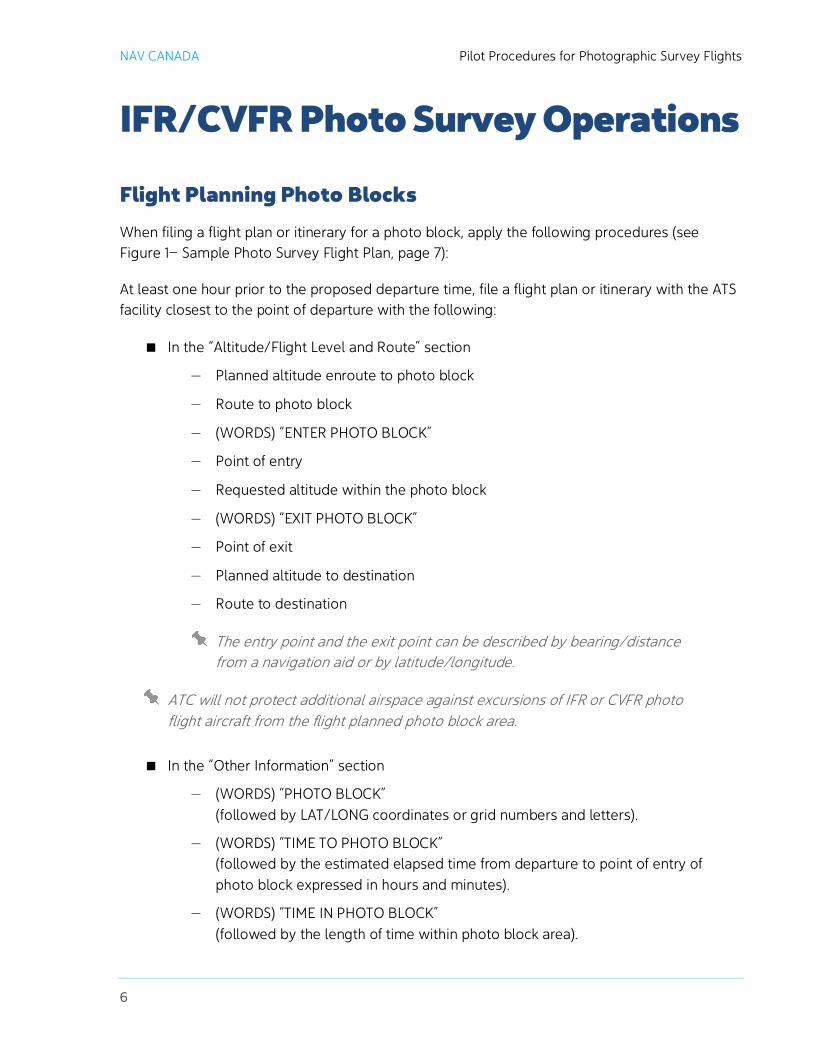
Flight Planning Photo Blocks When filing a flight plan or itinerary for a photo block, apply the following procedures (see Figure 1— Sample Photo Survey Flight Plan, page 7):
At least one hour prior to the proposed departure time, file a flight plan or itinerary with the ATS facility closest to the point of departure with the following:
In the “Altitude/Flight Level and Route” section
— Planned altitude enroute to photo block
— Route to photo block
— (WORDS) “ENTER PHOTO BLOCK”
— Point of entry
— Requested altitude within the photo block
— (WORDS) “EXIT PHOTO BLOCK”
— Point of exit
— Planned altitude to destination
— Route to destination
The entry point and the exit point can be described by bearing/distance from a navigation aid or by latitude/longitude.
ATC will not protect additional airspace against excursions of IFR or CVFR photo flight aircraft from the flight planned photo block area.
In the “Other Information” section
— (WORDS) “PHOTO BLOCK” (followed by LAT/LONG coordinates or grid numbers and letters).
— (WORDS) “TIME TO PHOTO BLOCK” (followed by the estimated elapsed time from departure to point of entry of photo block expressed in hours and minutes).
— (WORDS) “TIME IN PHOTO BLOCK” (followed by the length of time within photo block area).

Pilot Procedures for Photographic Survey Flights NAV CANADA
7
Figure 1— Sample Photo Survey Flight Plan
Flight Planning by Photographic Flight Lines Due to traffic density, it may at times be impossible to protect the required photo blocks. In such cases, ATC will request that the flight plan be by individual flight lines. When it is necessary to flight plan by photographic flight lines, the ATS facility may request that the photo survey pilot or operator file a flight plan at least 72 hours in advance with a topographical chart of adequate scale (1:500,000 or 1:1,000,000), on which the applicable flight lines, entry, and exit point are clearly delineated.
This special flight planning requirement will be exercised only where ATC considers that the flight line information would enable the controller to accommodate the affected air traffic more efficiently. This requirement will be made known to the photo survey pilot or operator during the initial coordination contact.

NAV CANADA Pilot Procedures for Photographic Survey Flights
8
In-Flight Operating Procedures Advise ATS on initial contact that “This is a photo survey mission.”
Advise ATS when entering and exiting the photo block.
Monitor ATS frequencies at all times.
Operate transponders as directed by ATC, except in an emergency or communication failure using the standard emergency transponder code.
Advise the appropriate ATS facility when work has progressed to the point where the area defined in the flight plan can be reduced by blocks or quarter blocks.
IFR flights – Include a position report, preferably by bearing/distance from a navigational aid or, if not practical, the aircraft’s position in the quarter block being flown.
Pilots of photo survey aircraft, operating in accordance with IFR or CVFR, are responsible for the navigation necessary to confine their activity to the airspace allocated.
Airspace to Be Protected While the photo survey aircraft is either enroute to, arriving in, departing from, or established on a flight line, controllers apply lateral, longitudinal, or vertical separation minima between the photo survey aircraft and other aircraft operating under an ATC clearance in accordance with the requirements of the airspace classification involved.
While the photo survey aircraft is operating, controllers protect the whole block by ensuring the airspace to be protected for IFR and CVFR aircraft not engaged in the photo survey work does not overlap the assigned photo block.
ATC will not apply separation between individual aircraft operating in the same block(s). If more than one aircraft has been assigned to work in the same photo block(s), operators are responsible for separation.
ATC will not apply separation between individual aircraft operating in abutting photo blocks, but will advise each operator of the activity in the adjoining photo block. For the common line that separates the two photo blocks, operators are responsible for separation between the individual aircraft.
ATC will protect four nautical miles each side of the flight line of the photo survey aircraft operating in reference to individual photographic flight lines instead of a photo block(s).
In addition, controllers will provide the following additional airspace for the aircraft to complete a turn at the end of the flight line:
4 miles below FL 180
14 miles at FL 180 to FL 230
17 miles above FL 230
Pilot Procedures for Photographic Survey Flights NAV CANADA
9
Communication Failure Procedures These procedures are in accordance with TWO WAY COMMUNICATIONS FAILURE in
the Canada Flight Supplement (CFS), In the event of a discrepancy between this document and the CFS, the procedures defined in the CFS take precedence.
Except when instructed by a controller to cover an anticipated communications failure, the pilot of a photo survey aircraft operating in, or cleared to enter, controlled airspace in accordance with IFR, who experiences communications failure:
Sets the transponder code to 7600
If operating in VFR weather conditions or if such conditions are subsequently encountered, continues to fly in VFR weather conditions and lands at the nearest suitable aerodrome
If the above procedure cannot be followed and the communications failure occurs, the pilot:
Sets the transponder code to 7600
While enroute to the photo area, proceeds to the photo block via the cleared routing and altitude
While in the photo block, operates according to the flight times and altitudes When the estimated time in the photo block has expired, proceeds to the destination airport as filed
When there is no existing procedure, is expected to exercise good judgment.
In any event, ATC will protect the airspace in the immediate vicinity of the aerodrome of first intended landing for 30 minutes from the time at which the aircraft is expected to commence approach.
RPAS Operations The procedures in this document do not apply to remote piloted aerial photography or survey operations. For further information on RPAS operations please consult the NAV CANADA website.

NAV CANADA Pilot Procedures for Photographic Survey Flights
10
Primary Contacts
GANDER ACC Shift Manager Telephone: (709) 651-5207 Email: [email protected] ACC Operations - Area Control Centre Gander International Airport Memorial Drive P.O. Box 328 Gander, NF A1V 1W7
WINNIPEG ACC Shift Manager Telephone: (204) 983-8338 Email: [email protected] ACC Operations - Area Control Centre Winnipeg International Airport 777 Moray Street Winnipeg, MB R3J 3W8
MONCTON ACC Shift Manager Telephone: (506) 867-7173 Email: [email protected] ACC Operations - Area Control Centre Moncton International Airport 222 Old Coach Road Riverview, NB E1B 4G2
EDMONTON ACC Shift Manager Telephone: (780) 890-8397 Email: [email protected] ACC Operations - Area Control Centre Edmonton International Airport P.O. Box 9867 Edmonton, AB T5J 2T2
MONTREAL ACC Shift Manager Telephone: (514) 633-3365 Email: [email protected] ACC Operations - Area Control Centre Dorval International Airport 1750 Chemin St. François Dorval, QB H4P 2P6
VANCOUVER ACC Shift Manager Telephone: (604) 586-4500 Email: [email protected] ACC Operations Area - Control Centre 7421-135th Street Surrey, BC V3W 0M8
TORONTO ACC - TMU EAST Telephone: (800) 268-4831 (Canada) (800) 387-3801 (US) FAX: (905) 676-3121 Email: [email protected]

Pilot Procedures for Photographic Survey Flights NAV CANADA
11
NAV CANADA Facilities Map The following map is current as of the date of this document.
Figure 2— NAV CANADA Facilities Map

NAV CANADA Pilot Procedures for Photographic Survey Flights