flood and scour related failure incidents at railway … flood and scour related failure incidents...
TRANSCRIPT

W13-4224 Flood and scour related failure incidents at railway assets between 1846 and 2013 i
The JBA Trust is an independent charity, registration No. 1150278.
The JBA Trust supports and promotes scientific research, education and training in the fields of environmental risks and resources.
Flood and scour related failure incidents at railway assets between 1846 and 2013
April 2014 Project W13-4224

W13-4224 Flood and scour related failure incidents at railway assets between 1846 and 2013 ii
Authors Zora van Leeuwen and Rob Lamb
Acknowledgements The JBA Trust is very grateful to the Rail Safety and Standards Board for permission to include data from the database created for the Infrastructure Integrity (4) Research Theme: Project Number T112 Scour & Flood Risk at Railway Structures, March 2004.
Acknowledgement is given to Dr Duncan Reed for his work prior to 2004 on developing the BIRDIE approach to investigating the flood severity of failure events.
The assistance of staff from JBA Consulting in providing data and also reviewing the report draft is also appreciated, in particular Jeremy Benn and Alexandra Scott.
Front cover: Malahide Viaduct collapse, 2009 © Fergus Wheatley, http://www.flickr.com/photos/thegreenparty/3851511163/in/photostream/
Purpose This document has been prepared as a resource to help inform further research. The JBA Trust makes no representations or warranties of any kind concerning the material contained within this report, whether express, implied, statutory, or other. This includes, without limitation, warranties of title, merchantability, fitness for a particular purpose, non-infringement, absence of latent or other defects, accuracy, or the presence or absence of errors, whether or not known or discoverable. In no event will the JBA Trust be liable for any legal theory (including, without limitation, negligence) or otherwise for any direct, special, indirect, incidental, consequential, punitive, exemplary, or other losses, costs, expenses, or damages arising out of this material or use of the material.
Copyright © JBA Trust Limited 2014
License This work is licensed under the Creative Commons Attribution-NonCommercial-NoDerivatives 4.0 International License. To view a copy of this license, visit http://creativecommons.org/licenses/by-nc-nd/4.0/.
W13-4224 Flood and scour related failure incidents at railway assets between 1846 and 2013 iii
Executive Summary
Incidence of failures
This study updates an assessment of railway asset failures due to flooding and scour that was published in 2004 by the Rail Safety and Standards Board in ‘Report T112’ covering the period 1846-2003. This update includes incidents between 2003 and 2013.
Failures of bridges and culverts are prioritised, where failure is defined as "complete or partial collapse of the structure sufficient to cause derailment or closure of the line” Although railway assets are the focus of this study, the collapse of seven road/footbridges in 2009 in Cumbria are also investigated. These are of interest because of the survival, rather than failure, of a railway bridge in the area.
Seventeen scour failure incidents have been identified in the UK and Ireland. Of these incidents, six relate to railway bridges or viaducts.
We have found evidence of 138 incidents of failure of rail bridges or culverts related to flooding during the period 1846-2013 in the UK. The annual probability of observing a flood event in which one or more structures fails is estimated to be approximately 41%, or 1 in 2.44 years. This is broadly consistent with the analysis in 2004’s Report T112.
Although not the specific focus of this study, it has been found (as for the 2004 RSSB study) that there is more evidence of embankment failures, track damage and landslip in addition to damages resulting from than failures of bridges and culverts due to scour.
Causes of failures
A quantitative flood and/or rainfall frequency estimate could be carried out for four of the new (2003-2013) incidents identified in this study. Three of the failures happened during relatively minor flood events. One of the bridge failure events was caused by a rare or exceptionally rare flood event.
A higher number of the reviewed incidents occurred during the winter months (in contrast with the findings of the 2004 RSSB report).
The failure mechanism of the four incidents was undermining of abutments or piers by scour, resulting in their collapse.
Associated processes, such as the build up of debris, exacerbated the effects of scour leading to the failure of structures in relatively minor flood events.
Recommendations
As the current report supports the conclusions drawn in the previous study it further reinforces the recommendations made in the previous report.
Factors other than high flood flows alone were implicated in three of the four failures that we investigated in detail. This implies that further work should be carried out investigating these factors.
The higher incidence of embankment and track failures should be investigated.
Dissemination and further updates
Basic information contained in the flood and scour incident database can be obtained from the JBA Trust website: www.jbatrust.org
To access further background information please contact the JBA Trust via the “Contact Us” page at www.jbatrust.org.

W13-4224 Flood and scour related failure incidents at railway assets between 1846 and 2013
Contents
Executive Summary ................................................................................................................. iii
1 Introduction ................................................................................................................. 1
1.1 Summary ...................................................................................................................... 1 1.2 Objectives ..................................................................................................................... 1 1.3 Scope ............................................................................................................................ 1
2 Review.......................................................................................................................... 2
2.1 Review of the 2004 study ‘Flood and Scour Failure of Railway Assets Database
for 1846-2003’ ............................................................................................................... 2 2.2 Scour Process and Assessment Procedure ................................................................. 4 2.3 Conclusion .................................................................................................................... 10
3 Failure Incident Database .......................................................................................... 11
3.1 Definitions and scope ................................................................................................... 11 3.2 Data Sources ................................................................................................................ 11
4 Methodology ............................................................................................................... 14
4.1 Bridge Incident Reviews (BIRDIEs) .............................................................................. 14 4.2 Probability classification system ................................................................................... 15 4.3 Event probability assessments ..................................................................................... 15
5 Incidents identified between 2003 and 2013 ............................................................ 17
5.1 Bridge failure incidents identified between 2003 and 2013 .......................................... 17 5.2 Geographical distribution .............................................................................................. 19 5.3 Seasonality ................................................................................................................... 20 5.4 Assessments of event rarity (BIRDIEs) ........................................................................ 20 5.5 Failure mechanisms ...................................................................................................... 22 5.6 Summary ...................................................................................................................... 22
6 Updated chronology of failure incidents .................................................................. 23
6.1 Consolidated list of failure incidents from 1846 to 2013 ............................................... 23 6.2 Frequency of failure incidents ....................................................................................... 23
7 Recommendations ...................................................................................................... 31
8 Dissemination and updates ....................................................................................... 32
8.1 Contact for further information ...................................................................................... 32 8.2 Updates......................................................................................................................... 32
9 References .................................................................................................................. 33
10 Web based resources................................................................................................. 34

W13-4224 Flood and scour related failure incidents at railway assets between 1846 and 2013 2
List of Figures Figure 1: Timeline of bridge scour failures published by RSSB (2004) ..................................... 2
Figure 2: Geographical Distribution of Incidents (RSSB, 2004) ............................................... 3
Figure 3: Components of total scour ........................................................................................ 5
Figure 4: Local scour and turbulence at a circular pier (after May et al., 2002) ........................ 6
Figure 5: Structures showing a developing scour hole (left) and general scour (right), from Environment Agency (2004). ........................................................................... 6
Figure 6: Malahide Viaduct Collapse (Railways Archive, 2010) ............................................... 7
Figure 7. Network Rail scour assessment procedure ............................................................... 8
Figure 8: Counts of number of failure incidents by year, and the number of hydro-meteorological events associated with one or more failures. .................................. 17
Figure 9: Incident map .............................................................................................................. 19
Figure 10: Count of number of failures by month ...................................................................... 20
List of Tables Table 1: Hydraulic structure failure mechanisms due to hydraulic action ................................ 7
Table 2: Priority rating meanings (JBA Consulting, 2004) ........................................................ 9
Table 3: Data sources for identification of incidents .................................................................. 11
Table 4: Information sought ...................................................................................................... 12
Table 5: Data Sources- technical information ............................................................................ 13
Table 6: Headings included in previous study BIRDIEs (RSSB, 2004) .................................... 14
Table 7: Classification of failure events .................................................................................... 15
Table 8: Failure incidents .......................................................................................................... 17
Table 9 Scour related incidents between 2003 and 2013 ......................................................... 18
Table 10: BIRDIE frequency estimates .................................................................................... 21
Table 11: Gauging stations ....................................................................................................... 21
Table 12: Consolidated list of railway bridge or culvert failure incidents related to flooding between 1846 and 2013 ............................................................................. 25
Abbreviations AMAX Annual Maximum
BIRDIE Bridge Incident Review Document Investigating Extremeness
CEH Centre for Ecology and Hydrology
CIRIA Company providing research and training in the construction industry
EA Environment Agency
ELR Engineers Line Reference

W13-4224 Flood and scour related failure incidents at railway assets between 1846 and 2013 3
FARL FEH index of flood attenuation due to reservoirs and lakes
FEH Flood Estimation Handbook
FMS Flow measurement station
FSR Flood Studies Report
GEV General Extreme Value Distribution
GL General Logistic Distribution
NERC Natural Environment Research Council
NRFA National River Flows Archive
NRW Natural Resources Wales
OS NGR Ordnance Survey National Grid Reference
PR Percentage Runoff
QMED Median Annual Flood (with return period 2 years)
SAAR Standard Average Annual Rainfall (mm)
SEPA Scottish Environment Protection Agency

W13-4224 Flood and scour related failure incidents at railway assets between 1846 and 2013 1
1 Introduction
1.1 Summary
In 2004 the Railway Safety & Standards Board (RSSB) published results of an appraisal of the scour risk rating method Handbook 47. As part of that project (Rail Safety & Standards Board Infrastructure Integrity (4) Research Theme: Project Number T112 Scour & Flood Risk at Railway Structures) a database of historic flood and scour related failure incidents of railway assets was collated.
The project reviewed the priority scoring system and threshold risk rating used by Network Rail to classify structures which may be subject to scour. The aim of the project was to “help work towards eliminating catastrophic accidents by application of existing control measures and new initiatives” (RSSB, 2004).
This report is an update of the work carried out in Project T112 to include incidents that have occurred in the ten years (2003-2013) since the compilation of the database for the 2004 study.
1.2 Objectives The objectives of the present study were therefore:
To update the Railway Assets Scour and Flood Failure Incidents Database to include incidents which have occurred between 2003 and September 2013.
To carry out detailed incident reports investigating the extremeness of the events causing failure.
This report is published for use as a research and educational resource.
1.3 Scope
To achieve the objectives listed above the following work was carried out:
A review of the report Rail Safety & Standards Board Infrastructure Integrity (4) Research Theme: Project Number T112 Scour & Flood Risk at Railway Structures by JBA Consulting, 2004.
A brief overview of scour mechanisms and assessment procedures.
Research to identify and collate information about scour-related failure of structures during the period 2003-2013.
Identification of additional information to collate for the updated Railway Assets Scour and Flood Failure Incidents Database
Detailed investigations into identified scour incidents, including rainfall and flood rarity estimates.

W13-4224 Flood and scour related failure incidents at railway assets between 1846 and 2013 2
2 Review
2.1 Review of the 2004 study ‘Flood and Scour Failure of Railway Assets Database for 1846-2003’
2.1.1 Overview of findings
The previous study RSSB Project Number T112 Scour & Flood Risk at Railway Structures was undertaken in 2002 and the reporting completed in 2004 on behalf of the Rail Safety and Standards Board (RSSB) as part of a research theme to investigate scour and flood risk at railway structures.
The study compiled a record of incidents between 1846 and 2003. During this period, 131 failure incidents were found in the UK and Ireland, resulting from 65 discrete flood events. Failures tend to be documented more reliably at larger structures due to the extent of disruption and cost. Therefore to increase confidence in the inclusion of most failure events the study aim was to report on the failure of larger structures.
Figure 1: Timeline of bridge scour failures published by RSSB (2004)
Failure was defined as “complete or partial collapse of the structure sufficient to cause derailment or closure of the line” (RSSB, 2004). Figure 1 shows the timeline of incidents found in the study. No significant trend or periodicity was found for the incidents. It was found that failures could occur in any month of the year, but that there were more incidents in summer.
Figure 2 shows the geographical distribution of the failure incidents. It was found that many of the structure failures occurred in groups associated with a common flood event, and are therefore geographically close.

W13-4224 Flood and scour related failure incidents at railway assets between 1846 and 2013 3
Figure 2: Geographical distribution of incidents (RSSB, 2004)
2.1.2 Data
The failure incident database included the following fields, although information was often not available for all fields:
Incident date, location, watercourse, structure type
Description of failure, hydrological classification of failure, contributing factors, consequences of failure (e.g. injuries)
Bridge details: line/route, name, Engineering Line Reference (ELR), Bridge number, construction and reconstruction details
Catchment Descriptors and Qmed values
Photos, pictures and diagrams
2.1.3 Data Sources
The RSSB 2004 database was compiled based on:
Network Rail Structures Records held at Waterloo, Swindon, Birmingham, York, Manchester, Liverpool Street and Glasgow
Rail Property/ BRB Residuary Records held at York
Accident Reports of the Board of Trade held at the Public Records Office, Kew and the National Railway Museum, York.
Accident Reports of the Railway Inspectorate.
Ransom, P J G. ‘Snow Flood & Tempest – Railways & Natural Disasters’. Ian Allen Publishing, 2001.
Simmons, J and Biddle, G. ‘The Oxford Companion to British Railway History’. Oxford University Press, 1997.
Holt, L T C. ‘Red for Danger. The Classic History of British Railway Disasters’. Sutton, 2001.

W13-4224 Flood and scour related failure incidents at railway assets between 1846 and 2013 4
‘British Railway Disasters’. Ian Allen Publishing, 1996. British Hydrological Society.
Chronology of British Hydrological Events.
Web searches.
2.2 Scour Process and Assessment Procedure
2.2.1 Introduction
Hydraulic action can lead to the failure of structures such as bridges through several different mechanisms, including the following.
Scour can undermine shallow foundations or cause destabilisation of deep foundations through erosion of the river bed. This can lead to undermining or tilting of the bridge piers or buttresses.
Bank erosion and channel migration causing undermining of piers or abutments on the floodplain.
Lateral forces can cause failure through sliding or overturning whilst uplift can lift bridge decks from their bearings or reduce the compression in arches.
Debris accumulation, which increases the effective width of a pier, increasing the scour risk as well as constricting the flow, which leads to higher water levels and flow velocities through the structure.
Of these mechanisms it is believed that scour is the most common cause of failure. In the UK there are estimated to have been 15 fatalities due to flood/scour failure of a structure since the 1840s (RSSB, 2004).
In recent years notable failures due to scour include the Glanrhyd railway bridge disaster in 1989 in Wales, which collapsed due to scour of a pier resulting in four fatalities as an approaching train attempted to cross the collapsed bridge and fell into the river.
More recently the Lower Ashenbottom viaduct in Lancashire failed in June 2002 as its central pier partially collapsed due to scour during a flood event; the scour was exacerbated by the presence of debris, exceeding the estimated foundation depth.
In the 2009 Cumbria floods seven road and foot bridges failed due to the combination of scour and hydrodynamic loading. The collapse of the Northside road bridge in Workington led to one fatality.
2.2.2 Scour
Scour is interpreted here as the removal of material from the bed and banks of a channel by the action of water. Guidance on management of scour has been given in a CIRIA report Manual on Scour at Bridges and Other Hydraulic Structures by May et al. (2002), which is currently undergoing an update
1. Scour can cause failure of the foundations of the abutments or piers of
bridges. Scour occurs naturally, and is most common in granular alluvial river beds and banks. Materials such as clay and even some kinds of rock are susceptible to scour. Scour may result from natural changes of flow in the channel, as part of longer-term morphological evolution, or as a result of human activity, such as the building of structures in the channel or dredging.
It was found in previous work by JBA Consulting (RSSB, 2004) that bridge failure due to scour was most commonly associated with flood events broadly with return periods of 50 to 500 years. Most of these failures are encompassed in 200 to 250 year return period events, with an average return period of 160 years. High intensity localised rainfall on small catchments appears to have caused a number of incidents in summer and early autumn.
2.2.3 Scour Mechanisms
There are three main scour mechanisms known as natural scour, contraction scour and local scour, which work additively to give total scour as shown in Figure 3.
1 http://www.ciria.org/Research/Projects_underway2/scour_at_bridges.aspx

W13-4224 Flood and scour related failure incidents at railway assets between 1846 and 2013 5
Figure 3: Components of total scour
2.2.4 Natural Scour
Natural scour is the result of long term changes to the river or catchment. Degradation of the channel occurs as the river attempts to find a balance between sediment load and sediment transport capacity to reach an equilibrium condition called regime flow. This can be disturbed by both natural and man-made alterations to the catchment and river such as dredging, changes in catchment drainage or long term morphological changes.
Lateral channel migration, where the entire river channel position changes due to meander progression, or where the deep water channel changes position within the channel banks, may also occur due to these natural or man-made causes. These changes occur slowly over time or in steps during flood events. Braided rivers may also be susceptible to confluence scour, which occurs where two rivers meet as the centreline of the meeting flows is directed towards the channel bed. Bend scour occurs due to flow curvature, which creates secondary spiral currents that increase scour at the outside of river bends.
2.2.5 Contraction Scour
Contraction scour occurs where the narrowing of a river channel (for example due to the presence of bridge piers or abutments) causes increased velocity and shear stress at the bed. Material may be removed from the entire width of the channel. Contraction can also occur where the flow has been forced from the flood banks to flow under a bridge due to approach embankments, where a downstream control has been removed or where the stream flow rate at a site increases for some other reason.
2.2.6 Local Scour
Obstructions to the flow in rivers can increase flow velocities and turbulence locally, which can cause the formation of vortices exerting forces on the river bed, leading to erosion. This causes the river bed to be lowered in the immediate locality of the obstruction.
Formulae can be used to predict the depth of the scour hole caused by different types of structures. In the case of bridge abutments and piers the turbulent structure which occurs is known as the horseshoe vortex, shown in Figure 4. The vortices which are deflected to the downstream side of the pier increase flow velocities and cause scour of the river bed at this location, creating what is known as a ‘scour hole’. Material from the scour hole is deposited downstream, further changing the river bed level. The flow structures are discarded periodically and move downstream, which can cause further erosion of the river bed downstream on either side of the pier (May et al., 2002).

W13-4224 Flood and scour related failure incidents at railway assets between 1846 and 2013 6
Figure 4: Local scour and turbulence at a circular pier (after May et al., 2002)
Figure 5: Structures showing a developing scour hole (left) and general scour (right), from
Environment Agency (2004).
The three different scour mechanisms need to be considered when evaluating the scour conditions in a river. It is important to note that both long term, in the case of natural scour, and short term monitoring is required; the scour hole often re-fills after the flood event.
2.2.7 Factors Affecting Scour
Factors which affect flow are listed in the CIRIA Manual on scour at Bridges and other Hydraulic structures as the following:
the position and type of structure
the flow conditions affecting it
the characteristics of the channel boundary materials in the vicinity of the structure and in the upstream reach
These factors are subject to a high level of uncertainty, and hence scour predictions cannot be made to the same level of accuracy as structural calculations. For example, the flow and sediment conditions affecting the structure may change because of climate or catchment changes during the life of the structure.
2.2.8 Impact of Scour
Scour can cause the undermining of bridge pier and abutment foundations, thereby causing failure of the structure through various mechanisms (Table 1).

W13-4224 Flood and scour related failure incidents at railway assets between 1846 and 2013 7
Table 1: Hydraulic structure failure mechanisms due to hydraulic action
Primary Secondary
Pier settlement due to loss of support to
foundation
Pier tilting, or tilting of group of piles
Abutment settlement or tilting
Piers, abutments or footings damaged by
hydraulic loading, possibly aggravated
by debris accumulation
Piers, abutments or footings damaged by
collision, sediment abrasion or impact
from boulders
Superstructure or deck sliding off
supports due to hydraulic or debris
loading or collision
Superstructure or deck damaged by
collision of debris or vessel
Scour hole or washout of embankment
behind abutment
Structural damage to superstructure or deck
caused by twisting from differential settlement of
piers and/or abutments
Superstructure or deck falling off abutment or
pier due to adverse tilt of support. increasing
gap between supports
Superstructure or deck buckling or riding up
over support due lo reduced gap between
supports
Superstructure or deck sliding off supports
because of tilting of supports
Collapse of railway into embankment scour hole
or washout
The collapse of the Malahide Viaduct in the Broadmeadow Estuary, Ireland (shown in Figure 6 and front cover) was a structural failure due to scour. A combination of natural scour and local scour led to the exposure of the pier foundations, which were undermined by hydraulic action resulting in the collapse of the pier when it was loaded by two trains in August 2009 (RAIU, 2010).
Figure 6: Malahide Viaduct Collapse (Railways Archive, 2010)
2.2.9 Assessment Procedure
Network Rail follows a four step process in the management of scour as shown in Figure 7. A risk based approach is used to assign priority ratings to structures depending on the level of assessed risk from scour. This procedure was developed following the 1987 Glanrhyd disaster

W13-4224 Flood and scour related failure incidents at railway assets between 1846 and 2013 8
and was known as Handbook 47 (British Railways Board, 1989), this was revised in 1992 and is now generally known as EX2502 (Bettess, 1993).
Figure 7. Network Rail scour assessment procedure
More recent studies, such as that carried out by JBA Consulting, Safe management of railway structures: flooding and scour risk, have been commissioned by the Rail Safety and Standards Board to review and improve these methods (JBA Consulting, 2004).
The Network Rail standard for management of existing bridges and culverts (RT/CE/S/080) states that “all structures over watercourses, adjacent to flowing or tidal water, or at risk of flooding or susceptible to damage or reduced load carrying capacity as a result of scour or flooding (including overturning, sliding and/or uplift)” should be subject to initial scour assessments at a minimum of once every three years. Any structures which are deemed to be at risk are to be included in the flood warning plan. Unlike previous standards, there is not a recommended assessment procedure such as EX2502.
2.2.10 Stage 1: Data Collection
The first stage of the assessment procedure was to collate all available information on the structure. This includes sources such as previous EX2502 examinations and drawings, coring and underwater surveys and as-built design drawings.
2.2.11 Stage 2: Initial Scour Assessment
The data collected in Stage 1 was used to carry out an initial scour assessment to identify which of the 9000 structures that cross permanent water courses and which of the 20,000 further structures at risk from flooding were in need of a more detailed scour assessment (JBA Consulting, 2004).
2.2.12 Stage 3: Detailed Scour Assessment
The structures identified in Stage 2 were subjected to a detailed scour assessment. This assessment includes further review of the data collected in Stage 1 along with more detailed data collection and a risk assessment.
EX2502
EX2502 (Bettess, 1993) is the risk assessment procedure which has been followed by Network Rail to assess structures at risk of scour and flooding.
A preliminary priority score (PP) is assigned to a structure by summing the contraction scour and local scour discussed in section 2.2.3 to give total scour (TS) and dividing this by the foundation depth (FD). As natural scour is the most difficult to assess it is treated as a separate variable.
PP = f(TS/FD) = 15 + ln(TS/FD)

W13-4224 Flood and scour related failure incidents at railway assets between 1846 and 2013 9
The PP is then modified by several factors which up or down scale it to its final priority rating (PR)
PR = f(TS/FD,TR,FM) = 15 +ln(TS/FD) + TR + FM
where river type (TR) describes the changeability of the river course, the natural scour, and FM describes the foundation material.
2.2.13 Stage 4: Long-term Management
Any structure with a priority rating above 16.0 is classified as high risk. Structures which have had scour protection put in place should not automatically be excluded from flood plans as the need for the scour protection indicates that the structure is vulnerable, and should therefore be inspected on a regular basis. The priority rating system is shown in Table 2.
Table 2: Priority rating meanings (JBA Consulting, 2004)
2.2.14 Mitigation
Scour mitigation options follow a hierarchy of preferred choices which can be included in the design or in many cases retrofitted to a structure.
Scour reduction measures improve flow conditions at the bridge to reduce the magnitude of scour. This is likely to be the most cost effective measure. Structural measures take into account the increase in hydrodynamic forces due to predicted scour depth. Scour protection measures include erosion resistant surfaces that can be fitted to limit scour depth, and may increase the whole-life cost of the bridge as maintenance of the scour protection will be required.
2.2.15 Scour Reduction
Choosing a stable channel location for the crossing can reduce the risk of natural scour. Building bridges on confluences, bends or alluvial fans should be avoided. Man-made changes such as dredging, removal of hydraulic structures such as weirs and deforestation should be minimised at the location.
Contraction scour can be reduced by minimising the contraction, i.e. increasing the flow area. This can be achieved by ensuring there is sufficient waterway opening, providing flood relief openings and by designing the bridge so that it has a lower approach to roads, which will allow flow to bypass the structure.
The choice of streamlined bridge elements reduces both local scour and debris accumulation which can exacerbate scour. The choice of shape is important. Using circular piers eliminates the problem of changes in approach flow alignment and elliptical piers reduce turbulence in comparison to rectangular piers. Sloping or spill-through abutments can be used instead of vertical wall abutments to reduce scour. Deflectors or sacrificial piles can be used to direct flow away from the structural elements and so reduce scour. For retrofits it is possible to add cut-waters to bridge piers.
Increasing the stability of the river through the use of bed control structures, longitudinal structures which prevent lateral movement of the channel or transverse structures which deflect flow away from the bank are river training methods which can be used to reduce scour.

W13-4224 Flood and scour related failure incidents at railway assets between 1846 and 2013 10
2.2.16 Structural Measures
Bridges can be designed to withstand the predicted scour depth or can be retrofitted. For example, care should be taken when designing shallow foundation so that they are placed either on non-erodible material or below the expected scour depth. The effective width reduction due to the spread footings should also be taken into account. Similarly, with piled foundations, the pile cap should be placed below the maximum predicted scour depth. If the pile cap is exposed to flow then the impact this has on scour, and the impact of the scour on the foundations should be taken into account. Structural repairs may be carried out to reduce the effect of scour, care should be taken, however, to ensure that this does not significantly increase contraction scour.
2.2.17 Scour Protection
Scour protection consists of the provision of a non-erodible layer to protect the channel. The extent, elevation and detail of the scour protection should be carefully designed to ensure that it does not cause further scour problems. Scour protection measures can be classed as flexible or rigid. Flexible methods include riprap, gabion baskets, articulated concrete blocks and biotechnical solutions. Rigid solutions include grout filled mattresses, concrete aprons and steel sheet piling.
2.2.18 Monitoring
As well as the above measures the effect of scour can be monitored to provide early warning of scour problems. However, for this to be effective, high reliability of the monitoring devices is required. Fixed or portable monitoring equipment can be used, with the advantage of fixed equipment being that it can provide a more timely warning. However, issues such as the need for a power supply mean that this is the more costly option.
2.3 Conclusion
Natural, constriction and local scour erode river channels, putting hydraulic structures at risk of failure by undermining abutment or pier foundations. In many cases this has led to the catastrophic collapse of bridges, viaducts and culverts, causing millions of pounds of damage, numerous casualties and even fatalities.
Scour assessment procedures classify structures as being at low, medium or high risk. High risk structures are included in the flood plan and actions are carried out to ensure their risk is managed effectively.
Scour risk can be managed by carrying out scour reduction measures, structural measures, installing scour protection or scour monitoring. Careful consideration of the changeability of the channel and catchment is required to ensure that scour mitigation measures are employed effectively.

W13-4224 Flood and scour related failure incidents at railway assets between 1846 and 2013 11
3 Failure Incident Database
3.1 Definitions and scope
The creation of a database of failure incidents of railway assets due to scour and flooding requires definition of the terms so that a boundary can be drawn as to which incidents should be included.
In line with previous work, “failure” has been defined as “total or partial destruction of a structure that is sufficient to cause line closure" (RSSB, 2004).
Priority was given to the investigation of failure of railway bridges and culverts.
The failure of retaining walls was also considered, although this was a secondary consideration as it is difficult to obtain information on these failures.
Track failures due to landslips caused by flooding have been listed. However as these are numerous and often not due to scour they are not further investigated in this report.
The failure database focuses on railway assets. Additionally some road and foot bridges have been included in particular from floods in Cumbria in 2009 when six road and foot bridges collapsed but a nearby railway bridge remained intact.
The study was confined to the UK and Ireland.
3.2 Data Sources
JBA staff provided a list of seven failure incidents known to them. Another 13 scour-related bridge failure incidents were identified through the use of web searches. Sources used along with a comment on their usefulness are shown in Table 3.
Table 3: Data sources for identification of incidents
Source Comment
National Railways Archive
Database of Railway Accidents in the UK and Ireland. Searchable by year, year range, locations, companies involved, causes, results, and relation to a certain development.
Links are provided to related published reports such as accident investigation reports.
Verdict: Very useful
RAIB & RAIU
The railway Accident Investigation Branch and its equivalent in Ireland provide free accident investigation reports. The website is not as easy to search as the national railways archive so it is recommended to find the incidents through this. Provides technical information.
Verdict: Very useful
BBC News website
News reports on incidents were found to be useful in identifying new incidents and giving qualitative descriptions. Although they did not provide any technical information, they were helpful in pin pointing the dates of the incidents.
Verdict: Useful, good starting point
New Civil Engineer (NCE)
NCE articles were of similar use to the BBC pages but provided slightly more technical information
Verdict: Useful, good starting point
Rail News & Railway Magazine
Similar use to BBC News website.
Local government/Council Provides more qualitative information, often a good source of

W13-4224 Flood and scour related failure incidents at railway assets between 1846 and 2013 12
websites photographs.
Published Research Papers
Provide technical information regarding specific incidents. Found to be very useful when available.
Verdict: Very Useful
Previous reports carried out by JBA Consulting, often for the Environment Agency or the RSSB.
Useful source of technical information, full descriptions of events and in depth review of the mechanism and/or rainfall and flooding events.
Verdict: Very useful
Scour Assessment Reports (JBA)
Where scour or general assessment reports have been carried out by JBA these are a useful source of information regarding the scour rating and technical details of the structure.
Verdict: Useful
It is thought that the search has identified most of the major incidents which have taken place over the past 10 years.
There is a large degree of variability between the amount of information available for incidents, some have had detailed technical reports carried out whereas others receive merely a passing comment in a newspaper article.
3.2.1 Data source matrix
Identifying what information should be included in the failure incident database was done in two steps. Firstly, the previous database was used as a starting point. JBA personnel with experience in the sector were then asked to identify the information they thought would be useful for inclusion in the database. The information was categorised as shown in Table 4.
A matrix of specific data sources is shown in Table 4.
Table 4: Information sought
Information category Details
Basic Information
Date River Location OS NGR Type of Structure Use
Failure mechanism Description of event Damages Injuries Fatalities Source
Bridge Information
Line/Route Name ELR Number Date of Construction Original
Construction Date of Reconstruction Type of Reconstruction Span Width (m) Foundation Depth
Weather and Rainfall Data
Total Daily rainfall depth (mm) Storm Return period Antecedent conditions EA River level gauge Proximity to watercourse (to identify flooding cause) Drainage data
Whether there has been a recent scour assessment. Whether the location is in the flood risk database. Cost and disruption periods. Comments
Flood and Scour Information Flow (m3/s) Flow return Period
Scour Rating Peak Water Level
W13-4224 Flood and scour related failure incidents at railway assets between 1846 and 2013 13
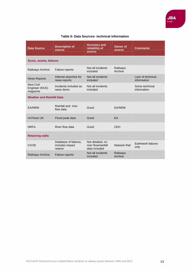
Table 5: Data Sources- technical information
Data Source Description of source
Accuracy and reliability of source
Owner of source
Comments
Scour, assets, failures
Railways Archive Failure reports Not all incidents included
Railways Archive
News Reports Internet searches for news reports
Not all incidents included
Lack of technical information
New Civil Engineer (NCE) magazine
Incidents included as news items
Not all incidents included
Some technical information
Weather and Rainfall Data
EA/NRW Rainfall and river flow data
Good EA/NRW
Hi-Flows UK Flood peak data Good EA
NRFA River flow data Good CEH
Retaining walls
CIV28 Database of failures, includes impact reason
Not detailed, no river flow/rainfall data included
Network Rail Earthwork failures only
Railways Archive Failure reports Not all incidents included
Railways Archive

W13-4224 Flood and scour related failure incidents at railway assets between 1846 and 2013 14
4 Methodology
4.1 Bridge Incident Reviews (BIRDIEs)
Bridge Incident Review Documents Investigating Extremeness, or BIRDIEs, are the reporting methodology adopted from previous work for the RSSB, originally developed by Dr Duncan Reed. The BIRDIEs consist of a loose structure which is adapted depending on the available information.
The previous RSSB (2004) study reviewed historic incidents. As the current study investigates more recent events a slightly different approach has been adopted with the focus on two questions:
1. What is the flood and rainfall frequency for the failure event?
2. Have there been greater flooding events in the past which the structure survived?
The second question leads into an investigation into the failure mechanism of the incident, so that the reasons for its current failure can be identified where the structure has survived greater flood events.
The BIRDIE structure and format is shown in Table 6. For example, where available, a historic review of previous flood events has been included in the flood event rarity section to put the event in a larger historic context.
Table 6: Headings included in previous study BIRDIEs (RSSB, 2004)
In addition to these headings a summary page has been included for each BIRDIE which includes the following information:
Event Description
o A short, qualitative description of the event
Incident & Gauge data
o A map showing gauge and incident location, as well as flood and rainfall frequency estimates obtained for the gauges.
o List of gauging station data available, including length of record
Estimate Certainty
o Comment on the certainty of the estimate, including the gauges and methods used.

W13-4224 Flood and scour related failure incidents at railway assets between 1846 and 2013 15
4.2 Probability classification system
For consistency with the previous study the same classification system is adopted for expressing the rarity of the hydrological or meteorological events associated with failure incidents. This categorical approach was taken in view of the considerable uncertainty in assessments of event rarity, in particular for the earlier historic events reviewed in RSSB (2004).
The classification scheme is shown in Table 7. These categories were chosen in the original study in the context of rail-bridge flood safety. Due to the uncertainties in the assessments the incidents are often classed as having a return period of greater or less than 100 years.
Table 7: Classification of failure events
4.3 Event probability assessments
4.3.1 Data
For failure incidents where a nearby river gauge was identified, gauged flood data was used to obtain annual maximum (AMAX) peak flow series. Where available the AMAX series were directly obtained from Hi-flows UK, a publicly available database of peak flow data for around 1000 river flow stations around the UK (Environment Agency, 2013).
Where the relevant river gauge was not included in the Hi-flows database, the AMAX series was derived from 15-minute instantaneous flow data provided by the Environment Agency.
4.3.2 Flood Estimation Handbook frequency estimation
For the more recent events reviewed in this update, Flood Estimation Handbook (FEH, Institute of Hydrology, 1999) methods could be applied where relevant rainfall or river measurements could be found. Where 15 minute rainfall data is available the start and end point of the rainfall event are identified through visual examination of the (plotted) data. The total depth and duration of the event can then be calculated. The FEH rainfall Depth-duration method is applied to obtain a rainfall rarity assessment for the catchment. Flow data were analysed using FEH statistical methods based on fitting parametric extreme value distributions.
Flood frequency estimation is subject to uncertainties relating to the quality, geographical distribution and length of gauged records, and also possible changes in climate, river channel or catchment. Therefore it is recognised that the rarity assessment will only ever be as robust as the data and sampling techniques used. Site specific limitations, brought about by representativeness and accuracy of the gauges and their catchments are discussed within the BIRDIEs.
4.3.3 Use of historic data
Bayliss and Reed (2001) discussed use of historical evidence in flood frequency analysis. A rank-based probability analysis can be used to obtain a flood frequency estimate from qualitative historic accounts of flood events such as can be found in newspaper archives. This allows the assessment to be extended beyond river gauge records, which generally tend to start in the 1960/70s. Historic data can be found for flood events as far back as the 1800s. The Gringorten formula is a well known plotting position formula used to calculate the exceedance probability from ranked data (Shaw, Beven, Chappell, & Lamb, 2011). The exceedance probability, P(X) is estimated as

W13-4224 Flood and scour related failure incidents at railway assets between 1846 and 2013 16
where r is the rank position of the data and N is the size of the data period. The formula overcomes the problem that when N is not large, r/N is not a good estimator.
It is important to be aware of the authenticity and relevance of historic sources. For historic data to be useful for a Gringorten analysis it should include information regarding the date of the event, the location (ideally naming the tributary and location) and some information allowing the event to be ranked. This would ideally be the peak flow but may have to extracted from the historic record in less direct ways, for example from comparisons made to other floods in the historic extract.
Ideally it would be possible to extract the river flow from the historic data sets so that this can be linked to the AMAX series for the gauged period. Another option which could be considered for linking the two sets of data would be by looking at gauged rainfall data for the site, as some records date back over the historic period. Obtaining this information, however, was beyond the scope of this project. As it was not therefore possible to obtain detailed flood frequency estimates from the historical data, the historical information was instead simply listed in an estimated ranked order so that the floods which caused bridge failure incidents can be placed in a wider historic context.
The Gringorten formula is approximately quantile-unbiased (i.e. performs well when estimating flood magnitudes of a given frequency) for samples drawn from a Gumbel distribution (NERC, 1975). It relies on the use of a complete, uninterrupted dataset. In practice gauged records are often subject to periods of missing data for various reasons. In this study these datasets are used as the benefit of using a larger historical dataset (rather than excluding any periods containing missing data) outweighs the errors introduced due to missing data points.
Determining the length of the dataset is a great source of uncertainty in plotting position analysis when used on historic datasets. Bayliss and Reed (2001) suggest taking the start date as either a set number of years (~20) before the earliest flood record; as the period between the first and second flood record or as the average number of years between the flood events. The estimated probabilities are sensitive to choice of record length, especially for the largest few events
Ranking of historic data (from previous flood study reports) can be dubious. The ranking is often based on qualitative statements such as “the flood was the greatest in magnitude in living memory” as well as levels given on certain streets which are repeated in several records and statements concerning the recorded rainfall depth for the event. Not all historic data includes any of this information and few contain all three. Further to this it has been found that statements such as the above regarding “floods in living memory” should not be taken as being accurate for greater than approximately 20 years (Bayliss and Reed, 2001).

W13-4224 Flood and scour related failure incidents at railway assets between 1846 and 2013 17
5 Incidents identified between 2003 and 2013
5.1 Bridge failure incidents identified between 2003 and 2013
Seventeen scour related incidents were identified in the study. These are divided into categories and listed in Table 8. The full list is shown in Table 9.
Table 8: Failure incidents
Failure and asset type Number of incidences
Railway bridges and viaducts 6
Road and foot bridges 7
Track failures 4
Figure 8 shows a time series of the failures during the period studied. The difference between the number of incidents and number of events is accounted for by the seven Cumbrian bridge failures that occurred during the same event in 2009 (although this was not the only flood event related to a failure incident in 2009).
Figure 8: Counts of number of failure incidents by year, and the number of hydro-
meteorological events associated with one or more failures.

W13-4224 Flood and scour related failure incidents at railway assets between 1846 and 2013 18
Table 9 Scour related incidents between 2003 and 2013
Date DD/MM/YYYY
River Location Type of Structure
Use
Railway Bridges/Viaducts
11/09/2003 Rother Beighton Brick arch - twin brick piers.
Rail
??/01/2003 Monk's Brook Chandler's Ford, Hampshire Brick arch with invert
Rail - goods line
14/11/2009 Crane Feltham, West London Bridge Rail
??/12/2013 Taw South West- Barnstaple line Bridge and Track
Rail
01/11/2006 Burn of Winless Watten Bridge Rail
21/8/2009 Broadmeadow Malahide - Broadmeadow Estuary
Viaduct Rail
Road/Foot bridges
21/11/2009 Derwent Northside Bridge, Workington, Cumbria
Bridge Road
??/11/2009 Derwent Northside Foot Bridge Bridge Foot
01/11/2009 Derwent Calva Bridge, Workington, Cumbria (road bridge)
Bridge Road
21/11/2009 Derwent Camerton bridge, Workington, Cumbria (foot bridge)
Bridge disused railway/ footbridge
??/11/2009 Cocker Lorton Bridge, near Cockermouth
Bridge Road
??/11/2009 Eamont suspension footbridge near Dalemain
Bridge Foot
??/11/2009 Newlands Beck Newlands Beck bridge, near Keswick
Bridge Road
Track
18/07/2007 Multiple Moruisg/Loch Sgamhain Track Rail
28/06/2012 N/A Tebay Track Rail
Nov/Dec 2012 Exe South West- Cowley bridge Junction
Track Rail
26/11/2011 N/A Cornwall, Bodmin and Wenford
Track Preserved Railway

W13-4224 Flood and scour related failure incidents at railway assets between 1846 and 2013 19
5.2 Geographical distribution
Figure 9 shows the locations of the scour failure incidents found between 2003 and 2013. It can be seen that the incidents are geographically spread out, except for the road/footbridge failures in Cumbria which occurred during the same event. This is similar to the findings of report T112. The cluster of incidents in Cumbria is not a repeat of any of the clusters found in the previous study.
The Incident in Feltham in 2009 adds to the events found in the previous study clustered around London. The only repeated event is Cowley Bridge Junction in the South West, which is known to flood on a regular basis.
Figure 9: Incident map
Contains Ordnance Survey data © Crown copyright and database right (2014)

W13-4224 Flood and scour related failure incidents at railway assets between 1846 and 2013 20
5.3 Seasonality
Figure 10 shows that there is a skew of failure events towards the winter months. This is as expected as this is known to be the main flood season. However, it is in contrast to the previous RSSB (2004) study of the longer historical record, which found more scour related failures to occur in the summer months.
Figure 10: Count of number of failures by month
5.4 Assessments of event rarity (BIRDIEs)
Out of the 17 failure incidents identified, four were found to satisfy the criteria listed below which allowed a BIRDIE to be carried out.
Structural Failure
Failure caused by a flood event
Flow and/or rainfall data available or provided by the national gauging authority
BIRDIEs were not carried out for the other incidents for several reasons:
Four events related to track failure, which is not prioritised in the study.
In one case the structure could not be identified from the source (a BBC news item)
One incident was caused by scour due to tidal action rather than a weather event.
It was not possible to obtain any flow or rainfall data for one event, although this was requested from the gauging authority.
A BIRDIE assessment was carried out for the 2009 Cumbria event associated with seven Cumbrian road and footbridge failures. This is of interest since the nearby rail bridge did not fail, but the return period assessment is not included in later analysis because of the primary focus of the study on railway bridges.
The frequency estimates and subsequent classification assigned to the failure events for which BIRDIEs were carried out are shown in Table 10.
Table 11 shows a summary of the gauge data used to carry out these estimates.

W13-4224 Flood and scour related failure incidents at railway assets between 1846 and 2013 21
Table 10: BIRDIE frequency estimates
Return period estimate (years)
Date River Incident Flood:FEH
Flood: GG*
Rainfall Classification
11/09/2003 Rother Beighton 2-3 2-3 <1 month Minor flood
14/11/2009 Crane Feltham, West London
1 1 Minor flood
01/11/2006 Burn of Winless
Watten 15 32 3 Minor Flood
21/11/2009 Derwent Northside Bridge, Workington Cumbria
600† 90 Exceptionally rare
flood.
Not a rail bridge failure.
*Gringorten plotting position estimate
†Derived from a post-event analysis for the Environment Agency (JBA Consulting, Review of November
2009 Flooding in Cumbria (River Derwent Catchment) Event Analysis Report, 2010)
Table 11: Gauging stations
Incident, date
River flow gauging station used for analysis
Flow period of record
Rain gauge Rainfall period of record
Beighton, 2003
27025 Woodhouse Mill 1960-2009 084532 Woodhouse Mill
2002-2013
Feltham, 2009
39057 Crane at Cranford park
1973-2009
Watten, 2006
1001 Wick at Tarroul 1995-2013 97002 Thurso at Halkirk
1997-2013
Northside Bridge, 2009
75002 Derwent at Camerton
1960-2010
Unlike with the findings of the T112 report, it can be seen that the failure events were predominantly caused by minor floods. In the previous 2004 study, only 14% of incidents fell into this category, with 80% being associated with more extreme floods (RSSB, 2004). However the events in Cumbria 2009 were associated with a more extreme flood, despite the survival of the rail bridge.
The T112 study found that the average flood rarity which caused the incidents was approximately 1/160 annual exceedance probability (RSSB, 2004). Inspection of the flood
W13-4224 Flood and scour related failure incidents at railway assets between 1846 and 2013 22
frequencies shown in Table 10 shows that this is not representative of the estimates obtained for the studied incidents.
The results do support the statement given in the previous report that "The very rare floods appear to be so destructive that is hard to imagine any reasonably economic bridge protection measure that would withstand the associated forces, other than to ensure that the bridge/culvert opening is wide enough to accommodate these floods." (RSSB, 2004).
5.5 Failure mechanisms
As for the previous study it is found that the main cause of failure due to scour is the undermining of abutments and piers. The lack of emphasis of the role of debris found in the previous study is still found to be relevant. Further to this refilling of scour holes during flood events, leading to their under judgement in scour assessments is also found to play a role in failures.
The previous study noted that numerous embankment failures due to scour were encountered. This is emulated in the current study.
The scour ratings assigned to the structures on which BIRDIEs were carried out were between 15.6 and 15.8, showing that none of them exceeded the high risk threshold of 16. The RSSB (2004) report investigated the priority rating threshold and concluded that 16.0 was an appropriate score.
5.6 Summary
In the period between 2003 and 2013, we identified 17 scour failure incidents in the UK and Ireland. Of these incidents, six related to railway bridges or viaducts.
Of the four events for which it was possible to carry out a more detailed assessment of rarity, it was found that three were attributed to relatively minor floods. As these floods events have been exceeded in previous events it seems that factors other than a peak flow alone may have contributed to failure of the structures; this could possibly include cumulative effects over time.
It was found that most failure incidents during 2003 - 2013 occurred in the winter months, which is in agreement with this being the main flooding season but in disagreement with the previous 2004 study which found more historic incidents occurred in the summer months.

W13-4224 Flood and scour related failure incidents at railway assets between 1846 and 2013 23
6 Updated chronology of failure incidents
6.1 Consolidated list of failure incidents from 1846 to 2013
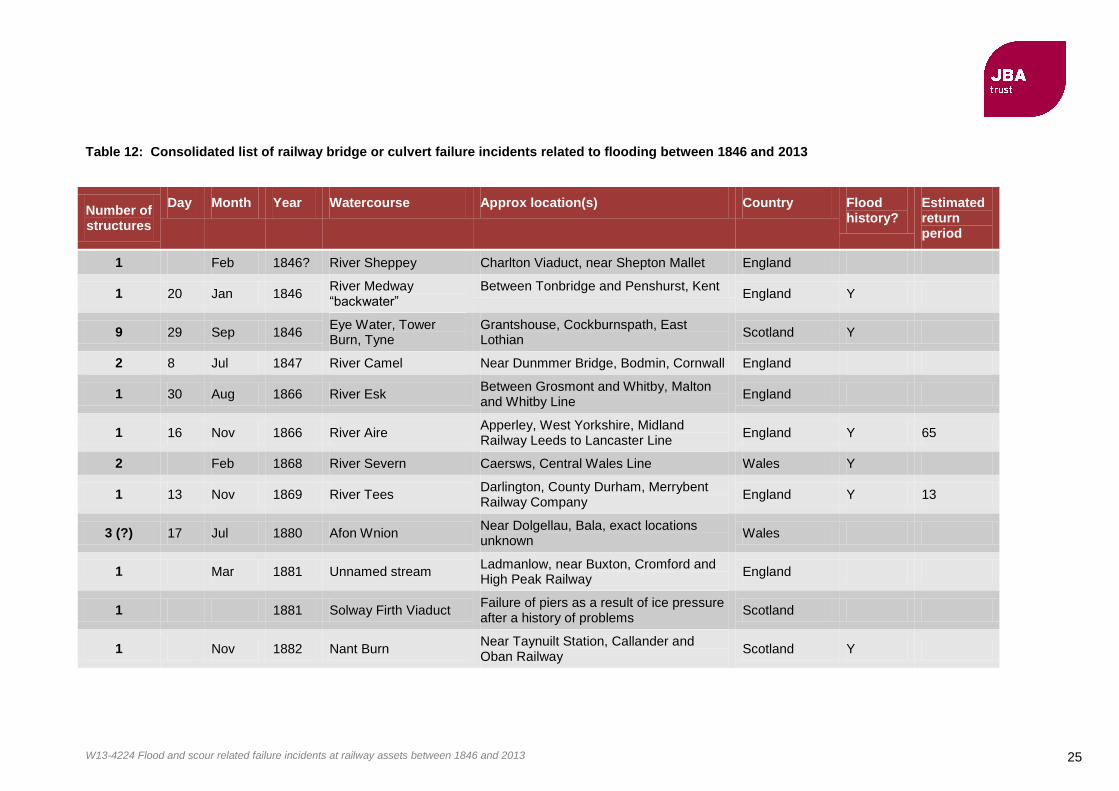
Table 12 is a consolidated list of failure incidents at railway bridges or culverts over watercourses in the UK for the period 1846 to 2013. Also included are two events in the Republic of Ireland.
The list combines data compiled in the RSSB (2004) Report T112 with the more recent events identified in this update study.
When researching events of this type over such a long historical period there are inevitably some events for which the information in the various historical sources is ambiguous or possibly even mistaken. Whilst care has been taken in the interpretation of sources, it is possible that there could be some errors in the list presented here, particularly in situations where historical accounts are unclear about whether the failure of a structure could be attributed to flooding or scour processes.
The basic facts about the occurrence of many incidents are reasonably well established. However inferences about the rarity of the events, in particular the associated probabilities, are much more uncertain and should be regarded as indicative assessments.
6.2 Frequency of failure incidents
6.2.1 Analysis of RSSB (2004) Report T112
Report T112 estimated that there had been, historically, a 40% chance of at least one structural failure per year, and deemed this risk unacceptable.
This figure was derived from there having been approximately 60 events associated with a structural failure over a period of approximately 150 years. It was also noted that there was no evidence of this risk being reduced over time.
Based on the current re-analysis of the Report T112 data, plus the new information for 2003-2013, we can now update this estimate of failure probability.
6.2.2 Analysis of the 2003 to 2013 update
For the period covered by this update study, there have been five rail crossing failure incidents identified in the UK over 10 years, each from a separate flooding event, suggesting an annual probability of 50% or 1 in 2 years. Therefore although this is a small sample, it would not support a view that the occurrence rate or probability of such incidents is diminishing.
6.2.3 Analysis of the consolidated 1846 to 2013 chronology
Taking the consolidated records for 1846-2013 as a whole, there are 140 incidents thought to be bridge or culvert failures related to flooding over the 167 years since the first recorded incident in 1846. This includes data from UK plus two incidents in Ireland. The precise location of some of the affected structures is not known. Therefore it is not possible to be sure how many unique structures have been affected.
The development of the railways pre-dates the earliest recorded failure event (1846) in our database. In the following analysis we assume that the effective period of record over which our evidence has been sampled is the period from 1840 to 2013. The year 1840 has been adopted because this marks the establishment of HM Railway Inspectorate and just slightly pre-dates the start of the “railway mania” of the 1840s. The effective period of record for our study is therefore assumed to be 173 years.
The following analysis treats the flood incident records as a homogenous sample and therefore takes no account of changes that may have occurred since 1840s and that would affect the probabilistic interpretation. Such changes include:
increase or decrease in the number of structures on the rail network as a result of new development or of line closures
changes in asset management and maintenance regimes

W13-4224 Flood and scour related failure incidents at railway assets between 1846 and 2013 24
new design standards
new construction practices
changes in river catchments that could affect flood hydrology or sediment regimes
climate change and variability
changes in practices that affect the recording and documentation of events, including attitudes to risk or newsworthiness and evolving institutional arrangements for data collection.
Annual probability of failure incidents in the UK
We have found evidence of 138 incidents involving failures of rail bridges and culverts related to flooding during the period 1846-2013 in the UK. We have assumed that this is representative of an effective record length of 173 years from 1840 to 2013. The annual probability of a structure failure incident somewhere in the UK is therefore estimated to be approximately 138/173 ≈ 80%, or 1 in 1.25 years.
Some of the historical events were characterised by clusters of multiple structural failures within close proximity. For example in Scotland there have been several occasions when many bridges and culverts were washed out apparently as a result of the same underlying flood event (16 structures in one event in 1915, 16 culverts in Lochaber in 1962, another 8 bridges and culverts washed out in Lochaber in 1969, amongst other events). It is possible that some structures may have failed more than once historically, although we cannot be sure.
Annual probability of flood events associated with failure incidents in the UK
We have identified 68 flood events in which one or more rail bridge or culvert failures occurred. Assuming an effective period of record of 173 years, the annual probability of observing a flood event in which one or more structures fails is therefore estimated to be 67/173 ≈ 39%, or 1 in 2.6 years. This is consistent with the analysis in 2004’s Report T112.
Probability of a year containing failure incidents in the UK
For the consolidated record up to 2013, there are 47 years during which one or more structure failure incidents were observed somewhere in the UK.
The probability of a year being one in which one or more such events occur is therefore approximately 27%, or 1 in 3.7 years.
W13-4224 Flood and scour related failure incidents at railway assets between 1846 and 2013 25
Table 12: Consolidated list of railway bridge or culvert failure incidents related to flooding between 1846 and 2013
Number of structures
Day Month Year Watercourse Approx location(s) Country Flood history?
Estimated return period
1 Feb 1846? River Sheppey Charlton Viaduct, near Shepton Mallet England
1 20 Jan 1846 River Medway “backwater”
Between Tonbridge and Penshurst, Kent England Y
9 29 Sep 1846 Eye Water, Tower Burn, Tyne
Grantshouse, Cockburnspath, East Lothian
Scotland Y
2 8 Jul 1847 River Camel Near Dunmmer Bridge, Bodmin, Cornwall England
1 30 Aug 1866 River Esk Between Grosmont and Whitby, Malton and Whitby Line
England
1 16 Nov 1866 River Aire Apperley, West Yorkshire, Midland Railway Leeds to Lancaster Line
England Y 65
2 Feb 1868 River Severn Caersws, Central Wales Line Wales Y
1 13 Nov 1869 River Tees Darlington, County Durham, Merrybent Railway Company
England Y 13
3 (?) 17 Jul 1880 Afon Wnion Near Dolgellau, Bala, exact locations unknown
Wales
1 Mar 1881 Unnamed stream Ladmanlow, near Buxton, Cromford and High Peak Railway
England
1 1881 Solway Firth Viaduct Failure of piers as a result of ice pressure after a history of problems
Scotland
1 Nov 1882 Nant Burn Near Taynuilt Station, Callander and Oban Railway
Scotland Y

W13-4224 Flood and scour related failure incidents at railway assets between 1846 and 2013 26
Number of structures
Day Month Year Watercourse Approx location(s) Country Flood history?
Estimated return period
3 14 May 1886 River Teme Near Bransford (Worcester) and between Ludlow and Craven Arms on the Hereford and Shrewsbury Line
England
1 Dec 1886 River Thames Osney, near Oxford England
1 26 Dec 1886 Trib of River Rother Selham, West Sussex, Midhurst Branch of London, Brighton and South Coast Railway
England
1 Aug 1891 Black Brook Chorley, Lancashire, Chorley to Blackburn (Cherry Tree Line)
England Y
3 21 Sep 1891 Gala Water Galashields Scotland Y 30
1 Aug 1912 River Tas Between Forncett and Flordon, Norfolk England
1 Aug 1912 River Stiffkey Fakenham, Norfolk England
1 15 Jun 1914 Baddengorm Burn Aviemore to Inverness, near Carrbridge Station, Highland Rlwy
Scotland Y 1000
16 26 Sep 1915 Findhorn and Spey Valley
Highland Railway Scotland
4 8 Jul 1923 Bogbain Burn Near Carrbridge Scotland Y 2000
1 9 Jun 1924 River Erewash Pye Bridge, Ripley, Erewash Valley Line England Y
3 23 Jul 1930 River Esk Glaisdale, Esk Valley Line England Y 1000
1 4 Sep 1931 River Esk Glaisdale, Esk Valley Line England Y 500
1 21 Jun 1936 Mochdre Brook Dulais Bridge, near Glandulais, Newtown, Powys
Wales Y 100

W13-4224 Flood and scour related failure incidents at railway assets between 1846 and 2013 27
Number of structures
Day Month Year Watercourse Approx location(s) Country Flood history?
Estimated return period
1 7 Sep 1945 Llangollen Canal Sun Bank Halt, GWR Llangollen Line Wales
1 12 Aug 1946 River Blackwater Railway Bridge at Ballymaquirke, near Kanturk
N. Ireland
1 Mar 1947 River Wye Strangford Viaduct, near Fawley, Hereford to Gloucester Line
Wales Y 100
1 12 Apr 1947 Eastburn Beck Eastburn Bridge, between Skipton and Keighley, Yorkshire
England
9 12 Aug 1948 River Eye
Harelawside Bridge, Smiddy Bridge, Mason's Bridge, Free Kirk Bridge, Eyemouth Viaduct and others Between Dunbar and Berwick, East Coast main line
Scotland Y 500
1 12 Aug 1948 Birns Water Between Humbie and Gifford, possibly Gilchriston.
Scotland Y 500
1 12 Aug 1948 Wooler Water Wooler (Haugh Head), Northumberland England Y 200
1 25 Oct 1949 Wooler Water Wooler (Haugh Head), Northumberland England Y 111
1 26 Oct 1949 Lilburn Burn Near Lilburn Tower, Northumberland England
1 19 Nov 1951 Midhurst Stream Between Cocking and Midhurst, West Sussex
England Y 100
2 Oct 1954
Exact Location unknown. Culverts collapsed near Coniston, Cumbria
England
1 Oct 1954 River Derwent Bridge between Cockermouth and Workington
England

W13-4224 Flood and scour related failure incidents at railway assets between 1846 and 2013 28
Number of structures
Day Month Year Watercourse Approx location(s) Country Flood history?
Estimated return period
1 8 Dec 1954 River Tolka Great Northern main line to Belfast, half a mile from Dublin terminus
Ireland
1 30 Sep 1960 River Creedy (or Exe) Cowley Junction England
16 Feb 1962
16 culverts washed out near Lochaber, exact locations unknown
Scotland
1 12 Dec 1964 River Ystwyth Llanilar, near Aberystwyth, Cambrian Railway
Wales Y 30
1 12 Dec 1964 River Banwy Castle Caereinion Wales Y 30
1 9 Jul 1968 River Chew Viaduct near Pensford, Somerset England
1 15 Sep 1968 River Wey Between Farncombe and Godalming, England Y 200
1 15 Sep 1968 River Mole Cobham England Y 200
1 Sep 1968 River Kennett Nuns Wood, between Kennett and Higham, Newmarket
England Y 200
1 Sep 1968 Trib of R. Waveney Bridge 317, Norwich Ipswich Main Line, between Diss and Burston
England Y 200
8 10 Aug 1969
Lochaber, 2 bridges and 6 culverts washed out, exact locations n/a
Scotland
1 31 Aug 1973 Glen Finnan Fort William to Mallaig Line, bridge 313/051 Drumsallie
Scotland
1 27 Dec 1979 Nant Rhyd-y-Car Culvert near Merthyr Tydfil (exact location unknown)
Wales
1
1985 River Deben Whickham Market, East Suffolk Line

W13-4224 Flood and scour related failure incidents at railway assets between 1846 and 2013 29
Number of structures
Day Month Year Watercourse Approx location(s) Country Flood history?
Estimated return period
2 19 Oct 1987 R. Towy and R. Dulais Glanrhyd and Llanwrda, Central Wales Line
Wales Y 50
1 10 May 1988 Colne Brook Wraysbury, bridge No. 71, Staines -Windsor Line
England
1 7 Feb 1989 River Ness Ness Viaduct near Inverness Scotland Y 100
1 2 Jan 1991 Afon Twymyn Cemmaes Road Wales
3 14 Jan 1993 Rivers Tay, Earn and May
Dalguise, Forgandenny, Forteviot (10km SW of Perth)
Scotland Y 100
1 Jan 1994 River Severn Cilcewydd, between Welshpool and Newtown
Wales
1 Oct 1997 Ettrick Water Heatherlie Bridge near Selkirk (disused line)
Scotland
1 15 Oct 1998 Trib of R. Leven Renton (Balloch), near Dunbarton Scotland
1 8 Dec 2000 River Exe Cowley Junction, bridge carrying Barnstaple Branch
England
1
Oct 2000 River Taw Weir Marsh Bridge England
1 3? Oct 2002 River Tay Scotland
1 14 Jun 2002 River Irwell Lower Ashenbottom Viaduct, near Rawtenstall, Greater Manchester
England Y 100
1
Dec 2002 Monks Brook Between Eastleigh East Junction and Romsey Junction, at Chandlers Ford
England
1 11 Sep 2003 River Rother Beighton England Y 2

W13-4224 Flood and scour related failure incidents at railway assets between 1846 and 2013 30
Number of structures
Day Month Year Watercourse Approx location(s) Country Flood history?
Estimated return period
1 1 Nov 2006 Burn of Winless Watten Scotland Y 15
1 21 Aug 2009 Broadmeadow Malahide - Broadmeadow Estuary Ireland
1 14 Nov 2009 River Crane Feltham, West London England Y 1
1
Dec 2012 River Taw Barnstaple line England
Notes *Road and foot bridges damaged or collapsed (railway bridge survived) “Flood History” indicates that an analysis of the rarity of the associated flood event was carried out (referred to as BIRDIEs, see Section 4). Some BIRDIE studies were unable to find enough information to estimate a flood event return period, in which case the Return Period column is left blank.
W13-4224 Flood and scour related failure incidents at railway assets between 1846 and 2013 31
7 Recommendations The present study updates and appears broadly to confirm the findings of the earlier RSSB (2004) historical study. The recommendations from the 2004 work therefore continue to be relevant. These were summarised as follows:
“A risk priority score of 15.0 would be appropriate for a 250-year flood event, and in view of the age profile of railway structures, this is highly relevant. The risk assessment method could be improved at little additional cost. Also the collection and recording of information on damage incurred and water levels reached after a flood will be valuable in developing effective management procedures.
[Report T112] also recommend[s] that enhancements to the existing EX2502 scour assessment procedure should be considered, if it is to cover the full range of flood-related risks (e.g. build up of debris within the watercourse and impounding of water behind embankments) and all the types of structure maintained by railway operators.”
The occurrences of embankment failure due to scour during the period 2003 to 2013 imply that this issue should be further investigated, especially where track damage has caused derailment of trains. It would be interesting to investigate the balance between frequency of occurrence and impact of the incidents for embankment and structural failures. It may be found that although structural failures have a greater impact in terms of direct costs, the more frequent track damage caused by scour may have a greater impact in terms of the aggregated disruption to services.

W13-4224 Flood and scour related failure incidents at railway assets between 1846 and 2013 32
8 Dissemination and updates
8.1 Contact for further information This report and supporting information can be obtained from the JBA Trust website: www.jbatrust.org
The flood and scour incident database and BIRDIE reports are available for research purposes. Please contact the JBA Trust via the JBA Trust website “Contact Us” page to request further details.
8.2 Updates
We would be pleased to hear about any further information sources that could help in improving the historical records for future updates. Please contact us at www.jbatrust.org as above if you have any further information that you would like to tell us about.

W13-4224 Flood and scour related failure incidents at railway assets between 1846 and 2013 33
9 References Bayliss, A. C., & Reed, D. W. (2001). The use of historical data in flood frequency estimation. Wallingford.
BBC News Magazine. (2009). Can you stop bridges collapsing in floods? Retrieved from http://news.bbc.co.uk/1/hi/magazine/8374616.stm
Bettess, R. (1993). Hydraulic aspects of bridges: Assessment of the risk of scour. Report EX2502, HR Wallingford, Wallingford.
British Railways Board. (1989). Precautions against Scour Action on Structures. Railway Engineering Handbook 47.
Environment Agency (2004) Afflux at Bridges and Culverts: Review of current knowledge and practice, Report W5A-061/TR1, Environment Agency, Bristol, ISBN 1 8443 2291 2.
Environment Agency. (2013). HiFlows UK. Retrieved from http://www.environment-agency.gov.uk/hiflows/91727.aspx
Holt, L T C. (2001) ‘Red for Danger: The Classic History of British Railway Disasters’. Sutton.
Institute of Hydrology, 1999, Flood Estimation Handbook, Wallingford.
JBA Consulting. (2004). Scour & Flood Risk at Railway Structures. See RSSB, 2004.
Kjeldsen, T. R. (2007). The revitalised FSR / FEH rainfall-runoff method. Wallingford.
May, R. W. P., Ackers, J. C., & Kirby, A. M. (2002). Manual on scour at bridges and other hydraulic structures. CIRIA Report C551.
Merz, B., & Thieken, A. H. (2005). Separating natural and epistemic uncertainty in flood frequency analysis. Journal of Hydrology, 309(1-4), 114–132. doi:10.1016/j.jhydrol.2004.11.015
Morss, R. E., Wilhelmi, O. V., Downton, M. W., & Gruntfest, E. (2005). Flood Risk, Uncertainty, and Scientific Information for Decision Making: Lessons from an Interdisciplinary Project. Bulletin of the American Meteorological Society, 86(11), 1593–1601. doi:10.1175/BAMS-86-11-1593
Railways Archive. (2010). Accident at Malahide Viaduct on 21st August 2009. Retrieved from http://www.railwaysarchive.co.uk/eventsummary.php?eventID=6594
Rail Accident Investigation Unit. (2010). Malahide Viaduct Review: Final report. Blackrock, Ireland.
Rail Safety and Standards Board, RSSB (2004) Impact of scour and flood risk on railway structures, Infrastructure Integrity (4) Research Theme: Report Number T112.
Rakhecha, P. R., & Singh, V. P. (2009). Applied Hydrometeorology. Dordrecht: Springer.
Rail Safety & Standards Board (RSSB). (2004). Infrastructure Integrity (4) Research Theme : Project Number T112 Scour & Flood Risk at Railway Structures, (4). Report by JBA Consulting, Skipton.
Ransom, P J G. (2001) ‘Snow Flood & Tempest – Railways & Natural Disasters’. Ian Allen Publishing.
Shaw, E. M., Beven, K. J., Chappell, N. A., and Lamb, R. (2011). Hydrology in Practice (4th ed.). Oxon: Spon Press.
Simmons, J and Biddle, G. (1997) ‘The Oxford Companion to British Railway History’. Oxford University Press.

W13-4224 Flood and scour related failure incidents at railway assets between 1846 and 2013 34
10 Web based resources
Information Available at
Online resource of archived railway information including a searchable database of accident and incident reports
www.railwaysarchive.co.uk
RSSB Report: Infrastructure Integrity (4) Research Theme : Project Number T112 Scour & Flood Risk at Railway Structures (2004)
Available via
http://www.sparkrail.org
HiFlows-UK (flood peak data at river flow gauging stations in the UK)
http://www.environment-agency.gov.uk/hiflows/91727.aspx

Registered Office: South Barn
Broughton Hall
Skipton
North Yorkshire
BD23 3AE
United Kingdom
t:+44(0)1756 799919 e:[email protected] JBA Trust Ltd. Registered Charity 1150278
Visit our website:
www.jbatrust.org