flood plain and channel dynamics of the quinault …...flood plain and channel dynamics of the...
TRANSCRIPT

Flood plain and channel dynamics of the Quinault and
Queets Rivers, Washington, USA
Jim E. O’Connora,*, Myrtle A. Jonesb, Tana L. Haluskaa
aUS Geological Survey, 10615 SE Cherry Blossom Dr., Portland, OR 97216, USAbUS Geological Survey, 1201 Pacific Ave. Suite 600, Tacoma, WA 98402, USA
Received 30 June 2001; received in revised form 6 March 2002; accepted 18 October 2002
Abstract
Comparison of historic channel migration rates, modern planform conditions, and overall sediment, wood, and flow
conditions and interactions for the Quinault River and Queets River in the western Olympic Peninsula, Washington, reveals
decadal- to century-scale interactions between gravel-bed channels and forested flood plains in temperate maritime
environments. The downstream alluvial portions of these two rivers can be divided into three reaches of different slope, flow,
sediment, and wood regimes: (i) the upper Quinault River is aggrading behind Lake Quinault, a natural lake that traps most
sediment and wood transported from the Olympic Mountain headwaters. (ii) The lower Quinault River, downstream of Lake
Quinault, transports only sediment and wood derived from reworking of flood-plain deposits and contributed from valley
margins. (iii) The Queets River has unimpeded movement of sediment and water from the mountainous headwaters to the
Pacific Ocean. Measurements of channel planform characteristics and historic migration rates and patterns show that these three
reaches have correspondingly distinct channel and flood-plain morphologies and dynamics. The aggrading and sediment-rich
upper Quinault River has the widest flood plain, widest active channel, greatest number of low-flow channels and flanking
gravel bars, and an average channel migration rate of 12.7F 3.3 m/year between 1900 and 1994. The comparatively sediment-
poor lower Quinault River has the narrowest flood plain, narrowest active channel, and lowest channel migration rate (4.0F 1.2
m/year); and most flow is through a single channel with few adjacent gravel bars. The Queets River has attributes intermediate
between the lower and upper Quinault Rivers, including an average channel migration rate of 7.5F 2.9 m/year. Flood-plain
turnover rates are similar for all three reaches, with channels eroding the flood plain at the rate of about 0.2% of the flood-plain
area per year, and with corresponding flood-plain half-lives of 300 to 500 years.
Observations from this study and previous studies on the Queets River show that channel and flood-plain dynamics and
morphology are affected by interactions between flow, sediment, and standing and entrained wood, some of which likely
involve time frames similar to 200–500-year flood-plain half-lives. On the upper Quinault River and Queets River, log jams
promote bar growth and consequent channel shifting, short-distance avulsions, and meander cutoffs, resulting in mobile and
wide active channels. On the lower Quinault River, large portions of the channel are stable and flow within vegetated flood
plains. However, locally, channel-spanning log jams have caused channel avulsions within reaches that have been subsequently
mobile for several decades. In all three reaches, log jams appear to be areas of conifer germination and growth that may later
further influence channel and flood-plain conditions on long time scales by forming flood-plain areas resistant to channel
migration and by providing key members of future log jams. Appreciation of these processes and dynamics and associated
0169-555X/02/$ - see front matter. Published by Elsevier Science B.V.
PII: S0169 -555X(02 )00324 -0
* Corresponding author. Tel.: +1-503-251-3222.
E-mail address: [email protected] (J.E. O’Connor).
www.elsevier.com/locate/geomorph
Geomorphology 51 (2003) 31–59

temporal and spatial scales is necessary to formulate effective long-term approaches to managing fluvial ecosystems in forested
environments.
Published by Elsevier Science B.V.
Keywords: Channel migration; River pattern; Large woody debris: log jams; Flood plains; Gravel-bed rivers; Olympic Peninsula
1. Introduction
Channel and flood-plain morphology develop from
a suite of processes involving sediment and water
movement, channel migration, flood-plain erosion and
deposition, and wood entrainment and deposition. For
alluvial rivers with forested flood plains, feedbacks
between channel instability and sediment and wood
input and deposition are important factors in control-
ling channel migration processes and resulting chan-
nel and bar morphology at the reach scale (lengths of
channel on the order of 10 to 20 channel widths; e.g.,
Keller and Swanson, 1979; Fetherston et al., 1995;
Abbe and Montgomery, 1996; Abbe, 2000). At
broader spatial and temporal scales involving several
decades and segments of rivers greater than about 20
channel widths, interactions between the channel and
forested flood plains have also been hypothesized to
control valley-scale patterns of channel instability and
flood-plain formation and morphology (e.g., Swanson
and Lienkaemper, 1982; Hickin, 1984; Sedell and
Froggatt, 1984; Gottesfeld and Gottesfeld, 1990;
Church, 1992; Piegay and Gurnell, 1997; Fetherston
et al., 1995; Abbe and Montgomery, 1996; Abbe,
2000; Gurnell et al., 2000). While there have been
numerous studies that describe such processes and
resulting channel and flood-plain morphology, espe-
cially at the reach scale, there have been few com-
parative studies of large alluvial rivers from which to
draw conclusions of how these interactions might
relate to specific conditions of flow, slope, wood
and sediment input, and how these interactions might
relate to broader-scale channel and flood-plain con-
ditions.
This paper describes evidence for rates and mech-
anisms of channel migration on the wood-rich Qui-
nault and Queets Rivers of the western Olympic
Peninsula in NW Washington state (Fig. 1). In partic-
ular, we describe how differences in channel migra-
tion rates and patterns between the two rivers likely
relate to differences in interactions among flow, flood-
plain forests, sediment flux, and other reach and
valley characteristics. Our conclusions draw primarily
from analysis of historic channel migration supported
by mostly anecdotal historic and field observations of
wood, channel, and flood-plain conditions and inter-
actions. Many of our interpretations regarding the
specific role of wood in affecting channel and flood-
plain dynamics derive in part from studies by Fether-
ston et al. (1995) and Abbe and Montgomery (1996,
2003) on the Queets River.
2. Setting of the Quinault and Queets Rivers
2.1. Watershed physiography and climate
Both the Quinault River and Queets Rivers drain
the rugged core of the Olympic Mountains within
Olympic National Park before emptying into the
Pacific Ocean along the western coast of the Olympic
Peninsula (Fig. 1). The headwaters of each basin are
incised into Tertiary marine sedimentary and volcanic
rocks that have undergone rapid Cenozoic uplift
(Tabor and Cady, 1978a,b; Brandon et al., 1998).
Both rivers drain SW from glaciated mountains with
peaks higher than 2200 m, exiting the Olympic
Mountains and then flowing across a 10- to 30-km
wide coastal piedmont underlain by Quaternary gla-
ciofluvial sediment. The Queets River drains a total
area of about 1170 km2 and the Quinault River drains
1134 km2 (Table 1).
Fig. 1. Location maps of the study reaches. (a) Map of Queets and Quinault River drainage basins and geologic flood plains of the three study
reaches. Topographic base from USGS 30-m digital elevation model. (b) Geologic flood plains and 1994 channel of each of the three study
reaches. Flood-plain and channel transects shown at 1-km intervals. (c) Section of the Queets River flood plain showing 1994 channels and
flood-plain surfaces as mapped from 1994 orthophotos. Channel and flood-plain transects are spaced at 0.2-km intervals.
J.E. O’Connor et al. / Geomorphology 51 (2003) 31–5932

J.E. O’Connor et al. / Geomorphology 51 (2003) 31–59 33
Both of these watersheds are strongly influenced
by Pacific maritime conditions. During fall, winter,
and spring, these watersheds are repeatedly subject to
large storms from the SW, delivering substantial rain-
fall at lower elevations and snow in the higher
Olympic Mountains. Summers are relatively dry.
Mean annual precipitation is about 3.6 m at Lake
Quinault, somewhat less on the coast, and much
greater in the mountainous headwaters because of
orographic effects. The large precipitation volumes
are reflected in high average flows; average annual
flow generation is 3.4 m3/m2 for the Queets watershed
and about 3.7 m3/m2 for the Quinault watershed.
Particularly large flows, such as the one of March
1997, result during warm and wet storms during
which rivers gain substantial flow from melting of
low-elevation snowpack.
2.2. Alluvial reaches
As both rivers leave the core of the Olympic
Mountains and approach the western foothills and
coastal piedmont, valley bottoms broaden and the
rivers have established alluvial flood plains up to
3.5 km wide that are flanked by the western ramparts
of the Olympic Mountains or, further downstream, by
tall bluffs of Pleistocene glacial till and outwash.
Overall, channel gradient in the alluvial section of
the Queets River between river kilometer (RK) 0 and
RK 42.5 is 0.0023; the overall slope for the alluvial
section of Quinault River between RK 0 and RK 84.3
is 0.0022. Within their alluvial sections, both rivers
have cobble-gravel beds with pool-and-riffle profile
morphologies. The planview patterns of these rivers
do not neatly fit into standard classes such as ‘‘brai-
ded’’ or ‘‘meandering’’ but, at length scales of tens
of kilometers, are similar to the ‘‘irregular wander-
ing’’ or ‘‘irregular meandering’’ morphologies as des-
cribed by Church (1992). Shorter reaches within
these wandering river segments have braided (flow
around bars within an active channel) and anasto-
mosing (flow around islands excised from the flood
plain) planforms as defined by Knighton and Nanson
(1993).
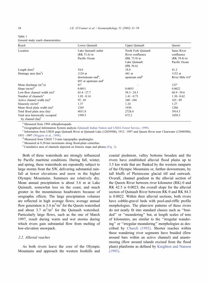
Table 1
General study reach characteristics
Reach Lower Quinault Upper Quinault Queets
Location Lake Quinault outlet
(RK 51.6) to
Pacific Ocean
North Fork Quinault
River confluence
(RK 73.9) to
Lake Quinault
(RK 56.6)
Sams River
confluence
(RK 39.4) to
Pacific Ocean
Length (km)a 54.0 18.0 41.2
Drainage area (km2) 1124 at
downstream endb;
683 at upstream endc
441 at
upstream endb1152 at
River Mile 4.6c
Mean discharge (m3/s) 81c – 123c
Slope (m/m)d 0.0011 0.0035 0.0022
Low-flow channel width (m)a 65.4–27.7 58.3–24.3 68.9–39.6
Number of channelsa 1.02–0.14 1.41–0.73 1.30–0.62
Active channel width (m)a 95–45 240–104 165–89
Sinuosity (m/m)a 1.37 1.24 1.27
Mean flood plain width (m)e 1245 1930 1286
Total flood plain area (ha) 4831.8 2728.4 3914.3
Total area historically occupied
by channel (ha)f1509.5 675.2 1050.3
a Measured from 1994 orthophotoquads.b Geographical Information System analysis (Quinault Indian Nation and USDA Forest Service, 1999).c Information from USGS gage Quinault River at Quinault Lake (12039500), 1912–1997 and Queets River near Clearwater (12040500),
1931–1997 (Wiggins et al., 1998).d Measured from USGS 7.5-min topographic quadrangles.e Measured at 0.20-km increments along flood-plain centerline.f Cumulative area of channels depicted on historic maps and photos (Fig. 2).
J.E. O’Connor et al. / Geomorphology 51 (2003) 31–5934

Within their alluvial valleys, both of these rivers
have shifted back and forth during the Holocene,
leaving a suite of fluvial landforms. Valley-bottom
surfaces range from unvegetated gravel bars to
densely forested alluvial surfaces several meters
above the present channel. Aquatic environments
include swift flowing main channels, side channels,
abandoned channels that are now ponds or wetlands,
and abandoned channels that now serve as routes for
local tributaries. The native flood-plain trees include
hardwoods such as red alder (Alnus rubra), vine
maple (Acer circinatum), bigleaf maple (Acer macro-
phyllum), and black cottonwood (Populus tricho-
carpa) and conifers Sitka spruce (Picea sitchensis),
western hemlock (Tsuga heterophylla), and smaller
amounts of western red cedar (Thuja plicata) and
Douglas fir (Pseudotsuga menziesii). Immense trees
grow in the temperate maritime climate, with stem
dimensions of some Sitka spruce, Douglas fir, western
red cedar exceeding 4 m in basal diameter and 70 m in
height.
Despite similarities in the geology, physiography,
and channel characteristics between the two water-
sheds, significant differences result in contrasting
channel and flood-plain processes and morphology.
The foremost dissimilarity is the continuity of sedi-
ment and wood transport. The Queets River flows
uninterrupted from its headwaters to the Pacific
Ocean, allowing continuous passage of water, sedi-
ment, and large woody debris along its entire course.
In contrast, the alluvial section of the Quinault River
is interrupted between RK 51.6 and RK 56.6 by Lake
Quinault, a moraine-dammed lake with a surface area
of 15 km2 (Fig. 1). Lake Quinault forms an inter-
mediate base level for the Quinault River and traps all
coarse sediment (sand and coarser) and most large
woody debris. Consequently, the Quinault River has
two distinct alluvial segments; an upstream segment
between RK 56.6 and RK 84.3 that receives sediment
and wood from upstream and is aggrading behind the
base level set by Lake Quinault, and a segment
downstream from the lake (RK 0 to RK 51.6) that
receives neither sediment nor wood from upstream.
Furthermore, transient flow storage in the lake sub-
stantially attenuates peak flows of the Quinault River
downstream of Lake Quinault, reducing peak dis-
charges of the five largest flows between 1933 and
1960 by 38%, as determined by comparing normal-
ized discharges for a series of floods on the Queets
and Quinault Rivers (Quinault Indian Nation and US
Department of Agriculture Forest Service, 1999, pp.
2.4–6).
Ownership and land use history also differ between
the Queets River and Quinault River valleys. Most of
the Queets River flood plain is now within the
Olympic National Park, although early settlers locally
cleared and harvested parts of the flood plain prior to
acquisition by the Park Service in the 1940s. The
lowermost 15 km of the Queets River is within the
Quinault Indian Nation Reservation, and the flanking
flood plain was mostly unaffected by timber harvest
until the 1990s. Upstream of Lake Quinault, the
Quinault River flood plain is under a mixture of
ownerships, including Olympic National Park, Olym-
pic National Forest, and private landowners. Parts
within the National Park are largely undisturbed, but
other ownerships have cleared and harvested small
areas of the flood plain. The Quinault River flood-
plain downstream from Lake Quinault is completely
within the Quinault Indian Nation Reservation and has
been almost completely harvested one or more times
since the late 1920s.
2.3. The study reaches
These differences and the general physiography
conveniently lead to the three independently analyzed
river segments (Fig. 1; Table 1): (i) the lower
Quinault River downstream of Lake Quinault with
no upstream-derived sediment or wood and an aver-
age gradient of 0.0011, (ii) the alluvial section of
upper Quinault River between the North Fork con-
fluence and Lake Quinault that does receive wood
and coarse sediment from upstream and has an
average gradient of 0.0035, and (iii) the alluvial
section of Queets River between RK 41 and RK 0
that also receives sediment and wood from upstream,
but has a lower average gradient of 0.0022. The
multiple differences among the reaches in what might
be considered ‘‘independent’’ or ‘‘predictor’’ varia-
bles (sediment and wood supply, slope, flood dis-
charge, land use history) prevent rigorous isolation of
the effects of individual variables on channel and
flood-plain morphology. Nevertheless, measured and
observed differences in channel pattern and dynam-
ics, as discussed in the following sections, can be
J.E. O’Connor et al. / Geomorphology 51 (2003) 31–59 35

Table 2
Summary of sources for mapping of historic channel positions
Channel map source Scale Coverage Dates Plot
date
Comments
General Land Office
Surveys (available
at the Bureau of
Land Management,
Portland, OR)
1:31,680 Queets
Upper
Quinault
Lower
Quinault
Sams River
confluence to
Pacific Ocean
Entire study reach
Quinault Indian
Reservation
1895–1906
1895–1906
1902
1900
1900
1902
Instrument survey of
stream channel (and
unvegetated gravel bars?).
Digitized from 1:31,680
paper copies; georeferenced
by section corners.
Office of Indian Affairs
(available at Quinault
Indian Nation,
Taholah, WA)
1:31,680 Lower
Quinault
Quinault Indian
Reservation
Map dated 1920,
notes state
surveyed
1915–1917
1915 Transit and stadia for
primary control. Digitized
from 1:31,680 paper copy;
georeferenced by section
corners.
US Army Corps of
Engineer Tactical
Maps ‘‘Destruction
Island’’ and ‘‘Queets’’
1:62,500 Queets Elk Park to
Pacific Ocean
Maps dated 1922,
unknown
survey date
1922 Surveyed and compiled by
US Coastal and Geodetic
Survey; methods unknown.
Map not used for channel
migration analysis because
of unsatisfactory registration.
US Geological Survey
(USGS) Plan and
Profile River Maps
(available at University
of Washington Map
Library, Seattle, WA)
1:31,680 Queets
Upper
Quinault
Lower
Quinault
Paul Creek
confluence to
Pacific Ocean
Rustler Creek
confluence to
Lake Quinault
Lake Quinault
to Pacific Ocean
Map dated 1935,
notes state
surveyed
1931–1933
Map dated 1930,
notes state
surveyed 1929
1931
1929
1929
Survey methods unknown
but probably by transit and
stadia. Digitized from paper
copy; georeferenced by
section corners. Lower
Quinault reach required
significant editing due to
poor registration.
1939 USGS aerial
photographs (available
at US Geological
Survey, Tacoma, WA)
1:60,000 Most of the Olympic Peninsula 7–39 and 8–39 1939 1939 channel transcribed
by eye onto 7.5Vquadranglesand digitized. Spatially
referenced by quadrangle
corners.
15VUSGS topographic
quadrangles
1:62,500 Queets Entire study
reach
Maps dated 1956;
on the basis of 1952
source photographs
1952 Digitized from paper copy.
Spatially referenced by
quadrangle corners.
Upper
Quinault
No 1950s
source coverage
east of
123jE45jN(RK 67.6)
Maps dated
1953–1955
on the basis
of 1953–1954
aerial photography
1953
Lower
Quinault
Entire study
reach
1953
Duncan and Steinbrenner
(1976?) Soil Survey
(available at Quinault
Indian Nation, Taholah,
WA)
1:31,680 Lower
Quinault
Quinault Indian
Reservation
Map dated 1976(?);
on the basis of 1972
aerial photographs
1972 ‘‘River’’ polygons from
existing Quinault Indian
Nation digital coverage.
Date of source photographs
provided by Tony Hartrich,
Quinault Indian Nation.
J.E. O’Connor et al. / Geomorphology 51 (2003) 31–5936

qualitatively attributed to differences in flow, slope,
and sediment and wood inputs.
3. Methods
For each of the three study reaches, channel
characteristics and historic channel migration rates
were mapped and measured from historic and current
aerial photographs and maps. Inferences regarding
interactions between large woody debris, standing
forests, the channel, and flood plain were based on
historical records and reconnaissance field observa-
tions, supplemented by previous work on the Queets
River by Fetherston et al. (1995), Abbe (2000), and
Abbe and Montgomery (1996, 2003).
3.1. Modern profile and planform characteristics
Channel profiles were obtained from spot water-
surface elevations and 6 m (20 ft) contour crossings
on USGS 7.5-min topographic quadrangles that were
surveyed during the 1980s. Modern channel plan-
form characteristics were measured from digital
orthophotos made in the summer of 1994 that
covered all three river segments (Table 2). To
quantify planform features, measurement transects
were placed perpendicular to the centerline of the
Table 2 (continued )
Channel map source Scale Coverage Dates Plot
date
Comments
7.5VUSGS topographic
quadrangles
1:24,000 Queets
Upper
Quinault
Lower
Quinault
Entire study
reach
Entire study
reach
Entire study
reach
Map dated
1982–1990; on
the basis of 1980,
1981, and 1987
source photographs
Maps dated 1990;
on the basis of 1981,
1985, and 1987
aerial photography
Map dated
1982–1990, on
the basis of 1980,
1981, 1985, and
1987 source
photographs
1981
1981
1981
Digitized from 1:24,000
paper copy. Spatially
referenced by quadrangle
corners. Plot dates assigned
on the basis of comparisons
of mapped channel positions
with aerial photographs from
time period.
1994 USGS and
Washington
Department of
Natural Resources
(DNR) digital
orthophotoquads
Derived
from
1:12,000
to 1:40,000
aerial photos
Queets
Upper
Quinault
Lower
Quinault
Entire study
reach
Entire study
reach
Entire study
reach
DNR Sept. 22, 1994
USGS Sept. 16, 1994
USGS July 11
(major;) and
DNR Sept. 22
(minor), 1994
1994 Channel digitized from
1:24,000 paper copy
(Queets R.) and on screen
from 1:5000) georeferenced
digital orthophotoquadrangles
(Quinault R.). Queets R.
discharge Sept. 22: 25.4 m3/s.
Quinault R. discharge July 11:
35.7 m3/s, Quinault R.
discharge Sept. 16: 54.4 m3/s,
Quinault R. discharge
Sept. 22: 24.5 m3/s
1997 Quinault Indian
Nation digital
orthophotoquads
(available at
Quinault Indian
Nation, Taholah, WA)
Derived
from
1:12,000
aerial
photos
Lower
Quinault
(and lower
15.8 km of the
Queets River)
Quinault Indian
Reservation
DNR 1997 Channel digitized on screen
(1:5000) from georeferenced
digital orthophotoquads. Only
the lower Quinault coverage
used in the channel migration
analysis.
J.E. O’Connor et al. / Geomorphology 51 (2003) 31–59 37

primary low-flow channel at 0.2-km increments (Fig.
1c). The primary low-flow channel was defined as
the widest wetted channel, although in some loca-
tions of two or more roughly equal-sized channels,
we arbitrarily chose a single channel from which to
establish transect locations and orientations. For each
of these transects, we measured the number, width,
and area of the primary low-flow channel as well as
other visible water-filled channels connected at their
upstream and downstream termini at the time of the
photographs (dates and approximate discharges indi-
cated in Table 2). We also measured the number,
width, and area of isolated or partly isolated water-
bodies assumed not be flowing, defined as those
either not connected to a through-going low-flow
channel (i.e., flood-plain lakes and ponds) or a
channel only connected at one end to a through-
going low-flow channel (i.e., backwater channel). In
addition, we also measured the number, width, and
area of unvegetated gravel bars. We considered the
sum of the widths of the flowing channels and
flanking unvegetated gravel bars to represent the
‘‘active channel’’ width as described by Osterkamp
and Hedman (1982), which for the Quinault River
and Queets Rivers is the part of the flood plain that
had sufficient flow during the few years prior to the
summer of 1994 to prevent substantial establishment
of woody vegetation. The resolution of the 1994
orthophotos is 2 m, but, because of canopy cover, it
is likely that many channels and gravel bars less
than 10 m wide and bordered by vegetated flood
plains were not included in the transect measure-
ments.
More general flood-plain properties were charac-
terized with similar types of measurements using the
centerline of the valley bottom (here termed ‘‘geologic
flood plain’’) as a frame of reference (Fig. 1c). A
flood-plain reference frame allows for systematic
measurements of broad-scale attributes such as chan-
nel sinuosity and flood-plain width. Furthermore,
measurements based on a flood-plain centerline frame
of reference are more appropriate for channel and
flood-plain features that are widely dispersed across
the flood plain and not necessarily causally associated
with the present channel.
For both rivers, the geologic flood plain was map-
ped from aerial photographs, topographic maps, and
field observations and consists of the relatively flat
areas between flanking valley slopes. For the Queets
River, the geologic flood plain closely corresponds to
the Holocene alluvium map unit of Thackray (1996).
The mapped flood plains of both rivers contain areas of
slightly higher elevation that may be due to Neoglacial
or earlier Holocene aggradation but are nevertheless
inundated during large flows. The delineated flood
plains for all three river segments exclude tributary fans.
3.2. Channel migration
Patterns and rates of channel change for each of the
three study reaches were determined from maps, aerial
photos, and orthophotos showing channel position
between 1895 and 1997 (Table 2, Fig. 2). Channel
boundaries as shown on each source were digitized
into a geographic information system. Channel posi-
tions derived from maps and orthophotos were geore-
ferenced by quadrangle corners and public land survey
township corners. Channel positions from aerial photo-
graph sources were first transcribed onto topographic
quadrangles and then digitized.
Several sources of uncertainty affect quantitative
assessments of channel position with time from these
types of historical data. A key uncertainty associated
with the turn-of-the-century General Land Office
(GLO) surveys is that they do not necessarily show
the actual channel boundary but the inferred channel
extent at ‘‘mean high-water elevation,’’ which ‘‘is
found at the margin of the area occupied by the water
for the greater portion of each average year’’ (Bureau of
Land Management, 1973, pp. 93–97). In practice, this
definition probably results in local inclusion of gravel
bars and overflow channels outside the low-flow chan-
nel, whereas most other sources portray only the low-
flow channel. This was clearly the case for the GLO
surveys of the upper Quinault River (Fig. 2b), but the
GLO maps for the lower Quinault River and Queets
River distinguish between channel and unvegetated
gravel bars. Other uncertainties arise from differences
in flow stage, errors in transcription, and errors in
registration and digitizing. From consideration of the
degree of overlay of relatively stable reaches and the
scale of the source documents, our estimate of the
maximum error in placement of channel boundaries
from the older sources (1900–1902 GLOmaps, 1921–
1931 USGS Plan and Profile Maps, and 1939 aerial
photos) is about 50 m, but the error is probably much
J.E. O’Connor et al. / Geomorphology 51 (2003) 31–5938
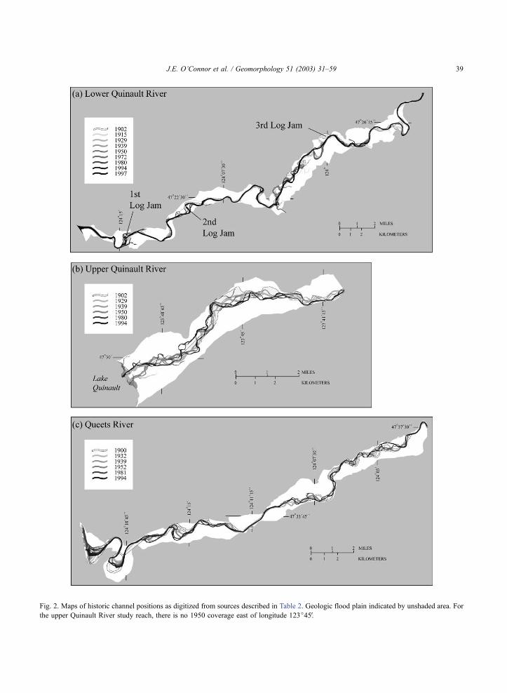
Fig. 2. Maps of historic channel positions as digitized from sources described in Table 2. Geologic flood plain indicated by unshaded area. For
the upper Quinault River study reach, there is no 1950 coverage east of longitude 123j45V.
J.E. O’Connor et al. / Geomorphology 51 (2003) 31–59 39

less ( < 20 m) for the more recent topographic maps and
orthophotos. In the worst case, an uncertainty of 50 m
over a 10-years time interval between channel position
sources results in errors of about 50% to 100% of the
mean distance of channel movement for the three
reaches. However, for longer time intervals and higher
accuracy source maps, the errors are probably much
smaller.
For this study, we quantified channel migration
across the flood plain in two manners. The first
approach is similar to a variety of methods for
obtaining lineal measurements of lateral channel
movement (e.g., Leopold, 1973; Hickin and Nanson,
1975; Hooke, 1980; Pizzuto, 1994; Gurnell et al.,
1994; Gillespie and Giardino, 1996; Gurnell, 1997;
Elliot and Gyetvai, 1999; Shields et al., 2000). For
each of the three study reaches, we measured changes
in the position of the intersection of channel centerline
of the primary low-flow channel with flood-plain
transects spaced at 0.2-km increments, thus providing
70 (upper Quinault), 150 (Queets), and 196 (lower
Quinault) closely spaced measurements of lateral
channel movement (orthogonal to the flood-plain
axis) for each photo and map interval. This method
is similar to that of Gurnell et al. (1994), Piegay et al.
(1996), and Gurnell (1997), and allows for systematic
temporal and spatial analysis of channel movement
within a flood-plain frame of reference without the
bias typically introduced by trying to make measure-
ments at specific channel geometric features, such as
channel bends or straight reaches.
The second approach to evaluating channel move-
ment was to define each mapped channel and the
geologic flood plain as polygons in a geographic in-
formation system and evaluate the temporal sequence
of channel positions. This approach has been the ba-
sis of studies such as Piegay et al. (1996), Jacobson and
Pugh (1997), and Ham and Church (2000). For each
record of channel position, we calculated (i) the total
area of the low-flow channel, (ii) the area of channel
outside the area of the previous record, and (iii) the area
of channel outside any previous map or photo record of
previous channel positions. These results allow assess-
ment of how total channel area has changed with time
and the proportion of new channel area at each map
date that represents erosion of historically uneroded
flood plain (in contrast to reoccupying channel loca-
tions shown in previous maps and photos). Thus
providing a basis for determining flood-plain turnover
rates—that is, a measure of time required for the
channel to occupy the entire flood plain.
3.3. Large woody debris and forested flood-plain
interactions
The role of in-channel large woody debris and
flood-plain vegetation in affecting channel migration
was evaluated from historical accounts of locations
and positions of large wood jams, including records of
early settlers, notes accompanying late 1800s and
early 1900s General Land Office Surveys, and maps
and aerial photographs showing locations of wood
jams. Reconnaissance field mapping of channel con-
ditions, wood accumulations, bank stratigraphy and
vegetation conditions supplemented these historical
sources. Included in these field observations were
site visits before and after the flood of March 19,
1997 (1315 m3/s, Quinault River; 3115 m3/s Queets
River), which was the largest (Quinault River) or
second largest (Queets River) flood since 1955. Addi-
tionally, we relied heavily on the findings of Fether-
ston et al. (1995), Abbe and Montgomery (1996,
2003), and Abbe (2000) regarding the role of channel
and flood-plain wood in affecting channel morphology
and migration processes on the Queets River.
4. Results
4.1. Modern profile and planform characteristics
Measurements of 1994 flood-plain and channel
planform characteristics (Figs. 2 and 3) show distinct
differences among the three river segments, many of
Fig. 3. Box plots summarizing major study reach characteristics as measured from the channel and flood-plain transects. Boxes show 75th, 50th,
and 25th percentiles; vertical lines depict the 90th and 10th percentiles; individual symbols are points outside the 10th and 90th percentiles.
Low-flow channel width, active channel width, and number of low-flow channels are from measurements from 1994 orthophotos at 0.2-km
increments along the 1994 channel axis. Channel migration rate is from analysis of historic lateral movement of the primary channel measured
on transects orthogonal to the flood-plain axis spaced at 0.2-km increments.
J.E. O’Connor et al. / Geomorphology 51 (2003) 31–5940

J.E. O’Connor et al. / Geomorphology 51 (2003) 31–59 41

which that would be difficult to describe using typical
channel classification schemes (e.g., Leopold and
Wolman, 1957; Kellerhals et al., 1976; Schumm,
1985; Church, 1992; Knighton and Nanson, 1993).
The average flood-plain width for the lower Quinault
and Queets segments is about 1250 m, but the upper
Quinault River flood plain is substantially wider with
a mean width of 2470 m. Channel sinuosity is similar
for the upper Quinault River (1.24) and Queets River
(1.27) segments but is higher for the lower Quinault
River (1.37). All of these values are within the < 1.5
‘‘sinuous’’ (as opposed to >1.5 ‘‘meandering’’) cat-
egory of Leopold et al. (1964, p. 281).
Although resolution is coarse, all three reaches
have longitudinal profiles of generally decreasing
gradient downstream (Fig. 4a). Channel slopes for
both the upper Quinault and Queets segments
decrease almost monotonically, resulting in smooth
profiles at this scale of analysis. In contrast, the profile
of the lower Quinault River is more varied; gradients
range between 0.0001 and 0.0025, with less system-
atic change in the downstream direction.
Fig. 4. Plots of channel and flood-plain features for each of the three study reaches. The thin vertical lines relate the flood-plain axis used for
plots d– f to the 1994 channel axis used for plots b and c, and the 1980s channel axis used for plot a. Wide patterned vertical lines on the lower
Quinault River plots show relative locations of the three channel-spanning log jams shown on the 1915 timber survey map of the Quinault
Indian Reservation (Table 2). (a) Channel profile and reach gradients, from information on USGS 7.5Vtopographic quadrangles. (b) Low-flowand active channel width, as measured from 1994 orthophotos (Table 1) at 0.2-km increments along the axis of the primary low-flow channel.
Low-flow channels were defined as water-filled channels visibly connected at both their upstream and downstream ends on the 1994
orthophotos. The ‘‘active channel’’ was operationally defined to include the low-flow channels and flanking unvegetated sand and gravel bars.
(c) The number of low-flow channels and unvegetated gravel bars intersected by transects orthogonal to the 1994 low-flow channel at 0.2-km
increments. (d) Width of the Holocene flood plain as portrayed in Fig. 1, measured at 0.2-km increments along the flood-plain centerline. (e)
Number of low-flow and isolated channels, measured at 0.2-km increments along the flood-plain centerline. Isolated channels included all
flood-plain waterbodies visible on the 1994 orthophotos that were not low-flow channels. (f) Mean annual channel migration rate for the entire
period of historical channel information for each flood-plain transect.
J.E. O’Connor et al. / Geomorphology 51 (2003) 31–5942

The low-flow channel widths of each of the three
river segments are similar, but the active channel
widths are significantly different (Figs. 3 and 4b).
The upper Quinault River has by far the widest active
channel, averaging 240 m wide compared to 165 m
for the Queets River and 95 m for the lower Quinault.
The active channel of upper Quinault River is almost
everywhere at least twice as wide as the low-flow
channel. However, for both for the Queets and lower
Quinault segments, several reaches more than a kilo-
meter long consist of a single channel flowing entirely
within vegetated flood-plain surfaces, with no flank-
ing exposed and unvegetated gravel bars. For both the
Queets and lower Quinault segments, the low-flow
channels widen as they approach within 1 to 2 km of
the Pacific Ocean.
Although all three river segments have reaches
containing multiple channels at low flow, the upper
Quinault and Queets segments have more low-flow
channels than the lower Quinault River, averaging
1.41 and 1.30 channels per flood-plain transect,
respectively, compared to 1.02 for the lower Quinault
River (Table 1; Figs. 3 and 4c,e). For both the upper
Quinault River and Queets River, there are several
reaches as long as a kilometer with two or three low-
flow channels. Some reaches have four or five visible
low-flow channels. The lower Quinault River has only
five multichannel reaches, all of which are shorter
than 400 m.
4.2. Patterns of channel movement, channel migra-
tion rates, and flood-plain turnover
The historic map and photo sequences show that
the styles and spatial patterns of channel migration
vary between the three study reaches (Fig. 2). The
channels of the upper Quinault River and the Queets
River upstream of RK 20 are mobile, with no stable
reaches and most migration accomplished by lateral
bank erosion and short avulsions (generally < 0.5 km)
involving low-amplitude meander curves with wave-
lengths of 2 to 3 km (Figs. 2 and 5). Downstream of
RK 20 on the Queets River, most of the historic
channel migration has been associated with progres-
sive enlargement and subsequent cutoff of five large
meander loops. Three of these meander loops have
migrated over more than a kilometer of flood-plain
width during the last 100 years and have undergone
Fig. 5. Sequence of channel maps of a portion of the Queets River near RK 26. Maps from 1895–1994 from sources listed in Table 2. The 1999
map from a field sketch.
J.E. O’Connor et al. / Geomorphology 51 (2003) 31–59 43

complete cycles of growth and cutoff (Fig. 6). Rea-
ches between individual meander loops have re-
mained generally stable.
The lower Quinault River has a planview channel
pattern similar to the downstream portion of the
Queets River study reach, flowing through meanders
with wavelengths of up to 4 km and amplitudes as
great as 2 km (Fig. 1b). In contrast with the Queets
River, few of these meander loops have migrated
substantially during the last 100 years (Fig. 2a). Most
channel migration on the lower Quinault River has
been associated with (i) channel avulsions across
previously stable meander loops and (ii) adjacent
short stretches of more fully dynamic reaches similar
to the upper Quinault and upper Queets Rivers. Three
reaches have been particularly active historically: (i) a
short reach within RK 6–8; (ii) between RK 10 and
17; and (iii) a long reach between RK 27 and 40,
where, since 1902, the channel has avulsed across two
meander bends (Fig. 7).
Channel migration rates vary within and among the
three study segments (Figs. 3 and 4f). Calculated on
the basis of changes in channel centerline position
relative to flood-plain transects spaced at 0.2-km
increments, the mean channel migration rate for the
lower Quinault River between 1902 and 1997 was
5.0F 3.9 m/year. The Queets River had a similarly
calculated mean migration rate of 5.6F 4.5 m/year
between 1900 and 1994. The upper Quinault River
has had a channel migration rate of 8.8F 4.1 m/year
between 1902 and 1994, significantly higher than
those measured for the lower Quinault and Queets
segments ( pb0.01; two-tailed t-test). Error terms are
the standard deviation of the spatial variation in mean
migration rate, as averaged for each flood-plain trans-
ect for the entire period of record.
Owing to substantial back-and-forth channel
movement between times of known channel position,
the calculated migration rates will likely be less than
the actual migration rates by some factor that depends
on the length of time between sequential maps. Con-
sequently, the calculated migration rates for each of
the study reaches is likely biased by the different
number of historic sources and uneven interval
lengths between known channel positions. For each
of the three study segments, significant inverse corre-
lations ( p < 0.1; two-tailed t-test) between measured
reach-average migration rates and the number of years
between map dates (Fig. 8) indicate that this bias is
indeed present for all three reaches and that a signifi-
cant amount of channel migration is ‘‘missed’’
between times of known channel positions. To
account for this, we have normalized migration rates
to a 17-year interval period, representing the mean
interval between all pairs of channel position infor-
mation used in the study, using the linear regressions
Fig. 6. Sequence of channel maps of a portion of the Queets River near RK 14. Sources listed in Table 2.
J.E. O’Connor et al. / Geomorphology 51 (2003) 31–5944

shown in Fig. 8. This adjustment results in normalized
migration rates of 4.0F 1.2 m/year for the lower
Quinault River, 7.5F 2.9 m/year for the Queets River,
and 12.7F 3.3 m/year for the upper Quinault River
(the error terms are the estimated standard error for a
sampling interval of 17 years resulting from the
regression of the mean cross-section migration rate
against the sampling period, calculated using Eq.
1.4.7 of Draper and Smith, 1966).
The other approach to analyzing channel change,
the overlay of channel polygons, shows that for all
three reaches, the apparent channel areas were greatest
at the time of the turn-of-the-century General Land
Office mapping (Fig. 9). These earliest maps, however,
undoubtedly include large active channel areas outside
the low-flow channels—especially for the upper Qui-
nault River and perhaps for the Queets River. For the
1939 and later sources, which were all based on aerial
photographs made during summer low-flow periods,
channel area for each of the three study reaches has
varied by less than F 20%. For almost all time periods
on the upper Quinault and Queets segments, more than
50% of the channel area at a specific map date was
outside of the channel area of the previous record. For
the upper Quinault River, channel movement between
times of mapping typically involved more than 75% of
the channel area (Fig. 9b). For the lower Quinault
River, the area of new channel between map dates
has generally been less than 50% of the total channel
area (Fig. 9a). Similarly, the proportion of channel
movement that was into previously unoccupied flood
plain (as opposed to previous channel locations) has
remained relatively constant for the last 50 to 60 years.
(The results from the first part of the historical record
are skewed by the shortness of the record.) For the
Queets and upper Quinault segments, 40% to 50% of
the channel erosion between photo and map sets is into
historically unoccupied flood plain; whereas for the
lower Quinault River, only 18% to 30% of new channel
areas are outside of historical channel positions.
Over the 94 to 97 years covered by the channel
maps, the channel has at some time occupied 25% to
Fig. 7. Sequence of channel maps of a portion of the lower Quinault River at the site of the 3rd log jam near RK 38. Sources listed in Table 2.
J.E. O’Connor et al. / Geomorphology 51 (2003) 31–59 45

29% of the geologic flood plains (Fig. 2). The annual
rate with which the channels moved into flood-plain
areas not occupied previously within the record of
maps and photos has generally varied between about
0.05% and 0.5% per year (Fig. 10). Extrapolated
forward, these rates imply 200- to 2000-year flood-
plain ‘‘turnover’’ periods in which, on average, the
channel occupies all of the geologic flood plain.
However, mobile channels typically form and
erode relatively young flood-plain surfaces near to
recent and present channel positions, allowing surfa-
ces farther away to become much older (Everitt,
1968). This is the case for both the Queets River
and Quinault River, where 18% to 50% of channel
migration reworks flood plain or gravel bars < 100
years old (Fig. 9). Therefore, the age distribution of
flood-plain surfaces is likely to be logarithmic, lead-
ing Everitt (1968) and Gottesfeld and Gottesfeld
(1990) to discuss the time scale of flood-plain turn-
over in terms of flood-plain half-lives, defined as the
length of time in which the channel occupies half of
the total flood-plain area.
We have calculated flood-plain half-lives for each
of the three study reaches by fitting exponential
decay curves to the cumulative erosion of 1900–
1902 flood plains (areas outside the 1900–1902
mapped channel, but within the geologic flood plain)
over the subsequent 94 to 97 years (Fig. 11). For the
Queets River segment, the calculated flood-plain
half-life is 385 + 48/� 39 years (the stated error
represents the standard error about the exponential
regression), whereas the half-life is somewhat longer
at 495 + 38/� 32 years for the upper Quinault River
flood plain and somewhat shorter at 277 + 53/� 38
years for the lower Quinault River segment,
although this latter result is heavily influenced by
the measured channel differences between the 1902
and 1915 maps for which errors due to poor
registration may be large. Because of the likelihood
that there were areas of the flood plains occupied by
the channels over the last 94 to 97 years that were
not recorded at the isolated instances portrayed on
the channel maps, these calculated half-lives likely
overestimate the actual flood-plain half-lives, al-
Fig. 8. Scatter plots and linear regressions showing relations between the interval between successive channel maps used in the analysis and the
calculated annual channel migration rate for the corresponding periods. Vertical gray line represents the mean interval (17 years) between
successive channel maps used in this analysis and is the basis for marmalizing the calculated channel migration rates.
J.E. O’Connor et al. / Geomorphology 51 (2003) 31–5946

though this error is probably partly compensated for
by registration errors associated with the individual
maps and photos (which would most likely lead to
erroneously high calculated migration rates). This
approach to calculating flood-plain half-life differs
from the more direct approach adopted by Everitt
(1968) in which the age distribution of the flood-
plain surface was determined by mapping tree ages.
Such an approach could be undertaken on the
Queets and Quinault Rivers to test the results
determined from analysis of channel movement, as
well as provide information on flood-plain turnover
rates prior to human land use effects, but this has
not yet been done.
Fig. 9. Results of GIS analysis of sequential channel positions for the (a) lower Quinault, (b) upper Quinault, and (c) Queets River segments
showing, for each map/photo record, (i) the area of channel, (ii) the area of channel that is different than the previous record of channel
positions, and (iii) the area of channel that is different than any previous map/photo record.
J.E. O’Connor et al. / Geomorphology 51 (2003) 31–59 47

4.3. Large woody debris
On the lower Quinault River, despite little wood
entering from upstream, large in-channel log jams
were common. Early settlers reported that wood accu-
mulations grew large enough to completely span the
channel, including jams that were nearly 0.5 km long
and completely impassable to navigation (Cleland,
1959, pp. 177–178). Prior to the historic record, such
jams required the Quinault Indians to build flat-bot-
tomed canoes to ease portage over these jams when
navigating the Quinault River (Capoeman, 1991, p.
Fig. 11. Exponential decay curves fit to the cumulative erosion (as indicated by subsequent channel positions shown in Fig. 2) of the portions of
the geologic flood plains that were outside the channels portrayed on the 1900–1902 General Land Office maps.
Fig. 10. Temporal variation in mean annual erosion of the geologic flood plain by the channel. Calculated on the basis of annual percent area of
channel movement into areas of the flood plain, which have not been historically occupied by the channel. Results are partly a function of the
length of record, especially for the first 40 to 50 years (when the historical record is relatively short).
J.E. O’Connor et al. / Geomorphology 51 (2003) 31–5948
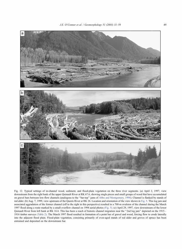
Fig. 12. Typical settings of in-channel wood, sediment, and flood-plain vegetation on the three river segments. (a) April 2, 1997, view
downstream from the right bank of the upper Quinault River at RK 67.6, showing single pieces and small groups of wood that have accumulated
on gravel bars between low-flow channels (analogous to the ‘‘bar-top’’ jams of Abbe and Montgomery, 1996). Channel is flanked by stands of
red alder. (b) Aug. 7, 1999, view upstream of the Queets River at RK 26. Location and orientation of the view shown in Fig. 5. This log jam and
associated aggradation of the former channel (off to the right in this perspective) resulted in a 700-m avulsion of the channel during the March
1997 flood along a route marked by a small overflow channel on 1994 aerial photos (Fig. 5). (c) April 29, 1997, view downstream of the lower
Quinault River from left bank at RK 16.6. This has been a reach of historic channel migration near the ‘‘2nd log jam’’ depicted on the 1915–
1916 timber surveys (Table 2). The March 1997 flood resulted in formation of a point bar of gravel and wood, forcing flow to erode laterally
into the adjacent flood plain. Flood-plain vegetation, consisting primarily of even-aged stands of red alder and groves of spruce has been
entrained and deposited on the downstream bar.
J.E. O’Connor et al. / Geomorphology 51 (2003) 31–59 49
107). A map constructed during a 1915–1916 timber
survey (Table 2) of the reservation shows three large
log jams (Fig. 2a), one of which covered about 15 ha
(Fig. 7). Presently, no channel log jams span the lower
Quinault River, in part due to active removal to aid
navigation (Philip Martin Jr., Quinault Indian Nation,
oral communication, 1997) and, perhaps, less large
wood in the river because of substantial flood-plain
timber harvest during the last 80 years.
The sequence of events at what was mapped as
‘‘3rd log jam’’ on the 1915–1916 timber survey (Fig.
7) may be representative of channel and flood-plain
conditions associated with channel-spanning log jams
on the lower Quinault River prior to significant human
channel clearing and flood-plain timber harvest. The
location of this jam is consistent with early 1890s
accounts of a ‘‘big jam of trees and rubbish com-
pletely blocking the channel’’ (Cleland, 1959, pp.
177–178). This large jam completely spanned the
channel in 1902, according to notes accompanying
the General Land Office survey of the channel (cadas-
tral survey notes for T. 22 N., R. 10 E., housed at the
Bureau of Land Management office in Portland,
Oregon). The 1902 General Land Office survey
depicts a wide and ponded channel at the area of the
jam but no note or portrayal of a bypass channel. The
1915–1916 timber survey also shows the log jam
completely blocking the main channel but by that
time, a small bypass channel had formed. A 1929
survey of the channel shows that the bypass channel
had become the main channel, with the former route
dashed in, indicating as much as 500 m of lateral
avulsion of nearly a kilometer of channel. A similar
sequence of events apparently caused another avul-
sion in the next meander downstream between 1953
and 1997 (Fig. 7), partly resulting from a log jam most
likely formed of wood eroded from the flood-plain
forest during the 1902–1929 avulsion. The locations
of other two log jams portrayed on the 1915–1916
timber survey have also had similar but smaller
avulsions and have been reaches of persistent channel
instability (Figs. 2 and 4).
In contrast to the large, channel-spanning jams and
consequent channel avulsions that have affected at
least three reaches of the lower Quinault River during
the early 20th century, the Queets River and upper
Quinault River (and, to a more local extent, the lower
Quinault River) have mostly been affected by indi-
vidual pieces of wood and wood jams that flank or
only partially block the channel (Fig. 12). These wood
accumulations have been associated with rapid bar
growth, bank erosion, and short-length channel avul-
sions as described for the Queets River by Fetherston
et al. (1995), Abbe and Montgomery (1996, 2003),
and Abbe (2000). In these reaches of frequent wood
and sediment transport, large woody debris is com-
monly deposited on bar tops, at bar apices, and in
meander bends, commonly promoting mid-channel
and point bar growth which then redirects flow against
channel margins, causing bank erosion and channel
migration (Abbe and Montgomery, 1996). An exam-
ple on the Queets River is shown in Figs. 5 and 12b,
where about 500 m of new channel formed as a result
of partial channel blockage by wood and sediment,
resulting in a meander cutoff during the high flow of
March 1997. Two similar avulsions, both involving
channel lengths less than 400 m, occurred during the
same flood on the lower Quinault River at RK 32.5
and 27.2. Judging from the abundant in-channel
wood, our field observations of channel change
between 1996 and 1999, and high lateral migration
rates, such channel shifting and lateral migration is
common, perhaps occurring most years on the upper
Quinault River and Queets River above RK 20.
Downstream of RK 20 on the Queets River, the
channel has a lower gradient and more sinuous plan-
form and there has been more systematic growth and
cutoff of large meander loops (e.g., Fig. 6). Inspection
of aerial photographs and observations from site visits
indicate that these meanders grow as a result of point
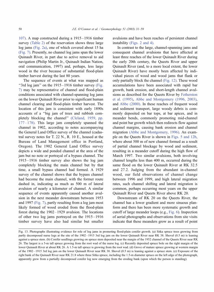
Fig. 13. Photographs illustrating evidence for role of log jams in promoting flood-plain conifer growth. (a) Sitka spruce trees growing from
partly decomposed nurse logs at the site of the 1902–1915 3rd log jam on the lower Quinault River near RK 38. Shovel (0.5 m) is leaning
against a spruce stem. (b) Conifer seedlings growing on spruce stem deposited near the margin of the 1952 channel of the Queets River near RK
26. The largest is a 5-m tall spruce growing from the root wad of the nurse log. (c) Recently deposited spruce bole on the right margin of the
lower Quinault River at about RK 26. A 1.5-m tall spruce is growing from the root wad. (d) Grove of mature spruce growing at western margin
of the 1902–1915 3rd log jam on the lower Quinault River near RK 38. Shovel (0.5 m) is leaning against a spruce stem. (e) Exposure of the
right bank of the Quinault River near RK 21.8 where three Sitka spruce, including the 1.5-m diameter spruce on the left edge of the photograph,
apparently grew from a partially decomposed conifer log now emerging from the eroding bank (upon which the person is standing).
J.E. O’Connor et al. / Geomorphology 51 (2003) 31–5950

J.E. O’Connor et al. / Geomorphology 51 (2003) 31–59 51

bars forming on the insides of meander bends,
facilitated by deposition in the lee of wood accumu-
lations. The resulting aggradation, as indicated by
buried wood accumulations and wide active channels
within the meander bends, probably facilitates over-
bank flow across the meander bend and eventual
cutoff.
Longer-term feedbacks between fluvially trans-
ported wood and flood-plain vegetation are evident
at sites of historic wood accumulation and channel
change. At the location of the channel-spanning 3rd
log jam on the lower Quinault River segment, which
is now as far as 500 m away from the channel,
numerous spruce are now growing from higher logs
within this jam (Fig. 13a). Many of these spruce have
diameters of 30 to 40 cm within vegetation otherwise
dominated by maple and alder, indicating that these
log jams may facilitate flood-plain conifer establish-
ment by providing elevated and nourishing sites for
seedling establishment. Consistent with this, large
conifers recently deposited along both the Quinault
River and Queets River have young spruce and west-
ern red cedar growing from their stems and rootwads
(Fig. 13a,b). In addition, the unharvested flood plain
within the cutoff meander loop adjacent to the area of
the 3rd log jam is vegetated primarily by hardwoods,
but locally interspersed are groves of large spruce,
some with basal diameters exceeding 2 m (Fig. 13d).
These spruce grow in clusters of about 400 m2 or less
on surfaces that stand 1 to 2 m above the surrounding
flood plain. No direct evidence of nurse logs was
found at these groves, but commonly three or more of
the spruce would be aligned, supporting the inference
that these spruce groves have formed on long-rotted or
buried nurse logs. The grouping of these spruce, in
combination with the higher terrain which they are
found, leads us to conclude that these groves of
mature spruce occupy sites of old log jams, although
it cannot be ruled out that windthrow may have
formed the downed logs upon which the present
spruce have grown. A bank exposure downstream
along the lower Quinault River shows that similar
arrangements of large spruce are indeed rooted in logs
now buried by overbank sediment and forest soils
(Fig. 13e).
Similar interactions between channel shifting, wood
deposition and recruitment, and flood-plain morphol-
ogy and vegetation are also evident in conjunction with
wood accumulations that do not completely span the
channel. In particular for the Queets River, Fetherston
et al. (1995) described feedbacks between riparian
forest conditions and large woody debris accumula-
tions, and Abbe and Montgomery (1996) conducted
detailed studies between RK 41 and 46where they have
related wood accumulations to hydraulic, depositional,
and aquatic habitat conditions. These earlier studies on
the Queets River and our observations on all three river
segments indicate that deposited large woody debris
commonly promotes mid-channel and point bar growth
(Fig. 12a). Additionally, bar formation in the lee of
wood accumulations can lead to establishment of
riparian vegetation on the resulting higher and finer-
grained deposits, and ultimately, stands of even-age
riparian vegetation. Bank erosion and the consequent
entrainment of flood-plain trees can foster further
channel instability as the downed wood steers flow
into banks (the ‘‘auto diversion’’ process of Keller and
Swanson, 1979).
5. Discussion
Despite the overall similar physiographic settings
of the Queets River and Quinault River basins, the
three study reaches have distinct planform character-
istics as well as patterns and rates of channel migra-
tion and flood-plain erosion. These differences can be
logically attributed to the different sediment, water,
and wood inputs to the basin, and interactions among
these factors, although rigorous identification of cause
and effect is hampered by the multiple differences
between the reaches and the long time scales of
interactions. These inferences regarding effects of
sediment, wood, and flow on channel morphology,
coupled with observations of flood-plain morphology
and vegetation that may represent even longer time
frames, serve as a basis for speculation on interactions
among channel migration, in-channel wood, and
flood-plain forests at time scales ranging from decades
to centuries (Fig. 14).
5.1. Flood-plain and channel planform character-
istics
Variation in flood-plain width primarily reflects
Quaternary geologic controls on valley morphology.
J.E. O’Connor et al. / Geomorphology 51 (2003) 31–5952

For both the lower Quinault River and Queets River
segments, there is pronounced narrowing of the flood
plains where they pass through Quaternary terminal
moraine complexes (Thackray, 1996). Within the
upper Quinault River segment, the flood-plain nar-
rows where bedrock ridges encroach from the north,
but widens where it is aggrading behind moraine-
dammed Lake Quinault. Flood-plain width does not
correlate with channel planform characteristics such
as low-flow width, active channel width, or the
frequency of low-flow channels ( p>0.1 in all cases;
two-tailed t-test). Thus, we infer that most aspects of
channel and flood-plain morphology are independent
of the local geologic controls that affect flood-plain
width.
Channel planform characteristics appear to be more
directly related to overall sediment, wood, and flow
regimes. For example, similar low-flow widths for all
three study reaches are likely due to similar low-flow
discharges. The greater active channel width, greater
channel slopes, higher migration rates, and greater
frequency of multiple and unconnected channels of
the upper Quinault River, and to a lesser extent the
Queets River, probably owe to the greater sediment
supply and higher peak discharges of these two rea-
ches compared to the lower Quinault River. The lower
Quinault River has an overall narrower active channel
width, lower channel gradient, and greater sinuosity,
likely reflecting the combined influence of upstream
sediment and wood trapping and flow attenuation
provided by Lake Quinault. These differences are
consistent with Schumm’s (1985) qualitative observa-
tions of the relationships among channel slope, sedi-
ment load, channel stability, and channel form.
Different base-level conditions may also be an
important factor in controlling planform channel and
flood-plain morphology. The Queets and upper Qui-
nault Rivers have overall similar sediment and flow
regimes; however, the upper Quinault River, which
has been aggrading behind Lake Quinault during the
Holocene, has a significantly wider flood plain, wider
active channel, more low-flow and high-flow chan-
nels, and greater migration rates. Valley aggradation
of the upper Quinault River has apparently primarily
affected the downstream 5 km of valley bottom, re-
sulting in lower channel gradient and higher channel
migration rate compared to the upstream part of the
upper Quinault study segment (Fig. 4).
In contrast, the Queets River and lower Quinault
Rivers have similar base-level conditions, but differ-
ent sediment, wood, and peak discharge conditions
because of the presence of Lake Quinault upstream of
Fig. 14. Feedbacks hypothesized between large wood and flood-plain and channel evolution, at time scales of decades to centuries, for the
Queets River and Quinault River. Partly derived from findings described by Fetherston et al. (1995), Abbe and Montgomery (1996) and Abbe
(2000).
J.E. O’Connor et al. / Geomorphology 51 (2003) 31–59 53

the lower Quinault River. The relatively greater sedi-
ment and wood supply of the Queets River in con-
junction with greater peak flows is probably
responsible for its greater active channel width and
perhaps gradient as well. The greater sediment supply
and steeper channel of the Queets River also likely
result in the slightly greater channel migration rates
and, in conjunction with the wider active channel,
more numerous low-flow channels (which generally
occupy recently abandoned channels). In general,
though, the overall morphologic differences between
the Queets and lower Quinault segments are less
pronounced than are the differences between the
aggrading upper Quinault River and the other two
study reaches (Fig. 3).
5.2. Channel migration patterns and dynamics
Parts of all three study reaches have distinctive
styles and rates of channel migration (Figs. 2–4).
The upper Quinault River has been multi-channeled
with high migration rates, with most migration accom-
plished by lateral bank erosion and short avulsions.
Similarly, the channel of Queets River upstream of RK
20 has been everywhere active, but changes down-
stream to a series of stationary meander loops that have
grown and cutoff over time scales of about 100 years.
Channel migration on the lower Quinault River during
the last 94 years has been focused in three distinct
reaches of channel avulsions across meander loops and
adjacent reaches of lateral channel migration and short
avulsions. Between these dynamic reaches, the lower
Quinault River has been mostly stable.
On all three river segments, rates of channel migra-
tion over the last 100 years correspond with modern
channel and flood-plain planform characteristics (Fig.
4). This is especially evident for the Queets River and
lower Quinault River, where discrete reaches of dis-
tinctly higher historic migration rates have wider
active channel widths, greater numbers of low-flow
and unconnected channels, and more unvegetated
gravel bars compared to reaches that have been histor-
ically stable or less active. This correspondence sup-
ports the importance of channel migration as a process
responsible for many ecologically important channel
and flood-plain characteristics.
Despite different channel migration rates, the
flood-plain occupancy rates for all three reaches are
broadly similar, indicating that flood-plain turnover
occurs over 200 to 2000 years with flood-plain half-
lives of 200 to 500 years. These half-lives are close
to those determined for a variety of other alluvial
rivers (e.g., Nanson and Beach, 1977; Hughes, 1997),
but somewhat longer than the 30–50 years estimated
by Gottesfeld and Gottesfeld (1990) for the Morice
River in British Columbia, which has a similar
physiographic setting as the three study segments
analyzed here. Three factors apparently control
flood-plain turnover rates the Queets and Quinault
study segments: (i) the width of the flood plain; (ii)
the channel migration rate; (iii) the propensity of
channel migration to erode into the flood plain rather
than to occupy previous channel locations. These
factors apparently counterbalance each other in the
Queets and Quinault Rivers to produce broadly
similar flood-plain turnover rates. The high migration
rate of the upper Quinault River is offset by its wider
flood plain. In contrast, the Queets and lower Qui-
nault segments have lower migration rates but nar-
rower flood plains.
5.3. Interactions among wood, sediment, flow and
resulting channel and flood-plain morphology
At length scales of individual channel bends and
time scales of individual flow events to decades, many
of the channel migration and flood-plain growth and
erosion processes on all study reaches are controlled
by interactions between flow, sediment, and wood
(Fig. 12). As described for the Queets River by
Fetherston et al. (1995) and Abbe and Montgomery
(1996, 2003), and Abbe (2000), these processes
involve many forms of wood, including standing
trees, entrained wood, and previously deposited accu-
mulations of large woody debris. In places, wood
deposition triggers sedimentation, such as in the ‘‘bar
apex jams,’’ and in other locations, sediment deposits
trap woody debris, such as the ‘‘bar top jams’’ (Abbe
and Montgomery, 1996). In both cases, the resulting
accumulations of wood and sediment can promote
flood-plain generation by providing sites and substrate
suitable for establishment of flood-plain vegetation
(Gottesfeld and Gottesfeld, 1990; Abbe and Mont-
gomery, 1996; Fetherston et al., 1995). Additionally,
sediment and wood accumulations locally cause
flood-plain erosion by directing flow toward banks,
J.E. O’Connor et al. / Geomorphology 51 (2003) 31–5954

thus introducing additional sediment and wood in the
river (e.g., Keller and Swanson, 1979). These inter-
actions are evident along most of the lengths of the
Queets and upper Quinault Rivers, which both receive
substantial sediment and wood from upstream as well
as from bank erosion, although the style of migration
apparently corresponds to channel slope on the Queets
River. All of these and similar processes have been
described for rivers with forested flood plains (e.g.,
Hack and Goodlet, 1960; Nanson and Beach, 1977;
Keller and Swanson, 1979; Swanson and Lienkaem-
per, 1982; Sedell and Froggatt, 1984; Gottesfeld and
Gottesfeld, 1990; Church, 1992; Piegay, 1993; Maser
and Sedell, 1994, pp. 44–50; Piegay and Gurnell,
1997; Piegay and Marston, 1998; Jacobson et al.,
1999; Gurnell et al., 2000).
On the lower Quinault River, however, these types
of short reach- and time-scale interactions have been
primarily restricted to the parts of the river that have
been historically active between RK 6 and 8, RK 10
and 17, and RK 27 and 40 (Fig. 2). This condition of
dynamic reaches within otherwise more stable chan-
nels has been observed in other rivers with forested
flood plains where they have been called ‘‘sedimen-
tation zones’’ (Church, 1983) or ‘‘disturbance rea-
ches’’ (Jacobson and Pugh, 1997). Higher channel
mobility within such sedimentation zones has been
attributed to external controls such as Neoglacial
sediment production, tributary fan locations (Church,
1983), and valley geometry (Jacobson and Pugh,
1997), as well as internal mechanisms involving
feedbacks between large woody debris accumula-
tions, sedimentation, and lateral channel shifting
(Keller and Swanson, 1979; Gottesfeld and Gottes-
feld, 1990). On the lower Quinault River, where
external controls such as tributary fans and upper
basin sediment and wood production have little influ-
ence on the channel or flood plain, internal mecha-
nisms involving wood, sediment, and channel
migrations must be the primary factors controlling
channel and flood-plain dynamics.
The correspondence of the three large log jams
mapped in the 1915–1916 timber survey with these
dynamic reaches on the lower Quinault River points to
the likely role of large log jams in creating persistent
zones of unstable channels (Fig. 4). In particular, the
long reach of high channel migration since 1902
between RK 27 and 40 is mostly downstream of the
large channel-spanning log jam at the time of the 1902
cadastral survey (Fig. 7). Ponding behind this log jam
likely triggered the channel avulsion between 1915
and 1929, and indirectly caused the 1953–1981 avul-
sion downstream (Fig. 7) as erosion of the new channel
brought additional wood from the flood-plain forest
into the channel, leading to formation of another jam
downstream. Wood and sediment brought into the
channel by these two jam-related avulsions has prob-
ably been the source of the continued downstream
instability in a river system where the only sources of
wood and sediment are the flood plains and valley
margins. For the lower Quinault River, such feedbacks
between flood-plain sediment and wood erosion and
deposition must be primary mechanisms promoting
channel instability.
The absence of large, channel-spanning log jams
on the upper Quinault River or Queets River may be
due to their greater sediment supply, peak discharge,
and gradient. Although there is no direct evidence for
this, we speculate that the higher sediment flux on the
upper Quinault and Queets River segments results in
more rapid sediment deposition at sites of wood
accumulation compared to the lower Quinault River,
thus forcing flow to erode laterally prior to complete
blockage of the channel by wood. The greater slopes
and peak discharges of the upper Quinault River and
Queets River would also promote such lateral erosion
as well as erosion of alternate flow routes prior to
complete blockage. In contrast, the lower Quinault
River, with low sediment flux and lower peak dis-
charges, may allow substantial wood accumulation—
to the point of completely blocking the channel—
before the ponded river completely overtops the flood
plain and erodes another course.
Channel-spanning log jams and consequent avul-
sions similar to those of the lower Quinault River have
been reported for other large, low-gradient rivers with
forested flood plains. Examples include the Willamette
River of western Oregon, where historic accounts
describe extensive rafts of wood blocking channels
and consequent formation of new channels (Sedell and
Froggatt, 1984); the Morice River of British Columbia
(Gottesfeld and Gottesfeld, 1990); the Skagit and
Stillaquamish Rivers of western Washington (Maser
and Sedell, 1994, p. 134); and the Red River of
Louisiana, where a complex series of channel-span-
ning log jams formed between the mid-17th century
J.E. O’Connor et al. / Geomorphology 51 (2003) 31–59 55

and 1873, obstructing the channel for more than 250
km and diverting the lower Red River to another route
to the Gulf of Mexico (Veatch, 1906).
Feedbacks among log jams, channel migration,
and flood-plain vegetation also involve longer time
scales (e.g., Naiman et al., 2000). Bars composed of
relatively fine-grained sediment form in the lee of
large woody debris accumulations (Fig. 12a; Swan-
son and Lienkaemper, 1982; Gottesfeld and Gottes-
feld, 1990; Church, 1992; Maser and Sedell, 1994,
pp. 47–50; Fetherston et al., 1995; Abbe and Mont-
gomery, 1996, 2003; Jacobson et al., 1999). Woody
debris accumulations, especially large and stable bar-
apex and meander jams (Fig. 12b; Abbe and Mont-
gomery, 1996, 2003), and their associated down-
stream pendant bars commonly stand several meters
above adjacent channel and bar areas and provide
advantageous substrate and topographic conditions
for flood-plain vegetation establishment and growth.
For the Queets and Quinault Rivers, red alder typi-
cally colonizes these bars within a few years of
emplacement and, if the log jam remains in place,
will survive to further stabilize the bar and promote
soil and flood-plain forest development, resulting in
forest patches older than surrounding vegetation
growing in subsequently abandoned channels (Fether-
ston et al., 1995; Abbe and Montgomery, 1996;
Abbe, 2000).
Furthermore, the log jams themselves may become
important in controlling future in-channel wood and
flood-plain forest conditions. Log jams are a rich
source of organic material and provide habitats and
energy sources for a variety of terrestrial plant and
animal species (Maser and Sedell, 1994, pp. 47–50;
Fetherston et al., 1995; Jacobson et al., 1999). More-
over, log jams become germination sites for conifers,
especially spruce that grow directly on logs or from
soil clinging to rootwads on less-traveled tree stems
incorporated into the log jam (Fig. 13; Gottesfeld and
Gottesfeld, 1990). In the Queets and Quinault River
valley bottoms, it appears that large log jams provide
germination sites, stability, and organic-rich substrate
to allow conifers to successfully compete and coexist
with rapid hardwood colonization of the more barren
gravel bars (Fig. 13). This is shown by the young
spruce growing from members of the 1902 log jam on
the Quinault River, and perhaps by the groves of large
and aligned spruce at the margins of the 1902 jam.
Analogously, spruce forests advance into salt marshes
in coastal environments by colonizing stable piles of
driftwood (Maser and Sedell, 1994, p. 84).
We further speculate that for the Quinault River
and Queets River, such spruce groves may have
effects on channel migration on time scales of cen-
turies to millennia (Fig. 14) by (i) providing a source
of large trees that may eventually fall into the channel
and become key members of future log jams (Abbe
and Montgomery, 1996; Abbe, 2000) and (ii) forming
patches of flood-plain vegetation resistant to erosion,
thus affecting locations of future log jams and channel
migration. This may have been the case for the 1902
log jam on the lower Quinault River, for which the
downstream logs are racked up against one of these
mature spruce groves.
5.4. Management implications
These results and inferences have implications for
management of large, gravel-bed rivers flowing
through forested flood plains. Foremost, flood-plain
morphology and channel conditions at any one time
are the product of several hundred to thousands of
years of channel migration and flood-plain forest
development. Consequently, time scales of this order
are the necessary perspective from which to consider
the full suite of channel and flood-plain processes for
these types of rivers. River management strategies that
do not fully consider the entire flood plain over time
scales of centuries are likely to lead to eventual
changes in channel and flood-plain processes and
morphology (Naiman et al., 2000), although such
effects may require several decades or centuries to
become evident. In contrast, most present strategies
for actively managed forested flood plains implicitly
operate in consideration of time frames of at most
several decades, corresponding to timber cutting
schedules and areas of sediment and wood input
associated with the present channel location. Sec-
ondly, channel and flood-plain processes and mor-
phologies can be very different, even within broadly
similar physiographic settings such as the western
Olympic Peninsula. For example, the distribution
and extent of various flood-plain environments (chan-
nels, unvegetated gravel bars, flood-plain forests of
various composition and age structure) were likely to
have been different for each of the three study reaches
J.E. O’Connor et al. / Geomorphology 51 (2003) 31–5956

under natural conditions because of differences in the
natural sediment, flow, and wood regimes. Specifica-
tion of realistic goals and optimizing actions to meet
habitat or harvest objectives must account for these
differences and the processes that underlie them.
6. Conclusions
The gravel-bed channels and forested flood plains
of the lower Quinault River, upper Quinault River,
and Queets River have distinctive physical morphol-
ogies and dynamics that reflect different flow, sedi-
ment, and wood regimes within an overall similar
physiographic environment. These are the major
observations:
(i) Local channel migration rates, active channel
width, and number of channels are highly
correlated to one another (Fig. 4). The sedi-
ment-and-wood-rich upper Quinault River, ag-
grading behind Lake Quinault, has the greatest
migration rate, widest active channel, most multi-
channel reaches, and greatest overall channel
slope of the three river segments. The lower
Quinault River, with no upstream sediment
source, has the lowest migration rate, narrowest
active channel, fewest multi-channel reaches, and
the lowest overall gradient. The Queets River,
with a sediment supply that is likely similar to the
upper Quinault River but in a nonaggradational
setting, has attributes intermediate between the
upper Quinault and lower Quinault segments.
(ii) Overall, rates of encroachment of the channel
across the flood plain are broadly similar for each
of the three study reaches, resulting in flood-plain
half-lives of 200 to 500 years. The higher channel
migration rate of the upper Quinault River
relative to the Queets and lower Quinault Rivers
is compensated by a wider flood plain. For the
lower Quinault River segment, the lower overall
channel migration rate and the relatively low
proportion of channel movement into historically
unoccupied flood plain are likely responsible for
the overall narrower Holocene flood plain.
(iii) Historic patterns and processes of channel
migration are different among the three reaches,
and these differences influence channel and
flood-plain morphology as well as spatial
variations in channel migration and flood-plain
occupancy rates. Channel change on the upper
Quinault River and the upstream portion of the
Queets River study reach is primarily due to
short-wavelength, low-amplitude meander for-
mation and cutoffs, largely spurred by bar
formation in the lee of large woody debris
accumulations and by partial blockage of the
channel by log jams. These reaches are dynamic
and multichanneled, and channels commonly
shift back and forth between previously occu-
pied channels on an annual to decadal time
frame. For the lower portion of the Queets River
study reach, most channel migration is due to
progressive enlargement and cutoff of large
meander bends, with complete cycles of mean-
der growth and cutoff occurring over several
decades to centuries. For the lower Quinault
River, avulsions are apparently triggered by
channel-spanning log jams, which then set up
reaches of channel instability separated by long
reaches of relatively stable channels.
(iv) Channel migration, sediment transport, large
woody debris, and flood-plain vegetation and
morphology involve several feedbacks, some
encompassing several century durations of the
same order as flood-plain turnover rates. Channel
shifting introduces large woody debris and flood-
plain sediment into the channel system, which
then triggers further channel shifting. For the
lower Quinault River, this is probably the primary
process maintaining input of wood and sediment
into the channel. Log jams and sediment accu-
mulations become unique terrestrial environ-
ments for flood-plain forest formation. The log
jams are preferred sites of conifer germination and
thus become areas resistant to future flood-plain
erosion as well as areas that may eventually
provide source wood for future log jams.
Acknowledgements
Phillip Martin Jr. of the Quinault Indian Nation,
Department of Natural Resources, provided logistical
support and boat access to the lower Quinault River.
Mark Mobbs, Justine Turner, Antonio Hartrich, and
J.E. O’Connor et al. / Geomorphology 51 (2003) 31–59 57

John Sims of the Quinault Indian Nation provided
historic documents and maps. Tina Marie and Danial
Polette, US Geological Survey, provided cartographic
and GIS assistance. Discussions with Mark Mobbs,
Dave Lasorda, Gordon Grant, Tim Abbe, Jonathan
Friedman, and Fred Swanson helped to clarify many
of the ideas presented here. Reviews of earlier
versions by John Parker, Ed Prych, Jonathan Fried-
man, and Fred Swanson improved the paper. Kevin
Fetherston and an anonymous referee provided help-
ful reviews for Geomorphology, as did journal editors
David Montgomery and Herve Piegay. Partial funding
was provided by the Quinault Indian Nation.
References
Abbe, T.B., 2000. Patterns, mechanics and geomorphic effects of
wood debris accumulations in a forest river system. PhD dis-
sertation. University of Washington, Seattle.
Abbe, T.B., Montgomery, D.R., 1996. Large woody debris jams,
channel hydraulics and habitat formation in large rivers. Regu-
lated Rivers: Research and Management 12, 201–221.
Abbe, T.B., Montgomery, D.R., 2003. Patterns and processes of
wood debris accumulation in the Queets River Basin, Washing-
ton. Geomorphology, this issue.
Brandon, M.T., Roden-Tice, M.K., Garver, J.I., 1998. Late Ceno-
zoic exhumation of the Cascadia accretionary wedge in the
Olympic Mountains, northwest Washington State. Geological
Society of America Bulletin 110, 985–1009.
Bureau of Land Management, 1973. Manual of Instructions for the
Survey of the Public Lands of the United States. Bureau of Land
Management Technical Bulletin 6, Catalog Number I 53.7:973-
2. US Government Printing Office, Washington, DC.
Capoeman, P.K. (Ed.), 1991. Land of the Quinault, 2nd ed. Qui-
nault Indian Nation, Taholah, WA.
Church, M., 1983. Pattern of instability in a wandering gravel bed
channel. Special Publication of the International Association of
Sedimentologists 6, 169–180.
Church, M., 1992. Channel morphology and typology. In: Carlow,
P., Petts, G.E. (Eds.), The Rivers Handbook, vol. 1. Blackwell,
Oxford, UK, pp. 126–143.
Cleland, L.H., 1959. Trials and Trails of the Pioneers of the Olym-
pic Peninsula, State of Washington. Humptulips Pioneers Asso-
ciation, Hoquiam, WA.
Draper, N.R., Smith, H., 1966. Applied Regression Analysis. Wiley,
New York.
Duncan, S.H., Steinbrenner, E.C., 1976. Soil Survey, Quinault In-
dian Reservation. Quinault Indian Nation, Taholah, WA. 12
plates (1:31,600). 13 pp.
Elliot, J.G., Gyetvai, S., 1999. Channel-Pattern Adjustments and
Geomorphic Characteristics of Elkhead Creek, Colorado,
1937–1997. U.S. Geological Survey Water-Resources Investi-
gations, Report 99-4098. US Government Printing Office, Den-
ver, CO.
Everitt, B.L., 1968. Use of the cottonwood in an investigation of the
recent history of a flood plain. American Journal of Science 266,
417–439.
Fetherston, K.L., Naiman, R.J., Bilby, R.E., 1995. Large woody
debris, physical process, and riparian forest development in
montane river networks of the Pacific Northwest. Geomorphol-
ogy 13, 133–144.
Gillespie, B.M., Giardino, J.R., 1996. Determining the migratory
activity index for a river: an example from the Brazos River,
Texas. Zeitschrift fur Geomorphologie 40, 417–428.
Gottesfeld, A.S., Gottesfeld, L.M.J., 1990. Floodplain dynamics of
a wandering river, dendrochronology of the Morice River, Brit-
ish Columbia, Canada. Geomorphology 3, 159–179.
Gurnell, A.M., 1997. Channel change on the River Dee meanders,
1946–1992, from the analysis of air photographs. Regulated
Rivers: Research and Management 13, 13–26.
Gurnell, A.M., Downward, S.R., Jones, R., 1994. Channel planform
change on the River Dee meanders, 1976–1992. Regulated
Rivers: Research and Management 9, 187–204.
Gurnell, A.M., Petts, G.E., Hannah, D.M., Smith, B.P.G., Edwards,
P.J., Kollmann, J., Ward, J.V., Tockner, K., 2000. Wood storage
within the active zone of a large European gravel-bed river.
Geomorphology 34, 55–72.
Hack, J.T., Goodlet, J.C., 1960. Geomorphology and Forest Ecol-
ogy of a Mountain Region in the Central Appalachians. U.S.
Geological Survey Professional Paper, vol. 347. US Govern-
ment Printing Office, Washington, DC.
Ham, D.G., Church, M., 2000. Bed-material transport estimated
from channel morphodynamics, Chilliwack River, British Co-
lumbia. Earth Surface Processes and Landforms 25, 1123–1142.
Hickin, E.J., 1984. Vegetation and river channel dynamics. Cana-
dian Geographer 28, 111–126.
Hickin, E.J., Nanson, G.C., 1975. The character of channel migra-
tion on the Beatton River, Northeast British Columbia, Canada.
Geological Society of America Bulletin 86, 487–494.
Hooke, J.M., 1980. Magnitude and distribution of rates of river
bank erosion. Earth Surface Processes 5, 143–157.
Hughes, F.M.R., 1997. Floodplain biogeomorphology. Progress in
Physical Geography 21, 501–529.
Jacobson, R.B., Pugh, A.L., 1997. Riparian-Vegetation Controls
on the Spatial Pattern of Stream-Channel Instability, Little
Pine Creek, Missouri. U.S. Geological Survey Water-Supply
Paper, vol. 2494. US Government Printing Office, Washing-
ton, DC.
Jacobson, P.J., Jacobson, K.M., Angermeier, P.L., Cherry, D.S.,
1999. Transport, retention, and ecological significance of woody
debris within a large ephemeral river. Journal of the North
American Benthological Society 18, 429–444.
Keller, E.A., Swanson, F.J., 1979. Effects of large organic material
on channel form and fluvial processes. Earth Surface Processes
4, 361–380.
Kellerhals, R., Church, M., Bray, D.I., 1976. Classification and
analysis of river processes. Journal of the Hydraulics Division
102, 813–829.
Knighton, A.D., Nanson, G.C., 1993. Anastomosis and the contin-
J.E. O’Connor et al. / Geomorphology 51 (2003) 31–5958

uum of channel pattern. Earth Surface Processes and Landforms
18, 613–625.
Leopold, L.B., 1973. River channel change with time—an example.
Geological Society of America Bulletin 84, 1845–1860.
Leopold, L.B., Wolman, M.G., 1957. River Channel Patterns—
Braided, Meandering and Straight. United States Geological
Survey Professional Paper, vol. 282B. US Government Printing
Office, Washington, DC, pp. 39–85.
Leopold, L.B., Wolman, M.G., Miller, J.P., 1964. Fluvial Processes
in Geomorphology. Freeman, San Francisco, CA.
Maser, C., Sedell, J.R., 1994. From the Forest to the Sea—the
Ecology of Wood in Streams, Rivers, Estuaries and Oceans.
St. Lucie Press, Delray Beach, FL.
Naiman, R.J., Elliott, S.R., Helfield, J.M., O’Keefe, T.C., 2000.
Biophysical interactions and the structure and dynamics of riv-
erine ecosystems: the importance of biotic feedbacks. Hydro-
biologia 410, 79–86.
Nanson, G.C., Beach, H.F., 1977. Forest succession and sedimen-
tation on a meandering-river floodplain, northeast British Co-
lumbia, Canada. Journal of Biogeography 4, 229–251.
Osterkamp, W.R., Hedman, E.R., 1982. Perennial-Streamflow Char-
acteristics Related to Channel Geometry and Sediment in Mis-
souri River Basin. U.S. Geological Survey Professional Paper,
vol. 1242. US Government Printing Office, Washington, DC.
Piegay, H., 1993. Nature, mass and preferential sites of coarse woody
debris deposit in the Lower Ain valley (Mollon reach) France.
Regulated Rivers: Research and Management 8, 359–372.
Piegay, H., Gurnell, A.M., 1997. Large woody debris and river
geomorphological pattern: examples from S.E. France and S.
England. Geomorphology 19, 99–116.
Piegay, H., Marston, R.A., 1998. Distribution of large woody debris
along the outer bend of meanders in the Ain River, France.
Physical Geography 19, 318–340.
Piegay, H., Barge, O., Landon, N., 1996. Streamway Concept
Applied to River Mobility/Human Use Conflict Management.
Proceedings ‘‘Rivertech96’’ 1st International Conference on
New/Emerging Concepts for Rivers, Chicago, USA, Septem-
ber, pp. 681–688.
Pizzuto, J.E., 1994. Channel adjustments to changing discharges,
Powder River, Montana. Geological Society of America Bulle-
tin 106, 1494–1501.
Quinault Indian Nation and US Department of Agriculture Forest
Service, 1999. Quinault River Watershed Analysis. Quinault
Indian Nation, Taholah, WA.
Schumm, S.A., 1985. Patterns of alluvial rivers. Annual Review of
Earth and Planetary Science 13, 5–27.
Sedell, J.R., Froggatt, J.L., 1984. Importance of streamside forests
to large rivers: the isolation of the Willamette River, Oregon,
USA, from its floodplain by snagging and streamside forest
removal. Internationale Vereinigung fur Theoretische and Ange-
wandte Limnologie Verhandlungen (International Association of
Theoretical and Applied Limnology) 22, 1828–1834.
Shields Jr., F.D., Simon, A., Steffen, L.J., 2000. Reservoir effects on
downstream river channel migration. Environmental Conserva-
tion 27, 54–66.
Swanson, F.J., Lienkaemper, G.W., 1982. Interactions among flu-
vial processes, forest vegetation, and aquatic ecosystems, South
Fork Hoh River, Olympic National Park. In: Starkey, E.E.,
Franklin, J.F., Matthew, J.W. (Eds.), Ecological Research in Na-
tional Parks of the Pacific Northwest. Proceedings of the 2nd
Conference on Scientific Research in the National Parks, No-
vember 1979, San Francisco, California. Oregon State Univer-
sity Forest Research Laboratory, Corvallis, OR, pp. 30–34.
Tabor, R.W., Cady, W.M., 1978a. The Structure of the Olympic
Mountains, Washington. Analysis of a Subduction Zone. U.S.
Geological Survey Professional Paper, vol. 1033. US Govern-
ment Printing Office, Washington, DC.
Tabor, R.W., Cady, W.M., 1978b. Geologic Map of the Olympic
Peninsula. U.S. Geological Survey Miscellaneous Investigations
Map I-994. US Government Printing Office, Washington, DC.
Thackray, G.D., 1996. Glaciation and neotectonic deformation on
the western Olympic Peninsula, Washington. PhD dissertation.
University of Washington, Seattle.
Veatch, A.C., 1906. Geology and Underground Water Resources of
Northern Louisiana and Southern Arkansas. U.S. Geological
Survey Professional Paper, vol. 46. U.S. Government Printing
Office, Washington, DC.
Wiggins, W.D., Ruppert, G.P., Smith, R.R., Reed, L.L., Courts,
M.L., 1998. Water Resources Data, Washington, Water Year
1997. US Geological Survey Water-Data Report WA-97-1, Ta-
coma, WA.
J.E. O’Connor et al. / Geomorphology 51 (2003) 31–59 59