floodplain and hydraulic infrastructure system … and hydraulic... · floodplain and hydraulic...
TRANSCRIPT

FLOODPLAIN AND HYDRAULIC INFRASTRUCTURE SYSTEM MODELING FOR
INTERGRATED FLOOD MANAGEMENT
Hii Ching Poon
Doctor of Philosophy 2010

I Pusa, 'dmat ~ akJumat . k UNlVERSm MALAy 'J ,.
FLOODPLAIN AND HYDRAULIC INFRASTRUCTURE SYSTEM MODELING FOR INTEGRATED FLOOD MANAGEMENT
P.KHIDMAT MAKLUMAT AKADEMIK
1llIllllIlli'rn 111111111 1000246294
HII CHING POON
A dissertation submitted in fulfilment of the requirements for the degree of
Doctor of Philosophy
Faculty of Engineering . UNIVERSITI MALAYSIA SARA W AK
2010

I ,
Acknowledgements
I wish to acknowledge with deepest gratitude the guidance and
encouragement provided throughout the course of this research project by my
supervisors, Professor Ir. Dr. Frederik Josep Putuhena and Professor Dr. Salim
Said. I am very grateful of their ideas, feedbacks, comments and mentorship
throughout the journey of the study. I would like to thank UNlMAS, the Faculty of
Engineering and the Center of Graduate Studies for the opportunity, assistance and
arena to conduct this applied research.
I am also indebted to the academic, secretarial and technical staffs of
the Department of Civil Engineering for their kind help, in particular Dr. Darrien
Mah Yau Seng for his assistance and invaluable advice for the hydrological and
hydraulic modeling works.
The research was only made possible due to generous support from the Director of
State Planning Unit, State Secretary Sarawak and other government departments
and agencies for their assistance provision of research materials for which the
author is grateful. I have benefited from the suggestions and comments provided by
the Natural Resources and Environmental Board Sarawak (NREB), Jabatan Kerja
Raya Sarawak (JKR) , Jabatan Pengairan dan Saliran Sarawak (JPS) , Sarawak
Rivers Board (SRB) and Captain Goh Chin Guan from Kuching Barrage
Management Sdn Bhd.
Finally, I wish to express my earnest thanks to Rolin and Madelyn,
wonderful parents, brothers and sisters for their love, encouragement, patience,
and unwavering support throughout the journey to completion of my PhD study.
11

_
I
Abstract
en recent years, river floods in Sarawak River seemed to occur more frequently and
had been causing more and more economic and social damages. One of the greatest
deficiencies of the current flood management system for Sg. Sarawak basin is its
inadequate optimization of the existing structural measures. This optimization may
be achieved by application of some of the models and the framework developed
recently for enhancement of participation of various local stakeholders in flood
management.)
Hydrological simulations had been conducted and carried out using HEC-HMS for
Sg. Sarawak catchment. The model was calibrated and validated using years 1976
and 2000 flood events. The rainfall - runoff hydrographs generated from calibration
and validation processes showed Nash-Sutcliffe values of 0.78 and 0.71,
respectively. Sensitivity analysis was perfonned to examine the impacts of the three
parameters, namely, initial loss, constant loss and lag time parameters on the HEC
HMS hydrological model. The analysis revealed that the initial loss parameter acted
as the most sensitive parameter with respect to peak flow and total runoff volume.
It was also found that an increase in constant loss could result in a lower peak,
while the lag time was the most sensitive parameter with respect to peak time. ~ .
However, lag time parameter was found to be the least sensitive among the three
parameters tested.
The calibrated hydrological model was then used as inflow hydrographs in
InfoWorks RS model. Two hydraulic models, namely, Pre-barrage Sg. Sarawak
Model and Post-barrage Sg. Sarawak Model were developed, calibrated and
validated by modifying Manning's n values corresponding to field observations.
. " . 111

Years 1976 and 2000 flood events were used for calibration and validation purposes,
and showed to have an accuracy of approximately 90% for both processes.
Sensitivity analysis was carried out to investigate the impact of Manning's n on the
water levels. Manning's n sensitivity was tested using values ranging from 0.025 to
0.055. The results revealed that the peak water level was not sensitive to Manning's
n values. The hydraulic model was intended to integrate the existing flood
mitigation structures available in Sg. Sarawak Basin.
Two Scenarios: 1) Sarawak River basin-wide modeling and 2) Flood Bypass Channel
modeling were carried out using the models developed for this research to
investigate the performance of the existing flood mitigation measures in Sg.
Sarawak basin. The results revealed that the existing structure, Sg. Sarawak
barrage was able to trim down the backwater due to King Tide or the flood flow from
the upstream. However, the barrage had insignificant on water level during king
tide and flood event. The modeled results were used in Logical Framework Analysis
to look into the possible alternatives that may help reduce the damage. The
outcomes of this study showed that the existing condition could be significantly
improved once the Flood Bypass Channel and Early Flood Warning System are
constructed.
Flood Bypass Channel modeling was carried out to determine the impact of the
proposed alternatives on the existing conditions of Sg. Sarawak Basin. In this
scenario, a flood bypass channel and an additional barrage are proposed to divert
the excess flood water from Kuching City in the event of severe flood. It was shown
that flooding problems in Kuching can be significantly reduced. However, the areas
located upstream of Kuala Maong could still be subjected to flooding. Early Flood
Warning system could be provided to evacuate the floodplain dwellers before severe

floods strike. An analytical logical framework for Early Flood Warning System IS
presented in this dissertation.
The models and methods developed in this study are flexible and easy for Sg.
Sarawak Basin. In this research, both the feasibility of and effectiveness in
incorporating the premise of the combined technical information and institutional
setup in flood management are addressed.
v
I
I',
I,'
I
I
Abstrak
Sejak kebelakangan ini, bencana banjir di lembangan Sungai Sarawak semakin
kerap dan membawa kerugian ekonomi and sosial kepada penduduk dan kerajaan
tempatan. Salah satu kekurangan besar sistem pengurusan banjir yang wujud di
lembangan Sg. Sarawak adalah kekurangan sistem yang dapat mewujudkan
prestasi optimum bagi struktur-struktur yang terbina. Keadaan optimum ini dapat
dicapai melalui model yang dibangunkan dan rangka pengurusan yang
menggalakkan penyertaan berbagai pihak berkepentingan.
Simulasi hidrologi telah dijalankan dengan menggunakan HEC-HMS. Model yang
digunakan telah ditentukur dan disahihkan dengan menggunakan data berasal
daripada banjir tahun 1976 dan 2000. Hidrograf yang dihasilkan melalui proses
penentukuran dan pengesahan menunjukkan nilai Nash-Sutcliffe 0.78 dan 0.71
masing-masing. Analisis kepekaan parameter telah diadakan untuk menguji kesan
dan tindakbalas parameter seperti "initial loss", "constant loss" dan "lag time" ke
atas model yang dibangunkan. Keputusan analisis menunjukkan "initial loss"
merupakan parameter yang amat sensitive kepada air larian puncak dan jumlah
isipadu air larian. Peningkatan "constant loss" boleh menurunkan puncak air larian.
IrLag time" memberi kesan sensitif kepada parameter tempoh ke puncak hidrograJ
Manakala, "lag time" merupakan parameter yang kurang sensitif berbanding dengan
parameter yang lain.
Model hidrologi yang ditentukur telah digunakan untuk menghasilkan hidrograf
sebagai input kepada model hidraulik, Info Work RS. Dua model hidraulik telah
dibangunkan, iaitu, sebelum baraj Sg. Sarawak dan selepas baraj Sg. Sarawak.
Model-model ini telah ditentukur dan disahihkan dengan mengubahsuaikan nilai
rl I'
I'
I
Manning's n yang dikaitkan kepada tinjauan lapangan. Data danpada banjir tahun
1976 dan tahun 2000 telah digunakan untuk tujuan pentukuran dan pengesahan
bagi model hidraulik. Keputusan menunjukkan 90% ketepatan bagi kedua-dua ujian.
Analisis kepekaan parameter juga telah diadakan ke atas parameter Manning's n
untuk mengkaji kesannya ke atas aras air. Manning's n dalam julat 0.025 - 0.055
telah diuji. Keputusan menunjukkan nilai puncak paras air kurang sensitif kepada
parameter Manning's n. Model hidraulik yang telah ditentukurkan mengintegrasikan
struktur tebatan banjir yang sediada di lembangan Sungai Sarawak.
Dua senano, iaitu, 1) Permodelan lembangan Sungai Sarawak dan 2) Premodelan
labJ.an pintasan banjir telah dilaksanakan dengan menggunakan model-model yang
dibangunkan untuk menyiasat prestasi struktur-struktur tebatan banjir yang wujud
di lembangan Sungai Sarawak. Keputusan permodelan menunjukkan baraj Sungai
Sarawak dapat mengurangkan kesan air prasang atau air lanan dan hulu Sungai
Sarawak. Namun, baraj Sungai Sarawak memben kesan kecil semasa banjir dan
pasang-surut berlaku. Keputusan danpada permodelan telah digunakan dalam
an a lis is rangka logik untuk menyiasat altematif-alternatif yang dapat
mengurangkan kerosakan yang dibawa oleh banjir. Keputusan permodelan
mendedahkan bahawa keadaan yang ada dapat dipertingkatkan jikalau laluan
pintasan banjir dan sistem amaran awal banjir dapat dibekalkan.
Permodelan laluan pintasan banjir telah dijalankan untuk mengkaji keberkesanan
alternatif tersebut kepada lembangan Sungai Sarawak. Dalam senano ini, laluan
pintasan banjir dan sekatan sungai telah dibekalkan untuk memintaskan air banjir
berasal dan hulu Sungai Sarawak jauh dan bandar Kuching semasa banjir.
Keputusan menunjukkan masalah banjir di Kuching dapat dikurangkan. Kawasan
yang terletak di hulu Kuala Maong masih berada dalam nsiko banjir. Sistem amaran
1

banjir harus dibekalkan untuk mengeluarkan penduduk yang tinggal dalam
kawasan tersebut. Rangka logik analitikal bagi sistem amaran awal banjir telah
dibangunkan.
Model-model dan prosedur yang dibangunkan dalam penyelidikan ini adalah
fleksibel dan mudah digunakan di lembangan Sungai Sarawak. Melalui penyelidikan
yang dilaksanakan, kebolehlaksanaan dan keberkesanan dalam menyatukan
maklumat teknikal dan instituisi dalam pengurusan banjir telah dibuktikan.

P sat Khidmat 1 kJum Akadtmik UNlVE m 1 LAY f • A WAf(
Table of Contents
Acknowledgements Abstract Abstrak Table of Contents List of Figures List of Tables List of Appendices List of Abbreviations
CHAPTER 1 INTRODUCTION
1.1 Background 1.2 Integrated Flood Management 1.3 Flooding Problem in Sarawak 1.4 Challenge of Applying Flood Model in Practice 1.5 Research Objectives 1.6 Research Hypothesis 1. 7 Structure of Dissertation
CHAPTER 2 LITERATURE REVIEW
2.0 Sungai Sarawak Basin and Kuching City 2.1 Flood Modeling of Sungai Sarawak 2.2 Flood Management for Integrated Water Resources
Management 2.3 Logical Framework Analysis 2.4 Interactive Multiobjectives Modeling of Discrete Decisions
in Water Resources Planning 2.5 Adaptive Management
CHAPTER 3 METHODOLOGY
3.1 Introduction 3.2 Hydrological Model Development 3.3 Hydraulic Model Development 3.4 Logical Framework Development
CHAPTER 4 RESULTS AND DISCUSSION
4.1 Introduction 4.2 Hydrological Model Calibration and Validation 4.3 Hydraulic Model Calibration and Validation 4.4 Logical Framework Analysis 4.5 Sarawak River Basin - Wide Modeling 4.6 Flood Bypass Channel Modeling 4.7 Sub-logical Framework Development
J
I
Page 11
III
VI
IX
Xl
XlII
xiv xv
1
1 1 4 7 9 9 11
12
12 31 61
69
71 72
76
76 76 84 85
93 93 106 120 132 134 138
93

,...
4.8 Summary of Findings 142 I' I
CHAPTER 5 CONCLUSIONS AND RECOMMENDATIONS 143 I'
5.1 Concl usions 143I, 5.2 Recommendations 145
References 146
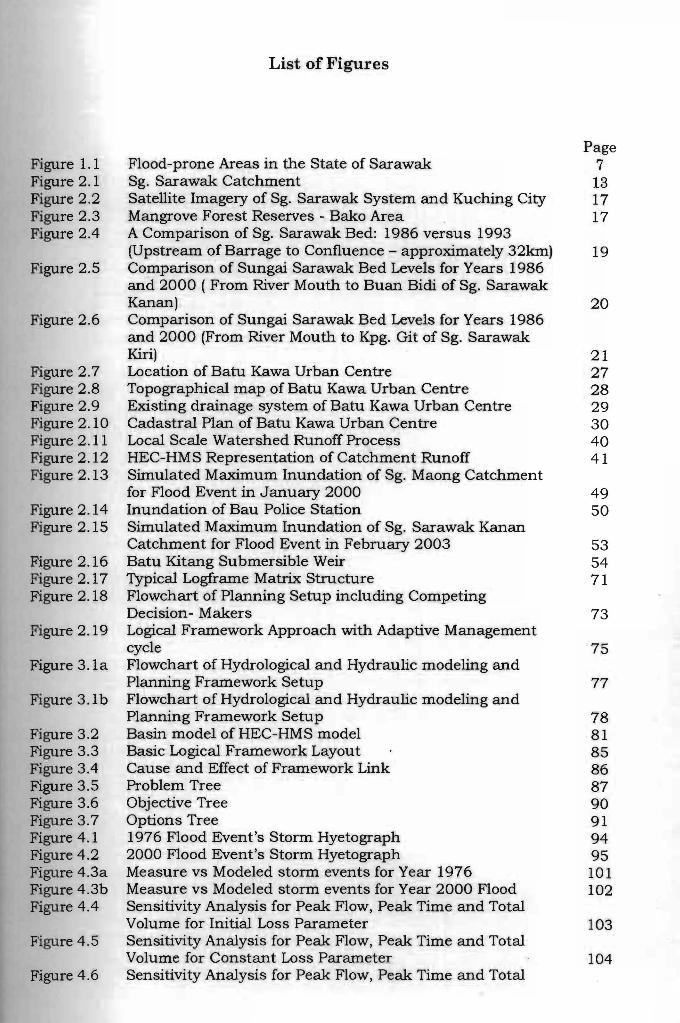
--List of Figures
Page Figure 1.1 Flood-prone Areas in the State of Sarawak 7 Figure 2.1 Sg. Sarawak Catchment 13 Figure 2.2 Satellite Imagery of Sg. Sarawak System and Kuching City 17 Figure 2 .3 Mangrove Forest Reserves - Bako Area 17 Figure 2.4 A Comparison of Sg. Sarawak Bed: 1986 versus 1993
(Upstream of Barrage to Confluence - approximately 32km) 19 Figure 2.5 Comparison of Sungai Sarawak Bed Levels for Years 1986
and 2000 ( From River Mouth to Buan Bidi of Sg. Sarawak Kanan) 20
Figure 2 .6 Comparison of Sungai Sarawak Bed Levels for Years 1986 and 2000 (From River Mouth to Kpg. Git of Sg. Sarawak Kiri) 21
Figure 2.7 Location of Batu Kawa Urban Centre 27 Figure 2.8 Topographical map of Batu Kawa Urban Centre 28 Figure 2.9 Existing drainage system of Batu Kawa Urban Centre 29 Figure 2.10 Cadastral Plan of Batu Kawa Urban Centre 30 Figure 2.11 Local Scale Watershed Runoff Process 40 Figure 2.12 HEC-HMS Representation of Catchment Runoff 41 Figure 2.13 Simulated Maximum Inundation of Sg. Maong Catchment
for Flood Event in January 2000 49 Figure 2.14 Inundation of Bau Police Station 50 Figure 2.15 Simulated Maximum Inundation of Sg. Sarawak Kanan
Catchment for Flood Event in February 2003 53 Figure 2.16 Batu Kitang Submersible Weir 54 Figure 2.17 Typical Logframe Matrix Structure 71 Figure 2.18 Flowchart of Planning Setup including Competing
Decision- Makers 73 Figure 2.19 Logical Framework Approach with Adaptive Management
cycle 75 Figure 3.1a Flowchart of Hydrological and Hydraulic modeling and
Planning Framework Setup 77 Figure 3.1b Flowchart of Hydrological and Hydraulic modeling and
Planning Framework Setup 78 Figure 3.2 Basin model of HEC-HMS model 81 Figure 3.3 Basic Logical Framework Layout 85 Figure 3.4 Cause and Effect of Framework Link 86 Figure 3 .5 Problem Tree 87 Figure 3.6 Objective Tree 90 Figure 3.7 Options Tree 91 Figure 4.1 1976 Flood Event's Storm Hyetograph 94 Figure 4.2 2000 Flood Event's Storm Hyetograph 95.' Figure 4.3a Measure vs Modeled storm events for Year 1976 101 Figure 4.3b Measure vs Modeled storm events for Year 2000 Flood 102 Figure 4.4 Sensitivity Analysis for Peak Flow, Peak Time and Total
Volume for Initial Loss Parameter 103 Figure 4.5 Sensitivity Analysis for Peak Flow, Peak Time and Total
Volume for Constant Loss Parameter 104 Figure 4 .6 Sensitivity Analysis for Peak Flow, Peak Time and Total
1 l.

Volume for Lag Time Parameter 104 Figure 4.7 Sg. Sarawak Network Developed in InfoWorks RS 107 Figure 4.8 Property Tool Showing Cross-Section of Sg Sarawak using
InfoWorks RS 108 Figure 4.9 Flow Time Boundary for Inflow Point 111 Figure 4.10 Stage Time Boundary for Downstream Point 111 Figure 4.11 Property Sheet Showing the Operating Rules of Sluice Gate 112 Figure 4.12 Property Sheet Showing the Geometry and Gate 112 Figure 4.13 InfoWorks Simulation Controller 114 Figure 4.14 Comparison of Measured and Modeled Water Levels at
Batu Kawa Bridge in January 1976 117 Figure 4.15 Comparison of Measured and Modeled Water Levels at
Batu Kitang Bridge in January 1976 117 Figure 4.16 Comparison of Measured and Modeled Water Levels at
Batu Kawa Bridge in January 2000 118 Figure 4.17 Comparison of Measured and Modeled Water Levels at
Batu Kitang Bridge in January 2000 118 Figure 4.18 Comparison of Measured and Modeled Water Levels at
Batu Kitang Bridge 119 Figure 4.19 Comparison of Measured and Modeled Water Levels at
Batu Kawa Bridge 120 Figure 4.20 Sarawak River Basin - Wide Flood Map 133 Figure 4 .21 Simulated Flood Map for Flood Bypass Channel Modeling
Scenario 136

IList of Tables
Page Table 1.1 Summary of Flood-Prone Areas in Sarawak 5 Table 2.1 Flood Historical Flood Levels 25 Table 2.2 Limitations of Models used in HEC-HMS 44 Table 2.3 GIS Operations Supportive of Surface Water Modeling 55 Table 2.4 Surface Water Hydrology Model 59 Table 2.5 Floodplain Hydraulic Software with GIS 60 Table 2.6 Level of Coverage of Aspect of IFM 68 Table 3.1 List of Stakeholders 88 Table 3.2 Category of Interactive Multiobjectives Decision-Making 89 Table 4.1 Initial - Constant Loss Model Parameters 96 Table 4.2 Lag Times Parameters for HEC-HMS 96 Table 4.3 Exponential Recession Model 97 Table 4.4 Hydrologic Routing Model 97 Table 4.4a Summaries of Calibration and Validation Statistics for HEC-
HMSModel 99 Table 4.5 The Storm Events used Sensitivity Analysis 103 Table 4.6 Summaries of Calibration and Validation for Statistic Hydraulic
Model 116 Table 4.7 Alternative Analysis 123 Table 4.8 Indicators and Mean of Verification 127 Table 4.9 Logical Framework Matrix for Sungai Sarawak Integrated
Flood Management 129 Table 4.10 Predicted of Rising and Spreading Rate of Floodwaters from Sg.
Sarawak 137 Table 4.11 Sub-Logical Framework of Sarawak River Integrated Flood
Management 140

I
List of Appendices
Page
Appendix A Description of Data Used in Modeling 158 Appendix B Summary of Publications 181

List of Abbreviations
APFM
DID
DEM
GIS
GeoHMS
GWP
HEC
HMS
HYDSIS
IFM
InfoWorks RS
IWRM
IWRC
IRBM
KURS
LFA
Logframe
LUAS
MASMA
MAFR
MMS
NERC
NGO
NREB
RAMSAR
SRSS
SPU
SRB
USACE
WA
WMO
Associated Programme on Flood Management
Department of Irrigation and Drainage (JPS)
Digital Elevation Model
Geographical Information System
GIS Incorporated HMS
Global Water Partnership
Hydrologic Engineering Center
Hydrological Modeling System
Hydrological System
Integrated Flood Management
InfoWorks River Simulation
Integrated Water Resources Management
Integrated Water Resources Council
Integrated River Basin Management
Kuching Urban and Regional Study
Logical Framework Approach
Logical Framework
Lembaga Urus Air Selangor
Malaysian Stormwater Management Manual
Mean Annual Flood Region
Malaysian Meteorological Service
Natural Environmental Research Council
Non Government Organization
Natural Resources and Environmental Board
International treaty for the conservation and sustainable utilization of wetlands
Sungai Sarawak Regulation Scheme
State Planning Unit
Sarawak River Board
U.S. Army Corps of Engineers
Water and River Commission
World Meteorological Organization
xv

CHAPTER 1
INTRODUCTION
1.1 Background
River basins are the ultimate source of water and the receptor of most wastewater.
Moreover, river basins have important non-consumptive uses, such as recreation,
nature, shipping and hydropower production. River basins are being used ever
more intensively than before. In most of the river basins, human activities have
been reaching the maximum sustainable level or have already surpassed this level.
Conflicts between different water uses, and between upstream and downstream use
are increasing. Many basins are overexploited and the capacity to meet the different
social demands is decreasing. The situation has been worsened with the occurrence
of more frequent floods in recent years than before that had incurred substantial
losses to human life and properties. A new integrated approach that takes into
account the interest of and needs of various stakeholders and natural system is in
urgent need to alleviate these problems.
Basic elements of the approach shall include a basin-wide scope; attention to the
different forms (surface and groundwater) and aspects (quantity, quality) of water;
attention to the relations between land and water resources; and the integration of
natural limitations, social and economic demands, and legal, political and
administrative processes (Teclaff, 1985; Lundqvist et aI., 1985; Newson, 1992; Lee,
1999; Molle, 2003).
1.2 Integrated Flood Management
Integrated Water Resources Management (IWRM) is a United Nations-initiated
paradigm for managing water resources in an international context, particularly in
developing nations. The IWRM can be defined as "a process which promotes the

coordinated development and management of water, land and related resources, in
order to maximize the resultant economic and social welfare in an equitable manner
without compromising the sustainability of vital ecosystems" (Global Water
Partnership, 2000). The IWRM is often supposed to deal with the shortcomings
associated with a fragmented approach in policies affecting water resources and its
management, which has been a prevailing characteristic of water management.
Malaysian Federal Government has set up the National Water Resources Council
(NWRC) in 1999 under the chairmanship of Malaysian Prime Minister to ensure
coordination of various stakeholders between Federal and State Government in the
management of river basins. The Selangor Waters Management Authority was
formed and supported by the Selangor Waters Management Authority Act (1999).
This authority is commonly known as LUAS (Lembaga Urus Air Selangor) and
became operational on 1st August 2000.
The LUAS was formed with the aim of adopting and implementing IWRM at the river
basin level within the State of Selangor, besides conserving coastal resources and
the environment. The LUAS becomes a management and an enforcement agency at
state level. In 2003, LUAS initiated a study on integrated catchment management of
Sungai Damansara that involved four local authorities, namely Petaling Jaya and
Subang Jaya Municipal Councils, and Kuala LumpuT and Shah Alam City Councils.
The study aimed to improve catchment management of Sungai Damansara by
addressing water quality issues and flash floods within the catchment. The study
incorporated the Malaysian Stormwater Management Manual (MASMA) in order to
control at source and additional runoff as result of project development
(www.water.gov.my).
2

Integrated River Basin Management (IRBM) projects are being undertaken in two
river basins, namely Sungai Selangor and Sungai Kedah. These river basins were
chosen due to their different management practices; Sungai Selangor basin is
managed by LUAS acting as a single agency whilst Sungai Kedah basin is managed
by an inter-agency committee. Sungai Sdangor primarily serves the domestic and
industrial water supply sectors whereas Sungai Kedah primarily serves irrigation
sector.
As in the State of Kedah, Sarawak water resources are managed by various
agencies. Being the largest state in Malaysia, the land of Sarawak has a wide
network of perennial rivers. Most of the human settlements are concentrated on
river floodplains, Sibu and Sarikei towns are established on the bank of Batang
Rajang; Limbang town built next to Sg. Limbang, Lawas town situated next to
Batang Lawas and Kuching City on the bank of Sungai Sarawak. Due to their
geographical factors and rapid development, flood risk has became one of the major
threats among those settlements.
The IWRM and IRBM implemented in Peninsular Malaysia clearly lack defined
objectives for flood management. Most emphasis have been given in water, land and
related resources development and coordination. The occurrences of flood problems
at different temporal and spatial scales could increase the complexity of IWRM and
IRBM. There is a need to provide a sound scientific approach for the development
and implementation of supporting tools that can optimize the effectiveness of the
existing and proposed flood mitigation measures on the ground. In addition, the
approach shall be embedded with capabilities to model and to analyze the changes
in physical conditions (e.g. urbanization and climate change), economic
developments, management policy and measurement, and modelling technologies.
3

I
Integrated Flood Management (IFM) integrates land and water resources
developments in a river basin, within the context of Integrated Water Resources
Management (IWRM), with a view to maximizing the efficient use of flood plains and
minimizing loss to life. Tbe primary aim of IFM is to put in place well-functioning
integrated measures for flood management.
To accomplish this, collaborative network among various relevant sectors becomes
very important. Thus, the most important key is the cooperation and co-ordination
across institutional boundaries, noting that the mandates of many institutions are
either to cover part of the river basin or to extend well beyond the basin boundary.
At the core of integration is effective communication across institutional and
disciplinary boundaries, which can take place only if there is a perception of
common interest (APFMjWMOjGWP, 2004).
A participatory approach includes a representative range of stakeholders in the
decision-making process. The degree of public participation can differ from region to
region. However, it should not be assumed that such stakeholder involvement will
necessarily result in a consensus. Therefore, a methodology for managing conflicts,
possibly a formal system of conflict resolution and technical supporting tools need
to be developed.
1.3 FloocliDg Problem in Sarawak
In Sarawak, flooding has been common and has brought about excessive damage
since last decade. Department of Irrigation and Drainage (DID) reported that about
13,400 sq. km. or about 10% of Sarawak total land are flood-prone and 494,000
4

Pu at Khid at [\: a umat it emik UNTVERSTT1 MALAY lA SARAWAK
people are dwelling on those areas. With areas subject to tidal inundation being
included, the total flood prone areas increase to 18,300 sq. km or 14.7% of total
land area of Sarawak. The tide inundated areas are estimated to be 4900 sq. km.
The distributions of the flood-prone areas by river basin in Sarawak are
summarized in Table 1.1.
Table 1.1 Summary of the Flood-prone Areas in Sarawak River Basin Catchment
Area (km2)
Flood Areas
(km2)
(%)
1 Lawas 1,070 II 28.60 2.7 I 2 Trusan 2,742 186.50 6.8 I
3 Limbang 3,978 II 261.75 6.6 I 4 Baram 22,325 4480.00 20.1 I
5 Miri 788 II 673.80 85.5 6 Sibuti 935 214.10 22.9 7 Niah 1,345 479.70 35.7 8 Suai 1,440 I 185.65 12.9 9 Simila,jau 1,268 17.00 1.3 10 Kemena 5,834 884.85 15.2 11 Tatau 5,008 698.45 13.9 12 Balingian 2,457 107.80 4.4 13 Mukah 2,562 I 179.70 7.0 14 Oya 2,209 396.70 18.0 15 Rajang 51,315 3034.10 5.9 16 Sadong 3,688 405.00 11.0 17 Sarawak 3,398 I 446.10 13.1 18 Kayan 1,838 180.05 9.8 19 Sri Aman 10,250 I 515.00 5.0
Total 124,450 II 13403.55 10.7 (Source: Keizrul, 2002)
The flood-prone areas in the State of Sarawak are illustrated in Figure 1.1 . Most of
the flood-prone areas are the estuaries, and low-lying riverbanks that are subjected
to frequent inundations. The average annual rainfall of Sarawak is about 3,800
mm. The wetter months are recorded from November to March during Northeast
monsoon season for coastal areas including Sungai Sarawak, Batang Samarahan,
Batang Sadong, Batang Rajang and Batang Baram. For the interior regions of
Batang Rajang and Batang Baram, floods are generally recorded from June to
September during Southwest monsoon.
5

I
The coincidence of heavy rainfall with King Tide is generally perceiYed as
responsible event for the Sarawak historical extreme floods . These floods caused
serious problem in Sarawak in the past and shall continue in the coming decades.
In year 1963, 1976, 2000 2003, 2004 and 2009, Kuching City experienced rare
flood events which coincides with the king-tide that reached about 5.70 m MSL at
Batu Kawa along the Sungai Sarawak.
In 1997, the construction of the Su_ngai Sarawak Regulation Scheme (SSRS) was
completed, whereby both the Sungai Sarawak and Sungai Santubong were closed
with rock-filled causeways and the Sungai Sarawak flows were diverted through a
regulatory barrage constructed along a land isthmus just downstream of Kuching
City. Construction of barrage has largely stabilized the river water level in Kuching
at a level approximately midway between the former high and low tide elevations.
Some tidal affected areas are now permanently dry and available for development
(Sharp and Lim, 2000}. However, in years 2000, 2003, 2004 and 2009, the
Kuching City experienced rare flood events in a row which coincided with the king
tides in spite of Kuching Barrage in place to regulate the water level in Sg. Sarawak.
6

FLOOD PRONE AREAS OF SARAWAK
"
"-<;>-' , " .. "." "" ,,
--
North East Monsoon (November-February)
(Sourced: DID)
Figure 1.1 Flood-prone Areas in the State of Sarawak
1.4 Challenge of Applying Flood Models in Practice
To engage in a successful flood modeling study, the researcher must not only
possess the requisite mathematical and systems methodology skills, but also an
understanding of environmental engineering, economic, political, cultural and
social aspect of planning implications (Daniel and Eelco, 2005). For instance, the
study of a flood mitigation project for an urban centre, one should be able to predict
how the proposed development will affect the quantity and quality of the surface
and subsurface runoffs, and the impacts on the community and ecosystem. Those
impacts might affect the proposed development or landuse downstream.
The clients are typically the planners and managers who would benefit from a better
understanding of what options they have and what impacts may result. Generally,
7

the aim of flood modelling analysis is to provide planners and managers with
meaningful, understandable, useful, accurate, reliable and timely information.
Those information serve to help them better understand the systems, problems, and
alternative ways to address them.
There is a gap between what researchers in flood modeling can produce and
publish, and what practitioner finds useful (Daniel and Eelco, 2005). Researchers
are naturally interested in developing new and improved tools and methods to
study, identify and evaluate alternatives flood mitigation options. If there are no
gaps between what is being developed and advocated by researchers actually used
by practitioners, either the research community would be very ineffective ill
developing new technology or the practitioners would be incredibly skilled In
assimilating, evaluating and adapting this research to meet their needs (Daniel and
Eelco, 2005). Evaluation, testing and inevitable modifications take time. Not all
published researches are ready or suited for implementation. Some research
outcomes or data are useful and yet some are not. It is a work in progress.
The other challenges include 1) How researchers can reduce the time required for
new ideas and approaches to be used in practice?, and 2) Will some new models or
computer programs facilitate the practitioners to carry out their responsibilities?
Practitioners are likely to accept new idea and .modeling approaches if it will
improve the performance of their works as well as help them address problems they
are trying to solve. Successful use of the information derived from the models or
programs is the ultimate test of the value of those tools.
8