floodplain management session 2 stream systems on dynamic earth geologic framework prepared by...
Post on 21-Dec-2015
215 views
TRANSCRIPT

Floodplain ManagementSESSION 2
Stream Systems on
Dynamic Earth
Geologic Framework
Prepared By
Donald R. Reichmuth, PhD.

Geologic Framework
Objectives:Define FloodplainsDescribe Stream System FunctionsExplain Tectonic PlatesExplain Vertical Plate MotionIdentify Tectonic DomainsSummarize Glacial BehaviorCompare Erosion Related Processes

River Basin Definition
A region or area
bounded by a topographic divide
that contributes water
to a particular stream channel (corridor)
or other water body.

Floodplain Definition
That portion of a Drainage Basin
that is covered by Transported Sediment
that was deposited in or near a stream channel.

FUCTIONS OF RIVER SYSTEMS
• Removes Erosional Debris– Most Important– Acts Over Long Periods
• Removes Excess Water– Importance Secondary– Acts Sporadically Over Short Periods
• Provides Fresh Water Supply– Necessary To Sustain Life
• Transports Chemicals & Nutrients
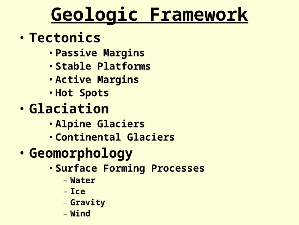
Geologic Framework• Tectonics
• Passive Margins• Stable Platforms• Active Margins• Hot Spots
• Glaciation• Alpine Glaciers• Continental Glaciers
• Geomorphology• Surface Forming Processes
– Water– Ice– Gravity– Wind

Present Plate Boundaries

BASIC TYPES OF PLATE INTERACTION
Stream Systems on
Dynamic Earth

North America
Structure– Craton
• Shield• Stable Platform
– Mobile Belts
Tectonic Activity– Active Margin– Passive Margin
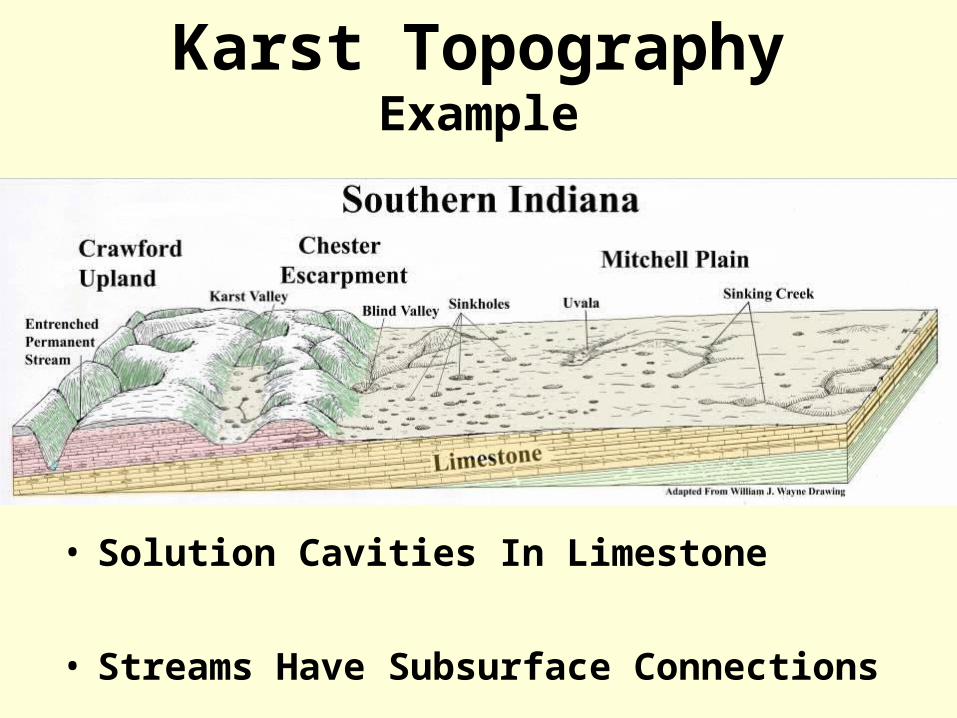
Karst TopographyExample
• Solution Cavities In Limestone
• Streams Have Subsurface Connections
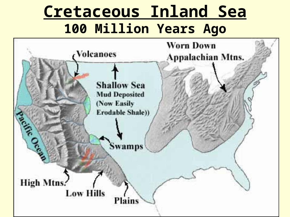
Cretaceous Inland Sea100 Million Years Ago

Vertical Plate Motion
Causes:Tectonic/Earthquake Activity
Erosion & Sediment Loading
Glaciation
Human Activities

Uplift Example

Himalayan Data
Present Height --- 30,000 Ft (9,500 m)
Tectonic Uplift Rate ---More Than 1 cm/yr
Erosion Rate ---Now Equals Uplift Rate
Sediment Yields Highest Known

Worldwide Erosion Rates

Oceanic-Continental Convergence
Oceanic Crust SubductsOcean Trench Forms
Lighter Melted Material RisesVolcanoes Form
Lithosphere Plunges Into Asthenosphere

Effects Of Plate Locking
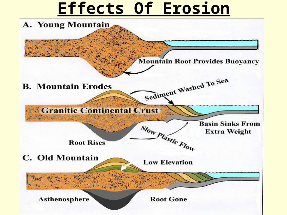
Effects Of Erosion

Man Induced Vertical Movement

Ongoing Elevation Changes

Active MarginNote:• Aleutian Trench
• Canada– Strike-Slip Faulting
• Mobile Belt Deposits
• California– Strike-Slip Faulting

Active Margin
• Ocean-Continent Subduction
• Strike Slip Faulting
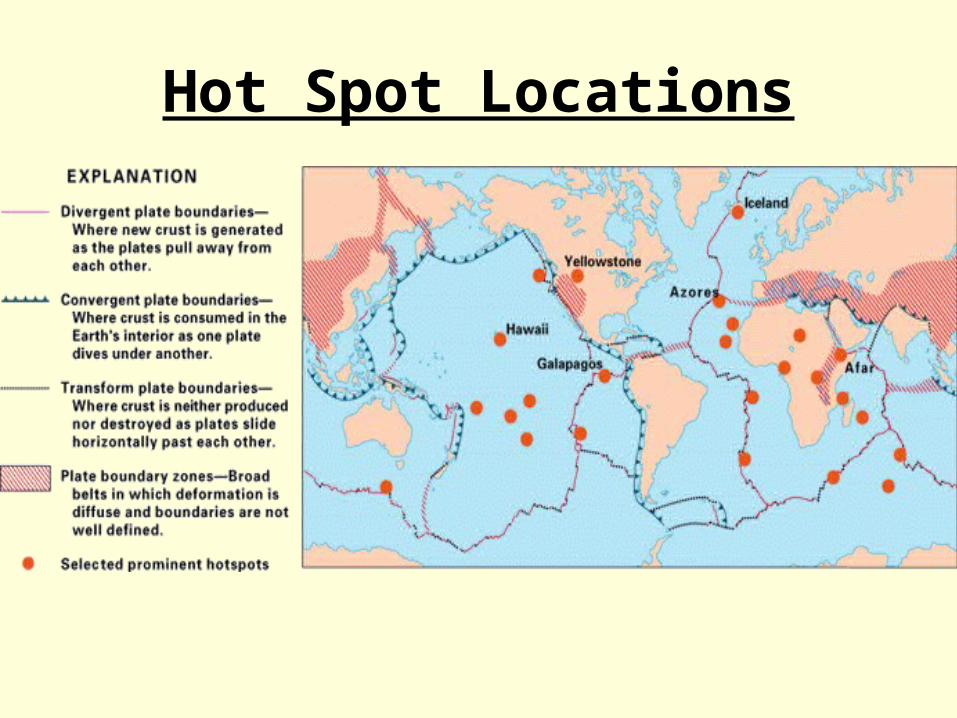
Hot Spot Locations
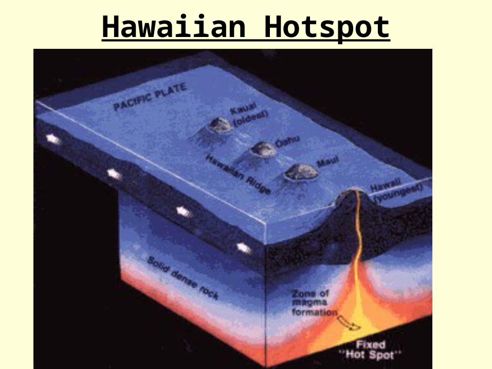
Hawaiian Hotspot
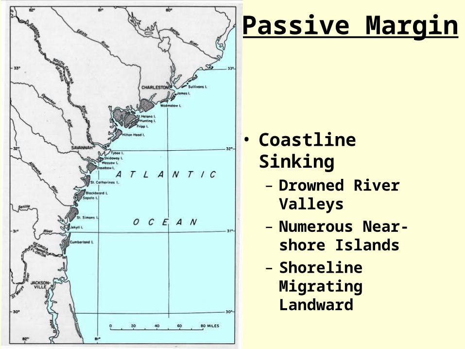
Passive Margin
• Coastline Sinking– Drowned River
Valleys– Numerous Near-
shore Islands– Shoreline Migrating
Landward

Northern Hemispheric Glacial Areas
16,000 B.P.
NOTE:
Portions Of Alaska
Are Ice Free

Pleistocene Glaciation
Note:• Alpine Glaciers• Continental
Glaciers• Ice Marginal Rivers• Alaska Ice Free
Area

Glacial Impact Areas
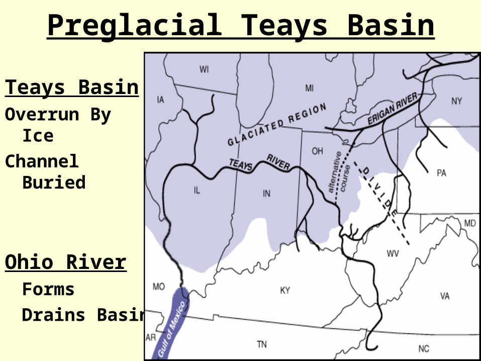
Preglacial Teays Basin
Teays BasinOverrun By Ice
Channel Buried
Ohio RiverForms
Drains Basin

Western Glacial Lakes
15,000 B.P.
– Climate Much Wetter Than Present
– Large Basins Had Internal Drainage

Loess
Wind Blown Silt
From GlaciersRock Flour
Stream Banks Stand Vertical
When Stable

Glacial ReboundContours In Meters Uplift

Great Lakes Glacial ReboundContours – Uplift per 100 Yrs.
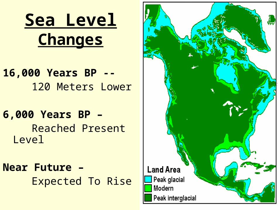
Sea Level Changes
16,000 Years BP -- 120 Meters Lower
6,000 Years BP – Reached Present Level
Near Future – Expected To Rise

Holocene Sea Level Changes
Primarily Cause --- Glacial Melting
In The
Northern Hemisphere

Erosion In River Basins
Controlling Factors:• Chemical vs. Mechanical Weathering
– Temperature– Precipitation
• Basin Gradient
• Basin Soil/Bedrock Type
• Tectonic Activity

Chemical & Mechanical Weathering

Erosion Processes

Erosion Processes
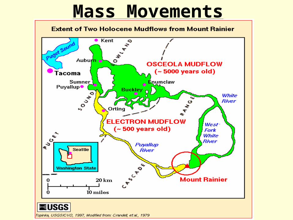
Mass Movements
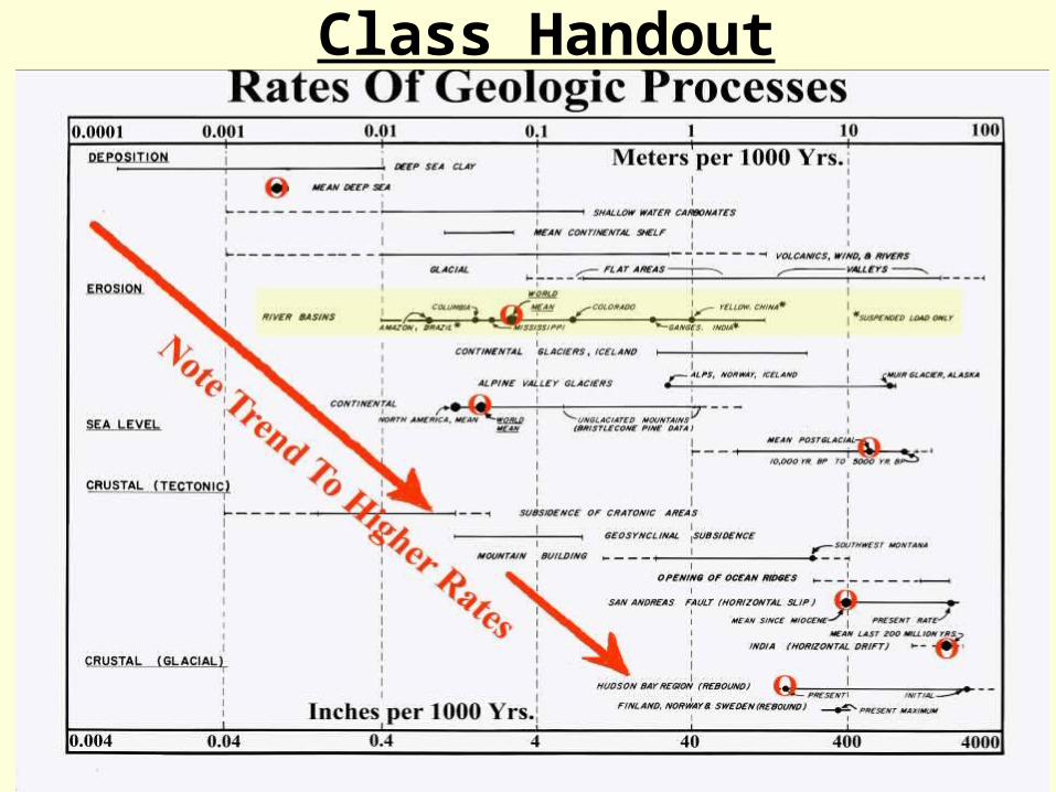
Class Handout
CASE STUDIES
• Columbia River
• Mississippi River
• Ohio River
• Potomac River
• Red River of the North
• Rio Grande River
• Santa Ana River

Geologic Setting
Tectonic Glacial Water Sediment Outlet
COLUMBIA RIVER (INCLUDING ROCKY MTN. TRENCH,
SNAKE RIVER, WILLAMETTE RIVER, COLUMBIA RIVER BAR &
LONG BEACH)
Active Margin, Subducting Plate, Flood Basalts Shifted Channel
Alpine Glaciation, Lake Missoula Floods, Bonneville Flood
Significant Snow-pack, Dryer Summers
Considerable Bedrock Control, Average
Sediment Production
Pacific Ocean, Glacial Flood Deposits Off Coast, Northern Shore Current
Dominant
MISSISSIPPI RIVER (INCLUDING MISSOURI RIVER &
LOUISIANA DELTA)
Passive Margin, Stable Mid-continent Shelf, Coastal Zone
Sinking
Major Glacial Meltwater Channel, Strong Impact From Low Glacial
Sea Level
Heavy Lowland Spring Runoff, Heavy
Rainfall At Times
Large Quantities Of Fine Sediment And Dissolved
Solids
Gulf Of Mexico, Large Marine Fan-delta, Westward Coastal
Circulation
OHIO RIVER (INCLUDING TEAYS RIVER, MONONGAHELA RIVER &
ALLEGHENY RIVER)
Stable Mid-continent, Heads In Old Eroded Allegheny Mtns., Crosses Stable Mid-continent
Sedimentary Shelf
Ice Marginal Channel Built From Pieces Of Numerous Drainages
Significant Spring Runoff, Above
Average Precipitation
Below Average Because Of Low Elevation And
Good Vegetative Cover
Flows Into Mississippi River, Can Have Flood
Synchronization Problems
POTOMAC RIVER (INCLUDING CHESAPEAKE BAY &
DELMARA PENINSULA)
Passive Margin, Heads In Old Eroded Allegheny Mtns., Crosses
Into Sinking Sedimentary Coastal Shelf, Impacted By A
Meteor
Originally Graded To Low Glacial Sea level
Above Average Precipitation
Below Average Because Of Low Elevation And
Good Vegetative Cover
Atlantic Ocean, Submerged River Valley,
Northern Coastal Circulation.
RED RIVER OF THE NORTH (INCLUDING LAKE WINNIPEG &
HUDSON BAY)
Stable Mid-continent, Flows From Sedimentary Shelf OnTo
Continental Craton
Originates In Glacial Lake Agassiz, Flows North Against
Glacially Induced Crustal Rebound Centered Near Hudson Bay, Stream Gradient Lowering
Rapid Spring Lowland Snowmelt Occasionally Mixed
With Rain
Fine Grained Derived From Old Glacial Lake
Bed
Hudson Bay That Has Uplifted Over 100 Meters
Since The Last Glaciation
RIO GRANDE RIVER (INCLUDING ELEPHANT BUTTE
RESERVOIR, RIO PUERCO & PADRE ISLAND)
Active Uplift At Head (Mtn. Building), Mouth Sinking At
Passive Margin
No Significant Glacial Impacts, Small Amount Of Alpine
Glaciation At Head
Area Arid, Significantly Higher Precipitation During
Glacial Periods
High Fine Sediment Production Caused By
Occasional High Intensity Storms And Scant Vegetative Cover
Gulf Of Mexico, Northeast Coastal Circulation
Strongly Influences The Stability Of Padre Island
SANTA ANA RIVER (INCLUDING SAN BERNARDINO
MTNS., PRADO WETLANDS, LOS ANGLES BASIN & HUNTINGTON
BEACH)
Active Margin, Strike-slip Faulting Very Active
No Significant Glacial Impacts
Area Arid, Significantly Higher Precipitation During
Glacial Periods,Water
Imported Into Basin
High Fine Sediment Production Caused By
Occasional High Intensity Storms And Scant Vegetative Cover
Pacific Ocean, Southern Coastal Circulation
Influences Huntington Beach
GEOLOGIC SETTINGRIVER BASIN
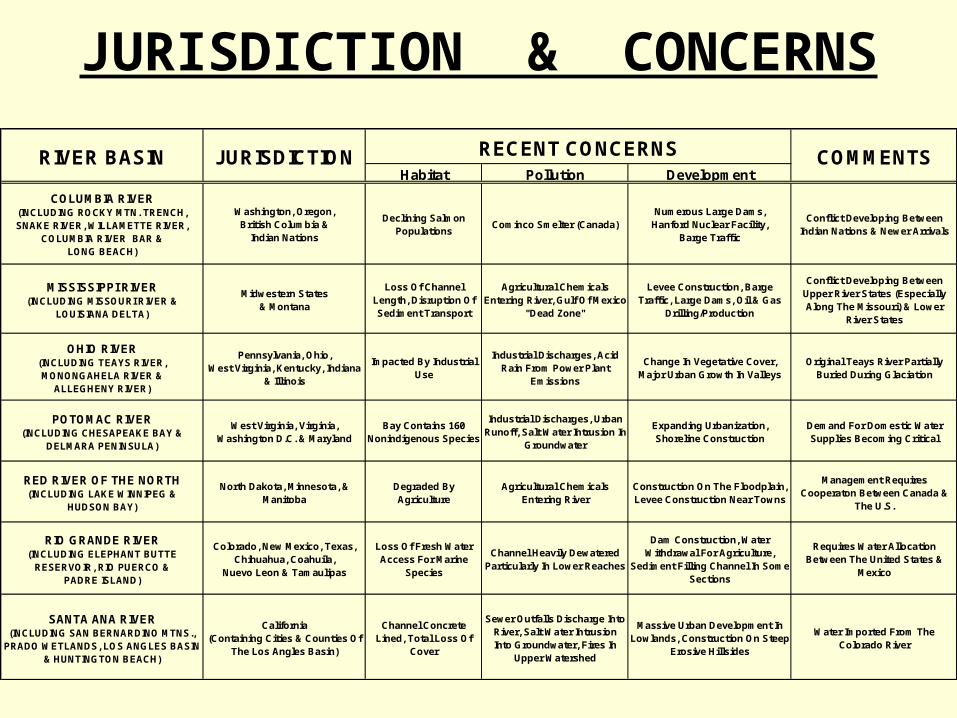
JURISDICTION & CONCERNS
Habitat Pollution Development
COLUMBIA RIVER (INCLUDING ROCKY MTN. TRENCH, SNAKE RIVER, WILLAMETTE RIVER,
COLUMBIA RIVER BAR & LONG BEACH)
Washington, Oregon, British Columbia &
Indian Nations
Declining Salmon Populations
Cominco Smelter (Canada)Numerous Large Dams,
Hanford Nuclear Facility, Barge Traffic
Conflict Developing Between Indian Nations & Newer Arrivals
MISSISSIPPI RIVER (INCLUDING MISSOURI RIVER &
LOUISIANA DELTA)
Midwestern States & Montana
Loss Of Channel Length, Disruption Of Sediment Transport
Agricultural Chemicals Entering River, Gulf Of Mexico
"Dead Zone"
Levee Construction, Barge Traffic, Large Dams, Oil & Gas
Drilling/Production
Conflict Developing Between Upper River States (Especially Along The Missouri) & Lower
River States
OHIO RIVER (INCLUDING TEAYS RIVER, MONONGAHELA RIVER &
ALLEGHENY RIVER)
Pennsylvania, Ohio, West Virginia, Kentucky, Indiana
& Illinois
Impacted By Industrial Use
Industrial Discharges, Acid Rain From Power Plant
Emissions
Change In Vegetative Cover, Major Urban Growth In Valleys
Original Teays River Partially Buried During Glaciation
POTOMAC RIVER (INCLUDING CHESAPEAKE BAY &
DELMARA PENINSULA)
West Virginia, Virginia, Washington D.C. & Maryland
Bay Contains 160 Nonindigenous Species
Industrial Discharges, Urban Runoff, Salt Water Intrusion In
Groundwater
Expanding Urbanization, Shoreline Construction
Demand For Domestic Water Supplies Becoming Critical
RED RIVER OF THE NORTH (INCLUDING LAKE WINNIPEG &
HUDSON BAY)
North Dakota, Minnesota, & Manitoba
Degraded By Agriculture
Agricultural Chemicals Entering River
Construction On The Floodplain, Levee Construction Near Towns
Management Requires Cooperaton Between Canada &
The U.S.
RIO GRANDE RIVER (INCLUDING ELEPHANT BUTTE
RESERVOIR, RIO PUERCO & PADRE ISLAND)
Colorado, New Mexico, Texas, Chihuahua, Coahuila,
Nuevo Leon & Tamaulipas
Loss Of Fresh Water Access For Marine
Species
Channel Heavily Dewatered Particularly In Lower Reaches
Dam Construction, Water Withdrawal For Agriculture,
Sediment Filling Channel In Some Sections
Requires Water Allocation Between The United States &
Mexico
SANTA ANA RIVER (INCLUDING SAN BERNARDINO MTNS.,
PRADO WETLANDS, LOS ANGLES BASIN & HUNTINGTON BEACH)
California (Containing Cities & Counties Of
The Los Angles Basin)
Channel Concrete Lined, Total Loss Of
Cover
Sewer Outfalls Discharge Into River, Salt Water Intrusion Into Groundwater, Fires In
Upper Watershed
Massive Urban Development In Lowlands, Construction On Steep
Erosive Hillsides
Water Imported From The Colorado River
RIVER BASIN JURISDICTION RECENT CONCERNS COMMENTS

Slide Presentation Prepared By
Geomax, P.C.Dr. Donald R. Reichmuth, President
1023 W. 30th Ave.Spokane, WA 99203-1324
Phone & FAX – 509-838-6390E-mail – [email protected]