flora and fauna assessment 109-111 caravan head road
TRANSCRIPT
Flora and Fauna Assessment – 109 – 111 Caravan Head Road OYSTER BAY
1
Fraser Ecological Consulting
abn 797 637 40114
665 Scenic Road
Macmasters Beach NSW 2257
telephone 042323 8193
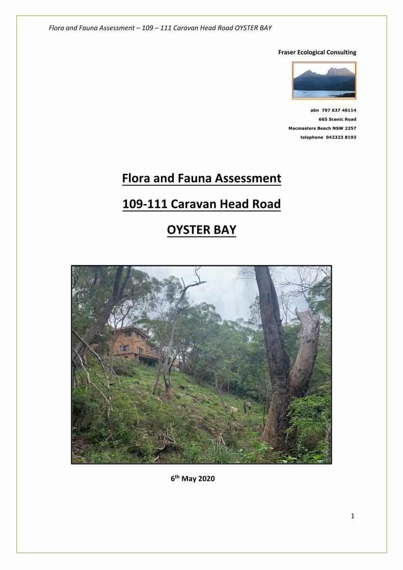
Flora and Fauna Assessment
109-111 Caravan Head Road
OYSTER BAY
6th May 2020
Flora and Fauna Assessment – 109 – 111 Caravan Head Road OYSTER BAY
2
EXECUTIVE SUMMARY Fraser Ecological Consulting has been contracted by Alistair McKerron to prepare an impact assessment of the proposed subdivision development on the terrestrial ecology located at 109 - 111 Caravan Head Road Oyster Bay in the Sutherland Shire Council local government area.
This assessment has been conducted in accordance with Commonwealth and State legislation.
Commonwealth legislation (Environment Protection and Biodiversity Conservation (EPBC) Act 1999) requires that actions judged to significantly impact upon matters of National Environmental Significance are to be assessed via a formal referral process. This assessment report determines whether a referral to be made to the Department of the Environment, Water, Heritage and the Arts for further assessment is required.
State legislation (Environmental Planning and Assessment Act 1979) requires that actions judged to significantly impact upon threatened species, populations or ecological communities, or their habitats listed under the Biodiversity Conservation Act (2016) trigger the preparation of a Species Impact Statement.
This assessment report applies considerations under Section 5A of the EPA Act (1979) and determines whether a significant impact is likely to occur and, correspondingly, whether a Species Impact Statement is required.
The proposal is to torrens title subdivide the block of land into 3 lots for the purposes of two lots and retention of the existing dwelling on the third lot. No development is proposed on waterfront lands. The development is situated as close as possible to Caravan Head Road (southern portion of the property) and will result in the additional removal of 0.5ha of a combination sparse native vegetation cover and mostly introduced weeds for the future building envelope and APZ on proposed Lot 3.
The proposal has significantly reduced ecological impacts in comparison the previously refused DA (5 lot Torrens Title Subdivision DA No. 17/1534) as determined by the Sutherland Shire Council Local Planning Panel (Business Paper dated 4th December 2018).
The proposal will result in the retention of 0.5ha remnant bushland (approximately 50% of the entire property) that can be subject to a Vegetation Management Plan conditioned by Council as 88e positive covenant (Restriction-as-to user) under the Conveyancing Act 1919 if approved by Council. Therefore, remnant bushland that connects with waterfront lands of Coronation Bay can protected and enhanced in perpetuity whilst facilitating the development proposal.
The site is mapped by the NSW Office of Environment & Heritage (2016) as containing the following plant community types (PCTs):
• PCT 1778 – Smooth-barked Apple Coast Banksia / Cheese Tree Open Forest on Sandstone Slopes on the foreshores of drowned River Valleys of Sydney
• PCT 1776 – Smooth-barked Red Bloodwood Open Forest on enriched sandstone slopes around Sydney and the Central Coast
The site does not contain a Threatened Ecological Community listed under the Biodiversity Conservation Act 2016. PCT 920 Mangrove Forests in estuaries of the Sydney Basin Bioregion and South East Corner Bioregion occurs along the foreshore of Coronation Bay along the northern boundary of the property, however, it will not at all be impacted by the proposal.
The native vegetation on site is in poor condition where the proposed development impacts will occur. The remnant community lack significant understorey vegetation, structure, species diversity and native resilience

Flora and Fauna Assessment – 109 – 111 Caravan Head Road OYSTER BAY
3
(low potential for natural regeneration) for a majority of the site. However, some areas contain some regenerating groundcover species and sparse distribution of locally indigenous canopy trees including the following species:
- Smooth-barked Apple (Angophora costata) - Red Bloodwood (Corymbia gummifera) - Black She Oak (Allocasuarina littoralis) - Sydney Peppermint (Eucalyptus piperita)
Introduced noxious and environmental weeds dominate the site particularly including highly invasive Asparagus Fern (Asparagus aethiopicus) and Lantana camara. The site is constantly under pressure from typical urbanisation pressures such as external weed and nutrient sources which further inhibition of natural regeneration.
Two hollow-bearing trees are proposed for removal within the indicative building envelope of proposed Lot 3. Targeted surveys were undertaken to ensure no threatened fauna use these potential habitats. Potential breeding and roosting habitat for Powerful Owl (Ninox strenua) will not be impacted by the proposal. The hollow bearing habitat features could be relocated and kept on-site within the 0.5ha of retained forest within a future Restricted Development Area (RDA) Proposed Lot 3.
The potential development impact areas do not contain potential habitat for threatened Thick Lip Spider Orchid (Caladenia tessallata) and this species was no detected during the entire property despite targeted surveys undertaken during the optimal detection period (October 2019).
Sufficient riparian setbacks from a drainage line would be achieved in accordance with NSW Office of Water guidelines. The design of the allotment layout was specifically amended to reduce any potential APZ conflicts to the drainage line, and therefore, complies with Clause 4.b.2 of the Sutherland Shire DCP 2006. The drainage line can further protected by a future Restricted Development Area and VMP should the application be approved and conditioned as part of the Notice of Determination.
The major conclusion arising from this Flora and Fauna Impact Assessment is that the proposed works are unlikely to result in a significant impact on any listed species or communities providing that the applicant actively implements the recommendations from this assessment. Therefore, in accordance with the EPA Act (1979), BC Act (2016) and FM Act (1994), a Species Impact Statement is not required.

Flora and Fauna Assessment – 109 – 111 Caravan Head Road OYSTER BAY
4
Disclaimer
This document may only be used for the purposes for which it was commissioned.
Fraser Ecological Consulting accepts no liability or responsibility in respect of any use or reliance upon this report by any third party.
Unauthorised use of this report in any form is prohibited.
Licensing
When conducting flora and fauna surveys, consultants are required to possess licences to ensure that works are completed in an appropriate manner. Fraser Ecological Consulting is licensed under s.132c and s.91 of the NSW National Parks and Wildlife Act (1974) from the NSW Office of Environment & Heritage. This allows Alex Fraser to undertake scientific investigations, collect specimens of protected flora and fauna across NSW in service and non-service areas and undertake bushland restoration works in EECs. This licence requires that all survey results are reported to the NSW NPWS for inclusion into the Atlas of NSW Wildlife.
Alex Fraser also holds an Animal Research Authority under the Animal Research Act (1995), as administered by NSW Agriculture. Surveys are approved and supervised by an Animal Care and Ethics Committee, applying the standards as detailed in the Australian Code of Practice for the Care and Use of Animals for Scientific Purposes (NHMRC 1997).

Flora and Fauna Assessment – 109 – 111 Caravan Head Road OYSTER BAY
5
Contents 1. Introduction ................................................................................................................................. 6
2. Statutory Framework ................................................................................................................. 5
3. Methodology ............................................................................................................................. 12
3.1 Existing records ...................................................................................................................... 12
3.2. Literature review .................................................................................................................. 12
3.3 Desktop survey ....................................................................................................................... 13
3.4 Field Surveys ............................................................................................................................ 13
3.5 Targeted surveys ............................................................................................................... 14 Call playback (Large Forest Owls) ................................................................................................................ 16 Spotlighting (All nocturnal fauna species) ................................................................................................ 16 Stagwatching (All nocturnal fauna species) ............................................................................................. 16 Diurnal survey methods (birds) .................................................................................................................... 17 Song-meter recording device .......................................................................................................................... 17 Microchiropteran bat surveys ........................................................................................................................ 17
3.5 Assessment of conservation value ................................................................................... 19
4. Results ........................................................................................................................................ 20 4.1. Plant Community Types (PCTs) .................................................................................................. 20 4.2. Plant species recorded on-site .................................................................................................... 24 4.2.1 Fauna habitat and species ................................................................................................... 27
4.2.2 Specific habitat features................................................................................................................. 27 4.2.3 Fauna results ...................................................................................................................................... 32
4.4 Fauna of Conservation Significance ................................................................................... 37
5. Assessment of Ecological Impacts ......................................................................................... 38
6. Environmental Protection Measures ............................................................................. 43
7. Conclusion ............................................................................................................................... 46
8. References ............................................................................................................................... 47
APPENDIX A: THREATENED SPECIES PREVIOUSLY RECORDED WITHIN 10KM OF THE SITE ........................................................................................................................................... 51
APPENDIX B: ASSESSMENTS OF SIGNIFICANCE ‘FIVE PART TESTS’ ............................. 59 Five part test for Little Lorikeet, Grey-Headed Flying-fox, Eastern Freetail-bat, Eastern Bent-wing Bat, Yellow-bellied Sheathtail-bat, Greater Broad-nosed bat and Eastern False Pipistrelle (State Biodiversity Conservation Act 2016) ........................................................................................................ 60 Five part test for Powerful Owl – Ninox strenua (State Biodiversity Conservation Act 2016) ...... 62
APPENDIX C: EPBC PROTECTED MATTERS SEARCH TOOL DATABASE RESULTS . 64
APPENDIX D: RELEVANT QUALIFICATIONS & EXPERIENCE OF THE AUTHOR ......... 65

Flora and Fauna Assessment – 109 – 111 Caravan Head Road OYSTER BAY
6
1. Introduction
1.1. Introduction
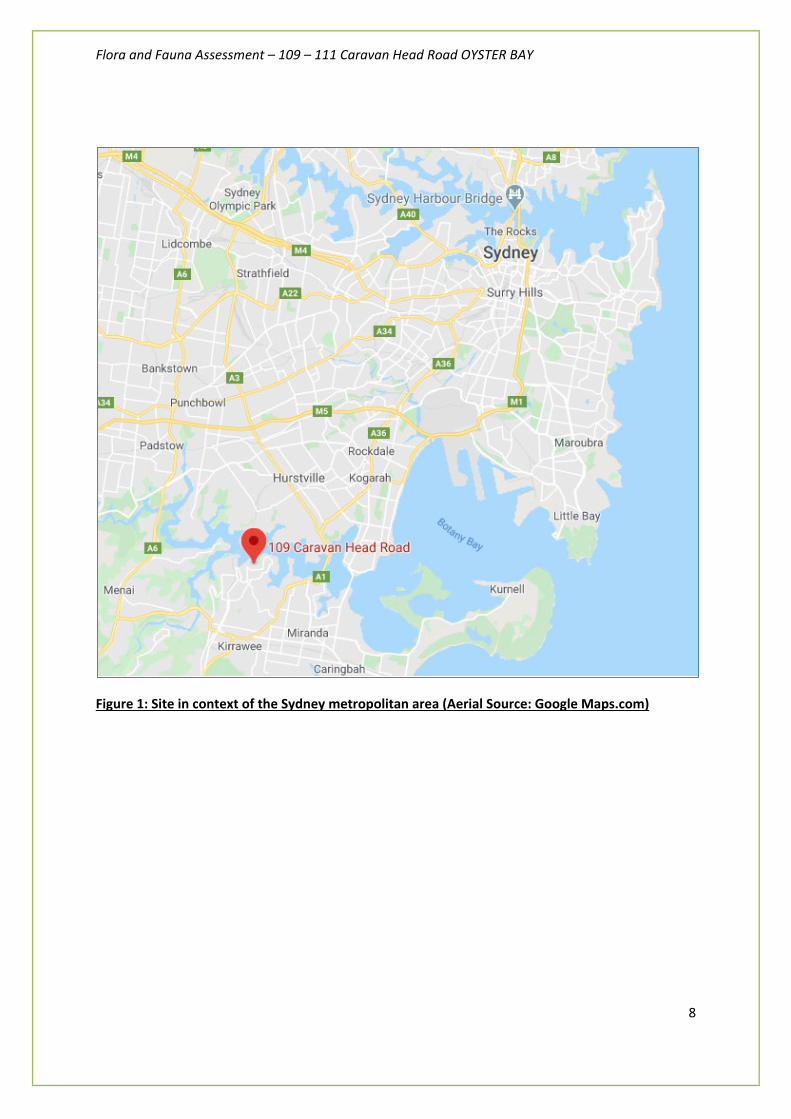
This terrestrial ecological assessment was commissioned by Alistair McKerron to prepare an impact assessment of the proposed subdivision development on the terrestrial ecology located at 109 - 111 Caravan Head Road Oyster Bay (Lot 432 DP 855460) in the Sutherland Shire Council local government area (Figures 1-4).
For the purposes of this report, the site is defined by the property boundaries of Lot 432, DP 855460. It is approximately 9,154 m2 in size and the elevation varies between approximately two and fifty metres above sea level. The site is adjacent to other residential properties, small patches of bushland and Coronation Bay.
Coronation Bay is part of the Georges River. The site is adjacent to other residential properties, small patches of bushland and Coronation Bay. The site is an old subdivision. A dwelling was constructed on the site sometime between 1955 and the early 1960s. A small retaining wall, possibly functioning as a sea wall is present near the northern boundary of the site adjacent to Coronation Bay. The lower portion of the site appears to have been cleared around the 1940s. This clearing is where on the indicative building envelopes is proposed.
The proposal is to torrens title subdivide the block of land into 3 lots for the purposes of two lots and retention of the existing dwelling on the third lot.
The terrestrial ecological assessment:
- Identifies key flora and fauna habitats within the subject site;
- Reviews literature and databases relevant to the subject site;
- Describes the methodology and results of the survey;
- Addresses potential impacts on flora and fauna and their habitats resulting from the proposed development;
- Proposes appropriate mitigation measures; and
- Provides an assessment of the likelihood of significant impacts on threatened species and populations, and endangered ecological communities, according to Section 5A of the NSW EPA Act, BC ACT, Commonwealth EPBC Act. This was done to determine the need for an SIS or an application under the EPBC Act.
Activities specifically related to the preparation of this report included:
• Identification of weed and indigenous native species recorded from the subject site

Flora and Fauna Assessment – 109 – 111 Caravan Head Road OYSTER BAY
7
• Assessment of impacts of the proposed development
• Outlining the applicant’s responsibilities including weed control and environmental safeguards before, during and post construction.
This assessment has taken into consideration the observations of previous Flora and Fauna works done on the site for previous development application DA/17/1534 that was refused in December 2018 and lodged by the previous owner. The former ecological reports that were lodged with the refused DA includes:
- Flora and Fauna Report prepared by Abel Ecology dated 11th October 2017 - Powerful Owl and Thick Lip Spider Orchid Management Plan prepared by Abel Ecology dated
October 2017 - Vegetation Management Plan prepared by Abel Ecology dated 27th October 2017
The proposal has significantly reduced ecological impacts in comparison the previously refused DA (5 lot Torrens Title Subdivision DA No. 17/1534) as determined by the Sutherland Shire Council Local Planning Panel (Business Paper dated 4th December 2018).
The current development proposal will involve the subdivision of 1 into 3 lots as follows:
• Proposed Lot 1 – 1254 sqm • Proposed Lot 2 – 1526 sqm • Proposed Lot 3 – 6446 sqm
A majority of this will occur within existing modified lands.
Flora and Fauna Assessment – 109 – 111 Caravan Head Road OYSTER BAY
8
Figure 1: Site in context of the Sydney metropolitan area (Aerial Source: Google Maps.com)

Flora and Fauna Assessment – 109 – 111 Caravan Head Road OYSTER BAY
9
Figure 2: Aerial map of in context of the local catchment (Aerial Source: Google Maps.com)

Flora and Fauna Assessment – 109 – 111 Caravan Head Road OYSTER BAY
10
Figure 3: Topographic map of site (Source: SIX Maps.com)

Flora and Fauna Assessment – 109 – 111 Caravan Head Road OYSTER BAY
1
Figure 4: Aerial map of site boundaries shown in red (Source: Department of Lands SIX Maps.com)
Flora and Fauna Assessment – 109 – 111 Caravan Head Road OYSTER BAY
2
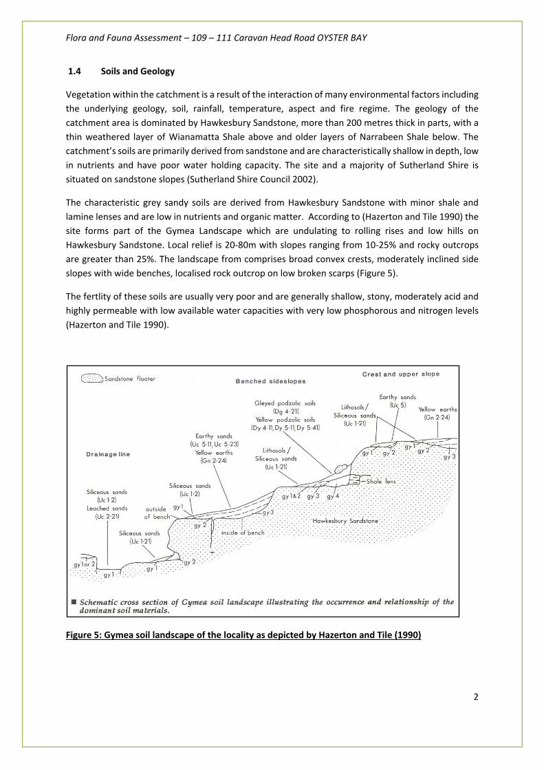
1.4 Soils and Geology
Vegetation within the catchment is a result of the interaction of many environmental factors including the underlying geology, soil, rainfall, temperature, aspect and fire regime. The geology of the catchment area is dominated by Hawkesbury Sandstone, more than 200 metres thick in parts, with a thin weathered layer of Wianamatta Shale above and older layers of Narrabeen Shale below. The catchment’s soils are primarily derived from sandstone and are characteristically shallow in depth, low in nutrients and have poor water holding capacity. The site and a majority of Sutherland Shire is situated on sandstone slopes (Sutherland Shire Council 2002).
The characteristic grey sandy soils are derived from Hawkesbury Sandstone with minor shale and lamine lenses and are low in nutrients and organic matter. According to (Hazerton and Tile 1990) the site forms part of the Gymea Landscape which are undulating to rolling rises and low hills on Hawkesbury Sandstone. Local relief is 20-80m with slopes ranging from 10-25% and rocky outcrops are greater than 25%. The landscape from comprises broad convex crests, moderately inclined side slopes with wide benches, localised rock outcrop on low broken scarps (Figure 5).
The fertlity of these soils are usually very poor and are generally shallow, stony, moderately acid and highly permeable with low available water capacities with very low phosphorous and nitrogen levels (Hazerton and Tile 1990).
Figure 5: Gymea soil landscape of the locality as depicted by Hazerton and Tile (1990)
Flora and Fauna Assessment – 109 – 111 Caravan Head Road OYSTER BAY
3
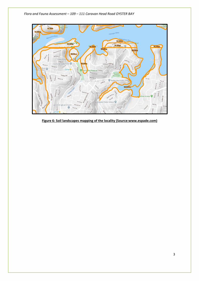
Figure 6: Soil landscapes mapping of the locality (Source:www.espade.com)

Flora and Fauna Assessment – 109 – 111 Caravan Head Road OYSTER BAY
4
1.45 Climate
The climate of the area is temperate and influenced by coastal sea breezes with mild to hot summers and cool to cold winters. The Port Hacking station shows a mean annual rainfall of 1036mm (Bureau of Meteorology 2020).

Flora and Fauna Assessment – 109 – 111 Caravan Head Road OYSTER BAY
5
2. Statutory Framework
The criteria used to assess likely impacts upon threatened species, populations or endangered ecological communities vary between Commonwealth and State jurisdictions. The following describes the legislative requirements for each level.
2.1. Commonwealth
The Environment Protection and Biodiversity Conservation Act (1999) (EPBC Act) is a nationally applicable Act that is administered by the Department of the Environment, Water, Heritage and the Arts. This Act requires approval for actions that are likely to have a significant impact on matters of National Environmental Significance (NES).
There are seven matters of NES that are triggers for Commonwealth assessment and approval. These are:
1. World Heritage properties; 2. National Heritage places; 3. Ramsar wetlands of international importance; 4. Nationally threatened species and communities; 5. Migratory species; 6. Nuclear actions; and 7. Commonwealth marine environment.
Threatened species and ecological communities are listed under Part 13, Division 1, Subdivision A of the EPBC Act 1999. Migratory species are listed under part 13, Division2, Subdivision A of the Act.
The Department of the Environment and Water Resources identifies the following:
“Under the EPBC Act a person must not take an action that has, will have or is likely to have significant impact on any of these matter of NES without approval from the Commonwealth Environment Minister. There are penalties for taking such an action without approval.
In general, an action that may need approval under the Act will involve some physical interaction with the environment, such as clearing native vegetation, building a new road, discharging pollutants into the environment, or offshore seismic survey.
If, following a referral, it is determined that that an action is likely to have a significant impact, and approval is therefore required, the action is called a 'controlled action'. The proposal will then undergo a formal assessment and approval process, and cannot proceed unless approval is granted.
If it is determined that an action is not likely to have a significant impact, then the action is not a controlled action. Approval under the EPBC Act is not required and the action may proceed, subject to obtaining any other necessary permits or approvals.”
Flora and Fauna Assessment – 109 – 111 Caravan Head Road OYSTER BAY
6
2.2. State
Water Management Act 2000
Under Part 3 (Approvals], Division 1, Section 91 (2), a controlled activity approval confers a rights on its holder to carry out a specified controlled activity at a specified location in, on or under waterfront land. Waterfont land is defined as:
a) the bed of any river or lake, and any land lying between the bed of the river or lake and in a line drawn parallel to, and the prescribed distance inland of:
- in the case of non-tidal waters, the highest bank or shore above the river or lake, and
- in the case of tidal waters, the mean high water mark of the river or lake, and
b) if the regulations so provide, the bed of the coastal waters of the State, and any land lying between the shoreline of the coastal waters and a line drawn parallel to, and the prescribed distance inland of, the mean high water mark of the coastal waters, where the prescribed distance is 40 metres of ( if the regulations prescribe a lesser distance, either generally or in relation to a particular location or class of locations) that lesser distance.
Under the WM Act, a controlled activity is defined as:
a) the erection of a building or the carrying out of work (within the meaning of the EPA&A Act), or
b) the removal of material (whither or not extractive material) or vegetation from land, whether by way of excavation or other wise, or
c) the deposition of material (whether or not extractive material) on land, whether by way of landfill operations or otherwise, or
d) the carrying out of any other activity that affects the quantity of or flow of water in a waters sources.
A controlled activity approval will not be granted unless the Minister is satisfied that adequate arrangements are in force to ensure that minimal harm will be done to any waterfront land as a consequence of carrying out the proposed controlled activity.
Local
Sutherland Shire Local Environment Plan 2015 (SSLEP 2015)
The property is within Zone E3 Environmental Management under the provisions of Sutherland Shire Local Environment Plan 2015 (SSLEP 2015). SSLEP2015 indicates that the site is mapped as being affected by a 30m foreshore building line (FBL), Class 5 acid sulphate soils, within Greenweb Çore’, an area of high aboriginal significance and is environmentally sensitive land (environmental and scenic qualities of natural landforms, riparian land and watercourses and terrestrial biodiversity).
Flora and Fauna Assessment – 109 – 111 Caravan Head Road OYSTER BAY
7
The Sutherland Shire Development Control Plan 2015 (SSDCP2015) applies to all land to which Sutherland Shire Local Environmental Plan 2015 (SSLEP2015) applies. The SSDCP2015 has been prepared to provide more detailed provisions with respect to carrying out development permissible under the SSLEP2015.
Section 79C of the Environmental Planning and Assessment Act sets mandatory heads of consideration that form the basis of development assessment, including:
• The likely impacts of the development, including environmental impacts on both the natural and built environments, and social and economic impacts in the locality
• The suitability of the site for the development
• The public interest. This DCP contains detailed objectives and controls that will be used by council when determining applications. Essentially the DCP sets benchmarks of what is acceptable in land use, development and environmental management decisions. Each application will be considered on the individual circumstances and merits of the case in terms of achieving the objective. However, any variation to the controls must be supported by a statement documenting how these objectives are fully satisfied. Any submission in support of a variation to a control must be in writing and demonstrate how the objectives have been achieved. The DCP also contains administrative provisions that detail how development applications will be publicly notified and the duration of consents.
Greenweb Strategy
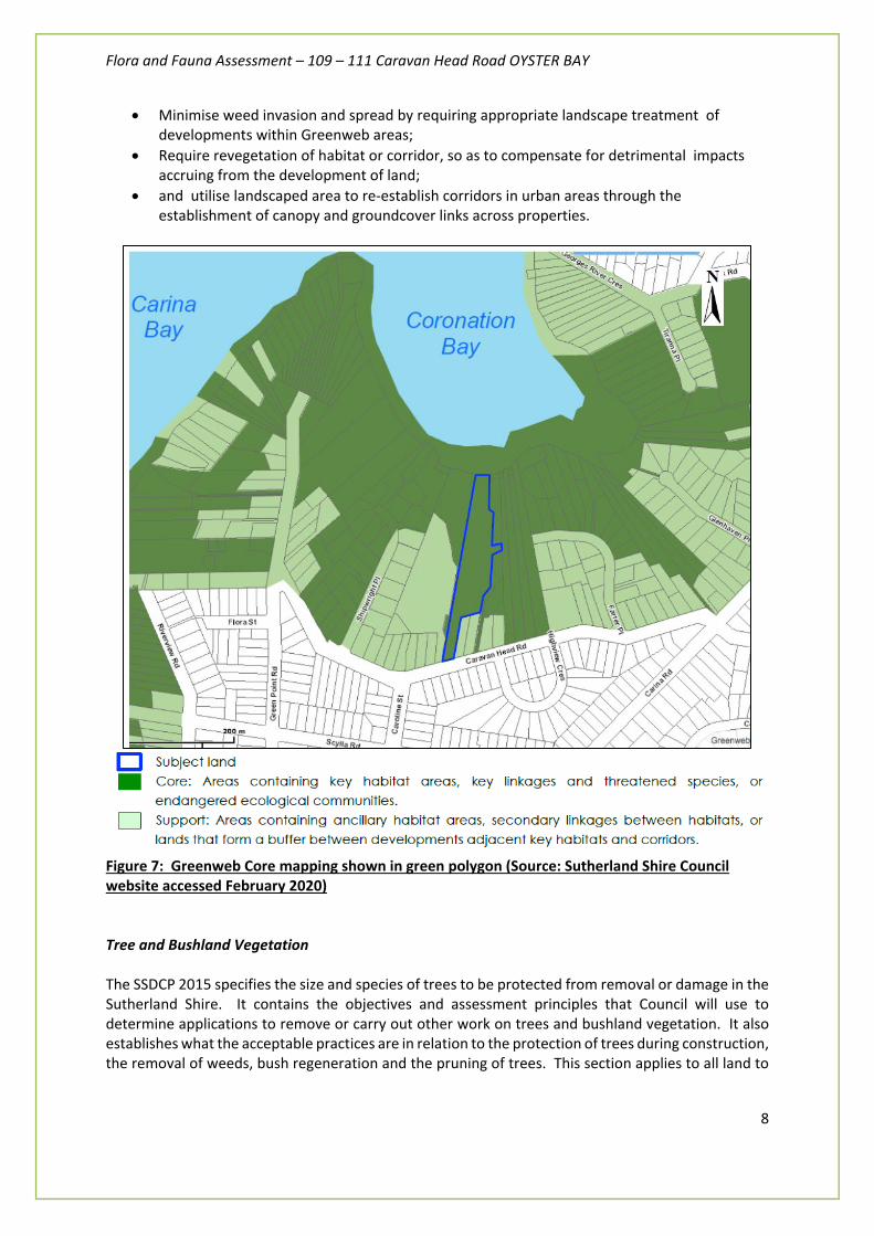
The site has Council constraints covering the protection of vegetation on the property. The entire site is listed under Sutherland Shire Council’s Greenweb Strategy for the purpose of habitat connectivity but in addition, the northern end of the site has two overlays placed on it, for:
- A threatened vegetation community and associated buffer, and - A mangrove/riparian vegetation and waterway buffer.
The SSDCP 2015 identifies key habitat and habitat linkage areas called Greenweb Areas as part of a strategy to improve and maintain habitat and wildlife corridors in the Sutherland Shire. Developmental objectives and controls exist for all areas mapped as Greenweb Core, Greenweb Support and Greenweb Restoration. The subject site is mapped as Greenweb Core (Figure 7). The objectives for all development in Greenweb Areas are to:
• Prevent direct loss of habitat in core and support areas by requiring the retention or restoration of areas of habitat in a size and configuration that will enhance long term sustainability;
• Prevent fragmentation of bushland by requiring the landscaped component of a site to function as a wildlife corridor, linking proximate areas of core habitat;
• Improve the function of riparian zones and foreshores as natural areas so that they provide linkages and corridors between areas of habitat;
Flora and Fauna Assessment – 109 – 111 Caravan Head Road OYSTER BAY
8
• Minimise weed invasion and spread by requiring appropriate landscape treatment of developments within Greenweb areas;
• Require revegetation of habitat or corridor, so as to compensate for detrimental impacts accruing from the development of land;
• and utilise landscaped area to re-establish corridors in urban areas through the establishment of canopy and groundcover links across properties.
Figure 7: Greenweb Core mapping shown in green polygon (Source: Sutherland Shire Council website accessed February 2020) Tree and Bushland Vegetation The SSDCP 2015 specifies the size and species of trees to be protected from removal or damage in the Sutherland Shire. It contains the objectives and assessment principles that Council will use to determine applications to remove or carry out other work on trees and bushland vegetation. It also establishes what the acceptable practices are in relation to the protection of trees during construction, the removal of weeds, bush regeneration and the pruning of trees. This section applies to all land to

Flora and Fauna Assessment – 109 – 111 Caravan Head Road OYSTER BAY
9
which the SSDCP 2015 applies, except land zoned National Parks and Special Uses (Defence) and any land under the ownership or care, control and management of Sutherland Shire Council. In particular, Clause 4.b.2 of the SSDCP 2006, specifies that the controls for the preservation of trees and bushland vegetation applies to any tree or bushland vegetation which satisfies any one or more of the following criteria:
• A single or multi-trunked tree with a diameter of 100mm or more measured at 500mm above ground level;
• Any bushland vegetation, including mangroves. Bushland vegetation is defined in this clause as vegetation which is either remnant of the natural vegetation of the land or, if altered, is still representative of the structure and floristics of the natural vegetation. Bushland vegetation includes trees of any size, shrubs and all herbaceous species;
• and any tree and/or riparian vegetation growing within 4 metres of a creek or watercourse.
Rural Fires Amendment (Vegetation Clearing) Bill 2014 The recent Rural Fires Amendment (Vegetation Clearing) Bill 2014 gives the relevant authorities a mechanism to clear certain vegetation for the purposes of preventing a bushfire. The bill seeks to authorise vegetation clearing work to be carried out in certain areas near residential accommodation or high-risk facilities to reduce bushfire risk. This bill will give residents living in bushfire-prone areas additional powers to protect their homes and to clear trees and vegetation from around their property. The new laws will provide for people with homes in bushfire zones to clear within 10 metres of their home and to clear shrubs and other vegetation, except for trees, within 50 metres of their home. The vegetation clearing entitlement area may carry out certain vegetation clearing work on that land, despite any requirement for an approval, consent or other authorisation for the work made by other legislation.
The bill provides that the Commissioner of the NSW Rural Fire Service is to determine what land is a 10/50 vegetation clearing entitlement area and to identify this land on a map published on the NSW Rural Fire Service website. The map has yet been published. However, it is understood that by accessing a portal on the Rural Fire Service website, home owners will be able to identify easily whether their home stands within an entitlement area. It is unknown when this map will be produced, however, given the location of the dwelling it is likely that site would be contained within the mapped area.
The bill states that vegetation clearing work must be carried out in accordance with the 10/50 clearing code of practice, which is to be prepared by the commissioner and is to deal with certain matters. Those matters are listed in the bill as follows:
(a) the type of vegetation that can and cannot be cleared, including the types of trees, (b) the circumstances in which vegetation should be pruned and not entirely removed, (c) the use of herbicides, (d) managing soil erosion and landslip risks, (e) protection of riparian buffer zones,

Flora and Fauna Assessment – 109 – 111 Caravan Head Road OYSTER BAY
10
(f) protection of Aboriginal and other cultural heritage, (g) protection of vegetation that the owner of the land on which vegetation clearing work may
be carried out is under a legal obligation to preserve by agreement or otherwise
The code of practice has not yet been prepared. The bill further states the vegetation clearing work that can be carried out is the removal, destruction (by means other than by fire) or pruning of:
• any vegetation (including trees or parts of trees) within 10 metres of an external wall of a building containing habitable rooms that comprises or is part of residential accommodation or a high-risk facility, and
• any vegetation, except for trees or parts of trees, within 50 metres of an external wall of a building containing habitable rooms that comprises or is part of residential accommodation or a high-risk facility.
Of most relevance to the development application, the bill also makes consequential amendments to the National Parks and Wildlife Act 1974 to expand the exemptions contained in sections 118A and 118D of that Act, provided there is compliance with the 10/50 Vegetation Clearing Code of Practice.
Biodiversity Conservation Act 2016
Proponents should be aware that transitional arrangements under the new Scheme have not been fully developed and, in some cases, NSW Office of Environment and Heritage (OEH) should be approached directly for further information. The BC Act sets out the biodiversity assessment requirement for any development or activity that requires assessment or approval under the EP&A Act. The main elements of the Act:
- New Biodiversity Offsets Scheme (BOS) - New assessment methodology - Biodiversity Assessment Method (BAM) - Establishment of a Biodiversity Conservation Fund (collects and directs spending of offset
monies throughout the state) - Expansion of Biodiversity Certification for large rezoning proposal and masterplan ‘green
field’ type developments (streamlined assessment at strategic planning stage)
It also consolidates:
- existing wildlife licensing requirements - nominations of areas of outstanding biodiversity values - updated criteria for listing threatened species and communities - biodiversity offsets scheme - Biocertification (large scale master planning development) - Biodiversity stewardship agreements (where offset credits are created)
Note: The BOS area clearing threshold in this Act is also applied within the new SEPP and LLS Act. If the amount of native vegetation clearing application is below the threshold it is optional if the applicant wants to submit a Biodiversity Assessment Report (BAR). In relation to Council DAs assessments, Part 4 local development requires application of the BAM to determine whether an offset obligation if it either:

Flora and Fauna Assessment – 109 – 111 Caravan Head Road OYSTER BAY
11
1) Exceeds the BOS threshold (also referred to as ‘area trigger’) 2) Located in an area of ‘Sensitive Biodiversity Values’
The Act sets outs the Biodiversity Assessment Methodology (BAM) which directs the methodology to be undertaken by accredited assessors (consultants) to produce a Biodiversity Assessment Report (BAR) submitted with a development application. The BAM sets out a detailed, complex and quantitative assessment methodology for producing the assessment report (BAR).
The methodology sets a framework for decision makers (Council assessment officers) to determine whether or not the proposal will have ‘Serious and Irreversible Impact (SAII)’ for certain threatened species and communities (referred to as ‘candidate entities’).
For local developments, the new regulations make the new Offset Scheme mandatory for applications assessed under part of the Act that exceed the BOS thresholds. Under the Act, and offsets calculator will be used by accredited and appropriately trained assessors.
Tests of significance (‘5 part tests’) are set out in s.7.3 of the Biodiversity Conservation Act 2016. The tests determine the need for a Species Impact Statement (SIS).
Figure 8: The site is not mapped on the OEH sensitive biodiversity values map (above).
Flora and Fauna Assessment – 109 – 111 Caravan Head Road OYSTER BAY
12
3. Methodology
This chapter presents the methods used in conducting the ecological survey and assessment of the conservation importance of the study area.
3.1 Existing records
Records of threatened flora and fauna species and populations, listed in the schedule of the TSC and EPBC Acts, were obtained and reviewed to document known locations threatened and regionally significant fauna within the locality. The source of these records was the NSW OEH Bionet and the Department of Environment, Water, Heritage and the Arts online Protected Matters Search Tool database (Appendix C) for an area covering approximately 10km radius of the subject site.
3.2. Literature review
A literature review was carried out. Of particular importance were those containing records of species, populations and communities of conservation significance. This background information informed the impact assessment.
The following information was relied upon in regard to local conservation and planning issues for this study.
1. Soil landscapes of the Sydney 1: 100 000 Sheet (Hazelton and Tile 1990)
The subject site has been mapped as occupying the Gymea soil landscape as already described in Section 1.4. Sandstone Gullies provide humid and fire-free conditions for the development of temperate rainforest which can grow on sandy soils with low nutrients.
2. Sutherland Shire Biodiversity Strategy (Sutherland Shire Council 2000)
This planning document details the biodiversity of the Sutherland LGA, the legislative framework for its conservation and priority conservation and planning actions. The strategy identifies major habitat corridors and identifies both environmental and noxious weeds. Additionally, it lists species of flora and fauna of local and state conservation significance.
3. The Native Vegetation of the Sydney Metropolitan Area. Volume 2: Vegetation Community Profiles (2016 Version 3.0) This contains a detailed profile of each vegetation community, describing their occurrence and floristic composition – along with technical data to assist with identifying the community in the field – as well as their relationships to threatened ecological communities (TECs) listed under the NSW Threatened Species Conservation Act 1995 (now under the Biodiversity Conservation Act 2016) and Commonwealth Environment Protection and Biodiversity Conservation Act 1999.
Flora and Fauna Assessment – 109 – 111 Caravan Head Road OYSTER BAY
13
3.3 Desktop survey
A desktop survey was performed to ensure all relevant documentation is considered when preparing the plan. Documents and other information resources utilised include:
• Aerial photographs (Google Maps, NearMaps & DPI Land Information)
• Architectural Plans, Engineering Plan, Bushfire and Arborist Report
• Soil Landscapes of the Sydney 1:100,000 Sheet (Hazerton and Tile 1990)
• Civil Engineering Plans prepared by Greenview Consulting
This assessment has taken into consideration the observations of previous Flora and Fauna works done on the site for previous development application DA/17/1534 that was refused in December 2018 and lodged by the previous owner. The former ecological reports that were lodged with the refused DA includes:
- Flora and Fauna Report prepared by Abel Ecology dated 11th October 2017 - Powerful Owl and Thick Lip Spider Orchid Management Plan prepared by Abel Ecology dated
October 2017 - Vegetation Management Plan prepared by Abel Ecology dated 27th October 2017
3.4 Field Surveys
A visual inspection was undertaken on the 9th October, 11th November, 10-15th December 2019 & 3rd February 2020 to identify and evaluate the current vegetation community occurring on the subject site, identify any threatened flora and fauna species and assess the current nature and extent of fauna habitats.
Features of the vegetation including floristics, structure, extent, type and projective foliage cover, presence of weed species and other significant features were noted and recorded). All flora recorded were predominantly identified to family, genus and species level with confirmation according to Field Guide to the Native Plants of Sydney (Robinson, 2003), Weeds of the south-east: an identification guide for Australia (Richardson, 2006), Tree & Shrubs in Rainforest of New South Wales and Southern QLD (Williams et al 1984), Native Plants of the Sydney District (Fairly and Moore 2000) and the Botanic Gardens Trust (2009) PlantNET flora database.
It was not possible to determine with certainty all the fauna that utilise habitats in the subject site. This is because of the likely seasonal occurrences of some fauna species, the occasional occurrence of vagrant species, and because some species are difficult to detect because of their timid or cryptic behaviour. However, all efforts were made to address all potential fauna that may use the site.
Fauna investigations comprised of
1) An assessment of fauna habitats present on site and an indication of their potential to support native wildlife populations and, in particular, threatened species.

Flora and Fauna Assessment – 109 – 111 Caravan Head Road OYSTER BAY
14
2) Targeted surveys for threatened species requested by Council (letter dated 24th October 2014) after the submission of the original Flora and Fauna Assessment in March 2014. The methods and results of these surveys are provided within Appendix C. NPWS format Survey proformas can be provided upon request.
The fauna habitat assessment criteria included:
Mammals: extent of ground cover, shrub layer and tree canopy, hollow-bearing trees, substrate type (for burrowing etc), evidence such as droppings, diggings, footprints, scratches on trees, nests, burrow paths and runways.
Birds: structural; features such as the extent and nature of the canopy, understorey and ground strata and flowering character
Reptiles and amphibians: cover shelter, suitable substrate, basking and breeding site availability, reptiles and frogs sough in likely sheltering places
Invertebrates: logs and other debris, leaf and bark accumulations around base of trees, grass clumps, loose soil for burrowing
Wildlife corridor values: Importance of the creek systems and riparian vegetation as movement corridors for fauna, especially birds, aquatic fauna, mammals (e.g. microchiropteran bats) & amphibians
3.5 Targeted surveys
Relevant targeted survey guidelines were used, including:
- OEH Biodiversity Assessment Method, 2017 No 469
- NSW Guide to Surveying Threatened Plants (OEH, 2016)
- 'Species credit' threatened bats and their habitats: NSW survey guide for the Biodiversity Assessment Method (OEH, 2018)
- Threatened Biodiversity Survey and Assessment: Guidelines for Developments and Activities (Department of Environment and Conservation (DEC), 2004)
- OEH Threatened Species, Populations and Ecological Communities website
- Commonwealth DEE Species, Profile and Threats Database;
- Commonwealth Conservation Advice – Pommerhelix duralensis (Dural Land Snail) (Commonwealth of Australia 2015a);
- Threatened species survey and assessment guidelines: field survey methods for fauna: Amphibians (DEC 2009);
- NSW Guideline to Surveying Threatened Plants (OEH 2016b);
- Operational Manual for BioMetric 3.1. (DECCW 2011);

Flora and Fauna Assessment – 109 – 111 Caravan Head Road OYSTER BAY
15
- Survey guidelines for Australia’s threatened birds. Guidelines for detecting birds listed as threatened under the Environment Protection and Biodiversity Conservation Act 1999 (Commonwealth of Australia 2010a);
- Survey guidelines for Australia’s threatened bats. Guidelines for detecting bats listed as threatened under the Environment Protection and Biodiversity Conservation Act 1999(Commonwealth of Australia 2010b);
- Survey guidelines for Australia’s threatened frogs. Guidelines for detecting frogs listed as threatened under the Environment Protection and Biodiversity Conservation Act 1999 (Commonwealth of Australia 2010c);
- Survey guidelines for Australia’s threatened mammals. Guidelines for detecting - mammals listed as threatened under the Environment Protection and Biodiversity
Conservation Act 1999 (Commonwealth of Australia 2011); - Survey guidelines for Australia’s threatened orchids. - Guidelines for detecting bats listed as ‘threatened’ under the Environment Protection and
Biodiversity Conservation Act 1999(Commonwealth of Australia 2013).
The location of targeted surveys is provided within Figure 9.
A full description of these survey methods are described on the following pages.

Flora and Fauna Assessment – 109 – 111 Caravan Head Road OYSTER BAY
16
Call playback (Large Forest Owls)
The focus of the call payback survey was on Barking Owl, Masked Owl, Sooty Owl and Powerful Owl. At various locations of the site on different nights, a five minute listening period was conducted in order to detect 'voluntary' calling of resident birds. This was followed by a call playback session consisting of five minutes of intermittent calls for each of the three targeted species, with listening periods interspersed between calls. Calls of the Powerful Owl were played first to accommodate their slower response time (T Soderquist pers. comm.), followed by the Masked Owl, Sooty Owl and finally the Barking Owl. The call playback sessions were then followed by a 20-minute period of listening during which spotlighting was conducted on a 1 ha circular plot (i.e. approx. 57 m radius). Therefore, between 40 and 50 minutes was spent at each site.
Other information recorded, particularly for the target species included: species detected, number of individuals, response intensity, initial distance and direction of responses, and also additional vertebrates responding or otherwise detected.
Spotlighting (All nocturnal fauna species)
Spotlight searches were mainly at targeting Large Forest Owls and Petaurus gliders. The smaller Petaurus gliders are often difficult to detect by spotlight as their eyes do not reflect brightly, and often remain stationary when in the spotlight beam (Menkhorst et al., 1988). Larger gliders such as Yellow-bellied Glider and Greater Glider, and possums such as Common Brushtail Possum and Common Ringtail Possum are more easily detected by spotlight.
Vocalisations by the Sugar Glider, Yellow-bellied Glider, Common Ringtail Possum, Common Brushtail Possum, Koala, and very rarely the Squirrel Glider, will also indicate their presence.
During these surveys, spotlighting (using 100 watt hand held spotlights) was undertaken by surveyors per spotlight session (Alex Fraser and Lizzie Bowman). The spotlighting transects were all walked on foot, these transects being chosen as they sampled all of the vegetation present. The spotlighting sessions commenced on either dusk or after 9pm and lasted between 30-45 minutes. During the spotlighting sessions, efforts were made to target those habitats considered suitable for nocturnal animals, particularly those of conservation significance identified during the literature review process.
Stagwatching (All nocturnal fauna species)
Stagwatching involves direct counts of nocturnal animals emerging from tree hollows at dusk. The technique involves observers stationed beneath hollow-bearing dead or living trees in a defined area and recording the identity and number of emergent animals following dusk for a period of about 40 minutes. This technique is useful as it provides an accurate measure of absolute abundance, provided that all individuals emerge following dusk, and all individuals in a population or group den in tree hollows (Smith et al., 1989). Stagwatching is best done with more than one observer if possible, each placed on different sides of the stag (NPWS 1998).

Flora and Fauna Assessment – 109 – 111 Caravan Head Road OYSTER BAY
17
Diurnal survey methods (birds)
Systematic surveys designed to capture peak activity (dawn chorus and prior to 10 am) were undertaken on five mornings and afternoons. Any birds sighted or heard calling during other survey activities were recorded.
Bird surveys, generally lasting for twenty minutes, were undertaken during the early morning and dusk periods. During this time, the principal investigator and assistant ecologist traversed those all portions of the study area observing and identifying by call recognition any birds present. Whilst traversing the site, any evidence that indicated the presence of a fauna species (i.e. characteristic tracks, diggings, scats, crushed cones and so forth) was identified. Carnivore scats were also sought in an attempt to identify predator and prey species.
Song-meter recording device
The Song Meter SM2+ is a digital audio / ultrasonic recorder specifically designed for scheduled recording of wildlife vocalisations. The one device can be employed to remotely monitor and record ultrasonic bat calls, bird song and frog calls. All amplitude and harmonic information is preserved onto a SD card. It is capable of 740 hours of highest sample rate audio recordings, or over 17000 hours at the lowest setting. It is also capable of recording frogs/birds on one channel and bats on the other simultaneously. SM2+ automatically adjusts for changing dawn and dusk times. The device recorded sounds as WAV files which were analysed after the field survey period.
Two song–meters were simultaneously deployed for 4 nights at a time for a total of 2 different locations across the site. Each device recorded for one hour at 8am (one hour after sunrise), 4pm (one hour before sunrise) and 9pm to optimise detection of birds (diurnal and nocturnal as well as other potential fauna species.
The main focus of the recordings were to identify the presence of threatened species.
Microchiropteran bat surveys
During the nocturnal surveys, the identification of microchiropteran bats, using a Titley Anabat Express echolocation detectors was undertaken. The detectors used to identify the presence of these species were placed at a number of locations within the study area.
These detectors were established prior to dusk and were left in place for the entire duration of the evening. Any calls recorded were uploaded onto Anabat Insight Software by Fraser Ecological using reference call guide in accordance with:
- Pennay, M., Law, B., Reinhold, L. (2004). Bat calls of New South Wales: Region based guide to the echolocation calls of Microchiropteran bats. NSW Department of Environment and Conservation, Hurstville.

Flora and Fauna Assessment – 109 – 111 Caravan Head Road OYSTER BAY
18
Table 1: Weather conditions encountered during targeted fauna surveys
Survey type Date Temperature
(degrees Celsius)
Rainfall
(mm)
Relative humidity (%)
Wind (Dir & Speed)
Moon phase
Call playback and Spotlighting
10/12/2019 – 15/12/2019
Max 35
Min 22
0mm 12 WNW/ 5km.hr
93% full
Point census bird survey
10/12/2019 – 15/12/2019
Max 35
Min 22
0mm 12 WNW/ 5km.hr
93% full
Songmeter 10/12/2019 – 15/12/2019
Max 35
Min 22
0mm 12 WNW/ 5km.hr
93% full
Stag-watching 10/12/2019 – 15/12/2019
Max 35
Min 22
0mm 12 WNW/ 5km.hr
93% full
Anabat 10/12/2019 – 15/12/2019
Max 35
Min 22
0mm 12 WNW/ 5km.hr
93% full

Figure 9: Location of targeted fauna surveys
Anabat Call Playback Spotlighting
Point Census Bird Surveys Stagwatching

Flora and Fauna Assessment – 109 – 111 Caravan Head Road OYSTER BAY
19
3.5 Assessment of conservation value
Conservation value parameters
The conservation value of flora and fauna habitats on the subject site was determined by reference to the following criteria:
- Representativeness - whether the vegetation communities of the site are unique, typical or common in the bioregion. In addition the criteria takes into account whether or not such vegetation units are presently held in conservation reserves;
- the presence of threatened or regionally significant species on the site;
- the extent of human influence on the natural environment of the site and the condition of habitats (e.g. the presence of weeds, fire frequency, etc.);
- the uniqueness of the natural values of the site;
- the amount of native vegetation to be cleared or modified by the proposed development in relation to what remnant vegetation will remain in the locality; and
- the relative importance of the site as a corridor for the movement of wildlife.
Flora and Fauna Assessment – 109 – 111 Caravan Head Road OYSTER BAY
20
4. Results
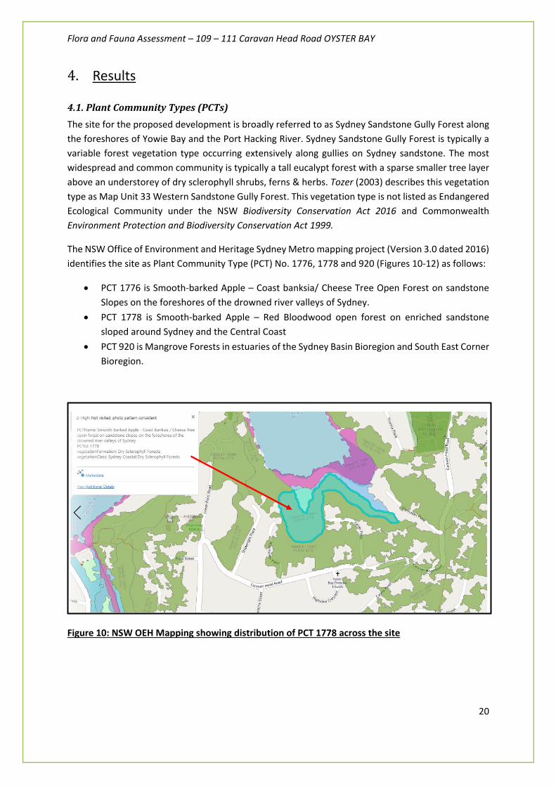
4.1. Plant Community Types (PCTs) The site for the proposed development is broadly referred to as Sydney Sandstone Gully Forest along the foreshores of Yowie Bay and the Port Hacking River. Sydney Sandstone Gully Forest is typically a variable forest vegetation type occurring extensively along gullies on Sydney sandstone. The most widespread and common community is typically a tall eucalypt forest with a sparse smaller tree layer above an understorey of dry sclerophyll shrubs, ferns & herbs. Tozer (2003) describes this vegetation type as Map Unit 33 Western Sandstone Gully Forest. This vegetation type is not listed as Endangered Ecological Community under the NSW Biodiversity Conservation Act 2016 and Commonwealth Environment Protection and Biodiversity Conservation Act 1999.
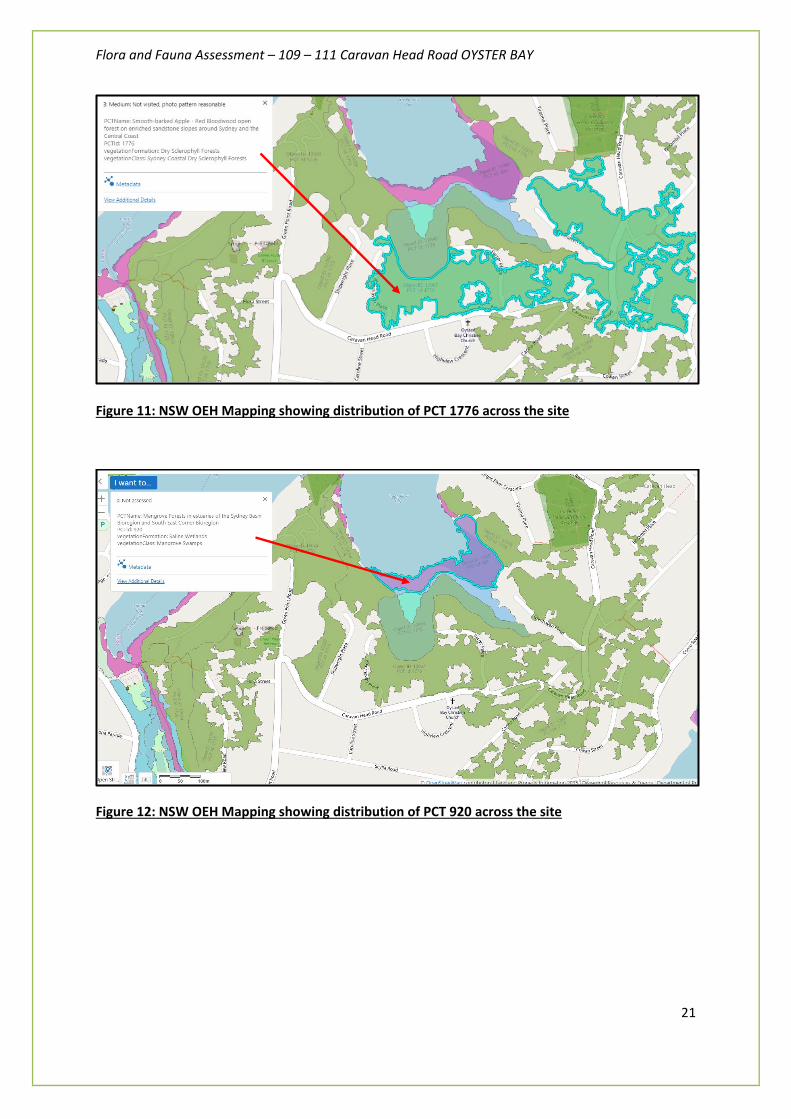
The NSW Office of Environment and Heritage Sydney Metro mapping project (Version 3.0 dated 2016) identifies the site as Plant Community Type (PCT) No. 1776, 1778 and 920 (Figures 10-12) as follows:
• PCT 1776 is Smooth-barked Apple – Coast banksia/ Cheese Tree Open Forest on sandstone Slopes on the foreshores of the drowned river valleys of Sydney.
• PCT 1778 is Smooth-barked Apple – Red Bloodwood open forest on enriched sandstone sloped around Sydney and the Central Coast
• PCT 920 is Mangrove Forests in estuaries of the Sydney Basin Bioregion and South East Corner Bioregion.
Figure 10: NSW OEH Mapping showing distribution of PCT 1778 across the site
Flora and Fauna Assessment – 109 – 111 Caravan Head Road OYSTER BAY
21
Figure 11: NSW OEH Mapping showing distribution of PCT 1776 across the site
Figure 12: NSW OEH Mapping showing distribution of PCT 920 across the site

Flora and Fauna Assessment – 109 – 111 Caravan Head Road OYSTER BAY
22
Proposed Lots 2 and 3 (indicative building envelopes and APZ)
The native vegetation on site for the proposed development is generally in poor condition, lacking significant understorey vegetation, structure, species diversity and native resilience (low potential for natural regeneration) for most of the site. However, some areas do contain some regenerating groundcover species and a sparse distribution of native canopy trees. It was previously cleared in the 1940s. It has regenerated with significant weed cover including Lantana and Broad-leaved Privet.
Upslope of the vegetation to be retained within proposed Lot 3, the vegetation transitions to an area where Smooth-barked Apple Angophora costata, Sydney Peppermint Eucalyptus piperita and Blackbutt Eucalyptus pilularis become more common. The drainage line flows through part of this area.
Approximately around the location of the existing dwelling there are some Red Bloodwood Corymbia gummifera that appear to be more common. Closer to the Caravan Head Road the shrub layer has been cleared and the remaining vegetation is a mixture of canopy trees and an occasionally mown groundcover layer.
Introduced noxious and environmental weeds dominate the site particularly including Asparagus Fern (Asparagus aethiopicus). The site is constantly under pressure from typical urbanisation pressures such as external weed and nutrient sources which further inhibition of natural regeneration occurring at lower slopes of the site. However, active weed control, bush regeneration and revegetation works would benefit the site greatly.
The vegetation is consistent with PCT 1776 Smooth-barked Apple – Coast banksia/ Cheese Tree Open Forest on sandstone Slopes on the foreshores of the drowned river valleys of Sydney AND PCT 1778 Smooth-barked Apple – Red Bloodwood open forest on enriched sandstone sloped around Sydney and the Central Coast.
No threatened plant species listed under the NSW Threatened Species Conservation Act 1995 and Commonwealth Environment Protection and Biodiversity Conservation Act 1999 were recorded on.
Flora and Fauna Assessment – 109 – 111 Caravan Head Road OYSTER BAY
23
Vegetation near Coronation Bay (to be retained within proposed Lot 3)
The vegetation near Coronation Bay is includes mangroves, fringing saltmarsh vegetation and Swamp Oaks. On the lowest gently sloping area the canopy is dominated by Bangalay Eucalyptus botryoides and Cheese Tree Glochidion ferdinandii. The shrub layer is generally sparse and the groundcover layer is dominated by exotic weeds, including Morning Glory Ipomoea indica. Grey Mangroves Avicennia marina are present off-site on the edge of the estuary. Mangroves are protected under the Fisheries Management Act 1994. It is anticipated that there will be no significant impact on the mangroves from the proposal On the landward side of the Grey Mangroves a narrow strip of low herbaceous vegetation is present. It includes Baumea juncea, Juncus krausii and Paspalum vaginatum. These species are typical of saltmarsh. The strip is so narrow that generally the canopy from the tree species on both the estuary side (mangroves) and landward side (mostly swamp-oaks) partially shade the saltmarsh plants. The narrow strip was possibly wider prior to the construction of the sea wall and the apparent filling and presumably raising of the soil level behind the sea wall. While the strip of vegetation is narrow, it appears to represent a remnant of the listed Endangered Ecological Community Coastal Saltmarsh that is listed in Part 3 of Schedule 1 of the former NSW TSC Act 1995. On the southern side of the sea wall there is a patch of Swamp Oaks Casuarina glauca. It appears these Swamp oaks are probably growing on fill above the sea wall. While the geographic location of the Swamp oaks fits the distribution of the Endangered Ecological Community Swamp oak floodplain forest, it is less certain that Swamp oaks growing on fill represent the community. For example, if clearing of an natural area of swamp oaks (EEC Swamp Oak floodplain) was proposed, it is probably unlikely that Swamp Oaks planted into a filled area above a sea wall adjacent to an estuary would be considered an appropriate offset. However, some typical features of Swamp Oak Forest are likely to still be present at this location, such as an increased level of salinity in the groundwater within the root zone of the Swamp Oaks Casuarina glauca.
The mangrove vegetation along the foreshore is consistent with PCT 920 Mangrove Forests in estuaries of the Sydney Basin Bioregion and South East Corner Bioregion.

Flora and Fauna Assessment – 109 – 111 Caravan Head Road OYSTER BAY
24
4.2. Plant species recorded on-site Remnants of the original Sydney Sandstone Gully Forest (PCT 1776 and 1778) are represented on the property by the presence of the following species:
• Acacia implexa • Acacia parramattensis • Acacia terminalis • Adiantum aethiopicum • Allocasuarina littoralis • Angophora bakeri • Angophora costata • Avicennia marina • Banksia serrata • Brachychiton acerifolius • Callistemon viminalis • Casuarina glauca • Corymbia gummifera • Corymbia maculata • Christella dentata • Calochlaena dubia • Cyathea cooperi • Dichondra repens • Dodonaea triquetra • Elaeocarpus reticulatus • Eucalyptus botryoides • Eucalyptus pilularis • Eucalyptus piperita • Eucalyptus resinifera • Exocarpos cupressiformis • Ficus (rubiginosa - seedling) • Ficus coronata • Glochidion ferdinandii • Glycine clandestina • Glycine tabacina • Gonocarpus teucrioides • Homalanthus populifolius • Lobelia alata • Persoonia levis • Persoonia linearis • Phyllanthus hirtellus • Pittosporum undulatum • Polyscias sambucifolia • Portulaca olearacea • Archontophoenix (cunninghamiana) • Aristida vagans • Baumea juncea • Carex inversa • Commelina cyanea • Cynodon dactylon
Flora and Fauna Assessment – 109 – 111 Caravan Head Road OYSTER BAY
25
• Dianella caerulea var. producta • Digitaria didactyla • Entolasia marginata • Entolasia stricta • Juncus krausii • Lepidosperma laterale • Lomandra (filiformis) • Lomandra longifolia • Microlaena stipoides • Oplismenus aemulus • Paspalum vaginatum • (Sporobolus virginicus) • Pteridium esculentum • Themeda australis
Introduced exotic and environmental weed species recorded on-site include:
• Agapanthus praecox • Agave americana • Asparagus aethiopicus - DOMINANT • Axonopus fissifolius • (Billbergia sp.) • Bromus catharticus • Bryophyllum delagoense • Chlorophytum comosum • Clivia minata • Cyperus eragrostis • Digitaria ciliaris • Ehrharta erecta • Eleusine indica • Epidendrum ibaguense • Lantana camara - DOMINANT • Ligustrum lucidum - DOMINANT • Papalum dilatatum • Paspalum urvillei • Pennisetum clandestinum • Phyllostachys aurea • Ravenala madagascariensis • Setaria parviflora • Syagrus romanzoffiana • Stenotaphrum secundatum • Tradescantia fluminensis • Yucca aloifolia • Abelia x grandiflora • Ageratina adenophora • Anredea cordifolia • Araujia sericifera • Bidens pilosa

Flora and Fauna Assessment – 109 – 111 Caravan Head Road OYSTER BAY
26
• Cinnamomum camphora • Conyza bonariensis • Conyza sumatrensis • Coreopsis lanceolata • Cotoneaster sp. • Crassula sp. • Cyclospermum leptophyllum • Cupressus macrocarpa • Ficus pumila • Galinsoga parviflora • Gamochaeta coarctata • Gomphrena globosa • Hedera helix • Hibiscus rosa-sinensis • Hydrocotyle bonariensis • Hypochaeris radicata • Ipomoea indica • Jacaranda mimosifolia • Jasminum mesnyi • Ligustrum sinensen • Lonicera japonica • Michelia figo • Monstera deliciosa • Nandina domestica • Nerium oleander • Ochna serrulata • Olea europea subsp. cuspidata • Pelagonium x hybridum • Physalis peruviana • Plantago lanceolata • Polygala sp • Rhaphiolepis indica • Senna pendula • Sida rhombifolia • Sonchus olearcea • Taraxacum officinale • Thunbergia alata • Ulmus parvifolia • Viola odorata • Nephrolepis cordata

Flora and Fauna Assessment – 109 – 111 Caravan Head Road OYSTER BAY
27
4.2.1 Fauna habitat and species
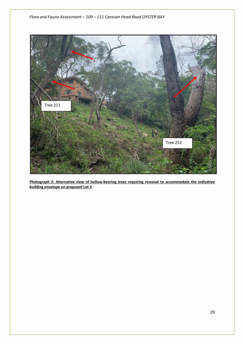
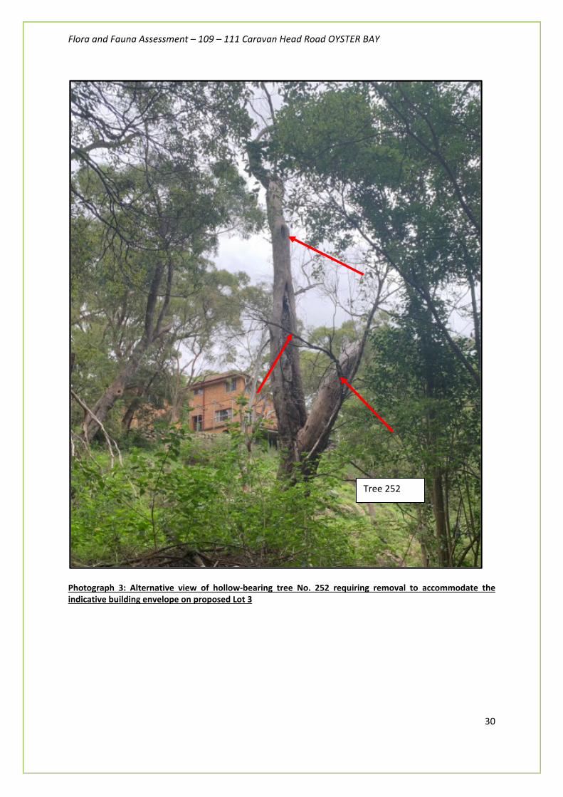
4.2.2 Specific habitat features The site for the proposed development does not significant fauna habitat, however, a dead tree (Tree 252) with some ‘spout’ hollows and a living Eucalyptus piperita (Tree 211) with would be removed to accommodate the indicative building envelope (dwelling construction subject to future development application) on proposed Lot 3. Photographs of these trees are provided on the following pages. There is a variable supply of fallen logs and dead wood/coarse woody debris throughout the remainder of the property (downslope of proposed Lot 3) that will be retained and undisturbed by the proposal. The amount of rocks and leaf litter cover is variable across the site. There is some rotting material at the base of some trees and the canopy cover varies from very open near Caravan Head Road portion of the site to semi-closed in the densely vegetated section of the property (below proposed Lot 3). The shrub layer and groundcover is variable with exotic weeds dominating the mid-storey of the APZ for proposed Lot 3. The blossoms and seeds of Eucalypts and Acacia provide food resources for common species of native birds.

Flora and Fauna Assessment – 109 – 111 Caravan Head Road OYSTER BAY
28
Photograph 1: View of hollow-bearing trees requiring removal to accommodate the indicative building envelope on proposed Lot 3
Tree 211
Living E.piperita
Tree 252
Dead E.piperita
Flora and Fauna Assessment – 109 – 111 Caravan Head Road OYSTER BAY
29
Photograph 2: Alternative view of hollow-bearing trees requiring removal to accommodate the indicative building envelope on proposed Lot 3
Tree 211
Tree 252
Flora and Fauna Assessment – 109 – 111 Caravan Head Road OYSTER BAY
30
Photograph 3: Alternative view of hollow-bearing tree No. 252 requiring removal to accommodate the indicative building envelope on proposed Lot 3
Tree 252
Flora and Fauna Assessment – 109 – 111 Caravan Head Road OYSTER BAY
31
Hollow-bearing trees and potential impacts to Powerful Owl In 2016, Powerful Owls have been observed during the daytime near the site as adults perching at a roost site and also nesting near to the site. The Powerful Owl is listed as Vulnerable in the BC Act 2016. The Powerful Owl (Ninox strenua) has been previously raised as a species concerns within the previously refused DAs so we undertook targeted surveys with particular focus on this species. No observations of Powerful Owl activity were made during surveys undertaken from the 9th October till the 3rd February 2020. We note the optimal detection period for this species is late April to end of the June. It is our intention to undertake follow up surveys in April and May 2020 for this very reason and update this assessment accordingly (noting that by the time Council has opportunity to assess this report the surveys will have been completed and this report will be updated accordingly). The previous Flora and Fauna Reports prepared by Abel Ecology dated October 2017 noted that a hollow is present in a Smooth-barked Apple Angophora costata on the section of the site that ‘juts out from the eastern boundary’. This tree is of significance as it contains a hollow potentially suitable for use by Powerful owls for nesting, and it is likely that hollows optimal for Powerful owls are uncommon in the locality. This tree is not impacted by the proposal. However, Abel Ecology also notes that the hollow is not optimal for Powerful owl nesting as the internal dimensions of the hollow are smaller than that typically preferred by Powerful owls. The other issue which was discovered upon inspection of the hollow, was that it is vulnerable to flooding from heavy rainfall. Four centimetres of water was discovered on the floor of hollow. This application does not propose the removal of this tree as a precautionary measure. Figures 13 and 14 (provided on the following pages) are reproduced from previous ecology surveys by Abel Ecology (Oct 2017) that shows:
- The location of hollow-bearing trees occurring on the property - The estimated territories of Powerful Owl in the locality.
We have undertaken Assessments of Significance (‘five part tests’) for Powerful Owl within Appendix B as a precautionary measure. Hollow-bearing trees and potential impacts to microbats We undertook anabat surveys as part of this assessment in December 2019. Four common bat species, namely Gould’s Wattled Bat, Chocolate Wattled Bat, Little Forest Bat and Long-eared Bat were detected. Where calls were easily identifiable to species, they were classed as Confident. Where the calls were most likely to represent a particular species, they were classed as Probable. Where calls were likely to belong to a species but the quality or length of the call precluded a confident identification, they were classed as Possible. Where the calls could have belonged to two or more species, they were classified into a species group. Any calls of very poor quality, which could not be reliably placed into any species or species group category, were classified as Unknown. Many of the calls were of good quality and the poor ones most likely represented bats flying just within the bat detector’s outer detection limits. This site provides potentially suitable foraging habitat for seven of the eight possible threatened species. Myotis macropus (syn. Myotis adversus) has suitable foraging habitat in the form of open water bodies (Coronation Bay). Kerivoula papuensis is only likely to forage in areas within a few kilometres of rainforest or rainforest gullies. As mentioned earlier, the site has tree hollows (shown in Photographs 1-3 on the previous pages) that provide suitable roosting habitat for Falsistrellus tasmaniensis, Mormopterus norfolkensis, Scoteanax rueppellii, Myotis macropus, Miniopterus australis and Saccolaimus flaviventris.

Flora and Fauna Assessment – 109 – 111 Caravan Head Road OYSTER BAY
32
Kerivoula papuensis normally roosts in hanging bird nests or trees in rainforest gullies so is very unlikely to roost in the surveyed site. We have undertaken Assessments of Significance (‘five part tests’) for microbats within Appendix B as a precautionary measure.
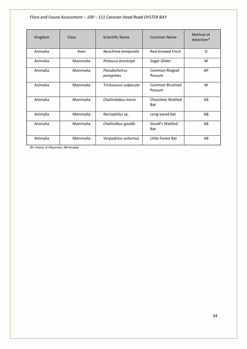
4.2.3 Fauna results The current surveys undertaken by Fraser Ecological recorded a total 46 animal species as listed in Table 1 (below). No threatened species of fauna were recorded on-site.
Kingdom Class Scientific Name Common Name Method of detection*
Animalia Reptilia Phyllurus platurus Broad-tailed Gecko O
Animalia Reptilia Ctenotus robustus Robust Ctenotus O
Animalia Reptilia Intellagama lesueurii Eastern Water Dragon
O
Animalia Reptilia Tiliqua scincoides Eastern Blue-tongue
O
Animalia Reptilia Lampropholis guichenoti
Dark-flecked Sunskink
O
Animalia Aves Macropygia amboinensis
Brown Cuckoo-Dove
O
Animalia Aves Podargus strigoides Tawny Frogmouth W
Animalia Aves Cacatua galerita Sulphur-crested Cockatoo
W
Animalia Aves Calyptorhynchus funereus
Yellow-tailed Black-Cockatoo
W
Animalia Aves Eolophus roseicapillus Galah W
Animalia Aves Alisterus scapularis Australian King-Parrot
W
Animalia Aves Platycercus elegans Crimson Rosella W
Animalia Aves Platycercus eximius Eastern Rosella W
Animalia Aves Trichoglossus haematodus
Rainbow Lorikeet W
Animalia Aves Dacelo novaeguineae Laughing Kookaburra
W
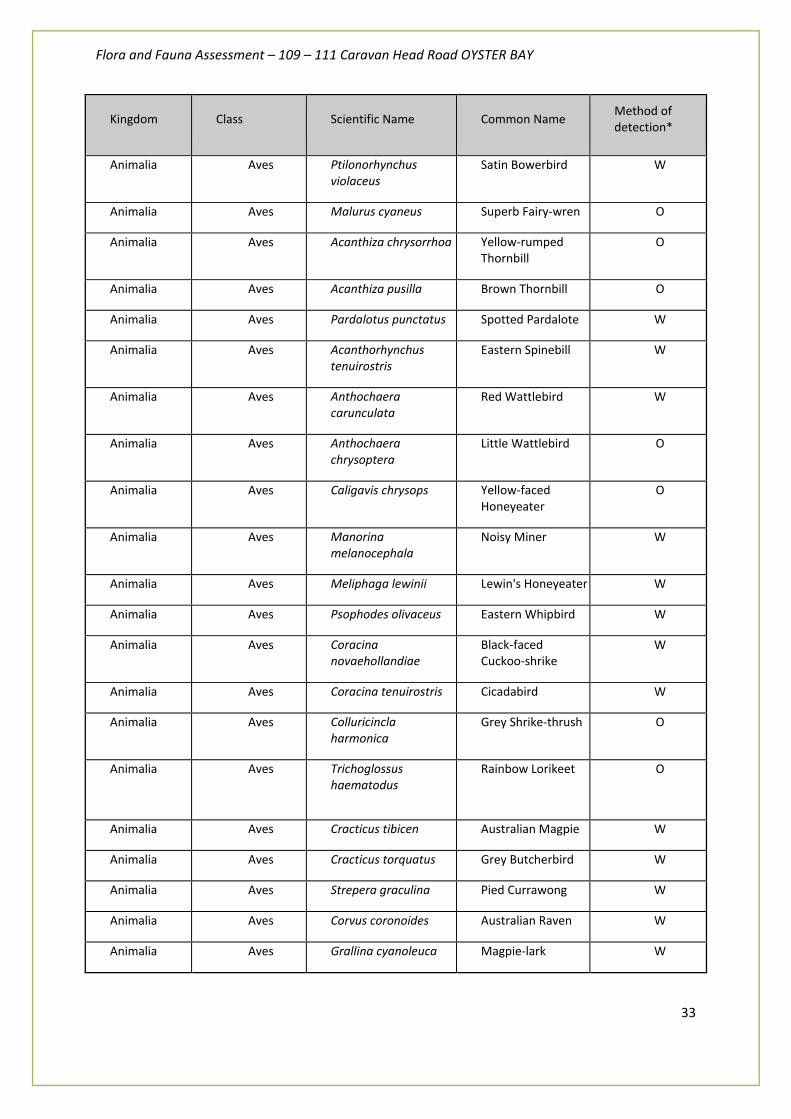
Flora and Fauna Assessment – 109 – 111 Caravan Head Road OYSTER BAY
33
Kingdom Class Scientific Name Common Name Method of detection*
Animalia Aves Ptilonorhynchus violaceus
Satin Bowerbird W
Animalia Aves Malurus cyaneus Superb Fairy-wren O
Animalia Aves Acanthiza chrysorrhoa Yellow-rumped Thornbill
O
Animalia Aves Acanthiza pusilla Brown Thornbill O
Animalia Aves Pardalotus punctatus Spotted Pardalote W
Animalia Aves Acanthorhynchus tenuirostris
Eastern Spinebill W
Animalia Aves Anthochaera carunculata
Red Wattlebird W
Animalia Aves Anthochaera chrysoptera
Little Wattlebird O
Animalia Aves Caligavis chrysops Yellow-faced Honeyeater
O
Animalia Aves Manorina melanocephala
Noisy Miner W
Animalia Aves Meliphaga lewinii Lewin's Honeyeater W
Animalia Aves Psophodes olivaceus Eastern Whipbird W
Animalia Aves Coracina novaehollandiae
Black-faced Cuckoo-shrike
W
Animalia Aves Coracina tenuirostris Cicadabird W
Animalia Aves Colluricincla harmonica
Grey Shrike-thrush O
Animalia Aves Trichoglossus haematodus
Rainbow Lorikeet O
Animalia Aves Cracticus tibicen Australian Magpie W
Animalia Aves Cracticus torquatus Grey Butcherbird W
Animalia Aves Strepera graculina Pied Currawong W
Animalia Aves Corvus coronoides Australian Raven W
Animalia Aves Grallina cyanoleuca Magpie-lark W
Flora and Fauna Assessment – 109 – 111 Caravan Head Road OYSTER BAY
34
Kingdom Class Scientific Name Common Name Method of detection*
Animalia Aves Neochmia temporalis Red-browed Finch O
Animalia Mammalia Petaurus breviceps Sugar Glider W
Animalia Mammalia Pseudocheirus peregrines
Common Ringtail Possum
AP
Animalia Mammalia Trichosurus vulpecula Common Brushtail Possum
W
Animalia Mammalia Chalinolobus morio Chocolate Wattled Bat
AB
Animalia Mammalia Nyctophilus sp. Long-eared bat AB
Animalia Mammalia Chalinolbus gouldii Gould’s Wattled Bat
AB
Animalia Mammalia Vespadelus vulturnus Little Forest Bat AB
W= Heard, O=Observed, AB=Anabat

Flora and Fauna Assessment – 109 – 111 Caravan Head Road OYSTER BAY
35
Figure 13: Reproduction of Powerful Owl territory map prepared by Abel Ecology (2017)

Flora and Fauna Assessment – 109 – 111 Caravan Head Road OYSTER BAY
36
Figure 14: Reproduction of hollow-bearing tree map prepared by Abel Ecology (2017)

Flora and Fauna Assessment – 109 – 111 Caravan Head Road OYSTER BAY
37
4.4 Fauna of Conservation Significance
Commonwealth
Results from the Protected Matters Search Tool and the Atlas of NSW Wildlife database searches revealed a number of EPBC Act (1999) listed species that require consideration as part of this assessment (see Appendix A).
State
The results of the Atlas of NSW Wildlife/ Bionet (NSW Office of Environment & Heritage 2020) database search indicated that a number of threatened fauna species and population were recorded within 10 kilometres of the subject site (see Appendix A).
Powerful Owl (Ninox strenua) was identified as the major species of concern.
Whilst we are confident we will not impact this species or its habitat, we have undertaken a ‘five part test’ in Appendix B as a precautionary measure.
We have also undertaken a ‘five part tests’ (Appendix B) for the following species:
1. Little Lorikeet 2. Pteropus poliocephalus Grey-Headed Flying-fox 3. Mormopterus norfolkensis Eastern Freetail-bat 4. Miniopterus schreibersii oceanensis Eastern Bent-wing Bat 5. Saccolaimus flaviventris Yellow-bellied Sheathtail-bat 6. Scoteanax rueppellii Greater Broad-nosed bat 7. Falsistrellus tasmaniensis Eastern False Pipistrelle
The assessments of significance concluded that the local population of these species would not be impacted, and in accordance with the EPA Act (1979) and BC Act (2016), a Species Impact Statement is not required.

Flora and Fauna Assessment – 109 – 111 Caravan Head Road OYSTER BAY
38
5. Assessment of Ecological Impacts
This chapter evaluates if the proposed development will significantly impact on ecological processes and the conservation value of the subject site and neighbouring bushland areas, especially with respect to threatened biota and migratory fauna species, and their habitats, and on the ecological integrity of the landscape. It also recommends ways in which impacts can be minimised or avoided.
Trees proposed for removal
A total of thirty-three (33) trees are proposed for removal, of which twenty-seven (27) are locally native trees.
The Arborist Report prepared by Jackson Nature Works dated 5th May 2020 assessed trees potentially impacted by the proposal and made the following assessment:
The trees proposed for removal do not provide important habitat resources (i.e. significant habitat hollows or winter flowering blossoms) that are critical to the breeding cycle of locally common or threatened species. The vegetation proposed for removal does not form part of an Endangered Ecological Community.
Two hollow-bearing trees are proposed for removal within the indicative building envelope of proposed Lot 3. Targeted surveys were undertaken to ensure no threatened fauna use these potential habitats. Potential breeding and roosting habitat for Powerful Owl (Ninox strenua) will not be impacted by the proposal. The hollow bearing habitat features could be relocated and kept on-site within the 0.5ha of retained forest within a future Restricted Development Area (RDA) Proposed Lot 3.
Impacts to Ecological Communities
The subject area comprises Sydney Sandstone Gully Forest (SSGF). It is proposed that some elements of this community will be removed within the subject site where the proposed building will be located.
As the community is not an endangered ecological community and is well represented throughout the locality, the proposed development will not have a significant impact on EECs
Impacts to Flora
Flora and Fauna Assessment – 109 – 111 Caravan Head Road OYSTER BAY
39
No flora species listed under the BC Act or EPBC Act were recorded on the subject land. It is not considered likely that the proposed development would have a significant detrimental impact upon any listed threatened species of plants and no Assessments of Significance are considered necessary. No species that are considered to have conservation significance according to Briggs & Leigh (1995) or Benson & Howell (1994) were recorded on the subject land.
Potential direct impacts to flora species include:
• Removal and thinning of vegetation; • Runoff, erosion and sedimentation; and • Hydrological changes (e.g. increased storm water runoff from the proposed dwelling
Potential indirect impacts to flora species include:
• Weed invasion; and • Long and short-term edge effects resulting from the clearing of vegetation (e.g. changes in light
filtration). The proposal includes the use of stormwater tanks to capture and re-use as much stormwater as possible to minimise these impacts.
Impacts to Fauna Fauna Habitat The site contains limited fauna habitat. The proposed development is not likely to have a significant impact on native fauna species. Potential direct impacts to fauna species include:
• Loss of marginal foraging and roosting habitat; and • Noise disturbance from construction work.
Potential indirect impacts to fauna species include:
• Minor hydrological changes resulting in altered fauna habitats. We have addressed the impacts of the removal of hollow-bearing trees in Section 4.2.2 and Appendix B. Impacts to Sutherland Shire Biodiversity Values Greenweb Strategy Sutherland Shire developed a Greenweb Strategy in February 2001 to supplement the aims and objectives of bushland preservation in the Sutherland Shire Local Environmental Plan (SSLEP 2015). The subject land has been identified as Greenweb Core. This means the subject site forms part of an identified major habitat area and its value must be considered during development.
Flora and Fauna Assessment – 109 – 111 Caravan Head Road OYSTER BAY
40
The area of Greenweb Core and Support for Core habitat that the subject land forms a part of an area that is of a size large enough to sustain a range of species forming a local ecosystem. The removal and modification of vegetation for the proposed development will not reduce the size of the Greenweb Core area to an unsustainable size. As the removal and modification of vegetation will occur within a previously cleared area, adjacent to pre-existing houses and roads, the proposed development will not fragment or significantly alter the shape of the Greenweb Core area. The subject site is located on the edge of a vegetation link. The removal and modification of vegetation for the proposal will not severe connectivity between other areas of core habitat. The Greenweb Core areas down slope of the site may be impacted by increased runoff, erosion, sedimentation and weed invasion as a result of the development. If these impacts are managed appropriately it is unlikely that they will have a significant impact to the Greenweb Core area. Bushland Vegetation Considerations The proposed development must consider the SSLEP. Under clause 32 Bushland Vegetation Consideration, consent will not be granted unless it is shown that the proposed development will not significantly adversely impact the following; i. The protection of rare and endangered flora and fauna species and the protection of habitats for native flora and fauna No threatened flora species are known to occur on the subject site. Mobile threatened fauna species may pass through the site, however, no important breeding or roost sites were detected on the subject site. As potential roost and foraging habitat will be retained on the subject land, the removal or modification of vegetation on the subject site will not have a significant adverse impact to this species. ii. The protection of wildlife corridors and vegetation links with other nearby bushland vegetation The subject site has been identified as Greenweb Core and Support for Core habitat that lies directly the subject site (as shown in Figure 6). The subject site is located on the edge of a corridor. The removal and modification of vegetation for the proposal will not significantly reduce the size of this link and a minimum desirable corridor width will be retained on the subject land. Therefore, the proposal will not significantly adversely impact habitat corridors and vegetation links with surrounding bushland. iii. The protection of bushland vegetation as a natural stabiliser of the soil surface and the protection of existing landforms such as natural drainage lines, water courses and foreshores Possible impacts to the water regime may arise from storm water discharge and this must be taken into consideration in the planning and landscaping stage of the development. iv. The protection of bushland vegetation of scenic values and the retention of the unique visual identity of the landscape

Flora and Fauna Assessment – 109 – 111 Caravan Head Road OYSTER BAY
41
The small amount of bushland to be removed will not impact adversely on the scenic values of the area, nor will it compromise the visual identity of the landscape. A majority of the native canopy trees will remain and will maintain the character of the locality. Overall loss of terrestrial flora and fauna habitat
Biodiversity is the diversity and richness of living things. This includes the variety of plant communities and animal habitats, and the number of different species. Most natural areas support a complex mixture of different species and plant communities. Biodiversity in disturbed areas is generally lower than in more pristine areas. An awareness on native biodiversity emphasis the conservation of the variety of native life, rather just rare or threatened species.
There are three important principles associated with ESD. These are:
- maintenance of native biodiversity
- erring on the side of caution when assessing and taking risks with the biological environment; and
- passing on to future generations a natural environment that is at least as good and enjoyable as our own.
- many species of forest flora and fauna are threatened both nationally and within NSW. This is largely a result of the clearing of this native habitat.
The proposed development is unlikely to result in the loss of biodiversity at a local, regional, state or national level. This is because of the small area of bushland to be removed from the site, the highly degraded or modified habitat area to be developed, the unlikelihood of the status of threatened or regionally significant species being significantly placed at risk, and the broader distribution of other fauna and flora species.
Impacts on wildlife corridor
The native vegetation present on the subject site is likely to function as a stepping stone for the movement of mobile fauna such as birds, microchiropteran bats and megachiropteran bats, through the presence of inter connecting canopy connectivity of trees. The proposal will have an insignificant interruption in upper canopy connectivity but this would not significantly impact upon the movement of wildlife and genetic exchange and dispersal of plant pollen in the local ecosystem.
Impacts on migratory species
Under the EPBC Act, a migratory species is significantly impacted on if a proposal will or is likely to:
- substantially modify (including by fragmenting, altering fire regimes, altering nutrient cycles or altering hydrological cycle), destroy or isolate an area of important habitat of the migratory species; or
- result in invasive species that are harmful to the migratory species becoming established in an area of important habitat of the migratory species; or
Flora and Fauna Assessment – 109 – 111 Caravan Head Road OYSTER BAY
42
- seriously disrupt the life cycle (breeding, feeding, migration or resting behaviour) of an ecologically significant proportion of the population of the species.
Significant habitat for migratory species does not exist on site.
Impacts on aquatic environment
Potential impacts on aquatic habitat include changes in drainage, runoff from construction sites, buildings and landscape surfaces, erosion and sedimentation during construction, and contamination from nutrients, oils and heavy metals. These impacts would be avoided or minimised if the recommended environmental protection measures (Section 6) are implemented.
Sufficient riparian setbacks from a drainage line would be achieved in accordance with NSW Office of Water guidelines. The design of the allotment layout was specifically amended to reduce any potential APZ conflicts to the riparian zone.
Impacts on threatened species
No species listed under the NSW Biodiversity Conservation Act 2016 and Commonwealth Environment Protection and Biodiversity Conservation Act 1999 were recorded on site. Threatened flora and fauna previous recorded within 10km of the site (OEH 2020) and have the potential to occur site have been considered in the table provided in Appendix A.
The proposal will not have a significant impact upon the local population of threatened species that may use the site a marginal foraging area (refer to Appendix A and B).

Flora and Fauna Assessment – 109 – 111 Caravan Head Road OYSTER BAY
43
6. Environmental Protection Measures
The current proposal is to be carried out in accordance with all policies, operational procedures and guidelines in place as part of consent conditions issued by Sutherland Shire Council relating to environmental management or impact minimisation for construction projects.
The following environmental safeguard measures have been recommended for all phases of the proposed development:
1) Vegetation Management Plan
Introduced noxious and environmental weeds dominate the site particularly including highly invasive Asparagus Fern (Asparagus aethiopicus) and Lantana (Lantana camara). The site is constantly under pressure from typical urbanisation pressures such as external weed and nutrient sources which further inhibition of natural regeneration.
However, active weed control, bush regeneration, APZ and revegetation works could be provided as on-site biodiversity offset as a new Vegetation Management Plan that would remain in perpetuity as an s88b instrument on the title of the property should the application be approved by Council. This is typical condition with a Notice of Determination (Council approval conditions) prior to the release of the Subdivision Certificate.
2) Vegetation protection fencing A protection zone surrounding the upslope limit of retained bushland is to be provided for all areas to be retained during construction. This zone is a specified area indicated on the approved plans nominally enclosing the protected trees and other native vegetation.
The following activities shall not be conducted within the protection zone:
- Ripping, cultivation, trenching or mechanical removal of vegetation or earth - The placement of fill
- Movement, stockpiling or storage of plant, materials, waste, equipment or vehicles
- Any activity likely to damage the trunk, crown or root system of the protected vegetation
Tree protection fencing is recommended within the Arborist Report prepared by Jacksons Nature Works and accompanies the application.
3) Native landscaping Any tree plantings should be located in areas that are not likely to be impacted by future uses such as dwelling construction and associated infrastructure (garages, driveways etc).
All plants used for landscaping shall comprise of species listed within Council’s ‘Landscape Specifications 2004 - Part 4’ (available on Council’s website).

Flora and Fauna Assessment – 109 – 111 Caravan Head Road OYSTER BAY
44
Maximum bushrock will be retained where possible as part of the dwelling construction. Bush rock will be re-used for landscaping and habitat enhancement.
Council’s pre-DA advice states that subdivision of the land into 2 lots requires each resultant lot to comply with the 40% minimum landscaped area requirement for land in Zone E3.
4) Tree removal and protection Any native remnant trees proposed for removal due to poor health should be done during the construction stage so that compensatory tree planting can be considered within any future Vegetation Management Plan. Unhealthy trees that have potential to recover should be retained. Removed trees should be mulched and re-used on site.
The Arborist Report dated 5th May 20202 prepared by Jacksons Nature Works makes the following recommendations:
- - Tree removal work shall be carried out by an experienced tree surgeon in accordance with
NSW WorkCover Code of Practice for Amenity Tree Industry (1998); - Install the following Tree Protection Measures around the retained trees: Tree protection
measures shall be a temporary fence of chain wire panels 1.8 metres in height (or equivalent), supported by steel stakes or concrete blocks as required and fastened together and supported to prevent sideways movement. Existing boundary fences or walls are to be retained shall constitute part of the tree protection fence where appropriate. A sign is to be erected on the tree protection fences of the trees to be retained that the trees are covered by Council’s tree preservation orders and that “No Access” is permitted into the tree protection zone;
- That a Tree Management Plan be prepared as part of the Construction Certificate by a consulting arborist who holds the Diploma in Horticulture (Arboriculture), Level 5 under the Australian Qualification Framework;
- An AQF Level 5 Project Arborist shall be engaged to supervise the building works and certify compliance with all Tree Protection Measures;
All selective removal / thinning of the trees in the area to provide an APZ shall be undertaken in consultation with Council’s Environmental Officer, a Bushfire Consultant and a Consulting Arborist as a condition of consent.
5) Erosion and Sediment Control
All erosion and sediment controls (i.e. geotextile sediment fence and straw bales) shall be in place before any works begin so as to protect the remnant bushland and native fauna habitat. Techniques used for erosion and sediment control on building sites are to be adequately maintained at all times and must be installed in accordance with Sutherland Shire Council and EPA/DPIE guidelines. All techniques shall remain in proper operation until all development activities have been completed and the site fully stabilised. This condition must be complied with during building work.

Flora and Fauna Assessment – 109 – 111 Caravan Head Road OYSTER BAY
45
6) Turf selection and barriers
Turf type will be non-invasive such as a native grass or a soft leaf buffalo. The use of turf such as Kikuyu and Couch shall be prohibited as they are highly invasive. The spread of turf or weeds into the down slope bushland area of the property shall be prevented through the erection of a physical barrier along the edge of the existing turf area using materials such as timber, logs, rock, or concrete. The barrier is to be installed underground as well as above ground to provide a root barrier and to act as a mown strip to delineate the mown area from the bushland area. The physical barrier shall be inserted approximately 20cm below the soil with a minimum 8cm above the soil 8) Fauna habitat protection and creation
Any bush rock encountered and felled timber is to be treated sensitively and re-used as habitat.
9) Sensitive excavation around critical root zones
Any construction for essential stormwater/ sewerage infrastructure shall be undertaken under the supervision of an ‘AQF Level 5 Arborist’ or equivalent to minimise damage of critical root zones of trees proposed for retention. The Arborist Report prepared by Jacksons Nature Works includes sensitive tree protection measures.
10) Prevent Spread of Weed and Pathogens
To prevent the spread of weeds and fungal pathogens such as Cinnamon Fungus (Phytophthora cinnamomi) and Chytrid Fungus (Batrachochytrium dendrobatidis), all machinery shall be cleaned of soil and debris before entering the subject site.
11) General Environmental Management
The site must be managed in accordance with the Protection of the Environment Operations Act 1997 by way of implementing appropriate measures to prevent sediment run-off, excessive dust, noise or odour emanating from the site during the construction of the development.

Flora and Fauna Assessment – 109 – 111 Caravan Head Road OYSTER BAY
46
7. Conclusion
The proposed works are unlikely to result in a significant impact upon species, populations and communities listed under the Biodiversity Conservation Act 2016 and a Species Impact Statement is not required.
Flora and Fauna Assessment – 109 – 111 Caravan Head Road OYSTER BAY
47
8. References
Auld, R.A & Medd, R.W 19897. Weeds – an illustrated guide the weeds of Australia. Inkata Press Melbourne
ARBOR 1996. Garden plants that go feral in the Sydney Bushland, Sydney.
Australian Museum (2005) Birds in Backyards. http://birdsinbackyards.net/finder
Bannerman, S.M and Hazelton, P.A. (1990) Soil Landscapes of the Penrith 1:100,000 Sheet. Soil Conservation Service of NSW, Sydney
Barker, J., Grigg, G. C., and Tyler, M. J. (1995) A Field Guide to Australian Frogs. Surrey Beatty & Sons, Chipping Norton
Benson, D. (1992) The natural vegetation of the Penrith 1:100,000 map sheet. Cunninghamia 2(4):541-5962
Benson, D.H. and Howell, J. (1990) Taken for Granted: The Bushland of Sydney and Its Suburbs. Kangaroo Press, Sydney
Benson, D.H. and Howell, J. (1994) The Natural Vegetation of the Sydney 1:100,000 Map Sheet. Cunninghamia 3(4):679-788
Benson, D.H. and Howell, J. (2000) Sydney’s Bushland — More than Meets the Eye. Royal Botanic Gardens, Sydney
Benson, D.H., Howell J. and McDougall, L. (1996) Mountain devil to mangrove. Royal Botanic Gardens, Sydney
Beruldsen G (1980) Field Guide to Nests and Eggs of Australian Birds. Rigby: Adelaide
Blakers, M., Davies, S.J.J.F. and Reilly, P.N. (1984) The Atlas of Australian Birds. Globe Press Pty Ltd, Australia
Botanic Gardens Trust (2010) NSW Flora Online (http://plantnet.rbgsyd.nsw.gov.au) . Accessed March 2010
Benson, D and Howell, J., Cunninghamia Volume 3 (4), National Herbarium of NSW, Royal Botanic Gardens Sydney 1994.
Benson, D. and Howell, J. (1994) The natural vegetation of the Sydney 1:100 000 map sheet Cunninghamia 3(4):677-995.
Buchanan, R. 1989. Bush Regeneration. TAFE Publications.
Bureau of Meterology 2011. Climate Averages Sydney Metropolitan Area, Sydney

Flora and Fauna Assessment – 109 – 111 Caravan Head Road OYSTER BAY
48
Churchill, S. (1998) Australian Bats. Reed New Holland, Sydney Australia
Cogger, H. G. (2000) Reptiles and Amphibians of Australia. Reed New Holland, Sydney
Cumberland Ecology (2008). Flora and Fauna Assessment for the residential subdivision of part Lot 607 DP 1038362.
Department of Environment and Conservation 2005. Restoring bushland on the Cumberland Plain: Best practice guidelines for the management and restoration of bushland. Department of Environment an4d Conservation. Sydney.
Department of the Environment, Water, Heritage and the Arts 2010. Weeds of National Significance. Canberra ACT.
DECCW (2000). Menippus fugitivus (a beetle) population, Sutherland Shire - endangered population listed under the Threatened Species Conservation Act 1995
DECCW (2004). NSW Scientific Committee Determination for listing Littoral Rainforest as an Endangered Ecological Community in NSW North Coast, Sydney Basin and South East Corner bioregions.
Department of Environment and Heritage (2006) EPBC Act Policy Statement 1.1 Significant Impact Guidelines Matters of National Environmental Significance. Commonwealth of Australia
Duncan, A., Baker, G.B., and Montgomery, N. (eds) (1999) The Action Plan for Australian Bats. Environment Australia, Canberra
Department of Environment, Water, Heritage and the Arts (DATE) Environmental Protection and Biodiversity Conservation Act 1999 – Protected Matters Search Tool [http://deh.gov.au/cgi_bin/erin/ert/epbc] accessed October 2011
Fairley, A. (2004) Seldom Seen - Rare Plants of Greater Sydney. Reed New Holland:Sydney
Fairley, A. and Moore, P. (2002) Native Plants of the Sydney District. Revised edition. Kangaroo Press:Sydney
Flegg, J. (2002) photographic Field Guide – Birds of Australia. Second Edition. Reed New Holland.Sydney.
Fairley, A. Moore, P; Native Plants of the Sydney Distrcit and identification guide: New Holland Sydney 2002
Garnett S., and Crowley, G. (2000) The Action Plan for Australian Birds. National Heritage Trust.
Gibbons, P. and Lindenmayer, D. (2000) Tree Hollows and Wildlife Conservation in Australia. CSIRO Publishing: Canberra
Hazerton and Tile 1990. Soil landscapes of the Wollongong-Port Hacking 1:100 000 Map Sheet. Department of Primary Industries.
Flora and Fauna Assessment – 109 – 111 Caravan Head Road OYSTER BAY
49
Harden, G. (1990) (ed) Flora of New South Wales Vol. 1 NSW University Press
Harden, G. (1991) (ed) Flora of New South Wales Vol. 2 NSW University Press
Harden, G. (1992) (ed) Flora of New South Wales Vol. 3 NSW University Press
Harden, G. (1993) (ed) Flora of New South Wales Vol. 4 NSW University Press
Harden, G. J. (2000) (ed.) Flora of New South Wales Vol. 1. UNSW Press, Kensington, NSW.
Hindell, M.A. and Lee, A.K. 1990. Tree preferences of the koala In: Lee, A.K., Handasyde, K.A. and Sanson, G.D. (eds) Biology of the Koala. Surrey Beatty and Sons, Sydney
Hollands, D. (2003) Eagles, Hawks and Falcons of Australia. Bloomings Books, Melbourne
Kavanagh, R.P. and Peake, P. (1993) Survey procedures for nocturnal forest birds: an evaluation of the variability in census results due to temporal factors, weather and technique. Pp. 86-100 in Australian Raptor Studies, ed. by P. Olsen. Royal Australasian Ornithologists Union, Melbourne
Matheney, N.P and Clark, J.R Trees and Development: A technical guide to preservation of trees during land development. International Society of Arboriculture 1998
Menkhorst, P and Knight, F. (2001) A Field Guide to the Mammals of Australia. Oxford University Press, Melbourne Australia
Menkhorst, P. W. (1995) Eastern Pygmy-possum (pp101-102) in Menkhorst, P. W, (ed.) Mammals of Victoria: distribution, ecology and conservation. Oxford University Press, Melbourne.
NPWS Native Vegetation of the Cumberland Plain Map 1 to 16; NPWS Sydney 2002
NSW Department Infrastructure Planning and Natural Resources 2007. Guidelines for the preparation of Vegetation Management Plans, Parramatta.
NSW Rural Fire Service (2006) Planning for Bushfire Protection A Guide for Councils, Planners, Fire Authorities, Developers and Homeowners NSW Rural Fire Service, Sydney.
NSW Department of Environment, Climate Change and Water (2010) Threatened Species Profiles (http://www.threatenedspecies.environment.nsw.gov.au). Accessed November 2011.
NSW National Parks and Wildlife Service (1997) Urban Bushland Biodiversity Survey. Native Flora of Western Sydney. NSW NPWS, Hurstville
NSW National Parks and Wildlife Service (1997) Urban Bushland Biodiversity Survey. Stage 1: Western Sydney. NSW NPWS, Hurstville
NSW National Parks and Wildlife Service (2002) Native Vegetation of the Cumberland Plain - Final Edition. NPWS, Sydney
NSW National Parks and Wildlife Service (2010) Wildlife Atlas website [http://wildlifeatlas.nationalparks.nsw.gov.au/wildlifeatlas/watlas.jsp] accessed March 2010

Flora and Fauna Assessment – 109 – 111 Caravan Head Road OYSTER BAY
50
Pennay, M., Law, B. and Reinhold, L. (2004) Bat calls of NSW: Region based guide to the echolocation calls of Microchiropteran bats. NSW Department of Environment and Conservation, Hurstville.
Pizzey, G. and Knight, F. (1997) Field Guide to the Birds of Australia. Harper Collins Publishers, Hong Kong
Robinson, L. Field Guide to the Native Plants of Sydney; Kangaroo Press, Sydney 2004
Robinson, M. (1993) A Field Guide to Frogs of Australia. Australian Museum / Reed
Rural Fire Service of NSW (2006) Planning for Bushfire Protection. RFS of NSW in co-operation with the NSW Department of Planning
Simpson, K., and Day, N. (1999) Field Guide to the Birds of Australia. Sixth Edition. Penguin Books, Australia
Slater, P., Slater, P. and Slater, R. (1995) The Slater Field Guide to Australian Birds. Lansdowne Publishing, Australia
Strahan, R. (1995) A Photographic Guide to Mammals of Australia. New Holland, Sydney Australia
Sutherland Shire Council (2002). Biodiversity Conservation Strategy.
Swan, G. (1990) A Field Guide to the Snakes and Lizards of New South Wales. Three Sisters Productions, Winmalee NSW
Swan, G., Shea, G., and Sadlier, R. (2004) A Field Guide to Reptiles of New South Wales. Reed New Holland, Sydney
Tame, T. (1992) Acacias of South East Australia. Kangaroo Press Pty Ltd, Kenthurst
Tozer, M.G., Turner, K., Simpson, C., Keith, D.A., Beukers, P., MacKenzie, B., Tindall, D. and Pennay, C. (in press) Native vegetation of southeast NSW: a revised classification and map for the coast and eastern tablelands. Version 1.0. Cunninghamia 11
Tozer, M.G. (2003) The native vegetation of the Cumberland Plain, western Sydney: systematic classification and field identification of communities. Cunninghamia 8(1):1-75
Triggs, B. (1996) Tracks, Scats and Other Traces: A Field Guide to Australian Mammals. Oxford University Press:Melbourne
Tozer, M. (2003) The Native Vegetation of the Cumberland Plain, western Sydney: Systematic classification and field identification of communities Cunninghamia 8(1):1-75
Wilson, S.K. and Knowles, D.G. (1988) Australia’s Reptiles – A Photographic Reference to the Terrestrial Reptiles of Australia. Collins Publishers, Australia
Wrigley, J.W Fagg, M.A Australian Native Plants Cultivation, Use in Landscaping and Propagation; Kangaroo Press, Sydney 2003
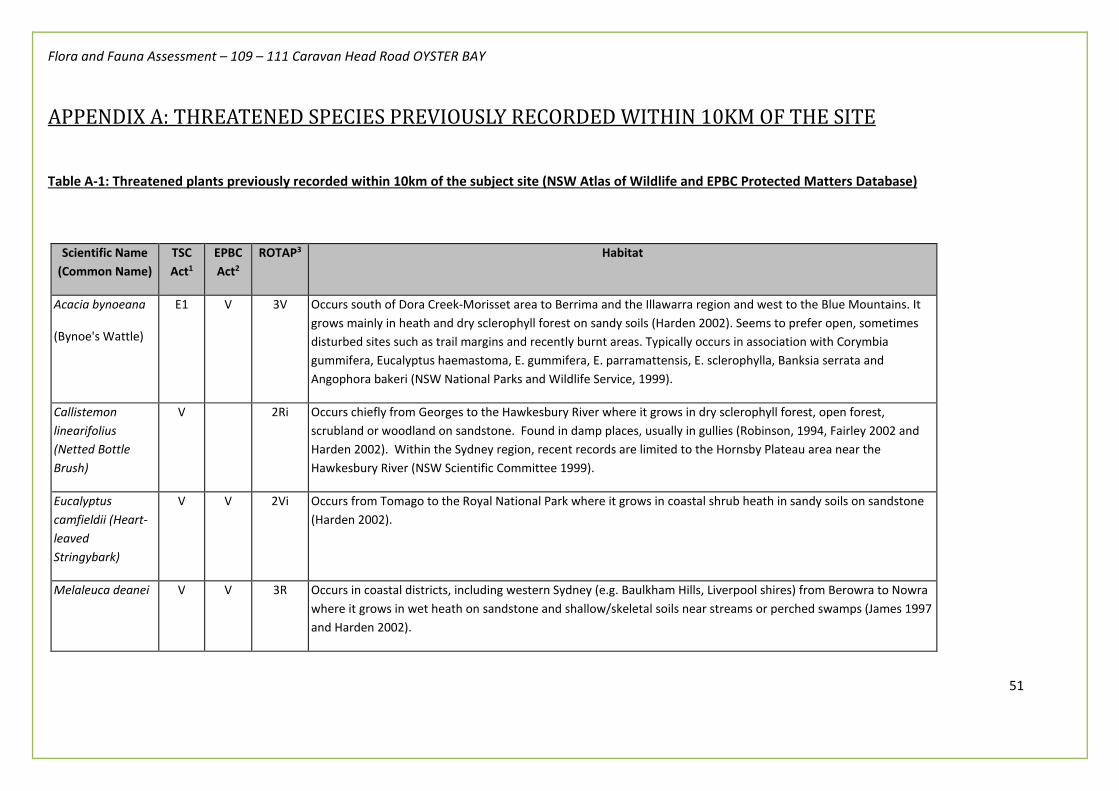
Flora and Fauna Assessment – 109 – 111 Caravan Head Road OYSTER BAY
51
APPENDIX A: THREATENED SPECIES PREVIOUSLY RECORDED WITHIN 10KM OF THE SITE
Table A-1: Threatened plants previously recorded within 10km of the subject site (NSW Atlas of Wildlife and EPBC Protected Matters Database)
Scientific Name (Common Name)
TSC Act1
EPBC Act2
ROTAP3 Habitat
Acacia bynoeana
(Bynoe's Wattle)
E1 V 3V Occurs south of Dora Creek-Morisset area to Berrima and the Illawarra region and west to the Blue Mountains. It grows mainly in heath and dry sclerophyll forest on sandy soils (Harden 2002). Seems to prefer open, sometimes disturbed sites such as trail margins and recently burnt areas. Typically occurs in association with Corymbia gummifera, Eucalyptus haemastoma, E. gummifera, E. parramattensis, E. sclerophylla, Banksia serrata and Angophora bakeri (NSW National Parks and Wildlife Service, 1999).
Callistemon linearifolius (Netted Bottle Brush)
V 2Ri Occurs chiefly from Georges to the Hawkesbury River where it grows in dry sclerophyll forest, open forest, scrubland or woodland on sandstone. Found in damp places, usually in gullies (Robinson, 1994, Fairley 2002 and Harden 2002). Within the Sydney region, recent records are limited to the Hornsby Plateau area near the Hawkesbury River (NSW Scientific Committee 1999).
Eucalyptus camfieldii (Heart-leaved Stringybark)
V V 2Vi Occurs from Tomago to the Royal National Park where it grows in coastal shrub heath in sandy soils on sandstone (Harden 2002).
Melaleuca deanei V V 3R Occurs in coastal districts, including western Sydney (e.g. Baulkham Hills, Liverpool shires) from Berowra to Nowra where it grows in wet heath on sandstone and shallow/skeletal soils near streams or perched swamps (James 1997 and Harden 2002).

Flora and Fauna Assessment – 109 – 111 Caravan Head Road OYSTER BAY
52
Scientific Name (Common Name)
TSC Act1
EPBC Act2
ROTAP3 Habitat
Syzygium paniculatum (Magenta Lilly Pilly)
V V 3Ri Occurs between Buladelah and St Georges Basin where it grows in subtropical and littoral rainforest on sandy soils or stabilized dunes near the sea (Harden, 2002).
Woronora Beard Heath
Leucopogon exolasius
V V Woronora Beard-heath is found along the upper Georges River area and in Heathcote National Park.
The plant occurs in woodland on sandstone.
Flowering occurs in August and September.
Allocasuarina diminuta subsp. mimica L.A.S.Johnson population in the Sutherland and Liverpool local government areas
Endangered
Population
The endangered population occurs along sandstone ridges and upper hillsides in the region northwest from Heathcote, towards Menai and Holsworthy, in heathy and low open woodland communities. It is restricted to the Local Government Areas listed in this instance (Sutherland and Liverpool). Other occurrences in the Blue Mountains and Southern Highlands (Blackheath to Bundanoon and Taralga), and also in the coastal communities from Kingsford to Little Bay) are not included in the Endangered population listing.
Habitat and ecology- Heathy woodland, Heathlands and Low open woodlands.
Hibbertia puberula E1 Hibbertia puberula is found in the central coast botanical subdivision in sandy soil often associated with sandstone. Early records are from the Hawkesbury River area and Frenchs Forest in northern Sydney, South Coogee in eastern Sydney, the Hacking River area in southern Sydney, and the Blue Mountains. Hibbertia puberula has not been collected for over 40 years.
Acacia baueri subsp. aspera
V Occurs in low, damp heathlands, often on exposed rocky outcrops over a wide range of climatic and topographical conditions. Appears to prefer open conditions; rarely observed where there is any shrub or tree canopy

Flora and Fauna Assessment – 109 – 111 Caravan Head Road OYSTER BAY
53
Scientific Name (Common Name)
TSC Act1
EPBC Act2
ROTAP3 Habitat
development; and many of the observations of this species have been made following fire, suggesting the species prefers early successional habitats.
Peak flowering occurs December to March. Pods have been observed to remain on the plants for several months, maturing October to December. Fire response is unknown, however, the frequency and intensity of fire is likely to play an important role in the persistence of populations.
Maundia triglochinoides
V Restricted to coastal NSW and extending into southern Queensland. The current southern limit is Wyong; former sites around Sydney are now extinct
Grows in swamps, lagoons, dams, channels, creeks or shallow freshwater 30 - 60 cm deep on heavy clay, low nutrients. Flowering occurs during warmer months. Associated with wetland species e.g. Triglochin procerum.
Probably wind pollinated. Diaspore is the seed and root tubers, which are probably dispersed by water.
Spreads vegetatively, with tufts of leaves arising along rhizome. Populations expand following flood events and contract to more permanent wetlands in times of low rainfall. Flowers November-January.
Prostanthera densa
V V This species has been recorded from the Currarong area in Jervis Bay, Royal National Park, Cronulla, Garie Beach and Port Stephens (Gan Gan Hill, Nelson Bay). The Sydney and Royal National Park populations were thought possibly extinct, but the species is now known to occur at Bass and Flinders Point in Cronulla. Villous Mintbush is generally grows in sclerophyll forest and shrubland on coastal headlands and near coastal ranges, chiefly on sandstone, and rocky slopes near the sea. Plants regenerate from rootstock after fire and flower within the first year or two.
Caladenia tessellata
E1 V The Thick Lip Spider Orchid is known from the Sydney area (old records), Wyong, Ulladulla and Braidwood in NSW. Populations in Kiama and Queanbeyan are presumed extinct. It was also recorded in the Huskisson area in the 1930s. The species occurs on the coast in Victoria from east of Melbourne to almost the NSW border. Generally found in grassy sclerophyll woodland on clay loam or sandy soils, though the population near Braidwood is in low

Flora and Fauna Assessment – 109 – 111 Caravan Head Road OYSTER BAY
54
Scientific Name (Common Name)
TSC Act1
EPBC Act2
ROTAP3 Habitat
woodland with stony soil. The single leaf regrows each year. Flowers appear between September and November (but apparently generally late September or early October in extant southern populations).
Cryptostylis hunteriana
V V The Leafless Tongue-orchid has been reported to occur in a wide variety of habitats including heathlands, heathy woodlands, sedgelands, Xanthorrheoa spp. plains, dry sclerophyll forests (shrub/grass sub-formation and shrubby sub-formation), forested wetlands, freshwater wetlands, grasslands, grassy woodlands, rainforests and wet sclerophyll forests (grassy sub-formation) (Backhouse & Jeanes 1995; Bell 2001; DECC 2005a; Jones 2006; Riley & Banks 2002). Soils are generally considered to be moist and sandy, however, this species is also known to grow in dry or peaty soils (Backhouse & Jeanes 1995; Bell 2001; Brown 2007; Jones 2006; Riley & Banks 2002).
Genoplesium baueri
E1 E The species has been recorded from locations between Ulladulla and Port Stephens. About half the records were made before 1960 with most of the older records being from Sydney suburbs including Asquith, Cowan, Gladesville, Longueville and Wahroonga. No collections have been made from those sites in recent years. Currently the species is known from just over 200 plants across 13 sites. The species has been recorded at locations now likely to be within the following conservation reserves: Berowra Valley Regional Park, Royal National Park and Lane Cove National Park. May occur in the Woronora, O’Hares, Metropolitan and Warragamba Catchments. Habitat and ecology: Grows in dry sclerophyll forest and moss gardens over sandstone. Flowers February to March.
1: V= Vulnerable, E1= Endangered, E4 = Presumed extinct (TSC Act 1995)
2: V= Vulnerable, E1= Endangered, X = Presumed extinct (EPBC Act 1999)
3: Plant distribution: 2=Restricted distribution - range extending over less than 100km, 3=Range more than 100km but in small populations. Conservation Status: X=Presumed extinct - not collected for 50 years or the only known populations destroyed, E Endangered = at serious risk in the short term (one or two decades) ,V Vulnerable= at risk over a longer period (20-50 years), R Rare but with no current identifiable threat, K Poorly known species suspected of being at risk. Reservation Status: C= Species is known to occur within a proclaimed reserve, a= Species is considered to be adequately reserved. 1000 or more plants occur within a proclaimed reserve. i= Species is considered to be inadequately reserved. Less than 1000 plants occur within a proclaimed reserve.
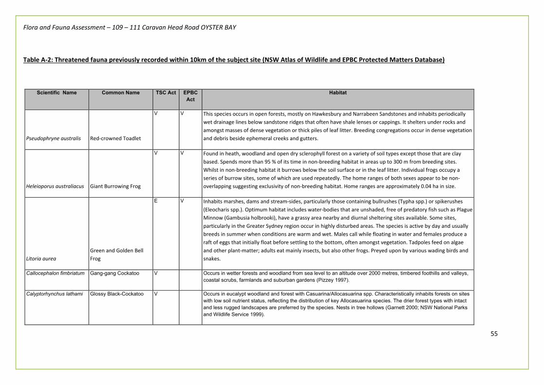
Flora and Fauna Assessment – 109 – 111 Caravan Head Road OYSTER BAY
55
Table A-2: Threatened fauna previously recorded within 10km of the subject site (NSW Atlas of Wildlife and EPBC Protected Matters Database)
Scientific Name Common Name TSC Act EPBC Act
Habitat
Pseudophryne australis Red-crowned Toadlet
V V This species occurs in open forests, mostly on Hawkesbury and Narrabeen Sandstones and inhabits periodically wet drainage lines below sandstone ridges that often have shale lenses or cappings. It shelters under rocks and amongst masses of dense vegetation or thick piles of leaf litter. Breeding congregations occur in dense vegetation and debris beside ephemeral creeks and gutters.
Heleioporus australiacus Giant Burrowing Frog
V V Found in heath, woodland and open dry sclerophyll forest on a variety of soil types except those that are clay based. Spends more than 95 % of its time in non-breeding habitat in areas up to 300 m from breeding sites. Whilst in non-breeding habitat it burrows below the soil surface or in the leaf litter. Individual frogs occupy a series of burrow sites, some of which are used repeatedly. The home ranges of both sexes appear to be non-overlapping suggesting exclusivity of non-breeding habitat. Home ranges are approximately 0.04 ha in size.
Litoria aurea Green and Golden Bell Frog
E V Inhabits marshes, dams and stream-sides, particularly those containing bullrushes (Typha spp.) or spikerushes (Eleocharis spp.). Optimum habitat includes water-bodies that are unshaded, free of predatory fish such as Plague Minnow (Gambusia holbrooki), have a grassy area nearby and diurnal sheltering sites available. Some sites, particularly in the Greater Sydney region occur in highly disturbed areas. The species is active by day and usually breeds in summer when conditions are warm and wet. Males call while floating in water and females produce a raft of eggs that initially float before settling to the bottom, often amongst vegetation. Tadpoles feed on algae and other plant-matter; adults eat mainly insects, but also other frogs. Preyed upon by various wading birds and snakes.
Callocephalon fimbriatum Gang-gang Cockatoo V Occurs in wetter forests and woodland from sea level to an altitude over 2000 metres, timbered foothills and valleys, coastal scrubs, farmlands and suburban gardens (Pizzey 1997).
Calyptorhynchus lathami Glossy Black-Cockatoo V Occurs in eucalypt woodland and forest with Casuarina/Allocasuarina spp. Characteristically inhabits forests on sites with low soil nutrient status, reflecting the distribution of key Allocasuarina species. The drier forest types with intact and less rugged landscapes are preferred by the species. Nests in tree hollows (Garnett 2000; NSW National Parks and Wildlife Service 1999).

Flora and Fauna Assessment – 109 – 111 Caravan Head Road OYSTER BAY
56
Scientific Name Common Name TSC Act EPBC Act
Habitat
Lathamus discolor Swift Parrot E1 EM Breeding occurs in Tasmania, majority migrates to mainland Australia in autumn, over-wintering, particularly in Victoria and central and eastern NSW, but also south-eastern Queensland as far north as Duaringa. New evidence indicates that the forests on the coastal plains from southern to northern NSW are also extremely important. In mainland Australia is semi-nomadic, foraging in flowering eucalypts in eucalypt associations, particularly box-ironbark forests and woodlands. Preference for sites with highly fertile soils where large trees have high nectar production, including along drainage lines and isolated rural or urban remnants, and for sites with flowering Acacia pycnantha, is indicated. Sites used vary from year to year (Garnett 2000; Swift Parrot Recovery Team 2001).
Glossopsitta pusilla Little Lorikeet
V Forages primarily in the canopy of open Eucalyptus forest and woodland, yet also finds food in Angophoras, Melaleucas and other tree species. Riparian habitats are particularly used, due to higher soil fertility and hence greater productivity. Isolated flowering trees in open country, e.g. paddocks, roadside remnants and urban trees also help sustain viable populations of the species. Feeds mostly on nectar and pollen, occasionally on native fruits such as mistletoe, and only rarely in orchards. Roosts in treetops, often distant from feeding areas. Nests in proximity to feeding areas if possible, most typically selecting hollows in the limb or trunk of smooth-barked Eucalypts. Entrance is small (3 cm) and usually high above the ground (2–15 m). These nest sites are often used repeatedly for decades, suggesting that preferred sites are limited. Riparian trees often chosen, including species like Allocasuarina.
Daphoenositta chrysoptera Varied Sittella
V Inhabits eucalypt forests and woodlands, especially those containing rough-barked species and mature smooth-barked gums with dead branches, mallee and Acacia woodland. Feeds on arthropods gleaned from crevices in rough or decorticating bark, dead branches, standing dead trees and small branches and twigs in the tree canopy. Builds a cup-shaped nest of plant fibres and cobwebs in an upright tree fork high in the living tree canopy, and often re-uses the same fork or tree in successive years.
Pyrrholaemus saggitatus Speckled Warbler
V The Speckled Warbler lives in a wide range of Eucalyptus dominated communities that have a grassy understorey, often on rocky ridges or in gullies. Typical habitat would include scattered native tussock grasses, a sparse shrub layer, some eucalypt regrowth and an open canopy. Large, relatively undisturbed remnants are required for the species to persist in an area.
Melanodryas cucullata Hooded Robin
V Prefers lightly wooded country, usually open eucalypt woodland, acacia scrub and mallee, often in or near clearings or open areas. Requires structurally diverse habitats featuring mature eucalypts, saplings, some small shrubs and a ground layer of moderately tall native grasses. Often perches on low dead stumps and fallen timber or on low-hanging branches, using a perch-and-pounce method of hunting insect prey. Territories range from around 10 ha during the breeding season, to 30 ha in the non-breeding season.
Lophoictinia isura Square-tailed Kite V M This species hunts primarily over open forest, woodland and mallee communities as well as over adjacent heaths and other low scrubby habitats in wooded towns. It feeds on small birds, their eggs and nestlings as well as insects. Seems to prefer structurally diverse landscapes (Garnett 2000).
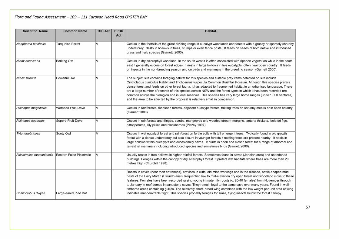
Flora and Fauna Assessment – 109 – 111 Caravan Head Road OYSTER BAY
57
Scientific Name Common Name TSC Act EPBC Act
Habitat
Neophema pulchella Turquoise Parrot V Occurs in the foothills of the great dividing range in eucalypt woodlands and forests with a grassy or sparsely shrubby understorey. Nests in hollows in trees, stumps or even fence posts. It feeds on seeds of both native and introduced grass and herb species (Garnett, 2000).
Ninox connivens Barking Owl V Occurs in dry sclerophyll woodland. In the south west it is often associated with riparian vegetation while in the south east it generally occurs on forest edges. It nests in large hollows in live eucalypts, often near open country. It feeds on insects in the non-breeding season and on birds and mammals in the breeding season (Garnett 2000).
NInox strenua Powerful Owl V The subject site contains foraging habitat for this species and suitable prey items detected on site include Oryctolagus cuniculus Rabbit and Trichosurus vulpecula Common Brushtail Possum. Although this species prefers dense forest and feeds on other forest fauna, it has adapted to fragmented habitat in an urbanised landscape. There are a large number of records of this species across NSW and the forest types in which it has been recorded are common across the bioregion and in local reserves. This species has very large home ranges (up to 1,000 hectares) and the area to be affected by the proposal is relatively small in comparison.
Ptilinopus magnificus Wompoo Fruit-Dove V Occurs in rainforests, monsoon forests, adjacent eucalypt forests, fruiting trees on scrubby creeks or in open country (Garnett 2000).
Ptilinopus superbus Superb Fruit-Dove V Occurs in rainforests and fringes, scrubs, mangroves and wooded stream-margins, lantana thickets, isolated figs, pittosporums, lilly pillies and blackberries (Pizzey 1997).
Tyto tenebricosa Sooty Owl V Occurs in wet eucalypt forest and rainforest on fertile soils with tall emergent trees. Typically found in old growth forest with a dense understorey but also occurs in younger forests if nesting trees are present nearby. It nests in large hollows within eucalypts and occasionally caves. It hunts in open and closed forest for a range of arboreal and terrestrial mammals including introduced species and sometimes birds (Garnett 2000).
Falsistrellus tasmaniensis Eastern False Pipistrelle V Usually roosts in tree hollows in higher rainfall forests. Sometimes found in caves (Jenolan area) and abandoned buildings. Forages within the canopy of dry sclerophyll forest. It prefers wet habitats where trees are more than 20 metres high (Churchill 1998).
Chalinolobus dwyeri Large-eared Pied Bat
Roosts in caves (near their entrances), crevices in cliffs, old mine workings and in the disused, bottle-shaped mud nests of the Fairy Martin (Hirundo ariel), frequenting low to mid-elevation dry open forest and woodland close to these features. Females have been recorded raising young in maternity roosts (c. 20-40 females) from November through to January in roof domes in sandstone caves. They remain loyal to the same cave over many years. Found in well-timbered areas containing gullies. The relatively short, broad wing combined with the low weight per unit area of wing indicates manoeuvrable flight. This species probably forages for small, flying insects below the forest canopy.
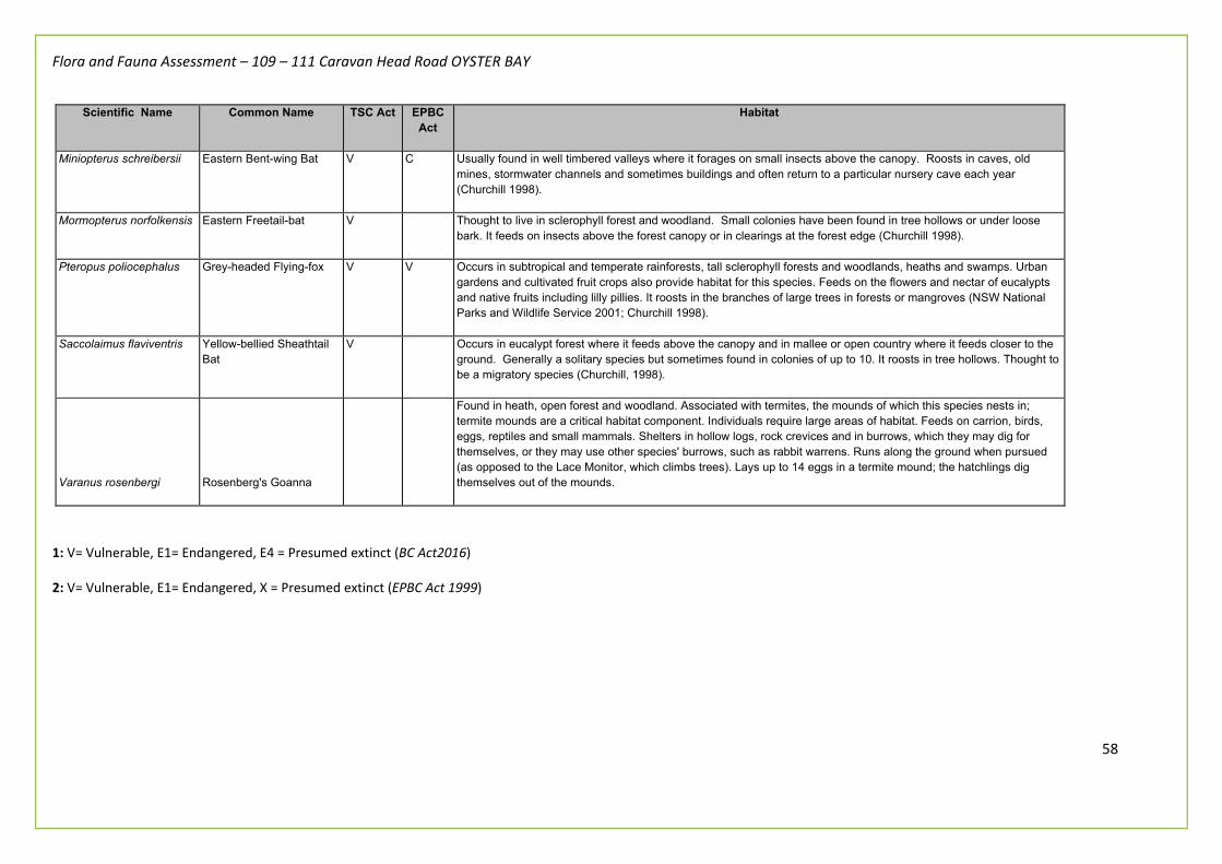
Flora and Fauna Assessment – 109 – 111 Caravan Head Road OYSTER BAY
58
Scientific Name Common Name TSC Act EPBC Act
Habitat
Miniopterus schreibersii Eastern Bent-wing Bat V C Usually found in well timbered valleys where it forages on small insects above the canopy. Roosts in caves, old mines, stormwater channels and sometimes buildings and often return to a particular nursery cave each year (Churchill 1998).
Mormopterus norfolkensis Eastern Freetail-bat V Thought to live in sclerophyll forest and woodland. Small colonies have been found in tree hollows or under loose bark. It feeds on insects above the forest canopy or in clearings at the forest edge (Churchill 1998).
Pteropus poliocephalus Grey-headed Flying-fox V V Occurs in subtropical and temperate rainforests, tall sclerophyll forests and woodlands, heaths and swamps. Urban gardens and cultivated fruit crops also provide habitat for this species. Feeds on the flowers and nectar of eucalypts and native fruits including lilly pillies. It roosts in the branches of large trees in forests or mangroves (NSW National Parks and Wildlife Service 2001; Churchill 1998).
Saccolaimus flaviventris Yellow-bellied Sheathtail Bat
V Occurs in eucalypt forest where it feeds above the canopy and in mallee or open country where it feeds closer to the ground. Generally a solitary species but sometimes found in colonies of up to 10. It roosts in tree hollows. Thought to be a migratory species (Churchill, 1998).
Varanus rosenbergi Rosenberg's Goanna
Found in heath, open forest and woodland. Associated with termites, the mounds of which this species nests in; termite mounds are a critical habitat component. Individuals require large areas of habitat. Feeds on carrion, birds, eggs, reptiles and small mammals. Shelters in hollow logs, rock crevices and in burrows, which they may dig for themselves, or they may use other species' burrows, such as rabbit warrens. Runs along the ground when pursued (as opposed to the Lace Monitor, which climbs trees). Lays up to 14 eggs in a termite mound; the hatchlings dig themselves out of the mounds.
1: V= Vulnerable, E1= Endangered, E4 = Presumed extinct (BC Act2016)
2: V= Vulnerable, E1= Endangered, X = Presumed extinct (EPBC Act 1999)

Flora and Fauna Assessment – 109 – 111 Caravan Head Road OYSTER BAY
59
APPENDIX B: ASSESSMENTS OF SIGNIFICANCE ‘FIVE PART TESTS’
Flora and Fauna Assessment – 109 – 111 Caravan Head Road OYSTER BAY
60
Five part test for Little Lorikeet, Grey-Headed Flying-fox, Eastern Freetail-bat, Eastern Bent-wing Bat, Yellow-bellied Sheathtail-bat, Greater Broad-nosed bat and Eastern False Pipistrelle (State Biodiversity Conservation Act 2016) (a) “…in the case of a threatened species, whether the action proposed is likely to have an adverse effect on the life cycle of the species such that a viable local population of the species is likely to be placed at risk of extinction…” No nesting or maternity sites were observed on site. It is not anticipated that any active hollow-bearing trees (and therefore nesting sites) will be removed making the proposal unlikely to place the species at risk of extinction. (b) “…in the case of an endangered ecological community or critically endangered ecological community, whether the action proposed: (i) ..is likely to have an adverse effect on the extent of the ecological community such that its local occurrence is likely to be placed at risk of extinction, or (ii).. is likely to substantially and adversely modify the composition of the ecological community such that its local occurrence is likely to be placed at risk of extinction...” An Endangered Ecological Community means a threatened ecological community specified in BC Act. Therefore, not applicable to threatened species. (c) “…in relation to the habitat of a threatened species, population or ecological community: (i)... the extent to which habitat is likely to be removed or modified as a result of the action proposed…”, and (ii) … whether an area of habitat is likely to become fragmented or isolated from other areas of habitat as a result of the proposed action…, and (iii)…the importance of the habitat to be removed, modified, fragmented or isolated to the long-term survival of the species, population or ecological community in the locality… The proposal will impact upon marginal foraging habitat that would be considered of insignificant value to this species. Vegetation removal for the future construction of dwelling on the site will not prevent the subject species from foraging on similar habitat resources in the locality. The removal of environmental weeds within the Study Area is unlikely to impact on the long-term survival of the subject species within the Locality or Region. (d) “whether the proposed development or activity is likely to have an adverse effect on any declared area of outstanding biodiversity value (either directly or indirectly),” The Study Area is not listed as an area of outstanding biodiversity value. (e) whether the proposed development or activity is or is part of a key threatening process or is likely to increase the impact of a key threatening process.”

Flora and Fauna Assessment – 109 – 111 Caravan Head Road OYSTER BAY
61
“Clearing of Native Vegetation” is a Key Threatening Process listed in Schedule 3 of the Biodiversity Conservation Act 2016. However, given this species is highly mobile/migratory, and the area to be cleared is considered to be of relative small, and large areas of foraging habitat is still available in the locality it is considered that the proposal would not significantly exacerbate this KTP.
Conclusion
It is not considered that the proposal would have a significant impact on the subject species, their populations or habitats. Therefore, the preparation of a Species Impact Statement is NOT REQUIRED.

Flora and Fauna Assessment – 109 – 111 Caravan Head Road OYSTER BAY
62
- Little Lorikeet - Grey-headed Flying Fox - Yellow-bellied Sheathtail Bat - Eastern Freetail Bat - Eastern Bent-wing Bat
Five part test for Powerful Owl – Ninox strenua (State Biodiversity Conservation Act 2016)
(a) “…in the case of a threatened species, whether the action proposed is likely to have an adverse effect on the life cycle of the species such that a viable local population of the species is likely to be placed at risk of extinction…” No nesting or maternity sites were observed on site. It is not anticipated that any active hollow-bearing trees (and therefore nesting sites) will be removed making the proposal unlikely to place the species at risk of extinction. (b) “…in the case of an endangered ecological community or critically endangered ecological community, whether the action proposed: (i) ..is likely to have an adverse effect on the extent of the ecological community such that its local occurrence is likely to be placed at risk of extinction, or (ii).. is likely to substantially and adversely modify the composition of the ecological community such that its local occurrence is likely to be placed at risk of extinction...” An Endangered Ecological Community means a threatened ecological community specified in BC Act. Therefore, not applicable to threatened species. (c) “…in relation to the habitat of a threatened species, population or ecological community: (i)... the extent to which habitat is likely to be removed or modified as a result of the action proposed…”, and (ii) … whether an area of habitat is likely to become fragmented or isolated from other areas of habitat as a result of the proposed action…, and (iii)…the importance of the habitat to be removed, modified, fragmented or isolated to the long-term survival of the species, population or ecological community in the locality… The proposal will impact upon marginal foraging habitat that would be considered of insignificant value to this species. Vegetation removal for the future construction of dwelling on the site will not prevent the subject species from foraging on similar habitat resources in the locality. The removal of environmental weeds within the Study Area is unlikely to impact on the long-term survival of the subject species within the Locality or Region. (d) “whether the proposed development or activity is likely to have an adverse effect on any declared area of outstanding biodiversity value (either directly or indirectly),”
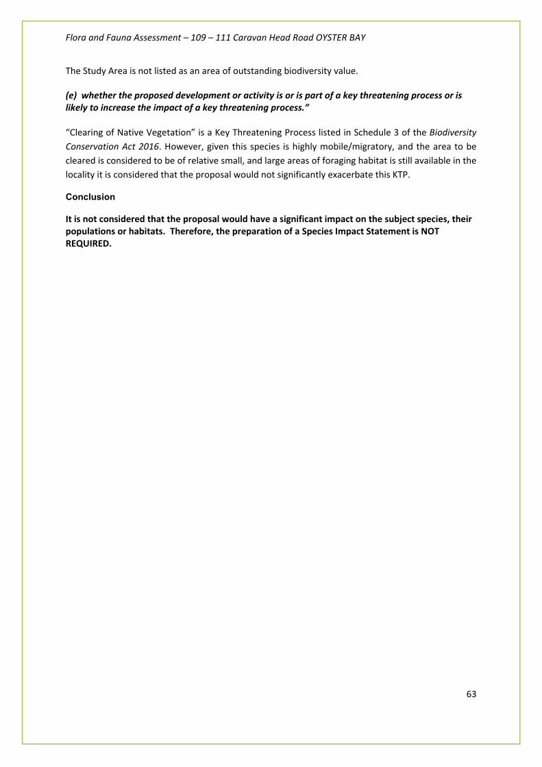
Flora and Fauna Assessment – 109 – 111 Caravan Head Road OYSTER BAY
63
The Study Area is not listed as an area of outstanding biodiversity value. (e) whether the proposed development or activity is or is part of a key threatening process or is likely to increase the impact of a key threatening process.” “Clearing of Native Vegetation” is a Key Threatening Process listed in Schedule 3 of the Biodiversity Conservation Act 2016. However, given this species is highly mobile/migratory, and the area to be cleared is considered to be of relative small, and large areas of foraging habitat is still available in the locality it is considered that the proposal would not significantly exacerbate this KTP.
Conclusion
It is not considered that the proposal would have a significant impact on the subject species, their populations or habitats. Therefore, the preparation of a Species Impact Statement is NOT REQUIRED.

Flora and Fauna Assessment – 109 – 111 Caravan Head Road OYSTER BAY
64
APPENDIX C: EPBC PROTECTED MATTERS SEARCH TOOL DATABASE RESULTS

EPBC Act Protected Matters Report
This report provides general guidance on matters of national environmental significance and other mattersprotected by the EPBC Act in the area you have selected.
Information on the coverage of this report and qualifications on data supporting this report are contained in thecaveat at the end of the report.
Information is available about Environment Assessments and the EPBC Act including significance guidelines,forms and application process details.
Other Matters Protected by the EPBC Act
Acknowledgements
Buffer: 10.0Km
Matters of NES
Report created: 23/03/20 15:07:16
Coordinates
This map may contain data which are©Commonwealth of Australia(Geoscience Australia), ©PSMA 2010
CaveatExtra Information
DetailsSummary
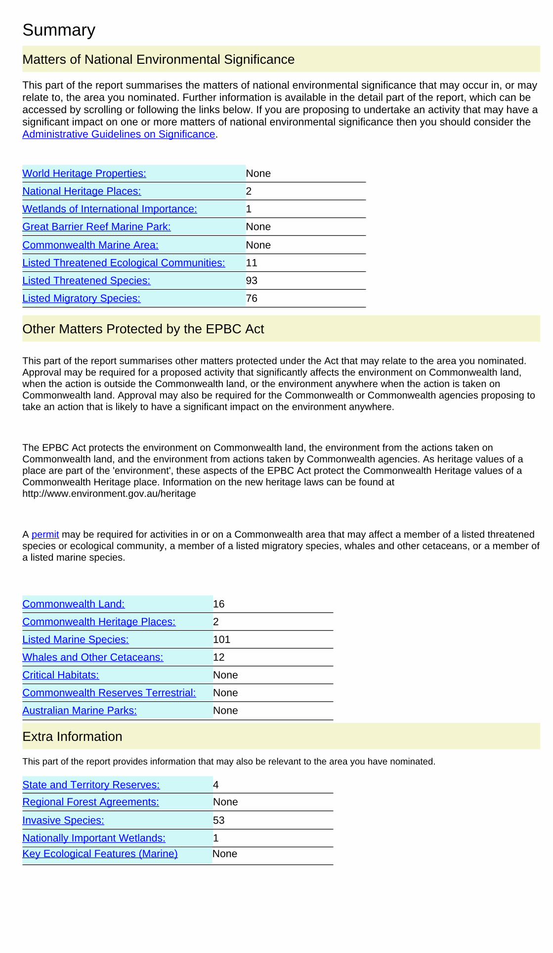
Summary
This part of the report summarises the matters of national environmental significance that may occur in, or mayrelate to, the area you nominated. Further information is available in the detail part of the report, which can beaccessed by scrolling or following the links below. If you are proposing to undertake an activity that may have asignificant impact on one or more matters of national environmental significance then you should consider theAdministrative Guidelines on Significance.
Matters of National Environmental Significance
Listed Threatened Ecological Communities:
Listed Migratory Species:
11
Great Barrier Reef Marine Park:
Wetlands of International Importance:
Listed Threatened Species:
None
93
2
None
National Heritage Places:
Commonwealth Marine Area:
World Heritage Properties:
1
None
76
The EPBC Act protects the environment on Commonwealth land, the environment from the actions taken onCommonwealth land, and the environment from actions taken by Commonwealth agencies. As heritage values of aplace are part of the 'environment', these aspects of the EPBC Act protect the Commonwealth Heritage values of aCommonwealth Heritage place. Information on the new heritage laws can be found athttp://www.environment.gov.au/heritage
This part of the report summarises other matters protected under the Act that may relate to the area you nominated.Approval may be required for a proposed activity that significantly affects the environment on Commonwealth land,when the action is outside the Commonwealth land, or the environment anywhere when the action is taken onCommonwealth land. Approval may also be required for the Commonwealth or Commonwealth agencies proposing totake an action that is likely to have a significant impact on the environment anywhere.
A permit may be required for activities in or on a Commonwealth area that may affect a member of a listed threatenedspecies or ecological community, a member of a listed migratory species, whales and other cetaceans, or a member ofa listed marine species.
Other Matters Protected by the EPBC Act
None
None
12
Listed Marine Species:
Whales and Other Cetaceans:
101
Commonwealth Heritage Places:
16
2
Critical Habitats:
Commonwealth Land:
Commonwealth Reserves Terrestrial:
NoneAustralian Marine Parks:
Extra Information
This part of the report provides information that may also be relevant to the area you have nominated.
1
4State and Territory Reserves:
Nationally Important Wetlands:
NoneRegional Forest Agreements:
Invasive Species: 53
NoneKey Ecological Features (Marine)
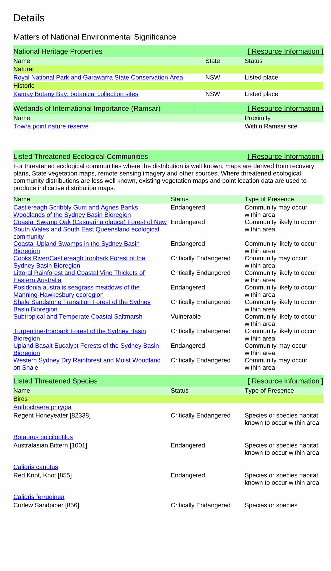
Details
Wetlands of International Importance (Ramsar) [ Resource Information ]Name ProximityTowra point nature reserve Within Ramsar site
Listed Threatened Species [ Resource Information ]Name Status Type of PresenceBirds
Regent Honeyeater [82338] Critically Endangered Species or species habitatknown to occur within area
Anthochaera phrygia
Australasian Bittern [1001] Endangered Species or species habitatknown to occur within area
Botaurus poiciloptilus
Red Knot, Knot [855] Endangered Species or species habitatknown to occur within area
Calidris canutus
Curlew Sandpiper [856] Critically Endangered Species or speciesCalidris ferruginea
National Heritage Properties [ Resource Information ]Name StatusStateNaturalRoyal National Park and Garawarra State Conservation Area Listed placeNSWHistoricKamay Botany Bay: botanical collection sites Listed placeNSW
For threatened ecological communities where the distribution is well known, maps are derived from recoveryplans, State vegetation maps, remote sensing imagery and other sources. Where threatened ecologicalcommunity distributions are less well known, existing vegetation maps and point location data are used toproduce indicative distribution maps.
Listed Threatened Ecological Communities [ Resource Information ]
Name Status Type of PresenceCastlereagh Scribbly Gum and Agnes BanksWoodlands of the Sydney Basin Bioregion
Endangered Community may occurwithin area
Coastal Swamp Oak (Casuarina glauca) Forest of NewSouth Wales and South East Queensland ecologicalcommunity
Endangered Community likely to occurwithin area
Coastal Upland Swamps in the Sydney BasinBioregion
Endangered Community likely to occurwithin area
Cooks River/Castlereagh Ironbark Forest of theSydney Basin Bioregion
Critically Endangered Community may occurwithin area
Littoral Rainforest and Coastal Vine Thickets ofEastern Australia
Critically Endangered Community likely to occurwithin area
Posidonia australis seagrass meadows of theManning-Hawkesbury ecoregion
Endangered Community likely to occurwithin area
Shale Sandstone Transition Forest of the SydneyBasin Bioregion
Critically Endangered Community likely to occurwithin area
Subtropical and Temperate Coastal Saltmarsh Vulnerable Community likely to occurwithin area
Turpentine-Ironbark Forest of the Sydney BasinBioregion
Critically Endangered Community likely to occurwithin area
Upland Basalt Eucalypt Forests of the Sydney BasinBioregion
Endangered Community may occurwithin area
Western Sydney Dry Rainforest and Moist Woodlandon Shale
Critically Endangered Community may occurwithin area
Matters of National Environmental Significance

Flora and Fauna Assessment – 109 – 111 Caravan Head Road OYSTER BAY
65
APPENDIX D: RELEVANT QUALIFICATIONS & EXPERIENCE OF THE AUTHOR
Alex Fraser (Fraser Ecological Consulting) has over 15 years experience in ecological assessment and on-ground bushland restoration management. Previous work roles include ecological consulting with Parsons Brinckerhoff (large infrastructure), NPWS (biodiversity surveys), NSW Department of Environment and Climate Change (SIS DGRs) and Hornsby Shire Council (residential and light industrial development) have focussed primarily on ecological survey, development assessment, project management and policy development for consent authorities. Alex also has practical experience in landscape construction, bushland restoration and property management. A full list of flora and fauna assessments previously undertaken can be provided upon request.
Professional Affiliations include the Australian Association of Bush Regenerators, Ecological Society of Australia, Royal Zoological Society of NSW, Birds Australia, Australasian Bat Society, Urban Feral Animal Action Control Group (Sydney North Councils), Surfrider Foundation & Fred Hollows Foundation.
Relevant qualifications and training:
• Bachelor of Applied Science – Coastal Resource Management (Honours)
• Certificate 3 Natural Area Restoration (Ryde Horticultural College)
• Chemcert (Department of Natural Resources)
• Chainsaw Cross Cutting Techniques (Ryde Horticultural College)
• Certificate 3 Vertebrate Animal Pest Control (NSW DPI, Orange)
• OH&S General Induction for Construction Work (Work Cover NSW)
• Senior First Aid ( St. Johns Ambulance Australia)
• Project Management ’the hard and soft skills’ (NPWS- 2004)
• Frog, Bat and Reptile: species identification and survey skills (Forests NSW)
• Advanced Open Water SCUBA diver (PADI Australia)
• State Rail Contractor Safety Awareness (State Rail Authority)
• NPWS Scientific Licence (NSW Office of Environment and Heritage)
• Animal Ethics Authority (NSW Department of primary Industries)
• Planning or Bushfire Protection 2006 (University of Technology Sydney)
• BAM Accredited Assessor