florence area transportation study … · transportation administration and planning activities...
TRANSCRIPT

UNIFIED PLANNING WORK PROGRAM FISCAL YEARS 2018 AND 2019
FLORENCE AREA TRANSPORTATION STUDY
Metropolitan Planning Organization (MPO)
Federal ID #57-6000351
Funding Agencies: Florence County and
The Federal Highway Administration
Contact: FLATS Administrator Florence County Planning Department 518 S. Irby Street Florence, SC 29501 (843) 676-8600 www.florenceco.org/offices/planning/flats/
This report was funded in part through grant[s] from the Federal Highway Administration [and Federal Transit Administration], U.S. Department of Transportation. The views and
opinions of the authors [or agency] expressed herein do not necessarily state or reflect those of the U.S. Department of Transportation.
Public Comment Period: June 13, 2017 through June 22, 2017

FLATS Unified Planning Work Program FY2018 and FY2019
Adopted by FLATS Policy Committee: June 26, 2017 Page 1
Table of Contents INTRODUCTION .................................................................................................. 2
TRANSPORTATION PLANNING PROCESS BACKGROUND ...................................... 4
FLATS STUDY AREA ............................................................................................. 4
FLATS COMMITTEE MEMBERS............................................................................. 5
PLANNING EMPHASIS AND ISSUES ...................................................................... 6
FUNDING ............................................................................................................ 9
A. PROGRAM ADMINISTRATION ...................................................................... 10
A-1 Administration .............................................................................................................. 10
A-2 Public Participation ....................................................................................................... 13
A-3 Transportation Alternatives Program ............................................................................. 15
B. SURVEILLANCE ............................................................................................. 17
B-1 Mapping ........................................................................................................................ 17
B-2 Air Quality Surveillance ................................................................................................. 20
B-3 Traffic Surveillance ........................................................................................................ 22
C. DOCUMENTATION AND ANALYSIS ................................................................ 23
C-1 Development and Maintenance ..................................................................................... 23
C-2 Socioeconomic and Land Use Data ................................................................................. 25
C-3 Public Transportation Planning ...................................................................................... 27
APPENDIX A: AGENCY PARTICIPATION ............................................................. 29
APPENDIX B: FUNDING SOURCES ..................................................................... 30
APPENDIX C: LIST OF ACRONYMS ..................................................................... 31
APPENDIX D: GENERAL REFERENCES ................................................................ 32
RESOLUTION ..................................................................................................... 33
SCDOT LPA AGREEMENT ................................................................................... 34

FLATS Unified Planning Work Program FY2018 and FY2019
Adopted by FLATS Policy Committee: June 26, 2017 Page 2
Introduction The Unified Planning Work Program (UPWP) outlines the work tasks to be carried out for transportation administration and planning activities for fiscal year 2018 and fiscal year 2019 for the Florence Area Transportation Study (FLATS) Metropolitan Planning Organization (MPO). The UPWP identifies the transportation planning activities which are to be undertaken in the FLATS Study Area in support of the goals, objectives and actions established in the FLATS 2035 Long Range Transportation Plan (LRTP), which was adopted on July 23, 2012. The LRTP is a 25-year vision of future transportation improvements. The FLATS 2035 LRTP is required to be updated every five years. The 2040 LRTP should be completed by December, 2017. The UPWP serves as the basis for all federal (the Federal Highway Administration {FHWA} and the Federal Transit Authority {FTA}), state (the South Carolina Department of Transportation {SCDOT}), and local funding assistance for transportation planning activities. This document is federally required as a basis and condition for all funding assistance for transportation planning to State, local and regional agencies. The authority for this requirement and for the Federal funding is found in two separate Federal legislative acts establishing transportation planning programs:
1) Title 23, U.S. Code Section 134, Section 5303(c) (Federal Aid Highway Act of 1962, as amended)
2) Title 49, U.S. Code Section 1603 et. al.: (Urban Mass Transportation Act of 1964, as amended)
The FY2018 and FY2019 Work Programs are intended to be consistent with the metropolitan planning requirements of the Federal Legislation: “Fixing America’s Surface Transportation Act” or “FAST Act” and its implementing regulations. The FAST Act Bill, which provides five years of funding, was signed into law on December 4, 2015 {114-357} and directs transportation planning activities (Titles 23 and 49, United States Code). The bill addresses a wide range of issues including highway, transit, bicycle and pedestrian, highway safety, motor carrier safety, rail and other related programs. The notable changes or new elements to the bill include new freight programs and a significant streamlining of project approvals and environmental reviews. If the FAST Act does not mention a particular program or policy, that program or policy remains in place as directed in previous transportation bills. The Surface Transportation Program (STP) is renamed the Surface Transportation Block Grant (STBG) under the FAST Act. The Act also has changes to policy and planning language that strengthen the expectation that states and localities should have a “complete streets” approach to roadway design such as:
FLATS Unified Planning Work Program FY2018 and FY2019
Adopted by FLATS Policy Committee: June 26, 2017 Page 3
• There is a small change to language that now requires State DOTs “shall considers” the access of all users to non-Interstate National Highway System (NHS) roads;
• USDOT is asked to “encourage” States and MPOs to adopt design standards that ensure the safe and accessible accommodation of all users (i.e. Complete Streets).
• The National Association of City Transportation Officials (NACTO) Urban Streets Design Guide is added to the list of appropriate design manuals to use for Federally-funded projects.
The FAST Act, corresponds with MAP-21 and states that the metropolitan transportation planning process shall provide for the establishment and use of a performance-based approach to transportation decision-making to support the national goals of safety, infrastructure condition, congestion reduction, system reliability, freight movement and economic vitality, environmental sustainability, and reduced project delivery delays. The FLATS MPO will establish performance targets that address performance measures for use in tracking progress towards attainment of critical outcomes for the FLATS area. These performance targets will be coordinated with providers of public transportation when applicable. This information is described in section 150(b) of Title 23 and in section 5301(c) of Title 49. The UPWP outlines a framework for the work program which the FLATS staff is expected to accomplish and provides guidance with respect to a financial plan to support the Work Program. In short, Transportation Performance Management:
• Is systematically applied, a regular ongoing process; • Provides key information to help decision makers allowing them to understand the
consequences of investment decisions; • Improves communications between decision makers, stakeholders and the traveling
public; • Ensures targets and measures are developed in cooperative partnerships and based on
data and objective information. The UPWP is prepared by the Florence County Planning Department staff in consultation with the FHWA, the FTA, the SCDOT and other agencies involved in transportation planning and implementation. The work tasks are performed by the Florence County Planning and Geographic Information Systems (GIS) Departments. Periodically, a Consulting Firm may be attained to complete a work task. All tasks that involve the procurement of a consultant, FLATS will navigate the SCDOT LPA process prior to initiating any work on those items. Should the Planning staff foresee that a consultant will be necessary to complete a work task, it is noted in the Work Schedule portion for the work category it pertains to. The UPWP is written in compliance with the Title VI requirements contained in the Federal Regulations for the development of plans and programs.
FLATS Unified Planning Work Program FY2018 and FY2019
Adopted by FLATS Policy Committee: June 26, 2017 Page 4
Transportation Planning Process Background The Florence Area Transportation Study (FLATS) is the Metropolitan Planning Organization (MPO) responsible for the transportation planning process for the Florence urbanized area. The Federal-Aid Highway Act of 1962 established the federal requirement for urban transportation planning throughout the country. The Act required, as a condition attached to federal transportation financial assistance, that transportation projects in urbanized areas of 50,000 or more in population be based on a continuing, comprehensive, urban transportation planning process undertaken cooperatively by the states and local governments. As a result of this Act, Metropolitan Planning Organizations were formed to administer the urban transportation planning process. The most recent laws extending the federal requirement for transportation planning are:
• The Intermodal Surface Transportation Efficiency Act of 1994 (ISTEA); • The Transportation Equity Act for the 21st Century, adopted in 1998; • The Safe, Accountable, Flexible Transportation Equity Act: A Legacy for Users
(SAFEATEA-LU), enacted on August 10, 2005; • Moving Ahead for Progress in the 21st Century (MAP-21), a bill reauthorizing surface
transportation programs through fiscal year 2014, was signed by the President on July 6, 2012.
• Fixing America’s Surface Transportation Act (FAST Act), a bill providing five years of funding, which was signed into law on December 4, 2015 {114-357}.
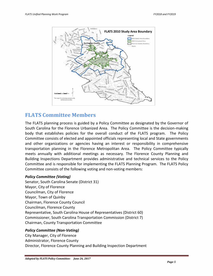
FLATS Study Area The FLATS MPO urbanized area has a population of 89,535 as determined by the 2010 U.S. Census. This area includes the City of Florence, Town of Quinby, City of Darlington, Town of Timmonsville and unincorporated areas of Florence and Darlington counties. An MPO is allowed to include areas beyond the urbanized area that are anticipated to become urbanized over the next twenty years as their Study Area. Federal transportation financial assistance may be utilized in the entire study area. The total population for the FLATS Study Area is approximately 124,316. The following map indicates both the urbanized and study area for the Florence Area Transportation Study Metropolitan Planning Organization.
FLATS Unified Planning Work Program FY2018 and FY2019
Adopted by FLATS Policy Committee: June 26, 2017 Page 5
FLATS Committee Members The FLATS planning process is guided by a Policy Committee as designated by the Governor of South Carolina for the Florence Urbanized Area. The Policy Committee is the decision-making body that establishes policies for the overall conduct of the FLATS program. The Policy Committee consists of elected and appointed officials representing local and State governments and other organizations or agencies having an interest or responsibility in comprehensive transportation planning in the Florence Metropolitan Area. The Policy Committee typically meets annually with additional meetings as necessary. The Florence County Planning and Building Inspections Department provides administrative and technical services to the Policy Committee and is responsible for implementing the FLATS Planning Program. The FLATS Policy Committee consists of the following voting and non-voting members: Policy Committee (Voting) Senator, South Carolina Senate (District 31) Mayor, City of Florence Councilman, City of Florence Mayor, Town of Quinby Chairman, Florence County Council Councilman, Florence County Representative, South Carolina House of Representatives (District 60) Commissioner, South Carolina Transportation Commission (District 7) Chairman, County Transportation Committee Policy Committee (Non-Voting) City Manager, City of Florence Administrator, Florence County Director, Florence County Planning and Building Inspection Department

FLATS Unified Planning Work Program FY2018 and FY2019
Adopted by FLATS Policy Committee: June 26, 2017 Page 6
Deputy Secretary for Intermodal Planning, SCDOT District Engineering Administrator, SCDOT (District 5) Chairman, Florence County Planning Commission Executive Director, PDRTA Chairman, Florence Airport Commission Division Administrator, FHWA Chairman, City of Florence Planning Commission The FLATS Study Team is established by the Policy Committee to provide recommendations on technical methods, procedures and standards that are used in the development of transportation plans and programs. The Study Team consists of representatives from each of the municipalities within the FLATS Study Area, the FHWA, the SCDOT, elected and appointed local officials, the local transit authority, and the Pee Dee Council of Governments (PDCOG). The Study Team meets approximately two weeks prior to the scheduled Policy Committee meetings to review the agenda documents for their recommendations to the Policy Committee. The FLATS Study Team consists of the following members: Study Team Regional Planning Manager, SCDOT, Office of Public Transit Regional Planner, SCDOT District 5 Traffic Engineer, SCDOT Program Manager, Pee Dee Regional Production Group, SCDOT Manager, SCDOT Enhancement Program Coordinator, SCDOT Enhancement Program Community Planner, FHWA Director, Planning, Research and Development, City of Florence Engineering Plans Reviewer/Project Manager, City of Florence Chairman, Florence County Planning Commission Planner, Pee Dee Regional Council of Governments Executive Director, Pee Dee Regional Transportation Authority Chairman, City of Florence Planning Commission Planning Director, Darlington County Councilmember, City of Darlington Councilmember, Town of Timmonsville Director, Florence County Planning and Building Inspections Department Planning Emphasis and Issues Changes in the economy will always present challenges for the Florence Area Transportation Study. There are several key planning issues to continually address for improvements. Implementation of safety measures in the transportation planning process is at the top of the list. The FLATS planning process focuses on a multi-modal transportation network that can be financially justified, maintain its current attainment air quality status, increase public involvement in the planning process and strive for a livable, sustainable community.

FLATS Unified Planning Work Program FY2018 and FY2019
Adopted by FLATS Policy Committee: June 26, 2017 Page 7
Recognizing the need to move from an emphasis on major highway widening projects towards creating a multi-modal transportation system in the LRTP, FLATS will emphasize the development of transit and other alternative modes of travel in the Study Area. A focus on operational improvements and the protection of existing corridors through access management offers relatively low cost projects that can significantly improve congestion and safety on community streets and roads. FLATS works closely with the City of Florence Parks and Beautification Department on enhancing its current Florence Trail System. Enhancing the FLATS area to a more bicycle/pedestrian friendly area will assist in improving traffic flow and potentially mitigate congestion. The FLATS MPO will identify, select and prioritize potential bicycle/pedestrian projects to be funded by the SCDOT through the Transportation Alternatives Program (TAP). FLATS also works closely with the Pee Dee Regional Transportation Authority (PDRTA) assisting them with any documentation, statistical information and any Geographic Information Services (GIS) data needed to enhance their service to more adequately serve the residents of Florence County. The FLATS area’s population, employment and housing continue to expand creating the need to plan for and implement transportation infrastructure and services. The ability for the FLATS Study Area to remain livable and sustainable, as well as economically competitive is highly dependent on the quality of our transportation systems and availability of services. FLATS recognizes the importance of intermodal freight and associated truck and distribution activities, as well as the economic impact of these activities in the Study Area. Freight movement and accompanying distribution centers may increase economic activity and employment in the Study Area. Careful planning is necessary to ensure truck routes that minimize impacts on local roadways and to area residents, as well as reducing negative environmental impacts. The FLATS MPO ensures that transportation plans address environmental impacts or mitigation activities involving conservation of natural resources, historic preservation and land use development activities as well as other provisions necessary to comply with the local, state and federal regulations, laws and policies. FLATS will monitor growth trends based on building permit and employment activities as well as updating the socio-economic data. Work will focus on updating data to ensure consistency with growth and transportation trends in the area. The FLATS Policy Committee invites and encourages public participation. FLATS has increased public outreach and education through the development and use of its Public Participation Process. Additionally, FLATS has developed and continually updates a Distribution List of various stakeholders who are sent electronic notifications regarding upcoming Policy Committee meetings, website updates and transportation activities. The FLATS transportation planning process is continuous, cooperative and comprehensive and provides for consideration and implementation of projects, strategies and services that will address the eight planning factors as directed by the previous Surface Transportation Bill, Moving Ahead for Progress in the 21st Century Act (MAP-21), and the current Federal

FLATS Unified Planning Work Program FY2018 and FY2019
Adopted by FLATS Policy Committee: June 26, 2017 Page 8
Legislature, Fixing America’s Surface Transportation Act (FAST Act). (U.S. Code, Title 23, Section 134. U.S. Code, Title 49, Section 5303. Initially there were eight planning factors required by the above referenced Federal Legislature for Metropolitan Planning Organizations. Two additional planning factors have been included per (23 CFR 450.206 and 23 CFR 450.306). The ten planning factors are listed below:
1. Support the economic vitality of the metropolitan area, especially by enabling global competitiveness, productivity, and efficiency;
2. Increase the safety of the transportation system for motorized and non-motorized users;
3. Increase the security of the transportation system for motorized and non-motorized users;
4. Increase the accessibility and mobility of people and freight; 5. Protect and enhance the environment, promote energy conservation, improve the
quality of life, and promote consistency between transportation improvements and State and local planned growth and economic development patterns;
6. Enhance the integration and connectivity of the transportation system, across and between modes, for people and freight;
7. Promote efficient system management and operation, and; 8. Emphasize the preservation of the existing transportation system. 9. Improve the resiliency and reliability of the transportation system and reduce or
mitigate stormwater impacts of surface transportation. 10. Enhance travel and tourism.
Table 1 outlines how each of the ten planning factors are addressed in each work schedule activities. Table 1: Planning Factors
UPWP Work Task 1 2 3 4 5 6 7 8 9 10 A. Program Administration A-1 Administration X X X X X X X X X X A-2 Public Participation X X X A-3 Transportation Alternatives Program X X B. Surveillance B-1 Mapping X X X X X B-2 Air Quality Surveillance X X X B-3 Traffic Surveillance X X X X X C. Documentation and Analysis C-1 Development and Maintenance X X X X X X X C-2 Socioeconomic and Land Use Data X X X X X X C-3 Public Transportation Planning X X X X X X

FLATS Unified Planning Work Program FY2018 and FY2019
Adopted by FLATS Policy Committee: June 26, 2017 Page 9
Funding The work tasks in the UPWP are funded by a consolidated planning grant through the Federal Highway Administration (FHWA) Metropolitan Planning Funds (PL funds) {U.S. Code Title 23 Section 104(f)} and the Federal Transit Administration (FTA) 49 U.S.C. § 5303 Federal Program. The FHWA/FTA consolidated planning grant allocates planning funds to the FLATS MPO each fiscal year to perform planning activities to encourage and promote the safe and efficient management, operation and development of surface transportation systems that will serve the mobility needs of people and freight and foster economic growth and development within and between States and urbanized areas. These planning activities also attempt to minimize transportation-related fuel consumption and air pollution. The federal share payable to the FLATS MPO for the activities using these funds is 80% of allowable costs. The remaining 20% is locally funded by Florence County. If all of the allocated planning funds for a particular fiscal year are not expended, the remainder will carryover and be added to the FLATS MPO allocation for the next fiscal year. The FLATS MPO is allocated $184,121 for FY2018 in addition to a carryover amount of $275,008 for a total of $459,129. The breakdown of funds in Table 2 and Appendices A & B reflect the FY2018 total. Table 2 shows the allocated amount to be utilized for each work task, in addition to what the required local match will be for the fiscal year. The total column will reflect the combined 100% total for the fiscal year. Appendices A & B also indicates the total amount and specifies the funding sources and participating agencies by activity for the UPWP work tasks. Table 2: Proposed Funding Sources – FY2018 (Year 1)
WORK TASK PERCENTAGE FHWA/FTA LOCAL SHARE
TOTAL
Program Administration 10% $ 36,730 $ 9,183 $ 45,913 Public Participation 3% $ 11,019 $ 2,755 $ 13,774 Transportation Alternatives Program 2% $ 7,346 $ 1,836 $ 9,182 Mapping 16% $ 58,769 $ 14,692 $ 73,461 Air Quality Surveillance 2% $ 7,346 $ 1,837 $ 9,183 Traffic Surveillance 7% $ 25,711 $ 6,428 $ 32,139 Development and Maintenance 33% $ 121,210 $ 30,303 $ 151,513 Socioeconomic and Land Use Data 25% $ 91,826 $ 22,956 $ 114,782 Public Transportation Planning 2% $ 7,346 $ 1,836 $ 9,182 TOTAL 100% $ 367,303 $ 91,826 $ 459,129

FLATS Unified Planning Work Program FY2018 and FY2019
Adopted by FLATS Policy Committee: June 26, 2017 Page 10
A. Program Administration
A-1 Administration Purpose: To administer the transportation planning program in the FLATS area, ensuring that it is continuous, cooperative and comprehensive, and is in compliance with applicable State, Federal and local laws and regulations. This includes coordinating all activities of the Policy Committees and Study Team, developing narrative reports for citizens and public/private agencies and providing liaison activities among government agencies and the public. Other administrative activities include preparing narrative and expenditure reports, maintaining financial accountability including an annual report, keeping routine correspondence and preparing and retaining information related to billing and training. The transportation planning activities will be conducted in compliance with all federal, state, and local laws regulations and requirements. Activity: The Planning Factors enhanced by this work task are 1 through 10. The staff will implement the work task as contained in this UPWP. Administrative activities include, but are not limited to the following:
1. Every two years, create and adopt a UPWP for the appropriate fiscal years. 2. Prior to the beginning of the second fiscal year of the two-year UPWP, the SCDOT will
supply the funding amounts for that year to the FLATS staff. The UPWP will be amended to reflect the new amount, a 10-day public comment period will be held and the amended UPWP will be presented to the Policy Committee for approval. Should additional amendments be required to the document during the two year period, they will be handled in the same manner;
3. Maintain financial records of all revenues and expenditures; 4. Prepare and distribute meeting notices and agenda packages for all FLATS committees; 5. Prepare and maintain minutes from all FLATS committee meetings; 6. Provide progress reports to all FLATS committees; 7. Prepare certification documentation, resolutions, memorandum of agreements
(MOA’s), etc.; 8. Maintain agreements between local governmental agencies and the MPO; 9. Acts as local liaison to the FHWA, FTA, SCDOT and other transportation related agencies
to ensure coordination; 10. Amend the transportation planning process in accordance with changes in federal laws
and regulations; 11. Comply with Title VI of the Civil Rights Act of 1964;

FLATS Unified Planning Work Program FY2018 and FY2019
Adopted by FLATS Policy Committee: June 26, 2017 Page 11
12. Comply with the SCDOT and FTA Disadvantaged Business Enterprise (DBE) Programs; 13. Ensure that all programs and activities sufficiently address Environmental Justice
principles and procedures, as appropriate; 14. Maintain activity time sheets for quarterly progress reports; 15. Submit quarterly progress reports with requisitions and a year-end annual report with
the final requisition to the SCDOT; 16. Attend training sessions and seminars and participate in webinars as related to the
transportation planning process. Focus on courses and conferences on air quality, public involvement, intelligent transportation systems, congestion management systems, environmental justice, compliance with the FTA regulations and livable and sustainable communities and intermodal issues;
17. Communicate and coordinate work among study participants, governments and citizens; 18. Maintain a building permit report; 19. Coordinate with SCDOT regarding transition to performance based planning;
Previous Work:
• The FLATS MPO staff performed work tasks as directed by the UPWP; • Prepared meeting agenda packets and minutes for FLATS Study Team and Policy
Committee meetings; • Submitted quarterly narrative reports to the SCDOT (including the account of quarterly
expenditures and the quarterly reimbursement requests) {Dates as noted in the work schedule table below};
• Submitted the annual year-end progress reports; • Staff attended an MPO/COG workshop hosted by the SCDOT; • Staff participated in several webinars on issues regarding transportation planning; • Staff attended Title VI training hosted by the FHWA and SCDOT: • Staff signed a contract with the consultant to update the 2035 LRTP; • Staff signed a contract with the consultant for the U.S. Highway 76 (E. Palmetto Street)
Engineering Study and Design Plan;

FLATS Unified Planning Work Program FY2018 and FY2019
Adopted by FLATS Policy Committee: June 26, 2017 Page 12
Work Schedule: ACTIVITY ANTICIPATED COMPLETION
DATE 1. Submit quarterly narrative reports and reimbursement
requests and year-end Annual Report to the SCDOT July 15, 2017, October 15, 2017,
January 15, 2018, April 15, 2018, July 15, 2018, October 15, 2018, January
15, 2019 and April 15, 2019 2. Participate in quarterly coordination meetings and/or
conference calls with the SCDOT and other MPOs and COGs
Continuous as scheduled by the SCDOT
3. Modify and review of the PL agreement with the SCDOT June 2017 4. Perform work tasks as directed by the UPWP Continuous 5. Organize Study Team and Policy Committee meetings At least annually 6. Prepare agenda packets and distribute for FLATS
committee meetings Continuous at least two weeks prior
to all meetings 7. Prepare and maintain minutes from FLATS committee
meetings Continuous immediately after
meetings 8. Staff will apply the performance management process in
transportation planning as applicable As directed by the FHWA and the
SCDOT 9. Staff will educate the FLATS committees on
implementing the performance management process in each work task as prescribed by MAP-21 and the current Surface Transportation Bill (FAST ACT).
As directed by the FHWA and the SCDOT
10. Attend transportation planning related seminars, conferences and meetings. In addition, participate in webinars related to transportation planning
July 2017 and as offered by SCDOT
11. Staff will add additional information in the Federal Obligations Report as recommended by the Review Team during the FLATS Self-Certification review
Upon receipt of information from the SCDOT to prepare next report
12. Perform daily FLATS administrative duties Continuous 13. Performance Based Planning (training & coordination) July 2017 and as offered by SCDOT
Products: Minutes, meeting summaries, resolutions, agreements, audits and other records of FLATS will be produced and maintained. All required documents will be published. Copies of written correspondence concerning FLATS or transportation related activities with citizens, local governments, developers and other agencies will be maintained to provide a record of the year’s activities. The UPWP will be maintained and/or developed. Work activities are continuous as applicable from July, 2017 – June, 2019
FLATS Unified Planning Work Program FY2018 and FY2019
Adopted by FLATS Policy Committee: June 26, 2017 Page 13
A-2 Public Participation Purpose: To provide information to FLATS participants and the general public about the transportation planning process, to respond to requests for information from the public and to encourage meaningful public input into all transportation plans, programs and projects and to ensure that the requirements of Title VI are met in this process. Additionally, the purpose is to promote and provide a variety of meaningful forums for FLATS stakeholders to communicate with the FLATS committees. The purpose of FLATS public involvement is to canvass the communities within the study area in search of ideas that will have public support and improve mobility and travel safety.
Examples include conducting public meetings, publishing an annual newsletter, responding to requests for information, FLATS staff will continue to evaluate the effectiveness of these and other outreach activities and make adjustments as necessary with the goal of obtaining meaningful public input on all FLATS activities.
Activity: The Planning Factors enhanced by this work task are 4, 6 and 9. The FLATS MPO will provide ample opportunities for comments on projects as they are considered for inclusion in the LRTP, the TIP and other FLATS documents and plans. A variety of outreach techniques are employed to obtain public input. Among the tools used to circulate information about FLATS activities are advertising FLATS committee meetings via media outlets and electronic notification to all stakeholders, publication and distribution of an annual newsletter, making presentations to neighborhood and civic organizations, publishing information on the FLATS website and the dissemination of FLATS publications (LRTP, TIP, etc.) for public review and comment. Respond to requests for information from the public and providing regular feedback on any issues of concern within two business days.
The FLATS website is updated as necessary to publish basic information about FLATS (meeting agendas and minutes, FLATS documents, annual newsletter, etc.) FLATS will continue to ensure that the principles of Environmental Justice, including minority and low income communities, senior citizens and non-English speaking population are included and represented in all public outreach efforts.
Techniques for the distribution of information include, but are not limited to the following:
1. Provide a constant avenue for the availability of FLATS federal documents at various public venues;
2. Maintain and update the FLATS Distribution List to remain in contact with the public/citizens and various stakeholders;
3. Media releases, press articles and paid advertisements; 4. Annual Newsletters;
FLATS Unified Planning Work Program FY2018 and FY2019
Adopted by FLATS Policy Committee: June 26, 2017 Page 14
5. Brochures, flyers and maps; 6. Utilize surveys, questionnaires, comment cards, etc. as applicable; 7. Public information meetings, workshops and conferences; 8. Maintaining updates on the FLATS website (www.florenceco.org/flats.org); 9. Maintain a record of attendance and public comments received to evaluate the
effectiveness of the current public involvement practices. 10. Coordinate public meetings for input on how to improve multi-modal transportation
and increase public involvement. Previous Work:
• Provided the opportunity for the public to review and comment on amendments to the FY2017-FY2022 TIP, the FY2016/17 UPWP;
• Distributed FLATS meeting agenda to stakeholders on the FLATS Distribution List; • Updated the FLATS website on a regular basis with information regarding FLATS
meetings, public comment notifications and document updates; • Responded to requests for information from media outlets; • Responded to requests for information from the general public and other stakeholders; • Updated FLATS document binders at various public venues as documents were
approved (Bylaws, PPP, UPWP, TIP); • Advertised in print for committee meetings and public comment notifications; • Updated the Public Participation Plan (PPP) to explore options to expand public
outreach and measure the effectiveness of the methods.
Work Schedule: During this program year the FLATS MPO staff will continue to implement the strategies in the FLATS Public Participation Process Plan. The anticipated public outreach opportunities include the following:
ACTIVITY ANTICIPATED COMPLETION DATE
1. Publish and distribute the FLATS Newsletter June 30, 2018 2. Provide public participation opportunities through
meetings, workshops and presentations April 2017, July 2017, October 2017
Continuous as necessary 3. Update FLATS website Continuous as necessary 4. Add information regarding performance management in
the transportation planning process as prescribed by MAP-21 and the FAST Act on the FLATS website for public information.
Upon direction of the FHWA and the SCDOT
5. Update FLATS document binders at public venues June 2017, Continuous as necessary

FLATS Unified Planning Work Program FY2018 and FY2019
Adopted by FLATS Policy Committee: June 26, 2017 Page 15
6. Notify stakeholders on the FLATS Distribution List regarding committee meetings and website updates
Continuous as necessary
7. As time allows, continue to work on developing a FLATS public website showing FLATS projects, sidewalk and trail locations, areas of congestion, transit bus stops and roadways that are safe for bikers (Phase I)
Continuous
8. Explore options such as forming a Citizens Advisory Committee to increase minority participation and representation in the decision making processes
Upon direction from Policy Committee
Products: The Florence County Planning Department and FLATS staff will make available any information on the planning and transportation planning process that may be of interest to any persons or groups. The FLATS website will be maintained and updated. The FLATS Distribution List will be updated accordingly. All activities in the Public Participation Process Plan will be met along with a continuous evaluation of the process. The PPP will be updated at a minimum on a three-year basis. The FLATS Newsletter will be developed on an annual basis. Work activities are continuous as applicable from July, 2017 – June, 2019
A-3 Transportation Alternatives Program Purpose: To be the liaison between potential grant recipients and the SCDOT for selecting bicycle and pedestrian projects that comply with the Transportation Alternative Program (TAP) regulations. The TAP consists of annual and multi-year project identification, selection and prioritization. Funding may be used for bicycle/pedestrian facilities as well as streetscape efforts. The SCDOT approved projects are listed in the Transportation Improvement Plan (TIP). Activity: The Planning Factors enhanced by this work task are 5 and 8. The SCDOT notifies the FLATS MPO staff when funding for the appropriate fiscal year’s TAP has been approved by the SCDOT Commission. FLATS staff mails notification letters to all applicable agencies advising of this potential grant and identifies the project qualifications, the applicant requirements and instructions for applicant submission. Applications are submitted to FLATS staff and staff submits to the SCDOT. The applications for the TAP are not required to be presented to the Policy Committee prior to forwarding to the SCDOT for selection and ranking. However, the FLATS Policy Committee has requested that staff present the potential project applications to them prior to submitting to the SCDOT for information purposes.

FLATS Unified Planning Work Program FY2018 and FY2019
Adopted by FLATS Policy Committee: June 26, 2017 Page 16
Previous Work: • FLATS continued to coordinate with applicants and the SCDOT on the one project
(NoName Creek Trail) that remains uncompleted under the Safe, Accountable, Flexible, Efficient, Transportation Equity Act, A Legacy for Users Law (SAFETEA-LU) to insure quarterly reports were submitted accordingly;
• FLATS submitted a project to the SCDOT for consideration for the FY2015 TAP funds – November, 2014. Project name is (Williamson Road Pedestrian & Mobility Impaired Non-Motorized Pathway). This project was approved by the SCDOT Commission during their January, 2015 meeting. FLATS staff contacted the applicant to advise;
• Included the approved FY2014 and FY2015 TAP projects in the FY2014-2019 TIP. • FLATS continues to coordinate with the applicants and the SCDOT on three projects
approved for under the TAP: Francis Marion University SC 327 Enhancement, Florence School District One Sidewalks and the Williamson Road Pedestrian Improvements. The Francis Marion University SC 327 Enhancement project was completed in early FY2015;
• Staff received notification from the SCDOT on March 8, 2016 that funding for the FY2016 TAP was approved by the SCDOT Commission. Staff sent electronic notification letter of funding to all applicable agencies - March 9, 2016;
Work Schedule:
ACTIVITY ANTICIPATED COMPLETION DATE
1. Stay in contact with applicants and the SCDOT regarding status on TAP projects to report to Policy Committee
Continuous
2. Stay in contact with approved applicants as projects are underway for any assistance needed
Continuous
3. Mail notification letter to all applicable agencies regarding TAP funding approval once notified by the SCDOT
Estimated January, 2017 and January, 2018
4. Assist potential applicants with questions regarding projects
Continuous
5. Stay in contact with the SCDOT on status of projects if submitted for TAP funds
Continuous
6. Follow the progress and quarterly report status on remaining SAFETEA-LU projects until each are completed
Continuous
7. Include approved TAP projects in the FLATS TIP if applicable
Continuous as applicable

FLATS Unified Planning Work Program FY2018 and FY2019
Adopted by FLATS Policy Committee: June 26, 2017 Page 17
Products: The TAP projects that are approved by the SCDOT will be listed in the FLATS TIP. Information regarding the projects that are both approved and considered will be maintained and available from the FLATS staff at any time. Work activities are continuous as applicable from July, 2017 – June, 2019
B. Surveillance
B-1 Mapping Purpose: Provide a visual instrument that identifies areas of study and provides a detailed tool for transportation planning and analysis within the FLATS area. Continue the development and maintenance of Geographic Information Systems (GIS) data. Update computer hardware and software as necessary to keep pace with changes in GIS and other computer programs. Activity: The Planning Factors enhanced by this work task are 2, 3, 7, 9 and 10. The FLATS MPO will continue to use its existing GIS for mapping activities and to develop compatible data layers. The Florence County GIS department develops and maintains GIS data and interactive map websites that assist with the collection, analysis and distribution of transportation related information. Staff will produce maps to be used for land use, socioeconomic characteristics, transit routes, TIP and LRTP project locations and trend analysis. County-wide address and roads databases will continuously be maintained. Previous Work:
• Updated and maintained the following databases: Roads layer for address ranges, surface types, bridge location, speed limits, road
ownership and maintenance, location of stop signs, traffic signals and yield signs; Major points of interest, building permits and hazard sites; Parcel data and subdivision locations; Right-of Way data; Roads centerlines/attribute data; Amendments as necessary to the land use and zoning data; Socio-economic data including a new project to update subdivision boundaries
and link annexations; Road atlas; Verify new road accurate placement; Right-of-way data as finalized, provided by the SCDOT, for each Capital Sales Tax
project.

FLATS Unified Planning Work Program FY2018 and FY2019
Adopted by FLATS Policy Committee: June 26, 2017 Page 18
• Provided various maps as requested by citizens, businesses and government officials; • Staff maintained a database of building permits issued during this quarter, which
documents growth and the types of growth that are occurring; • Updated and maintained a road atlas and provided to PDRTA, emergency personnel and
other public entities as updates were completed; • Staff maintained all necessary upgrades to desktop and server levels to a higher version
of mapping software (ESRI ArcGIS Server 10.5 and ESRI ArcGIS Pro) to improve GIS data editing workflows and improved functionality for web and mobile based applications used for transportation planning;
• Provided other digital data, as requested, to law enforcement, E911 Dispatch, fire departments and emergency management personnel to assist in improving their ability to find locations quickly and accurately;
• Continue to build mobile based solutions for all emergency management personnel to provide accurate timely and dependable GIS and dispatch data reporting;
• Provided demographic data to PDRTA to assist them as they prepare their Transit Development Plan;
• Staff developed and maintains mobile websites in JavaScript and HTML5 as well as mobile applications in Apple IOS and Android OS. ESRI’s AppStudio also allows routing and other useful mobile tools to support County staff and citizens. The mobile tools will empower county departments, especially emergency services and planning, in addition to the citizens and visitors in Florence County with transportation services including routing and evacuation;
• Staff developed and maintains various websites for several departments where they can easily find accurate location in relation to Districts they work with. This assist in cutting down on personnel travel time or possibly even saves the need for a site visit all together;
• Staff developed a tool in CSharp for ArcMap which greatly enhances its ability to update road centerline features more accurately and quickly. Once a road feature is clicked with the tool, a form opens which shows the road range of this feature, and the road ranges of the feature before and after the feature. The user is able to correct the road range of the feature while making sure that there are no gaps between this feature and the other ones. Also, a form opens which gives a street view image of the location that the user clicked. The user is easily able to update the road speed, surface, zip code, zip code community, and what type of signal or signage is at the end of each segment of the road. A great deal of work has been completed using this tool during the quarter in the FLATS area and other parts of Florence County;
• After edits are made an ArcGIS model can be run that plots the County’s address points using the road centerline ranges. A line is created between the actual location of each
FLATS Unified Planning Work Program FY2018 and FY2019
Adopted by FLATS Policy Committee: June 26, 2017 Page 19
address point and where it was plotted. This shows the level of accuracy of the road ranges, and helps identify road ranges that should be corrected first. By updating this data on the centerline, it should improve traffic flow within the FLATS area by making it easier for people to find locations better by using their in-vehicle locators and locators on other devices. Socio-economic data to be used in traffic modeling can be located more accurately and easily. Emergency personnel can reach emergency scenes with a faster response time (the updated road data is shared with the Dispatch Center). It should improve road maintenance because there is better data on the location of roads and road surfaces. This data is also shared with SCDOT GIS as it updates its files;
• Created an application for emergency management staff to update a point file for hazardous material locations and sites that would or could be impacted by hazards within the County. The data and information will assist with emergency evacuation notifications and routes to citizens, businesses and visitors of Florence County;
• Maintained necessary upgrades to desktop and server levels to improve Geographic Information Systems (GIS) data editing workflows and improved functionality for web and mobile based applications used for transportation planning;
• Created an application for the Emergency Management Division for them to identify road closures during an emergency. All emergency personnel can then see the closures;
• Created an easy to use web mapping application to give feedback on address point locations that have not been mapped;
• Created various websites for several departments where they can easily find accurate locations in relation to Districts they work with. This assists in cutting down on personnel travel time or possibly even saves the need for a site visit all together;
• Created process to comprehensively review land use in Florence County. The project will review multiple sources of data including permit and tax assessor records and then reference the aerials and GIS data to conclude actual use of the property and determine if a building outline is shown. If necessary, review process will include sketching a building outline onto visible structures on property;
• Continue providing data and customized applications to Economic Development, Voter Registration/Election Commission, Parks, Planning, Emergency Services, Tax Assessor, Recreation, Sheriff’s Office, Public Works, Treasurer’s Office, Building, Administration and other County Departments and Divisions so that GIS can help them serve their customers accurately and efficiently;
• Continue to build indexed street wall maps for towns and municipalities in Florence County as requested;
• Update Major Points of Interest point file; • Improve functionality of public web-serves for ease of use and improved performance

FLATS Unified Planning Work Program FY2018 and FY2019
Adopted by FLATS Policy Committee: June 26, 2017 Page 20
Work Schedule:
ACTIVITY ANTICIPATED COMPLETION DATE
1. Develop digital layer of current freight corridors TBD 2. Develop digital layer of existing sidewalks TBD 3. Maintain and update all websites Continuous as necessary 4. Update and maintain current databases as referenced in
the previous work section and determine new databases to develop to tracking trend data in the FLATS area
Continuous
5. Provide a new road Atlas to PDRTA, emergency personnel and other public entities as updates are completed
Annually
6. Update existing bus routes as necessary for PDRTA and create new route maps as requested
Continuous
7. Maintain necessary upgrades to desktop and server levels to improve Geographic Information Systems (GIS) data editing workflows to improve functionality for web and mobile based applications used for transportation planning
Continuous
Products: The County GIS and FLATS staff will maintain digital data as described above in the Previous Work and Work Schedule sections. Staff will produce maps to be used for land use, transportation planning and trend analysis. County-wide address and roads databases will continuously be maintained. Transit bus routes will be continuously updated and altered for highest efficiency. Work activities are continuous as applicable from July, 2017 – June, 2019
B-2 Air Quality Surveillance Purpose: Track current Federal and State legislation regarding air quality in an effort to remain compliant with the Environmental Protection Agency’s National Ambient Air Quality Standards (NAAQS) for ground-level ozone. Help implement local and regional air quality initiatives, keep local stakeholders informed about air quality issues and participate in air quality training. Activity: The Planning Factors enhanced by this work task are 1, 5 and 8. Flats staff will monitor relevant air quality data, help implement local and regional air quality initiatives,

FLATS Unified Planning Work Program FY2018 and FY2019
Adopted by FLATS Policy Committee: June 26, 2017 Page 21
monitor developments related to federal air quality regulations and requirements, attend air quality training workshops, work with other stakeholders to maintain an air quality action plan and disseminate information to stakeholders in the study area. FLATS staff will proactively research and administer projects that would have a positive impact on air quality for the FLATS area. Previous Work:
• Reviewed rules and regulations of the Environmental Protections Agency (EPA); • Staff attended relevant workshops, meetings, training sessions and webinars as
available; • The EPA announced on October 1, 2015 that the new NAAQS for ozone will be set at 70
parts per billion (ppb). This will apply to both the primary and secondary ozone standard and is stricter than the current NAAQS of 75 ppb promulgated in 2008. As of the October, 2015 announcement the preliminary design value for the FLATS area is 61 ppb. This is the three-year estimate of 2013-2015;
Work Schedule:
ACTIVITY ANTICIPATED COMPLETION DATE
1. Attend Annual SC Air Quality Coalition Workshops as Available
Continuous
2. Exploration of alternatives or projects that will reduce air quality emissions
Continuous
3. Attend relevant workshops, meetings, training sessions and webinars
Continuous as available
4. Begin process of developing a Pee Dee Air Quality Coalition
TBD
Products: FLATS staff will abide by all Federal and State programs and requirements relating to air quality and conformity for the FLATS area. These efforts are designed to enhance local ambient air quality as part of the overall strategy to meet Federal and State clean air regulations, promote public and assist local government. Complete air quality analysis for projects as needed. Work activities are continuous as applicable from July, 2017 – June, 2019

FLATS Unified Planning Work Program FY2018 and FY2019
Adopted by FLATS Policy Committee: June 26, 2017 Page 22
B-3 Traffic Surveillance Purpose: Monitor current traffic characteristics and travel patterns to improve efficiency, reliability, safety, security and volume affecting the movement of traffic in the FLATS area. To compile and distribute historical and current accident statistics and other data related to traffic safety to the public at-large and to state and local officials responsible for traffic and transportation safety. Data will provide planners with information on both the existing and projected operating conditions of the transportation system and to assist in the identification of needs on an intermodal basis. Activity: The Planning Factors enhanced by this work task are 2, 3, 7, 9 and 10. This work element involves completing traffic reviews for projects as necessary. Intersection accident data is collected for intersections where ten (10) or more accidents have occurred or where there have been one or more fatalities and compiled into an annual report. Additional data collected and maintained includes current freight corridors and areas of congestion, travel time and traffic. Previous Work: Staff has participated in various traffic-related meetings and continues to use the SCDOT Average Annual Daily Traffic (AADT) data to complete traffic reviews for various projects. This information will also be used to update and provide information when amendments to the LRTP are necessary. In addition, these counts will be made available to the public as requested.
Work Schedule: ACTIVITY ANTICIPATED COMPLETION
DATE 1. Coordinate with the South Carolina Department of
Public Safety and the SCDOT to collect collision study data to develop an Intersection Accident Analysis Report (Phase I)
TBD
2. Collect and maintain data on current freight corridors (Phase I)
TBD
3. Field collection of data for areas of congestion, travel time and traffic (Phase I)
TBD
4. As traffic counts are continuously collected for our area by the SCDOT, staff will continue to incorporate these counts into traffic reviews for projects
Continuous

FLATS Unified Planning Work Program FY2018 and FY2019
Adopted by FLATS Policy Committee: June 26, 2017 Page 23
Products: Intersection accident reports will be produced and maintained. In addition, documentation regarding freight corridors and areas of congestion will be maintained. This data will be updated as necessary and available upon request. As growth occurs throughout the FLATS area and as traffic patterns change, staff will continue to produce traffic reviews on development projects. This information will also be used to update and provide information for the LRTP as updates are needed. In addition, these counts will be made available as requested by the public. Work activities are continuous as applicable from July, 2017 – June, 2019
C. Documentation and Analysis
C-1 Development and Maintenance Purpose: Maintain the FLATS program by developing the Unified Planning Work Program (UPWP), the Transportation Improvement Plan (TIP), the Long Range Transportation Plan (LRTP), and any other documents in compliance with federal regulations as they relate to metropolitan transportation planning. In addition and as needed, staff will update the Florence County Comprehensive Plan. Activity: The Planning Factors enhanced by this work task are 2, 4, 5, 6, 8, 9 and 10. Develop and publish the annual UPWP, TIP and other required federal documents. Review and update the FLATS LRTP as necessary in response to changing transportation needs and priorities and to conform to transportation planning regulations. Previous Work:
• Procured a Consultant to update the 2035 LRTP. A contract was signed and initiated to develop goal and objectives, and an inclusive outreach strategy to include: public workshops, online surveys and stake holder interviews. A major element of the LRTP will be the Action Plan, which will contain identified project priorities, funding resources and implementation steps.
• LRTP deliverables will include prioritization and financial analysis spreadsheets, a summary report, and ArcGIS map package.
• Developed the FY2016 – FY2017 UPWP, sent draft to federal and state agencies for comments, incorporated comments, hosted public comment period, presented final draft to the Policy Committee for approval and sent approved document to state and federal agencies;

FLATS Unified Planning Work Program FY2018 and FY2019
Adopted by FLATS Policy Committee: June 26, 2017 Page 24
• Completed amendments to the FY2017-2022 TIP in FY2017, hosted the public comment period and presented to the FLATS Policy Committee for approval and sent approved document to state and federal agencies;
• Staff amended the FY2016/17 UPWP to include the FY2017 funding amount and added previous work tasks, sent draft to federal and state agencies for comments, incorporated comments, hosted public comment period, presented final draft to Policy Committee for approval and sent approved document to state and federal agencies;
• Completed amendments to the FY2017-2022 TIP in FY2017, hosted the public comment period and presented to the FLATS Policy Committee for approval and sent approved document to state and federal agencies;
• Staff prepared the new FY2017-2022 TIP as instructed by the SCDOT, hosted public comment period, presented final draft to the Policy Committee for approval and sent approved document to state and federal agencies;
Work Schedule: ACTIVITY ANTICIPATED COMPLETION
DATE 1. Assist consulting firm to complete the update to the
2035 LRTP December, 2017
2. Update the Public Participation Plan (PPP) to explore options to expand public outreach and determine outreach methods. Measure the effectiveness of the methods and include in the PPP
Continuous
3. Begin developing the draft of the FY2020-FY2021 UPWP March, 2019 4. Submit the FY2020- FY2021 UPWP to the FHWA, FTA and
SCDOT for comments and amend as comments require March, 2019
5. Host public comment period for FY2020-FY2021 UPWP May, 2019 6. Present final draft of the FY2020/21 UPWP to the FLATS
Policy Committee for approval June, 2019
7. Send approved FY2020–FY2021 UPWP to state and federal agencies
June, 2019
8. Amend the FY2017-2022 TIP, host public comment period and present to the FLATS Policy Committee for approval and send approved document to state and federal agencies for inclusion in the State Transportation Improvement Program (STIP)
Continuous as necessary
Products: Staff will produce the UPWP, TIP and other Federal and State documents including the LRTP. Until notified otherwise from the FHWA, FTA and SCDOT, Staff will work as a team

FLATS Unified Planning Work Program FY2018 and FY2019
Adopted by FLATS Policy Committee: June 26, 2017 Page 25
with a third-party consultant to update the LRTP every five years as required. All tasks that involve the procurement of a consultant, FLATS Staff will navigate the SCDOT LPA process prior to initiating any work on those items. In addition, staff will update the Florence County Comprehensive Plan. Work activities are continuous as applicable from July, 2017 – June, 2019
C-2 Socioeconomic and Land Use Data Purpose: Monitor growth trends based on building permit and employment data. Maintain a comprehensive, up-to-date socioeconomic and land use database for the transportation planning process. Coordinate land use, transportation planning and socioeconomic data in an effort to facilitate a healthy, sustainable community. Activity: The Planning Factors enhanced by this work task are 1, 4, 5, 7, 8 and 9. FLATS staff will monitor changes in land use from one year to the next. FLATS staff will use a Transportation Planning Application to track areas that generate or attract trips. FLATS staff will review new site plans, subdivision plats and related information to evaluate the timing and location of land use changes taking place in the study area. Changes in land use may, in turn, trigger adjustments in socioeconomic data or have other impacts on the transportation system. Previous Work: FLATS staff continued to collect and maintain socioeconomic and land use data. Several databases including but not limited to zoning, land use and building permits have been maintained and updated. Zoning cases, new site and subdivision plans were reviewed to evaluate the timing and location of land use changes taking place in the FLATS study area. Staff continued tracking foreclosures in our area on a monthly basis to establish comparable socioeconomic trends for future reference.
• Negotiated contract with top ranked consultant to develop the U.S. Highway 76 Engineering Corridor Study and Design Plan, presented to the Policy Committee for approval, presented evaluation and negotiation process to the SCDOT for a Notice to Proceed with Contract.
Work Schedule:
ACTIVITY ANTICIPATED COMPLETION DATE
1. The Performance Management process will be followed as data is collected for socio-economic and land use information
Continuously
FLATS Unified Planning Work Program FY2018 and FY2019
Adopted by FLATS Policy Committee: June 26, 2017 Page 26
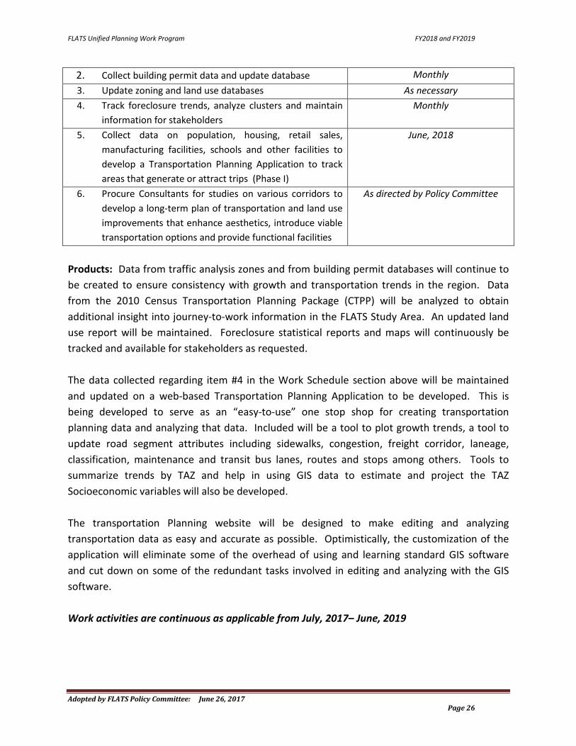
2. Collect building permit data and update database Monthly 3. Update zoning and land use databases As necessary 4. Track foreclosure trends, analyze clusters and maintain
information for stakeholders Monthly
5. Collect data on population, housing, retail sales, manufacturing facilities, schools and other facilities to develop a Transportation Planning Application to track areas that generate or attract trips (Phase I)
June, 2018
6. Procure Consultants for studies on various corridors to develop a long-term plan of transportation and land use improvements that enhance aesthetics, introduce viable transportation options and provide functional facilities
As directed by Policy Committee
Products: Data from traffic analysis zones and from building permit databases will continue to be created to ensure consistency with growth and transportation trends in the region. Data from the 2010 Census Transportation Planning Package (CTPP) will be analyzed to obtain additional insight into journey-to-work information in the FLATS Study Area. An updated land use report will be maintained. Foreclosure statistical reports and maps will continuously be tracked and available for stakeholders as requested. The data collected regarding item #4 in the Work Schedule section above will be maintained and updated on a web-based Transportation Planning Application to be developed. This is being developed to serve as an “easy-to-use” one stop shop for creating transportation planning data and analyzing that data. Included will be a tool to plot growth trends, a tool to update road segment attributes including sidewalks, congestion, freight corridor, laneage, classification, maintenance and transit bus lanes, routes and stops among others. Tools to summarize trends by TAZ and help in using GIS data to estimate and project the TAZ Socioeconomic variables will also be developed. The transportation Planning website will be designed to make editing and analyzing transportation data as easy and accurate as possible. Optimistically, the customization of the application will eliminate some of the overhead of using and learning standard GIS software and cut down on some of the redundant tasks involved in editing and analyzing with the GIS software. Work activities are continuous as applicable from July, 2017– June, 2019

FLATS Unified Planning Work Program FY2018 and FY2019
Adopted by FLATS Policy Committee: June 26, 2017 Page 27
C-3 Public Transportation Planning Purpose: Support and assist the Pee Dee Regional Transportation Authority (PDRTA) and evaluate transit options to enhance planning for new multi-modal initiatives and projects. Also support and assist the four additional agencies within the FLATS area who receive direct funding from the Federal Transit Administration (FTA). These additional agencies are the Florence Senior Citizens Association (FSCA), the Florence County Disabilities and Special Needs Board (FCDSNB), the Darlington County Council on Aging (DCCOA) and the Darlington County Disabilities and Special Needs Board (DCDSNB). These agencies receive their FTA funds directly from an alternate Federal Program and are not included in the UPWP total. However, if any of these agencies utilize any of their direct funds for planning, the work will be listed in this section (i.e. Previous Work or Work Schedule) and the amount will be listed in the tables in Appendix A and B. The FTA Federal Program that these agencies are allowed to utilize for planning is under Program 5307. State Mass Transit Funds provided to these agencies by the SCDOT can be utilized for their required match. Activity: The Planning Factors enhanced by this work task are 1, 2, 3, 6, 7 and 9. Flats staff will provide technical assistance to the PDRTA, the Florence Senior Citizens Association, the Florence County Disabilities and Special Needs Board, the Darlington County Council on Aging and the Darlington County Disabilities and Special Needs Board as needed to develop new routes and identify additional ridership. Staff created the current bus routes for PDRTA and will update them as necessary. Any information or data for all five agencies is supplied by staff upon request. Previous Work:
• Staff continues quarterly meetings with PDRTA and the Pee Dee Council of Governments (PDCOG) to keep them up to date on transportation planning activities and to stay abreast of any assistance needed by FLATS staff;
• Staff created and provided digital data regarding various specific categories for all three of the public transportation agencies within the FLATS Study Area as necessary;
• PDRTA is preparing to update their Transit Development Plan. Staff met with them and will provide demographic information as necessary to complete this task.

FLATS Unified Planning Work Program FY2018 and FY2019
Adopted by FLATS Policy Committee: June 26, 2017 Page 28
Work Schedule: ACTIVITY ANTICIPATED COMPLETION
DATE 1. Continue organizing and hosting the quarterly meetings
with PDRTA and the PDCOG Continuous
2. Contact PDRTA, FCSA, FCDSNB, DCCOA and DCDSNB to collect their appropriated FTA funding to include in the TIP
February, 2018 and February 2019
3. Update FLATS TIP to include the FTA funding for the PDRTA, FCSA, FCDSNB, DCCOA and DCDSNB
February, 2018 and February 2019
4. Provide demographic information to PDRTA as requested to update their Transit Development Plan
Upon request
5. Continue to provide assistance to PDRTA, FCSA, FCDSNB, DCCOA and DCDSNB as requested
Continuously
Products: FLATS staff will provide an updated County Road Atlas to the PDRTA annually. FLATS staff will provide all documentation necessary for PDRTA, The Florence Senior Citizens Association, The Florence DSN Board, the Darlington County Council on Aging and the Darlington County DSN Board as requested to more efficiently serve their customers. In addition, GIS digital data will be produced for each of the above referenced agencies as requested. Reports and plans developed in conjunction with each of the above referenced agencies will be maintained. Work activities are continuous as applicable from July, 2017 – June, 2019

FLATS Unified Planning Work Program FY2018 and FY2019
Adopted by FLATS Policy Committee: June 26, 2017 Page 29
Appendix A: Agency Participation
FY2018 (Year 1)
WORK TASK(S) FLORENCE COUNTY FHWA *FTA SCDOT TOTAL
A-1 Administration $9,183 $36,730 $45,913
A-2 Public Participation $2,755 $11,019 $13,774
A-3 Transportation Alternatives Program $1,836 $7,346 $9,182
B-1 Mapping $14,692 $58,769 $73,461
B-2 Air Quality Surveillance $1,837 $7,346 $9,183
B-3 Traffic Surveillance $6,428 $25,711 $32,139
C-1 Development and Maintenance $30,303 $121,210 $151,513
C-2 Socioeconomic and Land Use Data $22,956 $91,826 $114,782
C-3 Public Transportation Planning $1,836 $7,346 $9,182
TOTAL $91,826 $367,303 $459,129
* PDRTA will not utilize any of their FTA 5307 Program funds for planning during FY2017
FLATS Unified Planning Work Program FY2018 and FY2019
Adopted by FLATS Policy Committee: June 26, 2017 Page 30
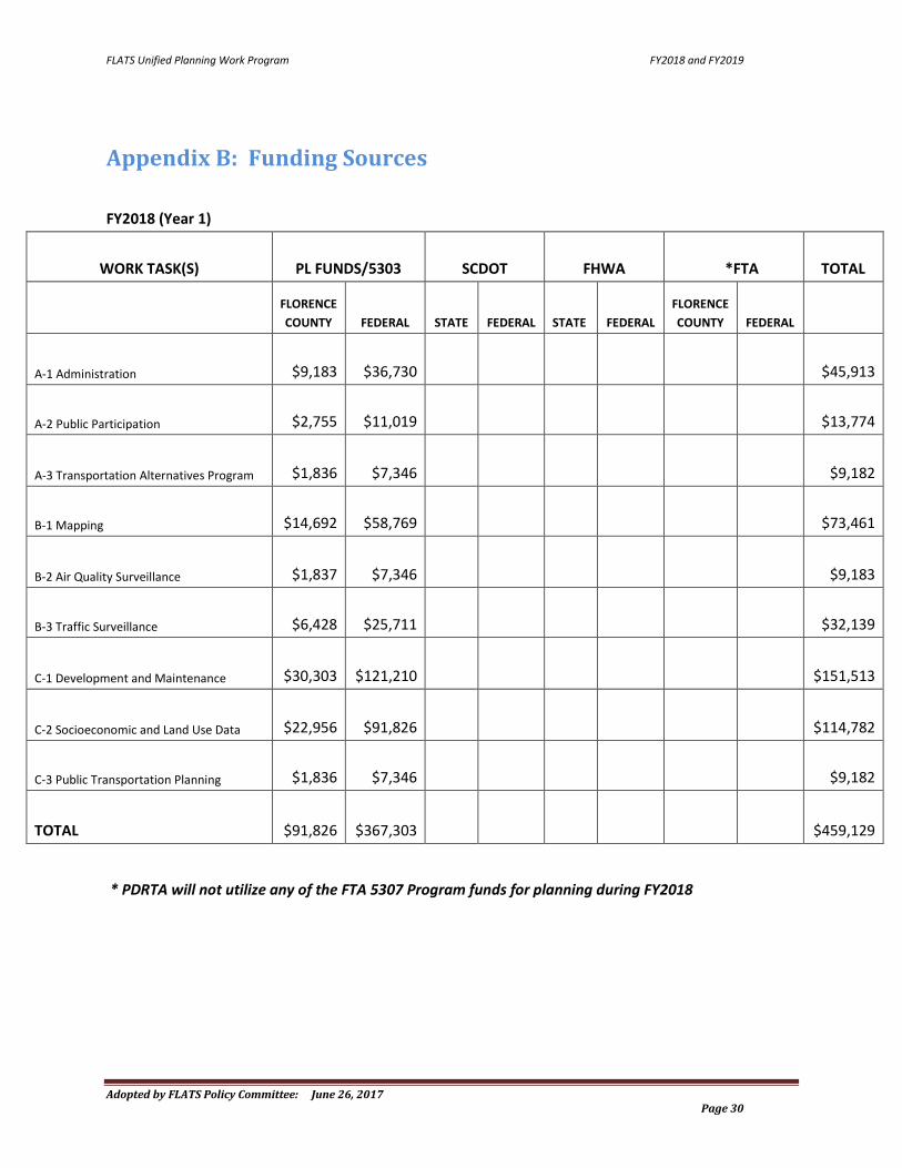
Appendix B: Funding Sources
FY2018 (Year 1)
WORK TASK(S) PL FUNDS/5303 SCDOT FHWA *FTA TOTAL
FLORENCE COUNTY FEDERAL STATE FEDERAL STATE FEDERAL
FLORENCE COUNTY FEDERAL
A-1 Administration $9,183 $36,730 $45,913
A-2 Public Participation $2,755 $11,019 $13,774
A-3 Transportation Alternatives Program $1,836 $7,346 $9,182
B-1 Mapping $14,692 $58,769 $73,461
B-2 Air Quality Surveillance $1,837 $7,346 $9,183
B-3 Traffic Surveillance $6,428 $25,711 $32,139
C-1 Development and Maintenance $30,303 $121,210 $151,513
C-2 Socioeconomic and Land Use Data $22,956 $91,826 $114,782
C-3 Public Transportation Planning $1,836 $7,346 $9,182
TOTAL $91,826 $367,303 $459,129
* PDRTA will not utilize any of the FTA 5307 Program funds for planning during FY2018

FLATS Unified Planning Work Program FY2018 and FY2019
Adopted by FLATS Policy Committee: June 26, 2017 Page 31
Appendix C: List of Acronyms
AADT Average Annual Daily Traffic CMAQ Congestion Mitigation and Air Quality Improvement Program CTPP Census Transportation Planning Package DBE Disadvantaged Business Enterprise DCCOA Darlington County Council of Aging DCDSNB Darlington County Disabilities and Special Needs Board DHEC Department of Health and Environmental Control EPA Environmental Protection Agency FAST Act Fixing America’s Surface Transportation Act FCDSNB Florence County Disabilities and Special Needs Board FLATS Florence Area Transportation Study FSCA Florence Senior Citizens Association FHWA Federal Highway Administration FTA Federal Transit Administration FY Fiscal Year GIS Geographic Information Systems GPS Global Positioning Systems LPA Local Project Agreement LRTP Long Range Transportation Plan MAP-21 Moving Ahead for Progress in the 21st Century Act MPO Metropolitan Planning Organization NAAQS National Ambient Air Quality Standards NACTO National Association of City Transportation Officials NEPA National Environmental Protection Act NHPP National Highway Performance Program NHS National Highway System NHTS National Household Transportation Survey PDCOG Pee Dee Council of Governments PDRTA Pee Dee Regional Transportation Authority PL Planning Law ppb parts per billion PPP Public Participation Process RFP Request for Proposal RFQ Request for Qualifications RPWP Rural Planning Work Program SAFETEA-LU Safe, Accountable, Flexible, Efficient Transportation Equity Act: A Legacy for Users SCAPA South Carolina American Planning Association SCBO South Carolina Business Opportunities SCDOT South Carolina Department of Transportation SMTF State Mass Transit Funds SPR State Planning and Research STIP State Transportation Improvement Program
FLATS Unified Planning Work Program FY2018 and FY2019
Adopted by FLATS Policy Committee: June 26, 2017 Page 32
STP Surface Transportation Program TAP Transportation Alternatives Program TAZ Traffic Analysis Zone TIP Transportation Improvement Program UPWP Unified Planning Work Program USC United States Code USDOT United States Department of Transportation
Appendix D: General References MAP-21, Public Law 112–141 (H.R. 4348) — July 6, 2012, 112th U.S. Congress U.S. Code Title 23, Section 134 U.S. Code Title 49, Section 5303 H.R. 2847, Hiring Incentives to Restore Employment Act; Surface Transportation Extension Act of 2010
This area left blank intentionally