florida’s turnpike (sr 91)€™s 2004 edition of “a policy on geometric design of highways and...
TRANSCRIPT

Florida’s Turnpike (SR 91)
Exception ReportLane Width
Financial Project ID:411406-1, 411406-4
Turnpike Widening From South of Osceola Parkway to Beachline Expressway
Osceola and Orange Counties(92471) and (75470)
Turnpike Design Engineer: Patrick Muench, P.E.GEC Project Manager: Bob Alderman, P.E.
This item has been electronically signed and sealed by Keegan Larson, P.E. on May 19, 2016 using a Digital Signature.
Printed copies of this document are not considered signed and sealed and the signature must be verified on any electronic copies.
The official record of this sheet is the electronic file signed and sealed under rule 61G15-23.004 F.A.C.
Keegan Larson, P.E.Wantman Group, Inc.2035 Vista ParkwayWest Palm Beach, FL 33411Cert No. 6091Vendor No. 65-0271367
Keegan Larson
2016.05.19 16:56:48 -04'00'

To: Patrick Muench, P.E. Date: January 11, 2016_ Turnpike Design Engineer Financial Project ID: 411406-1-52-01 and 411406-4-52-01 New Const. ( X ) RRR ( )
Federal Aid Number: N/A
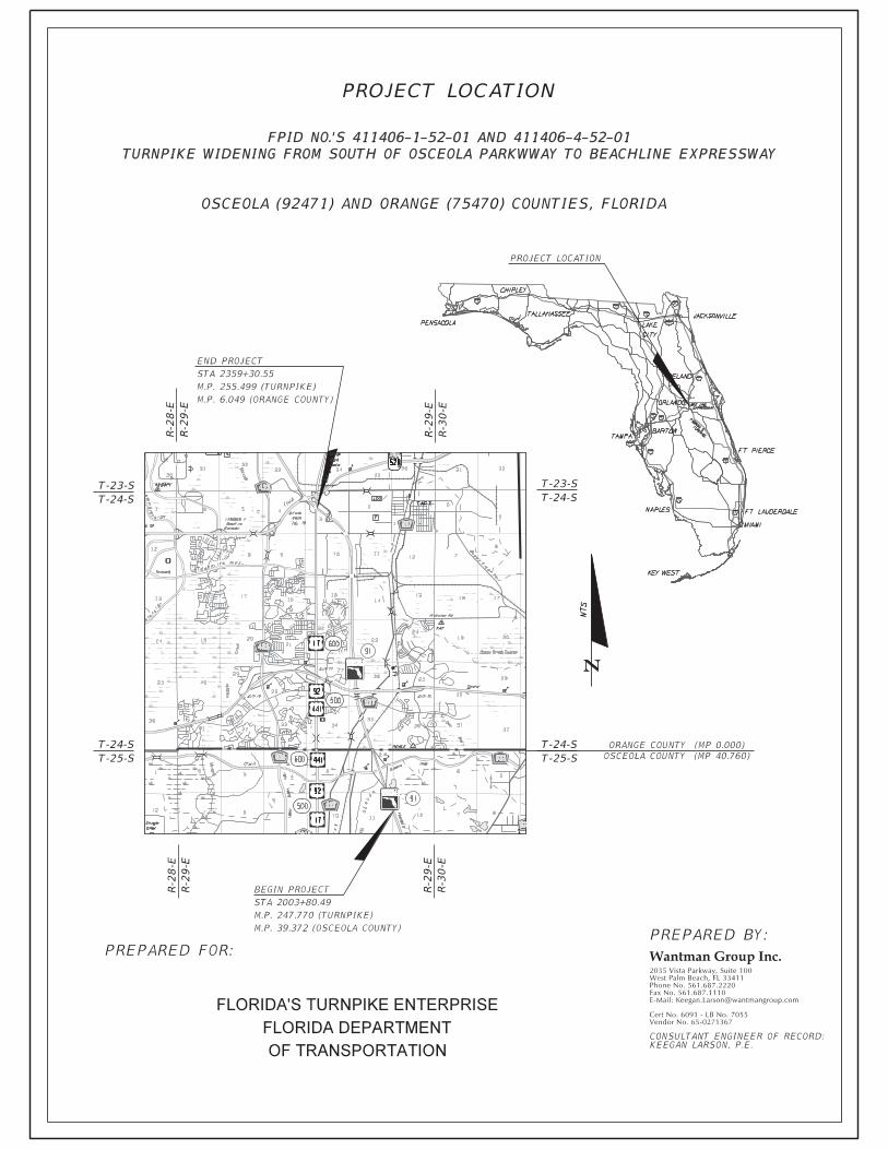
Project Name: Turnpike Widening from South of Osceola Parkway to Beachline Expressway. State Road Number: S.R. 91 Co./Sec./Sub. Osceola (92471) and Orange (75470)
Begin Project MP: 247.770 (39.372 Osceola) End Project MP: 255.499 (6.049 Orange)
Full Federal Oversight: Yes ( ) No ( X )
Request for Design Exception ( X), Design Variation ( ) (For Design Exception or Variations Requiring Central Office Approval) Re-submittal: Yes ( ) No ( ) Original Ref# - - _____
Requested for the following element(s):
The Florida’s Turnpike (SR 91) within Orange County (75470) and Osceola County (92471) is in need of widening. There are two Financial Project IDs for this project: 411406-1 and 411406-4. The specific limits for this project are the northbound and southbound lanes from M.P. 247.770 to M.P. 255.499. A project location map is located in Appendix A. This project will consist of the widening and/or reconstruction of Florida’s Turnpike from Osceola Parkway to the Beachline Expressway. Within this 8-lane section of the Turnpike, the northbound and southbound directions each will consist of two 12-foot express lanes separated from two 12-foot general purpose toll lanes by a 4-foot buffer with express lane markers. Other improvements associated with this project include the construction of three ramps at the Turnpike/SR 417 interchange. These ramps include Ramp A2 (northbound Turnpike to westbound SR 417), Ramp C2 (southbound Turnpike to eastbound SR 417), and Ramp D1 (southbound Turnpike to westbound SR 417). Improvements associated with this project also include the reconstruction and/or widening of the Osceola Parkway and Orlando South Interchange exit/entry ramps.
Florida Department of Transportation design criteria states that for urban freeways, the minimum lane width shall be 12’ wide (FDOT 2015 PPM Vol. 1 Table 2.1.1). AASHTO’s 2004 Edition of “A Policy on Geometric Design of Highways and Streets” states that through traffic lanes on freeways should be 12’ wide (2004 AASHTO Pg. 504). AASHTO’s 2005 Edition of “A Policy on Design Standards Interstate System” states that all traffic lanes shall be at least 12’ wide (2005 AASHTO IS Pg. 3).
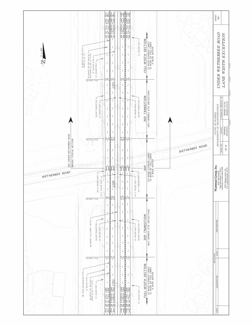
A Design Exception is being requested to allow the Turnpike northbound and southbound express lane widths under the existing Wetherbee Road bridge (Existing Bridge No. 754094) to be reduced to a minimum of 11.5’. This lane width reduction along with a 2’ reduction in the buffer will provide an outside shoulder width between 10’ and 11’. The two inside express lanes in each direction will have lane widths less than 12’ for approximately 900’ until the constricting existing bridge is passed. The two general purpose toll lanes in each direction will maintain a full 12’ lane width the entire length of the project.
___________________________________________________________________________________________________
Requested by: _____________________________Date _____________ Keegan Larson, P.E. Responsible Professional Engineer
Approvals: ____________________________ Date _____________ N/A Date _____________ Patrick Muench, P.E. Turnpike Structures Design Engineer Turnpike Design Engineer N/A Date _____________ N/A Date _____________ State Roadway Design Engineer State Structures Design Engineer N/A Date _____________ N/A Date _____________ State Chief Engineer FHWA Division Administrator
( ) Design Speed (X) Lane Widths ( ) Shoulder Widths ( ) Bridge Widths( ) Structural Capacity ( ) Vertical Clearance ( ) Grades ( ) Cross Slope( ) Superelevation ( ) Horizontal Alignment ( ) Vertical Alignment ( ) Stopping Sight Distance( ) Horizontal Clearance ( ) Other
June 1, 2016
Keegan Larson
2016.05.19 16:56:17 -04'00'
Patrick M Muench
Digitally signed by Patrick M Muench DN: c=US, o=IdenTrust ACES Business Representative, ou=FDOT - TURNPIKE, cn=Patrick M Muench, 0.9.2342.19200300.100.1.1=A01097C0000014504DA516B000038CB Date: 2016.06.01 08:45:40 -04'00'

Lane Width Exception Report – Page 2Florida’s Turnpike Widening –From Southof Osceola Parkway to Beachline ExpresswayFPID No.: 411406-1-52-01 & 411406-4-52-01
TABLE OF APPENDICES
APPENDIX A: Project Location Sheet
APPENDIX B: Exception Limits
APPENDIX C: Typical Section
APPENDIX D: Crash Data
APPENDIX E: Benefit/Cost Analysis
APPENDIX F: FTE Checklist

Lane Width Exception Report – Page 3Florida’s Turnpike Widening –From Southof Osceola Parkway to Beachline ExpresswayFPID No.: 411406-1-52-01 & 411406-4-52-01
PROJECT DESCRIPTIONThe Florida’s Turnpike (SR 91) within Orange County (75470) and Osceola County (92471) is in need of widening. There are two Financial Project IDs for this project: 411406-1 and 411406-4. The specific limits for this project are the northbound and southbound lanes from M.P. 247.770 to M.P. 255.499. Aproject location map is located in Appendix A. This project will consist of the widening and/or reconstruction of Florida’s Turnpike from Osceola Parkway to the Beachline Expressway. Within this 8-lane section of the Turnpike, the northbound and southbound directions each will consist of two 12’express lanes separated from two 12’ general purpose toll lanes by a 4’ buffer with express lane markers.Other improvements associated with this project include the construction of three ramps at the Turnpike/SR 417 interchange. These ramps include Ramp A2 (northbound Turnpike to westbound SR 417), Ramp C2 (southbound Turnpike to eastbound SR 417), and Ramp D1 (southbound Turnpike to westbound SR 417). Improvements associated with this project also include the reconstruction and/or widening of the Osceola Parkway and Orlando South Interchange exit/entry ramps. The project is currently scheduled for final sign and sealed, production ready plans in June 2016 with no perceived obstacles.
EXISTING CONDITIONSWithin the project limits, the Florida’s Turnpike is a four-lane divided limited access facility. The existing typical section includes four 12’ wide travel lanes (two in each direction) divided by a 40’ wide median. The median shoulder is 8’ wide (4’ paved) and the outside shoulder is 12’ wide (10’ paved). The Shoulder Warning Device (SWD) is a ground-in rumble strip. Double-faced guardrail is installed just outside the southbound median shoulder. The existing Wetherbee Road bridge (Existing Bridge No. 754094) has a total width from the face of the outside pier to the face of the inside (median) pier of 75’-8” in both the northbound and southbound direction. This existing under bridge width is not suitable to accommodate the required width for the proposed typical section and is not to be increased as the bridge is not includedfor improvements under this project. The horizontal clearance to the recently constructed Wetherbee Bridge immediately south of the constricting bridge does provide adequate horizontal clearance.
PROPOSED DESIGNThe proposed eight lane section of two 12’ express lanes separated from two 12’ general purpose toll lanes by a 4’ buffer with 12’ inside and outside paved shoulders creates a total width greater than the existing width of 75’-8” allowed by the existing bridge. Based on these conditions, the inside express lane widths will need to be constricted in order to preserve the existing Wetherbee Road bridge structurewithout reducing the shoulder widths less than 10’. In order to provide sufficient space for an emergency vehicle to bypass congested travel lanes in the event of a crash it is not desirable to reduce the shoulder widths below 10’. Both the inside and outside shoulder widths will need to be reduced within this section to accommodate the additional pier protection and an 8” column strengthening collar, but will remain greater than 10’. The proposed typical section under Wetherbee Road bridge (see Appendix C) is composed of two 11.5’ express lanes with a 2’ buffer and two 12’ general purpose toll lanes in each direction. The inside and outside shoulder widths are all between 10’ and 11’ and have been included as a design exception in a separate report.
MINIMUM DESIGN CRITERIAFlorida Department of Transportation design criteria states that for urban freeways, the minimum lane width shall be 12’ wide (FDOT 2015 PPM Vol. 1 Table 2.1.1). AASHTO’s 2004 Edition of “A Policy on Geometric Design of Highways and Streets” states that through traffic lanes on freeways should be 12’ wide (2004 AASHTO Pg. 504). AASHTO’s 2005 Edition of “A Policy on Design Standards Interstate System” states that all traffic lanes shall be at least 12’ wide (2005 AASHTO IS Pg. 3).

Lane Width Exception Report – Page 4Florida’s Turnpike Widening –From Southof Osceola Parkway to Beachline ExpresswayFPID No.: 411406-1-52-01 & 411406-4-52-01
PROPOSED CRITERIAA design exception is being requested for the acceptance of the reduction of lane widths at the following Turnpike mainline locations. Northbound and southbound Turnpike mainline under Wetherbee Road bridge from STA 2196+30.00 to STA 2205+30.00. The proposed minimum lane widths at these locations are shown in the table below.
Location Number of Proposed Lanes PPM AASHTO Minimum
ProposedTurnpike Northbound from
STA. 2196+30 to STA.2205+30 2 Express Lanes 12’ 12’ 11.5’
Turnpike Southbound fromSTA. 2196+30 to STA.2205+30 2 Express Lanes 12’ 12’ 11.5’
The above station ranges include the transition lengths required to reduce the proposed lanes from 12’ to 11.5’. The transitions occur over 300’ at a deflection angle of 100:1 (approximately 0º35’0”). See Appendix D for the complete depiction of the geometry of the lane width exception.
REASON DESIGN CRITERIA IS NOT APPROPRIATEThe PPM and AASHTO design criteria of 12’ lane widths does not specifically address facilities with express lanes. Rather it is applicable to an entire freeway facility in which there is no definitive lane designations for varying vehicle types. Since the express lanes are intended for two-axle vehicles and buses only (FDOT Express Lanes Handbook Section 3.3.1), a lane width reduction to the express lanes is less significant than if the lanes were accessible to heavy vehicles as well. Furthermore, by reducing the lane width of the express lanes, the outside shoulder width does not need to be reduced to less than 10’.This provides an adequate outside shoulder refuge area, between 10’ and 11’, for the general purpose toll lanes which service all vehicle types. Also, impacts to traffic operations, specifically free flow speed, arenot anticipated as the total length of the reduced lane widths is for such a short segment. Overall it is not feasible to uphold the lane width design criteria in this unique scenario as this would result in either a less than desirable shoulder width adjacent to the general purpose toll lanes or a bridge replacement.
OPERATIONAL IMPACTSThe current Annual Average Daily Traffic (AADT) for the section of roadway is 59,200, with an increase of AADT to 111,000 in 2040 (Design Year).
Traffic Distribution: D = 58.1% K = 9.5% T24 = 12.8%
According to the Highway Capacity Manual (HCM Equation 11-1) a reduction in lane width causes a decrease in the free flow speed. However, the lane width reduction occurs for a short segment and is only applied to the lanes in which trucks are not eligible. Therefore the facility’s free flow speed and Level of Service is not expected to be impacted. Similarly, operational impacts on the facility are not expected when taking into account the cumulative effect of this lane width exception combined with the shoulder width exception and the cross slope variation requested in separate reports. The cross slope is not a factor when considering free flow speed, flow rate, or density. Shoulder width is a factor for free flow speed.

Lane Width Exception Report – Page 5Florida’s Turnpike Widening –From Southof Osceola Parkway to Beachline ExpresswayFPID No.: 411406-1-52-01 & 411406-4-52-01
However, the reduction is so minimal that according to the HCM a decrease in free flow speed is not anticipated. Therefore the facility’s Level of Service is not expected to be impacted by the cumulative effect of these variations and exception.
MITIGATION STRATEGIESThe potential mitigation strategies provided by FHWA for reduced lane widths have been evaluated for this project. A mitigating strategy will be to install shoulder rumble strips and provide adequate lighting to improve the ability for drivers to remain within their lane. Shoulder rumble strips are proposed along the entire corridor within the project limits. Rumble strips provide an audible warning along with a slight vibration within the vehicle that a driver is able to feel. Underdeck bridge lighting will provide the driver with increased visibility of the approaching roadway configuration which will assist them to remain in their lane. Furthermore, standard deflections are utilized through the lane width reduction section which will create a gradual shift that is expected to go seemingly unnoticed by the drivers.
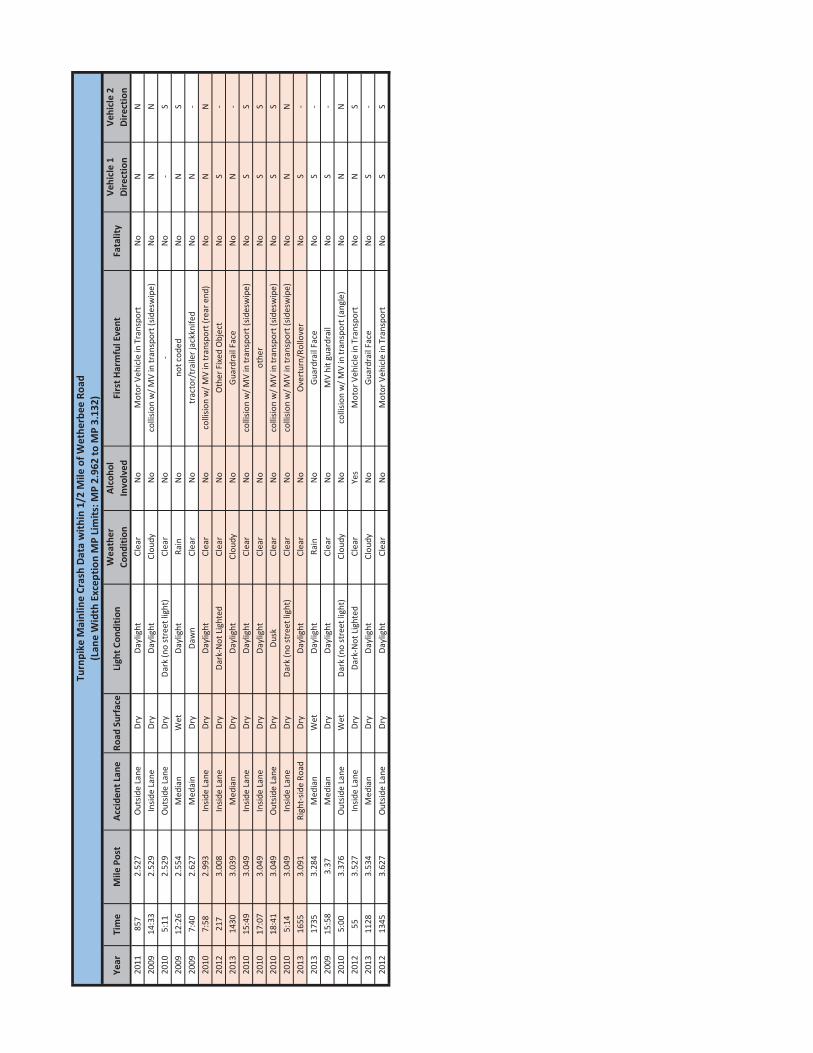
CRASH DATACrash data within the project limits has been provided for a five year period from 2009 to 2013. Of the 384 crashes reported within the project limits, 8 (2.08%) occurred within the limits of the lane width exception limits. Of these, the most common crash event was a collision with another vehicle.Environmental conditions were varied, including time of day and the presence of inclement weather. No accidents were fatal. See Appendix D for the detailed crash data occurring within ½ mile of Wetherbee Road. The following table provides an analysis of the location each crash occurred within the lane width exception limits:
Location of Crashes within Lane Width Exception Limits
Location 2009 2010 2011 2012 2013 Total Average (Crashes/Year)
Median 0 0 0 0 1 1 0.2 Inside Lane 0 4 0 1 0 5 1 Outside Lane 0 1 0 0 0 1 0.2 Right Side Road 0 0 0 0 1 1 0.2
Total 0 5 0 1 2 8 1.6
The above table shows that there is not an unusually high number of crashes within the proposed lane width exception limits. There have only been 8 crashes total (1.6 per year). There is no quantitative evidence suggesting that the proposed configuration under Wetherbee Road as outlined in this report would directly cause an increase in crashes. Rather it is anticipated that there will be a greater likelihood of increased crashes by not reducing the lane widths and creating an outside shoulder width less than 10’ instead. This claim is supported by the Crash Modification Factors (CMF) obtained from the CMF Clearinghouse database developed by the FHWA:

Lane Width Exception Report – Page 6Florida’s Turnpike Widening –From Southof Osceola Parkway to Beachline ExpresswayFPID No.: 411406-1-52-01 & 411406-4-52-01
Lane Width Reduction vs. Shoulder Width Reduction Comparison
Inside Shoulder
Width
Express Lanes
Widths
Buffer Width
GP Lane Widths
Outside Shoulder
Width
Clearinghouse
CMF ID
CMF Description
Anticipated Increase in
Crashes
Lane Width
Reduction 10'-2" 11.5’ 2’ 12’ 10’-3" 5339
Reduce Lane Width from
12' to 11' 1%
Shldr Width
Reduction 10'-2" 12’ 4’ 12’ 7’-3" 4817
Reduce Shldr Width from X’ to Y’
8.6%
A value of X = 10’-2” and Y = 7’-2” was used in the equation provided by the CMF ID 4817. A CMF for a lane width reduction of 12’ to 11.5’ was not available so a more conservative value of 12’ to 11’ reduction was used. CMF ID 5339 and CMF ID 4817 were selected as the most applicable CMFs available to the situation under Wetherbee Road. Both values were obtained from a study conducted on rural two-lane highways. There are no CMFs available for multi-lane freeways. Nevertheless, these values suggest that reducing an outside shoulder width by 3’ would create a higher likelihood for crashes than reducing a lane width by 1’.
BENEFIT/COST ANALYSISA benefit/cost analysis was performed to compare the cost of reconstructing the Wetherbee Road Bridge to provide the full lane widths and shoulder widths against the benefit of potential crash reductions. See Appendix E for the complete B/C analysis. Conservative values were used throughout the analysis. The results of the B/C analysis was a ratio of 0.27. This value indicates that the cost of providing the full lane widths and shoulder widths far outweighs the benefits associated with the improvement.
SUMMARY OF CONCLUSIONSBased on the information evaluated, WGI requests the northbound and southbound express lanes be reduced to 11.5’ as outlined in the Proposed Design section of this report. By reducing the express lane widths, the general purpose toll lanes maintain a full 12’ lane width the entire length of the project. Additionally, the lane width reduction eliminates the need for a shoulder width less than 10’. The crash data does not suggest any history of an unusually high number of crashes within the station limits of the lane width exception. All appropriate pier protection and rumble strips will be installed to mitigate any safety concerns. Drainage will be designed to meet FDOT spread requirements. Shoulder rocking along the median barrier wall will be utilized as deemed appropriate in areas where longitudinal grade isinsufficient. WGI does not propose replacing the bridge or providing a shoulder width less than 10’ adjacent to the general purpose toll lanes for the sole purpose of achieving the lane width set forth by the Plans Preparation Manual and AASHTO. In conclusion, WGI requests a design exception be granted for reduced lane widths for the Turnpike mainline express lanes at the specific locations outlined in this report.

Lane Width Exception ReportFlorida’s Turnpike Widening – From South of Osceola Parkway to Beachline Expressway FPID No.: 411406-1-52-01 & 411406-4-52-01
APPENDIX A: PROJECT LOCATION SHEET
Lane Width Exception ReportFlorida’s Turnpike Widening – From South of Osceola Parkway to Beachline Expressway FPID No.: 411406-1-52-01 & 411406-4-52-01
APPENDIX B: VARIATION LIMTS

Lane Width Exception ReportFlorida’s Turnpike Widening – From South of Osceola Parkway to Beachline Expressway FPID No.: 411406-1-52-01 & 411406-4-52-01
APPENDIX C: TYPICAL SECTIONS


Lane Width Exception ReportFlorida’s Turnpike Widening – From South of Osceola Parkway to Beachline Expressway FPID No.: 411406-1-52-01 & 411406-4-52-01
APPENDIX D: CRASH DATA
Year
Tim
eM
ile P
ost
Acci
dent
Lan
eRo
ad S
urfa
ceLi
ght C
ondi
tion
Wea
ther
Co
nditi
onAl
coho
l In
volv
edFi
rst H
arm
ful E
vent
Fata
lity
Vehi
cle
1 Di
rect
ion
Vehi
cle
2 Di
rect
ion
2011
857
2.52
7O
utsid
e La
neDr
yDa
ylig
htCl
ear
No
Mot
or V
ehic
le in
Tra
nspo
rtN
oN
N20
0914
:33
2.52
9In
side
Lane
Dry
Dayl
ight
Clou
dyN
oco
llisio
n w
/ MV
in tr
ansp
ort (
sides
wip
e)N
oN
N20
105:
112.
529
Out
side
Lane
Dry
Dark
(no
stre
et li
ght)
Clea
rN
o-
No
-S
2009
12:2
62.
554
Med
ian
Wet
Dayl
ight
Rain
No
not c
oded
No
NS
2009
7:40
2.62
7M
edai
nDr
yDa
wn
Clea
rN
otr
acto
r/tr
aile
r jac
kkni
fed
No
N-
2010
7:58
2.99
3In
side
Lane
Dry
Dayl
ight
Clea
rN
oco
llisio
n w
/ MV
in tr
ansp
ort (
rear
end
)N
oN
N20
1221
73.
008
Insid
e La
neDr
yDa
rk-N
ot L
ight
edCl
ear
No
Oth
er F
ixed
Obj
ect
No
S-
2013
1430
3.03
9M
edia
nDr
yDa
ylig
htCl
oudy
No
Gua
rdra
il Fa
ceN
oN
-20
1015
:49
3.04
9In
side
Lane
Dry
Dayl
ight
Clea
rN
oco
llisio
n w
/ MV
in tr
ansp
ort (
sides
wip
e)N
oS
S20
1017
:07
3.04
9In
side
Lane
Dry
Dayl
ight
Clea
rN
oot
her
No
SS
2010
18:4
13.
049
Out
side
Lane
Dry
Dusk
Clea
rN
oco
llisio
n w
/ MV
in tr
ansp
ort (
sides
wip
e)N
oS
S20
105:
143.
049
Insid
e La
neDr
yDa
rk (n
o st
reet
ligh
t)Cl
ear
No
colli
sion
w/ M
V in
tran
spor
t (sid
esw
ipe)
No
NN
2013
1655
3.09
1Ri
ght-
side
Road
Dry
Dayl
ight
Clea
rN
oO
vert
urn/
Rollo
ver
No
S-
2013
1735
3.28
4M
edia
nW
etDa
ylig
htRa
inN
oG
uard
rail
Face
No
S-
2009
15:5
83.
37M
edia
nDr
yDa
ylig
htCl
ear
No
MV
hit g
uard
rail
No
S-
2010
5:00
3.37
6O
utsid
e La
neW
etDa
rk (n
o st
reet
ligh
t)Cl
oudy
No
colli
sion
w/ M
V in
tran
spor
t (an
gle)
No
NN
2012
553.
527
Insid
e La
neDr
yDa
rk-N
ot L
ight
edCl
ear
Yes
Mot
or V
ehic
le in
Tra
nspo
rtN
oN
S20
1311
283.
534
Med
ian
Dry
Dayl
ight
Clou
dyN
oG
uard
rail
Face
No
S-
2012
1345
3.62
7O
utsid
e La
neDr
yDa
ylig
htCl
ear
No
Mot
or V
ehic
le in
Tra
nspo
rtN
oS
S
Turn
pike
Mai
nlin
e Cr
ash
Data
with
in 1
/2 M
ile o
f Wet
herb
ee R
oad
(Lan
e W
idth
Exc
eptio
n M
P Li
mits
: MP
2.96
2 to
MP
3.13
2)

Lane Width Exception ReportFlorida’s Turnpike Widening – From South of Osceola Parkway to Beachline Expressway FPID No.: 411406-1-52-01 & 411406-4-52-01
APPENDIX E: BENEFIT/COST ANALYSIS

Rev. 02/2014
District: County: Date Prepared: 01/11/16
Location:
Section : Beg. Milepost : 247.8 End Milepost : 255.5Rdway Type:
Control Element:
Service Life
Capital Recovery
Factor Total100 0.0408 -$15 0.0899 -$30 0.0578 202,300.00$20 0.0736 7,356.73$20 0.0736 -$20 0.0736 -$20 0.0736 -$
209,656.73$Annual Cost = 209,656.73$
Total number of crashes = 384 5# of correctable crashes, PC = 6# of years of crash data, YD = 5
PC/YD = 1.20 22.6Crash reduction factor, CRF = 26.47%
CRF x (PC/YD) = 0.32Cost per crash, CPC = $180,836.00 0
Benefit = $57,441
BENEFIT/COST RATIO
Benefit $57,440.75Cost $209,656.73
Prepared by:
FHWA CMF ID 5509Additional crash reduction factor:
Keegan Larson, P.E.
Turnpike Widening from South of Osceola Parkway to Beachline Expressway
75470 & 92471Turnpike Urban Divided
= =
CMF ID: 3 was utilized and states that an increase in lane width from 11 ft to 12 ft will result in a 5% reduction in crashes. This CRF was chosen as a conservative approach seeing that the scenario as part of this project consists of a lane width reduction to 11.5 ft. CMF ID 5509 states that increasing the paved outside shoulder width from 10 ft to 12 ft will result in a 22.6% reduction in crashes. The conservative B/C ratio shows that sufficent benefit does not exist to justify the cost of reconstructing the Wetherbee Bridge.
Additional crash reduction factor:
Primary crash reduction factor (%):
OtherSub-Total 3,599,955.51$
RoadwayDrainage
Signal
CostTypeROW
P.E.C.E.I.Structure
Benefit-Cost Analysis
Turnpike Orange
ANNUAL COST OF IMPROVEMENTS
Lane Widths
There are two Financial Project IDs for this project: 411406-1 and 411406-4. This project will consist of the widening and/or reconstruction of Florida’s Turnpike from Osceola Parkway to Beachline Expressway. Within this 8-lane section of the Turnpike, the northbound and southbound directions each will consist of two 12-foot express lanes separated from two 12-foot general purpose toll lanes by a 4-foot buffer with express lane markers.
3,500,000.00$99,955.51$
FHWA CMF ID 3
0.27

Lane Width Exception ReportFlorida’s Turnpike Widening – From South of Osceola Parkway to Beachline Expressway FPID No.: 411406-1-52-01 & 411406-4-52-01
APPENDIX F: FTE CHECKLIST

Page | 1
Request for FTE Design VariationsChecklist
Date:District:Project Name:Project Section BMP: EMP:Exemption BMP: EMP:FM: New Construction RRRProject Description:
Requested Control Element(s):Design Speed*Structural Capacity*SuperelevationHorizontal Clearance**
Lane WidthVertical Clearance**Horizontal AlignmentSide Slope
Shoulder WidthsGradesVertical Alignment
Bridge Widths*Cross SlopesStopping Sight Distance
*Requires supplementary review (i.e. Planning/Structures/etc)**Requires Utility Accommodation Manual (UAM) Exception Submittals
Page #/ NASubmittal/Approval Letter Included (Cover Letter)
Short description of project, applicable criteria and reason for variation requestApplicable signature fields, names, and titles listed
Report CoverProject Title, FPID, signature,date, and seal
Project descriptionGeneral project information, typical section, begin/end milepost,county section numberInclude Work Mix, To – From, Objectives, Obstacles and Schedule.
Description of the variation element and applicable criteria (AASHTO andDepartment value or standard)
Detailed explanation of why the criteria or standard cannot becomplied with or is not applicableDescription of any proposed value for project and why it isappropriate
Amount and character of traffic using the facilityDescription of the anticipated impact on Operations,Adjacent Sections, Level Of Service, Safety, Long and ShortTerm Effects
Is the variation temporary or permanent?Description of the anticipated Cumulative Effects
A plan view or aerial photo of the variation locationShowing right of way lines, and property lines of adjacent property.
A photo of the area.Typical section or cross section of variation locationThe milepost and station location of the exception
✔
✔
✔
✔
✔
✔
✔
✔
✔
✔
✔
✔
✔
✔
✔
✔
✔
✔
✔
✔
✔
Florida's Turnpike Enterprise
Turnpike Widening from South of Osceola Parkway to Beachline Expressway
247.77 255.499N/A N/A
1/11/2016
There are two Financial Project IDs for this project: 411406-1 and 411406-4. This project will consist of the widening and/or reconstruction of Florida’s Turnpike from Osceola Parkway to Beachline Expressway. Within this 8-lane section of the Turnpike, the
Page # / NA
2
5,15
13
N/A
11
5,6
4,5
4
1

Page | 2
Any related work programmed or in future work plans
The Project Schedule Management (PSM) Project ScheduleActivities submitted
< Phase I Phase I – Phase II Phase II – Phase IIIPhase III – Phase IV > Phase IV
Letting:All mitigating efforts
An explanation of what if any associated existing or futureLimitations as a result of public or legal commitments.Description and explanation of any practical alternatives,the selected treatment and why.
Comments on the most recent 5 year crash historyIncluding all pertinent crash reportsIs the location of the variation on the High Crash List
Description of the anticipated Cost (Social and to the Department –Benefit/Cost)Summary Conclusions
Summary description of included support documentation such as:Location map or descriptionTypical sectionAerial or Photo logs when they best illustrate the element issuesCrash History and analysisPlan sheets in the area of the variation elementsProfiles in the area of vertical alignment variation elementsTabulation of pole offsets for horizontal clearance variationApplicable Signed and Sealed Engineering Support Documents
For the specified conditions the following additional documentation is required:For design speed on FIHS/SIS
Provide typical sections at mid blocks and at intersections.For lane width
Provide locations of alternative routes that meet criteriaProposal for handling drainageProposed signing and pavement markings
For shoulder widthProposal for handling stalled vehiclesProposal for handling drainage
For bridge widthPlan view of the approaching roadwaysExisting bridge plans (these may be submitted electronically)
For a bridge with a design inventory load rating less than 1.0Written evaluation and recommendation by the Office ofMaintenance is requiredLoad rating calculations for the affected structure
N/A
✔
✔
✔
✔
✔
✔
✔
✔
Page # / NA
N/A
6
6,15
7,17
7
N/A
N/A
N/A
N/A
7
N/A

Page | 3
For vertical clearanceLocations of alternative routes that meet criteria
For cross slopeProposal for handling drainageDetails on how the cross slope impacts intersections
For conditions that may adversely affect the roadway’s capacity
Provide the comments on compatibility of the design and operationwith the adjacent sectionsEffects on capacity (proposed criteria vs. AASHTO) using anacceptable capacity analysis procedureCalculate reduction for design year, level of service
For superelevationProvide the side friction factors for the curve for each lane of differentcross slope at the PC of the curve, the point of maximum cross slope,and the PT of the curve using the following equation.f = (V2 – 15Re)/(V2e+15R)
For areas with crash histories or when a benefit to cost analysis is requestedProvide a time value analysis between the benefit to society quantifiedin dollars and the costs to society quantified in dollars over the life of thevariation.
Roadside Safety Analysis Program (RSAP)Historical Crash Method (HCM)
Page # / NA
N/A
N/A
N/A
N/A
N/A