flow river floodplain connectivity - upper midwest ... · river floodplain connectivity ......
TRANSCRIPT

June 2005
River Floodplain Connectivity and Lateral Fish Passage:
A Literature Review
Tremplelau National Wildlife Refuge
───────►
────►
──────────►
Flow
Levees

Cover: (top left) An example of the effects of levee construction on lateral connectivity. (bottom right) An example of isolated floodplain environments.

River Floodplain Connectivity and Lateral Fish Passage:
A Literature Review
by
Brian S. Ickes1, Jon Vallazza, John Kalas, and Brent Knights
Contract Completion Report submitted to U.S. Fish and Wildlife Service, Mark Twain Wildlife Refuge Complex
1740 N 24th Street Quincy, Illinois 62301
U.S. Geological SurveyUpper Midwest Environmental Sciences Center
2630 Fanta Reed RoadLa Crosse, Wisconsin 54603
June 2005

Suggested citation:
Ickes, B. S., J. Vallazza, J. Kalas, and B. Knights. 2005. River floodplain connectivity and lateral fish passage: A literature review. U.S. Geological Survey, Upper Midwest Environmental Sciences Center, La Crosse, Wisconsin, June 2005. 25 pp.
iii
Contents
Introduction ……………………………………………………………………………………… 1Defining Lateral Connectivityin Floodplain Systems …………………………………………… 3
Conceptual Development …………………………………………………………………… 3Theoretical Development …………………………………………………………………… 4
Upper Mississippi River Development and Effects on Lateral Connectivity …………………… 6Floodplain Status and Management …………………………………………………………… 7
General System Overview ………………………………………………………………… 7Present Management of UMR Floodplains ………………………………………………… 9
Lateral Connectivity—its Relevance to Fishes ………………………………………………… 10Role in Reproduction ……………………………………………………………………… 10Role in Survival …………………………………………………………………………… 11Life-History Considerations ……………………………………………………………… 13
Considerations for Actively Managed UMR Floodplains ……………………………………… 14Considerations for Passively Managed UMR Floodplains ……………………………………… 15Information Needs and Conclusions …………………………………………………………… 16References ……………………………………………………………………………………… 20
Tables
1. Total acres of floodplain and percent of floodplain surface area sequestered behind levees in different segments of the Mississippi River …………………………………………… 5
2. Survey map sets by major river reach and publication year compiled by researchers at Southern lllinois University under a National Science Foundation grant ……………… 17
Number
Page
iv
Figures
1. The watershed and major tributaries of the Upper Mississippi River System …………… 22. Conceptualization of the multiple dimensions of hydrologic connectivity ……………… 33. Cross sections of an idealized floodplain river depicting natural and leveed conditions … 44. An example of the effects of levee construction on lateral connectivity by Trempeleau
National Wildlife Refuge, Wisconsin …………………………………………………… 45. An early photograph of snag removal in the Mississippi River …………………………… 56. Two time-lapsed photographs of the same area on the Open River Reach of the
Mississippi River, near Grand Tower, Illinois …………………………………………… 77. The effects of levee development and enrollment of floodplain lands into agriculture
have been profound in many areas of the Upper Mississippi River System ……………… 88. A typical example of isolated floodplain environments in the Middle Mississippi River
region (St. Louis, Missouri, to Cairo, Illinois) near St. Genevieve, Missouri …………… 89. An example of a continuously inundated floodplain of the Upper Mississippi River in
Pool 8 near Brownsville, Minnesota ……………………………………………………… 910. An example of a seasonally inundated floodplain of the Upper Mississippi River near
Bellevue, Iowa …………………………………………………………………………… 1011. Ideal spawning conditions for floodplain spawning fishes occur when the floodpulse
and temperature rise are coupled and are least favorable when the floodpulse recedes ahead of the temperature rise ……………………………………………………………… 11
12. In the Open River Reach of the Upper Mississippi River System, reproductive success was high following the Great Flood of 1993 for many fish that require access to the floodplain for spawning …………………………………………………………………… 12
NumberPage

River Floodplain Connectivity and Lateral Fish Passage:
A Literature Review
by
Brian S. Ickes, Jon Vallazza, John Kalas, and Brent Knights
U.S. Geological SurveyUpper Midwest Environmental Sciences Center
2630 Fanta Reed RoadLa Crosse, Wisconsin 54603
Abstract: Floodplains play a key role in the ecology of the Upper Mississippi River; however, humans have significantly affected the ecological function of floodplains by isolating them from the main stem of the river with levees. Impoundment and channel training within the main stem also influence floodplain function by altering the flow of water through the system. Because of the key role hydrology plays in floodplain ecosystem function, such effects are frequently conceptualized as decreases in lateral connectivity, or the hydrologically mediated lateral exchange of energy, material, and organisms between fluvial and floodplain system components. Some management practices attempt to reestablish periods of lateral connectivity to mitigate functional losses associated with isolation and an altered hydrograph. This report presents a review of scientific literature and synthesis of lateral connectivity as a theoretical and an applied management topic using fish as a point of focus. On the basis of our review of the literature, we recommend a framework for adaptive management of lateral connectivity at several scales within the system and identify data sources that can be used to develop this framework. Specifically, we recommend the development of a time-sequenced geospatial inventory of Upper Mississippi River floodplains. Such an inventory is presently being developed by university researchers investigating changing flood risks in the Mississippi and Missouri River basins. In addition, we highlight the need for high-resolution floodplain elevation data and the development of a detailed life-history database for Upper Mississippi River fishes. Finally, we believe that adaptive management techniques will be critical for developing applied management alternatives for enhancing lateral connectivity and biotic responses in the Upper Mississippi River Basin.
Key words: altered hydrology; fish habitat; floodplains; floodplain elevation; lateral connectivity; lateral fish passage; levees; Mississippi River
and interconnected environments. Correspondingly, floodplains are widely regarded as one of the most productive and diverse ecosystems on Earth (Tockner and Standford 2002).
While floodplains are acknowledged for their diversity and productivity, they are also frequently described as one of the most imperiled ecosystems on Earth (Welcomme 1979), principally owing to human activities. Many factors are attributed to degraded floodplain environments and include floodplain sequestration (e.g., flood control levees to reduce flooding for urban development, or more prominently, for agricultural development), and altered hydrology (e.g., impoundment, channel-training measures to facilitate river navigation, and snag removal). These changes have greatly
Introduction
The lateral components of alluvial river systems, known as floodplains, are viewed as critical for maintaining river productivity (Junk et al. 1989), biotic diversity (Connell 1978; Wellborn et al. 1996; Wootton et al. 1996; Wootton 1998; Amoros and Bornette 2002), and for providing many ecosystem services of direct benefit to humans (Mitsch and Grosselink 2000). By definition, floodplains are transitional environments between terrestrial and aquatic ecosystems and hydrology is a key factor in determining the type and functional nature of floodplains. The dynamic interplay that exists between terrestrial and aquatic components in floodplain ecosystems lead to spatially complex
2
altered the magnitude, duration, and frequency where flood waters interact with the floodplain in many floodplain river systems. This “loss of interaction” is most frequently conceptualized as “altered lateral connectivity.”
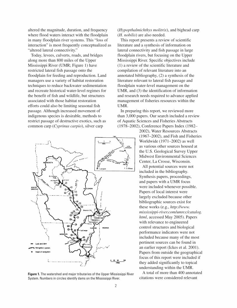
Today, levees, culverts, roads, and bridges along more than 800 miles of the Upper Mississippi River (UMR; Figure 1) have restricted lateral fish passage onto the floodplain for feeding and reproduction. Land managers use a variety of habitat restoration techniques to reduce backwater sedimentation and recreate historical water-level regimes for the benefit of fish and wildlife, but structures associated with those habitat restoration efforts could also be limiting seasonal fish passage. Although increased movement of indigenous species is desirable, methods to restrict passage of destructive exotics, such as common carp (Cyprinus carpio), silver carp
(Hypopthalmichthys molitrix), and bighead carp (H. nobilis) are also needed.
This report presents a review of scientific literature and a synthesis of information on lateral connectivity and fish passage in large floodplain rivers, but focusing on the Upper Mississippi River. Specific objectives include (1) a review of the scientific literature and compilation of relevant literature into an annotated bibliography, (2) a synthesis of the literature relevant to lateral fish passage and floodplain water-level management on the UMR, and (3) the identification of information and research needs required to advance applied management of fisheries resources within the UMR.
In preparing this report, we reviewed more than 3,000 papers. Our search included a review of Aquatic Sciences and Fisheries Abstracts (1978–2002), Conference Papers Index (1982–
2002), Water Resources Abstracts (1967–2002), and Fish and Fisheries Worldwide (1971–2002) as well as various other sources housed at the U.S. Geological Survey Upper Midwest Environmental Sciences Center, La Crosse, Wisconsin.
All potential sources were not included in the bibliography. Synthesis papers, proceedings, and papers with a UMR focus were included whenever possible. Papers of local interest were largely excluded because other bibliographic sources exist for these works (e.g., http://www.mississippi-river.com/umrcc/catalog.html, accessed May 2005). Papers with relevance to engineered control structures and biological performance indicators were not included because many of the most pertinent sources can be found in an earlier report (Ickes et al. 2001). Papers from outside the geographical focus of this report were included if they added significantly to topical understanding within the UMR.
A total of more than 400 annotated citations were considered relevant
Figure 1. The watershed and major tributaries of the Upper Mississippi River System. Numbers in circles identify dams on the Mississippi River.

3
and included in the bibliographic database. Abstracts within this database are those of the original author. The database is served as a searchable electronic document on the Upper Midwest Environmental Science Center’s Web site (http://www.umesc.usgs.gov/ltrmp_fish/fish_passage_biblio.html, accessed May 2005).
A summary of many of the major ideas contained within the annotated bibliography is provided within this report. However, a thorough review of the ecology of the UMR, its history of modification, and an accounting of the diversity of management challenges as they pertain to floodplain environments is beyond the scope of this summary, although we do touch upon these subjects to build sufficient context. In the final section of this report, we identify several general, yet key information needs. We believe that addressing these needs could provide many applied management and research benefits on issues concerning floodplain management practices within the UMR.
Defining Lateral Connectivity in Floodplain Systems
Conceptual Development
Connectivity, generally defined by Pringle (2003), is the water-mediated transfer of energy, materials, and organisms across a hydrologic landscape. Thus defined, “connectivity” can be invoked and subsequently modified to focus on different components of a system (Ward 1989). For example, the term “longitudinal connectivity” is frequently invoked to describe changes along a river’s primary axis of flow following impoundment (Ickes et al. 2001; Knights et al. 2002b). Similarly, “vertical connectivity” is invoked to describe fluxes between thermally stratified bodies of water in lakes, or between groundwater or hyporheic zones and flowing surface waters in rivers. Correspondingly, “lateral connectivity” is invoked to provide a conceptualization of the interaction between fluvial river segments and their corresponding lateral (e.g., perpendicular to the main axis
of flow) floodplain environments. A graphical depiction of these forms of connectivity is presented in Figure 2.
While the term “lateral connectivity” implies a spatial or structural relation between a river and its floodplain, the degree to which lateral connectivity exists is a time-dependent phenomenon (Tockner et al. 1999a). This happens because rivers are hydrologically dynamic. At any time, whether a floodplain or some portion of it is connected depends on prevailing hydrologic conditions within the river and the corresponding surface elevation of the floodplain. As river stage exceeds floodplain elevation thresholds on the ascending limb of a hydrograph, connection occurs and floodplains are inundated (Figure 3). This conceptualization
�������������������
��������
��������
�������
������������
������������
�������������������
�������������������
�������������������
Figure 2. Conceptualization of the multiple dimensions of hydrologic connectivity. Panel A presents “in channel” definitions of connectivity (e.g., vertical and longitudinal). Panel B highlights lateral connectivity, the subject of this report. Figures are adapted from Luther Aadland (Minnesota Department of Natural Resources, personal communication).

4
simplifies this dynamic process, but captures the main idea. In northern temperate rivers such as the UMR, lateral connectivity events have a strong seasonal signature that coincides with seasonal precipitation patterns. Thus, flood events are often classified on the basis of their magnitude, duration, timing, and frequency.
Human activities on and around floodplains can greatly alter lateral connectivity (Figure 4). Most obvious are the effects of levee construction on
lateral connectivity (Figure 5). Levees are regionally extensive in the UMR (Table 1) and serve to increase the effective elevation of floodplain landscapes, principally in support of flood control and agriculture development on UMR floodplains. Thus, river elevations must exceed local levee heights to inundate the floodplain. This has resulted in a decrease in the probability of lateral connectivity events (Figure 4). Because of the dynamic nature of lateral connectivity in floodplain river systems, scientists have yet to develop reliable methods for measuring lateral connectivity, although there is growing recognition that any means of measurement should be based on a mechanistic understanding of how physical and biological systems interact and how human activities influence these interactions (Johnson et al. 1995; Power et al. 1995). Moreover, it is becoming apparent that connectivity as a concept would benefit operationally from nonambiguous definitions (Pringle 2003). In other words, it does one little good operationally to talk about the lateral connectivity of the Mississippi River, as this is too ambiguous to be operational. Modifying Pringle’s definition, connectivity needs to be defined as the transfer of energy, materials, and organisms between specific locations on the river and floodplain.
Theoretical Development
Large rivers and particularly floodplain rivers remain little studied until the 1970s-1980s (Johnson et al. 1995) because of difficulties in sampling these systems. Since the 1980s, however, large river research has opened new insights into the physical, biological, and human forces that shape rivers. Today, physical and biological concepts have been combined into a more holistic framework that views river systems as interdependent, hierarchically structured combinations of aquatic and terrestrial landscapes. This perspective draws heavily from theory
Figure 3. Cross sections of an idealized floodplain river depicting natural (top) and leveed (bottom) conditions.
Figure 4. An example of the effects of levee construction on lateral connectivity by Trempeleau National Wildlife Refuge, Wisconsin. This aerial photograph demonstrates the lack of hydrologic connectivity that exists following levee development. Water in the Mississippi River (left side of photo) is clearly darker than water on the refuge side of the levees, suggesting no hydrologic mixing. Correspondingly, water, nutrient, energy, and biotic exchange between the main channel and the floodplain are severed.
Tremplelau National Wildlife Refuge
───────►
────►
──────────►Flow
Levees

5
in fields as diverse as fluvial geomorphology, fractal geometry, network theory, hydrology and hydrodynamics, fisheries science, landscape ecology, chaos theory, and theories of self-organization (Tockner et al. 1998; Ward and Tockner 2001; Church 2002; Tockner and Standford 2002; Benda et al. 2004). While a full and cohesive theory has yet to emerge, there are two prevailing hypotheses of how lotic systems function: the river-continuum concept (Vannote et al. 1980) with several corollaries (Elwood et al. 1983; Ward and Stanford 1983) and the flood-pulse concept (Junk et al. 1989).
The river-continuum concept (Vannote et al. 1980) was developed from observations on unperturbed forested watersheds at northern-temperate latitudes. The concept postulates that physical and biological structure in these systems is determined from physical forces that change predictably from the headwaters to the mouth, resulting in a longitudinally oriented continuum of features. Energy for biological production is assumed to come from three sources: local organic inputs (allochthonous), primary production within the stream (autochthonous),
and transport of organic material within the stream. The relative prominence of each of these energy sources is predicted to vary along the river continuum, with allochthonous inputs being prominent in low stream order reaches, autochthonous sources predominating in midstream order reaches, and downstream transport dominating in high stream order reaches. Similarly, secondary productivity (e.g., invertebrates) and life-history traits of dominant organisms will be predictable based on energy sources along the continuum, with shredders and collectors dominating in low stream order reaches, collectors and grazers dominating in midstream order reaches, and collectors dominating in high stream order reaches. Differences in the variation of hydrologic, temperature, and organic matter sources along the stream order continuum predict that medium-sized rivers should have the greatest biotic diversity.
The flood-pulse concept (Junk et al. 1989) incorporates a lateral dimension into river theory, stating that the most important hydrological feature of large rivers is the annual flood pulse. Under this theory, carbon that accumulates on the floodplain throughout an annual cycle is assimilated by biogeochemical processes during and following a flood
Figure 5. An early photograph of snag removal in the Mississippi River. Snag removal conducted in concert with sandbar dredging represents the earliest attempts to improve navigation on the Upper Mississippi River and served as a precursor to more highly engineered channel development measures. Improved navigability lead to expanded floodplain development and sequestration of floodplain environments from the main channel of the river. (Photograph from N. Moore [1972].)
Table 1. Total acres of floodplain and percent of floodplain surface area sequestered behind levees in different segments of the Mississippi River.
River segmentFloodplain
acres
Percentage of floodplain
behind levees(%)
Headwaters 328, 000 <0.01Upper Mississippi-northa 496, 000 3Upper Mississippi-southa 1,006,000 53Middle Mississippia 663,000 82Lower Mississippi 25,000,000 93Deltaic Plain 3,000,000 96 Total 30,493,000 90
aThe Upper Mississippi-north includes Pools 1–13, the Upper Mississippi-South includes Pools 14–26, and the Middle Mississippi includes the unimpounded reach from below Pool 26 to the confluence of the Ohio River. Collectively these three river segments comprise the Upper Mississippi River.

6
pulse that inundates vast carbon reserves on the floodplain. Biotic communities are predicted to be in dynamic equilibrium with the dynamics of the flood pulse (e.g., timing, duration, and magnitude). This equilibrium is possible because of the large size of floodplain river systems and the attenuating and moderating effects of this size on the flood pulse, which results in some degree of annual flood predictability. Thus, flood pulses that are too short may not allow flood-dependent organisms time to complete reproductive cycles whereas those that are too long may not allow terrestrial vegetation to develop. Such flood pulses are predicted to enhance system productivity and to support and sustain biodiversity. Contrary to the river-continuum concept, the flood-pulse concept predicts organic matter from upstream origins is insignificant for river production relative to organic material produced and consumed locally on the floodplain. Thus, when the lateral dimensions of floodplain rivers are considered, biotic diversity may be highest in large rivers rather than medium-sized rivers as predicted by the river-continuum concept and lateral connectivity is viewed as critical to perpetuating ecological integrity (Junk 1999; Ward et al. 1999).
However, main stem impoundments have altered the natural hydrology of the UMR and corresponding floodplain inundation regimes (Sparks et al. 1998) and permanently inundated sizeable areas of former floodplain. Moreover, urban and agricultural developments have isolated sizeable portions of most of the Earth’s floodplain systems, in effect making them functionally extinct (Tockner and Stanford 2002). Such developments serve to alter the dynamic equilibrium between connected and disconnected landscape features present in natural systems (Galat et al. 1998). Several recent studies have begun to document the ecological consequences of these alterations. Examples include decreased biotic diversity (Bornette et al. 1998; Matthews and Robison 1998; Tockner et al. 1999b; Ward et al. 1999; Stein 2001; Ward and Tockner 2001), and biotic production (Welcomme 1979; Bayley 1988; Mitsch and Gosselink 2000), and increased pollution (Van den Brick et al. 1996; Burkart and James 1999; David and Gentry 2000; Goolsby et
al. 2000), and species invasion rates (Galat and Zweimueller 2001).
Upper Mississippi River Development and Effects on Lateral Connectivity
The Upper Mississippi River System (Figure 1) has undergone a long history of development that has greatly influenced lateral connectivity and the ecology of the river (Sparks 1995; Galat and Zweimueller 2001; Anfinson 2003). Human alterations in the past two centuries have isolated much of the floodplain and seriously degraded remaining floodplain habitats. Alterations have been progressive and largely center on making the river navigable for commercial shipping and on developing floodplains for agricultural production using flood-control measures. Physical, chemical, and ecological changes associated with these alterations are detailed in many studies (e.g., Simons et al. 1974; Belt 1975; Sparks 1992; Scientific Assessment and Strategy Team 1994; Wlosinski 1994; Yin and Nelson 1995).
Navigation-related modifications began in 1823 with snag removal and sandbar dredging (Figure 5), progressed to the construction of channel-training structures by 1873 (Figure 6), and culminated in the construction of 29 low head dams in the 1930s (Figure 1; Fremling and Claflin 1984; Anfinson 2003). These navigation improvements resulted in altered flow regimes (Johnson et al. 1995, see Figure 4 therein), which in turn affected hydraulic processes (Wlosinski 1994) and sediment transport dynamics (DeHaan 1998) critical for maintaining diverse physical habitats. Impoundment also resulted in the permanent inundation of vast expanses of former floodplain (Scientific Assessment and Strategy Team 1994).
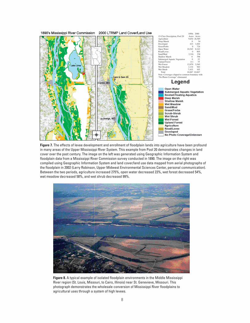
In the same period, agriculture development on the floodplain was pronounced and had two major effects on UMR floodplains. Levees were constructed to incorporate rich alluvial floodplain soils into agricultural production (Figure 7), disconnecting floodplains from the main stem of the river. Increases in the scale of agriculture operations and tillage practices also resulted in large increases in the sediment load being

7
delivered to the UMR (DeHaan 1998). Additional alterations associated with floodplain isolation include railway and road embankments, bridges, and floodwalls in urban and residential settings.
The UMR floodplain environment exists now as a complex mosaic of private and public lands comprised principally of agriculture, urban, navigation, commercial, and natural resource interests. Complex ownership patterns and the multiuse nature of the UMR floodplain present substantial challenges to natural resource managers throughout the basin.
Floodplain Status and Management
River scientists have not yet developed reliable methods that can quantify connectivity of habitats and incorporate the variability in land and water elevation typical of large rivers. However, in the UMR, differences in land use, levee prominence, and impoundment characteristics can be used to develop a coarse classification of the degree where floodplains are connected to the main stem. This classification does not measure connectivity explicitly, but provides useful proxies for assessing large-scale
patterns that presently exist in the floodplain (Laustrup and Lowenberg 1994).
General System Overview
On the basis of the connection to the main channel, present floodplain habitats of the UMR can be classified into three general categories. The first category is Isolated Floodplain. Isolated Floodplains where the historical floodplain has been completely sequestered behind levees (Figure 8) and are virtually never connected to the river. Often these areas have been converted to residential, urban, and agricultural use. Conversion of historically connected floodplain areas to isolated levied areas has been profound in many areas of the UMR (Figure 8). The amount and distribution of Isolated Floodplains varies considerably by geomorphic reach within the UMR (U.S. Geological Survey 1999; Table 1). The greatest isolation exists in the unimpounded Mississippi River (83% of floodplain sequestered behind levees), lower Illinois River (60%), and lower impounded Mississippi River (Pools 14–26; 50%). Comparatively, the upper impounded Mississippi River (Pools 1–13) is only lightly affected by levees (3%).
The second category is Continuously Inundated Floodplain. Continuously Inundated Floodplains have been permanently inundated as a result of impoundment (Figure 9) and, thus, are always connected to the main channel. They exist in the lower portions of
Figure 6. Two time-lapsed photographs of the same area on the Open River Reach of the Mississippi River, near Grand Tower, Illinois. These photographs from the 1930s (top) and the 1950s (bottom) demonstrate channel-training measures enacted to increase main channel velocities, minimizing the need for in-channel navigation maintenance. Geomorphic responses in nonbedrock river bottom zones include channel incision, which reduces the frequency of water elevations required for lateral connectivity in large areas of the Upper Mississippi River. For example, in regions of the Middle Mississippi River (St. Louis, Missouri, to Cairo, Illinois), many side channels “perch” above the main stem of the Mississippi River during periods of lower flows. (Photograph from N. Moore [1972].)
8
���������������������������������������������������������������������������������������������������������������������������������������������������������������������������������������������������������������������������������������������������������������������������������������������������������������������������������������������������������������������������������������������������������������������������������������������������������������������������������������������������������������������������������������������������������������������������������������������������������������������������������������������������������������������������������������������������������������������������������������������������������������������������������������������������������������������������������������������������������������������������������������������������������������������������������������������������������������������������������������������������������������������������������������������������������������������������������������������������������������������������������������������
Figure 7. The effects of levee development and enrollment of floodplain lands into agriculture have been profound in many areas of the Upper Mississippi River System. This example from Pool 20 demonstrates changes in land cover over the past century. The image on the left was generated using Geographic Information System and floodplain data from a Mississippi River Commission survey conducted in 1890. The image on the right was compiled using Geographic Information System and land cover/land use data mapped from aerial photographs of the floodplain in 2002 (Larry Robinson, Upper Midwest Environmental Sciences Center, personal communication). Between the two periods, agriculture increased 275%, open water decreased 23%, wet forest decreased 54%, wet meadow decreased 58%, and wet shrub decreased 99%.
Figure 8. A typical example of isolated floodplain environments in the Middle Mississippi River region (St. Louis, Missouri, to Cairo, Illinois) near St. Genevieve, Missouri. This photograph demonstrates the wholesale conversion of Mississippi River floodplains to agricultural uses through a system of high levees.

9
river pools within the impounded reaches of the UMR. Their present habitat characteristics are the direct result of increased and stabilized water levels in impounded sections of the river following dam construction. The presence of artificially stable and high water levels throughout the year has led to wind-induced island erosion sediment deposition, loss of diversity in depths, loss of aquatic vegetation, and disruption of the seasonal cycle between aquatic and terrestrial habitats. While fish can physically access such areas any time, the quality of these areas as habitat may restrict use within the UMR.
The third category is Seasonally Inundated Floodplain. Seasonally Inundated Floodplains encompass a variety of seasonally inundated terrestrial areas as well as reconnected backwater habitats that are isolated from the main channel throughout much of the year (Figure 10). Low elevation areas may be connected to the river almost every year, whereas areas at higher elevation may be connected only during extreme flow events. Consequently, these areas retain some degree of floodplain function in the system, although the extent of the
function is dependent on regional geomorphology, floodplain elevation, and altered hydrology.
Present Management of UMR Floodplains
Rasmussen et al. (1999) recognized two general categories of floodplain management in the UMR. The first of these is “controlled flooding.” Areas managed by controlled flooding are protected by levees, and water levels are actively managed using some combination of pumps, drains, and water control structures. Generally, these units are actively managed as moist soil units with some combination of the following three goals: (1) artificially simulate a spring flood pulse for fisheries production, (2) initiate a summer drawdown for moist-soil vegetation, or (3) simulate a fall flood pulse for waterfowl and shorebird use during migration (Fredrickson 1991; Heitmeyer et al. 1993). Reid et al. (1989) reported that moist-soil management is practiced on more than 80% of the National Fish and Wildlife Refuges in the United States.
The second category of floodplain management is “uncontrolled flooding” or passive management. This technique permits the portion of floodplain under management to be inundated at intervals dictated by the hydrograph and the surrounding landscape features. Consequently, the amount and degree of connection to the main channel can vary substantially, both seasonally and interannually. Often, limited “active” management is implemented on these passively managed areas to enhance habitat values within the unit. Examples include the installation of flow
Figure 9. An example of a continuously inundated floodplain of the Upper Mississippi River in Pool 8 near Brownsville, Minnesota. These areas exist in the lower portions of river pools within the impounded reaches of the Upper Mississippi River and exist as a consequence of impoundment. Before impoundment, these areas consisted of a rich mix of side channel, island, and backwater environments that provided aquatic to terrestrial linkages that ebbed with varying hydrology. Today, water levels are held artificially high and stable. While fishes are free to move about in these environments, habitat quality issues may limit use.
10
deflecting devices to promote scour and channel formation, levee breaching, and removal of shoreline revetments.
Many U.S. Fish and Wildlife Service lands are subject to management constraints mainly because of land ownership restrictions and operation and maintenance costs. The most restrictive situation arises when the Service lands lie within a levee management district. The existence of other private landowners within the levee district requires consideration of the economic, social, and political consequences of ecologically beneficial management activities on Service lands. Consequently, biotic benefits on these lands tend to be limited to migratory waterfowl, passerines, and nonriverine fish and wildlife species, as high elevation levees may severely or entirely restrict lateral movements of fishes from channel environments.
When Service lands are not within a levee management district, there is much more flexibility in management. Under this scenario, managers can minimize threats of catastrophic breach and scour, permit more frequent spring flooding and fish passage opportunities, allow for moist-soil vegetation management, and allow fall flooding for migratory waterfowl use. However, the cost of initial infrastructure development and annual maintenance may limit some management options.
Lateral Connectivity—its Relevance to Fishes
We summarize the literature on associations between lateral connectivity and fish responses at several spatial scales and levels of ecological organization. Our presentation draws on recent findings in European systems as well as on findings from the UMR.
Riverine fish species have evolved migratory patterns and life-history characteristics to exploit seasonally predictable flood pulses and make use of resulting seasonal habitats and energy sources, particularly for reproduction, feeding, and refuge from intolerable conditions (Welcomme 1979; McKeown 1984; Petts 1989; Winemiller and Rose 1992; Scheimer
2000). Thus, seasonal use of floodplain habitats is common in river fishes worldwide (Welcomme 1979; Petts 1989; Winemiller and Rose 1992). As a consequence, large river fish communities exhibit high diversity, which has been attributed to the structural diversity and habitat richness of floodplain environments (Schiemer 2000).
Role in Reproduction
The timing and duration of the flood pulse are particularly critical to UMR fishes that require lateral access to floodplain environments for reproduction. Ideal conditions for reproduction of fish
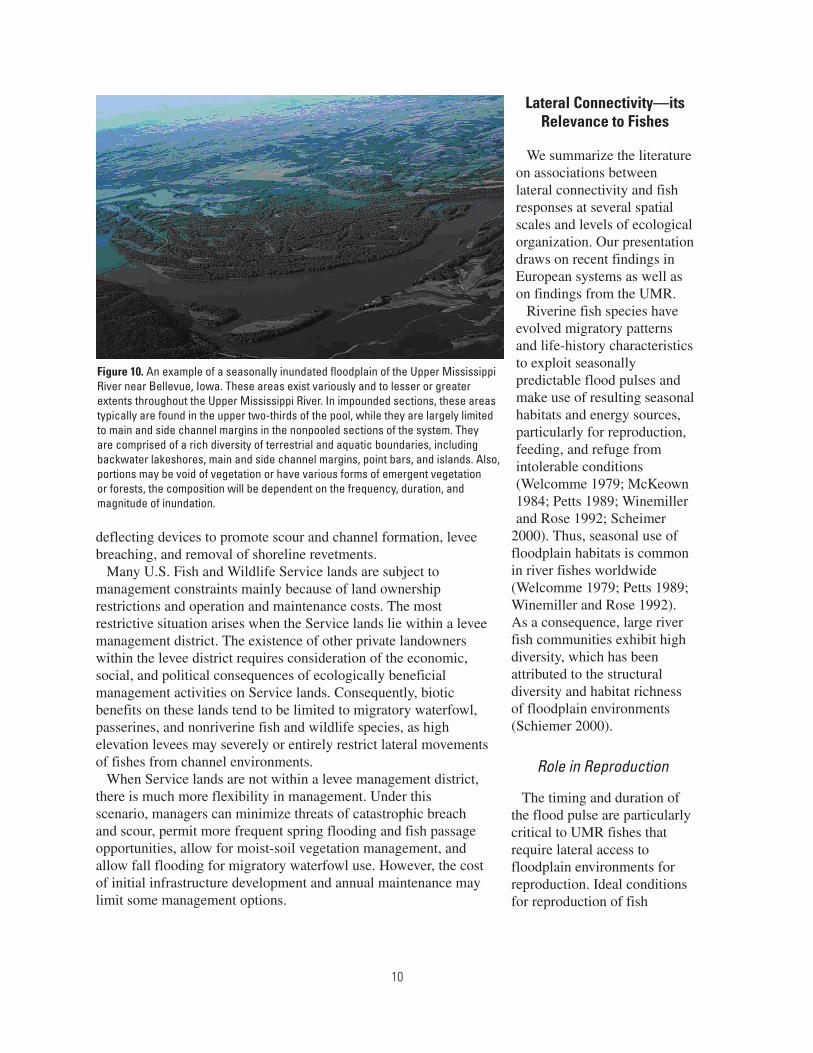
Figure 10. An example of a seasonally inundated floodplain of the Upper Mississippi River near Bellevue, Iowa. These areas exist variously and to lesser or greater extents throughout the Upper Mississippi River. In impounded sections, these areas typically are found in the upper two-thirds of the pool, while they are largely limited to main and side channel margins in the nonpooled sections of the system. They are comprised of a rich diversity of terrestrial and aquatic boundaries, including backwater lakeshores, main and side channel margins, point bars, and islands. Also, portions may be void of vegetation or have various forms of emergent vegetation or forests, the composition will be dependent on the frequency, duration, and magnitude of inundation.

11
species that spawn on the floodplain exist in years when the flood pulse and water temperature rise are coupled (Figure 11; Junk et al. 1989). Bayley (1991) observed that a coupled rise in temperature and discharge results in increased fish yield, a measure of production, and termed this observation as the “Flood-Pulse Advantage.” Levee development and enhancement on UMR floodplains reduce the likelihood of such an advantage because flood waters are conveyed by the main channel on the river side of the levees rather than by the floodplain. Thus, flood waters are less likely to interact with the floodplain to the advantage of fishes because of levee constriction (Wlosinski 1994; Wlosinski and Olsen 1994; Sparks 1995).
Increases in the production of some fish species following flood years (i.e., following periods of increased floodplain connectivity) demonstrate the foregone production when fish are denied seasonal access to floodplain habitats. For example, Gutreuter et al. (1999) tested for differences in growth responses of several fish species using long-term monitoring data from the UMR, comparing growth following a 500-year flood event that breached many levees in the UMR with growth from nonflood years. Growth was used as a surrogate for production as it represents the rate where biomass is accrued by individuals in a population. Consistent with the flood-pulse concept (Junk et al. 1989), Gutreuter et al. (1999) provided evidence for increased growth of some UMR fishes in the Great Flood of 1993. Benefits in growth were restricted to fishes that exploited the moving littoral zone. Theiling et al. (1999) reported a greater than fourfold increase in the number of fish species using a backwater complex in lower Pool 26 following the Great Flood of 1993, suggesting increased use of floodplains when accessible. It remains uncertain whether these observations reflected local production because of floodplain connectivity or whether these observations represented use of the floodplain as a refuge from high flows. Thus, there is evidence that increased access to the floodplain during annual flood pulses can increase the production of some important UMR fish species and suggests the potential for targeted management.
The preceding discussion focused on large-scale fish responses to floods, but local responses can also be noteworthy. For example, fish production within refuge areas managed by controlled flooding can be substantial. Lake Chautauqua is a backwater lake on the Illinois River that has an upper section—480-ha Kikunessa Pool, managed for waterfowl and fish—and a lower section—970-ha Wasenza Pool, managed as a moist-soil unit by the U.S. Fish and Wildlife Service. Fish production in the Wasenza Pool in 1996 was estimated between 18 and 27 million larval/early juvenile fishes representing 34 taxa (Irons et al. 1997). Subsequent studies of larval fish emigration from Wasenza Pool revealed that larger numbers of fish were produced in relatively high water years when the levees were overtopped versus years when levees were not overtopped, suggesting that adult fish access to the pool for spawning may be limited during normal-water years.
Role in Survival
Whereas flood pulses are viewed as critical determinants of juvenile production, UMR fishes are generally long-lived (Galat and Zweimueller 2001). Thus, survival of fishes produced following
Figure 11. Ideal spawning conditions for floodplain spawning fishes occur when the floodpulse and temperature rise are coupled (left) and are least favorable when the floodpulse recedes ahead of the temperature rise (right). Bayley (1991) termed this the “Flood-Pulse Advantage.”
12
a flood pulse depends on whether suitable habitat conditions are sufficiently present throughout the entire life of UMR fishes. Survival for many species depends on laterally connected, low-velocity habitats during nonflood pulse periods that provide foraging and overwintering habitats (Knights et al. 1995; Barko and Herzog 2003; Barko et al. 2004a,b). These habitats include a diverse array of side channel, slough, and backwater environments that provide refuge and foraging habitats for juvenile and adult fishes of many UMR species. The availability of these habitats to UMR fishes can have important effects on population dynamics. These are the types of habitats most likely to be affected by managing floodplain connectivity.
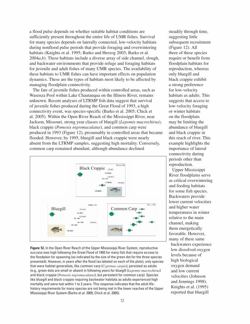
The fate of juvenile fishes produced within controlled areas, such as Wasenza Pool within Lake Chautauqua on the Illinois River, remains unknown. Recent analyses of LTRMP fish data suggest that survival of juvenile fishes produced during the Great Flood of 1993, a high connectivity event, was species-specific (Barko et al. 2005; Chick et al. 2005). Within the Open River Reach of the Mississippi River, near Jackson, Missouri, strong year classes of bluegill (Lepomis macrochirus), black crappie (Pomoxis nigromaculatus), and common carp were produced in 1993 (Figure 12), presumably in controlled areas that became flooded. However, by 1995, bluegill and black crappie were nearly absent from the LTRMP samples, suggesting high mortality. Conversely, common carp remained abundant, although abundance declined
steadily through time, suggesting little subsequent recruitment (Figure 12). All three of these species require or benefit from floodplain habitats for reproduction, whereas only bluegill and black crappie exhibit a strong preference for low-velocity habitats as adults. This suggests that access to low-velocity foraging or winter habitats on the floodplain may be limiting the abundance of bluegill and black crappie in this reach of river. This example highlights the importance of lateral connectivity during periods other than reproduction.
Upper Mississippi River floodplains serve as critical overwintering and feeding habitats for some fish species. Backwaters provide lower current velocities and higher water temperatures in winter relative to the main channel, making them energetically favorable. However, many of these same backwaters experience low dissolved oxygen levels because of high biological oxygen demand and low current velocities (Johnson and Jennings 1998). Knights et al. (1995) reported that bluegill
Bluegill
Black Crappie
Common Carp
Figure 12. In the Open River Reach of the Upper Mississippi River System, reproductive success was high following the Great Flood of 1993 for many fish that require access to the floodplain for spawning (as indicated by the size of the green dot for the three species presented). However, in years after the flood (as labeled on each of the plots), only species that were habitat generalists, like common carp (Cyprinus carpio), persisted as adults (e.g., green dots are small or absent in following years for bluegill (Lepomis macrochirus) and black crappie (Pomoxis nigromaculatus), but persistent for common carp). Species like bluegill and black crappie requiring backwater habitats as adults experienced high mortality and were lost within 1 to 2 years. This response indicates that the adult life-history requirements for many species are not being met in the lower reaches of the Upper Mississippi River System (Barko et al. 2005; Chick et al. 2005).

13
and black crappie in an UMR backwater preferred winter habitats characterized by water temperatures >1°C and undetectable current velocity. When dissolved oxygen levels fell below 2 mg/L, both species sought areas with higher dissolved oxygen but would avoid areas with water temperatures <1°C and current velocities >1 cm/s. Similar preferences for higher water temperatures, low current velocities, and adequate dissolved oxygen have been documented for largemouth bass (Micropterus salmoides) in the Upper Mississippi and Illinois Rivers (Gent et al. 1995; Raibley et al. 1997). These species are known to exist in channel habitats at other times of the year (LTRMP, unpublished data); thus, restricted access to floodplain habitats before winter may lead to reduced survival, reproduction, and growth on the basis of habitat preferences.
In contrast, use of floodplain habitats by typical large river fishes such as paddlefish (Polyodon spathula) and lake sturgeon (Acipenser fulvescens) is poorly understood. Recent telemetry studies have shown that both species use floodplain habitats as feeding areas (Knights et al. 2002a; Zigler et al. 2003). Although use of floodplain habitats by paddlefish and lake sturgeon has been documented, the benefits gained from the use of these habitats remain unknown. In Pool 8 of the UMR, adult paddlefish preferred off-channel habitats with current velocities <5 cm/s and depths >4 m (Zigler et al. 2003). It remains unclear whether paddlefish used these habitats to avoid high flows for feeding or for some other purpose. Adult lake sturgeon also used floodplain habitats, but unlike paddlefish, was in a wide range of current velocities (Knights et al. 2002a). This suggests that adult lake sturgeon may benefit from access to floodplain habitats for feeding. These studies suggest that paddlefish and lake sturgeon are wide ranging and use a broad array of habitat types, including floodplain habitats, during their lifetime. The status of paddlefish and lake sturgeon as U.S. Fish and Wildlife Service trust species increases the importance of management actions that benefit these species. Therefore, to enhance populations of these large-bodied fishes, more research should be directed at understanding what constitutes good floodplain
habitat for these fishes and how to best connect floodplain habitat with the main stem river.
The role of floodplain habitats for reproduction and survival suggests that alternatives for managing UMR floodplains for fisheries benefits will require an integrated approach. Effective management needs to know which species use these habitats, the temporal nature of fish use, and the life-history requirements that are met to determine the potential benefits of increased access to floodplain habitats and to plan and design effective passage alternatives. Potential goals of enhanced lateral fish passage are many, but should be founded in an integrated approach to floodplain management.
Life-History Considerations
The ichthyofauna of the UMR is incredibly rich and diverse. Of the nearly 600 fish species documented within North America, 136 (nearly one quarter) have been collected in the UMR by the LTRMP. The Mississippi River Basin as a whole exhibits the highest diversity of freshwater fishes for any region of the world at comparable latitudes (Robison 1986, cited in Scientific Assessment and Strategy Team 1994). Many of these species use floodplain environments to fulfill essential life needs (e.g., reproduction, feeding, and refuge from intolerable conditions; Galat and Zweimueller 2001). Understanding how floodplain isolation affects fish populations and communities requires a detailed understanding of the life history of each of these species.
Life-history traits can be defined as a suite of characteristics particular to a species that describe its association to the environment where it evolved or presently exists. These characteristics can be conceptualized as particular to the physiology, behavior, and general ecology of the species. Examples of general life-history trait categories include reproductive strategies, habitat associations, feeding affinities, phylogenetic associations, and physiological tolerances. Generally, species demonstrate physiological affinities and behavioral associations such that some combination of life-history traits define a concept of niche or a suite of conditions that meet

14
critical life-history needs and defines the general association of a species to its environment.
Knowledge of life-history strategies is critical in planning effective habitat restoration of freshwater communities (Regier 1974; Power et al. 1988; Mobrand et al. 1997; Schmutz and Jungwirth 1999; Naiman and Turner 2000; Zalewski et al. 2001; Schiemer et al. 2002). For example, fish life-history information has been used to create indices of biological integrity that function to detect habitat degradation or to evaluate habitat restoration (Oberdorff and Hughes 1992; Lyons et al. 2001). Also, life-history information has been essential to manage species of special interest such as exploited sport and commercial species, threatened or endangered species, and undesirable exotic species (Fogarty et al. 1991; Casselman and Lewis 1996; Lappalainen and Kjellman 1998; Nislow 1998; Schrank and Guy 2002).
Given the diversity of the UMR fish fauna and the variety of floodplain units managed by the U.S. Fish and Wildlife Service, we cannot provide a detailed account of which management practices would benefit which species in each area. We do, however, provide information that should be considered in the context of actively and passively managed floodplains.
Considerations for Actively Managed UMR Floodplains
Actively managed floodplain units present unique physiological and behavioral challenges to fishes. Water exchange between the managed unit and the channel is commonly achieved using a series of pumps and gates. With gated control structures, a head differential exists across the gate because of differences in water elevation between the managed unit and the connecting channel. High-head differentials can result in current velocities that exceed the swimming performance of most UMR fish species. We were unable to find information on common head differentials for actively managed floodplain units in our literature review, but generally, as head increases, water velocity through a control
structure increases with a constant gate opening size.
Directionality of flow across the control structure also probably affects lateral passage opportunities in actively managed floodplain units. Fish have highly evolved sensory systems for detecting and responding to flow, however, these sensory systems require fish to orient into flowing water for information exchange between the sensory system and the environment (Jobling 1995). This is the basis for the concept of “attractant flow” commonly used in longitudinal passage settings (Barry and Kynard 1986; Barekyan et al. 1988; Bunt et al. 1999). Attractant flow is an area at the base of a water control structure where flow is modified to attract target fishes and direct them through a control structure. However, in actively managed lateral passage settings, this concept may be reversed. For lateral passage, fish must move with the flow to enter areas as they fill and leave those areas as they drain. Thus, attractant flows may cause fish to move in the wrong direction and actually reduce lateral fish passage.
The physical characteristics of gates used to exchange water may also limit lateral fish passage into managed units. The size of the gate may preclude some large-bodied species from passing. Because water levels in managed units are controlled by incrementally lifting horizontally placed “logs” from the top of the gate (e.g., stop-log gate water control structures), some benthic species may be precluded from passing over these structures. Finally, the actual composition of the gate itself may preclude certain species. For example, paddlefish, which use their rostrum to detect the electrical impulses of their zooplankton prey, demonstrate aversions to weak electrical fields generated by metallic objects in the absence of visual cues (Wilkens et al. 1997; Gurgens et al. 2000). Thus, paddlefish may avoid water control and fish passage structures that typically include metal in their construction. Little is known about how these factors affect lateral fish passage. More research is needed to develop water control structures that can effectively pass large and small fishes in both directions.
15
Considerations for Passively Managed UMR Floodplains
Passively managed units do not present nearly the range of physiological and behavioral challenges that actively managed units do. However, their availability to fishes varies considerably over time and space as a function of annual hydrology and floodplain and levee elevation.
Summer drawdown is a technique that lowers water levels in summer to promote growth of aquatic macrophytes and to consolidate sediments (Lubinski et al. 1991). This technique has proven successful at small and poolwide scales and is gaining popularity. When applied at the poolwide scale, the reduction in water levels is greater in the lower reaches of the pool than in the upper reaches; thus, drawdowns have their greatest effect in the lower impounded areas. A potential biological cost of this management technique is loss of fish nursery habitat as shallow areas are dewatered (Theiling 1995), although the long-term consequences on fish populations remain unclear. For example, larval and juvenile fishes may experience increased mortality if connections to traditional nursery areas are lost or these areas are dewatered. However, new nursery areas may develop in other locations that were previously too deep. We may be able to predict the location and availability of new nursery areas and other critical habitats based on models of floodplain elevation flow characteristics and corresponding vegetation responses. In addition, many fish species may benefit in the future if the drawdown increases emergent vegetation that provides food, cover, and spawning habitat during subsequent increases in water levels. Wlosinski et al. (2000) found little difference in fish abundance or diversity following three consecutive years of drawdowns on Pools 24–26. However, little information is available on long-term and species-specific effects of large-scale (i.e., poolwide) drawdowns on UMR fish populations.
Significant questions remain about water-level management and its effects on UMR fishes. For example, studies have suggested that increases in water levels in winter may increase overwinter survival of some fishes by introducing oxygen
rich water into backwaters subject to high biological oxygen demand (Gent et al. 1995; Johnson and Jennings 1998). However, reduction of water levels in winter may result in high mortality because of anoxia, as fish become stranded in backwaters (Raibley et al. 1997). Water control structures may help in maintaining relatively warmwater temperatures, low current velocities, and dissolved oxygen levels >2 mg/L in backwaters in winter. Thus, actively managed refuge lands have the potential to provide such critical habitat needs in reaches where overwintering areas for fish are otherwise limited (Gutreuter 2004).
Progressive techniques for managing “uncontrolled” UMR floodplains may affect the future roles of “controlled” floodplains. Poolwide water-level manipulations designed to elicit particular physical, chemical, and biological responses have the potential to affect vast portions of the floodplain. By mimicking the natural flood pulse, these manipulations may provide large-scale enhancement of wildlife habitat throughout the UMR. If poolwide water-level management can duplicate the habitat conditions created by moist-soil management within controlled areas, existing controlled areas can be used to provide habitat for other wildlife concerns.
Each area of the floodplain and U.S. Fish and Wildlife Service refuge holdings is distinct, with a unique set of challenges to provide enhanced lateral fish passage. Some areas are passively managed while others are actively managed as moist-soil units. Approaches and goals will differ among sites and can provide the foundation for an integrated management program to benefit a range of management goals from species of concern to regional biodiversity. Management experiments should play a key role in developing and evaluating management alternatives, filling information gaps, and finding common principles that apply across different areas. Given the incredible faunal diversity of UMR fish assemblages, the variety of sizes and types of floodplain environments throughout the UMR, and a host of different management goals, we cannot possibly identify every need at every scale. Rather, we conclude that a few key pieces of information and research could lay the
16
foundation for an integrated management and science approach to lateral connectivity issues in the basin. Below, we identify and elaborate on these broad informational and research needs.
Information Needs and Conclusions
The goal of this report is to identify information and research needs required to enhance management of fisheries resources on National Fish and Wildlife Refuges on the Upper Mississippi River. Although the scope of this effort precludes us from identifying needs at specific management units, our literature review consistently revealed particular broad themes concerning information gaps.
Dam and levee construction have altered the riverine landscape and isolated a large portion of floodplain habitat. The disruption of natural fluvial processes has had a homogenizing effect on riverine habitats, wherein habitats lose diversity and complexity and become more similar and homogenous. Refuge lands, whether leveed or unleveed, suffer from habitat homogenization. Habitat diversity is presently being restored to some unleveed refuge lands through various forms of habitat rehabilitation and experimental water-level manipulations. However, opportunities for increasing habitat diversity on leveed refuge lands are much more limited, spatially and physically. While the physical characteristics of floodplain refuge lands vary notably and management goals and methods are quite different between these types of lands, we suggest that a few broad, yet key informational sources could lay the foundation for enhanced management and research on these lands.
The first information need for predicting where and how management of refuge lands can affect fish resources is to compile a geospatial inventory of floodplain habitats along the UMR. Such a database would contain information on spatial extent (size, distance to the main channel, depth), land use (categorical representation of land use at several scales, proximity to contiguous channels, management practices), water control structures (levee type, presence or absence of a spillway, levee height, pumps,
stop-log gates, and composition), and ownership. These data would provide many management and scientific benefits.
For the manager, the availability of floodplain habitats within a given pool or reach could identify areas in need of enhanced floodplain connectivity to determine how to best manage specific parcels of land to enhance reachwide benefits to fish. Inclusion of historical floodplain extent would more accurately assess the magnitude of floodplain loss within a pool or reach. For the research scientist, such data would provide a framework for determining how the effects of manipulations (natural or experimental can be assessed within the refuge framework.
Fortunately, abundant data on UMR floodplains are available in survey maps and remotely sensed information. Many of these data are accessible through the Upper Midwest Environmental Sciences Center’s Web site (http://www.umesc.usgs.gov/, accessed May 2004), and various state agency offices. Additionally, many systemic survey sets not available through the Upper Midwest Environmental Sciences Center’s Web site are presently being compiled by a team of university researchers at Southern Illinois University under a National Science Foundation grant (Table 2). The Southern Illinois University data sources are particularly relevant for lateral connectivity issues because they represent a relatively long time series of floodplain changes permitting quantification of engineering changes and floodplain responses over the past century. Because many of these data sources have only recently been digitally registered and rectified, little work has been done to quantify these changes to date.
A second information need relates to the elevation of lands within the floodplain and their frequency of connection to the main channel. Data on elevations of floodplains and levees would enable managers to model the seasonal extent of inundation of floodplains, as well as frequency and degree of connection of floodplain habitats to the main channel. Available elevation data vary in their accuracy, resolution, and availability. Coarse data are derivable from various river survey maps (Table 2), and 30-m resolution digital elevation models are

17
Table 2. Survey map sets by major river reach and publication year compiled by researchers at Southern Illinois University under a National Science Foundation grant. Each set has been digitally registered and rectified. For additional information, contact Dr. Nicholas Pinter, Department of Geology, Southern Illinois University.
River reach Map set name Year of publicationLower Mississippi River Preliminary map of the Lower Mississippi River 1881
Survey of the Mississippi River 1890Survey of the Mississippi River 1911–1915
Flood control and navigation map of the Mississippi River 1933Mississippi River and Levee Charts: Cairo, Illinois, to Rosedale,
Mississippi 1937
Flood control and navigation map of the Mississippi River 1948Mississippi River hydrographic survey: USACEa, Memphis Engineering
District 1951
Mississippi River hydrographic survey: USACE New Orleans Engineering District 1952
Mississippi River hydrographic survey: USACE Vicksburg Engineering District
1952
Flood control and navigation map of the Mississippi River 1957
Mississippi hydrographic survey: USACE Memphis District 1962–1964
Flood control and navigation map of the Mississippi River 1968
Flood control and navigation map of the Mississippi River 1977
Flood control and navigation map of the Mississippi River 1983
Flood control and navigation map of the Mississippi River 1998
Middle Mississippi River Survey of the Upper Mississippi River 1880–1881
Mississippi River: Saint Louis, Missouri, to Cario, Illinois 1908
Hydrographic survey maps of the Mississippi River: mouth of Ohio River Miles 0 to 300
Compilation of various surveys
1939, 1947, 1956, and 1961
Program of improvements 1940
Mississippi River between mouths of Ohio and Missouri Rivers 1948
Hydrographic survey of the Mississippi River: River Miles 0 to 300 1972
Hydrographic survey of the Mississippi River: River Miles 0 to 202 1983
Upper Mississippi River navigation charts: Maps 94 through 118 only 2001
Upper Mississippi RiverMap of the Mississippi River from Falls of Saint Anthony to junction of
Illinois River 1878
Upper Mississippi River: Minneapolis to mouth of Missouri River 1895Map of the Mississippi River from Falls of Saint Anthony to junction of
Illinois River1915
Upper Mississippi River: Hasting, Minnesota, to Grafton, Illinois 1930Map of the Mississippi River from Falls of Saint Anthony to junction of
Illinois River 1905
Upper and Middle Mississippi River Survey of the Upper Mississippi River 1895
Minnesota and Mississippi Rivers
Minnesota and Mississippi Rivers as far south as Arkansas 1869
Illinois River Illinois Waterway navigation charts 1999
Missouri River Missouri River, Missouri, Kansas, Nebraska, hydrographic survey 1987
Lower Missouri River Missouri River, Rulo, Nebraska to mouth 1940
Missouri River hydrographic survey: Rulo, Nebraska, to mouth 1994
Upper Missouri RiverMissouri River hydrographic survey: Ponca State Park to Rulo,
Nebraska 1994
Missouri River, Kansas to Sioux City 1929
aUSACE = U.S. Army Corps of Engineers

18
available through the U.S. Geological Survey (http://seamless.usgs.gov/, accessed May 2005). However, even the digital elevation models may be too coarse for many research and management needs. Such sources are regarded as too coarse because UMR floodplain environments are extremely low gradient landscapes, requiring highly precise elevation data for floodplain inundation and lateral connectivity modeling. Ideally, high-resolution elevation data, as could be provided with Light Detection and Ranging (LIDAR) technology, would provide the greatest utility. However, LIDAR data are only available for small areas within the UMR (e.g., St. Louis area, Mississippi River). Information on the frequency of water elevations is also necessary for assessing lateral connectivity events. Empirically derived estimates of water elevation frequencies based on long-term hydrologic data have been determined by river mile for the Mississippi River (http://www.umesc.usgs.gov/data_library/water_elevation/flood_potential.html, accessed May 2005). However, such estimates presently do not exist for the Illinois River.
In addition to mapping floodplain availability for fishes, floodplain elevation data will allow modeling of the type and quality of floodplain habitats available to fishes at various water-level elevations. Habitat quality is a poorly understood characteristic in UMR floodplain ecosystems (but see Knights et al. 1995; Johnson and Jennings 1998). Floodplain habitats encompass a number of aquatic area types described for the UMR including contiguous and isolated floodplain lakes, contiguous and isolated shallow aquatic areas, and impounded areas and the various secondary and tertiary channels which connect them to the main stem (Wilcox 1993). However, each of these aquatic area types is characterized by a range of physical variables (depth, current velocity, temperature, substrate, vegetative cover, etc.) that vary both spatially and temporally. Different combinations of these variables determine the suitability of these areas for various fishes. Many of these physical characteristics have been negatively affected by high siltation rates and disruption of natural fluvial processes. Access to high-resolution elevation data would allow managers and
researchers to model the effects of manipulating water levels or breeching levees and to more effectively characterize issues related to habitat quality.
A third primary information need is detailed life-history data for the large number of species that comprise the UMR fish community. Effective fisheries management strategies for the UMR must be based on an understanding of the life-history characteristics of the large number of species that comprise the fish community. To determine the potential benefits of increased access to floodplain habitats, we need to know which species use these habitats, the temporal nature of fish use, and the life-history requirements that are met. A thorough compilation of life-history data is necessary to determine potential effects of management actions on particular fish species (e.g., U.S. Fish and Wildlife Service trust species), as well as particular ecological guilds and community-based indicators. Such a database is presently being compiled by the LTRMP (O’Hara et al., in review).
Second order needs would include developing a classification of floodplain habitats based on physical and chemical features, then developing models and decision support systems that combine this information to help predict the effects of different management actions and identify research and experiments to fill information gaps.
Not all fishes should benefit from increased access to floodplain habitats. Several nonnative fish species, particularly Asian carps (Hypopthalmichthys spp.), have invaded the UMR in the last few years and the trend is likely to continue (Irons et al., in review). Because these are recent introductions, little is known about how these species exploit UMR habitats. Methods for preventing the spread of these species have been largely ineffective. In our review of the literature, we found few examples of effective exclusion structures. The few examples we found were highly engineered solutions, requiring continual maintenance and labor expenditures, with only marginal benefits and, in our opinion, with limited potential for application on the UMR (Royal Botanical Gardens 1998; http://www.rbg.ca/pdf/FISHWAY.
19
pdf, accessed May 2005). Thus, more research is needed to develop methods or devices that would allow cost effective and selective passage of fish species through water control structures or other constriction points.
Sequestering floodplain habitats through levee construction has imposed structural limitations on fish use of refuge lands. The type of water control structure, its dimensions, and possibly even its material composition can affect fish access to these areas. Construction, maintenance, and operating costs can limit the effectiveness of water control structures for passing fish. Passive water control structures, such as levee notches or spillways, only permit fish passage once the minimum water level has been attained. The dimensions of the water control device may also limit fish use, especially by large-bodied fishes. Even the material from which control devices are constructed may affect fish use of passage structures. Additionally, present water control structures may not provide the necessary environmental cues (e.g., attractant flows) to promote fish movement between the floodplain and main channel. Research on the development and testing of water control structures that effectively pass target species and life stages is required to enhance biological connectivity to these actively managed areas.
Although the floodplain can be viewed as a continuum across space and time, similarities in spatial, physical, and chemical properties exist among different segments of UMR floodplain environments that would permit classification of similar habitat types. Such a classification would be based on key habitat attributes (e.g., morphoedaphic and chemical characteristics) and could lead to the development of management alternatives tailored to particular classes of floodplain habitats. When biotic data are available or can be collected, such a classification permits investigation of hypothesized species occurrence or use on the basis of life-history traits. This approach could provide insight into potential bottlenecks in the life-history needs of UMR fishes and help evaluate whether any given class or specific floodplain unit could be managed to help alleviate such bottlenecks.
In conclusion, our review of the literature revealed conceptual advances in connectivity
and identified alternative theoretical constructs for managing and understanding the role lateral connectivity plays in overall river system function. However, specific information concerning fisheries management in laterally altered environments was less available. We identified information and data gaps on the principle that effective management and restoration of UMR fishery resources should be based on a mechanistic understanding of how physical and biological systems interact and how human activities influence these interactions.
We identified three first order and three second order information needs required to construct such a mechanistic understanding. First order information needs are (1) a geospatial inventory of floodplain habitats along the UMR, (2) high-resolution floodplain elevation data, and (3) a detailed life-history database for UMR fishes. Second order information needs are (1) development of nonnative fish species exclusion methods, (2) an understanding of fish behavior responses to water control structures, and (3) the classification of floodplain habitats based on physiologically relevant fish habitat variables.
Finally, we suggest that filling these information gaps should proceed by compiling and centralizing readily available data sources, supplemented by new data sources as they become available. However, readily available data will not meet all of the needs in each of these areas. In such instances, directed research will probably prove the most efficient method for filling information gaps. We suggest that experimental approaches conducted in an adaptive management framework hold the best promise. For example, public landscapes within the UMR floodplain, such as U.S. Fish and Wildlife Service refuge holdings, can be viewed as replicate units for study (e.g., fish behavior studies around water control structures). Similar units can be divided randomly into test and control sites. We recognize that multiple uses of many refuge lands may preclude such experimental treatment. However, when possible, such experiments hold great promise for effective and efficient learning to greatly increase management capabilities.

20
References
Amoros, C., and G. Bornette. 2002. Connectivity and biocomplexity in waterbodies of riverine floodplains. Freshwater Biology 47(4):761–776.
Anfinson, J. O. 2003. The river we have wrought: a history of the upper Mississippi. University of Minnesota Press, Minneapolis, Minnesota. 365 pp.
Barekyan, A. S., B. S. Malevanchik, and M.A Skorobogatov. 1988. Promising designs of fishways. Hydrotechnical Construction 22(7):384–388.
Barko, V., and D. Herzog. 2003. Relationship among side channels, fish assemblages, and environmental gradients in the unimpounded Upper Mississippi River. Journal of Freshwater Ecology 18(3):377–382.
Barko, V. A., D. P. Herzog, R A. Hrabik, and J. S. Scheibe. 2004a. Relationships among fish assemblages and main channel border physical habitats in the unimpounded Upper Mississippi River. Transactions of the American Fisheries Society 133:370–383.
Barko, V. A., M. W. Palmer, D. P. Herzog, and B. Ickes. 2004b. Influential environmental gradients and spatiotemporal patterns of fish assemblages in the unimpounded Upper Mississippi River. American Midland Naturalist 152(2):369–385.
Barko, V. A., B. S. Ickes, D. P. Herzog, R. A. Hrabik, J. H. Chick, and M. A. Pegg. 2005. Spatial, temporal, and environmental trends of fish assemblages within six reaches of the Upper Mississippi River System. U.S. Geological Survey, Upper Midwest Environmental Sciences Center, La Crosse, Wisconsin, February 2005. Technical Report LTRMP 2005-T002. 27 pp.
Barry, T., and B. Kynard. 1986. Attraction of adult American shad to fish lifts at Holyoke Dam, Connecticut River. North American Journal of Fisheries Management 6:233–241.
Bayley, P. B. 1988. Factors affecting growth rates of young tropical floodplain fishes: Seasonality and density-dependence. Environmental Biology of Fishes 21(2):127–142.
Bayley, P. B. 1991. The flood pulse advantage and the restoration of river-floodplain systems. Regulated Rivers: Research & Management 6(2):75–86.
Belt, C. B. 1975. The 1973 flood and man’s constriction of the Mississippi River. Science 189:681–684.
Benda, L., and 6 authors. 2004. The Network Dynamics Hypothesis: How channel networks structure riverine habitats. Bioscience 54(5):413–427.
Bornette, G., C. Amoros, and N. Lamouroux. 1998. Aquatic plant diversity in riverine wetlands: The role of connectivity. Freshwater Biology 39(2):267–283.
Bunt, C. M., C. Katopodis, and R. S. McKinley. 1999. Attraction and passage efficiency of white suckers and smallmouth bass by two Denil fishways. North American Journal of Fisheries Management 19(3):793–803.
Burkart, M. R., and D. E. James. 1999. Agricultural-nitrogen contributions to hypoxia in the Gulf of Mexico. Journal of Environmental Quality 28(3):850–859.
Casselman, J. M., and C. A. Lewis. 1996. Habitat requirements of northern pike (Esox lucius). Canadian Journal of Fisheries and Aquatic Sciences 53(1):161–174.
Chick, J. H., B. S. Ickes, M. A. Pegg, V. A. Barko, R. A. Hrabik, and D. P. Herzog. 2005. Spatial structure and temporal variation of fish communities in the Upper Mississippi River. U.S. Geological Survey, Upper Midwest Environmental Sciences Center, La Crosse, Wisconsin, April 2005. LTRMP Technical Report 2005-T004. 15 pp.
Church, M. 2002. Geomorphic thresholds in riverine landscapes. Freshwater Biology 47(4):541–557.
21
Connell, J. H. 1978. Diversity in tropical rainforests and coral reefs. Science 199:1302–1310.
David, M. B., and L. E. Gentry. 2000. Anthropogenic inputs of nitrogen and phosphorus and riverine export for Illinois, USA. Journal of Environmental Quality 29(2):494–508.
DeHaan, H. C. 1998. Large river sediment transport and deposition: An annotated bibliography. U.S. Geological Survey, Environmental Management Technical Center, Onalaska, Wisconsin, April 1998. LTRMP 98-T002. 85 pp.
Elwood, J. W., J. D. Newbold, R. V. O’Neill, and W. Van Winkle. 1983. Resource spiraling: an operational paradigm for analyzing lotic ecosystems. Pages 3–27 in T. D. Fontaine, and S. M. Bartell, editors. Dynamics of lotic ecosystems. Ann Arbor Science, Michigan.
Fogarty, M. J., M. P. Sissenwine, and E. B. Cohen. 1991. Recruitment variability and the dynamics of exploited marine populations. Trends in Ecology & Evolution 6:241–246.
Fredrickson, L. H. 1991. Strategies for water level manipulations in moist-soil systems. Waterfowl Management Handbook, Fish and Wildlife Leaflet 13.4.6. 8 pp.
Fremling, C. R., and T. O. Claflin. 1984. Ecological history of the Upper Mississippi River. Contaminants in the Upper Mississippi River: Proceedings of the 15th Annual Meeting of the Mississippi River Research Consortium, La Crosse, Wisconsin.
Galat, D. L., and 13 co-authors. 1998. Flooding to restore connectivity of regulated, large-river wetlands. Bioscience 48(9):721–733.
Galat, D. L., and I. Zweimueller. 2001. Conserving large-river fishes: is the highway analogy an appropriate paradigm? Journal of the North American Benthological Society 20(2):266–279.
Gent, R., J. Pitlo, Jr., and T. Boland. 1995. Largemouth bass response to habitat and
water quality rehabilitation in a backwater of the upper Mississippi River. North American Journal of Fisheries Management 15(4):784–793.
Goolsby, D. A., W. A. Battaglin, B. T. Aulenbach, and R. P. Hooper. 2000. Nitrogen flux and sources in the Mississippi River Basin. Science of the Total Environment 248(2-3):75–86.
Gurgens, C., D. F. Russell, and L. A. Wilkens. 2000. Electrosensory avoidance of metal obstacles by the paddlefish. Journal of Fish Biology 57(2):277–290.
Gutreuter, S. 2004, Challenging the assumption of habitat limitation: an example from centrarchid fishes over an intermediate spatial scale: River Research and Applications 20:413–425.
Gutreuter, S., A. D. Bartels, K. Irons, and M. B. Sandheinrich. 1999. Evaluation of the flood-pulse concept based on statistical models of growth of selected fishes of the Upper Mississippi River System. Canadian Journal of Fisheries and Aquatic Sciences 56(12):2282–2291.
Heitmeyer, M. E., J. W. Nelson, B. D. J. Batt, and P. J. Caldwell. 1993. Waterfowl conservation and biodiversity. Presented at the 55th Midwest Fish and Wildlife Conference, St. Louis, Missouri. 13 pp.
Ickes, B. S., J. H. Wlosinski, B. C. Knights, and S. J. Zigler. 2001. Fish passage through dams in large temperate floodplain rivers: an annotated bibliography. U.S. Geological Survey, Upper Midwest Environmental Sciences Center, La Crosse, Wisconsin. An LTRMP Web-based report available online at http://www.umesc.usgs.gov/ltrmp_fish/fish_passage_biblio.html. (Accessed June 2001.)
Irons, K., B. S. Ickes, S. DeLain, E. Gittinger, C. Kohler, D. Ostendorf, and E. Ratcliff. In review. Non-native fishes of the Upper Mississippi River System. U.S. Geological Survey, Upper Midwest Environmental Sciences Center, La Crosse, Wisconsin.

22
Irons, K. S., P. T. Raibley, K. D. Blodgett, and R. E. Sparks. 1997. Progress Report: Lake Chautauqua Fish Production Study, 1996. Illinois Natural History Survey, Aquatic Ecology Technical Report 97/13. 59 pp.
Jobling, M. 1995. Environmental biology of fishes. Chapman and Hall, New York. 455 pp.
Johnson, B. L., and C. A. Jennings. 1998. Habitat associations of small fishes around islands in the upper Mississippi River. North American Journal of Fisheries Management 18(2):327–336.
Johnson, B. L., W. B. Richardson, and T. J. Naimo. 1995. Past, present, and future concepts in large river ecology. Bioscience 45(3):134–141.
Junk, W. J. 1999. The flood pulse concept of large rivers: Learning from the tropics. River Ecosystem Concepts 115(3):261–280.
Junk, W. J., P. B. Bayley, and R. Sparks. 1989. The flood pulse concept in river-floodplain systems. Canadian Special Publication of Fisheries and Aquatic Resources 106:110–127.
Knights, B. C., B. L. Johnson, and M. Sandheinrich. 1995. Responses of bluegills and black crappies to dissolved oxygen, temperature, and current in backwater lakes of the Upper Mississippi River during winter. North American Journal of Fisheries Management 15(2):390–399.
Knights, B. C., J. M. Vallazza, S. J. Zigler, and M. R. Dewey. 2002a. Habitat and movement of lake sturgeon in the Upper Mississippi River System, USA. Transactions of the American Fisheries Society 131:507–522.
Knights, B. C., J. H. Wlosinski, J. A. Kalas, and S. W. Bailey. 2002b. Estimating upstream fish passage opportunities at Ohio River mainstem dams. Draft final report to the U.S. Army Corps of Engineers, Nashville District, Nashville, Tennessee. 125 pp.
Lappalainen, J., and J. Kjellman. 1998. Ecological and life history characteristics of ruffe (Gymnocephalus cernuus) in relation to
other freshwater fish species. Journal of Great Lakes Research 24(2):228–234.
Laustrup, M. S., and C. D. Lowenberg. 1994. Development of a systemic land cover/land use database for the Upper Mississippi River System derived from Landsat Thematic Mapper satellite data. National Biological Survey, Environmental Management Technical Center, Onalaska, Wisconsin, May 1994. LTRMP 94-T001. 103 pp.
Lubinski, K. S., G. Carmody, D. Wilcox, and B. Drazkowski. 1991. Development of water level regulation strategies for fish and wildlife, Upper Mississippi River System. Regulated Rivers: Research & Management 6(2):117–124.
Lyons, J., R. R. Piette, and K. W. Niermeyer. 2001. Development, validation, and application of a fish-based index of biotic integrity for Wisconsin’s large warmwater rivers. Transactions of the American Fisheries Society 130(6):1077–1094.
Matthews, W. J., and H. W. Robison. 1998. Influence of drainage connectivity, drainage area and regional species richness on fishes of the interior highlands in Arkansas. American Midland Naturalist 139(1):1–19.
McKeown, B. A. 1984. Fish migration. Croom Helm, London. 224 pp.
Mitsch, W. J., and J. G. Gosselink. 2000. Wetlands. John Wiley and Sons. New York.
Mobrand, L. E., J. A. Lichatowich, L. C. Lestelle, and T. S. Vogel. 1997. An approach to describing ecosystem performance `through the eyes of salmon.’ Canadian Journal of Fisheries and Aquatic Sciences 54(12):2954–2973.
Moore, N. R. 1972. Improvement of the lower Mississippi River and tributaries, 1931–1972. Mississipppi River Commission, Vicksbury, Mississippi.
Naiman, R. J., and M. G. Turner. 2000. A future perspective on North America’s freshwater

23
ecosystems. Ecological Applications 10(4):958–970.
Nislow, K. 1998. The relationship between habitat and performance of age-0 Atlantic salmon. Ph.D Dissertation. Dissertation Abstracts International Part B: Science and Engineering 58(8):4021.
Oberdorff, T., and R. M. Hughes. 1992. Modification of an index of biotic integrity based on fish assemblages to characterize rivers of the Seine Basin, France. Hydrobiologia 228(2):117–130.
O’Hara, M., B. S. Ickes, E. Gittinger, S. DeLain, T. Dukerschein, M. Pegg, and J. Kalas. In review. Development of a life-history database for Upper Mississippi River fishes. U.S. Geological Survey, Upper Midwest Environmental Sciences Center, La Crosse, Wisconsin.
Petts, G. E. 1989. Perspectives for ecological management of regulated rivers. Pages 3–24 in J. A. Gore and G. E. Petts, editors. Alternatives in Regulated River Management. CRC Press, Inc., Boca Raton, Florida,
Power, M. E., and 8 co-authors. 1988. Biotic and abiotic controls in river and stream communities. Journal of the North American Benthological Society 7(4):456–479.
Power, M. E., A. Sun, G. Parker, W. E. Dietrich, and J. T. Wootton. 1995. Hydraulic food-chain models. Bioscience 45(3):159–167.
Pringle, C. 2003. The need for a more predictive understanding of hydrologic connectivity. Aquatic Conservation: Marine and Freshwater Ecosystems 13:467–471.
Raibley, P. T., K. S. Irons, T. M. O’Hara, K. D. Blodgett, and R. Sparks. 1997. Winter habitats used by largemouth bass in the Illinois River, a large river-floodplain ecosystem. North American Journal of Fisheries Management 7(2):401–412.
Rasmussen, J., and 9 co-authors. 1999. Floodplain land management practices of
the U.S. Fish and Wildlife Service on Upper Mississippi River System National Wildlife Refuges. Upper Mississippi River Ecosystem Levee Committee Final Report, June 24, 1999. 6 pp.
Regier, H. A. 1974. Application of ecological theory to the conservation of fishery resources. Food and Agriculture Organization of the United Nations, Rome, Italy.
Reid, F. A., J. R. Kelley, Jr., T. S. Taylor, and L. H. Fredrickson. 1989. Upper Mississippi Valley wetlands—refuges and moist-soil impoundments. Pages 181–202 in L. M. Smith, R. L. Pederson, and R. M. Kaminski, editors. Habitat management for migrating and wintering waterfowl in North America. Texas Technical University Press, Lubbock, Texas.
Robison, H. W. 1986. The geographic importance of the Mississippi River basin. Pages 267–286 in C. H. Hocutt and E. O. Wiley, editors. The geography of North American freshwater fishes. John Wiley and Sons. New York.
Royal Botanical Gardens. 1998. The Cootes Paradise fishway: Carp control techniques at Royal Botanical Gardens, Hamilton, Ontario, Canada. Royal Botanical Gardens Fishway FactSheet. 12 pp. Available online at http://www.rbg.ca/pdf/FISHWAY.pdf. (Accessed May 2005.)
Schiemer, F. 2000. Fish as indicators for the assessment of ecological integrity of large rivers. Hydrobiologia 422/423:271–278.
Schiemer, F., H. Keckeis, and E. Kamler. 2002. The early life history stages of riverine fish: ecophysiological and environmental bottlenecks. Comparative Biochemistry and Physiology A: Molecular and Integrative Physiology 133(3):439–449.
Schmutz, S., and M. Jungwirth 1999. Fish as indicators of large river connectivity: The Danube and its tributaries. Large Rivers 115(3):329–348.
Schrank, S. J., and C. S. Guy. 2002. Age, growth, and gonadal characteristics of adult bighead

24
carp, Hypophthalmichthys nobilis, in the lower Missouri River. Environmental Biology of Fishes 64(4):443–450.
Scientific Assessment and Strategy Team. 1994. Science for floodplain management into the 21st century. Part 5 of the Report of the Interagency Floodplain Management Review Committee to the Administration Floodplain Management Task Force. Washington, D.C. 272 pp.
Simons, D. B., S. A. Schumm, and M. A. Stevens. 1974. Geomorphology of the Middle Mississippi River. Engineering Research Center, Colorado State University, Fort Collins, Colorado. Completion Contract Report to the U.S. Army Corps of Engineers, Waterways Experiment Station, Vicksburg, Mississippi.
Sparks, R. E. 1992. Risks of altering the hydrologic regime of large rivers. Pages 119–152 in J. Cairns, Jr., B. R. Niederlehner, and D. R. Orvos, editors. Predicting ecosystem risk, advances in modern environmental toxicology. Volume XX. Princeton Scientific Publishing Co., New Jersey.
Sparks, R. E. 1995. Need for ecosystem management of large rivers and their floodplains. BioScience 45:168–182.
Sparks, R. E., J. C. Nelson, and Y. Yin. 1998. Naturalization of the flood regime in regulated rivers. Bioscience 48(9):706–720.
Stein, B. A. 2001. A fragile cornucopia assessing the status of US biodiversity. Environment 43:11–22.
Theiling, C. H. 1995. Habitat rehabilitation on the Upper Mississippi River. Regulated Rivers: Research & Management 11(2):227–238.
Theiling, C. H., J. K. Tucker, and F. A. Cronin. 1999. Flooding and fish diversity in a reclaimed river-wetland. Journal of Freshwater Ecology 14(4):469–475.
Tockner, K., D. Pennetzdorfer, N. Reiner, F. Scheimer, and J. V. Ward. 1999a. Hydrological connectivity and the exchange of organic
matter and nutrients in a dynamic river-floodplain system (Danube, Austria). Freshwater Biology 41(3):521–535.
Tockner, K., F. Schiemer, C. Baumgartner, G. Kum, E. Weigand, I. Zweimueller, and J. V. Ward. 1999b. The Danube Restoration Project: Species diversity patterns across connectivity gradients in the floodplain system. Regulated Rivers: Research & Management 15:1–3.
Tockner, K., F. Schiemer, and J. V. Ward. 1998. Conservation by restoration: The management concept for a river-floodplain system on the Danube River in Austria. Aquatic Conservation: Marine and Freshwater Ecosystems 8(1):71–86.
Tockner, K., and J. A. Standford. 2002. Riverine flood plains: present state and future trends. Environmental Conservation 29:308–330.
U.S. Geological Survey. 1999. Ecological status and trends of the Upper Mississippi River System 1998: A report of the Long Term Resource Monitoring Program. U.S. Geological Survey, Upper Midwest Environmental Sciences Center, La Crosse, Wisconsin, April 1999. LTRMP 99-T001. 236 pp.
Van den Brick, F. W. B., G. Van der Velde, A. D. Buijse, and A. G. Klink. 1996. Biodiversity in the lower Rhine and Meuse River-floodplains: Its significance for ecological river management. Netherlands Journal of Aquatic Ecology 30(2-3):129–149.
Vannote, R. L., G. W. Minshall, K. W. Cummins, J. R. Sedell, and C. E. Cushing. 1980. The river continuum concept. Canadian Journal of Fisheries and Aquatic Science 37:130–137.
Ward, J. V. 1989. The four-dimensional nature of lotic ecosystems. Journal of the North American Benthological Society 8(1):2–8.
Ward, J. V., and J. A. Stanford. 1983. The serial discontinuity concept of lotic ecosystems. Pages 29–42 in T. D. Fontaine and S. M. Bartell, editors. Dynamics of lotic ecosystems, Ann Arbor Science, Michigan.
25
Ward, J. V., and K. Tockner. 2001. Biodiversity: towards a unifying theme for river ecology. Freshwater Biology 46(6):807–819.
Ward, J. V., K. Tockner, and F. Scheimer. 1999. Biodiversity of floodplain river ecosystems: ecotones and connectivity. Regulated Rivers: Research & Management 15(1-3):125–139.
Wellborn, G. A., D. K. Skelly, and E. E. Werner. 1996. Mechanisms creating community structure across a freshwater habitat gradient. Annual Review of Ecology and Systematics 27:337–363.
Welcomme, R. L. 1979. Fishery management in large rivers. Food and Agriculture Organization of the United Nations, Rome, Italy. Food and Agriculture Organization Fisheries Technical Paper 194. 60 pp.
Wilcox, D. B. 1993. An aquatic habitat classification system for the Upper Mississippi River System. U.S. Fish and Wildlife Service, Environmental Management Technical Center, Onalaska, Wisconsin. EMTC 93-T003. 9 pp. + Appendix A.
Wilkens, L. A., D. F. Russell, X. Pei, and C. Gurgens. 1997. The paddlefish rostrum functions as an electrosensory antenna in plankton feeding. Proceedings of the Royal Society of London, Series B: Biological Sciences 264(1389):1723–1729.
Winemiller, K. O., and K. A. Rose. 1992. Patterns of life-history diversification in North American fishes: Implications for population regulation. Canadian Journal of Fisheries and Aquatic Sciences 49(10):2196–2218.
Wlosinski, J. H. 1994. The relationship between discharge and water levels on the open-river portion of the Upper Mississippi River. National Biological Survey, Environmental Management Technical Center, Onalaska,
Wisconsin. Report to the Scientific Assessment and Strategy Team.
Wlosinski, J. H., and E. R. Olson. 1994. Analysis of water level elevations and discharge on the Lower Missouri River. National Biological Survey, Environmental Management Technical Center, Onalaska, Wisconsin. LTRMP 94-T004. 74 pp.
Wlosinski J. H., J. T. Rogala, T. W. Owens, K. L. Dalrymple, D. Busse, C. N. Strauser, and E. Atwood. 2000. Response of vegetation and fish during an experimental drawdown in three pools, Upper Mississippi River. U.S. Geological Survey, Upper Midwest Environmental Sciences Center, La Crosse, Wisconsin. LTRMP 2000-T001. 18 pp. + Appendixes A–B.
Wootton, J. T. 1998. Effects of disturbance on species diversity: a multitrophic perspective. American Naturalist 152:803–825.
Wootton, J. T., M. S. Parker, and M. E. Power. 1996. Effects of disturbance on river food webs. Science 273(5281):1558–1561.
Yin, Y., and J. C. Nelson. 1995. Modifications to the Upper Mississippi River and their effects on floodplain forests. National Biological Service, Environmental Management Technical Center, Onalaska, Wisconsin, February 1995. LTRMP 95-T003. 17 pp.
Zalewski, M., B. Bis, P. Frankiewicz, M. Lapinska, and W. Puchalski. 2001. Riparian ecotone as a key factor for stream restoration. International Journal of Ecohydrology & Hydrobiology 1(1–2):245–251.
Zigler, S., M. Dewey, B. Knights, A. Runstrom, and M. Steingraeber. 2003. Movement and habitats of radio-tagged paddlefish in the Upper Mississippi River and tributaries. North American Journal of Fisheries Management 23(1):189–205.