focus smart growth technical assistance technical assistance san... · final priority development...
TRANSCRIPT
FOCUS Smart Growth Technical AssistancePriority Development Area Regulations
City of San Carlos
Final PDA Regulations
March 2011
Prepared by:

!"#$%&'(&)'*+%*+,&-"./01'2*3&44444444444444444444444444444444444444444444444444444444444444444444444444444444444444444444444444444444444444444444444444&5!
6277"18&'(&9%.'77%*3"+:'*,&4444444444444444444444444444444444444444444444444444444444444444444444444444444444444444444444444&5!;1"(+&9%02$"+:'*,&44444444444444444444444444444444444444444444444444444444444444444444444444444444444444444444444444444444444444444444444&<!=:*"$&9%02$"+:'*,&444444444444444444444444444444444444444444444444444444444444444444444444444444444444444444444444444444444444444444444444&<!
>%3%,+1:"*?&"*3&!1"*,:+?@1:%*+%3&;%A%$'B7%*+&9%02$"+:'*,&444444444444444444444444444444444444444444444444&C!D*+1'32.+:'*&4444444444444444444444444444444444444444444444444444444444444444444444444444444444444444444444444444444444444444444444444444444&C!9%02$"+:'*,&444444444444444444444444444444444444444444444444444444444444444444444444444444444444444444444444444444444444444444444444444444&EF!
>"1/:*0&"*3&!1"*,B'1+"+:'*&;%7"*3&G"*"0%7%*+&6+1"+%0:%,&44444444444444444444444444444444444444444444&H<!D*+1'32.+:'*&44444444444444444444444444444444444444444444444444444444444444444444444444444444444444444444444444444444444444444444444444444&H<!9%02$"+:'*,&444444444444444444444444444444444444444444444444444444444444444444444444444444444444444444444444444444444444444444444444444444&HI!
J(('13"#$%&K'2,:*0&D*.%*+:A%,&>1'01"7,&4444444444444444444444444444444444444444444444444444444444444444444444444444&5C!D*+1'32.+:'*&44444444444444444444444444444444444444444444444444444444444444444444444444444444444444444444444444444444444444444444444444444&5C!9%02$"+:'*,&444444444444444444444444444444444444444444444444444444444444444444444444444444444444444444444444444444444444444444444444444444&5C!

City of San Carlos Zoning FOCUS Grant
ii
This page intentionally left blank
Final Priority Development Area Regulations
3
Background
The Metropolitan Transportation Commission (MTC), along with partner agencies, the Association of Bay Area Governments (ABAG) and Bay Area Conservation and Development Commission (BCDC) have initiated the FOCUS program to provide funds for Priority Development Areas (PDA) that have a high level of transit accessibility and potential for redevelopment in a compact vibrant setting. PDAs are eligible for planning grants and technical assistance from the regional agencies.
San Carlosʼs Railroad Corridor, including El Camino Real and Downtown, has been designated as a PDA, reflecting Caltrain access, this Cityʼs vibrant retail district Downtown, and housing within walking distance of the station. The boundaries of the PDA are shown at the end of this section.
The City received a FOCUS grant to use toward the update of its development code, to implement the policies of the Cityʼs recent General Plan, adopted in 2009, but also to meet the goals of the FOCUS program. Consistent with the Grand Boulevard Initiative,1 the FOCUS Program describes the intent to re-design El Camino Real into a walkable urban boulevard, with funding recommended to make improvements to transportation, bicycle and pedestrian circulation, and streetscape improvements, as well as the development of multi-family and transit-oriented housing.
The first step in that process was to present best practices, define the issues and options related to San Carlos, and make recommendations for pedestrian- and transit-oriented development standards, parking and transportation demand management strategies, and affordable housing incentive programs. The recommendations proposed for City review are summarized below.
SUMMARY OF RECOMMENDATIONS
PEDESTRIAN- AND TRANSIT-ORIENTED DEVELOPMENT STANDARDS
Recommendation No. 1: Adopt Development Standards to Promote Pedestrian Orientation
Development standards should be written to support pedestrian oriented development through careful site planning that allows sun light access and orients building entries to the street and massing that ensures that even large buildings are appropriately scaled for pedestrians on the street. Building design, setbacks, open space, landscaping, and parking design can all contribute to the safety and comfort of pedestrians. San Carlos already successfully regulates many of these elements through the Zoning Ordinance and Downtown Design Guidelines. This recommendation explores best practices from
1 See www.grandboulevard.net for details.
City of San Carlos Zoning FOCUS Grant
4
Mountain View, Palo Alto, Davis and Pasadena, to inform potential changes and enhancements to the Cityʼs current code.
Recommendation No. 2: Encourage Transit-Oriented Development Near the Station
Downtown San Carlos—particularly west of the railroad tracks—already represents transit-oriented development (TOD), given the proximity of medium- and high-density residential and commercial developments to the Caltrain station and intersecting SamTrans bus lines. The challenges for the city will be to strategically allow a greater mix of uses at the population and employment density levels can support transit ridership, while ensuring compact development and maintaining the existing character of Downtown.
Recommendation No. 3: Develop Pedestrian-Friendly Streetscapes
Streetscapes refer to all the amenities and utilities that compose the sidewalk area. The combination of landscaping, materials, and street furniture, along with the width of the sidewalk affect the quality of experience a pedestrian has when walking down the street. Different streetscape designs may be appropriate for different contexts, depending on the mix of uses and the amount of pedestrian traffic (e.g. a residential neighborhood vs. a busy Downtown).
PARKING AND TRANSPORTATION DEMAND MANAGEMENT STRATEGIES
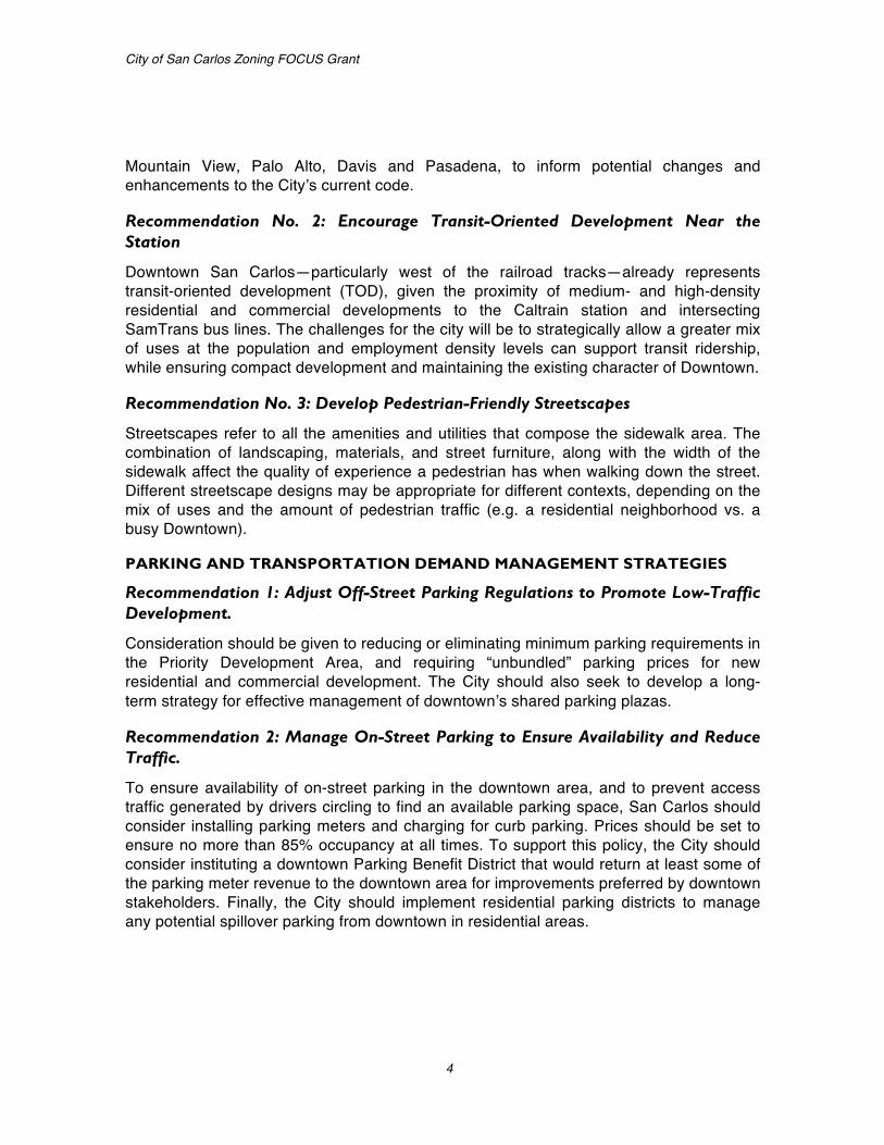
Recommendation 1: Adjust Off-Street Parking Regulations to Promote Low-Traffic Development.
Consideration should be given to reducing or eliminating minimum parking requirements in the Priority Development Area, and requiring “unbundled” parking prices for new residential and commercial development. The City should also seek to develop a long-term strategy for effective management of downtownʼs shared parking plazas.
Recommendation 2: Manage On-Street Parking to Ensure Availability and Reduce Traffic.
To ensure availability of on-street parking in the downtown area, and to prevent access traffic generated by drivers circling to find an available parking space, San Carlos should consider installing parking meters and charging for curb parking. Prices should be set to ensure no more than 85% occupancy at all times. To support this policy, the City should consider instituting a downtown Parking Benefit District that would return at least some of the parking meter revenue to the downtown area for improvements preferred by downtown stakeholders. Finally, the City should implement residential parking districts to manage any potential spillover parking from downtown in residential areas.
Final Priority Development Area Regulations
5
Recommendation 3: Implement Transportation Demand Management (TDM) Policies that Encourage Balanced Multimodal Access to the Priority Development Area.
The City should consider establishing a Transportation Management Association in San Carlos to promote the adoption of TDM strategies for new commercial and multifamily residential development. It should also require participation in the TMA, along with mandatory trip reduction targets for new development. Participation in the TMA would be voluntary for existing businesses.
AFFORDABLE HOUSING INCENTIVES PROGRAMS
Recommendation: Facilitate the Creation of Affordable Housing
This recommendation seeks to build on the Cityʼs recent accomplishments in adopting a certified Housing Element and amending its density bonus and inclusionary housing ordinance to be consistent with State and case law, respectively. Development standards, particularly parking and lot area per unit standards should be revisited to ensure that development can be built at maximum allowable densities. In addition, priority processing for affordable housing projects can speed up and facilitate the construction of affordable housing.
DRAFT REGULATIONS
In the second phase of the project, preliminary regulations were prepared in draft form for review by City staff, the Transportation and Circulation Commission (TCC), and the Technical Advisory Committee (TAC). The draft regulations built on the Cityʼs current zoning regulations, modifying them as necessary to implement the new General Plan and promote pedestrian- and transit-oriented development and affordable housing. The proposed standards were based on a review of existing development regulations and design guidelines, General Plan policies, Issues and Options Papers, and comments from Stakeholders, Planning Commissioners, City Council members, and Staff.
FINAL REGULATIONS
In this final phase of the project, the preliminary regulations are revised to address concerns raised by City staff, TCC, and TAC. These final regulations will be included in the Public Review Draft Zoning Ordinance and be considered for adoption as part of the comprehensive Zoning Ordinance Update.

City of San Carlos Zoning FOCUS Grant
6
Figure 1: Priority Development Area
101
82
ELM ST LA
UR
EL ST
HOLLY ST
OLD
CO
UN
TY
RD
CH
ESTN
UT
ST
STAT
E H
IGH
WAY
82
SKYW
AY R
D
IND
UST
RIA
L R
D
CED
AR
ST
HULL DR
WA
LNU
T ST
VINE ST
HALL ST
ARROYO AVE
IND
UST
RIA
L W
Y
SHO
REW
AY R
DU
S H
IGH
WAY
101
BRANSTEN RD
CHERRY ST
MORSE BLVD
OLIVE ST
MC CUE AVE
TAYLOR WY
SAN CARLOS AVE
TERMINAL WY
PROSPEC
T ST
FIR
ST
SYLVAN DR
BAY
PORT
AV
E
MAGNOLIA AVE
COMMERCIAL ST
WO
OD
LAN
D A
VE
FAIRFIELD
DR
MONTGOMERY ST
ROSE
WO
OD
AVE
GLE
NN
WY
OAK ST
SYC
AM
OR
E ST
BRAGATO RD
RIVERTON DR
SPRINGFIELD DR
INVERNESS DR
TANKLAGE RD
BAYTREE RD
BAYPORT CT
SPRING ST
MANZANITA AVE
F ST
HIL
LCR
EST
RD
BUSH ST
SHELFO
RD AVE
NORTHWOOD DR
ASTER RD
CHERRY LN
SCHOOL ST
GLEN
WO
OD
ST
WA
LTO
N S
T
ORANGE AVE
AC
AC
IA C
T
MONTGOMERY LN
VALLEY RD
UNNAMED CHERRY ST
US
HIG
HW
AY 1
01
CH
EST
NU
T S
T
WA
LNU
T ST
SAN CARLOS AVE
Mixed-UseMixed Use, Low DensityMixed Use, Medium DensityNeighborhood Retail/Mixed Use,
Priority Development Area
0 500 1,000250
Feet
Medium Density
San Carlos City Limits
General Plan Land Use
Non-Residential ParkPlanned Industrial
Priority Development Area
Final Priority Development Area Regulations
7
Pedestrian- and Transit-Oriented Development Regulations
INTRODUCTION
In the updated zoning ordinance, each base zoning district chapter will contain tables that state the essential development standards (e.g. lot area, height, setbacks) for the district and makes reference to other applicable standards that will be located within the chapter itself or in another part of the zoning regulations. Following each table are additional provisions that expand on summary provisions listed in the tables. In addition, a number of supplemental citywide standards—such as regulations for fences, projections into setbacks, screening, and trash enclosures—will be located in a separate chapter titled General Site Regulations.
PURPOSE STATEMENTS
Proposed purpose statements are based on relevant General Plan policies and designations on the Land Use Diagram and explain, in general language, the way the district is intended to be used and how it fits into the Cityʼs land use policy. These statements serve as a guide for administration of district regulations, and can provide a basis for the findings required for architectural review and action on discretionary permits. They can also serve as specific reference criteria for rezoning to implement General Plan policies.
FORM-BASED CODE – DEVELOPMENT STANDARDS
Form-based coding techniques are used for development standards. The standards of each district list dimensional requirements for lots, build-to lines, setbacks, frontage types, location of parking, minimum open space (“outdoor living area”) and building heights, as well as limits on floor area and density. Supplemental regulations include elements such as performance criteria that implement General Plan policy and ensure compatibility among uses in a given district. A number of the new standards are intended to respond to issues raised during the course of the zoning update including, but not limited to, types of housing that may be built in different zoning districts, the bulk and mass of new residential development and additions, transitions between different districts and uses, and transit-oriented development. Other changes are intended to ensure consistency between the updated zoning ordinance and the General Plan.
One of the objectives of the standards for the PDA is to help create a pedestrian-friendly and transit-oriented mixed-use activity center. The Mixed–Use Districts, along with a small portion of the Heavy Industrial District make up the PDA in San Carlos and are shown in Figure 2 on the following page.

City of San Carlos Zoning FOCUS Grant
8
Figure 2: Priority Development Area Proposed Zoning
101
82
NB
D
SA
DC D
DCDC
N
N
SA
D
SA
N
D
N
D D
DC
N
D D
IH
N
N
DC
N
DC
NB
N
NB
DC
DC
D D
DC
N
DC N
N
N
IH
N
IH
ELM ST LA
UREL ST
HOLLY ST
OLD
CO
UN
TY R
D
CH
ESTN
UT ST
STAT
E H
IGH
WAY
82
SKYW
AY R
D
IND
UST
RIA
L RD
CED
AR
ST
HULL DR
WA
LNU
T ST
VINE ST
HALL ST
ARROYO AVE
IND
UST
RIA
L W
Y
SHO
REW
AY R
DU
S H
IGH
WAY
101
BRANSTEN RD
CHERRY ST
MORSE BLVD
OLIVE ST
MC CUE AVE
TAYLOR WY
SAN CARLOS AVE
TERMINAL WY
PROSPEC
T ST
FIR
ST
SYLVAN DR
BAY
PORT
AVE
MAGNOLIA AVE
COMMERCIAL ST
WO
OD
LAN
D A
VE
FAIRFIELD
DR
MONTGOMERY ST
ROSE
WO
OD
AV
E
GLE
NN
WY
OAK ST
SYC
AM
OR
E ST
BRAGATO RD
RIVERTON DR
SPRINGFIELD DR
INVERNESS DR
TANKLAGE RD
BAYTREE RD
BAYPORT CT
SPRING ST
MANZANITA AVE
F ST
HIL
LCRE
ST R
D
BUSH ST
SHELFO
RD AVE
NORTHWOOD DR
ASTER RD
CHERRY LN
SCHOOL ST
GLEN
WO
OD
ST
WA
LTO
N S
T
ORANGE AVE
AC
AC
IA C
T
MONTGOMERY LN
VALLEY RD
UNNAMED CHERRY ST
US
HIG
HW
AY 1
01
CH
EST
NU
T ST
WA
LNU
T S
T
SAN CARLOS AVE
DowntownDowntown Core
North BoulevardNeighborhood Mixed UseStation AreaHeavy Industrial
Priority Development Area
0 500 1,000250
Feet
Medium Density
San Carlos City Limits
Proposed Zoning
Non-Residential ParkPlanned Industrial
Priority Development Area
Mixed-UseMixed Use, Low DensityMixed Use, Medium DensityNeighborhood Retail/Mixed Use,
NB
D
DC
N
SA
IH
Existing General Plan
Final Priority Development Area Regulations
9
Mixed-Use Districts
The Mixed-Use Districts are the heart of pedestrian- and transit-oriented development in San Carlos. Standards include requirements for buildings on key corridors to be built to the front and street property lines, with exceptions for widened sidewalks and active outdoor uses. These ʻbuild-toʼ lines work in conjunction with supplemental standards such as transparency provisions and other design elements intended to make the area more attractive to pedestrians by creating more interesting street frontages. Public improvement requirements for commercial development include sidewalks and street furniture, lights, and trees.
Where appropriate, design standards and policies from the Downtown Design Guidelines and Railroad Corridor Policies and Guidelines have been translated into objective standards. Standards have been included for upper story setbacks, transparency requirements, building design, articulation, materials, entrances and parking location. Specific standards have been included, as requested by City Council, for transition areas where new development is built adjacent to existing lower-scaled residential development.
Requirements for pedestrian walkways address connections within the site and to adjoining uses and pedestrian networks, including routes for the Safe Routes to Schools program and across the rail corridor. Standards have also been included to ensure rail station design addresses pedestrian connectivity.
Supplemental standards for residential uses within mixed-use developments are intended to encourage high quality, resident-sensitive design in new building construction in order to create mixed-use areas that facilitate easy pedestrian movement and to promote the establishment of a rich mixture of uses. The standards address building entry, require open space, and establish setback requirements for residential units.
Heavy Industrial District
A small portion of the PDA is within the Heavy Industrial District. Pedestrian- and transit-oriented development standards in this district focus on creating an environment conducive to walking from a place of residence or a transit stop to a place of employment. Standards focus on accessibility and require sidewalk improvements and limit parking access and location to areas least likely to impede pedestrian circulation.
City of San Carlos Zoning FOCUS Grant
10
REGULATIONS
Chapter 18.05 Mixed-Use Districts 18.05.010 Purpose
The specific purposes of the Mixed-Use Districts are to:
A. Provide for the orderly, well-planned, and balanced growth of mixed-use districts.
B. Encourage a mix of uses that promotes convenience, economic vitality, fiscal stability, and a pleasant quality of life.
C. Promote pedestrian- and transit-oriented, mixed-use commercial centers at appropriate locations.
D. Establish design standards that improve the visual quality of development and create a unified, distinctive, and attractive character along mixed-use streets.
E. Provide appropriate buffers and transition standards between commercial and residential uses to preserve both commercial and mixed-use feasibility and residential quality.
Additional purposes of each Mixed-Use District which follow implement General Plan classifications of “Mixed-Use, Low Density”, “Mixed-Use, Medium Density”, “Mixed-Use, Medium High Density”, and “Neighborhood Retail/Mixed-Use, Medium Density”.
MU-DC Mixed Use Downtown Core. This district is intended to maintain the pedestrian-oriented environment in the heart of San Carlosʼ Downtown, with a focus on ground-level active storefronts and pedestrian- and transit-oriented development that encourages pedestrian activity and supports multi-modal transportation. Physical form is regulated to reflect the urban character of the Downtown Core. Allowable uses include retail, commercial, and office uses, as well as residential development of up to 50 units per net acre.
MU-D Mixed Use Downtown. This district is intended to maintain the pedestrian-oriented environment around the Downtown Core and connect surrounding districts. Physical form is regulated to provide shopfront buildings that frame the street and support pedestrian- and transit-oriented development that encourages pedestrian activity and supports multi-modal transportation. Allowable uses include retail, commercial, and office uses, as well as residential development of up to 50 units per net acre.
MU-SA Mixed Use Station Area. This district is intended to provide for transit-oriented development to support vitality around transit centers and the historic San Carlos Train Depot and provide linkages to the Downtown Core and neighborhoods adjacent to Old

Final Priority Development Area Regulations
11
County Road. Allowable uses include retail, commercial, and office uses, as well as residential development of up to 50 units per net acre.
MU-NB Mixed Use North Boulevard. This district is intended to facilitate the transformation of the northern portion of El Camino Real into a multi-modal, mixed use corridor. The physical form varies to reflect the urban character of the El Camino Real corridor and to transition to surrounding, lower-density districts. This district allows a mix of residential development of up to 50 units per net acre and retail and commercial uses, as well as hotels and other commercial uses oriented toward a regional market.
MU-N Mixed Use Neighborhood. This district is intended to provide an appropriate transition from mixed-use areas into the residential neighborhoods. This district allows a mix of residential and commercial development appropriately scaled to ensure a residential physical form to relate to adjacent single-family residential neighborhoods. Allowable uses include retail, commercial, and office uses, as well as residential development of up to 20 units per net acre.
18.05.020 Development Standards
Tables 18.05.020-1 through 18.050.020-6 prescribe the development standards for Mixed-Use Districts. Additional regulations are denoted in a right hand column. Section numbers in this column refer to other sections of the Ordinance, while individual letters refer to subsections that directly follow the table. The numbers in each illustration below refer to corresponding regulations in the “#” column in the associated table.
TABLE 18.05.020-1: LOT, DENSITY, AND FAR STANDARDS—MIXED-USE DISTRICTS
District MU-DC MU-D MU-SA MU-NB MU-N Additional Regulations #
Maximum Density (units/net acre) 50 50 50 50 20
Minimum Lot Size (sq ft) 5,000 5,000 5,000 5,000 5,000
Minimum Lot Width (ft) 50 50 50 50 50
Maximum Floor Area Ratio (FAR) 2.5 2.5 2.5 2.5 2.0

City of San Carlos Zoning FOCUS Grant
12
TABLE 18.05.020-2: BUILDING PLACEMENT STANDARDS—MIXED-USE DISTRICTS
District MU-DC MU-D MU-SA MU-NB MU-N Additional Regulations #
Setbacks, Residential-only Development
Residential-only development in the MU Districts is subject to the setback requirements of the RM-59 District.
Setbacks, Commercial and Mixed-Use Development (ft)
Laurel Street Frontage Property line or 15 ft from curb (the greater)
n/a n/a
Property line or 15 ft from curb (the greater) (A)
①
El Camino Real Frontage
Property line or 20 ft from curb (whichever is greater)
5 min, 15 max 5 min, 15 max (A)
①
San Carlos Avenue Frontage
Property line or 15 ft from curb (whichever is greater) n/a 5 min, 15 max (A)
①
Elm Street Frontage 0 min, 10 max n/a n/a n/a n/a
①
All Other Street Frontages
0 min, 5 max
0 min, 5 max
0 min, 5 max
5 min, 15 max 5 min, 15 max
①
Interior Side 0 min; 10 min adjacent to RS District (B) ② Rear 0 min; 20 min adjacent to RS District (B) ③
Corner Build Area (ft) 30; Buildings must be located in accordance with the required setbacks within 30 feet of every corner. Public plazas may be at the street corner provided buildings are built to the edge of the public plaza.
④

Final Priority Development Area Regulations
13
A. Build-to Line. Buildings shall be constructed at the required setback for 80 percent of linear street frontage. The area between the building and property line shall be paved so that it functions as a wider public sidewalk. This requirement may be modified or waived by the Review Authority if:
1. Substantial landscaping is located between the build-to line and ground floor residential units to soften visual impact of buildings;
2. Entry courtyards, plazas, entries, or outdoor eating and display areas are located between the build-to line and building, provided that the buildings are built to the edge of the courtyard, plaza, or dining area; or
3. The building incorporates an alternative entrance design that creates a welcoming entry feature facing the street.
B. Required Side and Rear Yards for Residential Uses. In order to provide light and air for residential units, the following minimum setbacks apply to any building wall containing windows and facing an interior side or rear yard. When the site is adjacent to a Residential District, the project must comply with whichever standard results in the greater setback. The following setbacks shall be provided:
1. For any wall containing windows, a setback of at least 5 feet shall be provided.
2. For any wall containing bedroom windows, a setback of at least 10 feet shall be provided.
3. For any wall containing living room or other primary room windows, a setback of at least 15 feet shall be provided.
4. The required setbacks apply to that portion of the building wall containing and extending three feet on either side of any window.
City of San Carlos Zoning FOCUS Grant
14
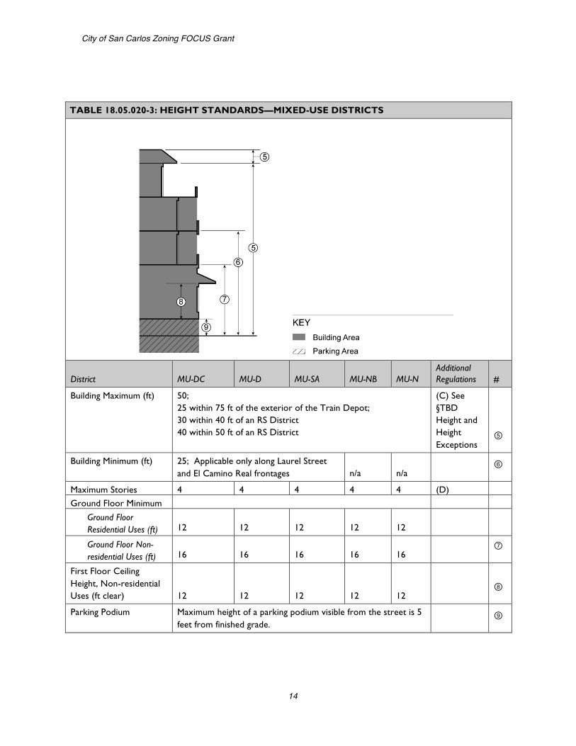
TABLE 18.05.020-3: HEIGHT STANDARDS—MIXED-USE DISTRICTS
District MU-DC MU-D MU-SA MU-NB MU-N Additional Regulations #
Building Maximum (ft) 50; 25 within 75 ft of the exterior of the Train Depot; 30 within 40 ft of an RS District 40 within 50 ft of an RS District
(C) See §TBD Height and Height Exceptions
⑤
Building Minimum (ft) 25; Applicable only along Laurel Street and El Camino Real frontages n/a n/a
⑥
Maximum Stories 4 4 4 4 4 (D) Ground Floor Minimum
Ground Floor Residential Uses (ft) 12 12 12 12 12 Ground Floor Non-residential Uses (ft) 16 16 16 16 16
⑦
First Floor Ceiling Height, Non-residential Uses (ft clear) 12 12 12 12 12
⑧
Parking Podium Maximum height of a parking podium visible from the street is 5 feet from finished grade.
⑨
Final Priority Development Area Regulations
15
C. Height Exceptions.
1. A parapet wall, cornice or sloping roof may project up to four feet above the height limit.
2. Towers. If the project site is greater than 15,000 square feet, a tower or other projecting architectural elements may extend up to 15 feet above the top of a pitched roof, provided that the square footage of the element(s) do not total more than 10 percent of the building footprint. The area above the uppermost permitted floor of the element(s) shall not be habitable space. a. The composition of the tower element shall be balanced, where
the width of the tower has a proportional relationship to the height of the tower.
b. The tower element shall be proportional to the rest of the building.
c. The roof shall include architectural detailing, such as a cornice or eave.
D. Upper Story Limitations.
1. Third Story – Laurel Street. The third story along the 600, 700, and 800 blocks of Laurel Street shall be setback a minimum of 10 feet from the story below.
2. Fourth Story. The fourth story of all buildings shall contain only residential uses and shall be stepped back a minimum of 10 feet from the story below, except as provided below. a. Laurel Street. The fourth story along the 600, 700, and 800
blocks of Laurel Street may align with the story below. b. San Carlos Avenue and El Camino Real. The fourth story front
facade may align with the story below along San Carlos Avenue in the MU-SC District and along El Camino Real.

City of San Carlos Zoning FOCUS Grant
16
E. Building Projections. The maximum width of any projection is ten feet and the total of all projections along a building face may not be more than 10 feet wide or 25 percent of the building frontage, whichever is greater.
TABLE 18.05.020-4: BUILDING FORM STANDARDS—MIXED-USE DISTRICTS
District MU-DC MU-D MU-SA MU-NB MU-N Additional Regulations #
Maximum Length of Blank Wall (ft)
10 for ground floor,
25 ft for upper floors
25 25 25 25
⑩
Building Projections (ft) 3; Minimum 12 feet above sidewalk grade. (E) ⑪ Awnings & Overhangs (ft)
8; Minimum 8 feet above sidewalk grade. ⑫

Final Priority Development Area Regulations
17
TABLE 18.05.020-5: PARKING AND LOADING STANDARDS—MIXED-USE DISTRICTS
District MU-DC MU-D MU-SA MU-NB MU-N Additional Regulations #
Setback from Street Property Line (ft)
40; Buildings shall be placed as close to the street as possible, with parking underground, behind a building, or on the interior side or rear of the site. (F) ⑬
Setback from Buildings and Public Plazas (ft)
5 ft walkway plus 3 ft landscaping; Applicable only to above ground lots. ⑭
Access Location Side street or alley wherever possible. ⑮ Curb Cuts Prohibited
on Laurel Minimized and in area least likely to impede pedestrian circulation
Loading/Service Area Side or rear of lot; must be screened from public ROW ⑯
F. Limitations on Location of Parking. Parking may be located within 40 feet of the street facing property line in accordance with the following standards.
1. Underground and Partially Submerged Parking. Parking completely or partially underground, may match the setbacks of the main structure. The maximum height of a parking podium visible from a street is five feet from finished grade.
2. Surface Parking. Above ground surface parking may be located within 40 feet of a street facing property line with the approval of a Conditional Use Permit when the Planning Commission makes the following findings:

City of San Carlos Zoning FOCUS Grant
18
a. Buildings are built close to the public sidewalk to the maximum extent feasible;
b. The parking area is screened along the public right-of-way with a wall, hedge, trellis, and/or landscaping; and
c. The site is small and constrained such that underground, partially submerged, or surface parking located more than 40 feet from the street frontage is not feasible.
G. Residential Open Space. Residential open space may be provided as common or private open space. Private areas typically consist of balconies, decks, patios, fenced yards, and other similar areas outside the residence. Common areas typically consist of landscaped areas, walks, patios, swimming pools, barbeque areas, playgrounds, turf, or other such improvements as are appropriate to enhance the outdoor environment of the development. Landscaped courtyard entries that are oriented towards the public street which create a welcoming entry feature are also considered common areas. All areas not improved with buildings, parking, vehicular accessways, trash enclosures, and similar items shall be developed as common areas with the types of attributes described above.
1. Minimum Dimensions. a. Private Open Space. Private open space located on the ground
level (e.g., yards, decks, patios) shall have no dimension less than 10 feet. Private open space located above ground level (e.g., balconies) shall have no dimension less than six feet.
b. Common Open Space. Minimum dimension of 30 feet.
TABLE 18.05.020-6: LANDSCAPING AND OPEN SPACE STANDARDS—MIXED-USE DISTRICTS
District MU-DC MU-D MU-SA MU-NB MU-N Additional Regulations #
Minimum Residential Open Space (sq ft per unit) 100 100 150 150 150 (G)
Minimum Public Open Space (% of site) 10; applicable only to lots greater than 15,000 square feet
Minimum Dimensions (ft) 20 20 20 20 20
Minimum Amount of Landscaping (% of site) 10 15 15 15 20
Final Priority Development Area Regulations
19
2. Usability. A surface shall be provided that allows convenient use for outdoor living and/or recreation. Such surface may be any practicable combination of lawn, garden, flagstone, wood planking, concrete, or other serviceable, dust-free surfacing. The maximum slope shall not exceed 10 percent.
3. Accessibility. a. Private Open Space. The space shall be accessible to only one
living unit by a doorway to a habitable room or hallway. b. Common Open Space. The space shall be accessible to the
living units on the lot. It shall be served by any stairway or other accessway qualifying as an egress facility from a habitable room.
18.05.030 Supplemental Regulations:
A. Maximum Block Length. 500 feet; block length of up to 600 feet is allowed when a mid-block pedestrian connection is provided.
B. Street Preservation. Existing public right-of-way shall be preserved. Public right-of-way shall not be eliminated or abandoned unless substantial public benefits are provided, such as a new park.
C. Street Frontage Improvements. New development shall provide street frontage improvements in accordance with the following:
1. Between the Property Line and Curb. a. Sidewalks. Sidewalks shall be provided if none already exist or if
the existing sidewalks are in poor condition. b. Street Furniture. Trash receptacles, benches, bike racks, and
other street furniture from a list maintained by the City shall be provided.
c. Street Lights. Pedestrian scaled street lights, including attachments from which banners may be hung, from a list maintained by the City shall be provided.
d. Street Trees. Shade trees shall be planted at least 30 feet on center. Tree guards shall be provided. Trees shall be a minimum of 15 gallon in size, and at least 10 percent of the required trees shall be 24 inch box size or larger.
2. Interior from Property Line. Except where occupied by a building or necessary for parking access, the street frontage, for a depth of 10 feet from the property line, shall be utilized for active outdoor uses, including, but not limited to outdoor dining; paved for public uses so that it functions

City of San Carlos Zoning FOCUS Grant
20
as part of a wider public sidewalk; or improved with landscaping, public art, and/or pedestrian amenities such as outdoor seating.
D. Building Orientation and Entrances.
1. Buildings shall be oriented to face public streets. 2. Building frontages shall be generally parallel to streets, and the primary
building entrances shall be located on a public street. 3. Building entrances shall be emphasized with special architectural and
landscape treatments. 4. Entrances located at corners shall generally be located at a 45 degree
angle to the corner and shall have a distinct architectural treatment to animate the intersection and facilitate pedestrian flow around the corner. Different treatments may include angled or rounded corners, arches, and other architectural elements. All building and dwelling units located in the interior of a site shall have entrances from the sidewalk that are designed as an extension of the public sidewalk and connect to a public sidewalk.
5. Entrances to residential units shall be physically separated from the entrance to the permitted commercial uses and clearly marked with a physical feature incorporated into the building or an appropriately scaled element applied to the facade.
E. Building Transparency; Required Openings for Non-Residential Uses. Exterior walls facing and within 20 feet of a front or street side property line shall include windows, doors, or other openings for at least 60 percent of the building wall area located between 2.5 and seven feet above the level of the sidewalk. No wall may run in a continuous plane for more than 25 feet without an opening.
1. Design of Required Openings. Openings fulfilling this requirement shall have transparent glazing and provide views into work areas, display areas, sales areas, lobbies, or similar active spaces, or into window displays that are at least three feet deep.
2. Exceptions for Parking Garages. Multi-level garages are not required to meet the building transparency requirement of this subsection. Instead, they must be screened and treated, consistent with the requirements of Chapter TBD.
3. Alternatives through Design Review. Alternatives to the building transparency requirement may be approved if the Planning Commission finds that: a. The proposed use has unique operational characteristics with
which providing the required windows and openings is incompatible, such as in the case of a cinema or theater; and

Final Priority Development Area Regulations
21
b. Street-facing building walls will exhibit architectural relief and detail, and will be enhanced with landscaping in such a way as to create visual interest at the pedestrian level.
F. Building Design and Articulation. Buildings shall provide adequate architectural articulation and detail to avoid a bulky and “box-like” appearance. Building design shall reflect and complement the architectural style of significant buildings within the community (such as the Train Depot, Drake Building, and Pacific Hacienda project). This may be accomplished through the incorporation of architectural style, colors, and materials of significant buildings within the community. The following standards apply to commercial and mixed-use development in the MU Districts. Residential-only development is subject to the building design standards for the RM Districts in subsection 18.04.060(B), Building Design.
1. Massing. Building massing shall align with the street grid of adjacent blocks.
2. Relation to Existing Buildings. Buildings shall be designed to appear integrated with existing buildings in the district.
3. Wide Buildings. Any building over 50 feet wide shall be broken down to read as a series of buildings no wider than 50 feet each or 30 feet in the MU-DC District or within 100 feet of the Train Depot.
4. Vertical Relationship. Buildings shall be designed to have a distinctive base (ground floor level), middle (intermediate upper floor levels), and top (either top floor or roof level). Cornices, balconies, roof terraces, and other architectural elements should be used, as appropriate, to terminate rooflines and accentuate setbacks between stories.
5. Windows. a. Trim at least two inches in depth must be provided around all
windows, or window must be recessed at least two inches from the plane of the surrounding exterior wall.
b. Snap-in vinyl mullions between double pane glass is prohibited. If a divided light appearance is desired, mullions must be made of dimensional material projecting in front of the panes on both the inside and outside of the window.
c. Exceptions may be granted through the design review process to accommodate alternative window design complimentary to the architectural style of the structure.
6. Exterior Building Materials and Colors. a. A unified palette of materials shall be used on all sides of
buildings.

City of San Carlos Zoning FOCUS Grant
22
b. Exterior building materials shall be stone, brick, stucco, concrete block, painted wood clap-board, painted metal clapboard or other quality, durable materials approved by the City as part of the project review.
c. A wainscoting of quality materials on the bottom 18 to 36 inches of the ground floor façade is required.
d. Colors shall be used to help delineate windows and other architectural features to increase architectural interest.
7. Building Details. Buildings shall provide adequate architectural articulation and detail to avoid a bulky and “box-like” appearance. a. Building facades shall include building projections or recesses,
doorway and window trim, and other details that provide architectural articulation and design interest.
b. All applied surface ornamentation or decorative detailing shall be consistent with the architectural style of the building.
c. All balconies that do not meet the minimum size required for private open space, such as Juliet balconies, shall have a minimum dimension of two feet.
d. Each side of the building that is visible from a public right-of-way shall be designed with a complementary level of detailing.
G. Pedestrian Access. On-site pedestrian circulation and access must be provided according to the following standards.
1. Internal Connections. A system of pedestrian walkways shall connect all buildings on a site to each other, to on-site automobile and bicycle parking areas, and to any on-site open space areas or pedestrian amenities.
2. To Circulation Network. Regular connections between on-site walkways and the public sidewalk and other planned or existing pedestrian routes, such as Safe Routes to School, shall be provided. An on-site walkway shall connect the primary building entry or entries to a public sidewalk on each street frontage.
3. To Neighbors. Direct and convenient access shall be provided from commercial and mixed-use projects to adjoining residential and commercial areas to the maximum extent feasible while still providing for safety and security.
4. To Transit. Safe and convenient pedestrian connections shall be provided from transit stops to building entrances.

Final Priority Development Area Regulations
23
5. Across Rail Corridor. Safe and convenient pedestrian connections shall be provided across the rail corridor. If an aerial viaduct is used for rail alignment, the following standards shall apply. a. Extend the street grid below the aerial viaduct to provide new
street and pedestrian connections across the corridor. b. Locate active commercial or uses or public park and recreation
space below the aerial viaduct to enhance connectivity and create safe, attractive connections across the corridor.
c. Enhance connections below the viaduct with lighting and public art.
6. Interior Pedestrian Walkway Design. a. Walkways shall have a minimum of clear unobstructed width of
six feet, shall be hard-surfaced, and paved with concrete, stone, tile, brick, or comparable material.
b. Where a required walkway crosses driveways, parking areas, or loading areas, it must be clearly identifiable through the use of a raised crosswalk, a different paving material, or similar method.
c. Where a required walkway is parallel and adjacent to an auto travel lane, it must be raised or separated from the auto travel lane by a raised curb at least four inches high, bollards, or other physical barrier.
H. Residential Notification. Residents of mixed-use development shall be informed of potential noise from refuse collection and other activities typically associated with commercial activity.
I. Rail Station.
1. Rail stations shall be designed to have physical presence and visibility on both sides of the rail corridor, including key architectural features that are visible from major roadways and connections, as well as pedestrian-level entries and vehicle drop-off areas.
2. East-west pedestrian connections shall be provided at the ground level of the station to enhance pedestrian connectivity along the corridor. These connections should be extensions of the existing street grid and pedestrian network with a minimum clear width of eight feet.
City of San Carlos Zoning FOCUS Grant
24
Chapter 18.06 Industrial Districts 18.06.010 Supplemental Regulations
A. Landscaping. A minimum of 10 percent of the site must be landscaping.
B. Building Design Near Highway 101. For any site that is fully or partially located within 200 feet of the right-of-way line of Highway 101, buildings shall be designed with four-sided architecture where each exterior wall is designed equivalent to the primary façade in the extent of building articulation and quality of exterior materials, and consistent with the color scheme of the primary façade.
C. Sidewalks. Sidewalks shall be provided if none already exist or if the existing sidewalks are in poor condition.
D. Parking Location. Parking shall be located at the side or rear of buildings wherever possible.
1. Customer parking should be located near the office area. 2. Where parking is located between a building and a street, a landscaped
setback at least 10 feet wide must be provided between the parking area and adjacent right-of-way.
E. Limitations on Curb Cuts. Wherever possible, parking and loading entrances shall share curb cuts in order to minimize the overall number of curb cuts. On corner lots, curb cuts shall be located on the street frontage with the least pedestrian activity wherever feasible.
F. Access Location. Access shall be provided from a side street or alley wherever possible.

Final Priority Development Area Regulations
25
Parking and Transportation Demand Management Strategies
INTRODUCTION
PARKING
The parking regulations apply to new buildings and uses, projects creating additional dwelling units, change or expansion in use, or expansion of floor area, consistent with the existing triggers for the provision of required parking. However, the specific number of parking spaces required is tailored to reflect the unique characteristics of Mixed-Use Districts which make up the majority of the PDA.
Several regulations are proposed to allow flexibility in meeting parking requirements. These include parking exceptions, parking reductions, and the ability of the City to establish an in-lieu fee so applicants could pay a fee in-lieu of providing parking. Parking exceptions have been included for certain commercial uses that are less than 1,500 square feet in size. Parking reductions are available for projects that are subject to transportation demand management (TDM) requirements; locations near transit, provision of motorcycle parking, and shared parking. The parking reduction provisions for restaurants have been retained. These standards provide flexibility for commercial development in specific areas while still accommodating parking demand. New regulations for “un-bundling” of residential parking spaces are also proposed.
TRANSPORTATION DEMAND MANAGEMENT
The transportation demand management standards require new multi-unit and non-residential development, additions that expand existing floor area by 10 percent or more, and new uses or changes of use which result in an average daily trip increase more than five percent to incorporate measures to meet vehicle trip generation rates that are 20 percent lower than the standard rates as estimated by the ITE trip generation manual.
A menu of trip reduction measures is offered, similar to the list of acceptable TDM programs provided by the City/County Association of Governments of San Mateo County (C/CAG). C/CAG provides, and annually updates, the equivalent number of trips that are reduced per measure.
City of San Carlos Zoning FOCUS Grant
26
REGULATIONS
Chapter 18.18 Parking 18.18.010 Purpose
The specific purposes of the on-site parking and loading regulations are to:
A. Ensure that adequate off-street parking and loading facilities are provided for new land uses and major alterations to existing uses, to avoid the negative impacts associated with spillover parking into adjacent neighborhoods;
B. Minimize the negative environmental and urban design impacts that can result from parking lots, driveways, and drive aisles within parking lots;
C. Insure that adequate off-street bicycle parking facilities are provided and promote parking lot designs that offer safe and attractive pedestrian routes;
D. Establish standards and regulations for safe and well-designed parking, unloading, and vehicle circulation areas that minimize conflicts between pedestrian and vehicles within parking lots and, where appropriate, create buffers from surrounding land uses;
E. Offer flexible means of minimizing the amount of area devoted to vehicle parking by allowing reductions in the number of required spaces in transit-served locations, shared parking facilities, and other situations expected to have lower vehicle parking demand; and
F. Reduce urban run-off and heat island effect.
18.18.020 Applicability
The requirements of this chapter apply to the establishment, alteration, expansion, or change in any use or structure, as provided in this section.
A. New Buildings and Land Uses. On-site parking shall be provided according to the provisions of this chapter at the time any main building or structure is erected or any new land use is established.
B. Reconstruction, Expansion and Change in Use of Existing Non-Residential Buildings. When a change in use, expansion of a use, or expansion of floor area creates an increase of 10 percent or more in the number of required on-site parking or loading spaces, on-site parking and loading shall be provided according to the provisions of this chapter. The existing parking shall be maintained, and additional parking shall be required only for such addition, enlargement, or change in use and not for the entire building or site. If the number of existing parking
Final Priority Development Area Regulations
27
spaces is greater than the requirements for such use, the number of spaces in excess of the prescribed minimum may be counted toward meeting the parking requirements for the addition, enlargement, or change in use. A change in occupancy is not considered a change in use unless the new occupant is in a different use classification than the former occupant. Additional parking spaces are not required for the reconstruction of an existing building when there is no increase in floor area.
C. Alterations that Increase the Number of Dwelling Units. The creation of additional dwelling units through the alteration of an existing building or construction of an additional structure or structures requires the provision of on-site parking to serve the new dwelling units. This requirement does not apply when sufficient on-site parking exists to provide the number of spaces required for the existing and new dwelling units.
D. When Constructed. On-site parking facilities required by this chapter shall be constructed or installed prior to the issuance of a Certificate of Occupancy for the uses that they serve.
18.18.030 General Provisions
A. Existing Parking and Loading to be Maintained. No existing parking and/or loading serving any use may be reduced in amount or changed in design, location or maintenance below the requirements for such use, unless equivalent substitute facilities are provided.
B. Nonconforming Parking or Loading.
1. An existing use of land or structure shall not be deemed to be nonconforming solely because of a lack of on-site parking and/or loading facilities required by this chapter, provided that facilities used for on-site parking and/or loading as of the date of adoption of this Ordinance are not reduced in number to less than what this chapter requires.
2. If an existing garage or carport legally constructed with a building permit is less than 16 feet wide, it is considered physically unsuitable for two cars.
C. Accessibility. Parking must be accessible for its intended purpose during all business hours.
D. Stacked Parking. Stacked or valet parking is allowed if an attendant is present or an automated system is in place to move vehicles. If stacked parking managed by an attendant is used for required parking spaces, some form of guarantee must be filed with the City ensuring that an attendant will always be present when the lot is in operation.
City of San Carlos Zoning FOCUS Grant
28
E. Unbundling Parking from Residential Uses. The following rules shall apply to the sale or rental of parking spaces accessory to new multifamily residential uses of 10 units or more unless waived by the Director as infeasible:
1. All off-street spaces shall be leased or sold separately from the rental or purchase fees for dwelling units for the life of the dwelling units, such that potential renters or buyers have the option of renting or buying a residential unit at a price lower than would be the case if there were a single price for both the residential unit and the parking space.
2. In cases where there are fewer parking spaces than dwelling units, the parking spaces shall be offered first to the potential owners or renters of three-bedroom or more units, second to owners or renters of two bedroom units, and then to owners and renters of other units. Spaces shall be offered to tenants first. Non-tenants may lease with a provision for 30 days to terminate the lease.
3. Renters or buyers of on-site inclusionary affordable units shall have an equal opportunity to rent or buy a parking space on the same terms and conditions as offered to renters or buyers of other dwelling units.
18.18.040 Required Parking Spaces
A. Minimum Number of Spaces Required. The required numbers of on-site parking spaces are stated in Table 18.18.040-A, Required On-Site Parking Spaces, Mixed-Use Districts. The parking requirement for any non-residential use not listed in Table 18.18.040-A shall be the same as required for the land use in other districts.
TABLE 18.18.040-A: REQUIRED ON-SITE PARKING SPACES, MIXED-USE DISTRICTS
Land Use Required Parking Spaces
Residential
Studio and one-bedroom units
1 space per unit One covered space shall be designated for each unit.
One additional guest parking space must be provided for every 4 units for projects greater than 10 units.
Two or more bedrooms
1.5 spaces per unit
NonResidential
Office 1 space per 450 square feet
Retail 1 space per 400 square feet
Restaurant 1 space per 250 square feet

Final Priority Development Area Regulations
29
B. Sites with Multiple Uses. If more than one use is located on a site, the number of required on-site parking spaces and loading spaces shall be equal to the sum of the requirements calculated separately for each use unless a reduction is approved pursuant to Section 18.18.050, Parking Reductions.
C. Exceptions. The following commercial uses are not required to provide on-site parking when they contain less than 1,500 square feet of floor area: Retail Sales, Personal Services, Eating and Drinking Establishments, Food and Beverage Retail Sales, Offices–Walk-in Clientele, and Banks and Financial Institutions. However, when more than four such establishments are located on a single lot, their floor areas shall be aggregated with all other establishments located on the lot in order to determine required parking.
18.18.050 Parking Reductions.
The number of on-site parking spaces required by Section 18.18.040, Required Parking Spaces, may be reduced as follows.
A. Transportation Demand Management Programs. The number of required parking spaces for any project subject to Chapter 18.23, Transportation Demand Management, shall be reduced by 20 percent of the normally required number of spaces.
B. Motorcycle Parking. Motorcycle parking may substitute for up to five percent of required automobile parking. Each motorcycle space must be at least four feet wide and seven feet deep.
C. Shared Parking. Where a shared parking facility serving more than one use will be provided, the total number of required parking spaces may be reduced up to 40 percent with Planning Commission approval of a Conditional Use Permit approval, if the Commission finds that:
1. The peak hours of use will not overlap or coincide to the degree that peak demand for parking spaces from all uses will be greater than the total supply of spaces;
2. The adequacy of proposed shared parking provided will equal or exceed the level that can be expected if parking for each use were provided separately;
3. A parking demand study prepared by an independent traffic engineering professional approved by the City supports the proposed reduction; and
4. In the case of a shared parking facility that serves more than one property, a parking agreement has been prepared consistent with the provisions of Off-Site Parking Facilities.
City of San Carlos Zoning FOCUS Grant
30
D. Restaurant Parking. The total number of required parking spaces for restaurants with more than 2,500 square feet of floor area located within the area bounded by the south side of Holly Street, the west side of El Camino Real, the south side of Brittan Avenue and the east side of Walnut Street, as shown on Figure TBD, may be reduced with Planning Commission approval of a Conditional Use Permit, subject to the following criteria:
1. The restaurant is open for operation during the evenings until at least 9:00 p.m., a minimum of five days per week including one weekend evening; and
2. Employees are required to park in permit parking areas of public parking plazas, when such permits are available.
E. Other Parking Reductions. Required parking for any use may be reduced through Planning Commission approval of a Conditional Use Permit.
1. Criteria for Approval. The Commission may only approve a Conditional Use Permit for reduced parking if it finds that: a. Special conditions—including but not limited to the nature of the
proposed operation; proximity to frequent transit service; transportation characteristics of persons residing, working, or visiting the site; or because the applicant has undertaken a transportation demand management program—exist that will reduce parking demand at the site;
b. The use will adequately be served by the proposed on-site parking; and
c. Parking demand generated by the project will not exceed the capacity of or have a detrimental impact on the supply of on-street parking in the surrounding area.
2. Parking Demand Study. In order to evaluate a proposed projectʼs compliance with the above criteria, the Director may require submittal of a parking demand study that substantiates the basis for granting a reduced number of spaces.
18.18.060 Parking In-Lieu Fee
If a parking assessment district has been established, a fee may be paid to the City in lieu of providing required parking within the district.
A. In-lieu Fee Amount. The amount of the in-lieu fee shall be calculated and paid as set forth in a resolution of the City Council.
B. Use of Funds. In-lieu fees shall be used for programs to reduce parking impacts including, but not limited to, the costs of any of the following:

Final Priority Development Area Regulations
31
1. Off-street parking facilities, including acquisition, development, and maintenance of parking facilities located in the parking assessment district;
2. Mass transit equipment, including stock and attendant facilities serving the area in which the buildings for which the payments are made are located;
3. Transit or paratransit passes, coupons, and tickets to be made available at a discount to employees and customers and to promote and support incentives for employee ride-sharing and transit use; or
4. Transportation system management projects.
City of San Carlos Zoning FOCUS Grant
32
Chapter 18.23 Transportation Demand Management 18.23.010 Purpose
The specific purposes of this chapter are to:
A. Reduce the amount of traffic generated by new development and the expansion of existing development.
B. Promote the more efficient utilization of existing transportation facilities and ensure that new developments are designed in ways to maximize the potential for alternative transportation usage.
C. Establish an ongoing monitoring and enforcement program to ensure that the Cityʼs desired alternative mode use percentages are achieved.
18.23.020 Applicability
The requirements of this chapter apply to:
A. New multi-unit and nonresidential development;
B. Additions to non-residential development that expand existing gross floor area by 10 percent or more; and
C. Establishment of a new use, change of use, or change in operational characteristics that results in an average daily trip increase of more than five percent of the current use based on the Institute of Traffic Engineers (ITE) trip generation rates.
18.23.030 Performance Requirements
All projects subject to the requirements of this chapter shall incorporate measures to meet vehicle trip generation rates that are 20 percent lower than the standard rates as estimated by the Institute of Transportation Engineers (ITE) trip generation manual.
18.23.040 Trip Reduction Measures
All projects subject to the requirements of this chapter shall implement any combination of the following measures to achieve the required minimum vehicle trip generation reduction. Guidelines listing the number of trips that are reduced per trip reduction measure are available from the City/County Association of Governments of San Mateo County (C/CAG).
A. Passenger Loading Zones. Passenger loading zones for carpool and vanpool drop-off located near the main building entrance.

Final Priority Development Area Regulations
33
B. Direct Route to Transit. A well-lighted path or sidewalk utilizing the most direct route to the nearest transit or shuttle stop from the building.
C. Pedestrian Connections. Safe, convenient pedestrian connections provided from the project to surrounding public streets and, if applicable, trails. Lighting, landscaping and building orientation should be designed to enhance pedestrian safety.
D. Bicycle Connections. If a site is abutting a bicycle path, lane or route, provision of a bicycle connection close to an entrance to the building on the site.
E. Land Dedication for Transit/Bus Shelter. Where appropriate, land dedicated for transit or a bus shelter provided based on the proximity to a transit route.
F. Long-Term Bicycle Parking. Covered and secure long-term bicycle parking located within 75 feet of a main entrance. Long-term bicycle parking must be in at least one of the following facilities:
1. An enclosed bicycle locker; 2. A fenced, covered, locked or guarded bicycle storage area; or 3. A rack or stand inside a building that is within view of an attendant or
security guard or visible from employee work areas. G. Short-Term Bicycle Parking. Secure short-term bicycle parking located within 50
feet of a main entrance to the building.
H. Free Preferential Carpool and Vanpool Parking. Ten percent of vehicle spaces reserved for carpools or vanpools, with a minimum of one space required. The preferential parking spaces shall be provided free of charge.
I. Showers/Clothes Lockers. Shower and clothes locker facilities free of charge.
J. Transportation Management Association (TMA). Participation in or requirement for tenant to participate in a local TMA, the Peninsula Congestion Relief Alliance (Alliance) or a similar organization approved by the Director, that provides ongoing support for alternative commute programs.
K. Paid Parking at Prevalent Market Rates. Parking provided at a cost equal to the prevalent market rate, as determined by the City based on a survey of parking in San Mateo County.
L. Alternative Commute Subsides/Parking Cash Out. Provide employees with a subsidy, determined by the applicant and subject to review by the Director, if they use transit or commute by other alternative modes.
City of San Carlos Zoning FOCUS Grant
34
M. Carpool and Vanpool Ride-matching Services. Matching of potential carpoolers and vanpoolers by administering a carpool/vanpool matching program.
N. Guaranteed Ride Home. Guaranteed rides home in emergency situations for carpool, vanpool and transit riders. Rides shall be provided either by a transportation service provider (taxi or rental car) or an informal policy using company vehicles/and or designated employees.
O. Shuttle Program. Provision of a shuttle program or participation in an existing shuttle program approved by the Director and subject to any fees for the existing program.
P. Information Boards/Kiosks. Display of the following information in a prominent location, maintained by a designated TDM contact: transit routes and schedules; carpooling and vanpooling information; bicycle lanes, routes and paths and facility information; and alternative commute subsidy information.
Q. Promotional Programs. Promotion and organization of events for the following programs: new tenant and employee orientation packets on transportation alternatives; flyers, posters, brochures, and emails on commute alternatives; transportation fairs; Spare the Air (June - October); Rideshare Week (October); trip planning assistance-routes and maps.
R. Compressed Work Week. Allow employees or require tenants to allow employees to adjust their work schedule in order to complete the basic work requirement of five eight-hour workdays by adjusting their schedule to reduce vehicle trips to the worksite.
S. Flextime. Provide or require tenants to provide employees with staggered work hours involving a shift in the set work hours of all employees at the workplace or flexible work hours involving individually determined work hours.
T. On-site Amenities. One or more of the following amenities provided on-site: ATM, day care, cafeteria, limited food service establishment, dry cleaners, exercise facilities, convenience retail, post office, on-site transit pass sales.
U. Telecommuting. Provide or require tenants to provide opportunities and the ability for employees to work off-site.
V. Other Measures. Additional measures not listed in this chapter, such as childcare facilities or an in-lieu fee that would be negotiated in a development agreement with the City.
Final Priority Development Area Regulations
35
18.23.050 Submittal Requirements
All projects subject to the requirements of this chapter shall submit a transportation demand management plan in conjunction with the development application. These plans must demonstrate that, upon implementation, they will achieve the required alternative mode use and shall include the following.
A. Checklist. A completed checklist of the trip reduction measures chosen by the applicant pursuant to Section 18.23.040, Trip Reduction Measures.
B. Implementation Plan. A description of how the applicable minimum alternative mode use will be achieved and maintained over the life of the project, including, but not limited to, the transportation demand management goals targeted for the various measures.
C. Designated TDM Contact. Designation of an employee or resident as the official contact for the transportation demand management program. The City shall be provided with a current name and phone number of the designated TDM contact who administers carpool and vanpool ride-matching services and promotional programs, updates information on the information boards/kiosks, and is the official contact for the administration of the annual survey and triennial report.
D. Site Plan. A site plan that designates transportation demand management design elements including:
1. External: preferential parking areas, paid parking areas, bicycle connections, bicycle parking, location of onsite amenities, passenger loading areas, land dedicated for transit facilities and bus shelters, direct route to transit, and pedestrian connections.
2. Internal: showers/lockers, information boards/kiosks, ATM, dry cleaners, day care, convenience retail, post office, cafeteria, limited food service establishment, exercise facilities, onsite transit pass sales.
18.23.060 Required Findings
Prior to approval of a permit for a project subject to the requirements of this chapter, the Review Authority shall make the following findings:
A. The proposed trip reduction measures are feasible and appropriate for the project, considering the proposed use or mix of uses and the projectʼs location, size, and hours of operation; and
B. The proposed performance guarantees will ensure that the target alternative mode use established for the project by this chapter will be achieved and maintained.
City of San Carlos Zoning FOCUS Grant
36
18.23.070 Modifications and Changed Plans
A. Minor Modifications. The Director may approve minor modifications to an approved transportation demand management plan that are consistent with the original findings and conditions approved by the Review Authority and would result in the target minimum alternative mode use.
B. Changed Plans. A change in an approved project that would result in the addition of 10 percent of the building area or a 10 percent increase in the number of average daily trips shall be treated as a new application.
18.23.080 Monitoring
A report, documenting the TDM activities undertaken and their results, shall be submitted to the Director annually. A five-year review shall evaluate the overall effectiveness of all of the TDM activities and may suggest new or modified activities or substitute activities to meet the programʼs objectives, per the Directorʼs review and approval. The Director may impose reasonable changes to assure the programʼs objectives will be met.
Final Priority Development Area Regulations
37
Affordable Housing Incentives Programs
INTRODUCTION
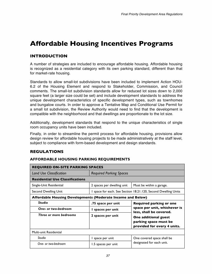
A number of strategies are included to encourage affordable housing. Affordable housing is recognized as a residential category with its own parking standard, different than that for market-rate housing.
Standards to allow small-lot subdivisions have been included to implement Action HOU-6.2 of the Housing Element and respond to Stakeholder, Commission, and Council comments. The small-lot subdivision standards allow for reduced lot sizes down to 2,000 square feet (a larger size could be set) and include development standards to address the unique development characteristics of specific development types, such as townhomes and bungalow courts. In order to approve a Tentative Map and Conditional Use Permit for a small lot subdivision, the Review Authority would need to find that the development is compatible with the neighborhood and that dwellings are proportionate to the lot size.
Additionally, development standards that respond to the unique characteristics of single room occupancy units have been included. Finally, in order to streamline the permit process for affordable housing, provisions allow design review for affordable housing projects to be made administratively at the staff level, subject to compliance with form-based development and design standards.
REGULATIONS
AFFORDABLE HOUSING PARKING REQUIREMENTS
REQUIRED ON-SITE PARKING SPACES
Land Use Classification Required Parking Spaces
Residential Use Classifications
Single-Unit Residential 2 spaces per dwelling unit Must be within a garage.
Second Dwelling Unit 1 space for each. See Section 18.21.120, Second Dwelling Units
Affordable Housing Developments (Moderate Income and Below)
Studio .75 space per unit Required parking or one space per unit, whichever is less, shall be covered.
One additional guest parking space must be provided for every 4 units.
One- or two-bedroom 1 spaces per unit
Three or more bedrooms 2 spaces per unit
Multi-unit Residential
Studio 1 space per unit One covered space shall be designated for each unit. One- or two-bedroom 1.5 spaces per unit

City of San Carlos Zoning FOCUS Grant
38
REQUIRED ON-SITE PARKING SPACES
Land Use Classification Required Parking Spaces
Three or more bedrooms 2 spaces per unit One additional guest parking space must be provided for every 2 units.
SMALL-LOT DEVELOPMENT
A. Small Lot Subdivisions
1. Purpose. The purpose of this section is to provide opportunities to increase the supply of smaller dwelling units and rental housing units by allowing the creation of subdivisions with smaller lots and dwellings. It also is intended to establish design and development standards for these projects to ensure that they are compatible with the surrounding neighborhood, where the General Plan anticipates no change to existing neighborhood character.
2. Location. A small lot subdivision may be proposed and approved on any site within the RS District where such development would be compatible with adjacent uses and the character of the area. A small lot subdivision shall not be allowed where the Review Authority determines that public utilities and services are inadequate or the landform is inappropriate for such development because of grading or impacts on views from adjacent lots.
3. Development Types. Small lot subdivisions may be proposed and approved for small lot single unit, bungalow court, and townhouse development developed according to Section B, Residential Development Types.
4. Lot Standards. The lot standards listed in Table 1, Small Lot Subdivision Lot Standards, apply to small lot subdivisions.
TABLE 1: SMALL LOT SUBDVISION LOT STANDARDS
Standard Small Lot Bungalow Court Townhouse
Minimum Lot Size (sq ft) 2,000 2,000 n/a
Minimum Lot Width (ft) 30 30 20
5. Permit Requirement. A proposed small lot subdivision shall require the approval of a Conditional Use Permit in compliance with Chapter TBD, Use Permits, and a Tentative Map in compliance with the Subdivision Ordinance.
6. Required Findings. In addition to standard Use Permit findings, the Review Authority must find that the development is compatible with the neighborhood and that dwellings are proportionate to the lot size.

Final Priority Development Area Regulations
39
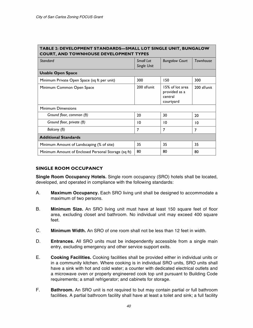
B. Small Lot Single Unit, Bungalow Court, and Townhouse Development. Small Lot Single Unit, Bungalow Court, and Townhouse development are subject to the development standards and supplemental regulations of the base district unless modified by Table 2, below.
TABLE 2: DEVELOPMENT STANDARDS—SMALL LOT SINGLE UNIT, BUNGALOW COURT, AND TOWNHOUSE DEVELOPMENT TYPES
Standard Small Lot Single Unit
Bungalow Court Townhouse
Site Standards
Minimum Project Site Width (ft) 80 100 80
Maximum Project Site Floor Area Ratio (FAR) .45 .45 1.0
Maximum Project Site Lot Coverage (% of site) 35 35 35
Building Height and Form Maximum Number of Stories 3 2 3
Maximum Building Length (ft) n/a n/a 150
Setbacks Project Site The overall project site is subject to the
setback requirements of the base district.
Individual Lot (ft)
Front 10; 7 for porch
Side 1-story portion: 4; 2-story portion: 8 For Townhouses, required setbacks apply to the ends of rows of attached units
Rear 15; 0 for detached garage on alley
Building Separation of Detached Units (ft) 5 5 3
Parking and Access
Minimum Garage Setback from Primary Façade (ft) 5 5 5
Maximum Garage Width (ft) 25; common garages not visible from the street may accommodate up to four cars.
Access Location Alley or side street wherever possible.
Building Orientation Orientation Facades shall be designed to orient towards
the public street and a common courtyard, if provided.
Entrance Location The main entrance to each ground floor dwelling shall be visible to and located directly off a common courtyard or directly from the street.
City of San Carlos Zoning FOCUS Grant
40
TABLE 2: DEVELOPMENT STANDARDS—SMALL LOT SINGLE UNIT, BUNGALOW COURT, AND TOWNHOUSE DEVELOPMENT TYPES
Standard Small Lot Single Unit
Bungalow Court Townhouse
Usable Open Space
Minimum Private Open Space (sq ft per unit) 300 150 300
Minimum Common Open Space 200 sf/unit 15% of lot area provided as a central courtyard
200 sf/unit
Minimum Dimensions
Ground floor, common (ft) 20 30 20
Ground floor, private (ft) 10 10 10
Balcony (ft) 7 7 7
Additional Standards Minimum Amount of Landscaping (% of site) 35 35 35
Minimum Amount of Enclosed Personal Storage (sq ft) 80 80 80
SINGLE ROOM OCCUPANCY
Single Room Occupancy Hotels. Single room occupancy (SRO) hotels shall be located, developed, and operated in compliance with the following standards:
A. Maximum Occupancy. Each SRO living unit shall be designed to accommodate a maximum of two persons.
B. Minimum Size. An SRO living unit must have at least 150 square feet of floor area, excluding closet and bathroom. No individual unit may exceed 400 square feet.
C. Minimum Width. An SRO of one room shall not be less than 12 feet in width.
D. Entrances. All SRO units must be independently accessible from a single main entry, excluding emergency and other service support exits.
E. Cooking Facilities. Cooking facilities shall be provided either in individual units or in a community kitchen. Where cooking is in individual SRO units, SRO units shall have a sink with hot and cold water; a counter with dedicated electrical outlets and a microwave oven or properly engineered cook top unit pursuant to Building Code requirements; a small refrigerator; and cabinets for storage.
F. Bathroom. An SRO unit is not required to but may contain partial or full bathroom facilities. A partial bathroom facility shall have at least a toilet and sink; a full facility

Final Priority Development Area Regulations
41
shall have a toilet, sink and bathtub, shower or bathtub/shower combination. If a full bathroom facility is not provided, common bathroom facilities shall be provided in accordance with the California Building Code for congregate residences with at least one full bathroom per floor.
G. Closet. Each SRO unit shall have a separate closet.
H. Common Area. Four square feet per living unit shall be provided, excluding janitorial storage, laundry facilities and common hallways. At least 200 square feet in area of interior common space provided as a ground floor entry area that provides a central focus for tenant social interaction and meetings.
I. Tenancy. Tenancy of SRO units shall be limited to 30 or more days.
J. Facility management. An SRO Facility with 10 or more units shall provide full-time on-site management. An SRO Facility with less than 10 units shall provide a management office on-site.
K. Management Plan. A management plan shall be submitted with the permit application for all SRO projects. At minimum, the management plan must include the following:
1. Security/Safety. Proposed security and safety features such as lighting, security cameras, defensible space, central access, and user surveillance;
2. Management Policies. Management policies including desk service, visitation rights, occupancy restrictions, and use of cooking appliance;
3. Rental Procedures. All rental procedures, including weekly and monthly tenancy requirements;
4. Staffing and Services. Information regarding all support services, such as job referral and social programs; and
5. Maintenance. Maintenance provisions, including sidewalk cleaning and litter control, recycling programs, general upkeep, and the use of durable materials.
PERMIT STREAMLINING
Assignment of Design Review Responsibilities
A. Director. The Director shall conduct design review for affordable housing projects where 30 percent of the units are restricted and affordable to low- or low-moderate-income households.