folkestone & hythe swmp stage 1 report
TRANSCRIPT

Folkestone & Hythe Surface Water Management Plan - Stage 1
Final Report
November 2012
Kent County Council County Hall MAIDSTONE Kent ME14 1XQ

Folkestone_&_Hythe_SWMP_Stage 1_Report.doc ii
JBA Project Manager
Rachel Huitson-Little MSc CEnv MCIWEM C.WEM Aberdeen House South Road HAYWARDS HEATH West Sussex UNITED KINGDOM RH16 4NG
Revision History
Revision Ref / Date Issued Amendments Issued to
November 2012, v1 Max Tant
November 2012, v2 Minor formatting amendments
Max Tant
Contract
This report describes work commissioned by Kent County Council, by a letter 5th January 2012. Kent County Councils representative for the contract was Max Tant. Margaret Moran and Rachel Huitson Little of JBA Consulting carried out this work.
Prepared by .................................................. Margaret Moran LLM BSc Dip
Analyst
Reviewed by ................................................. Rachel Huitson-Little MSc CEnv MCIWEM C.WEM
Principal Analyst
....................................................................... Marc Pinnell BSc MSc MCIWEM C.WEM
Director
Purpose
This document has been prepared as a draft report for Kent County Council. JBA Consulting accepts no responsibility or liability for any use that is made of this document other than by the Kent County Council for the purposes for which it was originally commissioned and prepared.
JBA Consulting has no liability regarding the use of this report except to Kent County Council

Folkestone_&_Hythe_SWMP_Stage 1_Report.doc iii
Acknowledgements
We would like to acknowledge and thank Shepway District Council, the Environment Agency, Southern Water, and Kent County Council for all their assistance during this project.
Copyright
© Jeremy Benn Associates Limited 2013
Carbon Footprint
399g
A printed copy of the main text in this document will result in a carbon footprint of 313g if 100% post-consumer recycled paper is used and 399g if primary-source paper is used. These figures assume the report is printed in black and white on A4 paper and in duplex.
JBA is aiming to achieve carbon neutrality.

Folkestone_&_Hythe_SWMP_Stage 1_Report.doc iv
Contents
1 Introduction ................................................................................................................. 1
1.1 What is a Surface Water Management Plan ................................................................ 1 1.2 Summary of aims and objectives .................................................................................. 1 1.3 Study area .................................................................................................................... 2 1.4 Using this report ............................................................................................................ 4
2 Preparation .................................................................................................................. 5
2.1 Establishment of Local Partnership .............................................................................. 5 2.2 Data Collation and Review ........................................................................................... 5 2.3 Historical flooding ......................................................................................................... 6 2.4 Source Pathway Receptor ............................................................................................ 7 2.5 Communicating and mapping the risk .......................................................................... 8
3 Sustainable Drainage Systems ................................................................................. 10
3.1 Feasibility in Folkestone and Hythe .............................................................................. 10
4 SWMP Action Plan ...................................................................................................... 12
4.1 Introduction ................................................................................................................... 12 4.2 Generic Action Plan ...................................................................................................... 12 4.3 Location Specific Action Plan ....................................................................................... 15 4.4 Review Timeframe and Responsibilities ....................................................................... 21 4.5 Sources of funding ........................................................................................................ 21 4.6 Ongoing Monitoring ...................................................................................................... 21
Appendices .................................................................................................................................
A Data Review ...................................................................................................................
B Detailed Summary Sheets and Mapping .........................................................................
C Flood History Table ........................................................................................................
D Sustainable Urban Drainage Systems (SUDS) ................................................................

Folkestone_&_Hythe_SWMP_Stage 1_Report.doc v
List of Figures
Figure 1.1 Study Area ................................................................................................................ 2
Figure 2.1 Source-Pathway-Receptor (simplified) ..................................................................... 7
Figure 2.2 Example of a Folkestone and Hythe SWMP Receptor ............................................ 8
Figure 2.3 Folkestone and Hythe Drainage Areas .................................................................... 9
Figure 3.1 Groundwater Source Protection Zone ...................................................................... 10
List of Tables
Table 1-1 Report layout ............................................................................................................. 4
Table 2-1 Drainage Areas .......................................................................................................... 8
Table 4-1 Generic Action Plan ................................................................................................... 12
Table 4-2 Location Specific Action ............................................................................................ 15

Folkestone_&_Hythe_SWMP_Stage 1_Report.doc vi
Abbreviations and Glossary of Terms
Term Definition CFMP Catchment Flood Management Plan- A high-level planning strategy through
which the Environment Agency works with their key decision makers within a river catchment to identify and agree policies to secure the long-term sustainable management of flood risk.
CIRIA Construction Industry Research and Information Association DA Drainage Area DBC Dartford Borough Council DEM Digital Elevation Model Drainage Area Are defined for the purposes of this study using FMfSW (1 in 200 year (deep)),
historic flooding records and policy areas as defined by Kent County Council DTM Digital Terrain Model EA Environment Agency EU European Union Flood defence Infrastructure used to protect an area against floods as floodwalls and
embankments; they are designed to a specific standard of protection (design standard).
Flood Risk Area An area determined as having a significant risk of flooding in accordance with guidance published by Defra and WAG (Welsh Assembly Government).
Flood Risk Regulations Transposition of the EU Floods Directive into UK law. The EU Floods Directive is a piece of European Community (EC) legislation to specifically address flood risk by prescribing a common framework for its measurement and management.
Floods and Water Management Act
Part of the UK Government's response to Sir Michael Pitt's Report on the Summer 2007 floods, the aim of which is to clarify the legislative framework for managing surface water flood risk in England.
Fluvial Flooding Flooding resulting from water levels exceeding the bank level of a main river FMfSW Flood Map for Surface Water GBC Gravesham Borough Council IDB Internal Drainage Board JBA Jeremy Benn Associates KCC Kent County Council LLFA Lead Local Flood Authority - Local Authority responsible for taking the lead on
local flood risk management Local Flooding Flooding from surface runoff, groundwater and ordinary watercourses Main River A watercourse shown as such on the Main River Map, and for which the
Environment Agency has responsibilities and powers NPPF National Planning Policy Framework NRD National Receptor Dataset – a collection of risk receptors produced by the
Environment Agency Ordinary Watercourse All watercourses that are not designated Main River. Local Authorities or, where
they exist, IDBs have similar permissive powers as the Environment Agency in relation to flood defence work. However, the riparian owner has the responsibility of maintenance.
Pathway The mechanism or method flood waters are directed to a location/ receptor. PFRA Preliminary Flood Risk Assessment Receptor The area at risk from receiving flood water Risk In flood risk management, risk is defined as a product of the probability or
likelihood of a flood occurring, and the consequence of the flood. RMA Risk Management Authorities SAB SUDS Approving Body - responsible for approving, adopting and maintaining
drainage plans and SuDS schemes that meet the National Standards for sustainable drainage.
SDC Sevenoaks District Council Sewer flooding Flooding caused by a blockage or overflowing in a sewer or urban drainage
system. SFRA Strategic Flood Risk Assessment SHLAA Strategic Housing Land Availability Assessment - The Strategic Housing Land
Availability Assessment (SHLAA) is a technical piece of evidence to support the Core Strategy and Sites & Policies Development Plan Documents (DPDs). Its

Folkestone_&_Hythe_SWMP_Stage 1_Report.doc vii
purpose is to demonstrate that there is a supply of housing land in the District which is suitable and deliverable.
Source Source of flooding i.e. heavy rainfall Stakeholder A person or organisation affected by the problem or solution, or interested in the
problem or solution. They can be individuals or organisations, includes the public and communities.
SUDS Sustainable Drainage Systems - Methods of management practices and control structures that are designed to drain surface water in a more sustainable manner than some conventional techniques
Surface water flooding Flooding as a result of surface water runoff as a result of high intensity rainfall when water is ponding or flowing over the ground surface before it enters the underground drainage network or watercourse, or cannot enter it because the network is full to capacity, thus causing what is known as pluvial flooding.
SW Southern Water SWMP Surface Water Management Plan - The SWMP plan should outline the preferred
surface water management strategy and identify the actions, timescales and responsibilities of each partner. It is the principal output from the SWMP study.

Folkestone_&_Hythe_SWMP_Stage 1_Report.doc 1
1 Introduction
1.1 What is a Surface Water Management Plan
A Surface Water Management Plan (SWMP) is a study to understand the flood risks that arises from local flooding, which is defined by the Flood and Water Management Act 2010 as flooding from surface runoff, groundwater, and ordinary watercourses.
SWMPs are led by a local partnership of flood risk management authorities who have responsibilities for aspects of local flooding, including the County Council, Local Authority, Sewerage Undertaker and other relevant authorities.
The purpose of a SWMP is to identify what the local flood risk issues are, the damage they cause and what options there may be to manage them. These options are presented in an Action Plan which lists the partners who are responsible for taking the options forward. Although the SWMP provides a full flood history for the study area which may include coastal and fluvial flood sources, the Action Plan only proposes measures to manage local flooding. The Action Plan is agreed by partners and reviewed periodically.
This SWMP is being undertaken by Kent County Council (KCC) in partnership with the Environment Agency, to investigate the local flood risks in Folkestone and Hythe as part of their new remit for strategic oversight of local flood risk management in Kent, conferred on them by the Flood and Water Management Act 2010. Folkestone and Hythe have been identified as areas potentially at risk of local flooding in the Preliminary Flood Risk Assessment1, which KCC undertook in 2011 for the whole county of Kent. This SWMP will determine whether there are any local flood risks and what further work may be needed. To find out more about KCC’s new role and other SWMPs they are undertaking please visit their website:
http://www.kent.gov.uk/environment_and_planning/flooding.aspx
1.2 Summary of aims and objectives
The main aims and objectives of the Folkestone and Hythe Stage 1 Surface Water Management Plan (SWMP) are detailed below.
1. The establishment of a local partnership;
2. The collation of a comprehensive flood history for all relevant local flood risk sources;
3. The identification, collation and mapping of all available flood data and its availability for future use including an assessment of the reliability of the data;
4. The identification, where possible from the available data, of flood prone areas;
5. The identification of areas where existing data may be missing or unreliable, as a consequence of inappropriate local assumptions, additional local features or any other reason, and options to improve our understanding;
6. The identification of areas where the risks originate from a combination of sources;
7. Identification of any proposed or allocated development sites and any impacts they may have on local flood risks;
8. The preparation of source pathway receptor models for all the risks and sources that are identified;
9. The suitability of SUDS in the area and the techniques that are appropriate, identifying regional variations where necessary;
10. The identification of any easy win opportunities that are apparent without further work, which may include planning policies or simple flood defence measures; and
11. A plan for further work that may be necessary to manage or better understand the risks identified, including the owner of the actions, the timeframe for undertaking them and indicative costs.
1 Kent County Council (2011) Preliminary Flood Risk Assessment available at
http://publications.environment-agency.gov.uk/PDF/FLHO1211BVSI-E-E.pdf

Folkestone_&_Hythe_SWMP_Stage 1_Report.doc 2
1.3 Study area
Folkestone and Hythe are located in the south east of England within the Rother Romney Catchment and River Stour Catchment. The M20/A20 motorway between Sellindge and Capel-le-Ferne defines the northern boundary of the study area while the southern boundary is defined by the coastline between Dymchurch in the west and Folkestone in the East. Figure 1.1 shows the extent of the study area.
Location Folkestone and Hythe CFMP Rother Romney CFMP, Stour CFMP Local Authority Kent County Council/ Shepway District Council
Figure 1.1 Study Area
1.3.1 Catchment Flood Management Plan (CFMP)
Folkestone and Hythe are located within the Romney Catchment and the Stour Catchment. Within any Catchment Flood Management Plan there are six standard flood risk management policies which can be applied to each policy unit:
Policy 1 – No active intervention (including flood warning and maintenance). Continue to monitor and advice.
Policy 2 – Reduce existing flood risk management actions (accepting that flood risk will increase over time).
Policy 3 – Continue with existing or alternative actions to manage flood risk at the current level.
Policy 4 – Take further action to sustain the current level of flood risk into the future (responding to the potential increases in risk from urban development, land use change and climate change).
Policy 5 – Take further action to reduce flood risk.
Policy 6 – Take action to increase the frequency of flooding to deliver benefits locally or elsewhere (which may constitute an overall flood risk reduction, e.g. for habitat inundation).
The SWMP area falls within both the Romney and Rother and the Stour Catchment Flood Management Plans (CFMPs), both of which describe Folkestone and Hythe as a Policy Option 4; an area of low, moderate or high flood risk, where flood risk is already being managed effectively

Folkestone_&_Hythe_SWMP_Stage 1_Report.doc 3
but where further action may need to be taken in order to account for climate change in the future.
1.3.2 Surface Water
Surface water presents a risk throughout Folkestone and Hythe. When there are instances of heavy rainfall and water fails to infiltrate into the ground or enter the drainage system there is an increased risk of surface water flooding. Ponding generally occurs at low points in the topography. Historically there have been significant events attributed to surface water in Folkestone and Hythe; however the likelihood of flooding is dependent on not only the rate of runoff but also the condition of the surface water drainage system (surface water sewers, KCC Highway drains and gullies), and notably within Folkestone the interaction of the surface water system with the Pent Stream.
There are two sources of information available from the Environment Agency, relating to the identification of potential surface water flood risk in Folkestone and Hythe. These are:
Areas Susceptible to Surface Water Flooding (AStSWF) - Since July 2009, these maps have been available to Local Resilience Forums and Local Planning Authorities, and provided a starting point in understanding the broad areas where surface water flooding is likely to cause problems.
Flood Maps for Surface Water (FMfSW) - these followed on from the AStSWF maps and provide a more realistic representation than the AStSWF maps in many circumstances. The Environment Agency considers this to be the national source of information2.
For the purposes of this report we will be using the FMfSW datasets.
1.3.3 Watercourses
Main Rivers
The Pent Stream flows in a south-easterly direction through the town of Folkestone to its outlet into the sea at Folkestone Harbour. The channel has been heavily modified through Folkestone as a result of urbanisation; culverting, channel realignment, channel widening and the construction of weirs resulting in changes to channel gradients have all taken place over a period of time. The Pent catchment is a Rapid Response Catchment (RRC) which means that it responds rapidly following a rainfall event. This is due to the characteristics of the catchment (i.e. topography and geology).
The Seabrook Stream, Saltwood &Mill Lease Stream and Brockhill Stream form part of the Rother and Romney Catchment. They flow in a south-easterly direction discharging into the Royal Military Canal which flows between Seabrook and Cliff End.
Ordinary Watercourses
An Ordinary Watercourse is any watercourse which is not shown as a main river on the Environment Agency's Main River map. Main River's are managed by the Environment Agency while Kent County Council and the Internal Drainage Boards have powers and responsibilities for consenting and enforcement on ordinary watercourses.
The flooding mechanism for ordinary watercourses is similar but often less significant in its effects than flooding from Main Rivers. Flooding from ordinary watercourses also tends to be more localised. There is a high concentration of ordinary watercourses in the north west of the SWMP study area, where drainage flows in a north to north westerly direction towards the River Stour. Other ordinary watercourses are located to the north of Folkestone and Hythe at Saltwood. These watercourses feed into the Saltwood &Mill Lease Main River.
2 Environment Agency (2012) Flooding from Surface Water - available at http://www.environment-
agency.gov.uk/research/planning/109490.aspx

Folkestone_&_Hythe_SWMP_Stage 1_Report.doc 4
1.3.4 Sewers
Southern Water is responsible for the sewer network in this area. Data provided shows that there are various sewer types located within the study area:
Combined
Foul
Treated effluent
Surface Water
Records show that the sewers within the Folkestone and Hythe area are predominantly combined sewers.
Southern Water has a comprehensive model of the foul/combined public sewer network in Folkestone. There is also a model of the surface water sewer system located to the west of Downs Road which culminates in a 2.1m diameter tunnel discharging to the sea.
1.3.5 Land Use
The urban area covers approximately 50% of the study area with the remainder predominantly rural. The largest urban area is Folkestone to the south east, followed by Hythe in the west of the study area.
1.4 Using this report
Use Table 1-1 to find the information that you need.
Table 1-1 Report layout
Section Description of contents
1. Introduction This section defines objectives of the Stage 1 SWMP and describes the background of the study area.
2. Preparation
This section provides a summary of the key partners and consultation, data collected and a brief summary of the historic flooding collected. It introduces the source-pathway-receptor model and outlines how local sources of flood risk have been assessed.
3. Sustainable Drainage Provides details on the suitability of SUDS within Folkestone and Hythe.
4. SWMP Action Plan Provides details of the generic and location specific Action Plan and potential funding opportunities.

Folkestone_&_Hythe_SWMP_Stage 1_Report.doc 5
2 Preparation
2.1 Establishment of Local Partnership
Local flooding cannot be managed by a single authority or organisation. Instead, all the key partners and decision-makers must work together to plan and act to manage local flooding across Folkestone and Hythe. Many authorities and organisations have responsibilities for local flood risk management. Although Kent County Council has commissioned this project, the key partners have been consulted at appropriate stages in the study. Working in partnership encourages co-operation and enables all parties to make informed decisions and agree the most cost effective way of managing local flood risk across Folkestone and Hythe. The partnership process is also designed to encourage the development of innovative solutions and practices; and improve understanding of local flooding.
2.1.1 Key Partners
Partners are defined as authorities or organisations with responsibilities for decisions or actions that need to be taken to manage local flooding. The key partners involved in this project are:
Kent County Council
Kent County Council - Highways
Shepway District Council
Environment Agency
Southern Water
The Stage 1 SWMP was undertaken to determine whether there are any local flood risks within Folkestone and Hythe that may require further work and / or investigation. In fulfilling this objective, the decision was made only to consult with the key partners noted above. Future studies that may be undertaken at a more local level will seek to widen this consultation to include parish and / or town councils as well as other community groups or local people. During the course of the study the key partners were involved in the following engagement events:
Inception meeting
Data gathering exercise
Action plan workshop
2.2 Data Collation and Review
Data has been collected from the key partners and the quality of the data has been assessed and uncertainty or perceived weakness has been described and discussed with the key partners. A table summarising the data collected is located in Appendix Error! Reference source not found.. A vast array of information was made available to inform the SWMP, including:
The Environment Agency historical flood maps, FMfSW and LIDAR were used to delineate the individual drainage areas and define the receptors within Folkestone and Hythe.
Records of historic flooding from Shepway District Council (SDC), Southern Water and Kent County Council Highways were used to identify areas where actions are required within Folkestone and Hythe. It should be noted that many of the historic records, specifically from KCC Highways only went back as far as 2008.
Groundwater vulnerability zones and groundwater source protection zones were informative when determining the applicability of SUDS within Folkestone and Hythe.
The National Receptor Database (NRD) was used to quantify risk and prioritise potential measures and actions. The NRD was not used to determine the number of properties potentially affected by flooding but rather to indicate the critical infrastructure that may be affected.
Folkestone_&_Hythe_SWMP_Stage 1_Report.doc 6
Other data utilised included the Shepway District Council SFRA3 and Environment Agency Flood Zone4.
2.3 Historical flooding
It should be noted that it is difficult to ascertain one source or "cause" of flooding, especially in Folkestone, where events can be caused by a combination of pluvial, fluvial (Pent Stream) and / or overloaded drainage and sewerage systems. This is why partnership involvement between all Risk Management Authorities (RMAs) is key to managing flood risk within Folkestone and Hythe.
Each RMA provided data on incidents of historical flooding.. The records begin in 1988 to the present; there are a number of records which do not have a date specified. For further details on each recorded event, see Appendix Error! Reference source not found.. A short summary is noted below.
Fluvial
Fluvial flooding during 1996 was recorded at numerous locations across Folkestone and Hythe, the areas chiefly affected included Downs Road, Morehall, Enbrook Valley, Spring Lane, Foord Road, Pavilion Road, Tontine Street, Cherry Garden Avenue and West Hythe. It was reported that this event was a 1 in 500 year event.
Coastal
Coastal flooding occurred along Sandgate Esplanade, Hythe on the 24th October 1999 and August 1992 due to wave overtopping prior to the coastal defence scheme of 2004.
Surface Water
The 1996 event was a significant combined fluvial and surface water flood event, and since this event there have been works undertaken to help alleviate similar events occurring again. However, with the steep nature of the urban area, and the interaction with the Pent Stream, flooding from surface water remains inevitable and the following areas continue to be hot spot areas.
Cherry Garden Lane in Folkestone, where the highway floods regularly as a result of heavy rainfall.
In Saltwood blocked gullies/ drains lead to flooding of Sandling Road. Blocked gully obstructed the pavement and centre of the road over the carriageway. Six inches of water was measured on the road and three inches of water on the pavement.
Frogholt and Newington in the north of the study area have been affected by surface water flooding. Both these areas are surrounded by higher land. Runoff would naturally accumulate in these areas. In addition the sewers are unable to cope with heavy rainfall and incidents of hydraulic overload have been recorded in Newington.
On Downs Road, road heights and the camber of the road pushes surface water from one side of the road to the other into properties. Surface water collects in the bowl like topography at the junction with Down's Road with Dolphin’s Road.
Sewer
Heavy rainfall and hydraulic overload of the sewer system has caused issues historically. The majority of the incidents recorded were as a result of heavy rainfall. In some instances, specifically those where the sewers discharge to the sea, tidal waters entered the foul system and resulted in surcharging. Less frequent occurrences, due to faults within the sewer system were also reported, i.e. faulty non return valve.
3 Shepway District Council (2009) Shepway District Strategic Flood Risk Assessment available at:
http://www.shepway.gov.uk/UserFiles/File/pdf/flood-consultation/shepway-district-council_sfra_rev2_final_june_2009.pdf
4 Environment Agency Flood Maps available at www.environment-agency.gov.uk/homeandleisure/37837.aspx

Folkestone_&_Hythe_SWMP_Stage 1_Report.doc 7
2.4 Source Pathway Receptor
The Source-Pathway-Receptor concept can be used to highlight the processes that influence the flood risk in a given area. A simple schematic is illustrated in Figure 2.1.
Figure 2.1 Source-Pathway-Receptor (simplified)
The sources of flood water in the study catchment are heavy rainfall and rivers when the banks are overtopped.
The pathway of flood water is the sewer network, drains, gullies and river networks within Folkestone and Hythe. Further detail on pathways is provided in the summary sheets in Appendix Error! Reference source not found. (see section 2.5 for discussion on summary sheets).
Receptors within the Folkestone and Hythe study area were highlighted where supplied historic records indicate groupings of flood incidents in particular locations. In addition the FMfSW - 1 in 200 year (deep) was used to indicate where potential receptors may be located. It should be noted that the location of the receptors are not intended to specifically pinpoint exact locations (i.e. house, business or street) but rather to highlight an area, such as a settlement, for example Figure 2.2.

Folkestone_&_Hythe_SWMP_Stage 1_Report.doc 8
This map is reproduced from Ordnance Survey material with the permission of Ordnance Survey under the PSMA Member Licence on behalf of the Controller of Her Majesty's Stationery Office Crown copyright. Unauthorised reproduction infringes Crown copyright and may lead to prosecution or civil proceedings. Kent County Council May 2012.
Figure 2.2 Example of a Folkestone and Hythe SWMP Receptor
2.5 Communicating and mapping the risk
In order to consider the study area in more detail and enable partners and other interested parties to be able to focus in on certain areas of interest (aside from the whole SWMP area), the Folkestone and Hythe study area has been split into nine drainage areas, see Table 2-1. The drainage areas have been split using the topography of the landscape, historic events (from Risk Management Authorities (RMA)) and mapped outlines (Flood Zones and Flood Maps for Surface Water (1 in 200yr, deep)).
Table 2-1 Drainage Areas
Drainage Area Location DA01 Lympne DA02 Pedlinge, Saltwood, Horn Street, Newington and Peene Village DA03 Palmarsh and Pennypot DA04 Hythe and Horn Street, DA05 Channel Tunnel Terminal DA06 Cheriton, Sandgate and Shorncliffe DA07 Folkestone, Castle Hill and Morehall DA08 Folkestone, Sugar Loaf Hill and Dover Hill DA09 Folkestone, Lower Leas and Mill Point

Folkestone_&_Hythe_SWMP_Stage 1_Report.doc 9
Figure 2.3 Folkestone and Hythe Drainage Areas
Each drainage area has been described in detail in a corresponding Summary Sheet in Appendix Error! Reference source not found.. Each summary sheet provides an overview of:
the drainage area;
its size;
drainage assets i.e. main river, ordinary watercourse and sewer network; and
highlights the source-pathway-receptor model within each area;
In addition, each drainage area has a corresponding flood history table, which provides details of all recorded historic data, as provided by the key partners. The flood history tables are located in Appendix Error! Reference source not found., they include details on the:
year of the incident;
general location;
perceived source as per the data provided;
whether property was recorded as being affected; and
any additional comments provided within the historic datasets.
Maps to accompany the summary sheets are also provided for each drainage area illustrating:
Historic Flooding - this map details the location of the historic flood data as provided by the key partners.
Surface Water and Critical Infrastructure - this map illustrates the FMfSW and the NRD.
Watercourses and Drainage Systems - this map illustrates the rivers and sewer network within Folkestone and Hythe.

Folkestone_&_Hythe_SWMP_Stage 1_Report.doc 10
3 Sustainable Drainage Systems
3.1 Feasibility in Folkestone and Hythe
The choice of SUDS technique is site-specific depending on the nature of the proposed development and local conditions. The suitability of areas for different types of SUDS techniques is often determined by existing land use and in the case of SUDS which involve infiltration, soil type, underlying geology and ground water conditions need also to be considered.
The underlying geology in Folkestone and Hythe is widely varied in its permeability’; from silts and clays (low permeability) to sand and gravels (high permeability).
Within Folkestone and Hythe the leaching potential of the soils, range from low leaching potential (L) to high leaching potential (H). The majority of soils are classified as having high leaching potential and are described as not having the qualities to enable diffusion of source pollutants.
When considering infiltration options, the risk of groundwater contamination must also be considered. The Environment Agency provides a web based resource in order to check which areas could be at risk. They define groundwater Source Protection Zones (SPZs) in their "What's in my backyard" section5 as Zone I - Inner protection Zone, Zone II - Outer Protection Zone and Zone III - Total Catchment. All three zones are found within the Folkestone and Hythe study area, see Figure 3.1. The Environment Agency define Source Protection Zones for 2000 groundwater sources such as wells, boreholes and springs used for public drinking water supply. These zones show the risk of contamination from any activities that might cause pollution in the area. The closer the activity, the greater the risk. Figure 3.1 show three main zones (inner, outer and total catchment).6
Figure 3.1 Groundwater Source Protection Zone
There are other factors to consider in the use of infiltration techniques, these are described in the Shepway District SFRA (May 2009):
Soakaways must be constructed such that they do not exceed 3m in depth below the existing ground level.
5http://maps.environment-agency.gov.uk/wiyby/wiybyController?ep=maptopics&lang=_e 6 http://www.environment-agency.gov.uk/homeandleisure/37833.aspx

Folkestone_&_Hythe_SWMP_Stage 1_Report.doc 11
In order for water to be discharged to the ground, it must be demonstrated that an unsaturated zone will be available between the discharge point and the groundwater table at all times of the year.
Assuming that the above can be satisfied, runoff from roofs will need to be discharged to the soakaway via sealed downpipes. This arrangement must be capable of preventing accidental/unauthorised contaminated liquids into the soakaway.
All discharge must be into a clean, uncontaminated area of natural ground.7
It is likely that SUDS using infiltration methods may not be suitable within the study area unless urban diffuse pollutants can be removed from the surface water runoff prior to infiltration. However, other methods such as those discussed above should be considered. The most appropriate option will depend on the type of development, the catchment area, the depth to the water table and the availability of space for SUDS.
Further background information with regards the use and types of SUDs is provided within Appendix D.
7 Shepway District Council SFRA (2009) Strategic Flood Risk Assessment

Folkestone_&_Hythe_SWMP_Stage 1_Report.doc 12
4 SWMP Action Plan
4.1 Introduction
The SWMP has identified a range of recommended actions for the reduction of flood risk across the Folkestone and Hythe study area. The Action Plan considers all the information collated as part of this SWMP study and:
outlines the actions required and where and how they should be undertaken;
sets out which partner or stakeholder is responsible for implementing the actions and who will support them;
provides indicative costs; and
identifies priorities.
4.2 Generic Action Plan
Table 4-1 describes the generic actions to be applied throughout all drainage areas (DA01- DA06), it should be noted that the first and fourth action highlighting areas that may need may need monitoring in the future.
Table 4-1 Generic Action Plan
Ref Applicable Drainage Areas
Action/Option (What?) Priority Actions (How?) Lead Action Owner
Supporting Action Owner(s)*
Priority (When?) **
Indicative Relative Cost
1
All drainage areas, and of particular importance: DA02: Pedlinge DA04: Mill Road and Station Road
Develop and implement a targeted maintenance schedule: KCC, SDC, EA and SW should develop and implement a targeted maintenance schedule so that the highway gullies, drains and other drainage assets (including SuDS), the Pent Stream and sewers operate effectively to their design capacity. Of note, maintenance schedules of gullies should be reviewed as a high priority as currently KCC are undertaking maintenance programmes.
1. Use the stage 1 SWMP to identify and record where existing drainage infrastructure is, where it drains to and who owns and/or is responsible for maintaining it. Records of assets should be available to all partners.
KCC EA, SDC & SW
Quick win High
2. Partners to develop a coordinated maintenance schedule using information in the SWMP (i.e. areas at high risk of flooding, natural flow routes, etc).
KCC EA, SDC & SW
Short Term
Medium

Folkestone_&_Hythe_SWMP_Stage 1_Report.doc 13
Ref Applicable Drainage Areas
Action/Option (What?) Priority Actions (How?) Lead Action Owner
Supporting Action Owner(s)*
Priority (When?) **
Indicative Relative Cost
DA07: Folkestone, Castle Hill and Morehall
3. Continue to invest in hydraulic improvements, including de-silting, root removal and minor collapse repair, to reduce the risk of property flooding.
KCC EA, SDC & SW
Medium Term
Medium
4. Communicate coordinated maintenance activities to the public to manage expectations.
KCC EA, SDC & SW
Short Term
Low
2 All drainage areas
Raise awareness within the LLFA regarding the current policy for surface water management, specifically SuDS within the evidence base documents – such as the Shepway District Council SFRA.
1. Ensure new developments incorporate SuDS in accordance with : the NPPF, SDC SFRA (Section 13) requirements of the relevant SuDS Approving Body (SAP)
SDC, EA, KCC Long Term
Low
2. Ensure new developments do not increase the risk of surcharge of sewer network within their catchment.
EA, SDC & SW
KCC Long Term
Low
3. Stakeholder engagement to inform the public about the benefits of rainwater reuse and recycling and SuDS retrofitting (Three Acres)
KCC, EA, SDC,
SW Long term
Low
3
All drainage areas, and of particular importance: DA02: Horn Street, Brockhill College DA06: Risborough Lane DA07: Shaftsbury Avenue
Develop and implement a monitoring strategy for areas highlighted within the FMfSW deep and/or areas at risk from fluvial national mapping (possible combined risk), and where appropriate raise awareness of possible risk.
1. Use the Stage 1 SWMP to identify a list of areas highlighted within the FMfSW at risk from deep flooding.
EA, KCC
SDC Long Term
Low
2. Develop a monitoring schedule of these areas to check and verify the mapping during extreme events
EA, KCC
SDC Long Term
Low
3. Use records of flood incidents to check against the FMfSW annually, to ascertain whether any further areas highlighted as being at risk in the national mapping needed further work / investigation.
EA, KCC
SDC Long Term
Low
4 All drainage Improve the understanding within LLFA and Develop and implement a strategy for EA, SW Long Medium

Folkestone_&_Hythe_SWMP_Stage 1_Report.doc 14
Ref Applicable Drainage Areas
Action/Option (What?) Priority Actions (How?) Lead Action Owner
Supporting Action Owner(s)*
Priority (When?) **
Indicative Relative Cost
areas partners of the natural and manmade drainage systems.
effective land and drainage management. KCC & SGC
Term
5 All drainage areas
Raise awareness within Shepway District of the problems caused by inappropriate disposal of Fats Oil and Grease (FOG) to drains and gullies.
Reduce the inappropriate dumping of Fats Oils and Grease by developing and implementing a campaign to educate the public of the impacts on drainage. In addition, consideration, along with stakeholder engagement as to the whether a collection for of Fats Oil and Grease (FOG) within the relevant authority areas, could reduce the inappropriate disposal of FOGs
KCC, SDC, & SW
EA, Long term
Medium
6 DA06 - DA09
Risk in DA06, DA08 and DA09 is shown by national mapping (Pent Stream modelling study and FMfSW). The risk from the national mapping shows potentially very high risk (but as of yet, has not been supported by historic risk in all instances). In combination with this, there are known hot spot areas across Folkestone that require further investigation in order to test and develop appropriate mitigation measures. Therefore, further modelling to investigate the risk will be required across Folkestone.
Include a Stage 2 SWMP for Folkestone within future schedule of works
KCC SW, SDC & EA
Quick Win
Medium
**Priority: Quick win = within 12 months. Short Term = up to 2 years. Medium Term = up to 5 years. Ongoing = regular monitoring.

Folkestone_&_Hythe_SWMP_Stage 1_Report.doc 15
4.3 Location Specific Action Plan
Table 4-2 describes the action plan for specific locations. Each action has been defined into its particular drainage area and receptor. Through discussion with the key partners specific actions for this stage of the Surface Water Management Plan were defined. It should be noted that a specific action has not been defined for every receptor.
Table 4-2 Location Specific Action
Drainage Area
Area of benefit
Location of action
Action Benefits Next Steps Action Owner
Supporter(s) Priority Indicative Cost (£)
DA02
Newington Newington
Historic data suggests this area was affected by surface water flooding (1995) but looking at the drainage assets within Newington, it is possible that flooding does result in this location from fluvial sources (both main and ordinary watercourses). There are sections of culverted watercourse, which may be exceeding their capacity. Once the source of risk has been verified the following actions may be appropriate:
Improve understanding of flood risk from fluvial and surface water
1. Commission modelling study to better understand risk within Newington
Include study within future schedule of works
EA and KCC
SDC Long term
Up to 50k
2. Maintain culvert inlets of both Main River (Seabrook Stream) and Ordinary Watercourse
Include culvert in maintenance schedule, ensuring frequency is adequate
EA and KCC
SDC Long term
Up to 50k
3. Feasibility options could include flood storage, culvert resizing and/or diversion or flood bunds. There may also be opportunities for deculverting the Ordinary Watercourse entering Newington from the
Complete project mandate form and include within
EA and KCC
SDC Long term
150 – 250k

Folkestone_&_Hythe_SWMP_Stage 1_Report.doc 16
Drainage Area
Area of benefit
Location of action
Action Benefits Next Steps Action Owner
Supporter(s) Priority Indicative Cost (£)
north west and exploring the potential for open storage and river restoration. However, the scale of problem within Newington is unlikely to result in positive cost benefit for costly works.
MTP
DA02 Frogholt Ashford Road, Frogholt
Highway and gardens flooded due to restricted grill.
Ensure maintenance of highway grills Improved drainage
Identify problem highway grills and include within maintenance schedule
KCC SDC Quick win
Up to 50k
DA02 Sandling Road Saltwood
Sandling Road Saltwood
Records suggest that backed up drains led to flooding of Sandling Road. Water collects in troughs, drains back up and there is no way for the surface water to infiltrate or get away
Consider use of green infrastructure or localised measures (kerbing, minor bunding, signage etc) to improve management of surface water during intense rainfall.
Improved drainage
Include study within future schedule of works
KCC SDC Long term
Up to 50k
DA04
Cannongate Road/Sene Park/Cliff Close, Hythe
Cannongate Road/Sene Park/Cliff Close, Brockhill Hythe
1. A CCTV study to investigate the condition of drains and gullies,
Identify issues
Include study within future schedule of works
KCC, SW SDC Short Term
Up to 50k
2. Ensure gullies, drains, sewers are cleared and cleansed within the same day. Signposting to inform locals of plans for gully and sewer jetting, would help to demonstrate that the RMAs were working together to help and improve the current problems.
Removes potential blockage s
Liaise with all KCC and SW and include within maintenance schedule
KCC SW SDC Short Term
Up to 50k

Folkestone_&_Hythe_SWMP_Stage 1_Report.doc 17
Drainage Area
Area of benefit
Location of action
Action Benefits Next Steps Action Owner
Supporter(s) Priority Indicative Cost (£)
3. Consider use of property resilience and resistance measures
Protect residents
Apply for EA grant to fund such measures
KCC, SDC
EA Medium Term
Up to 100K
Land west of properties along Blackhouse Hill
Divert surface water runoff by using land raising or ditches to divert runoff to Saltwood and Mill Lease Stream
Improve drainage
Include study within future schedule of works and complete project mandate form and include within MTP
KCC EA/SDC Long term
Up to 100k
DA04
Spring Lane, Horn Street
Spring Lane, Horn Street
Historic risk suggests this area was affected by surface water flooding (date unknown) and fluvial flooding (1996) but looking at the drainage assets and the FMfSW it is possible that flooding in this location is from surface water only, although there could be potential issues of the ordinary watercourse not being able to discharge freely to the Main River (Seabrook Stream). Once the source of risk has been verified the following actions may be appropriate:
Improve understanding of flood risk from fluvial and surface water
1. Commission modelling study to better understand risk within Horn Street
Include study within future schedule of works
KCC EA and SDC Long term
Up to 50k
2. Feasibility options could include green infrastructure along Spring Lane
Complete project mandate form and include within MTP
KCC EA and SDC Long term
50-150k
DA06 Enbrook Enbrook From historic records and discussions Improve
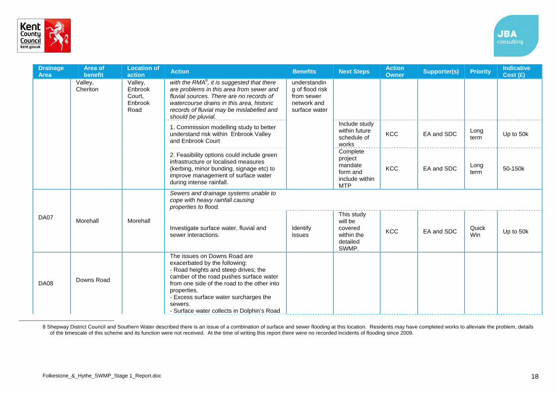
Folkestone_&_Hythe_SWMP_Stage 1_Report.doc 18
Drainage Area
Area of benefit
Location of action
Action Benefits Next Steps Action Owner
Supporter(s) Priority Indicative Cost (£)
Valley, Cheriton
Valley, Enbrook Court, Enbrook Road
with the RMA8, it is suggested that there are problems in this area from sewer and fluvial sources. There are no records of watercourse drains in this area, historic records of fluvial may be mislabelled and should be pluvial.
understanding of flood risk from sewer network and surface water
1. Commission modelling study to better understand risk within Enbrook Valley and Enbrook Court
Include study within future schedule of works
KCC EA and SDC Long term
Up to 50k
2. Feasibility options could include green infrastructure or localised measures (kerbing, minor bunding, signage etc) to improve management of surface water during intense rainfall.
Complete project mandate form and include within MTP
KCC EA and SDC Long term
50-150k
DA07
Morehall Morehall
Sewers and drainage systems unable to cope with heavy rainfall causing properties to flood.
Investigate surface water, fluvial and sewer interactions.
Identify issues
This study will be covered within the detailed SWMP.
KCC EA and SDC Quick Win
Up to 50k
DA08 Downs Road
The issues on Downs Road are exacerbated by the following: - Road heights and steep drives; the camber of the road pushes surface water from one side of the road to the other into properties. - Excess surface water surcharges the sewers. - Surface water collects in Dolphin’s Road
8 Shepway District Council and Southern Water described there is an issue of a combination of surface and sewer flooding at this location. Residents may have completed works to alleviate the problem, details
of the timescale of this scheme and its function were not received. At the time of writing this report there were no recorded incidents of flooding since 2009.

Folkestone_&_Hythe_SWMP_Stage 1_Report.doc 19
Drainage Area
Area of benefit
Location of action
Action Benefits Next Steps Action Owner
Supporter(s) Priority Indicative Cost (£)
due to the topography (bowl)
Downs Road (mid)
Complete study to investigate source of flooding on Downs Road and undertake options testing, options to consider9 include: Increase kerb heights to keep the
surface water on the roads Store floodwater in the allotment
gardens Permeable roads Consider installation of further
gullies along Downs Road (although note that Highways have already done some works)
Potential for diversion to the Pent Stream
Identify issues
This study will be covered within the detailed SWMP (will be necessary to complete a combined probability model to analyse potential options)
KCC EA and SDC Quick Win
Up to 50k
Downs Road / Dolphins Road
Remove allotment drainage from main sewer network (SW explained that a 150mm pipe constriction had been removed and replaced with a 600mm pipe and it was also highlighted that the allotments have been modified so that they drain directly into the sewer. Ownership of allotment needs confirming with Folkestone Town Council).
Reduce surface water entering sewerage system
Complete Stakeholder engagement with allotment committee
KCC SDC Quick win
Up to 50k
DA08 Warren Road and Burrow Road
Warren Road and Burrow Road
This area was affected by surface water flooding and fluvial flooding in 1996 but from observing the drainage assets and the FMfSW it is possible that flooding in this location is from surface water only,
Improve understanding of flood risk from fluvial and surface
9 Underground storage was mentioned within the workshop but this was discounted due to cost and issues associated with maintenance over lifetime.

Folkestone_&_Hythe_SWMP_Stage 1_Report.doc 20
Drainage Area
Area of benefit
Location of action
Action Benefits Next Steps Action Owner
Supporter(s) Priority Indicative Cost (£)
Once the source of risk has been verified the following actions may be appropriate:
water
Commission modelling study to better understand risk within Warren Road and Burrow Road.
Include study within future schedule of works
KCC EA and SDC Long term
Up to 50k
DA09 Harbour Approach Road
Pent Stream discharges to the sea south east of Harbour Approach Road. There are a number of issues present at this location at the Harbour that may benefit from the following actions:
Improve property protection
Harbour Approach Road
Investigate opportunities to improve property resilience for properties historically affected by surcharged sewers.
Stakeholder engagement to encourage the uptake of flood resilience measures
KCC, SDC
SW Medium term
Up to 100k
DA09 Marine Parade Marine Parade
Consider use of green infrastructure or localised measures (kerbing, minor bunding, signage etc) to improve management of surface water during intense rainfall.
Include study within future schedule of works
KCC SDC Short term
Up to 50k
DA09 Clifton Crescent
Clifton Crescent
Consider use of green infrastructure or localised measures (kerbing, minor bunding, signage etc) to improve management of surface water during intense rainfall.
Include study within future schedule of works
KCC, SDC
EA Short term
Up to 50k

Folkestone_&_Hythe_SWMP_Stage 1_Report.doc 21
4.4 Review Timeframe and Responsibilities
The project partners have reviewed and commented upon the actions in Table 4-1 and Table 4-2 during the Action Plan workshop.
Quick win actions identified in the ‘Action Plan’ are likely to be those addressed first. However, this report can only consider relative priorities within Folkestone and Hythe. Some partner organisations such as Southern Water and Kent County Council have flood risk management responsibilities beyond the geographic scope of this study, and therefore the priority and timescale of delivering actions within Folkestone and Hythe will have to be assessed against actions in other areas. Kent County Council is currently embarking upon a number of more strategic-scale SWMPs in a number of other settlements across the county.
Folkestone was ranked 3rd in the summary of settlement flood risks from 1 in 200 year greater than 0.3 m surface water event (ranked by dwellings at risk) detailed within the PFRA. Hythe was placed 18th within the same table10.
Actions leading to capital works will initially require a detailed local study that provides robust estimates of costs and justification (i.e. tangible benefits) of the scheme. If a study demonstrates that a scheme is beneficial, funding will need to be obtained before it can be delivered. Applications for funding, implementation of solutions on the ground, and the availability of funding all have the potential to change the recommendations of this report.
It is recommended that an annual review of the Short and Medium Term actions is undertaken. This will allow for forward financial planning in line with external partners and internal budget allocations. Long Term actions should be reviewed on a three-year cycle.
4.5 Sources of funding
Funding for local flood risk management may come from a wide range of sources. In Folkestone and Hythe these may include:
Defra (Flood Defence Grant in Aid)
Kent County Council (highways)
Southern Water
Network Rail
Industrial estate owners and businesses
New developments (directly through the developer or through CIL)
Local communities
Shepway District Council
Romney Marshes Area Internal Drainage Board
River Stour Internal Drainage Board
It is likely that schemes in Shepway will not have sufficiently strong cost-benefit ratios to attract 100% funding from Defra Flood Defence Grant in Aid (FDGiA), and would therefore require a portfolio of funding to be developed from various sources, including funding sources available for delivering other objectives such as improvements to highways, public open spaces and bio-diversity.
4.6 Ongoing Monitoring
The partnership arrangements established as part of the SWMP process should continue beyond the completion of the SWMP in order to discuss the implementation of the proposed actions, review opportunities for operational efficiency and to review any legislative changes.
The SWMP Action Plan should be reviewed and updated once every six years as a minimum, but there may be circumstances which might trigger a review and/or an update of the action plan in the interim, for example:
10 Kent County Council (2011) Preliminary Flood Risk Assessment available at http://cdn.environment-
agency.gov.uk/flho1211bvsi-e-e.pdf - Table 5

Folkestone_&_Hythe_SWMP_Stage 1_Report.doc 22
Occurrence of a surface water flood event;
Additional data or modelling becoming available, which may alter the understanding of risk within the study area;
Outcome of investment decisions by partners is different to the preferred option, which may require a revision to the action plan, and;
Additional (major) development or other changes in the catchment which may affect the surface water flood risk.
The action plan should act as a live document that is updated and amended on a regular basis, and as a minimum this should be as agreed in the Local Flood Risk Management Strategy for Kent, although individual partners may wish to review their actions more regularly.
