food growing strategy environmental report
TRANSCRIPT

Food Growing Strategy Strategic Environmental Assessment (SEA)
Environmental Report
Contents Non-Technical Summary 2 Summary of Environmental Report 8 Section 1. Key Facts 9
1.1 Key Facts relating to the Food Growing Strategy 8 Section 2. Strategic Action Context 10
2.1 Relationship with other Plans, Programmes and Strategies 10 2.2 Baseline Environmental Data 12 2.3 Environmental Issues for the Food Growing Strategy 21 2.4 Evolution of the Environment in the Absence of the Food Growing Strategy 22
Section 3. Assessment of Environmental Effects 23
3.1 Assessment Framework 23 3.2 Assessment Methodology 24 3.3 Alternatives 24 3.4 Assessment Findings 25 3.5 Assessment: Vision 25 3.6 Assessment: Aims and Objectives 29 3.7 Assessment: Potential Community Food Growing Sites 39 3.8 Cumulative Impacts 40 3.9 Influence of SEA on the Food Growing Strategy 42
Section 4. Mitigation and Monitoring 43
4.1 Mitigation Measures 43 4.2 Monitoring 43
Section 5. Statutory Consultation and SEA Timetable 45
5.1 Statutory Consultation 45 5.2 SEA Timetable 45
Section 6. Appendices 47
Appendix A
Initial list of the International, European Community and National Protection, Regional and Local Objectives
48
Appendix B
Consultation Reponses to the Scoping Report 58
Appendix C
SEA Assessment Criteria and Questions 67
Appendix D
Potential Community Food Growing Site Assessments 68
Appendix E
Development and Assessment of Reasonable Alternatives 90

2
Non-Technical Summary Strategic Environmental Assessment and the Food Growing Strategy
As part of the preparation of the Food Growing Strategy (FGS), East Dunbartonshire Council carried out a Strategic Environmental Assessment (SEA). The process of SEA is a systematic method for considering the likely environmental effects of this Strategy. It aims to:
Integrate environmental factors into the Plan preparation and decision-making
Improve the Strategy and enhance environmental protection
Increase public participation in decision making
Facilitate the openness and transparency of decision-making
Key SEA Stages
The key SEA stages carried out in the preparation of the FGS were: Screening & Determination: This is the process whereby the Screening Report is produced to set out the characteristics of the Strategy and its likely environmental effects, if implemented. The Council requests the views of the Consultation Authorities: Scottish Natural Heritage (SNH), Historic Environment Scotland (HES) and the Scottish Environmental Protection Agency (SEPA) on the likely significant of any environmental effects identified through the formal submission of the Screening Report. After taking into account the views of each of the Consultation Authorities, the Council must determine whether a SEA is required or not and advertise their decision-making. Scoping : This is the process by which details for the Environmental Report were determined. Through the Scoping Report the level of detail and the consultation period was determined for the Environmental Report and followed by a consultation with the appropriate Consultation Authorities. Environmental Assessment: The Environmental Report documents the environmental assessment of the FGS. The assessments of the relevant components were carried out in parallel to the development of the Strategy. This helped the policy-maker to refine the Strategy in order to avoid or mitigate the negative environmental impacts and to further enhance the positive environmental impacts. Post-Adoption Statement: The Post-Adoption Statement will demonstrate how the findings of the SEA have been taken into account in the adopted FGS. In accordance with the Environmental Assessment (Scotland) Act 2005, the Post-Adoption Statement will highlight:
How the environmental considerations have been incorporated into the FGS;
How the findings of the Environmental Report have been taken into account;
How opinions expressed, from both the Community and Consultation Authorities during the consultation of the Environmental Report have been taken into account;
The reasons for choosing the FGS as adopted in light of other reasonable alternatives; and,
The measures to be taken to monitor the significant effects of the implementation of the Plan.
The purpose of SEA is to inform the development process of the FGS. The assessment identified, described and evaluated the likely significant negative and positive environmental effects of the FGS, including any alternatives. This was beneficial in order to reduce, avoid or mitigate any potential environmental impact and further enhance any potential positive impacts. This Environmental Report presents the results of the SEA for the FGS. It also establishes a monitoring framework and measures to mitigate any adverse impacts that may occur as a result of the strategic document.

3
Key facts relating to the Food Growing Strategy
Responsible Authority
East Dunbartonshire Council
Title of PPS Food Growing Strategy Purpose of PPS The Strategy is intended to adhere to legislative requirements for the
identification and provision of community food growing in East Dunbartonshire.
What prompted the PPS
New legislation to fulfil the duties of Part 9 Section 119 of the Community Empowerment (Scotland) Act 2015 for each local authority in Scotland to prepare a Food Growing Strategy.
Subject Land Use – Community Food Growing Period covered 2020 – 2025 Frequency of updates
The Strategy will be monitored on an ongoing basis to ensure that action being taken to meet demand is effective, including a review of available resources. A mid-term interim review of the Strategy will be undertaken 2 ½ years after its approval and a full review after 5 years.
Area covered by PPS
East Dunbartonshire Council area
Summary of nature/ Content of the PPS
As set out in Section 9 of the Community Empowerment (Scotland) Act 2015, every local authority in Scotland has a duty to prepare a Food Growing Strategy for its area. The Food Growing Strategy intends to identify suitable land for allotments and for other food growing provisions, describe what reasonable steps will be taken to increase food growing opportunities throughout East Dunbartonshire, with a focus on whether there is scope to provide food growing opportunities in socio-economic disadvantaged areas, and identify how the Council will support and encourage community food growing. The Strategy will be developed in line with the Councils Local Outcome Improvement Plan and Locality Plans. The Strategy will also inform the spatial strategy for the Local Development Plan 2 process.
Proposed/draft outcomes
The vision, aims, objectives and allocated community growing spaces for the FGS will be determined over the course of the production of the Strategy. All reasonable alternatives will be considered and assessed as part of the SEA process.
Context of the Food Growing Strategy The Food Growing Strategy (FGS) aims to define and identify opportunities to increase food growing provision in East Dunbartonshire in response to our legislative duties under Part 9 of the Community Empowerment (Scotland) Act 2015, encompassing food growing in the widest sense and the many benefits it offers. Though traditionally the cultivation of food has been in the form of allotments, there has been a more recent shift towards other types of growing models within a number of different settings from school grounds, parks, raised beds in private gardens and growing on window sills. The Strategy will identify land with potential suitability for both allotments and other community growing models and in turn will demonstrate the range of food growing opportunities that are available for communities and individuals. It will also explore the support mechanisms that will contribute to an engaged, empowered and knowledgeable network of local gardeners over the next 5 years. The Strategy will take a balanced and considered approach to encouraging and

4
supporting new and existing growing spaces in order to help achieve growing aspirations and meet local needs. Within East Dunbartonshire Food Growing Strategy food growing refers to any grow-your-own models where people come together to grow vegetables, fruits, herbs and/or flowers at varying scales. The FGS will be shaped by a Vision, Aims and Objectives, Community Growing Sites and delivered through a Delivery Programme of actions. These strategic elements will help shape other plans, policies, programmes, strategies, masterplans and commitments by the Council.
Environmental Baseline Data for East Dunbartonshire
The environmental baseline information for East Dunbartonshire has been identified in relation to each of the environmental factors scoped into the assessment for the FGS (Population and Human Health; Biodiversity, Flora and Fauna; Cultural Heritage; Landscape; Soil and Geology; Water Quality; Climatic Factors and Material Assets). The information has been collated using a range of statistics and resources, including information from Scotland’s Environment Web, SNH, SEPA, Historic Environment Scotland, SNIFFER, Forestry Commission Scotland, Scottish Government, National Records and Air Quality Scotland, as well as local information obtained from the different relevant Services within the Council. The baseline data has been updated if and when available data has become available in order to ensure that the data is as relevant as possible. Section 2.2 of the main report contains a full outline of the environmental baseline data for each of the environmental factors considered in SEA, including spatial representations of the main environmental constraints in East Dunbartonshire using Geographical Information Systems (GIS). Existing Environmental Problems Reviewing the environmental baseline data for East Dunbartonshire helped to identify any existing environmental problems that would need to be taken into account during the preparing and implementation of the FGS. The likely nature of the environment without a Plan to address local socio-economic disadvantages has also been described along with the implications of this for the Council, where appropriate. The main challenges identified include:
Lack of availability and access to community growing opportunities East Dunbartonshire. By addressing this through the FGS it could benefit all of East Dunbartonshire including the datazones which fall into the top 25% most deprived areas in Scotland located in Hillhead, Lennoxtown, Auchinairn and Twechar as identified in the Scottish Index of Multiple Deprivation (SIMD).
There is a significant reliance on public transport and access to primary facilities, particularly in areas of deprivation and due to East Dunbartonshire’s ageing population.
East Dunbartonshire has a range of local, national and international cultural heritage assets of value including the Antonine Wall UNESCO World Heritage Site and the Forth and Clyde Canal Scheduled Monument.
The local natural environment hosts a wide range of designated and non-designated environmental and ecological assets including protected and priority species and habitats.

5
Assessment of Environmental Effects The main function of the Environmental Report as part of the full SEA process is to suggest ways to improve the environmental performance of the plans and strategies through assessment of the significant environmental effects identified. An assessment of the Strategy’s Vision, Aims, Objectives and Site specific proposals were carried out which highlighted an overall positive effect on the environment with the potential for significant impacts and particular focus of effects for multiple factors, Population and Human Health, Biodiversity, Landscape and Material Assets. The positive nature of the effects has been enhanced, where it was deemed appropriate, through the integration of SEA suggested alterations to the wording or focus of the individual Strategy components. A summary of the findings are detailed below:
Population and Human Health
Overall positive effects, the potential for significant impacts, including:
Provision of safe environments to demonstrate the benefits for communities and associated health and wellbeing aspects of community food growing;
Increased provision of community food growing assets which encourage active travel/sustainable travel and outdoor leisure;
Better access to quality provisions and services at a local level; and,
Opportunities for local communities and individuals to become involved in local community based projects.
Cultural Heritage The effects on cultural heritage are likely to insignificant overall. However the assessment of the policy and site specific elements of the Strategy identified a small number of minor positive and negative impacts which were directly related to the setting of historic environment designations such as the Antonine Wall World Heritage Site, Scheduled Monuments and locally important Gardens and Designed Landscapes. These impacts are dependent on the receiving environment and the detailed proposal.
Biodiversity, Flora and Fauna Overall positive effects, the potential for significant impacts, including:
The introduction of community growing opportunities potentially enhancing biodiversity and green network links; and
Encouragement of biodiversity-friendly practices.
Soil and Geology The effects on soils and geology are likely to insignificant overall. However the assessment of the policy and site specific elements of the Strategy identified a small number of minor positive and negative impacts which were directly related to the potential remediation or improvement of contaminated land and promotion of sites as functional community assets.
Landscape Overall positive effects, the potential for significant impacts, including:
The development of community growing opportunities improving the attractiveness of sites and the related settlements, enhancing landscape character and visual amenity value; and
Enhancing green network links and biodiversity value.
Water Quality The effects on water quality are likely to insignificant overall. However the assessment of the policy and site specific elements of

6
the Strategy identified a small number of minor positive and negative impacts which were directly related to:
Proposals which could result in a reduction of risk to the ecological status of the water environment; and/or
Proposals likely to exacerbate surface water issues, increase risk of run-off from impacts to soil or the proposed uses.
Climatic Factors The potential for significant impacts (positive and negative) were identified for this factor, mainly as a result of:
Potential locations for community growing spaces in locations which would not support active or sustainable transport;
Potential for proposals to impact on drainage and exacerbate or transfer flooding or drainage risks to neighbouring areas; and
Potential development of community growing spaces in locations which could pose significant issues throughout the Council area in relation to flood risk.
Material Assets Overall positive effects, the potential for significant impacts, including:
Better access to quality provisions and services at a local level;
Potential remediation or improvement of contaminated land and promotion of sites as functional community assets; and
Potential for low carbon technologies and sustainable material use.
Sections 3 and Appendix D provide full details of the assessments. Mitigation and Monitoring Mitigation measures have been proposed through the environmental assessments and incorporated into the Strategy where necessary in order to avoid, reduce, mitigate or offset any potential adverse environmental impacts and enhance any uncertain, neutral, positive environmental impacts identified. The mitigation measures incorporate all environmental factors which were scoped into the assessment and will be the responsibility of East Dunbartonshire Council to implement in conjunction with key agencies and stakeholders. The mitigation measures will form part of the Post-Adoption Statement for the FGS, prepared as soon as reasonably practicable after the adoption of the Strategy, in accordance with Section 18 of the Environmental Assessment (Scotland) Act 2005. The environmental baseline data (Section 2.2) and the monitoring indications as part of the proposed monitoring framework (Section 4.2) will form the basis of future monitoring of the potential effects, predicted and unforeseen, of the FGS on the local environment. Next Steps: Statutory Consultation The next step for both the Environmental Report and the FGS is a 6 week consultation with the public and key agencies. All of the comments received will be taken into account and amendments may be made accordingly to both documents. Any significant changes to the Strategy in relation to consultation responses may require further consideration in terms of environmental implications. The statutory consultation for this Strategic Environmental Assessment document and corresponding FGS is:

7
15th April 2019 – 9th June 2019
If you would like to express your views on the Environmental Report, your comments should be submitted through email or post to the following:
Email: [email protected] Post: Sustainability Policy Place, Neighbourhood and Corporate Assets East Dunbartonshire Council Southbank House Strathkelvin Place Kirkintilloch G66 1XQ

8
Summary of Environmental Report Following the Screening Determination for the Food Growing Strategy (FGS), East Dunbartonshire Council is carrying out a full environmental assessment for the FGS. The FGS will be a 5 year Strategy which will fulfil the statutory duties for Local Authorities to adhere to Part 9 of the Community Empowerment (Scotland) Act 2015, with regards to the identification and provision of community food growing opportunities within East Dunbartonshire.
Section 1: Key Facts This section provides some key facts about the Food
Growing Strategy (FGS) including a brief summary regarding the content.
Section 2: Strategic Action Context This section provides an overview of the FGS and the main issues it is likely to address. In addition, this section provides the environmental baseline data collected and used as part of the assessment of the Strategy.
Section 3: Assessment of Environmental Effects
This section outlines how the SEA process incorporates the identification of reasonable alternatives; assessment methodology, assessment process and findings regarding each Strategy element and the influence of the SEA on the FGS.
Section 4: Mitigation and Monitoring
This section sets out the concluding stages proposed for the Environmental Report.
Section 5: Statutory Consultation and SEA Timetable
This section outlines the consultation dates and procedures and the timeline for the FGS and corresponding SEA documentation.
Appendix A: Influence of key legislation & PPS
This appendix lists key legislation, plans, programmes, policies and strategies that influence or are influenced by the FGS.
Appendix B: Consultation Responses to the Scoping Report
The appendix highlights the main issues raised by the Consultation authorities during the consultation of the Scoping Report and how they have been addressed within the Environmental Report.
Appendix C: SEA Assessment Criteria and Questions
This appendix outlines the chosen assessment methodology for both the policy framework and site proposals.
Appendix D: Potential Community Food Growing Site Assessments
This appendix includes the individual site assessment for each potential Community Food Growing site identified within the Strategy.
Appendix E: Development and Assessment of Reasonable Alternatives
This appendix illustrates the Strategy and SEA preferred options in relation to the policy framework for the FGS.

9
Section 1: Key Facts
1.1. Key Facts relating to the Food Growing Strategy
Responsible Authority
East Dunbartonshire Council
Title of PPS Food Growing Strategy Purpose of PPS The Strategy is intended to adhere to legislative requirements for the
identification and provision of community food growing in East Dunbartonshire.
What prompted the PPS
New legislation to fulfil the duties of Part 9 Section 119 of the Community
Empowerment (Scotland) Act 2015 for each local authority in Scotland to
prepare a Food Growing Strategy.
Subject
Land Use – Community Food Growing
Period covered 2020 – 2025 Frequency of updates
The Strategy will be monitored on an ongoing basis to ensure that action being taken to meet demand is effective, including a review of available resources. A mid-term interim review of the Strategy will be undertaken 2 ½ years after its approval and a full review after 5 years.
Area covered by PPS
East Dunbartonshire Council area
Summary of nature/ Content of the PPS
As set out in Section 9 of the Community Empowerment (Scotland) Act 2015, every local authority in Scotland has a duty to prepare a Food Growing Strategy for its area. The Food Growing Strategy intends to identify suitable land for allotments and for other food growing provisions, describe what reasonable steps will be taken to increase food growing opportunities throughout East Dunbartonshire, with a focus on whether there is scope to provide food growing opportunities in socio-economic disadvantaged areas, and identify how the Council will support and encourage community food growing. The Strategy will be developed in line with the Councils emerging Local Outcome Improvement Plan and Locality Plans. The Strategy will also inform the spatial strategy for the Local Development Plan process.
Proposed/draft outcomes
The vision, objectives and allocated community growing spaces for the FGS will be determined over the course of the production of the Strategy. All reasonable alternatives will be considered and assessed as part of the SEA process.

10
Section 2: Strategic Action Context 2.1. Relationship with other Plans, Programmes and Strategies There are a number of other strategies and plans internationally, nationally, regionally and locally that the Food Growing Strategy (FGS) needs to be integrated with. The following list indicate the primary related legislation and Figure 1 shows a diagrammatic representation, although it does not include every one of the plans listed. The template below is useful for demonstrating such relationships. International
Rio Declaration 1992
Johannesburg Declaration 2002 National
Community Empowerment (Scotland) Act 2015
Scottish Government National Outcomes
Allotments (Scotland) Act of 1882, as amended by the Land Settlement (Scotland) Act 1919 and the Allotment (Scotland) Acts of 1922 and 1950
Community Growing in Scotland – Towards a Framework for Action
Getting the best from our land: A land use strategy for Scotland 2016-2021 Regional
Clydeplan
Sow and Grow Everywhere (SAGE) Strategy
Other Authorities’ Best Practice Local
East Dunbartonshire Community Planning Partnership Local Outcome Improvement Plan (LOIP) and Locality Plans/Place Plans
Local Development Plan 2017 – 2022
East Dunbartonshire Council Open Space Strategy
East Dunbartonshire Green Network Strategy
East Dunbartonshire Council Local Biodiversity Action Plan
Sustainability and Climate Change Framework
Mugdock Country Park Strategy 2015-2020 2.1.1 Cross-boundary effects with neighbouring authorities will be considered through the
integration of the FGS and the consideration of Plans and Strategies produced by the neighbouring authorities.
2.1.2 Appendix A lists key legislation, plans, programmes, policies and strategies that influence or are influenced by the FGS. This list includes documents that refer to international, European Community, and national environmental objectives; regional and local objectives. Their content, where appropriate, has been used to inform the environmental objectives for the SEA of the Strategy.

11
Figure 1: Interrelationship of the Food Growing Strategy with Other Plans, Programmes and Strategies
Key: International National Regional Local

12
2.1.3 The Environmental Protection Objectives that are contained within international, European, UK and Scottish legislation, as well as national guidance which are considered to be of the greatest relevance to the FGS will be taken into account when preparing the Plans. These are set out in Appendix A.
2.2 Baseline Environmental Data
2.2.1 The early stages of SEA, such as describing the baseline, identifying environmental
problems/issues and analysing the links and relationships between other strategic actions, should be carried out concurrently and they should inform each other throughout the process. This approach has been adopted as part of the FGS SEA.
2.2.2 In order to measure the significant environmental effects of these strategic actions the current state of the environment must be known. East Dunbartonshire Council will gather sufficient information to provide the current state of the environment, or an Environmental Baseline, utilising GIS mapping where possible, to show the geographical location and scale of key environmental designations and assets. The potential effects (including, cumulative, secondary and synergistic effects) of the information contained within the FGS and their alternatives have been measured against this baseline.
2.2.3 For the purposes of this Scoping Report, a broad summary of baseline environmental information has been collated. Table 1 below summarises the main baseline environmental features.
2.2.4 Table 1 contains a broad summary of the baseline environmental information which has been collated and also includes the SEA objectives used for the assessment. These have been developed taking into account the summary baseline data. The SEA Objectives were used to assess the Strategy and they provide the basis for the development of the assessment questions and monitoring indicators.

Environmental Report
13
Table 1: Proposed Environmental Baseline Data
Environmental Receptor
Summary of baseline Environmental Data Source of Data Collected Proposed
SEA Objectives
Population & Human Health
East Dunbartonshire has a total population of 108,130 (2017); an increase of 0.5% from 107,540 in 2016. Population Projections forecast that the population of East Dunbartonshire will increase to 112,640 by 2026 (+4.7% increase between 2016 and 2026). East Dunbartonshire has an ageing population. This is highlighted through the population projections that by 2026 East Dunbartonshire’s 75+ population will increase by +30.5% based on 2016 levels. Areas of Hillhead, Lennoxtown and Auchinairn are in the most deprived 20% in Scotland (SIMD 2016). Twechar is also considered to be an area of socio-economic disadvantaged. Each of these localities have a Locality Plan as outlined in the Local Outcome Improvement Plan (LOIP). Generally the health of the residents of East Dunbartonshire is good with nearly 73% of the residents being generally healthy, in comparison to the average of Scotland (68%) according to the 2001 census. The level of residents found to be in general health status of ‘not good’ within East Dunbartonshire and Scotland was 8% and 10% respectively. In terms of walking and cycling to work in 2012/13, East Dunbartonshire had low rates of walking (5.1%) when compared with the Scottish national average (13.2%). Walking to work rates in East Dunbartonshire represent the 2nd lowest rates in Scotland against all other Council areas. There are similarly low levels of cycling to the Scottish national average (2.3%). The percentage of economically active people living in East Dunbartonshire has decreased between 2014 and 2015 by -0.6%; however, this percentage is still higher than both the Scottish and British national averages at 78.2%. Of this total in East Dunbartonshire, 82.1% of economically active people are male and 74.5% female. Current community food growing assets:
Rosebank Allotment – Kirkintilloch
Torrance – Demonstration Garden
Population, health and employment statistics
National Records for Scotland
2011 Scottish Census
Nomis 2015 Local Authority Labour Market Profile
SIMD 2016 Open Space Audit and Strategy Food Growing Strategy (Emerging) East Dunbartonshire Green Network Strategy East Dunbartonshire Local Outcome Improvement Plan
To improve human health and community wellbeing
Environmental Report
14
Environmental Receptor
Summary of baseline Environmental Data Source of Data Collected Proposed
SEA Objectives Twechar – community growing spaces
Hillhead Housing Association – Gardens and Friars Croft Orchard There are 6 Strategic Green Network Assets in the area: including Mugdock Country Park and Milngavie Reservoirs and 6 Green Network Strategic Access Links, including the long distance paths of the West Highland Way and John Muir Way.
Cultural Heritage
East Dunbartonshire has: -
1 UNESCO World Heritage Site (part) - Frontiers of the Roman Empire (Antonine Wall). A buffer zone has been identified around the Wall to help protect its setting, in Supplementary Planning Guidance.
48 Scheduled Monuments. In particular the Forth & Clyde Canal and Antonine Wall are made up of a series of Scheduled Monuments.
178 Listed Building, including 15 Category A (of national importance) including: Luggie Water Aqueduct and Bridge; Mugdock & Craigmaddie Reservoirs; three churches, two castles, three town houses , four country houses and a cemetery. There are 85 category B designations and 78 category C designations.
15 Conservation Areas (4 of which are designated as outstanding)
21 Townscape Protection Areas
Mugdock and Craigmaddie Reservoirs national inventory Garden and Designed Landscape, and two other sites recommended as having the potential for meeting national inventory standards. 30 such sites have also been identified as having local value.
There are nine buildings identified in the Buildings at Risk Register, one of which has restoration in progress.
It is important to recognise and consider non-designated heritage assets as part of the assessment process.
Historic Environment Scotland Sites and Monuments Record (SMR) East Dunbartonshire Council United Nations Educational, Scientific and Cultural Organisation – World Heritage Site Designation Scottish Natural Heritage Scottish Canals Heritage Strategy 2013-38 Buildings at Risk register for Scotland
To protect, conserve and, where appropriate, enhance the historic environment
Environmental Report
15
Environmental Receptor
Summary of baseline Environmental Data Source of Data Collected Proposed
SEA Objectives
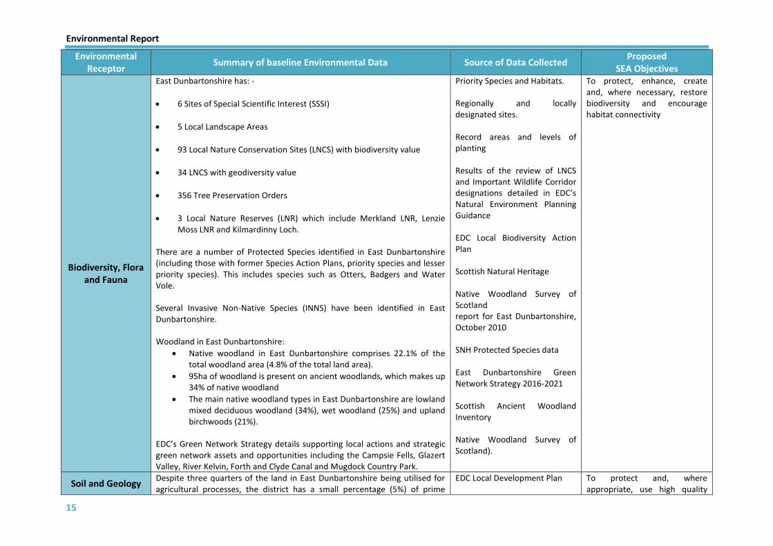
Biodiversity, Flora and Fauna
East Dunbartonshire has: -
6 Sites of Special Scientific Interest (SSSI)
5 Local Landscape Areas
93 Local Nature Conservation Sites (LNCS) with biodiversity value
34 LNCS with geodiversity value
356 Tree Preservation Orders
3 Local Nature Reserves (LNR) which include Merkland LNR, Lenzie Moss LNR and Kilmardinny Loch.
There are a number of Protected Species identified in East Dunbartonshire (including those with former Species Action Plans, priority species and lesser priority species). This includes species such as Otters, Badgers and Water Vole. Several Invasive Non-Native Species (INNS) have been identified in East Dunbartonshire.
Woodland in East Dunbartonshire:
Native woodland in East Dunbartonshire comprises 22.1% of the total woodland area (4.8% of the total land area).
95ha of woodland is present on ancient woodlands, which makes up 34% of native woodland
The main native woodland types in East Dunbartonshire are lowland mixed deciduous woodland (34%), wet woodland (25%) and upland birchwoods (21%).
EDC’s Green Network Strategy details supporting local actions and strategic green network assets and opportunities including the Campsie Fells, Glazert Valley, River Kelvin, Forth and Clyde Canal and Mugdock Country Park.
Priority Species and Habitats. Regionally and locally designated sites. Record areas and levels of planting Results of the review of LNCS and Important Wildlife Corridor designations detailed in EDC’s Natural Environment Planning Guidance EDC Local Biodiversity Action Plan Scottish Natural Heritage Native Woodland Survey of Scotland report for East Dunbartonshire, October 2010 SNH Protected Species data East Dunbartonshire Green Network Strategy 2016-2021 Scottish Ancient Woodland Inventory Native Woodland Survey of Scotland).
To protect, enhance, create and, where necessary, restore biodiversity and encourage habitat connectivity
Soil and Geology Despite three quarters of the land in East Dunbartonshire being utilised for agricultural processes, the district has a small percentage (5%) of prime
EDC Local Development Plan
To protect and, where appropriate, use high quality

Environmental Report
16
Environmental Receptor
Summary of baseline Environmental Data Source of Data Collected Proposed
SEA Objectives agricultural soil. Currently East Dunbartonshire has not designated any areas of land as contaminated land as defined in the Environmental Protection Act 1990. However, a list of potential contaminated sites has been created based on previous land use. On this list 626 potentially contaminated sites (to varying degrees of contamination) have been identified. There are currently 25 Vacant and Derelict Land within East Dunbartonshire with a total area of 76 hectares. East Dunbartonshire also has 1 RIGS (Regionally Important Geological or Geomorphological Site) at Clachan of Campsie. It has 36 sites representing geological diversity, and 34 are recommended as Local Geodiversity Sites (LGS). There are varying levels of identified peatland in East Dunbartonshire including:
Class 1, 3, 4 and 5 across the Campsie Fells
Class 3 predominantly in the Kilpatrick Hills
Areas of Class 1 and 5 including High Moss
Class 3, 4 and 5 around Lennox Forrest
Areas of Class 4 in Kirkintilloch, Torrance and Twechar
Scottish Vacant and Derelict Land Survey 2016 James Hutton Institute Scottish Natural Heritage British Geological Survey UKRIGS (Regionally Important Geological or Geomorphological Site) SNH Carbon and Peatland Map 2016
and sensitive soils in a sustainable manner and conserve recognised geodiversity assets
Landscape
East Dunbartonshire’s landscape is diverse in terms of character and land uses. The district is characterised by five main types of landscape character: Drumlin Foothills; Rolling Farmland; Broad Valley Lowland; Rugged Moorland Hills; and urban areas. The topography of East Dunbartonshire is generally low lying, undulating land with the exception of the two Local Landscape Areas; the Campsie Fells and the Kilpatrick Hills to the North and West of the district respectively. There are five Local Landscape Areas (LLA) within East Dunbartonshire Council’s boundary, including the Campsie Fells, Kilpatrick Hills, Bar Hill (which are also Green Network Strategic Assets); Bardowie, Balmore and Torrance and Glazert Valley.
British Geological Survey UKRIGS (Regionally Important Geological or Geomorphological Site) Glasgow & Clyde Valley Landscape Character Assessment, 1999 EDC Local Development Plan
To protect and, where appropriate, restore landscape character, local distinctiveness and scenic value

Environmental Report
17
Environmental Receptor
Summary of baseline Environmental Data Source of Data Collected Proposed
SEA Objectives East Dunbartonshire has a total of 973.46 hectares of urban open space; the greatest proportion of which is classified as semi-natural greenspace and Regional Greenspace. The green belt is a Development Plan policy which covers the East Dunbartonshire area, with the exception of the upland areas; its objectives include maintaining the character and distinctiveness of the areas settlements.
Water Quality
The main watercourses within East Dunbartonshire are the River Kelvin, Glazert Water, Allander Water, Luggie Water, Forth and Clyde Canal and Bothlin Burn. East Dunbartonshire also has two reservoirs in Milngavie and a number of other small dams in various locations throughout East Dunbartonshire, which are of significant value to the surrounding area. Watercourse ecological status related to East Dunbartonshire:
River Carron – good classification (improved from previous year)
River Kelvin (Glazert Water to Tidal Limit – poor classification (degraded from previous year)
River Kelvin (Kelvinhead to Glazert) – bad classification (degraded from previous year)
Allander Water – moderate classification (degraded from previous year)
Craigmaddie Burn – good classification (no change from previous year)
Luggie Water (Kelvin to Mollins Burn) – moderate classification (no change from previous year)
Bothlin Burn (Garnkirk Burn to Luggie confluence) – moderate classification (no change from previous year)
Glazert Water/Finglen Burn – poor classification (degraded from previous year)
Kirk Burn – moderate classification (no change from previous year)
Garrel Burn – poor classification (degraded from previous year)
Forth and Clyde Canal (Mountblow to Maryhill and Glasgow Branch to Kirkintilloch) – good classification (degraded from previous year)
Stand Burn/Park Burn – poor classification (degraded from previous year)
River Basin Management Plan for the Scotland River Basin District 2015-2027 Local water quality data Drinking water quality SEPA – RBMP Data East Dunbartonshire Council Local Biodiversity Action Plan
To prevent deterioration and, where possible, enhance the water environment.

Environmental Report
18
Environmental Receptor
Summary of baseline Environmental Data Source of Data Collected Proposed
SEA Objectives Luggie Water (u/s Mollins Burn) – good classification (improved
from previous year)
Forth and Clyde Canal (Kirkintilloch to Kelvinhead) – good classification (degraded from previous year)
Board Burn – moderate classification (no change from previous year)
The ecological status of groundwater sources applicable to East Dunbartonshire are as follows:
Clydebank: good
Kilpatrick: good
Lennoxtown: poor
Denny: poor
Carron and Touch: good
Campsie: good
Kirkintilloch: poor
Glasgow and Motherwell: poor
Kelvin Sand and Gravel: good
Clydebank Sand and Gravel: good *Flooding is discussed in Climatic Factors
Climatic Factors
A significant source of carbon dioxide in East Dunbartonshire is attributable to vehicular transport emissions (144.3ktCO2), which contributes towards climate change, although the largest proportion of CO2 emissions is attributable to domestic emissions (208.4 ktCO2). Travel:
The level of public transport access varies across the area. Kirkintilloch is served by bus services that provide access to towns and villages in East Dunbartonshire and adjacent local authorities such as Glasgow. However, there are areas that do not have services that are frequent or operate out-with peak travel periods and daytime hours.
Although rail patronage has increased by approximately 10% from the period 2012/13 to 2013/14, accessibility to such services means there is a significant reliance on car-based travel in the area.
The number of bus passenger journeys in Strathclyde and South West Scotland has decreased since 2007/08 to 2012/13, which equates to a
Flood Risk Assessments. Flood defences. Emissions levels within East Dunbartonshire. Flooding and storm information and events. Renewable energy potential. Scottish Government SEPA
To contribute towards the reduction of Scottish greenhouse gas outputs in line with Government targets in order to reduce or prevent the overall effects of climate change including those related to flood risks

Environmental Report
19
Environmental Receptor
Summary of baseline Environmental Data Source of Data Collected Proposed
SEA Objectives decrease of 21%. The total distance travelled by buses 2007/08 to 2012/13 decreased by 17%. This can be attributable to a reduction in the number of services that operate or alterations to routes. This trend is reflected in trends across Scotland which has seen a decrease in 4% in bus and coach journeys between 2012 and 2013.
Traffic levels have decreased during recent years from the particularly high volumes experienced during the mid-2000s. This may be a result of the economic downturn.
In 2013, 86% of households in East Dunbartonshire had access to at least 1 car.
Glasgow is a key attraction for both employment and high education opportunities for the population of East Dunbartonshire which increases the need for travel.
CO2 emissions associated with the expenditure of energy from industrial/commercial (including agriculture) and domestic buildings accounts for 96.8 ktCO2 and 208.4 ktCO2 respectively in 2012. Such energy use has a significant impact on air quality. Flooding has been an issue in the Kelvin Valley for many years with the most recent flood events occurring in 1994 and 2005. The main areas of concern for potential flooding are the River Kelvin and its tributaries – the Allander, Glazert and Luggie Waters. East Dunbartonshire only has one operating landfill (Inchbelle Quarry, Kirkintilloch) but is only used for the disposal of inert materials, mainly construction materials. All household and commercial municipal waste is transferred to landfills in North Lanarkshire. Therefore, there is minimal methane produced from landfill within East Dunbartonshire to impact on climate change.
East Dunbartonshire Council UK Climate Impacts Programme Online Handbook of Climate Trends across Scotland 2006 (as updated) (SNIFFER Guidance) Scottish Household Survey 2013 (access to cars per household) Office of Rail Regulation (rail patronage by region, 2013/14) Scottish Transport Bus and Coach Statistics No. 32, 2013 SEPA Flood map Scotland’s Climate Change Declaration 2013-14 Report (SSN; Keep Scotland Beautiful; EDC) 'Local and Regional CO2 Emissions Estimates for 2005-2012’, Department of Energy and Climate Change Scottish Government UK local authority and regional carbon dioxide emissions national statistics: 2015
Material Assets
East Dunbartonshire is supplied by various levels of transport infrastructure, through well serviced rail networks, bus routes encompassing the whole district and the various road networks that link settlements within East Dunbartonshire together with providing routes out with the district.
Transport and infrastructure data. Core Path Network and Rights
To promote the sustainable use of community assets in East Dunbartonshire

Environmental Report
20
Environmental Receptor
Summary of baseline Environmental Data Source of Data Collected Proposed
SEA Objectives There are 54km of A class roads, 47 km of B class roads and 34km of C class roads. This amounts to 27% of the road network. There are 369 km of unclassified roads. East Dunbartonshire has a network of Core Paths and public open spaces which provide opportunities for recreation. Some of these also provide active travel routes from residential areas to services and businesses. Studies into housing requirements have indicated that East Dunbartonshire has one of the highest net needs for affordable housing, compared to other Scottish Local Authorities. The Local Development Plan and emerging Local Development Plan 2 identifies the location of new development proposals with potential for changes to transport infrastructure/routes.
of Way. Walking and cycle routes Public open spaces and accessibility. Scottish Government East Dunbartonshire Council Transport Scotland SPT Local Development Plan for large scale development proposals.

Environmental Report
21
2.3 Environmental Issues1 for the Food Growing Strategy 2.3.1 The purpose of this section is to explain how existing environmental issues will affect or be
affected by the Food Growing Strategy, and whether this strategic action is likely to aggravate, reduce or otherwise affect existing environmental issues. The main environmental issues and problems facing East Dunbartonshire are outlined in Table 2 below.
Table 2: Environmental Issues
SEA
Topic Relevant Environmental Issues
Po
pu
lati
on
an
d H
um
an H
eal
th
The FGS intends to identify and realise potential community growing opportunities throughout East Dunbartonshire. This could directly benefit areas of deprivation and inequality in particular, the three most deprived areas in East Dunbartonshire; Lennoxtown, Hillhead & Harestanes and Auchinairn, as well as Twechar which experiences varying levels of inequality so will target a reduction in deprivation.
Access for residents to community growing sites and opportunities is the main potential driver of the FGS.
Community safety is an important element of the FGS and will be an essential criteria when identifying potential community food growing sites.
The FGS intends to contribute towards and promote a healthy environment and the positive impacts that community food growing opportunities can have on health and wellbeing.
The FGS will encourage involvement of communities and volunteers in community food growing projects and decision making which will have additional health and wellbeing benefits at a local level.
Cu
ltu
ral H
erit
age There are a large number and variety of cultural heritage assets in East Dunbartonshire
including the Antonine Wall (UNESCO World Heritage Site) and the Forth and Clyde Canal which require protection and management, but also contribute to East Dunbartonshire as a tourist destination. The FGS will be in a position to contribute towards the continued protection and conservation of the historic environment.
Bio
div
ersi
ty, F
lora
an
d
Fau
na
East Dunbartonshire has a wide range of designated and non-designated sites, including those of ecological importance and protected species. This is seen through a number of Local Nature Conservation Sites and Important Wildlife Corridors, Tree Preservation Orders and Local Nature Reserves. East Dunbartonshire also has 6 Sites of Special Scientific Interest (SSSI).
River and canal corridors in East Dunbartonshire contribute significantly to wide ranging habitats and biodiversity. The natural environment plays a considerable role in healthy lives and the attractiveness of East Dunbartonshire as an economic and habitable centre.
The FGS intends to enhance sites with little existing biodiversity and habitat value without compromising habitat links and connections to the wider green network.
1 The term “environmental issues” is the name collectively given to air, water, soil, biodiversity, climatic factors, landscape, material assets, population and human health as well as cultural heritage (including architectural and archaeological heritage) in the EU Directive 2001/42/EC. In practice they are referred to as “SEA topics”.

Environmental Report
22
Soil
and
Geo
logy
There are a number of potentially contaminated land areas in East Dunbartonshire along with vacant and derelict land sites which are underutilised and will be supported by the FGS as potential community food growing opportunities.
There are several sites in East Dunbartonshire that have been identified as peatland.
There are 36 sites identified as being geologically diverse, of which 34 have been assigned as Local Geodiversity Site (LGS). The area also hosts 1 RIGS (Regionally Important Geological or Geomorphological Site) and 1 SSSI of geological importance.
Lan
dsc
ape
East Dunbartonshire has a number of areas with high/moderate scenic value as well as specific landscape characters and settings across the Council area, including the Campsie Fells and Kilpatrick Hills.
Landscape character, scenic value and particularly local distinctiveness are an area which can positively impact East Dunbartonshire’s communities and contribute to health and wellbeing benefits.
Wat
er
Qu
alit
y There are a number of good/moderate quality watercourses in East Dunbartonshire including the Forth and Clyde Canal which is a Scheduled Monument. These assets require protection in order to reduce, prevent or offset any adverse impacts.
Clim
atic
Fac
tors
Domestic emissions account for the largest proportion of carbon dioxide in East Dunbartonshire, although emissions from transport account for the largest proportion of NO2 and PM10 emissions. This contributes to the effects of climate change which include changing temperatures and rainfall patterns, and increased incidences of extreme weather events.
Climate change has a direct link to flood risk. The SEPA Flood Risk Map has identified several locations within the East Dunbartonshire Council area which could have significant impacts on communities.
Mat
eri
al A
sse
ts
As a result of the spatial strategy of the new adopted Local Development Plan there is likely to be a rise in developments in East Dunbartonshire over the life of the Plan.
There are a series of Core Path networks and open spaces in East Dunbartonshire which create recreational opportunities, promote active travel and provide a sense of community.
Sustainable access to community food growing opportunities will be a key consideration for the FGS. This will be a criteria during the fit for purpose / suitability assessment process and the continued promotion of the active travel network throughout East Dunbartonshire.
2.4 Evolution of the Environment in the Absence of the Food Growing Strategy
2.4.1 The SEA process is also required to assess the likely impact on the environment if the LOIP
was not implemented.
2.4.2 Aside from a failure to carry out national duties as set by Part 9 of the Community Empowerment (Scotland) Act 2015, not implementing a Food Growing Strategy would result in a lost opportunity to aid increasing access to food growing provision for local communities based on local demographics and demand including associated positive effects of being involved in food growing such as socialisation, recreation, skills development, enhanced physical and mental wellbeing and improved access and use of the local environment. Furthermore, the absence of a Food Growing Strategy has the potential to result in increasing demand for allotments without action to reduce waiting list numbers.
Environmental Report
23
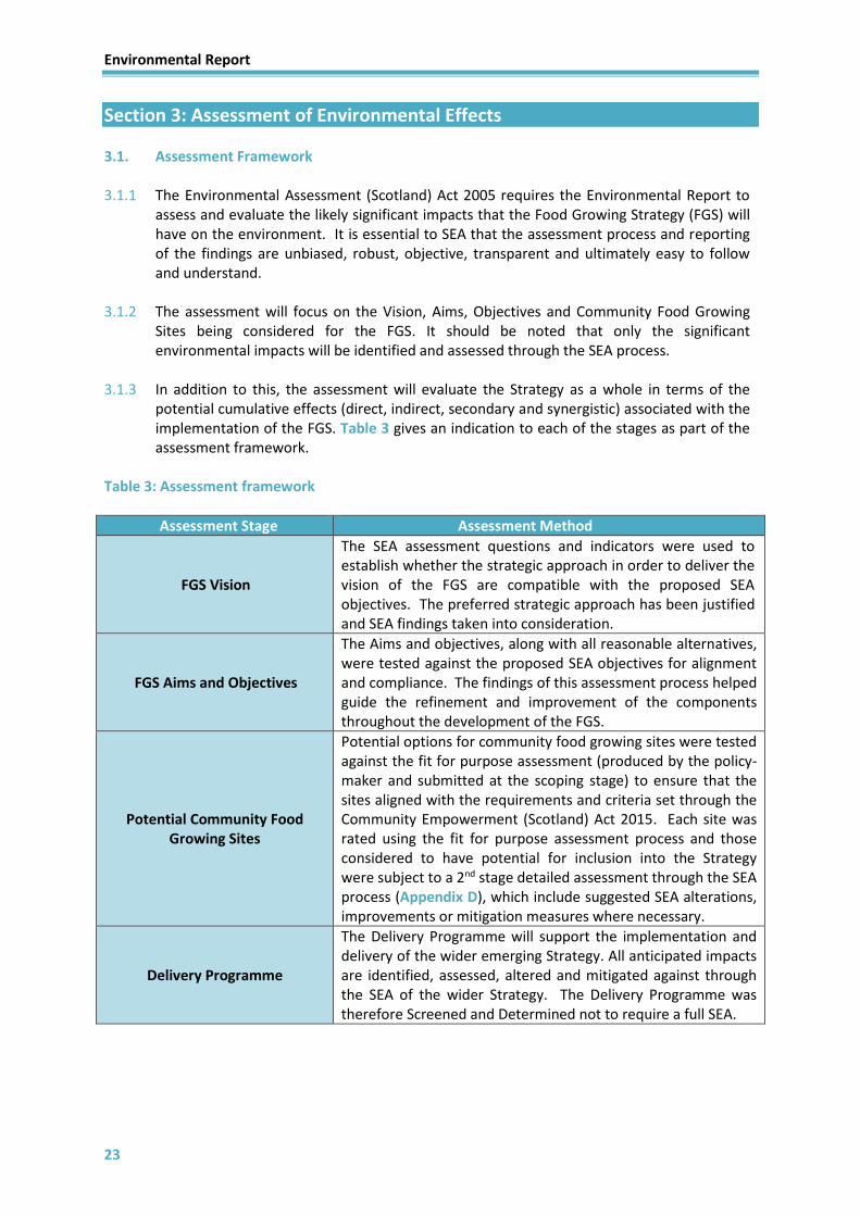
Section 3: Assessment of Environmental Effects 3.1. Assessment Framework
3.1.1 The Environmental Assessment (Scotland) Act 2005 requires the Environmental Report to
assess and evaluate the likely significant impacts that the Food Growing Strategy (FGS) will have on the environment. It is essential to SEA that the assessment process and reporting of the findings are unbiased, robust, objective, transparent and ultimately easy to follow and understand.
3.1.2 The assessment will focus on the Vision, Aims, Objectives and Community Food Growing Sites being considered for the FGS. It should be noted that only the significant environmental impacts will be identified and assessed through the SEA process.
3.1.3 In addition to this, the assessment will evaluate the Strategy as a whole in terms of the potential cumulative effects (direct, indirect, secondary and synergistic) associated with the implementation of the FGS. Table 3 gives an indication to each of the stages as part of the assessment framework.
Table 3: Assessment framework
Assessment Stage Assessment Method
FGS Vision
The SEA assessment questions and indicators were used to establish whether the strategic approach in order to deliver the vision of the FGS are compatible with the proposed SEA objectives. The preferred strategic approach has been justified and SEA findings taken into consideration.
FGS Aims and Objectives
The Aims and objectives, along with all reasonable alternatives, were tested against the proposed SEA objectives for alignment and compliance. The findings of this assessment process helped guide the refinement and improvement of the components throughout the development of the FGS.
Potential Community Food Growing Sites
Potential options for community food growing sites were tested against the fit for purpose assessment (produced by the policy-maker and submitted at the scoping stage) to ensure that the sites aligned with the requirements and criteria set through the Community Empowerment (Scotland) Act 2015. Each site was rated using the fit for purpose assessment process and those considered to have potential for inclusion into the Strategy were subject to a 2nd stage detailed assessment through the SEA process (Appendix D), which include suggested SEA alterations, improvements or mitigation measures where necessary.
Delivery Programme
The Delivery Programme will support the implementation and delivery of the wider emerging Strategy. All anticipated impacts are identified, assessed, altered and mitigated against through the SEA of the wider Strategy. The Delivery Programme was therefore Screened and Determined not to require a full SEA.

Environmental Report
24
3.2. Assessment Methodology 3.2.1 The SEA Directive requires the environmental effects of ‘reasonable alternatives’ to the
strategic document to be identified, described and assessed where appropriate. The FGS has been assessed against the list of environmental issues set out in Schedule 3 of the Environmental Assessment (Scotland) Act 2005.
3.2.2 It also requires environmental assessments to consider the environmental objectives established at International, European Community and national levels that are relevant to the strategic document. During the Scoping stage of SEA, it was determined that the environmental issues likely to be significantly impacted by the FGS were all of the environmental factors (with the exception of Air Quality); therefore the remaining factors were scoped into the assessment. The Consultation Authorities were in agreement with this level of scope, as expressed in their views following the consultation at the Scoping stage (Appendix B).
3.2.3 East Dunbartonshire Council has adopted a set of SEA Objectives and criteria questions for the environmental issues that were scoped into the assessment, shown in Table 4, which were derived from other legislation and Strategies (Appendix A). The criteria questions are used to guide the assessments of all elements of the Plans.
Table 4: SEA objectives
Environmental
Factor SEA Objectives
Population and Human Health
To improve human health and community wellbeing
Cultural Heritage To protect, conserve and, where appropriate, enhance the historic environment
Biodiversity, Flora and Fauna
To protect, enhance, create and, where necessary, restore biodiversity and encourage habitat connectivity
Soil and Geology To protect and, where appropriate, use high quality and sensitive soils in a sustainable manner and conserve recognised geodiversity assets
Landscape To protect, enhance and, where appropriate, restore landscape character, local distinctiveness and scenic value
Water Quality To prevent deterioration and, where possible, enhance the water environment
Climatic Factors To contribute towards the reduction of Scottish greenhouse gas outputs in line with Government targets in order to reduce or prevent the overall effects of climate change including those related to flood risks
Material Assets To promote the sustainable use of community assets and natural resources in East Dunbartonshire
3.3 Alternatives 3.3.1. As the FGS is driven by legislative requirements set out in the Community Empowerment
(Scotland) Act 2015, there are no reasonable alternatives to the Strategy itself, although alternatives to the content of the FGS including its vision, aims, objectives and allocated community growing sites have been considered and assessed within the Environmental Report.

Environmental Report
25
3.3.2. The environmental assessment will also, where appropriate, propose further alternatives to the proposed strategic elements, as well as suggest changes from an SEA perspective that will form part of the overall Strategy. This will guide any required mitigation measures in order to reduce any potential negative/adverse impacts or to suggest enhancements to those receptors that provide potential positive impacts to East Dunbartonshire.
3.4 Assessment Findings
3.4.1 An environmental assessment has been undertaken for the proposed vision, aims, objectives, and community food growing sites for the Strategy and has been assessed against the SEA Objectives and criteria, based on their predicted impact on the current environmental baseline. The assessment has been conducted using professional judgement and GIS analysis where appropriate.
3.4.2 The environmental assessments have been recorded in the form of a matrix identifying the environmental performance of each component against the SEA objectives and criteria. The environmental effects are recorded according to their nature (positive, neutral, negative, unknown or no significant effect). The significance of these effects is determined using a combination of the magnitude of the impact and the importance or sensitivity of the receiving environment.
3.4.3 Recommendations have been made where necessary so that environmental considerations are incorporated into the FGS. The assessments also seek to enhance the environmental benefits and suggest recommendations to further enhance or protect the environment.
3.4.4 Table 5, 6 and Appendix D provide a full assessment of the vision, aims and objectives and potential community food growing sites for the FGS respectively. An assessment has been undertaken for each component, including all reasonable alternatives and recommendations considered, the key environmental factors are outlined including the influence of SEA on the development of the FGS. In each case the SEA preferred option has been illustrated and commentary to support the reasoning and the options taken forward into the Strategy have also been illustrated.
3.4.5 In cases where the assessed SEA preferred option has not been carried forward into the Strategy as a preferred option the detailed non-environmental reasoning for this has been expanded upon within the assessment summary.
3.5 Assessment: Vision
3.5.1 The full assessments of the Vision, including all reasonable alternatives are contained
within Table 5.

Environmental Report
26
Table 5: Full assessment of the Vision of the Food Growing Strategy
SEA ENVIRONMENTAL FACTORS
Proposed
Vision
Alternatives
Population
and Human
Health
Cultural
Heritage
Biodiversity,
Flora and
Fauna
Soil and
Geology Landscape
Water
Quality
Climatic
Factors
Material
Assets
SEA
Preferred
Option
Proposed Vision
Alternative
1
+ + ? / + ? / + ? / 0 ? / + ? / + + +
Proposed Vision:
Everyone in East Dunbartonshire has access to healthy, nutritious and affordable food by having the opportunities to grow
their own fruit, vegetables, herbs and flowers to create an increasingly healthy and sustainable environment
Assessment Commentary:
Through this proposed vision has the potential for positive effects in relation to Population and Human Health, Climatic
Factors and Material Assets. This proposed vision puts a focus on providing affordable options to include all people in East
Dunbartonshire, and be inclusive to those living in SIMD areas. Although other options have the potential to incorporate a
wider range of opportunities, this vision captures the intended long term aspirations for the FGS without limiting its scope.
The effects on the remaining environmental factors are uncertain at this stage with the potential to provide a positive or
neutral impacts but this will be dependent on the link with more detailed aims and objectives, the site specific proposals set
out and delivery of the FGS.
ASSESSMENT TABLE KEY
+ + Major Positive SEA Preferred Option
+ Minor Positive
0 Neutral FGS Preferred Alternative Option
X No Significant Effect
- Minor Negative
- - Major Negative
? Uncertain

Environmental Report
27
SEA ENVIRONMENTAL FACTORS
Proposed
Vision
Alternatives
Population
and Human
Health
Cultural
Heritage
Biodiversity,
Flora and
Fauna
Soil and
Geology Landscape
Water
Quality
Climatic
Factors
Material
Assets
SEA
Preferred
Option
Proposed Mitigation Measures / SEA Suggested Alteration:
Alterations could be made to the proposed vision to make the impact of its implementation more significant for a number of
environmental factors. By incorporating references to the natural and the built environment and how the FGS will improve
and interact with these elements, while also highlighting where the FGS can contribute to the Councils sustainability and
climate change agenda.
Alternative
2
+ ? / + ? / + ? / 0 ? / + ? / + + +
Proposed Vision:
Everyone in East Dunbartonshire has access to healthy and nutritious food by growing their own fruit, vegetables, herbs and
flowers to create an increasingly healthy environment.
Assessment Commentary:
Through this proposed vision has the potential for minor positive effects in relation to Population and Human Health,
Climatic Factors and Material Assets. This vision is in line with the Good Food Nation Bill ambitions and focuses on giving
people better access to opportunities to grow their own as part of a healthy environment. Although other options have the
potential to incorporate a wider range of opportunities, this vision captures the intended long term aspirations for the FGS
without limiting its scope. The effects on the remaining environmental factors are uncertain at this stage with the potential to
provide a positive or neutral impacts but this will be dependent on the link with more detailed aims and objectives, the site
specific proposals set out and delivery of the FGS.
Proposed Mitigation Measures / SEA Suggested Alteration:
Alterations could be made to the proposed vision to make the impact of its implementation more significant for a number of
environmental factors. By incorporating references to a sustainable natural and the built environment and how the FGS will
improve and interact with these elements, while also highlighting where the FGS can contribute to the Councils sustainability
and climate change agenda.

Environmental Report
28
SEA ENVIRONMENTAL FACTORS
Proposed
Vision
Alternatives
Population
and Human
Health
Cultural
Heritage
Biodiversity,
Flora and
Fauna
Soil and
Geology Landscape
Water
Quality
Climatic
Factors
Material
Assets
SEA
Preferred
Option
Alternative
3
+ + ? / + + ? / + + + + + +
Proposed Vision:
East Dunbartonshire is a place where all people have access to and are aware of the benefits of, and opportunities for, growing
your own fruit, vegetables, herbs and flowers through community growing spaces that are sustainable and can flourish.
Opportunities to grow the healthy, nutritious and local food that people need will encourage community empowerment and
promote skills development to improve social cohesion and inequalities, contribute to local climate change adaptation and
mitigation and reduce food waste production without deterioration to the built and natural environment.
Assessment Commentary:
Through this proposed vision has the potential for broadly significant and minor positive effects in relation to Population and Human Health, Biodiversity, Flora and Fauna, Landscape, Water Quality, Climatic Factors and Material Assets. This vision takes into account the ambitions relating to the Good Food Nation Bill and the key priorities set out in the Community Empowerment (Scotland) Act 2015. It also sets our ambitions to support other agendas such as health and wellbeing improvements, climate change mitigation and adaptation, zero waste, protection of East Dunbartonshire’s cultural heritage and biodiversity value. This vision captures the wider benefits associated with having access to the natural environment and opportunities to participate in community growing projects. The effects on the remaining environmental factors are uncertain at this stage with the potential to provide positive impacts but this will be dependent on the link with more detailed aims and objectives, the site specific proposals set out and delivery of the FGS
Proposed Mitigation Measures / SEA Suggested Alteration:
None
3.5.2 The Vision, and all reasonable alternatives, for implementing the FGS for East Dunbartonshire have been considered through the SEA process.
The outcome of the assessment is that Vision 3 (above) is the SEA preferred option as it encompasses more elements that will provide more significant and wider benefits for the environment. Despite this recommendation, the Strategy preferred option and the vision taken forward into the Strategy is Vision 2 (above). This vision provides a clear focus for the Council and captures the long term aspirations of the Strategy without limiting its scope. The SEA process has influenced the vision and strategic direction of the FGS by ensuring that the additional elements proposed within the SEA preferred vision are incorporated into the Aims and Objectives for the Strategy.
Environmental Report
29
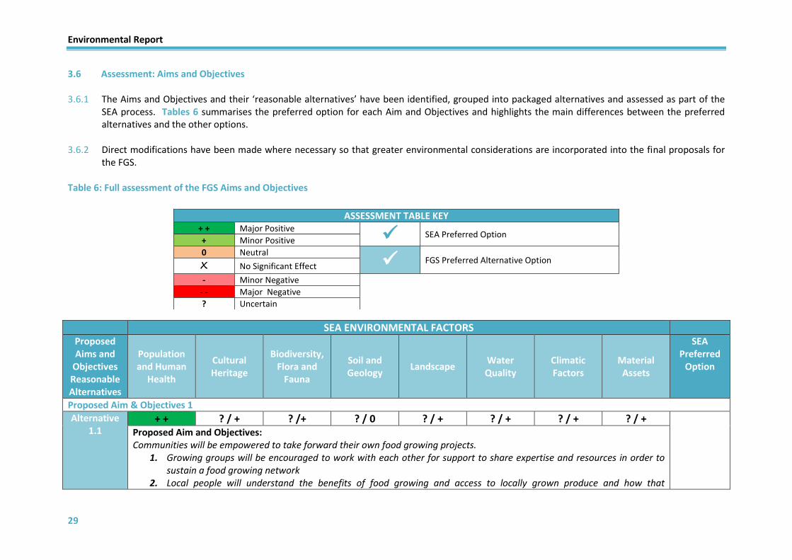
3.6 Assessment: Aims and Objectives
3.6.1 The Aims and Objectives and their ‘reasonable alternatives’ have been identified, grouped into packaged alternatives and assessed as part of the SEA process. Tables 6 summarises the preferred option for each Aim and Objectives and highlights the main differences between the preferred alternatives and the other options.
3.6.2 Direct modifications have been made where necessary so that greater environmental considerations are incorporated into the final proposals for the FGS.
Table 6: Full assessment of the FGS Aims and Objectives
SEA ENVIRONMENTAL FACTORS
Proposed Aims and
Objectives Reasonable Alternatives
Population and Human
Health
Cultural Heritage
Biodiversity, Flora and
Fauna
Soil and Geology
Landscape Water Quality
Climatic Factors
Material Assets
SEA Preferred
Option
Proposed Aim & Objectives 1
Alternative 1.1
+ + ? / + ? /+ ? / 0 ? / + ? / + ? / + ? / +
Proposed Aim and Objectives: Communities will be empowered to take forward their own food growing projects.
1. Growing groups will be encouraged to work with each other for support to share expertise and resources in order to sustain a food growing network
2. Local people will understand the benefits of food growing and access to locally grown produce and how that
ASSESSMENT TABLE KEY + + Major Positive
SEA Preferred Option + Minor Positive
0 Neutral FGS Preferred Alternative Option
X No Significant Effect
- Minor Negative
- - Major Negative
? Uncertain

Environmental Report
30
SEA ENVIRONMENTAL FACTORS
Proposed Aims and
Objectives Reasonable Alternatives
Population and Human
Health
Cultural Heritage
Biodiversity, Flora and
Fauna
Soil and Geology
Landscape Water Quality
Climatic Factors
Material Assets
SEA Preferred
Option
contributes to improved health and wellbeing, and reduces food waste 3. Training and skills development will be available to those who need it.
Assessment Commentary: Through this proposed aim and objectives will result in the potential for positive effects in relation to Population and Human Health. This is mainly through the community empowerment to take forward food growing projects and the related benefits and skills development/sharing and the related positive impacts on the health and wellbeing of communities. The effects on the remaining environmental factors are uncertain at this stage with the potential to provide positive or neutral impacts but this will be dependent on the link with other aims and objectives and action programme for the FGS.
Proposed Mitigation Measures / SEA Suggested Alteration Aim 1 – Addition of specific engagement will enhance the impact on population and human health. Objective 1 – By including the provision of direct support will further improve the positive impacts on population and human health factor. Objective 2 - Adjust to read “The benefits of food growing and links to health and wellbeing, a reduction in food waste, access to locally grown produce and its role in creating a high-quality built and natural environment will be understood“, which will ensure that multiple factors will have a more positive impacts through its implementation.
Alternative 1.2
+ + + + + + + ? / + +
Proposed Aim and Objective: Empower and engage communities to take forward food growing projects where they will learn from each other and have opportunities to develop skills to achieve their Grow-Your-Own aspirations.
1. Communities who want it will know where to get support to help start their journey towards growing their own fruit, herbs, vegetables and flowers. They will be encouraged to work with each other for support to share expertise and resources in order to sustain a food growing network.
2. The benefits of food growing and links to health and wellbeing, a reduction in food waste, access to locally grown produce and its role in creating a high-quality built and natural environment will be understood.
3. Partners will work towards the development of training and skills development initiatives to support community food growing.
Assessment Commentary:

Environmental Report
31
SEA ENVIRONMENTAL FACTORS
Proposed Aims and
Objectives Reasonable Alternatives
Population and Human
Health
Cultural Heritage
Biodiversity, Flora and
Fauna
Soil and Geology
Landscape Water Quality
Climatic Factors
Material Assets
SEA Preferred
Option
As with Alternative 1.1, the implementation of this proposed aim and objectives will result in the potential for positive effects in relation to Population and Human Health. Although with the suggested alterations, the impacts on Population and Human Health will be further enhanced and the potential for positive impacts on the other environmental factors are more likely. This is mainly through the promotion of the role the Strategy will have in creating a high quality built and natural environment and the demonstrable benefits of community food growing, local community involvement, support provision, skills development/sharing and the related positive impacts on the health and wellbeing of communities. The effects on the remaining environmental factors are uncertain at this stage with the potential to provide positive or neutral impacts but this will be dependent on the link with other aims and objectives and the action programme for the FGS.
Proposed Mitigation Measures / SEA Suggested Alteration: None
Proposed Aim & Objectives 2
Alternative 2.1
+ + ? / + ? / + ? / + ? / + ? / + ? / + ? / +
Proposed Aim and Objectives: Increase food growing opportunities by identifying sites suitable for growing.
1. We will identify land with potential suitability for allotments as well as sites for other forms of community growing. 2. Our allotment waiting list management and signposting to Grow-Your-Own opportunities will be up-to-date and
transparent to give local people fair and equal opportunities to access good quality land and support for food growing in compliance with the provisions of the Community Empowerment (Scotland) Act 2015.
3. The number of people on the allotment waiting list will be reduced.
Assessment Commentary: This proposed aim and objectives will result in the potential for significant positive effects in relation to Population and Human Health. This is mainly through the identification and provision of food growing opportunities and the related positive impacts on the health and wellbeing of communities. The effects on the remaining environmental factors are uncertain at this stage with the potential to provide positive impacts but this will be dependent on the location, state of the environment and criteria set for site selection.
Proposed Mitigation Measures / SEA Suggested Alteration: Aim 2 – By expanding on the scope of the aim, including reference to the sustainability of potential food growing

Environmental Report
32
SEA ENVIRONMENTAL FACTORS
Proposed Aims and
Objectives Reasonable Alternatives
Population and Human
Health
Cultural Heritage
Biodiversity, Flora and
Fauna
Soil and Geology
Landscape Water Quality
Climatic Factors
Material Assets
SEA Preferred
Option
opportunities it will enhance the positive nature on a number of environmental factors. Objective 3 – Adjust to read “The number of people on the allotment waiting list will be reduced and the number of people participating in Grow-Your-Own activities will increase“, which will improve the positive nature of the Objective and attempt to increase the level of participation in food growing projects/activities as well as reducing waiting lists for allotments.
Alternative 2.2
+ + + + ? / + + + ? / + +
Proposed Aim and Objectives: Increase food growing opportunities by identifying sites suitable for allotments and other growing provision and support the development of sustainable growing spaces across East Dunbartonshire.
1. We will identify land with potential suitability for allotments as well as sites for other forms of community growing 2. Our allotment waiting list management and signposting to Grow-Your-Own opportunities will be up-to-date and
transparent to give local people fair and equal opportunities to access good quality land and support for food growing in compliance with the provisions of the Community Empowerment (Scotland) Act 2015.
3. The number of people on the allotment waiting list will be reduced and the number of people participating in Grow-Your-Own activities will increase.
Assessment Commentary: As with Alternative 2.1, the implementation of this proposed aim and objectives will result in the potential for positive effects in relation to Population and Human Health. Although with the suggested alterations, the impacts on Population and Human Health, Cultural Heritage, Biodiversity, Flora and Fauna, Landscape, Water Quality and Material Assets are more likely and will provide additional benefits mainly through the expanded scope of the aim going beyond the requirements of the Community Empowerment Act by incorporating the sustainability agenda (linking with Aim 5) but also through the aspiration to increase participation in food growing projects/activities. The effects on the remaining environmental factors are uncertain at this stage with the potential to provide positive but this will be dependent on the site selection.
Proposed Mitigation Measures / SEA Suggested Alteration: Soil and Geology
- Further surveys of peatland/carbon rich soils should be carried out to ensure construction activities for community food growing opportunities achieve outcomes which will not devalue protected soil.
- Implement soil erosion prevention measures outlined in good practice guidance where necessary.

Environmental Report
33
SEA ENVIRONMENTAL FACTORS
Proposed Aims and
Objectives Reasonable Alternatives
Population and Human
Health
Cultural Heritage
Biodiversity, Flora and
Fauna
Soil and Geology
Landscape Water Quality
Climatic Factors
Material Assets
SEA Preferred
Option
Proposed Aim & Objectives 3
Alternative 3.1
+ + ? / + ? / + ? / 0 ? / + ? / + ? / + ? / +
Proposed Aim and Objective: Give young people the understanding of the benefits associated with food growing and access to skills development and growing spaces
1. Support will be available to all schools in East Dunbartonshire to engage in food growing projects 2. We will engage with young people to understand their need to access locally-grown food 3. We will work with organisations supporting older people and encourage them to engage in growing activities
Assessment Commentary: Through this proposed aim and objectives will result in the potential for significant positive effects in relation to Population and Human Health. This is mainly through the community empowerment to take forward food growing projects and engagement with young people regarding the benefits and skills development related to food growing. The effects on the remaining environmental factors are uncertain at this stage with the potential to provide positive or neutral impacts but this will be dependent on the link with other aims and objectives, the action programme and site proposals for community growing spaces.
Proposed Mitigation Measures / SEA Suggested Alteration: Aim 3 – Amendments should be made to make the aim more inclusive as it is currently focussed solely on young people. Objective 1 – Support could be expanded to other educational facilities to capture as many young people as possible. Objective 2 – Widen scope of objective to make it more inclusive. Objective 3 – Widen the scope to engage with all generations and related organisations.

Environmental Report
34
SEA ENVIRONMENTAL FACTORS
Proposed Aims and
Objectives Reasonable Alternatives
Population and Human
Health
Cultural Heritage
Biodiversity, Flora and
Fauna
Soil and Geology
Landscape Water Quality
Climatic Factors
Material Assets
SEA Preferred
Option
Alternative 3.2
+ + ? / + ? / + ? / 0 ? / + ? / + ? / + ? / +
Proposed Aim and Objective: Give all generations an understanding of the benefits associated with food growing, access to skills development and growing spaces, and encourage intergenerational activities
1. Schools and nurseries in East Dunbartonshire will be encouraged to engage in food growing projects 2. All generation will be encouraged and supported to grow their own and access locally-grown food 3. Everyone will be given opportunities to take part in skills development, food growing education and practical
gardening training
Assessment Commentary: As with Alternative 3.1, the implementation of this proposed aim and objectives will result in the potential for significant positive effects in relation to Population and Human Health. Although with the suggested alterations, the impacts on Population and Human Health will be further enhanced. This is mainly through the more inclusive nature of the aim and objectives to work and engage with all generations and provide community food growing and related skills development opportunities for all. The effects on the remaining environmental factors are uncertain at this stage with the potential to provide positive or neutral impacts but this will be dependent on the link with other aims and objectives, the action programme and site proposals for community growing spaces.
Proposed Mitigation Measures / SEA Suggested Alteration: None
Proposed Aim & Objectives 4
Alternative 4.1
+ + ? / + ? / + ? / 0 ? / + ? / + ? / + ? / +
Proposed Aim and Objectives: Promote community-led growing initiatives to encourage healthier, more active lifestyles and reduce physical and mental health and wellbeing inequalities.
1. Community growing initiatives will encourage social inclusion and a network of like-minded people. 2. Vulnerable people and their carers will be supported to participate fully in their communities. 3. We will support the reduction in health inequalities.
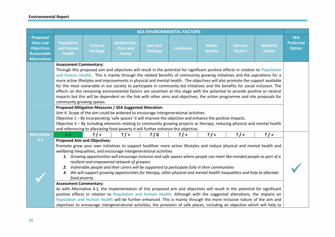
Environmental Report
35
SEA ENVIRONMENTAL FACTORS
Proposed Aims and
Objectives Reasonable Alternatives
Population and Human
Health
Cultural Heritage
Biodiversity, Flora and
Fauna
Soil and Geology
Landscape Water Quality
Climatic Factors
Material Assets
SEA Preferred
Option
Assessment Commentary: Through this proposed aim and objectives will result in the potential for significant positive effects in relation to Population and Human Health. This is mainly through the related benefits of community growing initiatives and the aspirations for a more active lifestyles and improvements in physical and mental health. The objectives will also promote the support available for the most vulnerable in our society to participate in community-led initiatives and the benefits for social inclusion. The effects on the remaining environmental factors are uncertain at this stage with the potential to provide positive or neutral impacts but this will be dependent on the link with other aims and objectives, the action programme and site proposals for community growing spaces.
Proposed Mitigation Measures / SEA Suggested Alteration: Aim 4- Scope of the aim could be widened to encourage intergenerational activities. Objective 1 – By incorporating ‘safe spaces’ it will improve the objective and enhance the positive impacts. Objective 3 – By including elements relating to community growing projects as therapy, reducing physical and mental health and referencing to alleviating food poverty it will further enhance this objective.
Alternative 4.2
+ + ? / + ? / + ? / 0 ? / + ? / + ? / + ? / +
Proposed Aim and Objectives: Promote grow your own initiatives to support healthier more active lifestyles and reduce physical and mental health and wellbeing inequalities, and encourage intergenerational activities
1. Growing opportunities will encourage inclusive and safe spaces where people can meet like-minded people as part of a resilient and empowered network of growers.
2. Vulnerable people and their carers will be supported to participate fully in their communities 3. We will support growing opportunities for therapy, other physical and mental health inequalities and help to alleviate
food poverty.
Assessment Commentary: As with Alternative 4.1, the implementation of this proposed aim and objectives will result in the potential for significant positive effects in relation to Population and Human Health. Although with the suggested alterations, the impacts on Population and Human Health will be further enhanced. This is mainly through the more inclusive nature of the aim and objectives to encourage intergenerational activities, the provision of safe places, including an objective which will help to

Environmental Report
36
SEA ENVIRONMENTAL FACTORS
Proposed Aims and
Objectives Reasonable Alternatives
Population and Human
Health
Cultural Heritage
Biodiversity, Flora and
Fauna
Soil and Geology
Landscape Water Quality
Climatic Factors
Material Assets
SEA Preferred
Option
alleviate food poverty and the contribution to improve community wellbeing. The effects on the remaining environmental factors are uncertain at this stage with the potential to provide positive or neutral impacts but this will be dependent on the link with other aims and objectives, the action programme and site proposals for community growing spaces.
Proposed Mitigation Measures / SEA Suggested Alteration: None
Proposed Aim & Objectives 5
Alternative 5.1
+ + ? / + + ? / + ? / + + + +
Proposed Aim and Objectives: Be considerate of and contribute to the achievement of the wider sustainability agenda through growing activities
1. Council owned and managed allotments will support biodiversity and green network priorities. 2. We will support groups to manage growing spaces for natural flood alleviation and water management. 3. New allotment sites will be accessible and located within walking and cycling distance, or near sustainable transport
links. 4. We will promote the food growing agenda to support the national zero waste agenda to help reduce local food miles
and food waste
Assessment Commentary: Through this proposed aim and objectives will result in the potential for significant positive effects in relation to Population and Human Health as well as positive impact on Biodiversity, Flora and Fauna, Water Quality, Climatic Factors and Material Assets. The aim refers to the wider local and national sustainability agendas as detailed in the Councils Sustainability and Climate Change Framework (SCCF) and referenced in the Local Outcomes Improvement Plan (LOIP). This along with the related objectives encompasses various agendas including localised climate change impacts such as flood risks and urban heating, sustainable material and resource use, protection and enhancement of biodiversity including pollinator species, protection of the built environment, maintenance and enhancement of soil condition and impacts relating to food waste, food poverty and food miles. The effects on the remaining environmental factors are uncertain at this stage with the potential to provide positive or neutral impacts but this will be dependent on the link with other aims and objectives, the action programme and site proposals for community growing spaces.

Environmental Report
37
SEA ENVIRONMENTAL FACTORS
Proposed Aims and
Objectives Reasonable Alternatives
Population and Human
Health
Cultural Heritage
Biodiversity, Flora and
Fauna
Soil and Geology
Landscape Water Quality
Climatic Factors
Material Assets
SEA Preferred
Option
Proposed Mitigation Measures / SEA Suggested Alteration: Objective 1 – The scope of this objective should be expanded to include all community growing activities, rather than restricting the objective to Council owned or managed allotments only. This will further enhance the likely impacts on multiple environmental factors. Objective 2 – Reword to read “New and existing growing spaces will be encouraged to implement best practice growing techniques and innovative design features to mitigate and adapt to local climate change issues.” Objective 3 – Reword to read “All growing spaces will be accessible to all and new sites will be located within walking, cycling or accessible sustainable transport distance”
Alternative 5.2
+ + ? / + + + + ? / + + + + + +
Proposed Aim and Objectives: Be considerate of and contribute to the achievement of the wider sustainability agenda through growing activities.
1. All growing activities will support both regional and local green infrastructure, green network and biodiversity priorities, with consideration for heritage, native and organic growing and quality soils where possible
2. New and existing growing spaces will be encouraged to implement best practice growing techniques and innovative design features to mitigate and adapt to local climate change issues
3. All growing spaces will be accessible to all and new sites will be located within walking, cycling or accessible sustainable transport distance
4. We will promote the food growing agenda to support the national zero waste agenda to help reduce local food miles and food waste
Assessment Commentary: As with Alternative 4.1, the implementation of this proposed aim and objectives will result in the potential for significant positive effects in relation to Population and Human Health. Although with the suggested alterations, the impacts on Population and Human Health, Biodiversity, Flora and Fauna, Soil and Geology, Water Quality, Climatic Factors and Material Assets will be further enhanced or become more likely due to the improvements. This is mainly through: Objective 1 – expanding the scope by incorporating all growing activities, improving the positive impacts by including links to the green infrastructure and green network, biodiversity priorities and also the consideration of quality soils. Objective 2 – This option aims to capture a range of climate change issues holistically, such as urban heating, food insecurity

Environmental Report
38
SEA ENVIRONMENTAL FACTORS
Proposed Aims and
Objectives Reasonable Alternatives
Population and Human
Health
Cultural Heritage
Biodiversity, Flora and
Fauna
Soil and Geology
Landscape Water Quality
Climatic Factors
Material Assets
SEA Preferred
Option
and flood risk and water management. By doing so, the Strategy can explore how it aims to address these issues through actions, specifically how and what people are growing and the initiatives used on site, such as rain water harvesting and drainage, to adapt to and alleviate issues. Objective 3 – Per the CE Act, all allotment sites should be accessible, within reason. This options enhances the legal duties on local authorities as all growing spaces, be that allotments or community gardens for example, should demonstrate consideration as to how accessible they are for all people and abilities, as well as how accessible they are by sustainable modes of transport in line with the Aim.
Proposed Mitigation Measures / SEA Suggested Alteration: None
3.6.3. The proposed Aims and Objectives, and all reasonable alternatives, for the FGS have been considered through the SEA process. The outcome of
the assessment is that each of the SEA preferred options have been carried forward into the Strategy, in some cases incorporating SEA suggested alterations and/or mitigation. The preferred options that were carried forward into the Strategy demonstrate wider environmental advantages, significantly in relation to the Population and Human Health topic area but also for a variety of other factors depending on the package of Aim and Objectives (detailed above).

Environmental Report
39
3.7 Assessment: Potential Community Food Growing Sites
3.7.1 An environmental assessment has been undertaken for each of the community food growing sites brought forward from the Stage 1 - Fit for purpose assessment. The site assessments have been recorded in the form of a matrix identifying the environmental performance against each of the scoped-in environmental factors and set criteria.
3.7.2 SEA suggested alterations and/or mitigation measures have been made where necessary to ensure that greater environmental considerations are incorporated into the final proposals for the FGS. This has been done through SEA commentary and suggested mitigation sections for each proposed site.
3.7.3 The full site assessment for each potential community growing space are contained within Appendix D. The site assessment findings, suggested
alterations and proposed mitigation measures have been used to form the decision-making within the FGS and the allocation of potential community growing site opportunities. When applications are received by the Council the SEA suggested alterations and mitigation measures will be used to form key requirements and put conditions in place to ensure that the SEA information is integrated into the project level in an efficient process.
3.7.4 Whilst the assessments highlighted positive impacts, the main negative impacts identified were attributable to a number of the sites being
unsustainable locations and potential for sites to exacerbate the risk of poor drainage and increased risk of flooding and surface water run-off and the related impacts on population and human health, climatic factors and material assets. Where negative impacts have been identified the environmental assessments of the sites have included mitigation measures or SEA suggested alterations to address these negative impacts and further enhance any of the positive impacts identified.

Environmental Report
40
3.8 Cumulative Impacts 3.8.1. Following the assessment of each of the components of the FGS an assessment of the
cumulative effects is carried out. Cumulative effects can arise from the combined effects of plans. They can also arise as a result of interaction between different components of a single plan. For example, where several developments each have insignificant effects but together have a significant effect, or where several individual effects of the PPS have a combined effect.
3.8.2. It should be noted that, with the implementation of the proposed mitigation measures suggested in each of the individual local opportunities assessments, the effects for each of the environmental factors are likely to be neutralised and other effects could potentially become more positive in nature.
3.8.3. The cumulative, secondary and synergistic effects of the FGS vision, objectives and proposed community food growing sites on the East Dunbartonshire wide area have been determined as detailed below:
3.8.4. The cumulative nature of the effects on Population and Human Health are anticipated to be major positive. The combined anticipated minor/major positive impacts of the Vision, Aims, Objectives and Community Growing sites on this SEA criteria are due to a number of factors including:
Provision of safe environments to demonstrate the benefits for communities and associated health and wellbeing aspects of community food growing;
Increased provision of community food growing assets which encourage active travel/sustainable travel and outdoor leisure;
Better access to quality provisions and services at a local level; and,
Opportunities for local communities and individuals to become involved in local community based projects.
3.8.5. The cumulative nature of the effects on Cultural Heritage, is likely to be insignificant overall. However the assessment of the Aims, Objective and a small number of Community Growing Sites identified minor positive/negative impacts in terms of the setting of historical designations such as the Antonine Wall World Heritage Site, Scheduled Monuments and locally important Garden and Designed Landscapes which is dependent on the receiving environment and the detailed proposal.
3.8.6. The cumulative nature of the effects on Biodiversity, Flora and Fauna are anticipated to be major positive. The combined anticipated minor/major positive impacts of the Vision, Aims, Objectives and Community Growing sites on this SEA criteria are mainly due to:
The introduction of community growing opportunities potentially enhancing biodiversity value and green network links; and
Encouragement of biodiversity-friendly practices. 3.8.7. The cumulative nature of the effects on Soil and Geology, is likely to be insignificant overall.
However the assessment of the Vision, Aims, Objective and a number of Community Growing Sites identified uncertain, minor positive/negative impacts related to:
The potential remediation of vacant, derelict and/or contaminated land; and
The improvement of contaminated land and promotion of sites as a community asset.
Environmental Report
41
3.8.8. The cumulative nature of the effects on Landscape are anticipated to be major positive. The combined anticipated minor/major positive impacts of the Vision, Aims, Objectives and Community Growing sites on this SEA criteria are mainly due to: the introduction of community growing opportunities potentially improving the attractiveness of sites within settlements and enhance landscape character and visual amenity value.
The development of community growing opportunities improving the attractiveness of sites and the related settlements, enhancing landscape character and visual amenity value; and
Enhancing green network links and biodiversity value.
3.8.9. The cumulative nature of the effects on Water Quality, is likely to be insignificant overall. However the assessment of the Vision, Aims, Objective and a number of Community Growing Sites identified uncertain, minor positive/negative impacts related to:
Proposals which could result in a reduction of risk to the ecological status of the water environment; and
The increased risk of exacerbating surface water issues, increase risk of run-off from impacts to soil or the proposed uses.
3.8.10. The cumulative effects on Climatic Factors are anticipated to be major positive and major
negative in nature through a significant contribution of combined minor positive and minor negative impacts. The combined anticipated minor positive impacts of the Vision, Aims, Objectives and Community Growing Sites on this criteria are mainly due to:
The integration of mitigation or adaptation proposals to support the Council and Scottish Government climate change goals;
Proposals for and potential for additional enhanced natural resources for flood alleviation and carbon capture; and
Increased provision and promotion of community food growing in sustainable locations to support active travel and sustainable transport Options.
3.8.11. The combined anticipated minor/major negative impacts of the Vision, Aims, Objectives and
Community Growing Sites on Climatic Factors are mainly due to:
The development of community growing opportunities in certain locations could pose significant issues Council-wide in relation to flood risk (pluvial and fluvial);
Flood risk could impact on drainage combined with the potential to exacerbate or transfer flooding or drainage risks to neighbouring areas;
Provision and promotion of community growing spaces in locations which would not support active or sustainable transport alternatives.
3.8.12. The cumulative effects on Material Assets are anticipated to be major positive in nature
through a significant contribution of combined minor positive impacts. The combined anticipated minor positive impacts of the Vision, Aims, Objectives and Community Growing Sites on this criteria are mainly due to:
Increased provision of community food growing assets which encourage active travel/sustainable travel and outdoor leisure;
Better access to quality provisions and services at a local level;
Opportunities for local communities and individuals to become involved in local community based projects;
Potential to incorporate low carbon technologies and sustainable materials into the design concepts for community growing spaces;
The potential remediation of vacant, derelict and/or contaminated land; and

Environmental Report
42
The improvement of contaminated land and promotion of sites as a community asset.
3.9. Influence of SEA on the Food Growing Strategy 3.9.1. Through each of the assessments for the Vision, Aims, Objectives and Community Growing
Sites, there have been notable examples of the positive influence of SEA on the development of the FGS including the acceptance of the vast majority of SEA suggested alterations, the inclusion as the Strategy preferred options and proposed mitigation measures to be integrated into the Strategy. The SEA preferred options were fed back to the FGS stakeholders and an agreement was made to adopt these into the final draft of the FGS.
3.9.2. However, the SEA preferred option for the Vision was not adopted as the Strategy preferred option. Therefore justification for this decision was requested and provided by the plan-makers. The reason for this decision was that the strategy preferred vision provides a clear focus for the Council and captures the long term aspirations of the Strategy without limiting its scope. The SEA process has influenced the vision and strategic direction of the FGS by ensuring that the additional elements proposed within the SEA preferred vision are incorporated into the Aims and Objectives for the Strategy.
3.9.3. Mitigation measures have also been identified as part of the assessments where appropriate
and discussed with the relevant stakeholders in order to avoid adverse impacts, reduce the significance of the effects or enhance neutral or positive impacts. Mitigation has also taken the form of suggested alterations to the wording of the policy options considered and project level mitigation.

Environmental Report
43
Section 4: Mitigation and Monitoring
4.1 Mitigation Measures
4.1.1. Schedule 3 paragraph 7 of the Environmental Assessment (Scotland) Act 2005 require that the Environmental Report includes the measures envisaged to prevent, reduce and, as fully as possible, offset any significant adverse effects on the environment of implementing the Food Growing Strategy (FGS).
4.1.2. Mitigation measures have been proposed and incorporated into each of the assessments, where necessary, in order to avoid, reduce, mitigate or offset any potential adverse environmental impacts and enhance any neutral or positive environmental impacts identified. For the assessment of the FGS, mitigation has been incorporated into the assessments in the form of SEA suggested alterations which have led to more positive environmental ratings and their adoption as the Strategy preferred option in the majority of cases.
4.1.3. When applications are received by the Council for community growing sites, the SEA suggested alterations and mitigation measures will be used to form key requirements and put conditions in place to ensure that the SEA information is integrated into the project level in an efficient process.
4.2 Monitoring
4.2.1 Through Section 19 of the Environmental Assessment (Scotland) Act 2005, East
Dunbartonshire Council is required to monitor significant environmental effects of the implementation of the FGS. The monitoring should be implemented to enable the identification of any unforeseen adverse effects at an early stage to allow the appropriate remedial action to be implemented.
4.2.2 The specific measures that are to be taken to monitor the significant environmental effects of the implementation of the FGS will form part of the Post-Adoption Statement, prepared as soon as reasonably practicable after the adoption of both documents in accordance with Section 18 of the Act. It is envisaged that the following indicators will be included within the monitoring framework.
4.2.3 The proposed SEA monitoring framework (Table 7) will directly align with the monitoring framework for the FGS.
Table 7: Proposed SEA Monitoring Framework for the FGS
SEA
C
ate
gory
Indicators Data Source
Po
pu
lati
on
, H
um
an H
eal
th Changes in deprivation levels according to SIMD statistics SCROL
Access to sustainable travel routes and open space EDC
Number of community/volunteer-led projects and level of involvement
EDC
Number of people who utilise the natural environment for leisure activities
EDC/EDLT
Environmental Report
44
Crime and anti-social behaviour levels EDC/ SCROL / Police Scotland
Waiting lists for allotments EDC
Number of new community growing assets/upgrades to existing assets
EDC
Cu
ltu
ral
Her
itag
e Number of cultural heritage assets (see Table 1) affected (positively and/or negatively) by the development of community growing assets
EDC / Historic Environment
Scotland
Bio
div
ersi
ty, F
lora
an
d
Fau
na
Number of biodiversity assets (see Table 1) affected (positively and/or negatively) by the development of community growing assets
EDC / SNH
Total area of protected sites (priority species) and changes to protected sites
Quality and connectivity of the green network in East Dunbartonshire
Number of biodiversity and natural environment projects undertaken involving the local community/volunteers
Soil
and
G
eo
logy
Area of existing vacant, derelict and contaminated land altered by community growing actions/projects
EDC
Changes to the number of vacant and derelict land sites in East Dunbartonshire
EDC
% of peatland improved/deteriorated EDC / SEPA
Lan
dsc
ape
Number of habitat/green network assets improved/created/deteriorated EDC / SNH
Changes in perception of local community areas and their local distinctiveness EDC
Wat
er
Qu
alit
y Changes to the classification of water bodies in line with the requirements of the Water Framework Directive
EDC / SEPA
Changes to the number of vacant and derelict land sites in East Dunbartonshire
EDC
Clim
atic
Fa
cto
rs Loss/creation of tree assets in East Dunbartonshire EDC / Forestry
Commission / SNH
Changes to flooding and drainage (SEPA Flood Risk Mapping) EDC / SEPA
Greenhouse gas output trends in East Dunbartonshire EDC / SEPA
Mat
eri
al A
sset
s Area of existing vacant, derelict and contaminated land altered by community actions/projects
EDC
Changes to the number of vacant and derelict land sites in East Dunbartonshire
EDC
Active and public transport patronage EDC
Access to sustainable travel routes and open space EDC

Environmental Report
45
Section 5: Statutory Consultation and SEA Timetable
5.1 Statutory Consultation 5.1.1. The statutory consultation for this SEA document and corresponding Food Growing
Strategy (FGS) is:
15th April 2019 – 9th June 2019
5.1.2. Responses should be submitted through email or post to the following addresses:
Email: [email protected]
Post: Sustainability Policy Place, Neighbourhood and Corporate Assets East Dunbartonshire Council Southbank House Strathkelvin Place Kirkintilloch G66 1XQ
5.2 SEA Timetable
5.2.1. The SEA activities to date and approximate timetable for the FGS for further SEA stages are summarised below (Table 8). The SEA process has aligned with the development stages for the Plan itself.
5.2.2. Please note that the anticipated timescales for the completion of further SEA stages and the Plan may require to be extended if contributions from the Outcome Delivery Groups are delayed or are reallocated due to failure of Partners to deliver them.
Table 8: Consultation and SEA timetable
Strategy Preparation Stages SEA Stages Timescale & Consultation Period, if required
Preliminary Assessment and Survey / Research work
Screening Report:
Production of Screening Report
Screening Determination
Screening Report produced and submitted 4th October 2017
Screening Determination produced and submitted 26th October 2018
Preliminary Assessment and Survey / Research work
Scoping Report:
Collate and forecast baseline environmental
March – April 2018 (research and draft)
Scoping Report submitted to the SEA

Environmental Report
46
information
Adopt SEA environmental objectives and criteria
Gateway on 19th April 2018
5 week period of Consultation with the Consultation Authorities.
Prepare Draft Plan Environmental Assessment:
Assess the FGS vision, aims and objectives and community food growing sites
Assess alternatives to the FGS
Prepare Draft Environmental Report
June-December 2018
Publish & Consult on Draft Plan Publish & Consult on Draft Environmental Report
Seeking Committee Approval for the Draft Strategy and ER at Place, Neighbourhood and Corporate Assets Committee 31st January 2019
Submission of the Draft ER to the CA’s March 2019 (6 week consultation)
Adopt Plan Produce Post-Adoption Statement and publish along with the adopted Finalised FGS
Final Strategy aiming to publish in January 2020
Submission of Post-Adoption Statement to the CAs February/March 2020
Monitor & Review Monitor and Review On-going/Annual review

Environmental Report
47
Section 6: Appendices
Appendix A Initial list of the International, European Community and National Protection, Regional
and Local Objectives
Appendix B Consultation Reponses to the Scoping Report
Appendix C SEA Assessment Criteria and Questions
Appendix D Community Food Growing Site Assessments
Appendix E Development and Assessment of Reasonable Alternatives

Environmental Report
48
Appendix A: Relevant Policies, Plans, Programmes, Strategies, Legislation and Environmental Protection Objectives Please note that this appendix lists key legislation, plans, programmes, policies and strategies that influence or are influenced by the Food Growing Strategy. Their content, where appropriate, has been used to inform the environmental objectives for the SEA of the Plan.
Relevant PPS and Legislation
Summary / Objectives or requirements How objectives and requirements influence or are influenced
by the Food Growing Strategy
International
Rio Declaration (1992)
The Declaration sets out 27 principles to enable the global community to work towards international agreements that respect the interests of all and protect the integrity of the global environmental and developmental system. The Declaration highlighted the necessity to protect and enhance the environment, economics and social aspects in both developed and developing countries.
The FGS will demonstrate a commitment at a local level to realise economic, social and environmental wellbeing as much as possible for the residents and visitors of East Dunbartonshire.
Johannesburg Declaration
(2002)
The Johannesburg Declaration on Sustainable Development. The 2002 Declaration built upon the principles established through the Rio Declaration and further developed principles of sustainable development and sought international commitment to these Sustainable Development Principles.
Within the FGS, all outcomes will be guided by sustainable development principles.
National
Local Government in Scotland Act
2003
This Act describes the way in which local authorities discharge their functions and about the local provision of certain public services; to give local authorities power to do things which they consider will advance well-being; to provide exemptions and reliefs from non-domestic rates in relation to certain lands and heritages; to confer power on the Scottish Ministers to combine certain lands and heritages for the purposes of assessing rateable value; to require local authorities to prepare, and endeavour to implement, a plan relating to the carrying out of their waste disposal and collection functions; to make new provision about the capital expenditure of those authorities and about the making
The Local Government in Scotland Act 2003 set the statutory basis for community planning in which the Community Empowerment (Scotland) Act 2015 stems from.

Environmental Report
49
of capital grants to them; to make some miscellaneous provisions connected with the functions of local authorities; and for connected purposes.
Community Empowerment
(Scotland) Act 2015
The Community Empowerment Act will help to empower community bodies through the ownership of land and buildings, and by strengthening their voices in the decisions that matter to them. It will also improve outcomes for communities by improving the process of community planning, ensuring that local service providers work together even more closely with communities to meet the needs of the people who use them. The Act does a number of things including: extending the community right to buy, making it simpler for communities to take over public sector land and buildings, and strengthening the statutory base for community planning. Crucially it can help empower community bodies through the ownership of land and buildings and strengthening their voices in the decisions and services that matter to them.
The Community Empowerment (Scotland) Act 2015 replaced Local Government in Scotland 2003 as the primary legislative provision for community planning. Part 9 of the Community Empowerment (Scotland) Act 2015 relates specifically to Allotments and sets out definitions for an allotment, the requirements for local authorities to provide allotments, maintain a list for local demand, leasing opportunities and maintenance of access to allotments. Specific for the preparation of a Food Growing Strategy, the Act sets a duty upon all local authorities in Scotland to prepare a food-growing strategy, review the strategy every 5 years and as part of the strategy conduct an annual allotments report with the details of all of the different allotments in the local authority’s area. The Act is the main driver behind the preparation of the Food Growing Strategy for East Dunbartonshire.
National Planning Framework 3
The National Planning Framework 3 is the Scottish Government’s Strategy for the long term development of Scotland’s towns, cities and the countryside. It sets out key planning outcomes for Scotland:
A successful sustainable place – supporting economic growth, regeneration and the creation of well-designed places
A low carbon place – reducing our carbon emissions and adapting to climate change
A natural resilient place – helping to protect and enhance our natural cultural assets and facilitating their sustainable use
A connected place – supporting better transport and digital connectivity
A sustainable, low carbon and natural resilient place are the most relevant outcomes that the Food Growing Strategy is likely to align with.
The consolidated SPP provides a shorter, clearer and more

Environmental Report
50
Scottish Planning Policy (SPP)
focused statement of national planning policy. The SPP and NPPG series has been replaced by a single SPP. As part of the commitment to proportionate and practical planning policies, the Scottish Government has rationalised national planning policy.
The SPP sets out:
the Scottish Government's view of the purpose of planning,
the core principles for the operation of the system and the objectives for key parts of the system,
statutory guidance on sustainable development and planning under Section 3E of the Planning etc. (Scotland) Act 2006,
concise subject planning policies, including the implications for development planning and development management, and
The Scottish Government's expectations of the intended outcomes of the planning system.
Alongside policy on development plans, development management, community engagement, sustainable development, climate change and sustainable economic growth, the SPP sets out policies related to the delivery of low carbon communities and natural heritage.
Scottish Planning Policy (SPP) outlines the need for community engagement, sustainable development, and contributions towards the requirements of the Climate Change (Scotland) Act 2009. It also lists open space and physical activity as a key priority for Scotland’s planning system which the Food Growing Strategy is likely to contribute to.
Scottish Government
National Outcomes
Fifteen National Outcomes were set for the Scottish Government, and were updated in 2011. These include:
We live in a Scotland that is the most attractive place for doing business in Europe.
We realise our full economic potential with more and better employment opportunities for our people.
We are better educated, more skilled and more successful, renowned for our research and innovation.
Of the 15 National Outcomes, the outcomes that will link to the Food Growing Strategy are:
We are better educated, more skilled and more successful, renowned for our research and innovation.
We live longer, healthier lives.
We have improved the life chances for children, young people and families at risk.
Environmental Report
51
Our young people are successful learners, confident individuals, effective contributors and responsible citizens.
Our children have the best start in life and are ready to succeed.
We live longer, healthier lives.
We have tackled the significant inequalities in Scottish society.
We have improved the life chances for children, young people and families at risk.
We live our lives safe from crime, disorder and danger.
We live in well-designed, sustainable places where we are able to access the amenities and services we need.
We have strong, resilient and supportive communities where people take responsibility for their own actions and how they affect others.
We value and enjoy our built and natural environment and protect it and enhance it for future generations.
We take pride in a strong, fair and inclusive national identity.
We reduce the local and global environmental impact of our consumption and production.
Our people are able to maintain their independence as they get older and are able to access appropriate support when they need it.
Our public services are high quality, continually improving, efficient and responsive to local people’s needs.
We live in well-designed, sustainable places where we are able to access the amenities and services we need.
We have strong, resilient and supportive communities where people take responsibility for their own actions and how they affect others.
We value and enjoy our built and natural environment and protect it and enhance it for future generations.
We reduce the local and global environmental impact of our consumption and production.
Our people are able to maintain their independence as they get older and are able to access appropriate support when they need it.
Regional
Clydeplan 2016
Placemaking Principle: Adaptable
Supporting a Successful and Sustainable city region, Natural, Resilient city region
Supports the ‘compact city’ model with priority given to
By setting the spatial vision for planning at a regional level and the planning outcomes it aims to achieve align with Scotland’s national outcomes and helps to inform the local interpretation for planning. This will need to be reflected within the FGS.

Environmental Report
52
brownfield locations supporting low energy consumption and higher residential density within a mixed land use context
Contributes towards the delivery of the Glasgow and Clyde Valley Green Network in particular and support for community growing.
Supports the ’town centre first principle’, where multiple uses and activities including housing, retail employment and community facilities are clustered in accessible locations in support of the centres role and function.
Sow and Grow
Everywhere (SAGE) Strategy
SAGE (Sow And Grow Everywhere) Strategy was a visionary initiative focussed on bringing changes to community food growing in the Glasgow and Clyde Valley (GCV) area. It was partnered by the GCV Green Network Partnership exploring the following:
bringing vacant and derelict land in densely populated urban areas into use for growing as an interim land use
bringing underused land (amenity space) in peripheral estates and social housing areas (‘green desert’) into use at scales up to market garden growing
bringing under used private garden space in suburban or outlying areas into use for growing
bringing under used public land into active use for growing
The Strategy provided the template for Glasgow City Council’s Stalled Space initiative and launched several projects including:
Shettleston Community Growing project - for Glasgow City Council / Shettleston Housing Association
Greyfriar's Gardens - for Glasgow City Council / Merchant City Community Council
Gartnavel Growing Space - for NHS Greater Glasgow & Clyde / Forestry Commission Scotland
Partick Growing Space - for Partick Housing Association
East Dunbartonshire Council’s Food Growing Strategy will be able to reflect, where possible, the principles explored in the SAGE Strategy.

Environmental Report
53
Bellsmyre Growing Space - for the Bellsmyre Community Garden Association
Possil Health Centre - with the Green Exercise Partnership (Forestry Commission Scotland /Scottish Natural Heritage /NHS collaboration) & the NHS Greater Glasgow & Clyde
Other Authority
Best Practice
The other authorities to which this would relate include:
Cultivating Communities: A Growing Challenge. (An allotments strategy for the City of Edinburgh 2010-2015
Belfast Outdoors – Growing Communities: A Citywide Strategy for Belfast 2012-2022
Brighton and Hove Allotments Strategy 2014-2024
The content of other authorities’ successful strategic actions have the potential to positively influence the outcomes of the EDC FGS and should be taken into account where appropriate.
Local (East Dunbartonshire Council)
East Dunbartonshire
Community Planning
Partnership Local Outcome
Improvement Plan (LOIP)
The LOIP reiterates the strategic direct, priorities and outcomes for East Dunbartonshire Council that will be delivered in partnership with the Community Planning Partners. It sets a vision for East Dunbartonshire ‘Working together to achieve the best with the people of East Dunbartonshire.’ The LOIP also hosts a number of Local Outcomes and Guiding Principles for the Community Planning Partners to adhere to and strive for.
The most relevant elements of the LOIP which will help to drive forward the FGS are throughout East Dunbartonshire, include:
- Local Outcome 5: Health and Wellbeing – Our people and communities enjoy increased physical and mental health and wellbeing.
- Guiding Principle 1: Planning for Place We will target resources where they are most needed to reduce disadvantage caused by socio-economic inequality.
- Guiding Principle 2: Sustainability - We will create the conditions for a better quality of life for East Dunbartonshire residents, by recognising the importance of the quality of our built, natural and historic environment in improving the health and wellbeing of our communities. Our environments must also support sustainable economic growth in our communities. We will protect and enhance our local natural environment, build resilience to a changing climate, use natural resources prudently and consider the long term implications of our decisions for present and future

Environmental Report
54
generations.
Locality Plans
The Locality Plans respond to a series of Place consultation and community engagement events in each of East Dunbartonshire Council’s areas of multiple deprivation to identify the needs of the local community. Overall the Plans will prioritise an approach to improving the outcomes for children, young people, families and the adult population within each area of deprivation. The Locality Plans respond to the requirements of the Community Empowerment (Scotland) Act 2015 and will be a distinctive local expression of the Vision, Outcomes and Guiding Principles of the emerging Local Outcome Improvement Plan (LOIP).
Although not exclusively, the Food Growing Strategy will aim to increase provision and access to food growing opportunities in areas identified as being socially-economically disadvantaged in line with the areas targeted in the Locality Plans. The Locality Plans and Food Growing Strategy should complement each other where the localities of Auchinairn, Hillhead and Harestanes, Twechar and Lennoxtown are focussed on.
Local Development Plan
2017 – 2022
The LDP for East Dunbartonshire sets the framework for the growth and development of East Dunbartonshire up to 2022 and beyond and establishes a presumption in favour of development that contributes to sustainable development as defined in Scottish Planning Policy.
Outlined within the proposed Local Development Plan (LDP) is support for new and/or improved community facilities and open space. In particular, Policy 7: Community Facilities and Open Space support provision within the green belt of a compatible scale and character with the landscape such as growing spaces. The Plan also states that more information on growing spaces will be outlined in a Community Growing Space Strategy (now referred to as the Food Growing Strategy) and Green Infrastructure and Green Network Planning Guidance. In addition, there is reference to King George V Park, Etive Park, Ashburn Gardens and Craigfoot Field as opportunities for further consideration as growing spaces as proposed in EDC’s Open Space Strategy.
Local Development Plan – Developer
Contributions Supplementary Guidance 2017
The draft LDP Developer Contributions Supplementary Guidance provides detail on the developer contributions that will be sought in determining relevant planning applications. In terms of open space provision the following contribution requirements for residential developments are set out as:
Play Space- £730 per unit
Open Space of Local Importance- £180 per unit
Open Space/ Green Network of Neighbourhood Importance- £310 per unit
Monies must be spent on projects relevant to the nature by which the contribution was sought and all other necessary requirements of Scottish Government Circular 3/2012: Planning Obligations and Good Neighbour Agreements so there is potential scope for this to apply to food growing projects.

Environmental Report
55
Open Space/ Green Network of Regional/ Strategic Importance- £310 per unit (sites of over 50 dwellings only)
Sustainability and
Climate Change Framework 2016
The SCCF is intended as a foundation for considering how Council policies, programmes, plans and strategies can contribute to the delivery of the Council’s main sustainability priorities:
Zero carbon: reducing carbon emissions
Maximising resilience to the impacts of climate change
Zero waste: reducing material use and waste generation
Reversing biodiversity decline
Sustainable materials
Maximising opportunities to promote health and wellbeing
Supporting fairness and reducing inequality locally and globally
Promoting community empowerment
Supporting local businesses.
Of these main sustainability priorities, the Food Growing Strategy is likely to contribute towards zero waste, reversing biodiversity decline, sustainable materials, maximising opportunities to promote health and wellbeing, supporting fairness and reducing inequality locally and globally and promoting community empowerment.
Community Asset Transfer Policy
The CAT Policy intends to define a set of rules and a procedure for dealing with community asset transfer requests under part 5 of the Community Empowerment (Scotland) Act 2015 taking into account the requirements set out within the Asset Transfer (Procedure)(Scotland) Regulations 2016 and associated guidance that came into effect 23rd January 2017. Whilst the CAT Policy will demonstrate some links to East Dunbartonshire’s Council Corporate Asset Management Plan (CAMP), the Policy will not be directly governed by existing procedures within the CAMP as it will set out its own specific procedure related to the transfer of Council owned assets to community groups.
As the Food Growing Strategy is likely to encourage community empowerment to take establish and take on the management of food growing initiatives, the Community Asset Transfer Policy will support community groups to achieve this.
Open Space Strategy 2015-2020
The East Dunbartonshire Open Space Strategy (2015 – 2020) replaced the East Dunbartonshire Greenspace Audit and Strategy 2004. It sets the framework for current and future open space provision in the Council area, meeting the requirement of Scottish
The Open Space Strategy (2015 – 2020) provides the Council’s Open Space Planning team with a viable and enforceable tool to define open space requirements and establish requirements for new open space from development proposals together with the

Environmental Report
56
Planning Policy for local authorities to prepare an Open Space Audit and Strategy. It also contributes to the development of the Central Scotland Green Network, promoted in the National Planning Framework 3. The Strategy will be reviewed and updated every 5 years.
scale and nature of any planning obligations. The OSS aspires for local access to allotments and community growing spaces, recognising them as a key open space provision in East Dunbartonshire. The Strategy also identifies existing allotment sites and indicates sites that would be potentially feasible as allotments or community growing spaces in the future with development. These should be considered in the development of the Food Growing Strategy.
Green Network Strategy 2017-2022
The purpose of the Green Network Strategy (GNS) is to define the existing strategic green network in East Dunbartonshire using GIS mapping analysis to identify opportunities for the enhancement of the existing green network in both urban and rural locations. The opportunities mapping methodology will guide the identification of areas that are eligible for the expansion and/or enhancement of the green network in order to improve habitat connectivity, increase active travel provision and enhance access to open spaces, as well as health and wellbeing benefits and opportunities for adaptation to the effects of climate change.
The Green Network Strategy provides the Council with a viable and enforceable tool to define green network opportunities and will establish requirements for new green network open opportunities from development proposals together with the scale and nature of any planning obligations. The Food Growing Strategy will add to the beneficial elements of the Green Network Strategy by encapsulating the role of access to the outdoors and local environment for enhanced biodiversity value, outdoor provision and health and wellbeing.
Local Biodiversity Action Plan 2017-
2021
The Local Biodiversity Action Plan (LBAP) 2016 – 2020 takes a strategic approach to protecting biodiversity across the East Dunbartonshire Council-wide area, including Mugdock Country Park (Stirling Council and the Joint Committee for the Park were involved in issues related to the Park). The LBAP recognises the importance of biodiversity at both a national and a local level. The production of a new LBAP replaced the Dunbartonshire Biodiversity Action Plan 2013 (East Dunbartonshire and West Dunbartonshire) for an updated, co-ordinated and targeted approach to the protection and enhancement of biodiversity. An ecosystem approach was taken in the development of the LBAP, focussing on Urban, Rural, Woodland and Freshwater ecosystems. Each Ecosystem Plan has its own set of objectives and
The Local Biodiversity Action Plan provides the Council with a viable and enforceable tool to protect and enhance biodiversity throughout East Dunbartonshire and will establish requirements for biodiversity enhancements and mitigation measures from development proposals together with the scale and nature of any planning obligations. Local food growing can contribute to improving the range of biodiversity at a local level and will contribute to the overall aims of the LBAP. The Food Growing Strategy should also consider the objectives and actions in the LBAP in order to align with it.

Environmental Report
57
provides information on associated priority habitats and lists the priority species. The actions within the plan tend to take a habitat focused approach to conserving biodiversity but some species that need an additional helping hand or that we need to gather further survey information for may also have specific actions.
Active Travel Strategy 2015-2020
This is the first Active Travel Strategy (ATS) for East Dunbartonshire. The ATS supplements the current Local Transport Strategy (LTS) 2013-2017 and sets a framework and evidence base for proposed programmes of active travel projects in East Dunbartonshire. The ATS is a strategy for increasing participation in active travel in East Dunbartonshire spanning five years and will complement and deliver on transport objectives and interventions within the current Local Transport Strategy and feed into the next LTS. The strategy sets out an action plan, accompanied by a map of proposed enhancements, outlining a range of coordinated projects which deliver multiple benefits and value for money for the area.
In support of the Active Travel Strategy, the Food Growing Strategy will aim to identify sites that will support active travel or sustainable modes of transport for access giving communities better options to participate in food growing activities without the need for private car use.

Environmental Report
58
Appendix B: Consultation Authority Responses to the Scoping Report
HISTORIC ENVIRONMENT SCOTLAND
ISSUE COMMENT HOW HAS THIS BEEN ADDRESSED IN THE
ASSESSMENT? Scope of Assessment and Level of Detail
We understand that the Food Growing Strategy will identify suitable land for food growing provisions, and increase, support and encourage community food growing. We note that the historic environment has been scoped into the assessment. On the basis of the information provided, we are content with this approach and are satisfied with the scope and level of detail proposed for the assessment.
Noted.
Consultation Period for the Environmental Report
We are content with the minimum six week period which you propose for consultation on the draft Strategy and the Environmental Report. Please note that, for administrative purposes, we consider that the consultation period commences on receipt of the relevant documents by the SEA Gateway.
Noted.
SNH
ISSUE COMMENT
HOW HAS THIS BEEN ADDRESSED IN THE
ASSESSMENT? Scope of Assessment and Level of Detail
Subject to the specific comments below, we are content with the scope and level of detail proposed for the environmental report.
Noted.
Table 1: Proposed Environmental Baseline Data
European protected species Please note that badgers and water voles are not European protected species - Badgers are protected under the Protection of Badgers Act 1992 (as amended) and water voles are protected under the Wildlife and Countryside Action 1981 (as amended). For further information on protected species, please see our website - http://www.snh.gov.uk/protecting-scotlands-nature/protected-species/which-and-how/.
Noted
Table 2: Environmental Issues
As highlighted in our screening response, the provision of additional land for allotments and other types of food growing could have negative impacts on biodiversity (e.g. through the loss of existing habitats of biodiversity value). We welcome the clarification in Table 2 that the Food Growing Strategy (FGS) will seek to enhance sites with little existing biodiversity and habitat value without compromising habitat links and connections to the wider green network.
Noted

Environmental Report
59
Table 5: Proposed SEA Objectives, Assessment Questions and Indicators
Biodiversity, Flora and Fauna We support the draft indicators but recommend that an additional indicator is used to assess the FGS:
Number of biodiversity assets (see Table 1) affected (positively and/or negatively) by the development of community growing assets.
Indicator incorporated into the monitoring framework for the FGS.
Appendix B: Fit for Purpose Assessment Matrix and Criteria
We welcome the inclusion of the assessment matrix and the criteria for biodiversity but recommend that impacts on non-designated habitats of value are also considered e.g. ancient woodland (identified on the Scottish Ancient Woodland Inventory) and native woodland (identified on the Native Woodland Survey of Scotland).
The impacts to ancient and/or native woodland has been reflected in the updated fit for purpose assessment matrix, and although the assessments of potential sites have not been checked retrospectively to determine whether their use would impact such assets, any other additional sites assessed against this matrix will consider it. Further site level assessments will also be required as stated in the FGS for sites taken forward and will consider these potential assets/constraints. Ancient woodland in East Dunbartonshire has been included in the baseline data tables.
Consultation We note a minimum period of six to eight weeks is proposed for consultation on the Environmental Noted.

Environmental Report
60
Period for the Environmental Report
Report and we are content with this timescale.
SEPA
ISSUE COMMENT HOW HAS THIS BEEN ADDRESSED IN THE
ASSESSMENT?
Comments on the Scoping Report
Our comments regarding Appendix B are in Sections 6.12 and 6.13 below. Our concerns relate to potential pollution of the water environment from selection of sites. Additionally we consider that development within flood risk areas should be avoided and that this should be taken into account in assessing sites.
Noted and amendments made to the ‘Fit for Purpose’ assessment criteria and any proposals within the flood risk area will be identified and suggested alterations/ mitigation proposed or alternatives identified to avoid flood risk. Flood risk under Climatic Factors is also be part of the stage 2 site assessments.
1.1 Relationship with other Plans, Policies and Strategies (PPS)
Some of the PPS included have themselves been subject to SEA. Where this is the case you may find it useful to prepare a summary of the key SEA findings that may be relevant to the Food Growing Strategy. This may assist you with data sources and environmental baseline information and also ensure the current SEA picks up environmental issues or mitigation actions which may have been identified elsewhere.
A review of PPS which have been subject to SEA was undertaken and lessons learned or elements taken forward into the FGS assessment.
2. Baseline Information 2.1
SEPA holds significant amounts of environmental data which may be of interest to you in preparing the environmental baseline, identifying environmental problems, and summarising the likely changes to the environment in the absence of the PPS, all of which are required for the assessment. Many of these
Noted

Environmental Report
61
data are now readily available on SEPA’s website.
2.2 Additional local information may also be available from our Access to Information unit at our Corporate Office (Telephone 01786 457700 or email [email protected]).
Noted
2.3 Other sources of data for issues that fall within SEPA’s remit are referenced in our SEA topic guidance notes for air, soil, water, material assets and human health.
Noted
3.1 Environmental Problems
We consider that the environmental problems described generally highlight the main issues of relevance for the SEA topics within our remit.
Noted
4.1 Alternatives
We note that alternatives are still being considered. Any reasonable alternatives identified during the preparation of the plan should be assessed as part of the SEA process and the findings of the assessment should inform the choice of the preferred option. This should be documented in the Environmental Report.
Noted
5,1 Scoping in / out of environmental Topics
We agree that in this instance all environmental topics with the exception of Air Quality should be scoped into the assessment. We noted in our screening response that significant effects on local air quality are not likely and therefore this topic could be scoped out.
Noted
6 Methodology for assessing environmental effects
6.1
Including a commentary section within the matrices in order to state, where necessary, the reasons for the effects cited and the score given helps to fully explain the rationale behind the assessment results. This allows the Responsible Authority to be transparent and also allows the reader to understand the rationale behind the scores given.
Noted
6.2 Where it is expected that other plans, programmes or strategies are better placed to undertake more detailed assessment of environmental effects this should be clearly set out in the Environmental Report.
Noted
6.3 We would expect all aspects of the PPS which could have significant effects to be assessed. Noted
6.4 We support the use of SEA objectives as assessment tools as they allow a systematic, rigorous and consistent framework with which to assess environmental effects.
Noted
6.5
When it comes to setting out the results of the assessment in the Environmental Report please provide enough information to clearly justify the reasons for each of the assessments presented. It would also be helpful to set out assumptions that are made during the assessment and difficulties and limitations encountered.
Noted
6.6
It is helpful if the assessment matrix directly links the assessment result with proposed mitigation measures such as in the example below:
Noted – Proposed SEA suggested alterations and

Environmental Report
62
SEA ISSUES -
CHECKLIST QUESTION
Yes or No
Effect COMMENT and OPPORTUNITIES TO MITIGATE OR IMPROVE
Is the allocation at risk from fluvial or coastal flooding?
Y Negative Part of site found to be at risk now removed from allocation.
Could the allocation have a physical impact on existing watercourses?
Y Negative Site dissected by watercourse. Developer Requirements includes statement "watercourse to be integrated as positive feature of the development. No culverting."
Can the allocation currently be connected to the public sewerage system?
Y Positive Developer Requirement includes statement "connect to public sewer"
/ or mitigation measures integrated into the assessment tables to link with the assessment results.
6.8 Design of the Assessment Matrices
We are content with the proposed detailed assessment matrix and particularly welcome the commentary box to fully explain the rationale behind the assessment results. We also welcome the link between effects and mitigation / enhancement measures in the proposed assessment framework and the consideration of mitigation of impacts.
Noted
6.9 Comments on wording of proposed SEA Objectives
We would recommend that the wording of the following SEA objective(s) be revised as follows: Soil and Geology should refer to carbon rich soils as well as peatland. We note that one of the questions refers to the protection of habitats and species including Invasive Non-Native Species. We do not consider that this is appropriate and should be amended. Water quality should refer to the water environment not just to water bodies.
In addition to peatland, carbon rich soils were included within the criteria question for Soil and Geology environmental factor. Error – Reference to Invasive Non-native species has been removed.
Environmental Report
63
Water Quality objective was altered to ‘To prevent deterioration and, where possible, enhance the water environment.
Assessment of land allocations
6.10
When it comes to assessment of the effects of allocations or sites we advocate a rigorous methodology which clearly assesses potential effects on all environmental topics. Our experience in relation to assessment of allocations is that it can be a much easier and useful exercise for the plan-maker if the assessment is made against a range of related questions, rather than directly against the environmental topics. This allows a very practical assessment to take place which clearly highlights the environmental benefits and costs of each individual allocation. As an example, assessing the allocation against the question “Can the allocation connect to public sewage infrastructure?” gives a clear practical view on how this allocation is likely to affect the water environment.
Noted
6.11 We would draw your attention to the joint SEA and development plan site assessment proforma which sets out the issues which we require to be addressed in more detail.
Noted
6.12
We note that Section g of the pre-site assessment referring to Water Quality and Flooding shows that a score of 3/5 will be the minimum score acceptable. The description of this score indicates that sites could potentially lead to impacts on the water body from surface water run off and have an impact on water quality. SEPA consider this to be unacceptable. SUDs are a requirement under The Water Environment (Controlled Activities)(Scotland) Regulations 2011 (as amended) (CAR). Suitable pollution control measures should be employed wherever there is an identifiable risk to the water environment. This should give particular consideration to contaminated surface water run off arising from earthworks, roads, drainage, compounds and any other associated infrastructure.
The fit for purpose matrix has been updated to include mitigation relating to the need for pollution control measures for identified risks to the water environment. In addition, the minimum score has been altered to 4/5, although the sites assessed and included in the FGS have not been retrospectively assessed. There will be further opportunities for site investigation when potential allotment sites

Environmental Report
64
are reviewed for their suitability by the Council or community groups note interest in using other sites for community growing. This matrix will also be used as the initial fit for purpose assessment for any future potential sites where there is interest. All potential sites taken forward into the Strategy have undergone a stage 2 site assessments, incorporating the water environment and flood risk through climatic factors.
6.13
Additionally a score of 4/5 indicates that there is the potential to have an impact on groundwater and the water table. SEPA consider this to be unacceptable. Suitable pollution control measures should be employed wherever there is an identifiable risk to the water environment. This includes groundwater (which is ‘the water table’).
As above.
7. Mitigation and enhancement 7.1
We would encourage you to use the assessment as a way to improve the environmental performance of individual aspects of the final option; hence we support proposals for enhancement of positive effects as well as mitigation of negative effects.
Noted
7.2 It is useful to show the link between potential effects and proposed mitigation / enhancement measures in the assessment framework.
Noted
7.3
We would encourage you to be very clear in the Environmental Report about mitigation measures which are proposed as a result of the assessment. These should follow the mitigation hierarchy (avoid, reduce, remedy or compensate).
Noted
7.4
One of the most important ways to mitigate significant environmental effects identified through the assessment is to make changes to the plan itself so that significant effects are avoided. The
Noted

Environmental Report
65
Environmental Report should therefore identify any changes made to the plan as a result of the SEA.
7.5
Where the mitigation proposed does not relate to modification to the plan itself then it would be extremely helpful to set out the proposed mitigation measures in a way that clearly identifies: (1) the measures required, (2) when they would be required and (3) who will be required to implement them. The inclusion of a summary table in the Environmental Report such as that presented below will help to track progress on mitigation through the monitoring process.
Issue / Impact Identified in ER
Mitigation Measure Lead Authority Proposed Timescale
Insert effect recorded in ER
Insert mitigation measure to address effect
Insert as appropriate Insert as appropriate
etc etc etc etc
Noted
8.1 Monitoring
Although not specifically required at this stage, monitoring is a requirement of the Act and early consideration should be given to a monitoring approach particularly in the choice of indicators. It would be helpful in the Environmental Report included a description of the measures envisaged to monitor the significant environmental effects of the plan.
Noted.
9.1 Consultation Period
We are satisfied with the proposal for a six to eight week consultation period for the Environmental Report.
Noted.
10.1 Outcomes of the Scoping exercise
We would find it helpful if the Environmental Report included a summary of the scoping outcomes and how comments from the Consultation Authorities were taken into account.
Noted – Scoping comments and ER/Strategy amendments noted within this Appendix.

Environmental Report
66

Environmental Report
67
Appendix C: SEA Assessment Criteria and Questions
Environmental Factor SEA Objective SEA Criteria – will the vision/objective/proposal in the FGS…?
Population and Human Health
1. To improve human health and community wellbeing.
Demonstrate the benefits of a healthy natural and historical environment on the health and wellbeing of communities?
Promote a sustainable environment?
Ensure a safe environment for community food growing and recreational purposes?
Contribute to reducing social, economic and environmental deprivation in East Dunbartonshire?
Encourage active travel, outdoor leisure and ensure access to community food growing provision?
Encourage local communities/volunteers to become involved in community food growing based projects (including Community-led/managed sites)?
Cultural Heritage
2. To protect, conserve, and where appropriate enhance the historic environment
Continue to protect and conserve cultural heritage assets?
Biodiversity Flora and Fauna
3. To protect, enhance, create and, where necessary, restore biodiversity and encourage habitat connectivity.
Promote the importance of biodiversity and the natural environment for local communities and health and wellbeing in East Dunbartonshire?
Seek to reduce the negative impact on valued biodiversity including non-protected and protected species?
Ensure no/minimal impact on important habitat fragmentation?
Encourage biodiversity-friendly practices?
Soil and Geology
4. To maintain or improve soil quality, prevent any further degradation of soils and conserve recognised geodiversity assets.
Protect and improve areas of peatland and carbon rich soils?
Seek to prevent and improve soil degradation and erosion?
Result in improvements or remediation to promote the community use of vacant, derelict and contaminated land?
Protect habitats and species that have Protected Species status?
Landscape 5. To protect and, where appropriate, restore
landscape character, local distinctiveness and scenic value.
Promote and enhance local distinctiveness and scenic value?
Protect and enhance landscape designations (e.g. the Campsie Fells, Local Landscape Areas, green belt)?
Water Quality 6. To prevent deterioration and, where
possible, enhance the water environment. Seek to reduce any impacts on the water environment and the ecological status of water bodies in East Dunbartonshire?
Climatic Factors
7. To contribute towards the reduction of Scottish greenhouse gas outputs in line with Government targets in order to reduce or prevent the overall effects of climate change including those related to flood risk.
Promote a change in culture and behaviour to ensure that the local communities are aware of the issues associated with climate change?
Include mitigation and adaptation measures in light of a changing climate and local environment?
Seek to protect, create or enhance natural resources for flood alleviation and carbon capture?
Material Assets 8. To promote the sustainable use of
community assets in East Dunbartonshire.
Result in improvements or remediation of contaminated land to promote the community use of vacant and derelict land?
Support the use of the existing sustainable transport network specifically active travel routes?
Protect and encourage access to public open spaces for recreation and community based activities?
Support the implementation of low carbon technologies and the use of sustainable materials through design concepts?

Environmental Report
68
Appendix D: Community Food Growing Site Assessments
Baldernock
Proposed Community Growing Site
SEA ENVIRONMENTAL FACTORS
Population and Human Health
Cultural Heritage Biodiversity, Flora and
Fauna Soil and Geology Landscape Water Quality Climatic Factors Material Assets
Site ID – 1
Field north of Glenorchard
+ / - X + X + X - + / - Assessment Commentary: The site has the potential for both positive and/or negative impacts on Population and Human Health, Landscape character, Climatic Factors and Material Assets. Despite the lack of surveillance which would reduce the safety level, the site would provide an opportunity for the local community to become involved in community based projects and benefit from the health and wellbeing aspects of community food growing. Utilising the site for a proposed allotments would result in the loss of open space for the local residents (albeit underused), although it would retain the space for recreation and community based activity and the visual amenity impacts would be dependent on the design. There is evidence of very poor drainage which would need to be investigated. The site is in an unsustainable location and currently has limited access solely from Croft Road which would require significant upgrading. Therefore, use of the site is likely to encourage private car use and require parking facilities unless used solely by nearby residents. The large area of the site along with its south facing aspect would support a range of community growing uses, including allotments potential, as well as low carbon technology opportunities (where appropriate). Introducing community growing opportunities could potentially upgrade the visual amenity aspect and attractiveness of the site, enhance biodiversity value and green network links.
Proposed Mitigation Measures / SEA Suggested Alteration: Landscape
- Integration of high environmental and design standards that enhance biodiversity value and landscape character and will be sensitive to the surrounding area. Climatic Factors and Material Assets
- Promote the community growing space as a local resource and opportunity for the local residents in the vicinity of the site to encourage active travel and promote behavioural change by raising the awareness of the issues associated with climate change.
- Control and treatment of surface runoff. - Adoption of best practices to prevent/minimise adverse impacts to drainage.
Site ID – 2
Field south of Blairnile
+ / - X + X + X - + / - Assessment Commentary: The site has the potential for both positive and/or negative impacts on Population and Human Health, Biodiversity, Landscape character, Climatic Factors and Material Assets. Minimal surveillance is anticipated from passing traffic on Golf Course Road. Despite the lack of consistent surveillance which would reduce the safety level, the site would provide an opportunity for the local community to become involved in community based projects and benefit from the health and wellbeing aspects of food growing. Utilising the site for community growing would retain the space for recreation and community based activity and the visual amenity impacts would be dependent on the design. The site is in an unsustainable location and currently has limited access solely from a gate on the north west corner of the site along Golf Course Road which would require upgrading. Therefore, use of the site is likely to encourage private car use and require parking facilities unless used solely by nearby residents. The small scale of the site would mean that it would support a limited range of community growing functions, such as a community garden (as proposed). The site is adjacent to Gelnorchard/Blairnile Wood which is protected by multiple designations from a natural and historic environment perspective, including locally important Garden and Designed Landscape (Glenorchard House), Local Nature Conservation Site (Glen Orchard/Blairnile Wood) and Tree Preservation Order. The potential community growing site is separated from these protected valuable areas by Golf Course Road, therefore given the space between the sites and the small scale nature of the site and potential uses, there is unlikely to be any impacts on the current designations as a result of the FGS. Introducing community growing opportunities could potentially upgrade the visual amenity aspect and attractiveness of the site, enhance biodiversity value and green network links.
Proposed Mitigation Measures / SEA Suggested Alteration: Landscape
- Integration of high environmental and design standards that enhance biodiversity value, landscape character and will be sensitive to the surrounding area. Climatic Factors and Material Assets
ASSESSMENT TABLE KEY
+ + Major Positive
+ Minor Positive
0 Neutral
X No Significant Effect
- Minor Negative
- - Major Negative
? Uncertain
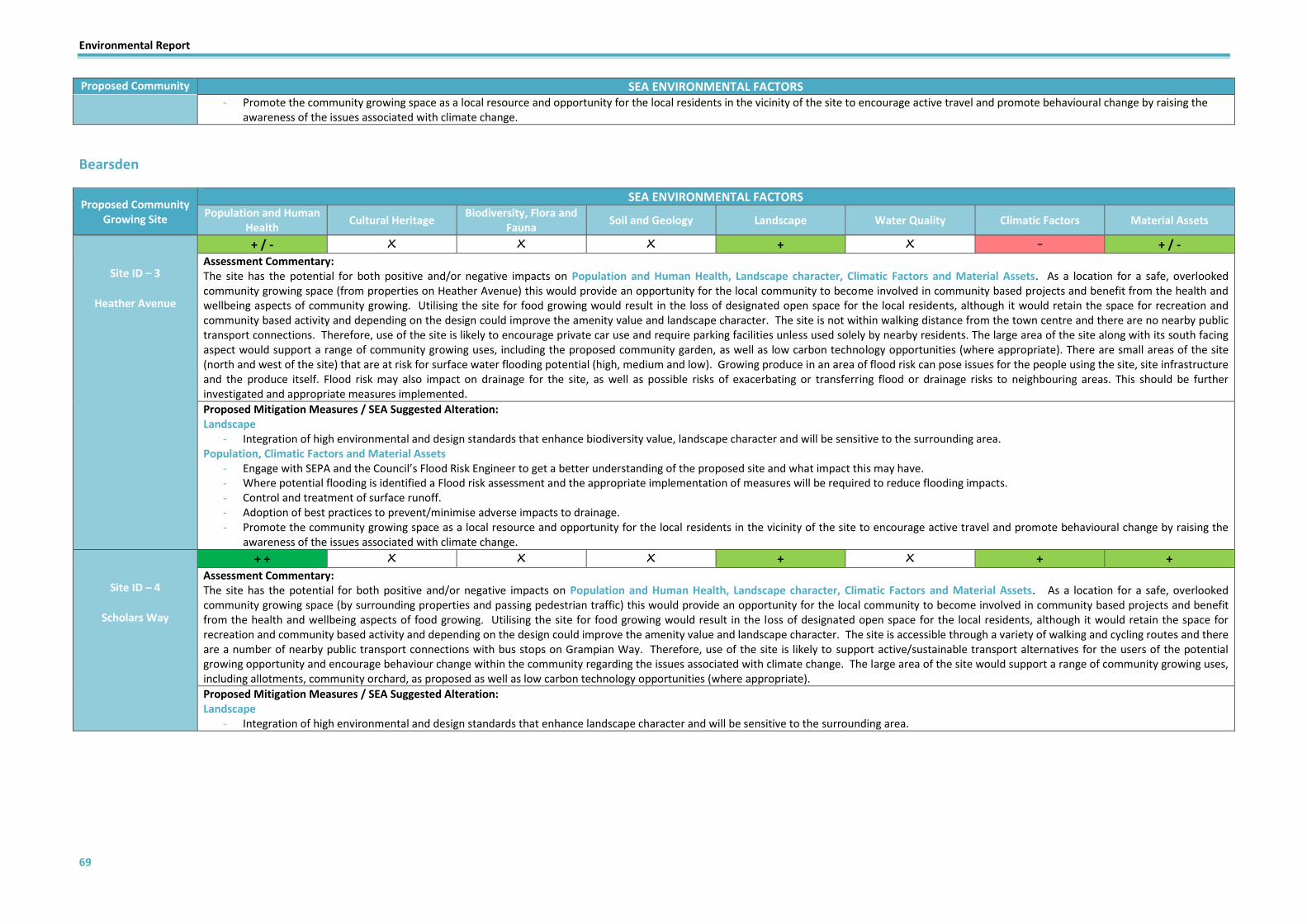
Environmental Report
69
Proposed Community Growing Site
SEA ENVIRONMENTAL FACTORS - Promote the community growing space as a local resource and opportunity for the local residents in the vicinity of the site to encourage active travel and promote behavioural change by raising the
awareness of the issues associated with climate change.
Bearsden
Proposed Community Growing Site
SEA ENVIRONMENTAL FACTORS Population and Human
Health Cultural Heritage
Biodiversity, Flora and Fauna
Soil and Geology Landscape Water Quality Climatic Factors Material Assets
Site ID – 3
Heather Avenue
+ / - X X X + X - + / - Assessment Commentary: The site has the potential for both positive and/or negative impacts on Population and Human Health, Landscape character, Climatic Factors and Material Assets. As a location for a safe, overlooked community growing space (from properties on Heather Avenue) this would provide an opportunity for the local community to become involved in community based projects and benefit from the health and wellbeing aspects of community growing. Utilising the site for food growing would result in the loss of designated open space for the local residents, although it would retain the space for recreation and community based activity and depending on the design could improve the amenity value and landscape character. The site is not within walking distance from the town centre and there are no nearby public transport connections. Therefore, use of the site is likely to encourage private car use and require parking facilities unless used solely by nearby residents. The large area of the site along with its south facing aspect would support a range of community growing uses, including the proposed community garden, as well as low carbon technology opportunities (where appropriate). There are small areas of the site (north and west of the site) that are at risk for surface water flooding potential (high, medium and low). Growing produce in an area of flood risk can pose issues for the people using the site, site infrastructure and the produce itself. Flood risk may also impact on drainage for the site, as well as possible risks of exacerbating or transferring flood or drainage risks to neighbouring areas. This should be further investigated and appropriate measures implemented.
Proposed Mitigation Measures / SEA Suggested Alteration: Landscape
- Integration of high environmental and design standards that enhance biodiversity value, landscape character and will be sensitive to the surrounding area. Population, Climatic Factors and Material Assets
- Engage with SEPA and the Council’s Flood Risk Engineer to get a better understanding of the proposed site and what impact this may have. - Where potential flooding is identified a Flood risk assessment and the appropriate implementation of measures will be required to reduce flooding impacts. - Control and treatment of surface runoff. - Adoption of best practices to prevent/minimise adverse impacts to drainage. - Promote the community growing space as a local resource and opportunity for the local residents in the vicinity of the site to encourage active travel and promote behavioural change by raising the
awareness of the issues associated with climate change.
Site ID – 4
Scholars Way
+ + X X X + X + + Assessment Commentary: The site has the potential for both positive and/or negative impacts on Population and Human Health, Landscape character, Climatic Factors and Material Assets. As a location for a safe, overlooked community growing space (by surrounding properties and passing pedestrian traffic) this would provide an opportunity for the local community to become involved in community based projects and benefit from the health and wellbeing aspects of food growing. Utilising the site for food growing would result in the loss of designated open space for the local residents, although it would retain the space for recreation and community based activity and depending on the design could improve the amenity value and landscape character. The site is accessible through a variety of walking and cycling routes and there are a number of nearby public transport connections with bus stops on Grampian Way. Therefore, use of the site is likely to support active/sustainable transport alternatives for the users of the potential growing opportunity and encourage behaviour change within the community regarding the issues associated with climate change. The large area of the site would support a range of community growing uses, including allotments, community orchard, as proposed as well as low carbon technology opportunities (where appropriate).
Proposed Mitigation Measures / SEA Suggested Alteration: Landscape
- Integration of high environmental and design standards that enhance landscape character and will be sensitive to the surrounding area.

Environmental Report
70
Bishopbriggs
Proposed Community Growing Site
SEA ENVIRONMENTAL FACTORS Population and Human
Health Cultural Heritage
Biodiversity, Flora and Fauna
Soil and Geology Landscape Water Quality Climatic Factors Material Assets
Site ID – 5
Springfield Park
+ + / - X + X + X - / + + Assessment Commentary: The site has the potential for both positive and/or negative impacts on Population and Human Health, Biodiversity, Landscape character, Climatic Factors and Material Assets. Despite the lack of surveillance (restricted by topography, mature trees and hedgerows) which would reduce the safety level, the site would provide an opportunity for the local community to become involved in community based projects and benefit from the health and wellbeing aspects of food growing. Utilising the site for food growing would result in the loss of designated open space for the local residents, although it would retain the space for recreation and community based activity and depending on the design could improve the biodiversity value, amenity value and landscape character. The site has mature trees along the southern boundary as well as scattered mature trees on the northern boundary and bordered by hedgerows. A significant proportion of the site is at risk of surface water flooding, particularly to the west of the site which is at high risk. Growing produce in an area of flood risk can pose issues for the people using the site, site infrastructure and the produce itself. Flood risk may also impact on drainage for the site, as well as possible risks of exacerbating or transferring flood or drainage risks to neighbouring areas. This along with the evidence of poor drainage on site should be further investigated and appropriate measures implemented. The site is accessible through a variety of walking and cycling routes and there are a number of nearby public transport connections with bus stops on Springfield Road and close proximity to the Bishopbriggs Train Station. Therefore, use of the site is likely to support active/sustainable transport alternatives for the users of the potential growing opportunity and encourage behaviour change within the community regarding the issues associated with climate change. The large area of the site would accommodate a variety of food growing functions, including allotments, enhanced community gardens or fruit trees. The aspect of the site may be an issue from a food growing perspective depending on proposed uses due to the topography of the site being below street level combined with the height of the properties on the southern boundary would restrict the amount of daylight on a large proportion of the site.
Proposed Mitigation Measures / SEA Suggested Alteration Landscape & Biodiversity
- Integration of high environmental and design standards that enhance biodiversity value, landscape character and will be sensitive to the surrounding area. - Any design concepts for community growing spaces should retain and integrate the existing mature trees and hedgerows as a feature.
Climatic Factors and Material Assets - Engage with SEPA and the Council’s Flood Risk Engineer to get a better understanding of the proposed site and what impact this may have. - Where potential flooding is identified a Flood risk assessment and the appropriate implementation of measures will be required to reduce flooding impacts. - Control and treatment of surface runoff.
- Adoption of best practices to prevent/minimise adverse impacts to drainage.
Site ID – 6
SUDS pond at Angus Avenue
+ / - X + X + X + + Assessment Commentary: The site has the potential for both positive and/or negative impacts on Population and Human Health, Biodiversity, Landscape character, Climatic Factors and Material Assets. Despite the site being encompassed by local properties and being on a public walkway linking the surrounding properties around the balancing pond, there is a lack of direct surveillance which would reduce the safety level. The site would provide an opportunity for the local community to become involved in community based projects and benefit from the health and wellbeing aspects of food growing. Utilising the site for food growing would result in the loss of an area of open space for the local residents, although it would retain the space for recreation and depending on the design could improve the biodiversity value, amenity value and landscape character. There is also the potential that community growing options could compliment or improve the valuable recreational space for the surrounding residents but this will also be dependent on the proposed uses and design concept. Also depending on the proposed uses there may also be an impact on (or required removal) of the existing wooded area which covers 50% of the site. The site is accessible through a variety of walking and cycling routes and there are a number of nearby public transport connections with bus stops on Angus Avenue. Therefore, use of the site is likely to support active/sustainable transport alternatives for the users of the potential growing opportunity and encourage behaviour change within the community regarding the issues associated with climate change. Given the existing woodland and small scale of the site the potential community growing opportunities will be limited to enhanced community gardens, fruit trees and food forest.
Proposed Mitigation Measures / SEA Suggested Alteration: Landscape & Biodiversity
- Integration of high environmental and design standards that enhance biodiversity value, landscape character and will be sensitive to the surrounding area. - Any design concepts for community growing spaces should reduce the impact on the existing wooded area and/or ensure that significant enhancement measures are employed that will improve the
wooded assets on the site as a key feature of the proposal.

Environmental Report
71
Proposed Community Growing Site
SEA ENVIRONMENTAL FACTORS
Site ID – 7
Bishop Gardens
+ + + X + X + + Assessment Commentary: The site has the potential for both positive and/or negative impacts on Population and Human Health, Cultural Heritage, Biodiversity, Landscape, Climatic Factors and Material Assets. The site is encompassed by local properties on Bishop Gardens and Brackenbrae Avenue and also has a public walkway running directly through the site linking the surrounding properties which provide significant surveillance and increase the safety levels for a potential community growing opportunity. The site would provide an opportunity for the local community to become involved in community based projects and benefit from the health and wellbeing aspects of community growing. Utilising the site for community growing would result in the enhancement of designated open space for the local residents and would retain the space for recreation and community based activity. There is also the potential that community growing options could compliment or improve the valuable recreational space for the surrounding residents but this will be dependent on the proposed uses and design concept. The site is accessible through a variety of walking and cycling routes and there are a number of nearby public transport connections with bus stops on St Mary’s Road. Therefore, use of the site is likely to support active/sustainable transport alternatives for the users of the potential growing opportunity and encourage behaviour change within the community regarding the issues associated with climate change. The site is within a locally important Garden and Designed Landscape (Kenmure), Tree Protection Order and plays a role as a green network link between residential areas. Given the existing woodland the site would only be considered for growing approaches which enhance the biodiversity value and green network connections (for example, food forest and/or foraging potential).
Proposed Mitigation Measures / SEA Suggested Alteration: Biodiversity, Flora & Fauna & Cultural Heritage
- Any uses and /or development of the site will need to take the Tree Preservation Order, biodiversity and heritage value, green network and landscape character into consideration and ensure that these factors are protected and enhanced through proposed changes for any community growing opportunities.
Site ID – 8
Etive Park
+ + / - X + X + X - / + + Assessment Commentary: The site has the potential for both positive and/or negative impacts on Population and Human Health, Biodiversity, Landscape character, Climatic Factors and Material Assets. The site is encompassed by surrounding properties from Etive Crescent and The Leys. Despite this, there is a lack of surveillance in certain parts of the large site which would reduce the safety level for a community growing opportunity. However, the site would provide an opportunity for the local community to become involved in community based projects and benefit from the health and wellbeing aspects of food growing. Utilising the site for food growing would result in the loss of designated open space and existing blaes pitch for the local residents, although it would retain the space for recreation and community based activity while bringing an under-utilised site back into wider community use. Visual amenity impacts and safety concerns would be dependent on the design and layout of any community growing proposals. There is a wooded area of the site (western corner) and mature trees throughout the site which may be impacted by any proposals. Although there are no biodiversity designations and the biodiversity and habitat value on site is relatively negligible, the park is part of a wider green network and may act as a habitat stepping stone. The majority of the site is at high/medium risk from surface water flooding. Growing produce in an area of flood risk can pose issues for the people using the site, site infrastructure and the produce itself. Flood risk may also impact on drainage for the site, as well as possible risks of exacerbating or transferring flood or drainage risks to neighbouring areas. This along with the evidence of drainage issues on site should be further investigated and appropriate measures implemented. The site is accessible through a variety of walking and cycling routes and there are a number of nearby public transport connections with bus stops on Springfield Road and close proximity to the Bishopbriggs Train Station. Therefore, use of the site is likely to support active/sustainable transport alternatives for the users of the potential growing opportunity and encourage behaviour change within the community regarding the issues associated with climate change. The large area of the site together with the south facing aspect would accommodate a variety of food growing functions, including allotments and enhanced community gardens, as well as low carbon technology opportunities (where appropriate).
Proposed Mitigation Measures / SEA Suggested Alteration: Landscape & Biodiversity
- Integration of high environmental and design standards that enhance biodiversity value, landscape character and will be sensitive to the surrounding area. - Any design concepts for community growing spaces should reduce the impact on the existing wooded area and/or ensure that significant enhancement measures are employed that will improve the
wooded assets and wider green network function on the site as a key feature of the proposal. Climatic Factors & Material Assets
- Engage with SEPA and the Council’s Flood Risk Engineer to get a better understanding of the proposed site and what impact this may have. - Where potential flooding is identified a Flood risk assessment and the appropriate implementation of measures will be required to reduce flooding impacts. - Control and treatment of surface runoff. - Adoption of best practices to prevent/minimise adverse impacts to drainage.
Site ID – 9
Low Moss Vacant and Derelict Land
+ / - ? / - + ? / + + X + / - + + Assessment Commentary: The site has the potential for both positive and/or negative impacts on Population and Human Health, Cultural Heritage, Biodiversity, Landscape character, Climatic Factors and Material Assets. The site is fully within and encompassed by potentially contaminated land site (former munitions dump at Low Moss) and is also classed as Vacant and Derelict Land (Barrage site). From a safety perspective the site is likely to be overlooked by passing traffic on Crosshill Road and in certain parts of the site from the neighbouring Golf Driving Range, which is accessed by the road which runs through the proposed site. The site would provide an opportunity for the local community to become involved in community based projects and benefit from the health and wellbeing aspects of food growing. Utilising the site for food growing would bring a derelict site back into use for recreation and community based activity. The site is within the existing buffer zone for the Antonine Wall. Development of the site for community growing could potentially enhance the current visual amenity/landscape character and would be dependent on the design and layout of any community growing proposals. Although the site has no biodiversity or

Environmental Report
72
Proposed Community Growing Site
SEA ENVIRONMENTAL FACTORS habitat designations, the site is within the wider green network and has links to Meltwater Channel Local Nature Conservation Site to the north of the site. However, it is unlikely that use of the site for food growing will deteriorate or detract from its value and may even improve habitat links and reduce fragmentation. The site is not within the flood risk area, however, there is evidence of very poor drainage throughout the site which would need to be investigated due to historical uses of the site and the potential contamination. There is public transport connections with bus stops on Crosshill Road at Low Moss Prison. However, use of the site and its proximity to additional assets and services are unlikely to significantly support active/sustainable transport alternatives for the users of the potential growing opportunity and may even encourage private car use and require parking facilities depending on the proposed uses. The large area of the site together with the south facing aspect would accommodate a variety of food growing functions, including allotments and enhanced community gardens, as well as low carbon technology opportunities (where appropriate).
Proposed Mitigation Measures / SEA Suggested Alteration: Cultural Heritage
- Minimise and monitor any ground disturbance and incorporate design measures in order for required infrastructure improvements and maintenance to be carried out in a sensitive and sustainable manner to avoid or minimise any impacts on the Antonine Wall and its setting.
Soil & Geology - Investigate the potential requirement for a contaminated land survey to determine the likely impacts on the site from the proposed uses and if any remedial works are required.
Population, Climatic Factors and Material Assets - Control and treatment of surface runoff. - Adoption of best practices to prevent/minimise adverse impacts to drainage.
- Promote the community growing space as a local resource and opportunity for the local residents in the vicinity of the site to encourage sustainable/active travel and promote behavioural change by raising the awareness of the issues associated with climate change.
Site ID – 10
Playing field south of Low Moss Plantation
+ / - X X X + X - + / - Assessment Commentary: The site has the potential for both positive and/or negative impacts on Population and Human Health, Landscape character, Climatic Factors and Material Assets. From a safety perspective the site is likely to be overlooked by surrounding non-residential buildings for most of the day. The site would provide an opportunity for the local community to become involved in community based projects and benefit from the health and wellbeing aspects of food growing. Utilising the site for food growing would bring an unused site back into use for recreation and community based activity. Development of the site for community growing could potentially enhance the current visual amenity/landscape character and would be dependent on the design and layout of any community growing proposals. The site has no biodiversity or habitat designations, although is close to Low Moss Local Nature Conservation Site but is unlikely to have an impact on the designation or biodiversity value. There is no easily accessible public transport connections and the site is a significant distance from a walking and cycling perspective from residential areas and the town centre. Therefore, use of the site and its proximity to additional assets and services are unlikely to support active/sustainable transport alternatives for the users of the potential growing opportunity and are likely to encourage private car use and require parking facilities depending on the proposed uses or utilise parking of neighbouring businesses. The large area of the site together with the south facing aspect would accommodate a variety of food growing functions, including enhanced community gardens (as proposed), as well as low carbon technology opportunities (where appropriate).
Proposed Mitigation Measures / SEA Suggested Alteration: Landscape, Climatic Factors and Material Assets
- Integration of high environmental and design standards that enhance landscape character and will be sensitive to the surrounding area. - Promote the community growing space as a local resource and opportunity for the local residents in the vicinity of the site to encourage sustainable/active travel and promote behavioural change by
raising the awareness of the issues associated with climate change.
Site ID – 11
Meadowburn to Cadder Road
+ X + X + X + / - + Assessment Commentary: The site has the potential for positive/negative impacts on Population and Human Health, Biodiversity, Landscape character, Climatic Factors and Material Assets. As a location for a safe, overlooked community growing space (proposed biodiversity enhancements) this would provide an opportunity for the local community to become involved in community based projects and benefit from the health and wellbeing aspects of community growing. Utilising the site for food growing would result in the loss of designated open space for the local residents, although it would retain the space for recreation and community based activity. Development of the site for community growing could potentially enhance the current visual amenity/landscape character and would be dependent on the design and layout of any community growing proposals. A small section of the site is at medium/low risk from surface water flooding. This along with the evidence of drainage issues on site should be further investigated and appropriate measures implemented. The site is accessible through a variety of walking and cycling routes and there are a number of nearby public transport connections with bus stops on Kirkintilloch Road. Therefore, use of the site is likely to support active/sustainable transport alternatives for the users of the potential growing opportunity and encourage behaviour change within the community regarding the issues associated with climate change.
Proposed Mitigation Measures / SEA Suggested Alteration: Landscape
- Integration of high environmental and design standards that enhance biodiversity value, landscape character and will be sensitive to the surrounding area. Climatic Factors & Material Assets
- Engage with SEPA and the Council’s Flood Risk Engineer to get a better understanding of the proposed site and what impact this may have. - Where potential flooding is identified a Flood risk assessment and the appropriate implementation of measures will be required to reduce flooding impacts.

Environmental Report
73
Proposed Community Growing Site
SEA ENVIRONMENTAL FACTORS - Control and treatment of surface runoff. - Adoption of best practices to prevent/minimise adverse impacts to drainage.
Site ID – 12
Pinelands
+ / - X + X X X + + Assessment Commentary: The site has the potential for positive impacts on Population and Human Health, Climatic Factors and Material Assets. As a location for a community growing space (proposed community garden) this would provide an opportunity for the local community to become involved in community based projects and benefit from the health and wellbeing aspects of community growing. Utilising the site for community growing would result in the loss of an area of open space, although it would retain the space for recreation and community based activity. The site is bordered by an area of woodland and trees/hedgerows which shield it from Kirkintilloch Road and Meadowburn. Encompassing the north east boundary of the site in close proximity is Meadowburn Tree Preservation Order. The site is accessible through a variety of walking and cycling routes and there are a number of nearby public transport connections with bus stops on Kirkintilloch Road. Therefore, use of the site is likely to support active/sustainable transport alternatives for the users of the potential growing opportunity and encourage behaviour change within the community regarding the issues associated with climate change.
Proposed Mitigation Measures / SEA Suggested Alteration: Biodiversity, Flora & Fauna & Climatic Factors
- Any uses and /or development of the site will need to take the Tree Protection Order, biodiversity value and green network into consideration and ensure that these factors are protected and enhanced through proposed changes for any community growing opportunities.
Site ID – 13
Cloan Crescent
+ / - X X ? / + ? / + X + + Assessment Commentary: The site has the potential for both positive and/or negative impacts on Population and Human Health, Soil and Geology, Landscape character, Climatic Factors and Material Assets. As a location for a safe, overlooked community growing space (proposed community gardens) this would provide an opportunity for the local community to become involved in community based projects and benefit from the health and wellbeing aspects of community growing. Utilising the site for community growing would result in the loss of designated open space for the local residents, although it would retain the space for recreation and community based activity and the link with the existing play facilities would be dependent on the design concepts. The site is accessible through a variety of walking and cycling routes and there are a number of nearby public transport connections with bus stops on Kirkintilloch Road. Therefore, use of the site is likely to support active/sustainable transport alternatives for the users of the potential growing opportunity and encourage behaviour change within the community regarding the issues associated with climate change. To the east of the site in close proximity is High Moss Plantation, which is a designated Local Nature Conservation Site and Tree Preservation Order. Therefore any uses and /or development of the site will need to take these designations into consideration. In addition to this, the site is also in close proximity to a potentially contaminated land site to the south on Plantation Parkway. This will also need to be taken into consideration and possibly investigated further depending on the proposed uses of the site.
Proposed Mitigation Measures / SEA Suggested Alteration: Biodiversity, Flora & Fauna and Climatic Factors
- Any uses and /or development of the site will need to take the Local Nature Conservation Site, Tree Preservation Order, biodiversity value and green network links into consideration and ensure that these factors are protected and enhanced through proposed changes for any community growing opportunities.
Soil & Geology - Investigate the potential requirement for a contaminated land survey to determine the likely impacts on the site from the proposed uses and if any remedial works are required.
Biodiversity and Landscape - Integration of high environmental and design standards that enhance biodiversity value, landscape character and will be sensitive to the surrounding area.
Site ID – 14
Friar Avenue
+ X X X + X X X
Assessment Commentary: The site has the potential for positive impacts on Population and Human Health and Landscape character. The small site is located within a residential area and is already seasonally planted and maintained. The site is proposed for enhanced community planting/growing and/or fruit trees. By enhancing the site as a safe, overlooked community growing space this would provide an opportunity for the local residents to become involved in a small scale community based projects and benefit from the health and wellbeing aspects of food growing. Utilising the site for food growing would further enhance the visual amenity of the site and surrounding area while also retaining the space for recreation and community based activity. The site is accessible through a variety of walking and cycling routes. Due to the small scale of the site, the impacts are unlikely to be significant on any of the environmental factors.
Proposed Mitigation Measures / SEA Suggested Alteration: None

Environmental Report
74
Kirkintilloch
Proposed Community Growing Site
SEA ENVIRONMENTAL FACTORS
Population and Human Health
Cultural Heritage Biodiversity, Flora and
Fauna Soil and Geology Landscape Water Quality Climatic Factors Material Assets
Site ID – 15
Moss Road
+ / - X + X + ? / - - + / - Assessment Commentary: The site has the potential for both positive and/or negative impacts on Population and Human Health, Biodiversity, Landscape character, Water Quality, Climatic Factors and Material Assets. From a safety perspective the majority of the site is likely to be overlooked by the rear of surrounding residential properties on Moss Road and Alexander Place. The site would provide an opportunity for the local community to become involved in community based projects and benefit from the health and wellbeing aspects of community growing. Utilising the site for community growing would bring an under-utilised site into use for recreation and community based activity. Development of the site for community growing could potentially enhance the current visual amenity/landscape character and would be dependent on the design and layout of any community growing proposals. The site has no biodiversity or habitat designations but depending on the proposal it has the potential to enhance the biodiversity value and green network potential that should be explored as part of any proposal. A large proportion of the site is at high/medium risk from surface water flooding. This along with the evidence of very poor drainage and the existence of drains that run the length of the north and eastern boundary of the site indicates that the site should be further investigated and appropriate measures implemented. The site is accessible via a number of nearby public transport connections with bus stops on Bankhead Road and Kirkintilloch Road. Although, walking and cycling routes are limited. Therefore, use of the site is likely to provide limited support to active travel and sustainable transport alternatives for the users of the potential growing opportunity and is likely to encourage private car use and require parking facilities depending on the proposed uses. Depending on the usable extent of the site, the potential large area together with its south facing aspect would accommodate a variety of food growing functions, including enhanced community gardens (as proposed), as well as low carbon technology opportunities (where appropriate).
Proposed Mitigation Measures / SEA Suggested Alteration Population, Landscape and Biodiversity
- Integration of high environmental and design standards that enhance biodiversity value, landscape character and will be sensitive to the surrounding area. Water Quality, Climatic Factors and Material Assets
- Engage with SEPA and the Council’s Flood Risk Engineer to get a better understanding of the proposed site and what impact this may have. - Where potential flooding is identified a Flood risk assessment and the appropriate implementation of measures will be required to reduce flooding impacts. - Control and treatment of surface runoff. - Adoption of best practices to prevent/minimise adverse impacts to drainage.
- Any design concepts for community growing spaces should reduce the impact on the existing wooded area and/or ensure that significant enhancement measures are employed that will improve the wooded assets and wider green network function on the site as a key feature of the proposal. Retention of the wooded area to the west of the site as natural food/drainage management.
- Promote the community growing space as a local resource and opportunity for the local residents in the vicinity of the site to encourage sustainable/active travel and promote behavioural change by raising the awareness of the issues associated with climate change.
Site ID – 16
Cleddans Playing Field
+ + ? / - + ? / + + X + + Assessment Commentary: The site has the potential for both positive impacts on Population and Human Health, Cultural Heritage, Biodiversity, Soil, Landscape character, Climatic Factors and Material Assets. The majority of the site is overlooked by the existing properties to the south and east of the proposed growing space, which should be further enhanced by the proposed housing in the development site directly adjacent to the south of the proposed area. As a location for a safe, overlooked community growing space this would provide an opportunity for the local community to become involved in community based projects and benefit from the health and wellbeing aspects of food growing. Utilising the site for food growing would result in the loss of open space for the local residents, although it would retain the space for recreation and community based activity and the visual amenity impacts would be dependent on the design and link with the existing play facilities. The north of the proposed growing site is adjacent to Harestanes Local Nature Conservation Site and is also in close proximity to the Forth and Clyde Canal. The site is not within the flood risk area, however, there is evidence of very poor drainage throughout the site which would indicate further investigation is required given the proximity to the Canal. The north of the site is also adjacent to the line of the Antonine Wall World Heritage Site and the entire site is within the existing buffer zone for the Antonine Wall. The site is accessible through a variety of walking and cycling routes and there are a number of nearby public transport connections with bus stops on Hillhead. Therefore, use of the site is likely to support active/sustainable transport alternatives for the users of the potential growing opportunity and encourage behaviour change within the community regarding the issues associated with climate change. In addition to this, the site is also in close proximity to a potentially contaminated land site to the north adjacent to Alloway Grove. This will also need to be taken into consideration and possibly investigated further depending on the proposed uses of the site and the extent of the developable area. The large area of the site together with the south facing aspect would accommodate a variety of food growing functions, including enhanced community gardens (as proposed), as well as low carbon technology opportunities (where appropriate).
Proposed Mitigation Measures / SEA Suggested Alteration: Cultural Heritage
- Minimise and monitor any ground disturbance and incorporate design measures in order for required infrastructure improvements and maintenance to be carried out in a sensitive and sustainable manner to avoid or minimise any impacts on the Antonine Wall and its setting.
Soil & Geology

Environmental Report
75
Proposed Community Growing Site
SEA ENVIRONMENTAL FACTORS - Investigate the potential requirement for a contaminated land survey to determine the likely impacts on the site from the proposed uses and if any remedial works are required.
Landscape, Biodiversity, Climatic Factors and Material Assets - Integration of high environmental and design standards that enhance biodiversity and heritage value, landscape character and will be sensitive to the surrounding area.
- Promote the community growing space as a local resource and opportunity for the local residents in the vicinity of the site to encourage sustainable/active travel and promote behavioural change by raising the awareness of the issues associated with climate change.
Site ID – 17
Burns Court
+ X X X X X + / - + Assessment Commentary: The site has the potential for positive/negative impacts on Population and Human Health, Climatic Factors and Material Assets. The majority of the site is fenced off and overlooked by the existing surrounding properties of the proposed growing space. As a location for a safe, overlooked community growing space this would provide an opportunity for the local community to become involved in community based projects and benefit from the health and wellbeing aspects of food growing. Utilising the site for food growing would result in the loss of existing open space for the local residents, although it would retain the space for recreation and community based activity. The site has limited biodiversity value at present. A small section on the western boundary of the site is at medium/low risk from surface water flooding. This along with the fact that the surrounding area is made up of impermeable surfaces which use of the site for other purposes could increase the risk of surface water run-off and indicates that the site should be further investigated and appropriate measures implemented. The site is accessible through a variety of walking and cycling routes and there are a number of nearby public transport connections with bus stops on Burns Road. However, given that the site is owned by the housing association the purpose/use of the proposed growing space would be solely for the residents in adjacent properties. Therefore, use of the site will reduce reliance on vehicular based journeys through on site facilities and encourage behaviour change within the community regarding the issues associated with climate change. The large area of the site would accommodate a variety of food growing functions, including allotments utilising raised beds and enhanced community gardens.
Proposed Mitigation Measures / SEA Suggested Alteration: Population and Human Health, Climatic Factors and Material Assets
- If the housing association were to allow the use of the proposed growing space to the wider community it would widen the benefits in terms of being inclusive, offering such a facility to a wider demographic and also encourage further active and sustainable travel.
Climatic Factors & Material Assets - Engage with SEPA and the Council’s Flood Risk Engineer to get a better understanding of the proposed site and what impact this may have. - Where potential flooding is identified a Flood risk assessment and the appropriate implementation of measures will be required to reduce flooding impacts. - Control and treatment of surface runoff. - Adoption of best practices to prevent/minimise adverse impacts to drainage
Site ID – 18
Luggie blaes pitch
+ + / - ? / + + ? / + + X + / - + Assessment Commentary: The site has the potential for positive/negative impacts on Population and Human Health, Cultural Heritage, Biodiversity, Soil, Landscape character, Climatic Factors and Material Assets. Due to the site being below the level of Waterside Road, it is unlikely to be overlooked other than by a number of properties on Holmfield whose view may be obscured by existing vegetation. As a location for a community growing space this would provide an opportunity for the local community to become involved in community based projects and benefit from the health and wellbeing aspects of food growing. Utilising the site for food growing would result in the loss of a blaes playing field for the local residents, albeit underused, although it would retain the space for recreation and community based activity. The site and entire surrounding area are encompassed by a locally important Garden and Designed Landscape Area designation. The site is also adjacent to the Luggie Water Local Nature Conservation Site. Utilising the site for food growing purposes is unlikely to deteriorate the landscape or biodiversity value that currently exists and could potentially present an opportunity to support and enhance local biodiversity. The site is in close proximity to the pluvial and fluvial flood risk areas, therefore further investigation is required given the proximity to the Luggie Water. Growing produce in an area of flood risk can pose issues for the people using the site, site infrastructure and the produce itself. Flood risk may also impact on drainage for the site, as well as possible risks of exacerbating or transferring flood or drainage risks to neighbouring areas. This should be further investigated and appropriate measures implemented. The site is accessible through a variety of walking and cycling routes and there are a number of nearby public transport connections with bus stops on Waterside Road. Therefore, use of the site is likely to support active/sustainable transport alternatives for the users of the potential growing opportunity and encourage behaviour change within the community regarding the issues associated with climate change. In addition to this, the site is also in close proximity to a potentially contaminated land site (Holm Bleachfield) to the east encompassing properties on Holmfield. This will also need to be taken into consideration and possibly investigated further depending on the proposed uses of the site and the extent of the developable area. The large area of the site together with part of the site being open to the south facing aspect would accommodate a variety of food growing functions, including allotments and enhanced community gardens, as well as low carbon technology opportunities (where appropriate). Unused pavilion on the border of the site could also be brought back into use as part of any community growing proposal. This would limit the development of new structures for storage, while also utilising an existing structure.
Proposed Mitigation Measures / SEA Suggested Alteration: Soil & Geology
- Investigate the potential requirement for a contaminated land survey to determine the likely impacts on the site from the proposed uses and if any remedial works are required. Biodiversity, Cultural Heritage, Landscape, Water Quality, Climatic Factors
- Integration of high environmental and design standards that enhance biodiversity and heritage value, landscape character and will be sensitive to the surrounding area. - Any uses and /or development of the site will need to take the biodiversity value and green network into consideration and ensure that these factors are protected and enhanced through proposed
changes for any community growing opportunities. - Engage with SEPA and the Council’s Flood Risk Engineer to get a better understanding of the proposed site and what impact this may have.

Environmental Report
76
Proposed Community Growing Site
SEA ENVIRONMENTAL FACTORS - Where potential flooding is identified a Flood risk assessment and the appropriate implementation of measures will be required to reduce flooding impacts. - Control and treatment of surface runoff. - Adoption of best practices to prevent/minimise adverse impacts to drainage. - Retention of the majority of the mature trees on the site within the design of any proposal will enhance the landscape character and also provide natural food/drainage management.
Site ID –19
The Greens (Parkburn) blaes pitch
+ + X X X + ? / - - - / + + / - Assessment Commentary: The site has the potential for positive/negative impacts on Population and Human Health, Landscape, Water Quality, Climatic Factors and Material Assets. The site is overlooked by the existing surrounding properties of the proposed growing space. As a location for a safe, overlooked community growing space this would provide an opportunity for the local community to become involved in community based projects and benefit from the health and wellbeing aspects of food growing. Utilising the site for food growing would result in the loss of a blaes playing field for the local residents, albeit underused, although it would retain the space for recreation and community based activity. Utilising the site for food growing purposes is unlikely to deteriorate the landscape or biodiversity value that currently exists and could potentially present an opportunity to support and enhance local biodiversity and amenity value. The site is completely within and encompassed by the flood risk area (fluvial and pluvial), therefore further investigation is required given the proximity to the Park Burn. Growing produce in an area of flood risk can pose issues for the people using the site, site infrastructure and the produce itself. Flood risk may also impact on drainage for the site, as well as possible risks of exacerbating or transferring flood or drainage risks to neighbouring areas. The site is accessible through a variety of walking and cycling routes and there are a number of nearby public transport connections with bus stops on Westergreens Avenue. Therefore, use of the site is likely to support active/sustainable transport alternatives for the users of the potential growing opportunity and encourage behaviour change within the community regarding the issues associated with climate change. The large area of the site together with part of the site being open to the south facing aspect would accommodate a variety of food growing functions, including allotments and enhanced community gardens, as well as low carbon technology opportunities (where appropriate).
Proposed Mitigation Measures / SEA Suggested Alteration: Water Quality, Climatic Factors and Material Assets
- Engage with SEPA and the Council’s Flood Risk Engineer to get a better understanding of the proposed site and what impact this may have. - Where potential flooding is identified a Flood risk assessment and the appropriate implementation of measures will be required to reduce flooding impacts. - Control and treatment of surface runoff. - Adoption of best practices to prevent/minimise adverse impacts to drainage. - Provision of natural food alleviation as part of any design proposals for community growing assets.
Lennoxtown
Proposed Community Growing Site
SEA ENVIRONMENTAL FACTORS Population and Human
Health Cultural Heritage
Biodiversity, Flora and Fauna
Soil and Geology Landscape Water Quality Climatic Factors Material Assets
Site ID – 20
Pine Street flood scheme
+ X X X + X - / + + Assessment Commentary: The site has the potential for both positive and/or negative impacts on Population and Human Health, Landscape character, Climatic Factors and Material Assets. The site is overlooked by surrounding properties on Lyndsay Terrace, Bencloich Road and Pine Street. Given the small scale and configuration of the site means it is unlikely to be able to support multiple forms of food growing. Given that the site includes existing flood defence infrastructure it may be an opportunity for a food growing opportunity such as an orchard and specific vegetation enhancements as a form of natural flood management. There are sections of the site that are at risk of low, medium and high risk for surface water flooding. Growing produce in an area of flood risk can pose issues for the people using the site, site infrastructure and the produce itself. Flood risk may also impact on drainage for the site, as well as possible risks of exacerbating or transferring flood or drainage risks to neighbouring areas. This should be further investigated and appropriate measures implemented. The site would provide an opportunity for the local community to become involved in community based projects and benefit from the health and wellbeing aspects of food growing. Utilising the site for small scale food growing would positively impact on the visual amenity and provide a space for recreation and community based activity. The site is in an unsustainable location and would therefore be likely to encourage private car use unless used solely by nearby residents.
Proposed Mitigation Measures / SEA Suggested Alteration Landscape
- Integration of high environmental and design standards that enhances landscape character and will be sensitive to the surrounding area. Climatic Factors and Material Assets
- Engage with SEPA and the Council’s Flood Risk Engineer to get a better understanding of the proposed site and what impact this may have. - Where potential flooding is identified a Flood risk assessment and the appropriate implementation of measures will be required to reduce flooding impacts. - Control and treatment of surface runoff. - Adoption of best practices to prevent/minimise adverse impacts to drainage.
- Promote the community growing space as a local resource and opportunity for the local residents in the vicinity of the site to encourage active travel and promote behavioural change by raising the

Environmental Report
77
Proposed Community Growing Site
SEA ENVIRONMENTAL FACTORS awareness of the issues associated with climate change.
Site ID –21
Balcorrach Wood
+ + / - X + ? / - + + ? + / - + Assessment Commentary: The site has the potential for both positive and/or negative impacts on Population and Human Health, Biodiversity, Soil, Landscape character, Climatic Factors and Material Assets. The site is only partially overlooked by the rear of properties on Crow Road. Given the large scale and configuration of the site means it is likely to accommodate multiple food growing functions, including food forest, community orchard and community garden/allotments on the flatter areas of the site. The site is currently a Forestry Commission management scheme with newly planted saplings. There is an opportunity to work with the Forestry Commission to enhance what is already there for a community orchard or food forest. The site would provide an opportunity for the local community to become involved in community based projects and benefit from the health and wellbeing aspects of food growing. Utilising the site for small scale food growing would positively impact on the visual amenity and provide a space for recreation and community based activity. There are two areas either adjacent to or within the north of the proposal site which are Class 5 carbon-rich soils/peatland. The site is in an unsustainable location and would therefore be likely to encourage private car use unless used solely by nearby residents. The site is not within the flood risk area, however, there is evidence of very poor drainage throughout the site which would indicate further investigation is required. Given the aspect and topography of the site there would also be opportunities to integrate low carbon technologies into any food growing design proposals.
Proposed Mitigation Measures / SEA Suggested Alteration: Soil and Geology and Water Quality
- Further surveys of peatland/carbon rich soils should be carried out to ensure construction activities for community food growing opportunities achieve outcomes which will not devalue protected soil. - Implement soil erosion prevention measures outlined in good practice guidance where necessary. - Investigation into the potential impacts on the hydrology of the area and the resulting impacts on the sensitive soils. - Any proposed development should avoid these areas as part of the design process and ensure proposals in close proximity have no detrimental impact on the soil quality.
Landscape, Climatic Factors and Material Assets - Integration of high environmental and design standards that enhance biodiversity value and landscape character and will be sensitive to the surrounding area. - Engage with SEPA and the Council’s Flood Risk Engineer to get a better understanding of the proposed site and what impact this may have. - Control and treatment of surface runoff. - Adoption of best practices to prevent/minimise adverse impacts to drainage. - Promote the community growing space as a local resource and opportunity for the local residents in the vicinity of the site to encourage active travel and promote behavioural change by raising the
awareness of the issues associated with climate change.
Site ID – 22
Rowantree Terrace
+ X + X + ? / + - / + + Assessment Commentary: The site has the potential for both positive and/or negative impacts on all environmental factors. Despite the site not currently being overlooked with no properties along B822, the site runs alongside the main link road connecting Lennoxtown to Kirkintilloch and the Lennoxlea housing site directly across the road will provide additional surveillance once developed. Given the small scale and configuration of the site means it is unlikely to be able to support all forms of food growing, although it would be appropriate for an orchard and could link with the proposed Lennoxlea development by encouraging the developer to shadow the food growing opportunity on both sides of the road creating an attractive green entrance to the settlement. The site would provide an opportunity for the local community to become involved in community based projects and benefit from the health and wellbeing aspects of food growing. The site currently has limited biodiversity value and improvement of the site as a community orchard could enhance the visual amenity and green network links for the area but this will be dependent on the food growing proposals and design. Utilising the site for small scale food growing would provide a space for recreation and community based activity. The site is in close proximity to the Glazert Water and a small proportion of the site is within the flood risk area. Growing produce in an area of flood risk can pose issues for the people using the site, site infrastructure and the produce itself. Flood risk may also impact on drainage for the site, as well as possible risks of exacerbating or transferring flood or drainage risks to neighbouring areas. This should be further investigated and appropriate measures implemented. The site is accessible by active travel and public transport via the bus stops of Rowantree Place.
Proposed Mitigation Measures / SEA Suggested Alteration: Landscape and Biodiversity
- Integration of high environmental and design standards that enhance existing biodiversity value, landscape distinctiveness and will be sensitive to the surrounding area. Population, Water Quality, Climatic Factors and Material Assets
- Engage with SEPA and the Council’s Flood Risk Engineer to get a better understanding of the proposed site and what impact this may have. - Where potential flooding is identified a Flood risk assessment and the appropriate implementation of measures will be required to reduce flooding impacts. - Control and treatment of surface runoff. - Adoption of best practices to prevent/minimise adverse impacts to drainage. - Provision of natural food alleviation as part of any design proposals for community growing assets.
- Promote the community growing space as a local resource and opportunity for the local residents in the vicinity of the site to encourage active travel and promote behavioural change by raising the awareness of the issues associated with climate change.
-

Environmental Report
78
Proposed Community Growing Site
SEA ENVIRONMENTAL FACTORS
Site ID – 23
Lennoxlea
+ X + X + ? - / + + Assessment Commentary: The site has the potential for both positive and/or negative impacts on Population and Human Health, Biodiversity, Landscape character, Water Quality, Climatic Factors and Material Assets. The site is part of an allocated housing site within the LDP. The developer has expressed an interest in using part of the site (south east corner) being used for food growing purposes. Dependent on the design of any food growing proposal and the housing site, it is likely that the proposed community growing space will be overlooked by the new properties and integrated as part of the development. The site would support multiple forms of food growing. The site would provide an opportunity for the local community to become involved in community based projects and benefit from the health and wellbeing aspects of food growing. The site currently has limited biodiversity value and improvement of the site as a community growing space could enhance the visual amenity and green network links for the development area but this will be dependent on the food growing proposals and design. Utilising the site for small scale food growing would provide a space for recreation and community based activity. The site is in close proximity to the Glazert Water and the associated fluvial flood risk area and a large proportion of the site is at risk of surface water flooding (high/medium risk). Growing produce in an area of flood risk can pose issues for the people using the site, site infrastructure and the produce itself. Flood risk may also impact on drainage for the site, as well as possible risks of exacerbating or transferring flood or drainage risks to neighbouring areas. This should be further investigated and appropriate measures implemented. The site is accessible by active travel and public transport via the bus stops of Rowantree Place and A891.
Proposed Mitigation Measures / SEA Suggested Alteration: Landscape and Biodiversity
- Integration of high environmental and design standards that enhance existing biodiversity value and landscape distinctiveness and will be sensitive to the surrounding area. Water Quality, Climatic Factors and Material Assets
- Engage with SEPA and the Council’s Flood Risk Engineer to get a better understanding of the proposed site and what impact this may have. - Where potential flooding is identified a Flood risk assessment and the appropriate implementation of measures will be required to reduce flooding impacts. - Control and treatment of surface runoff. - Adoption of best practices to prevent/minimise adverse impacts to drainage. - Provision of natural food alleviation as part of any design proposals for community growing assets. - Promote the community growing space as a local resource and opportunity for the local residents in the vicinity of the site to encourage active travel and promote behavioural change by raising the
awareness of the issues associated with climate change.
Site ID – 24
Station Road blaes pitch
+ + / - X + ? / + + ? / - - - / + + / - Assessment Commentary: The site has the potential for positive/negative impacts on Population and Human Health, Biodiversity, Soil, Landscape, Water Quality, Climatic Factors and Material Assets. The site is not overlooked by existing properties on station road, although the entrance way is directly adjacent to a number of homes. As a location for a community growing space this would provide an opportunity for the local community to become involved in community based projects and benefit from the health and wellbeing aspects of food growing. Utilising the blaes pitch and surrounding field would accommodate multiple food growing opportunities such as raised beds, allotments and community gardens for food growing which would result in the loss of a blaes playing field for the local residents, albeit underused, although it would retain the space for recreation and community based activity. The remaining grass playing fields would provide recreational space for sporting activities and should not be affected by the use of the eastern area of the site for food growing. Utilising the site for food growing purposes is unlikely to deteriorate the landscape or biodiversity value that currently exists and could potentially present an opportunity to support and enhance local biodiversity, green network links and amenity value given the close proximity to the Glazert Wood Local Nature Conservation Site. In addition to this, the site is also in close proximity to a potentially contaminated land site (Somervilles Nailworks) to the north encompassing properties on Station Road, Business and Industrial units and expanding westward. The site is completely within and encompassed by the flood risk area (pluvial (high risk) and fluvial). The site also had evidence of very poor drainage, including the blaes pitch, path network and grass pitches. Growing produce in an area of flood risk can pose issues for the people using the site, site infrastructure and the produce itself. Flood risk may also impact on drainage for the site, as well as possible risks of exacerbating or transferring flood or drainage risks to neighbouring areas. This should be further investigated given the proximity to the Glazert Water and appropriate measures implemented. The site is accessible through a variety of walking and cycling routes and there are a number of nearby public transport connections with bus stops on Main Street. Therefore, use of the site is likely to support active/sustainable transport alternatives for the users of the potential growing opportunity and encourage behaviour change within the community regarding the issues associated with climate change. The large area of the site together with part of the site being open to the south facing aspect would accommodate a variety of food growing functions, as well as low carbon technology opportunities (where appropriate).
Proposed Mitigation Measures / SEA Suggested Alteration: Soil and Geology
- Investigate the potential requirement for a contaminated land survey to determine the likely impacts on the site from the proposed uses and if any remedial works are required. Biodiversity and Landscape
- Integration of high environmental and design standards that enhance biodiversity value, landscape character and will be sensitive to the surrounding area. Population, Water Quality, Climatic Factors and Material Assets
- Engage with SEPA and the Council’s Flood Risk Engineer to get a better understanding of the proposed site and what impact this may have. - Where potential flooding is identified a Flood risk assessment and the appropriate implementation of measures will be required to reduce flooding impacts. - Control and treatment of surface runoff.

Environmental Report
79
Proposed Community Growing Site
SEA ENVIRONMENTAL FACTORS - Adoption of best practices to prevent/minimise adverse impacts to drainage. - Provision of natural food alleviation as part of any design proposals for community growing assets. - Promote the community growing space as a local resource and opportunity for the local residents in the vicinity of the site to encourage active travel and promote behavioural change by raising the
awareness of the issues associated with climate change.
Site ID – 25
Ferguson Road blaes pitch
+ / - X + ? / + + ? / - - - / + + / - Assessment Commentary: The site has the potential for positive/negative impacts on Population and Human Health, Biodiversity, Soil, Landscape, Water Quality, Climatic Factors and Material Assets. The site is not overlooked by existing properties on Glazert Meadow or Glazert Park Drive which are to the north of the site across the river and covered by a bank of mature trees which run alongside the Glazert Water. As a location for a community growing space this would provide an opportunity for the local community to become involved in community based projects and benefit from the health and wellbeing aspects of food growing. Utilising the blaes pitch would accommodate multiple food growing opportunities such as raised beds, allotments and community gardens for food growing which would result in the loss of a blaes playing field for the local residents, albeit underused, although it would retain the space for recreation and community based activity. The remaining grass playing field would provide recreational space for sporting activities and should not be affected by the use of the western area of the site for food growing. Utilising the site for food growing purposes is unlikely to deteriorate the landscape or biodiversity value that currently exists and could potentially present an opportunity to support and enhance local biodiversity, green network links and amenity value. In addition to this, the site is also in close proximity to a potentially contaminated land site (Redhills) to the south and directly on the site of a potentially contaminated site (Underwood Chemical Works). The site is completely within and encompassed by the flood risk area. The site also had evidence of very poor drainage, including the blaes pitch, access route, path network and grass pitch. Growing produce in an area of flood risk can pose issues for the people using the site, site infrastructure and the produce itself. Flood risk may also impact on drainage for the site, as well as possible risks of exacerbating or transferring flood or drainage risks to neighbouring areas. This should be further investigated given the proximity to the Glazert Water and appropriate measures implemented. The site is accessible through a variety of walking and cycling routes and there are a number of nearby public transport connections with bus stops on Main Street. Therefore, use of the site is likely to support active/sustainable transport alternatives for the users of the potential growing opportunity and encourage behaviour change within the community regarding the issues associated with climate change.
Proposed Mitigation Measures / SEA Suggested Alteration: Soil and Geology
- Investigate the potential requirement for a contaminated land survey to determine the likely impacts on the site from the proposed uses and if any remedial works are required. Biodiversity, Landscape, Water Quality and Climatic Factors
- Integration of high environmental and design standards that enhance biodiversity value and landscape character and will be sensitive to the surrounding area. - Engage with SEPA and the Council’s Flood Risk Engineer to get a better understanding of the proposed site and what impact this may have. - Where potential flooding is identified a Flood risk assessment and the appropriate implementation of measures will be required to reduce flooding impacts. - Control and treatment of surface runoff. - Adoption of best practices to prevent/minimise adverse impacts to drainage. - Provision of natural food alleviation as part of any design proposals for community growing assets. - Promote the community growing space as a local resource and opportunity for the local residents in the vicinity of the site to encourage active travel and promote behavioural change by raising the
awareness of the issues associated with climate change.
Site ID –26
Geelong Marsh
+ X + + X + + ? - - Assessment Commentary: The site has the potential for positive/negative impacts on Population and Human Health, Biodiversity, Soil, Landscape, Climatic Factors and Material Assets. The site is overlooked by existing properties on Geelong Gardens, Janefield Place and St Machan’s Primary School. As a safe, overlooked location for a community growing space this would provide an opportunity for the local community to become involved in community based projects and benefit from the health and wellbeing aspects of food growing. The site is recommended for use for a natural flood alleviation scheme with the addition of food growing and native planting on the periphery of the site for the community to utilise. This would retain the space for recreation and community based activity and the visual amenity impacts would be dependent on the design but are likely to be positive in nature. Utilising the parts of the site for food growing purposes is unlikely to deteriorate the landscape or biodiversity value that currently exists as the site is completely within and encompassed by Balgrochan Marsh Local Nature Conservation Site and could potentially present an opportunity to support and enhance local biodiversity, green network links and amenity value. A large proportion of the site is vulnerable to surface water flooding (areas of low, medium and high risk), therefore further investigation is required to determine the risks to the development of community food growing assets. The site also had evidence of very poor drainage. The site is in an unsustainable location and depending on the proposed uses would therefore be likely to encourage private car use unless used solely by nearby residents. Therefore, use of the site is unlikely to support active/sustainable transport alternatives for the users of the potential growing opportunity and encourage behaviour change within the community regarding the issues associated with climate change.
Proposed Mitigation Measures / SEA Suggested Alteration: Biodiversity and Landscape
- Integration of high environmental and design standards that enhance biodiversity value, landscape character and will be sensitive to the surrounding area. Water Quality, Climatic Factors and Material Assets
- Engage with SEPA and the Council’s Flood Risk Engineer to get a better understanding of the proposed site and what impact this may have. - Where potential flooding is identified a Flood risk assessment and the appropriate implementation of measures will be required to reduce flooding impacts. - Control and treatment of surface runoff.
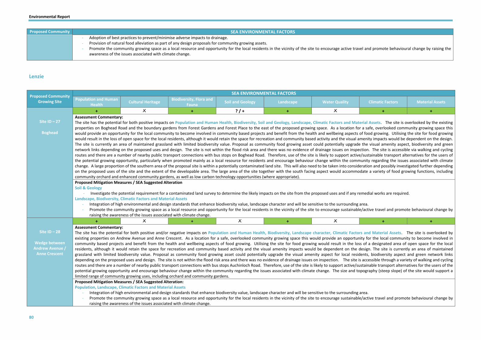
Environmental Report
80
Proposed Community Growing Site
SEA ENVIRONMENTAL FACTORS - Adoption of best practices to prevent/minimise adverse impacts to drainage. - Provision of natural food alleviation as part of any design proposals for community growing assets. - Promote the community growing space as a local resource and opportunity for the local residents in the vicinity of the site to encourage active travel and promote behavioural change by raising the
awareness of the issues associated with climate change.
Lenzie
Proposed Community Growing Site
SEA ENVIRONMENTAL FACTORS Population and Human
Health Cultural Heritage
Biodiversity, Flora and Fauna
Soil and Geology Landscape Water Quality Climatic Factors Material Assets
Site ID – 27
Boghead
+ X + ? / + + X + + Assessment Commentary: The site has the potential for both positive impacts on Population and Human Health, Biodiversity, Soil and Geology, Landscape, Climatic Factors and Material Assets. The site is overlooked by the existing properties on Boghead Road and the boundary gardens from Forest Gardens and Forest Place to the east of the proposed growing space. As a location for a safe, overlooked community growing space this would provide an opportunity for the local community to become involved in community based projects and benefit from the health and wellbeing aspects of food growing. Utilising the site for food growing would result in the loss of open space for the local residents, although it would retain the space for recreation and community based activity and the visual amenity impacts would be dependent on the design. The site is currently an area of maintained grassland with limited biodiversity value. Proposal as community food growing asset could potentially upgrade the visual amenity aspect, biodiversity and green network links depending on the proposed uses and design. The site is not within the flood risk area and there was no evidence of drainage issues on inspection. The site is accessible via walking and cycling routes and there are a number of nearby public transport connections with bus stops on Boghead Road. Therefore, use of the site is likely to support active/sustainable transport alternatives for the users of the potential growing opportunity, particularly when promoted mainly as a local resource for residents and encourage behaviour change within the community regarding the issues associated with climate change. A large proportion of the southern area of the proposal site is within a potentially contaminated land site. This will also need to be taken into consideration and possibly investigated further depending on the proposed uses of the site and the extent of the developable area. The large area of the site together with the south facing aspect would accommodate a variety of food growing functions, including community orchard and enhanced community gardens, as well as low carbon technology opportunities (where appropriate).
Proposed Mitigation Measures / SEA Suggested Alteration Soil & Geology
- Investigate the potential requirement for a contaminated land survey to determine the likely impacts on the site from the proposed uses and if any remedial works are required. Landscape, Biodiversity, Climatic Factors and Material Assets
- Integration of high environmental and design standards that enhance biodiversity value, landscape character and will be sensitive to the surrounding area. - Promote the community growing space as a local resource and opportunity for the local residents in the vicinity of the site to encourage sustainable/active travel and promote behavioural change by
raising the awareness of the issues associated with climate change.
Site ID – 28
Wedge between Andrew Avenue /
Anne Crescent
+ X + X + X + + Assessment Commentary: The site has the potential for both positive and/or negative impacts on Population and Human Health, Biodiversity, Landscape character, Climatic Factors and Material Assets. The site is overlooked by existing properties on Andrew Avenue and Anne Crescent. As a location for a safe, overlooked community growing space this would provide an opportunity for the local community to become involved in community based projects and benefit from the health and wellbeing aspects of food growing. Utilising the site for food growing would result in the loss of a designated area of open space for the local residents, although it would retain the space for recreation and community based activity and the visual amenity impacts would be dependent on the design. The site is currently an area of maintained grassland with limited biodiversity value. Proposal as community food growing asset could potentially upgrade the visual amenity aspect for local residents, biodiversity aspect and green network links depending on the proposed uses and design. The site is not within the flood risk area and there was no evidence of drainage issues on inspection. The site is accessible through a variety of walking and cycling routes and there are a number of nearby public transport connections with bus stops Auchinloch Road. Therefore, use of the site is likely to support active/sustainable transport alternatives for the users of the potential growing opportunity and encourage behaviour change within the community regarding the issues associated with climate change. The size and topography (steep slope) of the site would support a limited range of community growing uses, including orchard and community gardens.
Proposed Mitigation Measures / SEA Suggested Alteration: Population, Landscape, Climatic Factors and Material Assets
- Integration of high environmental and design standards that enhance biodiversity value, landscape character and will be sensitive to the surrounding area. - Promote the community growing space as a local resource and opportunity for the local residents in the vicinity of the site to encourage sustainable/active travel and promote behavioural change by
raising the awareness of the issues associated with climate change.

Environmental Report
81
Proposed Community Growing Site
SEA ENVIRONMENTAL FACTORS
Site ID – 29
Woodilee Industrial Estate
+ X + X + X - - Assessment Commentary: The site has the potential for both positive and/or negative impacts on Population and Human Health, Biodiversity, Landscape character, Climatic Factors and Material Assets. The site is overlooked by Woodcroft Drive and also adjacent properties from Woodilee Cottages. As a location for a safe, overlooked community growing space (proposed community orchard, fruit trees and planting for foraging) this would provide an opportunity for the local community to become involved in community based projects and benefit from the health and wellbeing aspects of food growing. Utilising the site for food growing would result in the loss of an area of open space currently designated as a business and employment site for the local residents, although it would retain the space for recreation and community based activity and the visual amenity impacts would be dependent on the design. The site currently has an area of woodland and shrubs with limited biodiversity or habitat value. Proposal as community food growing asset could potentially improve the attractiveness of the area for local residents, biodiversity value and green network links depending on the design and implementation. The site is also in close proximity to a number of potentially contaminated land sites to the west (Former Loch Road Gas Works and McGavigan’s Field) and Oxgang Cemetery to the north. This will also need to be taken into consideration and possibly investigated further depending on the proposed uses of the site and the extent of the developable area. However, an area to the north-west of the site is vulnerable to surface water flooding (low, medium and high risk), therefore further investigation is required to determine the risks to the development of community food growing assets. Whilst the site is accessible by public transport via a bus stop on Woodilee Road, it is unlikely to support active/sustainable transport alternatives for the users of the potential growing opportunity and encourage behaviour change within the community regarding the issues associated with climate change unless the site is promoted as a community growing project and asset for local residents only.
Proposed Mitigation Measures / SEA Suggested Alteration: Biodiversity, , Landscape, Water Quality, Climatic Factors and Material Assets
- Integration of high environmental and design standards that enhance biodiversity value and landscape character and will be sensitive to the surrounding area. Soil and Geology, Climatic Factors and Material Assets
- Investigate the potential requirement resulting from the surrounding contaminated land. Undertake survey to determine the likely impacts on the site from the proposed uses and if any remedial works are required.
- Engage with SEPA and the Council’s Flood Risk Engineer to get a better understanding of the proposed site and what impact this may have. - Where potential flooding is identified a Flood risk assessment and the appropriate implementation of measures will be required to reduce flooding impacts. - Control and treatment of surface runoff. - Adoption of best practices to prevent/minimise adverse impacts to drainage. - Provision of natural food alleviation as part of any design proposals for community growing assets. Retention of the woodland area to north of the site as a biodiversity/green network asset and natural
flood attenuation. - Promote the community growing space as a local resource and opportunity for the local residents in the vicinity of the site to encourage active travel and promote behavioural change by raising the
awareness of the issues associated with climate change.
Site ID – 30
Parkview Playing Field
+ X + ? / + + X + / - + / - Assessment Commentary: The site has the potential for both positive and/or negative impacts on Population and Human Health, Biodiversity, Soil and Geology, Landscape character, Climatic Factors and Material Assets. The site is partially overlooked by properties on Monkland Avenue and the site is regularly used by local residents for recreation and dog walking. As a location for a safe, overlooked community growing space this would provide an opportunity for the local community to become involved in community based projects and benefit from the health and wellbeing aspects of food growing. Utilising the site for food growing would result in the loss of an area of designated open space for the local residents, although it would retain the space for recreation and community based activity and the visual amenity impacts would be dependent on the design. The site only incorporates a small proportion of the larger open space site, which would be retained for residents. There is limited biodiversity value on site. However there are links with the wider green network with the banks of trees which border the site and should be retained and enhanced as part of any food growing proposal for shelter and habitat value. The site is adjacent to a potentially contaminated land site to the east (Larkfield Road Industrial Estate). This will also need to be taken into consideration and possibly investigated further depending on the proposed uses of the site and the extent of the developable area. A large section of the site is vulnerable to surface water flooding (medium and low risk). This along with the evidence of very poor drainage issues on site should be further investigated and appropriate measures implemented. The site is accessible through a variety of walking and cycling routes and there are a number of nearby public transport connections with bus stops on Kirkintilloch Road. The site is likely to support active/sustainable transport alternatives for the users of the potential growing opportunity and encourage behaviour change within the community regarding the issues associated with climate change.
Proposed Mitigation Measures / SEA Suggested Alteration: Biodiversity, Landscape, Water Quality, Climatic Factors and Material Assets
- Integration of high environmental and design standards that enhance biodiversity value and landscape character and will be sensitive to the surrounding area. - Engage with SEPA and the Council’s Flood Risk Engineer to get a better understanding of the proposed site and what impact this may have. - Where potential flooding is identified a Flood risk assessment and the appropriate implementation of measures will be required to reduce flooding impacts. - Control and treatment of surface runoff. - Adoption of best practices to prevent/minimise adverse impacts to drainage. - Retention of the existing trees on the site as a biodiversity/green network asset and natural flood attenuation.
Soil and Geology - Investigate the potential requirement resulting from the adjacent contaminated land. Undertake survey to determine the likely impacts on the site from the proposed uses and if any remedial works

Environmental Report
82
Proposed Community Growing Site
SEA ENVIRONMENTAL FACTORS are required.
Site ID – 31
Park Burn
+ X + X + ? / - - / + + / - Assessment Commentary: The site has the potential for both positive and/or negative impacts on Population and Human Health, Biodiversity, Landscape character, Water Quality, Climatic Factors and Material Assets. The site is mostly overlooked by properties on Pinewood Avenue, Thornwood Avenue and Conifer Place (although this may be restricted when the vegetation/trees are full). The main footpath that runs the length of the site is well used also by local residents providing additional surveillance. As a location for a safe, overlooked community growing space this would provide an opportunity for the local community to become involved in community based projects and benefit from the health and wellbeing aspects of food growing. Utilising the site for food growing would result in the loss of an area of designated open space for the local residents, although it would retain the space for recreation and community based activity and the visual amenity impacts would be dependent on the design and link/potential relocation of the existing play facilities. There is limited biodiversity value on site. However there are links with the wider green network and Park burn corridor which could be further enhanced with a community food growing project (proposed fruit trees and planting for foraging). The majority of the site is vulnerable to pluvial (areas of high, medium and low risk) and fluvial flooding. This along with the evidence of very poor drainage issues on site should be further investigated and appropriate measures implemented. Growing produce in an area of flood risk can pose issues for the people using the site, site infrastructure and the produce itself. Flood risk may also impact on drainage for the site, as well as possible risks of exacerbating or transferring flood or drainage risks to neighbouring areas. The site is accessible through a variety of walking and cycling routes and there are a number of nearby public transport connections with bus stops on Boghead Road. The site is likely to support active/sustainable transport alternatives for the users of the potential growing opportunity and encourage behaviour change within the community regarding the issues associated with climate change. The large area of the site would support a range of community growing uses, including allotments, orchard and enhanced community garden potential , as well as low carbon technology opportunities (where appropriate).
Proposed Mitigation Measures / SEA Suggested Alteration: Biodiversity and Landscape,
- Integration of high environmental and design standards that enhance biodiversity value and landscape character and will be sensitive to the surrounding area. Water Quality, Climatic Factors and Material Assets
- Engage with SEPA and the Council’s Flood Risk Engineer to get a better understanding of the proposed site and what impact this may have. - Where potential flooding is identified a Flood risk assessment and the appropriate implementation of measures will be required to reduce flooding impacts. - Control and treatment of surface runoff. - Adoption of best practices to prevent/minimise adverse impacts to drainage. - Retention of the existing trees on the site as a biodiversity/green network asset and natural flood attenuation.
Milngavie
Proposed Community Growing Site
SEA ENVIRONMENTAL FACTORS Population and Human
Health Cultural Heritage
Biodiversity, Flora and Fauna
Soil and Geology Landscape Water Quality Climatic Factors Material Assets
Site ID – 32
Roselea Drive
+ + ? / - + / - ? + X + + + Assessment Commentary: The site has the potential for both positive and/or negative impacts on Population and Human Health, Cultural Heritage Biodiversity, Landscape character, Climatic Factors and Material Assets. The site is overlooked by surrounding properties on Roselea Drive, Blane Drive and Strathblane Road and the site also bordered to the north by the Craigmaddie Reservoir and surrounding path network which provides additional surveillance for the potential site. As a location for a safe, overlooked community growing space this would provide an opportunity for the local community to become involved in community based projects and benefit from the health and wellbeing aspects of food growing. Utilising the site for food growing would result in the loss of an area of designated open space for the local residents, although it would retain the space for recreation and community based activity and the visual amenity impacts would be dependent on the design. The site is completely within the Local Nature Conservation Site (Cragmaddie and Mugdock Reservoirs) and the western section of the site is also within the locally designated Garden and Designed Landscape (Mugdock Reservoirs). Depending on the extent of development and multiple community growing proposed uses, there is potential for detrimental impacts on the designated area, habitats, biodiversity value and green network links. Depending on the design and the extent of proposals there is also potential that upgrading the site with community growing assets in a sensitive manner could improve the landscape character, biodiversity value and long-term green network potential for the site. The western edge of the site is adjacent to a potentially contaminated land sites to the west (Craigmillar Avenue). This will also need to be taken into consideration and possibly investigated further depending on the proposed uses of the site and the extent of the developable area. The site is not within the flood risk area (pluvial or fluvial). Use of the site for food growing purposes is unlikely to impact on the adjacent waterbody (Craigmaddie Reservoir) due to the steep embankment surrounding the Listed reservoir structure and the level of the site being below that of the reservoir. There was evidence of very poor drainage issues on site which should be further investigated and appropriate measures implemented. The site is accessible through a variety of walking and cycling routes and there are a number of nearby public transport connections with bus stops on Strathblane Road. The site is likely to support active/sustainable transport alternatives for the users of the potential growing opportunity and encourage behaviour change within the community regarding the issues associated with climate change. The site is large enough to support a wide range of community growing uses and recreation, including allotments, orchard, biodiversity enhancements and community garden potential , as well as low carbon technology opportunities due to the open aspect (where appropriate).
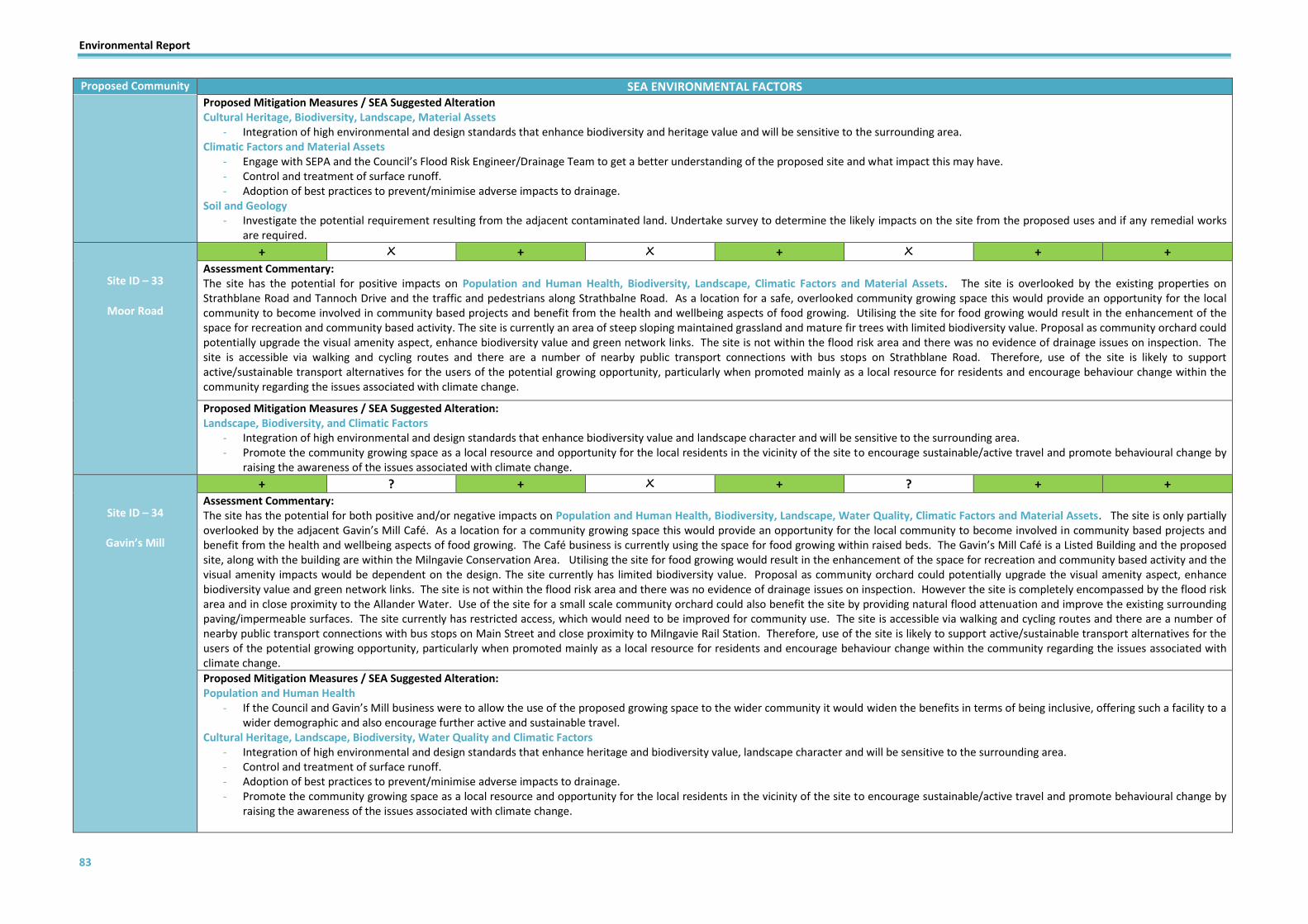
Environmental Report
83
Proposed Community Growing Site
SEA ENVIRONMENTAL FACTORS Proposed Mitigation Measures / SEA Suggested Alteration Cultural Heritage, Biodiversity, Landscape, Material Assets
- Integration of high environmental and design standards that enhance biodiversity and heritage value and will be sensitive to the surrounding area. Climatic Factors and Material Assets
- Engage with SEPA and the Council’s Flood Risk Engineer/Drainage Team to get a better understanding of the proposed site and what impact this may have. - Control and treatment of surface runoff. - Adoption of best practices to prevent/minimise adverse impacts to drainage.
Soil and Geology - Investigate the potential requirement resulting from the adjacent contaminated land. Undertake survey to determine the likely impacts on the site from the proposed uses and if any remedial works
are required.
Site ID – 33
Moor Road
+ X + X + X + + Assessment Commentary: The site has the potential for positive impacts on Population and Human Health, Biodiversity, Landscape, Climatic Factors and Material Assets. The site is overlooked by the existing properties on Strathblane Road and Tannoch Drive and the traffic and pedestrians along Strathbalne Road. As a location for a safe, overlooked community growing space this would provide an opportunity for the local community to become involved in community based projects and benefit from the health and wellbeing aspects of food growing. Utilising the site for food growing would result in the enhancement of the space for recreation and community based activity. The site is currently an area of steep sloping maintained grassland and mature fir trees with limited biodiversity value. Proposal as community orchard could potentially upgrade the visual amenity aspect, enhance biodiversity value and green network links. The site is not within the flood risk area and there was no evidence of drainage issues on inspection. The site is accessible via walking and cycling routes and there are a number of nearby public transport connections with bus stops on Strathblane Road. Therefore, use of the site is likely to support active/sustainable transport alternatives for the users of the potential growing opportunity, particularly when promoted mainly as a local resource for residents and encourage behaviour change within the community regarding the issues associated with climate change.
Proposed Mitigation Measures / SEA Suggested Alteration: Landscape, Biodiversity, and Climatic Factors
- Integration of high environmental and design standards that enhance biodiversity value and landscape character and will be sensitive to the surrounding area. - Promote the community growing space as a local resource and opportunity for the local residents in the vicinity of the site to encourage sustainable/active travel and promote behavioural change by
raising the awareness of the issues associated with climate change.
Site ID – 34
Gavin’s Mill
+ ? + X + ? + + Assessment Commentary: The site has the potential for both positive and/or negative impacts on Population and Human Health, Biodiversity, Landscape, Water Quality, Climatic Factors and Material Assets. The site is only partially overlooked by the adjacent Gavin’s Mill Café. As a location for a community growing space this would provide an opportunity for the local community to become involved in community based projects and benefit from the health and wellbeing aspects of food growing. The Café business is currently using the space for food growing within raised beds. The Gavin’s Mill Café is a Listed Building and the proposed site, along with the building are within the Milngavie Conservation Area. Utilising the site for food growing would result in the enhancement of the space for recreation and community based activity and the visual amenity impacts would be dependent on the design. The site currently has limited biodiversity value. Proposal as community orchard could potentially upgrade the visual amenity aspect, enhance biodiversity value and green network links. The site is not within the flood risk area and there was no evidence of drainage issues on inspection. However the site is completely encompassed by the flood risk area and in close proximity to the Allander Water. Use of the site for a small scale community orchard could also benefit the site by providing natural flood attenuation and improve the existing surrounding paving/impermeable surfaces. The site currently has restricted access, which would need to be improved for community use. The site is accessible via walking and cycling routes and there are a number of nearby public transport connections with bus stops on Main Street and close proximity to Milngavie Rail Station. Therefore, use of the site is likely to support active/sustainable transport alternatives for the users of the potential growing opportunity, particularly when promoted mainly as a local resource for residents and encourage behaviour change within the community regarding the issues associated with climate change.
Proposed Mitigation Measures / SEA Suggested Alteration: Population and Human Health
- If the Council and Gavin’s Mill business were to allow the use of the proposed growing space to the wider community it would widen the benefits in terms of being inclusive, offering such a facility to a wider demographic and also encourage further active and sustainable travel.
Cultural Heritage, Landscape, Biodiversity, Water Quality and Climatic Factors - Integration of high environmental and design standards that enhance heritage and biodiversity value, landscape character and will be sensitive to the surrounding area. - Control and treatment of surface runoff. - Adoption of best practices to prevent/minimise adverse impacts to drainage. - Promote the community growing space as a local resource and opportunity for the local residents in the vicinity of the site to encourage sustainable/active travel and promote behavioural change by
raising the awareness of the issues associated with climate change.

Environmental Report
84
Proposed Community Growing Site
SEA ENVIRONMENTAL FACTORS
Site ID – 35
Lennox Park
+ + / - X + X + ? + + Assessment Commentary: The site has the potential for positive/negative impacts on Population and Human Health, Biodiversity, Landscape, Climatic Factors and Material Assets. The site is not overlooked and doesn’t provide consistent surveillance which reduces the safety level for the potential site. As a location for a community growing space this would provide an opportunity for the local community to become involved in community based projects and benefit from the health and wellbeing aspects of food growing. Utilising the blaes pitch and surrounding maintained grassland would accommodate multiple food growing opportunities such as enhanced community gardens or raised beds as proposed. This would result in the loss of a blaes pitch for the local residents, albeit underused, although it would retain the space for recreation and community based activity. There is a significant amount of addition land within Lennox Park, including maintained grasslands, path network, play areas and skate park, which would provide further space for sporting/recreational activities and should not be affected by the use of this area of the Park for community gardens/food growing. Utilising the site for these purposes is unlikely to deteriorate the landscape or biodiversity value (links with Allander Water corridor) that currently exists and could potentially present an opportunity to support and enhance local biodiversity, green network links and amenity value. The site is not within but is in close proximity to the Allander Water flood risk area but there is evidence of significant drainage issues on site, including the blaes pitch, access route, path network and grassland. The site is accessible through a variety of walking and cycling routes and there are a number of nearby public transport connections with bus stops on Main Street. Therefore, use of the site is likely to support active/sustainable transport alternatives for the users of the potential growing opportunity and encourage behaviour change within the community regarding the issues associated with climate change. Given the open aspect of the site it is also a possibility that the potential community growing space could incorporate low carbon technology opportunities (where appropriate).
Proposed Mitigation Measures / SEA Suggested Alteration: Population, Biodiversity and Landscape
- Integration of high environmental and design standards that enhance biodiversity value and landscape character and will be sensitive to the surrounding area. - Promote the community growing space as a local resource and opportunity for the local residents in the vicinity of the site to encourage active travel and promote behavioural change by raising the
awareness of the issues associated with climate change. Climatic Factors and Material Assets
- Provision of natural food alleviation as part of any design proposals for community growing assets. - Control and treatment of surface runoff. - Adoption of best practices to prevent/minimise adverse impacts to drainage. - Promote the community growing space as a local resource and opportunity for the local residents in the vicinity of the site to encourage active travel and promote behavioural change by raising the
awareness of the issues associated with climate change.
Site ID –36
Milngavie Enterprise Centre
+ X + ? / + + X - / + + Assessment Commentary: The site has the potential for both positive and/or negative impacts on Population and Human Health, Biodiversity, Soil and Geology, Climatic Factors and Material Assets. The site is overlooked by the Community Education Centre (CEC). The site consists of the surrounding land for the CEC building, including a small memorial garden with limited potential for community growing purposes. As a location for a safe, overlooked community growing space this would provide a limited opportunity for the local community to become involved in community based projects and benefit from the health and wellbeing aspects of food growing. Utilising the site for food growing would result in the enhancement of the space for recreation and community based activity. The site currently has limited biodiversity value. Proposal for enhanced civic planting and potential community gardens could potentially upgrade the visual amenity aspect, enhance biodiversity value and green network links. The site is fully within and encompassed by a potentially contaminated land site (Allander Road). The eastern boundary of the site is also within the flood risk area (pluvial and fluvial) which will need further investigation. The site is accessible via walking and cycling routes and there are a number of nearby public transport connections with bus stops and close proximity to Milngavie Rail Station. Therefore, use of the site is likely to support active/sustainable transport alternatives for the users of the potential growing opportunity, particularly when promoted mainly as a local resource for residents and encourage behaviour change within the community regarding the issues associated with climate change.
Proposed Mitigation Measures / SEA Suggested Alteration: Landscape and Biodiversity
- Integration of high environmental and design standards that enhance biodiversity value, landscape character and will be sensitive to the surrounding area. Climatic Factors and Material Assets
- Engage with SEPA and the Council’s Flood Risk Engineer to get a better understanding of the proposed site and what impact this may have. - Where potential flooding is identified a Flood risk assessment and the appropriate implementation of measures will be required to reduce flooding impacts. - Control and treatment of surface runoff. - Adoption of best practices to prevent/minimise adverse impacts to drainage.
Soil & Geology - Investigate the potential requirement resulting from the adjacent contaminated land. Undertake survey to determine the likely impacts on the site from the proposed uses and if any remedial works
are required

Environmental Report
85
Proposed Community Growing Site
SEA ENVIRONMENTAL FACTORS
Site ID – 37
Milngavie Youth Centre
+ + + ? / + + X + + Assessment Commentary: The site has the potential for positive impacts on Population and Human Health, Cultural Heritage, Biodiversity, Soil and Geology, Landscape, Climatic Factors and Material Assets. The site is overlooked by the surrounding homes, businesses and passing traffic along Mugdock Road. The proposed site consists of the surrounding area of Youth Centre building. As a location for a safe, overlooked community growing space this would be provide a limited opportunity for the local centre and community members to become involved in community based projects and benefit from the health and wellbeing aspects of food growing. Utilising the site for food growing would result in the enhancement of the space for recreation and community based activity. The Youth Centre and surrounding area are situated within the Milngavie Conservation Area. The site currently has limited biodiversity value. Proposal for enhanced civic planting, fruit trees, raised beds and hanging baskets could potentially upgrade the visual amenity aspect, enhance biodiversity and heritage value for the Conservation Area and green network links. The south western corner of the wider grounds of the Youth Centre is within a potentially contaminated land site (Mugdock Road). The site is accessible via walking and cycling routes and there are a number of nearby public transport connections with bus stops and close proximity to Milngavie Rail Station. Therefore, use of the site is likely to support active/sustainable transport alternatives for the users of the potential growing opportunity, particularly when promoted mainly as a local resource for residents and encourage behaviour change within the community regarding the issues associated with climate change.
Proposed Mitigation Measures / SEA Suggested Alteration: Cultural Heritage, Landscape, Biodiversity, Climatic Factors and Material Assets
- Integration of high environmental and design standards that enhance biodiversity and heritage value, landscape character and will be sensitive to the surrounding area. - Promote the community growing space as a local resource and opportunity for the local residents in the vicinity of the site to encourage sustainable/active travel and promote behavioural change by
raising the awareness of the issues associated with climate change. Soil & Geology
- Investigate the potential requirement resulting from the contaminated land. Undertake survey to determine the likely impacts on the site from the proposed uses and if any remedial works are required
Site ID – 38
West Highland Way
+ X + X + ? - / + + Assessment Commentary: The site has the potential for positive impacts on Population and Human Health, Biodiversity, Landscape, Climatic Factors and Material Assets. The site is partially overlooked by the passing traffic and pedestrians along Ellangowan Road. As a location for a community growing space this would provide an opportunity for the local community to become involved in community based projects and benefit from the health and wellbeing aspects of food growing. Utilising the site for food growing would result in the enhancement of the space for recreation and community based activity. The size and shape of the site are unlikely to support a wide range of food growing provisions and given the site is part of the start/finish area for the West Highland Way, there is a risk that anything beyond enhanced planting, fruit trees and foraging potential could impact on the existing functions of the site. The current shrubs and trees on site provide some biodiversity value along the river banks and path network. Small scale community growing proposals for fruit trees, foraging and civic planting enhancements could potentially upgrade the visual amenity aspect, enhance biodiversity value and green network links. A small section of the site is at risk of pluvial and fluvial flooding (flood risk area - Allander Water). Growing produce in an area of flood risk can pose issues for the people using the site, site infrastructure and the produce itself. Flood risk may also impact on drainage for the site, as well as possible risks of exacerbating or transferring flood or drainage risks to neighbouring areas. This should be further investigated and appropriate measures implemented. The site is accessible via walking and cycling routes and there are a number of nearby public transport connections with bus stops and close proximity to Milngavie Rail Station. Therefore, use of the site is likely to support active/sustainable transport alternatives for the users of the potential growing opportunity, particularly when promoted mainly as a local resource for residents and encourage behaviour change within the community regarding the issues associated with climate change.
Proposed Mitigation Measures / SEA Suggested Alteration: Population, Landscape, Biodiversity, Water Quality, Climatic Factors and Material Assets
- Engage with SEPA and the Council’s Flood Risk Engineer to get a better understanding of the proposed site and what impact this may have. - Where potential flooding is identified a Flood risk assessment and the appropriate implementation of measures will be required to reduce flooding impacts. - Control and treatment of surface runoff. - Adoption of best practices to prevent/minimise adverse impacts to drainage. - Retention of the existing trees on the site and provide further improvements/enhancements to the biodiversity and green network asset to provide additional natural flood attenuation. - Integration of high environmental and design standards that enhance biodiversity value, landscape character and will be sensitive to the surrounding area. - Promote the community growing space as a local resource and opportunity for the local residents in the vicinity of the site to encourage sustainable/active travel and promote behavioural change by
raising the awareness of the issues associated with climate change.

Environmental Report
86
Proposed Community Growing Site
SEA ENVIRONMENTAL FACTORS
Site ID – 39
Milngavie Guide Hall
+ X + X + X + / - + Assessment Commentary: The site has the potential for positive impacts on Population and Human Health, Biodiversity, Landscape, Climatic Factors and Material Assets. The site is overlooked by the Guide Hall and surrounding properties and passing traffic and pedestrians along Dumgoyne Avenue, Dumgoyne Gardens and Oakburn Avenue. As a location for a safe, overlooked community growing space this would provide an opportunity for the local community to become involved in community based projects and benefit from the health and wellbeing aspects of food growing. Utilising the site for food growing would result in the enhancement of the space for recreation and community based activity. The size and shape of the site are unlikely to support a wide range of food growing provisions. The proposal for raised beds would not have a detrimental impact on the existing functions of the site. The site currently has some mature trees which provide some biodiversity value. Protection of the trees on site and the inclusion of small scale community growing raised beds could potentially upgrade the visual amenity aspect, enhance biodiversity value and green network links. According to SEPA flood mapping, small areas of the site are vulnerable to surface water flooding (low risk). The site is accessible via walking and cycling routes and there are a number of nearby public transport connections with bus stops on Dumgoyne Avenue. Therefore, use of the site is likely to support active/sustainable transport alternatives for the users of the potential growing opportunity, particularly when promoted mainly as a local resource for residents and encourage behaviour change within the community regarding the issues associated with climate change.
Proposed Mitigation Measures / SEA Suggested Alteration: Population, Landscape, Biodiversity, Water Quality, Climatic Factors and Material Assets
- Retention of the existing trees on the site and provide further improvements/enhancements to the biodiversity and green network asset to provide additional natural flood attenuation. - Engage with SEPA and the Council’s Flood Risk Engineer to get a better understanding of the proposed site and what impact this may have. - Control and treatment of surface runoff. - Adoption of best practices to prevent/minimise adverse impacts to drainage. - Integration of high environmental and design standards that enhance biodiversity value, landscape character and will be sensitive to the surrounding area. - Promote the community growing space as a local resource and opportunity for the local residents in the vicinity of the site to encourage sustainable/active travel and promote behavioural change by
raising the awareness of the issues associated with climate change.
Site ID – 40
Ashburn Gardens
+ + X + X + X + + Assessment Commentary: The site has the potential for positive impacts on Population and Human Health, Biodiversity, Landscape, Climatic Factors and Material Assets. The site is overlooked by the rear of surrounding properties and the boundary gardens from Ashburn Gardens, Ashburn Road and Hunter Place. As a location for a safe, overlooked community growing space this would provide an opportunity for the local community to become involved in community based projects and benefit from the health and wellbeing aspects of food growing. Utilising the site for food growing would result in the loss of an area of designated open space (albeit underused) for the local residents, although it would retain and potentially enhance the space for recreation and community based activity. The size and shape of the site would accommodate a range of food growing provisions. The proposal for allotments (with appropriate design) and/or enhanced community gardens could enhance the existing function of the site. The site currently has mature trees and shrubs which provide some biodiversity value. Protection of the mature trees on site and the inclusion of small scale community growing could potentially upgrade the visual amenity aspect, further enhance biodiversity value and green network links. The site is accessible via walking and cycling routes and there are a number of nearby public transport connections with bus stops on Dumgoyne Avenue and Hunter Road. Therefore, use of the site is likely to support active/sustainable transport alternatives for the users of the potential growing opportunity, particularly when promoted mainly as a local resource for residents and encourage behaviour change within the community regarding the issues associated with climate change.
Proposed Mitigation Measures / SEA Suggested Alteration: Population, Landscape, Biodiversity and Climatic Factors
- Retention of the existing mature trees on the site and provide further improvements/enhancements to the biodiversity and green network assets. - Integration of high environmental and design standards that enhance biodiversity value, landscape character and will be sensitive to the surrounding area. - Promote the community growing space as a local resource and opportunity for the local residents in the vicinity of the site to encourage sustainable/active travel and promote behavioural change by
raising the awareness of the issues associated with climate change.
Site ID – 41
Mains Estate Woodland
+ / - + / - + X + ? / + + / - + Assessment Commentary: The site has the potential for both positive and/or negative impacts on Population and Human Health, Cultural Heritage, Biodiversity, Landscape character, Water Quality Climatic Factors and Material Assets. Due to the nature and function of the site as a woodland area/habitat, the site is not overlooked by properties or roads as a result of the trees obscuring surveillance. As a location for a community growing space this would provide an opportunity for the local community to become involved in community based projects and benefit from the health and wellbeing aspects of food growing. Utilising the site as a community growing asset would retain the space for recreation and community based activity. Given the current woodland function of the site it is unlikely to support a wide range of food growing provisions. There is a risk that anything beyond biodiversity enhancements, fruit trees and forest foraging could impact on the existing functions of the site. The current woodland on site (protected as a locally important Garden and Designed Landscape and Tree Protection Order) provide a valuable habitat and food source for a variety of species and is part of the wider green network. Community growing proposals for fruit trees, forest foraging and biodiversity enhancements could potentially upgrade the visual amenity aspect, enhance biodiversity value and green network links. The southern part of the site is at a high risk of pluvial flooding due to the proximity to the Craigdhu Burn. This along with the evidence of very poor drainage issues on site should be further investigated and appropriate measures implemented. The site is accessible through a variety of walking and cycling routes and there are a number of nearby public transport connections with bus stops on Douglas Muir Road. Therefore, use of the site is likely to support active/sustainable transport alternatives for the users of the potential growing opportunity, particularly when promoted mainly as a local resource for residents and encourage behaviour change

Environmental Report
87
Proposed Community Growing Site
SEA ENVIRONMENTAL FACTORS within the community regarding the issues associated with climate change.
Proposed Mitigation Measures / SEA Suggested Alteration: Population, Cultural Heritage, Landscape, Water Quality, Biodiversity and Climatic Factors
- Retention of the existing woodland on the site and provide further improvements/enhancements to the biodiversity and green network asset to provide additional natural flood attenuation. - Engage with SEPA and the Council’s Flood Risk Engineer to get a better understanding of the proposed site and what impact this may have. - Where potential flooding is identified a Flood risk assessment and the appropriate implementation of measures will be required to reduce flooding impacts. - Control and treatment of surface runoff. - Adoption of best practices to prevent/minimise adverse impacts to drainage. - Integration of high environmental and design standards that enhance biodiversity and heritage value, landscape character and will be sensitive to the surrounding area. - Promote the community growing space as a local resource and opportunity for the local residents in the vicinity of the site to encourage sustainable/active travel and promote behavioural change by
raising the awareness of the issues associated with climate change.
Site ID – 42
Dougalston Estate
+ X + X + ? / + + / - + / - Assessment Commentary: The site has the potential for both positive and/or negative impacts on Population and Human Health, Biodiversity, Landscape character, Water Quality, Climatic Factors and Material Assets. The site is overlooked by surrounding properties on Dougalston Avenue, Dougalston Gardens North and Dougalston Gardens South. As a location for a safe, overlooked community growing space this would provide an opportunity for the local community to become involved in community based projects and benefit from the health and wellbeing aspects of food growing. Utilising the site as a community growing asset would result in the loss of an area of designated open space but retain the space for recreation and community based activity. The size and shape of the site would accommodate a range of food growing provisions. The proposal for fruit trees, planting for foraging and/or a community garden could align with the existing functions of the site, including incorporating the children’s play area into the design. The eastern part of site is within a Tree Protection Order area and the whole site is adjacent to a Local Nature Conservation Site (Dougalston Estate and Loch). The current woodland on site (protected as a locally important Garden and Designed Landscape and Tree Protection Order) provide a valuable habitat and food source for a variety of species and is part of the wider green network. Community growing proposals for fruit trees, forest foraging and biodiversity enhancements could potentially upgrade the visual amenity aspect, enhance biodiversity value and green network links. The site is not within the flood risk area. However, there was evidence of very poor drainage which should be further investigated and appropriate measures implemented. The site is in an unsustainable location with no nearby public transport connections, which is likely to encourage private car use. Therefore, use of the site is unlikely to support active/sustainable transport alternatives for the users of the potential growing opportunity, unless promoted solely as a local resource for residents and encourage behaviour change within the community regarding the issues associated with climate change.
Proposed Mitigation Measures / SEA Suggested Alteration: Population, Landscape, Water Quality, Biodiversity and Climatic Factors
- Retention of the existing mature trees on the site and provide further improvements/enhancements to the biodiversity and green network asset to provide additional natural flood attenuation. - Engage with SEPA and the Council’s Flood Risk Engineer/Drainage Team to get a better understanding of the proposed site and what impact this may have. - Control and treatment of surface runoff. - Adoption of best practices to prevent/minimise adverse impacts to drainage. - Integration of high environmental and design standards that enhance biodiversity and heritage value, landscape character, will be sensitive to the surrounding area and incorporate the existing
children’s play area and equipment. - Promote the community growing space as a local resource and opportunity for the local residents in the vicinity of the site to encourage sustainable/active travel and promote behavioural change by
raising the awareness of the issues associated with climate change.
Torrance
Proposed Community Growing Site
SEA ENVIRONMENTAL FACTORS Population and Human
Health Cultural Heritage
Biodiversity, Flora and Fauna
Soil and Geology Landscape Water Quality Climatic Factors Material Assets
Site ID – 43
The Daisy Field
+ + ? / - + X + X + / - + Assessment Commentary: The site has the potential for both positive and/or negative impacts on Population and Human Health, Cultural Heritage, Biodiversity, Landscape, Climatic Factors and Material Assets. The site is overlooked by surrounding properties on Rosehill Road as well as Rosedale, Turnerhill and Wardhill House. As a location for a safe, overlooked community growing space this would provide an opportunity for the local community to become involved in community based projects and benefit from the health and wellbeing aspects of food growing. The adjacent housing site to the southwest (Kelvin View) once developed could increase the demand for food growing in the area particularly given the proximity to the site. Utilising the site for food growing would result in the loss of an area of designated open space (albeit underused) but would retain the space for recreation and community based activity. The large size and shape of the site are likely to support a wide range of food growing provisions. The proposal for

Environmental Report
88
Proposed Community Growing Site
SEA ENVIRONMENTAL FACTORS
allotments and raised beds would not have a detrimental impact on the existing functions of the site. The site currently has limited biodiversity value. Introducing food growing opportunities could potentially upgrade the visual amenity aspect and attractiveness of the site, enhance biodiversity value and green network links. The site is completely within the buffer zone for the Antonine Wall. The site is out with the flood risk area from the River Kelvin to the south. However, there was evidence of poor drainage on inspection. The site is accessible through a variety of walking and cycling routes and there is a nearby public transport connections with bus stops on Main Street. Despite this, the distance from the site and frequency of services is likely to encourage private car use. Therefore, use of the site is likely to provide limited support for active/sustainable transport alternatives for the users of the potential growing opportunity, which could be improved if promoted solely as a local resource for residents and encourage behaviour change within the community regarding the issues associated with climate change. Given the open aspect of the site it is also a possibility that the potential community growing space could incorporate low carbon technology opportunities (where appropriate).
Proposed Mitigation Measures / SEA Suggested Alteration Population, Cultural Heritage, Landscape, Biodiversity, Climatic Factors and Material Assets
- Control and treatment of surface runoff. - Adoption of best practices to prevent/minimise adverse impacts to drainage. - Integration of high environmental and design standards that enhance biodiversity and heritage value, landscape character and will be sensitive to the surrounding area. - Promote the community growing space as a local resource and opportunity for the local residents in the vicinity of the site to encourage sustainable/active travel and promote behavioural change by
raising the awareness of the issues associated with climate change. - Minimise and monitor any ground disturbance or proposed site alterations and incorporate design measures in order for required infrastructure improvements, enhancement or maintenance to be
carried out in a sensitive and sustainable manner to avoid or minimise any impacts on the Antonine Wall and its setting.
Site ID – 44
Mill Crescent
+ X + X + X + + Assessment Commentary: The site has the potential for positive impacts on Population and Human Health, Biodiversity, Landscape, Climatic Factors and Material Assets. The site is overlooked by surrounding properties on Mill Crescent. As a location for a safe, overlooked community growing space this would provide an opportunity for the local community to become involved in community based projects and benefit from the health and wellbeing aspects of food growing. Utilising the site for food growing would bring the lock-up and car park area into use for recreation and community based activity (assuming the garage structures and access to boundary gardens are integrated into the project design). The size and shape of the site are likely to support a wide range of food growing provisions, including the proposal for allotments and raised beds. The site currently has no biodiversity value. Introducing food growing opportunities could potentially improve the visual amenity aspect and attractiveness of the site, enhance biodiversity value and green network links. The site is accessible through a variety of walking and cycling routes and there is a nearby public transport connections with bus stops on Mill Crescent. Therefore, use of the site is likely to support active/sustainable transport alternatives for the users of the potential growing opportunity, which could be further improved if promoted solely as a local resource for residents and encourage behaviour change within the community regarding the issues associated with climate change. Given the open aspect of the site it is also a possibility that the potential community growing space could incorporate low carbon technology opportunities (where appropriate).
Proposed Mitigation Measures / SEA Suggested Alteration: Population, Landscape Biodiversity, Climatic Factors and Material Assets
- Integration of high environmental and design standards that enhance biodiversity value, landscape character and will be sensitive to the surrounding area. - Promote the community growing space as a local resource and opportunity for the local residents in the vicinity of the site to encourage sustainable/active travel and promote behavioural change by
raising the awareness of the issues associated with climate change.
Site ID – 45
Torrance Demonstration
Garden
+ / - X + X + X + + Assessment Commentary: The site has the potential for positive impacts on Population and Human Health, Biodiversity, Landscape, Climatic Factors and Material Assets. The site is unlikely to be overlooked due to the hedgerows and walled borders. Despite the lack of surveillance which would reduce the safety level, this would provide an opportunity for the local community to become involved in community based projects and benefit from the health and wellbeing aspects of community growing. The adjacent housing site to the north (Kelvindale Nursery) once developed could increase the demand for community growing/food growing in the area particularly given the proximity to the site. Utilising the site for food growing would bring the currently underused area with impermeable materials into use for recreation and community based activity. The size and shape of the site are likely to support a range of community growing functions, including the proposal for an enhanced community garden. The site currently has limited biodiversity value. Introducing community growing opportunities could potentially improve the visual amenity aspect and attractiveness of the site, enhance biodiversity value and green network links. The site is accessible through a variety of walking and cycling routes and there is a nearby public transport connections with bus stops on School Road and Main Street. Therefore, use of the site is likely to support active/sustainable transport alternatives for the users of the potential growing opportunity, which could be further improved if promoted solely as a local resource for residents and encourage behaviour change within the community regarding the issues associated with climate change.
Proposed Mitigation Measures / SEA Suggested Alteration: Population, Landscape Biodiversity, Climatic Factors and Material Assets
- Integration of high environmental and design standards that enhance biodiversity value, landscape character and will be sensitive to the surrounding area. - Promote the community growing space as a local resource and opportunity for the local residents in the vicinity of the site to encourage sustainable/active travel and promote behavioural change by
raising the awareness of the issues associated with climate change.

Environmental Report
89
Proposed Community Growing Site
SEA ENVIRONMENTAL FACTORS
Site ID –46
Torrance Decoration Garden
+ / - X ? / - X ? / - X + + Assessment Commentary: The site has the potential for positive impacts on Population and Human Health, Biodiversity, Landscape, Climatic Factors and Material Assets. The site is unlikely to be overlooked due to the hedgerows and mature trees bordering the site. Despite the lack of surveillance which would reduce the safety level, this would provide an opportunity for the local community to become involved in community based projects and benefit from the health and wellbeing aspects of community growing. The adjacent housing site to the north (Kelvindale Nursery) once developed could increase the demand for community growing/food growing in the area particularly given the proximity to the site. Utilising the site for community growing, proposed for an enhanced community garden and to introduce food growing, would retain the current demonstration gardens for recreation and community based activity. The site has no biodiversity designations, however it is likely to host a range of species and act as a valuable habitat. Introducing community food growing opportunities could potentially have a detrimental impact on the biodiversity and amenity value but this will be dependent on the extent of change from current uses and the design of any proposals. The site is accessible through a variety of walking and cycling routes and there is a nearby public transport connections with bus stops on School Road and Main Street. Therefore, use of the site is likely to support active/sustainable transport alternatives for the users of the potential growing opportunity, which could be further improved if promoted solely as a local resource for residents and encourage behaviour change within the community regarding the issues associated with climate change.
Proposed Mitigation Measures / SEA Suggested Alteration: Population, Landscape Biodiversity, Climatic Factors and Material Assets
- Integration of high environmental and design standards that enhance biodiversity value, landscape character and will be sensitive to the surrounding area. - Promote the community growing space as a local resource and opportunity for the local residents in the vicinity of the site to encourage sustainable/active travel and promote behavioural change by
raising the awareness of the issues associated with climate change.

Environmental Report
90
Appendix E: Development and Assessment of Reasonable Alternatives Within the table below, each key strategic component of the FGS (Vision, Aims and Objectives) have been reviewed and all reasonable alternatives, including SEA suggested alterations/modifications, identified to meet the requirements of each component. Each option has then been subject to an environmental assessment to consider the likely impacts on the environment and an SEA preferred option (or best practicable environmental option) has been proposed as a result. This has been illustrated below and the full assessments and reasoning are documented within Section 3 of the Environmental report. Strategy Preferred Option Alternatives
Alternative 1 Alternative 2 Alternative 3
Vision Everyone in East Dunbartonshire has access to healthy, nutritious and affordable food by having the opportunities to grow their own fruit, vegetables, herbs and flowers to create an increasingly healthy and sustainable environment
Everyone in East Dunbartonshire has access to healthy and nutritious food by growing their own fruit, vegetables, herbs and flowers to create an increasingly healthy environment.
East Dunbartonshire is a place where all people have access to and are aware of the benefits of, and opportunities for, growing your own fruit, vegetables, herbs and flowers through community growing spaces that are sustainable and can flourish. Opportunities to grow the healthy, nutritious and local food that people need will encourage community empowerment and promote skills development to improve social cohesion and inequalities, contribute to local climate change adaptation and mitigation and reduce food waste production without deterioration to the built and natural environment.
Alternative 1 Alternative 2 Alternative 3
Aim 1 Empower and engage with communities to take forward food growing projects where they will learn from each other and have opportunities to develop skills to achieve their Grow-Your-Own aspirations
Communities will be empowered to take forward their own food growing projects
N/A
Objective 1 Communities who want it will know where to get support to help start their journey towards growing their own fruit, herbs, vegetables and flowers. They will be encouraged to work with each other for support to share expertise and resources in order to sustain a food growing network
Growing groups will be encouraged to work with each other for support to share expertise and resources in order to sustain a food growing network
N/A
Objective 2 The benefits of food growing and links to health and wellbeing, a reduction in food waste, access to locally grown produce and its role in creating a high-quality built and natural environment will be understood
Local people will understand the benefits of food growing and access to locally grown produce and how that contributes to improved health and wellbeing, and reduces food waste
N/A
Objective 3 Partners will work towards the development of training and skills development of training and skills development initiatives to support community food growing.
Training and skills development will be available to those who need it
N/A
Aim 2 Increase food growing opportunities by identifying sites suitable for allotments and other growing provision and support the development of sustainable growing spaces across East Dunbartonshire
Increase food growing opportunities by identifying sites suitable for growing
N/A
Objective 1 We will identify land with potential suitability for allotments as well as sites for other forms of community growing
No reasonable alternative: requirement of the CE Act
N/A

Environmental Report
91
Objective 2 Our allotment waiting list management and signposting to Grow-Your-Own opportunities will be up-to-date and transparent to give local people fair and equal opportunities to access good quality land and support for food growing in compliance with the provisions of the Community Empowerment (Scotland) Act 2015
No reasonable alternative: option is compliant with CE Act and meets goals of the draft consultation document for secondary guidance for Part 9 of the CE Act.
N/A
Objective 3 The number of people on the allotment waiting list will be reduced and the number of people participating in Grow-Your-Own activities will increase
The number of people on the allotment waiting list will be reduced
N/A
Aim 3 Give all generations an understanding of the benefits associated with food growing, access to skills development and growing spaces, and encourage intergenerational activities
Give young people the understanding of the benefits associated with food growing and access to skills development and growing spaces
N/A
Objective 1 Schools and nurseries in East Dunbartonshire will be encouraged to engage in food growing projects
Support will be available to all schools in East Dunbartonshire to engage in food growing projects
N/A
Objective 2 All generations will be encouraged and supported to grow their own and access locally-grown food
We will engage with young people to understand their need to access locally-grown food
N/A
Objective 3 We will work with organisations supporting older people and encourage them to engage in growing activities
Everyone will be given opportunities to take part in skills development, food growing education and practical gardening training
N/A
Aim 4 Promote community-led growing initiatives to encourage healthier, more active lifestyles and reduce physical and mental health and wellbeing inequalities
Promote grow your own initiatives to support healthier more active lifestyles and reduce physical and mental health and wellbeing inequalities, and encourage intergenerational activities
N/A
Objective 1 Community growing initiatives will encourage social inclusion and a network of like-minded people
Growing opportunities will encourage inclusive and safe spaces where people can meet like-minded people as part of a resilient and empowered network of growers.
N/A
Objective 2 Vulnerable people and their carers will be supported to participate fully in their communities
No reasonable alternative identified. N/A
Objective 3 We will support growing opportunities for therapy, other physical and mental health inequalities and help to alleviate food poverty
We will support the reduction of health inequalities N/A
Aim 5 Be considerate of and contribute to the achievement of the wider sustainability agenda through growing activities
No reasonable alternative: bound by SCCF and Sustainability guiding principle in the LOIP
N/A
Objective 1 All growing activities will support both regional and local green infrastructure, green network and biodiversity priorities, with consideration for heritage, native and organic growing and quality soils where possible
Council owned and managed allotments will support biodiversity and green network priorities
N/A
Objective 2 New and existing growing spaces will be encouraged to implement best practice growing techniques and innovative design features to mitigate and adapt to local climate change issues
We will support groups to manage growing spaces for natural flood alleviation and water management
N/A
Objective 3 All growing spaces will be accessible to all and new sites will be located within walking, cycling or accessible sustainable
New allotment sites will be accessible and located within walking and cycling distance, or near sustainable transport
N/A

Environmental Report
92
transport distance links
Objective 4 We will promote the food growing agenda to support the national zero waste agenda to help reduce local food miles and food waste
No reasonable alternative: bound by SCCF, Sustainability GP in the LOIP and national zero waste agenda
N/A