for black granite (dolerite) quarry - welcome...
TRANSCRIPT

FOR BLACK GRANITE (DOLERITE) QUARRY
IN NADAZHAGNANDAL VILLAGE, THIRUVANNAMALAI TALUK &
DISTRICT, TAMIL NADU.
(Period of Scheme of Mining: 2015 - 16 to 2019-20)
G.O.No. (4D) 2 Industries (MMB1) Dept. dated 27.08.1999
(Prepared under Rule 18(2) (1) of GCDR, 1999 for Existing Mining Lease)
Extent : 2.21.0 Hectares
S.F. No : 61/2 (P)
Village : Nadazhagnanthal
Taluk : Thiruvannamalai
District : Thiruvannamalai
State : Tamil Nadu
Applicant
Tvl. ARUNA GRANITES, Thiru A.Arunachalam (Managing Partner) No.109-A, Big Street
Thiruvannamalai Town Thiruvannamalai District.,Tamil Nadu
Pincode – 606 601.
Contact Number: +919585322655, +919487332411
Prepared by
S.SURIYAKUMAR, M.Phil.(Geology),F.C.C.(Mining), PGDBA,
PGDIPC (Industrial Pollution Control) RQP & NABET/QCI Accredited EIA Consultant,
Reg. No. RQP\MAS\013\87\A No.3/216, K.S.V.Nagar, Narasothipatti, SALEM-4.
Phone (0427) 2440446, Cell: 09842729655 www.suriyamining.com, [email protected]

CONTENTS
S. No. Description Page No.
i) LIST OF ANNEXURE (a)
ii) LIST OF PLANS AND SECTIONS (b)
iii) CERTIFICATES (i)-(iv)
INTRODUCTION 6
01. REVIEW OF MINING PLAN 8
PART – I
02. PROPOSAL UNDER SCHEME OF MINING FOR THE NEXT FIVE YEARS
18
03. GEOLOGY AND EXPLORATION 19
04. CONCEPTUAL MINING PLAN 25
05. MINING 26
06. MINE DRAINAGE 32
07. STACKING OF GRANITE REJECTS AND DISPOSAL OF WASTE
33
08. EMPLOYMENT POTENTIAL & WELFARE MEASURES
35
09. USES OF GRANITE 36
10. ANY OTHER INFORMATION 37
PART – II
11. ENVIRONMENT MANAGEMENT PLAN 38
12. ANY OTHER RELEVENT INFORMATON 54

PART – III
13. PROGRESSIVE AND FINAL MINE CLOSURE PLAN
57
14. ECONOMIC REPERCUSSIONS OF CLOSURE OF MINE AND MANPOWER
RETRENCHMENTS
61
15. TIME SCHEDULING FOR ABANDONMENT 62
16. PROPOSED FINANCIAL ESTIMATE / BUDGET FOR (EMP) ENVIRONMENT
MANAGEMENT
63
17. ABANDONMENT COST 63

(a)
LIST OF ANNEXURES
S. No. Description Page No.
01. LEASE DEED COPY 60
02. COPY OF FMB 100
03. COPY OF COMBINED SKETCH 102
04. COPY OF LAND DOCUMENT 104
05. BLASTING CERTIFICATE 108
06. COPY OF RQP CERTIFICATE 114

(b)
LIST OF PLATES
S. No. Description Page No.
01. Location Plan I
02. Lease Plan II
03. Geological Plan III
04. Geological Sections IV
05. Surface Plan V
06. Production and Development Plan VI , VIA & VIB
07. Sections of Production and Development Plan
VII
08. Conceptual Mining Plan / Final Mine Closure Plan
VIII
09. Sections of Ultimate Pit Limit IX
10. Progressive Mine Closure Plan showing Land Use and Afforestation at the end of Fifth Year
X
11. Key Map XI

(i)
CONSENT LETTER FROM APPLICANT
The Mining Scheme in respect of Granite quarry over 2.21.0 Hectares
in S.F.N0. 61/2 (P) in Nadazhagananthal village of Thiruvannamalai Taluk
and District, Tamil Nadu State has been prepared by Shri.S.Suriyakumar
Recognised Qualified Person, Reg.No. RQP\MAS\013\87\A .
I request the Dept. of Geology and Mining, Chennai to make further
correspondence regarding modifications of the mining scheme with the said
Recognised Person on this following Address,
S.SURIYAKUMAR, M.Phil.(Geology),F.C.C.(Mining), PGDBA,
PGDIPC (Industrial Pollution Control) RQP & NABET/QCI Accredited EIA Consultant,
No.3/216,K.S.V.Nagar,Narasothipatti, Alagapuram- Post, Salem - 636 004.
Phone (0427) 2444297, Cell : 98427 29655
I hereby under take that all modifications so made in the Scheme of
Mining by the Recognised Qualified Person may be deemed to have been
made with my knowledge and consent and shall be acceptable to me and
binding on me in all respects.
Place : Thiruvannamalai, Tamil Nadu
Date : 15.04.2015
Signature of the Applicant
(A.Arunachalam)

(ii)
Tvl. Aruna Granites, Thiru A.Arunachalam (Managing Partner)
No.109-A, Big Street Thiruvannamalai Town
Thiruvannamalai District.,Tamil Nadu Pincode – 606 601. Contact Number: +919585322655, +919487332411
DECLARATION OF MINE OWNER
The Scheme of Mining in respect of Granite quarry over an extent of
2.21.0 Hectares in S.F.N0. 61/2 (P), Nadazhagananthal village of
Thiruvannamalai Taluk and District, Tamil Nadu has been prepared with
my consultation and I have understood the contents and agree to
implement the same in accordance with the Mining Laws.
Place : Thiruvannamalai, Tamil Nadu
Date : 15.04.2015
Signature of the Applicant
(A.Arunachalam)
(iii)
S.SURIYAKUMAR, M.Sc.,M.Phil. (Geo),F.C.C.(Min),PGDBA,DIPC.
RQP & NABET/QCI Accredited EIA Consultant, No.3/216,K.S.V.Nagar, Narasothipatti, Salem - 636 004. [email protected], Email : [email protected]
Phone (0427) 2440 446, Cell : 98427 29655.
CERTIFICATE
This is to certify that the provisions of Granite Conservation and
Development Rules, 1999 (GCDR) have been observed in the Scheme of
Mining for Nadazhagananthal quarry in S.F.No. 61/2 (P), Thiruvannamalai
Taluk of Thiruvannamalai District over an extent of 2.21.0 Hectares, Tamil
Nadu State applied by Tvl. Aruna Granites, residing at, 109-A, Big Street,
Thiruvannamalai Town, Thiruvannamalai District, Tamil Nadu for the
Existing mining lease.
Wherever specific permissions/exemptions/relaxations or approvals
are required, the applicant will approach the concerned authorities of State
and Central Governments for granting such permissions etc.
Certified Place : Salem, Tamil Nadu
Date : 15.04.2015
Signature of Recognised Qualified Person

(iv)
S.SURIYAKUMAR, M.Sc.,M.Phil. (Geo),F.C.C.(Min),PGDBA,DIPC.
RQP & NABET/QCI Accredited EIA Consultant, No.3/216,K.S.V.Nagar, Narasothipatti, Salem - 636 004. [email protected], Email : [email protected]
Phone (0427) 2440 446, Cell : 98427 29655.
CERTIFICATE
Certified that in preparation of Scheme of Mining for Granite quarry
over an extent of 2.21.0 Hectares in S.F.No. 61/2 (P) , Nadazhagananthal
Village, of Thiruvannamalai Taluk, Thiruvannamalai District, Tamil Nadu for
Tvl. Aruna Granites, residing at, 109-A, Big Street, Thiruvannamalai Town,
Thiruvannamalai District, Tamil Nadu covers all the provisions of Mines
Act, Rules, and Regulations etc. made there under and whenever specific
permissions are required the applicant will approach the Director of Mines
safety, Chennai. The standards prescribed by DGMS in respect of Miners
Health will be strictly implemented.
Certified Place : Salem, Tamil Nadu
Date : 15.04.2015
Signature of Recognized Qualified Person
101
FOR BLOCK COLOUR GRANITE (DOLERITE) QUARRY
IN S.F. NO. 61/2 (P), NADAZHAGANANTHAL VILLAGE, THIRUVANNAMALAI
TALUK & DISTRICT, TAMILNADU
(Period of Scheme of Mining: 2015 - 16 to 2019-20)
G.O.No.(4D) 2, Industries (MMB1) Dept. dated 27.08.1999
(Prepared under Rule 18(2) (1) of GCDR, 1999 for Existing Mining Lease)
INTRODUCTION:
The mining Scheme is prepared under the Rule 18 (2) (1) of GCDR,
1999 for the existing mining lease once in five years for systematic and
scientific development of quarries. It is prepared for the next five years
period from 2015-16 to 2019-2020 for effective implementation. The
applicant, Tvl. Aruna Granites, Thiru A.Arunachalam (Managing
Partner), residing at, 109-A, Big Street, Thiruvannamalai Town,
Thiruvannamalai is having vast experience and skill on quarrying of granite
blocks in Thiruvannamalai for the last 15 years. The mining Lease has been
granted from the State Government over an extent of 2.21.0 Hectares in
promboke land, S.F.No. 61/2 (P), Nadazhagananthal village of
Thiruvannamalai to quarry block colour granite blocks under G.O.No(4D)2,
Industries (MMB1) Dept. dated 27.08.1999 and lease was executed on
21.01.2000 for a period of 20 years till 20.01.2020.
The Block colour granite deposit of this area is commercially called as
“Dolerite”. It is a type of ferro-magnesian dyke rock comprised of mineral
constituents such as Pyroxene (Augite and Hypersthene) and Plagioclase.
Granite is dark black in colour with light greenish back ground. In view of
its excellent appearance it find a steady market in the building Industry for
decorative purposes in the form of slabs, tiles, monuments, cut to size,
markers etc and to some extent in Engineering Industries.
The mining Scheme is prepared for optimum exploitation of granite
deposit by systematic and scientific mining as per the conditions stipulated
102
under the G.O. and enable the applicant to mine the granite blocks on a
long run with consistent ore to waste ratio with a view to maintain uniform
cost of mining and profit margin with safety and proper environment
management. Lease particulars and production details are given as under.
Table-I
G.0.No Extent
(Ha)
Date of
grant
Date of
execution
Period of
lease
Dateof
expiry
G.O.No.(4D)2,
Industries\Dept. 2.21.0 27.08.1999 21.01.2000 20Years 20.01.2020
Production particulars for the 2000-2015 years are given as under,
Years Production(cu.m)
2000-2001------- 140.194
2001-2002------- 204.891
2002-2005------- Nil
2005-2006------- 39.068
2006-2007------- 138.126
2007-2015------- Nil
----------------
Total = 522.279 M3
----------------
During the year 2002-05 the lessee concentrated in development
work and no production during this period. Again during the year 2007 -
2015 the lessee had done only development work. The mining plan was
approved by the Dept. of Geology and Mining Guindy, Chennai vide letter
No.819/MM5/2003 dated 13.06.2005 and the first scheme of mining Plan
expires in 31th March, 2010 but due to discontinuance of the quarry period
during 2007-2015 the lessee was not submitting the scheme of mining plan
and now the scheme of mining plan prepared from 2015-16 and 2019-
2020. Geological and working plans and sections are prepared in a suitable
scale in 1:1000 and 1:500 respectively Plate no. III – VI so as to illustrate
the existing pit dimensions and geology of granite deposit and its
disposition. Conceptual Mining Plan is prepared to show final pit
configuration of the mine and systematic method of working.

103
1.0 REVIEW OF MINING PLAN :
1.1. Name of the applicant : Tvl. Aruna Granites,
Address : Thiru A.Arunachalam,
No. 109-A, Big Street,
Thiruvannamalai Town,
Thiruvannamalai District.Tamil Nadu.
Contact No. : +919585322655,+919487332411,
1.2. Status of the applicant : Partnership firm,
1.3 Particulars of Approval of : 819/MM5/2003 dated 13.02.2005
1.4 Date of commencement of : February-2000
mining operation
1.5 Location: a)Details of the area:
The area is accessible at a distance of 1km from Nadazhagananthal
Village on eastern side. The NH road is situated about 0.10m away on the
southern side connecting Thiruvannamalai-Villupuram. There is no railway
line found within 10kms radius. The approach road located southern side of
the site for transport of materials.
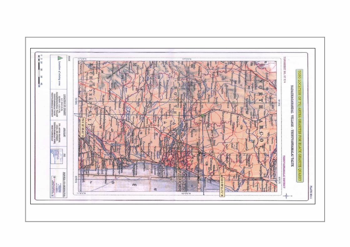
The Location of the area is given in Plate I. It is represented by
Survey of India Topo sheet No. 57 P/7 lies with centre reading in the
northern latitude of 12009‟27.49” to 12009‟33.86” and eastern longitude of
79010‟21.16” to 79010‟28.09”with elevation of 157m above MSL. The area
is a moderately elevated hilly terrain.
b) Latitude and Longitude of all Pillars reading are given below:
TABLE-I
PILLAR NAME LATITUDE LONGITUDE
A 12009‟30.99”N 79010‟21.16”E
B 12009‟33.86”N 79010‟22.43”E
D 12009‟28.01”N 79010‟28.09”E
E 12009‟26.67”N 79010‟27.30”E
G 12009‟27.49”N 79010‟23.30”E
H 12009‟28.20”N 79010‟22.20”E

104
c) Route:
Thiruvannamalai 15Kms
Nadazhagananthal 1km
34Kms 0.1m
Villupuram
Fig.1 Showing Location and route map of Existing Quarry lease
SITE

105
d) Details of Infrastructure is given as under,
TABLE -II S. No. Particulars Location Approximate
Distance in Kms
Direction
1. Post office Gangapattu 2 South
2. Town (Taluk Head) Thiruvannamalai 15 West
Road NH- Road
Thiruvannamalai-Villupuram
0.1 South
3. Police Station Vettavalam 10 East
4. Fire Station Vettavalam 10 East
5. Govt. Hospital Konaloor 3 West
6. School Gangapattu 2 South
7. Temple Nadazhagananthal 1 West
8. DSP Office Thiruvannamalai 15 West
9. Railway Station Thiruvannamalai 15 West
10. Nearest Airport Chennai 186 NE
11. Nearest Seaport Chennai 216 NE
12. Union Gangapattu 2 South
13. Villages
i) Kattumalaiyanur 1.5 North
ii) Iluppatangal 2 South
iii) Sanippundi 1.5 East
iv) Nadazhagananthal 1 West
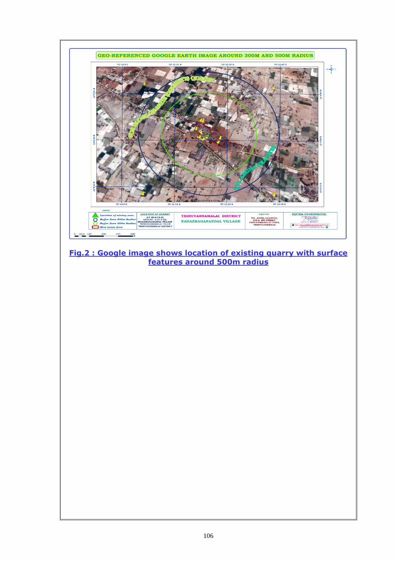
106
Fig.2 : Google image shows location of existing quarry with surface
features around 500m radius

107
12009’30.99”N79010’21.16”E
12009’33.86”N79010’22.43”E
12009’28.01”N79010’28.09”E
12009’26.67”N79010’27.30”E
12009’27.49”N79010’23.30”E
12009’28.20”N79010’22.20”E
Fig.3 : Google image shows Lease boundary of the existing quarry

108
1.6 REVIEW OF COMPLIANCE POSITION OF SALIENT FEATURES OF
MINING PLAN/ SCHEME OF MINING
Special conditions imposed by State Government while approving the
mining plan are,
i) The applicant should provide a safety distance of 50 meters from
the electric line on the northern side.
ii) The District Collector shall obtain a sworn –in- affidavit from the
applicant firm containing above conditions before execution of lease
deed and also ensure that the instruction issued in Govt. letter No.
12789/MMBII/2002-07, Ind. Dept. dated 09.1.2003 are complied
with.
No other special condition was imposed during the last 16 years by
the Dept. of Geology and Mining by the district office at Thiruvannamalai
and commissioner ate in Chennai. Now the mining scheme is prepared for
the lease area over an extent of 2.21.0 Hec. as per the above G.O.No.
(4D) 2, Industries (MMB1) Dept \dated 27.08.1999. As third time scheme
of mining plan period is expired on 31.3.2014, now the scheme of mining
is prepared for the period from 2015-16 to 2019-20 for approval from the
Dept of Geology and Mining, Chennai for systematic operation.
1.7 REVIEW OF IMPORTANT CHAPTERS OF MINING PLAN
a) Name of the Mine :
The Block colour granite (Dolerite) Quarry of Tvl. Aruna Granites,
Thiru A.Arunachalam, residing at. No. 109-A, Big Street, Thiruvannamalai
Town, Thiruvannamalai – 606 601, Tamil Nadu.
b) Particulars of approval of mining plan under GCDR 1999 indicate
approval letter No & date:
The mining plan for this Lease area was approved by the
Commissioner ate of Geology and Mining, Chennai in letter Rc.No
819/MM5/2003 dated 13.06.2005 and third Scheme of mining plan expired
on 31.03.2015.
c) Date of commencement of mining operation:
As such, the Block colour granite deposit referred to as „Dolerite‟ occurs
in the lease area is being mined since 12.02.2000 in accordance with the
109
provision of plan approved by the commissioner of Geology and Mining,
Chennai-32.
1.8(a) Deficiencies, if any that existed in the approved mining plan
to be taken note of and rectified by incorporating suitable proposal
for implementation in the scheme of mining.
No deficiencies existed against the proposals given in the earlier
mining plan except afforestation program. The recovery percentage was
proposed as 10-20% and the same was achieved. As the quarry reached 4-
9m depth below the weathered layer, the recovery rate is expected as 10-
20% up to a depth of 33m.
1.8(b) A review of compliance position of salient features of the
mining plan on chapter wise basis bringing out marked
deviations, if any and justifications/reasons thereof. Item to be
covered may include exploration, mine development, exploitation,
afforestation program, reclamation and rehabilitation, control of
dust, noise and ground vibration and any other significant feature
including conditions and stipulations imposed, if any, on year-wise
basis:
i) EXPLORATION:
Systematic remapping of commercially viable granite deposit has
been prepared with relevant information like structural features such as
dip, strike, lineation, joint patterns etc. Based on subsurface geology as
exposed in the working pit and marketability, the geological and minable
reserve has been computed to a reasonable depth of 33m bgl. In the earlier
approved mining plan, it has been proposed to lower two bore holes to
ascertain the depth persistence of deposit and recovery of gang saw size
blocks. But the proposed exploration has to be done during the ensuing
years (2016-18).
The proposed two core drilling shall be vertical to a depth of 30m
from the pit bottom with Nx and Bx standard size at the center along X1-Y1
and X2-Y2 sections to probe the depth and quality of the deposit at deeper
levels during the period 2016-17.

110
ii) MINE DEVELOPMENT
The mine development was undertaken as against the proposals laid
down in the five years plan period and the development actually done is
detailed below.
a. PROPOSED IN THE SCHEME OF MINING PLAN:
TABLE-III
Year
Development(M3) Production
@15% (m3)
Ore : Waste
(%) Top Soil Waste Rejects
@ 85%(m3)
2000-01 --- --- 2347 250 1: 0.11
2001-02 --- --- 1700 300 1: 5.66
2002-03 --- --- 1700 300 1: 5.66
2003-04 --- --- 1700 300 1: 5.66
2004-05 --- --- 1700 300 1: 5.66
Total --- ---- 9147 1450 1: 6.30
ACTUAL WORK DONE: TABLE-IV
Year Development Production
(m3)
Ore:
Waste (%) Top Soil Waste Rejects(m3)
2000-01 1150 176.24 273.041 140.194 1 : 11.41
2001-02 860 267.21 689.287 204.891 1 : 8.87
2002-05 2500 --- --- Nil ---
2005-06 --- 63.32 98.630 39.068 1 : 4.15
2006-07 --- 174.30 289.274 138.126 1 : 3.36
2007-15 No Production
4510 681.07 1350.232 522.279 1 : 12.52
Planned Actual
Over all Granite: Reject ratio= 1: 6.30 1: 12.52
i) REVIEW OF MINE DEVELOPMENT:
During the year 2002-05 the lessee concentrated in development
work and no production during this period. Again during the year 2007 -
2015 the lessee had done only development work.
ii) EXPLOITATION
Dimensions of the Existing working pits are given as under in Table –V.
TABLE-V
Pit Bench L(m) W(m) D(m)
I I 44m 46m 9m
II I 40m 26m 4m

111
Maximum depth at the bottom bench floor level is 9m from the
surface. Details of Pit dimensions and depth of quarry are shown in the
Surface plan (Plate –V)
iii) WASTE MANAGEMENT
The waste that generated during the approved mining plan period is
reported as 1450 m3 of Granite rejects (Mining losses, cracks and small
boulders of granite) were dumped randomly around the pit. It has been
advised to the applicant to dump all such waste separately as per
GCRD,1999 within the lease hold area with proper grading. Wide spread of
dump causing land degradation should be avoided.
Proper garland drainage and retention wall at the toe of dump should
be formed to control wash outs and drain rain water with minimum
contamination.
The dimension of dumps at the end of 5th year and at the end of life
of mine is demarcated in the mine conceptual plan and sections. (Refer
Plate No.VIII)
vi) AFFORESTATION:
It is proposed to plant 20 trees per annum over the dumps and the
inner boundary of lease during the mining plan period. As against the
proposal, only 15 plants were planted along the approach road in the last
five years of scheme of mining plan period. However, it is proposed to plant
20 trees per annum along the inner boundary of lease during the ensuing
five years period of mining. (Refer plate No.X).
vii) LAND RECLAMATION AND REHABILITATION
It is proposed not to backfill the mine pit(s) and these may be
utilized as storage of rainwater after the mining activities over. The pit
boundaries shall be fenced to safe guard from the inadvertent entry by
proper fencing. However, the waste dump areas will be taken up for
planting suitable trees. The reclamation of the mine–pit(s) is not proposed
in the ensuing five years period of mining.
viii) CONTROL OF DUST, NOISE AND GROUND VIBRATIONS:
The drilling and blasting are being carried out as per the proposals
laid down in the approved mining plan. Shallow holes of 32mm dia. holes
are drilled. Conventional low explosives are being used. The scale of
blasting is however very less considering the rate of production.

112
In view of above, there is no adverse effect on dust, noise and
ground vibration by mining activities. As proposed in the mining plan
approved earlier, the drilling and blasting parameters were followed. The
drilling and blasting parameters will be as designed as above in the
ensuring five years period.
1.9 Review of the compliance position of conditions and stipulations
imposed, if any, while approving the mining plan. In case of non-
compliance/partial compliance detailed justification/reasons thereof may
be furnished along with proposal for compliance in the ensuing period:
The mining plan for area under reference has been approved with
conditions to comply with the provisions of Mines Act, Mines Rules and
Regulations and the rules framed there under. The proposals given in the
earlier mining plan for this area has been complied with the above rules
and regulations. Besides, the lessee has generally carried out the mining
operation in conformity with the above Acts and Rules and adhered to the
general/special conditions stipulated by the State Government for providing
the statutory safety distances to be maintained.
1.10 Review of compliance of violations pointed out after
inspections made under GCDR, 1999 during last five years. The
position emerging out of the yearly review of the mining plan while
checking up implementation of the mining plans in the field shall
also be taken note of at this stage.
As the validity of third scheme of Mining Plan expires on 31.03.2014.
There is no violations letter pointed out by the Department of Geology and
Mining, Thiruvannamalai district and commissioner ate of Geology and
Mining, Chennai.
1.11 Any other points requiring attention in the interest of proper
mine design, development and conservation and environment and
ecology of the area:
The present as well as the proposed mine working is so designed in
such a way mainly keeping in view of conservation of granite deposit,
afforestation, and production of environment and ecology of the mine area.
1.12 SIGNIFICANT FEATURES:
No significant feature observed in this area.
113
PART-I
2.0 PROPOSAL UNDER SCHEME OF MINING FOR THE NEXT FIVE
YEARS :
2.1.(i) Name and Address of the : Tvl. Aruna Granites,
Applicant Thiru A.Arunachalam
109-A, Big Street,
Thiruvannamalai Town,
Thiruvannamalai – 606 601, TN.
Contact No. : +919487332411,+919994439635
(ii) Name and Address, Register No. : S.Suriya kumar.
Validity date of RQP/Person M.Sc., M.Phil., F.C.C.(Min) PGDBA,DIPC.
employed under Rule 42(1)(d) No.3/216, K.S.V.Nagar,
who prepared the mining scheme Narasothipatti, Salem -4.
Phone : (0427)2444297
Cell : 98427 - 29655
Registration No. : Reg.No.RQP/MAS/013/87/A
Validity up to : 08.11.2021.
2.3 Granites to be Mined : Block colour – “Dolerite”
2.4 Area and date of expiry of : 2.21.0 Hec, 20.01.2020
Mining Lease
2.5 Details of lease particulars are given as under,
G.0.No Extent
(Ha)
Date of
grant
Date of
execution
Period of
lease
Date of
expiry
G.O.No. (4D)2,
Industries\Dept. 2.21.0 27.08.1999 21.01.2000 20 Years 20.01.2020
2.6 Details of Land particulars are given below,
State & District Taluk Village S.F. No. Extent
(Hec.)
Ownership
Occupancy
ThiruvannamalaiT
amil Nadu
Thiruvanna
malai
Nadazha
ganandal 61/2 (P) 2.21.0
Poramboke
Land
TOTAL 2.21.0
2.7 Toposheet No. : 57 P/7
2.8 All pillars corners readings of latitude and longitude.

114
Location Latitude Longitude Elevation Topography
A 12009‟30.99”N 79010‟21.16”E 153m
Moderately Hilly Terrain
B 12009‟33.86”N 79010‟22.43”E 158m
D 12009‟28.01”N 79010‟28.09”E 159m
E 12009‟26.67”N 79010‟27.30”E 158
G 12009‟27.49”N 79010‟23.30”E 158
H 12009‟28.20”N 79010‟22.20”E 160
2.9 Date of expiry of approval of Second Scheme of mining: 31.03.2015
3.0 GEOLOGY AND EXPLORATION
a) Physiography :
The lease area is almost flat terrain to a height of 157m above MSL
and quarry has to be reached a depth of 4-9m above MSL. No major Pond
or seasonal track is found nearby except water log in the old mined out
areas.
Water table is located at a depth of 36m from the surface with poor
yield. Being a hard formation yield of water in the pit is very poor. Area
around quarry lease is dry agricultural lands with acacia bushes, dry crops.
Trees on regional ground includes palmera, neem, Palai, Nona etc.
Temperature of the region is reported to be 30ºC to a max. of 40º C during
summer. Rain fall of this area is about 1000 mm during monsoons in a
year. Regional crops are sugarcane, ground nuts, Mango, Paddy and maize.
There are no monuments or area of public interest found in the vicinity.
b) REGIONAL GEOLOGY
Thiruvannamalai District is comprised of Archaean peninsular
gneisses such as Charnockites, Hornblende gneisses, Biotite gneisses and
migmatites etc. They are intruded by younger formations like dolerite dyke
and pegmatite. The dolerite is running for several kilometers from East to
West direction with steep dipping from 80°-90° with width of 80m. Huge
boulder at surface with >3-5m size is good indication of massive formation
at depth. The dolerite dyke is invaded into charnokite/gneissic rock. The
order of superposition of geological sequence are given as under,
Description Geological Age
Top soil – Red soil (2m Thick) - Recent Age
Dolerite ( Black Granite) - Achaean “
Charnockite - Achaean Age
Biotite gneisses - Achaean “
The regional rocks mostly composed of charnockite and gneisses

115
c) GEOLOGY OF THE PRECISE AREA
Dolerite is commercially called as Black granite by the quarry
operators and buyers. It is a type of ferro-magnesian dyke rock comprised
of mineral constituents such as Pyroxene (Augite and Hypersthene) and
Plagioclase. Granite is dark black in colour with light greenish back ground.
The texture is a typical ophitic with fine grained plagioclase embedded over
pyroxene matrix but not visible to naked eye. The rock is fine to medium
grained melanocratic and without any segregation or textural defects, but
more bouldary due to spheroidal weathering.
Based on the field observation, it is presumed the massive sheets of
granite are available at a depth of 9m with estimated rate of recovery of
10-20%. Gang saw size sheets may be persisted below 9m depth. Two
core drilling is suggested as the deposit is fully exposed at surface with
intermittent outcrops with spheroidal boulders. Dimensional cutting and
polishing of these type of hard, compact and massive rocks exhibits an
attractive black colour and attain high polishing. Hardness ranging from 6.5
- 7.5 (Moh‟s scale) specific gravity 3- 3.30 gms/cc and attain high polishing
which create an excellent aesthetic value.
The area applied for quarry lease contain dolerite dyke intruded into
the country rock comprising biotite gneiss and charnockite. The dyke is
partly covered by red morum soil. The length and width of sheet rock in the
lease hold area is measured as about 240m X 90m and dips vertically. The
top soil is 1-2m thick with boulders of black granite. The mineral
constituents of the rock mass are Hypersthene \Augite 50%, plagioclase
45% and others 5% as identified magascopically.
The order of geological sequence are,
Description Geological Age
Top soil - Morum (1m thick) - Recent
Dolerite - Archaean formation
Granitic Gneiss\Charnockite - Archaean “
Granitic Gneiss is the oldest rock into which the younger dolerite dykes
intruded later. The strike direction is measured as East to west direction
and dips vertical.

116
EXPLORATION AND RESERVES :
3.1 Category wise reserves estimated in the earlier Mining Plan
3.1.1Geological reserves (As per the previous Mining Plan)
Category of reserves Quantity (m3) Type of Granite
i) Proved 29,385 Dolerite
ii) Probable --- ------------- Total = 29,385 "
------------- 3.1.2 Mineable reserves (As per the previous mining plan)
Quantity of Mineable reserves = 21,784 m3
Type of Granite = Dolerite
Life of the Mine = 73 years
3.2. DEPLETION OF RESERVES :
Reported production = 522.279m3
Balance mineable reserves = Nil
The mineable reserves is re-estimated as =33,134 m3 (Up to 33m depth)
3.3 ADDITIONAL RESERVES ESTABLISHED
No additional reserves proved by drilling but the reserves remain
same for 33m depth.
Fig.No.4: General view of the existing Pit of the western side

117
Fig.No.5: General view of the existing Pit of the eastern side
Fig.No.6: General view of the quarry on the northern side

118
Fig.7 : Photograph showing texture and colour of Block granite
Commercial Name: “Dolerite”
3.4 CATEGORY WISE UPDATED RESERVES :
i) Geological reserves :
Proved (0-33m) = 58,617 m3
Probable = --- (Not estimated in absence of drilling)
------------
58,617 m3 (Refer Table-VI and Plate –III & IV)
------------
Possible = Not Estimated
Table-VI
SECTION L
(m) W
(m) D
(m) Volume
Rate of recovery
Recovery @ 10-20%
(m3)
Reject @ 80-90%
(m3)
AB-X1Y1
39 30 3 3510 10% 351.0 3159.0
41 32 5 6560 20% 1312.0 5248.0
65 66 25 107250 20% 21450.0 85800.0
AB-X2Y2
64 45 3 8640 10% 864.0 7776.0
65 45 5 14625 20% 2925.0 11700.0
75 45 25 84375 20% 16875.0 67500.0
AB-X3Y3 43 26 3 3354 10% 335.4 3018.6
79 51 18 72522 20% 14504.4 58017.6
TOTAL 300836 58616.8 242219.2

119
ii) Mineable reserves :
The mineable reserves is also estimated by cross-sectional method
having considered the recovery factor, depth of mining, safety barriers etc.,
The mineable reserves is estimated as 33,134m3. Details of estimation of
mineable reserve are given in the Table-VII and Plate No.VIII & IX) below,
Table-VII
SECTION BENC
H L (m)
W (m)
D (m)
Volume Rate of recover
y
Recovery @
10-20% (m3)
Reject @ 80-90%
(m3)
AB-X1Y1
I 39 30 3 3510 10% 351 3159
II 38 29 6 6612 20% 1322 5290
III 56 57 6 19152 20% 3830 15322
IV 50 45 6 13500 20% 2700 10800
V 44 33 6 8712 20% 1742 6970
V 38 21 6 4788 20% 958 3830
AB-X2Y2
I 64 45 3 8640 10% 864 7776
II 65 42 6 16380 20% 3276 13104
III 75 36 6 16200 20% 3240 12960
IV 75 30 6 13500 20% 2700 10800
V 75 21 6 9450 20% 1890 7560
VI 75 9 6 4050 20% 810 3240
AB-X3Y3
I 43 26 3 3354 10% 335 3019
II 76 45 6 20520 20% 4104 16416
III 70 33 6 13860 20% 2772 11088
IV 64 21 6 8064 20% 1613 6451
V 58 9 6 3132 20% 626 2506
TOTAL 173424 33134 140290
TOPSOIL DEVELOPMENT
AB-X2Y2
I 64 21 3 4032 ‒ ‒ 4032
I 65 15 6 5850 ‒ ‒ 5850
I 75 9 6 4050 ‒ ‒ 4050
I 75 3 6 1350 ‒ ‒ 1350
TOTAL 15282 ‒ ‒ 15282
GRAND TOTAL 188706 33134 155572
Based on the field condition and lease boundary the economic depth
of mining is taken as 33m and the mine has reached a depth of 9m.
However the Granite band is continuing at depth with better recovery and
quality for mining.

120
OTHER EXPLORATORY DETAILS :
Almost the entire granite Band length on the southern side is opened
for winning the deposit and therefore no further trenching and pitting are
required for this area except two bore hole to prove the depth continuity,
colour, texture and recovery factor. The length and width of the deposit is
well established in the working pit but the depth should be proved by
drilling for proper planning of the mines. The proposed core drilling shall be
vertical and 30M depth with Nx and Bx standard size, should be drilled at
the centre along Section XY and AB to probe the depth and quality of the
deposit at deeper levels. Bore hole drilling have to be carried out with in a
period of five years.
Sampling:
In case of core drilling, the lithology, colour, texture, cracks, joints
mineral grains alignment have to be observed and manual polishing and
engineering properties can also studied for decorative purposes.
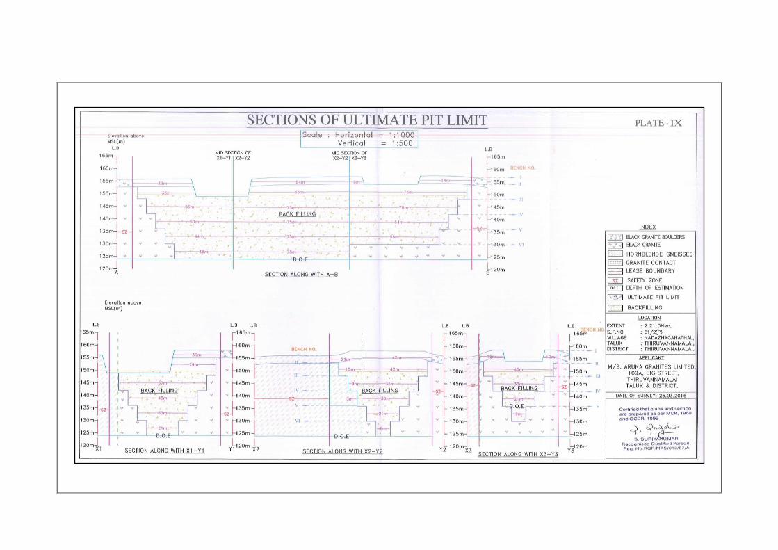
4.0 CONCEPTUAL MINING PLAN:
An updated conceptual mining plan and sections are prepared in
1:1000 scale to illustrate the final pit configuration. The ultimate pit
configuration and dump dimensions are shown as under,
ULTIMATE PIT DIMENSIONS (M) Table-VIIIA
Bench Mineral /
overburden L(m) W(m) D(m)
I Waste 219m 63m 3m
II Granite 213m 57m 6m
III Granite 201m 45m 6m
IV Granite 189m 33m 6m
V Granite 177m 21m 6m
VI Granite 113m 12m 6m
Total -33m
ULTMATE DUMP DIMENSIONS (M) Table-VIIIB
Description Dimension Quantity(m3)
Topsoil & Waste (Backfilling) (189m X 34m X 2.3782m) 15282m3
Reject (Backfilling) (189mX34m X 21.8316m) 140290m3
Total = 155572m3

121
Details of pit and dump dimensions are given in plate VIII. Ultimate
or over all pit slope shall be 60° and each bench height shall be 6M height
equal to the boom height of excavator and vertical. During working
normally 6m will be maintained as per the scheme of mining. After
completion of mining the pit will be used for fishy culture.
5.0. MINING
5.1 Salient Description of present Mining methods:
Open cast method of mining by mechanized method is adopted to
raise the production in this area using Line drilling, smooth blasting, block
lifting using cranes and waste and rejects removal using Hydraulic
excavators and tippers combination. The Wire saw cutting is proposed
below third bench to recover more granite blocks to increase the rate of
recovery. Granite is exposed in the existing pit and the recovery factor is
taken as 10-20% and it may increase further at deeper levels. Black
patches, side burden and granite rejects are the main development work to
raise production from this area.
The economical depth of mining is taken as 33m safely having
considered several field phenomenon. Five granite benches each of 6m
height are formed to win the blocks. As semi-permanent road was designed
such that it will not be affected for a long period on the western side to
enter the main pit. Massive sheets of granites is found on the East-West
side which is amenable for wire saw cutting.
Being a mechanized mining, the applicant had developed a long pit
over the granite band covering the entire area. Road is formed to connect
all pits for proper mining. Pit will be widened properly to reach depth to win
better quality granites with high recovery.
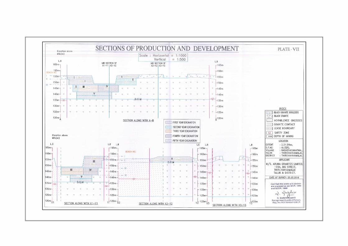
Details of Pit design parameters for production and development
work for the next five years are given in Plate VII. Height of benches shall
be maintained as 6m with vertical face for dimensional cutting during the
next five years.
5.2 a) Year Wise Production and Development for the first five Years:
The development involves only removal of rejects of some fines and
waste rocks to be generated out of production. About 80-90% of total
excavation is estimated to be the rejects\waste to win the saleable rough
122
blocks. The annual production is proposed as 2113m3 per annum. The
production schedule for the five years is given below in Table-IX and
production planning is shown in Plates VI,VIA & VIB.
TABLE-IX
Year Bench
(m3)
Overburden
/Boulders
(m3)
ROM Granite
(m3)
Recovery @
10-20%
(m3)
Reject @
80-90%
(m3)
Granite to
O/B ratio
2015-16 I 2079 14313 2075 12238 1: 6.89
2016-17 I 2790 10548 2110 8438 1: 5.32
2017-18 I --- 10602 2120 8482 1: 4.00
2018-19 I --- 10602 2120 8482 1: 4.00
2019-20 I 10692 2138 8554 1: 4.00
TOTAL 4869 56757 10564 46193 1: 4.83
Total production for the five Years = 10564M3
Total waste (4869m3+ 46193m3) = 51062 M3
Granite to Waste ratio = 51062/10564= 1:4.83
Safe benches with proper height were formed and pit will be widened
properly to reach depth to win better quality granites with high recovery.
Details of bench dimensions are given in Plate VI,VIA & VIB.
Details of Pit design parameters for production and development
work for the next five years are given in Plate VII. Height of benches shall
be maintained as 6m with vertical face for dimensional cutting.
i) BENCH DESIGN PARAMETERS :
Top soil shall be removed and stacked separately along Lease
boundary as Earth Bund which will be used for afforestation purposes in
phases. Granite benches will be formed to a height of 6m and width not
less than 10m for movement of machineries while working and the final
slope shall be 60°. Initially the granite benches will be vertical for
dimensional cutting of blocks. The applicant is proposed to produce
dimensional blocks to measure,
Minimum size = 1.50 x 1.00 x 1.00 m = 1.50 cu.m.
Maximum size = 3.40 x 1.90 x 1.80m = 11.62 cu.m.
Construction of parapet as a fencing around such ultimate pit limit on top of
opencast workings will be arranged to safeguard the mine from inadvertent
entry and hazards.
123
PROPOSED BENCH DIMENSIONS (m)
Year Bench
(m3)
Prod/Waste
Length
(m3)
Width
(m3)
Height
(m)
Slope
I --- Top soil --- --- --- ---
II I Boulder 33 21 3 60 deg
III II ,, 31 15 6 ,,
I
II
Production
38 30 3
Vertical II 33 45 3
II 37 29 6
II III
,, 31 42 6
,, III 8 57 6
III IV ,, 31 57 6 ,,
IV V ,, 31 57 6 ,,
V VI ,, 54 33 6 ,,
Final slope 60°
PRE-SPLITTING: Preface development is must for extraction of dimensional
blocks without cracking or fissuring of the body during drilling and blasting.
To achieve such preface a pre splitting technique using Jet burners on the
advanced direction are resorted to a distance of 6–10m.So as to isolate the
working face from the remaining area. These practices are followed to
minimize the formation of artificial cracks and tensional fissures that are
developed after blasting in the advance direction.
Shot - hole drilling with jack hammers and line drilling with top
hammers will be used at close spaced intervals to develop cracks along the
line of drilling and to open the blocks. Low strength explosives or merely
detonating fuse may be used to create a “pre-determined line of
cracks“so as to pull out the blocks from the working faces or wire
diamond wire saw cutting.
Block - Lifting is an art to remove the cracked rough block from the
face by a Crane/Excavator. The debris and rejects and waste will be cleared
from the face by Hydraulic Excavator and tipper combinations. The rough
blocks will further subjected to dressing to a desired size by secondary cut
at the surface. The rough dimensional blocks will be supplied to the
potential domestic and overseas customers. The waste will be dumped on
the specified place earmarked for dumping as shown in the Plate VI-X.

124
b) Drilling
Drilling of small dia holes is carried out using compressor and Jack
Hammers Combination for regular production of sizeable blocks. Large dia
drill shall be used to make hole for connecting the diamond saw wire for
cutting a large size blocks for pre-splitting arrangements. Depth of each
small dia is 2.5m for 3m bench height and large dia holes shall be 6-8m
depends on bench height and extent of cutting on advance direction. The
spacing of small dia holes shall be 30 - 40 cms and burden from the preface
depends upon the size of block. However it is preferred to have <1m
burden from the preface for effective pulling of blocks. In case of burden in
excess of 1.5m the spacing should be adjusted smaller, less than 30 cms.
To achieve a correct blasting geometry certain amount of trial blast is often
prerequisite to effect a perfect pre-determined to release the block from
the parent rock. In case of wire saw cutting joints and fracture have to be
studied below connecting the diamond wire for smooth cutting and to avoid
damage of wire. Details of Drilling equipments are tabulated below
TABLE-XA
Type Nos. Dia. Of
Hole
Size/Capacity
Make
Motive
Power
H.P.
Jack Hammer 3 32mm Hand held Atlas
Copco
Diesel 60
Compressor 1 7.5 Kgs/
Kg
Atlas copco 10.5
Kgs/cm2
“ 300cfm
Bench Floor
Bench Ht
Burner Cut l
Holes
Pre face
Diamond wire
Wire saw machine

125
c) Loading Equipment:
Loading of waste and granite rejects shall be done by Hydraulic
Excavators into 10 tonners tippers for clearing of waste and rejects from
the working place periodically. The applicant is engaging one Hydraulic
excavators with 1.7m3 capacity and one tippers of 10 tonnes capacity for
internal transport of rejects from the working face to the dumps.
TABLE-XB,
Type Nos. Bucket Capacity (m3) Make Motive Power H.P.
Hydraulic 1 No 1.7 m3 Volvo Diesel 180
Fig.8a) Hydraulic Excavator b): Tipping Truck
Tata LC 180
d) Haulage and Transport Equipment:
Transport of Rejects and waste are removed by Tippers of 10tonne
capacity Table-XC
Type Nos. Bucket Capacity
(m3) Make
Motive Power
H.P.
Tipper 1
1Nos 10M.T
Ashock
Leyland Diesel 110
5.3) Miscellaneous Operations : i) Extent of Manual Mining
Manpower will be engaged for drilling shot-holes, line drilling, smooth
blasting, Jet burner operation, dressing of granite blocks, cutting and
removal of small amount waste or rejects and support service labours for
operation of machineries.
The materials required for manual workings are listed as under,
1. Drill rods - 450mm , 800mm,1650mm,3900mm and upto 7200mm.
2. Steel alloy chains of sufficient lengths with dia. of 12 - 18mm with
“D‟ shackles.

126
3. Rubber hose and clamps
4. Feather and wedges of 15 cm and 30 cm sizes utilised for splitting of
blocks.
5. Crow bars of 1500 - 1800mm lengths.
6. Spades, Sludge hammers, Iron Pans and chisels.
ii) Pumping :
Dewatering arrangements shall be made to pump out the rain and
percolation of ground water during rainy seasons. A stand by pump with 10
H.P. capacity is essential to meet the emergency.
5.4. BLASTING :
A controlled Blasting technique is adopted to open a pre-determined
crack of the block from the parent body. Shot-hole with 32-40mm dia.
which are drilled by line drilling and Jack hammers at a close spaced
interval of 30 cms will be initiated suitably with any one or more of the
following methods,
i. Pre-splitting
ii. Cushing blasting with low strength and very low dia. Cartridges axial
priming or standard dia. cartridge with intermittent stemming
materials.
iii. Water impulsion with Detonating cords of sufficient power, Preferably
10gms per metre to develop cracks along the line of drilling,
a) BROAD BLASTING PARAMETER
Dia. of the hole = 32 - 36 mm
Spacing = 30 cms
Depth = 2.5 m
Burden = Min =1m ; Max = 2m
Charge per Hole = D.cord with water or 70 gms of gun powder or slurry.
In watery holes, the detonating fuse is directly used and water act as
a cushion to move the blocks and form a line of crack. In other cases, small
vibrations created by low explosives open the artificial shear plane \
tensional crack formed by a line of drilling. Sometimes wedges are used to

127
cut the major blocks into smaller sizes after drilling of holes to a depth of
30-40 cms. Then the blocks are dressed to desire sizes.
b) TYPE OF EXPLOSIVES :
Common explosives used to develop a line of crack along the line of
drilling are,
i. Detonating Fuse or Cord with 5-10gms of Expl. per metre,
ii. Low explosives like Gun powder or 70 gms of slurry cartridges,
iii. Ordinary Detonator, class- 6
iv. Safety fuse, class -6.
c) Powder factor : The Powder factor for waste rock development shall
be 2m3 or 7 tonnes per Kg. of explosives.
d) STORAGE OF EXPLOSIVES
The applicant is directly purchasing explosives from the authorized
dealer and they are blasting with help of blaster certificate holders as there
is no space for storing explosives in nearby area. It is advised to store the
explosives as per the Indian Explosives Act, 1958. The explosives to be
used in mines being a small quantity the District collector may be
approached to keep the stocks not exceeding 5 kgs at time or any other
quantity permitted by the concerned authorities in a portable magazine of S
& B types.
6.0 MINE DRAINAGE
a)Surface Water control: There is no major river, drainage, track and
water bodies are located around 500m radius.
b)Water Table: The ground water table is observed at a depth of 36m in
the tube wells. Though the mining is proposed to a depth of 33m, the
ground water may not percolate into the quarry in view of massive
formation without much fractures and joints.
c) Quantity and Quality of Ground water: The recuperation of ground
water is poor in hard formation. The rain water percolation and collection
shall be less than 300 lpm and it shall be pumped about periodically by a
stand by diesel powered centrifugal pump motivated with 30H.P. Motor.
The quality of water is potable without any contamination and it shall be
pumped into the adjacent agricultural fields and plantation area.

128
7.0 STACKING OF GRANITE REJECTS AND DISPOSAL OF WASTE
Granite rejects which amounts to 80-90% of the total excavation,
about 46193 M3 will be generated for mining up to 33m depth. It is
revealed in the final mine closure plan showing the ultimate depth of
mining and ultimate pit configuration. Maximum height and spread of
dumps for the next five years are given as under, Table-XI
Year Topsoil
(M3) Overburden/Waste
(M3) Granite Rejects
(M3) Total
2015-16 --- 2079 12238 14317
2016-17 --- 2790 8438 11228
2017-18 --- --- 8482 8482
2018-19 --- --- 8482 8482
2019-20 --- --- 8554 8554
Total --- 4869 46193 51062
All dumps will be made separately over barren area as per Plate –VI,
VIA & VIB. All the rejects shall be dumped along eastern side of the lease
area temporarily and back filled over the mined out area in future. Small
pieces of granite shall be used for tile and monument industries.
Year wise Dump Dimensions (m)
Description Dimension Quantity(m3)
Topsoil & Waste (Backfilling) (29m X 33m X 5.0878m) 4869m3
Reject (Backfilling) (31mX55m X 27.0927m) 46193m3
Total = 51062m3
All the rejects and waste materials shall be dumped eastern side of
the lease area. Being a working mine the approach road is already available
on the south side and the exiting road within the mines shall be used for
proper transport of materials by tippers\dumpers. For convenience of
operation and increase of production together with safety and environment,
it is designed parallel to the strike length over the good quality portion for
the next five years. Granite rejects and side burden are major waste work
which has to be transported to the respective places as per the plan. The
overall Granite to waste ratio for the next five years as 1: 4.83

129
7.1 ANY CHANGE IN PROPOSED METHOD OF MINING AND DEVELOPMENT:
MACHINERIES:
No change is envisaged for future development of Mines.
7.2. Handling of waste / Sub grade materials:
The waste rocks to be generated from the mine will be fragmented
gneisses and rejects of Granite with patches, cracks and small size blocks.
All top soil and waste materials shall be dumped barren lease area for
plantation purposes over inactive dumps after end of year mining
operation. Total generation of Granite rejects and waste for the next five
years will be 46193M3 and for the whole life of mine will be 140290M3.
7.3 OTHER PERMANENT STRUCTURES
7.3.1 Habilitation:
The following villages are found in the buffer zone with population as
per 2011 census. The Nadazhagananthal Population of 2184 peoples of
both male (1140) and female (1044).
7.3.2 Power lines:
The HT line is found nearby the area leaving 50meters safety
distance as provided and LT line is found 60meters away on western side
from the site.
7.3.3 Water bodies:
There is no major river; drainage, track and water bodies are located
around 500m radius. Water table is located at a depth of 36m.
7.3.4 Archaeological\Historical monuments:
No infrastructures and places of interest like archeological
monuments, Sanctuaries, bridges etc are found within 500m radius.
7.3.5 Road:
NH-road is situated about 10meters away on southern side
connecting Thiruvannamalai-Villupuram. The approach road located
southern side of the site for transport of materials.
Name of Village Direction Distance
from Mines
Population
(Approx)
Kattumalaiyanur North 1.5 3173
Iluppatangal South 2 2782
Sanippundi East 1.5 2832
Nadazhagananthal West 1 2184

130
7.3.6 Place of worship:
There is no place of worship like School, archeological monuments and
Villages found around 500m radius.
7.3.7 Reserves Forest\Forest\ social forest\ wild life sanctuaries etc
There is no reserve forest is situated around 10kms radius. There is
no wild life sanctuaries are involved around 10kms radius.
7.3.8 Any other structures: Nil
8. EMPLOYMENT POTENTIAL & WELFARE MEASURES
8.1 Employment Potential
Management and supervisory personal.
For the purpose of Mines safety under the provisions of MMR, 1961
under the Mines Act, 1952.The Mining Engineer so appointed should have
First\ Second class Mine Manager certificate to act as a Manager of the Mine
as per the Mining laws. To supervise daily, of all workings and the persons
employed therein the First\second class Manager so appointed must be
assisted by a Foreman certificate holder. Wherever the workers are
employed more than 10, it is preferred to have a qualified Mining Mate to
keep all the production workers directly under his control and supervision.
A mines clerk shall also be appointed to keep the registers and
record of the mine and make necessary entries for the persons employed in
the mines.
a) Manager Cum Mining Engineer : 1 Person
(exempted under rule 42(6)(d) of
GCDR, 1999) Second Class
b) Mining Mate : 1 person
c) Blaster : Nil
d) Supervisor : 1 Persons
e) Clerk cum record keeper : 1 person
LABOUR SKILLED – SEMI SKILLED AND UNSKILLED
1) Skilled
Operator : 1 Persons
Wire saw operator : 1 Persons
1) Semi-skilled
Driver : 2 Persons
Welder 1 Person
Driller 8 Persons
1) Unskilled
Dressing Labours : 4 Persons.

131
Cleaners : 2 “
Office boy : 1 “
---------------
Total Labours = 20
Management and supervisory staffs 1
---------------
Total employees = 21
---------------
ORGANISATION CHART
9.0. USES OF GRANITE:
Polished black granite are widely used for decorative purposes in
building, monument, Institutional, commercial and residential buildings in
the form of slabs, tiles, cut to size, markers etc., Its demand is high both in
domestic and International market even for the rough blocks preferably in
Europe, middle east, china etc
Part of Granite raised out of the mine is proposed to be transported
to the polishing units located in Chennai, Bangalore and other parts of
Tamil Nadu and Karnataka as well as exports through agencies.
9.1.GRANITE PROCESSING UNITS:
The applicant does not have the facilities to cut and polish the rough
blocks of granite. He proposes to export the rough blocks directly to the
potential buyers of the Domestic and world market.
Owner/Agent (mines)
Permit Manager / Mining Engineer
Clerk cum Record Keeper Mining Mate
Office Assistant
Blaster Work Men Drillers

132
9.2 ENVIRONMENTAL MANAGEMENT PLAN :
Salient Items Proposal as per
Approved
Mining
Position at the end of five
years
Proposal for the next five
years
1. Topsoil belt storage and
preservation
Top soil was
proposed to use for dump
afforestation
Dumped along with waste
No much top soil
2. Reclamation and
Rehabilitation
No land
reclamation and rehabilitation proposed
Does not arise No proposal
3. Waste dump
Management :
Separate dumps proposed for top
soil, rejects and waste.
Top Soil along
with waste
Again separate dumps for
Topsoil for Next five years
4. Afforestation
Programme
20 trees per annum proposed
for plantation
Not implemented due to lack of
water.
20 trees will be planted per year
as per Plate X
5. Quality of Air : Small mine No proposal is
given --
6. Quality and Make up of water
Drinking water is provided through
public source only No major
seasonal drainages.
No effect for
surface or ground water
sources.
As per the
previous Mining Plan
7. Noise Level No machineries No Impact No proposal
8. Vibration Does not araise No impact No proposal
9. Treatment of Mine Water
Does not araise No impact No proposal
10. ANY OTHER INFORMATION : Nil

133
PART - II
11.0 ENVIRONMENT MANAGEMENT PLAN
A) BASE LINE INFORMATION
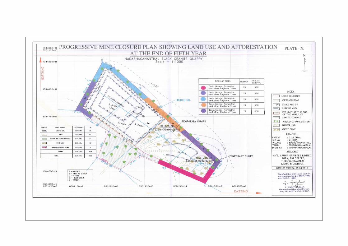
i)Existing Land use Pattern:
The area is composed of red soil and outcrops of Block colour granite.
The existing and the end of fifth years land use pattern is given as under,
TABLE-XII
S.No Description Present
area (Ha)
Extent (Ha) % of Use
1 Working Pit 0.31.72 0.54.97 25%
2 o/B or Back Filling --- --- ---
3 Mine Roads 0.01.70 0.03.50 2%
4 Safety and Area
under plantation 0.74.39 0.74.39 34%
5 Dump area 0.50.34 0.26.62 12%
6 Labour shed and
office 0.05.00 0.05.00 2%
7 Virgin 0.57.85 0.56.52 25%
Total 2.21.0Ha 2.21.0Ha 100
ii) Air quality: Air sampling was not done. It is proposed to carry out
monitoring of Dust raise by periodical air sampling for every season as per
norms of MoEF and DGMS.
iii)Water quality: A water sample has to be tested once in a Year for a
minimum of 20 elements in a NABL \MoEF Lab to assess hardness, salinity,
colour, specific gravity, PH, turbidity, COD, BOD, fluorine etc
iv)Noise levels: Threshold sound level is reported as 60dB. This is within
the limit as prescribed by DGMS.
v)Vibration levels: No deep hole blasting at present. In case of deep hole
blasting or any large dia explosive usages. Vibration and air blast noise
have to be tested.
vi)Water Regime: There is no major river, drainage, track and water bodies
are located around 500m radius. Water table is located at a depth of 36m.
vii) Public building, Places and Historical monuments:
No infrastructures like residential building, places of special interest
like archeological monuments, Sanctuaries etc., are found in the radius of
500m.

134
viii) Flora and Fauna:
a)Flora:
Flora as observed and identified on regional scale are covered by
photograph and shown below. Mostly Palm tree, acacia, neem, Panai tree
and coconut trees are found more on regional scale. The lessee has
developed trees like Teak, Mango, Tamarind and other regional trees etc
with proper nursery garden and plantation on vacant land.
Fig.9 a) Erukku trees b) Palmara trees
c) Neem tree d) Acacia bushes & Corai
Flora is represented by herbs and shrubs of local species and free regional
trees and their botanical terms are given as under with numbers.
TREES :
S.No. Name of
trees
Botanical Name Number Remarks
1 Vembu Azadirachta indica 22 Growing well
2 Bushes Acacia Nilotica 34 „‟
3 Coconut Cocos nucifera 108 Growing well
4 Panai Borassus flabellifer 36 ,,

135
SHRUBS:
S.No. Local Name Botanical Name
1 Nayuruvi Achyranthus aspera
2 Erukku Calotrophis gigantea
3 indumul Pterolobium indicum
HERBS:
S.No. Local Name Botanical Name
1 Poolai poondu Aerva lanata
2 Korai Elacocarpus aerratas
3 Thumbai Leucas aspera
4 Peru Nerunji Pedalium murex
5 Kantangkathri Solanum xanthocarpum
b)Fauna:
The fauna species observed around the project site is given below, Mammals:
S.No. Local Name Botanical Name
1 Indian palm squirrel Funambulus palmarum
2 Rabbits Lepus curpaeums
Avian Fauna:
S.No. Local Name Botanical Name
1 Black kite Milvis migrans
2 House crow Corvus splendens
3 Black drongo Dicrurus macrocercus
4 Greater racket-Tailed drongo Dicrurus paradiseus
Butterfly/Insects:
S.No. Local Name Botanical Name
1 Scorpion Scorpiones
2 Millipedes Diplopoda
3 Cicada ---
4 Common Mormom Papilio polytes
5 Dot dash sergent Athyma kanwa

136
ix) Climatic Conditions:
The district receives the rain under the influence of both southwest
and northeast monsoons. The northeast monsoon chiefly contributes to the
rainfall in the district. Most of the precipitation occurs in the form of
cyclonic storms caused due to the depressions in Bay of Bengal. The
southwest monsoon rainfall is highly erratic and summer rains are
negligible. Rainfall data from seven stations over the period 1901-2000
were utilized for analysis and a perusal of the data shows that the normal
annual rainfall over the district varies from 103-458 mm. Average rain fall
is reported as 1047mm per annum.
The district enjoys a subtropical climate. The period from April to June is
generally hot and dry. The weather is pleasant during the period from
November to January. Usually mornings are more humid than afternoons.
The relative humidity is on an average between 65 and 85% in the
mornings. Humidity in the afternoon is generally between 40 and 70%.The
annual mean minimum and maximum temperatures are 23.78 and 33.95°
C respectively. The daytime heat is oppressive and the temperature is as
high as 40.2°C. The lowest temperature recorded is of the order of 19.3° C.
Summers
The sun is at its glory and shines very brightly during the summers. During
the summer months, i.e. from May to June, the temperature varies
between 27°C and 40° C. Therefore, the climate is quite hot. May is the
hottest month. Cottons are recommended during this time.
Winters
In winters, which starts from December and lasts till February, the
temperature ranges between 20° C and 30° C. The climate remains pleasant
during this time, as the temperature rarely falls below 20° C.
Monsoon
Though the rainfall is very frequent and uniform throughout the year,
just like the flow of pilgrims and tourists, the city receives the major share
of rainfall between the months of July and October. The average rainfall is
85 cm.

137
Fig.10 Meteorological data
Fig.11 Monsoon Forecast

138

139

140
x) Human Settlement :
The following villages are found in the buffer zone with population as
per 2011 census. The Nadazhagananthal Population of 2184 peoples of
both male (1140) and female (1044).
xi) Public Building Places of worship and Monuments:
No infrastructures like residential building, places of special interest like
archeological monuments, Sanctuaries etc., are found in the radius of
500m. Nadazhagananthal Village is situated about 1kms on the western
side.
B) ENVIRONMENT MANAGEMENT PLAN
i)Dust: Dust expected to be generated from drilling , hauling roads, place
of excavation etc will be suppressed by periodical wetting of land by
spraying using MgCl2 solutions. Wet drilling and dust extractor
arrangements will be provided to drilling units so as to control raise of dust
from the site of drilling. Operators, those exposed directly to such
conditions will be provide such protective equipments like mask, ear plug,
helmet, gloze etc as per the Mines Act.
ii)Temporary storage and Utilization of Top Soil:
Top soil shall be dumped along separately on the eastern side of
lease area for plantation purposes over inactive dumps after end of year
mining operation.
iii)Proposal for reclamation land affected by mining activities during and
at the end mining lease period :
The depth of granite deposit is not known. However for economical
planning, the depth is taken as 33m from the surface. Immediate
reclamation of land does not rise for this deposit. However it pits will be
used for miscellaneous purposes like fish bond etc., after completion of
mining.
Name of Village Direction Distance
from Mines
Population
(Approx)
Kattumalaiyanur North 1.5 3173
Iluppatangal South 2 2782
Sanippundi East 1.5 2832
Nadazhagananthal West 1 2184
141
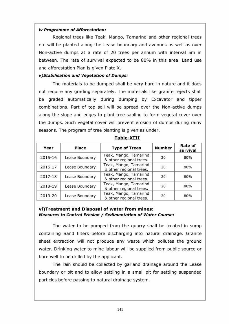
iv Programme of Afforestation:
Regional trees like Teak, Mango, Tamarind and other regional trees
etc will be planted along the Lease boundary and avenues as well as over
Non-active dumps at a rate of 20 trees per annum with interval 5m in
between. The rate of survival expected to be 80% in this area. Land use
and afforestation Plan is given Plate X.
v)Stabilisation and Vegetation of Dumps:
The materials to be dumped shall be very hard in nature and it does
not require any grading separately. The materials like granite rejects shall
be graded automatically during dumping by Excavator and tipper
combinations. Part of top soil will be spread over the Non-active dumps
along the slope and edges to plant tree sapling to form vegetal cover over
the dumps. Such vegetal cover will prevent erosion of dumps during rainy
seasons. The program of tree planting is given as under,
Table-XIII
Year Place Type of Trees Number Rate of
survival
2015-16 Lease Boundary Teak, Mango, Tamarind
& other regional trees. 20 80%
2016-17 Lease Boundary Teak, Mango, Tamarind
& other regional trees. 20 80%
2017-18 Lease Boundary Teak, Mango, Tamarind
& other regional trees. 20 80%
2018-19 Lease Boundary Teak, Mango, Tamarind
& other regional trees. 20 80%
2019-20 Lease Boundary Teak, Mango, Tamarind
& other regional trees. 20 80%
vi)Treatment and Disposal of water from mines:
Measures to Control Erosion / Sedimentation of Water Course:
The water to be pumped from the quarry shall be treated in sump
containing Sand filters before discharging into natural drainage. Granite
sheet extraction will not produce any waste which pollutes the ground
water. Drinking water to mine labour will be supplied from public source or
bore well to be drilled by the applicant.
The rain should be collected by garland drainage around the Lease
boundary or pit and to allow settling in a small pit for settling suspended
particles before passing to natural drainage system.

142
vii) Measures for minimizing adverse affect on water regime:
Sampling of water shall be done at discharge point to check the
quality of water as per TNPCB standards.
viii) Protective measure for ground vibration:
Only shot hole blasting shall be adopted for breaking the boulders and
hard rocks. No deep hole blasting or machineries is used in this quarry.
Vibration from blasting or heavy machineries will be negligible. In case of
any report of vibration from the public Vibration test shall be conducted.
ix) Measures for protection of historical monuments and rehabilitation of
human settlements likely to be distributed due to mining activity:
No historical monuments or area of special interest or any other
sanctuaries are found around 500m radius from this area. Village also
located about 1kms away and no dwellings around 500m. Therefore
rehabilitation of human settlement or protection of historical places or
monuments does not arise.
x) Others like legal factors like tribal issues, national park etc:
There is no much heavy industry in this area. No other quarry is
operating around 500m radius. The villager will get some income due to
growth of mining industry. There are no legal issues or tribal problems
associated with this mine. It is Poramboke land in a village and no tribal
issues here. National park, Monuments etc totally absent around 5kms.
(xi) Monitoring schedule: Top soil conservation and dust control, surface
water contamination during rainy season, ground water protection, trees
plantation are the main area of EMP attention is required for this “B”
category mine.
xii) Socio-economic benefits arising out of Mining:
SOCIO-ECONOMIC ENVIRONMENT
Introduction
This section of the EIA report deals with Socio-Economic impact
assessment of the proposed Mining Project promoted by Tvl.Aruna Granites
properator, Thiru.A.Arunachalam, residing at. 109A, Big Street,
Thiruvannamalai town, site located at Nadazhagananthal village, Sub-
district Thiruvannamalai, District Thiruvannamalai, Tamilnadu.
The objects of the socio-economic impact assessment are as follows:

143
a) To study the socio-economic status of the people living in the study area
of the proposed mining project.
b) To assess the impact on socio-economic environment due to proposed
mining project.
Methodology
The methodology adopted for impact assessment is as follows:
The methodology adopted for the study is primarily based on the
review of secondary data, such as Primary Census Statistical
Handbook of Thiruvannamalai District in Thiruvannamalai taluk, 2001
& 2011 for the parameters of demography, occupational structure of
people within the study area of 300m and 500m radius around the
proposed plant. The salient features of the demographic and socio
economic aspects of the study area are described in the different
sections.
The details of the activities and population structure have been
obtained from Census 2001 and 2011 and analyzed.
Based on the above data, impacts due to mining operation on the
community have been assessed and recommendations for further
improvement have been made.
Population Characteristics – Nadazhagananthal Village
In Thiruvannamalai taluk, Nadazhagananthal village had a total
household 424 in 2001 which is increased to 545 in according to census
2011. Village had a total person of 2184 in 2011 census previous census
1636 persons in 2001. There were about 1140 men (52 %) according to
2011 census and 803 men (50 %) in 2001 census marking a decrease of
337 men over the previous census. During 2001 there were about 833
women (50 %), which is increase to 1044 (48 %) in 2011 census.
Nadazhagananthal village had a literate accounted for 1081 persons
(66 %) in 2001 and increased to 1423 persons (65 %) in 2011. There were
about 76 percent males in 2001 and 72 percent in 2011. There were about
469 (56 %) females increased to 596 (57 %) classes as literates in 2011.
Sex composition is the most important demographic characteristics
that affect the incidence of birth and death. The average sex ratio in
Thiruvannamalai district, Nadazhagananthal village was 1037 during 2001

144
and decreased to 915 during the year of 2011. The lowest sex ratio may be
either due to the migrants for educational purpose and employment
opportunities and due to infant birth of female is very Low during the year
of 2011.
Population Characteristics-Nadazhagananthal Village,
Thiruvannamalai Taluk, Thiruvannamalai District (2001-2011)
Sno Characteristics 2001 % 2011 %
1 Total Household 424 545
2 Total Population 1636 2184
3 Male Population 803 49.08 1140 52.20
4 Female Population 833 50.92 1044 47.80
5 Total Literacy 1081 66.08 1423 65.16
6 Male Literacy 612 76.21 827 72.54
7 Female Literacy 469 56.30 596 57.09
8 Sex Ratio 1037 915.8
Occupational Characteristics - Na–azhagananthal Village
The term workers denote the population engaged in primary,
secondary and tertiary activities classified in the census reports of Indian
government. During the year 2001 Nadazhagananthal village had 977
workers accounting for 59 percent of the total population of the Village.
During 2011 there were about 1042 (47 %) according to the census. There
were about 496 men (61 %) during 2001 which is increase to 655 persons
(57 %) according to census 2011. There were about 481 (57 %) female

145
according to 2001 which is decreased 387 (37 %) female during 2011
marking a decrease of 94 women over the previous census.
In Nadazhagananthal village had a total main workers accounted of
786 (48 %) persons during 2001 census which is increase to 833 (38 %)
persons during 2011. There were about 348 (41 %) women in 2001 and
280 (26%) women according to the census 2011 marking an decreases of
68 women over the previous census.
Study on occupation characteristics of population should analyze the
workforce engaged in different type of occupation. Cultivators are the
major category of occupation representing the workforce owning land.
Nadazhagananthal village had total cultivators 556 (56 % of the total
workers) cultivators. The proportion of cultivators to total workers is
calculated as a percent for the two census years 2001 and 2011 for the
taluk of Thiruvannamalai in Nadazhagananthal village. There were about
316 (63 %) men in 2001 which is decrease 309 (47 %) according to census
2011. Nadazhagananthal village had female cultivators 240 (49 % of the
female workers) cultivators during 2001 census which is decreased 177 (45
%) during according to census 2011.
The distribution of agricultural laborers in the study area for the two
census periods has revealed that the study area has experienced a decline
in the proportion of workers classed as agricultural laborers between 2001
and 2011. Thiruvannamalai taluk in Nadazhagananthal village had
agricultural labourers 151 (15 % of the total workers) agricultural labourers
during census 2001. There were about 70 (14 % of male workers) men in
2001 which is increase to 94 (14 % of male workers) according to census
years 2011. Nadazhagananthal village had female agricultural laborer
decreased 66 (17 % of female workers) census 2011 compare to the
previous census year 2001 about 16 % of female workers.
This group includes the employment of workers in manufacturing
activities. Agro based industries, located in the study area engages a
sizeable amount of workers. The distribution of secondary workers in the
study area is calculated as percent to the total workers. The proportion of
secondary workers to total workers has experienced decreasing trend in the
Nadazhagananthal village area between 2001 and 2011. Secondary

146
workers during 2001 and 2011 it could be stated that this may be due to
the opening of a number of manufacturing units in the study area.
The tertiary workers include the labour force engaged in service
sector such as education, medical, judicial, finance, administration,
recreation, trade and commerce and transport. In Nadazhagananthal village
had tertiary workers accounted for about 5percent of the workers during
2001 census it is increased 17 % according to census 2011. There were
about male tertiary workers of 43 (8 % of the male workers which is
increases 146 (22% of the male workers) according to census 2011. There
were about 13 women tertiary workers (2 % of the female workers) during
2001census which is almost increased to (9% of the female workers)
according to census 2011.
The study area has experienced a change in the occupational structure
in the form of a decline in the proportion of cultivators, agricultural laborers
and an increase in the proportion of tertiary workers.
In Nadazhagananthal village had non workers population accounted of
1142 (52 % of the total population) according to census 2011. Which is
decreased from previous census 2001 had population 659 (40 %). There
were about male non workers of (38 % of the male population) during the
census 2001. Which is increase to 485 (42 % of the male population)
according to census 2011. Because of more number of people are educated
most of people living the village had mining industries money earn our daily
life.
Amenities - Na–azhagananthal Village
Educational facilities All the villages in the study area are provided with minimum
educational facility. There are one primary or elementary school at
Nadazhagananthal village in the study area. However, there is no senior
secondary school, Industrial/Training school and college in the study area.
For higher education people have to rush to other towns.
Health Facilities The Primary health care centre is located in Nadazhagananthal
village distance between 5 km. Study area of the proposed Multi mineral
Granite project is very lacking in medical facilities in this area. There is no
hospital any type. The field investigation has revealed that during
emergency one rush to district hospital at Thiruvannamalai. Deep probe

147
made during the field survey has revealed that the health institutions
located in the study area are not fully equipped due to paucity of man
power, medicines, equipment and ambulances.
Drinking water : Drinking water is available in all the villages of the study
area. The various sources of drinking water are taps, wells, tanks, hand
pumps and rivers.
Electricity: All the villages in the study area are provided with electricity
and the same is available for domestic use, agricultural use and industrial
use.
Roads:Paved roads are available in eight villages. Where paved roads are
not there mud roads are there. They are connected by mud roads only. In
the mining lease area there is a paved road.
Other Facilities
Other facilities available in the study area are Post offices available in
Nadazhagananthal 3km from the mining area. Further, fire station is near
Thiruvannamalai and police station is nearest mining area and nearest
railway station taluk of Thiruvannamalai. Bus services are available in 11
above villages.
It is suggested that the project authority may take up the following
community development activities in order to uplift the socio-economic
conditions of the people in the impact area:
1) Construction of paved roads where mud roads are still in existence.
2) Setting up of an occupational training center at village Thiruvannamalai.
3) Setting up of secondary schools in those villages where it is still missing.
4) Setting of dispensaries or mobile medical units for providing medical aid
to villagers.
5) Protected water supply in villages where drinking water supply is
inadequate.
6) Village development by adopting selected villages.
Conclusions
With the setting up of the proposed mining project the occupational
pattern of the people in the study area will change to making more people
engaged in mining and business activities. This will reduce occupational
dependence of people on agriculture. In this study area are the facilities
like education up to 10+2 level, health, housing, drinking water, road etc.

148
are far from satisfactory. It is expected that same will improve to a great
extent due to intervention of the project proponent.
Occupational Characteristics of Population -Nadazhagananthal
Village,Thiruvannamalai Taluk, Thiruvannamalai District (2001-2011)
Sno Characteristics 2001 % 2011 %
1 Total Population 1636 2184
2 Male Population 803 49.08 1140 52.20
3 Female Population 833 50.92 1044 47.80
4 Total Workers 977 59.72 1042 47.71
5 Male Workers 496 61.77 655 57.46
6 Female Workers 481 57.74 387 37.07
7 Total Main workers 786 48.04 833 38.14
8 Male Main workers 438 54.55 553 48.51
9 Female Main Workers 348 41.78 280 26.82
10 Total Cultivators 556 56.91 486 46.64
11 Male Cultivators 316 63.71 309 47.18
12 Female Cultivators 240 49.90 177 45.74
13 Total Main Agricultural Labourers 151 15.46 160 15.36
14 Male Agri.Labourers 70 14.11 94 14.35
15 Female Agri.Labourers 81 16.84 66 17.05
16 Total Main HHI 23 2.35 5 0.48
17 Male HHI 9 1.81 4 0.61
18 Female HHI 14 2.91 1 0.26
19 Total Main Other Tertiary workers 56 5.73 182 17.47
20 Male OT 43 8.67 146 22.29
21 Female OT 13 2.70 36 9.30
22 Total Nonworkers 659 40.28 1142 52.29
23 Male Nonworkers 307 38.23 485 42.54
24 Female Non workers 352 42.26 657 62.93

149
xiii) Waste management: The waste to be generated shall be debris of
portable size hard rock without any red soil and connate water and
therefore collapse of dumps is not possible for this mine. All waste and
reject materials shall be dumped on the eastern side of the lease area.
Dimensions of Dump at the end of 5th year and at the end of Life of
Mine are given as under,
Description End of 5th Year End of Life of Mine
Topsoil No much of topsoil shall be removed
No much of topsoil shall be removed
Reject 46193m3 140290m3
Waste 4869m3 15282m3
As a part of Granite conservation and Environmental issues small
pieces of granite shall be used for tile and monument industries. Huge gang
saw size blocks shall be used for making slabs etc as well as for exports.
xiv) Tailing dam management:
No ground water discharge or slurry from the mine and thereby no
tailing or settling tank required for this mine except a small pit for
decanting the slurry water.
12.0 ANY OTHER RELEVENT INFORMATION
Black granite is a commercial name for “Dolerite”. These rocks occur
mostly as dykes cutting across the country rocks. The Dolerite consist
mostly of Plagioclase feldspar embedded over matrix of Ferromagnesian
minerals like Pyroxene (Hypersthene-Augite) with small quantities of
Magnetite (Ilemenite). The geological and mineable reserves are estimated
as 58,617 M3 and 33,134 M3 up to a depth of 33m. Systematic mining
with proper orientation of working faces and blasting techniques will
improve the recovery, by which the mining cost will be so low from the
present status of mining; also the valuable rock will be conserved.
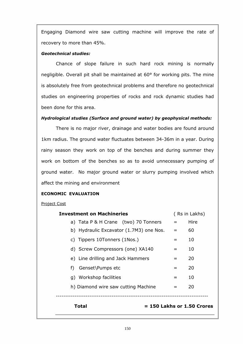
150
Engaging Diamond wire saw cutting machine will improve the rate of
recovery to more than 45%.
Geotechnical studies:
Chance of slope failure in such hard rock mining is normally
negligible. Overall pit shall be maintained at 60° for working pits. The mine
is absolutely free from geotechnical problems and therefore no geotechnical
studies on engineering properties of rocks and rock dynamic studies had
been done for this area.
Hydrological studies (Surface and ground water) by geophysical methods:
There is no major river, drainage and water bodies are found around
1km radius. The ground water fluctuates between 34-36m in a year. During
rainy season they work on top of the benches and during summer they
work on bottom of the benches so as to avoid unnecessary pumping of
ground water. No major ground water or slurry pumping involved which
affect the mining and environment
ECONOMIC EVALUATION
Project Cost
Investment on Machineries ( Rs in Lakhs)
a) Tata P & H Crane (two) 70 Tonners = Hire
b) Hydraulic Excavator (1.7M3) one Nos. = 60
c) Tippers 10Tonners (1Nos.) = 10
d) Screw Compressors (one) XA140 = 10
e) Line drilling and Jack Hammers = 20
f) Genset\Pumps etc = 20
g) Workshop facilities = 10
h) Diamond wire saw cutting Machine = 20
----------------------------------------------------------------------------------
Total = 150 Lakhs or 1.50 Crores

151
Tentative cost of Production per cu.m of Slable granite Blocks :
Production cost for rough granite
The average production cost is given as Rs 16060 per M3. Details are
given as under,
S.No. Description Cost per
MT (Rs)
1 Exploration and Development 200
2 Salary and wages 1500
3 Depreciation 1650
4 Interest on Investment @18% 1800
5 Fuels and Lubricants 1400
6 Spares @ 30% of (5) 450
7 Depreciation of Infrastructures@ 5% of
capital
500
9 Royalty 2500
10 Over heads, pumping etc 500
11 Transport from Mine to Port 3500
12 Sale Tax (14.5%) (item1-9) 2060
Total 16060
i) Sale value = Rs 25000 per M3
ii) Production cost = Rs 16060 “
iii) Profit = Rs 8940 per M3 or 33%

152
PART-III
13.0 PROGRESSIVE AND FINAL MINE CLOSURE PLAN
13.0 Introduction:
i) Name and Address:
a). Name of the applicant : Tvl.Aruna Granites,
Address Thiru.A.Arunachalam,
No.109A, Big Street,
Thiruvannamalai Town,
Thiruvannamalai District,
Tamil Nadu
Pincode-606 601
b). Granite to be mined : Block colour Granite
c). Area and date of expiry of : 2.21.0Hec, 20.01.2020
Mining Lease
iii) Details of lease particulars are given below,
G.0.No Extent
(Ha)
Date of
grant
Date of
execution
Period of
lease
Date of
expiry
G.O.No. (4D)2,
Industries\Dept. 2.21.0 27.08.1999 21.01.2000 20 Years 20.01.2020
iv) Details of Land particulars are given below,
State & District Taluk Village S.F. No. Extent (Hec.)
Ownership Occupancy
ThiruvannamalaiT
amil Nadu
Thiruvanna
malai
Nadazha
ganandal 61/2 (P) 2.21.0
Poramboke
Land
TOTAL 2.21.0
Type of lease area : Non – Forest land / Poramboke land.
Present land use pattern : Existing Mining Lease quarry.
Method of Mining : Opencast Mining– Semi mechanised.
13.1 Mined – out land:
Depth of mining is estimated as 33m based on the adjacent pit of
southwestern side of the lease area. The existing and the end of fifth years
land use pattern is given as under,
S.No Description Present
area (Ha)
Extent (Ha) % of Use
1 Working Pit 0.31.72 0.54.97 25%
2 o/B or Back Filling --- --- ---

153
3 Mine Roads 0.01.70 0.03.50 2%
4 Safety and Area
under plantation 0.74.39 0.74.39 34%
5 Dump area 0.50.34 0.26.62 12%
6 Labour shed and
office 0.05.00 0.05.00 2%
7 Virgin 0.57.85 0.56.52 25%
Total 2.21.0Ha 2.21.0Ha 100
The Mined out Land during the mining scheme period is very shallow
and it will be used as percolation Pond for storage of water for Agricultural
use after reaching sufficient depth.
13.2 Water Quality Management:
There is no major river, drainage and water bodies are found around
1km radius. Ground water table is located at a depth of 36m and
fluctuating between 34-36m in a year where as mining is planned up to a
depth of 33m only. Therefore pumping of ground water or surface water
does not arise in this mine.
The turbid rain water during rainy season is proposed to settle in a
pit before discharging in to the natural stream for settling the suspended
particles. No other EMP required for water quality management.
13.3 Air Quality Management
There is no gaseous matter to be generated in this quarry. Dust
generation during drilling of shot holes, haul road, smoke from vehicles
shall be controlled as given below,
i) Dust extractor or wet drilling to be followed to control dust at source of
emission during drilling,
ii) Emission level in all machineries and transport vehicles to be tested once
in a year to keep them in control with proper maintenance and service as
per TNPCB standards,
iii) Water sprinklers along the sides of haul road shall be fixed to control fly
of dust while transporting minerals and waste,
iv) Avenue trees along roads and green belt around ML boundary shall be
planted with density of 1500 trees per Hectare as per the norms of MoEF
to control fly of dust, noise etc,
v) In above all, labours engaged in such dust prone areas should be
provided with safety devices like ear muff, mask, goggles etc as per the

154
MMR,1961 amendments and circulars of DGMS under the provisions of
occupational diseases.
vi) Labours may be permitted officially to undergo medical checkup to test
silicosis and other respiratory check up once in 5 years
And other guidance required under these laws should be strictly adopted.
13.4 Waste Management
The waste to be generated shall be debris of portable size hard rock
with some fines. No clayey matter shall present in the waste. The solid
waste shall be dumped systematically with proper repose angle and
stabilization as given below,
i) Gradation of dump shall be done automatically as coarser materials go to
the bottom and finer at the top and therefore drain of rain water flow freely
to the bottom without endangering the stability of dump,
ii) Stabilization of dump with top soil and tree plantation shall make the dump
more stable on long,
iii) 1m height parapet shall be constructed for dumps more than 6m height
along the toe to prevent and control wash out from dumps entering into
natural system through rain water,
iv) Garland drainage around dump shall prevent under wash of dump by
hydrostatic pressure to be developed by surface water and control wash
outs and collapse,
v) Dump should be terraced for every 5m height and stabilized as above,

155
vi) As practically as possible the dump should be made as per the plate VIII
on barren grounds so as to avoid re-handling so that the dump shall be
seasoned and stabilized.
Dimensions of Dump at the end of 4th year and at the end of Life of
Mine are given as under,
Description End of 4th Year End of Life of Mine
Topsoil No much of topsoil shall be removed
No much of topsoil shall be removed
Reject 46193m3 140290m3
Waste 4869m3 15282m3
All waste and reject materials are dumped eastern side of lease area.
13.5 Top Soil Management:
Top soil is a precious product of the earth which normally forms from
the rocks by weathering by millions of years of exposures to the
atmosphere with aid of oxygen and water. The top soil should be dumped
along the Lease boundary for dump afforestation purposes. Top soil should
not be mixed with other waste or reject materials. It should be conserved
by judicious utilization in the mine premises.
13.6 Tailing Dam Management:
No water shall be used for quarrying or any other processing except
drinking water to be drawn from public sources. Some stagnation of rain
water in the pit shall be used for wire saw cutting and recycled using slurry
pumps. Therefore need for tailing dam does not arise. But tailing control of
rain water flow during rainy season has to be done by decanting the SPM in
a pit before passing the water into natural system.
13.7 Infrastructure:
Approach road is available from the village road up to the mining
Lease Area. Basic amenities for workers and field office shed such as First
Aid Station, canteen, Rest Shed, Toilet etc as per Mines Rules, 1955 shall
be made available at the entrance of mine.
13.8 Disposal of Mining Machinery:
No proposal for disposal of machineries during the last five years of
Scheme of mining period.

156
13.9 Safety and Security:
No immediate abandoned plan, being a shallow operation. S1-type of
stone fencing will be constructed around the open pit mines and watch and
ward shall be to safeguard the mine from access to surface openings.
13.10 Disaster Management and Risk Assessment:
Name and Address of Contact Person coordinating in case of
Eventuality is,
Name of the applicant : Tvl.Aruna Granites,
Address Thiru.A.Arunachalam,
No.109A, Big Street,
Thiruvannamalai Town,
Thiruvannamalai District, TN
Pincode-606 601
Manager will be appointed and he will be provided suitable
communication facilities. Primary Health centre is available in
Thiruvannamalai for medical emergencies, about 11kms away from the
mine.
13.11 Care and Maintenance during temporary discontinuance:
Watch and ward are provided permanently in the Mine premises to
monitor the Mine openings to prevent inadvertent entry. Temporary
discontinuance will be minimum as there is enough demand for this
material in tiles industries.
14.0 Economic repercussions of closure of mine and
manpower retrenchments
14.1 Number of local residents employed in the mine, status of
continuation of family occupation and scope of joining occupation back.
21 Persons get employment. Most of labours are Agriculturist. In
case of closure of mine, they may continue their own workers and there is
no other granite quarry found within 500m radius. Being a proposed quarry
immediate retrenchment may not arise.
157
14.2 Compensation given or to be given to the employees
connecting with sustenance of himself and their family members.
In case of any closure of mine the compensation under Industrial
Dispute Act will be paid as per law. All workers shall get retrenchment
benefits as per labour laws under enforcement.
14.3 Satellite occupations connected to the mining industry –
number of persons engaged therein – continuance of such business
after mine closes.
The quarrying activity shall lead to development of several ancillary
units and business, which are explained below:
i) Other than mine employment, workshops, spare parts, tyres and tubes and
related several self-employment opportunities.
ii) Several shops and service providers shall grow in the public adjacent
to mines,
iii) Schools and city development shall also be possible owing to the fact
of economic growth in the village.
14.4 Continued engagement of employees in the rehabilitate status of
mining lease area and any other remnant activities.
In the event of closure of mine, the mine worker shall get alternate
work or business like agriculture etc. No serious repercussions envisaged in
the event of cessation of mining activity, as they will be provided
employment in other mines belong to the company.
14.5 Envisaged repercussions on the expectation of the society around
due to closure of mine.
Persons on Roll at the time of closure will get benefit as per State
Govt. guidelines as applicable at the time of retrenchment
15.0 Time Scheduling for abandonment:
The following works are scheduled before abandoning the mine,
i) Parapet wall of 2m height will be constructed around the pit,
ii) Planting and monitoring of Afforestation program me.
There is no mine closure proposal for the next 4 years and therefore
the abandonment of quarry does not arise. The parapet and plantations will
be done during the year 2017-19. In case of any abandonment the
following time is required,
Activities Days for schedule
Time schedule for fencing 6 months
Time schedule for reclamation of mined out area
1 year

158
16.0 Proposed financial Estimate / Budget for (EMP) Environment
Management
a) Project cost / investment
i) Land Cost : Promboke Land
ii) Machinery to be used : Rs 1,50,000,00
iii) Refilling / Fencing : Rs 75,000
iv) Labourers Shed : Rs 75,000
v) Sanitary facility : Rs 50,000
vi) Other items : Rs 75,000
Total Rs 152.75lakhs
b)EMP Cost
i) Drinking water facility for the labourers = Rs 75,000
ii) Sanitary arrangement = Rs 70,000
iii) Safety Kits, = Rs 75,000
iv) Water sprinkling for dust control = Rs 75,000
v) Afforestation etc. = Rs 3,80,000
Total Rs 6.75lakhs
17. Abandonment Cost:
Being a deep dipping deposit and depth persistence is yet to be
established by proposed exploration and therefore program of back filling
or reclamation of Land will be considered after completion of exploration to
ascertain the cut-off limit of Mining. However budgetary provisions for
Afforestation program and rehabilitation of the Area shall be carried out
with cost as given below,
i) Budgetary Provisions under abandonment
At the end of
5th year
At the End of Life of
Mine
i) Afforestation
(Planting and Securing) Rs.20,000 Rs.1,00,000
ii) Backfilling --- Rs.3,00,000
iii) Rehabilitation of Area (Dump Grading)
--- Rs1,50,000
iv) Construction of Parapet --- Rs.50,000
Rs.20,000 Rs.6,00,000
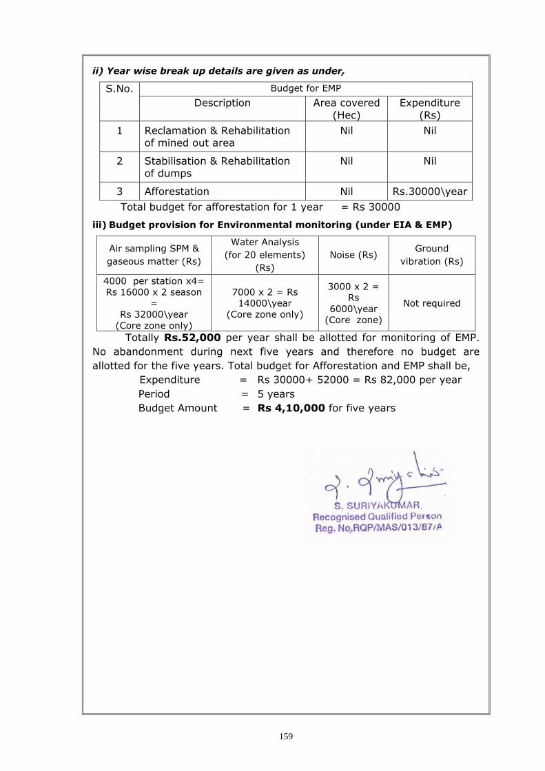
159
ii) Year wise break up details are given as under,
S.No. Budget for EMP
Description Area covered
(Hec)
Expenditure
(Rs)
1 Reclamation & Rehabilitation
of mined out area
Nil Nil
2 Stabilisation & Rehabilitation
of dumps
Nil Nil
3 Afforestation Nil Rs.30000\year
Total budget for afforestation for 1 year = Rs 30000
iii) Budget provision for Environmental monitoring (under EIA & EMP)
Air sampling SPM &
gaseous matter (Rs)
Water Analysis
(for 20 elements)
(Rs)
Noise (Rs) Ground
vibration (Rs)
4000 per station x4=
Rs 16000 x 2 season
=
Rs 32000\year
(Core zone only)
7000 x 2 = Rs
14000\year
(Core zone only)
3000 x 2 =
Rs
6000\year
(Core zone)
Not required
Totally Rs.52,000 per year shall be allotted for monitoring of EMP.
No abandonment during next five years and therefore no budget are
allotted for the five years. Total budget for Afforestation and EMP shall be,
Expenditure = Rs 30000+ 52000 = Rs 82,000 per year
Period = 5 years
Budget Amount = Rs 4,10,000 for five years

160
LIST OF PLATES
S. No. Description Plate No.
01. Location Plan I
02. Lease Plan II
03. Geological Plan III
04. Geological Sections IV
05. Surface Plan V
06. Production and Development Plan VI , VIA & VIB
07. Sections of Production and Development Plan
VII
08. Conceptual Mining Plan / Final Mine Closure Plan
VIII
09. Sections of Ultimate Pit Limit IX
10. Progressive Mine Closure Plan showing Land Use and Afforestation at the end of Fifth Year
X
11. Key Map XI