for more information - south carolina department of...
TRANSCRIPT
For More Information
Draft text developed by Lynn DavidsonMapping, layout, design and project coordination by Lisa A. Gutierrez
Cover photo by Dave Harp
This publication was developed through a partnership betweenDorchester County Tourism and the Maryland Department of
Natural Resources’s Greenways and Water Trails Program.
Dorchester County Tourism2 Rose Hill Place, Cambridge, MD 21613phone: (410) 228-1000; (410) 221-6545e-mail: [email protected]
For copies of this brochure contact us at the address above. For more information on Dorchester visit the website: www.tourdorchester.org
Maryland Department of Natural Resources
Maryland Greenways and Water Trails Programcoordinates the creation of a statewide network of ecological corridors and recreational trails in Maryland.580 Taylor Ave., Suite E-2, Annapolis, MD 21401phone: 1-877-260- 8DNRwww.dnr.state.md.us/greenways
Maryland Wildlife and Heritage Serviceis the lead state agency responsible for the identification, ranking, protection, and management of nongame, rareand endangered species and their habitats in Maryland. 580 Taylor Ave., Suite E-1, Annapolis, MD 21401phone: (410) 260-8572 www.dnr.state.md.us/wildlife/nhpdo.asp
The Maryland Ornithological Society (MOS)is a nonprofit, statewide organization of people who areinterested in birds and nature.www.mdbirds.org
1st printing July 2005
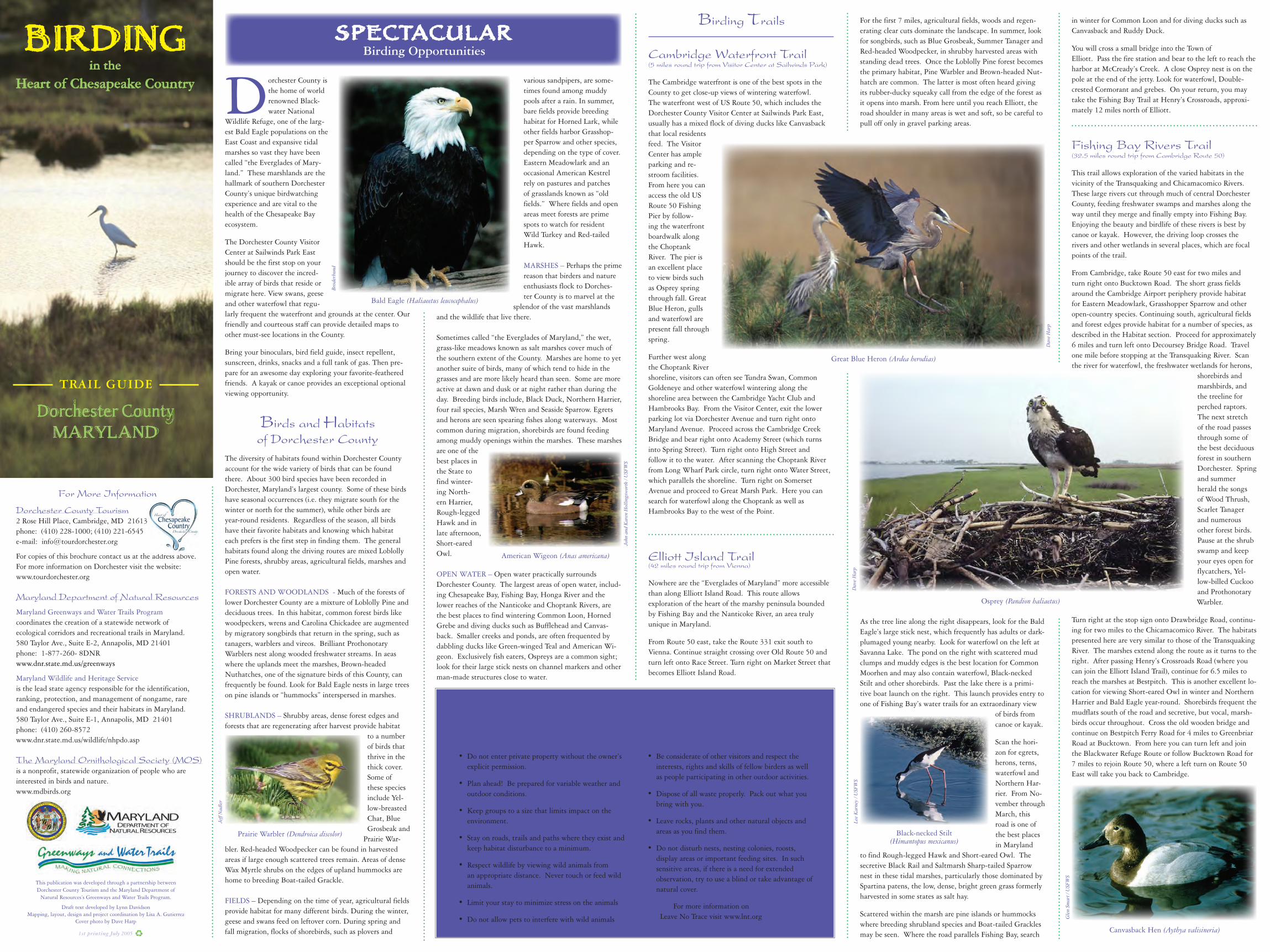
Bald Eagle (Haliaeetus leucocephalus)
Brod
erbu
nd
Great Blue Heron (Ardea herodias)
Osprey (Pandion haliaetus)
American Wigeon (Anas americana)
John
and
Kar
en H
ollin
gsw
orth
/ U
SFW
S
Prairie Warbler (Dendroica discolor)
Jeff
Nad
ler
Black-necked Stilt(Himantopus mexicanus)
Lee
Kar
ney
/ USF
WS
Canvasback Hen (Aythya valisineria)
Gle
n Sm
art /
USF
WS
Dorchester County is the home of world renowned Black-water National
Wildlife Refuge, one of the larg-est Bald Eagle populations on the East Coast and expansive tidal marshes so vast they have been called “the Everglades of Mary-land.” These marshlands are the hallmark of southern Dorchester County’s unique birdwatching experience and are vital to the health of the Chesapeake Bay ecosystem.
The Dorchester County Visitor Center at Sailwinds Park East should be the first stop on your journey to discover the incred-ible array of birds that reside or migrate here. View swans, geese and other waterfowl that regu-larly frequent the waterfront and grounds at the center. Our friendly and courteous staff can provide detailed maps to other must-see locations in the County.
Bring your binoculars, bird field guide, insect repellent, sunscreen, drinks, snacks and a full tank of gas. Then pre-pare for an awesome day exploring your favorite-feathered friends. A kayak or canoe provides an exceptional optional viewing opportunity.
Birds and Habitatsof Dorchester County
The diversity of habitats found within Dorchester County account for the wide variety of birds that can be found there. About 300 bird species have been recorded in Dorchester, Maryland’s largest county. Some of these birds have seasonal occurrences (i.e. they migrate south for the winter or north for the summer), while other birds are year-round residents. Regardless of the season, all birds have their favorite habitats and knowing which habitat each prefers is the first step in finding them. The general habitats found along the driving routes are mixed Loblolly Pine forests, shrubby areas, agricultural fields, marshes and open water.
FORESTS AND WOODLANDS - Much of the forests of lower Dorchester County are a mixture of Loblolly Pine and deciduous trees. In this habitat, common forest birds like woodpeckers, wrens and Carolina Chickadee are augmented by migratory songbirds that return in the spring, such as tanagers, warblers and vireos. Brilliant Prothonotary Warblers nest along wooded freshwater streams. In aeas where the uplands meet the marshes, Brown-headed Nuthatches, one of the signature birds of this County, can frequently be found. Look for Bald Eagle nests in large trees on pine islands or “hummocks” interspersed in marshes.
SHRUBLANDS – Shrubby areas, dense forest edges and forests that are regenerating after harvest provide habitat
to a number of birds that thrive in the thick cover. Some of these species include Yel-low-breasted Chat, Blue Grosbeak and
Prairie War-bler. Red-headed Woodpecker can be found in harvested areas if large enough scattered trees remain. Areas of dense Wax Myrtle shrubs on the edges of upland hummocks are home to breeding Boat-tailed Grackle.
FIELDS – Depending on the time of year, agricultural fields provide habitat for many different birds. During the winter, geese and swans feed on leftover corn. During spring and fall migration, flocks of shorebirds, such as plovers and
various sandpipers, are some-times found among muddy pools after a rain. In summer, bare fields provide breeding habitat for Horned Lark, while other fields harbor Grasshop-per Sparrow and other species, depending on the type of cover. Eastern Meadowlark and an occasional American Kestrel rely on pastures and patches of grasslands known as “old fields.” Where fields and open areas meet forests are prime spots to watch for resident Wild Turkey and Red-tailed Hawk.
MARSHES – Perhaps the prime reason that birders and nature enthusiasts flock to Dorches-ter County is to marvel at the
splendor of the vast marshlands and the wildlife that live there.
Sometimes called “the Everglades of Maryland,” the wet, grass-like meadows known as salt marshes cover much of the southern extent of the County. Marshes are home to yet another suite of birds, many of which tend to hide in the grasses and are more likely heard than seen. Some are more active at dawn and dusk or at night rather than during the day. Breeding birds include, Black Duck, Northern Harrier, four rail species, Marsh Wren and Seaside Sparrow. Egrets and herons are seen spearing fishes along waterways. Most common during migration, shorebirds are found feeding among muddy openings within the marshes. These marshes are one of the best places in the State to find winter-ing North-ern Harrier, Rough-legged Hawk and in late afternoon, Short-eared Owl.
OPEN WATER – Open water practically surrounds Dorchester County. The largest areas of open water, includ-ing Chesapeake Bay, Fishing Bay, Honga River and the lower reaches of the Nanticoke and Choptank Rivers, are the best places to find wintering Common Loon, Horned Grebe and diving ducks such as Bufflehead and Canvas-back. Smaller creeks and ponds, are often frequented by dabbling ducks like Green-winged Teal and American Wi-geon. Exclusively fish eaters, Ospreys are a common sight; look for their large stick nests on channel markers and other man-made structures close to water.
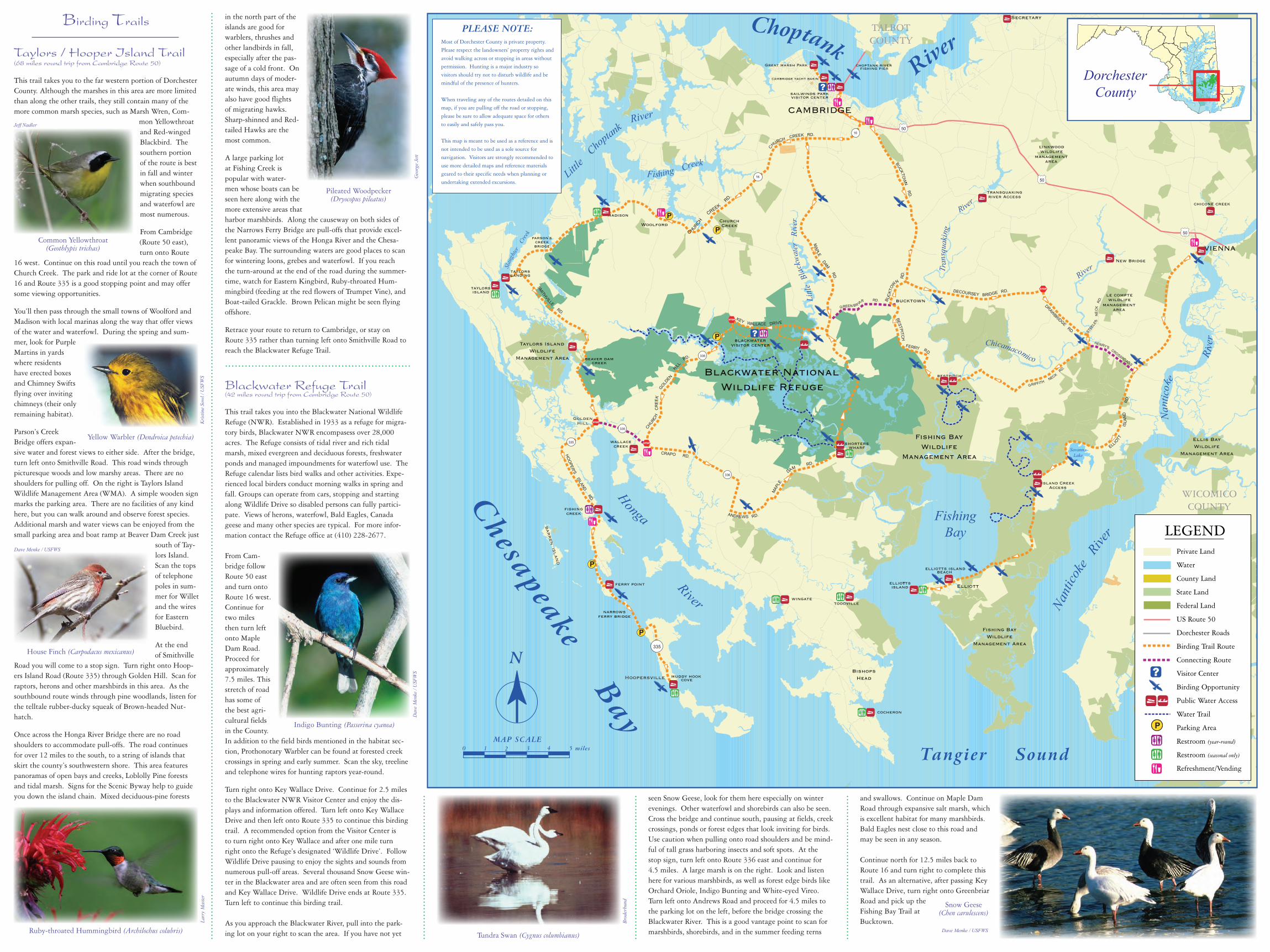
Cambridge Waterfront Trail (5 miles round trip from Visitor Center at Sailwinds Park)
The Cambridge waterfront is one of the best spots in the County to get close-up views of wintering waterfowl. The waterfront west of US Route 50, which includes the Dorchester County Visitor Center at Sailwinds Park East, usually has a mixed flock of diving ducks like Canvasback that local residents feed. The Visitor Center has ample parking and re-stroom facilities. From here you can access the old US Route 50 Fishing Pier by follow-ing the waterfront boardwalk along the Choptank River. The pier is an excellent place to view birds such as Osprey spring through fall. Great Blue Heron, gulls and waterfowl are present fall through spring.
Further west along the Choptank River shoreline, visitors can often see Tundra Swan, Common Goldeneye and other waterfowl wintering along the shoreline area between the Cambridge Yacht Club and Hambrooks Bay. From the Visitor Center, exit the lower parking lot via Dorchester Avenue and turn right onto Maryland Avenue. Proceed across the Cambridge Creek Bridge and bear right onto Academy Street (which turns into Spring Street). Turn right onto High Street and follow it to the water. After scanning the Choptank River from Long Wharf Park circle, turn right onto Water Street, which parallels the shoreline. Turn right on Somerset Avenue and proceed to Great Marsh Park. Here you can search for waterfowl along the Choptank as well as Hambrooks Bay to the west of the Point.
Elliott Island Trail(42 miles round trip from Vienna)
Nowhere are the “Everglades of Maryland” more accessible than along Elliott Island Road. This route allows exploration of the heart of the marshy peninsula bounded by Fishing Bay and the Nanticoke River, an area truly unique in Maryland.
From Route 50 east, take the Route 331 exit south to Vienna. Continue straight crossing over Old Route 50 and turn left onto Race Street. Turn right on Market Street that becomes Elliott Island Road.
Birding Trails in winter for Common Loon and for diving ducks such as Canvasback and Ruddy Duck.
You will cross a small bridge into the Town of Elliott. Pass the fire station and bear to the left to reach the harbor at McCready’s Creek. A close Osprey nest is on the pole at the end of the jetty. Look for waterfowl, Double-crested Cormorant and grebes. On your return, you may take the Fishing Bay Trail at Henry’s Crossroads, approxi-mately 12 miles north of Elliott.
Fishing Bay Rivers Trail(32.5 miles round trip from Cambridge Route 50)
This trail allows exploration of the varied habitats in the vicinity of the Transquaking and Chicamacomico Rivers. These large rivers cut through much of central Dorchester County, feeding freshwater swamps and marshes along the way until they merge and finally empty into Fishing Bay. Enjoying the beauty and birdlife of these rivers is best by canoe or kayak. However, the driving loop crosses the rivers and other wetlands in several places, which are focal points of the trail.
From Cambridge, take Route 50 east for two miles and turn right onto Bucktown Road. The short grass fields around the Cambridge Airport periphery provide habitat for Eastern Meadowlark, Grasshopper Sparrow and other open-country species. Continuing south, agricultural fields and forest edges provide habitat for a number of species, as described in the Habitat section. Proceed for approximately 6 miles and turn left onto Decoursey Bridge Road. Travel one mile before stopping at the Transquaking River. Scan the river for waterfowl, the freshwater wetlands for herons,
shorebirds and marshbirds, and the treeline for perched raptors. The next stretch of the road passes through some of the best deciduous forest in southern Dorchester. Spring and summer herald the songs of Wood Thrush, Scarlet Tanager and numerous other forest birds. Pause at the shrub swamp and keep your eyes open for flycatchers, Yel-low-billed Cuckoo and Prothonotary Warbler.
Turn right at the stop sign onto Drawbridge Road, continu-ing for two miles to the Chicamacomico River. The habitats presented here are very similar to those of the Transquaking River. The marshes extend along the route as it turns to the right. After passing Henry’s Crossroads Road (where you can join the Elliott Island Trail), continue for 6.5 miles to reach the marshes at Bestpitch. This is another excellent lo-cation for viewing Short-eared Owl in winter and Northern Harrier and Bald Eagle year-round. Shorebirds frequent the mudflats south of the road and secretive, but vocal, marsh-birds occur throughout. Cross the old wooden bridge and continue on Bestpitch Ferry Road for 4 miles to Greenbriar Road at Bucktown. From here you can turn left and join the Blackwater Refuge Route or follow Bucktown Road for 7 miles to rejoin Route 50, where a left turn on Route 50 East will take you back to Cambridge.
BIRDINGHeart of Chesapeake Country
TRAIL GUIDE
Dorchester CountyMARYLAND
SPECTACULARBirding Opportunities
in the
For the first 7 miles, agricultural fields, woods and regen-erating clear cuts dominate the landscape. In summer, look for songbirds, such as Blue Grosbeak, Summer Tanager and Red-headed Woodpecker, in shrubby harvested areas with standing dead trees. Once the Loblolly Pine forest becomes the primary habitat, Pine Warbler and Brown-headed Nut-hatch are common. The latter is most often heard giving its rubber-ducky squeaky call from the edge of the forest as it opens into marsh. From here until you reach Elliott, the road shoulder in many areas is wet and soft, so be careful to pull off only in gravel parking areas.
As the tree line along the right disappears, look for the Bald Eagle’s large stick nest, which frequently has adults or dark-plumaged young nearby. Look for waterfowl on the left at Savanna Lake. The pond on the right with scattered mud clumps and muddy edges is the best location for Common Moorhen and may also contain waterfowl, Black-necked Stilt and other shorebirds. Past the lake there is a primi-tive boat launch on the right. This launch provides entry to one of Fishing Bay’s water trails for an extraordinary view
of birds from canoe or kayak.
Scan the hori-zon for egrets, herons, terns, waterfowl and Northern Har-rier. From No-vember through March, this road is one of the best places in Maryland
to find Rough-legged Hawk and Short-eared Owl. The secretive Black Rail and Saltmarsh Sharp-tailed Sparrow nest in these tidal marshes, particularly those dominated by Spartina patens, the low, dense, bright green grass formerly harvested in some states as salt hay.
Scattered within the marsh are pine islands or hummocks where breeding shrubland species and Boat-tailed Grackles may be seen. Where the road parallels Fishing Bay, search
Dav
e H
arp
Dav
e H
arp
Leave No Trace and Wildlife Viewing Ethics
When visiting Dorchester County keep in mind that much of the County is part of a sensitive ecosystem.Please practice the following stewardship principles of Leave No Trace and ethical wildlife viewing:
• Do not enter private property without the owner’s explicit permission.
• Plan ahead! Be prepared for variable weather and outdoor conditions.
• Keep groups to a size that limits impact on the environment.
• Stay on roads, trails and paths where they exist and keep habitat disturbance to a minimum.
• Respect wildlife by viewing wild animals from an appropriate distance. Never touch or feed wild animals.
• Limit your stay to minimize stress on the animals
• Do not allow pets to interfere with wild animals
• Be considerate of other visitors and respect the interests, rights and skills of fellow birders as well as people participating in other outdoor activities.
• Dispose of all waste properly. Pack out what you bring with you.
• Leave rocks, plants and other natural objects and areas as you find them.
• Do not disturb nests, nesting colonies, roosts, display areas or important feeding sites. In such sensitive areas, if there is a need for extended observation, try to use a blind or take advantage of natural cover.
For more information onLeave No Trace visit www.lnt.org
Ruby-throated Hummingbird (Archilochus colubris)
Larr
y M
aste
r
Common Yellowthroat(Geothlypis trichas)
Jeff Nadler
Kri
stin
e So
wl /
USF
WS
Yellow Warbler (Dendroica petechia)
Snow Geese(Chen carulescens)
Pileated Woodpecker(Dryocopus pileatus)
Tundra Swan (Cygnus columbianus)
Brod
erbu
nd
House Finch (Carpodacus mexicanus)
Dave Menke / USFWS
Geo
rge
Jett
Dave Menke / USFWS
Indigo Bunting (Passerina cyanea)
Dav
e M
enke
/ U
SFW
S
FishingBay
Nantic
oke
River
Honga
River
Nan
ticok
e
Rive
rChicamacomico
RiverTr
ansq
uaki
ng
River
SavannaLake
Littl
e B
lackw
ater
Ri
ver
Fishing Creek
Tangier Sound
Little
Cho
ptank River
Slau
ghter
Cr
eek
ChoptankRive
r
Chesapeake B
ay
STOP
STOP
STOP
STOP
P
P
P
P
Pmadison
taylorslanding
taylorsisland
bestpitch
elliotttsisland
toddville
cocheron
wallacecreek
fishingcreek
shorterswharf
muddy hookcove
ferry point
wingate
beaver damcreek
elliotts islandbeach
transquakingriver Access
chicone creek
choptank riverfishing pier
sailwinds parkvisitor center
Island CreekAccess
raggedpoint
New Bridge
?
?
.
CHURCH C
REEK R
D.
narrowsferry bridge
HO
OPER'S ISLAND RD.
335
KEY WALLACE DRIVE
MAPLE DAM R
D.
HENRY'S CROSSROADS
STEEL
E'S
N
ECK
RD.
DRAWBRIDGE RD.
335
335
336
MAP
LE
D
AM RD.
ANDREWS RD.
335
16
BUC
KTOW
N R
D.
16
CHURCH CREEK RD.
DECOURSEY BRIDGE RD.
BESTPITCH
FERRY RD.
BUCKTOW
N RD
.
G
RIFFITH NECK
RD.
ELLIO
TT
ISLA
ND
RD
.
CRAPO RD.
SMITHVILLE RD.
CHURCH
CR
EE
K
GOLD
EN
HILL
RD.
G
REEN BR IAR RD.
50
50
50
le comptewildlife
managementarea
Elliott
VIENNA
blackwatervisitor center
bucktown
GoldenHill
Hoopersville
parson'screekbridge
BA
RR
EN
ISL
AN
D
linkwoodwildlife
managementarea
TALBOTCOUNTY
Blackwater NationalWildlife Refuge
Fishing BayWildlife
Management Area
Ellis BayWildlife
Management Area
Fishing BayWildlife
Management Area
CAMBRIDGE
Great marsh Park
cambridge yacht basin
Secretary
Taylors IslandWildlife
Management Area
ChurchCreek
BishopsHead
WICOMICOCOUNTY
Woolford
PLEASE NOTE:Most of Dorchester County is private property. Please respect the landowners’ property rights and avoid walking across or stopping in areas without permission. Hunting is a major industry so visitors should try not to disturb wildlife and be mindful of the presence of hunters.
When traveling any of the routes detailed on this map, if you are pulling off the road or stopping, please be sure to allow adequate space for others to easily and safely pass you.
This map is meant to be used as a reference and is not intended to be used as a sole source for navigation. Visitors are strongly recommended to use more detailed maps and reference materials geared to their specific needs when planning or undertaking extended excursions.
LEGENDPrivate Land
Water
County Land
State Land
Federal Land
US Route 50
Dorchester Roads
Birding Trail Route
Connecting Route
Visitor Center
Birding Opportunity
Public Water Access
Water Trail
Parking Area
Restroom (year-round)
Restroom (seasonal only)
Refreshment/Vending
P
?N
2 3 4MAP SCALE
1 5 miles0
DorchesterCounty
Taylors / Hooper Island Trail(68 miles round trip from Cambridge Route 50)
This trail takes you to the far western portion of Dorchester County. Although the marshes in this area are more limited than along the other trails, they still contain many of the more common marsh species, such as Marsh Wren, Com-
mon Yellowthroat and Red-winged Blackbird. The southern portion of the route is best in fall and winter when southbound migrating species and waterfowl are most numerous.
From Cambridge (Route 50 east), turn onto Route
16 west. Continue on this road until you reach the town of Church Creek. The park and ride lot at the corner of Route 16 and Route 335 is a good stopping point and may offer some viewing opportunities.
You’ll then pass through the small towns of Woolford and Madison with local marinas along the way that offer views of the water and waterfowl. During the spring and sum-mer, look for Purple Martins in yards where residents have erected boxes and Chimney Swifts flying over inviting chimneys (their only remaining habitat).
Parson’s Creek Bridge offers expan-sive water and forest views to either side. After the bridge, turn left onto Smithville Road. This road winds through picturesque woods and low marshy areas. There are no shoulders for pulling off. On the right is Taylors Island Wildlife Management Area (WMA). A simple wooden sign marks the parking area. There are no facilities of any kind here, but you can walk around and observe forest species. Additional marsh and water views can be enjoyed from the small parking area and boat ramp at Beaver Dam Creek just
south of Tay-lors Island. Scan the tops of telephone poles in sum-mer for Willet and the wires for Eastern Bluebird.
At the end of Smithville
Road you will come to a stop sign. Turn right onto Hoop-ers Island Road (Route 335) through Golden Hill. Scan for raptors, herons and other marshbirds in this area. As the southbound route winds through pine woodlands, listen for the telltale rubber-ducky squeak of Brown-headed Nut-hatch.
Once across the Honga River Bridge there are no road shoulders to accommodate pull-offs. The road continues for over 12 miles to the south, to a string of islands that skirt the county’s southwestern shore. This area features panoramas of open bays and creeks, Loblolly Pine forests and tidal marsh. Signs for the Scenic Byway help to guide you down the island chain. Mixed deciduous-pine forests
in the north part of the islands are good for warblers, thrushes and other landbirds in fall, especially after the pas-sage of a cold front. On autumn days of moder-ate winds, this area may also have good flights of migrating hawks. Sharp-shinned and Red-tailed Hawks are the most common.
A large parking lot at Fishing Creek is popular with water-men whose boats can be seen here along with the more extensive areas that harbor marshbirds. Along the causeway on both sides of the Narrows Ferry Bridge are pull-offs that provide excel-lent panoramic views of the Honga River and the Chesa-peake Bay. The surrounding waters are good places to scan for wintering loons, grebes and waterfowl. If you reach the turn-around at the end of the road during the summer-time, watch for Eastern Kingbird, Ruby-throated Hum-mingbird (feeding at the red flowers of Trumpet Vine), and Boat-tailed Grackle. Brown Pelican might be seen flying offshore. Retrace your route to return to Cambridge, or stay on Route 335 rather than turning left onto Smithville Road to reach the Blackwater Refuge Trail.
Blackwater Refuge Trail(42 miles round trip from Cambridge Route 50)
This trail takes you into the Blackwater National Wildlife Refuge (NWR). Established in 1933 as a refuge for migra-tory birds, Blackwater NWR encompasess over 28,000 acres. The Refuge consists of tidal river and rich tidal marsh, mixed evergreen and deciduous forests, freshwater ponds and managed impoundments for waterfowl use. The Refuge calendar lists bird walks and other activities. Expe-rienced local birders conduct morning walks in spring and fall. Groups can operate from cars, stopping and starting along Wildlife Drive so disabled persons can fully partici-pate. Views of herons, waterfowl, Bald Eagles, Canada geese and many other species are typical. For more infor-mation contact the Refuge office at (410) 228-2677.
From Cam-bridge follow Route 50 east and turn onto Route 16 west. Continue for two miles then turn left onto Maple Dam Road. Proceed for approximately 7.5 miles. This stretch of road has some of the best agri-cultural fields in the County. In addition to the field birds mentioned in the habitat sec-tion, Prothonotary Warbler can be found at forested creek crossings in spring and early summer. Scan the sky, treeline and telephone wires for hunting raptors year-round.
Turn right onto Key Wallace Drive. Continue for 2.5 miles to the Blackwater NWR Visitor Center and enjoy the dis-plays and information offered. Turn left onto Key Wallace Drive and then left onto Route 335 to continue this birding trail. A recommended option from the Visitor Center is to turn right onto Key Wallace and after one mile turn right onto the Refuge’s designated ‘Wildlife Drive’. Follow Wildlife Drive pausing to enjoy the sights and sounds from numerous pull-off areas. Several thousand Snow Geese win-ter in the Blackwater area and are often seen from this road and Key Wallace Drive. Wildlife Drive ends at Route 335. Turn left to continue this birding trail.
As you approach the Blackwater River, pull into the park-ing lot on your right to scan the area. If you have not yet
Birding Trails
seen Snow Geese, look for them here especially on winter evenings. Other waterfowl and shorebirds can also be seen. Cross the bridge and continue south, pausing at fields, creek crossings, ponds or forest edges that look inviting for birds. Use caution when pulling onto road shoulders and be mind-ful of tall grass harboring insects and soft spots. At the stop sign, turn left onto Route 336 east and continue for 4.5 miles. A large marsh is on the right. Look and listen here for various marshbirds, as well as forest edge birds like Orchard Oriole, Indigo Bunting and White-eyed Vireo. Turn left onto Andrews Road and proceed for 4.5 miles to the parking lot on the left, before the bridge crossing the Blackwater River. This is a good vantage point to scan for marshbirds, shorebirds, and in the summer feeding terns
and swallows. Continue on Maple Dam Road through expansive salt marsh, which is excellent habitat for many marshbirds. Bald Eagles nest close to this road and may be seen in any season. Continue north for 12.5 miles back to Route 16 and turn right to complete this trail. As an alternative, after passing Key Wallace Drive, turn right onto Greenbriar Road and pick up the Fishing Bay Trail at Bucktown.