for temperate perennial pastures in new south wales · for temperate perennial pastures in new...
TRANSCRIPT

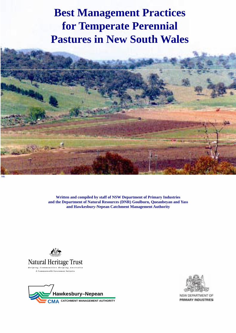
Best Management Practicesfor Temperate Perennial Pastures in New South Wales
Written and compiled by staff of NSW Department of Primary Industries and the Department of Natural Resources (DNR), Goulburn, Queanbeyan and Yass
and Hawkesbury–Nepean Catchment Management Authority
6652
Written and compiled by staff of NSW Department of Primary Industries and the Department of Natural Resources (DNR) Goulburn, Queanbeyan and Yass
and Hawkesbury-Nepean Catchment Management Authority
Best Management Practices for Temperate Perennial
Pastures in New South Wales
MK
Hawkesbury–Nepean
CMA CATCHMENT MANAGEMENT AUTHORITY
Acknowledgments
This publication was developed with funding from the Natural Heritage Trust through the Hawkesbury-Nepean Catchment Management Authority as part of the project “Best Practice Grazing Management for Agriculture, Biodiversity and Water Quality in the Warragamba Catchment.”
It is written for use by farmers and land managers. It draws on the knowledge and experience of district advisory and research staff from NSW Department of Primary Industries (NSW DPI) and the Department of Natural Resources (DNR) and Hawksbury-Nepean Catchment Management Authority (H-NCMA).
The authors and editor acknowledge the assistance of many farmers and professional colleagues who commented on various drafts. Special mention is made of Peter Orchard who has given valuable support to the project.
Bill Smith is acknowledged for his assistance in proof-reading the publication as is the Publications Unit of NSW DPI Head Office for advice and superb graphic design.
Typing assistance from Michelle Benisch, Sheryl Greentree, Joanne Ottaway and Margaret Parry is gratefully acknowledged.
Photographic credits
BC Bruce Clements, District Agronomist NSW DPI, Bathurst
BS Bill Schumann, Extension Officer Soils, NSW DPI , Queanbeyan
DH David Henry, formerly Project Officer, NSW DPI, Queanbeyan
DNR Department of Natural ResourcesGJ Graham Johnson, NSW DPI EMAI,
CamdenGL Greg Lodge, Snr. Research Agronomist,
NSW DPI, TamworthJS Jenny Schabel, H-NCMA, GoulburnMK Mike Keys, Agronomist (Special
Projects) NSW DPI, QueanbeyanMM Michael Michelmore, NSW DPI , Goulburn
Disclaimer
The information contained in this publication is based on knowledge and understanding at the time of writing. However, because of advances in knowledge, users are reminded of the need to ensure that information upon which they rely is up to date and to check currency of the information with the appropriate officer of New South Wales Department of Primary Industries, DNR, H-NCMA or the user’s independent adviser.
NOTE:
• Livestock health disordersPasture improvement, spray grazing and grazing some weed species, may be associated with an increase in the incidence of certain livestock health disorders. Livestock and production losses from some disorders are possible. Management may need to be modified to minimise risk. Consult your veterinarian for further advice.
• Native vegetationThe Native Vegetation Act (2003) may regulate some pasture improvement practices where existing pasture contains native species. Inquire through your local Catchment Management Authority office for further details.
© 2006 NSW DPI
This publication is copyright. Except as permitted under the Copyright Act 1968, no part of this publication may be reproduced by any process, electronic or otherwise, without the specific written permission of the copyright owners. Neither may information be stored electronically in any form whatever without such permission.
ISBN 0 7347 1726 1
2nd edition, May, 2006
ContentsIntroduction ............................................................................................................... 4
Some things I can change or influence as a farmer ................................................... 5
Ground Cover and other Measurements used in the Grazing Industry ..................... 7
Rural Land Capability ............................................................................................... 9
Summary Table of Best Management Practices ..................................................... 11
BMP1 - Managing Pastures for Clean Water .......................................................... 12
BMP2 - Managing Pastures for Protective Groundcover ....................................... 14
BMP3 - Managing Pastures to Reduce Soil Erosion .............................................. 16
BMP4 - Managing Pastures for Biodiversity and Weed Control ............................ 18
BMP5 - Managing Soil Fertility in Pastures ........................................................... 20
BMP6 - Managing Soil Acidity in Pastures ............................................................ 22
BMP7 - Managing Dryland Salinity in Pastures .................................................... 24
BMP8 - Managing Pastures to Reduce the Impact of Drought .............................. 25
BMP9 - Managing Grazing for Pasture Persistence, Production and Livestock Performance ................................................................................... 27
Appendix I: Pasture Benchmarks for Sheep and Cattle .......................................... 29
Glossary .................................................................................................................. 30
Bibliography ........................................................................................................... 34
Training Courses — StockPlan & Climate Workshop ............................................ 34
Training Courses — PROGRAZE™ ...................................................................... 35
Training Courses — LANDSCAN™ ..................................................................... 36

4
The BMP’s primarily target dryland beef and sheep production on grazed pastures
1 June 2004
MK
Introduction
These Best Management Practice (BMP) guidelines provide a basis for sustainable management of grazing lands in the tablelands and adjacent high rainfall, temperate pasture areas of New South Wales. BMP guidelines need to balance both socio-economic and environmental outcomes and be flexible as knowledge and experience change.
The BMP’s primarily target dryland beef and sheep production on grazed pastures, but the principles will apply to other grazing enterprises in these areas. It does not address highly intensive systems such as dairies or feedlots and the potential point sources of pollution associated with them.
Managing the vegetation and grassland systems in this area needs to account for the multiple and sometimes conflicting goals and outcomes associated with different land uses. The great diversity in soil, pasture types, climate and landscape of the region, also present further challenges to land managers who need to consider both the on and off-farm effects of their management decisions.
Our aim is to provide practical guidelines to help owners and land managers develop whole farm practices that lead to healthy, stable and productive pasture systems that also have off-farm benefits for the wider community, such as production of clean water and improved bio-diversity. It also needs to be acknowledged that some compromise is necessary for short periods especially when natural events such as drought or flood occur. Inflexible, regulatory approaches should be avoided if the community at large wants to encourage sustainable natural resource management by farmers.
Written by:Denys Garden, formerly Research Agronomist, NSW DPI , Canberra.Phil Graham, Sheep & Wool Advisor, NSW DPI , YassGarry Hogan, Snr. Natural Resource Officer, H-NCMA, Goulburn.Bill Johnston, Environmental Officer (terrestrial ecology), DNR, Queanbeyan.Michael Keys, Agronomist (special projects), NSW DPI , Queanbeyan.Colin Langford, Sheep & Wool Advisor, NSW DPI , GoulburnGreg Meaker, Beef Cattle Advisor, NSW DPI , GoulburnBill Schumann, formerly Extension Officer (Acid Soil Action), NSW DPI , Queanbeyan.Peter Simpson, formerly Regional Director of Agriculture, Goulburn
Technical Comment:Alan Bell, formerly Technical Specialist (Grazing Systems), NSW DPI , Tamworth, Bruce Clements, District Agronomist, NSW DPI , Bathurst, Clare Edwards, District Agronomist, NSW DPI , Armidale, Fiona Leech, District Agronomist, NSW DPI , Yass, Jeff Lowien, District Agronomist, NSW DPI , Glen Innes, Peter Orchard, Program Leader, NSW DPI , Wagga Wagga.
Editing and layout: David Henry, formerly Project Officer NSW DPI (Warragamba Grazing NHT Project)

5
Some things I can change or influence as a farmer…………
I can manage my soil fertility!
I need to consider fertiliser history, pasture composition, paddock use and if appropriate, take a soil test and make sure fertiliser is needed. This will help me answer the following questions:
What is the most limiting factor? Which fertiliser do I need and how much? Have I considered my soil acidity? Do I need to lime?Have I considered when I am going to apply
fertiliser?Where am I going to place it? How am I going to apply it?
To maximise the efficiency of my fertiliser use I need to ensure nutrients aren’t wasted – washed into watercourses, leached or locked up in the soil – to optimise plant uptake and production.
I can control my choice of pasture type and the presence of weeds!
I can do this by controlling my choice of pasture species.I need to consider the following when choosing appropriate species in my pasture:
I need to recognise the landscape strengths and weaknesses. It may be better for me in some landscape situations to maintain and enhance my native pasture rather than trying to establish costly introduced pasture that may not persist;
Am I going to be able to keep fertiliser levels up to my pasture? Some pastures need more fertiliser than others;
I need to consider the environment in my paddock. Does the soil have the right depth, water holding capacity, pH, drainage and is the climate right for the establishment and maintenance of my chosen species?
Is this pasture going to provide the right level of production for my livestock enterprise?
Is my pasture going to give me adequate ground cover?
Is it going to survive in the long term?Have I considered weeds in my choice of pasture species? Some plants can out-compete weeds, others
make weed control difficult.I can use selective herbicides or other practices to remove weeds from the pasture with minimal
pasture damage.
DH
BC
Fertilised microlaena/sub-clover pasture
Red grass persistence vital here
6
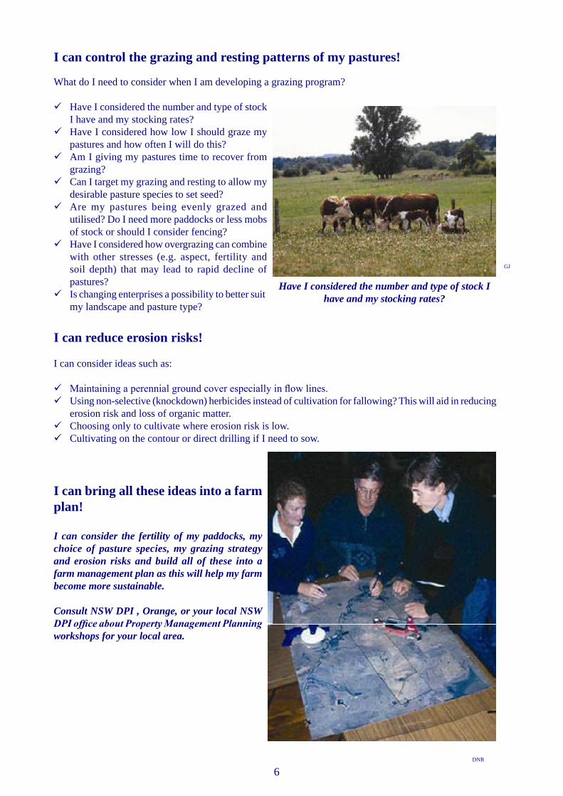
I can control the grazing and resting patterns of my pastures!
What do I need to consider when I am developing a grazing program?
Have I considered the number and type of stock I have and my stocking rates?
Have I considered how low I should graze my pastures and how often I will do this?
Am I giving my pastures time to recover from grazing?
Can I target my grazing and resting to allow my desirable pasture species to set seed?
Are my pastures being evenly grazed and utilised? Do I need more paddocks or less mobs of stock or should I consider fencing?
Have I considered how overgrazing can combine with other stresses (e.g. aspect, fertility and soil depth) that may lead to rapid decline of pastures?
Is changing enterprises a possibility to better suit my landscape and pasture type?
I can reduce erosion risks!
I can consider ideas such as:
Maintaining a perennial ground cover especially in flow lines.Using non-selective (knockdown) herbicides instead of cultivation for fallowing? This will aid in reducing
erosion risk and loss of organic matter.Choosing only to cultivate where erosion risk is low.Cultivating on the contour or direct drilling if I need to sow.
I can bring all these ideas into a farm plan!
I can consider the fertility of my paddocks, my choice of pasture species, my grazing strategy and erosion risks and build all of these into a farm management plan as this will help my farm become more sustainable.
Consult NSW DPI , Orange, or your local NSW DPI office about Property Management Planning workshops for your local area.
GJ
DNR
Have I considered the number and type of stock I have and my stocking rates?

7
Ground Cover and other Measurements used in the Grazing Industry
Measurements used to monitor pastures depend on what you are trying to quantify. Here are some examples.
Measurement System 1: Percentage Ground Cover
Ground cover is live and dead plants and unattached litter. Ground cover is measured as a percentage of the whole area, the remainder being bare ground. It is often measured in a ½ metre by ½ metre area.
This system is often useful for discussing erosion prone areas and it gives a good idea of how hard a pasture has been grazed.
Various ground cover benchmarks have been developed for different soil types, climatic regions and land slopes. Generally these range from 70% to 100%. (Lang and McDonald)
Measurement System 2: Pasture Composition
It is not possible to manage a pasture if you can’t identify the species and don’t know what you have. You need to be able to tell the difference between perennial and annual, native and introduced, legume and grass, summer and winter growers, useful and weedy species, etc. The amount of legume in a pasture for instance, has a strong influence on grass vigour and pasture quality. Percent composition can be measured by recording species at the point of your right boot at every 5th step – take 1-200 recordings to get a reasonable estimate in any paddock.
Measurement System 3: Pasture Quantity and Quality
Pasture quantity is usually given as kilograms dry matter per hectare (kg DM/ha) can be estimated by eye.
It is the amount of material that can be cut from an area (then dried and weighed). It is always expressed on a dry matter basis and can be either “green” or “total”.
Total Dry Matter is the dried weight of ALL plant material in a paddock; this includes living and dead plant parts.
Green Dry Matter is the dried weight of only the green, living parts of the plants in the paddock and provides a better measure of how valuable the feed is for animal production (percent legume will provide further feed quality data).
Quantifying Dry Matter is the first step in assessing the fourth form of measurement, livestock carrying capacity and performance.
MK
DH
This photograph shows 90% of the ground covered by plants or litter with only 10% bare ground.

8
Measurement system 4: Animal Equivalents and Feed Days
Many measurement systems are expressed in terms of how much an animal consumes or needs. DSE/ha (dry sheep equivalents per hectare), cows/ha and feed days are all examples of this type of measurement.
They are based on knowing how much a particular type of animal can consume or needs for say growth, lactation or maintenance etc, where both the pasture quality and quantity are important. Some feeds don’t supply sufficient quality and/or quantity.
See Table 1 for the DSE Ratings for various classes of livestock.
This table has been adapted from the PROGRAZE™ manual. PROGRAZE™ is an 8-day course available to graziers and service industry people who wish to develop skills in pasture and animal assessment. It assists in identifying ways to use these skills to improve their grazing management decisions.
9
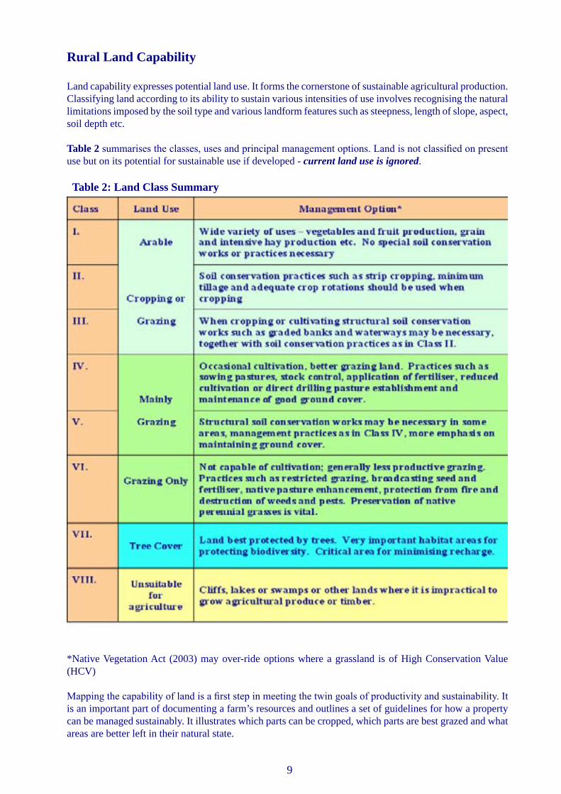
Rural Land Capability
Land capability expresses potential land use. It forms the cornerstone of sustainable agricultural production. Classifying land according to its ability to sustain various intensities of use involves recognising the natural limitations imposed by the soil type and various landform features such as steepness, length of slope, aspect, soil depth etc.
Table 2 summarises the classes, uses and principal management options. Land is not classified on present use but on its potential for sustainable use if developed - current land use is ignored.
*Native Vegetation Act (2003) may over-ride options where a grassland is of High Conservation Value (HCV)
Mapping the capability of land is a first step in meeting the twin goals of productivity and sustainability. It is an important part of documenting a farm’s resources and outlines a set of guidelines for how a property can be managed sustainably. It illustrates which parts can be cropped, which parts are best grazed and what areas are better left in their natural state.
Table 2: Land Class Summary
10
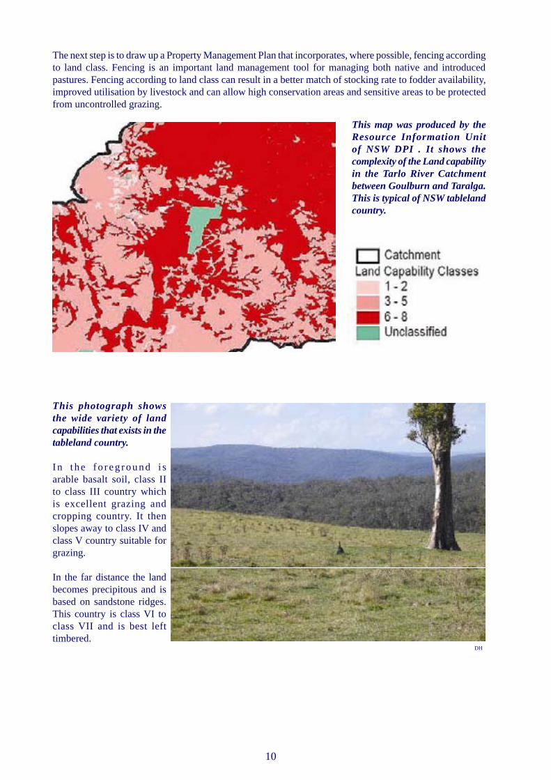
The next step is to draw up a Property Management Plan that incorporates, where possible, fencing according to land class. Fencing is an important land management tool for managing both native and introduced pastures. Fencing according to land class can result in a better match of stocking rate to fodder availability, improved utilisation by livestock and can allow high conservation areas and sensitive areas to be protected from uncontrolled grazing.
This map was produced by the Resource Information Unit of NSW DPI . It shows the complexity of the Land capability in the Tarlo River Catchment between Goulburn and Taralga. This is typical of NSW tableland country.
This photograph shows the wide variety of land capabilities that exists in the tableland country.
I n t h e f o r e g r o u n d i s arable basalt soil, class II to class III country which is excellent grazing and cropping country. It then slopes away to class IV and class V country suitable for grazing.
In the far distance the land becomes precipitous and is based on sandstone ridges. This country is class VI to class VII and is best left timbered.
DH

11
Summary Table of Best Management Practices
NSW DPI’s LANDSCAN™ course will assist land managers implement many BMP’s.

12
Managing Pastures for Clean Water
Why is this important to me as a farmer?
Water entering streams from agricultural land needs to have low levels of dissolved nutrients, especially nitrogen and phosphorus and low levels of soil particles. Clean water is an essential resource for human and livestock consumption and healthy aquatic life in streams.
Ensuring clean water will prevent sedimentation and pollution of farm dams and streams and allows for fresh water for livestock, fish and frogs.
On a farm there are several ways water can enter a watercourse:
1. Surface flows (e.g. permanent running water, surface flow and occasional flowlines); and2. Underground flows such as deep drainage or lateral flow over clay layers e.g. springs and soaks.
A strip of perennial grass and trees down the side of permanent running water (riparian vegetation buffer) is effective in trapping nutrients if ground cover is kept above 90%.
Perennial pasture plants can reduce/control many forms of land degradation although they also reduce the amount of run-off water. The management of vegetation cover on riparian land is critical in harvesting clean run-off water.
BMP1
A 90% ground cover is assessed visually using simple tools or photos like this photograph showing 90% ground cover in a microlaena pasture. Ground cover is the proportion (%) of the ground surface covered by plant material (including litter), which protects the soil from wind and water erosion.
In drought years ground cover can get to seriously low levels, particularly in sacrifice areas. Such areas have no protection from storm rains and significant erosion can occur, resulting in poor quality, turbid water entering streams and farm dams. This is why careful choice of sacrifice areas is so important.
MK
DH

13
What goal am I aiming to achieve?
I want to try to ensure adequate and clean run-off into waterways on and near my farm.
To achieve this goal what paddock objectives should I set?
Objective 1: I want to optimise the run-off of clean water from pasture into streams and dams.
To do this I need to try to:
Graze pastures in riparian areas to prevent build-up of excessive plant material (> 5000 kg/ha);Graze pastures to maintain ground cover at or above 90%; andUse a grazing system that includes rest periods to preserve groundcover as this minimises livestock
tracks and stock camps.
Objective 2: I want to prevent nutrients from reaching streams and dams.
To do this I need to try to:
Protect riparian areas from streambank damage by fencing to control livestock access so they can access water in stable areas. This also applies to vehicle creek crossings;
Establish fenced vegetation buffer zones containing perennial grasses, trees and shrubs adjacent to permanent water courses. Control and limit grazing of buffer zones to allow build-up of plant bulk and preserve 90% groundcover. Maintain some grazing to prevent grass clumps forming as they will develop bare ground patches between them;
Avoid fertilising riparian areas (refer to BMP 5);
Avoid applying fertiliser when ground- cover is low in sloping areas and when thunderstorms are likely;
Preferably rotationally graze pastures to prevent stock camps and tracks forming as they can potentially become erosion problems;
Control willows and other woody weeds in and along streams/lakes especially if they harbour pests such as rabbits and particularly if they are interfering with the free flow of water in the stream; Note 1, Note 2
To repair past streambank damage, fence and plant appropriate trees, shrubs and grasses to stabilise the area, control grazing and improve the visual appeal of dams and watercourses.
Note 1: Consult DNR before removing snags, trees or constructing earthworks in or around streams. Penalties under Water Management Act, 2000, can apply.
Note 2: Contact National Parks and Wildlife for advice on native animal relocation or control if your animal problem is wombats.
DNR

14
BMP2Managing Pastures for Protective Groundcover
Why is this important to me as a farmer?
It has been estimated that there can be 15 times more soil lost from a pasture if ground cover drops from 70% to 40%. It is important to keep ground cover above 70% to prevent soil erosion. On some soil types and topography, minimum ground cover needs to be higher than 70%.
Ground cover will minimise erosion, improve water quality, reduce weed invasion and enhance pasture survival during dry times. Together these will prevent loss of production and maintain the value of your property.
Some areas, especially shallow soils or exposed, steep or stony ridges may be better suited to trees and shrubs rather than pastures.
Ground cover gives the best protection against loss of valuable and productive topsoil, because it slows down water as it runs off after rain.
Ground cover can also have a direct effect on the plant production as bare ground increases soil temperatures, overheating and killing beneficial microbes and slowing plant growth. Above 60% ground cover this is less likely to occur. (Lang and McDonald, 2004)
40% ground cover 70% ground cover
These two photographs highlight the differences in ground cover which can exist in a pasture.
GL GL

15
MK
DH
What goal am I trying to achieve?
I want to try to maintain ground cover levels appropriate to my individual paddocks.
To achieve this goal what paddock objectives should I set? I want to try to manage pastures to maintain at least:
1. 80% ground cover on land capability classes IV & V; and2. 90% ground cover on capability classes VI & VII. (Lang & McDonald 2004)
To do this I need to try to:
Provide rest periods from grazing to prevent the formation of stock tracks, preserve ground cover and boost production and survival of perennial grasses;Revegetate disturbed or degraded areas with perennial species that will establish and persist in your
area;On sloping land, establish pastures by
direct drilling rather than ploughing;Actively manage native and sown
pastures to maintain their perennial grasses. This often includes fertilising and addition of companion legumes to maintain their vigour;
Provide multiple watering points in large paddocks to reduce bare, erosion prone stock tracks;
Control total grazing pressure by managing native and feral animalsNote
1; andAn appropriate form of rotational grazing can assist in achieving ground cover targets.
Gateways need to be carefully located to prevent erosion from vehicle and stock tracks, particularly in unstable soils.
Note 1: Contact National Parks and Wildlife for advice on native animal relocation or control.

16
BMP3
DNRGully erosion leads to loss of productive land
Managing Pastures to Reduce Soil ErosionWhy is this important to me as a farmer?
Erosion involves the loss of soil material. After European settlement the clearing of native vegetation, overgrazing pastures with domestic livestock and rabbit plagues all contributed to the loss of protective ground cover.
To maintain production the topsoil needs to stay in place since the majority of the organic matter is found in this layer. Managing pastures to prevent erosion will maintain the earning potential and asset value of the land.
Managing pastures to repair erosion is designed to restore the earning potential and asset value as well as provide a significant aesthetic appeal.
There are three major forms of erosion: sheet Note 1, gully and streambank erosion.
What goal am I aiming to achieve?
I want to try and prevent soil erosion in a pasture and repair past damage.
To achieve this goal what paddock objectives should I set?
I want to prevent and repair sheet, gully and streambank erosion in my paddocks.
First thing I must do is contact my local Catchment Management Authority (CMA) office and seek their opinion, as every soil erosion problem is different. In general I can try the following things:
Try to prevent and repair sheet erosion.Try to prevent and stabilise gully erosion.Try to prevent and stabilise streambank erosion.Develop a whole farm plan that incorporates provision for roads, fences and laneways, and minimises
soil disturbance.
Note 1: Sheet Erosion is the broadacre loss of surface soil by wind and water

17
I want to prevent and repair sheet erosion?
To do this I need to try to:
Maintain ground cover according to paddock land class as described in BMP 2;Only lightly graze newly sown pasture areas in the first season or if dry, spell them to allow perennial
species to seed down;Fertilise introduced pastures to maintain vigour according to soil test results;Establish windbreaks;If eroded, remove all livestock or temporarily fence out sheet eroded areas. Sow a cover crop of oats,
ryecorn or short-term rye grasses to protect the soil surface;Improve and maintain groundcover by sowing perennial pastures and manage the pasture to increase
cover.
I want to prevent and stabilise gully erosion?
To do this I need to try to:
Protect vegetation in drainage lines from vehicle and stock tracks, ploughing, over-grazing or clearing;
Fence waterways and maintain ground cover above 80% and at least 1500 kg D.M./ha;If a gully is present I need to contact the CMA office and seek their advice.
I want to prevent and stabilise streambank erosion?
To do this I need to try to:
Control stock access to stream banks;Provide an alternative water supply if required;I then need to contact the CMA office and seek their advice. They can assist in advising how to control
stream bank erosion and also how to remove willows and debris that interfere with stream flow and cause erosion;
If streambank erosion is present I may consider the following:–
• Fencing and revegetating to perennial species (grass, shrubs, trees);
• Maintaining grassy buffer strips from 10 to 30 metres wide on either side of the stream to hold the soil in place;
• Locating creek crossings in stable areas or create stable crossings with rock;
• Protecting stream-banks with trees, logs, rock revetment;
• Controlling burrowing animals;• Controlling weeds by hand-hoeing, target
spraying or short bursts of high intensity grazing;
• Providing an off-stream, alternative water supply e.g. troughs if totally dependent on creek/stream water supply.
GJ

18
BMP4Managing Pastures for Biodiversity and Weed Control
Why is this important to me as a farmer?A more diverse ecosystem has natural checks and balances which can benefit agriculture by maintaining the stability and resilience of the farm landscape, encouraging birds and naturally reducing insect pests, increasing shelter and lamb survival, year round water use.
In contrast, certain invasive weeds can totally dominate and degrade both native and sown pastures reducing biodiversity, productivity or carrying capacity and the value of the property. Once weeds take over they are generally costly to eradicate. There is also a legal responsibility to control or eradicate noxious weeds (Weeds Act, 1996, Noxious Weeds Act, 1993 as amended) and pest animals (Rural Lands Protection Act, 1998)
What goal am I aiming to achieve?1. Develop a Farm Plan to provide a mosaic of different development levels across the property and increase
the land’s visual appeal. Certain areas will have high productivity and possibly low biodiversity but in other parts of the farm, maintaining native pastures or the condition of remnant vegetation may be the most appropriate action.
2. Protect clean land from weed invasion - continuously control light infestations and generally reduce the area of land infested by weeds.
To achieve this goal what paddock objectives should I set?1. Manage High Conservation Value (HCV) Areas
Use a property plan to identify areas best reserved solely for biodiversity and preservation; Fence HCV areas to control (but not exclude totally) livestock grazing and permit natural
regeneration;Minimise disturbance and fragmentation that may reduce habitats and species;Connect remnant areas to increase survival and allow wildlife corridors;Do not fertilise HCV grasslands or grassy woodlands.
This aerial photograph is showing two hills covered in trees. These are significant wildlife refuges. Unfortunately, they are not connected to each other with stands of native vegetation as wildlife corridors.
To provide corridors, this farmer could either fence out the creek line (shown in blue) and allow regeneration of native trees or the area next to the fence line (shown in green) and allow for a wide native tree lot, either way both would be excellent corridors.
These areas would normally have some trees and therefore limited production. They would also be more protected being under the native vegetation and livestock would gain benefit from the presence of a windbreak. By simply working with the farm landscape and using LANDSCAN™ Note 1principles, local wildlife has benefited and possibly you have also met Native Vegetation Act provisions as well.
JS

19
2. Conserve existing native vegetation
Avoid cultivation of native grasslands especially using disc ploughs and/or multiple cultivations;Minimise damage to non-target species wherever possible by using selective herbicides or spraying when
the desirable species are dormant;On grazed pastures balance fertiliser use to match nutrient export & tie-up in the soil;Do not clear native vegetation without a permit (Native Vegetation Act, 2003).
3. Graze to achieve specific outcomes
Use short periods of heavy grazing to reduce selective grazing of desirable species;
Rest pastures at times to allow desirable species to set seed and recruit seedlings and target grazing of undesirable species, e.g. wiregrass over summer;
Heavily graze annual weeds at appropriate times to remove seedheads and reduce seed set.
4. Keep weeds out of clean areas
Identify and remove weeds before they set seed;Quarantine all newly purchased stock in a designated paddock for 7 days after purchase; Watch for weeds that may have been introduced with the supplementary feeding of hay or grain. Where
infestations occur, quarantine these paddocks for control.
5. Manage edible weedsNote 2
Use animal preferences and selective grazing to target specific weeds, for example dry sheep on Capeweed, goats on blackberry/thistles etc;
Use sub lethal herbicide rates and “spray-graze” or “spray topping” techniques where appropriate;Use tactical pasture spelling or short duration, high intensity grazing;Use selective herbicides or mechanical means e.g. slashing or silage making to reduce seeding.
6. Remove noxious and non-edible weeds
Use appropriate herbicides at the right time and stage of growth;Use integrated control measures such as cultivation, biological control where available, grazing e.g.
goats on blackberries, re-sowing perennial pastures etc;Maintain competitive pastures and high levels of ground cover; Plant trees in degraded, non-arable and uneconomic areas of land.
Note 1: LANDSCAN™ is a NSW DPI course available to all rural landholders that develops skills and knowledge to assess natural resources (pastures, vegetation, soils and topography) on farms to better match land-use to land capability. Landholders can then make informed decisions about managing individual paddocks and allocating resources to balance production, profit and sustainability.
Note 2: Beware of possible livestock health problems if “spray grazing” - consult your local veterinarian.
Grazing management and competitive pastures can prevent invasion by weeds such as serrated tussock
MM

20
BMP5Managing Soil Fertility in PasturesWhy is this important to me as a farmer?
Soils in the region are generally deficient in phosphorus and/or sulphur and the trace element molybdenum. Unless these deficiencies are addressed, pasture growth and ground cover will be restricted.
To maintain pasture production fertiliser applications are best aimed to balance the export of nutrients in products, translocation to stock camps and nutrient losses due to leaching and soil tie up.
Unfertilised pastures have lower carrying capacity and grazing enterprises may become uneconomic. They tend to have poor ground cover and when grazed are prone to weed invasion.
This photograph shows the effect of fertiliser on pasture growth. Above the fence (left hand side) the pasture has not been fertilised and carrying capacity is lower. The paddock below the fence (right hand side) has been fertilised with superphosphate and has a higher carrying capacity.
What goal am I aiming to achieve?
To improve production of perennial pastures through improved soil fertility.
To achieve this goal what paddock objectives should I set? 1. Match nutrient inputs to pasture production potential:
Identify limiting nutrients by considering paddock history, soil testing or fertiliser strip tests;Apply appropriate rates and types to different soils, pastures and landscapes (e.g. deep soil and highly
productive pastures will respond to higher rates);Choose a fertiliser rate that is matched to stocking rate and enterprise; Carry out soil tests to monitor soil fertility every three to five years;Undertake a LANDSCAN™ course to learn more about fertiliser use.
MK

21
2. Minimise off-site movement of nutrients
Minimise soil erosion (see BMP3);Avoid topdressing onto:
• bare ground (preferably ground cover should be above 70%);• waterlogged soils;• riparian buffer areas;• stock camps;• immediately before irrigation or within 3 days of predicted heavy rain;
On high input, intensively farmed areas, use split applications of fertiliser.
3. Use fertilisers economically
Identify nutrient deficiencies by strategic soil and leaf testing or fertiliser strip tests;Prioritise paddocks for potential profitability from an application of fertiliser;Avoid fertilising pastures unless they contain a legume or other responsive species;Avoid supering in cold wet conditions – apply fertiliser from late spring to early autumn provided ground
cover is at least 70%;Wherever possible apply fertilisers by ground spreading rather than aerially to better control where the
fertiliser is placed.
Determining Riparian Buffer Zones
The width of these depends on the size of the catchment, the slope of the land and the erodibility of the soil. The bigger the catchment, the greater the slope and the more erodible the soil, the wider the zone required to adequately protect the waterway. When risks are all low a 5 metre zone may suffice but when all are high the width needed will be 20 to 50 metres.
Response to fertiliser is clearly shown in this photograph as dark green strips following poor aerial application.
BC

22
BMP6Managing Soil Acidity in Pastures
Why is this important to me as a farmer?
Acid soils can reduce pasture production due to aluminium toxicity, molybdenum deficiency, stunted plant roots, inability to establish acid sensitive species such as lucerne or phalaris, increased weed species and declining pasture vigour. Aluminium only becomes available to plants when soil pHCa drops below 4.6.
Many Tableland soils are highly weathered and naturally acidic throughout the soil profile. However, the rate of soil acidification of non acidic soils has increased under agriculture. Once the surface acidifies, acidity can then move to depth where it becomes untreatable.
The main causes of agriculturally induced acidity are the build up of soil organic matter, leaching/loss of nitrate nitrogen below the plant root zone and removal of agricultural products which are alkaline.
What goal am I aiming to achieve?
I want to try to prevent the soil pHCaNote 1 of non acidic soils from dropping below 4.8 and minimise
the rate of further acidification on all my soils.
Brittle Gum indicating highly acid soils of the Southern Tablelands
Note 1: pH is measured in water or calcium chloride. The latter is more accurate in soils with a pH below 6 and is denoted pHCa. Water pH values tend to be O.8 units higher than pHCa
BS

23
To achieve this goal what paddock objectives should I set?
1. Slow the rate of further acidification
Replace annual pastures with deep-rooted perennials;
Fertilise perennial pastures to increase their persistence and vigour;
Confine high production systems (e.g. lucerne hay production and dairying) that are highly acidifying, to land classes where lime can be incorporated;
Target fertiliser and grazing practices in non-trafficable areas to achieve persistence of the perennial grass component (i.e. persistence takes priority over production);
Manage land classes above land class V to slow the rate of acidification using lower input and lower removal systems such as wool production from wethers;
Undertake a LANDSCAN™ course to get a better understanding of soils and to gain meaningful soil tests.
2. Overcoming the adverse effects of soil acidity on pastures
Preserve acid tolerant native perennial pastures especially on soils that are acidic to depth (below 20 cm) and of poor fertility;
Where perennial grasses are absent, use acid tolerant introduced species on soils with subsoil acidity;
In soils that are only acidic in the top 10 cm, use lime to prevent acidity moving to depth;
Liming will change soil pH in the top 10 cm of the soil, whether ploughed in or topdressed. Note, topdressed lime only appears to move into sandy soils and those with good water infiltration;
Lime does not move into soils derived from slate/shale rocks when topdressed and to be effective lime needs to be incorporated;
When resowing pastures on acid soils to depth, use a combination of lime and acid tolerant species for best results;
Use molybdenum for effective legume nodulation every 4 years and fertiliser to maintain pasture vigour;
When establishing pastures on acid soils with a pH of less than 4.6, consider using lime. If I am direct drilling I need to surface apply lime at least 12 months before sowing;
Use farm mixed lime super (see glossary) at sowing for best establishment as this provides a cheaper option than topdressing with heavy rates of lime and markedly increase establishment of acid sensitive seedlings, such as phalaris.
You can only change soil pH in the top 10 cm of the soil by liming or topdressing. Top dressed lime only appears to move into sandy soils and those with good water infiltration.
MK

24
Managing Dryland Salinity in Pastures Why is this important to me as a farmer?
Dryland salinity occurs because there is increased infiltration of water beyond the reach of plant roots which leads to water tables rising and discharge lower in the landscape. The former brings dissolved salts into the root zone and where it breaks the soil surface, results in saline seeps.
As a result the following occur:
1. Tree death in severe cases;2. Loss of ground cover and pasture production;3. Salt deposits on the soil surface;4. Soil erosion accelerates;5. Turbidity and salt concentrations in streams and rivers increase; and6. Damage to off-farm infrastructure such as
roads, fences and buildings.
What goal am I aiming to achieve?
I want to try to use as much water as possible for plant growth where it falls on my farm landscape and limit the amount of ground water recharge.
To achieve this goal what paddock objectives should I set?
1. Use soil water for plant growth and reduce deep drainage
Aim for 80–100% of the property with a dominant perennial cover of pastures and trees where appropriate;
Manage perennial grass based pastures (either native or introduced) to ensure vigour and persistence for production of green leaf in summer;
Use deep rooted, summer active perennial pastures and/or strategically placed tree plantings to lower water tables in saline areas;
Fence off and retain, or plant, trees and woody shrubs especially in rocky recharge areas high in the landscape.
2. Protect and manage saline areas and salt scalds
Fence out saline discharge sites and manage separately from surrounding areas;
Divert water flow and erosion across the site using physical structures above the site;
Establish salt and waterlogging tolerant pastures on discharge areas and salt scalds;
Use mulching and/or soil ameliorants (gypsum or lime) where appropriate;
Aim for 100% groundcover and encourage green leafy growth over summer and autumn by using short duration/high intensity grazing techniques.
BMP7
Salinity causes loss of groundcover and thus, loss of pasture production
MK

25
BMP8Managing Pastures to Reduce the Impact of Drought
Why is this important to me as a farmer?
You can’t make it rain.
Climate variability is part of our natural landscape. There are seasonal feed shortages which occur for short lengths of time, due to cold or dry conditions. When you get a string of ongoing seasonal feed shortages this is termed a drought. The problem is that droughts are unpredictable.
Planning to cope with both these situations is important and this is where a Drought Plan within the Farm Plan is useful. You need to take advantage of good seasons and/or prices and minimise the damage in bad seasons.
The tougher and harder the country (i.e. steeper, non-arable land classes—class IV and above) the more difficult it is to repair the damage caused by droughts. Native perennial pastures are extremely difficult to re-establish if they are lost.
The higher you push your pasture productivity and increase stocking rates, the more readily disposable livestock you need to run, e.g. wethers or trader steers. In other words, the extra stock you put on the pasture in good seasons need to be able to be readily sold in bad seasons.
By planning for droughts you can reduce its impacts (e.g. plant death and pasture decline, wind erosion, animal welfare issues, loss of farm finance). Wind erosion is often overlooked but when ground cover is lost it occurs every day that the wind blows.
What goal am I aiming to achieve?
I want to try and minimise the impacts of drought on my farm.
To achieve this goal what management objectives should I set?
What I need to do –
1. Use off-farm investments in the good years (e.g. farm management bonds) to spread risks;2. Protect native pastures on steep and/or shallow soil non-arable areas where re-sowing is not an option.
As the drought progresses these areas need to be de-stocked first to prevent overgrazing and the irreversible degradation.
A level arable paddock, good shelter and supplementary feeding indicate good drought management.
GJ

26
GJ
3. Draw up a Drought Plan before a drought as this will better protect your farm’s physical and financial resources. Remember, loss of valuable topsoil, pastures and nutrients are significant costs over and above feeding, livestock production and replacement costs during and after drought.
Points to consider when developing a drought plan:
Use appropriate decision support tools such as Grazfeed™ and StockPlan® Note 1 to aid decision making in drawing up your drought plan.
Find out local rainfall patterns; learn how to read a weather map in NSW DPI’s 1 day climate workshops;
Protect steep, difficult country and protect new or valuable pastures;Plan and plant shelter belts to protect soil in exposed paddocks from wind erosion;Plan to have ‘safety valve’ stock on hand which can be readily identified and disposed of early;Identify critical dates and pasture benchmarks for further de-stocking and other actions;Monitor animal health and welfare issues;With remaining stock, and pastures approaching minimum pasture benchmarks, provide appropriate
supplementary feed;De-stock by disposing of saleable fat animals, seek agistment, or dispose of other classes of stock
progressively that are not essential at the end of the drought;
Once you have de-stocked as much as possible, pastures may be better protected if animals are moved into either a feedlot or sacrifice paddock to prevent further pasture damage;
Sacrifice or feedlot areas should have some of the following attributes:
• Relatively flat• Easily re-sown (arable)• Sheltered• Well watered• Good access• Not drain directly into farm dams or creeks
After the drought breaks, be alert to new or introduced weeds germinating over the whole farm that have come in with purchased feed and also local weeds which establish in the absence of pasture competition;
Continue feeding past the “break” of the drought to allow for pasture recovery. This may avoid sudden feed changes which can cause rumen problems;
Note 1: StockPlan® is a NSW DPI course designed to assist graziers in developing drought plans; Grazfeed™ is a CSIRO decision support system that aids in the prediction of animal performance from pastures and supplements or full hand feeding.
A well chosen sacrifice paddock

27
Managing Grazing for Pasture Persistence, Production and Livestock Performance Why is this important to me as a farmer?
Grazing management provides the link between ground cover and pasture quantity and quality to achieve livestock and business targets and better environmental outcomes.
When pasture types are matched to suit soils, aspect, topography, climate and livestock enterprise they have the potential to support high levels of livestock production and achieve various environmental outcomes, provided they are well managed.
Well managed perennial pastures provide good ground cover and can reduce various forms of soil degradation (soil acidification, soil erosion, rising water tables and dryland salinity) and produce cleaner water.
What goal am I trying to achieve?
I want to maintain a healthy, productive, profitable pasture system.
To achieve this goal what paddock objectives should I set?
1. Maintain a productive and well balanced persistent, perennial pasture (native or introduced)
To do this I need to try to:
Use grazing (and fertiliser) to ensure 20–30% legume for high quality pastures, especially for lactating and finishing animals;
Graze to prevent legumes and annual grasses from out-competing native grasses in spring;
Match stocking rates to the pasture available. Always maintain pasture dry matter of sub-clover based pastures above 400 kg DM/ha and maintain dry matter of white clover based pasures on the northern tablelands between 600–800 kg DM/ha. Even higher levels are preferable over dry summers to ensure pasture persistence;
Know and visually recognise key pasture benchmarks, by completing a PROGRAZE™ course to gain these skills. (refer to Appendix I)
BMP9
GJ

28
2. Manage seasonal grazing to ensure species persistence and high feed quality
To do this I need to try to follow these seasonal guidelines:
Grazing management needs to be flexible from season to season and year to year, but in general:
Graze to avoid one species dominating the pastureMaintain active pasture growth with green leaves for as long as possibleAt times of the year you need to allow pastures to rest for seed set and re-establishment (e.g. delay
grazing of sub-clover in autumn until the 2–3 leaf stage where possible)Increase stocking rates to reduce dominance of a particular species (e.g. crash graze annuals in Spring
to reduce seed set or use high stocking rates on sown pastures to prevent introduced perennials dominating)
Repeated or continuous defoliation when perennials are under stress will lead to their death.
3. Maintain healthy and productive livestock
To do this I need to try to:
Identify and set animal targets, e.g. weaner cattle reaching a minimum 240 kg in 7–9 monthsMatch the animals’ requirements to seasonal pasture availability, for example:
This graph shows the potential yearly pasture growth from a well fertilised pasture grown on the southern or central tablelands and the requirements for an autumn lambing enterprise and a spring lambing enterprise.
It can be seen that the pasture growth on the central and southern tablelands peaks mainly in spring, just in time to meet the increased feed requirements of ewes and their spring lambs. On the other hand the slight pasture production peak in autumn is unreliable and insufficient to meet the needs of ewes and their autumn lambs as you approach winter. This will mean heavier pressure on remaining pasture during the feed gap and the cost of supplementary feeding. On the northern tablelands greatest pasture production occurs from November to March but in both regions there is a winter feed gap.
I can also try to:
Monitor pastures for quantity and quality to ensure livestock requirements are metMonitor animal liveweight or fat scores at key times to achieve livestock targetsImplement an animal health plan to cover vaccination, worm control and overcome nutritional
disorders, e.g. grass tetany
29
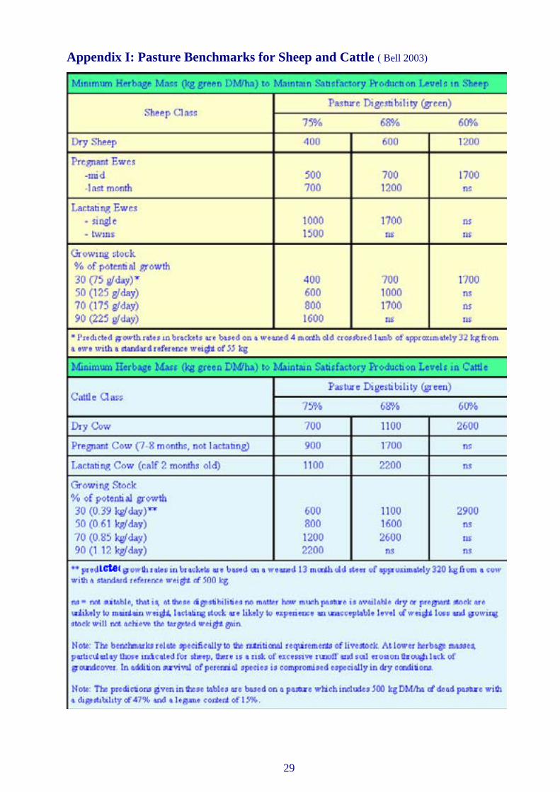
Appendix I: Pasture Benchmarks for Sheep and Cattle ( Bell 2003)
30
Glossary
Acid Soil: Technically, a soil with a pH of less than 7. However, pasture problems only occur at the extremes (above 9 & below 5). In this region, when the pH falls below 4.5 (calcium chloride test) or below 5 (1:5 soil: water test), problems related to toxic amounts of aluminium and/or manganese, poor root growth and legume nodulation occur. (see also Glossary note on pH).
Annual: A plant that germinates, grows, flowers and sets seed within a year.
Arable: Land that can be cultivated and sown to crop or pastures.
Bank: A constructed earth embankment, incorporating a channel on the up-slope side, typically traversing a slope, to control and/or prevent erosion of that slope. This is achieved by intercepting, diverting or sorting run-off instead of permitting it to flow uninterrupted down the slope.
Biodiversity: The maintenance of the variety of life forms, plants animals and micro-organisms, the genes they contain and the ecosystems they form within the catchment.
Buffer strip: A vegetated strip of land that functions to absorb/trap sediment and nutrients.
Carrying capacity: A paddock or farm’s capacity to carry livestock. Usually measured in DSE’s per hectare, carry capacity is largely influenced by pasture production which varies within and between years.
Continuous stocking: Pastures continuously stocked, rarely or if ever receiving a spell from grazing.
Crash grazing: Very heavy stocking rates (e.g. 100 DSE or more per hectare) used for relatively short periods to non-selectively remove weedy species from pastures.
Direct drilling: Sowing pasture seed and fertiliser directly into uncultivated land, generally after a knockdown herbicide is sprayed.
Discharge area: An area where underground water is discharged at the soil surface.
Dispersible soil: A soil which readily disperses into its constituent particles (clay, silt, sand) in water, often due to high levels of sodium (salt).
Diversion bank: An earth bank, with a graded channel on the upslope side, designed to divert water away from an actively eroding area or gully head.
Drainage line: A channel down which surface water naturally concentrates and flows, conveying water only during and/or immediately after periods of heavy rain. Drainage lines may be stable, as in a well-grassed depression, or unstable, as in an active gully.
Dry sheep equivalent (DSE): Energy required to maintain the weight of a 2 year old merino wether weighing 50 kg. It is used as a base comparison for other livestock types and classes.
Disturbance: Changed state of soil or pasture by external means such as cultivation, herbicides, etc.
Dryland salinity: Is the build up if salt in surface soil usually as a result of a rising water table and subsequent groundwater seepage. This is commonly called saline seep. Dryland salinity refers to non-irrigated areas showing a salt problem.
Duplex soils: One with a sharp texture contrast between topsoil and subsoil.
31
Ecosystems: All organisms, physical habitats and processes pertaining to ecology at a location.
Erosion: The wearing away of the land by water or wind, leading to the loss of topsoil. Farm Mixed Lime Super: Equal amounts of fine lime and superphosphate mixed immediately prior to sowing. This only provides a short-term liming effect.
Fertiliser Strip Tests: A means of visually assessing a paddock’s response to fertiliser. Ferliser is broadcast in a single strip across a paddock at twice the normal spreading rate.
Flowlines: Elongated areas in a paddock where water concentrates and flows during heavy rainfall.
Fragmentation: Breaking of blocks of vegetation into smaller and less-effective parts.
Forbs: Herbaceous broadleaved plants (essentially non-grasses) e.g. legumes, native daisies, etc.
Good (or prime) agricultural land: Land which, because of its soil, climate, topography and location, is highly suitable for regular agricultural production, but which may have limitations to productions requiring significant inputs and/or restrictions to achieve and maintain long-term productivity, soil fertility and soil stability.
Grazing capacity: Maximum stocking rate which grazing land can support in the long term without deterioration.
Ground cover: The proportion (%) of the ground surface covered by plant material (including litter), which protects the soil from wind and water erosion.
Gully: An open erosion channel greater than 30cm deep. Gullies have very gently inclined floors and precipitous walls.
Gully Head: The upstream end of a gully where runoff from the catchment above falls to the gully floor.
Habitat: The place where a particular animal or plant naturally lives or grows.
High Conservation Value (HCV) Areas: Endangered ecological communities, threatened communities, threatened species habitat, migratory species habitat, declining species habitat, edge-of-range species habitat, species rich habitats, wildlife corridors between core habitat areas, wildlife movement pathways, etc.
High density/short duration grazing: Grazing system whereby large numbers of stock are placed in a paddock for short periods.
Infiltration: Movement of rainfall and run-off water into the soil.
Introduced pastures: Refers to sown pasture species which have been introduced by humans.
Knockdown herbicide: A non-residual herbicide that kills both grasses and broadleaf weeds.
Land capability: The ability of land to accept a type and intensity of use permanently, or for specified periods, under specified periods, under specific management without permanent damage. It is an expression of the effect of biophysical land resources, including climate, on the ability of land to sustain various uses such as crop production/regular tillage, grazing, woodland or wildlife.
Land degradation: The decline in quality of natural land resources caused through improper use of the land by humans.

32
Litter: Dead plant material lying on the ground (unattached to plant).
Native pastures: Pastures with a majority of indigenous Australian species. A “modified native pasture” contains an introduced legume and receives fertiliser.
Naturalised pastures: Contains many non indigenous species, often introduced accidentally, which have spread extensively on their own (e.g. barley grass, rat tail fescue, ball clover).
Non-trafficable: Land which cannot be safely driven across with a wheeled tractor.
Noxious weeds: Plants proclaimed under the Local Government Act where there is a legal obligation to control it (e.g. serrated tussock, blackberry, scotch thistle).
Over-grazing: A short-term concept relating to the eating of pastures by stock below optimum Leaf Area Index (LAI) so that the growing point of the plant is injured and recovery and growth slowed. Under certain circumstances this practice is necessary for short periods.
Over-stocking: A long-term concept relating to stocking rate which can lead to a detrimental change in the botanical composition of pastures.
Perennial plant: A plant whose life cycle extends for more than two years and continues to live from year to year.
Pest species: Harmful, destructive, nuisance or troublesome types of animals or plants.
Pesticide: Chemical substance for destroying pests (i.e. weeds or insects).
pH: A measure of the acidity or alkalinity of a soil. Measured in either water or calcium chloride – the latter is preferred for acid soils. A pH of 7.0 denotes neutrality, higher values indicate alkalinity and lower values indicate acidity. Soil pH in the tablelands range from 4 to 6 in calcium chloride. Plants grow best in soils with a pHCa above 4.6.
Re-charge: The process that replenishes groundwater, usually by rainfall infiltrating from the ground surface to the water table.
Recruitment: The process of regeneration from seedlings.
Remnant vegetation: An isolated patch of original vegetation in a landscape that has been altered by human activity such as agriculture.
Revetment: A protective layer of rip-rap or other erosion-resistant material, placed along the edge of a stream or shoreline, to stabilise the bank and protect it from the erosive action of water.
Rill erosion: Formation of shallow channels up to 30 cm deep due to channelling of water runoff, usually from initial sheet erosion.
Riparian area/zone: Any land which adjoins, directly influences or is influenced by a body of water such as a permanently or intermittently flowing creek, a wetland that interacts with a river only during periods of high flow or a dam/reservoir.
Riparian buffer: A strip of vegetation in a riparian area protecting the water environment from the surrounding land use.

33
Rotational grazing: A grazing strategy that involves a period of grazing followed by a period of rest. The rest period is generally based on the pasture growth rate. May be employed during only part of or during the whole year.
Runoff: That portion of precipitation not immediately absorbed into the soil and which becomes surface flow and forms the majority of harvested water for dams and streams.
Sediment: Material of varying size, both mineral and organic, that is being transported, or has been moved from its site of origin by air, water, gravity, or ice and comes to rest on the earth’s surface either above or below sea-level.
Selective grazing: Allowing animals choice to select particular plants in preference to others, often resulting in loss of more palatable species.
Set stocking: Fixed number of stock grazing a paddock for an extended period but not continuously stocked with no spelling.
Sheet erosion: Heavy rainfall dislodges soil particles from large bare areas and carries substantial volumes of sediment down the slope.
Sown pasture: Pastures sown by machinery or aerially, either into a ploughed or sprayed out (direct drill) seedbed.
Stocking rate: The number of livestock on a particular area. Usually described in DSE’s/ha but also head/ha (e.g. wethers/ha).
Streambed erosion: The removal of soil from streambeds by the direct action of stream flow. Typically occurs during periods of high flow.
Streambank: A moderately inclined to precipitous slope forming the margin of a stream channel and resulting from erosion by channelled stream flow.
Subsoil: That part of the soil profile, typically the (B) and (C) horizons which underlay the topsoil. Being older than the topsoil it is generally lower in organic matter and fertility. The subsoil can at times be significantly different in colour and texture to the topsoil.
Topsoil: The part of the soil profile, typically the surface (A) horizon, containing material which is usually more fertile and better structured than underlying layers. It is the most important part of the soil for growth of crops and pastures, and its loss or degradation represents the most serious aspect of soil erosion.
Turbidity: The cloudy appearance of water due to the presence of suspended material.
Vegetation Management Plans: A negotiated plan which identifies existing and critical areas of vegetation and those that should be retained as outlined in the Native Vegetation Act, 2003.
Weeds: Plants that are growing out of place. They maybe invasive, low producing or unpalatable. Some weeds are noxious and it is the land managers responsibility to under legislation control these (e.g. serrated tussock).
Wildlife corridor: An area of (generally native) vegetation which can allow movement of wildlife between larger remnant vegetation areas (e.g. vegetation along fences, roads, rivers).
Windbreak: One or more rows or groups of shrubs and trees planted across the prevailing wind direction to reduce wind speed on the lee side.

34
Bibliography
Bell, AK (2003) “PROGRAZE™ Manual” NSW DPI , Orange NSW, and Meat & Livestock Australia.
“ The Graziers Guide to Pastures: Sowing and managing profitable pastures in the Central and Southern Tablelands, Monaro and Upper South West Slopes of New South Wales”, (2003). NSW DPI publication ISBN 07347 11697.
Keys, MJ (2000) “ Management of Profitable and Sustainable Pastures - A Field Guide”. NSW DPI publica-tion ISBN 07310 57325.
Lang, D and McDonald, W (2004) “Maintaining groundcover to reduce soil erosion and sustain productivity - estimates of minimum groundcover requirements for pastures in New South Wales”. In print. NSW DPI , website publication.
Training Courses To Help You Implement Best Management Practice
1. StockPlan® a 2 day workshop to help cattle and sheep producers explore management options in the early stages of drought and during drought. Three computer decision support tools help producers answer
questions such as:- How much will it cost to feed my stock for a specified time? How will my decision affect my flock or herd and financial position?
Is it better to sell or agist my cattle? Is agistment an option for certain classes of animals?
2. Farmers’ Guide to Weather and Climate on Farms: this is a practical one day workshop that examines how weather works in eastern Australia. Covers interpretation of synoptic charts and cloud pictures, how the SOI and El Nino can influence weather in the future, where to find
historical records and managing risk/ making decisions based on the probabilities of certain climatic events.
3. PROGRAZE™ see page 35.
4. LANDSCAN™ see page 36.
To participate in any of these courses contact your local NSW DPI office.

35
When you think grazing management, think PROGRAZE™
PROGRAZE™ develops in participant’s pasture and animal assessment skills and importantly, how to use these skills to improve on-farm grazing decisions. Using the skills and knowledge developed in PROGRAZE™, results in more effective matching of livestock feeding requirements and pasture production. As well, more efficient, profitable and sustainable grazing strategies may be developed. PROGRAZE™ has been developed for producers on the slopes and tablelands of NSW.
PROGRAZE™ has a course format and is delivered in 8 segments, each 2-4 weeks apart depending on the wishes of the group. A measure of the success of PROGRAZE™ has been that most groups have continued to meet following the completion of the 8 segments.
Reference notes will be provided for each segment.
Key components of PROGRAZE™ are:
• Understanding pasture quantity and quality issues and their influence on animal production
• Setting targets for both livestock and pastures• Fat scoring of livestock• Pasture growth and managing pastures by grazing• Developing grazing plans and strategies • Fodder budgeting.
Contact your local NSW DPI agronomist, sheep or beef officer to register your interest in participating in PROGRAZE™ in your area.
PROGRAZE™ has been developed by NSW Department of Primary Industries and promoted in collaboration with Meat & Livestock Australia.

36
LANDSCANTMLandscape and Soil Test Interpretation
for Sustainable Farm Management
A workshop series for farmers, graziers and land managers
Have you ever wanted to know how to:-
• assess potential paddock productivity and match it to enterprise use• read and understand your landscapes• understand soil test results• choose the correct fertiliser or liming product and how much to use• choose the right pasture plants or crops for different landscapes• understand and manage soil fertility, acidity and salinity• prioritise inputs for paddocks and develop strategies for sustainable and profitable farm
management?
LANDSCANTM helps to achieve sustainable productivity and improved environmental outcomes by better matching production and management options to the potential of your landscape.
LANDSCANTM is a NSW Deparment of Primary Industries workshop series running over 4-6 months, with 5 half day sessions and 1 full day session, all held on participants’ farms.
LANDSCANTM provides a vehicle to address all major Catchment Management Authority targets (water quality, soil health & biodiversity).
LANDSCANTM was developed by NSW Deparment of Primary Industries and is available to all rural landholders (regardless of property size or income source). For further information contact your local NSW Deparment of Primary Industries office or the course co-ordinator, Michael Keys at Queanbeyan, telephone: 6297 1861.
6652