for the monitoring of our environment from space and from earth the igos geohazards theme stuart...
TRANSCRIPT

For the monitoring of our environment
from Space and from Earth
The IGOS Geohazards Theme
Stuart Marsh, British Geological Survey (BGS)Chairman, IGOS Geohazards Team
Marc Paganini, European Space Agency (ESA) Co-chairman, IGOS Geohazards Team
Robert Missotten, United Nations Educational, Scientific and Cultural Organisation (UNESCO)Co-chairman, IGOS Geohazards Team

For the monitoring of our environment
from Space and from Earth
The IGOS Geohazards initiative
UNESCO, CEOS and ICSU initiated and scoped the IGOS Geohazards Theme in 2001.
An Ad-hoc Working Group was formed, held an international workshop in Frascati (Rome), and delivered a proposal to the IGOS partnership in May 2002.
An IGOS Geohazards Theme Team with BGS-ESA-UNESCO as co-Chairs and an ESA-supported Secretariat was set up.
The Theme Team, representing 20 organisations, worked for 1 year with regular meetings.
A Theme Report was delivered to the IGOS Partners in May 2003 for provisional endorsement.
An international peer review took place during the summer 2003.
The Geohazards Theme Report was then finalised, submitted to the IGOS partners and approved in November 2003.

For the monitoring of our environment
from Space and from Earth
The IGOS Geohazards theme report
Context, scope and strategic objectives
Beneficiaires, stakeholders and user needs
Required observations and key systems
Integration issues
Filling the gaps
Implementation plan and commitments to act

For the monitoring of our environment
from Space and from Earth
IGOS Geohazards scopeWhich Geohazards?
the 3 main geohazards: Volcanoes, Earthquakes, Ground Instabilities
The Use ofThe Use ofEarth Observing SatellitesEarth Observing Satellites
for Hazard Supportfor Hazard Support
CEOSCEOSCommittee on EarthCommittee on Earth
Observation SatellitesObservation Satellites
2000A REPORT OF THE CEOSA REPORT OF THE CEOS
DISASTER MANAGEMENT SUPPORT GROUPDISASTER MANAGEMENT SUPPORT GROUP
International Charter on
Space and Major Disasters
International Charter on
Space and Major Disasters
Building on previous works International Decade for Natural Disaster
Reduction (IDNDR) CEOS Disaster Management Support Group
(DMSG)
Why different Geohazards in a single theme? all driven by geological / geophysical processes share ground deformation as a common thread similar ground and satellite based observations
systems
Which phases? Preparedness / mitigation, mapping, monitoring,
and forecasting / prediction support to disaster response and to risk
assessment
Close links with complementary initiatives UN Action Team on Disaster Management International Charter on Space and Major
Disasters other IGOS Themes
(e.g. tsunamis with ocean team)

For the monitoring of our environment
from Space and from Earth
Strategic objectives
IGOS Mission Statement:
Develop a global strategy, for the next decade, to better
integrate current disparate, multi-disciplinary, applied
research into operational systems for an optimum
exploitation of observations and exchange of knowledge
Building capacity
Improving observations
Integrating effort
Promoting actions
Aims to increase capacity of all nations to manage risks related to their geohazards
Ultimately, this will release resources for other issues, like sustainable development
4 lines of actions4 lines of actions

For the monitoring of our environment
from Space and from Earth
Beneficiaries, Stakeholders, Users
Citizens are the ultimate beneficiaries of the strategy
But to deliver its benefit to society the strategy aims at 3 types of users:
Responsible AuthoritiesResponsible Authorities, who are provided with key information by …
…Scientists in Monitoring and Scientists in Monitoring and Advisory AgenciesAdvisory Agencies, who are provided with geohazards knowledge by …
…Research ScientistsResearch Scientists
Other key stakeholders addressed are the IGOS Partners and the data suppliers (in-situ, airborne, satellite-based)

For the monitoring of our environment
from Space and from Earth
User shared needs
Citizen’s questions are: What will happen? How?
Where? Over what area?
When? For how long?
User’s have shared needs: Baseline hazard inventory
Ongoing monitoring of a hazard against baseline
Rapid information supply during a crisis
The three types of users have specific needs that are detailed in the report

For the monitoring of our environment
from Space and from Earth
User needs (earthquake hazard)Type of user Needs for seismic crisis response Needs for seismic hazard assessments
Responsible Authorities
Clear, authoritative information on the location and magnitude of the shock and the timeframe (in days) of aftershocks.
Post-event maps (shake maps, damaged/ affected areas, identification of safe areas).
Hazard zonation maps (in paper maps or GIS databases).
Maps for various secondary effects of seismic hazards (landslides, liquefaction etc.).
Ultimate need: reliable prediction of events.
Scientists
in monitoring and advisory agencies
All data available, in as near to real-time as possible, on the following in particular: seismicity, intensity, strain, DEMs, soil type, moisture conditions, infrastructure and population.
Compilation of seismic archives.
Base maps (geological, soil, active faults, hydrological, DEMs) and conceptual models.
Monitoring of post-seismic events to identify fault geometry.
Continuous monitoring of deformation, seismicity and other geophysical and geochemical parameters.
Research scientists
All data relevant to their research, collected in real time but accessed when needed.
Feedback on performance of models and scenarios.
Same as above.
Feedback on the performance of conceptual models etc.

For the monitoring of our environment
from Space and from Earth
Most required observations
Four common observational requirements but at different scales:
Baseline TopographyBaseline Topography Baseline against which to measure change Modelling of gravity process, visualisation
Baseline MappingBaseline Mapping Geology, structure, soils, faults, fractures Regional to local scales
Deformation MonitoringDeformation Monitoring Sudden change (catastrophic events) Gradual (on going processes, precursors)
Seismic MonitoringSeismic Monitoring Seismic magnitude Depth and location in the subsurface
+ + Hazard(s) specific:Hazard(s) specific: thermalthermal, , gassesgasses, , physical propertiesphysical properties
Topography
Deformation
Mapping
Seismicity

For the monitoring of our environment
from Space and from Earth
Key observational systems
the Key observational systems are described in the report:
Baseline TopographyBaseline Topography Stereoscopy (Photogrammetry, Optical stereoscopy,
Radargrammetry), Altimetry, LiDAR, Radar interferometry. Ground-based surveying tools (levelling, GPS, etc.)
Baseline MappingBaseline Mapping Aerial photography and field work. Various airborne & spaceborne EO sensors.
Deformation MonitoringDeformation Monitoring Radar Differential Interferometry (DINSAR), multi-
interferogrammes techniques (e.g. Permanent Scatterers) Levelling, EDM measurements, GPS, airborne and terrestrial
LiDAR, ground-based INSAR.
Seismic MonitoringSeismic Monitoring In-situ networks of seismometers. Coverage, density, real time data.

For the monitoring of our environment
from Space and from Earth
Integration issues
Better infrastructures are required to turn observations into useful information products for end users
The Report considers 3 main integration issues: Data Management:Data Management:
establishment of strategic data sets: long term; complete; global; validated; geographically registered; accessible; and visible.
Integration and Modelling:Integration and Modelling:improved knowledge, on which to base hazard models; software to turn data into information products; shared knowledge and experience, an integrated scientific community.
Capacity Building:Capacity Building:creation of a global geohazards community to support transfer of geohazards data, information, knowledge and technology to users in all countries.
For the monitoring of our environment
from Space and from Earth
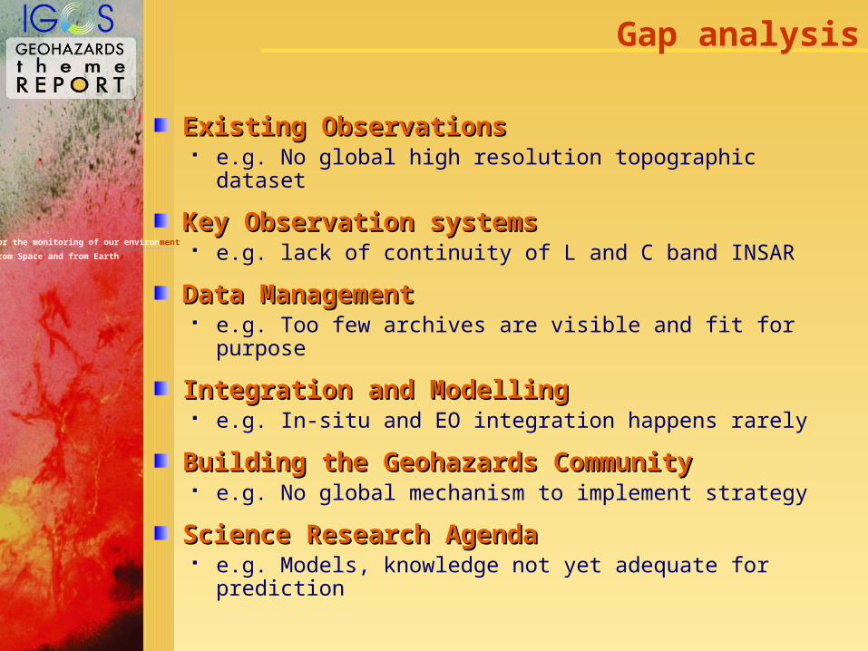
Gap analysis
Existing ObservationsExisting Observations e.g. No global high resolution topographic dataset
Key Observation systemsKey Observation systems e.g. lack of continuity of L and C band INSAR
Data ManagementData Management e.g. Too few archives are visible and fit for purpose
Integration and ModellingIntegration and Modelling e.g. In-situ and EO integration happens rarely
Building the Geohazards CommunityBuilding the Geohazards Community e.g. No global mechanism to implement strategy
Science Research AgendaScience Research Agenda e.g. Models, knowledge not yet adequate for prediction

For the monitoring of our environment
from Space and from Earth
0 2.83 cm
Akutan
Co-event deformation mapped by ERS (C-band, = 5.66 cm) InSAR

For the monitoring of our environment
from Space and from Earth
0 11.76 cm
Akutan
Co-event deformation mapped by JERS (L-band, = 23.53 cm) InSAR

For the monitoring of our environment
from Space and from Earth
Implementation plan highlights
Commence capacity building through IGOS Develop GARS as implementation mechanism
Maximise existing observations Seek release of SRTM and ASTER DEMs
Lobby for new observation tools L-band radar satellites and C-band INSAR continuity
Promote integration of data into products Integration of INSAR with GPS networks
Improve Infrastructures Support WOVO and use as a template
Increase knowledge of geohazard processes Define a global geohazards research agenda

For the monitoring of our environment
from Space and from Earth
Detailed plan for 2004
IGOS Geohazards Team Secretariat publish theme report, update website, by Q1 2004
Establish IGOS Geohazards Bureau, by end Q2 2004
ESA will fund a Bureau to support the implementation of IGOS Geohazards for three years
This will have a full time staff member, dedicated to IGOS Geohazard Theme implementation
Consolidate observational requirements, by the end of 2004
Hold Theme Launch Workshop, before the end of 2004
Establish implementation mechanism for the Theme (complete the modification of the GARS program)
Establish Steering Committee and Working Groups

For the monitoring of our environment
from Space and from Earth
Where to get the Final Report?
Final Report on line at:Final Report on line at:
http://dup.esrin.esa.it/
IGOS-Geohazards
For more information:For more information:
Geohazards Theme
Schedule / Docs

For the monitoring of our environment
from Space and from Earth
Thank you to many colleagues…
NOAA for kicking this initiative off
ESA, ICSU, UNESCO, IUGS & GARS for support
Theme Team colleagues from:
BNSC, BRGM, CCRS, CNES, CNR, DMT, IPG-P,ITC, MRAM, NPA, RAS, USGS & Universities: Basilicata (Italy) & Bonn (Germany)
Workshop Participants…
…and International Peer Reviewers…
…giving us input from every region of the globe!