forest fire management plan for kashmir...
TRANSCRIPT
1
Jammu & Kashmir Forest Department
Forest Fire Management Plan
for Kashmir Region
2
Forest Fire Management Plan for Kashmir Region (Standard Operating Procedure thereof)
1. Fire Management Plan and its requirement in Forest Sector
Jammu and Kashmir State is a forest rich State having 20,230 sq km of forest
i.e about 10% of its geographical area. If Ladakh region is excluded which does
not have significant expanse of natural forests, the proportion of natural forests
in the state area increases to 47%. Per capita forests and tree cover in the state is
about 0.15 ha which almost double the national average of 0.07 is ha.
The forests in Kashmir region mostly fall in dry temperate class. These forests
are predominantly having conifers comprising of Deodar, Kail and Fir. The
distribution of these species varies with altitude. These forests are not normally
vulnerable to forest fires as they are predominately having evergreen species
and lush green ground cover. The vulnerability increases during the Autumn
season if it remains dry for long period. During Summer season hurricanes
sometimes cause immense damage to forests. Pest attack also takes place at
times in summer months in respect of few species where there is mono culture.
Flush floods in forest areas are also common which cause immense damage to
forests and at times block the connectivity between the villages.
To combat these disasters which can be both natural and also human induced
Disaster Management Plan is required to be drawn as impacts of such damages
exceed the ability of the department to cope up with the situation using its
available resources.
2. Brief about the forests of the State and their vulnerability
About 40% of the forest area in the State is either dense or very dense and rest
falls in the category of open forest. 60% of the total forest area falls in Jammu
region and balance in Kashmir. It is the most important resource base for
sustenance of livelihood in rural and urban areas. This also provides base for
3
important economic sectors like Power Development, Tourism, Agriculture,
Horticulture etc.
The State is bestowed with forests of different types ranging from sub-tropical
to moist temperate and alpine one’s. Kashmir valley grows best natural
coniferous forests of the world. These form pure or mixed crops with species
dominating as Cedrus deodara (Deodar),Pinus wallichiana (Kail) and Abies
pindrow (Fir).All these conifers show marked stratification along altitudinal
gradient with Deodar and Kail mostly restricting themselves to range 1600-2500
mts and Fir growing between 2300 and 3300 mts.
3. Climate in the State.
The state of Jammu and Kashmir comprises of three distinct climatic regions:
cold arid desert areas of Ladakh, temperate Kashmir Valley, and the humid
subtropical region of Jammu. The temperature in the region varies spatially. Leh
is the coldest (-28°C average) while Jammu is the hottest. Mean monthly
temperature is lowest in January and highest in July except in Jammu where
highest temperature is experienced in June. Mean monthly temperature in
January varies from –17°C at Drass to 14°C at Jammu; Kargil and Leh being
other stations of below freezing average.
The climate of the Kashmir Valley is peculiar. The seasons are marked with
sudden change and the climate can be divided into six seasons of two months
each. The aforementioned climatologic divide does not apply only to Kashmir
Valley but to parts of Jammu, which like Kashmir Valley, are subjected to
snowfall and a severe winter. Many parts of the Ladakh region are also
subjected to heavy snowfall and others to severe dry cold. There is such heavy
snowfall on the way to Ladakh from the valley that it remains cut off by road
for about 5 - 6 months every year. Pooch, Rajouri & Uri belts are moderately
hot while as Baderwah, Doda, Ramban belts have different climate.
The annual rainfall and temperature of the state range between 600 –
800 mm and sub Zero and up to 40 degree Celsius respectively. However,

4
about 59% of the geographic area under possession is covered with Glaciers
and is not available for tree plantation.
4. Population of the State and its bearing on Forests
The population is most highly concentrated in the Kashmir valley and to some
extent in Jammu division. However, the population is highly sparse in Ladakh
region having only 4 persons per sq km. This population distribution follows
the climatic and physical characteristics of different regions/divisions.
The State of Jammu and Kashmir has a sizable population of nomadic tribes.
These tribes are distributed all over the State and constitute about 10.9% of the
total population of the State (Census-2001). Most of the tribes are nomadic and
livestock rearing is their primary occupation.
The State of Jammu and Kashmir is bestowed with valuable natural resources.
The forests covering hill slopes constitute vital water sheds which as on date are
helping in maintaining environmental stability. These forests provide wood and
wood products for sustenance of people, serve as pastures for both local and
nomadic livestock and are abode for wild flora and fauna. The sustainability of
these forests is crucial for present and future generations of the state. However,
natural resources of state particularly the forests have degraded over for the last
four decades.
The present ecological scenario of mountainous ranges in the state gets
attributed to all these key issues. Concern about relentless destruction of state’s
forests in the past and its impact on lives of people around has compelled for re-
examination of management regime of forests in the State. The forest cover of
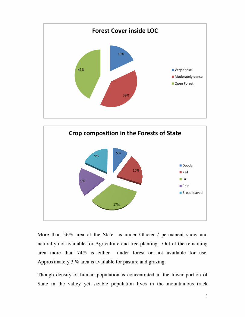
the State as per 2011 assessment presents position as under:-
Very dense
forest
Moderately
dense forest
Open
forest
Scrub Non
forest
Total
Area in Sq Kms Area in Sq Kms Area in Sq
Kms
Area in Sq
Kms
Area in Sq
Kms
Area in Sq
Kms
4140 8760 9639 2105 197592 222236
5
More than 56% area of the State is under Glacier / permanent snow and
naturally not available for Agriculture and tree planting. Out of the remaining
area more than 74% is either under forest or not available for use.
Approximately 3 % area is available for pasture and grazing.
Though density of human population is concentrated in the lower portion of
State in the valley yet sizable population lives in the mountainous track
18%
39%
43%
Forest Cover inside LOC
Very dense
Moderately dense
Open Forest
5%
10%
17%
9%
9%
Crop composition in the Forests of State
Deodar
Kail
Fir
Chir
Broad leaved

6
surrounding it. The people living in this high altitude track mainly sustain
through raring of their livestock. Stall feeding is not common. During summer
months the livestock permanently remains in the high altitude grazing lands
locally called as ‘Bahaks. Because of the movement of this sizeable population
through the forests and dependence on them accidental damages in the shape of
forest fires are common. These fires during summer months do not have any
impact because of lush green environment and soothing temperatures. However
these accidental fires become disastrous during dry months of autumn and
sometime early winter. This is the main issue before the Forest Department and
reason for drawing up of this plan.
5. Forest Disasters
The valuable forests of the State are to be shielded against the dangers which
either can completely destroy them or at least damage them to such extent that
they may no more remain able to perform the functions and confer benefits
which they are expected to give. This is what can be termed as Forest
Protection. Protection requires efforts as well as financial backup. As regards
the causes of the forest damages they are immense. The important one is that of
forest fire:-
5.1. Forest Fires:-
Forest fire is the most important cause which results in immense damage to the
extensive forests. The uncontrolled fires sometimes completely ruin a forest and
finish the work of both the nature as well as the forest officers. The forest fires
are common in sub-tropical forests of the Jammu Region whereas their intensity
and frequency in Kashmir Region has not been much. However, with global
changes in climate taking place, the precipitation in winter has not been normal
for the last few years which has resulted in dry autumn which creates an
environment for the forest fires to take place. This will be in detail discussed in
the following paras.
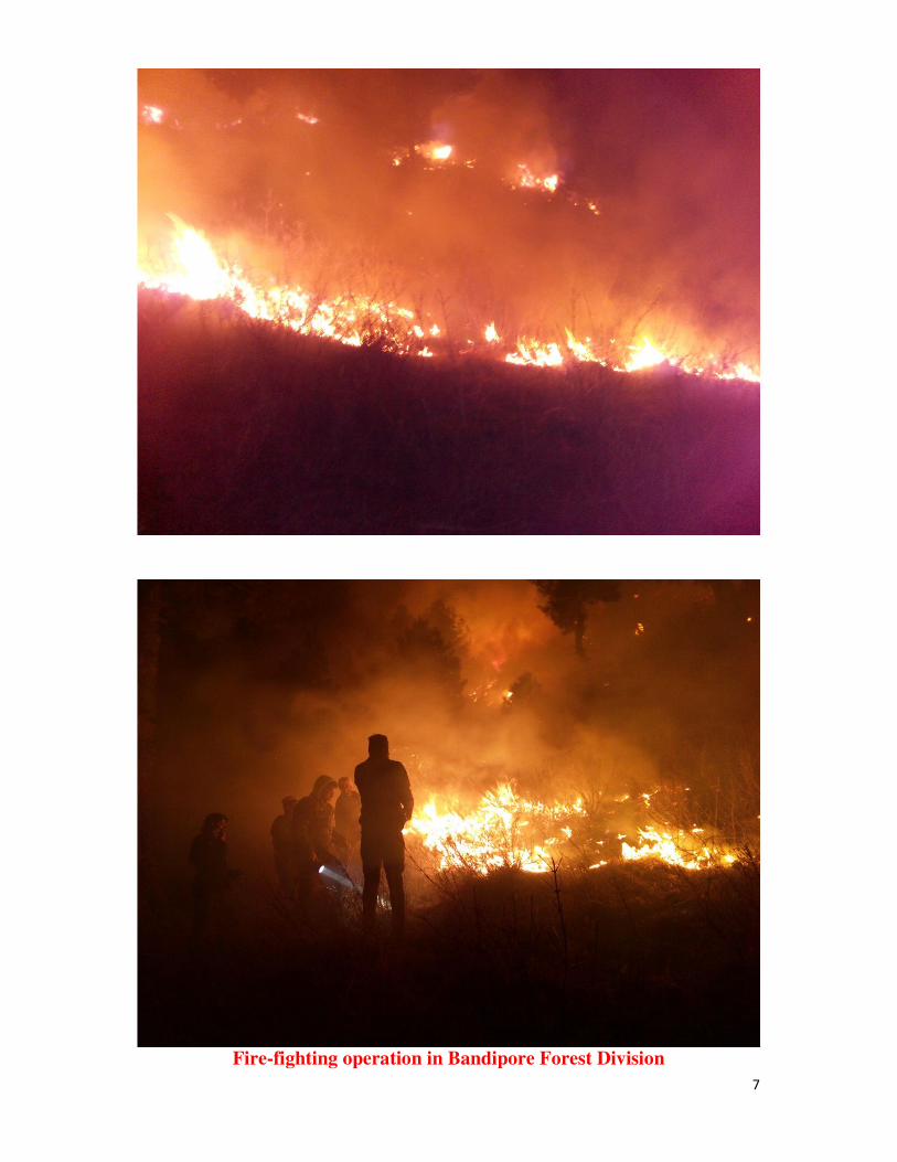
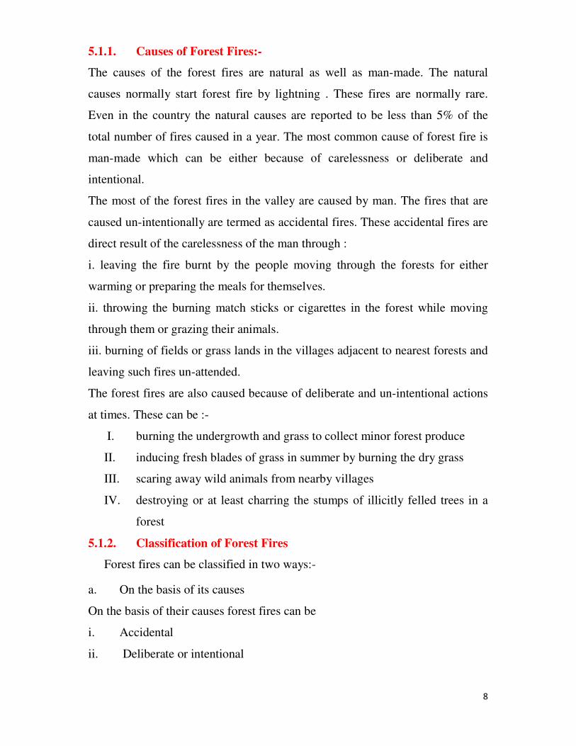
7
Fire-fighting operation in Bandipore Forest Division
8
5.1.1. Causes of Forest Fires:-
The causes of the forest fires are natural as well as man-made. The natural
causes normally start forest fire by lightning . These fires are normally rare.
Even in the country the natural causes are reported to be less than 5% of the
total number of fires caused in a year. The most common cause of forest fire is
man-made which can be either because of carelessness or deliberate and
intentional.
The most of the forest fires in the valley are caused by man. The fires that are
caused un-intentionally are termed as accidental fires. These accidental fires are
direct result of the carelessness of the man through :
i. leaving the fire burnt by the people moving through the forests for either
warming or preparing the meals for themselves.
ii. throwing the burning match sticks or cigarettes in the forest while moving
through them or grazing their animals.
iii. burning of fields or grass lands in the villages adjacent to nearest forests and
leaving such fires un-attended.
The forest fires are also caused because of deliberate and un-intentional actions
at times. These can be :-
I. burning the undergrowth and grass to collect minor forest produce
II. inducing fresh blades of grass in summer by burning the dry grass
III. scaring away wild animals from nearby villages
IV. destroying or at least charring the stumps of illicitly felled trees in a
forest
5.1.2. Classification of Forest Fires
Forest fires can be classified in two ways:-
a. On the basis of its causes
On the basis of their causes forest fires can be
i. Accidental
ii. Deliberate or intentional

9
The reference of these two types of fires and reasons for same have
already been given here-in-before.
b. On the basis of their action
On the basis of their resultant action forest fires are classified into:-
i. Creeping fire
It is the fire which spreads slowly over the ground with low flame. Such
fires are common in forests where there is no ground cover or
undergrowth. Usually ground in such forests is covered with layers of dry
leaves which burn slowly in the absence of strong wind.
ii. Ground Fire
It is the fire that burns the ground cover only which comprise of
herbaceous plants and low shrubs which cover the soil.
iii. Surface fire
It is the forest fire which burns not only the ground cover but also the
dense and tall shrubs
iv. Crown fire
It is a forest fire which spreads through the crowns of the trees and
consumes all or part of the upper branches and foliage
All these fires are not independent of each other. Once a fire of particular
class starts it doesn’t remain confine to that class and may develop into
some other class or the combination of the two classes depending on the
prevailing circumstances.
5.1.3. Damage caused by forest fires
Forest fires sometimes cause colossal damages to the forest unless they are mild
and controlled in time. The damages caused are:-
i. Damage to trees
ii. Damage to regeneration
iii. Damage to soil
iv. Damage to productive capacity of the forest

10
v. Damage to protective capacity of the forest
vi. Damage to wild animals
vii. Damage to the recreational and scenic value of forests
These damages are result of the nature of the fires and time taken to restrict and
extinguish the same.
5.1.4. Fire Environment
Even if fire is caused with intention it is not going to spread to large areas
normally unless and until there is a proper fire environment existing there. Fires
occur as a result of certain circumstances which constitute its environment. For
discussing the methods of controlling of forest fires, studying of environmental
factors and behaviour and dynamics of forest fires are essential. The following
factors make a fire environment:-
i. Weather is the most important factor which determines the fire
environment. Even in weather the temperatures and winds are
important factors. In Kashmir Region normally the autumn season
used to be brief and dry followed by winter precipitation in the shape
of rain and snow. With the changes in climate taking place at global
level the precipitation pattern has altogether changed. The autumn
and Ist part of winter remains usually dry which results in spreading of
forest fires engulfing large areas. Even if such fires occur by accident
or intention in the summer months they don’t cover large areas and are
extinguished with ease. The comparison clearly reveals the deviations
from the normal pattern. This year the season is abnormal and there
has been almost no winter precipitation in the form of snow. If
intermitted summer rains through westerly depressions are not there
then it can be a major cause for forest fires.
ii. Inflammable material
Forest fires cannot occur unless there is inflammable material
available in the forest. In the favourable fire environment, fire occurs

11
only when there is inflammable material in the shape of dry grasses,
shrubs, fallen leaves and fallen wood available on the ground. The
more the inflammable material, the more fierce and damaging will be
the forest fire.
iii. Topography
In plains the fire environment and presence of sufficient quantities of
inflammable material are enough to set the stage for a large and rapid
fire to take place. Topography adds another dimension in the hilly
terrain to the fire behaviour. Fire spreads very fast when travelling up
a hill slope but its spread slows down when it travels downhill.
5.1.5. Fire behavior and dynamics
A common man usually takes the forest fires as normal fires taking place
in habitations and expect a quick action and resultant control by the
Forest Department. The study of behaviour and dynamics of forest fires
shows how difficult and cumbersome is the control and extinguishing of
forest fires that too in a mountainous topography.
The fire usually starts naturally or because of intention of the human
beings at a particular spot in the forest area and then under the influence
of winds, inflammable material and topographic factors spreads fast in
one direction and slowly in others. From the place ignition, the direction
of spread, speed, extent and shape of fire depends on wind, inflammable
material and topography.
i. Direction of spread
In case there is no wind blowing in the area at the time of start of
the fire it spreads in all directions slowly and thus assumes a
circular shape. On the other hand if the wind is blowing in a
particular direction then the fire spreads in that direction fast and in
other directions slowly. If inflammable material is available only

12
on a particular side, fire spreads in that particular direction fast and
slowly in other directions. The spread of fire in a hilly terrain is
further affected by topographic factors, particularly the slope. Fire
spreads fast uphill and slowly downhill.
The fire normally spreads in a single plane along the ground with
its height usually remaining between one to three meters but
presence of dry climbers of trees, lichens on deodar trees induce it
to spread at places vertical to normal plane burning the crowns of
the trees and changes into crown fire at times.
ii. Speed of Fire
The speed at which the fire spreads is greatly influenced by wind.
The stronger is the wind the faster will be the spread. The presence
of dry inflammable material also determines the speed of the
spread of fire. The topography has an effect on the speed of spread
of fire if rising slope comes in front of moving fire it moves fast
uphill. On the other hand, on the downhill slopes fire moves very
slowly. But in such places the half burnt cones, round wood
sometimes rolls down and starts the fire uphill from those places.
iii. Extent
The extent of the fire usually depends on wind, presence or
absence of inflammable material and topography. However, it is
also affected by the promptness with which the forest staff tries to
extinguish it. The greater the delay in detecting the start of forest
fire and in starting control operations, the greater is the area
affected by it and the greater is the labour and money required in
controlling it. On the basis of simple calculations it emerges that
area of the fire varies from that in the first hour as the square of
number of hours that lapse between the start of fire and start of
fire-fighting operations. To make explicitly clear the area of fire in
two hours will be 4 times larger than in the first hour, in the three

13
hours it will be 9 times larger the area of first hour and in four
hours it will be 16 times larger than that of the first hour. Thus real
time monitoring and immediate mobility of staff to start fire-
fighting operations can restrict the area of damage.
iv. Shape of the affected area
The area engulfed by a fire cannot be a regular geometrical figure.
Under the influence of wind, inflammable material and the
topography its shape is likely to be very irregular.
5.1.6. Protection against damage by fire
Fires are most destructive elements. They can destroy all the life forms,
cause serious soil erosion, kill all micro-organisms and destroy the eco-
system that had been built up over a long period of time. The protection
against the fire damage requires to be carefully devised and executed. The
methods that can be both preventive and remedial are briefly given in the
action plan drawn as under:-
i. Direct preventive measures
The measures to be adopted are:-
a) Organization and detailing of staff for fire control rooms:
Control rooms have already been established in all Divisions at
Divisional Headquarters. What is required is connectivity by
proving wireless sets / cell phones, mobility facilities (some
pickup Vans) and proper gear for the staff to save themselves
from any injury while extinguishing fires, first aid kits for
emergencies and tools for carrying out the fire control
operations.
b) Hazard reduction: Forest fires can be prevented by reducing or
limiting the exposure of forests to fire risks. This may be
14
achieved by creating fire lines and maintaining them in the
subsequent years.
ii. Remedial measures:
These refer to measures which are to be taken to extinguish them
when they break out inspite of the preventive measures. The action
has to be quick. The delay can be avoided by quick detection,
quick communication of occurrence of fire and quick action to
suppress it.
a. Detection:
For quick detection there should be provision of engaging local fire
watchers during the fire season for ground patrolling. There have to
be facilities of communication to send information to the Range /
Divisional Headquarters for mobilizing staff and labour. Again the
transport facilities should be handy for moving the staff and the
labour to the site
b. Quick action for suppression of fire
For quick action sufficient labour force and staff is required to be
deployed. Arrangement of tools, food, water and lighting should be
there as the process of fire extinguishing sometimes may take days
together. The arrangement of transportation of men and material
should be available.
5.1.7. Methods of fire extinguishing
Since large occurrence of fires is not there in the region except during the
prolonged dry season as such conventional methods of fire extinguishing
are in vogue at present which are :-
i. by water
ii. by earth
15
iii. by beating
iv. by counter firing.
Extinguishing of fires by throwing water is only possible in plain area
where water is readily available. Extinguishing of fire by throwing soil on
it is a time consuming operation and the only and the best way to
extinguish all surface fires is to beat them out with brooms, branches etc.
counter firing is required where area of the fire is to be restricted to a
small portion and then controlling it. For all such operations fire is to be
restricted first to some area and for that fire traces are to be created by
removal of inflammable material, cutting the branches and clearing the
strip of sufficient width. The distance of fire trace from the advancing fire
will be governed by :
a) Speed of advancing fire
b) Labour force available
c) Length of fire trace
d) Topography
5.1.8. Safety measures in fire fighting
Unsafe and careless fire-fighting strategy can be hazardous or even fatal
to the men at the fire front. The safeguards to be taken are :
a) Wear non synthetic fire proof clothing to protect it from heat
b) Use head gear and goggles from radiant heat, sparks etc.
c) Use footwear preferably leather boots
d) Carry enough water to guard against desiccation by heat\
e) Carry first aid kit for emergencies
f) To plan for escape route in case of danger
g) To maintain communication between fire fighters
16
5.1.9. Fire-fighting tools
With the advancement in fire control measures the tools are also likely to
go on changing however, the common tools of use are :
a) Peg type fire rakes
b) Adjustable sticks
c) Nail type fire rakes
d) Fire beaters
e) Brooms
f) Fire pathal
g) Water bottles
h) Haversacks
i) Adjustable head lamps
j) Torches
k) Spades
l) Pick axes
m) Power chain saws
n) Axes
5.2. Fire Management Plan
This plan aims at developing strategies to combat the emergencies and also to
reduce vulnerability to hazards in respect of forest sector which have been
discussed in detail in the foregoing paras. The Department will be dealing with
all aspects of exigencies in particular preparedness, response and recovery to
reduce the impact of this disaster.
Budget
The quantum of actual works relating to fire management activities wholly
dependent on availability of funds in time for these works. Thrust will be there
on fire prevention management and creating local awareness about the damages
17
caused by the fire through participatory fire management programmes. The
requirement of Rs.397.02 Lacs has already been projected to start the project of
overall disaster management in respect of the sector for providing the basic
requirements and then the annual requirement of Rs.141.52 Lacs for fire
management activities. The same has not been sanctioned so far. As regards the
preventive and remedial measures these have been discussed in detail in this
report and will remain restricted to the budget which will become available. The
Control Rooms already established at Divisional level will remain operative for
firefighting measures. However for real time monitoring of situation and
mobilizing all available resources at District level, the committees will have to
be constituted as was discussed in detail in the meeting taken by the Divisional
Commissioner, Kashmir. The constitution of the committees will be as under:-
District Level Committee District Dev. Commissioner Chairman
DFO Territorial Member Secretary
Superintendent of Police Member
Deputy Director Forest Protection Force Member
Wildlife Warden Member
DFO Social Forestry Member
District Soil Conservation Officer Member
� The Committee shall monitor and coordinate the forest fire, prevention
and control in the District and shall meet once in a month to take steps
required for effective management of prevention of forest fire incidents.
The committee will work in coordination with the District Disaster
Management Committees.
� Formation of Forest Fire Control Sub-Stations:
The Forest Control Rooms will act as Fire Fighting Control Rooms as
well. The staff will be deputed for these control rooms not only from the Forest
Department but from all other allied wings. This will be coordinated and
managed by the local territorial DFO. The Control Room will in the charge of a
Range Officer. Staff from different departments and will be as under:-
Chief Conservator of Forests,
Kashmir