forest management effects on hillslope processes · 276 this example is not typical of the entire...
TRANSCRIPT

275
introduction
British Columbia’s geologic history and climate con-tribute to a landscape that is geomorphically active (see Chapter 2, “Physiography of British Columbia,” and Chapter 8, “Hillslope Processes”). In many areas, hillslopes are highly sensitive to impacts from changes in forest cover, hydrology, and soil condi-tions. Soils exposed from logging or road-building operations can erode through rain splash erosion, rilling, or ditch erosion. Vegetated soils can erode if subjected to concentrated flow such as a culvert dis-charge. Landslides occur when gravitational forces and hydrologic conditions exceed the strength of the soil.
In coastal British Columbia in the 1950s, forest harvesting began to shift from lowland valley-bottom areas onto hillslopes in search of new timber supplies. With some earlier exceptions, forest development in the Interior began to access steep-slope areas only in the 1970s. Harvesting and road construction were done with poor understanding or considera-tion of potentially unstable terrain, of erosion from roads and exposed soils, or of risks to downslope resources. As a result, forest practices caused in-creased erosion and increased landslide frequency, which affected water quality, fish habitat, public and worker safety, soil and forest resources, infrastruc-ture, and the public perception of the forest industry. High-profile landslide events in coastal British Co-lumbia in the late 1970s and early 1980s focussed the need for changes in forest management practices.
This chapter provides an overview of the effects of historic forest management practices and how newer practices address issues related to slope stabil-ity, sediment production, and alluvial fans. A brief discussion of remote sensing applications is also provided.
Information in this chapter comes from three general sources: (1) research and applied work published in the scientific literature or in govern-ment reports; (2) unpublished reports from British Columbia Forest Service files, typically related to operational work such as landslide investigations; and (3) unpublished data and observations collected by the authors in their operational or research work. The authors are practitioners in their professional fields, and collectively have conducted investigations into geomorphic and hydrologic processes and the relationship of these processes to forest management practices in all regions of the province. Where ap-propriate in this chapter, conclusions reflecting the authors’ experience are presented. In this section, some research dealing with the general effects of forest development on watershed geomorphology is summarized. Following sections in the chapter give more detailed information on landslides, erosion, gullies, and alluvial fans in the context of forest practices.
Figure 9.1 shows the Norrish Creek watershed in the lower Fraser Valley, an area heavily affected by landslides caused by roads and logging. Although
Forest Management Effects on Hillslope Processes
Chapter 9
Peter Jordan, THomas H. Millard, David Campbell, James W. Schwab, David J. Wilford, Doug Nicol, and Denis Collins

276
this example is not typical of the entire British Co-lumbia coastal region, it is reasonably representative of many areas of the high-rainfall parts of the region (windward side of Vancouver Island, Haida Gwaii, and Coast Mountains), which were logged signifi-cantly from the 1960s to the 1980s (Figure 9.2).
Slaymaker (2000) reviewed the impacts of forest development on stream channels, slope stability, and sediment yield, and suggested that landslides and erosion have produced a 10-fold increase in sediment production from harvested areas in British Columbia.
Since the 1970s, several sediment budget studies have examined various aspects of sediment produc-tion from logging and roads, and its effects on fluvial systems in the U.S. Pacific Northwest (Beschta 1978; Kelsey 1980; Swanson et al. [editors] 1982; Reid and Dunne 1984; Megahan et al. 1986) and in British Co-
lumbia (Roberts and Church 1986; Jordan and Com-mandeur 1998; Hudson 2001; Toews and Henderson 2001). All of these studies identified the significance of forest roads as sediment sources due to both sur-face erosion and their role in causing landslides.
In coastal British Columbia streams, coarse sedi-ment (bedload) from landslides has long been recog-nized as an important part of the sediment budget (Roberts and Church 1986). In watersheds that have been heavily affected by logging, increased landslide frequency is believed to have caused approximately an order of magnitude increase in sediment supply (Rood 1984; Schwab 1988). However, in one detailed study, Hudson (2001) examined coarse- and fine-sediment budgets during rainstorm events in Rus-sell Creek, a 30-km2 partially logged watershed on Vancouver Island. He found that landslides were the
FIGURE 9.1 Orthophoto prepared from 1995 air photos, showing part of the Norrish Creek watershed near Mission in the lower Fraser Valley.

277
most important contributor of suspended sediment (followed by gully erosion), and that development-related sediment sources were minor compared to natural sources within the watershed.
In the Interior of British Columbia, long-term wa-tershed studies with a sediment budget component have been conducted in the Stuart-Takla watersheds northwest of Prince George, the West Arm Demon-stration Forest near Nelson, and the Penticton Creek watershed in the Okanagan.
In the Stuart-Takla project, Macdonald et al. (2003) measured streamflow and suspended sediment concentration in three small watersheds (0.4–1.0 km2). A significant increase in suspended sediment occurred following logging and lasted for 2–3 years. Stream crossings were considered the big-gest contributor of the sediment.
On Redfish Creek, a 26-km2 partially logged watershed near Nelson, which had 10 years of data, Jordan (2006) found that the amount of suspended sediment from forest development (mainly from road erosion) was comparable to that produced by natural sources. In comparison, at Gold Creek near Cranbrook, a less mountainous and lower-precipita-
tion area, development-related suspended sediment was insignificant. Based on limited measurements and observations in other watersheds in the region, Jordan (2001b) concluded that, on the average, sediment from development-related landslides was much less significant than erosion from roads, but that in isolated instances, landslides could dominate the sediment budget for several years in watersheds where they occurred.
Many mountainous areas of British Columbia have high levels of geomorphic activity, especially where there are recent (Neoglacial) glacial deposits, recent volcanism, or weak sedimentary rocks, and areas with high rates of precipitation (Guthrie 2005; see Chapter 2, “Physiography of British Columbia”). However, many forested mountain and plateau areas in the British Columbia Interior have little geomor-phic activity and very low sediment yields when compared with other mountain regions of the world (Slaymaker 1987; Church et al. 1989; Jordan 2006). In these areas, where many streams naturally carry very little sediment, erosion and landslides from forest development can have a significant impact on watershed sediment budgets.
FIGURE 9.2 Numerous landslides caused by road-fill failure and harvesting effects in an area that was heavily logged in the 1970s. Many slides occurred 10 years or more after logging or construction. Mamquam River, Squamish Forest District. (Photo: P. Jordan)

278
erational terrain stability mapping done by the forest industry, or have used terrain attributes not based on terrain mapping.
Landslide frequencies in terrain attribute stud-ies have usually been reported as the number of landslides per square kilometre per year (Ls/km2 per year, where Ls = number of landslides) in areas where the approximate dates of logging and landslide occurrence are known. In some studies, including most early air photo–based inventories, if the dates of landslides are not well known, areal frequencies (or landslide densities) are reported as the number of landslides per square kilometre.
Landslide rates due to harvesting are variable in coastal British Columbia, and are generally higher in areas of higher precipitation. Steep slopes (> 20°) on Haida Gwaii are reported to have the highest post-clearcut landslide rate—about 1–1.7 Ls/km2 per year—based on the assumption of a 10-year post-harvest period of landslides (Schwab 1988; Rollerson 1992). The west coast of Vancouver Island and the Cascade Mountains south of the Fraser Valley also have high post-clearcut landslide rates on steep slopes of about 0.7 Ls/km2 per year (Rollerson et al. 1998, 2002; Millard et al. 2002). Horel (2006) reported landslide frequencies on steep slopes on northern Vancouver Island of 8.6 Ls/km2 before the implementation of the Forest Practices Code of British Columbia Act (FPC) and 4.9 Ls/km2 post-FPC. Again, assuming a 10-year period of post-harvest landslides, the pre-FPC landslide rate of 0.86 Ls/km2 per year is similar to other Vancouver Island studies. When entire watershed areas are considered, rather than just steep slopes, landslide rates are much lower. Rates on Vancouver Island are 0.07–0.17 Ls/km2 per year (Jakob 2000; Guthrie 2002), and in the Coast Mountains, they average 0.13 Ls/km2 per year in exposed windward areas and 0.04 Ls/km2 per year in drier leeward areas (Rollerson et al. 2001).
Studies in the Kootenay and Columbia regions of southeastern British Columbia reported landslide densities for development-related landslides of 0.38–1.07 Ls/km2, with the highest densities occurring in the higher-relief and wetter terrain of the northern Selkirk and Monashee Mountains (Jordan 2001a, 2002) (Figure 9.3). Landslide frequencies in these areas increased 4–9 times because of forest develop-ment. The landslide densities for these regions are based on a time frame of about 20–30 years—that
In the 1970s and 1980s, several reviews and inven-tories of landslides and erosion caused by forest de-velopment in the Pacific Northwest were conducted in response to increasing concern about the envi-ronmental effects of forest practices. Swanston and Swanson (1976), reviewing data from several study areas in Washington, Oregon, and British Colum-bia, found that the occurrence of debris avalanches and debris flows increased by 2–9 times in clearcuts, and by 25 to over 300 times due to roads, compared to undeveloped forest (based on area covered by roads, not total development area). Rood (1984), in an inventory of landslides on Haida Gwaii (formerly the Queen Charlotte Islands), reported that frequen-cies of debris slides increased by 30 times and debris flows increased by 41 times, and estimated that 80% of the resulting sediment yields came from clearcuts, whereas 20% came from roads. Sidle et al. (1985), reviewing data from Oregon, found that the rate of landslides increased up to 23 times in clearcuts, and that increases in mass movement rates were typically observed for 10–15 years.
Beginning in the 1980s, terrain attribute studies were introduced in British Columbia to more rigor-ously study the frequencies and causes of develop-ment-related landslides. A terrain attribute study is a statistical analysis relating landslide occurrence to variables that describe terrain features (attributes) and that can be measured or mapped (Howes 1987; Rollerson 1992). These variables can be quantitative (e.g., slope angle or gully depth) or qualitative (e.g., terrain category, bedrock lithology, or slope posi-tion). The purpose of terrain attribute studies is to provide quantitative predictions of landslide fre-quencies that are likely to occur from forest develop-ment in a particular region, and to determine which terrain attributes are most significant in predicting landslide occurrence. Most terrain attribute studies have been conducted in coastal British Columbia (Rollerson 1992; Rollerson et al. 1998, 2001, 2002; Millard et al. 2002). These typically consist of an inventory of landslides caused by forest development in a study area and detailed terrain mapping of the study area to collect the required terrain attribute data. Only a few terrain attribute studies have been conducted in the Interior (Jordan 2002). Since land-slide frequencies are relatively low there compared to the Coast, and large study areas must be used, terrain attribute studies in the Interior have used op-
historic landslide rates: inventories and terrain attriBute studies

279
is, the period in which landslides can be reliably identified on air photos. Therefore, they translate to landslide frequencies of about 0.01–0.05 Ls/km2 per year—an order of magnitude lower than most of the landslide frequencies measured in the coastal stud-ies.
The time period used for estimating landslide frequencies on the Coast is shorter than that used in the Interior because revegetation is faster on the Coast, obscuring small landslides sooner. Also, most landslides on the Coast occur in clearcuts within 10 years of logging, whereas most landslides in the Interior occur in unlogged forest below roads, and can occur many years after construction.
Terrain attribute studies have typically shown that the most significant variables in explaining development-related landslide occurrence in coastal British Columbia are slope angle, presence of gullies, gully depth, presence of natural landslides, and slope configuration; however, these results vary somewhat between study areas. In the southeastern interior, the most significant variables were terrain category (with
glaciofluvial and deep morainal deposits having the highest landslide densities), presence of gullies, and presence of natural landslides.
There is an important difference in study results for interior and coastal British Columbia. In the Interior, most development-related landslides are caused by roads (about 80%)1 and most cutblock-related landslides are caused by skid trails. On the Coast, some studies indicate that most landslides are caused by clearcuts (Schwab 1988; Rollerson 1992; Rollerson et al. 1998, 2002; Millard et al. 2002), whereas others show that roads and harvesting are of about equal importance (Rollerson et al. 2001; Guthrie 2002). The proportion of coastal road-re-lated slides may be related to the inherent instability of the area. Areas with high post-logging landslide rates, such as Haida Gwaii, tend to have a higher percentage of cutblock-related slides, whereas areas with lower post-logging landslide rates, such as the Coast Mountains, tend to have a greater proportion of road-related landslides.
FIGURE 9.3 Results from terrain attribute studies in the southeastern interior of British Columbia. The graphs show the relationship between densities of development-related landslides vs slope class and terrain category in two different study areas. Grey bars indicate abundance of each class or category in the study area; coloured bars indicate landslide density. (a) Southwest study area (southern Selkirk Mountains) landslide density by slope class. Areas with slope less than 20° are not included in the analysis. “TIN” is “triangular irregular network,” a form of slope map that is more precise than grid-based slope maps. (b) Detailed terrain map study areas, Selkirk and Purcell Mountains, landslide density by terrain category. Categories are rock (R), colluvial (C), fluvial (F), shallow morainal (M1), deep morainal (M2), glaciofluvial/kame (G+K). (From Jordan, 2003, unpublished report)
80
60
40
20
0
2
1
0
Are
a (%
)
Land
slid
es p
er k
m2
Are
a (%
)
Land
slid
es p
er k
m2
20–25 25–30 30–35 35–40 >40 R C F M1 M2 G+K
a) Southwest study area
TIN slope class (°)
b) Polygons
Terrain category
Mean frequency = 0.488 landslides/km2 Mean frequency = 1.40 landslides/km260
50
40
30
20
10
0
6
5
4
3
2
1
0
1 Jordan, P. 2003. Landslide and terrain attribute study in the Nelson Forest Region. B.C. Min. For., Res. Br., Victoria, B.C. FRBC Proj. No. KB97202-0RE1. Unpubl. report.

280
quickly. Hemlock and Sitka spruce roots less than 5 mm in diameter lose 40–90% of their strength within 2 years of harvesting (Ziemer and Swanston 1977). For an extensive discussion of root strength, see Sidle and Ochiai (2006).
Few methods are available to reduce landslide occurrences that result from harvesting. Some of the effects of harvesting, such as changes in water inputs and loss of root strength, are inevitable once a slope is harvested. Therefore, the primary method of reducing landslide occurrences is to avoid slopes that are likely to have post-harvest landslides, particu-larly if those slopes are above high-value resources or pose a health or safety concern. Some harvest methods can theoretically reduce landslide rates, but no studies have been conducted to quantify these effects. Partial harvesting, particularly single-stem harvesting, is less likely than clearcutting to cause significant loss of root strength due to root decom-position and increased delivery of water to the soil. “Snap-and-fly” single-stem harvesting, in which a helicopter is used to lift a tree directly off its stump, should not cause any damage to soil drainage path-ways; therefore, it is less likely to cause post-harvest landslides, but has not been the subject of detailed research.
An important terrain stability factor to con-sider in the placement of cutblock boundaries is the likelihood of windthrow. A new study of land-slides near Bamfield on Vancouver Island showed that windthrow was associated with half of the open-slope landslides that occurred during winter 2006–2007 (J. McDonald, MSc candidate, Simon Fraser University, pers. comm., Jan. 30, 2008). Wind-exposed edges of cutblocks should not be located on the edge of potentially unstable terrain such as gully edges. For a more detailed discussion of windthrow management, see Stathers et al. (1994). Figures 9.4–9.9 show examples of harvesting-related landslides.
harvesting-caused landslides
Harvesting can result in changes to soil moisture and soil strength that can cause landslides. Har-vested areas tend to receive more snow and undergo more rapid snowmelt than unharvested areas; con-sequently, higher inputs of moisture into the soil can occur in harvested sites in both coastal areas, which are subject to rain-on-snow events, and interior areas, which are subject to spring melt (Chapter 7, “The Effects of Forest Disturbance on Hydrologic Processes and Watershed Response”). Increased intensity of water input to the soil may result when the attenuating effect of a forest canopy is removed. Keim and Skaugset (2003) compared 1-minute-long rainfall intensities in sites beneath a forest canopy and adjacent sites without a forest canopy. In general, lower precipitation intensities were recorded in sites underneath a forest canopy. It is possible that short-term spikes in rainfall intensity may result in higher pore pressures in soils that are not protected by a for-est canopy (Horel 2006). Although rainfall intensity is an important determinant in landslide initiation on the Coast, other factors such as antecedent condi-tions and snowmelt from rain-on-snow events are also important causes (Jakob and Weatherly 2003).
Harvesting and yarding of trees may affect the soil structure, which can disrupt preferential drain-age pathways in the soil. For example, soil macro-pores can be crushed when cut trees land on the soil or when trees are dragged across the surface during yarding. This can result in increased pore pressures and subsequent landslides (Ziemer 1981).
The loss of root strength caused by roots rotting or yarding disturbance can also result in landslides. Root strength, which is generally treated as an added cohesive element in slope stability analysis, is lost when trees are cut and the roots rot. Ziemer (1981) found that soil strength is most strongly correlated with the total weight of live roots less than 5 mm in diameter; roots greater than 5 mm in diameter had less of an effect on soil strength. Small roots rot

281
FIGURE 9.4 An unusual clearcut-caused debris slide / avalanche complex at Gorman Creek near Golden, in the Interior of British Columbia. The slide occurred the spring (about 1990) following harvesting and probably resulted from yarding disturbance combined with increased snowmelt rate following logging. (Photo: D. Toews)
FIGURE 9.5 Debris slides that initiated within a helicopter-yarded cutblock a few years after harvesting at Indian Arm in the Chilliwack Forest District. (Photo: T. Millard)

282
FIGURE 9.6 Headscarp area of a typical harvesting-related debris slide, Klanawa River, South Island Forest District. (Photo: T. Millard)
FIGURE 9.7 Transport zone of debris slide shown in Figure 9.6. Note the role of the tree roots in retaining sediment, and how the slide eroded to bedrock downslope of the rooting zone. (Photo: T. Millard)

283
FIGURE 9.9 Another view of Clayoquot Sound after the 1996 storm event, showing a mix of harvesting and road-related landslides. (Photo: T. Millard)
FIGURE 9.8 Slopes in north Clayoquot Sound after a 4-day storm event in 1996 resulted in 273 landslides. (Photo: T. Millard)

284
road-caused landslides
Forest roads have been identified as the cause of many landslides in both coastal and interior British Columbia. Before about the 1980s, most forest roads, including those on steep slopes, were built using bulldozers and employed sidecast construction (Fan-nin et al. 2005; see Chapter 5, “Forest Practices”). This resulted in unstable fills on steep slopes, and combined with inadequate drainage control and inspection, caused many road-fill landslides.
In a study in the Kalum Forest District, Van-Buskirk et al. (2005) found that the terrain factors that contributed significantly to road-fill landslides were presence of natural slope instability, gullied terrain, deep surficial materials, and moderate to im-perfect drainage. Significant contributing engineer-ing factors included perched fills (supported by logs, stumps, or trees) and poor drainage control.
Table 9.1 shows probable causes of development-related landslides based on a sample of air photos of 429 landslides in the Arrow and Kootenay Lake Forest Districts.2 Field checking of about half the landslides confirmed the general distribution of these causes, as did numerous operational investiga-tions of landslides. In this study area, road-fill fail-ures were more common on older roads where weak fills on steep slopes were more likely.3 On newer roads (especially those built after 1995), most failures were found to be caused by inadequate or poor road drainage. The authors’ operational experience in this region supports these general conclusions, and provides additional information about the causes of typical landslide events. Landslides related to road drainage frequently occur below a culvert. Often, sufficient cross-drain culverts have been installed but minor errors have been made in culvert location, resulting in water being discharged at an unstable location. Sometimes more water is intercepted by
the road cut than was anticipated by the design, but the appropriate drainage upgrades were not made. Landslides may also occur when a ditch or culvert is blocked and water is diverted down a road to a po-tentially unstable location. In many cases, more fre-quent inspections or the use of seasonal water bars could have prevented the landslide, which suggests that maintenance is an important factor in reducing road-related failures.
TABLE 9.1 Landslide characteristics in the Arrow and Kootenay Lake Forest Districts (Jordan 2003, unpublished report)
Observed cases Landslide characteristic (%; n = 429)
Road-fill failure 41Road-cut failure 5Road drainage 31Skid trail drainage 10Skid trail fills or cuts 2Clearcuts (unrelated to roads or skid trails) 2Other causes unrelated to forestry 9
Figures 9.10–9.17 show several examples of landslides caused by road-fill failures and drain-age diversions. In particular, Figure 9.14 illustrates an example of several very large debris avalanches that originated as road-fill failures in old roads containing wood in the fill. The incident, which oc-curred near Chilliwack in 1990, was instrumental in motivating the B.C. Ministry of Forests to initiate a program to deactivate old roads in landslide-prone terrain. This became the Watershed Restoration Program (Atkins et al. 2001).
2 Jordan, P., 2003. Unpublished.3 Jordan, P., Unpublished data, Southern Interior Forest Region.
285
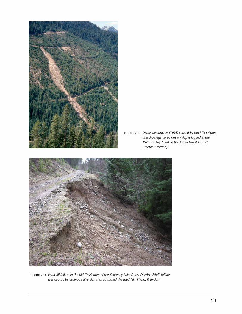
FIGURE 9.10 Debris avalanches (1993) caused by road-fill failures and drainage diversions on slopes logged in the 1970s at Airy Creek in the Arrow Forest District. (Photo: P. Jordan)
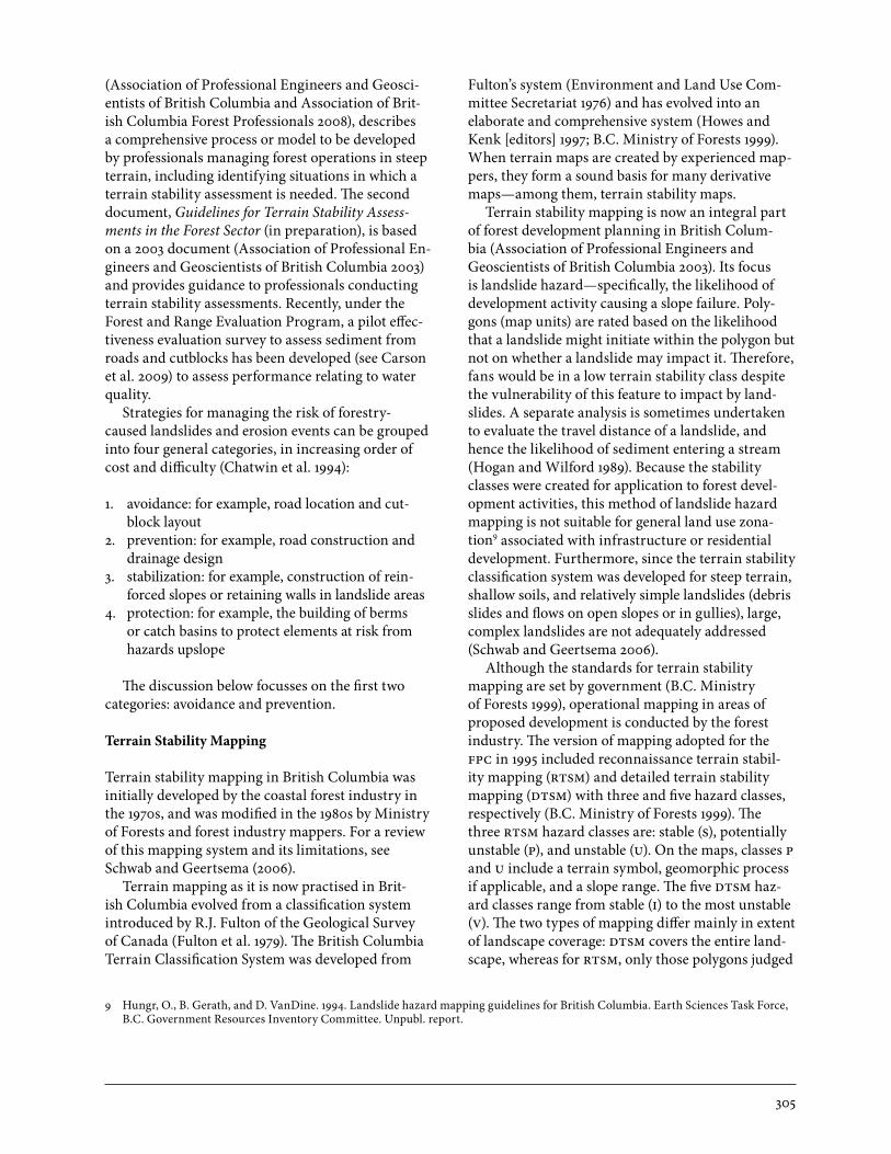
FIGURE 9.11 Road-fill failure in the Kid Creek area of the Kootenay Lake Forest District, 2007; failure was caused by drainage diversion that saturated the road fill. (Photo: P. Jordan)

286
FIGURE 9.12 Debris slide that progressed to a large debris flow below a culvert in the Blueberry Creek area of the Arrow Forest District, 1993. The slide happened the spring following logging, occurring below a culvert that was misplaced by only a few metres from its optimum location. (Photo: P. Jordan)
FIGURE 9.13 Debris slide/avalanche that progressed to a large debris flow below a culvert in the Fortynine Creek area of the Kootenay Lake Forest District, 1996. Water flow to the culvert increased because of the cumulative effects of roads and cutblocks over a 20-year period, although culverts, ditches, and road maintenance generally followed accepted standards. (Photo: P. Jordan)

287
FIGURE 9.14 Landslides at Wahleach Lake, Chilliwack Forest District. These landslides occurred during a rainstorm in 1990, and originated in old road fills that were partially supported by wood. Poor drainage control on the roads, which were not deactivated, may also have been a contributing factor. (Photo: P. Jordan)
FIGURE 9.15 Debris slide/avalanche that involved a fill failure of a mainline Forest Service road near Giveout Creek in the Kootenay Lake Forest District, 2002. The debris slide was caused by drainage diversion on skid trails on private land above. Although ground-based logging of steep slopes is no longer practised on Crown land, it still sometimes occurs on private land. (Photo: P. Jordan)

288
FIGURE 9.16 Two road-fill slope slides associated with uncontrolled road drainage in the San Juan watershed, South Island Forest District. (Photo: T. Millard)
FIGURE 9.17 Road surface and slide headscarp from Figure 9.16. Note heavily eroded road surface. Several blocked culverts led to large volumes of water flowing onto the fillslope at the headscarp of both slides. (Photo: T. Millard)

289
gentle-over-steeP landslides
Drainage diversions from forest roads and trails have been recognized as an important cause of landslides in the British Columbia interior since the late 1980s. In many cases, forest development has occurred on relatively gently sloping terrain, plateaus, or bench-lands above steeper slopes. Landslides occurring in such topographic situations are commonly referred to as “gentle-over-steep” landslides (e.g., Figures 9.18–9.20).
Forest development in such areas has been widespread in the British Columbia interior for several reasons. The main reason is that large areas of commercially valuable forests on plateaus and uplands lie above incised valleys; however, most of the potentially unstable terrain occurs on the steep valley sides. Most elements at risk, such as populated areas, infrastructure, and fish habitat are at the base of these slopes. The gently sloping terrain was devel-oped first, since logging costs are lower on gentler slopes, and most logging was ground-based, which
creates opportunities for drainage diversion by skid trails and roads. In areas where forest development spanned steeper and gentler slopes and used cable-harvesting systems, roads were typically located on the gentler slopes to minimize costs and avoid unstable terrain.
Historically, many gentle-over-steep landslides were caused either by drainage diversions on roads that had insufficient or substandard culverts or other drainage structures, or by skid trails that had not been deactivated. With the introduction of the Forest Practices Code of British Columbia Act in 1995, or through changes implemented some years earlier by many forest companies, it became standard practice to deactivate roads and skid trails; however, many landslides continued to occur because of drain-age diversions from older roads and logged areas. An important benefit of improved road engineer-ing practices was a reduction in landslides caused by road-fill failure. Nevertheless, landslides that
FIGURE 9.18 “Gentle-over-steep” debris avalanche below road and ground-based harvesting near Shaw Creek in the Kootenay Lake Forest District, 1996. In this case, the road and skid trails were properly deactivated, and there were no drainage diversions observed; subtle changes to slope hydrology may have been responsible. (Photo: P. Jordan)

290
FIGURE 9.19 “Gentle-over-steep” debris avalanche caused by drainage diversions on road and skid trails near Ferguson Creek in the Arrow Forest District, about 1990. (Photo: P. Jordan)
FIGURE 9.20 “Gentle-over-steep” debris flow caused by road drainage diversion on Lower Arrow Lake in the Arrow Forest District, 1999. On a newly constructed road, two culverts were not installed on a small ephemeral stream, and water was discharged off a switchback. This caused the debris flow, which began as a small debris slide below the switchback. (Photo: P. Jordan)

291
occurred below roads continued to be a significant problem (Grainger 2002). Investigation of many such incidents by B.C. Ministry of Forests engineering and geoscience specialists showed that FPC regula-tory requirements had a significant weakness; that is, the requirement for a terrain stability assessment by a qualified professional was based on the terrain stability at the site, not on terrain conditions below the proposed development. Thus, in many cases, drainage control on roads or in proposed logging developments was never reviewed or prescribed by a qualified specialist in gentle-over-steep situa-tions (although in some high-risk areas, assessments were done voluntarily by forest companies, or were required by the forest districts).
In the British Columbia interior, drainage diver-sions by roads in gentle-over-steep situations were first recognized as a serious problem in an engineer-ing report to the Arrow Forest District.4 In 1990, a group of gentle-over-steep debris flows near Slocan resulted in a major investigation,5 and recommenda-tions for more regulation and improved practices for road and skid trail deactivation were made. The hydrologic and engineering causes of such landslides were reviewed by Jordan (2001a), Grainger (2002), and Jordan and Nicol (2002).
Gentle-over-steep landslides (and other drainage-related landslides downslope from forest develop-ment) are caused by the hydrologic changes brought about by roads or logging. These hydrologic changes can include:
• dispersedsubsurfaceflowbroughttothesur-
face and concentrated into discrete pathways by ditches, culverts, water bars, or water discharged off switchbacks;
• overlandflowgeneratedfromroadortrailsur-faces, which is discharged onto a slope below at discrete locations;
• accidentaldischargeofwateratanunplannedlo-cation because of the failure of a ditch or culvert; and
• increasedgenerationofrunofffromsnowmeltorrainfall that is due to the effects of forest harvest-ing.
The physical processes that lead to increased landslide hazard are the same whether or not the
contributing drainage area upslope is of lower slope steepness; landslides are frequently caused by drain-age concentration or diversion below roads that are on steep terrain. However, the gentle-over-steep con-figuration is common in areas of plateau topography because of the prevalence of forest development on gentle slopes.
Figures 9.21 and 9.22 are conceptual sketches showing the typical effects of roads on slope hydro-logy and landslide initiation. Shallow subsurface flow is intercepted and concentrated by road cuts and ditches. A landslide may occur downslope if the increased flow of water encounters a location where the slope is barely stable (factor of safety close to 1.0) and requires only slightly increased pore water pres-sure to fail. Typically, these failures occur where the slope steepens, and also where the soil thins downs-lope, bringing the water table close to the surface.
Case Study: Belgo Creek Debris Avalanche
Three case studies are presented below (Belgo Creek, Donna Creek, and Hummingbird Creek) as ex-amples of gentle-over-steep failures with significant downslope or downstream impacts.
Six slope failures occurred in the vicinity of Belgo Creek, 30 km east of Kelowna, on June 11–13, 1990. The most destructive event (Figure 9.23) was a large debris avalanche on June 12, which destroyed a house on Philpott Road and resulted in three fatalities (Schwab et al. 1990; Fannin et al. 2005).
The landslides occurred during a 3-day rain-on-snow event, which was heavy but not exceptional (Schwab et al. 1990). This followed 1.5 months of very wet weather; May and June of 1990 had the highest 2-month rainfall on record at Kelowna.
The landslide started as a group of four small debris flows in an area of old logging (pre-1963). The lowest of these rapidly increased in width and volume downslope, flowing a total of 1.5 km and eroding an area of 5 ha. The deposits of saturated debris spread out over an area of 12 ha in the valley bottom. The magnitude of the event was estimated at 23 000 m3 (Cass et al.1992). The event was originally classified as a debris flow; however, according to the more recent classification of Hungr et al. (2001), it would more properly be called a “debris avalanche.”
The slope in the landslide start zone averages 33°
4 Chow, B. 1988. Review of logging related slope failures of April 1988 in Arrow Forest District, Nelson Forest Region. B.C. Min. For. Unpubl. report.
5 Curran, M., B. Chow, D. Toews, and D. Boyer. 1990. Landslide study: Cape Horn bluffs area. B.C. Min. For. and B.C. Min. Environ. Unpubl. report.

292
FIGURE 9.22 Sketch showing the typical role of a road drainage diversion in triggering a “gentle-over-steep” landslide: (a) Plan view, landslide below a switchback;(b) cross-section showing typical point of landslide initiation; and (c) enlargement, showing convergence of groundwater caused by the thinning soil depth at break in slope. Often, landslides initiate in a concavity on the contour where horizontal convergence of flow also occurs (Jordan 2001a).
FIGURE 9.21 Sketch showing the typical effect of roads and culverts on slope hydrology for uniform slopes with shallow soils and low drainage density (Jordan 2001a).
Dispersed flow
Flow concentratedin plumes belowculverts
Permeable soil
Impermeable till or bedrock
Road
Road Landslide
Break in slope
(a) (b)
(c)

293
(65%), and is covered with veneers and blankets of sandy till and colluvium. The investigation following the event showed evidence of extensive small-scale slope instability in the area and a lack of defined sur-face watercourses, but no evidence of previous large landslides. On the plateau above, large clearcuts had been created from 1983 to 1988. The roads access-ing these clearcuts had been deactivated with water bars. Selective logging had occurred before 1963 in and above the landslide start zone and in the upper part of the slide path, on both Crown and private land. Most of the logging roads in that area had not been deactivated. Roads in the clearcut above the landslide increased the contributing drainage area by about 20%, and it is estimated that the effects of the clearcut increased the rate of runoff during the storm by about 15%.
This event was important in the history of forest geomorphology in British Columbia because it led to awareness, for the first time, of the risks presented by landslides following forest development in the Interior. This contributed to:
1. the development of regulations in the FPC that were aimed at minimizing landslide hazards;
2. the development of the Watershed Restoration Program, which aimed to reduce risks by deacti-vating abandoned logging roads throughout the province; and
3. the use of terrain stability mapping as a planning tool.
Case Study: Donna Creek Washout Debris Flow
The catastrophic washout / debris flow at Donna Creek, near Mackenzie, in June 1992 emphasizes a very basic concept in our knowledge of water source areas (drainage basins) and how roads modify water movement. Roads constructed on the hillslope intersected poorly defined microtopographic drain-age basins (Figure 9.24). Water was captured and routed along road ditches. Sufficient cross-drains or culverts were not provided to allow water to cross the roads and flow into natural drainage basins (Figure 9.25). The capture and redirection of surface and subsurface water expanded the drainage area to an existing basin outlet. The expanded drain-
age represented a catchment increase of 9.8 times (5.8 ha to 56.9 ha). An excessive volume of water, in the order of 193 000 m3 over 9 days during a period of rapid snowmelt, was delivered onto a glacioflu-vial-glaciolacustrine terrace composed of highly erodible sands, silts, and gravels. Even though the site appeared to be well drained, it could not handle a rapid increase in groundwater discharge at the ter-race scarp. A rapid increase in seepage exit gradient resulted from the sudden increase in groundwater discharge combined with a possible sudden removal of material at the terrace scarp by a landslide and (or) running water. Catastrophic seepage face ero-sion describes the sudden change in the discharge conditions that resulted in a rapidly retreating seepage face, caving, collapse, and debris flow surges (Figure 9.26).
FIGURE 9.23 Aerial view of the Belgo Creek debris avalanche. (Photo: J. Schwab)

294
FIGURE 9.24 Natural flow pathways downslope (right to left in photo) are intersected by roads on the hillslope above Donna Creek (far left). (Photo: J. Schwab)
FIGURE 9.25 Insufficient cross-drainage resulted in the capture and routing of water along road ditches. (Photo: J. Schwab)

295
Case Study: Hummingbird Creek Debris Avalanche and Debris Flow
On July 11, 1997, a large debris flow descended Hum-mingbird Creek and caused considerable damage to property and infrastructure on its alluvial fan. The fan is located on Mara Lake, 8 km south of Sicamous. About 150 houses were located on the fan, and Highway 97A crosses the upper part of the fan. Several unoccupied summer homes and other buildings were damaged by the debris flow, the highway was washed out, and further minor dam-age occurred below the direct impact zone due to inundation by water and fine debris. There were no direct fatalities or injuries. The incident was investi-gated by a team of government staff and consultants (Anderson et al. 1997; Jakob et al. 2000). Wilford et al. (2009) undertook a retrospective analysis of the event; Figure 9.27 provides an overview of the area.
The event started as a debris avalanche 35 m below a culvert on a logging road. At this location, roads and logging are on relatively gentle terrain, which
drops off steeply below the road to the creek. The terrain consists of shallow till and colluvium over coarse-textured metamorphic bedrock that dips downslope. The slope at the landslide scarp was about 35° (70%). Pre-landslide terrain stability map-ping rated this location as “potentially unstable.” 6 The landslide occurred after a week of heavy rain; the 7-day rainfall at three nearby climate stations averaged 112 mm, an event that is estimated to have a return period of about 60 years. This followed the melting of an above-average snowpack, so anteced-ent soil moisture was likely high. During the May–July period, numerous other landslide and erosion events in the area were caused by wet weather and a rapid melting of a deep snowpack.
The culvert directly above the landslide drains an area within a cutblock that was logged in 1994. A spur road in the cutblock caused the drainage area above the culvert to more than triple in size from 1.6 to 5.6 ha. A second culvert 65 m up the road drains a larger area, and contributed water to the slope in the lower part of the debris avalanche. Concentration
FIGURE 9.26 Water discharged onto a highly erodible terrace resulted in the catastrophic seepage face erosion. (Photo: J. Schwab)
6 Terratech Consulting Ltd. 1997. Reconnaissance terrain stability study (TSIL D), Riverside Forest Products Ltd. Hunters Range Operating Area, Salmon Arm Forest District. Draft submitted to Riverside Forest Products Ltd., Lumby, B.C. Unpubl. report.

296
of runoff by the cutblock road and the culverts was identified as the main development-related factor that caused the landslide.
The debris avalanche was exceptionally large, with a volume estimated at 25 000 m3. On entering the creek, the additional water transformed the mode of transport to a debris flow (Figure 9.28). The debris flow scoured gravel, soil, and trees from the creek bed and banks, and continued for about 2.5 km to the fan. Once on the fan, the debris flow lost confine-ment and began depositing sediment. Most of the coarse debris was deposited in the first 400 m, above the highway on the upper part of the fan, where the slope is about 6–10° (10–18%). Finer debris and flood deposits were spread over a large area of the lower fan, which has a gentler slope and is occupied mainly by roads and houses. The total volume of debris flow deposition was about 92 000 m3 (Jakob et al. 2000).
Except for its unusually large size, this event is fairly typical of “gentle-over-steep” landslides, which are common in the Columbia Mountains and Shuswap Highlands (Grainger 2002). These land-slides are caused when runoff is concentrated by log-ging roads and trails and is discharged onto steeper slopes below. In this region, such events can present risks to life and property in the inhabited valley bot-toms (Wilford et al. 2009).
A Forest Practices Board investigation concluded that the forest licensee adequately maintained the road and complied with FPC requirements. The report recommended revisions to FPC regulations to include assessment of risks to life and property, and to reduce hazards from road drainage being discharged onto potentially unstable slopes (Forest Practices Board 2001).
FIGURE 9.27 Orthophoto prepared from air photos taken soon after the debris flow event.

297
surface erosion
In the Pacific Northwest, numerous studies have indicated that surface erosion from forest roads is an important source of sediment (Reid and Dunne 1984; Megahan et al. 1986; Hudson 2001). These stud-ies have generally shown that sediment production is greatest during and soon after construction, and that the level of industrial traffic on roads greatly affects sediment production. An important distinc-tion between landslides and surface erosion is that landslides are episodic, whereas surface erosion from roads is chronically occurring.
Factors affecting the importance of roads as sedi-ment sources include bedrock and surficial geology, soil texture, presence of seepage, and the relative contributions of surface and subsurface flow during spring runoff 7 or storm events. Engineering factors are also important, and include road location, road gradient, adequacy of drainage control, the use of
road surfacing material, and inspection and main-tenance practices (B.C. Ministry of Forests 2002). Additional factors include connectivity to water bodies, amount of vehicle traffic, frequency of main-tenance or inspection, and precipitation amounts. Figures 9.29 and 9.30 show examples of severe road erosion caused by some of the engineering factors; in particular, inadequate drainage control and failure of road drainage structures.
In sediment budget studies conducted in the southern Interior of British Columbia, Jordan (2001b) found that on a watershed scale, erosion from forest roads was a highly significant source of suspended sediment in Redfish Creek, a mountain-ous watershed underlain by granitic rocks that has had a moderate amount of forest development (10% logged). However, in Gold Creek, a more heavily de-veloped watershed underlain by fractured sedimen-
FIGURE 9.28 Photographs of the initial landslide (right) and the scoured channel upslope of the alluvial fan (left) (Anderson et al. 1997).
7 Thompson, S.R. 2000. A system for assessing surface erosion hazard on forest roads. BC. Min. For., For. Sci. Sect., Nelson Forest Region, Nelson, B.C. Unpubl. report.
Photograph 1Looking downstram along the scoured Hum-mingbird Creek channel toward Mara Lake, with the toe of the debris scarp in the foreground.
Photograph 2
Debris flow scarp in relation to the Ashton - Mara East FSR, CP 733 - Block 3, and Hummingbird Creek.

298
FIGURE 9.30 An extreme example of road erosion in the Lemon Creek drainage, Arrow Forest District, caused by diversion of a small creek down an old road during spring runoff (2002). (Photo: C. Pettitt, Valhalla Wilderness Society)
FIGURE 9.29 Surface erosion on a road near Redfish Creek in the Kootenay Lake Forest District in 1993, caused by a plugged culvert and inadequate water bars. (Photo: P. Jordan)
tary rocks, road erosion was a relatively insignificant source of sediment. Surface erosion from clearcuts was not a measurable source of sediment in either watershed.
In the British Columbia Interior, where landslides are relatively rare, surface erosion is probably the most significant source of sediment resulting from forest development in most areas. This is especially the case where development has occurred on erod-ible lacustrine soils, which are widespread in the central Interior. The low relative runoff (streamflow as a proportion of precipitation) in many areas of the dry central Interior may contribute to high potential impacts on stream channels and water quality from surface erosion, if connectivity exists between roads and stream channels.
Until the late 1980s, most logging in the Interior was done by ground-based methods, which often resulted in a high density of skid trails and excessive soil disturbance from ground skidding. This prob-ably resulted in considerable erosion and sediment contributions to streams; however, quantitative stud-ies are lacking. In the 1980s, soil disturbance guide-lines were developed by the B.C. Ministry of Forests (Lewis 1991), and were included in the FPC in 1995. Since then, improved practices, including the deacti-vation of skid trails following logging and increased use of cable logging on steep slopes, have greatly reduced the incidence of erosion and sediment pro-

299
duction from logged areas. Operational experience of Ministry of Forests staff, and the few sediment budget studies that have been done, indicate that erosion from logged areas is usually a minor source of sediment compared to erosion from roads.
Toews and Henderson (2001) presented methods to estimate sediment production from roads for use in the Interior Watershed Assessment Procedure (B.C. Ministry of Forests 1995b). They presented pre-liminary sediment budget data for four watersheds, which showed that sediment from road erosion was, on average, relatively minor compared with that from natural sources, and that most erosion came from a small part of the road system. Most of the
road segments they surveyed had erosion rates of 0.3–30 m3/km per year, and an average of 32% of eroded sediment was delivered to streams.
In a related, unpublished study, Thompson measured road surface erosion on newly construct-ed roads throughout the Kootenay region.8 Median erosion rates ranged from 0.4 m3/km per year for dry-climate sites with no seepage to 10 m3/km per year for moist-climate sites with seepage. The major factors affecting erosion were failures in the road drainage system, climate, and the presence of seep-age in the cutbank. Most erosion came from the cutbank-ditch system; the road surface was second in importance.
8 Ibid.
gullies
Steep gully wall slopes, concentration of groundwa-ter, and steep stream channels create difficult terrain conditions for forestry operations. Figures 9.31–9.37 show examples of gullies and forest management.
Yarding of timber often results in damage to gully sidewalls, and deposition of logging slash into the gully channel can alter flow pathways. In gullies with streams, the slash may be transported, resulting in debris jams and sediment wedges. In some cases, these jams fail catastrophically and a debris flow or debris flood can result. In other cases, the jams are stable, but if a debris flow initiates farther up the gully, the increased sediment and woody debris will add to the volume of the subsequent debris flow. Sometimes, debris jams and sediment wedges may force channel-water flows against a sidewall and erode into the toe of the slope, which can result in a sidewall slope failure. Harvesting of timber within coastal gullies results in some of the highest post-harvest landslide rates of any terrain type (Rollerson 1992; Rollerson et al. 1998, 2001; Millard et al. 2002).
Road crossings of gullies can create several problems. If culverts are blocked by woody debris, the road fill material may saturate and fail. Road cuts into steep gully sidewalls may fail, and if a steep road fill is constructed, that may fail as well. All these failures may result in debris flows that travel down the gully. Road ditches that deliver water from outside the gully onto the gully walls can initiate slope failures, or if the water is delivered directly
to the channel, it can initiate an in-channel debris flow. Conversely, roads that climb into a gully may direct gully water along the ditchline to open slopes beyond the gully, which can cause subsequent open-slope failures.
Recent cutblock layouts tend to leave potentially unstable gullies partially or completely unhar-vested. Commonly, the cutblock edge is near gully boundaries, or is buffered for gullies inside cutblock boundaries, with the buffer designed to be windfirm at the gully edge. A recent increase has been noted in the number of windthrow-related landslides, particularly where windthrow along a buffered gully penetrates into the buffer farther than expected and causes a gully wall failure. Where a gully appears stable, harvesting occurs, but if the stream is large enough to transport woody debris, the logging slash is removed from the gully. Individual trees within a gully may be selected for harvest, with the whole tree removed by a helicopter (“snap and fly”), which results in very little disturbance to the gully.
Designing roads to descend into and climb out of a gully reduces the likelihood that the channel will become blocked and cause an avulsion (Wilford et al. 2005b; Millard et al. 2006). Road crossings should be large enough to transport both water and debris. Where debris flows are likely to occur, the road crossing should be designed to either pass the debris flow or minimize the effect of the road on the pas-sage of the debris flow (Jakob and Jordan 2001).

300
FIGURE 9.31 Gullies in the Gordon River watershed, South Island Forest District. (Photo: T. Millard)
FIGURE 9.32 Closely spaced gullies (“dissected terrain”) at MacMillan Creek, Haida Gwaii Forest District. (Photo: T. Millard)

301
FIGURE 9.33 Steep headwall area of gully in Rennell Sound, Haida Gwaii Forest District. (Photo: T. Millard)
FIGURE 9.34 Unstable gully sidewall area in Rennell Sound, Haida Gwaii Forest District. (Photo: T. Millard)

302
FIGURE 9.35 Small helicopter-yarded patch cuts, with a buffered gully (middle of the photo), at Foley Creek watershed, Chilliwack Forest District. This approach to harvesting near unstable terrain is becoming more common. (Photo: T. Millard)
FIGURE 9.36 Debris slides in a gully near the Klanawa River in the South Island Forest District. The gully was left unlogged but was heavily damaged by windthrow. (Photo: T. Millard)

303
alluvial fans
Alluvial fans are deposits of sediment formed where streams or debris flow transport zones lose con-finement. Generally, these fans are found in valley-bottom locations where tributary streams or gullies enter a main valley. Fans also occur on mid-slope benches or other locations where confinement is lost, lowering the power to transport material. Sedi-ment originates in a watershed, which can be of any scale, ranging from a single hillslope gully to a valley system hundreds of square kilometres in area. Sediment in small (less than about 10 km2), steep watersheds can be transported to fans by debris flows (VanDine 1985; Wilford et al. 2005a; Millard et al. 2006). In British Columbia, the terrain classifica-tion system identifies these as colluvial fans (Howes and Kenk [editors] 1997). As watersheds become larger, it is common for fluvial processes to domi-nate sediment movement from watersheds to fans (e.g., floods and debris floods) (Wilford et al. 2005a; Millard et al. 2006). In British Columbia, these are classified as fluvial fans (Howes and Kenk [editors] 1997). In the literature, it is common to use the term
“alluvial fan” to refer to fans formed by fluvial or colluvial processes, or a combination of the two. Slope gradients on fluvial fans are characteristically less than 4°, with gradients of up to 18° on colluvial fans (at steeper gradients the landform is referred to as a “cone”) (Jackson et al. 1987; Howes and Kenk [editors] 1997; Wilford et al. 2005a). In graded (i.e., mountainous as opposed to plateau) watersheds, the dominant hydrogeomorphic process influencing fans can be correlated with the relative relief number, which is watershed relief divided by the square root of watershed area—sometimes known as the “Melton Ratio” (Melton 1965). Watersheds that produce floods typically have a relative relief number of less than 0.3 (Jackson et al. 1987; Bovis and Jakob 1999). Based on regional studies, it is possible to differentiate debris flow from debris flood watersheds (Wilford et al. 2004; Millard et al. 2006). Debris flood events are similar to flood events, but they have a higher sediment load and commonly result in greater dis-turbance on the fan surface (Hungr et al. 2001). Re-gardless of the hydrogeomorphic process, landslides
FIGURE 9.37 Debris flows that originate in gullies can present a significant hazard to public safety and to property in populated areas. (Photo: P. Jordan)

304
are important processes for delivering sediment to fans—either directly as in a debris flow or delivered by fluvial transport of bedload.
Many alluvial fans in British Columbia are con-sidered to be paraglacial—formed with sedminents delivered by the melting of Pleistoscene glaciers in denuded watersheds (Ryder 1971a, 1971b). High volumes of water and sediment resulted in large fans—larger than contemporary hydrogeomorphic conditions would suggest. Under current conditions, hydrogeomorphic processes may result in compara-tively minor additions or removals of sediment from paraglacial fans; however, these additions can have a profound influence on the surface of fans. In addi-tion, the spatial extent and complexity of the channel network on a fluvial fan surface reflects boundary
conditions, such as sediment and water supply from the watershed, fan vegetation, the space into which the fan is building, and whether hydrogeomorphic processes are removing sediment from the toe of the fan (Millard et al. 2010). Fluvial fans that receive a high sediment supply from the watersheds have a greater spatial extent of the channel network than fans that receive a lesser supply of sediment.
One change on alluvial fans in British Columbia compared to paraglacial time is the presence of for-est cover. It is clear that forests on fans, particularly along stream channels, provide a range of hydrogeo-morphic roles: storage of sediment, maintenance of stream channel location, and soil reinforcement by roots. Site features can be used to identify these “hydro-geomorphic riparian” zones (Wilford et al. 2005b).
Planning and Practices to reduce forestry effects on hillsloPe Processes
Before the establishment of the FPC in 1995, ter-rain stability management was either voluntary or a contractual obligation (Fannin et al. 2007). How-ever, environmental concerns and recognition of the effects of forest management on landslides and sediment production have resulted in many changes to forestry practices over the past two decades. Dur-ing this time, terrain stability mapping and terrain stability assessments began to be widely used in coastal British Columbia. The FPC established prov-ince-wide regulations regarding terrain stability and sediment production.
An investigation by the Forest Practices Board (2005) found that, based on a limited sample from both the Coast and Interior, the frequency of landslides resulting from cutblocks and roads had decreased following the introduction of the FPC. Probable factors contributing to this reduction included establishment of reserves and management zones around gullies and streams, better road loca-tion, and improved road construction practices.
The FPC required a terrain stability field as-sessment if one of the following criteria was met: unstable or potentially unstable terrain as shown on terrain stability mapping, slopes greater than 60%, field indicators of instability, or a District Manager’s request. Although the trigger for an assessment was based on hazard, the FPC required an evaluation of risk, and in certain situations, restricted forest man-agement activities if the risk was too high (see sec-tion on “Landslide Risk Management,” below). The
FPC also required watershed assessments that evalu-ated sediment sources and their effects on the stream channel or drinking-water quality. A risk-based approach to assessments was emphasized both in the FPC’s guidebooks and in standards developed by the Joint Practices Board (representing members of the Association of Engineers and Geoscientists of British Columbia and the Association of British Colum-bia Forest Professionals to provide guidance to its members on issues of professional practice). Profes-sionals who make the assessments and prescriptions develop practices and methods that are appropriate to the site. On-the-ground practices were generally not prescribed by the FPC, although information on recommended practices and methods was given in the guidebooks.
The transition to the Forest and Range Prac-tices Act started in 2004. This Act represents a “results-based” approach and does not require any assessments. Licensees are expected to choose management strategies that will not cause “material adverse effects.” Since a greater reliance is placed on professionals under the Act, professional associa-tions are providing greater direction for guiding professional practice. The Association of Professional Engineers and Geoscientists of British Columbia (APEGBC) and the Association of British Columbia Forest Professionals (ABCFP) have developed two documents that address professional practice for terrain stability. The first document, Guidelines for Management of Terrain Stability in the Forest Sector
305
(Association of Professional Engineers and Geosci-entists of British Columbia and Association of Brit-ish Columbia Forest Professionals 2008), describes a comprehensive process or model to be developed by professionals managing forest operations in steep terrain, including identifying situations in which a terrain stability assessment is needed. The second document, Guidelines for Terrain Stability Assess-ments in the Forest Sector (in preparation), is based on a 2003 document (Association of Professional En-gineers and Geoscientists of British Columbia 2003) and provides guidance to professionals conducting terrain stability assessments. Recently, under the Forest and Range Evaluation Program, a pilot effec-tiveness evaluation survey to assess sediment from roads and cutblocks has been developed (see Carson et al. 2009) to assess performance relating to water quality.
Strategies for managing the risk of forestry-caused landslides and erosion events can be grouped into four general categories, in increasing order of cost and difficulty (Chatwin et al. 1994):
1. avoidance: for example, road location and cut-block layout
2. prevention: for example, road construction and drainage design
3. stabilization: for example, construction of rein-forced slopes or retaining walls in landslide areas
4. protection: for example, the building of berms or catch basins to protect elements at risk from hazards upslope
The discussion below focusses on the first two categories: avoidance and prevention.
Terrain Stability Mapping
Terrain stability mapping in British Columbia was initially developed by the coastal forest industry in the 1970s, and was modified in the 1980s by Ministry of Forests and forest industry mappers. For a review of this mapping system and its limitations, see Schwab and Geertsema (2006).
Terrain mapping as it is now practised in Brit-ish Columbia evolved from a classification system introduced by R.J. Fulton of the Geological Survey of Canada (Fulton et al. 1979). The British Columbia Terrain Classification System was developed from
Fulton’s system (Environment and Land Use Com-mittee Secretariat 1976) and has evolved into an elaborate and comprehensive system (Howes and Kenk [editors] 1997; B.C. Ministry of Forests 1999). When terrain maps are created by experienced map-pers, they form a sound basis for many derivative maps—among them, terrain stability maps.
Terrain stability mapping is now an integral part of forest development planning in British Colum-bia (Association of Professional Engineers and Geoscientists of British Columbia 2003). Its focus is landslide hazard—specifically, the likelihood of development activity causing a slope failure. Poly-gons (map units) are rated based on the likelihood that a landslide might initiate within the polygon but not on whether a landslide may impact it. Therefore, fans would be in a low terrain stability class despite the vulnerability of this feature to impact by land-slides. A separate analysis is sometimes undertaken to evaluate the travel distance of a landslide, and hence the likelihood of sediment entering a stream (Hogan and Wilford 1989). Because the stability classes were created for application to forest devel-opment activities, this method of landslide hazard mapping is not suitable for general land use zona-tion9 associated with infrastructure or residential development. Furthermore, since the terrain stability classification system was developed for steep terrain, shallow soils, and relatively simple landslides (debris slides and flows on open slopes or in gullies), large, complex landslides are not adequately addressed (Schwab and Geertsema 2006).
Although the standards for terrain stability mapping are set by government (B.C. Ministry of Forests 1999), operational mapping in areas of proposed development is conducted by the forest industry. The version of mapping adopted for the FPC in 1995 included reconnaissance terrain stabil-ity mapping (RTSM) and detailed terrain stability mapping (DTSM) with three and five hazard classes, respectively (B.C. Ministry of Forests 1999). The three RTSM hazard classes are: stable (S), potentially unstable (P), and unstable (U). On the maps, classes P and U include a terrain symbol, geomorphic process if applicable, and a slope range. The five DTSM haz-ard classes range from stable (I) to the most unstable (V). The two types of mapping differ mainly in extent of landscape coverage: DTSM covers the entire land-scape, whereas for RTSM, only those polygons judged
9 Hungr, O., B. Gerath, and D. VanDine. 1994. Landslide hazard mapping guidelines for British Columbia. Earth Sciences Task Force, B.C. Government Resources Inventory Committee. Unpubl. report.

306
by the mapper as unstable or potentially unstable are mapped. This results in considerable cost savings, especially in areas such as the interior plateaus where most of the landscape is stable. In complex, moun-tainous terrain, or in areas with high downstream consequences, such as community watersheds, DTSM is generally preferred.
All terrain maps, including terrain stability maps, are based on air photo interpretation followed by field checking. Polygons of approximately homoge-neous surficial material and landform are identified on a stereo pair of photos, and preliminary terrain labels are assigned. The accuracy and reliability of the maps is determined mainly by the amount of field checking that is done. The level of field checking (terrain survey intensity level, or TSIL) for vari-ous types and scales of mapping is specified in the standards (B.C. Ministry of Forests 1999). Typically, TSIL B or C (50–75% and 20–50%, respectively, of polygons ground checked) and a scale of 1:10 000 or 1:20 000 is used for DTSM. For RTSM, TSIL D (1–20% of polygons ground checked) and a scale of 1:20 000 or 1:50 000 is used. Following field checking, final polygon boundaries, terrain labels, and interpreta-tions are completed. Various photogrammetric methods (such as monorestitution), or sometimes transfer to base maps by eye for RTSM, are used to transfer the polygon linework from the air photos onto topographic maps. With the increased use of computers for mapping purposes, GIS (geographic information systems) is replacing drafting on mylar, and Roman numerals are falling out of use.
A complete description of the terrain classifica-tion system used for the terrain labels is given in Howes and Kenk (editors, 1997). In its simplest form, the label consists of symbols for soil texture, genetic material (morainal, colluvial, fluvial, etc.), surface expression or landform, and modifying geomorphic processes (in that order). For example, the label “zsMb-V” means “silty sandy morainal blanket, modified by gullying.” Figure 9.38 provides an exam-ple of a terrain stability map, prepared at TSIL C and a scale of 1:20 000, showing both the air photo and the final map.
The accuracy of terrain stability mapping is highly dependent on the skill and experience of the mapper, as well as on the extent of field checking. No two mappers will produce exactly the same polygon configuration, labels, or stability ratings, although usually the products of experienced mappers will generally be in agreement. Individual mappers typi-cally develop terrain stability rating criteria tables based on slope, surficial material, drainage condi-tions, and evidence of past slope movement, and the mapper’s professional subjective opinion often is a factor in assigning a stability rating. To provide objective and quantitative ratings, data from terrain attribute studies can be used in those areas where available. It is generally accepted (although no longer required by government regulation) that mappers must be licensed professionals with adequate train-ing and experience.
A number of remote sensing and digital eleva-tion model (DEM) approaches have possible applica-
FIGURE 9.38 Example of a terrain map: (a) air photo interpretation and (b) completed terrain map. On this map, terrain stability classes are indicated by colours: classes I, II, III, IV, and V are coloured blue, green, yellow, orange, and red, respectively.
a) b)a b

307
tion to mapping terrain stability (Slaymaker 2001). Although attempts have been made to apply some of these to forestry-related landslide hazard (Niemann and Howes 1992; Pack et al. 1998), digital mapping methods have not gained wide acceptance in British Columbia.
Terrain Stability Assessments
Terrain stability assessments evaluate terrain stabil-ity hazards and risks that may be affected by forest development or that may affect forest development. Terrain stability assessments originated in coastal British Columbia in the 1980s as forestry-related landslides became a management issue (Fannin et al. 2007). These assessments were required under the FPC, and although not required under the Forest and Range Practices Act, they are an important part of due diligence in managing steep terrain (Horel and Higman 2006). The following summary is based on the Guidelines for Terrain Stability Assessments in the Forest Sector (Association of Professional Engineers and Geoscientists of British Columbia 2003), and on more recent developments in terrain stability assess-ment practice.
The objectives of terrain stability assessments include, but are not limited to:
• characterizingtheexistinglandslidehazards(terrain and terrain stability conditions) in areas within, adjacent to, or connected to the forest development area;
• evaluatingpotentialorexistingeffectsofthefor-est development on terrain stability;
• determiningthelandslidehazardsandpotentialor existing effects of the forest development on identified elements at risk, including worker and public safety;
• comparingthelandslidehazardsorriskswithavailable guidelines or standards of acceptable hazard or acceptable risk, including those deter-mined by government and those contained within a licensee’s terrain stability management model; and
• recommendingsite-specificactionstoreduceand/or manage the landslide hazards and risks resulting from the forest development.
In most cases, the terrain specialist does extensive office and field work to evaluate terrain conditions and the planned forestry development. Terrain con-ditions evaluated include:
• slopeconfigurationandgeometry;• surficialmaterialtype,strength,anddrainage;• evidenceofpastorhistoriclandslides,orsignsof
instability (Figure 9.39);• hillslopehydrology;• potentiallandslidetriggeringevents,suchas
rainstorms, rain-on-snow events, snowmelt, or windthrow; and
• characteristicsofanynearbylandslides,includinginitiation-zone characteristics and travel distance.
The terrain specialist also considers the potential effects of forest development, including:
• themethodandeffectsofharvestingonhillslopestability;
• thestabilityofanyproposedroads,includingcutslopes and fillslopes;
• theeffectsofroaddrainageonhillslopehydro-logy, particularly the concentration of drainage that may lead to fillslope or hillslope failure; and
• theeffectsofexistingdevelopment.
FIGURE 9.39 Tension cracks, Tangiers River in the Columbia Forest District. An important part of terrain stability assessments, as well as layout work by forest technicians, is to observe indicators of slope instability such as this. (Photo: P. Jordan)

308
The terrain stability assessment report often includes recommendations for managing terrain stability risks. Management options can include avoiding potentially unstable areas, modifying har-vesting or road building methods, or in rare cases, constructing stabilization or protective works such as debris flow basins.
Terrain specialists generally use a combination of theoretical understanding of terrain stability, profes-sional experience, and observations of nearby slopes to assess landslide likelihood. On the Coast, terrain attribute studies are important sources of informa-tion for quantifying landslide hazard in some areas. In other areas of the province, landslide densities are lower than on the Coast, and there have not been a sufficient number of terrain attribute studies to practically quantify landslide likelihood.
Landslide Risk Management
Landslide risk management is the systematic applica-tion of management policies, procedures, and prac-tices to the tasks of identifying, analyzing, assessing, mitigating, and monitoring risk resulting from landslides (Fell et al. 2005). It is often used in forest development planning and operations to weigh the benefits of a particular forest development against the potential of that development to cause landslides, which may result in subsequent damage. It is also used to assist with the management, mitigation, and monitoring of landslide risks. The benefits of land-slide risk management include (Fell et al. 2005):
• usesarational,systematicapproachtotheassess-ment of risk;
• canbeappliedtonon-deterministicsituations;• canbeappliedtolanduseplanning;• allowscomparisonsofrisksacrossalandscape;• focussesattentiononwhathappensifalandslide
does occur;• providesanopenandtransparentprocessonthe
nature and key contributors to landslide risk; and • allowsforthesystematicconsiderationofrisk
mitigation options and cost/benefit ratios.
The systematic determination of the degree of risk is referred to as risk analysis and is one step in the risk management process (Figure 9.40). Risk analy-sis includes the systematic use of information to identify hazards and to estimate the chance for, and severity of, injury or loss to individuals or popula-tions, property, the environment, or other things
of value (Canadian Standards Association 1997). Risk assessment combines risk analysis and the step of risk evaluation to determine whether the risk is acceptable or tolerable. Risk assessment includes nei-ther the consideration of options for risk control, nor the actions to control risk or monitor performance of site works over time. Risk management is a complete process involving all the steps in the decision-mak-ing framework and communication about risk issues (Wise et al. [editors] 2004). Risk analyses are often completed by terrain stability professionals, whereas
FIGURE 9.40 Six steps in the decision-making framework for risk management. (Source: Wise et al. [editors] 2004, as adapted from Canadian Standards Association 1997)
Initiation
PreliminaryAnalysis
Risk Estimation
Risk Evaluation
Risk Control
Action /Monitoring
Step 1
Step 2
Step 3
Step 4
Step 5
Step 6
RiskManagement
RiskAssessment
RiskAnalysis
RI
SK
C
OM
MU
NI
CA
TI
ON
W
IT
H
ST
AK
EH
OL
DE
RS
Decision
Decision
Decision
Decision

309
risk evaluation and risk control requirements are often the responsibility of the forest resource manag-ers.
Risk is the chance of injury or loss as defined as a measure of the probability and the consequence of an adverse effect to health, property, the environ-ment, or other things of value (Canadian Standards Association 1997). When considering risk in the context of forest management and hillslope proc-esses, risk can be evaluated with respect to the adverse effects of landslides, sediment delivery, and snow avalanches to elements at risk such as roads, highways, fish and fish habitat, water systems, water quality, public safety, timber values, visual values, buildings, and other infrastructure. The level of risk depends on the value placed on the item at risk and the likelihood of an adverse process affecting the element at risk.
In the forestry sector, landslide risk assessments are commonly conducted when roads and cutblocks are proposed on or above steep slopes, when impor-tant downslope values could be affected by forestry developments, when interface wildfire occurrence could trigger landslides, or when unstable areas are identified for inspection or monitoring.
In its simplest form, risk can be mathematically expressed as:
R = P × C (1)
where: R = risk, P = probability of an adverse process occurring, and C = consequence. Because its determination is usually based on judgement, the probability of an adverse process occurring can be referred to as judgemental or subjective probability (Vick 2002).
Risk can be estimated quantitatively or quali-tatively. A simple example of a quantitative risk analysis follows.
The subjective probability of a road-related land-slide occurring over a steep road segment is esti-mated at 1 in 10 (over a 20-year-design road life), and the consequence of the landslide is the value of the road segment potentially damaged (say $50 000). The 20-year risk can then be expressed monetarily as P × C = 0.1 × $50 000 or $5000. If no other values are at risk and the cost to eliminate the hazard is greater than $5000, then, based only on the present-day monetary road value, it would not be economi-cal to eliminate the hazard.
The degree of risk for non-monetary elements at risk is not easily quantified, and can be expressed in qualitative terms such as low, moderate, or high. For more complex situations involving social, environ-mental, and economic elements at risk, a single risk value or description cannot describe the risk for all elements. For example, a hazardous sediment source may pose a high risk to fish habitat and only a mod-erate risk to a community water system; likewise, a community water system may be exposed to multiple independent concurrent hazards of varying proba-bilities of occurrence. Additional terms can be added to the risk equation in situations where a possible ad-verse process could occur, but where it is uncertain whether, or to what degree, the adverse process will result in a negative consequence. Terms such as the probability of spatial impact to the element at risk, the probability of temporal impact to the element at risk, and the degree of damage to an element (should impact occur) can all be added as follows:
R = P × P(S:H) × P(T:S) × V(L:T) × E (2)
where: P(S:H) = probability of spatial impact of the element, P(T:S) = the probability of temporal impact, V(L:T) = vulnerability or an estimate of the proportion of loss or damage to the element, and E = the value of the element. For example:
A proposed forestry development results in three hazards that include a landslide hazard, a sediment production hazard, and a surface water diversion hazard. Elements at risk include domestic water use, fish habitat, a public highway, and the travel-ling public. A risk analysis would consider each element at risk and each possible hazard. Domestic water use may have both an infrastruc-ture value and a water quality value. All three of the noted hazards could affect these values and there-fore would be considered separately. The fish habitat component of the risk analysis may use the concept of partial risk where R = P(HA), and P(HA) is the probability of a landslide occurring and affecting the element at risk. If the likelihood of a landslide occurring is low and the probability that the landslide will reach and affect the fish habitat is high (if a landslide occurs), then the resulting partial risk to fish habitat as a result of a landslide would be low × high = moderate (Table 9.2). The advantage of using partial risk is that the degree of damage to the resource value does not need to

310
be estimated. A more refined fish habitat analysis may consider the species of fish, spawning areas, spawning times, stream channel characteristics, and recoverability. The highway has an infrastructure value, a safety value (travelling public), and a nuisance value (delays to those using the highway). The hazard to the highway is likely limited to possible landslides. When considering the risk to the travelling public using the highway, more terms are required that consider the likelihood of the slide reaching the highway, the likelihood that the slide will impact a vehicle (or the vehicle driving into slide debris), and the likelihood of injury or even death. Landslide characteristics such as the estimated landslide size, travel speed, runout distance, and trigger mecha-nisms may be used to refine the estimated hazard and risk.
This example discusses six values with up to three hazards for each value, resulting in up to 12 separate-ly described risk levels that require assessment and evaluation. For more detailed examples of landslide risk analyses in the forest sector, see the eight case studies in Wise et al. (editors, 2004).
When a risk analysis is completed, an evaluation is made to determine whether the risk is worth tak-ing. This evaluation may compare the risk to estab-lished risk criteria or to locally determined levels of tolerable risk. Acceptable or tolerable risk levels depend on many factors (Morgan 1997) including societal attitudes and response, legal attitudes, quan-tified tolerable societal and individual risks, and efficient expenditure of funds. The evaluation may also utilize a cost–benefit approach in which the risk cost can be directly compared to the benefits of pro-ceeding with the development. This can become very complex and caution must be exercised when the
benefits are financial and the risk costs are related to the environment or public safety.
After the risk evaluation is completed, considera-tion must be given to reducing the risk (risk control or risk mitigation) through whatever means are available that are consistent with the intent of the development and with financial constraints.
Practices to Avoid Harvesting-related Landslides and Sediment Production
Harvesting-related landslides are caused by changes in rooting strength, water inputs to the soil, or changes in soil structure and drainage. In many cases, the most effective method of avoiding harvest-ing-related landslides is to avoid slopes that may be subject to landslides. These slopes are identified by terrain mapping or terrain stability assessments and are excluded from cutblocks. Cutblock layout is much more selective now than in the past, and typi-cally avoids locations such as gullies. Where risks to resources are deemed not critical, approaches can be used to achieve protection from landslides and still make some timber supply available.
Partial harvesting methods may result in fewer landslides than clearcutting on steep hillslopes. Patch cuts are unlikely to reduce landslide incidence unless the patches are located on small areas of rela-tively stable ground and do not leave edge trees on unstable ground that may be subject to windthrow. Dispersed harvesting may result in fewer landslides as there will be less effect on rooting strength and water inputs. Although theory suggests that dis-persed harvesting should have less effect on hillslope stability than clearcutting, there are no field studies to show the effect of reduced levels of harvesting on post-harvest landslide rates.
Helicopter or full-suspension yarding of timber
TABLE 9.2 Example of a simple qualitative risk matrix for partial risk (Wise et al. [editors] 2004)
P(HA), annual probability (likelihood) of P(S:H) x P(T:S) occurrence of a specific hazardous landslide Probability (likelihood) that the landslide will reach and it reaching or otherwise affecting the site or otherwise affect the site occupied by a specific occupied by a specific element element, given that the landslide occurs
P(HA) = P(H) x P(S:H) x P(T:S) High Moderate Low
P(H), annual probability Very High Very High Very High High (likelihood) of occurrence High Very High High Moderateof a specific hazardous Moderate High Moderate Low landslide Low Moderate Low Very Low Very Low Low Very Low Very Low
311
may cause less damage to soils than conventional cable yarding. Krag (1996) found that cable-yarded slopes in Rennell Sound, Haida Gwaii, had 8% mineral soil exposure but adjacent heli-logged areas had 0.1–2.4% mineral exposure. The associated effect on landslide rates is uncertain since the trials were conducted over a range of terrain stability types (Millard and Chatwin 2001). Roberts et al. (2004) compared landslide rates in helicopter-yarded areas with those in conventionally cable-yarded areas. In gullied areas, no significant difference was evident in landslide rates between the two methods. In open-slope areas, a significant difference was evident: cable-yarded areas had a rate of 0.02 landslides per hectare, whereas no landslides occurred in the helicopter-yarded areas; however, the relatively small sample size and the contrary results for gullied terrain versus open-slope terrain make these study results somewhat tentative.
Sediment production from harvested areas is related primarily to soil disturbance that occurs dur-ing timber yarding. Most forest soils are covered by an organic duff layer that prevents rain splash ero-sion, but when mineral soils below the duff layer are exposed, erosion can occur. Cable-yarding systems may drag logs along the ground and create extensive areas of soil disturbance. Ground-based yarding sys-tems expose soils by dragging logs along the ground and by the actions of skidder wheels or tracks. The FPC regulations contained maximum soil distur-bance limits, as do the Forest and Range Practices Act regulations. Soil disturbances can be minimized during cable-yarding operations by designing cut-block layouts and choosing cable systems that ensure that most of the log is suspended. Ground-based sys-tems commonly use low ground pressure equipment or designated trails that are rehabilitated following harvest.
Practices to Avoid Landslides and Sediment Production from Forest Roads
In the last 20 years, road design and construction have progressed substantially, reducing the likeli-hood of landslides and sediment production from new road construction (Fannin et al. 2005). Major factors contributing to this progress include:
• improvedtechnology,suchastheuseofexcava-tors instead of bulldozers for most construction, and the use of geotextiles for engineered fillslopes;
• increasedinvolvementofengineersandother
qualified professionals in designing roads for dif-ficult terrain, and in conducting terrain stability assessments; and
• increasedregulation,andindustryresponsetoincreased public awareness of forest practices.
In 1991, the B.C. Ministry of Forests published A Guide for Management of Landslide-Prone Terrain in the Pacific Northwest (Chatwin et al. 1994). This guide was aimed at forest industry practitioners and provided basic information on landslide proc-esses, terrain stability assessments, recommended road locations, design and construction practices to minimize landslide hazard, road deactivation tech-niques, and general management of landslide risks. The Ministry of Forests, along with forest industry co-operators, conducted an extension program, which included a series of workshops based on the guide, for operational industry and government staff throughout the province.
With the introduction of the FPC in 1995, the Forest Road Engineering Guidebook was published (the most recent revision is B.C. Ministry of For-ests 2002). This guidebook provides recommenda-tions for measures to maintain slope stability when designing roads, including prescriptions made by a qualified professional. It also provides guidelines and information on stream crossings, erosion control, construction methods, drainage structures, and deactivation techniques, and includes methods for a qualitative risk assessment procedure.
The Forest and Range Practices Act brought increased reliance on professionals, and a more risk-based approach to management of landslides and other hazards. In support of this, the Ministry of Forests published Landslide Risk Case Studies in For-est Development Planning and Operations (Wise et al. [editors] 2004). This handbook includes an expla-nation of qualitative and quantitative risk assessment procedures, and provides a number of examples of the application of risk assessment to topics such as road location, reconstruction of landslide-damaged roads, alluvial fan risk management, and cutblock layout.
The publications listed above provide specific techniques for minimizing landslide risk. Some basic principles to prevent landslides and erosion from forest roads include:
• usingqualifiedprofessionalstoconductterrainstability assessments, design roads, prescribe road construction methods, and provide advice

312
on related subjects such as sediment control and drainage plans;
• usingriskassessmentprinciplestochooseopti-mum road locations to minimize landslide risk;
• usingengineeredroaddesignsinunstableandpotentially unstable areas;
• usingtechniquessuchasfullbenching,endhaul-ing, and engineered fills to avoid unstable road fills;
• recognizingthatdrainagecontrolonroadsisthekey to avoiding landslides and erosion; and
• inspecting,maintaining,andproperlydeactivat-ing roads.
Many road-caused landslides are related to drain-age control problems: poor drainage design, insuf-ficient culverting, inadequate or poorly implemented deactivation, failure of road drainage structures, and lack of adequate maintenance. Landslides often hap-pen where multiple levels of roads are built on a hill-side but culverts and cross-ditches on each level are not properly aligned with those on the levels below. In cases where a road on an ascending grade crosses
a small stream but the culvert is prone to blockage, failing to back up the culvert with a cross-ditch is another common cause of landslides. One key meas-ure to prevent such landslides is having a profession-ally prepared drainage plan for landslide-prone areas (e.g., Green and Halleran 2002). Other important measures (not requiring professional input) include frequently inspecting stream crossings, ditches, and cross-drain culverts, and installing temporary water bars or other seasonal deactivation works in areas with potential landslide or erosion problems.
Surface erosion is inevitable on all forest roads, especially ones that are actively used. Nevertheless, measures can be taken to reduce sediment inputs to streams (Carson and Younie 2003). For example, culverts, water bars, or grade dips are commonly used to divert local runoff into a stable, vegetated area instead of directing it into a stream channel. Numerous construction and maintenance methods are available to minimize road surface and ditch ero-sion. There is extensive literature on the subject, for example, Gillies (2007).
forest management and alluvial fans
Forest management can have direct and indirect ef-fects on alluvial fans. Direct effects involve practices on fans such as road construction, forest harvesting, windthrow, and drainage structures. Indirect effects to fans involve practices in the watershed that influ-ence the delivery of sediment and water to the fan.
The effects of forest management on fans were not generally recognized until the 1990s, when the Gully Assessment Procedure Guidebook (B.C. Minis-try of Forests 1995a) included a brief fan assessment procedure for coastal fans downslope of gullies. Although problems with roads, drainage structures, and stream avulsions frequently occurred on fans, these had not been placed in a landform context. Previous landform mapping undertaken for for-est management was principally focussed on the identification of unstable hillslopes, and therefore hillslope processes were mapped in detail but valley-bottom processes and landforms were often lumped into large polygons. Thus, valley-bottom units could include alluvial fans as well as morainal blankets and glaciofluvial deposits. When identifying landforms associated with road and drainage structure prob-lems, it is possible to develop prescriptions appropri-
ate for the hydrogeomorphic processes occurring on fans (Wilford et al. 2003; Wilford et al. 2005b). Such fan-specific prescriptions are appropriate to avoid destabilizing fan surfaces on the Coast (an offence under the Forest and Range Practices Act, Section 54), or to have an impact on forest soils or fish habitat on the Coast and in the Interior (Sections 35 and 57).
An appropriate step in planning forest develop-ment in an area is to identify alluvial fans. Office and field investigations identify the nature and extent of hydrogeomorphic activity on the fan. Design of drainage structures takes into account not just peak flow runoff but also the sediment and debris loads associated with the hydrogeomorphic process. Debris floods can have peak discharges up to two times greater than associated flood peak flows, and debris flows can have discharges one to two orders of magnitude higher than flood peaks (Hungr et al. 2001; Jakob and Jordan 2001). Attention must also be paid to the direction of the road gradient relative to the stream channel because a road could become a new channel if, for example, a drainage structure is not able to accommodate the water and sediment load or water is broadcast across a fan surface. The

313
portion of the fan surface influenced by hydrogeo-morphic processes is identified in the field through a series of features, including buried tree butts, log steps, splays of sediment, and cohorts of trees. This zone is referred to as the “hydrogeomorphic ripar-ian zone.” Removal of trees from this zone can lead to an increase in the extent of disturbance on fans from hydrogeomorphic events (Sato 1991; Wilford et al. 2003).
Indirect effects of forest management activities on fans centre on changes in the supply of sediment or water from a watershed. These changes can result in geomorphic adjustments and impacts to elements at risk on the associated alluvial fan. For example, an increase in sediment delivery to a fan can result in channel infilling and avulsions, and an increase in active channel area (Millard et al. 2010). An increase in water flows can also lead to erosion of the chan-nel on the fan (channel entrenchment). The increase in frequency of landslides related to forestry activi-ties, as discussed in the previous sections, has led to elevated disturbances on alluvial fans throughout British Columbia. For example, sediment from logging-related landslides in the Shale Creek wa-tershed on Haida Gwaii was transported out of the watershed by periodic floods and deposited in the stream channel on the fan. This resulted in a channel avulsion (see Wilford et al. 2009, Appendix 3). Con-centration of runoff by a logging road in the Hunter Range near Sicamous in the southern Interior led to a significant debris flow that resulted in the destruc-tion of two houses and damage to several other houses, as well as to a major highway and local roads on the fan of Hummingbird Creek (see Wilford et
al. 2009, Appendix 4; see also, “Case Study: Hum-mingbird Creek Debris Avalanche and Debris Flow” above). Debris flows from logged areas above Port Alice, a coastal town built on a fan, damaged homes and led to the construction of debris flow diversion structures.
Forest management in British Columbia has focussed prescription development at the site level (e.g., terrain stability assessments, silvicultural pre-scriptions based on ecosystem units). However, given the potential changes in sediment and water supply that result from forest management activities in the watersheds of fans, it is necessary to take a watershed perspective. In Managing Forested Watersheds for Hydrogeomorphic Risks on Fans, Wilford et al. (2009) presented a framework to gain this perspective when developing forestry plans in a watershed. This frame-work includes the following steps.
1. Identify fans and delineate watersheds.2. Identify elements at risk on fans.3. Investigate fan processes.4. Investigate watershed processes.5. Analyze risks and develop plans.
This framework may be of value when considering forestry operations in either first- or second-growth stands on a fan if previous forest development had occurred in the associated watershed. In this case, planning activity would focus on the determination of potential changes in sediment budget or peak flows and on forecasting the net impacts to the fan (see Wilford et al. 2009, Appendix 3).
forest management and snow avalanches
Snow avalanches are a common occurrence through-out much of British Columbia. These avalanches are a concern for forest management because of the potential damage to productive forest lands and infrastructure, the potential for increased avalanche hazard following harvesting, and the risk avalanches pose to forest workers, winter recreationists, and other members of the public.
Avalanche activity is determined by the combi-nation of slope conditions, snow properties (e.g., crystal structure), and weather. (For a more com-prehensive discussion of these factors and how they contribute to avalanches, see McClung and Schaerer
1993.) Seasonal snowpacks are inherently dynamic. During the colder winter period, precipitation falls as snow. Each weather event adds a layer of snow on top of the layers laid down previously in the season. Each layer of snow within the snowpack has unique snow crystal structure, which ultimately determines the strength within and between snow layers. Factors such as temperature, moisture, energy exchange, wind, and snow loading all contribute to changes in snow crystal structure over time.
Avalanches occur when the force of gravity act-ing on a layer or layers of snow exceeds the strength of the layer(s). Loose snow avalanches result from

314
a local loss of cohesion near the surface, and typi-cally spread out from a central trigger point. Slab avalanches occur when a weak layer of snow at depth within the snowpack fails, releasing the slab of over-lying snow. Avalanche paths are typically separated into three zones: (1) the start zone, (2) the track, and (3) the runout zone (Weir 2002). The start zone is where an avalanche is released; it then accelerates through the track and deposits in the runout zone.
Forests influence microclimate conditions, such as wind, precipitation, temperature, and radiation, which in turn affect snow stability (Table 9.3). As a result, microclimate conditions can vary from forested to open areas (e.g., Frey and Salm 1990). Forest harvesting, therefore, can influence avalanche activity through its effect on these microclimatic conditions.
Harvested areas typically have increased wind, precipitation, incoming shortwave radiation, and outgoing longwave radiation compared to closed canopy sites. Tree removal also results in reduced snowpack strength on harvested slopes. The net effect of these factors can be an increase in snow avalanche activity on steep harvested slopes. (For a comprehensive discussion on snow avalanches and forest management, see Weir 2002.)
McClung (2001) suggested that approximately 10 000 clearcuts in British Columbia are significantly affected by snow avalanches. Most of these have been affected by avalanches that initiated upslope from the clearcut. Approximately 10% of these cutblocks had avalanches that initiated within the cutblock and impacted downslope resources.
The primary concerns about avalanches in a forest
management context are related to safety, physical impacts, and silvicultural problems (Jordan 1998). Safety concerns focus on the safety of workers, rec-reational users of forest lands (such as snowmobilers and backcountry skiers), and highways and other areas downslope of harvested areas. Physical impacts from avalanches include loss of productive forest land, soil degradation, damage to timber, subsequent impacts on stream channels and water quality, and impacts to infrastructure. Silvicultural problems include poor regeneration in cutblocks affected by avalanches.
Mitigation of avalanche risks in a forest manage-ment context includes implementing measures that ensure worker and public safety, minimize damage to plantations from avalanches originating either inside or outside the cutblock, and preventing large avalanches from originating in clearcuts. Safety measures have been addressed by Worksafe BC and by the Canadian Avalanche Association, which has developed safety guidelines, avalanche control standards and procedures, and safety education programs. The Joint Practices Board has also been involved with setting standards for assessing snow avalanche risks related to forest management.
At present, little information exists on strategies to reduce risks from avalanches that initiate in cut-blocks. Weir (2002) summarized the state of current knowledge. Unlike in Europe, where clearcutting in avalanche terrain rarely occurs, in British Columbia clearcutting is the most widely practised silvicultural system in steep mountain environments. Since about 2000, snow avalanche hazard assessments have been done for several cutblocks, mainly in the Columbia
TABLE 9.3 Forest cover and climate factors affecting snow stability (Weir 2002, after Frey and Salm 1990)
Parameter In forest openings Under closed canopy forestWind Modified by terrain and forest margins.
Cornice formation is common at ridges. Winds may scour the snow surface.
Wind speed is markedly reduced within and below the canopy. Wind causes snow to fall, which disturbs the surface of the snowpack below.
Precipitation Accumulation rate is equivalent to precipi-tation rate unless it is modified by wind.
Canopy interception and sublimation losses reduce accumulation on ground typically by 30% (snow water equivalent).
Air temperature Strong air temperature gradients develop immediately above the snow surface.
Weak air temperature gradients develop immediately above the snow surface.
Radiation Receipt of shortwave radiation is affected only by topographic shadowing and forest margins. Losses of longwave radiation promote surface cooling, favouring surface hoar formation and upper-level faceting.
Snow surface is shaded by canopy. Long-wave radiation balance is damped and energy losses from snow surface are reduced. Surface hoar formation is reduced, and generally any surface hoar is destroyed by falling snow from the canopy.

315
FIGURE 9.41 Damage to a plantation caused by an avalanche that originated in a clearcut near Shannon Creek in the Arrow Forest District. The avalanche in the more recent upper cutblock occurred about 2 years after logging and created what may become a permanent avalanche path. The smaller feature to the left is a small landslide that resulted from drainage diversion on an old skid trail. (Photo: P. Jordan)
FIGURE 9.42 New avalanche track created by a large avalanche that originated in an 8-year-old clearcut and caused damage to timber and a plantation near Nagle Creek in the Columbia Forest District, 1996. (Photo: P. Jordan)
Mountains, and various risk reduction strategies were tried; however, there has been little documenta-tion or research on the results of those treatments.
Most of the prescribed treatments involved reduc-ing the size of clearcuts to decrease wind loading and limit the size of potential avalanches. This includes leaving reserves at obvious starting zones, breaking cutblocks up into a series of smaller patches, feather-ing the edges of cutblocks or leaving irregular edges to reduce wind effects, pulling back in-block road fills (which can form starting zones), and leaving high stumps or slash piles to increase surface roughness.
Figures 9.41–9.45 show examples of snow ava-lanche and forest management issues.

316
FIGURE 9.43 Avalanches in these two cutblocks in 1988 created avalanche tracks that threaten the highway below on Slocan Lake in the Arrow Forest District. (Photo: P. Jordan)
FIGURE 9.44 Bridge on Bull River in the Cranbrook Forest District destroyed in 1997 by a large avalanche in an established track. (Photo: D. Toews)

317
remote sensing aPPlications
Although terrain mapping and landslide invento-ries have traditionally relied on aerial photographs, commercially available satellite imagery is now a suitable alternative as the imagery approaches aerial photograph resolution at a reasonable cost (see case study below). Satellite imagery can be easily acquired soon after events occur, and sequential imagery can be used effectively to detect changes. Analysis of stereo satellite imagery may also be used for change detection purposes. Table 9.4 shows satellites that currently provide commercially available imagery. In addition, Google Earth provides an efficient platform for viewing imagery. Much of British Columbia is shown in high-resolution satellite or orthophoto
imagery in Google Earth; however, Google does not provide the actual date of the image.
Optimal atmospheric conditions for collecting re-motely sensed data include no clouds or extreme hu-midity; therefore, the collection of imagery is largely restricted to the summer months. Images with cloud cover greater than 20% are considered unacceptable.
In 2005, the Forest Practices Board of British Columbia produced the report Managing Landslide Risk from Forest Practices in British Columbia, and used high-resolution satellite imagery as a compo-nent of its review (Forest Practices Board 2005). The following are some of the conclusions and recom-mendations from this report.
FIGURE 9.45 Close-up of the destroyed bridge on Bull River (see Figure 9.44 above). (Photo: D. Toews)
TABLE 9.4 Satellites that provide commercially available imagery
Satellite Temporal resolution (days) Ground swath (km) Spatial resolution (m)
SPOT-5 26 117 10 × 10 (Multispectral Linear Array) 5 × 5 (Panchromatic Linear Array) 2.5 × 2.5 (Panchromatic Linear Array)IKONOS 3–11 13 4 × 4 multispectral 1 × 1 panchromaticQUICKBIRD 1–3 16.5 2.44 × 2.44 multispectral 0.61 × 0.61 panchromaticGeoEye-1 2–8 15.2 1.65 × 1.65 multispectral 0.41 × 0.41 panchromatic but resampled to 0.5 m

318
• Highspatialresolution,multispectraldatacollec-tion and stereoscopic viewing greatly improve the ability of a sensor for landslide detection.
• IKONOS and QUICKBIRD imagery outperformed SPOT imagery for landslide detection.
• Imageryusedforlandslidedetectionshouldcombine three properties: high spatial resolu-tion, multispectral data collection, and if possible, stereoscopic viewing.
The use of high-resolution satellite imagery for mapping and monitoring the forests of British Columbia is an environmentally responsible choice. Once the satellite has been launched, imagery is available at regular intervals, with no further use of fossil fuels, thereby reducing the carbon footprint of environmental monitoring.
Case study: Using satellite imagery for terrain and landslide evaluationA remote sensing project has been conducted in the Coast Forest Region since 2000 as a means of study-ing the effectiveness of using commercially available high-resolution (61 cm to 1 m resolution) satellite imagery for resource feature mapping and compli-ance and enforcement surveillance (Kliparchuk and
Collins 2003, 2008). The results have shown that the following features can be identified: types of distur-bance, origins or initiation points of disturbance, area of disturbance and runout zones, connectivity to streams, and degree of revegetation. The spatial distribution of the sediment sources is also readily apparent.
A comparative analysis of IKONOS (81 cm resolu-tion) imagery acquired in 2000 and QUICKBIRD (61 cm resolution) imagery from 2003 was also conducted using Principal Component Analysis (Figure 9.46). The analysis enabled the mapping of the spatial extent and magnitude of change over time across the landscape. Changes in harvesting pat-terns, revegetation, windthrow, road deactivation, and landslides, and subtle changes on the margins of cutblocks or within standing timber were detectable and provided input to compliance and enforcement risk rating and inspection prioritization. Other types of images were also used in the project. True colour composites allowed for more intuitive interpretation; however, colour infrared images provided better separation between vegetation and bare ground. In addition, the colour infrared highlighted areas of recent revegetation that was due to an increase in vegetation vigour (Figure 9.46b).
FIGURE 9.46 Different colour composite images for August 2006 imagery: (a) Red/Green/Blue; (b) Near IR/Red/Green; and (c) Principal Component Analysis 1/2/3. © GeoEye. (Kliparchuk et al. 2007)
a b c

319
In addition, stereo IKONOS imagery was acquired in 2006 for an area on the west coast of Vancouver Island (Kliparchuk et al. 2007). The stereoscopic capability of IKONOS imagery aided in the interpre-tation of slope morphology and provided resolutions comparable to air photos and offered the added advantage of multispectral digital data and large area coverage, which eased viewing (due to the larger field of view compared to a photo stereopair) and image enhancement (Figure 9.47). In addition, the imagery, when loaded into a softcopy photogrammetric work-station, can be directly viewed in stereo on a com-puter screen using polarized goggles, analyzed, and interpreted in three-dimensional perspective (3D), or it can be draped over a digital elevation model (DEM) to provide a 3D view of a landscape, which can be viewed in various perspectives. A DEM is produced by digitizing spot heights and breaklines from the stereo imagery, then turning the elevation points and lines into a regular elevation grid. The DEMs cre-ated from IKONOS stereo imagery appear to be more accurate and sensitive to microscale terrain features than those created from digital contour data (Nichol et al. 2006).
Linework digitized using the imagery enables in-terpretation of slope morphology and allows detailed contour lines to be generated (Figures 9.48a and 9.48b). The derived contour map can then be com-
pared with the TRIM mapsheets, and statistics can be calculated on the minimum, maximum, mean, variance, and standard deviation values for the grid difference values. Kliparchuk et al. (2007) asserted that this process is more efficient and less time con-suming than stereo air photo interpretation.
Kliparchuk et al. (2007) sampled spot heights and breaklines between 4 and 9 m within a slide area and in a 15-m area around the margin of the slide area. The spot heights and breaklines were saved as 3D AutoCAD files (Figure 9.49). The breaklines were saved as points, and then both point files were imported into MapInfo Professional format. A hypothetical pre-landslide DEM was created by removing the spot heights and breakline points from the interior of the landslide, and then was regrid-ded based on the sample points at the edges of the slide. Kliparchuk et al. (2007) did not want to make any assumptions about the convexity of the across-slope curvature, so did not use a gridding algorithm to add convexity. Figures 9.50a and 9.50b show the theoretical pre-slide grid, the post-slide grid, and the differenced grid. The authors summed up the differ-enced values from the differenced grid to determine the volume of material removed by the landslide: the value calculated was 368 000 m3. If the pre-slide area had a drainage channel, then the actual volume would be less than the calculated volume.
FIGURE 9.47 IKONOS stereo image-derived contours draped over IKONOS image. © GeoEye. (Kliparchuk et al. 2007)

320
FIGURE 9.48 (a) Stereo IKONOS-derived contours, and (b) corresponding TRIM contours (Kliparchuk et al. 2007).
FIGURE 9.49 (a) Spot heights and breakline points, and (b) image. © GeoEye (Kliparchuk et al. 2007).
a
b
a b

321
Kliparchuk et al. (2007) also generated a slope magnitude digital landform model (DLM) from the post-slide grid, which is shown in Figure 9.51. De-
TABLE 9.6 Descriptive statistics for a slope magnitude digital landform model slope magnitude grid (in metres; data from Kliparchuk et al. 2007)
Minimum 0.8 Maximum 94.1 Mean 26.6 Variance 246.5 Standard Deviation 15.7
FIGURE 9.50 (a) Pre-slide grid in the middle and post-slide grid on the right; (b) differenced grid: largest difference is in the red area (elevation legend on the left; values are in metres) (Kliparchuk et al. 2007).
scriptive statistics for the slope magnitude DLM were also produced (Tables 9.5 and 9.6).
TABLE 9.5 Descriptive statistics for a slope magnitude digital landform model differenced grid (in metres; data from Kliparchuk et al. 2007)
Minimum 0.2 Maximum 32.5 Mean 9.1 Variance 61.9 Standard Deviation 7.9
a
b

322
summary
Historical forest practices have increased hillslope erosion and sediment delivery into streams, which has resulted in significant environmental damage as well as costs to society, such as worker and public deaths, extensive damage to infrastructure, and impacts on human health. Landslides and surface erosion are the primary processes responsible for these effects, but significant differences exist between coastal and interior areas of British Columbia: land-slides are generally a greater concern on the Coast, whereas surface erosion from roads is more of an is-sue in the Interior. Coastal landslide rates increased about 10-fold as a result of historical forest practices, with landslides resulting from both road construc-tion and harvesting. As the costs associated with these impacts became recognized, forest practices began to change.
Practices to prevent landslides or soil erosion typically start with mapping of hillslope stability and surface erosion potential so that sensitive locations are identified before cutblock or road layout begins. Avoidance of unstable or sensitive areas is often the best approach. Detailed terrain stability assessments are often used when operations in potentially unsta-ble areas are being considered and generally include measures to reduce the likelihood of landslides oc-curring. As understanding of terrain issues increas-es, applications of new technology, such as remote sensing, or use of more sophisticated analysis, such as formal risk assessments, are utilized. As with any endeavour that entails risk, a better understanding of the processes involved and the use of more careful practices results in fewer problems.
FIGURE 9.51 Slope magnitude digital landform model (slope in degrees) (Kliparchuk et al. 2007).
323
references
Anderson, W.P.D., P.W. Clarke, E.A. Fuller, T.R. Giles, D.R. Lister, R.D. Winkler, and P.J. Woods. 1997. Hummingbird Creek debris event, July 11, 1997. B.C. Min. Environ., Lands Parks, B.C. Min. For., B.C. Min. Trans. High-ways, and B.C. Min. Attorney General, Victoria, B.C. Inter-agency report. http://web.archive.org/web/20021115062108/wlapwww.gov.bc.ca/sir/wm/eng/geomorph/humbird/hbfinal.html (Accessed May 2010).
Association of Professional Engineers and Geosci-entists of British Columbia. 2003. Guidelines for terrain stability assessments in the forest sector. Assoc. Prof. Eng. Geoscientists B.C., Burnaby, B.C.
Association of Professional Engineers and Geoscien-tists of British Columbia and the Association of British Columbia Forest Professionals. 2008. Guidelines for management of terrain stability in the forest sector. Burnaby and Vancouver, B.C. www.abcfp.ca/regulating_the_profession/documents/Management_Terrain_Stability.pdf (Accessed May 2010).
Atkins, R.J., M.R. Leslie, D.F. Polster, M.P. Wise, and R.H. Wong. 2001. Best management practices handbook: hillslope restoration in British Columbia. B.C. Min. For., Res. Ten. Eng. Br., Victoria, B.C. Watershed Restoration Program. www.for.gov.bc.ca/HFD/Pubs/Docs/Mr/Mr096.htm (Accessed May 2010).
B.C. Ministry of Forests. 1995a. Gully assessment procedure guidebook. For. Pract. Br., Victoria, B.C. For. Pract. Code B.C. Guideb.
_______. 1995b. Interior watershed assessment pro-cedure guidebook (IWAP), level 1 analysis. B.C. Min. For., For. Pract. Br., Victoria, B.C. For. Pract. Code B.C. Guideb. www.for.gov.bc.ca/tasb/legsregs/FPC/fpcguide/IWAP/iwap-toc.htm (Accessed April 2010).
_______. 1999. Mapping and assessing terrain sta-bility guidebook. 2nd ed. For. Pract. Branch, Victoria, B.C. For. Pract. Code B.C. Guideb. www.for.gov.bc.ca/TASB/LEGSREGS/FPC/FPCGUIDE/terrain/index.htm (Accessed May 2010).
_______. 2002. Forest road engineering guidebook. 2nd ed. For. Pract. Br., Victoria, B.C. For. Pract. Code B.C. Guideb. www.for.gov.bc.ca/TASB/LEGSREGS/FPC/FPCGUIDE/Road/FRE.pdf (Accessed April 2010).
Beschta, R.L. 1978. Long-term sediment production following road construction and logging in the Oregon Coast Range. Water Resour. Res. 14(6):1011–1016.
Bovis, M.J. and M. Jakob. 1999. The role of debris supply conditions in predicting debris flow ac-tivity. Earth Surf. Process. Land. 24:1039–1054.
Canadian Standards Association. 1997. Risk manage-ment: guideline for decision-makers. Etobi-coke, Ont. CAN/CSA-Q850-97.
Carson, B., D. Maloney, S. Chatwin, M. Carver, and P. Beaudry. 2009. Protocol for evaluating the potential impact of forestry and range use on water quality. Version 3.0. Forest and Range Evaluation Program, B.C. Min. For. Range and B.C. Min. Env., Victoria, B.C. www.for.gov.bc. ca/ftp/hfp/external/!publish/frep/indicators/Indicators-WaterQuality-Protocol-2009.pdf (Accessed May 2010).
Carson, B. and M. Younie. 2003. Managing coastal forest roads to mitigate surface erosion and sedimentation: an operational perspective. Streamline Watershed Manag. Bull. 7(2):10–13. www.forrex.org/publications/streamline/ISS25/streamline_vol7_no2.pdf (Accessed April 2010).
Cass, D.E., B.F. Kenning, and G. Rawlings. 1992. The Philpott Road debris failures, Kelowna B.C., 1990: the impacts of geology, hydrology and logging activities. In: Proc., Geotech. and Natural Hazards. Bitech Publishers Ltd., Van-couver, B.C., pp. 319–325.
Chatwin, S.C., D.E. Howes, J.W. Schwab, and D.N. Swanston. 1994. A guide for management of landslide-prone terrain in the Pacific North-west. 2nd edition. B.C. Min. For., Res. Br., Vic-toria, B.C. Land Manag. Handb. No. 18. www.for.gov.bc.ca/hfd/pubs/Docs/Lmh/Lmh18.htm (Accessed March 2010).

324
Church, M., R. Kellerhals, and T.J. Day. 1989. Region-al clastic sediment yield in British Columbia. Can. J. Earth Sci. 26:31–45.
Environment and Land Use Committee Secretariat. 1976. Terrain classification system. B.C. Min. Environ., Resour. Anal. Br., Victoria, B.C.
Fannin, R.J., G.D. Moore, J.W. Schwab, and D.F. VanDine. 2005. Landslide risk management in forest practices. In: Landslide risk manage-ment. Proc. Int. Conf. Landslide Risk Man-agement. O. Hungr, R. Fell, R. Couture, and E. Eberhardt (editors). May 31–June 3, 2005, Vancouver, B.C., pp. 299–320.
_______. 2007. The evolution of forest practices with landslide management in British Columbia: Part I and II. Streamline Watershed Manag. Bull. 11(1):5–16. www.forrex.org/publications/streamline/ISS36/streamline_vol11_no1_art2.pdf (Accessed May 2010).
Fell, R., K.K.S. Ho, S. Lacasse, and E. Leroi. 2005. A framework for landslide risk assessment and management. In: Landslide risk management. Proc. Int. Conf. Landslide Risk Management. O. Hungr, R. Fell, R. Couture, and E. Eberhardt (editors). May 31–June 3, 2005, Vancouver, B.C., pp. 3–25.
Forest Practices Board. 2001. Forest practices and the Hummingbird Creek debris flow: Complaint Investigation 990189. Victoria, B.C. FPB/IRC/50. www.for.gov.bc.ca/hfd/library/documents/bib48072.pdf (Accessed May 2010).
_______. 2005. Managing landslide risk from forest practices in British Columbia. Victoria, B.C. Spec. Invest. Rep. No. FPB/SIR/14. www.for.gov.bc.ca/hfd/library/documents/bib96822.pdf (Accessed March 2010).
Frey, W. and B. Salm. 1990. Snow properties in forests of different climatic regions. In: Proc. Int. Union For. Res. Org., XIX World Congr., Montreal, Que. Div. 1. Vol. 1, pp. 328–339.
Fulton, R.J., A.N. Boydell, D.M. Barnett, D.A. Hodgson, and V.A. Rampton. 1979. Terrain mapping in northern environments. In: Proc. Tech. Workshop: to develop an integrated ap-proach to base data inventories for Canada’s northlands. M.J. Romaine and G.R. Ironside
(editors). Supply Serv. Can., Ottawa, Ont. Ecol. Land Class. Ser. No. O, pp. 3–21.
Gillies, C. 2007. Erosion and sediment control practices for forest roads and stream crossings: a practical operations guide. FPInnovations, FERIC, Advantage 9(5).
Grainger, B. 2002. Terrain stability field assessments in “gentle-over-steep” terrain of the South-ern Interior of British Columbia. In: Terrain stability and forest management in the Inte-rior of British Columbia: Workshop Proc. P. Jordan and J. Orban (editors). May 23–25, 2001, Nelson, B.C. B.C. Min. For., Res. Br., Victoria, B.C., Tech. Rep. No. 3, pp. 51–69. www.for.gov.bc.ca/hfd/pubs/Docs/Tr/Tr003/Grainger.pdf (Accessed May 2010).
Green, K. and W. Halleran. 2002. Drainage plans: a comprehensive planning tool in high-risk terrain. In: Terrain stability and forest man-agement in the Interior of British Columbia: Workshop Proc. P. Jordan and J. Orban (edi-tors). May 23–25, 2001, Nelson, B.C. B.C. Min. For., Res. Br., Victoria, B.C., Tech. Rep. No. 3, pp. 121–130. www.for.gov.bc.ca/hfd/pubs/Docs/Tr/Tr003/Green.pdf (Accessed May 2010).
Guthrie, R.H. 2002. The effects of logging on fre-quency and distribution of landslides in three watersheds on Vancouver Island, British Co-lumbia. Geomorphology 43(3–4):273–292.
_______. 2005. Geomorphology of Vancouver Island: mass wasting potential. B.C. Min. Envi-ron., Victoria, B.C. Res. Rep. No. RR01. www.env.gov.bc.ca/wld/documents/techpub/rr01/VImasswaste.pdf (Accessed May 2010).
Hogan, D. and D. Wilford. 1989. Sediment transfer hazard classification system: linking erosion to fish habitat. In: Proc. Watersheds ‘89: confer-ence on the stewardship of soil, air and water resources, Juneau, Alaska, March 21–23, 1989. E.B. Alexander (editor). U.S. Dep. Agric. For. Serv., Juneau, Alaska. R10-MB-77, pp. 143–154.
Horel, G. 2006. Summary of landslide occurrence on northern Vancouver Island. Streamline Watershed Manag. Bull. 10(1):1–9. www.forrex.org/publications/streamline/ISS34/Streamline_Vol10_No1_art1.pdf (Accessed March 2010).

325
Horel, G. and S. Higman. 2006. Terrain management code of practice. Streamline Watershed Manag. Bull. 9(2):7–10. www.forrex.org/publications/streamline/ISS31/streamline_vol9_no2_art2.pdf (Accessed May 2010).
Howes, D.E. 1987. A terrain evaluation method for predicting terrain susceptible to post-logging landslide activity. B.C. Min. Environ. Parks, Victoria, B.C. MOEP Tech. Rep. No. 28.
Howes, D.E. and E. Kenk (editors). 1997. Terrain classification system for British Columbia (Ver-sion 2). B.C. Min. Environ., Fish. Br., and B.C. Min. Crown Lands, Surv. Resour. Mapp. Br., Victoria, B.C. http://archive.ilmb.gov.bc.ca/risc/pubs/teecolo/terclass/index.html (Ac-cessed March 2010).
Hudson, R. 2001. Storm-based sediment budgets in a partially harvested watershed in coastal British Columbia. B.C. Min. For., Victoria, B.C. Tech. Rep. No. 009. www.for.gov.bc.ca/rco/research/hydroreports/tr009.pdf (Accessed March 2010).
Hungr, O., S.G. Evans, M.J. Bovis, and J.N. Hutchin-son. 2001. Review of the classification of land-slides of the flow type. Environ. Eng. Geosci. 7: 221–238.
Jackson, L.E., R.A. Kostaschuk, and G.M. MacDon-ald. 1987. Identification of debris flow hazard on alluvial fans in the Canadian Rocky Moun-tains. In: Debris flows/avalanches: process, recognition, and mitigation. J.E. Costa and G.F. Wieczoreck (editors). Geol. Soc. Am., Boulder, Colo. Rev. Eng. Geol. 7:115–124.
Jakob, M. 2000. The impacts of logging on landslide activity at Clayoquot Sound, British Columbia. Catena 38:279–300.
Jakob, M., D. Anderson, T. Fuller, O. Hungr, and D. Ayotte. 2000. An unusually large debris flow at Hummingbird Creek, Mara Lake, British Columbia. Can. Geotech. J. 37:1109–1125.
Jakob, M. and P. Jordan. 2001. Design flood estimates in mountain streams—the need for a geomor-phic approach. Can. J. Civil Engin. 28:425–439.
Jakob, M. and H. Weatherly. 2003. A hydroclimatic threshold for landslide initiation on the North Shore Mountains of Vancouver, British Colum-bia. Geomorphology 54:137–156.
Jordan, P. 1998. Overview of avalanche and forestry interactions. In: Forestry and Avalanches Workshop Proc., Columbia Mountains Inst. Appl. Ecol., Revelstoke, B.C.
_______. 2001a. Regional incidence of landslides. In: Watershed assessment in the southern interior of British Columbia: Workshop Proc. D.A.A. Toews and S. Chatwin (editors). March 9–10, 2000, Penticton, B.C. B.C. Min. For., Res. Br., Victoria, B.C. Work. Pap. 57, pp. 237–247. www.for.gov.bc.ca/hfd/pubs/Docs/Wp/Wp57/Wp57-06.pdf (Accessed March 2010).
_______. 2001b. Sediment budgets in the Nelson Forest Region. In: Watershed assessment in the southern interior of British Columbia: Workshop Proc. D.A.A. Toews and S. Chatwin (editors). March 9–10, 2000, Penticton, B.C. B.C. Min. For., Res. Br., Victoria, B.C. Work. Pap. No. 57, pp. 174–188. www.for.gov.bc.ca/hfd/pubs/Docs/Wp/Wp57/Wp57-05.pdf (Accessed March 2010).
_______. 2002. Landslide frequencies and terrain attributes in Arrow and Kootenay Lake Forest Districts. In: Terrain stability and forest man-agement in the Interior of British Columbia: Workshop Proc. P. Jordan and J. Orban (edi-tors). May 23–25, 2001, Nelson, B.C. B.C. Min. For., Res. Br., Victoria, B.C. Tech. Rep. No. 3, pp. 80–102. www.for.gov.bc.ca/hfd/pubs/Docs/Tr/Tr003/Jordan.pdf (Accessed May 2010).
_______. 2006. The use of sediment budget concepts to assess the impact on watersheds of forestry operations in the Southern Interior of British Columbia. Geomorphology 79:27–44.
Jordan, P. and P. Commandeur. 1998. Sediment re-search in the West Arm Demonstration Forest, Nelson, B.C. In: Mountains to sea: human in-teraction with the hydrologic cycle. Proc. Can. Water Resour. Assoc., 51st Annu. Conf., June 10–12, 1998. Y. Alila (editor). Victoria, B.C., pp. 348–363.
Jordan, P., M. Curran, and D. Nicol. 2004. Debris flows caused by water repellent soil in recent burns in the Kootenays. Div. Eng. Geosci. For. Sector, Assoc. Prof. Eng. Geosci. B.C. Aspect 9(3):4–9.
326
Jordan, P. and D. Nicol. 2002. Causes of gentle-over-steep landslides in Arrow and Kootenay Lake Forest Districts. In: Terrain stability and forest management in the Interior of British Colum-bia: Workshop Proc. P. Jordan and J. Orban (editors). May 23–25, 2001, Nelson, B.C. B.C. Min. For., Res. Br., Victoria, B.C., Tech. Rep. No. 3, Appendix 2 (poster). www.for.gov.bc.ca/hfd/pubs/Docs/Tr/Tr003/JordanNicol_ GentleOverSteep.pdf (Accessed May 2010).
Keim, R.F. and A.E. Skaugset. 2003. Modelling effects of forest canopies on slope stability. Hydrol. Process. 17:1457–1467.
Kelsey, H.M. 1980. A sediment budget and an analysis of geomorphic process in the Van Duzen River basin, north coastal California, 1941–1975: summary. Geol. Soc. Am. Bull. 91(4):190–195.
Kliparchuk, K. and D. Collins. 2003. Using Quick-Bird sub-metre satellite imagery for implemen-tation monitoring and effectiveness evaluation in forestry. B.C. Min. For., Vancouver For. Reg., Nanaimo, B.C. TR-026. www.for.gov.bc.ca/RCO/research/projects/applications/tr026.pdf (Accessed March 2010).
_______. 2008. Using stereoscopic high-resolu-tion satellite imagery to map forest stands and landslides. Streamline Watershed Manag. Bull. 11(2):14–19. www.forrex.org/publications/streamline/ISS37/streamline_vol11_no2_art3.pdf (Accessed May 2010).
Kliparchuk, K., D. Collins, and D. Challenger. 2007. Using stereoscopic high-resolution satellite imagery to assess landscape and stand level characteristics. B.C. Min. For., Res. Sec., Na-naimo, B.C. Tech. Rep. TR-036. www.for.gov.bc.ca/rco/research/projects/applications/tr-036.pdf (Accessed May 2010).
Krag, R. 1996. Productivities, costs and site and stand impacts of helicopter-logging in clearcuts, patch cuts, and single-tree selection cuts: Rennell Sound trials. In: Carnation Creek and Queen Charlotte Islands Fish/Forestry Workshop: applying 20 years of coast research to management solutions. D.L. Hogan, P.J. Tschaplinski, and S. Chatwin (editors). B.C. Min. For., Res. Br., Victoria, B.C., Land Manag. Handb. No. 41, pp. 201–214. www.for.gov.bc.ca/
hfd/pubs/Docs/Lmh/Lmh41.htm (Accessed March 2010).
Lewis, T. and the Timber Harvesting Subcommittee. 1991. Developing timber harvesting prescrip-tions to minimize site degradation. B.C. Min. For., Victoria, B.C. Land Manag. Rep. No. 62. www.for.gov.bc.ca/hfd/pubs/Docs/Mr/Lmr/Lmr062.pdf (Accessed May 2010).
Macdonald, J.S., P.G. Beaudry, E.A. MacIsaac, and H.E. Herunter. 2003. The effects of forest harvesting and best management practices on streamflow and suspended sediment concen-trations during snowmelt in headwater streams in sub-boreal forests of British Columbia, Canada. Can. J. For. Res. 33:1397–1407. http://article.pubs.nrc-cnrc.gc.ca/RPAS/RPViewDoc?_handler_=HandleInitialGet&calyLang=eng&journal=cjfr&volume=33&articleFile=x03-110.pdf (Accessed May 2010).
McClung, D.M. 2001. Characteristics of terrain, snow supply, and forest cover for avalanche initiation caused by logging. Ann. Glaciol. 32:223–229.
McClung, D.M. and P.A. Schaerer. 1993. The ava-lanche handbook. The Mountaineers, Seattle, Wash.
Megahan, W.F., K.A. Seyedbagheri, T.L. Mosko, and G.L. Ketcheson. 1986. Construction phase sediment budget for forest roads on granitic slopes in Idaho. In: Proc. Drainage Basin Sedi-ment Delivery. R.F. Hadley (editor). Int. Assoc. Hydrol. Sci., Publ. No. 159, pp. 31–39.
Melton, M.A. 1965. The geomorphic and paleocli-matic significance of alluvial deposits in south-ern Arizona. J. Geol. 73:1–38.
Millard, T. and S. Chatwin. 2001. Using helicopter harvesting on steep slopes to reduce erosion: preliminary results: case study on the Queen Charlotte Islands, British Columbia. B.C. Min. For., Nanaimo, B.C. Exten. Note EN-010. www.for.gov.bc.ca/RCO/research/georeports/en10.pdf (Accessed May 2010).
Millard, T., D. Hogan, D. Wilford, and B. Roberts. 2010. A method to assess fluvial fan channel networks, with a preliminary application to fans in coastal British Columbia. Geomorphol-ogy 115(3–4):286–293.

327
Millard, T., T. Rollerson, and B. Thompson. 2002. Post-logging landslide rates in the Cascade Mountains, southwestern British Columbia. B.C. Min. For., Res. Sect., Nanaimo, B.C. Tech. Rep. No. TR-023. www.for.gov.bc.ca/RCO/research/georeports/tr023.pdf (Accessed May 2010).
Millard, T.H., D.J. Wilford, and M.E. Oden. 2006. Coastal fan destabilization and forest manage-ment. B.C. Min. For. Range, Res. Sect., Na-naimo, B.C. Tech. Rep. No. TR-034. www.for.gov.bc.ca/RCO/research/georeports/tr-034.pdf (Accessed May 2010).
Morgan, G.C. 1997. A regulatory perspective on slope hazards and associated risks to life. In: Land-slide risk assessment. D.M. Cruden and R. Fell (editors). Balkema, Rotterdam, Netherlands, pp. 285–295.
Nasmith, H.W. and A.G. Mercer. 1979. Design of dykes to protect against debris flows at Port Alice, British Columbia. Can. Geotech. J. 16(4):748–757.
Nichol, J.E., A. Shaker, and M-S. Wong. 2006. Ap-plication of high-resolution stereo satellite images to detailed landslide hazard assessment. J. Geomorphol. 76:68–75.
Niemann, K.O. and D. Howes. 1992. Slope stability evaluations using digital terrain models. B.C. Min. For., Victoria, B.C. Land Manag. Rep. No. 74. www.for.gov.bc.ca/hfd/pubs/Docs/Mr/Lmr/Lmr074.pdf (Accessed May 2010).
Pack, R.T., D.G. Tarboton, and C.N. Goodwin. 1998. The SINMAP approach to terrain stability mapping. In: 8th Congr. Int. Assoc. Eng. Geol. September 21–25, 1998, Vancouver, B.C.
Reid, L. and T. Dunne. 1984. Sediment production from forest road surfaces. Water Resour. Res. 20:1753–1761.
Roberts, B., B. Ward, and T.P. Rollerson. 2004. A comparison of landslide rates following heli-copter and conventional cable-based clear-cut logging operations in the southwest Coast Mountains of British Columbia. Geomophol-ogy 61(3–4):337–346.
Roberts, R.G. and M. Church. 1986. The sediment budget in severely disturbed watersheds, Queen Charlotte Ranges, British Columbia. Can. J. For. Res. 16:1092–1106.
Rollerson, T.P. 1992. Relationships between land-scape attributes and landslide frequencies after logging: Skidegate Plateau, Queen Charlotte Islands. B.C. Min. For., Victoria, B.C. Land Manage. Rep. No. 76. www.for.gov.bc.ca/hfd/pubs/Docs/Mr/Lmr/Lmr076.pdf (Accessed May 2010).
Rollerson, T., T. Millard, C. Jones, K. Trainor, and B. Thompson. 2001. Predicting post-logging land-slide activity using terrain attributes: Coast Mountains, B.C. B.C. Min. For., Nanaimo, B.C. Tech. Rep. No. TR-011. www.for.gov.bc.ca/RCO/research/Georeports/tr011.pdf (Accessed May 2010).
Rollerson, T., T. Millard, and B. Thompson. 2002. Using terrain attributes to predict post-logging landslide likelihood on southwestern Vancou-ver Island. B.C. Min. For., Nanaimo, B.C. Tech. Rep. No. TR-015. www.for.gov.bc.ca/RCO/research/georeports/tr015.pdf (Accessed May 2010).
Rollerson, T., B. Thompson, and T. Millard. 1998. Post-logging terrain stability in Clayoqout Sound and Barkley Sound. 12th Annu. Symp. Vancouver Geotech. Soc. Proc., pp. 1–13.
Rood, K.M. 1984. An aerial photograph inventory of the frequency and yield of mass wasting on the Queen Charlotte Islands, British Columbia. B.C. Min. For., Victoria, B.C. Land Manag. Rep. No. 34. www.for.gov.bc.ca/hfd/pubs/Docs/Mr/Lmr/Lmr034.pdf (Accessed May 2010).
Ryder, J.M. 1971a. Some aspects of the morphometry of paraglacial alluvial fans in south-central British Columbia. Can. J. Earth Sci. 8: 1252–1264.
_______. 1971b. The stratigraphy and morphology of paraglacial alluvial fans in south-central Brit-ish Columbia. Can. J. Earth Sci. 8:279–298.
Sato, T. 1991. Flood disaster with drifted logs and sand in Aso Volcano. In: Proceedings of the Japan-U.S. Workshop on snow avalanche, landslide, debris flow prediction and control. September 30–October 2, 1991. Tsukuba, Japan. Sci. Tech. Agency Jap., pp. 497–506.
Schwab, J.W. 1988. Mass wasting impacts to forest land: forest management implications, Queen Charlotte Timber Supply Area. In: Degradation

328
of forest land: forest soils at risk. Proc. 10th B.C. Soil Sci. Workshop. J.D. Lousier and G.W. Still (editors). February, 1986. B.C. Min. For., Res. Br., Victoria, B.C., Land Manag. Rep. No. 56, pp. 104–115. www.for.gov.bc.ca/hfd/pubs/Docs/Mr/Lmr/Lmr056.pdf (Accessed May 2010).
Schwab, J. and M. Geertsema. 2006. Challenges with terrain stability mapping in Northern Brit-ish Columbia. Streamline Watershed Manag. Bull. 10(1):18–26. www.forrex.org/publications/streamline/ISS34/Streamline_Vol10_No1_art4.pdf (Accessed May 2010).
Schwab, J.W., W.R. Mitchell, P.W. Clark, D.A. Dob-son, and R.J. Reimer. 1990. Investigation into the cause of the destructive debris flow, Joe Rich – Belgo Creek area, June 12, 1990. B.C. Min. For., Penticton For. Distr., Penticton, B.C.
Sidle, R.C. and H. Ochiai. 2006. Landslides: pro-cesses, prediction, and land use. Water Resour. Monogr. Vol. 18. Am. Geophys. Union, Wash-ington, D.C.
Sidle, R.C., A.J. Pearce, and C.L. O’Loughlin. 1985. Hillslope stability and land use. Water Resour. Monogr. Ser. 11. Am. Geophys. Union, Wash-ington, D.C.
Slaymaker, O. 1987. Sediment and solute yields in British Columbia and Yukon: their geomorphic significance reexamined. In: International Geomorphology 1986, Part 1. V. Gardiner (edi-tor). 1st Int. Geomorphol. Conf., September 1985, Manchester, U.K., John Wiley and Sons, Chichester, U.K., pp. 925–945.
_______. 2000. Assessment of the geomorphic im-pacts of forestry in British Columbia. Ambio 29:381–387.
_______. 2001. The role of remote sensing in geo-morphology and terrain analysis in the Ca-nadian Cordillera. Int. J. Appl. Earth Observ. Geoinf. 3:11–17.
Stathers, R.J., T.P. Rollerson, and S.J. Mitchell. 1994. Windthrow handbook for British Columbia forests. B.C. Min. For., Res. Br., Victoria, B.C. Work. Pap. No. 9401. www.for.gov.bc.ca/hfd/pubs/docs/wp/wp01.pdf (Accessed March 2010).
Swanson, F.J., R.J. Janda, T. Dunne, and D.N. Swan-ston (editors). 1982. Sediment budgets and routing in forested drainage basins. U.S. Dep. Agric. For. Serv., Pac. N.W. For. Range Exp. Stn., Portland, Oreg. Gen. Tech. Rep. PNW-141.
Swanston, D.N. and F.J. Swanson. 1976. Timber harvesting, mass erosion, and steepland for-est geomorphology in the Pacific Northwest. In: Geomorphology and engineering. D.R. Coates (editor). Dowden, Hutchison, and Ross, Stroudsburg, Pa., pp. 199–221.
Toews, D.A. and G.S. Henderson. 2001. Using sedi-ment budgets to test the watershed assessment procedure in southeastern British Columbia. In: Watershed assessment in the Southern Interior of British Columbia: Workshop Proc. D.A.A. Toews and S. Chatwin (editors). March 9–10, 2000, Penticton, B.C. B.C. Min. For., Res. Br., Victoria, B.C., Work. Pap. No. 57, pp. 189–208. www.for.gov.bc.ca/hfd/pubs/Docs/Wp/Wp57/Wp57-05.pdf (Accessed March 2010).
VanBuskirk, C.D., R.J. Neden., J.W. Schwab, and F.R. Smith. 2005. Road and terrain attributes of road fill landslides in the Kalum Forest Dis-trict. B.C. Min. For. Range, Res. Br., Victoria, B.C. Tech. Rep. No. 024. www.for.gov.bc.ca/hfd/pubs/Docs/Tr/Tr024.pdf (Accessed May 2010).
VanDine, D.F. 1985. Debris flows and debris torrents in the southern Canadian Cordillera. Can. Geotech. J. 22:44–68.
Vick, S.G. 2002. Degrees of belief, subjective prob-ability and engineering judgement. Assoc. Soc. Civil Eng. Press, Reston, Va.
Weir, P. 2002. Snow avalanche management in for-ested terrain. B.C. Min. For., Res. Br., Victoria, B.C. Land Manag. Handb. No. 55.
Wilford, D.J., M.E. Sakals, W.W. Grainger, T.H. Mil-lard, and T.R. Giles. 2009. Managing forested watersheds for hydrogeomorphic risks on fans. B.C. Min. For. Range, For. Sci. Prog., Victoria, B.C. Land Manag. Handb. No. 61. www.for.gov.bc.ca/hfd/pubs/Docs/Lmh/Lmh61.pdf (Ac-cessed May 2010).

329
Wilford, D.J., M.E. Sakals, and J.L. Innes. 2003. For-estry on fans: a problem analysis. For. Chron. 79(2):291–295.
_______. 2005a. Forest management on fans: hy-drogeomorphic hazards and general prescrip-tions. B.C. Min. For., Res. Br., Victoria, B.C. Land Manag. Handb. No. 57. www.for.gov.bc.ca/hfd/pubs/Docs/Lmh/Lmh57.pdf (Accessed March 2010).
Wilford, D.J., M.E. Sakals, J.L. Innes, and R.C. Sidle. 2005b. Fans with forests: contemporary hy-drogeomorphic processes on fans with forests in west central British Columbia, Canada. In: Alluvial fans: geomorphology, sedimentology, dynamics. A.M. Harvey, A.E. Mather, and M. Stokes (editors). Geol. Soc., London, U.K. Spec. Publ. No. 251, pp. 24–40.
Wilford, D.J., M.E. Sakals, J.L. Innes, R.C. Sidle, and W.A. Bergerud. 2004 Recognition of debris
flow, debris flood and flood hazard through watershed morphometrics. Landslides 1(1): 61–66.
Wise, M.P., G.D. Moore, and D.F. VanDine (edi-tors). 2004. Landslide risk case studies in forest development, planning and operation. B.C. Min. For., Res. Br., Victoria, B.C. Land Manag. Handb. No. 56. www.for.gov.bc.ca/hfd/pubs/Docs/Lmh/Lmh56.pdf (Accessed March 2010).
Ziemer, R.R. 1981. Roots and stability of forest soils. In: Erosion and sediment transport in Pacific Rim steeplands. T.R.H. Davies and A.J. Pearce (editors). Int. Assoc. Hydrol. Sci., Wallingford, U.K. Publ. No. 132, pp. 343–361.
Ziemer, R.R. and D.N. Swanston. 1977. Root strength changes after logging in southeast Alaska. U.S. Dep. Agric. For. Serv., Pac. N.W. For. Range Exp. Stn., Portland, Oreg. Res. Note PNW-306.
