forest management plan - maine.gov · 2 management objectives ken e. beck’s primary goal for this...
TRANSCRIPT

1
FOREST STEWARDSHIP PLAN
Ken E. Beck P.O. Box 1, Kennebec Center, Maine, 04000
207 123-4567, home
123-9876, work
Lot 570, Map 700, Town of Kennebec Center,
Kennebec County, Maine
107 forest acres+/-
Prepared by:
Woody Forrest
Treeline Street. West Kennebec Center, Me. 04000
207 123-1111
Woodrow Forrest, LPF #9999
July, 2005
This plan meets or exceeds specifications for the WoodsWise Forest Stewardship Assistance Program

2
MANAGEMENT OBJECTIVES
Ken E. Beck’s primary goal for this forest is to intensively manage the timber
resource for high value-added wood products, such as lumber, furniture and cabinetry. He
would like to do as much of the work himself as feasible, given the current constraints of
a full-time career. Looking ahead as a long-term plan, (5-year/ 10-year/ 15-year, etc), for
best stewardship of the forest he would like to maximize values for an optimum number
of trees on each acre. This will entail cutting, yarding, sawing, drying and planing
operations, along with carpentering finished products. This is an ambitious goal for this
size lot. Activities in the next five years will be primarily directed toward thinning,
pruning and tracking an inventory of healthy, standing trees, especially red oak and white
pine. Ken plans to market firewood as a by-product of these efforts.
Recreational trails are desired for himself, his family and possibly customers of a
local bed-and-breakfast businesses. Trail use will be designed for non-motorized modes
of travel. Existing snowmobile trail use is acceptable, as long as the land and trees are
respected. Aesthetic considerations go hand-in-hand with this objective.
Ken does not have any specific wildlife management goals, other than to maintain
the general diversity of species and habitats native to the local landscape. He anticipates
that healthy wildlife will be a by-product of caring for the forest properly.
An excellent illustration of Ken's vision is clearly laid out in the Spring 2005
edition of Northern Woodlands magazine in the article, "An Investment in Forestry" by
Brooks Mills, starting on page 28.
Planning period: 2005-2015
Acreage Breakdown: The 1996 survey map shows 108 acres. The Maine Forest Service
land use cover type breakdown is as follows:
Forestland (productive): 104
Reserved forestland (productive): 0
Non-commercial/unproductive forestland: 3
Non-forested:
Water: 0
Wetlands: 0
Developed (Cabin, garden site): 1
Agricultural: 0
Total: 108

3
GENERAL
BACKGROUND & HISTORY: This land was once a sheep farm. A map dated
1879 shows a dwelling on or near the property, possibly on the site of an old foundation
just north of the property. There are also some remains of machinery and a small dam,
possibly indicating a mill of some kind.
The current lot was purchased by Ken in the early 1970’s. Ken and his wife built
a cabin, planted a garden, and lived primarily from the land for three years. In 1980, an
eight-acre area was clearcut with intentions of establishing a pasture. However, that plan
changed and now a vigorous sapling stand is established in its place. Several additional
limited-area cuttings were done periodically as Ken sought an optimal mix of logging
contractor and harvesting technology, but operations were never extensive due to
dissatisfaction with results. For a long time, Ken was soured on the concept of forest
management, based on these logging experiences. Then, in 1997, under the auspices of
International Paper Company’s Landowner Assistance Program, a partial harvest was
conducted with cut-to-length harvesting technology. Licensed foresters marked much of
the area before the harvest. The Ice Storm of 1998 damaged a significant number of trees,
and prompted a return of the same logging company. By the end of that year, all the land
to the southwest of the Old Town Road had been commercially thinned. Ken was very
pleased with the method, the people involved, & the results. He became thrilled with the
concept of "Sustainable Forest Management".
Since then, Ken has continued to thin out dead and severely damaged trees,
mostly along the sides of the Old Town Road, yielding firewood for own use and sale.
Some logs of various species have been recovered and sawn out for projects around his
new home, which is now located approximately one-half mile southeast of the forest.
LOCATION: (see map). Ken E. Beck’s woodland is located in the west central
part of the town of Kennebec Center, in Kennebec County, Maine. Kennebec Center is
still primarily rural in nature, although recent waves of development have not passed it
by. The manufacturing centers of Livermore Falls and Jay are nearby, as is Augusta and
Interstate 95.
TERRAIN, HYDROLOGY & WATERSHED Position: The land lies between
650 and 800 feet above sea level. The ground is gently to moderately sloping, with a
predominantly west aspect. There are several intermittent streams that cross the land. The
largest of these, which effectively divides the lot in half, rises from a small wetland in the
east central portion of the lot. These streams all flow west to Swampy Brook, which
flows south and then east to join Running Stream, which flows southeast to the Kennebec
River.
PROPERTY LINES: Most lines are in fair shape, following stone walls, wire
fences and/or the edge of the old town roadway. Nearly all have some blazed and painted
4
line trees to distinguish them from all the other walls and fences in the reverting
agricultural landscape. Line maintenance should be a scheduled periodic event.
ACCESS: The primary access is the Old Town Road. This road’s legal status is
unclear; it is not currently maintained by the Town. It has been used for logging and
recreational access by several landowners over the last 20 years. Its current condition
limits it to seasonal use during frozen or dry conditions. A moderate amount of work
could bring it into year-round shape; however, the current legal limbo as to jurisdiction
makes it a chancy undertaking.
Internal access for timber management purposes, recreation and other activities is
good. About one third of the lot is within 1000 feet or less from the Old Town Road. The
logging company swamped a winter road in 1997-8 to reach the remaining two thirds.
This road incorporated an old woods road. A well established forwarder trail system
remains. Upgrading some of these trails for small truck access is advisable, given the
landowner objectives.
REGULATIONS: The primary law governing timber harvesting on this lot is the
Maine Forest Practices Act. This requires a Notification of Intent to Harvest be filed with
the Maine Forest Service before commercial cutting activities begin. There are also state
laws that protect water quality and prohibit siltation of brooks and streams. These laws
include the Protection and Improvement of Waters Act, the Erosion and Sedimentation
Control Act, and the Natural Resource Protection Act. Use of Best Management Practices
will be discussed below. Other laws pertaining to logging prohibit slash or tops within 25
ft. of a property line or 50 ft. of a public road. All property lines within 200 ft. of a
commercial harvest must be clearly marked. The Shoreland Zoning law does not affect
this property.
PROPERTY TAX STATUS: This lot is not currently enrolled in the Tree Growth
Tax program.
BIODIVERSITY & HABITAT: This property is part of a landscape that supports
a variety of species, including ruffed grouse, chickadees, woodpeckers, turkeys, hawks,
ravens, moose, whitetail deer, black flies, mosquitoes, frogs, toads, salamanders, beaver,
fisher, fox, coyote, hornets, and human beings. During inventory cruising in the spring of
2005, wild turkeys were often heard. Numerous nests, dens, tree cavities and other habitat
niches exist across the landscape. Conserving forested habitat includes protecting soil and
water quality, retaining den trees and safe standing snags, favoring healthy mast
producing species such as beech, apple and oak trees, and allowing some large woody
material to remain on the forest floor.
According to the Maine Natural Areas Program’s checklist of existing databases,
no rare, threatened or endangered plants or animals have been identified on this
5
woodlot. The attached map and checklist indicates a Department of Inland Fish and
Wildlife designated Deer Wintering Area in the southern and western parts of the
property. This is considered a Significant Wildlife Habitat. There are no binding
regulations associated with this designation. Management recommendations are included
in the Appendix. More information can be obtained from the Department of Inland
Fisheries and Wildlife and from the book “Biodiversity in the Forests of Maine:
Guidelines for Land Management”. Both are listed in the resources section.
SOILS: (see attached map). Soils in Maine are a rich and varied mixture of
textures and particle sizes, with a healthy dose of stones of all sizes and shapes. The
glacier that receded somewhere between 4 and 5,000 years ago is responsible for a lot of
this mixing; the resulting soil formation phenomenon is called “glacial till”. The soil
types under this forest are a prime example. These types are present in such an intricate
pattern that it is difficult to separate them all. The lines on the map are an educated guess
as to where one predominant association changes to another.
According to the Soil Survey of Kennebec County, last issued in August of 1978,
the majority of the soils underlying this lot are fine sandy and very stony fine sandy
loams in the Paxton, Woodbridge and Hollis series. Paxton and Woodbridge soils are
deep, moderately well to well drained, with good rooting capacity to a depth of about
22”. Permeability is moderately slow to slow, and available water capacity is moderate.
Erosion, windthrow, and seedling mortality hazard is slight. Bedrock is found at a depth
of 60” or more. Though considered “very stony”, limitation for modern harvesting
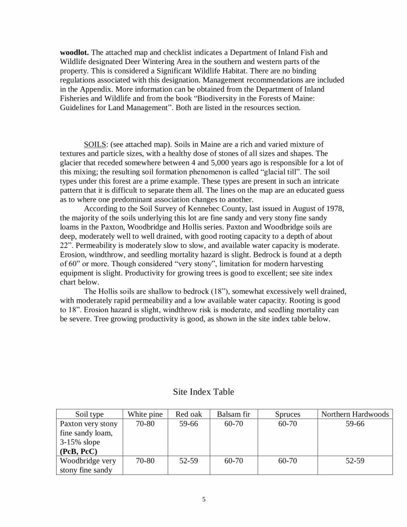
equipment is slight. Productivity for growing trees is good to excellent; see site index
chart below.
The Hollis soils are shallow to bedrock (18”), somewhat excessively well drained,
with moderately rapid permeability and a low available water capacity. Rooting is good
to 18”. Erosion hazard is slight, windthrow risk is moderate, and seedling mortality can
be severe. Tree growing productivity is good, as shown in the site index table below.
Site Index Table
Soil type White pine Red oak Balsam fir Spruces Northern Hardwoods
Paxton very stony
fine sandy loam,
3-15% slope
(PcB, PcC)
70-80 59-66 60-70 60-70 59-66
Woodbridge very
stony fine sandy
70-80 52-59 60-70 60-70 52-59

6
loam, 3-8% slope,
(WsB)
Hollis fine sandy
loam,3-25% slope
(HrB,HrC,HrD)
50-60 45-52 40-50 40-50 45-52
SPECIAL PLACES & CONCERNS: A search by the Maine Historic
Preservation Commission indicates no prehistoric archaeological sites are known to
exist on this parcel because no study has been undertaken. The attached Archaeology and
Historic Resources Review and map (c.1879) does show one former dwelling site, just
off the property.
GROWTH: In the absence of site specific continuous forest inventory data, the
general figures for the State will have to do. Based on the latest (2003) information,
Maine forests grow at an average rate of about .35 cords per acre per year. The Capital
Region (Kennebec, Knox, Lincoln, and Waldo Counties) does a little better: net growth,
including mortality but not harvesting) is .68 cd/ac/yr. This figure breaks down further to
.26 cd/ac/yr. for softwood species and .42 cd/ac/yr. for hardwoods. The goals for this
forest do not include high yields in short rotations. However, with prudently timed
thinning and spacing practices, the regional average may be reasonably attainable. The
site index on the majority of the tract’s soils is above average.
DAMAGE: This land was affected by the 1998 Ice Storm. Other damaging agents
such as insects and disease, while present in small to moderate amounts, are not a great
threat at this time. White pine blister rust is endemic to Maine, as is the white pine
weevil, which also affects white and Norway spruce. Past logging activities have left a
very few trailside trees scarred, but did not cause an overall significant loss of value to
the remaining stand. A healthy forest should contain some dying and decaying material at
all times, completing the cycle that supplies the nutrients and soil structure necessary for
the living organisms. This forest is biologically healthy.

7
FIELD METHODS: 30 variable radius inventory sample plots were taken during
April and May of 2005, using a 20-factor prism. Tally tree diameters were measured and
height estimates of current timber value (pulpwood or sawlog) were made for each stem
up to a merchantable top diameter of four inches. Utilization standards are those
expressed by the landowner, reflecting logs he would consider sawing for lumber. These
may differ from commercial mill specifications. Basal area, trees per acre, merchantable
volumes and other results were produced using NED-1 cruising software developed by
the USDA Forest Service. This level of sampling intensity meets or exceeds the
minimum statistical requirements of each stand for WoodsWISE plans. (See attached
Stand Inventory Statistics reports.)
The volume figures generated are useful for management purposes, as an
expression of relative stocking. However, experience often shows that the volume tables
used in most cruising programs may not be very accurate in predicting actual harvest
volumes. Data summary sheets are included in the appendix.

8
STAND DESCRIPTIONS & INVENTORY
The science of forest management is embodied in the sampling, measuring and
collection of data. The art of forestry involves where to draw the lines on the ground.
Tree species, size and age, soil types, elevation, drainage and past land uses such as
harvesting all point towards deciding what a stand or cover type is. Information about the
productive forest cover types follows. Please refer to the attached cover type map.
The Pine-Oak Mixed Wood: This is the dominant cover type on the tract,
comprising 80 acres. The name “Pine- Oak” refers to the primary forest community
found here. Besides eastern white pine and northern red oak, northern hardwoods such as
American beech, white and yellow birch, white and brown ash, sugar and red maple,
basswood and hop-hornbeam are abundant. Quaking and big-tooth aspens are
interspersed throughout the stand. Eastern hemlock mingles with (and in some spots,
particularly in the south west part of the stand, replaces) pine as the softwood component
of the type. Spruces, balsam fir, and northern white cedar are also present in small
amounts. The softwood/hardwood ratio is currently 53/47.
The average basal area for the stand is 85 sq. ft. /ac.; there are 285 stems per acre.
Average diameter at breast height is 6.1 inches. The stand is on the lower side of optimal
stocking, but not under-stocked. (See stocking guideline chart in Appendix.) According
to the NED-1 timber cruise program, about two thirds (6+/- Mbf/ac.) of the standing
volume is sawlog material (all grades), with the rest (6+/- cds/ac) being pulpwood or
firewood. The total volume per acre is approximately 18 cord equivalents.
The shrub layer (from ground to 10’ height) varies widely across the type, from
nearly 100% closure to nearly zero. Pine, oak, maple, fir and hemlock tree seedlings are
abundant throughout the stand, in some places reaching 15’ in height. The mid-canopy
(10-40 feet) is generally less than 50% closed. The upper canopy (40-80 feet) averages
from 50 to 75 % closed.
The Cabin Mixed Hardwood: This stand is located in the north east portion of
the tract, near the Cabin site and entirely on one side of the Old Town Rd. This
approximately 15 acre stand was not included in the late 1990’s harvesting. Red oak and
northern hardwood species such as beech, white and yellow birch, red and sugar maple,
basswood, white ash and hornbeam are predominant. A small amount of aspen is present.
Softwood component is represented by hemlock and white pine. The hardwood/softwood
ratio is currently 82/18.
The average basal area is 145 sq. ft. per acre, with 509 stems per acre. The mean
diameter is 7.2 inches. According to the hardwood stocking chart (see attached), this
stand is over-stocked. NED-1 shows approximately 2.8 Mbf per acre of sawlog quality
stems, or 21%. The remaining 21 cords per acre are in pulp or firewood classification.
Total volume according to NED-1 is nearly 27 cords per acre.
9
The shrub layer is sparse, with scattered hemlock, red maple, red oak, sugar
maple, white pine and beech seedlings. The mid-canopy is less than 50% closed, with the
same species present. The overstory runs from 75 to 95 % closed at height of 50 to 60
feet.
The Pasture: This 9 acre stand includes the area clearcut in 1980. No formal inventory
plots were taken here, as the total volume is less than 6 cords per acre. Aspen, red and
sugar maple, red oak and white ash are the predominant tree species here. Sapling heights
are 15-25 ft. Crown closure is near 100% at that level.
Other Cover Types: There is approximately one acre taken up by the Cabin and Garden
Site. This area has not been used much recently, but remains open. The forest is
encroaching, but use of part of this area for logging activities in the late 1990’s has
slowed the process.
There are approximately three acres of Wetlands associated with Beck’s Brook.
This is a forested wetland, not subject to any special regulations. However, growth and
response will be slow in these saturated sites, and habitat values may be higher than
timber values. No formal inventory plots were taken here.

10
MANAGEMENT RECOMMENDATIONS
In essentially even-aged stands such as are found in most of Maine, the fact that
some trees are better established in the canopy than others is largely a result of
competition for sunlight, water and nutrients. The “winning” trees, distinguished by
larger and fuller crowns, are known as dominant and co-dominants. Trees with smaller
crowns are referred to as intermediates or suppressed, and they are likely to be squeezed
out of the stand by natural process. Harvesting these suppressed and intermediate stems is
called “thinning from below”. As long as the dominant and co-dominant trees are
providing desirable attributes, such as adding timber value, producing mast or habitat
niche, or providing aesthetic pleasure, they should be grown to an optimum point. The
optimum point will vary according to the individual stem, species, and the attribute value.
For instance, an optimum size for a red oak of veneer log quality is between 18” and 24”
diameter at breast height (dbh). These trees are often referred to as “crop trees”. A
guiding management principle is to concentrate more of the growth potential of the site
on these crop trees by giving their crowns ample space to expand, thereby maintaining
and enhancing their growth rates. The idea is to combine thinning from below with crop
tree spacing, leaving a valuable and productive stand. This approach has been and should
continue to be the blueprint for forest management activities on the Beck forest.
Some trees are more valuable for providing food or shelter than for wood
products. Living and standing dead cavity trees, hard mast producers, and closed crown
evergreen groups are examples. They provide the “crop” of bio-diversity, and should be
part of the management scheme. A handful of stems on each acre should be allowed to
grow old and die; their “crop” is the aforementioned snag and downed woody material.
These do not have to be trees with high timber value to achieve important elements of
forest structure. With good planning and knowledge, a forest can be managed for a suite
of values.
More detailed recommendations by cover type follow.
PINE-OAK MIXEDWOOD: Based on current stocking levels, no commercial harvest
is recommended for this stand during the planning period. Rather the next ten years will
be a good opportunity for Ken to move systematically through the stand, identifying and
pruning crop trees, and cutting a minimal volume (1-2 cords per acre) of suppressed,
damaged or declining trees. Most of this material will be utilized for firewood or an
occasional own-use sawlog. To facilitate this, a series of compartments have been set up
along natural and logistical boundaries, such as stream channels, wetland edges, roads or
trails, and stone walls. See section on Compartments.
The process of identifying crop trees may be approached more formally than
usual. Trees could be physically tagged in the field, with some weather proof and UV
resistant material. A coding system could be devised to include compartment, tree
species, volume and product information, and possibly GPS coordinates. The landowner
is adept at creating data bases, and will track the crop tree inventory this way. Eventually,
application of Geographic Information System mapping will provide sophisticated tools
for marketing and utilization. This is expected to be an on-going process. Crop tree
11
information will be revised as growth, mortality, and harvesting occur. A goal will be to
cover the entire forest at least once in the Planning Period. Some crop trees may receive a
second or third visit during this period.
CABIN MIXED HARDWOOD: This stand has not been harvested since before Ken
moved on to the land, more than 25 years ago. It is overstocked according to the
guidelines for hardwood growth. Little or no regeneration has been adequately
established. All this points to the need for a commercial harvest. This harvest should take
place as soon as feasible, which should be within the next two years. The optimum
stocking for this stand is 60 square feet, according to the stocking chart. This would mean
a nearly 60 % reduction in basal area. A slightly more conservative target of a 50%
reduction in stand density to about 70 square feet may be more prudent. Then further
“fine-tuning” of stocking can be effectively carried out by the landowner, similar to the
activity in the Pine-Oak compartments.
A 50 % harvest of the Cabin Mixed-wood stand should yield approximately 200
cords. This should mostly consist of pulp and firewood quality stems, and a minimum of
low-grade log trees that are either damaged or in the process of being crowded out of the
canopy anyway. Aspen, hemlock, red maple and beech should be the primary species to
cut. The actual designation of harvest trees would best be done on an individual basis.
Based on the landowner’s objectives, some amount of this material may be stock-piled
for further processing and sale by him as firewood. A creative variation on a traditional
timber stumpage sale may be required to reach this goal. Details may be specified in a
subsequent Harvest Operation Plan.
As follow-up to the commercial harvest, the same recommendations as the Pine-
Oak Mixedwood Stand should be applied.
THE PASTURE: This stand is a good candidate for pre-commercial thinning and crop
trees release practices. Future crop trees should be identified, primarily red oaks, maples,
and ash. Competing stems should be removed on at least two sides. Some small amounts
of useable firewood may be generated, but this is mostly an investment of energy that
will improve future returns. This prescription should be carried out over the course of the
planning period, and may be tied to the availability of cost-share funding to defray
expenses.
OTHER COVER TYPES: No harvesting is recommended for the Wetlands at this time.
There is a lot of work to do on sites that will return greater benefits. The Cabin and
Garden site should be kept open, most likely as a staging area for logging and wood
processing. This will also add the ecological benefit of a small early-successional
opening in the forest, with some “edge” effect.

12
MANAGEMENT COMPARTMENTS
For the purposes of organizing and prioritizing the recommendations of this plan,
ten compartments have been established (see attached map). All are numbered; some are
also given a place name that has meaning for the landowner. Compartments do not
necessarily follow the same boundaries as the cover types, but are generally close. Over
time, more names may be assigned, and other sub-boundaries may be delineated. In this
Plan, the numbers will be used for identification purposes.
First priority: Compartments I and II, which closely correspond to the cabin
Mixed Hardwood Stand. See Stand recommendations above.
Second priority: Compartment IV, which closely corresponds to the pasture
Stand. This is mostly non-commercial work, and may be stretched over the entire
planning period to fit available cost-share funding. See Stand recommendations above.
Third priority: Compartments III, V, VII, VIII contain the highest numbers of
future white pine crop trees, and therefore should be worked through sooner, as access
allows.
Fourth priority: Compartments X, IX, and VI. X and IX may move up in the list
because of relative ease of access and numbers of hardwood crop trees.
Other recommended activities and practices:
Prune suitable white pine crop trees to 24’ height.
Expand road and trail system to match available yarding and hauling equipment. Manage
run-off and stabilize and control erosion on the road and trail system.
Recreational activities, Aesthetics and visual impact: A key to the recreational
uses will be maintaining a natural harmony in the appearance of the forest, particularly
along trail corridors. Principles of aesthetics should be incorporated in any thinning and
harvesting activities. As view-points are discovered and identified, some light additional
cutting may be done to enhance vistas. Unique natural features such as legacy trees can
be integrated into this system as focal points. The old stone walls that lace the property
are especially good visually. Signage and trail marking can add to the overall woodland
experience for guests of the local bed and breakfasts, as well as the public at large.
Cost share programs. There exist today two primary avenues for financial
assistance to forest landowners. The Environmental Quality Improvement Program is
administered by the Natural Resource Conservation Service of the U.S. Department of
Agriculture. The Kennebec County District Conservationist will assist landowners in the

13
preparation of a Conservation Plan that will outline the details of the practices to be done.
Projects are ranked and funded according to priority and availability of money. Another
source of federal cost-share dollars is the Forest Legacy Enhancement Program (FLEP),
administered through the WoodsWISE Program by the Maine Forest Service. Check with
the District Ranger for details regarding project application periods.

14
Recommended Schedule of Activities
TIME PERIOD STAND NAME RECOMMENDED
PRACTICE
2005-2015 PROPERTY LINES Establish, Brush, Blaze and
Paint; Maintain.
2005-2007 Cabin Mixed
Hardwood
Commercial harvest to
optimize stocking and crown
spacing of future crop trees.
2005-2015 The Pasture Pre-commercially thin and
release crop trees on 3-4
sides.
2005-2015 All Identify, tag, and prune crop
trees. Establish inventory
database to track growth and
yield.
2005-2015 All Expand and improve access
trail system for small tractor,
truck or forwarding trailer.
Apply BMPs as needed to
prevent erosion and protect
water quality.
15
Best Management Practices
Best Management Practices (BMP’s) are a critical part of sustainable forestry. It
makes sense to plan forest operations carefully and consider their impacts before starting.
Good design, construction, and maintenance of roads, landings, and trails protects water
quality and your investment in your woodlot. By using BMP’s, non-point sources of
pollution and rutting can be reduced or eliminated, both during and after active harvesting
operations. BMP’s help you to comply with Department of Environmental Protection or
Land Use Regulation Commission regulations.
Soil erosion in Maine occurs primarily where water is given a chance to form a
channel and gain velocity. Rutting from harvesting equipment, as well as heavy foot
traffic, can provide the channel. Timing harvests to occur during frozen or dry conditions
will reduce the likelihood of this occurring. Using limbs and tops or mulch to stabilize
equipment travel corridors is another good practice. Boardwalks over wet areas make
hiking trails more enjoyable as well as protecting the soil from compaction.
The water quality concern most applicable to this involves the road system. As
mentioned above, additional BMP’s should be constructed to manage run-off and protect
the local watershed. Care should also be exercised when harvesting around the
intermittent streams. Crossings should be minimized and approaches stabilized with
brush. Crossing locations should be chosen with care. Temporary portable skid bridges
are excellent BMP’s for this purpose. Adequately sized and properly installed culverts
should be used for gravel road crossings. Ditch backslopes should be stabilized with seed
or mulch and no steeper than 2:1. Adequate cross-drainage and diversion devices should
be installed, with stone rip-rap at the outlets to disperse run-off into undisturbed forest
floor. Please see the Maine Forest Service publication “Protecting Maine’s Water
Quality” for more detailed guidelines.
16
Glossary
Acre - A unit of land area containing 43,560 square feet. If it is a square, the sides will
be 208.7 feet long.
Basal Area - Cross-sectional area of a tree, measured at DBH. Used as a measure of
stand density, expressed in square feet/acre.
Board Foot - Unit of measure, referring to a 1” by 1’ by 1’ board. Used in scaling
sawlogs and veneer.
Buffer Zone - A transitional zone between two distinct habitats, a buffer zone can act to
protect sensitive areas from degradation and may provide additional diversity
within a landscape. Generally used along water bodies or around dwellings.
Cord - A unit of measure for stacked wood encompassing 128 cubic feet of wood, bark
and air space (4’ by 4’ by 8’). Roughly equivalent to 500 board feet of volume.
Crop Tree - Those trees in a stand left after thinning and destined to form the “final”
crop, usually the highest quality and most valuable of all the trees in a stand.
DBH - Diameter at breast height, measured 4.5 feet above the ground.
Den Tree - A tree with a cavity or other characteristics used as habitat by wildlife
Dominant Tree –refers to a tree’s crown position in the canopy. This tree will dominate
its immediate area. It receives full light from above and partly from the sides.
Epicormic Branching - Branches arising from buds in the bark along main stem, most
commonly occurring in trees under stress.
Forest type/stand - A group of trees, occupying a specific area and similar enough in
composition, species, age arrangement and condition, as to be distinguished from other
adjoining forested areas.
Girdle - The removal or killing of a ring of bark around the tree stem so that the flow of
nutrients from the crown to roots is blocked. The roots die and the whole tree is killed.
Occasionally used to remove “cull “trees, or to recruit snags and large woody debris.
Intermediate Tree – refers to a tree’s crown position in the canopy. A tree shorter than a
dominant but extending into the crown cover formed by dominant and co-dominant trees;
receiving some direct sunlight from above but none from the sides.
Landing - A place where logs and pulp are assembled for loading and transportation to a
mill. Also called a header, yard, or deck.

17
Mast - Any nut, seed, or fruit produced by woody plants and consumed by wildlife.
MBF - Thousand board feet, used as a volume measure of sawlogs; 2 cords = 1 MBF,
approximately.
Overtopped/Suppressed – refers to a tree’s crown position in the canopy. Trees with
crowns entirely below the general level of the crown cover, receiving no direct light
either from above or from the sides.
Raptor - Predatory birds such as hawks and eagles.
Regeneration - Seedlings and the methods used to establish them in a stand. May be
produced naturally from seed of mature trees, or raised in nurseries for “artificial”
planting.
Residual Stand - Those trees remaining uncut (and hopefully undamaged) following a
harvesting operation.
Riparian Area - An area adjacent to a water body such as a stream or pond. The
transitional zone between aquatic habitats and dry or upland habitats. Riparian areas are
very important in the protection of water quality and have many values for wildlife.
Release Operations - The process by which young stands of desirable trees, not past the
sapling stage, are freed from the competition of undesirable trees that threaten to suppress
them. Also called overstory removal.
Sapling - A small tree less than four inches at dbh, and over 4.5 feet tall. These are
usually, but not always young trees.
Sawlog - A portion of a tree that meets minimum standards of diameter, length, and
defect for sawmills. Usually at least 8’ long, sound and straight, and with minimum
diameters specified by specific sawmills. Boards are sawn from sawlogs to be made into
furniture, flooring and construction lumber, etc.
Scarification - The disturbance of the forest floor to expose areas of mineral soil. This is
done to prepare a seedbed and encourage establishment of desired species of tree
seedlings such as white pine or northern hardwoods.
Site index - The height to which a tree species will grow in 50 years on a given site.
Slash - The tops, branches and non-merchantable parts of trees left on the ground after a
harvesting job.
Snags - Dead standing trees, often with tops broken off, which serve as perches,
lookouts, foraging, and home sites for wildlife. Considered extremely hazardous by
O.S.H.A.

18
Species Diversity - Maintaining a number of wildlife species; requires diversity of
habitats.
Spring Pole - Saplings or smaller trees that are bent over by a larger felled tree. They
can be under extreme tension and are dangerous if not cut properly.
Stocking - The degree of occupancy of the growing space of land by trees, measured in
stems/acre.
TSI - Timber stand improvement. Includes activities such as pruning, pre-commercial
or non-commercial thinning, weeding, and/or crop tree release.
Topography - That characteristic of the land determined by surface features; usually
expressed as flat, rolling, gently rolling, or mountainous.
Veneer Logs - Usually a very high quality product. Veneer is peeled or sliced for
paneling, furniture, and other uses.
Vigor - Ability of a tree to transform environmental resources into its own substances in
large quantities and at a rapid pace.
Wildlife Habitat - Four basic components of habitat are food, water, cover, and space.
Specific requirements for each of these components will vary with species, season of
year, and the age and sex of the animal.
Wolf Trees - Usually large in size, limby, and poorly formed with little timber value.
Same function as snags, except the tree is still alive and possibly producing mast.

19
Resources (2005)
Inland Fisheries and Wildlife Department: 284 State St., Augusta, Me., 04330; 287-8000.
Regional Biologist: Jim Connolly, Region B, 270 Lyons Rd., Sidney, Me., 04330-9711;
tel.: 547-5318
Maine Forest Service, Department of Conservation: 22 State House Station, Augusta,
Me., 04333; 1-800-367-0223; 287-2791; www.maineforestservice.org
District Ranger: Patty Cormier, 536 Waldoboro Rd., Jefferson, Me., 04348
Tel.: 549-9003
Maine Natural Areas Program: 157 Hospital St., State House Station #93, Augusta, Me.,
04333; Toni Pied, Assistant Ecologist, 287-8044
Maine Department of Environmental Protection: Augusta, Me.; 287-7688
Small Woodland Owners Association of Maine (SWOAM): offices at Pine Tree State
Arboretum, 153 Hospital St., P.O. Box 836, Augusta, Me., 04332. 626-0005 or 877-467-
9626. [email protected]
Paul Miller, SWOAM forester, 1-866-845-3047
Project Learning Tree: P.O. Box 344, Augusta, Maine, 04332. 207 626-7990 (phone);
Pat Maloney, State Coordinator, 621-8245 (fax)
www.mainetreefoundation.org
Natural Resources Conservation Service / Kennebec County Soil & Water Conservation
District: 9 Green St., Third Floor, Augusta, Me., 04330-6393.
Ron Desrosier, District Conservationist, 622-7847
Nate Sylvester, GIS specialist, 622-7847, x 3
Best Management Practices for Forestry: Protecting Maine’s Water Quality. 2004. Maine
Department of Conservation, Maine Forest Service.
Focus Species Forestry: A Guide to Integrating Timber and Biodiversity Management in
Maine, 2004. Rob Bryan. Maine Audubon, in cooperation with Maine Department of
Conservation, Professional Logging Contractors of Maine, Master Logger Program, and
Small Woodland Owners Association of Maine.
Biodiversity in the Forests of Maine, 1999. Flatebo, Foss, and Pelletier. University of
Maine Cooperative Extension Bulletin # 7147

1 inch = 500 feet
Data Sources: Maine Office of GIS, Woody ForrestPhoto Date: 5-19-03Map Created: 7/ 12/05 by N. SylvesterRevised: 3/21/12 by A. Grindle
ÖForest Lands of Ken E. Bek Cabin Mixed Hardwood
Cabin and Garden SitePine Oak Mixed WoodThe PastureWetland
Kennebec Soil & Water Conservation District
×
Tract BoundaryDiscontinued Town RoadSeasonal RoadYarding TrailPerennial StreamIntermittent Stream
× House
Old Town Road
Town of Kennebec Center, Maine
Swam
py Br
ook
Cabin Brook
Bek's Stream
Big Birch Brook

PcC
HrC
PcBHrC
HrD
WsB
RdAHrB
PcD
WsB
HrB
PeC
PeCPcD
PeC
HrB
PcC
1 inch = 500 feet
Data Sources: Maine Office of GIS, Woody ForrestPhoto Date: 5-19-03Map Created: 7/ 12/05 by N. SylvesterRevised: 3/21/12 by A. Grindle
ÖForest Lands of Ken E. Bek
HrBHrCHrDPcBPcC
WsB
PcDPeCRdA
HOLLIS FINE SANDY LOAM 3 TO 8% SLOPESHOLLIS FINE SANDY LOAM, 8 TO 15% SLOPESHOLLIS FINE SANDY LOAM, 15 TO 25% SLOPESPAXTON VERY STONY FINE SANDY LOAM, 3 TO 8% SLOPESPAXTON VERY STONY FINE SANDY LOAM, 8 TO 15% SLOPES
WOODBRIDGE VERY STONY FINE SANDY LOAM, 3 TO 8% SLOPES
PAXTON VERY STONY FINE SANDY LOAM, 15 TO 25% SLOPESPAXTON-CHARLTON VERY STONY FINE SANDY LOAM, 8 TO 15% SLOPESRIDGEBURY VERY STONY FINE SANDY LOAM
WetlandCover Type Boundary
Kennebec Soil & Water Conservation District
×
Discontinued Town RoadSeasonal RoadYarding TrailPerennial StreamIntermittent Stream
× House
Town of Kennebec Center, Maine
Old Town Road
Cabin Brook
Bek's Stream
Big Birch Brook
Swam
py Br
ook