fort mason history walk
TRANSCRIPT

Fort Mason History WalkAn Army Post at the Edge of San Francisco
National Park ServiceU.S. Department of the Interior
Fort MasonGolden Gate National Recreation Area

1 Fort Mason History Walk: An Army Post at the Edge of San Francisco Printed on recycled paper using soy-based inks
Franklin
St
Van
Ness
Ave
Go
ug
hSt
Octavia
St
Lagu
na
St
Bu
chan
anSt
North P
Bay
Fr
Marina Blvd
North Point
Beach
Bay St
Franklin
St
Funston
Pope
MacA
rthur
MacDowell Rd
Mac Arthur
Pier3
-Festival Pavillio
n
Pier2
-H
erbst
Pavillion
Pier1
B CD E
A
Firehouse
Gatehouse
101
102
BlackPoint
Pier 4(closed)
F
201
HistoricOfficersClub
9
7
11
2
3
4
235
239
238
232
231
204
240241
34
33
36
3339
38
37
32
ParkHeadquarters
tenniscourts
1
5049
48
47
4644
41
42
43
H
San FranciscoMaritime NHPHeadquarters& Library
V
230
SaNational Historical Park
F
GreatMeadow
RepresentativePhillip BurtonStatue
BufanoStatue
CommunityGardens
Lower Fo
rtMason
Upper Fort
MasonFort Mason
Center Office
CowellTheater
R
ParkOffices
Residential
stairs
stairs
G
MarinaSafeway
B
30,42,47,49,1028
stairs
UpperFort MasonMain Entrance
Sea ScoutBase
S.F. Fire DepartmentPump Station
Bocce BallCourts
LowerFort MasonEntrance
1
Golden Gate NationalRecreation Area
1
Gate
?1
2
3
4
5
6
8
79
Fort MasonSan Francisco, CA
Fort Mason Waysides Self-Guided Stops#
National Park Service 2
Welcome to Fort Mason, one of the oldest military basesin San Francisco! Step back in time to visit buildings and astreetscape that have survived since before the 1906 earth-quake and fires. This self-guiding brochure takes you on awalking tour of Fort Mason, as well as explaining whereexamples of historic building styles can be found on this formerarmy post. While a specific walking order is suggested, way-sides exhibits provide you with additional information, sofeel free to wander, exploring what interests you.
Be Advised
• Most of the Fort Mason buildings, including the residences,are currently occupied, and visits to their interiors are notallowed.
• Please keep in mind that Golden Gate National RecreationArea is an urban park, and exercise common sense whileusing its trails, especially after dark.
On the cover: Fort Mason, aerialview, circa 1927.
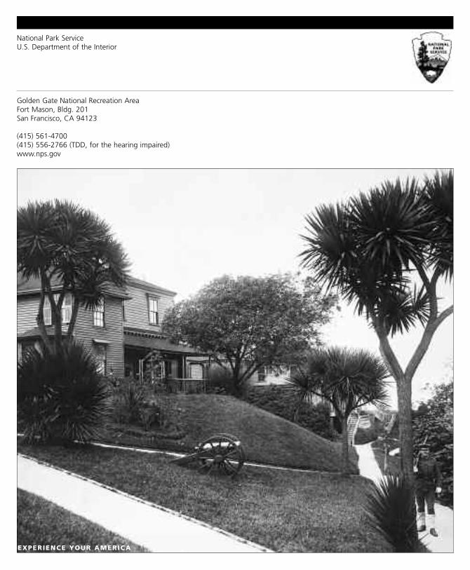
On the back: Quarters 3 and 4,facing the bay, showing FortMason’s former military land-scape. Photo circa 1915.
The Route
LLeennggtthh: Approximately 0.5-mile
NNuummbbeerr ooff SSttooppss:: 9
TTiimmee rreeqquuiirreedd:: Approximately 45 minutes
AAcccceessss:: The route is paved, but watch for steps andcracked pavement.
Restrooms are located at the southwest corner of the GreatMeadow (see the map).
Questions? Please stop by the Fort Mason VisitorInformation Center, located in the GGNRA HeadquartersBuilding 201, open Monday through Friday, 8:30 to 5:00 orphone (415) 561-4700.
All images courtesy Golden Gate National Recreation Area, Park Archives, unless otherwise noted

3 Fort Mason History Walk: An Army Post at the Edge of San Francisco
Start the tour outside Building 201, GGNRA Headquarters.
Defending the Bay
The San Francisco Bay Area, long recognized as aland rich with economic opportunity, has histori-cally attracted the attention of expanding nations,
including Spain, Mexico, Great Britain, Russia, and theUnited States. In 1776, the first Europeans—Spanish set-tlers—arrived and established Spain’s northernmost outpost,a presidio and a Catholic mission.
Early on, the land now occupied by Fort Mason was recog-nized as valuable. This hilltop promontory, overlooking anarrow stretch of the bay, was an obvious choice for thelocation of defensive fortifications. The Spanish built theBatteria San Jose here in 1797. When the United States tookcontrol of California in 1846, its military planners placed ahigh priority on protecting the rich bay from foreign invasion,notably by the British and Russians who maintained exten-sive fur trapping interests along the Pacific coast.
This 1865 illustration of Point SanJose (looking north towards thebay), was taken after the army hadestablished the post and showsthe original landscape of sanddunes and dune scrub. 1
National Park Service 4
The army therefore began to identify properties in San Franciscothat were well suited to national defense. In 1850, recognizing thegeographic and economic importance of the San Francisco Bayand the cargo that was funneled through its strait, PresidentMillard Fillmore established this land as a military reservation,designating it Point San Jose.
Now leave the GGNRA Headquarters and turn left on MacArthurStreet just to the east. Continue up the street and stop at the cornerof Pope and MacArthur. Look south past Fort Mason, toward thecity, and try to imagine this area minus trees, buildings and sky-scrapers.
Gold Rush Transforms San Francisco
In 1846, San Francisco, originally named Yerba Buena,was a sleepy port town with a few temporary wood-frame shacks clustered around the docks and wharves.
The ocean wind blew constantly, spreading sand and dirt acrossthe treeless landscape. At the time, only about 500 people livedin San Francisco, most of them sailors, fishermen, whalers, furtrappers, merchants and descendents of original settlers.California’s first government seat was 150 miles to the south, atMonterey. Except for the presidio and Mission Delores, youngSan Francisco had few permanent buildings.
Then in January 1848, gold was discovered in the foothills ofthe Sierra Nevada, and San Francisco would never be the sameagain. From all over the world, people came to California byship, wagon, and on foot to seek their fortune in the gold fields.Almost overnight, San Francisco was transformed from a small,dusty port town into a booming city filled with makeshift tent-houses, hotels, stores, saloons, gambling halls, and shanties. Bylate 1848, the number of people living in the city had risen toapproximately 850 and by 1849, as the gold rush fever sweptthrough the country, the city’s population had increased to astaggering 25,000. In 1860, on the eve of the Civil War, therewere almost 57,000 people living in the city by the bay.
22

5 Fort Mason History Walk: An Army Post at the Edge of San Francisco
San Francisco’s population was growing at an alarming rateand buildings could not be constructed fast enough toaccommodate everyone. Housing was so scarce that peoplepaid $1 a night (a substantial sum in the 1850s and an averageday’s pay for some people) to sleep in packing crates.
Cross MacArthur and turn left onto Franklin Street. Continueup on the right-hand side of Franklin Street and stop at thefirst driveway on your right (across from the Fort MasonChapel and near the lawn in front of Quarters 1). As youwalk up Franklin Street, note that the civilian-built residencesare on the right-hand side of the street, while the army-builtstructures are on the left side.
Black Point: A Civilian Neighborhood on Military Land
San Francisco’s population explosion affected Fort Mason,which was known to locals as Black Point because of the
large clusters of dark and wind-blown laurel trees that grewat the bluff’s edge. Although the U.S. Army had reservedthis land, by the mid-1850s, there was still no military pres-ence here. The army had not constructed any buildings andno soldiers were stationed at Point San Jose. A scenic andunderutilized piece of property that offered excellent viewsof the bay and refuge from the city, Black Point was excep-tionally desirable to civilians in need of homes. And frankly,in the midst of the chaotic and somewhat lawless days of earlySan Francisco, the U.S. government had trouble enforcing itsproperty claims. As a result, a few entrepreneurial civiliansmoved into this undeveloped area, claimed it for their own,and began construction.
Proceed up the street to the second driveway on the right side(across from Building 232). Look to your right for a glimpseof Aquatic Park.Then continue to the third driveway; Quarters2 is on your right and Quarters 3 is on your left. Please keepin mind that these homes are occupied, and go no farther thanthe driveway entrance.
By 1855, Leonard Haskell and George Eggleton, both SanFrancisco real estate developers, had constructed at Black
33
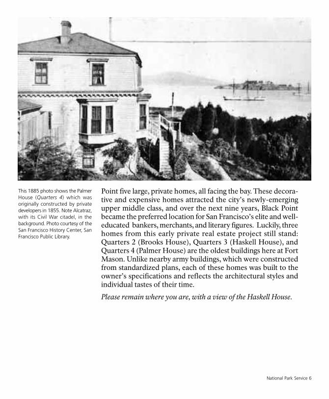
National Park Service 6
Point five large, private homes, all facing the bay. These decora-tive and expensive homes attracted the city’s newly-emergingupper middle class, and over the next nine years, Black Pointbecame the preferred location for San Francisco’s elite and well-educated bankers, merchants, and literary figures. Luckily, threehomes from this early private real estate project still stand:Quarters 2 (Brooks House), Quarters 3 (Haskell House), andQuarters 4 (Palmer House) are the oldest buildings here at FortMason. Unlike nearby army buildings, which were constructedfrom standardized plans, each of these homes was built to theowner’s specifications and reflects the architectural styles andindividual tastes of their time.
Please remain where you are, with a view of the Haskell House.
This 1885 photo shows the PalmerHouse (Quarters 4) which wasoriginally constructed by privatedevelopers in 1855. Note Alcatraz,with its Civil War citadel, in thebackground. Photo courtesy of theSan Francisco History Center, SanFrancisco Public Library.

The Anti-Slavery Movement at BlackPoint
By the late 1850s, the State of California hadbecome a focus of the heated issue of slavery. Its
population stimulated by the Gold Rush, California wasnow home to people from the North—often referred to asfree-soilers—who were against slavery, and transplantedSoutherners who supported the institution of slavery. ManySoutherners also passionately felt that, if need be, Southernstates should be able to secede from the union, to preserveslavery and the larger concept of states’ rights. The GoldRush also brought both free African-American settlers,seeking their fortunes, as well as enslaved African-Americans, who were forced to dig for their owners’ benefit.
As new states were added to the union, Congress tried toachieve a balance by carefully admitting an equal number ofas slave states and free states. After much bitter nationaldebate, California entered as a free-state, part of the so-called Compromise of 1850. However, its vague antislaveryconstitution was open for extensive interpretation. And
44
7 Fort Mason History Walk: An Army Post at the Edge of San Francisco
Quarters 2, also constructed in1855 by private developers, wasoriginally located further northnear the Officer’s Club. In 1877the Army moved the building to itscurrent location. Photo circa 1900.

National Park Service 8
because people of color could not testify for or against a whiteperson in a court of law, both African-Americans and localIndians were vulnerable to a white-only court system.
A chapter of the national anti-slavery movement was writtenhere at Black Point. By the mid-1850s, the civilian neighborhoodhad become home to a small but influential group of white res-idents who were openly hostile to secession and slavery. LeonardHaskell, Black Point’s developer and a resident, was a free-soilerand politically well-connected. He and a large group of influen-tial friends actively supported the anti-slavery movement by pro-moting David Broderick in his effort to become California’s U.S.Senator. Broderick was a self-made man who was outspokenlyopposed to the expansion of slavery. In 1859, California StateSupreme Court Justice David S. Terry, Broderick’s political oppo-nent, gave a searing speech, attacking Broderick and his anti-slavery stance. Broderick responded to Terry with unflatteringcomments, and Terry challenged him to a duel, which was thenillegal in San Francisco.
On September 13, 1859, the Broderick - Terry duel commencedat Lake Merced, south of the city. Broderick’s gun misfired andTerry, a man known for his hot temper and tendency towardviolence, aimed directly at Broderick’s chest and fired, wound-ing him severely. Broderick was rushed to Haskell’s home hereat Black Point (the house to your right), where he died threedays later, reportedly saying “They killed me because I amopposed to the extension of slavery and a corrupt administration.”This San Francisco duel drew national attention. Terry and hissouthern sympathizers were accused of assassination, whileDavid Broderick’s death made him a martyr for the anti-slaverymovement. The Broderick-Terry duel reflected the nation’s largerand more violent division and pushed it further toward a civil war.
Continue up Franklin and stop near the upper end of the tree-filledcircle. Look in the direction of the path leading north. Instead of thislandscape, marked by mature vegetation and simple army build-ings, imagine a modest Victorian cottage perched at the edge of thebluff, surrounded by rose bushes and garden paths. If time permits,you may want to follow this path to the grassy area where theFremont house once stood.
David Colbreth Broderick (1820-1859), was member of theCalifornia State Senate from 1850to 1851 and then elected as aDemocrat to the United StatesSenate in 1857. Photo dateunknown, courtesy of the SanFrancisco History Center, SanFrancisco Public Library.

9 Fort Mason History Walk: An Army Post at the Edge of San Francisco
Jessie Benton Fremont
Jessie Benton Fremont lived here at Black Point,at the end of this street. The wife of the explorerJohn Fremont and the daughter of Thomas Hart
Benton, a powerful U.S. senator from Missouri, Jessie carvedout special recognition on her own. She was bright, coura-geous, and ambitious at a time when these attributes were dis-couraged in women. Both she and her husband werefree-soilers, and lobbied hard to eliminate slavery. Afterhaving lived in New York; Washington, D.C.; Paris; and theSierra foothills, she and John moved to Black Point in 1860.Sited on the bluff, their house and its grounds occupied 13acres of land; once she moved in, she oversaw the con-struction of walkways and drives and the plantings of roses,geraniums, and fuchsias. She loved her home at Black Point,which was nicknamed “Porter’s Lodge”, because it pro-vided her and their three children with what she defined asa healthy mixture of city and country living.
Throughout her life, Jessie Fremont was politically andsocially active, and her home here became the center of SanFrancisco’s intellectual life. Jessie invited like-minded writers(both burgeoning and established), spiritual leaders, andartists to her house, and they were encouraged to walk thelandscaped grounds, to develop their thoughts, and to engagein lively conversations with one another. Among her friendswere Reverend Thomas Starr King, the impassionedUnitarian minister who supported preserving the Unionand would later charter national charities; Bret Harte, theyoung writer who would become a leader of the SanFrancisco literary movement and expose the American Westto the world through poems and articles; and CarletonWatkins, the commercial photographer who would becomefamous for capturing California’s landscapes on glass plate.
In the summer of 1861, as the long-feared Civil War brokeout, John Fremont was summoned east to active militaryservice, and Jessie and her family left their peaceful home onthe bluff and faced the challenges of living in a countrydivided by war.
55
Jessie Benton Fremont (1824-1902), shown here on the porch ofher Black Point house, loved thefact that her home was so close tothe water. In 1860, she wrote that“the flapping of the sails as theschooners round this point andthe noise of their paddles as thestreamers pass are householdsounds.... It is like being on thebow of a ship.” Photo circa 1861,courtesy of the San FranciscoHistory Center, San FranciscoPublic Library.

National Park Service 10
From Franklin, turn left (west) onto Funston Street. Walk downFunston and notice the 19th-century army buildings on both sidesof the street. Stop at the corner of Funston and Pope. You are nowstanding in what was the middle of the late 19th-century armypost.The western half of the post is gone, but the eastern side remainsintact. Feel free to cut back through to Franklin to get a second lookat the early army buildings.
Military Life at Point San Jose
The outbreak of the Civil War forced the army to takepermanent possession of Black Point and the army re-established the original name, Point San Jose. Because the
Union government feared possible Confederate attacks againstcommercial sailing ships and their valuable cargoes, as well asagainst the city itself, the army quickly identified the bay’s strate-gic vulnerabilities and ordered better defenses to be constructedimmediately. Point San Jose’s prominent bluff, in tandem with theforts at Alcatraz and Fort Point, served as an ideal location foranother pair of gun batteries. The civilian residents, whom thearmy referred to as genteel squatters, were evicted to free up theirhouses for incoming army officers. Jessie Benton Fremont’shome, once the center of San Francisco’s literary society, wastorn down to make way for one of the new harbor defense bat-teries on the point. Civilian life here was officially over.
66
Building 240, built in the 1860sas company barracks for theartillery troops, was one of thefirst buildings that the Army con-structed at Point San Jose. Photodate unknown.

In many ways, Point San Jose was laid out and constructed likemost late 19th century army posts, which were designed tofunction as small, self-sufficient towns. The main paradeground, an open, grassy square dedicated to drills, marches,parades, and public ceremonies, was the physical and orga-nizational center of post life. The most significant militarybuildings, like the post headquarters, the hospital, the barracks,and the mess halls were constructed on a rectangular gridaround the main parade ground. However, because the armyseized the existing civilian’s buildings for officers’ housing,Point San Jose evolved differently than standard army posts.Here the officers’ homes faced out toward the city, ratherthan in towards the main parade ground. Also, the historicalflagpole was not located in its traditional place in the middleof the parade ground but off to the east side, near the east-facing headquarters building (the flagpole was then latermoved closer to Building 201).
By 1870, Point San Jose comprised several different types ofbuildings. There was a six-bed hospital to provide the men withadequate health care, and a kitchen, a bakery and a postgarden for fresh food. Laundresses’ quarters housed the fewwomen on post, who were hired to keep the uniforms andlinens clean. Army life was often monotonous and alcohol fre-quently provoked problems, so Point San Jose had a guardhouse, that doubled as both a security post and jail withprison cells for drunk and unruly soldiers. Like all army post,the more utilitarian or unsightly buildings, like latrines, stables,and corrals, were located at the outskirts of the post.
When Point San Jose was first established, the post was pre-dominantly a bachelor society. Like soldiers at posts spreadacross the western United States, men stationed at Point SanJose participated in the resolution of the “Indian Wars” andstabilizing the western frontier. The army strongly discouragedmarried junior officers, and enlisted men were specifically for-bidden to marry. The general feeling was that women andchildren had no place within army life. But by the turn of thecentury, as part of an effort to improve morale, the army soft-ened its policy and officers were allowed to bring their fam-ilies with them.
This photograph shows a FortMason family sometime around1900.
11 Fort Mason History Walk: An Army Post at the Edge of San Francisco

National Park Service 12
Renamed Fort Mason in 1882 to honor Colonel Richard BarnesMason, the second military governor and commander ofCalifornia (1847 to 1849), the army post played an importantrole in the life of the city it bordered. In an effort to make the placemore hospitable and pleasing, Congress continued to fund addi-tional construction and general landscaping improvements.
As an 1884 article in The Daily Alta California describing FortMason noted:
The houses are neat and comfortable, but not extravagant inarchitecture or appointment. The grounds, once as dreary as awaste of sand as the outlying desert, have been wonderfully beau-tified with lawns, shade trees and flowers and no more pleasinga place could be designed for a military headquarters or anythingelse. A high lattice fence separates the officers’ quarters fromthose of the garrison, and in many places the fence is coveredwith flowering vines to its full height of twenty-five feet.
Continue down Pope, which was the original east side of the mainparade round. At the flagpole, at the corner of Pope and MacArthur,turn to your right and continue along the sidewalk to the GreatMeadow, which is the large grass field on the west side of Building201. Follow the red sidewalk to the benches at the first little hill.
This general view of Fort Masonshows the post after almost 30years of army occupation. Photocirca 1893, courtesy of theNational Archives, RG-92.

13 Fort Mason History Walk: An Army Post at the Edge of San Francisco
Top photo: This long-distance view (looking northwest) shows Fort Mason’s sprawling earthquake-relief encampments. Note,Building 201 (now park headquarters, circled) in the background. Photo circa1906, courtesy of the San Francisco History Center, SanFrancisco Public Library.
Bottom photo: As part of the earthquake relief effort, the Army quickly set-up a food distribution center at the end of Franklin Street.This photo, looking north towards the bay, shows Building 239, built as the post first hospital, on the left hand side of the street.Photo circa 1906.

Fort Mason’s Role within the CommunityEarthquake Relief
In the early morning hours of April 18, 1906, a devas-tating earthquake hit San Francisco, followed by even
more destructive fires. As news of the wide-spread damagereached Fort Mason, Brigadier General Frederick Funstonquickly established a command post in the CommandingOfficer’s residence (Quarters 1). With much of the downtown areaon fire, Fort Mason was designated as San Francisco’s temporaryCity Hall; from Quarters 1, the army managed an emergencycommand center and coordinated the law enforcement effortsrequired to maintain civilian peace.
Fort Mason was also the site of one of the essential earthquakerelief camps that sprang up in the hours and days following thedisaster. In these camps, soldiers provided food, water, medicalsupplies and temporary shelter to hundreds of homeless citi-zens. The relief camp was located here on the open land in frontof you and extended down and to the left, near today’s MarinaSafeway.
World’s Fair
In 1915, San Francisco hosted the Panama-Pacific InternationalExposition (PPIE), the world’s fair designed to celebrate theopening of the Panama Canal, which improved travel to andfrom the East Coast and indeed, worldwide. Locally, the PPIE wasSan Francisco’s opportunity to prove that the city, now fullyrecovered from the earthquake, was open for business.
77
National Park Service 14
“The Zone”, the fair’s amusementand concessions area, was set upin Fort Mason, to the left of theGreat Meadow in front of you.The Zone also introduced visitorsto the new idea of national parks.Replicas of Grand Canyon NationalMonument, complete with realis-tic pueblos, and YellowstoneNational Park were created ateither end of the Zone to pro-moted the value of conservingnatural resources. Photo circa1915.

15 Fort Mason History Walk: An Army Post at the Edge of San Francisco
Turn your attention to your right, to the large red-roofed build-ings near the water. If time permits, follow the red sidewalks tothe brown sign with the word “PIERS” and downward-facingarrow in white. Look down over Lower Fort Mason.
San Francisco Port of Embarkation
You are looking at the massive buildings of lowerFort Mason, built in 1912 to warehouse army sup-plies and provide docking space for army trans-
port ships. By 1898, with the onset of the Spanish-AmericanWar, the United States’ interests and responsibilities hadshifted from managing internal issues to exerting thecountry’s new power across the Pacific Ocean. The WarDepartment began to build new bases in Hawaii, thePhilippines, and various Pacific islands and most of thematerial for those bases was shipped through San Francisco.The three piers, their sheds, warehouses, and a railroadtunnel running under Fort Mason were completed by 1915.With these new facilities, Fort Mason was transformed froma harbor defense post into a logistical and transport hub forAmerican military operations in the Pacific.
From the 1920s through World War II, the San FranciscoPort of Embarkation played a critical role in the movementof supplies and troops to the Pacific. Fort Mason served asthe headquarters for the San Francisco Port of Embarkation,the nerve center of a vast network of shipping facilities thatspread throughout the Bay Area. However, by the 1950s,
88
This aerial view shows the postduring its most heavily developedperiod. What is today the GreatMeadow was once covered withlarge industrial-type buildings,and MacArthur Street was twiceas wide as it is now. Photo circa1954.

National Park Service 16
the port’s role was much diminished, as increasingly, troopmovement relied on air transport instead of ships. In the 1960s,the Department of Defense began examining cost-cutting pos-sibilities and eventually closed both the post and the docks alto-gether.
Continue back the way you came, following the red sidewalk alongthe Great Meadow. Stop near the statue of Congressman PhillipBurton.
Creation of Golden Gate NationalRecreation Area
In the 1960s, the Department of Defense identifiedFort Mason as no longer required for military purposes.
For the next decade, the future of this incredible property wasthe focus of lively debate at both the local and national level.Congressman Phillip Burton (D-CA), represented in the statuein front of you, championed the idea of creating new urbannational park that would provide outdoor recreational oppor-tunities and preserve historic and natural sites for all. So it wasthat this land, used by the military for more than a century,became part of the newly created Golden Gate NationalRecreation Area, a unit of the National Park Service. The newpark’s headquarters was established in Building 201, originallythe post hospital and over time, many of the underutilized anddilapidated army buildings were removed. Finally, in the 1980s,the Great Meadow was created as open space for the enjoymentof the city’s residents and visitors alike.
This marks the end of the walking tour.
Feel free to continue to explore the former army post and the piersand buildings at lower Fort Mason (now known as the FortMason Center) or return to the visitor information center. Thankyou for visiting, and please return to discover more stories of thishilltop overlooking the bay.
99

Architectural Guide to Fort Mason’s HistoricBuildings
As you walk the streets and trails of Fort Mason, you will seebuildings that span the post’s entire construction period,from 1855 through the 1940s. When the army established anew post, the Quartermaster Office in Washington D.C.,would dispatch plans, complete with layouts, elevations,and construction instructions; the particular architecturalstyle mirrored whatever was popular in the country at thetime. There was a standard plan for every type of building,be it the commanding officer’s quarters, company barracks,mess hall or stables.
Army construction was always economical and simple, withminimal attention to detail and color, so the architecturalstyles that you see here are stripped-down versions of theircivilian counterparts; you won’t find any of San Francisco’sfamous “painted ladies” here. Please use the map in thefront of the booklet to identify building numbers.
Italianate Style
Fort Mason’s oldest buildings, Quarters 1 (Fort MasonOfficers Club), Quarters 2 (the Brooks House), Quarters 3(the Haskell House) and Quarters 4 (the Palmer House),were all built by civilians between 1855 and 1877 and reflectthe Italianate style. The shapes and design features of theItalianate Style were derived from rambling Italian farm-houses and Italian-style villas; identifying features of thisstyle included asymmetrical plans, low-pitched roofs, over-hanging eaves with decorative brackets, tall, narrowwindows, frequently with elaborate crowns and cupolas ortowers.
17 Fort Mason History Walk: An Army Post at the Edge of San Francisco
Top: The decorative brackets andthe gabled dormers on Quarters 2are illustrative of the ItalianateStyle at Fort Mason.
Bottom: Quarters 4 has an asym-metrical building design, a taperedmansard roof and a row of dentilmoldings at the 1st floor roof line.
Photos circa 2005, K.Baron

National Park Service 18
Queen Anne Style
Popular in the U.S. during the 1880s and 1890s, the eclecticQueen Anne style, imported from England during the 19thcentury, was based on decorative Medieval forms. Similar tothose buildings commonly known as “Victorian,” these buildingswere often asymmetrical, with intersecting roofs, wrap-aroundporches, angled roof brackets, and different combinations ofexterior building materials. Buildings 231 and 238, built in 1891,represent the army’s restrained version of the Queen Anne Style.
Greek Revival
The Greek Revival style, popular from 1825 to 1860, was basedon the Greek temple form; pediments, columns, bold moldings,and heavy cornices were applied to all types of buildings, some-times indiscriminately. Building 232 and 235 (built in 1864) andBuilding 234 (built in 1878) are some the first buildings the armyconstructed after they took over Black Point.
Photos from left to right:Building 231 show theplayful use of differentshingle styles and a bull’seye window.
The supporting brackets atthe front entrance areanother decorative featureof the Queen Anne Style.
While Building 232 lacksdecorative or structuralcolumns, it still representsa simple Greek Revivalbuilding with a front-gabled shape, gable endreturns and a short boxyshape.
Photos circa 2005, K.Baron

19 Fort Mason History Walk: An Army Post at the Edge of San Francisco
Colonial Revival
The Colonial Revival style was characterized by large, stockysymmetrical buildings with classical elements, such ascolumns, porches, and wide windows. This style was fash-ionable from 1880 to 1955 and favored clean, simple lines anda minimal use of applied decoration. The Colonial RevivalStyle, which harkens back to the 18th-century Federal build-ings, was used to invoke a sentimental remembrance of theearly history of the United States, a time when America andher democracy were in their infancy. Both Building 201, thepark’s headquarters (constructed in 1902) and the adjacentBuilding 204 (constructed in 1904) are examples of theColonial Revival Style.
Top: Pairs of double-hungwindows with multi-windowpanes, as seen here in Building201, are characteristic of theColonial Revival Style.
Bottom: Building 204 was origi-nally constructed as a residencefor the hospital steward. The seg-mental arch window openingsand projecting front porch istypical for this style.
Photos circa 2005, K.Baron

National Park Service 20
Mission Revival
By the 1900s, the Mission Revival style was gaining popularitythroughout American West and Southwest; examples of this stylewere built up through the 1920. Developed with a desire to createan architectural form based on the Southwest’s historical influ-ences, specifically the Spanish Colonial Mission period, this stylewas characterized by silhouetted shapes that mimicked the oldmissions’ red tile roofs and large flat stucco surfaces, which wereoften punctuated by deep windows and door openings.
Top: The Fort Mason post chapel(Building 230), constructedin1942, is a good example of theMission Revival style with flatstucco surfaces, minimal applieddecoration, and in the case of thisbuilding, a bell tower.
Bottom: Red clay roof tiles, seenhere at Building 101, are com-monly found in the Mission Revivalstyle.
Photos circa 2005, K.Baron
Golden Gate National Recreation AreaFort Mason, Bldg. 201San Francisco, CA 94123
(415) 561-4700(415) 556-2766 (TDD, for the hearing impaired)www.nps.gov
National Park ServiceU.S. Department of the Interior
EXPERIENCE YOUR AMERICA