fourth five-year review report - records collections
TRANSCRIPT

Fourth Five-Year Review Report
B u r l i n g t o n N o r t h e r n Tie P l a n t S u p e r f u n d Site
Crow Wing County Brainerd/Baxter, Minnesota
PREPARED BY Minnesota Pollution Control Agency
St. Paul, Minnesota and
U.S. Environmental Protection Agency Chicago, Illinois
u s EPA RECORDS CENTER REGION 5
421664
Approved by: Date:
J j ^ M A ^ ^
JefL|j?Wlfe\ Manager Clo^scd Landfill and Superfund Section Minnesota Pollution Control Agency
J2. h4 I I
Approved by: Date:
Richard C. Karl, Director Superfund Division U.S. Environmental Protection Agency
f^/z^s/a

Five-Year Review R e p o r t
Table of Contents
List of Acronyms 5
Executive Summary 7
Five-Year Review Summary Form 9
I. INTRODUCTION 13
II. SITE CHRONOLOGY 14
i n . BACKGROUND 16 PHYSICAL CHARACTERISTICS 16
LAND AND RESOURCE USE 16
HISTORY OF CONTAMINATION 17
INITIAL RESPONSE 17
BASIS FOR TAKING ACTION ' 18
IV. REMEDIAL ACTIONS 18 REMEDY SELECTION FOR SOIL AND SLUDGE 18
REMEDY SELECTION FOR GROUNDWATER 19
REMEDY IMPLEMENTATION FOR SOIL AND SLUDGE 20
REMEDY IMPLEMENTATION FOR GROUNDWATER 23
INSTITUTIONAL CONTROLS 24
SYSTEM OPERATIONS/OPERATION AND MAINTENANCE ( O & M ) 26
V. PROGRESS SINCE THE LAST REVIEW 27 PROTECTIVENESS STATEMENTS FROM LAST REVIEW 26
SOIL ACTIVITIES SINCE LAST REVIEW 27
GROUNDWATER ACTIVITIES SINCE LAST REVIEW 29
VI. FIVE-YEAR REVIEW PROCESS 32 ADMINISTRATIVE COMPONENTS 32
COMMUNITY NOTIFICATION AND INVOLVEMENT 32
DOCUMENT REVIEW 33
DATA REVIEW 33
SITE INSPECTION 33
VII. TECHNICAL ASSESSMENT 33 QUESTION A: Is THE REMEDY FUNCTIONING AS INTENDED BY THE DECISION DOCUMENTS? .... 33

QUESTION B : ARE THE EXPOSURE ASSUMPTIONS, TOXICITY DATA, CLEANUP LEVELS, AND
RAOs USED AT THE TIME OF REMEDY SELECTION STILL VALID? 43 QUESTION C : HAS ANY OTHER INFORMATION COME TO LIGHT THAT COULD CALL INTO
QUESTION THE PROTECTIVENESS OF THE REMEDY? 44
TECHNICAL ASSESSMENT SUMMARY 45
V m . ISSUES 45
IX. RECOMMENDATIONS AND FOLLOW-UP ACTIONS 47
X. PROTECTIVENESS STATEMENT 56
XI. NEXT REVIEW 56

TABLES
1. Chronology of Site Events 2. Delineation of Areas of Site under Superfiind-lead and RCRA-lead Oversight
During Review Period 3. Institutional Controls Summary 4. Actions Taken in Response to Issues in Last Five-Year Review 5. Visual Observations of Petroleum-like Impacts (2005) 6. Visual Observations of Petroleum-like Impacts (2007) 7. Operational Dates for Groundwater Systems 7. Issues 8. Recommendations and Follow-up Actions
FIGURES
1. Site Location 2. Site Map 3. Baxter Zoning Map 4. Brainerd Zoning Map 5. Remedial-Investigation Soil Sampling Locations 6. Supplemental Soil Sampling Locations 7. Contaminant Trends in Groundwater
ATTACHMENTS
1. Environmental Land Use Notice 2. News Release Initiating Five Year Review 3. Documents Reviewed

List of Acronyms
AOC ARARs BaP Bay West BN CAPOC CERCLA
CFR cPAHs DRO EDD ENSR FS GAC GIS GRO HBVs HDPE HRLs IC LTU LWSA MCL MDH MCE mg/kg Minn. R. MN MNDOT MOA MPCA MW NCP ng/L NPDES NPL O&M OU PAH PID
Administrative Order on Consent AppHcable or Relevant and Appropriate Requirements Benzo(a)pyrene Bay West, Inc. Burlington Northern and Santa Fe Railway Company Corrective Action Point of Compliance Comprehensive Environmental Response, Compensation and Liability Act
Code of Federal Regulations Carcinogenic Polynuclear Aromatic Hydrocarbons Diesel Range Organics Enforcement Decision Document ENSR Corporation Feasibility Study Granular Activated Carbon Geographic Information System Gasoline Range Organics Health Based Values High Density Polyethylene Health Risk Limits Institutional Controls Land Treatment Unit Localized Well Search Area Maximum Contaminant Levels Minnesota Department of Health Methylene Chloride Extractable Milligrams per kilogram Minnesota Rule Minnesota Minnesota Department of Transportation Memorandum of Agreement Minnesota Pollution Control Agency Monitoring Well National Contingency Plan Nanograms per Liter National Pollutant Discharge Elimination System National Priorities List Operation and Maintenance Operable Unit Polynuclear Aromatic Hydrocarbons Photoionization Detector

PLP PNS PRP pVOCs RA RAO RBCA RBSE RCRA RETEC RI ROD SARA SDWA Site SLV SPM SRV STW SVOC TBC UECA EPA UU/UE VIC VOCs
Permanent List of Priorities (State of Minnesota) Peripheral Nervous System Potentially Responsible Party Petroleum Volatile Organic Compounds Remedial Action Remedial Action Objective Risk-Based Corrective Action Risk-Based Site Evaluation Resource Conservation and Recovery Act of 1976 The RETEC Group, Inc. Remedial Investigation Record of Decision Superfund Amendments and Reauthorization Act of 1986 The Safe Drinking Water Act Burlington Northern Tie Plant Superfund Site Soil Leaching Values State Project Manager Soil Reference Value Short Term Worker Semi-Volatile Organic Compound To Be Considered Uniform Environmental Covenants Act United States Enviroimiental Protection Agency Unlimited Use and Unrestricted Exposure Voluntary Investigation and Cleanup Volatile Organic Compounds

Executive S u m m a r y
The United States Environmental Protection Agency (EPA), Region 5, with assistance of the Minnesota Pollution Control Agency (MPCA), prepared the fourth five-year review of the Burlington Northern Tie Plant Superfiind Site (Site) in Brainerd/Baxter, Minnesota. This five-year review is being conducted as a matter of policy, because this is a pre-Superfiind Amendments and Reauthorization Act of 1986 (SARA) remedial action. The Site is the location of a former tie treating plant that operated from 1907 until 1985. Soil and groundwater contamination resulted from past operations and from the disposal of creosote/fuel oil mixtures and coal tar mixtures. Impacted soils are classified as a hazardous waste (KOOl) under the Recourse Conservation and Recovery Act (RCRA). The Site is located on the corporate boundary between the cities of Baxter and Brainerd, Minnesota. The Site is bordered by commercial and light industrial areas to the north, northeast, south and southwest and by residential areas to the south and southeast. Groundwater flow is to the east and discharges into the Mississippi River approximately 3,000 feet from the Site.
The Site was listed on the National Priorities List (NPL) in 1983. In 1985, an Administrative Order on Consent (AOC) was entered into by the EPA, the MPCA, and the Burlington Northern and Santa Fe Railway Company (BN). This AOC is still in effect. An Enforcement Decision Document (EDD), was signed by EPA in 1986. All of the Site's remedial activities were conducted under the AOC and EDD until March 1991, when certain RCRA design, construction, and operation and maintenance requirements for the former Land Treatment Unit (LTU) and its associated groundwater monitoring and groundwater corrective action were placed into a Resource Conservation and Recovery Act (RCRA) permit. The Site achieved construction completion under EPA's Superfund program on September 18, 1995. The current RCRA permit expired in 2006 and MPCA has completed a draft RCRA permit which has not been issued, so the landfill is operating under the 2001 permit, which remains fully enforceable. Groundwater was returned to the MPCA Superfund program for oversight in 2007. Thus, contamination in soils at the railroad tie operational areas located outside of the boundaries of the former LTU; contamination located underneath, but not within, the former LTU; and groundwater oversight are currently overseen by the Superfund program. The former LTU is currently overseen by the RCRA program. Currently the RCRA permitting activities have been suspended pending transfer of oversight of the entire Site to EPA-lead oversight under the Superfund program.
The soil remedy called for excavation of sludges and soils which were grossly contaminated and which contain free oils that could migrate to groundwater, based on a visual standard. A significant volume of visibly contaminated soil and sludge was excavated during remedy implementation, using practices in common use at the time and under the oversight of regulatory agencies. However, visual indications of contamination remain both above and below the regional water table in several areas. Soil contamination remains outside of the former LTU which exceeds screening values for leaching and direct contact by workers. These screening values are not applicable or relevant and appropriate requirements (ARARs) or cleanup levels for the Site, but do indicate areas of potential ongoing leaching to groundwater or potential risk to future workers.

The groundwater remedy was intended to prevent further migration of contaminants from the Site and to remove contaminated groundwater from the regional groundwater aquifer at and up-gradient of well nest MW-14 (thought at the time of remedy selection to be down-gradient of source areas). The remedy did not establish cleanup levels for the plume; instead it established action levels to define when the migration control system would no longer be needed. The 1985 AOC and the 1986 EDD required groundwater goals to be met through use of a groundwater extraction system. Cun-ently, a pilot program including a large number of air sparge points is in operation at the Site in place of the extraction wells. The current air sparging network is meeting the goal of the remedy at well nest MW-14. The current network also is preventing migration of groundwater exceeding health-based levels from leaving the BN property, and likely is preventing groundwater from causing unacceptable impacts to surface water where it discharges to the Mississippi River, although additional surface water analysis is underway for confirmation. However, groundwater continues to exceed health-based levels in the vicinity of source areas at the Site.
The Site contains portions zoned for industrial, commercial, and residential use. With the exception of the former LTU, the Site lacks sufficient institutional controls (ICs), such as a restrictive covenant to prevent contact with contaminated soils (if needed) and to prevent drilling wells or using wells that might draw contaminated water from the groundwater plume.
Based on the work performed to-date, as well as the data developed and considered as part of this five year review, the remedy as implemented at the Site is currently protective in the short-term. However, supplemental Remedial Invesfigation/Feasibility Study (RI/FS) evaluation and potentially additional actions for soil, groundwater, and the former LTU, as well as additional ICs, are necessary to ensure that the remedy remains protective in the long term.

Five-Year Review Summary Form
SITE IDENTIFICATION
Site name (from WasteLAN): Bur l ington Northern (Brainerd/Baxter Plant)
EPA \D (from WasteLAN): MND000686196
Region: 5 State: MN Citv/Countv: Baxter/Brainerd, Crow Wing Countv
SITE STATUS
NPL status: ^ Final D Deleted D Other (specify)
Remediation status (choose ail that apply): D Under Construction | ^ Operating [ElComplete
IWultiple OUs?* n YES M NO (One OU with two separate components)
Construct ion complet ion date: 09 / 1 8 /1995
Has site been put into reuse? D YES M NO
REVIEW STATUS
Lead agency: X P EPA D State D Tribe D Other Federal Agency
Author name: Leah Evison
Author t i t le: Remedial Project Manager Author aff i l iat ion: EPA
Review p e r i o d : " 10/1/2003 to 09/30/2011
Date(s) of site inspect ion: 9/17/2010
Type of review: n Post-SARA M Pre-SARA D Non-NPL Remedial Action Site DRegional Discretion
n NPL-Removal only n NPL StateATribe-lead
R e v i e w n u m b e r : D 1 (first) D 2 (second) D 3.(third) |g| other (specify) Fourth
Tr iggering act ion: n Actual RA Onsite Construction at OU #_ n Construction Completion D Other (specify)
n Actual RA Start at 0U# Previous Five-Year Review Report
Tr igger ing act ion date (from WasteLAN): 09/30/2003
Due date (five years after triggering action date): 09/30/08

Five-Year Review S u m m a r y F o r m , con t 'd .
Issues: 1. There is insufficient information available at present to address issues noted more
specifically below regarding soil, groundwater, and the former LTU.
2. Visual indications of contamination remain in soils at the Process Locale, areas immediately surrounding the former LTU, and the area of the CERCLA Pond, both above and below the regional water table. It is unclear if sludge or visibly contaminated soils remain beneath the former LTU. Soil contamination exists which exceeds leaching screening values above and below the water table. Both visual indications and exceedances of leaching screening values suggest that soils are likely to present an ongoing source to groundwater contamination.
3. Anomalies appear to exist concerning the performance of the former LTU as a containment unit which may affect the cleanup of downgradient groundwater. It is uncertain why leachate production has not significantly reduced over time and why contaminant concentrations in leachate are lower than nearby downgradient monitoring wells.
4. No site-specific risk assessment was done for direct contact pathways for surface soils, and no actions to address this pathway were required by either the EDD or AOC. Surface soils exist on-site which exceed Minnesota's current screening levels for surface soils on both industrial and residential use properties (Soil Reference Value or SRV). Although SRVs are not applicable or relevant and appropriate requirements (ARARs) for the Site, the exceedances suggest a possibility that unacceptable risk may remain for the direct contact soil pathway under future use scenarios.
5. The EDD does not include cleanup levels for groundwater and the contaminants of concern and groundwater action levels established in the EDD and AOC do not incorporate current understandings of risk. However, the RCRA permit's groundwater corrective action requirements and current groundwater monitoring procedures do incorporate more current understandings of risk.
6. The compliance point for groundwater containment established in the AOC does not incorporate current understandings of groundwater flow direction and the EDD does not include a compliance point for groundwater. However, the compliance points established in the RCRA permit and the current groundwater monitoring procedures do incorporate current understandings of groundwater flow.
7. The current groundwater remedy does not require cleanup to health-based levels thi-oughout the plume and does not appear to meet the NCP's general expectation of
10

returning usable ground waters to their beneficial uses wherever practicable (40 CFR 300.430(a)(l)(iii)(F)).
8. The AOC required containment of contaminated groundwater by groundwater extraction. The implementation of this method was documented in the subsequent EDD. Subsequently, groundwater extraction was found to increase the rate of plume migration, and a pilot test using air sparging of groundwater has attained containment more efficiently than the extraction method.
9. The current decision documents do not specifically include the need for ICs to ensure long-term protectiveness yet areas of the Site, including groundwater will not allow for UU/UE Additionally, while the LTU is covered by a deed notice, and the Site has zoning restrictions, further IC evaluation activities are needed to ensure that effective ICs are in-place and that effective long-term stewardship (LTS) procedures are in-place.
Recommendations and Follow-up Actions:
1. Conduct a supplemental RI/FS to address issues regarding soil, groundwater, and the former LTU. The FS shall identify all ARARs for these media/areas.
2. Evaluate whether contamination in the subsurface soils present outside of and beneath the former LTU inhibit groundwater cleanup.
3. Review perfonnance of the former LTU as a containment unit to evaluate whether it meets ARARs.
4. Evaluate whether surface soils present an unacceptable risk for future users of the BN property and determine whether the remedy needs to be modified to incorporate the results. Also incorporate the results into the IC Plan.
5. Determine whether the groundwater remedy needs to incorporate updated cleanup levels and modify the groundwater monitoring plan accordingly.
6. Determine whether the groundwater remedy needs to incorporate updated compliance points.
7. Determine whether the groundwater remedy needs to be modified in order to meet the expectation to return groundwater to its beneficial use or explain why it is technically impracticable for parts of the plume.
8. Determine whether the groundwater remedy needs to incorporate the results of the air sparging pilot.
9. Determine whether the Site remedy needs to be modified to incorporate appropriate ICs to ensure long-term protectiveness of human health and the environment. Review
11

ICs and LTS procedures to ensure that effective ICs are in-place which are monitored, maintained and enforced. To that end, the PRPS will be required to perform IC evaluation activities and develop and implement an IC workplan, including long-term stewardship measures, to ensure that effective ICs are maintained, monitored, and enforced.
Protectiveness Statement(s):
Based on the work performed to-date, as well as the data developed and considered as part of this five year review, the remedy as implemented at this Site is currently protective in the short-term. However, supplemental RI/FS infonnation and potentially additional actions for soil, groundwater, and the former LTU, as well as additional ICs, are necessary to ensure that the remedy remains protective in the long term.
Date of last Regional review of Human Exposure Indicator (from WasteLAN): _Nov 2011
Human Exposure Survey Status (from WasteLAN): Under Control
Date of last Regional review of Groundwater Migration Indicator (from WasteLAN): Nov 2011
Groundwater Migration Survey Status (from WasteLAN): Insufficient Data
Ready for Reuse Determination Status (from WasteLAN): ^Planned completion 9/30/2015_
12

I. In t roduc t ion
The EPA and MPCA jointly conducted this five-year review of the remedial actions implemented at the former Burlington Northern Tie Plant Superfund Site in Crow Wing County, Minnesota. The major part of the review was conducted between April 2008 and September 2010, although groundwater data submitted in 2011 is also included in the review. This report documents the results of the five-year review. The purpose of a five-year review is to determine whether the remedy at a site is protective of human health and the environment. The methods, findings, and conclusions of the review are documented in five-year review reports. In addition, five-year review reports identify issues found during the review, if any, and makes recommendations to address those issues.
EPA must implement five-year reviews consistent with the Comprehensive Environmental Response, Compensation, and Liability Act (CERCLA) and the National Oil and Hazardous Substances Pollution Contingency Plan (NCP). CERCLA 121(c), as amended, states:
If a remedial action is selected that results in any hazardous substances, pollutants, or contaminants remaining at the site, the remedial action shall be reviewed no less often than each five years after the initiation of such remedial action to assure that human health and the environment are being protected by the remedial action being implemented.
The NCP part 300.430(f)(4)(ii) of the Code of Federal Regulations (CFR) states:
If a remedial action is selected that results in hazardous substances, pollutants, or contaminants remaining at the site above levels that allow for unlimited use and unrestricted exposure, the lead agency shall review such action no less often than every five years after the initiation of the selected remedial action.
This is the fourth five-year review for the Site. This five-year review is being conducted as a matter of policy, because this is a pre-Superfund Amendments and Reauthorization Act of 1986 (SARA) remedial action. The triggering action for this review is the date of the last five-year review, completed in September 2003. Due to the fact that hazardous substances, pollutants, or contaminants remain at the Site above levels that allow for unlimited use and unrestricted exposure, this five-year review is required.
13
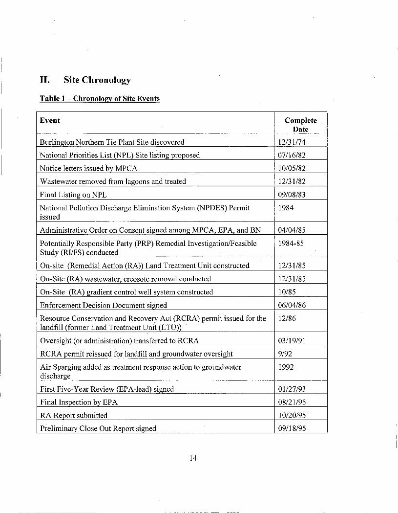
II. Site Chronology
Table 1 - Chronology of Site Events
Event
Burlington Northern Tie Plant Site discovered
National Priorities List (NPL) Site listing proposed
Notice letters issued by MPCA
Wastewater removed from lagoons and treated
Final Listing on NPL
National Pollution Discharge Elimination System (NPDES) Permit issued
Administrative Order on Consent signed among MPCA, EPA, and BN
Potentially Responsible Party (PRP) Remedial Investigation/Feasible Study (RI/FS) conducted
On-site (Remedial Action (RA)) Land Treatment Unit constructed
On-Site (RA) wastewater, creosote removal conducted
On-Site (RA) gradient control well system constructed
Enforcement Decision Document signed
Resource Conservation and Recovery Act (RCRA) permit issued for the landfill (former Land Treatment Unit (LTU))
Oversight (or administration) transferred to RCRA
RCRA permit reissued for landfill and groundwater oversight
Air Sparging added as treatment response action to groundwater discharge
First Five-Year Review (EPA-lead) signed
Final Inspection by EPA
RA Report submitted
Preliminary Close Out Report signed
Complete Date
12/31/74
07/16/82
10/05/82
12/31/82
09/08/83
1984
04/04/85
1984-85
12/31/85
12/31/85
10/85
06/04/86
12/86
03/19/91
9/92
1992
01/27/93
08/21/95
10/20/95
09/18/95
14

Thirteen additional sparge wells added in an east-west line for pre-treatment
State Environmental Real Estate Notice
Second Five-Year Review (EPA-lead) signed
RCRA Permit reissued
Gradient control wells discontinued to assess natural attenuation
Eighteen additional monitoring wells installed to further assess trial shutdown of gradient control
Third Five-Year Review signed (MPCA-lead, covered soil only)
Well Search Report updated
Three gradient control wells reactivated in response to naphthalene concentration
Groundwater oversight transferred to MPCA Superfund program from RCRA program
Supplemental soil investigation conducted based on 2003 Five-Year Review
Focused Alternatives Analysis for groundwater plume
Conditional approval of Air Injection Pilot System Phase 1 Work Plan
Phase I Air Injecfion Pilot Test
Soil Confinnation Report (initial assessment)
Additional soil sampling based on Soil Confirmafion Report
Partial approval of Phase II Air Injection Work Plan
Approval of Phase II Air Injection Work Plan and west and south lines added
Phase II Air Injection Pilot Test, including discontinuation of gradient control well pumping
Draft Supplemental Soil Investigation Report submitted
Supplemental groundwater and soil gas investigation conducted; additional monitoring well added
Additional off-site air sparging points and monitoring wells added
Air Injection Pilot System Evaluation Completed
Fall 1995
1/08/96
03/13/98
08/01/01
12/01
2003 - 2005
9/30/03
10/03
06/05
07/05
11/05
2005
06/06
10/16/06-1/17/08
03/07
08/07
10/12/2007
12/28/07
1/17/08 -present
06/08
07/08
09/08
04/09
15,

Additional monitoring well added
MDNR constructs fence to separate southern Site boundary from Paul Bunyan Trail
Two additional monitoring wells added
Three sparge points added in vicinity of MW-31A
Operation and maintenance of air sparge wells and groundwater monitoring
Operation and maintenance of former LTU containment unit
06/09
11/09
6/10
9/11
Ongoing
Ongoing
I I I . Background
Physical Characteristics
The Site is located on the corporate boundary between the cities of Baxter and Brainerd and therefore is near populated areas (Figure 1). The Site covers approximately 60 acres (acreage of BN property) and includes several historical source areas: a drip track, process area, wastewater disposal pond, and lagoon (Figure 2). Groundwater beneath the Site flows eastward and discharges into the Mississippi River approximately 3,000 feet east of the RCRA landfill. Other than the nearby Mississippi River, the Site is not located in or near an environmentally sensitive area.
Table 2. Delineation of Areas of Site under Superfund-lead and RCRA-lead Oversight During Review Period
Area
Former LTU Soils outside the boundary of the LTU Soils beneath the LTU Groundwater
Superfund-Lead Oversight
X
X X
RCRA-Lead Oversight
X
Land Use
The historical land use at the Site has included railroad tie treating, loading and unloading of ties and timbers, timber storage, and several railroad lines. Approximately half of the Site was used in the tie treating process and half for drying green timbers. The "Process Locale" consists of several former treatment areas including the Process Area, Retort Building, Conveyance Trench, Drip Track, and Black Dock (Figure 2). The "CERCLA pond" refers to the first wastewater disposal pond used until the 1930s. The "RCRA lagoon" refers to the second wastewater
16

disposal pond used from the 1930s until 1982. The "landfill" refers to the capped former Land Treatment Unit (LTU) with a RCRA permit and is identified as the RCRA regulated unit in Figure 2. It is located over most of the former RCRA lagoon.
Currently, a storage-shed, a compressor shed and groundwater extraction/air sparging sheds are on-site. No original buildings exist. The edges of the Site are wooded and have sparse ground cover as the soil is very sandy. All the Site property is currently owned by BN. The selected remedy for the Site did not indicate a projected future land use for the Site. The western half of the Site, located in Baxter, currently is zoned industrial (Figure 3). The eastern half of the Site, located in Brainerd, currently is zoned light industrial/commercial (northeast) and residential (southeast) (Figure 4). The Site is bordered by commercial, light industrial and residential areas. The. closest residences are located 100 feet to the south of the property line. The RCRA landfill is fully fenced and the remainder of the Site is partially fenced. A State bike trail is located along the north side of the Site, which was installed following an investigation which showed soil contamination below health-based levels. A fence was installed along the south side of the bike trail effectively fencing the north side of the Site from the east property boundary to near Hwy 210. There is also a bike trail along the north and west side of County Road 48 (West Laurel Street) that was installed in 2009.
A 2003 well survey indicated that no drinking water wells were located within the search area, which included an area approximately 1,000 feet up-gradient and side-gradient of the Site, and the area down-gradient of the Site to the Mississippi River. Two high capacity wells are located a little over one-half mile northwest of the Site, in an up-gradient direction. One of these wells is a city of Baxter municipal well and the other is a private well that is used for cooling water. The city of Baxter well is routinely sampled and analyzed for contaminants of concern. No contaminants of concern have been detected at concentrations above the laboratory method detection limits.
History of Contamination
Northern Pacific Railroad and Burlington Northern Railroad, predecessors to BN, operated the former tie plant in Brainerd, MN, from 1907 to 1985. The plant used creosote to preserve railroad ties. Starting in the 1950s, creosote was diluted using a 1:1 mixture with either diesel fuel Nos. 5 or 6 from two on-site tanks to formulate the railroad tie preservative. The ties were pressure-treated in the Process Area (including the Retort Building) (Figure 2). At some indeterminate time later, coal tar was used to dilute creosote using a 70% creosote to a 30% coal tar mixture in the Process Area. Pentachlorophenol was not used in the treatment process at the Site. Approximately 110,000 to 120,000 gallons of creosote/coal tar mixture were consumed at the plant each month. Wastewaters from the wood preserving operations were moved to a 60,000 ft , unlined surface impoundment for disposal (CERCLA pond). It is not known how waste waters were discharged to the CERCLA pond. In the 1930s the second impoundment was built, known as the RCRA lagoon. The two-acre RCRA lagoon was used until October 1982, when a wastewater treatment plant was completed. The Conveyance Trench discharged waste water to the RCRA lagoon. Treated ties dried on the Drip Track, east of the Process Area and south of
17

the RCRA lagoon. From approximately 1980 through 1986, a remedial investigation and feasibility study (RI/FS) was conducted at the Site.
Initial Response
EPA proposed this Site for its National Priorities List (NPL) of hazardous waste sites on December 30, 1982, and the Site was listed on September 8, 1983. The Site is also listed on the State of Minnesota's Permanent List of Priorities (PLP). BN began Site cleanup work pursuant to a CERCLA Section 106 Administrative Order and Response Order on Consent dated April 4, 1985. The Order on Consent (AOC) was entered into by EPA, MPCA, and BN. The RI/FS was completed by BN in 1985 and the EDD was issued by EPA in 1986.
Prior to remedy selection at the Site, approximately 374,000 gallons of creosote were recovered from the CERCLA pond for reuse or recycling. No pumpable creosote remained in the RCRA lagoon. In 1982, an unknown volume of wastewater was pumped from the RCRA lagoon to rail-tank cars and was transported to BN's Northtown, Minnesota wastewater treatment plant for pretreatment and subsequent discharge to the sanitary sewer. After the wastewater was removed, sometime between 1982 and 1985, approximately 63,000 gallons of creosote were recovered from the lagoon for reuse by the on-site plant.
Basis for Taking Action
Soil and groundwater beneath the CERCLA pond, the Process Locale, and the RCRA lagoon were impacted with multiple contaminants, including polynuclear aromatic hydrocarbon (PAH) compounds, heterocycles, salts, oil and grease, benzene extractable hydrocarbons, and total phenols. The Enforcement Decision Document (EDD) and Administrative Order on Consent (AOC) documented several exposure pathways and risks to receptors from these contaminants. These reports concluded that groundwater was at risk at the Site as the result of percolation of contaminants through sandy soil to the groundwater. Contaminated groundwater could affect wells located down-gradient from the Site and water quality of the Mississippi River. Surface runoff was concluded to be infrequent, and therefore not a risk, because of sandy soils and irregular topography. Direct contact with wastes in the RCRA lagoon was thought to be prevented by a fence. No significant volatilization was expected.
The AOC stated that there was an increased cancer risk if water and/or aquatic organisms were ingested from a water source contaminated with carcinogenic PAHs (cPAHs).
IV. Remedia l Actions
Remedy Selection for Soil and Sludge
On June 4,1986, EPA signed an EDD which documented remedial alternative selection for soil and sludge at the Site. The selected remedy for soil and sludge included the following major components (p. 1-2 of EDD):
18

• Preparation of lined staging area for temporary storage of the sludge and contaminated soil [near the RCRA lagoon];
• Removal of all standing water in the impoundment [RCRA lagoon]; • Excavation and segregation of the sludges for subsequent free oil recovery; • Excavation of visibly contaminated soil from both impoundments [CERCLA
pond and RCRA lagoon] and subsequent storage in the staging area. The excavated areas would be backfilled and covered.
• Preparation of a base for treatment consisting of 4 feet of clean backfill with on-site soils, a 100-mil high density polyethylene (HDPE) liner, a leachate collection system, and 4 feet of clean backfill consisting of on-site soils (fine sands). Installation of a sump for collection of the storm water and leachate;
• Installationof an irrigation system; • The land treatment of creosote focused on the breakdown and transformation
of organic constituents by aerobic microorganisms in the top layer of soil, and the immobilization of organic and inorganic constituents in the soil. .The final goal of this treatment was not the complete degradation of all waste constituents, but rather the transformation and immobilization of these constituents to render soil that would be no longer toxic and would not leach harmfiil constituents. The estimated time to process the contaminated materials was 6 years;
• After the treatment process has been completed, a final RCRA approved cover would be installed.
The 1986 EDD also documented the remedial objectives of the soil and sludge remedy (p. 7 of Attachment to EDD): "The objective of excavation is to remove sludges and soils which are grossly contaminated and contain free oils that could migrate to groundwater."
Remedy Selection for Groundwater
The AOC, signed April 4, 1985 by EPA, MPCA, and BN, required BN to propose and implement a groundwater gradient control system. The AOC stated that (AOC Exhibit A, p. 12):
The proposed first phase groundwater gradient control system once implemented shall prevent further migration of contaminants from the BN Site and shall remove contaminated groundwater from the regional groundwater aquifer at and upgradient of well nest 14. At a minimum, the groundwater gradient control system shall consist of three groundwater gradient control wells in the general location of monitoring wells 3, 13, and 14. ... In addition, within 30 days of notification of the selected alternative for response action for groundwater downgradient of well 14 pursuant to Part IX, Task E of this Exhibit, BN shall submit a proposed plan and design for implementation of the selected groundwater response action.
19

The AOC also stated that (AOC Exhibit A, p. 12-13):
BN shall continue the gradient control well pumping in the regional groundwater aquifer until at least two consecutive quarterly samplings indicate that levels in the monitoring wells in the regional groundwater aquifer are confirmed to be below 28 ng/1 for the sum of List 1 compounds specified in Attachment I to the Exhibit and 300 ng/1 for the sum of List 2 compounds specified in Attachment I to this Exhibit. These levels shall be termed "action levels". BN shall notify the U.S. EPA and the MPCA Director... of any proposed discontinuation of the operation of the ground water gradient control system. The U.S. EPA and the MPCA Director shall review, and modify or approve the proposed modification.
The List 1 and List 2 compounds included in the AOC are reproduced below.
LIST 1 1 benzo(a)anthracene benzo(b)fluoranthene benzo(j )fluoranthene benzo(a)pyrene
ideno(l ,2,3-c,d)pyrene benzo(g,h,i)perylene dibenzo(a,h)anthracene quinoline
Chrysene
LIST 2 indene 2,3-dihydroindene naphthalene 1 -methylnaphthalene 2-methylnaphthalene biphenyl acenaphthylene acenaphthene fluorene phenanthrene anthracene
fluoranthene pyrene benzo(h)fluoranthene benzo(e)pyrene perylene acridine carbazole 2,3-benzofuran benzo(b)thiophene dibenzothiophene indole
The 1986 EDD focused on the soil remedy, but did add the following further documentation of the groundwater remedy required by the AOC (EDD, p. 7 of Attachment):
A groundwater gradient control system has been designed and implemented to prevent ftirther migration of contamiriants from the BN Site and remove contaminated water from the regional groundwater aquifer. The "action levels" established in the Consent Order are used as definition of groundwater contamination for the purpose of remedial action. These limits are 28 ng/L for the
20

sum of cPAHs and heterocycles; and 300 ng/L for the sum of non-carcinogenic PAHs and heterocycles.
Based on data available at the time of the EDD, the EDD did not select a remedy for groundwater down-gradient of MW-14, as envisioned by the earlier AOC.
Remedy Implementation for Soil and Sludge
During the mid-1980's, following dewatering, sludge and visibly-contaminated soil was removed from the RCRA lagoon,CERCLA Pond, and Process Locale and placed in a temporary waste stockpile on-site. As was a common field practice at the time of the work in each of these areas, excavation occurred to the groundwater table and any remaining contamination below that depth was left in place. Any leaching impacts to groundwater from soils with non-visible levels of contamination and from contaminated soils below the water table were to be addressed by pumping the three gradient control wells.
Excavaition limits were based on the visual criteria as selected in the EDD. Few records of the depths or locations of excavation were kept beyond a general description of the area. The Remedial Action Report stated that 7,000 cubic yards of sludge and contaminated soil were removed from the RCRA lagoon, 2,500 cubic yards of sludge and contaminated soil were removed from the CERCLA pond, and an additional 4,500 cubic yards of contaminated materials were removed from other areas, including the Process Locale, and stockpiled on-site. Excavated areas were backfilled with fill from two unused portions of the Site which were believed to be clean, although verification samples were not collected.
A full scale Land Treatment Unit (LTU) for the stockpiled sludges and contaminated soils was constructed in 1985 in the area of the former RCRA lagoon. A 100-mil HDPE membrane liner covers the entire bottom, including the leachate collection system and side slopes. The base of the liner slopes 0.5 percent to the south and west. The liner elevation ranges from 1,195 feet at the northeast comer to 1,191 feet at the southwest comer. Above the liner is an 18 inch layer of silty sand ballast. A 6 inch gravel layer is located on top of the sand ballast. This gravel layer serves as a leachate collection system. Two filter fabric-wrapped perforated pipes carry leachate from the collection system to a 50,000 gallon-capacity sump. Leachate is discharged to the local wastewater treatment system.
The bioremediation objectives of the LTU were as follows:
1. The sum of PAH compounds and methylene chloride extractable (MCE) hydrocarbons in the treatment zone shall not exceed the sum of the sample compounds in impacted but non-visibly contaminated soil; or
2. Detoxification of the treatment zone utilizing the Microtox system.
21

It is unclear if sludge or visibly contaminated soils were left in place beneath the former LTU. A 100-mil high density polyethylene (HDPE) liner, a leachate collection system, 4 feet of clean backfill, a sump for collection of storm water and leachate, and an irrigation system were to be installed according to the EDD. After the completion of treatment, a final RCRA approved cover was to be installed over the LTU.
The LTU, as constructed and operated, differed from what was anticipated during the pilot study in the following ways: 1) Additional contaminated soil volume was added causing the fill layers to be thicker than originally intended; 2) the liner was sloped to the southwest and the leachate collection system consisted of piping in the southwest comer of the LTU; and 3) irrigation was done by a different method.
Treatment and operation of the LTU included the following:
1. Periodic monitoring of PAHs, total phenols, benzene extractables and toxicity parameters;
2. Application of lime and nutrients as necessary to meet design criteria;
3. Periodic irrigation to maintain the treatment zone near field capacity;
4. Bi-weekly cultivation with a tractor mounted rototiller; and
5. Maintenance of the leachate collection and run-off sumps.
Based on monitoring of the fiill-scale operation of the LTU, the rate of biodegradation of total extractable hydrocarbons reached a concentration that was slightly above the target treatment goal for detoxification (lethality). This may have been in part due to an under-estimation of soil excavation volumes and subsequently increased thickness of soil lifts placed in the LTU. A "plateau" effect limited the extent of biodegradation of the total extractable hydrocarbons and, in particular, of the cPAHs.
A RCRA hazardous waste landfill permit was issued by MPCA in December 1986 for the management of the LTU. Administrative oversight of the groundwater gradient control and monitoring system was transferred to the state RCRA program in February of 1991 to avoid duplication of effort between RCRA and Superfund programs. As soil lifts eventually became too thick to re-work by landfarming and further treatment proved not effective to eliminate remaining lethality, MPCA's RCRA program decided to close the LTU without further treatment and to allow placement of the cover over the LTU as described in the EDD.
A final RCRA cover designed to meet the closure standards of 40 CFR 264.111 was constructed for the LTU in the fall of 1995.. The surface of the LTU was graded and covered with pieces of low-permeability HDPE in a single layer. Approximately 1,550 cubic yards of concrete debris from a former building was crushed and placed over the HDPE pieces, and the voids filled with sand. Additional sand fill from an on-site borrow sources was placed up to 48 inches in thickness to meet design elevafions and graded with a 3 percent slope. A welded HDPE liner was
22

placed above the sand. Compacted clayey sand soil was placed in an 18 inch layer above the liner, covered by six inches of topsoil and vegetation.
The RCRA permit most recently was reissued for the LTU in in August 2001. An application for additional renewal of the RCRA permit was submitted in June 2008. The permit has not been renewed pending expected transfer of LTU oversight to the Superfund program, where management would be subject to ARARs but a permit would not be required.
Remedy Implementation for Groundwater
The groundwater gradient control system, located southeast of the source areas, was installed in fall of 1985. Contaminated groundwater was pumped from three gradient control wells on the property. Groundwater was pumped to the storm sewer which ultimately discharges to the Mississippi River as stipulated in a NPDES permit. In February 1991, MPCA's Superfiand program transferred the groundwater oversight responsibility of the Site to the RCRA program under Permit MND000686196 for administrative convenience.
In 1992, a small groundwater aeration (i.e., air sparge) line was installed to augment the three gradient control wells. The groundwater aeration system started with nine air injection wells prior to discharge to the storm-water system to facilitate biological breakdown of the contaminants so the NPDES limit for naphthalene could be achieved. In 1995, an additional thirteen air sparge wells were placed in operation to aerate the width of the contamination plume while pumping the gradient control wells. This dual system resulted in significant decreases in naphthalene concentrations. In 1996, EPA approved the use of the air sparge system to reduce . naphthalene concentrations before discharge to the storm sewer.
In 2001, a RCRA permit issued for the landfill included Corrective Action for groundwater which authorized BN to operate an air sparge system or gradient control system to control the off-site migration of groundwater contaminants above the concentration limits specified in the permit. As part of a pilot test, BN requested that the air sparging system be tested with the goal of replacing the three extraction wells. The pilot was approved by MPCA with the condition that the permit requirements would not be exceeded at compliance wells.
For the pilot test, the gradient control wells were shut off, followed by a six-month groundwater monitoring program. During implementation of the pilot groundwater monitoring program, the MPCA staff questioned the groundwater flow direction and requested that a well nest (MW-3 A/ B/ C) be installed directly east of the RCRA landfill. In 2003, BN installed a well nest and observed that contamination was found and was migrating eastward across the Site. During the installation of several additional wells, it was determined that one of the former monitoring wells used for establishing the groundwater flow direction was screened in a perched aquifer, making the contaminated groundwater flow direction appear to be to the southeast, when it actually was eastward. This eastward groundwater flow continues to be substantiated.
23

More recent events concerning implementation of the soil and groundwater remedies are discussed in Part V of this five year review.
Institutional Controls (ICs)
ICs are non-engineered instruments, such as administrative and legal controls, that help to minimize the potential for exposure to contamination and that protect the integrity of the remedy. Compliance with ICs is required to assure the long-term protectiveness for any areas which do not allow for unlimited use or unrestricted exposure (UU/UE).
The selected remedy for this Site did not include institutional controls as part of the remedy. It did include a requirement for fencing of the LTU, which is an access control (but not an IC), to ensure that the former LTU was not disturbed or vandalized. Even though ICs were not required by the EDD, initial IC evaluation activities have-revealed that ICs have been implemented as are discussed below. However, additional ICs are needed to ensure the protectiveness of the remedy for: 1) soils with residual contamination outside of the former LTU, and 2) for the groundwater plume. To that end, consideration will be given to modification of the remedy to included ICs. Also, the existing ICs will be evaluated to ensure they are effective and additional ICs will be implemented, if needed.
Analysis of Existing ICs: An IC in the form of a State Environmental Real Estate Notice was recorded in 1996 at the Crow Wing County Recorder's Office for the RCRA landfill to supply additional protection (Attachment 1). That notice has limitations and serves as an informational IC rather than a proprietary IC that "runs with the land." Additionally, portions of the Site are zoned for industrial, commercial, and residential use. The western half of the Site, located in Baxter, currently is zoned industrial (Figure 3). The eastern half of the Site, located in Brainerd, currently is zoned light industrial/commercial (northeast) and residential (southeast) (Figure 4). No other ICs currently exist at the Site. Since the Site will not allow for not allow for unlimited use/unrestricted exposure (UU/UE), for both soil and groundwater, then additional ICs will be needed to ensure protectiveness of the remedy.
Current Site Condition
Occasional trespassing by the public can occur on the Site, which is only partially fenced. Based on inspections and interviews, MPCA, and EPA are not aware of any wells installed within the groundwater contaminated areas, and MPCA and EPA are not aware of any current Site uses that interfere with the remedy.
IC Follow-up Actions Needed
An IC evaluation which includes the following is needed:
1. Mapping of the physical description, based on current conditions, identifying: current boundaries of restricted areas associated with the Site and areas which will not allow
24

for UU/UE, (preferably in both paper and Geographic Information System (GIS) format), and evaluation of the physical areas to see if any recorded deed restrictions (proprietary controls) and/or governmental controls exist to assure that all non-UU/UE areas are covered by the ICs;
2. Evaluating the legal description(s) contained in any existing deed restriction(s) to ensure it covers the UU/UE areas;
3. Evaluating property title work (preferably a current title commitment) to confirm ownership and determine whether some interest, such as a mortgage or utility easement, might defeat the efficacy of the institutional controls;
4. Evaluating the effectiveness of the existing ICs to assure they are enforceable and that they run with the land or embody procedures to ensure longevity;
5. Evaluating whether all remedial action objectives and media are covered by ICs; 6. Evaluating whether additional ICs are needed including groundwater ICs to address
the newly-identified plume (with a margin of safety); and 7. Evaluating the long-term stewardship prodecures at the Site.
Once the IC evaluation activities have been completed, an IC workplan is needed to incorporate the results of the evaluation and plan corrective measures to ensure long-term protectiveness. The IC Workplan should include a schedule and plan for additional IC evaluation activities, if needed, and steps for long-term stewardship to ensure that effective ICs are maintained, monitored, and enforced. If it is determined that the ICs shall be updated, then consideration should be given to implementing proprietary institutional controls known as Environmental Covenants (ECs), under the Minnesota Uniform Environmental Covenants Act (UECA). Minnesota enacted the MN UECA in 2007, which specifically provides that an owner of property may enter into a restrictive covenant and also be a "holder" of the covenant, with the right to enforce it against a third party even after it sells the property. The ECs will ensure that the restrictions are enforceable and run with the land to bind fiiture owners to the necessary restrictions to help to ensure long-term Site stewardship.
Long Term Stewardsliip: As mentioned, to ensure long-term protectiveness at the Site requires, effective ICs must be implemented, monitored, maintained and enforced. Therefore, once effective ICs are implemented, continued compliance with use restrictions will be necessary to ensure that the remedy continues to function as intended. To that end, LTS procedures will be reviewed and a plan developed to document long-term stewardship procedures. (This plan could be an amendment to the existing O&M plan or a LTS plan) plan (or O&M Plan revision). The plan should include provisions that the ICs be inspected regularly and annual certification should be made that the required ICs are in place and effective. In addition, annual certification should be provided to the MPCA and EPA-that ICs remain in place and are effective. Additionally, a communications plan should be developed and use of the State's one-call system should be explored for long-term stewardship.
The Table below summarizes the institutional controls (ICs) which are in place and will likely be required for the Site.
25

Table 3: Institutional Controls Summary Table
Media, Engineered Controls, & Areas that Do Not Support UU/UE* @ Current Conditions.
BN Tie Plant Site -Capped RCRA-regulated unit
BN Tie Plant Site - Soil areas which do not support UU/UE
1 BN Tie Plant Site - Groundwater area that exceeds UU/UE (on-site and down-gradient, if needed)
IC Objective
Prohibit any activities that would compromise the integrity of the cap; Prohibit any uses except routine maintenance. Prohibit unsafe uses.
Prohibit uses except monitoring.
Title of Institutional Control Instrument Implemented (note if planned) Environmental Land Use Notice (1996) (under review)
IC requirement planned based on soil data and assessment of risk. IC requirement planned based on recent groundwater monitoring data.
* unlimited use/unrestricted exposure
Follow-up Actions
The current decision documents do not specifically include the need for ICs to ensure long-term protectiveness yet areas of the Site and groundwater will not allow for UU.UE. Additionally, while the LTU is covered by a deed notice and the Site has zoning restrictions, ftirther IC evaluation activities are needed to ensure that effective ICs are in-place and that effective long-term stewardship (LTS) procedures are in-place.
To address these issues, U.S. EPA should determine whether a modification to the Site remedy is needed to incorporate appropriate ICs to ensure long-tenn protectiveness of human health and the environment. Additionally, a review of the ICs and LTS procedures needs to be conducted to ensure that effective ICs are in-place which are monitored, maintained and enforced. To that end, the PRPS will be required to perform IC evaluation activities and develop and implement an IC Workplan, including long-term stewardship measures, to ensure that effective ICs are maintained, monitored, and enforced.
System Operations/O&M
Initial Operations and Maintenance (O&M) requirements for the Site specified that BN operate and maintain: 1) a groundwater gradient control system; 2) a groundwater monitoring network; and 3) the LTU. The LTU was permitted by the RCRA program and closed as a landfill with a RCRA cover. Per the RCRA permit, O&M and re-permitting inspections are conducted by RCRA staff every three and five years. The types of inspections include inspection of the RCRA
26

landfill and leachate collection and treatment system, inspection of the groundwater monitoring well system, groundwater treatment system, observation of sampling events, and inspections to insure compliance with the RCRA permit and MPCA and federal rules and regulations. In addition, there are separate inspections for any permits issued by other parts of the MPCA. An example is the inspections under the NPDES permit for discharging carbon-treated leachate and water pumped from extraction wells GC-2 and GC-3. In 2007, oversight of the groundwater system was returned to MPCA's Superfiand program.
A groundwater gradient control system using extraction wells was previously used to control the flow of contaminated groundwater at the Site. The recovered groundwater was treated by carbon filtration prior to discharge to the Mississippi River under an NPDES permit. The gradient control system was shut down on January 17, 2008, as part of the Phase II air injection pilot test and remains shut down. The NPDES permit is maintained in case the gradient control system is reactivated.
Maintenance of the air injection system is performed routinely by BN and reported on semiannually to MPCA and EPA. The system is currently functioning as designed and delivers air to the subsurface at a rate of approximately 2.5 cubic feet per minute. Wells are routinely rehabilitated when they are not accepting full air flow. In November 2009, BN installed three new air injection points to replace three older points. The new points were installed deeper in the subsurface, in sands and gravels immediately above a hard clay unit. Two new groundwater monitoring wells were installed in June 2010 to better monitor middle and upper parts of the aquifer downgradient of existing well TMP-13. During the second half of 2010, BN installed a new air compressor and constructed a new on-site building to house it.
Detailed annual O&M costs are not available from BN. Before remedy implementation, EPA and MPCA estimated that O&M for the Site as a whole at between $250,000-$500,000 per year In a 2005 Focused Feasibility Study, BN estimated annual O&M costs for a pilot air sparge system at $67,000. This does not include the current expanded pilot air sparge system or O&M for the landfill.
V. Progress Since Las t Five-Year Review
Protectiveness Statements from the Last Review
This is the fourth five-year review for the Burlington Northem Tie Plant Site. The third five-year review was completed and signed in September 2003. The 2003 five year review included only a review of soil. The following protectiveness statements were presented in Section X of the third five-year review:
The soil excavation in 1985 at the Site was based on visual contamination removal criteria. Currently there is insufficient data to evaluate the remaining soil, therefore confimiation sampling is recommended in affected areas of the Site. Once the data is evaluated, a determination on protectiveness will be made in a five-year review amendment.
27

Additional confirmation soil sampling was recommended in the 2003 five-year review to enable determination of the protectiveness of the soil remedy. The 2003 five-year review did not review groundwater because at the time, oversight was being handled by the RCRA program. The following summarizes the issues, recommendations, and actions taken related to the last five-year review, which included only the soil medium. Significant groundwater actions have also been taken at the Site in recent years and these are also discussed below.
Table 4. Actions Taken in Response to Issues in Last Five-Year Review
Issues from Previous Review
More data needed to evaluate protectiveness of soil remedy
Currently, only the RCRA landfill is fully fenced at the Site
Recommendations / Follow-up
Actions
Collected soil samples and compared to current soil criteria
If new sampling data shows soil concentrations above residential values, restrict access by fencing impacted areas
Party Responsible
PRP
PRP
Milestone Date
9/30/04
NA
Action Taken and Outcome
Soil sampling conducted. Results of investigation indicated exceedances of screening levels for leaching and potential direct contact threats in certain areas on the BN property
Additional fencing added to separate north side of the Site from bike trail
Date of Action
Fall 2005 and Spring 2007
2003/2004
Soil Activities Since Last Five Year Review
Based on the recommendations of the third five-year review, in October and November of 2005, BN conducted a soil investigation designed to provide MPCA with the data necessary to evaluate protectiveness of the soil remedy (RETEC, 2007).
A push-probe drilling rig was used to collect soil samples from 19 borings continuously from the ground surface to the termination depth of each boring for visual observation and field screening using a portable photoionization detector (PID). Visual and odor impacts were noted and each core was logged. Analytical samples were taken at multiple depths following an approved work plan.
Soil boring locations were identified by targeting locations where previous investigations had identified highly-impacted soil. Sixteen boring locations were selected based on MPCA's Risk-Based Site Evaluation guidance; three boring locations were selected in the area of the RCRA
28

landfill to confirm the depth of a soil layer which appeared to cause perched groundwater. Borings were done in the following areas:
PROCESS LOCALE • Process Area • Conveyance Trench Area • Drip Track Area • Black Dock Area • CERCLA Pond Area • RCRA Lagoon Area
Contaminants of potential concern (COPCs) were identified in an approved work plan. The COPCs identified in the work plan include:
• Polynuclear aromatic hydrocarbon compounds (PAHs) • Semi-volatile organic compounds (SVOCs) • Volatile organic compounds (VOCs) • Total petroleum hydrocarbons (TPH) as diesel range organics (DRO) • TPH as gasoline range organics (GRO) • Metals (antimony, beryllium, boron, cobalt, lead, mercury, nickel, thallium, and
vanadium) • Cyanide
Results of this sampling effort (and the follow-up sampling effort summarized below) are discussed under the Data Review section of this five year review.
Based on the results of the 2005 sampling, BN followed up with a supplemental soil investigation in August 2007 (ENSR 2008). The purpose of the supplemental investigafion was to confirm the magnitude and extent, laterally and vertically, of contaminants remaining in soil both above and below the regional water table. Visual observation, field screening, core logging, and sampling for chemical analysis, were performed. The supplemental investigation included four areas:
• Operational Area (i.e., the area of the Process Locale where the bulk of wood treating activities were conducted), which includes the process area, drip track, and conveyance trench)
• CERCLA Pond • Black Dock • Area Immediately Surrounding the RCRA Landfill
Figure 5 shows the locations of the remedial investigation-related soil sampling and Figure 6 shows the supplemental 2005 and 2007 soil sample locations.
29

Groundwater Activities Since Last Five Year Review
An updated well survey conducted in 2003 indicated that no drinking water wells were located within a Localized Well Search Area extending approximately 1,000 feet up-gradient and side-gradient of the Site, and the area down-gradient of the Site to the Mississippi River. Two high capacity wells are located a little over one-half mile up-gradient and northwest of the Site. One of these wells is a City of Baxter municipal well and the other is a private well that is used for cooling water. The City of Baxter well is routinely monitored and no contaminants have been detected.
From monitoring conducted in 2003 through 2005, BN continued to refine identified boundaries of the plume and evaluate its stability, under oversight of the MPCA RCRA program. BN also evaluated whether natural attenuation was occurring at a high enough rate to control plume migration without active pumping or treatment. However, based on a statistically significant increase in the naphthalene concentration at a RCRA compliance boundary well, the groundwater extraction system was reactivated on June 29, 2005, as required under the MPCA-issued RCRA permit.
In 2005, one of the three gradient control wells, GC-1, which is located the fiirthest westward, developed operational issues. MPCA approved discontinuing pumping at this well based on results of a groundwater model which indicated that discontinuing pumping at GC-1 would not affect the capture rate. The same modeling effort also showed that although 90 to 95% of the plume was captured using the gradient control wells, the north-northeast side of the plume that passed under the RCRA landfill was not fully captured.
Also in 2005, a new NPDES permit was issued for discharge of the groundwater pumped from wells GC-2 and GC-3. The permit required treatment using a two-stage granular activated carbon (GAC) system.
In 2006, MPCA and EPA required that BN conduct a new groundwater feasibility study to explore options to prevent the plume from expanding and to evaluate alternative remedies for groundwater remediation. BN, MPCA, and EPA agreed to conduct a Phase I Pilot test of air sparging as part of a draft feasibility study that included installation of 1) air sparge points east of the landfill at the plume forefront; and 2) air sparge points on the southeast property boundary. The test was successfiil in reducing contaminant concentrations in the plume east of the landfill, but the sparge points on the southeast property line were found not sufficient to address the entire plume remnant to the southeast.
Groundwater activities were regulated under the RCRA permit until 2007, when the oversight of groundwater actions was transferred to the Superfund program.
In December 2007, MPCA and EPA approved a Phase 2 Pilot Test which included installation of 1) additional sparge points closer to the original source areas and 2) additional sparge points along West Laurel Street to the southeast. By March 2008, a portion of the plume to the
30

southeast of the new Phase 2 sparge line was found to have flowed fiarther southeast across the property line. In response, the following off-site investigations were conducted:
• June 2008 - Push probe borings, temporary wells, and soil vapor probes were installed and sampled
• July 2008 - Additional push probe borings and temporary wells were installed and sampled; installed and sampled monitoring well nest MW-35B/C
Based on the results of these data, BN developed a draft work plan which evaluated remedial options for off-site groundwater, including monitored natural attenuation, off-site expansion of the air injection system, reactivation of the gradient control system, and in-situ application of an oxygen releasing compound. The draft Work Plan recommended off-site expansion of the air injection system. During the work plan review process, MPCA identified the northem property boundary as an area needing further definition to verify if groundwater concentrations were above State of Minnesota health risk levels (HRLs). A separate work plan was developed for soil vapor sampling to evaluate the vapor intrusion pathway in the southeast residential area. MPCA subsequently approved both work plans and they were implemented by BN in fall of 2008.
This work is summarized in a May 2009 report Summary of Off-Site Response Action Activities (AECOM 2009a) and included the following:
• South Area - Installation of a south air injection line and two additional air injection points in an area separate from the line; installation of monitoring well MW-38B approximately 50 feet south of the new line.
• North Area - Installation of monitoring well MW-36B; installation of two new air injection points angle-drilled along the north property line.
• Soil Vapor Screening - Following MPCA vapor intrusion guidance (MPCA, 2007), soil vapor was sampled at a depth of 8-10 feet at five locations near and downgradient of MW-34B/C. Data were screened against values in the MPCA guidance and found not to present a vapor intrusion concern.
Figure 2 of this Five Year Review shows the current configuration of the air sparge system and monitoring network, including an additional monitoring well (MW-37B) installed in June 2009 at a locafion downgradient of well nest MW-35B/C.
In April 2009, BN submitted an evaluation of the air injection pilot system entitled Air Injection Pilot System Performance Evaluation Report (AECOM, 2009b). This report summarized perfomiance data collected during operation of the pilot air injection system from October 2006 through March 2009. As explained in this report, the air injection pilot study was conducted in phases with the gradient control system, as follows:
31

Table 5. Operational Dates for Groundwater Systems
Dates
10/31/1985-9/28/1992 9/28/1992-12/21/2001
12/21/2001-6/29/2005 6/29/2005-10/16/2006 10/16/2006-1/17/2008
1/17/2008-present
Gradient Control System Operation On (3 wells) On
Off On On
Off
Air Sparge System Operation ~
On (9 injection points installed 1992; 14 points added in 1995) On On On (Phase I Air Injection Pilot Test Period) On (Phase II Air Injection Pilot Test Period)
Based on the performance evaluation, the pilot air injection system appears to be operating as designed with the exception of one injection point (AI-2), for which rehabilitation efforts have not been successfiil. Changes in water level during system cycling were observed in all the monitoring wells evaluated with the transducer, indicating that the injection system was displacing water in the saturated zone. Measurements of dissolved oxygen indicate that the four hour cycle time is appropriate to maintain the maximum level of DO in the aquifer. A comparison of Phase I and Phase II operations indicated that air sparging appeared to be effective without the groundwater gradient control system operating. The data collected from the performance monitoring network support a decreasing trend in constituent concentrations at the majority of the monitoring locations since the pilot system began. This is discussed in more detail in the Technical Assessment section of this Five-Year Review.
VI. Five-Year Review Process
Administrative Components
Potentially interested parties, including BN, were notified of the inifiation of the five-year review in April 2008. The MPCA is the lead agency for the Site and the five-year review was led by MPCA.
Community Involvement/Notification
MPCA issued a press release on July 10, 2008, that announced the initiation of the five-year review and solicited written comments from the public. The Brainerd Daily Dispatch printed the release and the KLKS radio announced the release, both on July 11, 2008 (Attachment 2). No public comments were received.
32

Document Review
Generally, the documents reviewed included the decision documents and permits, the consultant's reports submitted on behalf of BN, and State and Federal standards. Specific documents reviewed for this five-year review are identified in Attachment 3.
Data Review
Generally, the data reviewed included confirmation and supplemental soil sampling data from 2005 and 2007, and groundwater monitoring data from the period since the last five-year review, with an emphasis on data from the most recent two years. These data for soil and groundwater are discussed in detail in Section VII of this review.
Site Inspection
A Site inspection was completed on May 15, 2008, by the MPCA, with representatives from the MPCA's consultant Bay West, BN, and BN's consultant ENSR also present. A second Site inspection was completed on September 17, 2010 by MPCA and EPA staff, with BN's consultant ENSR present. The purpose of the inspections was to assess the remedy, including a visual inspection of the entire property.
VI I . Technical Assessment
Question A: Is the remedy functioning as intended by the decision documents?
In general the remedy is fiinctioning as intended by the decision documents; however, actions may be needed in certain areas.
Remedial Action Performance: Former LTU
The LTU was intended to treat the soil so that it was no longer toxic and did not leach harmful constituents. Treatment of soil in the LTU resulted in significant reductions in hazards at the Site, although the agencies approved closure of the unit without meeting all treatment goals.
The former LTU currently operates as a containment unit under a RCRA permit overseen by MPCA's RCRA program. The landfill is inspected monthly and surveyed annually. This five-year review did not include a detailed review of the former LTU. However, oversight of the former LTU is in the process of retuming to the Superfund program. This five year review notes that anomalies appear to exist conceming the performance of the landfill which may affect the cleanup of groundwater immediately downgradient of the landfill. A better understanding is needed of why leachate production has not significantly reduced over time and why contaminant concentrations in leachate are lower than nearby downgradient monitoring wells.
33

Remedial Action Performance: Soils Outside of the RCRA Landfill
The soil remedy was intended to remove soils which were grossly contaminated and contained free oils that could migrate to groundwater. In response to requests from MPCA, confirmation and supplemental soil sampling were conducted in selected areas of the Site in 2005 (RETEC 2007) and 2007 (ENSR 2008), as discussed in Section V of this five-year review.
Visual observations of petroleum-like impacts noted during the 2005 field work are summarized in Table 4 (RETEC 2007) and during the 2007 field work are summarized in Table 5 (ENSR 2008). Overall, sampling indicated that visual contamination presently exists both above and below the regional water table in the Process Locale, the area immediately surrounding the RCRA landfill, and the area of the CERCLA Pond. These visual indications suggest that not all grossly contaminated soils were excavated during remedy implementation, and these soils are likely to be an ongoing source of groundwater contamination. However, implementation of the groundwater remedy has resulted in successfiil containment (discussed elsewhere under this question).
In addition to visual observation, the soils were sampled for contaminants of concem. The current soil remedy does not include concentration-based cleanup levels. Analytical results were compared to screening levels for direct contact (SRV) and for leaching (SLV). SLVs and SRVs are not applicable or relevant and appropriate requirements (ARARs) or cleanup levels for the Site, but were used to indicate areas of potential ongoing leaching to groundwater or potential risk to workers.
Overall, analytical results indicate that areas of soil contamination remain which exceed screening values for leaching and for direct contact by workers. Results are presented in Section 3 and 4 of the ENSR 2008 report. Samples in the upper four feet (defined by the MPCA as accessible soil) were compared to Tier 2 Industrial Worker Soil Reference Values (SRVs), consistent with current zoning for this part of the Site. Results for samples at all depths were compared to Tier 2 Short-Term Worker SRVs.
The following constituents exceeded SLVs in up to 23 sampling locations in the Operational Area of the Process Locale and in the former RCRA lagoon beyond the RCRA landfill (Table 6, ENSR 2008):
• BTEX compounds (benzene, ethylbenzene, toluene, total xylene) • Noncarcinogenic PAHs • acenaphthene • anthracene, • fluoranthene, • fluorene, • naphthalene, • pyrene, and
34

• Carcinogenic PAHs as total benzo(a)pyrene (BaP) equivalents
The above cPAHs were found above the SLV for total BaP equivalents of 10.2 up/L in up to 10 sampling locations in the CERCLA Pond Area and two locations in the Black Dock Area.
These exceedances of leaching screening values indicate that the presence of BTEX and PAH compounds in soils above and below the water table is likely to be an ongoing source of contamination to groundwater. This is consistent with groundwater monitoring data which show most of these compounds present in groundwater at the Site.
The following PAH compounds exceeded the Tier 2 Industrial SRVs in certain samples in the upper four feet of soil (ENSR 2008):
• BaP equivalents (multiple locations in Operational, Black Dock and CERCLA Pond Area)
• 2-methylnaphthalene (only at DTS-4, 2-4 ft, in the CERCLA Pond Area) • Naphthalene (only at DTS-4, 2-4 ft, in the CERCLA Pond Area)
The following compounds exceeded the Tier 2 Short-term Worker SRV in certain samples at multiple depths in soil at the Operational Area and the CERCLA Pond Area:
• PAH compounds (BaP equivalents, naphthalene) • Benzene
One sample in the Black Dock Area exceeded the Tier 2 Short-term Worker SRV for BaP equivalents.
These exceedances of direct contact screening values indicate that there may be unacceptable risk to future workers at the Site from exposure to contaminants in soils at certain areas of the Site.
Remedial Action Performance: Groundwater
Action levels were set in the 1985 AOC to determine when the groundwater containment system was no longer needed. The 1986 EDD clarified that the action levels would also be used to define the boundary of the groundwater plume. Action levels were set at 28 ng/L (0.028 ug/1) for the sum of carcinogenic PAHs and heterocycles (List 1 in previous section of this Five Year Review), and at 300 ng/1 (0.300 ug/1) for the sum of non-carcinogenic PAHs and heterocycles (List 2 in previous section).
In 2001, the RCRA permit issued for the former LTU included groundwater monitoring and corrective action for groundwater. Con-ective action requirements on page 7 of the permit include:
35

• Operate the air sparge system or gradient control system to control the off-site migration of contaminants from the facility above the concentration limits specified in Part F.5;
• If the ground water protection standard is exceeded in ground water at or beyond the compliance point for ground water corrective action, the Permittee shall complete a thorough review of the air sparge system and institute ftirther corrective actions as described in Part F.8 of the Permit and in the Permittee's Ground Water Protecfion Requirements, section 22, of the Part B
The permit defined updated groundwater monitoring parameters which are similar, but not identical, to the parameters listed in the AOC and EDD. Currently the RCRA permit parameters are monitored at a network of 39 wells at 16 locations. Each location includes 2 or 3 nested wells completed at various depth intervals. Monitored parameters include:
• PAHs • Total phenols • DRO • GRO • VOCs (benzene, toluene, ethylbenzene, xylene, 1,2,4-trimethylbenzene, and 1,3,5-
trimethylbenzene
The RCRA permit established ground water protection standards to define the boundaries of the plume and requires groundwater correction action to continue until these levels are met. The conditions of the permit are designed to ensure that hazardous constituents in groundwater at and beyond the groundwater corrective action point of compliance do not exceed concentrafion limits set in the permit; do not exceed a cumulative carcinogenic risk factor of 10-5; and do not exceed a cumulative hazard index of 1 (p. 7 of permit):
The hazardous constituents to which the permit's groundwater protection standards described above apply are PAHs, phenols, and other constituents identified in Minn. R. .7045.0143, which incorporates the groundwater monitoring list of CFR 40 Part 264.
Concentration limits in the RCRA permit are called Regulatory Action Limits (RALs). The RALs are based on Minnesota Health Risk Limits (HRLs) and are generally consistent with, though not identical to, EPA's risk-based screening levels for groundwater and Maximum Contaminant Levels (MCLs) under the Safe Drinking Water Act. The RALs are not ARARs for the CERCLA remedy but are useftil indications of health based levels at the time of permit issuance.
The RCRA permit establishes Corrective Action points of compliance at monitoring wells MW-13B, MW-14B, and MW-15. The permit specifies that groundwater corrective action will continue until the groundwater protection standards have not been exceeded for five consecutive years of groundwater monitoring.
36

For carcinogenic PAHs, the RCRA permit set an RAL of 0.05 ug/1 for the sum of the 9 PAHs which are the same PAHs as in List 1 from the AOC (see previous section of this Five Year Review). This is similar to, but slightly above, the 0.028 ug/1 established as an Action Limit in the AOC and EDD for this list of contaminants. The RALs in the RCRA permit are based on updated health-based information for these compounds. Subsequent to the permit, at MPCA's request, groundwater monitoring reports include six additional carcinogenic PAHs in the List 1 analysis:
7H-dibenzo [c,g] carbazole dibenz(a,h)acridine
dibenz(a,j )acridine dibenzo(a,e)pyrene dibenzo(a,i)pyrene dibenzo(a,k)pyrene.
For non-carcinogenic PAHs, the RCRA permit set RALs for 7 individual PAHs, based on protection to maintain a Hazard Index below 1:
biphenyl anthracene acenaphthene fluoranthene fluorene naphthalene
chrysene
300 ug/1 2000 ug/1 300 ug/1 300 ug/1 300 ug/1 300 ug/1
200 ug/1
Current groundwater monitoring includes 24 non-carcinogenic PAHs in the List 2 analysis, including all but one of those listed in the AOC and EDD (all except benzo(h)fluoranthene, which now should be reported with benzo[k]fluoranthene as total benzofluoranthenes; these two compounds coelute).
The permit did not set an RAL for all non-carcinogenic PAHs combined. In comparison, the 1985 AOC and 1986 EDD had set a combined Acfion Limit for 22 non-carcinogenic PAHs at 0.300 ug/1. The difference is due to a significantly updated understanding of risk for some of the PAH compounds that now have specific MN Health Risk Limits. The 0.3 ug/L limit no longer has a health basis.
The RCRA permit also set an RAL for total phenols at 4000 ug/1. The AOC and EDD require monitoring of total phenols in groundwater, but did not establish an action level for total phenols.
37

The 2001 RCRA permit did not establish RALs for VOCs; however, following a request by MPCA, current groundwater monitoring reports include comparisons of data to the following criteria:
benzene ethylbenzene toluene total xylenes 1,2,4-trimethylbenezene 1,3,5-trimethylbenzene
10 ug/1 700 ug/1 200 ug/1 300 ug/1 100 ug/1 100 ug/1
The 2001 RCRA permit also did not establish RALs for diesel range organics (DRO) or gasoline range organics (GRO); however, after a request by MPCA, current groundwater monitoring reports include comparison of data to the following criteria:
DRO 200 ug/1 GRO 200 ug/1
BN currently samples groundwater quarterly and submits groundwater monitoring reports semiannually. Analysis includes:
PAH List 1 (carcinogenic) compounds PAH List 2 (non-carcinogenic) compounds without individual RALs PAH List 2 (non-carcinogenic) compounds with individual RALs Total Phenols DRO GRO VOCs (compounds listed above)
The most recent reports indicate the following results. For a discussion of how these results relate to plume contaimnent, see the section "Plume Containment Results" below.
PAH Results
• Samples from point of compliance wells and other downgradient wells are analyzed using a method with a lower laboratory reporting limit, generally 0.02 ug/1, and samples from wells nearer the source areas are analyzed using a method with a higher reporting limit, generally 10 ug/1, because the lower reporting limit is not needed in that area.
•
•
Carcinogenic PAHs have been detected sporadically on and off the BN property in recent sampling events.
In the most current round of sampling (fourth quarter 2010), no wells contained List 1 PAHs at levels above the RALs or action levels.
38

•
•
•
In first quarter sampling of 2010, the new monitoring well (MW-37B) contained carcinogenic PAHs at concentrations above laboratory reporting limits: 7H-Dibenzo[c,g]carbazonle at 0.9 ug/1 and Dibenz(a,h)acridine at 0.23 ug/L. Using the respective potency factors of 1.0 and 0.1 for these compounds, this sample contained 0.92 ug/L BaP equivalents. This exceeds the RCRA permit's RAL of 0.05 ug/L. During the subsequent 2010 sampling events, these compounds were not detected, using appropriately low reporting limits.
In 2010 sampling, non-carcinogenic PAHs without individual RALs were detected above the reporting limits at multiple monitoring locations on and off the BN property. However, only naphthalene exceeded its individual RAL. This occurred at 8 wells, all on BN property and upgradient of air sparge lines.
The RAL exceedances for PAHs confirm that groundwater containment or treatment is still needed.
Phenol Results
• In accordance with the approved sampling plan, total phenols analysis was required in third and fourth quarter sampling of 2010 and was also conducted earlier in the year at the new monitoring wells MW-3 IB and MW-31C.
During 2010, total phenols were detected at several wells both on and off the BN property, but did not exceed the RAL established in the RCRA permit at any well.
Diesel Range Organics and Gasoline Range Organics Results
•
•
•
DRO and GRO are typically detected in monitoring wells where PAH and total phenol concentrations are highest.
In 2010 sampling, DRO concentrations exceeded the criterion of 200 ug/1 at multiple wells on the BN property and off the BN property. During the first half of 2010, DRO concentrations also exceeded the criterion by generally lower amounts at the following wells which are located off the BN property: MW-34B, MW-35B, MW-36B, and MW-38B.
During the 2" * half of 2010, DRO did not exceed the criterion at any well located off of the BN property.
In 2010 sampling, GRO concentrations exceeded the criterion of 200 ug/1 at a few locations on the BN property near source areas and upgradient of air sparge lines. There were no GRO exceedances off the BN property.
39
• The DRO and GRO exceedances suggest that groundwater containment or treatment is still needed.
VOC Results
• In 2010 sampling, generally low levels of VOCs were detected in locations where other contaminants were at their highest concentrations.
• In 2010 sampling, benzene was the only VOC which exceeded its RAL. This occurred at several wells on the BN property, all located in areas where groundwater currently is being treated by the air sparging network.
Plume Containment Results Based on MW-14B
In the AOC and EDD, monitoring well nest MW-14 was established as a point of compliance for defining containment of the plume. At that time, it was thought that groundwater flow was to the southeast, in the direction of this well.
At well nest MW-14, MW-14B is completed in the zone most highly contaminated. At MW-14B, no carcinogenic PAHs from List 1 of the AOC, EDD or RCRA permit were detected in 2010 sampling, using appropriate laboratory reporting limits to detect PAHs near the Action Level in the AOC and EDD of 0.028 ug/1. Three non-carcinogenic PAHs were detected sporadically in 2010 sampling at this location: two PAHs (biphenyl and carbazole) from List 2 as defined in the AOC and EDD, and one additional PAH (indole) which was added to the monitoring program for the RCRA permit. Concentrations of all three are several orders of magnitude below the AOC's 0.300 ug/1 Action Level for non-carcinogenic PAHs for defining containment of the plume.
Therefore, based on the compliance point and action levels established in the AOC and EDD, the current groundwater air sparge system is effectively containing the plume. However, based on the more recent understanding that groundwater flows to the east, additional analysis is appropriate and is presented below.
Plume Containment Down-Gradient of and Side-Gradient to Air Sparge System
An evaluation of containment which incorporates a more recent understanding of groundwater flow direction can be done by evaluating contaminant concentrations at all wells down-gradient and side-gradient of air sparge lines. The current monitoring program includes approximately 13 such wells. Five wells are located downgradient of the south air sparge line off BN property: TMP-15, TMP-10, MW-37B, MW-35B, and MW-35C. Eight wells are located downgradient of the eastmost air sparge line on BN property: TMP-5, 5A and 5C; TMP-8, TMP-11 and 1 IC; and TMP-14B and 14C. Two side-gradient wells are located to the south of the BN property, MW-32B and MW-14B, and one side-gradient well is located to the north of the BN property, MW-
40

36B. (The analysis below does not include an analysis of any background concentrations of contaminants, although this information is available as part of the RCRA permitting process and can be included in the future if needed.)
In 2010 sampling of down-gradient and side-gradient wells, most carcinogenic PAHs from the AOC and EDO's List 1 were not detected, using appropriately low laboratory reporting limits. Benzo(a)anthracene was detected in January 2010 at TMP-14C below the RAL and the AOC action limit. During fourth quarter 2010 sampling, low levels of several carcinogenic PAHs were detected at TMP-5 (located on the BN property) and TMP-10 (located off of the BN property). Contaminant levels at both wells are below the Action Limit established for containment in the 1985 AOC and below the RAL established in the RCRA permit.
In addition, during first quarter 2010 sampling, two carcinogenic PAHs which had been added for RCRA permit monitoring were detected in the new down-gradient well MW-37B. The levels detected in first quarter monitoring (0.92 ug/L BaP equivalent) are significantly above the Action Limit established for containment in the 1985 AOC for carcinogenic PAHs (0.028 ug/1). However, during all subsequent sampling events in 2010, neither compound was detected.
In 2010 sampling, carcinogenic PAHs were not detected in side-gradient wells located to the south of the BN property (MW-14B and MW-32B). At the side-gradient well located to the north (MW-36B), five carcinogenic PAHs were detected, with a combined concentration of approximately 0.035 BaP equivalent. This slightly exceeds the Action Limit of 0.028 ug/L from the AOC and EDD; however, it does not exceed the RAL from the RCRA permit, which is based on current health-based levels.
In 2010 sampling of down-gradient and side-gradient wells, non-carcinogenic PAHs were detected at TMP-8, TMP-14B, TMP-14C (0.03 ug/L), MW-14B (0.0094 ug/1), MW-34C (maximum 0.01 ug/1); MW-35B (maximum 100 ug/1); MW-36B (maximum 0.011 ug/1); and MW-37B (maximum 0.026 ug/1). Of these wells, only MW-35B exceeded the Action Level of 0.300 ug/1 for non-carcinogenic PAHs from the AOC or EDD. In addition, no compounds exceeded a Minnesota Health Risk Limit or an RAL.
Therefore, current data indicate that the current air sparge system effectively contains the contaminant plume to portions of the BN property, with the exception of the area adjacent to the property to the northeast of the landfill. This area adjacent to the property to the northeast does not exceed current health-based levels.
A 2003 analysis of surface water impacts indicated that the plume did not exceed MPCA's chronic standard for Class 2B surface water at the most down-gradient monitoring wells. However, in 2011, it appears that one well (TMP-7) slightly exceeds a new lower chronic standard for anthracene. Although contaminant concentrations at the point of interface with surface water are expected to be lower than the monitored levels, additional evaluation is underway to confirm that surface water is not at risk.
41

Contaminant Trends in Groundwater
Groundwater monitoring at the Site includes periodic tracking of contaminant trends in groundwater for multiple purposes. Neither the AOC, EDD, nor the RCRA permit require cleanup of the entire groundwater plume to health-based standards; however, tracking contaminant trends in groundwater can be a usefial indicator of the stability of the contaminant plume boundary, can document the shrinking of the plume through time, and can supply an early warning of potential plume expansion in fime for acfions to be taken.
The following conclusions can be drawn from current contaminant trends, as documented by semi-annual groundwater monitoring reports and figures included with this five year review and cited below:
• Contaminant concentrations in groundwater southeast of the BN property and down-gradient of air sparge lines have declined below health-based levels, very likely in response to ongoing air sparging (Fig. 7A-E)
• Pumping the groundwater extraction wells may have caused the groundwater contamination to migrate to the southeast of the Site at a faster rate than not pumping (Fig. 7F)
• Groundwater at several areas on the BN property remains above health-based levels, likely due to contaminants remaining in soil near those areas, and it is likely to continue to need treatment in order to contain the plume (Fig. 7G-J)
Cost of System Operations/Oi&M
Detailed annual O&M costs are not available from BN so these are not included in this evaluation.
Early Indications of Potential Issues
There has been some rebound in DRO and napthelene concentrations at MW-31A and BN is in the process of installing 3 additional sparge points in this vicinity (Fig. 7K). MPCA has requested the addition of a new deeper monitoring well at TMP-6 to determine if deep impacts are also present down gradient of this area. Ongoing monitoring in these two areas is important to confirm adequate placement of sparge points.
The most recent round of sampling for anthracene in monitoring well TMP-7 indicated a contaminant concentration for this constituent that slightly exceeds the current MPCA chronic standard for surface water. The plume intersects the Mississippi River several thousand feet downgradient of this well. Additional evaluation is underway.
42

Implementation of Institutional Controls and Other Measures
The remedy did not require institutional controls, even though wastes were left on-site and do not allow for unrestricted use/unlimited exposure. A deed notification was filed for the RCRA landfill, as required under the RCRA permit. Other than the landfill deed notification, no institutional controls are currently in place. This is discussed further in Section IV of this review.
Question B: Are the exposure assumptions, toxicity data, cleanup levels, and remedial action objectives (RAOs) used at the time of remedy selection still valid?
Changes in Standards and TBCs
The 1986 EDD required closure and post-closure plans to be consistent with the Resource Conservation and Recovery Act (RCRA) 40 CFR Part 265 and 264, including closure and post-closure standards and groundwater corrective action. A RCRA pennit including post-closure and groundwater corrective action requirements was issued for the former LTU and is currently in effect.
The EDD also required a National Pollutant Discharge Elimination System (NPDES) permit for discharge of gradient control system water. This permit was issued and is maintained in case the discharge is re-started.
The EDD did not include standards for direct contact with soils based on anticipated fiature use and did not include standards for ground water which were intended to return groundwater throughout the plume to its beneficial use (e.g., MCLs and non-zero MCLGs). Subsequent to the EDD, EPA issued guidance recommending health-based standards for both media (e.g.. Rules of Thumb for Superfund Remedy Selection, OSWER 9533.0-69; Summary of Key Existing EPA CERCLA Policies for Groundwater Restoration, OSWER Directive 9283.1-33.)
Changes in Exposure Pathways
The selected remedy for the Site did not consider the direct contact pathway for soils at the Site. Soil sampling conducted since the last five-year review shows exceedances of direct contact screening values, as discussed in the detail under Question A above. This indicates that, should the Site be redeveloped for use in the fiiture without ftirther actions being taken, there may be unacceptable risk from exposure to contaminants in soils at certain areas of the Site.
The selected remedy also did not consider the vapor intrusion exposure pathway. As explained in Section V of this five-year review, this pathway was evaluated in 2008-2009. However, since that time, MPCA and EPA have each issued additional guidance on vapor intrusion, which should be considered to ensure that adequate protection is maintained.
43

Changes in Toxicity and Other Contaminant Characteristics
At the time of remedy selection, contaminants of concern were selected which do not ftilly incorporate more recent understandings of all compounds currently considered contaminants of concem for the Site, and therefore no action levels were established for these compounds. For example, the List 1 cPAHs do not include all carcinogenic PAHs and non-carcinogenic PAHs which are detected at the Site. In addition, VOCs, DRO, and GRO are not included. The groundwater monitoring plan and groundwater corrective action requirements of the RCRA permit for the former LTU incorporate a more recent understanding of COCs for the Site, but the AOC and EDD remain unchanged.
At the time of remedy selection, action levels were selected which represented health-based levels and evaluation methods at the time. Some of the action levels do not reflect current health-based levels and/or current methods of risk evaluation. For example, MPCA and EPA's procedure for calculating cPAH exceedances has changed to a BaP equivalency method rather than the straight additivity method required in the AOC and EDD. For carcinogenic PAHs, this led to action levels which are more conservative than our current methods would indicate. The groundwater monitoring plan and groundwater corrective action requirements of the RCRA permit for the former LTU incorporate a more recent understanding of health-based levels and evaluation methods, but the AOC and EDD remain unchanged.
Changes in Risk Assessment Methods
Changes in EPA and MPCA's understandings of risk from exposure to contaminants in ground water have been incoiporated into the monitoring plan in response to RCRA permit corrective acfion requirements. Therefore, monitoring of the Site is in general up to date, although the AOC and EDD remain unchanged. As discussed above, the EDD and AOC did not include an evaluation of risk from direct contact with soil. A risk assessment is needed to ensure protectiveness of the existing remedy. It should be based on the latest risk assessment methods.
Expected Progress Toward Meeting RAOs
Progress toward meefing RAOs for groundwater and soils are discussed under Question A above on remedial action performance.
Question C: Has any other information come to light that could call into question the protectiveness of the Remedy?
No. No newly identified ecological risks have been found. There have not been significant impacts to the Site from natural disasters. No other information has come to light which could affect the protectiveness of the remedy beyond what has been noted under Questions A and B
44

Technical Assessment Summary
The soil remedy called for excavating sludges and soils which were grossly contaminated and which contain free oils that could migrate to groundwater, based on a visual standard. A significant volume of visibly contaminated soil and sludge was excavated during remedy implementation, using practices in common use at the time and under the oversight of regulatory agencies. However, visual indications of contamination remain both above and below the regional water table in several areas. Soil contamination remains outside of the former LTU which exceeds screening values for leaching and direct contact by workers. These screening values are not applicable or relevant and appropriate requirements or cleanup levels for the Site, but do indicate areas of potential ongoing leaching to groundwater or potential risk to workers.
The groundwater remedy intended to prevent further migration of contaminants from the BN Site and to remove contaminated groundwater from the regional groundwater aquifer at and upgradient of well nest MW-14 (thought at the time of remedy selection to be down-gradient of source areas). The current air sparging network is meeting this goal. Based on recent groundwater monitoring results, the current air sparge network also appears to be effectively preventing migration of groundwater exceeding health-based levels from leaving the BN property in any direction.
VIII. Issues
Issues discussed in detail in the previous sections are summarized in the following table:
Table 6. Issues
Issue
1. There is insufficient information available at present to address issues noted below regarding soil, groundwater, and the former LTU.
Affects Current Protectiveness
(Y/N) N
Affects Future Protectiveness
(Y/N) Y
45

2. Visual indications of contamination remain in soils at the Process Locale, areas immediately surrounding the former LTU, and the area of the CERCLA Pond, both above and below the regional water table. It is unclear if sludge or visibly contaminated soils remain beneath the former LTU. Soil contamination exists which exceeds leaching screening values above and below the water table. Both visual indicafions and exceedances of leaching screening values suggest that soils are likely to present an ongoing source to groundwater contamination.
3. Anomalies appear to exist conceming the performance of the former LTU as a containment unit which may affect the cleanup of downgradient groundwater. It is uncertain why leachate production has not significantly reduced over time and why contaminant concentrations in leachate are lower than nearby downgradient monitoring wells.
4. No site-specific risk assessment was done for direct contact pathways for surface soils and no actions to address this pathway were required by either the EDD or AOC. Surface soils exist on-site which exceed Minnesota's current screening levels for surface soils on both industrial and residential use properties (Soil Reference Value or SRV). Although SRVs are not applicable or relevant and appropriate requirements (ARARs) for the Site, the exceedances suggest a possibility that unacceptable risk may remain for the direct contact soil pathway under fiature use scenarios.
5. The EDD does not include cleanup levels for groundwater and the contaminants of concem and groundwater action levels established in the EDD and AOC do not incorporate current understandings of risk. However, the RCRA permit's groundwater corrective action requirements and current groundwater monitoring procedures do incorporate more current understandings of risk.
N
N
N
N
Y
Y
Y
Y
46

6. The compliance point for groundwater containment established in the AOC does not incorporate current understandings of groundwater flow direcfion and the EDD does not include a compliance point for groundwater.
. However, the compliance points established in the RCRA pennit and the current groundwater monitoring procedures do incorporate current understandings of groundwater flow.
7. The current groundwater remedy does not require cleanup to health-based levels throughout the plume and does not appear to meet the NCP's general expectation of retuming usable ground waters to their beneficial uses wherever practicable (40 CFR 300.430(a)(l)(iii)(F)).
8. The AOC required containment of contaminated groundwater by groundwater extraction. The implementation of this method was documented in the subsequent EDD. More recently, groundwater extraction was found to increase the rate of plume migration and a pilot test using air sparging for groundwater has attained containment more efficiently than the extraction method.
9. The current decision documents do not specifically include the need for ICs to ensure long-term protecfiveness yet areas of the Site, including groundwater will not allow for UU/UE Additionally, while the LTU is covered by a deed notice, and the Site has zoning restrictions, further IC evaluation activities are needed to ensure that effective ICs are in-place and that effective long-term stewardship (LTS) procedures are in-place.
N
N
N
N
Y
Y
N
Y
IX. Recommendations and Follow-up Actions
Recommendations and Follow-up Actions based on this five-year review are presented in the following table:
47
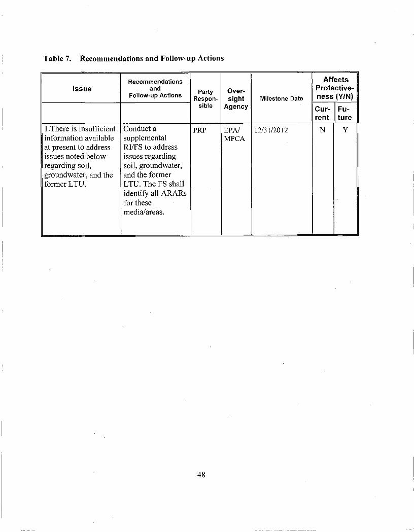
Table 7. Recommendations and Follow-up Actions
Issue
1 .There is insufficient infonnation available at present to address issues noted below regarding soil, groundwater, and the former LTU.
Recommendations and
Follow-up Actions
Conduct a supplemental RI/FS to address issues regarding soil, groundwater, and the former LTU. The FS shall idenfify all ARARs for these media/areas.
Party Respon
sible
PRP
Oversight
Agency
EPA/ MPCA
Milestone Date
12/31/2012
Affects Protectiveness (Y/N)
Current
N
Future
Y
48

Issue
2.Visual indications of contamination remain in soils at the Process Locale, areas immediately surrounding the fonner LTU, and the area of the CERCLA Pond, both above and below the regional water table. It is unclear if sludge or visibly contaminated soils remain beneath the former LTU. Soil contamination exists which exceeds leaching screening values above and below the water table. Both visual indications and exceedances of leaching screening values suggest that soils are likely to present an ongoing source to groundwater contaminafion.
Recommendations and
Follow-up Actions
Evaluate whether contamination in the subsurface soils present outside of and beneath the former LTU inhibit groundwater cleanup.
Party Respon
sible
PRP
Oversight
Agency
EPA/ MPCA
Milestone Date
12/31/2012
Affects Protectiveness (Y/N)
Current
. N
Future
Y
,
--
49

1 Issue
3. Anomalies appear to exist conceming the performance of the fonner LTU as a containment unit which may affect the cleanup of downgradient groundwater. It is uncertain why leachate production has not significantly reduced over fime and why contaminant concentrations in leachate are lower than nearby downgradient monitoring wells.
Recommendations and
Follow-up Actions
Review performance of the fomier LTU as a containment unit to evaluate whether it meets ARARs.
Party Respon
sible
PRP
Oversight
Agency
EPA/
MPCA
Milestone Date
12/31/2012
Affects Protectiveness (Y/N)
Current
N
Future
Y
50

Issue
4.N0 site-specific risk assessment was done for direct contact pathways for surface soils and no actions to address this pathway were required by either the EDD or AOC. Surface soils exists on-site which exceed Minnesota's current screening levels for surface soils on both industrial and residential use properties (Soil Reference Value or SRV). Although SRVs are not applicable or relevant and appropriate requirements . (ARARs) for the Site, the exceedances suggest a possibility that unacceptable risk may remain for the direct contact soil pathway under fiiture use scenarios. ,
Recommendations and
Follow-up Actions
Evaluate whether surface soils present an unacceptable risk for fiiture users of the BN property and recommend whether the remedy needs to be modified to incorporate the results. Also incorporate the results into the IC Plan.
Party Respon
sible
PRP
Oversight
Agency
EPA/
MPCA
Milestone Date
12/31/2013
r
Affects Protectivenes s (Y/N)
Current
N
Future
Y
51

Issue
5. The EDD does not include cleanup levels for groundwater and the contaminants of concem and groundwater action levels established in the EDD and AOC do not incorporate current understandings of risk. However, the RCRA permit's groundwater corrective action requirements and current groundwater monitoring procedures do incorporate more current understandings of risk.
Recommendations and
Follow-up Actions
Determine whether the groundwater remedy needs to incorporate updated cleanup levels and modify the groundwater monitoring plan accordingly.
Party Respon
sible
EPA
Oversight
Agency •
MPCA
Milestone Date
12/31/2013
Affects Protectiveness (Y/N)
Current
N
Future
Y
52

Issue
6. The compliance point for groundwater containment established in the AOC does not incorporate current understandings of groundwater flow direction and the EDD does not include a compliance point for groundwater. However, the compliance points established in the RCRA permit and the current groundwater monitoring procedures do incorporate current understandings of groundwater flow.
Recommendations and
Follow-up Actions
Determine whether the groundwater remedy needs to incorporate updated compliance points.
Party Respon
sible
EPA
Oversight
Agency
MPCA •
Milestone Date
12/31/2013
Affects Protectiveness (Y/N)
Current
N
Future
Y
53

Issue
7.1t is unclear whether the current groundwater remedy meets the NCP's general expectation of retuming usable ground waters to their beneficial uses wherever practicable (40 CFR 300.430 (a)(l)(iii)(F)). The remedy does not appear to require cleanup to health-based levels throughout the plume.
8.The AOC required containment of contaminated groundwater by groundwater extraction. The implementafion of this method was documented in the subsequent EDD. More recenfiy. Groundwater extraction was found to potentially increase the rate of plume migration and a pilot test using air sparging for groundwater has attained containment more efficiently than the extraction method.
Recommendations and
Follow-up Actions
Determine whether the groundwater remedy needs to be modified in order to meet the expectation to return groundwater to its beneficial use or explain why it is technically impracticable for parts of the plume.
Determine whether the groundwater remedy needs to incorporate the results of the air sparging pilot.
Party Respon
sible
EPA
EPA
Oversight
Agency
MPCA
MPCA
Milestone Date
12/31/2013
12/31/2013
Affects Protectiveness (Y/N)
Current
N
N
Future
Y
Y
54

Issue
9. The current decision documents do not specifically include the need for ICs to ensure long-term protectiveness yet areas of the Site, including groundwater will not allow for UU/UE Additionally, while the LTU is covered by a deed notice, and the Site has zoning restrictions, further IC evaluation activities are needed to ensure that effective ICs are in-place and that effective long-term stewardship (LTS) procedures are in-place.
Recommendations and
Follow-up Actions
Determine whether the Site remedy needs to be modified to incorporate appropriate ICs to ensure long-term protectiveness of human health and the environment. Review ICs and LTS procedures to ensure that effective ICs are in-place which are monitored, maintained and enforced. To that end, the PRPS will be required to
T.
perform IC evaluation activities and develop and implement an IC workplan, including long-temi stewardship measures, to ensure that effective ICs are maintained, monitored, and enforced.
Party Respon
sible
EPA
Oversight
Agency
MPCA
Milestone Date
12/31/2013
Affects Protectivenes s (Y/N)
Current
N
Future
Y
55

X. Protect iveness Sta tements
Based on the work performed to date, as well as the data developed and considered as part of this five year review, the remedy as implemented at this Site is currently protective in the short-term. However, additional evaluation and potentially additional actions for soil and groundwater, as well as additional ICs, are necessary to ensure that the remedy remains protective in the long term.
XI . Next Review
Five-year reviews are performed for sites where the selected remedy results in any hazardous substances, pollutants, or contaminants remaining at the site at levels above those that allow for unlimited use and unrestricted exposure. Since hazardous substances, pollutants or contaminants were left at the Site and will potentially remain above EPA and MPCA regulatory standards in the fiiture, the Burlington Northem Tie Plant Superfund Site will require ongoing five-year reviews. Therefore, another report is scheduled to be completed in 2016, five years after the current five-year review. The completion date of the current five-year review is the signature date shown on the cover attached to the front of this report.
56

Figure 1

2 a j n B i j
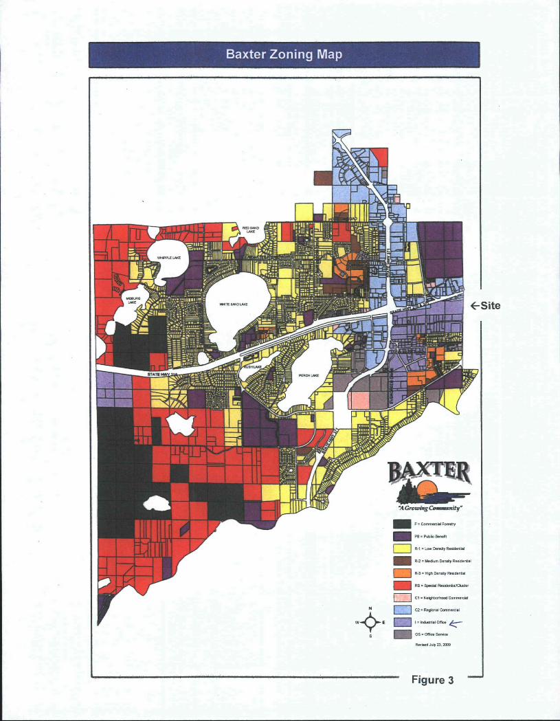
Baxter Zoning Map
^Si te
Figure 3

\
' ) J , ; J •'
W-
f i
A /V.
\ ^ / » fy
(T f v/ p
/-"'
\
\ i
Legend I 1 City Limits
E 3 Parka
I r * ^ Water
1 I Shoreland Mgmt - Rivers
|_ I Shoreland Mgmt - Lakes
Zoning Districts
R-1 Suburban Residential
mm^ I H I ^-2 Urban Residential
R-S Multiple Family
R-4 Manufactured Housing
R-F Rural Residental
^ ^ 1 B-1 Limited Business
^ m B-2 Neighbortiood Business
m 8-3 Centrai Business
^ ^ \.''^ B-4 General Business
; •*_ , 1-1 Light industrial
1-2 General Industrial
X Not in the City
Figure 4

.NOTE: SOILBORINGSSB-10ANDSB-11ARE , LOCATED APPROXIMATELY 300 FEET AND SB-9 1,000 FEET EAST OF SB-9 RESPECTIVELY. |5)
NOTE: SOIL BORINGS SB-1. SB-2, SB-S, SS-12 AND SB-13 ARE LOCATED OFFSITE APPROXIMATELY 1.000 FEET WEST OF SB-14. 5 g _ „
• 15)
Sampling Program; (1} AIMM • Assessmefit of Impacts and Mitigation Measures at the
Sudinglon Northem Brainerd MN Tie PlanL January 1984 (2)FS -FeasibilityStudy,August 1965 (3) ARi - Additional Remedial InvesHgab^ns Report, Brainerd Tie
Plant, Brainefd. MN. November 1965 (4)SI -SiteInvestigationRepoft,December 1987 (5) NTR - Nortl Track Letter Report. Juno 20O3
„ „ _ _ „ K
r-Z.'l T P 8 ,
(4)
L E G E N D
RAILROAD T7WCK
FENCE
BNSF PROPERTY BOUNDARY (APPROXIMATE)
FORMER TIE TREATING PLANT FACILITY
SAMPUNG P O I r ^
SAMPt.E TAKEN I H . • 19a3 a 19S5 • I9a7 • 2003
SAMPLING PROGRAM (SEE NOTES)
^ ; . \
^ R ETEC i B i S .
Scalo: r=100"
Five Year Review Soil Confinnation Report BNSF Fooner Tie Treating Plant
Bmirwcd, MNieNQ';0-13347-410)
bswMi T.C/STP I
HISTORICAL SOIL SAMPLE LOCATION MAP
Figure 5

Figure 6

500
MW-34B
•2,3-Dihydroindene —^—Benzene —iSs—Benzo(b)thiophene •Indene Phenolics, total
450 --
400
350 4-
oiBOO
o •S 250 4 w
c « g 200 o u
150 --
100 --
50 -
0
S'
GC System Off
^ rf-
GC System On
J " I
T
^ ^
^ ^
AlPS Phase I On GC System On
AlPS Phase II On GC System Off
Date
Figure 7A

MW-34C
1500
1250
1000
-B-2,3-Dihydroindene —0—Benzene ^6—Benzo(b)thiophene •Indene Phenolics, total
ai
c o B 750 -
c
8 c o u 500 -
250 -
GC System Off GC System On AlPS Phase I On GC System On
AlPS Phase II On GC System Off
Date
Figure 7B

cnn DUU
450 -
400 -
350 -
- 1
g300 -
c •S 250 -
c
1 200 -5
150 -
100 -
50 -
n 0 -
MW-35B
-e-2,3-Dihydroindene —e —Benzene —A—Benzo(b)thiophene —><—indene -*—Phenolics, total
t • — : , . ' > • ^ ~ \ ••'
GC System Off GC System On h AIPS Phase l On [J GC System On
r '
!"' " ""
i i ^
i i s i
" \ " "i ' i .— " " " i " i ; ^ t ! : s :
i \ i \
i i I
1 : 1 : . 1 j ' ] • • ' . ;
i 1 I
"
1 AlPS Phase II On j GC System Off
1
i j
i i i i
! • ! [ 1
[ I I I i j j 1
'' 1 .
jS ^ U L _ ^ ^ ^ 1
' <: ^ ^ , ^ ^ ^ ^ <> ^ ^ ^ r ^ ^ y ^ ^ ' ^ '
Date
Figure 7C

500
TMP-11
•2,3-Dihydroindene —^—Benzene —A—Benzo(b)thiophene •Indene Phenolics, total
Date
Figure 7D

500
TMP-14C
•2,3-Dihydroindene —e—Benzene —A—Benzo(b)thiophene •Indene •Phenolics, total
Date
Figure 7E

MW-13B
10000 T
o 'a
c « u c o u
• Diesel Range Organics —a—Gasoline Range Organics —©— Naphthalene
Date
Figure 7F

35000 T-
• Diesel Range Organics
TMP-1
- Gasoline Range Organics —e— Naphthalene
30000
25000
GC System Off GC System On ^j^Jf^^^^' ° " •' GC System On
AlPS Phase II On GC System Off
Date
Figure 7G

TMP-3
• Diesel Range Organics - Gasoline Range Organics —e— Naphthalene
10000 T-
9000 -
8000 -
Di 6000
GC System Off I GC System On '^j^Tf^^^^' ° " (• •' GC System On
AlPS Phase II On GC System Off
Figure 7H
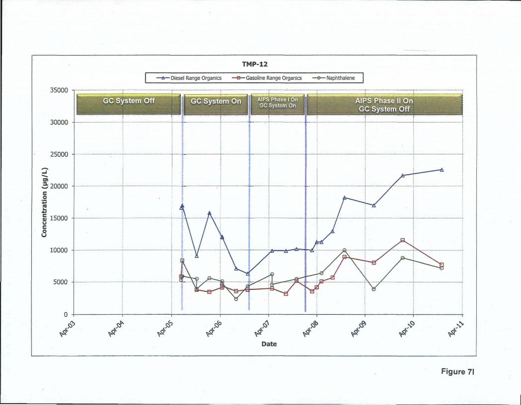
35000
30000
TMP-12
• Diesel Range Organics • Gasoline Range Organics o Naphthalene
GC System Off GC System On U AiPS/haseiOn ^ ^ ^ C System On
AlPS Phase II On GC System Off
Date
Figure 71

MW-29B
35000 T
30000
25000
• Diesel Range Organics -Gasoline Range Organics • Naphthalene
GC System Off GC System On A'^Vi^ase i on ' GC System On
AlPS Phase II On GC System Off
Date
Figure 7J

10000
• Diesel Range Organics
MW-31A
3—Gasoline Range Organics • Naphthalene
9000
8000 4
7000
gi 6000
c • | 5000
C
§ 4000 4 o u
3000 4
2000
10,00 4
0
. ^
GC System Off GC System On
. ^ ^
1 "T"
I r
Alps Phase I On GC System On
^ . *
/ . *
^^ ^
n B H
AlPS Phase II On GC System Off
Date
Figure 7K
BURUNGTON NORTHERN RAILROAD David C. Seep Manager Environmental Projects Burlington Northem Railroad 1600 Continental Plaza 777 lylain Street Fort Woith. Texas 76102-5384
Jaiiuaty 8, 1996
Kathy Ludenia Crow Wing County Recorder PC Box 383 Brainerd, Minnesota 56401
RE; Environmental Land Use Notice for Portions of Burlington Northem Railroad Property Located Within Grow Wing County (1-0061-880)
Dear Ms. Ludenia:
Enclosed is an environmental land use notice applicable to a portion of the fomier tie treating plant iniBrmnejrdy;!N4iahes6ta;?This land use notice was originally submitted to the Crow Wing County Recorder's Office on December 19,1995. The notice was returned to Burlington Northem Railroad on December 21,1995, with a memo requiring several clarifications. The notice is hereby being resubmitted with the clarifications requested in the December 21 memo.
This notice was prepared by Burlington Northem Railroad in accordance with applicable federal and state statutes and regulations. The enclosed land use restriction statement is to be recorded so that future purchasers of this parcel will be aware of the past land usage and land use restrictions prior to purchase. A check for the recording fee of $19.50 is also enclosed.
You may contact me. at (817) 3 3 3 -1946 with questions.
Sincerely,
David .0. Seep Manager Environmental Projects
Enclosures
cc: F. Jenness - Minnesota Pollution Control Agency T. Rutter - United States Environmental Protection Agency M. Salisbury - RETEC (w/o Exhibits)
P(tH.\\^t\i^ 1.
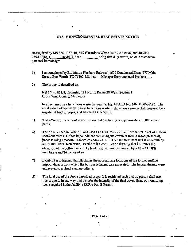
STATE ENVIRONMENTAL REAL ESTATE NOTICE
As required by MS Sec. 115B. 16. MN Hazardous Waste Rule 7-45.0496, and 40 CIvR 264.117(b), I, David C. Seep _ , being first duly sworn, on oath state firom personal knowledge:
1) I am employed by BurUrigton Northem Railroad, 1600 Continental Plaza, 777 Main Street, Fort Worth, TX 76102-5384, as Manager Environmental Projects
2) The property described as:
NE 1/4 - NE 1/4, Township 133 North, Range 28 West, Section 8 Crow Wing County, Minnesota
has been used as a hazardous waste disposal facility, EPA ID No. MND000686196. The areal extent of land used to treat hazardous waste is shown on a survey plat, prepared by a registered land surveyor, and attached as Exhibit 1.
3) The volume of hazardous waste disposed at the facility is approximately 10,000 cubic yards.
4) The area defined in ExHbit 1 was used as a land treatment unit for the treatment of bottom sediment ftom a surface impoundment containing wastewaters from a wood preserving jprocess using creosote. The waste code is KOOl. The land treatment unit is underlam by a 100 mil HDPE membrane. Exhibit 2 is a construction drawing that illustrates the elevation of the bottom liner. The land treatment unit is covered by a 40 mil HDPE membrane and 24 inches of soil.
7) Exhibit 3 is a drawing that illustrates the approximate locations of the former surface impoundments from which the bottom sediment was excavated. The impoundments were excavated to a \\sual cleanup criteria.
5) The land use of the above described property is restricted such that no person shall use this property in any way that disturbs the integrity of the final cover, liner, or monitoring wells required in the facility's RCRA Part B Permit.
Page 1 of2

6) The the land treatment unit/RCRA surface impoundment was closed during July and August of 1995 in accordance with a Minnesota Pollution Control Agency approved closure design.
Signature/^
Subscribed and sworn to before me this i i ^ ^ ^ Davof A?^y^y.tU^ • 1996. • 0'/li^M/U4J^
Signature of Notary Public or other official
, PMRJLM. GRANT NotaiyPuWte, Slate of Texas
MyCorrimlsslQnEmlres SEPTEMBER 20.1998
Page 2 of2
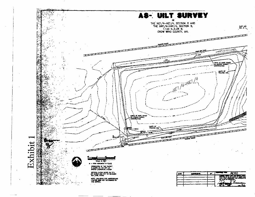
E*.'i ' ,
AS-: INLT SURVCY IN
THE NEt/4-NE1/+. SECTION 8 AND THE NW1/4-NW1/4, SECTION 9,
T.133 N..R.28 W. CROW WNG COUNTY. MN.
EAST UHC sec. i - ^
V5 tt:i-.\ * ,': . ii.'.ST': < ! V - ••• . •
• . ;• . : •^•¥ '"••
Pi?' ? : ;>, / . - : - •.
\K'.-'-'. •
m m ^ ^ •••' >-* ' • ' • • . , ' . ' . ' ' . • '
<".•.'--. • .•:: .^: '«-^.v . •
' : I.
t-.v:ii-.:-'^|;5^.! ••:••• •
• » MK kcnacHr If njicE cnotTAIKN OF 1HS SURVT saMBioN DcelTr cr -axmot cocaOMME nsiEM
. .« wiic».<iM> «Tr or m w o D
NOie U)tAK)« n * UMaotsniuw IIWTM « 0 r NOT DCIDMMCD *V

>CAS \ & r n TYPOU. Anouw ENnnc P€ftHeT£n o f tCM>0RAnT WASTE STOCICPIJ
T R E A T M E N T AREA P L A N V i e w SCALE f • 3 0 ' A
SUPPLY AMO IHSTALLATKM Of 24* g A 0 5 SUMPS AKO <* B PeW.»«0 WJN.peRP. HOPE Pipes BY OTHERS.
:2ass_
TSSHBHV K«tcca*s«£r-
" ^ g a S B S S S ^ ^
OH s r r e flACKFLL KONH^OUPACTES
AMCHOn TRENCK
TYPICAL DETAU [4.T.S.
TQa ras.
WELDED SEAMS
SCHLECEL'SHEET
H ^ - S H E E T NO. aYf.O - T O ? OF SEAM -TOE Of StDPE -EDGE OF AKCHOR TRE
.DETAIL OR SECTtON N ORAWlNGWy
tCITi SLT MAUKS KEFEIiaia F K K 1 ^ TOOmiK aSOIt K tMYK ERT REVISIQH I OAAMIHGS
^ pROjecTNo.o»s
SECTION 1
N.t.S. ™t»ef-« U »n« i cU . ~ , fMdt , 4 t t U ^ , t ^ t t m :
• r l t t a * iMra l l l l t n . ' 1 *"-! LsJ
~ ~" / d

(
m • 1—1
• 1—(
BURUNGTON HORTH£RN RAICROAO BRAINERD VZ PUMT
[iTt::^ |oj>«>l.&*itl > i / i m 1 • .f^Tgl

LOGIN . JOIN NOW 1 SUBSCRIBE t E-EOITION
N o v e m b e r s , 301111:50 am
JtfRAINERD D1SB4TCH g£AftCH
S i t e i? ' W e b \ - ' '**^ •••rch powmtmt bl VAH001 tCAMCH
Home New3 Spom Outdoors Opinion Obituaries Lifestyle Bnlertainmenl Real Estate Autos Jobs Clssjifteda Connect
Weather sponiored by:
BE SOCIAl I.HAM)
Are you searching for MPCA Burlln8;ton Nor the rn? Highlighi these search terms in the article
MPCA seeks comments on deanup at BN tie plant Poctitf: Fridiy, July 11,20oa
The MijiDGSOta PoUutioo Control Agency is starting ita five-year review of the Brainerd/Baxter
Burtingtoo Northern Railroad Tie Flam Superfund lite cleanup. Community input in this review will
be used in two areas: observations of the site over time and ways the cleanup may have helped the
area.
Superfund law requires that sites that have been clcaned.up but still have allowable levels of
contamination be reviewed al least every five years.
This, the fourth such review of the Burlington Northern site, will be completed by Sept. 30. The review ii to ensure that the cleanup remedies were effective and protected human health and the environment.
The review process includes site incpections, monitoring and Investigation data reviow, local
goveroinent and citizen interviews and public comment collectnn. it also summarizes site
information, cleanup techniques and possible future actions.
The approximately 70-aae site lies within the city limits of Baxter and Bninerd. Highway 310 and
Crow Wing County Road 48 border the property to the north and south, respectively, and the
Mississippi River flows about 3.000 feet cast of the site.
Burlington Northern operated a railroad-tie-treating plant on the site from 1907 to 1985. Ties were
pressure-treated at the plant with heated crflosote*coal tar or creosote-fiiel oil mocturcs.
The primary groundwater contaminant sources were shallow lagoons, which were used to hold
process wastewater from the time the plant opened until October 1982.
In the cleanup, conlHminated fioO and thidges were coiuolidated into a pennaneni, on-siie underground storage containment vault- /
Groundwater and soil contamination is stQ) an issue that BNSP is working loclean up, with oversight from the MPCA.
More information about the site and the Superfund program can be found on the MPCA'i Wdi site at
www.pca.itate.mn.us/progra ms/superf_p.html«site.
Public comment should be lubmitled to Susan Johnson, MPCA, 535 S. Lake Ave., Suite 400. Duluth,
MN 55B02 or e-mailed to susBnJohnson@pca jtate.mn.us. Comments must be received by July 35.
Related Content
MPCA pmiKisfj: lahinj t'tin tiff Siiprrfiind Itsi
MPCAseekjcommrnts on deanup «l BN tie plsnt
ll hut. lAken time to riean tip choji» silr
Raitraact citf clevelopmr.ni m*/ hinf;r cm dvanup
LOCAL BRIEFS
AGENDAS
ARfndas
I "Have you \ seen today's I deal?"
fe:?*;./^^'*'" •
^^^MtSlgnpimonllnel
i$^n;noin i c a t i o n Of t |EACHfDaily|Deal;;eih;^
} jtoRAI.NEKI) I)1SPVIT:H
Related Searches
SUSANJ0HNS0NS1PCA.STATE.MN.US SLUDGES POLLUTION CONTROL
MINNESOTA CREOSOTE-Ft/EL OIL MIXTURES MISSISSIPPI
MINNESOTA POLLUTION CONTROL AGENCY PROUUCTISSUES SOIL SUSANJOHNSON BAXTER E N V I R O N M E N T
DISASTER_ACCIDENT MISSISSIPPI RIVER
http://brainerddispatch.com/stories/07] 108/new_2008071 lOlO.shtml Attachment 1.

Advertise with Us I About I Contact I Directions I E&Q | Sitfiilaa | UolS£
:^^ ' ^y^-^m
R a d i o f o r t h e L a k e s Ar^£J
}?<-!»;< I p I <> I f ].:>:
Home On-Alr Schadute News Weather |Streomlng i Contests'. Homo Shopping I Obits JTripsl Event s i Extras
Friday, July 1 1 , 2008
The Bu r l i ng ton Nor thern Super fund Si te Gets a Rev iew
The Minnesota Pollution Control Agency is beginning a five-year review of the Brainerd-Baxter Burlington Northem Railroad Tie Plant Superfund cleanup site. The MPCA is asking for community Input. They are seeking observations of the site over time and ways the cleanup may have helped the area.
Superfund law requires a review at least every five years to determine if allowable levels of contamination have been exceeded. This Is the fourth such review of the B.N, site.
The 70-acre site lies between Baxter and Brainerd at State Highways 210 and 48.
Burlington Northern operated a railroad-tle-treating plant on the site from 1907 to 1985. Ties were pressure-treated at the plant with heated creosote-coal tar or creosote-fuel oil mixtures.
The primary groundwater contaminant sources were shallow lagoons, which were used to hold process wastewater from the time the plant opened until October 1982.
In the cleanup, contaminated soil and sludges were consolidated into a permanent, on-site underground storage containment vault.
The MPCA says groundwater and soil contamination Is still an Issue that the Burlington Northern Santa Fe Railroad Is working to clean up, with government oversight.
posted by KLKS News @ 10:30 AM E 3
UeOOCMRRK ^ :
O Comments:
Post a Comment
< < Home
Go
Previous Posts
• Mllle Lacs Band Chief Executive Sworn into Office
"The Exchange" Fire Still Under Investigation
• Bean Hole Davs a SuccessI
• Let's Go Fishlna!
• Buckle Up!
• House District Filinos Continue
Paul Bunvan's Paddle Has Been Found!
Metal Detectors in Crow Wing Countv Courthouse
Hackensack Sweetheart Davs!
http://klks.com/2008/07/buriington-northem-superfund-site-gets.html 11/3/2011

Attachment 3
Documents Reviewed
1. Administrative Order on Consent among MPCA, EPA, and BN, April 1985 2. Enforcement Decision Document/Remedial Alternative Selection, Burlington Northem
(BN), Brainerd, Minnesota, U.S. EPA, June 1986 3. Five Year Review Supplemental Soil confirmation report, RETEC, March 2007 4. Five Year Review Supplemental Soil Confirmation Report, ENSR/AECOM, June 2008 5. Air Injection Pilot System Performance Evaluation Report, AECOM, April 2009 6. Summary of Off-Site Response Action Activities, Former Tie Treating Plant Site,
Brainerd, Minnesota, AECOM, May 2009 7. Semi-Annual Monitoring Reports, Former Tie Treating Plant, Brainerd, Minnesota,
AECOM 8. Previous Five Year Reviews for the Site 9. RCRA Permit for Burlington Northem Santa Fe