freedom of navigation in the south china sea
TRANSCRIPT
SPECIAL REPORT
JUNE 2017
Freedom of Navigation in the South China SeaA Practical Guide
Eleanor Freund

Belfer Center for Science and International AffairsHarvard Kennedy School79 JFK StreetCambridge, MA 02138
www.belfercenter.org
Publication design and illustrations by Andrew Facini
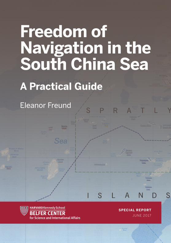
Cover photo: United States. Central Intelligence Agency. The Spratly Islands and Paracel Islands. Scale 1:2,000,000. Washington, D.C.: Central Intelligence Agency, 1992.
Copyright 2017, President and Fellows of Harvard CollegePrinted in the United States of America
SPECIAL REPORT
JUNE 2017
Freedom of Navigation in the South China SeaA Practical Guide
Eleanor Freund

ii Freedom of Navigation in the South China Sea: A Practical Guide
About the Author
Eleanor Freund is a Research Assistant at Harvard
Kennedy School’s Belfer Center for Science and
International Affairs. She studies U.S. foreign policy and
security issues, with a focus on U.S.-China relations.
Email: [email protected]
Acknowledgments
The author is grateful to James Kraska, Howard
S. Levie Professor of International Law at the U.S.
Naval War College, and Julian Ku, Maurice A. Deane
Distinguished Professor of Constitutional Law at
Hofstra University School of Law, for their thoughtful
comments and feedback on the text of this document.
All errors or omissions are the author’s own.
iiiBelfer Center for Science and International Affairs | Harvard Kennedy School
Table of Contents
What is the UN Convention on the Law of the Sea (UNCLOS)? ..............1
What are maritime features? ......................................................................1
Why is the distinction between different maritime features important? .................................................................................... 4
What are the territorial sea, the contiguous zone, and the exclusive economic zone? ........................................................... 5
What maritime zones do islands, rocks, and low-tide elevations generate? ....................................................................7
What maritime zones do artificially constructed islands generate? ..... 11
What are the restrictions on navigation in the territorial sea, contiguous zone, and exclusive economic zone? ............................12
What are excessive maritime claims? ..................................................... 17
Does the United States challenge excessive maritime claims? If so, why? ..................................................................... 17
How does the United States challenge excessive maritime claims? ......................................................................................18
What are Freedom of Navigation Operations (FONOPs)? .....................19
Why has the South China Sea become a focus of freedom of navigation concerns? ........................................................... 24
What excessive maritime claims has the United States challenged in the South China Sea? ....................................................... 26
U.S. Freedom of Navigation Operation #1 .................................................. 27U.S. Freedom of Navigation Operation #2 .................................................30U.S. Freedom of Navigation Operation #3 .................................................32U.S. Freedom of Navigation Operation #4 .................................................35U.S. Freedom of Navigation Operation #5 ................................................. 41
iv Freedom of Navigation in the South China Sea: A Practical Guide
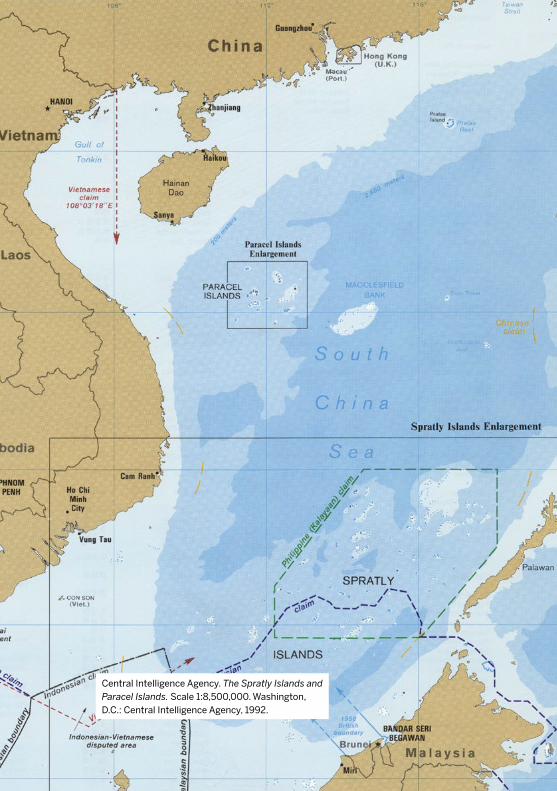
Central Intelligence Agency. The Spratly Islands and Paracel Islands. Scale 1:8,500,000. Washington, D.C.: Central Intelligence Agency, 1992.
1Belfer Center for Science and International Affairs | Harvard Kennedy School
What is the UN Convention on the Law of the Sea (UNCLOS)?
The UN Convention on the Law of the Sea
(UNCLOS) is the international agreement that
defines the rights and responsibilities of nations
with respect to their use of the world’s oceans. It
entered into force in 1994. Although the United
States has not ratified UNCLOS, it adheres to many
of its provisions, and strong support exists within
the U.S. foreign policy community for ratifying it.
What are maritime features?
A maritime feature is a part of the earth’s surface
occurring in the ocean that is not covered by water.
UNCLOS defines three kinds of maritime features:
1. islands
2. rocks
3. low-tide elevations
2 Freedom of Navigation in the South China Sea: A Practical Guide
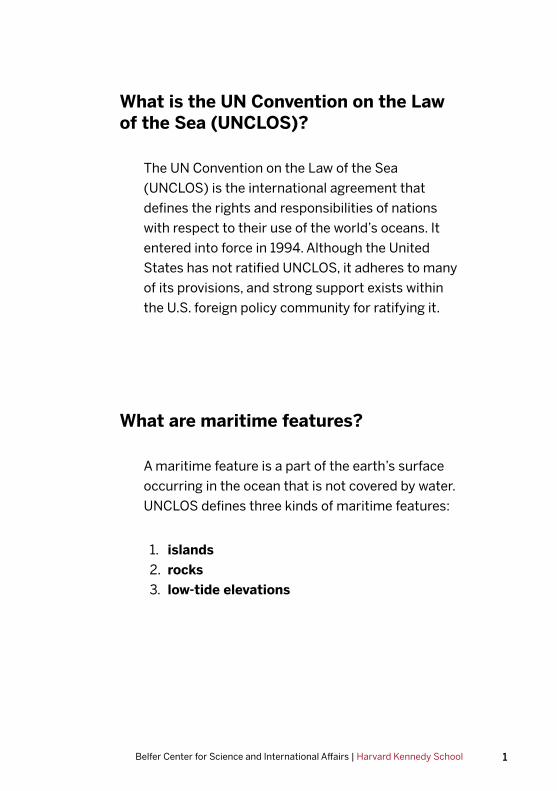
An island is a naturally formed area of land,
surrounded by water, which is always above water
and capable of sustaining human habitation or
economic activity.
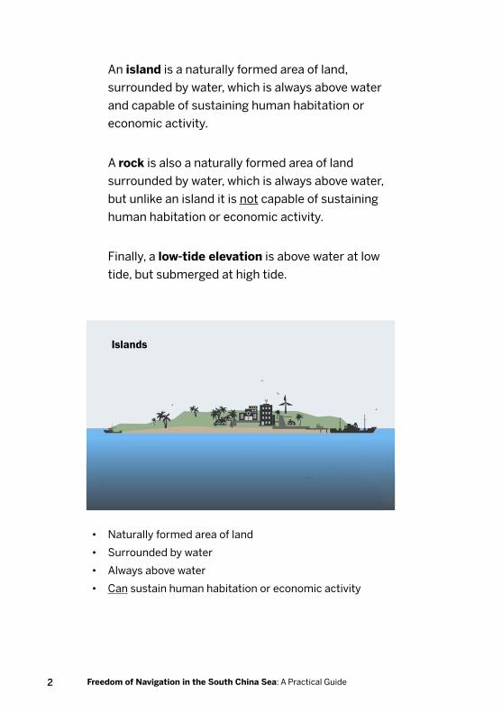
A rock is also a naturally formed area of land
surrounded by water, which is always above water,
but unlike an island it is not capable of sustaining
human habitation or economic activity.
Finally, a low-tide elevation is above water at low
tide, but submerged at high tide.
• Naturally formed area of land
• Surrounded by water
• Always above water
• Can sustain human habitation or economic activity
Islands
3Belfer Center for Science and International Affairs | Harvard Kennedy School
• Naturally formed area of land
• Surrounded by water
• Always above water
• Cannot sustain human habitation or economic activity
• Naturally formed area of land
• Surrounded by water
• Above water at low tide
• Submerged at high tide
Rocks
Low tide High tide
Low-Tide Elevations
4 Freedom of Navigation in the South China Sea: A Practical Guide
Why is the distinction between different maritime features important?
The distinction between maritime features (i.e.
islands, rocks, and low-tide elevations) is important
because each of these three features generates
different maritime zones. There are three basic
maritime zones:
1. the territorial sea
2. the contiguous zone
3. the exclusive economic zone (EEZ)1
1 The author is grateful to James Kraska for pointing out that maritime features only
generate these zones if they are under the sovereignty of a coastal state. Antarctica, for
example, does not generate any such maritime zones. For more on this point, see: James
Kraska, “Dewey Freedom of Navigation Operation Challenges China’s Sovereignty to
Mischief Reef,” Lawfare, May 25, 2017.
5Belfer Center for Science and International Affairs | Harvard Kennedy School
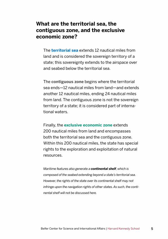
What are the territorial sea, the contiguous zone, and the exclusive economic zone?
The territorial sea extends 12 nautical miles from
land and is considered the sovereign territory of a
state; this sovereignty extends to the airspace over
and seabed below the territorial sea.
The contiguous zone begins where the territorial
sea ends—12 nautical miles from land—and extends
another 12 nautical miles, ending 24 nautical miles
from land. The contiguous zone is not the sovereign
territory of a state; it is considered part of interna-
tional waters.
Finally, the exclusive economic zone extends
200 nautical miles from land and encompasses
both the territorial sea and the contiguous zone.
Within this 200 nautical miles, the state has special
rights to the exploration and exploitation of natural
resources.
Maritime features also generate a continental shelf, which is
composed of the seabed extending beyond a state’s territorial sea.
However, the rights of the state over its continental shelf may not
infringe upon the navigation rights of other states. As such, the conti-
nental shelf will not be discussed here.
6 Freedom of Navigation in the South China Sea: A Practical Guide
Territorial Sea12 nautical m
iles
Contiguous Zone
+12 nautical miles
Exclusive Economic Zone
200 nautical miles
Land
7Belfer Center for Science and International Affairs | Harvard Kennedy School
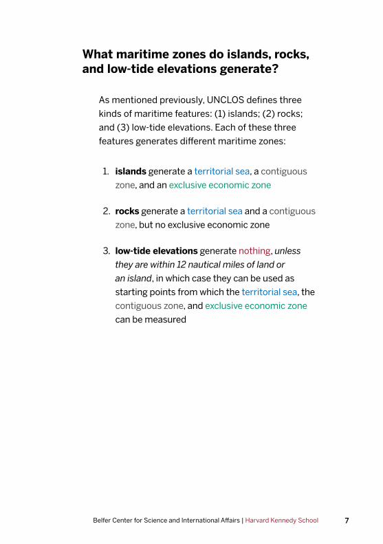
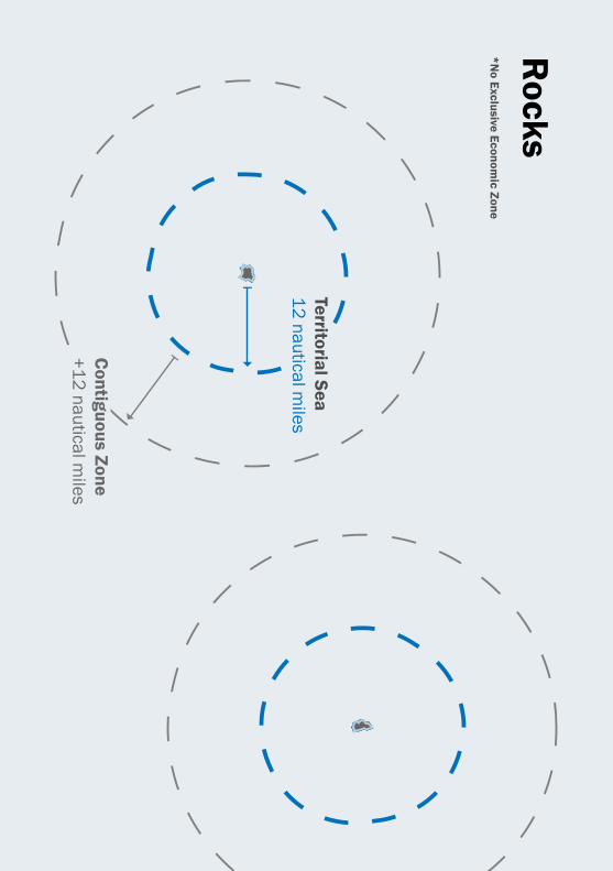
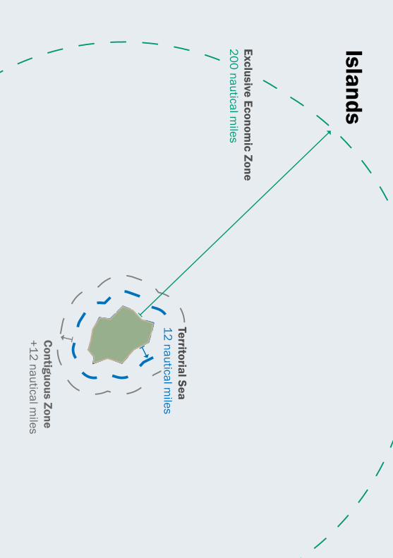
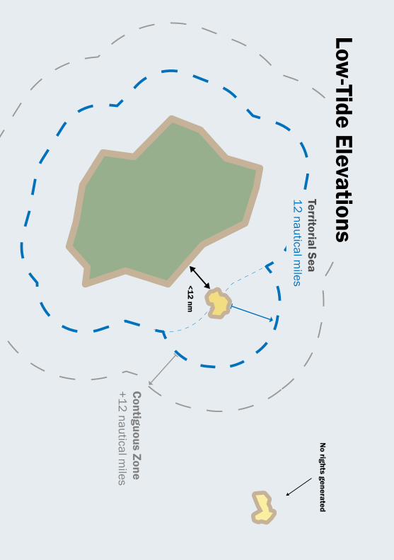
What maritime zones do islands, rocks, and low-tide elevations generate?
As mentioned previously, UNCLOS defines three
kinds of maritime features: (1) islands; (2) rocks;
and (3) low-tide elevations. Each of these three
features generates different maritime zones:
1. islands generate a territorial sea, a contiguous
zone, and an exclusive economic zone
2. rocks generate a territorial sea and a contiguous
zone, but no exclusive economic zone
3. low-tide elevations generate nothing, unless
they are within 12 nautical miles of land or
an island, in which case they can be used as
starting points from which the territorial sea, the
contiguous zone, and exclusive economic zone
can be measured
8 The Iran Nuclear Deal: A Definitive Guide
Territorial Sea12 nautical m
iles
Contiguous Zone
+12 nautical miles
*No Exclusive Econom
ic Zone
Rocks
9Belfer Center for Science and International Affairs | Harvard Kennedy School
Territorial Sea12 nautical m
iles
Contiguous Zone
+12 nautical miles
Exclusive Economic Zone
200 nautical miles
Islands
10 Freedom of Navigation in the South China Sea: A Practical Guide
<12 nm
No rights generated
Territorial Sea12 nautical m
iles
Contiguous Zone
+12 nautical miles
Low-Tide Elevations
11Belfer Center for Science and International Affairs | Harvard Kennedy School
What maritime zones do artificially constructed islands generate?
UNCLOS accords these rights to naturally formed
features. The rights accorded to an artificial island
would depend on what feature existed prior to the
construction of the artificial island.
If, for example, an artificial island was constructed
on top of a low-tide elevation, the new feature would
not be entitled to the rights of an island. In the
eyes of the law, it would still be a low-tide elevation
and granted only those rights accorded to low-tide
elevations.
12 Freedom of Navigation in the South China Sea: A Practical Guide
What are the restrictions on navigation in the territorial sea, contiguous zone, and exclusive economic zone?
Territorial Sea
The territorial sea is the sovereign territory of a
state. As such, the state has the exclusive right to
make, apply, and execute its own laws in that space
without foreign interference. However, one of the
fundamental principles of UNCLOS is that all ships
of all states, including both civilian and military ves-
sels, enjoy the right of innocent passage through
the territorial sea of other states. Any and all states
that have signed and ratified UNCLOS are obligated
to respect this provision.
Innocent passage requires that vessels move
directly through the territorial sea and refrain from
any activity not necessary for their continuous and
expeditious passage. Providing notice or obtaining
permission prior to transiting under innocent pas-
sage is not required.2
2 The author is grateful to Julian Ku for pointing out that not all countries agree with this
interpretation, particularly where the innocent passage of military vessels is concerned.
Over 40 states impose restrictions on the innocent passage of military ships, including
requiring permission or notice prior to transit under innocent passage.

13Belfer Center for Science and International Affairs | Harvard Kennedy School
Territorial Sea12 nautical m
iles
Contiguous Zone
+12 nautical miles
Civilian + Military
Innocent Passage

14 Freedom of Navigation in the South China Sea: A Practical Guide
UNCLOS lists those activities not permitted while
transiting under innocent passage:
• threatening/using force against the state
• military exercises
• practicing with weapons
• surveillance operations
• propagandizing against the state
• launching/landing/taking on board aircraft
or military devices
• loading/unloading illegal commodities,
currencies, or persons
• polluting
• fishing
• research or survey activities
• interfering with the state’s communications,
or any other facilities/installations
• any other activity not having a direct impact
on passage
It is important to note that while a state can limit
military and surveillance operations in its territorial
sea, it cannot limit military and surveillance ships
that transit in accordance with innocent passage,
provided they do not conduct military or surveil-
lance activities while they do so. If a ship is found
to conduct any of these activities while transiting
under innocent passage, the state may require the
ship to leave its territorial sea immediately.
15Belfer Center for Science and International Affairs | Harvard Kennedy School
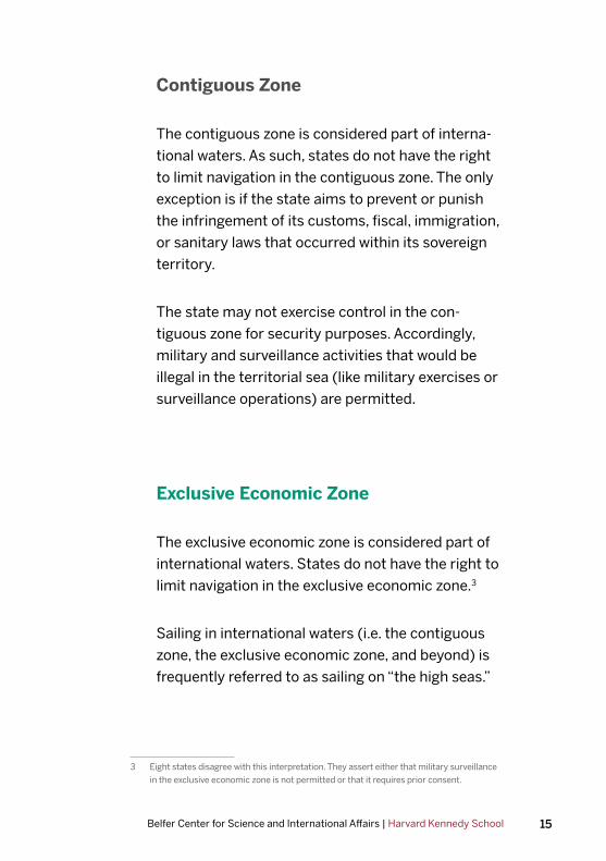
Contiguous Zone
The contiguous zone is considered part of interna-
tional waters. As such, states do not have the right
to limit navigation in the contiguous zone. The only
exception is if the state aims to prevent or punish
the infringement of its customs, fiscal, immigration,
or sanitary laws that occurred within its sovereign
territory.
The state may not exercise control in the con-
tiguous zone for security purposes. Accordingly,
military and surveillance activities that would be
illegal in the territorial sea (like military exercises or
surveillance operations) are permitted.
Exclusive Economic Zone
The exclusive economic zone is considered part of
international waters. States do not have the right to
limit navigation in the exclusive economic zone.3
Sailing in international waters (i.e. the contiguous
zone, the exclusive economic zone, and beyond) is
frequently referred to as sailing on “the high seas.”
3 Eight states disagree with this interpretation. They assert either that military surveillance
in the exclusive economic zone is not permitted or that it requires prior consent.

16 Freedom of Navigation in the South China Sea: A Practical Guide
Civilian + Military
Sailing on High Seas
Territorial Sea12 nautical m
iles
Contiguous Zone
+12 nautical miles
17Belfer Center for Science and International Affairs | Harvard Kennedy School
What are excessive maritime claims?
Excessive maritime claims are assertions by states
that are inconsistent with the terms of UNCLOS. In
other words, they are unlawful or illegal. There are
generally two types of these claims:
1. claims inconsistent with the legal divisions of
the ocean and related airspace (e.g. territorial
sea claims greater than 12 nautical miles)
2. restrictions on navigation and overflight
rights (e.g. requiring advance notification or
authorization for innocent passage of warships
through the territorial sea)
Does the United States challenge excessive maritime claims? If so, why?
It is recognized international law and practice that,
to prevent deviations from the law, states must
persistently object to actions by other states that
seek to change those rules.4 The United States
challenges excessive maritime claims under its
Freedom of Navigation Program, the purpose of
which is to do exactly this: object to excessive mar-
itime claims that could limit freedom of the seas.
The program impartially rejects the excessive mari-
time claims of all states, friend and foe alike.5
4 Fisheries Case (U.K. v. Nor.), Judgment, 1951 I.C.J. Rep. 116, 138 (Dec. 18).
5 Zbigniew Brzezinski, The White House, Memorandum for the Secretary of State and the
Secretary of Defense, et al., “Navigational Freedom and U.S. Security Interests,” March
20, 1979 (Confidential; declassified August 22, 2000).
18 Freedom of Navigation in the South China Sea: A Practical Guide
How does the United States challenge excessive maritime claims?
There are generally three ways the United States
contests excessive maritime claims as part of its
Freedom of Navigation Program:
1. diplomatic communications
2. operational assertions
3. bilateral and multilateral consultations
Diplomatic communications include correspon-
dence and formal protest notes.
Operational assertions are operations conducted by
U.S. naval and air forces that assert internationally-
recognized navigational rights and freedoms.
These operations are called freedom of navigation
operations, or FONOPs.
Finally, bilateral or multilateral consultations
encourage maritime stability and adherence to the
provisions of UNCLOS.
19Belfer Center for Science and International Affairs | Harvard Kennedy School
What are Freedom of Navigation Operations (FONOPs)?
Freedom of Navigation Operations are operations
by U.S. naval and air forces that reinforce
internationally-recognized rights and freedoms
by challenging excessive maritime claims. The
particulars of each operation are determined by the
excessive maritime claim that is being protested.
For illustration of this point, consider two
hypothetical scenarios on the following pages.

20 Freedom of Navigation in the South China Sea: A Practical Guide
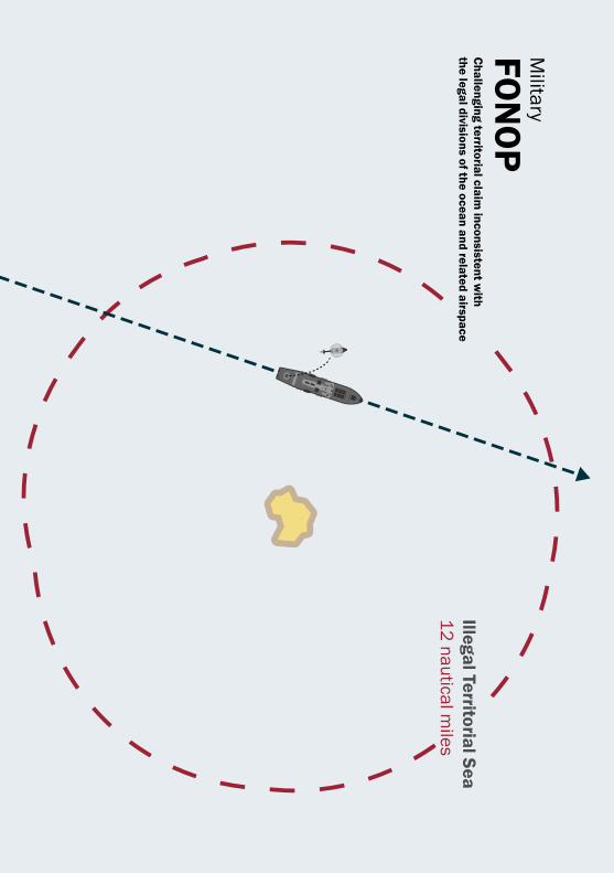
Scenario One:
A state claims a 12 nautical mile territorial sea
around a low-tide elevation that is not within 12
nautical miles of land or an island. This would be
inconsistent with the provisions of UNCLOS. (Recall
that low-tide elevations alone do not generate
territorial seas; see pages 7 and 10 for further elab-
oration on this point).
The United States protests this excessive claim by
sailing within 12 nautical miles of the low-tide ele-
vation and conducting activities not in accordance
with innocent passage.
By deliberately transiting in a manner inconsistent
with innocent passage—launching a helicopter, for
example—the United States would send the mes-
sage that it does not consider the low-tide elevation
to be entitled to a territorial sea. The unstated
assumption, of course, is that the United States
would not deliberately disregard international law.
21Belfer Center for Science and International Affairs | Harvard Kennedy School
Illegal Territorial Sea12 nautical m
iles
Military
FON
OP
Challenging territorial claim
inconsistent with
the legal divisions of the ocean and related airspace
22 Freedom of Navigation in the South China Sea: A Practical Guide
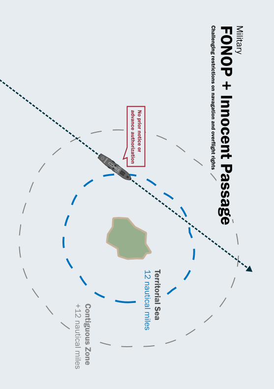
Scenario Two:
A state requires that ships provide notice and
obtain advance authorization for innocent pas-
sage through its territorial sea. This would be
inconsistent with the provisions of UNCLOS. (Recall
that all ships of all states enjoy the right of innocent
passage through the territorial sea of other states,
and providing or obtaining advance permission is
not required. See pages 12–14 for further elabora-
tion on this point.)
The United States wants to protest the requirement
that ships provide notice and obtain advance
authorization for innocent passage, but in this
scenario it does not dispute the existence of a
territorial sea. The United States thus sails under
innocent passage through the territorial sea, but
it does so without providing notice or obtaining
advance authorization.
As a result, the United States is both transiting
under innocent passage and conducting a freedom
of navigation operation. In other words, innocent
passage and freedom of navigation operations are
not necessarily mutually exclusive.
23Belfer Center for Science and International Affairs | Harvard Kennedy School
Contiguous Zone
+12 nautical miles
Military
FON
OP
+ Innocent PassageC
hallenging restrictions on navagation and overflight rights
No prior notice or
advance authorization
Territorial Sea12 nautical m
iles
24 Freedom of Navigation in the South China Sea: A Practical Guide
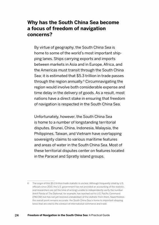
Why has the South China Sea become a focus of freedom of navigation concerns?
By virtue of geography, the South China Sea is
home to some of the world’s most important ship-
ping lanes. Ships carrying exports and imports
between markets in Asia and in Europe, Africa, and
the Americas must transit through the South China
Sea; it is estimated that $5.3 trillion in trade passes
through the region annually.6 Circumnavigating the
region would involve both considerable expense and
time delay in the delivery of goods. As a result, most
nations have a direct stake in ensuring that freedom
of navigation is respected in the South China Sea.
Unfortunately, however, the South China Sea
is home to a number of longstanding territorial
disputes. Brunei, China, Indonesia, Malaysia, the
Philippines, Taiwan, and Vietnam have overlapping
sovereignty claims to various maritime features
and areas of water in the South China Sea. Most of
these territorial disputes center on features located
in the Paracel and Spratly island groups.
6 The origin of this $5.3 trillion trade statistic is unclear. Although frequently cited by U.S.
officials since 2010, the U.S. government has not provided an accounting of the statistic,
and researchers are (at the time of writing) unable to independently verify the number.
Ankit Panda of The Diplomat, for example, has reached out to U.S. Pacific Command
(PACOM) but has not yet received a breakdown of the statistic from them. Nevertheless,
the overall point remains accurate: the South China Sea is home to important shipping
lanes that are vital to the conduct of international commerce and trade.
25Belfer Center for Science and International Affairs | Harvard Kennedy School
In order to reinforce territorial claims, several
states occupy features in the South China Sea, and
some have reclaimed land, built infrastructure (e.g.
airfields, hangers, docks), and stationed troops and
military hardware on these features. Their actions
have raised concerns over the possibility of conflict
and the increased capabilities of states to limit
navigation in the region. Although several states
have engaged in such activities, the amount of
reclamation and construction undertaken by China,
as well as the degree of militarization of features it
occupies, has raised particular concern.
The United States does not take a position on
territorial disputes over features in the South China
Sea and the merits of various sovereignty claims
will not be discussed in detail here. However, it
does actively protest illegal claims to the waters
surrounding these features, as well as illegal
restrictions on navigation. Several states in the
region have made such excessive maritime claims
that illegally limit freedom of navigation. The United
States conducts freedom of navigation operations
in the South China Sea to protest these claims.

26 Freedom of Navigation in the South China Sea: A Practical Guide
What excessive maritime claims has the United States challenged in the South China Sea?
Over the past year and a half, the United States has
publicly conducted five freedom of navigation oper-
ations in the South China Sea. These operations
took place on: October 27, 2015; January 29, 2016;
May 10, 2016; October 21, 2016; and May 24, 2017.
In the first three freedom of navigation operations, the
United States conducted operations challenging the
illegal requirement that ships provide notification or
obtain permission before transiting through another
state’s territorial sea under innocent passage.
In the fourth freedom of navigation operation,
the United States challenged excessive straight
baseline claims. This document has not yet described
straight baselines as outlined by UNCLOS, or excessive straight
baseline claims. This will be included in discussion of this freedom
of navigation operation.
In its fifth and most recent freedom of navigation
operation, the United States challenged the
existence of an illegal territorial sea. There is
some debate, however, as to whether this actually
constituted a freedom of navigation operation.
The operational nature and legal rationale of each
FONOP is outlined on the following pages.
27Belfer Center for Science and International Affairs | Harvard Kennedy School
U.S. Freedom of Navigation Operation #1
Date: October 27, 2015
Location: Spratly Islands (Subi Reef, Northeast
Cay, Southwest Cay, South Reef, Sandy Cay)
Vessel: USS Lassen (DDG-82)
Excessive Maritime Claim: Requirement that
states provide notice/obtain permission prior to
innocent passage through territorial sea
Nature of Transit: Innocent passage
On October 27, 2015, the U.S. Navy destroyer USS
Lassen conducted a freedom of navigation oper-
ation by transiting under innocent passage within
12 nautical miles of five features in the Spratly
Islands—Subi Reef, Northeast Cay, Southwest
Cay, South Reef, and Sandy Cay—each of which is
claimed by China, Taiwan, Vietnam, and the Phil-
ippines. The freedom of navigation operation was
designed to challenge policies by China, Taiwan, and
Vietnam requiring prior permission or notification
of transit under innocent passage in their territorial
sea. Accordingly, the United States did not provide
notification, or request permission, in advance of
transiting under innocent passage.
28 Freedom of Navigation in the South China Sea: A Practical Guide
Potential C
ontiguous Zone+12 nautical m
iles
October 27, 2015 | Spratly Islands FO
NO
P
Subi Reef
Innocent Passage
<12 nm
Northeast Cay
Southwest Cay
Thitu Island
Subi Reef
Sandy Cay
Potential Territorial Sea12 nautical m
iles
No prior notice or
advance authorization Approximation of
USS Lassen’s
route
29Belfer Center for Science and International Affairs | Harvard Kennedy School
It should be noted, however, that none of these
states has formally made a legal claim to a
territorial sea around these features. Indeed, no
state has made any specific claims to the waters
surrounding the features it occupies in the Spratly
Islands.
In practice, however, they still require that states
obtain permission or provide notice prior to
transiting within 12 nautical miles, and these
specific features would be legally entitled to
a territorial sea. As a result, the United States
observed requirements of innocent passage during
its transit. The United States does not take a
position on which nation has sovereignty over each
feature in the Spratly Islands, and the operation was
not intended to challenge any country’s claims of
sovereignty over land features.
30 Freedom of Navigation in the South China Sea: A Practical Guide
U.S. Freedom of Navigation Operation #2
Date: January 29, 2016
Location: Paracel Islands (Triton Island)
Vessel: USS Curtis Wilbur (DDG-54)
Excessive Maritime Claim: Requirement that
states provide notice/obtain permission prior to
innocent passage through territorial sea
Nature of Transit: Innocent passage
On January 29, 2016, the U.S. Navy destroyer USS
Curtis Wilbur conducted a freedom of navigation oper-
ation by transiting under innocent passage within 12
nautical miles of Triton Island in the Paracel Islands.
Triton Island is occupied by the Chinese, but also
claimed by Taiwan and Vietnam. The island is legally
entitled to a territorial sea. The freedom of naviga-
tion operation was designed to challenge policies by
China, Taiwan, and Vietnam requiring prior permission
or notification of transit under innocent passage in the
territorial sea. Accordingly, the United States did not
provide notification, or request permission, in advance
of transiting under innocent passage. The United
States does not take a position on which nation has
sovereignty over each feature in the Spratly Islands,
and the operation was not intended to challenge any
country’s claims of sovereignty over land features.

31Belfer Center for Science and International Affairs | Harvard Kennedy School
Territorial Sea12 nautical m
iles
January 29, 2016 | Paracel Islands FON
OP
Triton IslandInnocent Passage
Triton Island
Approximation of
USS Curtis W
ilbur’s route
No prior notice or
advance authorization
Triton Island中建岛
Zhōngjiàn Dǎo
đảo Tri Tôn
32 Freedom of Navigation in the South China Sea: A Practical Guide
U.S. Freedom of Navigation Operation #3
Date: May 10, 2016
Location: Spratly Islands (Fiery Cross Reef)
Vessel: USS William P. Lawrence (DDG-110)
Excessive Maritime Claim: Requirement that
states provide notice/obtain permission prior to
innocent passage through territorial sea
Nature of Transit: Innocent passage
On May 10, 2016, the U.S. Navy destroyer USS
William P. Lawrence conducted a freedom of
navigation operation by transiting under innocent
passage within 12 nautical miles of Fiery Cross Reef
in the Spratly Islands. Fiery Cross Reef is occupied
by the Chinese, but also claimed by the Philippines,
Taiwan, and Vietnam.
At the time that the freedom of navigation
operation was conducted, it was unclear if Fiery
Cross Reef was legally considered a rock or an
island. Moreover, none of the claimant states
has formally made a legal claim to a territorial
sea surrounding Fiery Cross Reef. Nevertheless,
because Fiery Cross Reef is legally entitled to a
territorial sea, irrespective of whether it is a rock or
island, the United States transited within 12 nautical
33Belfer Center for Science and International Affairs | Harvard Kennedy School
PotentialTerritorial Sea12 nautical m
iles
May 10, 2016 | Spratly Islands FO
NO
P
Fiery Cross R
eefInnocent Passage
Originally a rock;
subsequently reclaimed
No prior notice or
advance authorization
Fiery Cross R
eef 永暑礁
Kagitingan R
eefĐ
á Chữ
Thập
Approximation of
USS W
illiam P.
Lawrence’s route
Fiery Cross Reef
34 Freedom of Navigation in the South China Sea: A Practical Guide
miles of Fiery Cross Reef under the provisions
of innocent passage. When the decision in the
Philippines v. China case was issued in July 2016,
Fiery Cross Reef was found to be a rock.7
As in the previous two examples, this freedom of
navigation operation was designed to challenge
policies by China, Taiwan, and Vietnam requiring
prior permission or notification of transit under
innocent passage in the territorial sea. Accordingly,
the United States did not provide notification, or
request permission, in advance of transiting under
innocent passage. The United States does not take
a position on which nation has sovereignty over
each feature in the Spratly Islands, and the oper-
ation was not intended to challenge any country’s
claims of sovereignty over land features.
7 Philippines v. China was a legal case brought by the Philippines against China under the
dispute settlement provisions of UNCLOS. The case concerned disagreements between
the two countries in the South China Sea; as part of the case, the Philippines asked for
a ruling on the status of various features in the South China Sea. When the Permanent
Court of Arbitration released the award in July 2016, it was widely considered to be a
victory for the Philippines.
35Belfer Center for Science and International Affairs | Harvard Kennedy School
U.S. Freedom of Navigation Operation #4
Date: October 21, 2016
Location: Paracel Islands
Vessel: USS Decatur (DDG-73)
Excessive Maritime Claim: Excessive straight
baseline claims
Nature of Transit: Sailing on the high seas
The fourth freedom of navigation operation, con-
ducted on October 21, 2016, differed from the three
previous freedom of navigation operations in that
it did not challenge the illegal requirement that
states provide notification or obtain permission
prior to transiting through another state’s territorial
sea under innocent passage. Rather, it challenged
excessive straight baseline claims made by China
around the Paracel Islands. The Paracel Islands
are occupied by the Chinese, but also claimed by
Taiwan and Vietnam.
Baselines are the point from which the territorial
sea, contiguous zone, and exclusive economic
zone are measured. Generally speaking, they exist
at the low-water line along the coast.

36 Freedom of Navigation in the South China Sea: A Practical Guide
Territorial Seas12 nautical m
iles
Contiguous Zone
+12 NM
Paracel Islands
Legal Maritim
e Zones
Fiery Cross R
eef 永暑礁
Kagitingan R
eefĐ
á Chữ
Thập
Maritim
e zones based on CIA map. See: United States. Central Intelligence Agency.
South China Sea. Scale 1:2,900,000. Washington, D
.C.: Central Intelligence Agency, 1995.
37Belfer Center for Science and International Affairs | Harvard Kennedy School
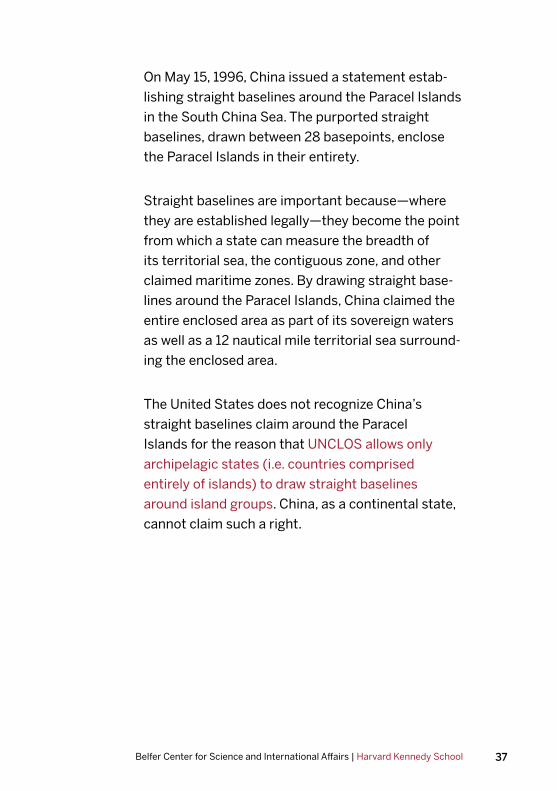
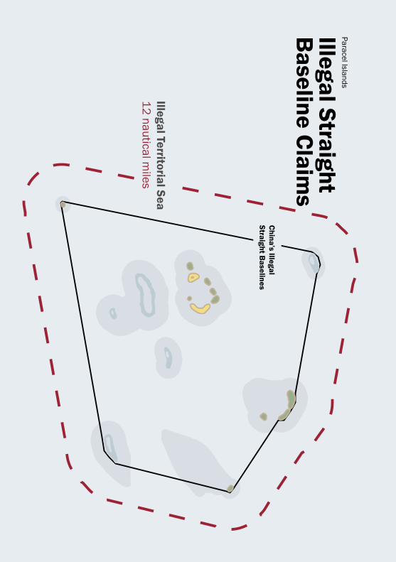
On May 15, 1996, China issued a statement estab-
lishing straight baselines around the Paracel Islands
in the South China Sea. The purported straight
baselines, drawn between 28 basepoints, enclose
the Paracel Islands in their entirety.
Straight baselines are important because—where
they are established legally—they become the point
from which a state can measure the breadth of
its territorial sea, the contiguous zone, and other
claimed maritime zones. By drawing straight base-
lines around the Paracel Islands, China claimed the
entire enclosed area as part of its sovereign waters
as well as a 12 nautical mile territorial sea surround-
ing the enclosed area.
The United States does not recognize China’s
straight baselines claim around the Paracel
Islands for the reason that UNCLOS allows only
archipelagic states (i.e. countries comprised
entirely of islands) to draw straight baselines
around island groups. China, as a continental state,
cannot claim such a right.

38 Freedom of Navigation in the South China Sea: A Practical Guide
October 21, 2016| Paracel Islands FO
NO
P
Challenging
Illegal Straight B
aseline Claim
sN
on-Innocent Passage
Fiery Cross R
eef 永暑礁
Kagitingan R
eefĐ
á Chữ
Thập
Approximation of
USS D
ecatur’s route
Territorial Seas12 nautical m
iles
Contiguous Zone
+12 NM
Maritim
e zones based on CIA map. See: United States. Central Intelligence Agency.
South China Sea. Scale 1:2,900,000. Washington, D
.C.: Central Intelligence Agency, 1995.
39Belfer Center for Science and International Affairs | Harvard Kennedy School
Illegal Territorial Sea12 nautical m
iles
China’s Illegal
Straight Baselines
Paracel Islands
Illegal Straight B
aseline Claim
sFiery C
ross Reef
永暑礁
Kagitingan R
eefĐ
á Chữ
Thập
40 Freedom of Navigation in the South China Sea: A Practical Guide
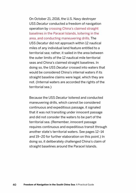
On October 21, 2016, the U.S. Navy destroyer
USS Decatur conducted a freedom of navigation
operation by crossing China’s claimed straight
baselines in the Paracel Islands, loitering in the
area, and conducting maneuvering drills. The
USS Decatur did not approach within 12 nautical
miles of any individual land feature entitled to a
territorial sea; rather, it sailed in the area between
the outer limits of the 12 nautical mile territorial
seas and China’s claimed straight baselines. In
doing so, the USS Decatur crossed into waters that
would be considered China’s internal waters if its
straight baseline claims were legal, which they are
not. (Internal waters are accorded the rights of the
territorial sea.)
Because the USS Decatur loitered and conducted
maneuvering drills, which cannot be considered
continuous and expeditious passage, it signaled
that it was not transiting under innocent passage
and did not consider the waters to be part of the
territorial sea. (Remember, innocent passage
requires continuous and expeditious transit through
another state’s territorial waters. See pages 12–14
and 19–20 for further elaboration on this point.) In
doing so, it deliberately challenged China’s claim of
straight baselines around the Paracel Islands.
41Belfer Center for Science and International Affairs | Harvard Kennedy School
U.S. Freedom of Navigation Operation #5
Date: May 24, 2017
Location: Spratly Islands (Mischief Reef)
Vessel: USS Dewey (DDG-105)
Excessive Maritime Claim: Unclear, presumed
illegal territorial sea
Nature of Transit: Sailing on the high seas
On May 24, 2017, the U.S. Navy destroyer USS
Dewey conducted a freedom of navigation oper-
ation by transiting within 12 nautical miles of
Mischief Reef in the Spratly Islands. Mischief Reef
is occupied by the Chinese, but also claimed by the
Philippines, Taiwan, and Vietnam. When the Per-
manent Court of Arbitration issued the decision in
Philippines v. China, it found Mischief Reef to be a
low-tide elevation. For that reason, Mischief Reef is
not legally entitled to a territorial sea.
The USS Dewey navigated within 12 nautical miles
of Mischief Reef and proceeded to sail in a zigzag
pattern. It also conducted a “man overboard” drill.
Both actions were clear indications that the USS
Dewey did not intend to transit under innocent
passage. (Remember, innocent passage requires
continuous and expeditious transit through another

42 Freedom of Navigation in the South China Sea: A Practical Guide
state’s territorial waters. Sailing in a zigzag pattern
and conducting a man overboard drill are both
violations of this condition. See pages 12–14 and
19–20 for further elaboration on this point.) Pre-
sumably then, the freedom of navigation operation
was intended to challenge the existence of an illegal
territorial sea around Mischief Reef by sailing within
12 nautical miles of the feature in a manner not in
accordance with innocent passage.
Complicating the operation, however, is the fact
that neither China, the Philippines, Taiwan, nor Viet-
nam has actually claimed a territorial sea around
Mischief Reef. This raises the question: what exces-
sive maritime claim was the United States actually
challenging? If the United States was not disput-
ing an existing excessive maritime claim, then its
actions would be more accurately described as sail-
ing on the high seas than as a freedom of navigation
operation. Unfortunately, the Pentagon has not
explained the legal rationale behind the operation
so the intent of the USS Dewey’s operation remains
unclear.
As was true in prior examples, the United States
does not take a position on which nation has sover-
eignty over each feature in the Spratly Islands, and
the operation was not intended to challenge any
country’s claims of sovereignty over land features.

43Belfer Center for Science and International Affairs | Harvard Kennedy School
May 24, 2017 | Spratly Islands FO
NO
P
Mischief R
eefN
on-Innocent Passage
Conducted man
overboard drill
Potential IllegalTerritorial Sea12 nautical m
iles
Mischief R
eefLow
-Tide Elevation
Approximation of
USS D
ewey’s route


Belfer Center for Science and International AffairsHarvard Kennedy School79 JFK StreetCambridge, MA 02138
www.belfercenter.org
Copyright 2017, President and Fellows of Harvard College
Printed in the United States of America