frequencies, nets, wx schedules and tables · frequencies, nets, wx schedules and tables formerly...
TRANSCRIPT

FREQUENCIES, NETS, WX SCHEDULES AND TABLES
Formerly Titled
“APPENDIX TO THE
isclaimer. This document was compiled from information supplied a member of the Cruising
at any of the formation is inaccurate, it has not confirmed the accuracy or completeness of the information and
resentation with respect thereto. Furthermore, this document does not purport to upply all of the information about offshore communications that someone should have before mbarking on an offshore passage.
OFFSHORE COMMUNICATIONS MEMORANDUM”
Version 6.1
Walter R. Paul DClub of America and from various publications and websites to which the reader is referred for more detailed and current information. While the Club has no reason to believe thinmakes no repse Note: Any reference to a commercial product or service does not imply any endorsement by the Cruising Club of America as to function or suitability for any purpose or environment.

FOREWORD The orientation of the original Offshore Communications Memorandum posted to the web in 2002 was outward bound from North America and included a little material about Bermuda and the Caribbean. Recognizing that cruisers can be in almost any part of the world these days, the scope has been expanded to include other cruising areas in various degrees. Particular emphasis on
urope has been included in recognition of pending cruises there. With the expanded coverage
mmunications Europe and so on. The focus is mainly on applications available to the Single Sideband Radio SB) omitting theory, installation and the like available elsewhere.
his paper, previously called the “Offshore Communication Memorandum Appendix” contains stings and table data such as authorized SSB frequencies, Nets (both SSB and Ham), weather
any, an xtended listing of Navtex stations, Airmail Stations, Conversion Tables and so on.
otes:
. All frequencies and SSB modes described are kHz and USB unless otherwise noted.
Marine Single Sideband Radios.
agencies and sources. L (Lima) signifies Local Time.
. The International Telegraphic Union (ITU) is a UN body located at Geneva, Switzerland that
munications Commission (FCC) and administered by various agencies.
. It has been suggested that an index be added. Actually, a facility in Adobe Acrobat is available
rogram will do the rest.
Eand additional material, it has been necessary to divide the original Memorandum into two parts. The primary paper, the Offshore Communications Memorandum, now deals with safety, weather, communication systems such as Navtex, RTTY, notes on yacht navigation, yacht coin(S Tlifax schedules for North America and Europe, the RTTY schedule for Hamburg, Germe N 1 2. Although Ham radios and other equipment operate in single sideband mode, SSB throughout this paper pertains to
3. Schedules, frequencies, Web sites and the like were current in the spring of 2006. Changes do occur particularly with volunteer nets which should be verified before casting off. 4. Greenwich Mean Time (GMT), Coordinated Universal Time (UTC) and Zulu (Z) are used interchangeably throughout to remain consistent with the various
5regulates radio usage including frequency and channel allocations. The US along with most maritime countries is party to treaties supporting these regulations. They are promulgated in the US by the Federal ComThe US Coast Guard has responsibility for maritime applications.
6. Hyperlinks and charts are presented in color. 7for this. Simply click on “Edit” on the Tool Bar, then “Find” and type in the reference word. The p
Version 6.1 - 2 - 29 Jul 06

8. o nloa nning on Windows XP requires Acrobat Reader Version 6.0 o der was released prior to Windows XP and while the display will appear correct on the computer screen running Windows XP, printing it out will not.
.
– 0.5”
learly, this material is not all inclusive and is also dated by its nature. Readers who learn of eaningful changes are asked to forward these for use in future updates as has been done in this
e this paper along with updates, corrections, and omments are most welcomed; please do not hesitate to send an email. By all means, the latest
version should always be consulted. My thanks to those readers with sharp e the time to write about corrections. Best wishes for fair winds and good sailing.
Walt Paul Chair Offshore Communications and Electronics CCA [email protected]
D w ding this paper to a computer rur higher. Acrobat Rea Ver. 5.0
Acrobat Reader Version 6.0 or better (available free at this website) will do the job properly 9. Margins, top and bottom, left and right have been set as follows:
a. Top and bottom – 0.9” b. Left and right – 0.6” c. Header and footer
10. Print on a color printer to avoid having the yellow highlighted text from printing black. Cmversion. Suggestions on how to improvc
yes who have taken
July 2006
Version 6.1 - 3 - 29 Jul 06

SIGNIFICANT CHANGES AND CORRECTIONS Changes, revisions and corrections in this version other than editorial corrections are highlighted in the Table of Contents and the title in the body of the paper in YELLOW.
ote: Printing should be done on a color printer. Otherwise, yellow highlighting will appear black!
4:
nean chart.
ay 2006:
ons” page.
4. Updated Northwood WX Fax schedule effective 8 June 04
) ns e.
0. Moved Sea Area Charts into a separate paper X Fax Schedules: Boston, New Orleans, Pt. Reyes, Hawaii, Kodiak, Northwood
& Hamburg 12. Revised changes to the German Weather Service RTTY locations 13. Added Radio Australia, New Zealand & Canada 14. Expanded Conversion Factors 15. Revised US GMDSS Schedule 6. Added HF Frequencies For Aviation Use
N Changes and corrections – Ver. 2.03, March 200 1. Added Mississippi River Frequencies. 2. Added US sea area charts and Spanish Mediterra3. Added some WX Fax Broadcast Schedules 4. Added many Ham and SSB nets Changes and corrections – Ver. 6.1, M 1. Added a “Significant Changes and Correcti2. Corrected RTTY 1.34 kHz Adjusted Frequency.3. Added RTTY 1.9 kHz Adjusted Frequencies
5. Added Hamburg WX Fax Schedule 6. Updated VOA & BBC Schedules (current May 067. Miscellaneous editorial correctio8. Revised velocity conversion tabl9. Changed Version numbering (year, issue) 111. Revised W
1
Version 6.1 - 4 - 29 Jul 06

TABLE OF C ONTENTS
1 SSB Frequencies Authorized By The FCC ………………………………………. 7
2 SSB and HAM Nets …………………………………………………………………… 10 2.1 SSB and Ham Nets ………………………………………………………….. 10 2.2 Transoceanic HF Frequencies Used By Airplanes ………………………. 15
2.3 Channels Authorized For Aviation Use ……………………………………. 16 3 WX
Fax & RTTY Broadcast Schedules ……………………………………..…… 17
3.01 Halifax Nova Scotia, Canada ……………………………………..……….. 17 3.02 Iqaluit, NWT, Canada ………………………………………...................... 19 3.03 Resolute, NWT, Canada ……………………………………………..……… 20 3.04 Sydney, Nova Scotia, Canada ………………………………………….….. 20 3.05 Boston, Massachusetts ………………………………………………….…… 21
3.06 New Orleans, Louisiana ……………………………………………….….... 23 3.07 Pt. Reyes, California …….……………………………………………….…… 25 3.08 Honolulu, Hawaii ………………………………………………………….…. 27 3.09 Kodiak, Alaska ……………….…………………………………………….…. 29
3.10 Northwood, England ……….……………………………………………….... 30 3.11 German Weather Service - Offenbach ………………………………………. 32
3.12 RTTY Broadcast Schedule, German Weather Service ………..…..….… 34 3.12.1 German Weather Service RTTY Broadcast Sequence & Location 37
3.12.2 Additional German Weather Service RTTY Locations …………. 38
4 Navtex Stations ………………………………………………………………………….. 39 4 4.2 US And Bermuda Navtex St
.1 Navtex Message Codes ………………………………………………………. 39
ations And Broadcast Schedule …………….. 39 4.3 Canadian Navtex Stations And Broadcast Schedule ………………..…….. 40 4.3 Worldwide Navtex Stations …………………………………………..……….. 40
5 WX Websites .........………………………….….………………………………………. 43
5.1 Internet Websites ……………………………………………………………….. 42
6 SailMail ………………………………………………………......................................... 44
7 DS
C (VHF) Installation Schedule r The USA …….………………………………. 45 Fo
Version 6.1 - 5 - 29 Jul 06

8 Conversion Tables …………………… ……………………………..………..….. 46
……
emperature Conversion – Celsius to Fahrenheit …………………….… 49 8.5 Time To Travel ½ Mile and 1 Mile …………..…………………………….. 50
ind Speed ………………………………..………………….…………….. 51
8.1 Altitude / Atmospheric Pressure and Pressure Conversion ….............. 46 8.2 Latitude / Longitude Seconds To Minutes ………………………………. 47 8.3 Meters / Feet / Fathoms …………………………………..………….... 48 8.4 T
8.6 Volume Conversion To Metric …………..………………………….… 51 8.7 W
8.7.1 Beaufort Scale ………………….…………………………………... 51 8.7.2 Beaufort, Meters per Second, Kilometers per Hour and Knots …. 52 8.8 Conversion Factors …………………………………………………………. 53
VOA and BBC Broadcasts ……………………………………………………………. 55
9
9.1 Voice Of America ……………………………………………………………. 55 9.2 BBC World Service …………………………………………………………. 56 10 US Zone Time Difference From UTC ………………………………….…………….. 57 11 Ham Voice Frequency Bands ……….………………………………………………… 57
Version 6.1 - 6 - 29 Jul 06

1 SSB Frequencies Authorized By The FCC Note: In t isting w, f encie 60 intentionally omitted. While listed by the ITU, they are not authorized by the FCC and may not be used by foreign vessels in US waters or US vessels anywhe
ITU RX Freq TX Freq
he l belo requ s 40 , 8113 and 8128 kHz have been
re.
Mode Comment
212 PERATIONAL 2065 2065 USB 2 ALPHA - BUSINESS AND O213 OPERATIONAL 2079 2079 USB 2 BRAVO - BUSINESS AND 218 2096.5 2096.5 USB 2 CHARLIE - BUSINESS AND OPERATIONAL
2182 2182 USB DISTRESS, SAFETY, HAILING & USCG WATCHKEEPING 2003 2003 USB GREAT LAKES ONLY 2203 2203 USB GULF OF MEXICO & INTERSHIP NON-COMMERCIAL FISHING 2830 2830 USB GULF OF MEXICO SHIP TO SHIP & SHIP TO AIR 2086 2086 USB MISSISSIPPI RIVER ONLY 2782 2782 USB MISSISSIPPI RIVER ONLY 2142 2142 USB CIFIC COAST, DAYTIME, SOUTH OF 42 N PA 2082.5 2082.5 USB SHIP TO SHIP - ALL AREAS 2093 2093 USB IP TO SHIP - ALL AREAS SH 2214 2214 USB SHIP TO SHIP - ALL AREAS
275 ALL AREAS 2638 2638 USB SHIP TO SHIP - 2670 2670 USB SHIP TO SHIP & USCG WORKING - SAFETY BROADCASTS
280 SHIP TO SHIP ALL AREAS EXCEPT GREAT LAKES 2738 2738 USB SHIP TO AIR &
3023 3023 USB SCENE-OF-ACTION SEARCH & RESCUE AND SHIP TO AIR 4000 4000 USB SHIP TO SHIP 4003 4003 USB SHIP TO SHIP 4006 4006 USB SHIP TO SHIP 4009 4009 USB SHIP TO SHIP 4012 4012 USB SHIP TO SHIP 4015 4015 USB SHIP TO SHIP 4018 4018 USB SHIP TO SHIP 4021 4021 USB SHIP TO SHIP 4024 4024 USB SHIP TO SHIP 4027 4027 USB SHIP TO SHIP 4030 4030 USB SHIP TO SHIP 4033 4033 USB SHIP TO SHIP 4036 4036 USB SHIP TO SHIP 4039 4039 USB SHIP TO SHIP 4042 4042 USB SHIP TO SHIP 4045 4045 USB SHIP TO SHIP 4048 4048 USB SHIP TO SHIP 4051 4051 USB SHIP TO SHIP 4054 4054 USB SHIP TO SHIP 4057 4057 USB SHIP TO SHIP
450 AIR & USCG WATCHKEEPING 4125 4125 USB SAFETY, HAILING, SHIP TO451 4146 4146 USB ALPHA - BUSINESS AND OPERATIONAL 4
Version 6.1 - 7 - 29 Jul 06

452 4149 4149 USB 4 BRAVO - BUSINESS AND OPERATIONAL 453 4417 4417 USB CHARLIE - BUSINESS AND OPERATIONAL 4
4065 4065 USB MISSISSIPPI RIVER ONLY 4089 4089 USB MISSISSIPPI RIVER ONLY 4116 4116 USB MISSISSIPPI RIVER ONLY 4405 4405 USB MISSISSIPPI RIVER ONLY 5680 5680 USB SCENE-OF-ACTION SEARCH & RESCUE AND- SHIP TO AIR
650 6215 6215 USB SAFETY, HAILING & USCG WATCHKEEPING 651 PERATIONAL 6224 6224 USB 6 ALPHA - BUSINESS AND O652 6227 6227 USB BRAVO - BUSINESS AND OPERATIONAL 6 653 SINESS AND OPERATIONAL 6230 6230 USB 6 CHARLIE - BU654 NESS AND OPERATIONAL - DAYTIME ONLY 6516 6516 USB 6 DELTA - BUSI
6209 6209 USB MISSISSIPPI RIVER ONLY 6212 6212 USB MISSISSIPPI RIVER ONLY 6510 6510 USB MISSISSIPPI RIVER ONLY 6513 6513 USB MISSISSIPPI RIVER ONLY 8101 8101 USB SHIP TO SHIP 8104 8104 USB SHIP TO SHIP 8107 8107 USB SHIP TO SHIP 8110 8110 USB SHIP TO SHIP 8116 8116 USB SHIP TO SHIP 8119 8119 USB SHIP TO SHIP 8122 8122 USB SHIP TO SHIP 8125 8125 USB SHIP TO SHIP 8131 8131 USB SHIP TO SHIP 8134 8134 USB SHIP TO SHIP 8137 8137 USB SHIP TO SHIP 8140 8140 USB SHIP TO SHIP 8143 8143 USB SHIP TO SHIP 8146 8146 USB SHIP TO SHIP 8149 8149 USB SHIP TO SHIP 8152 8152 USB SHIP TO SHIP 8155 8155 USB SHIP TO SHIP 8158 8158 USB SHIP TO SHIP 8161 8161 USB SHIP TO SHIP 8164 8164 USB SHIP TO SHIP 8167 8167 USB SHIP TO SHIP 8170 8170 USB SHIP TO SHIP 8173 8173 USB SHIP TO SHIP 8176 8176 USB SHIP TO SHIP 8179 8179 USB SHIP TO SHIP 8182 8182 USB SHIP TO SHIP 8185 8185 USB SHIP TO SHIP 8188 8188 USB SHIP TO SHIP 8191 8191 USB SHIP TO SHIP
850 8291 8291 USB FETY, HAILING & USCG WATCHKEEPING SA
Version 6.1 - 8 - 29 Jul 06
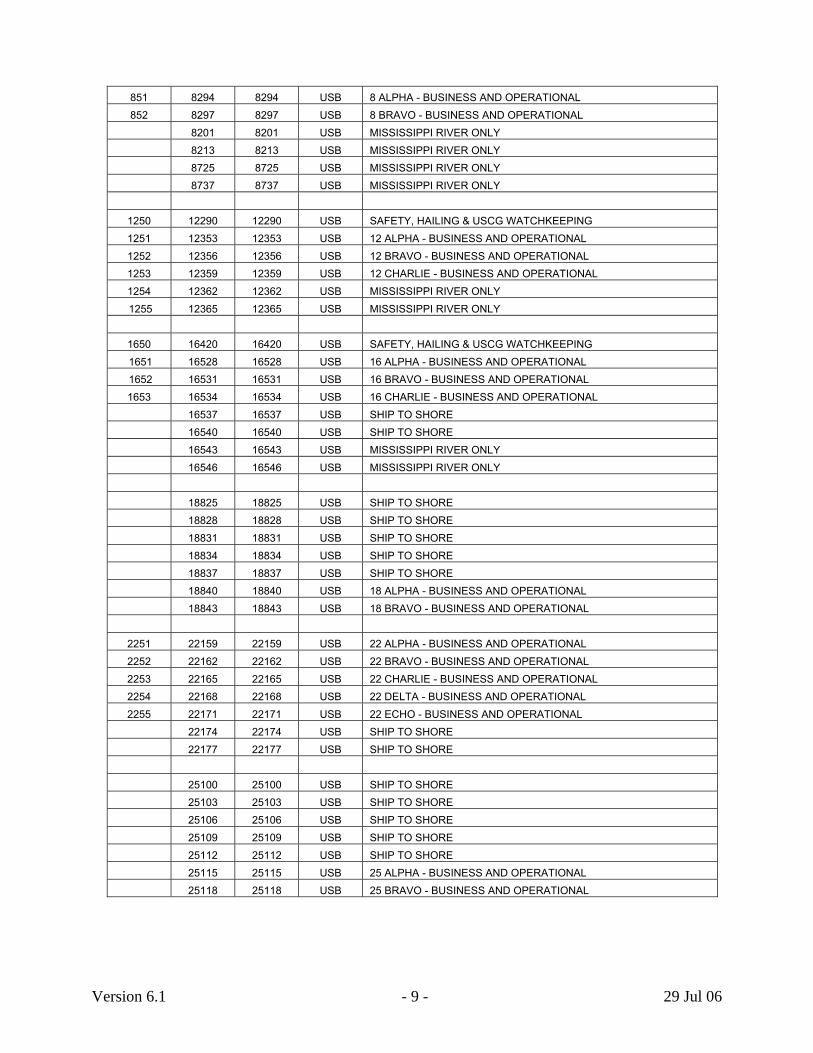
851 8294 8294 USB 8 ALPHA - BUSINESS AND OPERATIONAL 852 8297 8297 USB 8 BRAVO - BUSINESS AND OPERATIONAL
8201 8201 USB MISSISSIPPI RIVER ONLY 8213 8213 USB MISSISSIPPI RIVER ONLY 8725 8725 USB MISSISSIPPI RIVER ONLY 8737 8737 USB MISSISSIPPI RIVER ONLY
1250 12290 12290 USB SAFETY, HAILING & USCG WATCHKEEPING 1251 12353 12353 USB 12 ALPHA - BUSINESS AND OPERATIONAL 1252 12356 12356 USB 12 BRAVO - BUSINESS AND OPERATIONAL 1253 12359 12359 USB 12 CHARLIE - BUSINESS AND OPERATIONAL 1254 R ONLY 12362 12362 USB MISSISSIPPI RIVE 1255 R ONLY 12365 12365 USB MISSISSIPPI RIVE
1650 16420 16420 USB SAFETY, HAILING & USCG WATCHKEEPING 1651 16528 16528 USB ALPHA - BUSINESS AND OPERATIONAL 16 1652 ESS AND OPERATIONAL 16531 16531 USB 16 BRAVO - BUSIN1653 OPERATIONAL 16534 16534 USB 16 CHARLIE - BUSINESS AND
16537 16537 USB SHIP TO SHORE 16540 16540 USB SHIP TO SHORE 16543 16543 USB MISSISSIPPI RIVER ONLY 16546 16546 USB MISSISSIPPI RIVER ONLY 18825 18825 USB IP TO SHORE SH 18828 18828 USB SHIP TO SHORE 18831 18831 USB SHIP TO SHORE 18834 18834 USB SHIP TO SHORE 18837 18837 USB SHIP TO SHORE 18840 18840 USB 18 ALPHA - BUSINESS AND OPERATIONAL 18843 18843 USB 18 BRAVO - BUSINESS AND OPERATIONAL
2251 22159 22159 USB ALPHA - BUSINESS AND OPERATIONAL 222252 ESS AND OPERATIONAL 22162 22162 USB 22 BRAVO - BUSIN2253 OPERATIONAL 22165 22165 USB 22 CHARLIE - BUSINESS AND 2254 ESS AND OPERATIONAL 22168 22168 USB 22 DELTA - BUSIN2255 SS AND OPERATIONAL 22171 22171 USB 22 ECHO - BUSINE
22174 22174 USB SHIP TO SHORE 22177 22177 USB SHIP TO SHORE 25100 25100 USB SHIP TO SHORE 25103 25103 USB SHIP TO SHORE 25106 25106 USB SHIP TO SHORE 25109 25109 USB SHIP TO SHORE 25112 25112 USB SHIP TO SHORE 25115 25115 USB 25 ALPHA - BUSINESS AND OPERATIONAL 25118 25118 USB 25 BRAVO - BUSINESS AND OPERATIONAL
Version 6.1 - 9 - 29 Jul 06

2 SSB and Ham Nets
SSB and Ham nets operate around the world and there are numerous for lists of them besides
ord of mouth. It the name of the net is known, a search engine such as Google might have ocksider Radio,
aritime Cruising Ham Radio Nets and so on. These lists are extensive and updated frequently.
ly run by volunteers and subject to change.
wpertinent information. The SSCA has links to several extensive listings such as DM Nets are usual Z (Zulu MT = UTC, ima o Time, 24 / 7 = 24 hours, 7 a week. 2.1 SSB and Ham Nets
Ti e Comments
) = G L (L ) = L cal days
m Freq. Mode Net SSB/ HAM AVIATION ncy 5547 USB Air Emerge SSB
8843 USB Air Emergency SSB 13270 USB r Weather - East SSB Ai 13282 USB Air Weather - West SB S 13300 USB Airplane En-Route SSB 8971 USB USCG Air SSB 8983 USB USCG Air SSB
AT LANTIC 24 Z udi's Net / 7 & 1300-1400 21400 USB Trans-Atlantic Maritime HAM Tr
0400 Z 14313 USB Mobile Maritime – Trans-Atlantic HAM 0700 5 Z rans-Atlantic - West -1200 LT&124 14300 USB Mobile Maritime – T HAM
0800 / 1800 Z – UK 14303 USB Trans-Atlantic Maritime HAM 1100 00 Z 14300/313 / 2200-02 USB Intercontinental Net HAM D
1130 / 2330 Z 21325 SB uth Atlantic Roundtable M U So HA 1930 Z 12359 USB uthbound II Check-In SSB So D
20 Z 00-2300 12359 USB Southbound II WX SSB D 2030 Z 14303 LSB Swedish Maritime Net HAM D 2330 Z 21325 USB South Atlantic Roundtable HAM
BAHAMAS
0700 L 4003 SB SRA - Bahamas WX Net SB rolyn Wardle L BA S Ca0720 L 7096/3696 LSB Bahamas WX Net HAM 0845 L 6227 LSB Diver Dan WX HAM 1220 Z -Sea Rescue Assoc. 3696 USB BASRA (Bahamas Air HAM
CARIBB EAN
8297 Antigua - English Harbour Radio USB SSB 14175 USB Hurricane Net - Alt 1 HAM 14275 USB Hurricane Net - Alt 2 HAM 14324 USB Hurricane Net – Belize HAM
Version 6.1 - 10 - 29 Jul 06
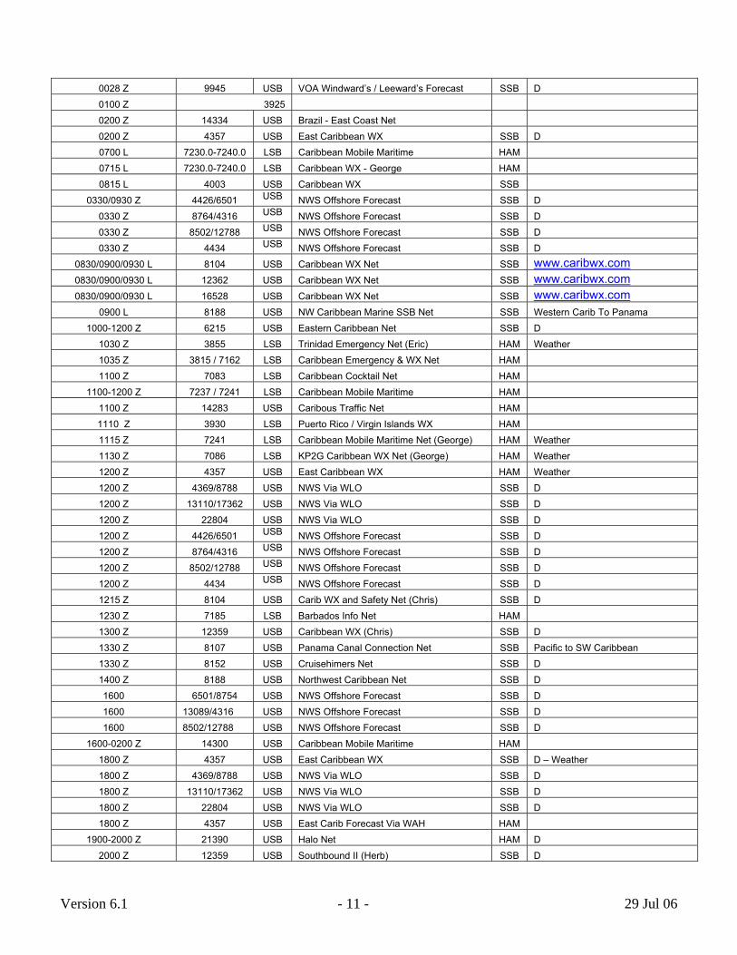
0028 Z 9945 USB VOA Windward’s / Leeward’s Forecast SSB D 0100 Z 3925 0200 Z 14334 USB Brazil - East Coast Net 0200 Z 4357 USB East Caribbean WX SSB D 0700 L 7 e 230.0-7240.0 LSB Caribbean Mobile Maritim HAM 0715 L 7230.0-7240.0 LSB Caribbean WX - George HAM 0815 L 4003 USB Caribbean WX SSB
0330/0930 Z 4426/6501 ast USB NWS Offshore Forec SSB D 0330 Z 8764/4316 ast USB NWS Offshore Forec SSB D 0330 Z 8502/12788 USB NWS Offshore Forecast SSB D 0330 Z 4434 USB NWS Offshore Forecast SSB D
0830 30 L ribwx.com/0900/09 8104 USB Caribbean WX Net SSB www.ca0830 30 L ww.caribwx.com/0900/09 12362 USB Caribbean WX Net SSB w0830 0 L ww.caribwx.com/0900/093 16528 USB Caribbean WX Net SSB w
0900 L 8188 USB NW Caribbean Marine SSB Net estern Carib To Panama SSB W10 et 00-1200 Z 6215 USB Eastern Caribbean N SSB D
1030 Z 3855 LSB Trinidad Emergency Net (Eric) HAM Weather 1035 Z 3815 / 7162 LSB Caribbean Emergency & WX Net HAM 1100 Z 7083 LSB Caribbean Cocktail Net HAM
11 Z 7237 / 7241 ritime 00-1200 LSB Caribbean Mobile Ma HAM 1100 Z 14283 USB Caribous Traffic Net HAM 1110 Z gin Islands WX 3930 LSB Puerto Rico / Vir HAM 1115 Z 7241 LSB Caribbean Mobile Maritime Net (George) ather HAM We1130 Z 7086 LSB KP2G Caribbean WX Net (George) ather HAM We1200 Z 4357 USB East Caribbean WX HAM Weather 1200 Z 4369/8788 USB NWS Via WLO SSB D 1200 Z 13110/17362 USB NWS Via WLO SSB D 1200 Z 22804 USB NWS Via WLO SSB D 1200 Z 4426/6501 cast USB NWS Offshore Fore SSB D 1200 Z 8764/4316 t USB NWS Offshore Forecas SSB D 1200 Z 8502/12788 USB NWS Offshore Forecast SSB D 1200 Z 4434 USB NWS Offshore Forecast SSB D 1215 Z 8104 USB Carib WX and Safety Net (Chris) SSB D 1230 Z 7185 LSB Barbados Info Net HAM 1300 Z 12359 USB Caribbean WX (Chris) SSB D 1330 Z n Net cific to SW Caribbean 8107 USB Panama Canal Connectio SSB Pa1330 Z 8152 USB Cruisehimers Net SSB D 1400 Z 8188 USB Northwest Caribbean Net SSB D 1600 6501/8754 USB NWS Offshore Forecast SSB D 1600 13089/4316 USB NWS Offshore Forecast SSB D 1600 850 2/12788 USB NWS Offshore Forecast SSB D
16 Z 00-0200 14300 USB Caribbean Mobile Maritime HAM 1800 Z 4357 USB East Caribbean WX Weather SSB D –1800 Z 4369/8788 USB NWS Via WLO SSB D 1800 Z 13110/17362 USB NWS Via WLO SSB D 1800 Z 22804 USB NWS Via WLO SSB D 1800 Z 4357 USB East Carib Forecast Via WAH HAM
19 Z 00-2000 21390 USB Halo Net HAM D 2000 Z 12359 USB Southbound II (Herb) SSB D
Version 6.1 - 11 - 29 Jul 06

2000 Z 14260 USB Party line Net HAM D 20 Z t 00-2200 21390 USB Inter American Traffic Ne HAM D
2030 Z 7086 LSB Caribbean Cocktail & WX (George) HAM D 2100 Z 14261 USB Ben's Friends HAM 2200 Z 6501/8764 USB NWS Offshore Forecast SSB D 2200 Z 13089/4316 USB NWS Offshore Forecast SSB D 2200 Z 8502/12788 USB NWS Offshore Forecast SSB D 2215 Z 8107 USB Caribbean WX Net - Hurricane eason SSB In S2230 Z 3855 LSB Trinidad Emergency Net (Eric) HAM D 2235 Z 7162 LSB aribbean Emergency & WX Net HAM C D 2310 Z 3930 LSB erto Rico / Virgin Islands WX HAM Pu D 2400 Z 4369/8788 USB NWS Via WLO SSB D 2400 Z 13110/17362 LO USB NWS Via W SSB D 2400 Z 22804 USB NWS Via WLO SSB D
EURO PE
0 hipping Forecasts 535/1201/1754 L 198 USB BBC Radio 4 S SSB D 06 L 01/1248/1902/2355 567 USB Radio Erin SSB D 0610/0930/ 1230 Z 1457 USB braltar SSB -F, Reduced Sched Sa & Su 1030/ Gi M
0800 & 1800 Z 14303 SB obile Maritime UK HAM U M 0820 & 1720 L glish Channel 2761 USB Belgium SSB En0940 & 2140 L 2673 USB Netherlands SSB Short Distances
1300 15 Z -F, Reduced Sched Sa & Su /1530/17 1458 USB Gibraltar SSB M
MEDITE N RRANEA 24/7 8173 USB Red Sea Net SSB
0530 Z 8122 USB Mediterranean Cruisers Net ril 1 – Oct 31 SSB Ap0600 Z 8188 USB Kemer Net SSB
0700-0000 Z 7085 SB editerranean Mobile Maritime AM L M H 0900 Z 14313 USB Mediterranean Mobile Maritime HAM 1800 Z 14303 USB Mediterranean Mobile Maritime HAM 1900 Z 14297 USB Italian Mobile Maritime HAM
NORTH AMERICA - CANADA
1100 Z - Sa 3770 LSB Maritime Provinces WX Net HAM M0400 / 1730 Z 14115 USB DDD Net HAM 1245 & 1800 Z HAM 14121 USB Mississauga Net Canadian
NORTH AM ICA - US EAST & SOUTHERN TER COAS S
24/7 6459 USB AFRS Roosevelt Roads, Puerto Rico USB 24/7 L 12690 USB AFRS Key West, F USB
3940/7247 ency Net LSB Florida Hurricane Emerg 7233 LSB East US Net HAM
7240 LSB Texas Hurricane Net HAM 14265 USB Salvation Army Emergency Relief Net N - 14625 (?) HAM SATER 14325 USB Hurricane Watch hwn.orgHAM www.
0730 L 4045 USB OCC Summertime Net USB D 0745 L 7268 LSB Waterway Radio and Cruising Club HAM D 0830 L 8152/8148 USB Cruiseheimer's Net SSB
Version 6.1 - 12 - 29 Jul 06

1200 Z 3897 LSB CCA Net HAM MWF 1215 Z 14323 USB CA Net HAM WF C M1700 Z 14287 USB S Power Squadron HAM turdays U Sa1800 Z turdays 28357 USB US Power Squadron HAM Sa
1930 & 2000 Z erb Hilgenberg) - Atlantic & Caribbean WX 12359 USB Southbound II (H SSB D 2130 Z et 14290 USB EC Waterway N HAM D
NORT CH AMERICA - US WEST OAST
3935 LSB Gulf Coast Hurricane HAM 7096 LSB BaHa WX Net HAM 14125/225/325 t USB Hurricane Ne HAM
0000 Z 3969 LSB Happy Hour Net HAM D 01 Z Pacific & Hawaii 30-0300 28313 USB 10 Meter Mobile Maritime Net HAM E.
0200 Z 21402 USB Gerry's Happy Hour HAM 02 Z 14313/300 00-0400 USB Pacific Seafarers Net HAM
0330 Z 7294 LSB Sandia Net HAM 0400-1800 Z 14310 USB Maritime Emergency Net HAM
0730 L 14340 USB Glenn's Friends Net - E. Pacific Coast HAM 0750 L 7278 LSB Great Northern Boater's Net HAM 0800 L 7238 LSB Baja California Maritime Net astal Baja – California HAM Co1415 Z 3968 LSB Sonrisa Net - E. Pacific & Mexico HAM
14 L co 30-1530 7214 LSB Chubasco Net - E. Pacific & Mexi HAM 1530 Z 7294 LSB hubasco Net - E. Pacific & Mexico HAM C 1630 Z 3865 SB orthwest Boater's Net AM L N H 1800 L 3855 LSB British Columbia Net HAM 1830 Z 14340 USB Manana Net Warm Up – Sa HAM M1900 Z 14340 USB Manana - E. Pacific and Mexico HAM
PACI FIC
Night Time ed Forces Radio Service 5765 USB AFRS Guam SSB ArmNight Time Harbor 6350 USB AFRS Pearl SSB Day Time 10320 USB AFRS Pearl Harbor SSB Daytime 13362 USB AFRS Guam SSB
00 Z 00 - 2400 14300 USB Mobile Maritime Net HAM Different Languages 0000 Z 14320 USB Southeast Asia MM Net HAM D 0300 Z 13940 USB French Net HAM French
023 Z 0 - 0350 14300 USB Pacific Seafarers Net HAM www.bitwrangler.com/yotreps04 Z t 00-1800 14310 USB Maritime Emergency Ne HAM
0400 Z 14318 USB Arnold's Net HAM 0715 Z 3820 LSB Bay Of Islands Net HAM New Zealand 0730 L 4445 USB Russell Radio - New Zealand HAM 0800 L 13137 USB Russell Radio - New Zealand HAM 0800 Z 14315 USB Pacific Inter Island Net HAM 0800 Z 21412 USB Pacific M/M Service Net HAM 0800 L 8161 USB Namba Net - New Caledonia to Solomon’s SSB May To October
0830 & 1630 L 12353 USB Russell Radio - New Zealand SSB Bora Bora to Australia 0900 L 8143 USB Panama Pacific Net SSB 0900 L 8164 USB Patagonia Cruiser's Net (Chile) SSB
0915 & 1600 L ealand ra Bora to Australia 12359 USB Russell Radio - New Z SSB Bo
Version 6.1 - 13 - 29 Jul 06

0930 & 2103 Z 12356 USB Fiji WX and Navigation Warnings SSB 0933 & 2133 Z gs 16531 USB Fiji WX and Navigation Warnin SSB 1000 & 2300 Z cific 14315 USB Robby's Net (Australia) HAM South Pa
1000 Z 14320 USB South China Sea Net HAM 1200 Z 14320 USB South East Asia Net HAM 1330 Z 8107 USB Panama Canal Connection Net cific & SW Caribbean SSB Pa1600 L 13137 USB Russell Radio - New Zealand HAM 1730 Z 8188 Coconut Breakfast - French Polynesia SSB EnUSB glish 1800 Z 7076 LSB South Pacific Cruising Net HAM 1830 Z 12353 USB Coconut Bkfst - West Of Fr. Polynesia SSB 1900 L 4445 USB Russell Radio - New Zealand HAM 1900 Z 6203 USB Fiji Weather SSB May be 6230 kHz 1900 Z 7285 LSB Hawaii AM Net HAM D 1900 Z 8173 USB Rag Of The Air Net SSB 1900 Z 14285 USB Kaffee Klatch Un-Net , W, Sa HAM M1900 Z 14305 USB Confusion Net HAM M-F1900 Z 14329 USB Bay Of Islands Net HAM D 2000 Z 7080 LSB New Zealand WX Net HAM D 2000 Z 7095 LSB Harry's Net HAM D 2000 Z 8104 USB Fiji Weather SSB 2040 Z 7087 LSB Comedy Net Ham D 2030 Z 14315 USB Tony's Net Warm Up HAM D 2100 Z 14315 USB Tony's Net HAM D 2100 Z 14113 USB ickey Mouse Connection HAM M D 2200 Z 8161 USB Sheila Net - NE Australia & New Guinea SSB D 2200 Z 21412 USB Pacific Maritime Net HAM M-F 2200 Z 21412 USB Maritime Mobile Service Net -F HAM M2300 Z 12165 USB SSB eas - 2130 & 0330 Z Voice Guam Storm & S
INDIAN O CEAN
Night Time USB Garcia SSB 4319 AFRS - Diego D USB SSB ay Time 12579 AFRS - Diego Garcia
0025 Z 4323 *** ? Richard Z21RH ? Weather 0500 Z 8101 USB SSB Fred PeriPeri Weather 0525 Z 2353 *** ? Fred PeriPeri ? Weather 0540 Z 4316 *** ? Fred PeriPeri ? Weather 1130 Z 4316 *** ? Alistair ZS5MU and Graham ZS2ABK ? Weather 1500 Z 8101 USB Fred PeriPeri SSB Weather 1525 Z 2353 *** ? Fred PeriPeri ? Weather 1540 Z 4316 *** ? Fred PeriPeri ? Weather 0500 Z 14316 USB Tony's Net (Kenya) HAM Indian Ocean / Red Sea
0630 / 1130 Z 14320 USB SE Asia M/M Net HAM Indian Ocean / S Atlantic 0630 / 1130 Z 14318 / 105 USB S. African Maritime Net HAM Indian Ocean / S Atlantic
1115 Z 14316 USB Indian Ocean Mobile Maritime Net HAM Indian Ocean / W. Pacific 1115 Z 14320 USB Roy's Net (Perth, Australia) HAM N & W Indian Ocean 2100 Z 14315 USB Tony's Net (New Zealand) HAM Indian Ocean / Red Sea
*** Unauthorized frequencies in SSB bandwidths.
Version 6.1 - 14 - 29 Jul 06

2.2 Transoceanic HF Frequencies Used By Airplanes* In the even of an emergency at sea and there is time to seek help, airplanes flying over can provide an initial emergency communications link. SSB and Ham operations are not authorized to se the following frequencies, but anything goes in an all out emergency; the next time a cruising
will not be the first.
he following are the frequency bands authorized for aviation use. The frequency channels used by region are on the following page. These frequency bands are in kHz and USB
uyacht is rescued at sea by a passing airplane T
:
2850 - 3155 3400 - 3500 4650 - 4750 5480 - 5730 6525 - 6765 8815 - 9040
10005 - 10100 11175 - 11400 13200 - 13360 15010 - 15100 17900 - 18030 21870 - 22000 23200 - 23350
* This information was provided courtesy of the Bob Ellis website.
Version 6.1 - 15 - 29 Jul 06

2.3 Cha horiz or via on U e
nnels Aut ed F A ti s Shannon - WX 5505
Shannon - ATC 5598 5616 5649 5658 5680 Shannon - ATC Alt 8906 8864 8879 Kinloss Rescue 5680 N Atlantic - A 3016 5598 8906 13306 17946 N Atlantic - B 2899 5616 8864 13291 17946 N Atlantic - C 2872 4675 8879 13306 17946 N Atlantic - D 2971 4675 8891 11279 13291 17946 N Atlantic - E 2962 6628 8825 11309 13354 N Atlantic - F 3476 6622 8831 11336 13291 Caribbean - A 2887 5550 6577 6649 8918 11396 13297 17907 Caribbean - B 3455 5520 6586 8846 11330 17907 Caribbean - C 3479 5526 8855 10096 13297 17907 S America - NE 3479 5526 8855 10096 13297 17907 S America - NW 17907 3479 5526 8855 10096 13297 S America - SE 17907 3479 5526 8855 10096 13297 S America - SW 2944 4669 6649 10024 11360 17907 S Atlantic - 1 3452 6535 8861 13357 17955 S Atlantic - 2 2854 5565 11291 13315 17955 Africa / Atlantic 3452 6535 8861 13357 17955 Africa / Med 3419 5652 8894 13273 17961 Africa East 3467 5517 10018 11300 13288 17961 Africa 2878 5493 8903 13294 17961 Indonesia 3476 5634 8879 13306 17961 Middle East - 1 2992 4669 5667 6331 8951 11375 17961 Middle East - 2 3467 5658 10018 11300 13288 17961 Middle East - 3 17961 2944 4669 6631 8951 11375 Europe / Asia 3479 5661 6598 10084 13288 17961 East Asia - 1 3016 6571 8897 10042 17958 East Asia - 2 3485 5649 5655 8942 11396 13309 17907 SE Asia - 1 3470 5670 6556 10066 13318 17907 SE Asia - 2 3485 5649 5655 8942 11396 13309 17907 SE Asia - 3 3470 5733 6556 10066 11396 13318 17907 Cent. E Pacific 10057 11282 13261 13288 17904 2869 3413 5547 6673 8843
Cent. W Pacific 2998 4666 6532 6562 8903 11384 13300 17904 N Pacific 2932 5628 5667 6655 8951 10048 13294 13339 17904 17946 21925
S Pacific 3467 5643 8867 13261 17904
Version 6.1 - 16 - 29 Jul 06

3 WX Fax & RTTY Broadcast Schedules The following unless otherwise noted was taken from Tim Rulon’s comprehensive work at www.nws.noaa.gov/om/marine/rfax.pdf. Note 1: With SSB use in conjunction with computer programs, the WX Fax frequencies for all stations that follow must be adjusted down 1.9 kHz for proper reception. These adjusted frequencies are highlighted in red. Note 2: While various emissions are indicated, USB (H3E) works fine. Note 3: All schedule times are UTC. Schedules and content change occasionally. While we have attempted to provide the latest version, it should be confirmed before casting off.
Note 4: Some computer programs can be adjusted to automatically start at specific times to catch the WX Fax broadcast. This is a clever idea and works well when the broadcast starts on schedule. Unfortunately, these broadcasts seldom start precisely on time (synchronized with GPS) and the program start time should be advanced to capture starting signals.
The initial fax signals tell the program to begin. If these starting signals are not received, the computer program will not activate to receive the fax. 3.0 ANAD CALL SIGN: CFH A ROM CCG 24 MAR 061 HALIFAX, NOVA SCOTIA, C A DOWNLO DED F
EQUENC
ASSIGNED ADJUSTED TIMES RPM/IOC EMISSION POWER
FR I ES
kHz FOR SSB - kHz
122.5 kHz 120.6 kHz Continuous 120 / 576 F3C 10 kW 4271.0 kHz 4269.1 kHz Continuous 120 / 576 F3C 6 kW 6496.4 kHz 6494.5 kHz Continuous 120 / 576 F3C 6 kW 10536.0 kHz 10534.1 kHz Continuous 120 / 576 F3C 6 kW 1 kHz ntinuous 120 / 576 F3C 6 kW3510.0 13508.1 kHz Co
MAP TIME CONTENTS OF TRANSMISSION VALID
AREA 0001/------ LABRADOR COAST ICE CHART (SEASONAL) LATEST -------/1201 3-DAY PROGNOSIS (?) 1200 G 0101/------ SATELLITE PICTURE INFRARED 00/12 -------/1222 4-DAY PROGNOSIS 1200 G -------/1301 5-DAY PROGNOSIS 1200 G 0201/1401 12/00Z SIGNIFICANT WEATHER DEPICTION Dec-00 A 0301/1501 500MB ANALYSIS 00/12 B 0322/1522 SURFACE ANALYSIS 00/12 F 0401/------- 500MB 36HR PROGNOSIS 1200 B ------/1601 850MB ANALYSIS 1200
Version 6.1 - 17 - 29 Jul 06

0422/------ 24HR ISOBARIC PROGNOSIS 0000 H ------/1622 500MB 36HR PROGNOSIS 0000 0501/------ 850MB FORECAST - WIND/TEMP/HEIGHT 18/00 A ------/1701 24HR ISOBARIC PROGNOSIS 1200 0601/1801 36HR ISOBARIC PROG 12/00 A ------/1822 850MB FORECAST WIND/TEMP/HEIGHT 06/12 C 0701/1901 18/06Z SIGNIFICANT WEATHER DEPICTION 18/06 A 0801/2001 24/36 HR SIGNIFICANT WAVE PROGNOSIS 00 &12/00&12 A 0901/2101 SURFACE ANALYSIS 06/18 F 1001/------ , LATEST E/D SST: NOVA SCOTIA - MON, NEWFOUNDLAND - TUE/FRI1001/------ IA - WED/SAT, NEWFOUNDLAND - SUN/THU NOVA SCOT LATEST E/D
2201 SST: NOVA SCOTIA - TUE/THU/FRI NEWFOUNDLAND -
E/D WED/SAT LATEST 2201 OFA: NOVA SCOTIA - SUN NEWFOUNDLAND - MON E/D LATEST
1022/------ SATELLITE PHOTO INFRARED LATEST -------/2222 NEWFOUNDLAND ICE CHART LATEST 1101/------ CFH BROADCAST SCHEDULE/TEST CHART LATEST -------/2301 GULF OF ST LAWRENCE ICE CHART (SEASONAL) LATEST
NOTES: 1. ICE CHARTS FOR THE GULF OF ST. LAWRENCE, LABRADOR, HUDSON STRAIT AND EASTERN ARCTIC ARE PREPARED BY THE CANADIAN ICE SERVICE (OTTAWA) AND ARE BROADCAST ACCORDING TO
EASON. ONE ICE CHART IS BROADCS AST WITHIN THE ALLOTTED TIME FROM HALIFAX (CFH), HOWEVER,
.
T
DIOTELETYPE. THE FACSIMILE SISTS OF EITHER ONE OR TWO CHARTS BEING BROADCAST AT THE BEGINNING OF EACH
OUR. THE REMAINING TIM IS LETYPE. MAP AREAS:
ONE ICE CHART MAY BE BROADCAST WITHIN THE ALLOTTED TIME FROM IQALUIT, FROBISHER BAY (VFF) ND RESOLUTE (VFR). A
2. BROADCAST TIME MAY ALSO BE USED TO REPEAT OTHER CHARTS OR SPECIAL CHARTS AS REQUIRED 3. THE CANADIAN FORCES FLEET METEOROLOGICAL AND OCEANOGRAPHIC CENTRE (METOC) BROADCAST ATLANTIC BROADCASTS TEXT AND CHART INFORMATION. THE BROADCAST IS MAINTAINED TO SERVE AND FULFIL THE REQUIREMENTS OF THE CANADIAN NAVY. CONSEQUENTLY THE BROADCASIS SUBJECT TO SHORT NOTICE CHANGE WITHOUT NOTIFICATION. THE AREA IN WHICH THE BROADCAST IS INTENDED TO BE RECEIVED IS NORTH ATLANTIC WATERS NORTH OF 350N AND WEST OF 350W. THE
HARES IT TIME BETWEEN RADIO-FACSIMILE AND RABROADCAST SORTION CONP
H E DEDICATED TO RADIOTE
A 49N - 90W 64N - 16W 28N - 67W 05N - 27W B 76N - 16W 30N - 20W 23N - 110W 08N - 69W C 48N - 85W 65N - 15W 28N - 62W 34N - 23W D 60N - 68W 53N - 30W 42N - 66W 38N - 40W E 46N - 77W 48N - 46W 32N - 74W 32N - 51W F 59N - 110W 59N - 10W 25N - 82W 25N - 40W G 49N - 21W 27N - 40W 27N - 80W 49N - 94W H 30N - 107W 15N - 67W 34N - 24W 79N - 60W
http://www.ccg-gcc.gc.ca/main_e.htm http://www.ccg-gcc.gc.ca/mcts-sctm/ramnatl_e.htm
Version 6.1 - 18 - 29 Jul 06

3.02 IQALUIT, N.W.T., CANADA CALL SIGN: VFF
FREQUENCIES ASSIGNED TIMES EMISSION POWER
ADJUSTED
RPM/IOC
kHz FOR Hz SSB - k
3251.1 3249.2 120 / 576 J3C 5 kW 7708.1 7706.2 120 / 576 J3C 5 kW
NTENTS OF TRANSMISSION VALID MAP TIME CO RPM/IOC TIME AREA
0500 ICE ANALYSIS (AREAS) 120/576 1,2,3,4,5,6,71000 SURFACE ANALYSIS & 18HR PROG & 48HR PROG 06/06/00 120/576 2100 SURFACE ANALYSIS & 18HR PROG 120/576 2135 ICE ANALYSIS (AREAS 1,2,3,4,5,6,7) 120/576
MAP AREA:
E BROADCASTS VARY WITH ICE CONDITIONS AND MARINE ACTIVITY. LL CHARTS AVAILABLE CAN BE TRANSMITTED ON REQUEST.
cg-gcc.gc.ca/cen-arc/mcts-sctm/broadcast/iqaluit_e.htm
1 HUDSON BAY (SOUTH) 2 HUDSON BAY (NORTH) 3 HUDSON STRAIT 4 FOXE BASIN 5 LABRADOR COAST 6 DAVIS STRAIT 7 BAFFIN BAY
NOTE: THE AREAS INCLUDED IN THA(INFORMATION UPDATED 03/2002) http://www.c
Version 6.1 - 19 - 29 Jul 06

3.03 RESOLUTE, N.W.T., CANADA CALL SIGN: VFR
REQU NASSIGNED ADJUSTED TIMES EMISSION RPM/IOC POWER
F E CIES
kHz FOR SSB - kHz
3251.1 3249.2 1 JUL-15 OCT J3C 120/576 5 kW 7708.1 7706.2 1 JUL-15 OCT J3C 120/576 5 kW
TIME RANSMISSION VALID TIME CONTENTS OF T MAP AREA
10 ICE ANALYSIS 7, 8, 9, 10, 11 700 ICE ANALYSIS 7, 8, 9, 10, 11 1100 SURFACE ANALYSIS & 18HR PROG & 48HR PROG 6/6/2000 2330 NALYSIS & 18HR PROG 18/12 SURFACE A
MAP AREAS:
7 BAFFIN BAY 8 APPROACHES TO RESOLUTE 9 EUREKA SOUND
10 PARRY CHANNEL 11 QYENN MAUDE/PRINCE REGENT
(INFORMATION DATED 01/2001) http://www.ccg-gcc.gc.ca/cen-arc/mcts-sctm/broadcast/iqaluit_e.htm
pdate Mar 2002)
.04 SYDNEY - NOVA SCOTIA, CANADA CALL SIGN: VCO
(U 3 U NCIES
ASSIGNED ADJUSTED RPM/IOC TIMES
EMISSION POWER
FREQ E
kHz FOR SSB – kHz
4416 4414.1 120 / 576 1121-1741 J3C 6915 6913.1 120 / 576 2200-2331 J3C
RENCE
TIME CONTENTS OF TRANSMISSION
1121 ICE ANALYSIS GULF OF ST. LAW1142 ICE ANALYSIS EAST OR SOUTHEAST NEWFOUNDLAND WATERS 1741 ICE ANALYSIS ICEBERG LIMIT 2200 ICE ANALYSIS GULF OF ST. LAWRENCE 2331 ICE ANALYSIS EAST OR SOUTHEAST NEWFOUNDLAND WATERS
(INFORMATION DATED 2001) http://www.ccg-gcc.gc.ca/mcts-sctm/ramnatl_e.htm
Version 6.1 - 20 - 29 Jul 06

3.05 BOSTON, MASSACHUSETTS, U.S.A. CALL SIGN: NMF EFFECTIVE: 16 MAY 2006 DOWNLO M HE WEB: 20 May 2006
E
ASSIGNED TIMES RPM / IOC EMISSION POWER
ADED FRO T
FREQUENCI S ADJUSTED
kHz F z OR SSB - kH
4235.0 kHz 4233.1 kHz 0 230 - 1028 Z 120 / 576 F3C 5 kW 6340.5 kHz 6338.6 kHz Continuous 120 / 576 F3C 5 kW 9110.0 kHz 9108.1 kHz Continuous 120 / 576 F3C 5 kW 12750.0 kHz 12748.1 kHz 1400 - 2228 Z 120 / 576 F3C 5 kW
TIME CONTENTS OF TRANSMISSION VALID MAP UTC TIME AREA
0230/1400 TEST PATTERN -------/1405 BROADCAST SCHEDULE (PART 1) -------/1420 BROADCAST SCHEDULE (PART 2) -------/1433 REQUEST FOR COMMENTS -------/1443 PRODUCT NOTICE BULLETIN 0233/1453 PRELIMINARY SURFACE ANALYSIS 00/12 1 0243/------ BROADCAST SCHEDULE (PART 1) 0254/------ BROADCAST SCHEDULE (PART 2) 0305/------ REQUEST FOR COMMENTS -------/1503 SATELLITE IMAGE 1200 5 0315/1515 WIND/WAVE ANALYSIS 00/12 1# 0325/1525 SURFACE ANALYSIS (PART 1 NE ATLANTIC) 00/12 2 0338/1538 SURFACE ANALYSIS (PART 2 NW ATLANTIC) 00/12 3 0351/------ SATELLITE IMAGE 0 5 -------/1600 ICE CHARTS LATEST -------/1720 TEST PATTERN 0402/1723 SURFACE ANALYSIS (PART 1) (REBROADCAST OF 0325/1525) 00/12 2 0415/1736 SURFACE ANALYSIS (PART 2) (REBROADCAST OF 0338/1538) 00/12 3 0428/1749 500MB ANALYSIS 00/12 4 -------/1759 SEA STATE ANALYSIS 1200 4 0438/1810 ICE CHARTS LATEST 0452/1824 CYCLONE DANGER AREA* or HIGH WIND/WAVES 03/15 7 0745/1900 TEST PATTERN 0755/------ PRELIMINARY SURFACE ANALYSIS 0600 1 0805/1905 24HR SURFACE FORECAST 00/12 8 0815/1915 24HR WIND/WAVE FORECAST 00/12 8 0825/1925 24HR 500MB FORECAST 00/12 40835/1935 36HR 500MB FORECAST 12/00 4 0845/1945 48HR 500MB FORECAST 00/12 4 0855/1955 48HR SURFACE FORECAST 00/12 4 0905/2005 48HR WIND/WAVE FORECAST 00/12 4 0915/2015 48HR WAVE PERIOD FORECAST 00/12 4 -------/2025 PRELIMINARY SURFACE ANALYSIS 1800 1
Version 6.1 - 21 - 29 Jul 06

------/2035 96 HR 500MB FORECAST 1200 4 ------/2045 96 HR SURFACE FORECAST 1200 4 ------/2055 96 HR WIND/WAVE FORECAST 1200 4 ------/2105 96 HR WAVE PERIOD FORECAST 1200 4 ------/2115 (REBROADCAST OF 2045) 1200 4 0925/2125 SURFACE ANALYSIS (PART 1 NE ATLANTIC) 06/18 2 0938/2138 SURFACE ANALYSIS (PART 2 NW ATLANTIC) 06/18 3 0951/2151 SATELLITE IMAGE 06/18 6 1002/2202 (REBROADCAST OF 0925/2125) 06/18 2 1015/2215 (REBROADCAST OF 0938/2138) 06/18 3 1028/2228 CYCLONE DANGER AREA* OR HIGH WIND/WAVES 09/21 7
MAP A EAS NO H E R RTH - SOUT AST - WEST
1 28N - 52N 45W - 85W 2 18N - 65N 10E - 45W 3 18N - 65N 40W - 95W 4 18N - 65N 10E - 95W 5 20N - 55N 55W - 95W 6 EQ - 60N 40W - 130W
7 05N - 60N 0W - 100W Notes:
8 22N - 51N 40W - 98W
1. * Tropical Cyclone Danger Area Chart replaced by High Wind/Wave Warning chart, Dec 01 – May 15. Valid times 00Z, 06Z, 12Z and 18Z. Map areas 05N – 40N, 35W – 100W. 2. Effective 16 May 2006, the map area for several wind/wave, surface and 24 Hr 500 mb changed from a polar
e of the 24 Hr 500 mb charts will be expanded to the ur charts.
. Latest Schedule: http://weather.noaa.gov/fax/marsh.txtl
stereographic to a Mercator projection and the area coveragsame basin-wide projection as the current 36, 48 and 96 ho 3. Transmit power has been reduced from 10 kW to 5 kW. 4
Version 6.1 - 22 - 29 Jul 06

3.06 N A, U.S.A. CALL SIGN: NMG EFFECTIVE: 16 MAY 2006EW ORLEANS, LOUISIAN DO ED R EB 006
UENCIE ASSIGNED ADJUSTED TIMES RPM / IOC EMISSION POWER
WNLOAD F OM THE W : 20 May 2 FREQ S
kHz FOR SSB - kHz
4317.9 4316.0 Continuous 120 / 576 F3C 5 kW 8503.9 8502.0 Continuous 120 / 576 F3C 5 kW
12789.9 12788.0 Continuous 120 / 576 F3C 5 kW 17146.4 17144. 0 / 576 F3C 5 1200Z - 2045Z 12 5 kW
TIME CONTENTS OF TRANSMISSION VA D MLI AP UTC TIME AR A E
0000/1200 TEST PATTERN 0005/1205 U.S. / TROPICAL SURFACE ANALYSIS (W HALF) 18/06 1 0020/1220 TROPICAL SURFACE ANALYSIS (E HALF) 18/06 2 0035/1235 24 HR WIND/WAVE FORECAST 00/12 3 0045/1245 48 HR WIND/WAVE FORECAST 00/12 3 0055/1255 72 HR WIND/WAVE FORECAST 00/12 3 0105/1305 24 HR SURFACE FORECAST 00/12 3 0115/1315 48 HR SURFACE FORECAST 00/12 3 0125/1325 72 HR SURFACE FORECAST 00/12 3 0135/1335 CYCLONE DANGER AREA* or HIGH WIND/WAVES 21/09 6 0150/------ 72 HR WAVE PERIOD/SWELL DIRECTION 0000 3 ------/1350 (REBROADCAST OF 0150) 0000 3 0200/1400 GOES IR TROPICAL SATELLITE IMAGE 00/12 4 0215/1415 00 HR SEA STATE ANALYSIS 00/12 3 ------/1425 PRODUCT NOTICE BULLETIN 0225/1445 HIGH SEAS FORECAST 22/10 5 0600/1800 TEST PATTERN 0605/1805 U.S. / TROPICAL SURFACE ANALYSIS (W HALF) 00/12 1 0620/1820 TROPICAL SURFACE ANALYSIS (E HALF) 00/12 2 0635/1835 24 HR WIND/WAVE FORECAST 06/18 3 0645/1845 REBROADCAST OF 0045/1245 00/12 3 0655/1855 REBROADCAST OF 0055/1255 00/12 3 0705/1905 REBROADCAST OF 0105/1305 00/12 3 0715/1915 REBROADCAST OF 0115/1315 00/12 3 0725/1925 REBROADCAST OF 0125/1325 00/12 3 0735/1935 CYCLONE DANGER AREA* or HIGH WIND/WAVES 03/15 6 0750/1950 48 HR WAVE PERIOD/SWELL DIRECTION 00/12 3 0800/2000 GOES IR TROPICAL SATELLITE IMAGE 07/18 4 0815/2015 REBROADCAST OF 0215/1415 00/12 3 0825/2025 REQUEST FOR COMMENTS / BROADCAST SCHEDULE 0845/2045 HIGH SEAS FORECAST 38823 5
Version 6.1 - 23 - 29 Jul 06

NOTES: 1.Tropical cyclone danger area chart is replaced by HIGH WIND/WAVE WARNING Chart DEC 01 – MAY 15. Valid
- 100W.
. Transmit power has been reduced from 10 kW to 5 kW.
or additional information about broadcasts of Marine Radio Fax charts from Station NMG, New Orleans (Belle hase), go to: http://weather.noaa.gov/fax/gulf.shtml
times 00Z, 06Z,12Z and 18Z. MAP AREA 05 N – 40 N, 35W 2 FC
MAP EA NO H E AR RTH - SOUT AST - WEST
1 05S - 50N 55W - 125W 2 05S - 50N 00W - 070W 3 00N - 31N 35W - 100W 4 12S - 44N 28W - 112W
5 * 07N - 31N 35W - 098W 6 05N - 60N 00W - 100W
* AREA COVERED BY TEXT FORECAST
Version 6.1 - 24 - 29 Jul 06

3.07 PT. REYES, CALIFORNIA, U.S.A. CALL SIGN: NOC EFFECTIVE: 16 MAY 2006 DOWNLOADED FROM THE WEB: 20 May 2006
FREQUENCIES
TIME CONTENTS OF TRANSMISSION VALID
ASSIGNED ADJUSTED TIMES RPM / IOC EMISSION POWER kHz FOR SSB - kHz
4346 4344.1 Night 120 / 576 F3C 4 kW 8682 8680.1 Continuous 120 / 576 F3C 4 kW 12786 12784.1 Continuous 120 / 576 F3C 4 kW
17151.2 17149.3 Continuous 120 / 576 F3C 4 kW 22527 22525.1 Day 120 / 576 F3C 4 kW
MAP UTC TIME AREA
0140/1400 TEST PATTERN 0143/1403 NE PACIFIC GOES IR SATELLITE IMAGE 21/12 6 0154/1414 PACIFIC GOES IR SATELLITE IMAGE 00/12 5 0205/1425 TROPICAL SEA STATE ANALYSIS 00/12 4 0215/1435 TROPICAL 24HR WIND/WAVE FORECAST 00/12 4 0225/------- TROPICAL 48HR WIND/WAVE FORECAST 0 4 0235/------- TROPICAL 72HR WIND/WAVE FORECAST 0 4 0245/1445 500MB ANALYSIS 00/12 1 0255/1455 SEA STATE ANALYSIS 00/12 1 / 8 0305/1505 PRELIMINARY SURFCE ANALYSIS (PART 1 - NE PACIFIC) 00/12 2 0318/1518 PRELIMINARY SURFCE ANALYSIS (PART 2 - NW PACIFIC) 00/12 3 0331/1531 FINAL SURFACE ANALYSIS (PART 1 - NE PACIFIC) 00/12 2 0344/1544 FINAL SURFACE ANALYSIS (PART 2 - NW PACIFIC) 00/12 3 0357/1557 TROPICAL CYCLONE DANGER AREA* or HIGH WIND/WAVES 10 03/15 0408/1608 TROPICAL SURFACE ANALYSIS 00/12 4 0655/1840 TEST PATTERN 0657/------- 2033Z REBROADCAST (96HR 500MB) 1200 1 0707/------- 2043Z REBROADCAST (96HR SURFACE) 1200 1 0717/------- 2053Z REBROADCAST (96HR WIND/WAVE) 1200 1 0727/------- 2103Z REBROADCAST (96HR WAVE PERIOD) 1200 1 ------/1842 SST ANALYSIS LATEST 9 ------/1852 SST ANALYSIS LATEST 6 0737/1902 TROICAL GOES IR SATELLITE IMAGE 06/18 7 0748/1913 WIND/WAVE ANALYSIS 06/18 8 0758/1923 24HR 500MB FORECAST 00/12 1 0808/1933 24HR SURFACE FORECAST 00/12 8 0818/1943 24HR WIND/WAVE FORECAST 00/12 8 0828/1953 48HR 500MB FORECAST 00/12 1 0838/2003 48HR SURFACE FORECAST 00/12 1
Version 6.1 - 25 - 29 Jul 06

0848/2013 48HR WND/WAVE FORECAST 00/12 1 0858/2023 48HR WAVE PERIOD/SWELL DIRECTION 00/12 1 -------/2033 96HR 500MB FORECAST 1200 1 -------/2043 96HR SURFACE FORECAST 1200 1 -------/2053 96HR WIND/WAVE FORECAST 1200 1 -------/2103 96HR WAVE PERIOD/SWELL DIRECTION 1200 1 0908/2113 PACIFIC GOES IR SATELLITE IMAGE 06/18 5 0919/2124 SURFACE ANALYSIS (PART 1 - NE PACIFIC) 06/18 2 0932/2137 SURFACE ANALYSIS (PART 2 - NW PACIFIC) 06/18 3 0945/2150 TROPICAL SURFACE ANALYSIS 06/18 4 0959/2204 TROPICAL 24HR WIND/WAVE FORECAST 06/18 4 1009/2214 TROPICAL CYCLONE DANGER AREA* or HIGH WIND/WAVES 09/21 10 1120/2320 TEST PATTERN 1124/2324 BROADCAST SCHEDULE (PART 1) 1135/2335 BROADCAST SCHEDULE (PART 2) 1146/------- REQUEST FOR COMMENTS 1157/------- PRODUCT NOTICE BULLETIN 1208/------- TROPICAL 48HR WIND/WAVE FORECAST 1200 4 1218/------- TROPICAL 72HR WIND/WAVE FORECAST 1200 4 1228/2346 TROPICAL 48HR WAVE PERIOD/SWELL DIRECTION 12/00 4 -------/2356 TROPICAL 72HR WAVE PERIOD/SWELL DIRECTION 0000 4
ap Are M as 1 20N - 70N 115W - 135E 6 23N - 60N EAST OF 150W 2 20N - 70N 115W - 175W 7 05N - 32N EAST OF 130W 3 20N - 70N 175W - 135E 8 18N - 62N EAST OF 157W 4 20S - 30N EAST OF 145W 9 40N - 53N EAST OF 136W 5 05N - 55N EAST OF 180W 10 0N - 40N 80W - 180W
Notes:
rojection.
1. Many of these charts are also broadcast from Kodiak, AK and Honolulu, HI.
2. Map area 8 changed from a polar stereographic to a Mercator p
3. Transmission power reduced from 10kW to 4 kW.
4. Website: http://weather.noaa.gov/pub/fax/hfreyes.txt 5. Weather Fax on the web: http://www.opc.ncep.noaa.gov/shtml/P_HighSeas.shtml
Version 6.1 - 26 - 29 Jul 06

3.08 HONOLULU, HAWAII CALL SIGN: KVM70 EFFECTIVE: 16 MAY 2006 DOWNLOADED FROM THE WEB: 20 May 2006
ENCIE
ASSIGNED TIMES RPM/IOC EMISSION POWER FREQU S
ADJUSTED kHz FOR SSB - kHz
9982.5 KHz 9880.6 0533-1630 Z 120/576 F3C 4 kW 11090.0 KHz 11088.1 CONTINUOUS 120/576 F3C 4 kW 16135.0 KHz 16133.1 EXCEPT 1030-1630 Z 120/576 F3C 4 kW
ONTENTS OF TRANSMISSION VALID MAP TIME CUTC
0007/1147 PACIFIC STREAMLINE ANALYSIS 18/06 K -------/1210 48 HR SURFACE FORECAST 1200 G 0030/1230 EAST PACIFIC GOES IR SATELLITE IMAGE LATEST EP 0045/1245 WEST PACIFIC GOES IR SATELLITE IMAGE LATEST SP 0103/1304 PACIFIC SURFACE PRESSURE ANALYSIS 18/06 J
0128/1328 48HR SURFACE / 1000-500 MB THICKNESS FORECAST 18/06 C
0148/1350 TROPICAL SURFACE ANALYSIS 18/06 H 0209/------- 24HR STREAMLINE/ISOTACH FORECAST 0000 D 0234/------- 48HR STREAMLINE/ISOTACH FORECAST 0000 D 0258/1444 24 HR WIND/WAVE FORECAST 00/12 G 0309/1503 48/72HR WIND/WAVE FORECAST 00/12 G 0320/1522 48/72HR WAVE PERIOD/SWELL DIR 00/12 G 0331/1541 REBROADCAST OF 0103/1304 18/06 J -------/1607 24 HR SURFACE FORECAST 1200 G 0354/1618 72 HR SURFACE FORECAST 00/12 G 0405/------- PACIFIC SEA STATE ANALYSIS 1800 D 0437/1630 TROPICAL CYCLONE DANGER AREA 03/15 M 0533/1733 TEST-ID-SYMBOLS-GENERAL NOTICE 0545/1745 SIGNIFICANT CLOUD FEATURES 00/12 A 0605/1804 PACIFIC STREAMLINE ANALYSIS 00/12 K 0630/1827 EAST PACIFIC GOES IR SATELLITE IMAGE LATEST EP 0645/1842 WEST PACIFIC GOES IR SATELLITE IMAGE LATEST SP 0656/1853 PACIFIC SURFACE PRESSURE ANALYSIS 00/12 J 0721/1918 PACIFIC OCEAN SEA SURFACE TEMPS LATEST NPA 0741/1937 24 HR WIND/WAVE FORECAST 06/18 G 0800/1956 TROPICAL SURFACE ANALYSIS 00/12 H 0823/------ 24 HR SEA STATE FORECAST 1800 K 1030/------- TROPICAL CYCLONE DANGER AREA 0900 M 1045/2018 SCHEDULE PART I 1111/2045 SCHEDULE PART II -------/2230 TROPICAL CYCLONE DANGER AREA 2100 M -------/2335 24HR SURFACE FORECAST 0000 G -------/2345 48HR SURFACE FORECAST 0000 G
Version 6.1 - 27 - 29 Jul 06

MAP AREA S: A 50N - 30S, 110W - 160E J 50N - EQ, 110W - 130E C 60N - 55S, 055W - 070E K 30N - 30S, 110W - 130E D 50N - 30S, 100W - 120E M EQ - 40N, 80W - 180W E DISCONTINUED EP 55N - 05S, 110W - 155E F DISCONTINUED SP 05N - 40S, 130W - 165E NPA 5N - EQ, 010W - 160E G 30N - 20S, 145W - 080W 5 H 40N - 40S, 105W - 120E
NOTES:
FOR ALL LATITUDES DIVIDE 50 BY THE SPACING BETWEEN THE STREAM FUNCTION LINES
EOSTATIONARY AND POLAR ORBITING SATELLITES OVER THE PACIFIC. ABBREVIATIONS ON THESE CHARTS INCLUDE:
US;
1. 23331.5 KHZ IS NO LONGER USED 2. TROPICAL STREAM-FUNCTION ANALYSIS AND THE WIND/STREAM-FUNCTION FORECAST CHARTS DISPLAY 1000 MILLIBAR STREAM
UNCTION LINES. FOR SPEEDS IN KNOTSFEXPRESSED IN DEGREES OF LATITUDE. 3. THE SIGNIFICANT CLOUD FEATURES CHARTS DEPICT CLOUD FEATURES BASED UPON IMAGES FROM THE VARIOUS G
AC - ALTOCUMULUS; CS - CIRROSTRAT OVC - OVERCAST; AS - ALTOSTRATUS; US; LUS; CU - CUMUL SC - STRATO-CUMUBKN - BROKEN; FEW - FEW; SCT - SCATTERED; CB - CUMULONIMBUS; ISOL - ISOLATED; US; TCU - TOWERING CUMULCC - CIRROCUMULUS; STM - THUNDERSTORM LYRS - LAYERS; TCI - CIRRUS; NS - NIMBOSTRATUS;
4. TRANSMITTERS MAY BROADCAST AT 10KW AT TIMES.
Version 6.1 - 28 - 29 Jul 06

3.09 KODIAK, ALASKA, U.S.A. CALL SIGN: NOJ EFFECTIVE: 16 MAY 2006 DOWNLOADED FR M THE WEB: 20 May 2006
QUENCI
ASSIGNED TIMES RPM/IOC MISSION POWER
O
FRE ES ADJUSTED E
kHz FOR SSB - kHz
2054.0 2052.1 CONTINUOUS 120/576 F3C 7.5 kW 4298.0 4296.1 CONTINUOUS 120/576 F3C 7.5 kW 8459.0 8457.1 CONTINUOUS 120/576 F3C 7.5 kW 12412.5 12410.6 CONTINUOUS 120/576 F3C 7.5 kW
TIME ONTENTS OF TRANSMISSION VALID TIME MAP AREA CUTC
0400/1600 TEST PATTERN 0403/1603 SURFACE ANALYSIS 00/12 2 0427/1627 REBROADCAST 24HR SURFACE F'CAST 2227/1027 12/00 3* 0437/1637 REBROADCAST 48HR SURFACE F'CAST 2237/1037 12/00 1 0447/1647 COASTAL MARINE FORECAST TABLES (ALASKA) LATEST 0456/1656 SEA STATE ANALYSIS / REBROADCAST 00/00 1 0506/1706 GOES IR SATELLITE IMAGE 00/12 5 0517/1717 500 MB ANALYSIS 00/12 1 0527/1727 SYMBOLS AND CONTRACTIONS / SCHEDULE 0548/1748 REQUEST FOR COMMENTS / PRODUCT NOTICE 0558/1758 24 HR 500 MB FORECAST 00/12 1 0950/2150 TEST PATTERN 0953/2153 SURFACE ANALYSIS 06/18 2 1017/2217 24HR SURFACE FORECAST 00/12 3* 1027/2227 24 HR SURFACE FORECAST 00/12 3* 1037/2237 48HR SURFACE FORECAST 00/12 1 1047/2247 48HR WIND/WAVE FORECAST 00/12 1 1057/2257 5-DAY SEA ICE FORECAST/SEA ICE ANALYSIS LATEST 6 1117/2317 GOES IR SATELLITE IMAGE 00/12 5 1128/2328 48HR WAVE PERIOD, SWELL DIRECTION 00/12 1 1138/2338 48HR 500 MB ANALYSIS 00/12 1 1148/------ SEA SURFACE TEMPERATURE ANALYSIS LATEST 4 1159/------ COOK INLET SEA ICE FORECAST LATEST 7 ------/2348 96HR SURFACE FORECAST 1200 1 ------/2358 96HR WIND/WAVE FORECAST 1200 1 ------/0008 96HR WAVE PERIOD, SWELL DIRECTION 1200 1 ------/0018 96HR 500 MB ANALYSIS 1200 1
MAP AREAS:
W - 160W 1 20N - 70N, 115W - 135E 5 05N - 60N, 1102 40N - 70N, 125W - 150E 6 E COVERED AK WATERS IC3 42N - 72N, 122W - 155E 7 COOK INLET 4 40N - 60N, 125W - 160E
N 10 kW to 7.5 kW OTE: Transmitter power reduced from
Version 6.1 - 29 - 29 Jul 06

3.10 NORTHWOOD, ENGLAND CALL SIGN: GYA RECEIVED BY SSB 29 Apr 06 Amended B14A - Schedule with effect from 20 Oct 05
FREQU ASSIGNED Adjusted IOC/RPM
ENCIES
kHz For SSB - kHz
2618.5 576/120 Three of the Four Frequencies 2616.6 4610 576/120 in use at any one time depending 4608.1 8040 8038.1 576/120 upon requirement
11086.5 11084.6 576/120
UTC Transmission Contents Valid UTC Transmission Contents Valid
Time Time
0000 SFC ANALYSIS 18 Z 1200 SFC ANALYSIS 06 Z
0012 SFC PROGNOSIS T+24 18 Z 1212 SFC PROGNOSIS T+24 06 Z
0024 850 MB WBPT /PPTN T+24 18 Z 1224 850 MB WBPT /PPTN T+24 06 Z
0036 OAT AND TD CONTOUR T+24 18 Z 1236 OAT AND TD CONTOUR T+24 06 Z
0048 SHIP ICE ACCRETION 12 Z 1248 SHIP ICE ACCRETION 00 Z
0100 MAIN SCHEDULE 1300 MAIN SCHEDULE
0124 QSL REPORT 1324 QSL REPORT
0136 OCEAN FRONTS 1336 OCEAN FRONTS
0148 300 MB GPH 18 Z 1348 300 MB GPH 06 Z
0212 SYMBOLOGY 1400 SEA SURFACE - TEMP T+12
0236 SFC ANALYSIS 00 Z 1436 SFC ANALYSIS 12 Z
0300 SFC ANALYSIS 00 Z 1500 SFC ANALYSIS 12 Z
0348 GALE WARNING SUMMARY 04 Z 1548 GALE WARNING SUMMARY 16 Z
0400 SFC ANALYSIS 00 Z 1600 SFC ANALYSIS 12 Z
0412 OAT AND TD CONTOUR T+24 00 Z 1612 OAT AND TD CONTOUR T+24 12 Z
0424 850 MB WBPT / PPTN T+24 00 Z 1624 850 MB WBPT / PPTN T+24 12 Z
0436 SFC PROGNOSIS T+24 00 Z 1636 SFC PROGNOSIS T+24 12 Z
0448 SCEXA TAFS 06 Z 1648 SCEXA TAFS 18 Z
0500 SFC ANALYSIS 00 Z 1700 SFC ANALYSIS 12 Z
0512 SFC PROGNOSIS T+24 00 Z 1712 SFC PROGNOSIS T+24 12 Z
0524 SFC PROGNOSIS T+48 00 Z 1724 SFC PROGNOSIS T+48 12 Z
0536 SCEXA TAFS 06 Z 1736 SCEXA TAFS 18 Z
0548 GALE WARNING SUMMARY 06 Z 1748 GALE WARNING SUMMARY 18 Z
0600 SFC ANALYSIS 00 Z 1800 SFC ANALYSIS 12 Z
0612 SFC PROG T+24 00 Z 1812 SFC PROG T+24 12 Z
0624 JMC SIG WX T+12 00 Z 1824 JMC SIG WX T+12 12 Z
0636 JMC SIG WX T+24 00 Z 1836 JMC SIG WX T+24 12 Z
0648 SCEXA TAFS 07 Z 1848 SCEXA TAFS 19 Z
0700 SFC PROGNOSIS 7 Z 1900 SPARE SCEKA TAFS 19 Z
0712 SIG WINDS T+24 00 Z 1912 SIG WINDS T+24 12 Z
0724 SFC PROGNOSIS T+48 00 Z 1924 SFC PROGNOSIS T+48 12 Z
0736 SFC PROGNOSIS T+72 00 Z 1936 SFC PROGNOSIS T+72 12 Z
0748 SFC PROGNOSIS T+96 00 Z 1948 SFC PROGNOSIS T+96 12 Z
0800 SFC PROGNOSIS T+120 00 Z 2000 SFC PROGNOSIS T+120 12 Z
Version 6.1 - 30 - 29 Jul 06

0812 THICKNESS / GPH ANALYSIS 00 Z 2012 THICKNESS/GPH ANALYSIS 12 Z
0824 SIG WINDS T+48 00 Z 2024 SIG WINDS T+48 12 Z
0836 SIG WINDS T+72 00 Z 2036 SIG WINDS T+72 12 Z
0848 SIG WINDS T+96 00 Z 2048 SIG WINDS T+96 12 Z
0900 SFC ANALYSIS 06 Z 2100 SFC ANALYSIS 18 Z
0912 THICKNESS /GPH ANALYSIS 00 Z 2112 THICKNESS / GPH ANALYSIS 12 Z
0924 THICKNESS /GPH T+24 00 Z 2124 THICKNESS / GPH T+24 12 Z
0936 850 MB SPOT WINDS T+24 00 Z 2136 850 MB SPOT WINDS T+24 12 Z
0948 700 MB SPOT WINDS T+24 00 Z 2148 700 MB SPOT WINDS T+24 12 Z
1000 SFC ANALYSIS 06 Z 2200 SFC ANALYSIS 18 Z
1012 SFC PROGNOSIS T+24 06 Z 2212 SFC PROGNOSIS T+24 18 Z
1024 REDUCED VIS T+24 06 Z 2224 REDUCED VIS T+24 18 Z
1036 850 MB WBPT /PPTN T+24 06 Z 2236 850 MB WBPT / PPTN T+24 18 Z
1048 OAT AND TD CONTOUR T+24 06 Z 2248 OAT AND TD CONTOUR T+24 18 Z
1100 SFC ANALYSIS 06 Z 2300 SFC ANALYSIS 18 Z
1112 SFC PROGNOSIS T+24 06Z 2312 SFC PROGNOSIS T+24 18 Z
1124 SEA AND SWELL T+24 06 Z 2324 SEA AND SWELL T+24 18 Z
1136 THICKNESS /GPH ANALYSIS T+24 00 Z 2336 THICKNESS /GPH ANALYSIS T+24 12 Z
1148 GALE WARNING SUMMARY 00 Z 2348 GALE WARNING SUMMARY 12 Z
Version 6.1 - 31 - 29 Jul 06

3.11 GERMAN WEAT E - OFFENBACH (MAIN), GERMANY – (HAMBURG/PINNEBERG)HER SERVIC UPDATED BY SSB: 2 MAY 2006
FREQUENCIES ASSIGNED AD CALL SIGN RPM / IOC EMISSION POWER
JUSTED
kHz FOR SSB - kHz
3855.0 DDH3 576 / 120 F1C 10 kW 3883.1 7880.0 7878.1 DDK3 576 / 120 F1C 20 kW 13882.5 13880.6 DDK6 576 / 120 F1C 20 kW
TIME CONTENTS OF TRANSMISSION MAP VALID TIME UTC AREA UTC
0430 SURFACE WEATHER CHART NA 0000 0512 SURFACE PROG H + 30 NA 1800 0525 SURFACE PRESSURE ANALYSIS W/ ARROWS SHOWING MOVEMENT NT1 0000
OF PRESSURE SYSTEMS, STORMS, SIGNIFICANT WX AND ICE 0546 TROPICAL STORMS - NORTH ATLANTIC – SEASONAL 0300 0559 500 MB TEMP & SURFACE PRESSURE PROG H+12, H+24 NA 0000 0612 850 MB TEMP, 700 MB HUMIDITY PROG H+12, H+24 NA 0000 0625 500 MB TEMP, SURFACE PRESSURE PROG H+36, H+48 NA 0000 0638 850 MB TEMP, 700 MB HUMIDITY PROG H+36, H+48 NA 0000 0651 500 MB TEMP, SURFACE PRESSURE PROG H+60, H+72 NA 0000 0704 850 MB TEMP, 700 MB RELATIVE HUMIDITY PROG H+60, H+72 NA 0000 0717 REPEAT CHART 0512 Z NA 0000
0730 SURFACE PROG H+48 NA 0000 0743 REPEAT CHART 0525 Z NT1 0000 0804 SURFACE PROG H+72 NA 0000 0817 SURFACE PROG H+96 NA 0000 0830 SEA & SWELL, WIND & SWELL DIRECTION H+24 NA 0000 0842 SEA & SWELL, WIND & SWELL DIRECTION H+48 NA 0000 0854 SEA & SWELL, WIND & SWELL DIRECTION H+72 NA 0000 0906 SEA & SWELL, WIND & SWELL DIRECTION H+96 NA 0000 0930 ICE CONDITIONS - NORTH WEST ATLANTIC NT2 & NT3 0000 0945 SEA SURFACE TEMPERATURE - NORTH SEA EN 0000 1007 ICE CONDITIONS - WEST BALTIC SEA – SEASONAL BQ1 0000 1029 WAVE PROG H+48 NT4 0000 1050 SURFACE WEATHER CHART NA 0600 1111 SCHEDULE 1132 TEST CHART 1145 REPEAT CHART 1050 Z NA 0600 1520 ICE CONDITIONS - W BALTIC OR SPECIAL AREA - SEASONAL BQ2 / XX1 0900 1540 ICE CONDITIONS - W BALTIC OR SPECIAL AREA - SEASONAL BQ3 / XX2 0900 1600 SURFACE WEATHER CHART NA 1200 1800 SURFACE PRESSURE ANALYSIS W/ ARROWS SHOWING MOVEMENT NT1 1200
OF PRESSURE SYSTEMS, STORMS, SIGNIFICANT WX AND ICE 1821 TROPICAL STORMS - NORTH ATLANTIC – SEASONAL 1200 1834 SURFACE PRESURE H+24 NA 1200
Version 6.1 - 32 - 29 Jul 06

1847 SURFACE PRESURE H+40 NA 1200 1900 SURFACE PRESURE H+72 NA 1200 1913 SEA & SWELL, WIND & SWELL DIRECTION H+24 NA 1200 1920 SEA & SWELL, WIND & SWELL DIRECTION H+48 NA 1200 1938 SEA & SWELL, WIND & SWELL DIRECTION H+72 NA 1200 2100 ICE CONDITIONS - NORTH WEST ATLANTIC - SEASONAL NT2 & NT3 1200 2115 ICE CONDITIONS - W BALTIC SEA – SEASONAL BQ2 1500 2137 WAVE PROG H+48 NT4 1200 2200 SURFACE WEATHER CHART NA 1800
Notes Ice conditions (as required) provided by Canadian Ice Service or USCG International Ice Patrol
Map Areas
BQ1 58 N, 08 E - 58N, 16 E x 53 N, 08 E - 53 N, 16 E Stereographic BQ2 66 N, 12 E - 66 N, 30 E x 57 N, 12 E - 57 N, 30 E Stereographic BQ3 58 N, 08 E - 58N, 22 E x 54 N, 08 E - 53 N, 22 E Mercator EN 60 N, 09 W - 62 N, 12 E x 50 N, 04 W - 51 N, 12 E Mercator NA 43 N, 67 W - 61 N, 79 W x 19 N, 27 W - 27 N, 33 E Stereographic NT1 41 N, 114 E - 60 N, 36 E x 14 N, 70 W - 21 N, 13 W Stereographic NT2 59 N, 82 W - 61 N, 28 W x 43 N, 70 W - 44 N, 35 W Stereographic NT3 53 N, 70 W - 52 N, 26 W x 36 N, 63 W - 36 N, 42 E Stereographic NT4 48 N, 117 W - 63 N, 42 E x 05 N, 63 W - 10 N, 18 W Stereographic
Version 6.1 - 33 - 29 Jul 06

3.12 RTTY Broadcast Schedule – German Weather g, Germany Service, Hambur Note: With SSB, RTTY frequencies must be adjusted 1.34 kHz down. However, some modems require a 1.9 kHz adjustment for proper reception. These adjustments are indicated in the following table. See “Offshore Communications Memorandum” for more details.
Assigned F Frequency Hours of Power Emission Call sign requencykHz Adju ted Adjusted Operation s
1.9 kHz 1.34 kHz
4583.0 4581.1 0000 - 2400 1 kW F1B (50 baud) DDK 2 4581.66 7646.0 7644.1 0000 - 2400 1 kW F1B (50 baud) DDH 7 7644.66
10100.8 10098.9 0000 - 2400 10 kW F1B (50 baud) DDK 9 10099.46 147.3 145.4 0500 - 2200 15 kW F1B (50 baud) DDH 47 145.96
11039.0 11037.66 11037.1 0500 - 2200 1 kW F1B (50 baud) DDH 9 14467.3 14465.96 14465.4 0500 - 2200 1 kW F1B (50 baud) DDH 8
Progr. 1 Progr. 2 C o n t e n t s
0:00 ----- Strong wind, gale and storm warnings for German Bight, Western and Southern Baltic Sea, German North Sea and Baltic Sea coast (in German / English)
0:05 ----- Weather report North Sea and Baltic Sea (in English) Weather situation, forecast valid for 12 hours and outlook valid for another 12 hours
0:20 ----- Weather report German North Sea and Baltic Sea coast (in English) Weather situation and forecast valid for 12 hours
0:30 ----- Advice on the use of weather data (in English) 0:35 ----- SYNOP (FM 12-XI Ext.) Coded station reports from Europe, North America and North Africa
2:00 ----- SHIP (FM 13-XI Ext.) Coded ship reports from North Sea, North Polar Sea, Atlantic and Mediterranean Sea
3:00 ----- Warnings for the sea areas (in German / English), see 00:00 UTC 3:05 ----- Weather report North Sea and Baltic Sea (in English), see 00:05 UTC 3:20 ----- Weather report German North Sea and Baltic Sea coast (in English), see 00:20 UTC
3:30 ----- Medium range weather report Baltic Sea (in English) Weather situation and time series forecast for 5 days
3:55 ----- Medium range weather report North Sea (in English) Weather situation and time series forecast for 5 days
4:15 ----- Medium range weather report Mediterranean Sea (in English) Weather situation and time series forecast for 5 days
4:40 ----- SHIP (FM 13-XI Ext.), see 02:00 UTC ----- 5:00 Warnings for the sea areas (in German / English), see 00:00 UTC ----- 5:05 Weather report North Sea and Baltic Sea (in German), see 00:05 UTC 5:15 ----- Navigational warnings for North Sea, Baltic Sea and German coast (in German / English) ----- 5:20 Weather report German North Sea and Baltic Sea coast (in German), see 00:20 UTC ----- 5:30 Station reports North Sea and Baltic Sea (in German) ----- 5:35 Medium range weather report Mediterranean Sea (in German), see 04:15 UTC 5:35 ----- Weather report North Sea and Baltic Sea (in English), see 00:05 UTC 5:50 ----- Weather report German North Sea and Baltic Sea coast (in English), see 00:20 UTC 6:00 6:00 Warnings for the sea areas (in German / English), see 00:00 UTC ----- 6:05 Weather report North Sea and Baltic Sea (in German), see 05:05 UTC 6:05 ----- Advice on the use of weather data (in English) 6:10 ----- SYNOP (FM 12-XI Ext.), see 00:35 UTC ----- 6:20 Weather report German North Sea and Baltic Sea coast (in German), see 05:20 UTC
Version 6.1 - 34 - 29 Jul 06

----- 6:30 Weather report Norwegian Sea and Baltic Sea (in German). Route North Cape - Shetlands, The Quark - Gulf of Finland. Weather situation and time series forecast for 2 days
----- 7:00 Weather report North Atlantic (in German). Route Pentlands - Southwest Greenland. Weather situation and time series forecast for 2 days
----- 7:25 Station reports North Sea and Baltic Sea (in German) ----- 7:30 Station reports Mediterranean Sea (in German) 7:35 7:35 SHIP (FM 13-XI Ext.), see 02:00 UTC 8:15 ----- BUOY (FM 13-XI Ext.) Coded buoy reports from North Polar Sea and Atlantic
----- 8:20 Weather report Western European Sea (in German). Route Southern Ireland - Area Canarias. Weather situation and time series forecast for 2 days
8:35 ----- Weather report North Sea and Baltic Sea (in English), see 00:05 UTC
----- 8:40 Weather report Western Mediterranean Sea (in German). Route Alboran - Tunis. Weather situation and time series forecast for 2 days
8:50 ----- Weather report German North Sea and Baltic Sea coast (in English), see 00:20 UTC 9:00 9:00 Warnings for the sea areas (in German / English), see 00:00 UTC ----- 9:05 Weather report North Sea and Baltic Sea (in German), see 05:05 UTC 9:05 ----- Weather report Norwegian Sea and Baltic Sea (in English), see 06:30 UTC (Progr. 2) ----- 9:20 Weather report German North Sea and Baltic Sea coast (in German), see 05:20 UTC 9:30 ----- Weather report North Atlantic (in English), see 07:00 UTC (Progr. 2)
----- 9:30 Weather report Eastern Mediterranean Sea (in German). Route Eastern Tunis - Rhodes/Cyprus. Weather situation and time series forecast for 2 days
----- 9:50 Navigational warnings for North Sea, Baltic Sea and German coast (in German / English) 9:55 ----- Weather report Western European Sea (in English), see 08:20 UTC (Progr. 2) 10:15 ----- Weather report Western Mediterranean Sea (in English), see 08:40 UTC (Progr. 2) ----- 10:10 Advice on the use of weather data (in German)
Notices (in German) ----- 10:25 Station reports North Sea and Baltic Sea (in German) ----- 10:30 Station reports Mediterranean Sea (in German)
10:35 ----- SHIP (FM 13-XI Ext.), see 02:00 UTC ----- 10:35 Medium range weather report Baltic Sea (in German), see 03:30 UTC (Progr. 1) ----- 11:00 Medium range weather report North Sea (in German), see 03:55 UTC (Progr. 1)
11:10 ----- Notices (in English) 11:15 ----- Weather report Eastern Mediterranean Sea (in English), see 09:30 UTC (Progr. 2) ----- 11:20 Medium range weather report Mediterranean Sea (in German), see 04:15 (Progr. 1)
11:35 ----- Weather report North Sea and Baltic Sea (in English), see 00:05 UTC ----- 11:45 Special transmissions for research vessels (only if required)
11:50 ----- Weather report German North Sea and Baltic Sea coast (in English), see 00:20 UTC 12:00 12:00 Warnings for the sea areas (in German / English), see 00:00 UTC ----- 12:05 Weather report North Sea and Baltic Sea (in German), see 05:05 UTC
12:05 ----- Advice on the use of weather data (in English) 12:10 ----- SYNOP (FM 12-XI Ext.), see 00:35 UTC ----- 12:20 Weather report German North Sea and Baltic Sea coast (in German), see 05:20 UTC ----- 12:30 Repetition weather report Norwegian Sea and Baltic Sea (in German), see 06:30 UTC ----- 13:00 Repetition weather report North Atlantic (in German), see 07:00 UTC ----- 13:25 Station reports North Sea and Baltic Sea (in German) ----- 13:30 Station reports Mediterranean Sea (in German)
13:35 13:35 SHIP (FM 13-XI Ext.), see 02:00 UTC ----- 14:20 Repetition weather report Western European Sea (in German), see 08:20 UTC
14:35 ----- Weather report North Sea and Baltic Sea (in English), see 00:05 UTC ----- 14:40 Repetition weather report Western Mediterranean Sea (in German), see 08:40 UTC
14:50 ----- Weather report German North Sea and Baltic Sea coast (in English), see 00:20 UTC
Version 6.1 - 35 - 29 Jul 06

15:00 15:00 Warnings for the sea areas (in German / English), see 00:00 UTC ----- 15:05 Weather report North Sea and Baltic Sea (in German), see 05:05 UTC
15:05 ----- Medium range weather report Baltic Sea (in English), see 03:30 UTC ----- 15:20 Weather report German North Sea and Baltic Sea coast (in German), see 05:20 UTC
15:30 ----- Medium range weather report North Sea (in English), see 03:55 UTC ----- 15:30 Repetition weather report Eastern Mediterranean Sea (in German), see 09:30 UTC ----- 15:45 Repetition medium range weather report Baltic Sea (in German), see 10:35 UTC
15:50 ----- Weather report Mediterranean Sea (in English) Weather situation and forecast valid for 24 hours ----- 16:10 Weather report Mediterranean Sea (in German) Weather situation and forecast valid for 24 hours
16:10 ----- Medium range weather report Mediterranean Sea (in English), see 04:15 UTC ----- 16:25 Station reports North Sea and Baltic Sea (in German) ----- 16:30 Station reports Mediterranean Sea (in German) ----- 16:35 Repetition medium range weather report North Sea (in German), see 11:00 UTC and/or
Special transmissions for research vessels (only if required) 16:35 ----- SHIP (FM 13-XI Ext.), see 02:00 UTC 17:15 17:15 Navigational warnings for North Sea, Baltic Sea and German coast (in German / English) ----- 17:35 Repetition medium range weather report Mediterranean Sea (in German), see 11:20 UTC
17:35 ----- Weather report North Sea and Baltic Sea (in English), see 00:05 UTC 17:50 ----- Weather report German North Sea and Baltic Sea coast (in English), see 00:20 UTC 18:00 18:00 Warnings for the sea areas (in German / English), see 00:00 UTC ----- 18:05 Weather report North Sea and Baltic Sea (in German), see 05:05 UTC
18:05 ----- Advice on the use of weather data (in English) 18:10 ----- SYNOP (FM 12-XI Ext.), see 00:35 UTC ----- 18:20 Weather report German North Sea and Baltic Sea coast (in German), see 05:20 UTC ----- 18:30 Weather report Norwegian Sea and Baltic Sea (in German), see 06:30 UTC ----- 19:00 Weather report North Atlantic (in German), see 07:00 UTC ----- 19:25 Station reports North Sea and Baltic Sea (in German) ----- 19:30 Station reports Mediterranean Sea (in German)
19:35 19:35 SHIP (FM 13-XI Ext.), see 02:00 UTC 20:15 ----- BUOY (FM 13-XI Ext.), see 08:15 UTC ----- 20:20 Weather report Western European Sea (in German), see 08:20 UTC
20:35 ----- Weather report North Sea and Baltic Sea (in English), see 00:05 UTC ----- 20:40 Weather report Western Mediterranean Sea (in German), see 08:40 UTC
20:50 ----- Weather report German North Sea and Baltic Sea coast (in English), see 00:20 UTC 21:00 21:00 Warnings for the sea areas (in German / English), see 00:00 UTC ----- 21:05 Weather report North Sea and Baltic Sea (in German), see 05:05 UTC
21:05 ----- Weather report Norwegian Sea and Baltic Sea (in English), see 09:05 UTC ----- 21:20 Weather report German North Sea and Baltic Sea coast (in German), see 05:20 UTC
21:30 ----- Weather report North Atlantic (in English), see 09:30 UTC ----- 21:30 Weather report Eastern Mediterranean Sea (in German), see 09:30 UTC
21:55 ----- Weather report Western European Sea (in English), see 09:55 UTC 22:15 ----- Weather report Western Mediterranean Sea (in English), see 10:15 UTC 22:35 ----- SHIP (FM 13-XI Ext.), see 02:00 UTC 23:15 ----- Weather report Eastern Mediterranean Sea (in English), see 11:15 UTC
as available Warnings for Baltic Sea (in English) as available Warnings for North Sea and Baltic Sea (in English) as available Warnings for North Sea and Baltic Sea (in German)
Version 6.1 - 36 - 29 Jul 06

3.12.1 German Weather Service - RTTY Broadcast Sequence & Location Caution: The names of the following locations can be somewhat misleading. For example, the Tyrrhenian Sea location at La 41.5º N, Lo 10.5º E is really just east of the Boniface Strait, about 90 miles to the NW of central Tyrrhenian. Clearly, the weather at the Bonifacio Strait, usually windy, will not be the same as that of the rest of the Tyrrhenian Sea. The prudent navigator will make suitable notation on his charts. The following listing is of the early morning broadcasts of most interest to the cruiser.
BALTIC La º λ º NORTH La º λ º MEDITERRANEAN La º λ º
START ~0330 Z START ~0355 Z START ~0415 Z SKAGERRAK 57.5N 8.9E GERMAN BIGHT 54.7N 5.7E GOLFE DU LION 42.2N 4.5E KATTEGAT 56.9N 11.5E HUMBER 53.3N 2.3E BALEARIC ISLANDS 39.2N 3.7E BELTS/SOUND 55.5N 10.9E THAMES 51.6N 2.2E LIGURIAN SEA 43.3N 9.3E WESTERN BALTIC 54.7N 12.4E DOGGER 55.2N 2.2E W OF CORSE/SARD. 41.4N 7.2E BODDENGEW – E 54.3N 14.0E FORTIES 57.1N 1.7E TYRRHENIAN SEA 41.5N 10.5E S-BALTIC 54.6N 15.7E FISHER 57.4N 5.3E ADRIA-NORTH 44.3N 13.5E SE-BALTIC 56.2N 17.8E VIKING 60.1N 0.8E ADRIA-SOUTH 41.6N 17.7E CENTRL BALTIC 58.1N 20.2E UTSIRA-SOUTH 58.3N 5.1E BOOT-S 37.7N 17.0E N- BALTIC 59.9N 20.9E UTSIRA - NORTH 60.3N 4.0E IONIAN SEA 37.3N 19.2E GULF OF RIGA 57.8N 23.5E SKAGERRAK 57.5N 8.9E AEGEAN SEA-N 38.9N 25.4E GULF FINLAND 60.1N 26.0E IJSSELMEER 53.0N 5.1E AEGEAN SEA-S 36.0N 25.4E SEA OF ALAND 60.4N 19.9E ENGLISH-CH.-E 50.1N 1.2W RHODES/CYPR 34.9N 30.6E BOTHNIA SEA 61.9N 19.8E ENGLISH-CH.-W 49.6N 4.1W BAY OF BISCAY 46.4N 5.7W QUARK 63.6N 21.1E BLACKSEA-W 43.3N 30.8E BOTHNIA BAY 65.1N 23.4E BLACKSEA-E 43.6N 35.3E
Version 6.1 - 37 - 29 Jul 06

3.12.2 Additional German Weather Service RTTY Locations In addition to the early morning broadcast above, the German Weather Service gives the weather for various other areas during the day listed below. Note that the coordinates for these locations are not necessarily the same as that above.
NORTH ATLANTIC WEST OF EUROPE MEDITERRANEAN AREA La º λ º AREA La º λ º AREA La º λ º NORTH CAPE 72.2N 25.3E LYME BAY 50.3N 3.0W S OF SICILY 35.9N 12.3E LOFOTEN 68.6N 13.9E BAY OF BISCAY 46.4N 5.7W OESTL.TUNIS 34.6N 18.3E HALTENBANK 65.5N 8.6E FINISTERRE 43.5N 9.8W S OF CRETE 34.1N 23.4E
SVINOY 62.3N 4.2E W OF PORTUGAL 39.5N 10.4W PORT-SAID 32.1N 31.2E FAEROES 60.7N 5.6W W OF GIBRALTAR 36.0N 6.6W ALGIER 37.6N 5.1E PENTLAND FIRTH 59.4N 3.1W CANARIAS- S 30.0N 15.0W HEBRIDES 57.9N 8.1W ALBORAN 36.0N 2.3W SHETLANDS 60.9N 1.6W PALOS 37.0N 0.0W BAY OF BOTHNIA 65.0N 23.5E QUARK 63.7N 21.0E SEA OF BOTHNIA 62.0N 19.5E SEA OF ALAND 61.0N 20.0E GULF OF FINLAND 60.0N 25.8E AREA 56 57.4N 15.7W AREA 51 52.1N 15.1W PENTL.-FARVEL 1 60.0N 15.0W PENTL.-FARVEL 2 59.0N 21.7W PENTL.-FARVEL 3 60.5N 31.2W CAPE FARVEL 58.1N 43.5W SE-GREENLAND 61.2N 38.5W SW-GREENLAND 60.3N 50.0W S OF IRELAND 50.9N 7.7W
Version 6.1 - 38 - 29 Jul 06

4 Navtex Stations 4.1 Navtex Message Codes Codes for Navtex messages are standard world wide:
A Navigation Warnings J GPS and GLONASS Status B Gale Warnings K Other Electronic Navaid C Ice Reports L Navigational Warnings - Sub & Gunnery Activity D SAR Info & Pirate Warnings V Amplify A Above E Weather Forecasts W Environmental - US Only (Not Used) F Pilot Service Messages X Special Services - IMO G Decca Messages Y Not Used H LORAN Messages Z No Message On Hand I OMEGA Messages (discontinued) NNNN End Of Message
4.2 US And Bermuda Navtex Stations And Broadcast Schedule
US Stations Identifier Broadcast Schedule (UTC) Call Sign
Bermuda B 0010 0410 0810 1210 1610 2010 ZBM Boston F 0045 04450 0845 1245 1645 2045 NMF
Portsmouth N 0130 0530 0930 1330 1730 2130 NMN Savannah E 0040 0440 0840 1240 1640 2040 NMN
Miami A 0000 0400 0800 1200 1600 2000 NMA San Juan R 0200 0600 1000 1400 1800 2200 NMR
New Orleans G 0300 0700 1100 1500 1900 2300 NMG Pt. Reyes C 0000 0400 0800 1200 1600 2000 NMC Cambria Q 0045 0445 0845 1245 1645 2045 NMQ
Astoria, OR W 0130 0530 0930 1330 1730 2130 NMW Kodiak J 0300 0700 1100 1500 1900 2300 NOJ Kodiak X 0340 0740 1140 1540 1940 2340
Honolulu O 0040 0440 0840 1240 1640 2040 NMO Guam V 0100 NRV
Version 6.1 - 39 - 29 Jul 06

4.3 Canadian Navtex Stations And Broadcast Schedule 4.4 Worldwide Navtex Stations This listing was obtained from the IMO. At the time of the last update in 2002, some station codes and/or ranges were not yet available but may very well be up and running in 2005. Supplemental stations were obtained from Eberhard Backeshoff’s (JVComm 32) listing. CODE LOCATION COUNTRY RANGE CODE LOCATION COUNTRY RANGE Atlantic - North East Mediterranean Basin & Surrounds
T Oostende Belgium 55 J Varna Bulgaria 350 M Oostende/Thames Belgium 150 Q Split Croatia 85 U Tallinn Estonia 250 M Troodos Cyprus 200 A Corsen France 300 N Alexandria Egypt 350 K Niton France 270 L Kosseir Egypt 400 G Cullercoats Great Britain 270 X Serapeum Egypt 200
E & S Niton Great Britain 270 W Toulon France 250 K Niton/Channel Great Britain H Iraklion Greece 280 O Portpatrick Great Britain 270 K Kerkyra Greece 280 X Reykjavik - Greenland Iceland 550 L Limnos Greece 280 R Reykjavik Radio Iceland 550 F Bandar Abbas Iran 300 Q Malin Head Ireland 400 A Bushehr Iran 300 W Valentia Ireland 400 P Haifa Israel 200 M Casablanca Morocco 180 S Augusta Italy 320 P Netherlands CG Netherlands 110 T Cagliari Italy 320 B Bodo Radio Norway 450 R Roma Italy 320
Canadian Stations Identifier Broadcast Schedule
Iqaluit T 0310 0710 1110 1510 1910 2310 Labrador X 0250 0750 1150 1660 1950 2350
Riviere-au-Renard C 0020 0420 0820 1220 1620 2020 Riviere-au-Renard D 0035 0435 0835 1235 1635 2035
St. Johns O 0220 0620 1020 1420 1820 2220 Sydney, Nova Scotia Q 0240 0640 1040 1440 1840 2240 Sydney, Nova Scotia J 0255 0655 1055 1455 1855 2255
Thunder Bay P 0230 0630 1030 1430 1830 2230 Wiarton H 0110 0510 0910 1310 1710 2110
Yammouth U 0320 0720 1120 1520 1920 2320 Yammouth V 0335 0735 1135 1535 1935 2335
Version 6.1 - 40 - 29 Jul 06

N Oerlandet Norway 450 U Trieste/Bari Italy 320 L Rogaland Norway 450 O Malta Malta 400 V Vardoe Norway 450 W Astrakhan (Caspian S) Russia 250 F Azores, Horta Portugal 640 A Novorossiyk Russia 300 P Madeira Portugal G Tarifa Spain R Monsanto Portugal 530 X Valencia/Mallorca Spain 300 F Arkhangelsk Russia F Antalya Turkey 300 C Murmansk Russia D Istanbul Turkey 300 D Coruna Spain 400 I Izmir Turkey 300 I Las Palmas Spain 400 E Samsun Turkey 300 G Tarifa Spain 400 B Mariupol Ukraine 280 H Bjuroklub/Stockholm Sweden 300 C Odessa Ukraine 280 J Gislovshammer Sweden 300 D Grimeton Sweden 300 Pacific Basin – North East U Stockholm Sweden
D Prince Rupert Canada 300 Atlantic - North West H Tofino Canada 300 Q La Paz Mexico
B Bermuda Bermuda 280 O Manzanillo Mexico T Iqaluit Canada J Salina Cruz Mexico X Labrador Canada 300 Anderma Russia W Montreal Canada F Arkhangelsk Russia 300 C Riviere-au-Renard Canada 300 E Beringovskii Russia D Riviere-au-Renard Canada 300 Dickson Russia O St Johns Canada 300 B Kholmsk Russia 300 J Sydney, Nova Scotia Canada 300 D Megaden Russia Q Sydney, Nova Scotia Canada 300 C Murmansk Russia 300 P Thunder Bay Canada 300 C Petropavlovsk Russia 300 H Wiarton (Great Lakes) Canada 300 Tuksi Russia U Yarmouth Canada 300 A Vladivostok Russia V Yarmouth Canada 300 Yanrangay Russia H Curacao (Netherlands) Curacao 400 Adak USA W Kook Island Greenland W 400 Astoria USA 216
Cozumel Mexico 250 Cambria USA 350 Veracruz Mexico 250 Honolulu USA 350
F Boston USA 200 X Kodiak USA 200 Q Miami USA 240 W San Francisco USA 350 G New Orleans USA 200 N Portsmouth USA 280 Indian Ocean & Surrounds R San Juan, P.R. USA 200 E Savannah USA 200 B Hamala Bahrain 270
X Serapeum ET 390 G Bombay India 378 Atlantic - South P Madras India
T Miri Malaysia 350 P Bahia Blanca Argentina 280 U Penang Malaysia 350 R Buenos Aires Argentina 560 S Sandakan Malaysia 350 O Comodoro Rivadavia Argentina 280 C Mauritius Radio Mauritius Q Mar del Plata Argentina 280 B Walvis Bay Namibia
Version 6.1 - 41 - 29 Jul 06

N Rio Gallegos Argentina 280 M Muscat Oman M Ushaia Argentina 280 P Karachi Pakistan
Argentina G Damman Saudi Arabia 400 Sao Vincente Cape Verde H Jeddah Saudi Arabia 400 Nouadhibou Mauritania O Durban South Africa
C Cape Town South Africa 500 I Port Elizabeth South Africa F La Paloma Urguay 280 F Bangkok Radio Thailand 200
Pacific Basin - West Pacific Basin – South East
R Dalian China 250 A Antofagasta Chile 300 O Fuzhou China 251 H Antofagasta Chile 300 N Guangzhou China 250 F Isle de Pascua Chile 300 L Hong Kong China M Isle de Pascua Chile 300 Q Shanghai China 250 D Puerto Montt Chile 300 B Ambon Indonesia 300 K Puerto Montt Chile 300 E Jakarta Indonesia 300 E Punta Arenas Chile 300 A Jayapura Indonesia 300 L Punta Arenas Chile 300 D Makassar Indonesia 300 C Talcahuano Chile 300 K Kushiro Japan 400 J Talcahuano Chile 300 H Moji Japan 400 B Valparaiso Chile 300 G Naha Japan 400 I Valparaiso Chile 300 J Otaru Japan 400 U Callao Peru 200 I Yokohama Japan 400 W Mollendo Peru 200 V Chukpyon Korea 200 S Paita Peru 200 W Pyonsan Korea 200 K Davao Philippines 320 J Manila Philippines 320 I Puerto Princess Philippines 320 C Jurong Singapore 400 V Guam USA 100 P Danang Vietnam W Haiphong Vietnam 400 X Ho Chi Minh City Vietnam 400
Version 6.1 - 42 - 29 Jul 06

5 WX Websites 5.1 Internet Weather Sites
Weather is available from many websites and with varying degrees of technology. The following is a listing of some of the sites. If anyone has a favorite they would like to add, please let me know.
Canada http://weather.ec.gc.caEuro Weather http://www.eurometeo.com/english/homeFrance - Meteorology http://www.mercator.com.frGerman http://www.wetterzentrale.de/ Germany, Univ. Cologne - Meteorology http://www.uni-koeln.de/math-nat-fak/geomet/meteoGreece, Univ. Athens http://forecast.uoa.gr/ramsindx.htmlGreece, Univ. Athens http://www.poseidon.ncmr.gr/weather_forecast.htmlNetherlands - Dutch Language http://www.knmi.nlOcean Weather- Anywhere http://www.oceanweather.com/data/index.html Raymarine - grib Files http://www.raytechonline.comSouth Africa www.cruisingconnections.co.zaSouth Africa, Univ. Cape Town http://www.uct.ac.zaSouth African Weather Service http://www.weathersa.co.zaSpain, Univ. of Barcelona http://www.infomet.fcr.esTurkey http://meteor.gov.tr/indexmaster_eng.htmUK - Met Office http://www.meto.gov.ukUK, Univ. Dundee - Satellite http://www.sat.dundee.ac.ukUS http://www.weather.comUS - Florida Sate Univ. http://www.met.fsu.eduUS - National Data Buoy Center http://www.ndbc.noaa.govUS - National Ocean Prediction Center http://www.opc.ncep.noaa.govUS - NOAA http://www.noaa.govUS - NWS Marine Product Dissemination Information http://www.nws.noaa.gov/om/marine/home.htmUS - NWS Marine Radio Facsimile Broadcasts http://www.nws.noaa.gov/om/marine/rfax.pdfUS - Pacific, North http://www.opc.ncep.noaa.gov/shtml/P_HighSeas.shtmlUS - SSB WX Fax Broadcasts - North Atlantic http://www.opc.ncep.noaa.gov/shtml/A_HighSeas.shtmlUS - SSB WX Fax Broadcasts - Pacific http://www.opc.ncep.noaa.gov/shtml/P_HighSeas.shtmlUS - The NWS Marine & Costal Service Publications: http://www.nws.noaa.gov/om/marine/pub.htmUS - Univ. Albany - North America http://www.atmos.albany.eduUS - Univ. Miami http://www.rsmas.miami.eduUS - Univ. Miami - Ocean Currents http://oceancurrents.rsmas.miami.edu/ US - Univ. Wisconsin http://cimss.ssec.wisc.edu/tropic/tropic.htmlUS Navy http://152.80.49.204/US Navy http://www.fnmoc.navy.mil/public/US Navy - Meteorology & Oceanography https://www.nlmoc.navy.milWind Guru – Almost Anywhere http://www.windguru.com
Note: Underline dashes in some addresses.
Version 6.1 - 43 - 29 Jul 06

6 SailMail SailMail is popular when GPRS is out of range or not available. CCA member Stan Honey and his wife are the principles in this venture. The software was developed by CCA member Jim Corenman. The SailMail Association is a non-profit association of yacht owners that operates and maintains a network of private coast stations in the Maritime Mobile Radio Service. The Association provides radioprinter (e.g. Internet email) communications for its members on a cooperative basis, in order to meet the private business and operational needs of the members' yachts.
The SailMail Association provides worldwide coverage. Every SailMail station provides service in Pactor, Pactor-II and Pactor-III. SailMail's stations and their frequencies are as follows:
SailMail Station Locations
Location Call sign Frequencies in kHz
Palo Alto, California, USA WRD719 5881.4, 7971.4, 10343, 13971, 13986, 18624
San Diego California, USA WQAB964 2759, 5740, 7380, 10206, 13874, 18390, 23060
San Luis Obispo, California, USA WHV861 2800.4, 5861.4, 8020.4, 10320, 10982, 13915, 13946, 18296
Friday Harbor, Washington, USA WHV382 2794.4, 5830, 7995, 10315, 13940, 18277
Honolulu, Hawaii, USA KUZ533 2701.4, 5836, 7957.4, 10325, 13930, 18264
Rockhill, South Carolina, USA (three transceivers)
KZN508 2656.4, 5876.4, 7961.4, 7981.4, 10331, 13998, 18618, 18630
Lunenburg, Nova Scotia, Canada XJN714 4805, 7822, 10523, 13937, 14436.2, 18234, 21866
Firefly, NSW, Australia (five transceivers)
VZX 2824, 4162, 5085.8, 6357, 8442, 10476.2, 12680, 13513.8, 14436.2, 16908, 18594, 22649
Maputo, Mozambique, Africa RC01 5212, 7957.4, 10335, 12689*, 13930, 13992*, 14588*, 18264, 18630*, 22212*, 27777*, 27888 (* these frequencies use a directional antenna pointed NE into the Indian Ocean)
Brunei Bay, Brunei Darussalam (two transceivers)
V8V2222 5212, 6305, 8399, 10323, 13426, 14987, 16786, 18893, 20373, 22352
Brugge, Belgium (four transceivers) OSY 6330.5, 8422, 12580.5, 16684.5
Corpus Christi, Texas, USA WPTG385 2720.8, 5859.4, 7941.4, 10361.4, 13906.4, 13926.4, 18376.4,
22881.4 South Daytona, Florida, USA WPUC469 2807.8, 5897.4, 8009.4, 10366.4, 13921.4, 18381.4, 22961.4
Version 6.1 - 44 - 29 Jul 06

Chiriqui, Panama HPPM1 2650, 4075, 5735, 8185, 10450, 13880, 18240, 18440, 18460,
23050 Los Lagos, Chile CEV773 2828.5, 5266.5, 10620, 10623, 13861.5, 13875
Abu Tig Marina, El Gouna Egypt SSM678 2824.5, 4162.5, 6239.5, 8325.5, 12394.5, 16598.5, 18866.5,
22645.5
For more information, see the SailMail website at: www.sailmail.com
7 DSC (VHF) Installation Schedule For The USA
2003 2004 2005 2006 Atlantic City Astoria Boston Eastern Shore Baltimore Buffalo Alaska Mobile Corpus Christi Cape Hatteras Caribbean Port Angeles Galveston Charleston Guam Seattle Gulf Coast Detroit Hawaii St. Petersburg Hampton Roads Fort Macon Milwaukee Key West Grand Haven Sault Ste. Marie Long Island Sound Great Lakes Western Rivers Mayport Humboldt Bay Miami Los Angeles Moriches Long Beach New Orleans Portland New York San Diego North Bend San Francisco Philadelphia Southwest Harbor Portland Woods Hole South West
Version 6.1 - 45 - 29 Jul 06

8 Conversion Tables 8.1 Altitude / Atmospheric Pressure and Pressure Conversion Some barometers read in inches of mercury (Hg) rather than millibars used on synoptic weather charts. The tables below provide the conversion. In addition, some weather fax broadcasts include an analysis and forecast for upper altitudes. The 500 mb weather fax is useful for WX analysis.
ALTITUDE / ATMOSPHERIC PRESSURE PRESSURE CONVERSION
Altitude x ft mb (hPa) PSI Inches Hg mb (hPa) Inches Hg Inches Hg mb (hPa)
Sea Level 1013.25 14.696 29.920 1040 30.72 31.0 1050
5,000 850 1035 30.57 30.9 1046
10,000 700 1030 30.42 30.8 1043
18,000 500 1025 30.27 30.7 1039
30,000 300 1020 30.13 30.6 1036
39,000 200 1019 30.10 30.5 1033
1018 30.07 30.4 1029
1017 30.04 30.3 1026
1 mb = 0.029536" Hg 1016 30.01 30.2 1022
1015 29.98 30.1 1019
1014 29.95 30.0 1016
1013 29.92 29.9 1012
1012 29.89 29.8 1009
1011 29.86 29.7 1006
1010 29.83 29.6 1002
1009 29.80 29.5 999
1008 29.77 29.4 995
1007 29.74 29.3 992
1006 29.71 29.2 989
1005 29.68 29.1 985
1000 29.54 29.0 982
995 29.39 28.9 978
990 29.24 28.8 975
985 29.09 28.7 972
980 28.95 28.6 968
975 28.80 28.5 965
970 28.65 28.4 962
965 28.50 28.3 958
960 28.35 28.2 955
28.1 951
28.0 948
Version 6.1 - 46 - 29 Jul 06

8.2 Latitude / Longitude Seconds To Minutes
SECONDS MINUTES SECONDS MINUTES SECONDS MINUTES
1 0.02 21 0.35 41 0.68 2 0.03 22 0.37 42 0.70 3 0.05 23 0.38 43 0.72 4 0.07 24 0.40 44 0.73 5 0.08 25 0.42 45 0.75 6 0.10 26 0.43 46 0.77 7 0.12 27 0.45 47 0.78 8 0.13 28 0.47 48 0.80 9 0.15 29 0.48 49 0.82
10 0.17 30 0.50 50 0.83 11 0.18 31 0.52 51 0.85 12 0.20 32 0.53 52 0.87 13 0.22 33 0.55 53 0.88 14 0.23 34 0.57 54 0.90 15 0.25 35 0.58 55 0.92 16 0.27 36 0.60 56 0.93 17 0.28 37 0.62 57 0.95 18 0.30 38 0.63 58 0.97 19 0.32 39 0.65 59 0.98 20 0.33 40 0.67 60 1.00
Version 6.1 - 47 - 29 Jul 06

8.3 Meters / Feet / Fathoms
METERS FEET FATHOMS FEET METERS FATHOMS 1 3.3 0.5 1 0.3 0.2 2 6.6 1.1 2 0.6 0.3 3 9.8 1.6 3 0.9 0.5 4 13.1 2.2 4 1.2 0.7 5 16.4 2.7 5 1.5 0.8 6 19.7 3.3 6 1.8 1.0 7 23.0 3.8 7 2.1 1.2 8 26.2 4.4 8 2.4 1.3 9 29.5 4.9 9 2.7 1.5
10 32.8 5.5 10 3.0 1.7 11 36.1 6.0 11 3.4 1.8 12 39.4 6.6 12 3.7 2.0 13 42.7 7.1 13 4.0 2.2 14 45.9 7.7 14 4.3 2.3 15 49.2 8.2 15 4.6 2.5 16 52.5 8.7 16 4.9 2.7 17 55.8 9.3 17 5.2 2.8 18 59.1 9.8 18 5.5 3.0 19 62.3 10.4 19 5.8 3.2 20 65.6 10.9 20 6.1 3.3 30 98.4 16.4 30 9.1 5.0 40 131.2 21.9 40 12.2 6.7 50 164.0 27.3 50 15.2 8.3 60 196.9 32.8 60 18.3 10.0 70 229.7 38.3 70 21.3 11.7 80 262.5 43.7 80 24.4 13.3 90 295.3 49.2 90 27.4 15.0 100 328.1 54.7 100 30.5 16.7
Version 6.1 - 48 - 29 Jul 06

8.4 Temperature Conversion – Celsius to Fahrenheit Probably the most often used daily measurement is that of temperature. Celsius or Centigrade is the way it is away from home base.
º C º F º C º F º C º F
45 113 30 86 15 59 44 111 29 84 14 57 43 109 28 82 13 55 42 108 27 81 12 54 41 106 26 79 11 52 40 104 25 77 10 50 39 102 24 75 9 48 38 100 23 73 8 46 37 99 22 72 7 45 36 97 21 70 6 43 35 95 20 68 5 41 34 93 19 66 4 39 33 91 18 64 3 37 32 90 17 63 2 36 31 88 16 61 1 34
0 32
C = 5/9 (F-32) F = 9/5C +32
Version 6.1 - 49 - 29 Jul 06

8.5 Time To Travel ½ Mile and 1 Mile There are occasions when onboard electronics fail. Alternately, the US Air Force has shut down GPS on occasion, sometimes pre-announced and sometimes not. This seems to happen mostly at night and in a fog while closing on land. Knowing how far a yacht will travel at a given speed (engine RPM) can assist the navigator and might help calm the First Mate.
1/2 MILE
1 MILE KNOTS MIN SEC MIN SEC
1.0 30 0 60 0 1.5 20 0 40 0 2.0 15 0 30 0 2.5 12 0 24 0 3.0 10 0 20 0 3.5 8 34 17 8 4.0 7 30 15 0 4.5 6 40 13 20 5.0 6 0 12 0 5.5 5 27 10 55 6.0 5 0 10 0 6.5 4 37 9 14 7.0 4 17 8 34 7.5 4 0 8 0 8.0 3 45 7 30 8.5 3 32 7 4 9.0 3 20 6 40 9.5 3 10 6 19 10.0 3 0 6 0
Version 6.1 - 50 - 29 Jul 06

8.6 Volume Conversion To Metric
GAL / LITERS OZ / MILLI LITERS GAL LITERS LITERS GAL Oz mL mL Oz
1 3.785 1 0.264 1 29.6 1 0.034 2 7.6 2 0.5 2 59.1 2 0.07 3 11.4 3 0.8 3 88.7 3 0.10 4 15.1 4 1.1 4 118.3 4 0.14 5 18.9 5 1.3 5 147.9 5 0.17 6 22.7 6 1.6 6 177.4 6 0.20 7 26.5 7 1.8 7 207.0 7 0.24 8 30.3 8 2.1 8 236.6 8 0.27 9 34.1 9 2.4 9 266.2 9 0.30 10 37.9 10 2.6 10 295.7 10 0.34 25 94.6 25 6.6 25 739.3 25 0.8 50 189.3 50 13.2 50 1478.6 50 1.7
100 378.5 100 26.4 100 2957.3 100 3.382 8.7 Wind Speed Beaufort wind scales are used to define wind velocity throughout much of the world, particularly Europe. 8.7.1 Beaufort Scale
Mean Wave Beaufort Velocity Height Number Knots Description Deep Sea Condition Feet
0 < 1 Calm Mirror Flat --- 1 1 -3 Light Ripples 0.25 2 4 - 6 Light Breeze Small Glassy Wavelets .5 - 1 3 7 - 10 Gentle Breeze Large Wavelets, Scattered White Caps 2 - 3 4 11 - 16 Mod. Breeze Small Waves, Frequent White Caps 3.5 - 5 5 17 - 21 Fresh Breeze Long Waves Form, Many White Caps 6 - 8.5 6 22 - 27 Strong Breeze Large Waves, White Foam Crests 9.5 - 13 7 28 - 33 Near Gale Sea Heaps, Foam Streaks Start 13.5 - 19 8 34 - 40 Gale Moderately High Waves, Foam In Streaks 18 - 25 9 41 - 47 Strong Gale High Waves, Foam Streaks, Crests Topple 23 - 32 10 48 - 55 Storm Very High Waves, Overhanging Crests, Sea White 29 - 41 11 56 - 63 Violent Storm Long Foam Patches, Poor Visibility 37 - 52 12 > 63 Hurricane Sea White With Foam & Spray, Bad Visibility 45 +
Version 6.1 - 51 - 29 Jul 06

8.7.2 Beaufort, Meters per Second, Kilometers per Hour and Knots: Some voice weather broadcast refer to wind speed in meters per second or kilometers per hour. The following is a conversion table: Note: 1 nautical mile = 6076.12 ft and 1 kilometer = 3280.83 ft. Meters Kilometers Meters KilometersBeaufort Knots Per Sec Knots Per Hour Knots Knots Per Sec Per Hour
0 < 1 1 1.9438 1 0.540 1 0.5144 1.852 1 1 – 3 2 3.9 2 1.1 2 1 3.7 2 4 – 6 3 5.8 3 1.6 3 1.5 5.6 3 7 – 10 4 7.8 4 2.2 4 2.1 7.4 4 11 – 16 5 9.7 5 2.7 5 2.6 9.3 5 17 – 21 6 11.7 10 5.4 6 3.1 11.1 6 22 – 27 7 81.6 15 8.1 7 3.6 13 7 28 – 33 8 15.6 20 10.8 8 4.1 14.8 8 34 – 40 9 17.5 25 13.5 9 4.6 16.7 9 41 – 47 10 19.4 30 16.2 10 5.1 18.5 10 48 – 55 15 29.2 35 18.9 15 7.7 27.8 11 56 – 63 20 38.9 40 21.6 20 10.3 37 12 > 63 30 58.3 45 24.3 30 15.4 55.6
40 77.8 50 27.0 40 20.6 74.1 50 97.2 55 29.7 50 25.7 92.6
60 32.4 65 35.1 70 37.8 75 40.5 80 43.2
Version 6.1 - 52 - 29 Jul 06

8.8 Conversion Factors
LENGTH / DISTANCE Inches Feet Millimeters Centimeters Yard Meters Fathom S. Mile N.Mile 1 Inch = 25.4 2.54 1 Meter = 39.37 3.28 1000 100 1.09 0.05 1 Yard = 36 3 0.91 0.5 1 Fathom = 6 2 1.83 1 Rod = 16.5 5.5 5.03 2.75 1 Cable (British) * = ~600 ~240 ~183 ~100 ~0.1 1 Kilometer = 3,280.84 0.54 1,000.00 546.81 0.62 0.54 1 Statute Mile = 5,280.00 1,760.00 1,609.34 880 0.87 1 Nautical Mile = 6,076.12 2,025.37 1,852.00 1,012.69 1.15 * Note: ~ means approximately SPEED Rate = Distance / Time Kilometers Feet/sec Meters/sec per hr Statute/hr Knots
1 ft/min = 0.02 100 ft/min = 1.67 0.51 1.83 1.14 0.99 1 meter per second = 3.28 1 meter per minute = 196.85 11.81 6 knots = 10.13 30 MPH (statute) = 44 30 knots = 50.63 Sound at sea level = 1116.99 340.46 1,225.65 761.58 661.8
Sound in 3.5% salt water = 4945.37 1,507.35 5426.46 3,371.84 2,930.05
VOLUME
Liters US
Gallons Imperial Gallons
1 Gallon (US) = 3.79 0.83 Imperial Gallon = 4.55 1.2 1 Drum = 158.97 42 34.97 1 Barrel = 208.18 55 45.79 MASS
Grains Grams Ounces Pound Kilogram Short Ton
Long Ton
Metric Ton
1 ounce = 437.5 28.3495 0.0625 0.0283 1 pound = 7437.5 453.5924 16 0.4536 1 kilogram = 1000 35.2734 2.2046 0.8929 0.9072 1 short ton = 2000 907.1847 1 long ton = 2240 1016.0469 1.12 1.016 1 metric ton = 2204.6226 1000 1.1023 0.9842
1 cubic ft fresh water = 62.5 28.3495
1 cubic ft salt water = 64 1 gallon fresh water = 8.33
Version 6.1 - 53 - 29 Jul 06

MATHEMATICS Degrees Radians π (pi) = 3.14159 Napierian Log Base = 2.71828 Common Log Base = 0.43429 1 Radian = 57.3 1 Circle = 360º 2π METEROLOGY Standard Atmospheric Pressure at Sea Level
mille bars mm - Hg
Inches - Hg Feet - H2O PSI Kg / c²
1013.25 760 29.92 33.9 14.7 1.03 TEMPERATURE º C º F Boiling = 100 212 Freezing = 0 32 Absolute zero = -273.15 -459.6
Version 6.1 - 54 - 29 Jul 06

Version 6.1 - 55 - 29 Jul 06
9 VOA and BBC Broadcasts The following VOA schedule was downloaded 22 April 06 and is effective from 26 March – October 29 2006. Service to Europe and the Middle East has been significantly curtailed. Considering the elegance of some of the music broadcast, this reduction may be an improvement. 9.1 Voice Of America
For the complete schedule, go to www.voanews.com/english/about/Frequenciesatoz_a.cfm
Europe, Middle East and Africa
Time - UTC
1100 - 1200 15205 1500 – 1700 15195 15445 2200 – 2230 1593
Far East Asia, South Asia and Oceania
0100 – 0200 9885 11705 11725 1100 – 1130 1575 1200 – 1230 1170 6160 9645 9760 11705 1230 – 1300 6160 9645 9760 11705 1300 – 1400 9645 9760 1400 – 1500 4930 6080 7125 9760 13795 15185
15490 15580 17685 17720 17730 1500 – 1600 4930 7125 12150 13735 15105 2200 – 2400 7215 15185 15290 17740 2230 – 2400 1575
English - Special 0000 - 0030 1593 0030 - 0100 1575 1593 9715 9780 15185 15205 15290 15560 17740 17820 1300 - 0200 7405 13740 1500 - 1530 6160 9590 9760 12040 15550 1500 - 1530 1575 1530 - 1600 1575 6160 9590 9760 12040 15550 1600 - 1700 12080 13600 17895 1900 - 2000 6040 9760 2230 - 2330 1593 9570 13755 15145 2330 - 2400 1593 7260 9570 13725 13755 15145

9.2 BBC World Service: The following schedule was downloaded 1 May 2006. The schedule is effective until October 29 2006 (we think). Frequencies – West And South West Europe:
0200 - 2300 1323 0300 - 0500 6195 0300 - 0600 9410 0500 - 0600 12095 1600 - 1800 9410 12095 1700 - 1800 6195
Frequencies – Central And South East Europe:
0200 - 0230 1413 0200 - 0500 11760 0200 - 2300 1323 0300 - 0400 1413 0600 - 0730 15575 0700 - 1400 11760 0730 - 0900 15575* 0900 - 1500 15575 1300 - 1400 1314 1413 1600 - 1800 12095+ 1800 - 1830 1413 1830 - 2000 12045 1900 - 2100 1413
* Sat - Sun + Europe Programs
For the complete schedule, go to: www.bbc.co.uk/worldservice/schedules/internet/800/radio_frequencies
Version 6.1 - 56 - 29 Jul 06

10 US Zone Time Difference From UTC
Standard Time Atlantic Eastern Central Mountain Pacific Alaska Hawaii UTC
difference -4 -5 -6 -7 -8 -9 -10 Subtract one hour for Daylight Saving Time (DST). Daylight Saving Time in the US begins at 2 a.m. on the first Sunday of April and reverts to Standard Time at 2 a.m. on the last Sunday of October. In the US, each time zone switches at a different time. DST is not observed in America Samoa, Guam, Hawaii, Puerto Rico, USVI, Arizona and parts of Indiana Congress has voted to change the DST duration beginning in 2007. DST will then start on the second Sunday of March at 2 a.m. and end on the first Sunday of November! In the European Union, Summer Time begins and ends at 1 a.m. Universal Time (GMT). It starts on the last Sunday in March and ends the last Sunday in October. In the EU, all time zones change at the same moment. 11 Ham Voice Frequency Bands Voice frequencies on the US Amateur bands below 30000 MHz can be received by anyone, but require a Ham License to transmit. The exception is a true emergency when anything goes. Note that LSB is used for Amateur frequencies below 7300 kHz. The FCC revised Amateur Operator Licenses into three classes on April 15, 2000. The new classes are Technician, Technician with Morse Code Credit, General and Amateur Extra (yes, that sure looks like four). The Novice and Advanced were discontinued although those classes may continue to be renewed and retain frequency privileges. Technician with Morse Code Credit is also called Technician Plus. Technician without Morse Code Credit have no privileges below 50 MHz. Morse Code requirements were also changed. Technician does not require code. The rest, Technician Plus, General and Amateur Extra all require passing a code test at 5 wpm. The Amateur Extra class enjoy all amateur privileges.
Meters Novice/Tech Plus General Advanced Extra/Amateur Extra Mode kHz kHz kHz kHz
80 -------- 3850 - 4000 3775 - 4000 3750 - 4000 LSB 40 -------- 7225 - 7300 7150 - 7300 7150 - 7300 LSB 20 -------- 14225 – 14350 14175 - 14350 14150 - 14360 USB 17 -------- 18110 - 18188 18110 - 18188 18110 - 18188 USB 15 -------- 21300 – 21450 21225 - 21450 21200 - 21450 USB 12 -------- 24930 – 24990 24930 - 24990 24930 - 24990 USB 10 28300 - 28500 28300 – 29700 28300 - 29700 28300 - 29700 USB
Version 6.1 - 57 - 29 Jul 06