freshwater protected area resourcbook - … · web viewthe word 'state' is used in this...
TRANSCRIPT
TheAustralian Freshwater Protected Area
Resourcebook:the policy background, role and importance of protected areas for
Australian inland aquatic ecosystems
Editors
Jon NevillNgaire Phillips
for theAustralian Society for Limnology
Representative Reserves Working Group
1 March 2004; version 1.056
OnlyOnePlanet.com.au
CATALOGUE AND COPYRIGHT INFORMATION
© Jon Nevill and Ngaire Phillips, 2004.
Keywords: freshwater, protected areas, governance, natural resource management, biological diversity, freshwater ecosystems, freshwater biodiversity, freshwater reserves, representative reserves, inventories, limnology, aquatic, rivers, wetlands, estuaries, stygofauna, catchment management.
Publisher: OnlyOnePlanet Australia (PO Box 106 Hampton 3188 Australia) for the Australian Society for Limnology Representative Reserves Working Group. Electronic copies are available from www.onlyoneplanet.com.au.
Copyright: Information presented in this document may be reproduced in whole or in part for study or training purposes, subject to the inclusion of acknowledgment of the source and provided no commercial usage or sale of the material occurs. Reproduction for purposes other than those given above requires written permission from the publisher. Requests for permission should be addressed to Jon Nevill, OnlyOnePlanet Australia, PO Box 106, Hampton, Victoria 3188, Australia.
Citation: this report may be cited as: Nevill J, and Phillips N (eds)(2004) The Australian Freshwater Protected Area Resourcebook: the policy background, role and importance of protected areas for Australian inland aquatic ecosystems. OnlyOnePlanet Australia; Hampton Melbourne.
Disclaimer: the views expressed in this report are not necessarily those of the Australian Society for Limnology or WWF Australia. Where differing viewpoints exist within the working or reference groups, this is noted in endnotes. No absolute guarantees can be given for the accuracy of information contained herein, and readers should check where necessary before making relevant commercial decisions.
Credits: Hardcopy cover design: Lena Nappa Design; cover photograph: Karlie Hawking; printed by Qprint Canberra. Acknowledgements: see Chapter 2.
For further information about this report, contact Jon Nevill, working group convenor, phone: (Australia) 0422 926 515; email [email protected]; address: PO Box 106, Hampton Victoria 3188 Australia.
ISBN: 0-646-43256-7.
1
The Australian Freshwater Protected Area Resourcebook
the policy background, role and importance of protected areas for Australian inland aquatic ecosystems
2004
Jon Nevill and Ngaire Phillips (editors)Australian Society for Limnology Representative Reserves Working Group
Structure (see the Contents List on page 4 for page numbers)
1. Summary2. Introduction3. Reserves in terrestrial and marine environments4. The need for representative freshwater protected areas5. Australian inventories of freshwater ecosystems6. Australian and New Zealand aquatic protection programs7. Protecting high value rivers: elements of a national framework8. The direction of current programs and the need for action9. Conclusions10. Recommendations11. Bibliography12. Abbreviations13. Appendices
1. Summary and objectives of IUCN Protected Area Management Categories.2. Freshwater biodiversity conservation: international and national agreements: 3. Freshwater biodiversity conservation: Commonwealth programs.4. Freshwater biodiversity conservation: State programs.5. Methods for waterway classification and assessment.6. New Zealand Resource Management Act 1991: extracts.7. Value and importance criteria.8. Definitions of “wetland”.9. Wetland classification: national directory.10. Tasmania: Conservation of Freshwater Ecosystem Values Project.11. Membership: ASL representative reserves working group.12. The Wentworth Group: water recommendations 2002.13. The 2003 amendments to the EPBC Act.14. The Canadian Heritage Rivers System.15. Managing the cumulative effects of incremental development.16. Extracts from Victoria’s Heritage Rivers Act 1999.17. New Zealand’s ‘Waters of National Importance’ initiative.18. IUCN World Conservation Congress resolution on freshwater protected areas.19. Criteria for protected area identification and selection.20. Protected area logic and management.21. Australian and New Zealand Water Quality Guidelines: risk-based approach.
14. End notes
2

Dedicated to those without voices.
There is in the community a view that the conservation of biological diversity also has an ethical basis. We share the earth with many other life forms which warrant our respect, whether or not they are of benefit to us. Earth belongs to the future as well as the present; no single species or generation can claim it as its own.
Source: Government of Australia (1996:2) National Strategy for the Conservation of Australia’s Biological Diversity. Department of the Environment and Heritage, Australia; Canberra.
3

The Australian Freshwater Protected Area ResourcebookContents
1. Summary................................................................................................................................ 31.1 Abstract................................................................................................................... 31.2 Project genesis........................................................................................................31.3 Biodiversity: importance of representative protected areas.....................................31.4 The wider role of freshwater protected areas..........................................................31.5 State commitments and programs:.........................................................................3
Table 1.1 Administrative models for establishing aquatic protected areas:.........................3Table 1.2 State representative freshwater reserve commitments and programs................3
1.6 Protection of high conservation value rivers:...........................................................31.6.1 Context of a protective framework:..........................................................................31.6.2 The range of protective instruments:.......................................................................31.6.3 Linkages to wider protective mechanisms...............................................................3
1.7 Overview of recommendations:...............................................................................32. Introduction........................................................................................................................... 3
2.1 Objectives of this book............................................................................................32.2 The Australian Society for Limnology......................................................................32.3 Acknowledgments...................................................................................................32.4 Scope and terminology............................................................................................32.5 Aquatic protected areas in brief...............................................................................32.6 Limitations to the representative reserve approach.................................................3
2.6.1 Rivers of the far north:.............................................................................................32.6.2 Unique ecosystems:................................................................................................32.6.3 Sympathetic management outside the reserve network:.........................................3
3. Reserves in terrestrial and marine environments..............................................................33.1 Terrestrial protected areas......................................................................................3
3.1.1 Commonwealth and State responsibilities...............................................................33.1.2 Historical perspective..............................................................................................33.1.3 Growth of concerns over gaps in the reserve system..............................................33.1.4 Representative reserves: a national perspective.....................................................33.1.5 The IBRA regionalisation framework.......................................................................33.1.6 Regional Forest Agreements...................................................................................33.1.7 Funding the National Reserves System..................................................................3
3.2 Marine protected areas...........................................................................................33.2.1 Marine reserves: the Great Barrier Reef.................................................................33.2.2 Development of strategic marine reserve planning.................................................33.2.3 The Oceans Policy..................................................................................................33.2.4 National Representative System of Marine Protected Areas...................................33.2.5 IMCRA: an ecosystem-based regionalisation of Australia’s oceans........................3
3.3 Implications for the development of representative freshwater reserves.................34. The need for representative freshwater protected areas..................................................3
4.1 Australian freshwater ecosystems...........................................................................34.2 Threatening processes............................................................................................3
4.2.1 Extraction of surface or groundwater flows.............................................................34.2.2 Stream regulation, agricultural drainage, and levee banks......................................34.2.3 Habitat degradation stemming other activities.........................................................34.2.4 Water pollution from agricultural, urban and industrial sources...............................34.2.5 Invasive species......................................................................................................34.2.6 Structures impeding the passage of fish on life-cycle journeys...............................34.2.7 Direct and indirect effects of mining operations.......................................................34.2.8 Threatening processes: a summary........................................................................3
4.3 The roles of freshwater protected areas..................................................................34.3.1 Protection of biodiversity.........................................................................................34.3.2 Protection of other ecological values.......................................................................3
4

4.3.3 Provision of benchmarks.........................................................................................34.4 Assessing the effects of freshwater protected areas...............................................3
5. Inventories of freshwater ecosystems................................................................................35.1 Inventories: an introduction....................................................................................35.2 The need for inventories:.........................................................................................35.3 Inventories and reserves:........................................................................................35.4 Inventory construction.............................................................................................35.5 National and regional inventories:...........................................................................3
5.5.1 National Directory of Important Wetlands................................................................35.5.2 Wild rivers database................................................................................................35.5.3 National Land and Water Resources Audit:............................................................35.5.3b Australian approaches to waterway assessment:...................................................3Table 5.5.3.1 Summary of Australian methods for waterway assessment...........................35.5.4 National and State estuary inventories:...................................................................35.5.5 Wetlands in the Murray-Darling:..............................................................................35.5.6 Inventories of subterranean freshwater ecosystems...............................................3
5.6 A note on bioregionalisation....................................................................................35.6.1 Terrestrial bioregions:..............................................................................................35.6.2 Marine bioregions:...................................................................................................35.6.3 Freshwater bioregions:............................................................................................3
5.7 State inventories of ecosystems:.............................................................................35.7.1 Associated inventories:...........................................................................................35.7.2 Australian Capital Territory......................................................................................3
Rivers.................................................................................................................................. 3Wetlands............................................................................................................................. 3Aquifers............................................................................................................................... 3
5.7.3 New South Wales....................................................................................................3Rivers.................................................................................................................................. 3Wetlands............................................................................................................................. 3Aquifers............................................................................................................................... 3
5.7.4 Northern Territory....................................................................................................3Rivers.................................................................................................................................. 3Wetlands............................................................................................................................. 3Aquifers............................................................................................................................... 3
5.7.5 Queensland.............................................................................................................3Rivers.................................................................................................................................. 3Wetlands............................................................................................................................. 3Aquifers............................................................................................................................... 3
5.7.6 South Australia........................................................................................................3Rivers.................................................................................................................................. 3Wetlands............................................................................................................................. 3Aquifers............................................................................................................................... 3
5.7.7 Tasmania................................................................................................................3Rivers.................................................................................................................................. 3Wetlands............................................................................................................................. 3Aquifers............................................................................................................................... 3Related inventories:............................................................................................................3
5.7.8 Victoria.................................................................................................................... 3Rivers.................................................................................................................................. 3Wetlands............................................................................................................................. 3Aquifers............................................................................................................................... 3Victorian Water Resources Data Warehouse......................................................................3Related inventories.............................................................................................................3
5.7.9 Western Australia....................................................................................................3Rivers.................................................................................................................................. 3Wetlands............................................................................................................................. 3
5

Aquifers............................................................................................................................... 35.7.10 Overview................................................................................................................. 35.7.11 Assessing State inventories....................................................................................3
5.8 Inventories in New Zealand.....................................................................................35.9 Recommendations regarding inventory development:............................................3
6. Australian and New Zealand protection programs:...........................................................36.1 Australian national commitments............................................................................3
6.1.1 Policy background...................................................................................................36.1.2 The Environment Protection and Biodiversity Conservation Act.............................36.1.3 The MDBC native fish strategy................................................................................36.1.4 Funding incentives..................................................................................................36.1.5 The Commonwealth: future directions.....................................................................3
6.1.5.1 The National Reserves System...........................................................................36.1.5.2 Encouragement of sympathetic land management.............................................3
6.2 Australian State commitments.................................................................................36.2.1 Australian Capital Territory......................................................................................36.2.2 New South Wales....................................................................................................36.2.3 Northern Territory....................................................................................................36.2.4 Queensland.............................................................................................................36.2.5 South Australia........................................................................................................36.2.6 Tasmania................................................................................................................36.2.7 Victoria.................................................................................................................... 36.2.8 Western Australia....................................................................................................36.2.9 Summary table: State freshwater biodiversity program components.....................36.2.10 Summary table: State representative reserve commitments & programs................3
6.3 New Zealand freshwater programs.........................................................................36.3.1 State of NZ freshwater biodiversity.........................................................................36.3.2 NZ policy commitments...........................................................................................36.3.3 NZ programs and protected areas..........................................................................36.3.4 New Zealand summary...........................................................................................3
7. Protecting high value rivers: elements of a national framework:....................................37.1 Introduction:............................................................................................................37.2 Summary:................................................................................................................37.3 The existing Ramsar framework:.............................................................................37.4 International context:...............................................................................................37.5 Natural values:........................................................................................................37.6 Australian models for a national framework:...........................................................37.7 Framework requirements:.......................................................................................37.8 Framework should be logical:..................................................................................37.9 Framework should be cost-effective:.......................................................................37.10 Framework should be simple:.................................................................................37.11 Framework should be flexible:.................................................................................37.12 Responsive to issues of scale:................................................................................37.13 A phased approach:................................................................................................3
7.13.1 Victoria's Heritage River Act 1992:..........................................................................37.13.2 Bilateral agreements relating to overlap of State and Commonwealth powers.......37.13.3 A national system of CAR freshwater reserves.......................................................37.13.4 Natural resource accounting:..................................................................................3
8. The direction of current programs and the need for action..............................................38.1 To recapitulate: a historical perspective..................................................................38.2 Difficulties in managing aquatic protected areas.....................................................3
8.2.1 Linear connected reserves – special issues............................................................38.2.2 Protected area identification and selection..............................................................3
8.3 Key questions..........................................................................................................39. Conclusions.......................................................................................................................... 310. Recommendations................................................................................................................3
6

10.1 Development of a national freshwater protected area framework...........................310.2 Protection of rivers of high conservation value:.......................................................310.3 Sympathetic management of utilised ecosystems:..................................................3
11. Bibliography.......................................................................................................................... 312. Abbreviations........................................................................................................................ 313. Appendices............................................................................................................................ 3
Appendix 1. Summary and objectives of IUCN Protected Area Management Categories..........3Appendix 2: Freshwater biodiversity conservation: international and national agreements.......3A2. International and national context...........................................................................3
A2.1 The cornerstone:.....................................................................................................3A2.2 Development of a national biodiversity strategy......................................................3A2.3 CoAG Water Reform Agenda..................................................................................3A2.4 Current Australian natural resource management frameworks...............................3A2.5 Freshwater biodiversity programs: an important “gap”............................................3A2.6 International agreements relating to wetlands.........................................................3
A2.6.1 International Convention on Biological Diversity 1992.........................................3A2.6.2 Ramsar convention.............................................................................................3A2.6.3 CAMBA and JAMBA............................................................................................3A2.6.4 Definitions...........................................................................................................3A2.6.5 Directory of Important Wetlands in Australia.......................................................3
Appendix 3. Freshwater biodiversity conservation: Commonwealth programs...........................3A3.1 The Commonwealth’s role.......................................................................................3A3.2 Commonwealth Wetlands Policy.............................................................................3A3.3 Commonwealth environmental assessment............................................................3
A3.3.1 Cumulative effects and the need for strategic assessment frameworks..............3A3.4 Commonwealth reserve programs..........................................................................3
A3.4.1 National Reserve System Program (NRSP)........................................................3A3.4.2 National Wetlands Program................................................................................3
A3.5 Environment Protection and Biodiversity Conservation Act.....................................3A3.6 Freshwater reserves; the National Heritage framework..........................................3A3.7 National Wild Rivers Program.................................................................................3A3.8 Land and Water Australia (formerly LWRRDC).......................................................3A3.9 National Land and Water Resources Audit.............................................................3A3.10 National River Health Program................................................................................3A3.11 Murray-Darling Basin Commission..........................................................................3A3.12 Border Catchments Ministerial Forum.....................................................................3A3.13 DAFF and the National Action Plan for Salinity and Water Quality.........................3A3.14 National Rivers Consortium.....................................................................................3A3.15 National Water Quality Management Strategy........................................................3A3.16 Commonwealth Scientific and Industrial Research Organisation............................3A3.17 National Framework for the Management and Monitoring of Native Vegetation.....3
Appendix 4. Freshwater biodiversity conservation: State programs............................................3A4.1 Overview................................................................................................................. 3
A4.1.1 Water legislation – historical overview.................................................................3A4.1.2 State water frameworks – overview of current legislation and policy...................3
A4.2 Freshwater environments in the States...................................................................3A4.3 Victoria.................................................................................................................... 3
A4.3.1 Victorian freshwater protected areas...................................................................3A4.3.2 Victoria's biodiversity strategy.............................................................................3A4.3.3 Victorian River Health Strategy...........................................................................3A4.3.4 State Environment Protection Policy (SEPP) Waters of Victoria.........................3A4.3.5 Victorian water management framework.............................................................3A4.3.6 The Victorian situation needs review...................................................................3
A4.4 New South Wales....................................................................................................3A4.4.1 Strategies for protecting freshwater biodiversity..................................................3A4.4.2 NSW Water management framework..................................................................3
7

A4.5 Queensland.............................................................................................................3A4.5.1 Strategies for protecting freshwater biodiversity..................................................3A4.5.2 Queensland's water management framework.....................................................3
A4.6 South Australia:.......................................................................................................3A4.6.1 Strategies for protecting freshwater biodiversity..................................................3A4.6.2 South Australia's water management framework................................................3
A4.7 Western Australia....................................................................................................3A4.7.1 Strategies for protecting freshwater biodiversity..................................................3A4.7.2 Western Australia's water management framework............................................3
A4.8 Tasmania................................................................................................................3A4.8.1 An inventory of freshwater ecosystems...............................................................3A4.8.2 Existing Tasmanian strategies impacting on freshwater biodiversity...................3A4.8.3 Options for protection through reservation in Tasmania......................................3A4.8.4 Tasmanian Water Legislation..............................................................................3A4.8.5 Water Development Plan:...................................................................................3A4.8.6 Proposals to construct new dams........................................................................3A4.8.7 Fish passage.......................................................................................................3A4.8.8 In summary: the Tasmanian situation..................................................................3
A4.9 Northern Territory....................................................................................................3A4.9.1 Strategies for protecting freshwater biodiversity..................................................3A4.9.2 The Northern Territory's water management framework.....................................3
A4.10 Australian Capital Territory......................................................................................3A4.11 Summary tabulation................................................................................................3
Appendix 5. Methods for waterway classification and assessment.............................................3Appendix 6. New Zealand Resource Management Act 1991: extracts.......................................3Appendix 7. Value and importance criteria................................................................................3
Value, importance (significance), condition and threat............................................................3Assessing the value of freshwater ecosystems:......................................................................3Assessing importance or significance:....................................................................................3Ramsar criteria for designating Wetlands of International Importance....................................3Directory of Important Wetlands in Australia inclusion criteria................................................3
Appendix 8. Definitions of “wetland”..........................................................................................3Appendix 9. Wetland classification – national directory............................................................3Appendix 10. Tasmania: Conservation of Freshwater Ecosystem Values Project..................3Appendix 11. Membership: ASL representative reserves working & reference groups...........3Appendix 12. The Wentworth Group's 2002 recommendations...............................................3Appendix 13. The 2003 amendments to the EPBC Act 1999..................................................3Appendix 14. The Canadian Heritage Rivers System..............................................................3
A14.0 National policy background.....................................................................................3A14.1 Overview................................................................................................................. 3A14.2 Administration of the CHRS....................................................................................3A14.3 Potential benefits of the CHRS................................................................................3A14.4 The CHRS Charter..................................................................................................3A14.5 Objectives and operating principles of the CHRS...................................................3A14.6 Principle procedures of nomination and designation...............................................3A14.7 Nomination guidelines.............................................................................................3A14.8 Designation guidelines............................................................................................3A14.9 Management and monitoring guidelines..................................................................3
Appendix 15. Managing the cumulative effects of incremental development...........................3Appendix 16. Extracts from Victoria’s Heritage Rivers Act.......................................................3Appendix 17. The NZ ‘Waters of National Importance’ project................................................3Appendix 18. World Conservation Congress resolution on freshwater protected areas..........3Appendix 19. Criteria for protected area identification and selection.......................................3Appendix 20. Protected area logic and management..............................................................3Appendix 21. Water quality guideines: a risk-based approach:...............................................3
14. Endnotes................................................................................................................................ 3
8

9
1. Summary
1.1 AbstractAccording to the Convention on Biological Diversity 1992, the conservation of biodiversity, including aquatic biodiversity, requires the protection of representative examples of all major ecosystem types (especially those vulnerable to degradation) coupled with the sympathetic management of ecosystems outside those protected areas. This requirement was re-affirmed by the 2004 World Conservation Congress (see Appendix 18). Although the Australian Commonwealth Government, and all eight Australian State and Territory governments are committed to this approach, only Victoria, Tasmania and the Australian Capital Territory have funded specific programs aimed at establishing fully representative systems of inland aquatic protected areas. In Victoria and Tasmania these systems remain incomplete. Although all Australian jurisdictions have established reserves (Ramsar sites, for example) which protect aquatic ecosystems, the degree to which such reserves protect representative inland aquatic ecosystems has not been systematically assessed in any Australian State.
The resourcebook examines the policy background, history, role and importance of protected areas for the conservation of inland aquatic ecosystems in Australia. Rivers and subterranean ecosystems are identified as neglected by the current terrestrial reserve network, although the fact that comprehensive inventories of freshwater ecosystems are incomplete in most Australian States makes this conclusion anecdotal rather than quantitative. Here ‘freshwater’ is used as shorthand for ‘inland aquatic’.
Commonwealth and State programs aimed at the sympathetic management of utilised ecosystems are summarised in Chapter 7 and are also examined and discussed in appendices. A major management issue in this area relates to a failure by all Australian States to implement effective strategic programs for the management of the cumulative effects of incremental developments impacting on freshwater ecosystems. Regional natural resource management programs now under development are unlikely to deliver better results in this regard unless supported by comprehensive inventories of freshwater ecosystems.
The resourcebook recommends the accelerated development of comprehensive inventories of freshwater ecosystems in all Australian jurisdictions, partly to provide platforms for the identification and selection of protected areas. A second key recommendation is the development of a national framework for the establishment of comprehensive, adequate and representative aquatic protected areas. The protection of high conservation value rivers is also the subject of specific discussion and recommendations.
1.2 Project genesisBiodiversity needs to be protected within the landscape – it is neither practical nor effective to conserve biodiversity values within ‘captive ecosystems’. Measures must be taken to protect biodiversity, not only within parks and reserves, but across a landscape of ecosystems (managed under different tenures) used to satisfy a variety of human needs. Within this larger framework, protected areas play a crucial role.
Representative reserves (or more correctly representative ‘protected areas’) are an accepted component of terrestrial and marine biodiversity conservation programs, both in Australian and around the world. In addition, representative reserves have important values in protecting ecosystems of special importance, in providing biodiversity ‘banks’ to assist in rehabilitation programs outside reserves, and in providing ecologically-based benchmarks useful in assessing the sustainability of management programs. However, in spite of explicit international and national commitments, Australian State governments have been slow to establish systems of representative reserves in freshwater environments.
In September 2000, the Australian Society for Limnology (ASL) established a working group to examine the issue of representative reserves in inland aquatic environments. This monograph is
10
the product of that investigation, and examines government commitments and programs in the light of information related to the use of the “protected area” concept.
A central purpose of this document is to promote discussion of all issues surrounding the development of freshwater protected areas, including their limitations. The importance of representative protected areas provides a focus for the document. Its expected audience is primarily natural resource managers at various levels, policy makers, and scientists. It is structured to allow the reader to find specific information on a particular issue quickly, without having to peruse the entire resourcebook. The degree of detailed technical information provided establishes the work as a resourcebook as well as a discussion paper.
1.3 Biodiversity: importance of representative protected areasA cornerstone of biodiversity protection (articulated in the international context in the Stockholm Declaration 1972 and the World Charter for Nature 1982, and repeated in the Convention on Biological Diversity 1992) is the tenet that, where ecosystems are subject to significant modification by humans (through harvesting, pollution, resource extraction, or the introduction of exotic species, for example) it is necessary to set aside from human use representative examples of these ecosystems to provide biodiversity “banks”, and benchmarks against which human management of the ecosystems can be measured in the long term.
The “mirror” of this tenet states that actions should also be taken in managed (utilised) ecosystems to minimise anthropogenic impacts by protecting natural values (including biodiversity) as far as practicable. Threatening processes need to be identified and abated as far as practicable everywhere, not just within reserves.
This cornerstone is one of the key foundations of the Convention on Biological Diversity 1992, and has been broadly adopted by all national biodiversity strategies developed by signatory-nations to the Convention, including Australia's national strategy. Australia’s national biodiversity program has a long history, but was re-defined by the National Strategy for the Conservation of Biological Diversity 1996, to which all Australian States are signatories (Commonwealth of Australia 1996). This strategy built on two existing inter-State agreements: the InterGovernmental Agreement on the Environment 1992 and the National Strategy for Ecologically Sustainable Development 1992. Principle Eight1 of the 1996 strategy articulates the above cornerstone, re-emphasising the importance of systems of representative protected areas.
Calls for the protection of representative aquatic ecosystems in Australia pre-date the World Charter for Nature. For example, Lake (1979) recommended: “There is a clear and urgent need to conserve representative ecologically viable samples of Australian rivers and streams.” These recommendations, like those of Pollard and Scott (1966) have been largely ignored.
1.4 The wider role of freshwater protected areasFreshwater ecosystems are amongst the most threatened, not only in Australia but around the planet (Saunders et al. 2002). Protected areas, as the name implies, exist to protect identified values pertaining to a specific area from processes which threaten those values. As is the case in terrestrial and marine environments, there are a number of roles that freshwater protected areas can play. These include (from section 4.3 below):
at a national level, protection of biodiversity against threatening processes through the establishment of a comprehensive, adequate and representative (CAR2) system of protected areas containing examples of all major inland aquatic ecosystems in relatively undisturbed condition;
the facilitation - through a process of the identification of natural values, ecosystem condition, and threats - of broad strategic planning processes aimed at the protection of biodiversity across the entire landscape;
11
provision for the conservation of special groups of organisms – for example, species with complex habitat requirements, or mobile or migratory species, or species vulnerable to disturbance and which may depend on reservation for their conservation, or species heavily dependent on particular (possibly threatened) habitats during certain life history stages;
provision for the special needs of rare, threatened or depleted species, and threatened or unique ecological communities;
provision of biodiversity ‘banks’ to recolonise damaged or degraded environment, whether such degradation has occurred by natural disaster, bad long-term management practices, or by accident (such as a major pollutant spill);
provision of scientific reference sites, either for research, or to provide benchmark indicators by which sustainable management may be judged;
protection of areas of high conservation value including those containing unusual diversity of habitats, communities or species; rare or threatened geological or geomorphological features; natural refugia for flora and fauna; and centres of species endemism;
protection of areas sufficiently large to allow extremely long term processes to take place, such as the evolution of species or landscapes;
assistance in the provision of ecosystem services: that is the provision of environments which sustain human life, including clean air and water, fertile soils, food, transport, flood mitigation, and the regulation of global weather patterns; and
within the constraints of the above, provision for the recreational, aesthetic and cultural need of indigenous and non-indigenous people.
Within overall frameworks for the protection of biodiversity and other natural values, representative reserves play an important, in fact critical, role. However systems of representative reserves cannot be established in the absence of background information; comprehensive inventories of aquatic ecosystems are a prerequisite before possible protected area sites can be identified and areas selected and managed. Most importantly, protected areas are not a replacement for good stewardship of lands and waters outside the reserve system. Aquatic reserves, with their issues of drainage and connectivity, involve important management problems often absent in relation to terrestrial reserves. These issues are discussed in more detail below.
1.5 State commitments and programs: Generally speaking, freshwater protected areas can be established either through special purpose legislation (eg: Victoria’s Heritage Rivers Act 1992); through legislation designed primarily for the purposes of creating terrestrial reserves (eg: the Australian Capital Territories’ River Reserves, created under the Land (Planning and Environment) Act 1991); through fisheries legislation containing area protection provisions; or through management plans having authority under a variety of different statutes (eg: Canada’s Heritage River System3, which, if instituted in the Australian context, might take advantage of area protection provisions within catchment legislation such as Victoria’s Catchment and Land Protection Act 1994).
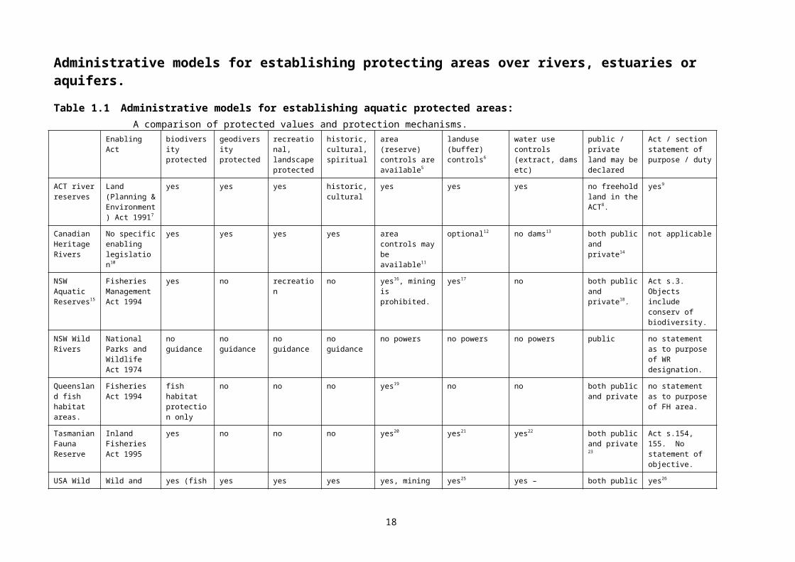
Table 1.1 (overleaf) presents summary information on a variety of Australian and overseas approaches to the establishment of aquatic protected areas. All Australian States have established protected areas over wetlands4. In most cases these reserves have been created using statutes focused mainly on the creation of terrestrial reserves. The statutes authorising the creation of terrestrial reserves are often called by titles like ‘Land Act’ or ‘National Parks and Wildlife Act’. This table, however, is focused on mechanisms created for the purpose of protecting inland aquatic areas.
12
Administrative models for establishing protecting areas over rivers, estuaries or aquifers.
Table 1.1 Administrative models for establishing aquatic protected areas: A comparison of protected values and protection mechanisms.
Enabling Act biodiversity protected
geodiversity protected
recreational, landscape protected
historic, cultural, spiritual
area (reserve) controls are available5
landuse (buffer) controls6
water use controls (extract, dams etc)
public / private land may be declared
Act / section statement of purpose / duty
ACT river reserves
Land (Planning & Environment) Act 19917
yes yes yes historic, cultural
yes yes yes no freehold land in the ACT8.
yes9
Canadian Heritage Rivers
No specific enabling legislation10
yes yes yes yes area controls may be available11
optional12 no dams13 both public and private14
not applicable
NSW Aquatic Reserves15
Fisheries Management Act 1994
yes no recreation no yes16, mining is prohibited.
yes17 no both public and private18.
Act s.3. Objects include conserv of biodiversity.
NSW Wild Rivers
National Parks and Wildlife Act 1974
no guidance no guidance no guidance no guidance no powers no powers no powers public no statement as to purpose of WR designation.
Queensland fish habitat areas.
Fisheries Act 1994
fish habitat protection only
no no no yes19 no no both public and private
no statement as to purpose of FH area.
Tasmanian Fauna Reserve
Inland Fisheries Act 1995
yes no no no yes20 yes21 yes22 both public and private 23
Act s.154, 155. No statement of objective.
USA Wild and Scenic Rivers
Wild and Scenic Rivers Act 1968
yes (fish and wildlife)
yes yes yes yes, mining and dredging may be prohibited24.
yes25 (“immediate environments”)
yes – obligation to protect “free flowing condition”
both public and private
yes26
Western Australian reserves
Land Administration Act 1997
yes unclear yes yes yes unclear unclear unclear Implicit aquatic purpose27
Victorian Heritage Rivers
Heritage Rivers Act 1992
yes yes recreation no Act requires mandatory management plans s.10.
certain activities prohibited or controlled s.10, s.12.
obligation to maintain "free flowing state" s.9
public Act s.1.
Act s.7.
Victorian Fisheries Reserves
Fisheries Act 1995
yes no passive recreation only
no Act requires mandatory management plan s.8928.
no no both public and private 29
yes, s.88. protection of species and habitats.
13

Table 1.1 includes examples of different approaches which either have been used to protect inland waters (such as the ACT’s land-based river reserves), or have been created with a clear intention of protecting inland waters. Note that at the moment, Queensland fish habitat areas and New South Wales aquatic reserves have not been established in freshwater, although they could be in the future. They have been established in estuarine and marine waters. Similarly the Tasmanian Fauna Reserve provisions have not been used at this stage. The NSW Wild River provisions will be used for the first time in the near future30.
Table 1.1 is not intended to be comprehensive; for example South Australia's aquatic reserve provisions are not included31. These also, like the equivalent provisions of the Victorian Fisheries Act, have not yet been used to protect freshwater areas. Table 1.1 does not include discussion of ‘special area' controls in NSW32 and Victorian33 legislation, or the 'environmental protection provisions' in the NSW Water Management Act 2000 (see Chapter 6 and Appendix 4) – all of which may be used to protect discrete areas. The Victorian Flora and Fauna Guarantee Act 1988 provides powers to designate and protect critical habitat areas, which could apply to aquatic ecosystems: it is noteworthy that these provisions have not yet been applied to protect freshwater areas. In summary, the same comment applies, in fact, to the area protection provisions of fisheries legislation in Queensland, New South Wales, Victoria, South Australia and Tasmania – they all remain unused (in relation to freshwater) as of the time of writing.
An expanded version of Table 1.1 is available at the freshwater policy page of www.onlyoneplanet.com.au. The specific URL at the date of writing is http://www.onlyoneplanet.com/PolicyFailure.doc.
Table 1.2 (below) lists specific State commitments to the development of systems of representative freshwater protected areas, and the programs developed to put these commitments in place. More detail on State programs is contained in the discussion below, and in Chapter 6 and Appendix 4.
Table 1.2 State representative freshwater reserve commitments and programs
Commitment contained in: Specific implementation program
National
National Strategy for Ecologically Sustainable Development 1992Intergovernmental Agreement on the Environment 1992National Strategy for the Conservation of Australia’s Biological Diversity 1996
National Reserve System Program
ACT Nature Conservation Strategy 1998 Nature Conservation Program - effectively complete.
NSW Rivers and Estuaries Policy 1992;
Wetlands Management Policy 1996;
Biodiversity Strategy 1999;
None. The State Aquatic Biodiversity Strategy, due for release in 1999, has not yet been published.
NT A Strategy for Conservation of the Biological Diversity of Wetlands, 2000
None. Conservation strategies under review 2005
14
Commitment contained in: Specific implementation program
Qld Strategy for the conservation and management of Queensland wetlands 1999
None, however a comprehensive State wetland inventory under preparation should enable identification of poorly represented freshwater ecosystems. The wild rivers program, although a separate commitment, seems likely to assist in meeting systematic conservation objectives.
SA Wetlands Strategy 2003. The policy has an explicit commitment to representative wetland reserves, set against a wide interpretation of the meaning of 'wetland'.
None – however efforts are being made within the Parks program to purchase poorly represented wetland types (Nevill and Phillips 2004).
Tas Nature Conservation Strategy (2000) State Water Development Plan 2002, Conservation of Freshwater Ecosystem Values (CFEV) Project (design phase 2002-2004)
State budget 2002 funded the CFEV project (see Appendix 10 of Nevill and Phillips 2004). No specific funds allocated for project implementation in the 2004 or 2005 State budgets.
Vic A Conservation Strategy for Victoria (CS)1987;
Biodiversity strategy 1997a, 1997b, 1997c
Healthy Rivers Strategy 2002
Heritage Rivers Programrepresentative wetlands component of the CS incomplete although progressing slowly.
Healthy Rivers Program
WA Wetlands Conservation Policy 1997.
This commitment was not reinforced by the draft Waterways WA Policy 2002 (Nevill and Phillips 2004).
None. The Waterways WA Policy, due for publication initially in 2003, has not yet been released.
All States have programs in place designed to meet commitments under the Ramsar convention - these commitments include the development of freshwater ecosystem inventories, and the establishment of systems of reserves covering the full range of wetlands included in the Ramsar definition of the term. In no State are these programs complete and up-to-date, although work, particularly on ecosystem inventories, continues - with Victorian, Tasmanian and ACT inventories being the most advanced.
The ACT is the only jurisdiction to establish a reasonably comprehensive system of representative freshwater protected areas including both still and flowing ecosystems. The ACT has had the advantage of being the smallest Australian jurisdiction, as well as having, historically, the most favourable funding. The ACT, Victoria, and Tasmania are in fact the only jurisdictions to attempt to directly action their "representative freshwater protected area" commitments. The Victorian program, while seemingly ambitious, has not been completed and is currently under review as part of the Healthy Rivers Program, with major commitments dating back more than a decade incomplete. The Tasmania system is under development, with the inventory phase due for completion at the close of 2004 - and no specific funds for program implementation in the current State budget.
Of the remaining five jurisdictions, Queensland and New South Wales have commenced the construction of State-wide freshwater ecosystem inventories, and South Australia is committed to do so (regional wetland inventories are available). In Western Australia and the Northern Territory, action has not been taken to put in place either comprehensive ecosystem inventories, or systems of representative freshwater protected areas - although regional ecosystem inventories have been prepared (see below). Instead, these States have concentrated on the broader bioregional framework of the Commonwealth's National Reserves System Program (NRSP), which itself did not highlight the freshwater reserve issue until 2004 (see discussion below). It is to be hoped that action will be taken within the NRSP to establish a nationally agreed approach to the classification of freshwater ecosystems into categories or types which could provide a framework for the
15
long-term development of a national system of representative freshwater reserves. However, a recently-completed Commonwealth (Land and Water Australia) contract aims to obtain State consensus on the need for a national framework to protect high-value rivers and estuaries. This project could ultimately result in a cohesive national approach to the development of river and estuarine inventories, which could in turn be expanded to include all inland aquatic ecosystems.
Victoria, although a leader in policy, suffers from serious implementation problems. Major commitments relating to three important areas: representative wetland reserve systems, protection of representative rivers, and protection of heritage rivers, remain basically without effect after more than 12 years (see below).
1.6 Protection of high conservation value rivers:
1.6.1 Context of a protective framework:‘Rivers’ in the discussion below are defined as including estuaries. At the simplest possible level, a national framework for the protection of HCV rivers must consist of three essential elements: agreement by Australia governments on how HCV rivers34 should be identified and
selected; a list of HCV rivers developed from that agreement; and ways of linking that list with environmental assessment, control and planning
mechanisms, as well as protected area reservation programs35.
Australia’s endorsement of the Ramsar Convention on Wetlands has provided a national framework for the protection of high conservation value inland aquatic ecosystems, including rivers. An advantage of expanding this framework (rather than developing a new one) by the inclusion of Australia’s most important natural rivers is that the framework is already accepted by all Australian States, and to some extent protective mechanisms already exist in both Commonwealth and State legislation, policy and conservation programs.
To date, no main river channels have been listed in Australia in isolation from associated floodplain wetlands or estuaries. While use of the Ramsar framework could assist in river conservation, the framework is one of many management approaches, and additional protective management tools are warranted to protect the full range of inland aquatic ecosystems (see Chapter 7).
In a more general context, a framework needs to relate to threats facing rivers and estuaries36. While a wide variety of threats exists, the three most important are probably: (a) invasive species (pests and weeds), (b) water extraction, drainage and diversion, and (c) catchment land use changes.
A framework also needs to meet certain criteria: it needs to be logical, cost-effective, simple, and flexible. It should also be responsive to issues of scale. As well, a staged approach may be necessary: if the proposed framework contains elements which are entirely new, or which require considerable community debate, such elements need to be developed in a second phase.
Both on-reserve and off-reserve protection will be important. A framework should extend the concept of aquatic protected areas past the current river programs in Victoria and the Australian Capital Territory. Aquatic reserves protecting wetlands are well accepted across Australia, and some small marine reserves protecting parts of estuaries have been established by most States; however most States have not established riverine protected areas, or protected catchments (Victoria and the ACT being notable exceptions).
16
1.6.2 The range of protective instruments:Potential managerial tools applicable to the protection of high conservation value rivers are discussed in more detail in Chapters 6 and more particularly 7. Whitten et al. (2002) provide detailed information on incentive opportunities. General approaches in terms of both incentives and prohibitions are summarised below:
Table 1.3, Protective mechanisms applicable to rivers:Commonwealth
Incentives Prohibitions
General Funding programs under NAP and NHT bilateral agreements are aimed at good natural resource management. These are discussed in more detail in Appendices Three and Four below.
Environment Protection and Biodiversity Conservation Act 1999 (EPBC Act). Major development proposals may be prohibited or restricted if they are likely to degrade environments of international importance.
Specific area
The NHT can fund plans or works applicable to special places.
Environment Protection and Biodiversity Conservation Act 1999 – as above. Where the Commonwealth Government has jurisdiction (eg: on Commonwealth Government land, or on designated Ramsar sites, or places on the National Heritage List) specific statutory prohibitions may be applied, or specific management regimes promoted.
States
Incentives Prohibitions
General All States have now established regional NRM frameworks with the ability to fund a wide variety of activities generally aimed at sustainable natural resource management. Some of these frameworks have been established by policy (eg: Western Australia) while others have been established by statute (eg: South Australia and Tasmania).
Three States (Victoria, South Australia and New South Wales) had pre-existing statutory catchment management frameworks in place prior to the development of regional NRM frameworks. The Victorian Catchment Management Authorities were alone in being able to raise independent funds through local government rating arrangements; however these powers were, unfortunately, withdrawn by the Victorian State Government in 1999.
A complex array of State statutes have the ability to impose prohibitions or controls on developments. For the purposes of this discussion, the most important statutes relate to:
1 fisheries controls
2 environmental assessment of major projects;
3 land use planning (many provisions apply through local government);
4 pollution control;
5 control of invasive species;
6 protection of threatened species and critical habitat; and
7 water resource management 37.
17
Incentives Prohibitions
Specific area
Some States (eg: Victoria and NSW) have statutes enabling 'joint management areas' to be created, where State funds can flow to encourage specified activities on privately-owned freehold land, under a formal government / landowner agreement. Another similar mechanism is provided for by informal voluntary landowner agreements 38 although here the level of government support is much reduced.
All States have statutes enabling the declaration of protected areas (or reserves) on crown, and sometimes freehold land. Victoria, for example, protects many wetlands under the Crown Land (Reserves) Act, and the National Parks Act.
Some States have statutes specifically designed to create aquatic protected areas. These are summarised in Table 1.1.
Local government:
Local government, in the main, operates through powers endowed by statute in each Australian State or Territory. As the third tier of Australian government, local municipalities can:
own and manage land;
raise funds through rates (and thus offer rate concessions);
receive and manage special purpose funds from State or Commonwealth sources; and
through their land use planning and development consent provisions they can influence a variety of threats to freshwater ecosystems relating to land development.
In some States local government can raise special-purpose environmental levies, collected as an adjunct to municipal rates.
The natural resource management regional planning arrangements (see below) which have evolved over the last five years as the result of Commonwealth-State bilateral agreements operate (in the absence of statutory NRM or ICM authorities) through State and local government administrative frameworks, making local governments powerful partners in managing the nation’s land and water.
18

Incentives Prohibitions
General As partners within Australia’s regional NRM planning framework, local governments can sponsor or partner programs like Landcare and Waterwatch.
Land use zoning controls can prohibit types of activities in designated areas of the municipality. These controls, as well as concurrent strategic planning responsibilities, can be used to manage threats (such as land drainage) to sensitive aquatic ecosystems.
In some States, local government has delegated responsibilities under State pollution control legislation, providing municipalities with opportunities to influence many aspects of the water environment, in particular water quality.
Specific area
Local governments can create and manage conservation reserves on municipal land.
As NRM partners, municipalities can offer landowners rate relief in exchange for conservation work or environmental programs on private land.
Development consent provisions can allow municipalities to assess and exclude specific developments from sensitive locations or their buffers. Alternatively, developments may be permitted under conditions designed to minimise environmental effects.
If a national framework is to be put in place to protect rivers of high conservation value, choices can be made about the instruments of protection. At a bare minimum, two of the above eight 'areas of control' could be selected to focus protective programs (for example, regional NRM planning programs could focus both State and Commonwealth funds into protective programs). A more ambitious framework would seek to influence all eight areas to a lesser or greater extent.
In choosing elements of a national framework, two models (at least) should be considered. The simplest model is the non-statutory approach, based on bilateral Commonwealth-State agreements (or a single multilateral agreement (eg: the InterGovernmental Agreement on the Environment 1992). This simple model would allow State government maximum flexibility. This model is also likely to hinge on a high degree of community support. This model would rely entirely on administrative programs already in place; no new legislation would be developed.
A more complex, less flexible, but arguably more effective model would embed the protective regime, to varying degrees, in statute. This model is of course more difficult to create, needing, in its most complex form, one special-purpose statute combined with amendments to several other statutes (in each State).
The Canadian Heritage Rivers System (CHRS) represents a good example of the first (non-statutory) model, while the Victorian Heritage Rivers Program (largely resting on the Heritage Rivers Act 1992 – see Appendix 16) represents an example of the second (statutory) approach.
1.6.3 Linkages to wider protective mechanismsDue to the complexity of existing administrative arrangements, it is appropriate here to summarise opportunities for developing linkages between heritage river protection and wider land management frameworks. For a more detailed discussion refer to Chapter 7.
19
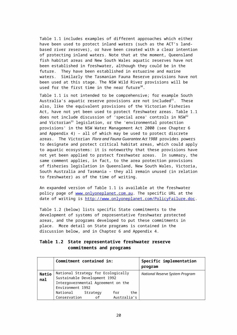
Table 1.4: Linking existing protective mechanisms with HCV river protection:Commonwealth
Incentives Prohibitions
General NAP and NHT bilateral agreements should be modified to require the identification and protection of HCV rivers in the development of accredited regional NRM plans.
Where proposed developments affect rivers placed on the National Heritage List, additional scrutiny could be required under the Environment Protection and Biodiversity Conservation Act 1999.
Specific The NHT can fund plans or works applicable to special places, and these provisions should be used in both developing regional NRM plans, and in developing specific management plans for HCV river areas.
Rivers can be placed on the National Heritage List (Environment Protection and Biodiversity Conservation Act 1999) Such listing would empower the Act in relation to developments which might affect identified river values.
Where the Commonwealth Government has jurisdiction (on Commonwealth land, for example) specific statutory prohibitions may be applied to protect designated rivers.
States
Incentives Prohibitions
General HCV rivers could be identified and protected through existing catchment management and NRM planning frameworks.
State statutes have the ability to impose prohibitions, and additional scrutiny could be place on proposals likely to affect the values of HCV rivers. Key statutes cover:
fisheries controls
environmental assessment of major projects;
land use planning (many provisions apply through local government);
pollution control;
control of invasive species;
protection of threatened species and critical habitat; and
water resource management39.
Specific Some States (eg: Victoria and NSW) have statutes enabling joint management areas to be created, where State funds can flow to encourage specified activities on privately-owned freehold land. Another similar mechanism is provided for by in-formal voluntary conservation agreements 40. These mechanisms could be used to provide buffer and catchment management around designated HCV rivers.
All States have statutes enabling the declaration of protected areas (or reserves) on crown, and sometimes freehold land. Victoria, for example, protects many wetlands under the Crown Land (Reserves) Act, and the National Parks Act.
Some States have statutes specifically designed to create aquatic protected areas. These are summarised in Attachment One. These provisions could be used to protect designated HCV rivers.
20

Local government:
Incentives Prohibitions
General Programs under municipal sponsorship, such as Landcare and Waterwatch, could be focused to provide additional protection to HCV rivers.
Strategic use of land use zoning controls could be used to provide HCV rivers with additional ‘buffer’ protection from the effects of land uses such as land levelling, draining, levee construction and irrigation.
Where municipalities have pollution management and water quality control programs, these could be used to provide additional direct and buffer protection to designated HCV rivers.
Specific Conservation reserves on municipal land could be used to encompass, or provide buffer protection for HCV rivers.
Municipalities could offer landowners rate relief in exchange for conservation works or environmental programs on private land targeted to protect HCV rivers.
Additional scrutiny could be applied to specific development proposals likely to impact, directly or indirectly, on the values of HCV rivers in the municipality.
In conclusion, there are strong arguments for (a) expanding the existing Ramsar frameworks in States to include Australia’s most important near-pristine rivers, and (b) developing additional river protection initiatives modelled either on Canada’s Heritage Rivers System, or Victoria’s Heritage Rivers Act 1992.
1.7 Overview of recommendations:The long-term benefits of creating freshwater protected areas should far outweigh short term costs. Many marine protected areas have been shown to enhance fisheries outside the protected zone (Gell and Roberts 2002). Some freshwater protected areas are almost certain to have similar effects, with consequent benefits for recreational fishers. Australian hunter’s organisations have, in previous years, helped fund the purchase of freshwater protected areas which provide breeding grounds for ducks and other waterbirds. Farmers will benefit from the protection of aquifer recharge areas. Indigenous groups supported the formation of the first listed Ramsar site in the world: Coburg Peninsula in the Northern Territory.
There are, however, a small number of urgent issues.
Firstly, although some representative examples of freshwater ecosystems are contained within existing protected areas, no systematic national review has been conducted to identify gaps in the reserve network. It is likely that many freshwater ecosystems are not adequately protected – particularly those of riverine or subterranean nature.
Secondly, although all jurisdictions are developing inventories of freshwater ecosystems, these remain incomplete. Nowhere are they comprehensive in the sense of containing up-to-date data on value, condition and threat over wetlands, rivers and subterranean ecosystems. The acceleration of work on inventories is urgent to underpin both protected area gap analysis studies, and developing regional NRM strategies.
Thirdly, river degradation is ubiquitous and increasing over much of temperate Australia; the identification and protection of remaining rivers of high conservation value is urgent. In all three areas, the Commonwealth needs to play a leading role, particularly with respect to promoting and funding inter-State working groups to address these issues in a coordinated way.
21

Fourthly, the sympathetic management of biodiversity outside protected area frameworks is essential, and urgent action needs to be taken to encourage and support biodiversity conservation measures on freehold and agricultural land. While current NRM regional planning frameworks do offer improved possibilities for effective management of the cumulative effects of incremental water-related development, this opportunity is likely to be lost unless (a) NRM frameworks embrace five key principles for cumulative effect management (see Appendix 15), and (b) comprehensive ecosystem inventories are developed to support biodiversity management within the regional planning framework (see Chapter 5).
Detailed recommendations are made in Chapter 10. These recommendations, in brief, seek to:
support accelerated development of comprehensive ecosystem inventories by the States, within a framework which would allow development of a national inventory;
use this inventory, supported by an ‘interim freshwater bioregionalisation of Australia’, to identify and seek to remedy gaps in the protected area network through the development of a comprehensive, adequate and representative national system of freshwater protected areas;
identify and protect rivers of outstanding conservation value, partly through existing mechanisms such as those associated with the Ramsar convention, as well as new mechanisms, perhaps modelled on the Canadian Heritage Rivers System; and
encourage and support owners of freehold land, as well as landholders of agricultural leasehold land, to undertake measures aimed at protecting freshwater biodiversity on land outside the protected area network. Effective management of cumulative effects, based on five key principles, needs to be explicitly incorporated within all NRM planning frameworks.
Urgent work is also needed to extend existing thinking on freshwater protected area management strategies, and to develop guidelines specific to different types of Australian freshwater ecosystems. The seminal work by Saunders et al. (2002) provides a starting point for such studies.
22
2. Introduction
2.1 Objectives of this bookThe objectives of the resourcebook are: to examine the role and importance of inland aquatic protected areas, particularly
those created for the protection of representative examples of aquatic ecosystems; to provide a source of important background information relating to the development
of freshwater protected areas in Australia; to make recommendations (where relevant) relating to government programs
affecting inland aquatic ecosystems, and to encourage, where appropriate, the development of aquatic protected areas; and
to promote discussion of the issue as a basis for the possible preparation of an Australian Society for Limnology (ASL) policy on the development of systems of representative protected areas for the conservation and management of major inland aquatic ecosystems.
The ASL has published a number of policies on important issues related to inland aquatic ecosystems. Existing policies are available from the ASL's website. The purpose of these policies relates to the objectives of the ASL. The ASL seeks to provide expert information, support, and where relevant guidance, to Australia's managers of inland aquatic ecosystems (see discussion below).
In its current form, this paper’s intended audience is principally managers, policy-makers, scientists, tertiary students and academics working on issues related to the management of natural resources.
2.2 The Australian Society for LimnologyThe Australian Society for Limnology (ASL) is an Australian-based scientific society whose focus is the study and management of inland waters. The ASL was established in 1961, and has a current membership of over 500 scientists, managers, engineers, teachers and tertiary-level students from all States and territories. Members have a strong professional interest in inland aquatic issues, in the maintenance of biodiversity, the maintenance and/or restoration of water quality, and the wise use of aquatic resources. The Society also has a strong interest in fostering the scientific and intellectual development of tertiary students.
The Society includes members working in most relevant government agencies, tertiary institutions and many industries related to aquatic resources. Through their daily activities, members have constant contact with local communities and are in a strong position to interpret and advise on inland water issues. The Society has a substantial knowledge base, and has assumed a responsibility to ensure that this is available to those who manage inland waters.
Accordingly, the charter of the ASL is to further our understanding of Australia's inland waters, and to promote the wise use and sustainable management of aquatic resources. In this manner, we will contribute to the continued existence of this valued resource, and the maintenance and enhancement of the quality of life for all Australians.
The roles of the ASL are to: to provide a forum for the exchange of ideas and research results amongst
scientists; to provide an interface between researchers and managers; to provide a venue for student development; and
23

to report to State and Federal Governments on the state of inland waters.
2.3 AcknowledgmentsIn September 2000, the ASL established a working group to explore the issue of representative reserves, with a view to promoting discussion on the issue, and making appropriate recommendations relevant to the ASL’s charter. The ASL has already published policy statements on several important aquatic issues, and a draft policy on representative reserves, or a draft policy on the use of protected areas to conserve important freshwater ecosystems, could be developed following circulation of this discussion paper.
The working group is comprised of ASL members. The working group also established a wider reference group taking in both ASL members, experts from related fields, and other interested persons. Information on the working group (including membership lists for both the working group and the reference group) is available through the ASL's website: http://www.asl.org.au/, and the membership of the working and reference groups is listed below in Appendix 11. Indigenous representatives were invited to joint the reference group, but did not participate.
The working group has authored this discussion paper. An initial draft was developed by Jon Nevill (convenor of the working group) and Ngaire Phillips, who are the editors of the document. Contributions by other working group members, as well as comments by reference group members have been incorporated into the resourcebook.
We would particularly like to thank Bob Pressey and Hugh Possingham, for discussions on reserve identification and selection, and Gary Brierley for insights into river geomorphology issues. Tony Ladson contributed many key insights, as did Andrew Boulton, Richard Kingsford, Janet Stein, Max Finlayson, Jim Tait, Richard Norris and Bill Phillips. The resourcebook also owes a debt to a number of scientists and managers outside both the working group and the reference group, in particular Helen Dunn and Richard Thackway. Special thanks too to Tracie Dean, Natasha Grainger, Theo Stephens and Lindsay Chadderton from the New Zealand Department of Conservation. Jessemy Long, Doug Hooley, Imogen Zethoven, and Peter Unmack also made important contributions.
In regard to the discussion of inventories of freshwater ecosystems, this book owes much to the work and helpful assistance of: Andy Spate, Angus Duguid, Bill Humphreys, Bill Logan, Bob Pressey, Brian Timms, Bruce Chessman, Bruce Cummings, Cecilia Tram, Colin Creighton, Damian Green, David Moffat, David Outhet, Dean Gilligan, Gavin Blackman, Glenn Conroy, Jane Bateson, Jane Gough, Janet Stein, Jim Tait, Judy Faulks, Martin Read, Max Finlayson, Mick Hillman, Penny Paton, Peter Newall, Richard Miller, Sarah Pizzey, Stuart Minchin, Terry Loos and Tim Bond. The Inventory Construction section draws heavily on the work of Blackman, Duguid and Finlayson. Janet Stein assisted with wild river database information. Damian Green and Deborah Nias assisted with information on the River Murray Wetland Database. Mark Lintermans assisted with information on the Australian Capital Territory. Bruce Chessman, Nick Gartrell and Dean Gillian assisted with information on the New South Wales situation. Angus Duguid, Max Finlayson, Mike Butler and Judy Faulks assisted with information on the Northern Territory. Gavin Blackman, David Moffatt, Roger Jaensch, Malcolm Dunning, and Karen Danaher assisted with information on Queensland. Tim Bond and Russell Seaman assisted with the South Australian section. Stewart Blackhall assisted with the Tasmanian section. Janet Holmes, Stuart Minchin and Paul Wilson assisted with the Victorian section. The Western Australian section draws on papers and comments by Bill Humphreys, Stuart Halse, Jim Lane, Roger Jaensch, Romeny Lynch, and Sue Elscot.
Peter Goonan supplied comment on South Australia’s water quality policy. Janet Stein, Jim Tait, Annette Maclean and Stuart Blanch assisted with the development of Chapter 7.
24
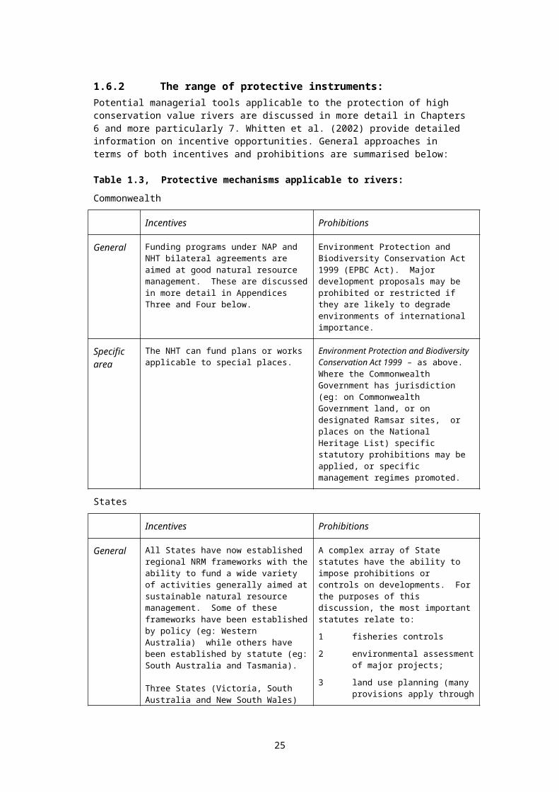
Peter Manins provided invaluable editorial assistance.
Special thanks also to WWF Australia for assistance with a portion of the costs of printing this document.
2.4 Scope and terminologyThe scope of this document includes all inland aquatic ecosystems. To be more specific, it includes all inland aquatic ecosystems described by the Ramsar Convention definition of “wetland”. This definition41 (in brief) encompasses both fresh and saline, flowing and still, and surface and subterranean ecosystems. In other words, the resourcebook covers rivers, lakes, artificially constructed reservoirs, wetlands (ie: lentic wetlands - using the more limited definition of wetlands current in Australia), salt-marsh, aquifers and karst systems, and estuaries whose ecosystems are significantly dependent on inflow from rivers, streams and aquifers.
Apart from brief references to international agreements and programs in other countries, the scope of the resourcebook is confined to Australia and New Zealand.
The most widely accepted definition of ‘protected area’ is that of the IUCN. Protected areas, as defined by the World Conservation Union (IUCN 1994) are areas of land and/or water “especially dedicated to the protection and maintenance of biological diversity, and of natural and associated cultural resources, and managed through legal or other effective means”. The definition has three key elements. The area must be under defined management (i.e. an agreed management plan should exist). Secondly, actual management arrangements must effectively reduce at least one major threat to the area's values (i.e. value and condition should be monitored and reported over time). Thirdly the area must have secure tenure (preferably through statute). The IUCN lists 6 categories of protected area, from full protection through to multiple use (see Appendix 1 below).
Where the term “freshwater ecosystem” is used, this includes all habitats covered by the Ramsar definition of the term “wetland” (see Appendix 8), notably including river, aquifer, ephemeral wetland, and estuarine ecosystems (where such ecosystem is heavily dependent on freshwater flows).
Where the term “wetland” is used, unless it is specifically mentioned that the Ramsar definition is being used in that particular context, the term equates to the definition used in the Commonwealth Wetlands Policy (see Appendix 8). This definition adopts the more conventional Australian usage of the word, and excludes estuaries, aquifer and river ecosystems, which the Ramsar definition includes.
The term “reserve” used here means tracts of land and/or water, over which particular management regimes are applied42, so as to meet the definitions of the IUCN protected area classes I-IV (see Appendix 1) in which direct human intervention and modification are limited43.
"Freshwater" in this resourcebook is used as a shorthand term for inland waters (as distinct from marine waters). The central arguments of the book apply equally to inland saline ecosystems, or coastal brackish systems heavily dependent on river or groundwater flow. It should be noted that the term "freshwater" has currency as a keyword for searching subjects covered in this paper.
Where 'representative freshwater reserves' are discussed, these include all inland aquatic ecosystems: lakes, wetlands, karst and other underground ecosystems, rivers and their associated channels, billabongs, and immediate surrounds (including sub-surface ecosystems). Where the ecologies of estuaries are dominated (sometimes seasonally) by inland water flows rather than marine influences, these too are included.
25

The term 'representative' can generally be taken (depending on context) as shorthand for 'comprehensive, adequate and representative' within the meaning attributed to that phrase in the proceedings of the CoP meetings of the Convention on Biological Diversity 1992, and the National Strategy for the Conservation of Australia's Biological Diversity 1996 (discussed further below).
Where the term 'groundwater' is used, this refers to all subsurface water.
Where the term 'intrinsic value' is used, this refers to strictly non-human values. For example, many ecosystems contain elements of little or no apparent use from a human perspective. Recognising intrinsic values of these elements acknowledges that humans share this planet with other species, and these species have an inherent right to exist alongside human use of the planet’s resources. (see: http://www.onlyoneplanet.com/Intrinsic_value.htm )
‘Biodiversity’ is the variety of living organisms, their genes and the ecosystems of which they form a part. An ‘ecosystem’ is a dynamic complex of plant, animal and micro-organism communities and their non-living environment interacting as a functional unit (as defined by the Convention on Biological Diversity, June 1992).
'Catchment management' in this book means natural resource management within catchment boundaries, and covers the integrated management of land, water and biological resources. However, this book does not concern itself with terrestrial issues in this context, simply to avoid diluting the focus of the book on water-related issues.
Australia has six States and two Territories, forming the middle level in a three-tiered government structure. The word 'State' is used in this book to encompass all eight jurisdictions in shorthand form, including the Northern Territory and the Australian Capital Territory.
2.5 Aquatic protected areas in briefAccording to several major international agreements including the Convention on Biological Diversity 1992, the conservation of biodiversity, including aquatic biodiversity, requires the protection of representative examples of all major ecosystem types, coupled with the sympathetic management of ecosystems outside those protected areas. This requirement was re-affirmed by the 2004 World Conservation Congress (see Appendix 18). Representative reserves are one of the most important types of aquatic protected area, and are selected to protect representative examples of natural ecosystems, features or phenomena. More generally, aquatic protected areas are established for the: protection of biodiversity through the preservation of representative examples of
ecosystems, and protection of the species and genotypes which depend on those ecosystems;
protection of threatened ecological communities and species; preservation of unique, rare or outstanding botanical, zoological or geological
phenomena; the establishment of ecological benchmarks for use in evaluating long-term
changes in ecosystems subject to intensive modification (eg: through water abstraction, or the harvesting of plants or animals); and
protection of important landscape, wilderness, recreational, scientific, cultural and educational values and uses associated with the natural environment, to the extent that such activities are compatible with other objectives.
See section 4.3 for further discussion.
26
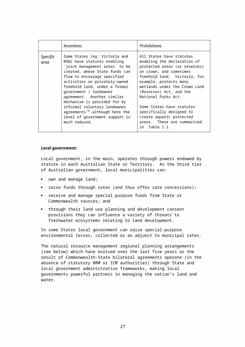
The development of comprehensive, adequate and representative reserves in terrestrial environments is relatively well established, both in Australia and overseas. This terminology44 (and the process behind it) is currently being applied to the marine environment, driven primarily by concerns relating to the protection of biodiversity, and encompassing related secondary objectives (see below).
Although all Australian States have made policy-level commitments to establish systems of representative freshwater reserves, these commitments, for the most part, have not been implemented in any systematic way (see below).
With growing emphasis (within government programs) on biodiversity conservation and sustainable management, the concept of representative freshwater reserves is becoming increasingly relevant. Moreover, the continuing degradation of most of the nation's freshwater ecosystems makes the concept both more relevant and more urgent.
Geoconservation and geodiversity are important issues, as defined within the Australian Heritage Charter (Australian Heritage Commission (1996)). Protected areas are needed to maintain typical river types, some of which are unique to Australian river systems45. In selecting such areas, reference needs to be made to a number of biophysical factors, as well as our global responsibility to protect representative rivers and their associated landforms.
The conservation of stygofauna (subterranean aquatic fauna) is an area which merits special attention. An aquifer in Western Australia has the highest diversity of subterranean amphipods recorded anywhere in the world46, highlighting stygofauna as an area of conservation significance and concern47.
Existing terrestrial reserves protect examples of many, but by no means all Australian freshwater ecosystems. Tasmania’s Franklin-Gordon Wild Rivers National Park provides an example. While the extent of protection is unknown (see below) some types of lentic48
(slow moving) wetland ecosystems may be well protected. However it seems likely that many river and aquifer ecosystem types are poorly protected.
The 2001 Fenner Conference on Freshwater Biodiversity called for, as a top national priority, the States and Commonwealth to work together to establish an enduring series of special catchments for the management of biodiversity. It also recommended that the Commonwealth environment agency (now the Department of Environment and Heritage) should “coordinate the development of an interim biogeographic regionalisation of inland waters to complement those already developed for terrestrial and marine systems, as a basis for allocating priorities and resources at national and regional scales.” (Georges and Cottingham 2002).
2.6 Limitations to the representative reserve approachHumans began modifying the environment a long time ago, as they moved from hunter-gatherer societies to more permanent agrarian settlements. Even hunter-gatherers modified the natural environment through the use of fire. World-wide, the last two centuries have seen the process of anthropogenic environmental modification expand exponentially, and today few ecosystems, save those of the deep ocean trenches, remain untouched.
This history has shown that anthropogenic modifications, in general, result in simplifications of ecosystems managed or utilised for human benefit. In by far the majority of cases, biodiversity values suffer under the simplifications and harvesting approaches which we impose on natural ecosystems. In extreme cases, which unfortunately are too common, entire ecosystems have been destroyed or seriously degraded – examples can be found in areas such as desertification, the destruction of marine habitat by trawling operations, the extinction of entire forest ecosystems on small
27
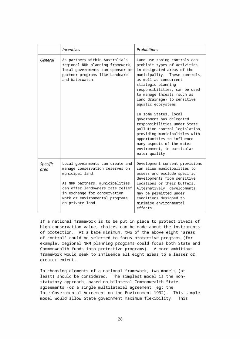
islands (through forest clearfelling), or the obliteration of freshwater ecosystems through sedimentation or water extraction.
Representative reserves are one key element in the two-pronged approach used to protect biodiversity values, not only in Australia, but around the world (see below). Representative reserves seek to protect representative examples of major ecosystem types from the threatening processes which affect these ecosystems under human management regimes elsewhere.
However, there are cases where this approach to biodiversity conservation raises difficult questions. Those discussed here relate to: the near-pristine rivers of the far north of Australia; unique ecosystems (such as subterranean ecosystems); and the failure by management authorities to apply ‘sympathetic’ management of utilised
ecosystems outside the reserve network.
2.6.1 Rivers of the far north:Aquatic ecosystems lie within catchments, and in large part depend for their health on the health of the surrounding landscape. Heavily modified and utilised landscapes, with altered drainage patterns, polluted waterways, and declining patterns of native vegetation will not support aquatic ecosystems having high natural values. In many respects, problems of land degradation tend to be amplified in streams, aquifers and wetlands.
In Australia, the National Wild Rivers Program, published in 1999 (see discussion below) showed that by far the majority of wild rivers outside nature reserves (such as national parks and World Heritage areas) were in the far north of the continent. The Land and Water Resources Audit (published in 2001) showed that, while the rivers of southern Australia - outside large nature reserves – are generally seriously degraded, the rivers of the far north generally still retain high natural values.
How should these near-pristine rivers of the far north be managed? Should representative reserves be created, while the remaining northern rivers are subject to the degrading processes which have accompanied human use of the rivers of the south? Pressures from cotton farming, rice growing and other tropical crops could see this happen. Or should action be taken which would provide much higher levels of protection over vast areas which still retain exceptional natural values?
According to Peter Whitehead and Ray Chatto:
In a landscape dominated by environments that are most often structurally intact, preoccupation with features of individual sites, as required by an attempt to list and rank, is a less than ideal way to analyse and present the conservation values of many wetland types. Under the influence of north Australia’s erratic climate and harsh seasonal droughts, wetlands are better viewed as complexes, as functionally integrated systems made up of highly dynamic and resource-rich patches in a matrix of drier, often nutrient-poor lands.
In combination, as components of this complex mosaic, they reliably support an extraordinarily diverse and abundant flora and fauna, in a way that no individual site could duplicate. A quest to assign importance to the separate pieces of the jigsaw is quixotic, because we can ill afford to lose any of them. It is the integrity and linked ecological function of the whole that must be protected and maintained.49
Could large areas – entire river basins, for example – be set aside as wilderness areas, without dams or irrigation projects or levee banks, and without borefields or drained wetlands or massive vegetation clearance? Could the high natural, tourism, indigenous and spiritual values of such areas justify this approach? Would such an approach gain community and industry support? The river basins of the far north offer what may be the last chance anywhere on this planet to protect such large areas in this way. The
28

protection of near-pristine river basins could provide the largest representative river reserves anywhere in the world, and would free these reserves from the catchment management difficulties which beset the creation of river reserves in ‘productive’ catchments. The arguments developed below appear to support such an approach.
2.6.2 Unique ecosystems:The protection of unique ecosystems raises a second difficult issue related to representative reserves. There are instances where distinct aquatic ecosystems have evolved in isolation. Examples are provided by spring-fed ecosystems in Australia’s dry interior, where species of mollusc are endemic to particular mound springs50, or by subterranean ecosystems in Western Australia, where invertebrates have evolved in isolated aquifers which have had relatively stable water quality, temperature and level for long periods of time. In many cases, assemblages have evolved within specific aquifers, with very limited links to other ecosystems. The stability of water levels over long periods of time, coupled with limited connectivity with surface waters, has allowed fauna to evolve which are endemic to particular aquifers. What approach should be taken if surveys of each major aquifer reveal that each is a distinct ecosystem?
In Victoria, the Gnotuk, Bullenmerri, Keilambete crater lakes system is unique in the world as a laboratory for time-based studies on sediments, pollen, rainfall, climate change, geomagnetic variation and land use51.
In this case, the protection of a representative example of the ecosystem, where each ecosystem is distinct, suggests that each should be protected. This situation could in fact be the case over substantial areas of Western Australia. The track record of Australian use of aquifers over the last century has been a record of the mining of aquifer waters rather than their sustainable use. Even sustainable use will alter groundwater levels, pressures and flows, and in some cases connectivity and temperatures.
What principles should be used to guide conservation programs in these cases? We suggest that, where a unique ecosystem is identified and lack of associated development allows a protected area approach, the above approach should be used. Where existing development precludes a protected area approach, land use planning controls, and in particular aquifer extraction controls, should be put in place to protect identified ecosystems to the maximum practical extent.
2.6.3 Sympathetic management outside the reserve network:Of deeper concern to many conservationists is the lip-service paid by ecosystem managers to the principle of ‘sympathetic management’ of utilised ecosystems. The forest industry presents a good example, where differences between rhetoric and reality continue to underpin disquiet amongst conservationists. The bilateral Regional Forest Agreements put in place between the Commonwealth and the States in the 1990s were based on the tenets of ‘comprehensive, adequate and representative’ reserves coupled with sympathetic management of utilised forests to protect biodiversity values.
Under the original proposals, a minimum of 15% of each major forest ecosystem would be protected within a ‘protected area’, while utilized forests would be managed sympathetically with respect to biodiversity conservation. Targets above 15% were to be set for rare and relic forest communities. The Commonwealth Scientific Committee that developed the targets did so with the provisos that there should be no more loss of native forest to clearance, and that management should be sympathetic to threatened native biodiversity in the part of the native forest used for wood production, with strict adherence to forest codes of practice designed partly to protect biodiversity. In Tasmania at least, these provisos have not been met (Mendel and Kirkpatrick 2002)52.
The Tasmanian experience is not unique amongst the States in this regard. These outcomes undermine the credibility of reserve systems in general.
29
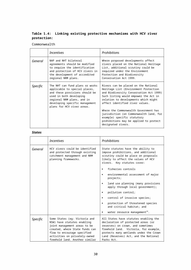
3. Reserves in terrestrial and marine environments
Reserves specifically dedicated to protecting representative freshwater environments are rare in Australia - and around the world. Most of the major Australian sites which do exist have been established partly by States moving to meet commitments made by Australia under the Ramsar Convention (discussed in more detail below). To understand why this is the case, and to predict future trends, it is important to obtain a brief historical overview of the establishment of reserves in terrestrial and marine environments.
The following sections outline the growth of the concept of representative reserves – on land and at sea – in the Australian context. This section borrows heavily from the work of Richard Thackway and Bob Pressey ( See reference list. Square brackets are used below to acknowledge quotes of complete paragraphs).
3.1 Terrestrial protected areas
3.1.1 Commonwealth and State responsibilitiesUnder the Australian Constitution, the primary responsibility for land management lies with the State and Territory governments. Most of Australia's terrestrial protected areas, therefore, have been identified and selected, and subsequently declared and managed, by the State and Territory nature conservation agencies, on behalf of their governments. Only three terrestrial protected areas on mainland Australia have been declared under Commonwealth legislation in response to national and international concerns regarding these areas' outstanding natural and cultural values. These protected areas are declared and managed by the Commonwealth in partnership with the traditional owners of these estates. [Thackway 1996:1].
3.1.2 Historical perspectiveA century ago, Australia was at the forefront of efforts to protect special terrestrial places. The first national parks in the world were created in the USA (Yellowstone National Park in 1872) and in Australia (Royal National Park, 1879). For the next one hundred years, reservations were primarily driven by a desire to protect the beauty of special natural environments, the inspirational values of wilderness, recreational resources, landscapes of particular cultural significance, or other smaller sites of special scientific importance or perceived fragility. With this historical perspective It is perhaps not surprising that the purpose of the USA Wild and Scenic Rivers Act 1968 is to protect the recreational and landscape values of wild rivers, not their biodiversity53.
Australia was no exception to this general rule, with the result that, by the end of the 1960’s, Australia had a variety of large parks in rugged, infertile areas, but comparatively few reserves covering arable grasslands, fertile woodlands, or forests with high timber value. Parks and reserves had grown essentially by ad hoc and opportunistic acquisitions, often driven by parochial political pressures. It is important to acknowledge that many major sites of exceptional natural value were protected in this way.
However, as Pressey and McNeil (1996) point out, “ad hoc decisions have serious practical disadvantages. One is that, in Australia and many other parts of the world, they have led to the secure protection of areas least threatened by processes that reserves are good at preventing (Pressey 1994, 1995). In north-eastern New South Wales, for example, reserves are concentrated in the steepest, least fertile environments, even though an overall reserved area of 7% of the region might at first sound impressive” (Figure 1).
30

Before the 1960s most protected areas in Australian jurisdictions were identified and selected by knowledgeable individuals and recreation interest groups whose recommendations were supported by government boards or committees. Early reserve recommendations usually had a local focus. By the mid-1960s this began to change with the widespread use of small-scale aerial photography and environmental maps, and as reconnaissance-scale biological survey data became generally available. Small-scale maps of surficial geology, climatic maps and vegetation maps provided ecologically meaningful surrogates as a basis for surveying biological communities (Myers & Thackway 1988). The use of these information sets provided the opportunity to develop more systematic approaches for identifying and selecting protected areas which sample the wide range of ecosystem types [Thackway 1996:2] although better surveys and better data have done little to
offset the tendency to reserve areas of low value for commercial uses (see Pressey and Thackway Biological Conservation (96)55-82).
3.1.3 Growth of concerns over gaps in the reserve systemIn the late sixties and early seventies, increasing concern amongst nature conservation professionals (see for example Marshall 1966) led to examinations of the degree to which terrestrial ecosystems (often using major plant communities as ecosystem surrogates) were protected. A review of the representativeness of Australia's reserves was undertaken by the Australian Academy of Science in 1968; this showed that, while each State and Territory had established systems of protected areas, they were not representative of the terrestrial ecosystems of Australia.
The first national systematic approach to identifying gaps in the representation of terrestrial ecosystems within protected areas was initiated by the Australian Academy of Science as part of the Australian contribution to the International Biological Programme (Specht et al. 1974). As a result, Specht (1975) recommended that at least one large sample of each major terrestrial ecosystem in each biogeographic division of each State should be incorporated into an ecological reserve, either by designating the whole or part of existing national parks and other nature conservation reserves as ecological reserves or, where necessary, by acquisition of land. [Thackway 1996:2]
The need to establish ecological reference areas in undisturbed samples of major terrestrial ecosystems resulted in the passage of Victoria’s Reference Areas Act in 1978.
Figure 1: Reservation of land in north-eastern New South Wales in relation to slope and fertility
Note: The vertical axis indicates the percentage of land in each of the slope and fertility classes that is reserved; S1 – steep slopes, S2 – moderate slopes, S3 – flat or gentle slopes; F1 – low fertility, F2 – moderate fertility, F3 – high fertility (from Pressey 1995).
31
steepermore fertile
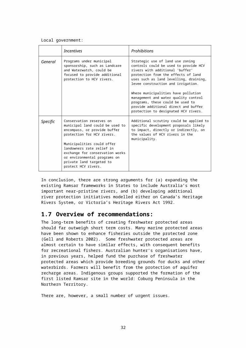
The Commonwealth initiated the Register of the National Estate in the late 1970’s54, encompassing both natural and cultural places.
At the international level, Australia made a commitment to the development of systems of representative ecological reserves in 1982, when Australian representatives at the United Nations supported the World Charter for Nature, a resolution of the General Assembly of the UN in October of that year. The reservation of representative examples of all ecosystems – terrestrial, marine and freshwater – was an important tenet of the Charter. The text of the Charter is available on many websites, including www.onlyoneplanet.com.au.
During the 1980s there was a considerable expansion in the respective systems of terrestrial protected areas, both in terms of the number of reserves and the total area managed for nature conservation (Bridgewater & Shaughnessy 1994; Thackway 1996). While this rapid expansion would appear to be effective for the conservation of biodiversity, most of the growth of these systems tended to include areas for their spectacular scenery, value for recreation, or special features, for example, areas comprising the 'taller, greener, and wetter' end of the ecosystem spectrum (Thackway & Cresswell 1995a). During this period, four jurisdictions - Queensland (Sattler 1986), Tasmania (Tasmanian Working Group for Forest Conservation 1990), Victoria (Land Conservation Council 1988) and Western Australia (McKenzie 1994) - developed systematic ecosystem-based approaches which had as their goal the representation of typical examples of the environments/ecosystems in conservation reserves. [Thackway 1996:2]
3.1.4 Representative reserves: a national perspectiveBy the 1990s there was widespread recognition that the existing State and Territory systems of protected areas had developed largely in isolation from each other, with a variety of operational goals, using various scales of data and information, and using a variety of approaches for identifying and selecting protected areas.
The vision to develop a national system of reserves which sampled the wide range of major terrestrial ecosystems was supported by all nature conservation agencies, many conservation-based non-government organisations and the wider community. It was also demonstrated in a number of major intergovernmental statements and policies, including the 1991 draft National Strategy for the Conservation of Endangered Species (ANZECC 1991), the 1992 InterGovernmental Agreement on the Environment (Commonwealth of Australia 1992a), the 1992 National Forest Policy Statement (Commonwealth of Australia 1992b), the 1992 National Strategy for Ecologically Sustainable Development (Commonwealth of Australia 1992c), and the 1996 National Strategy for the Conservation of Australia's Biological Diversity (Commonwealth of Australia 1996). In addition, in 1992 a House of Representatives Standing Committee on Environment, Recreation and the Arts inquiry into the role of protected areas in the maintenance of biodiversity identified the need for a systematic approach for planning the National Reserve System for Australia (HoRSCERA 1993). In its final report, HoRSCERA recommended the development of a nationally consistent bioregional planning framework for planning the National Reserve System. [Thackway 1996:3]
As an aside, it is important to note that the momentum which led to the development of a nationally consistent approach to the protection of terrestrial ecosystems appears to have been almost entirely lost in respect to the protection of freshwater ecosystems – at least at this point in time. The current (2003-4) LWA consultancy which aims to establish a national consensus on a framework for protecting high-value rivers and estuaries may re-capture this momentum.
The Australian Government was one of the first to ratify the international Convention on Biological Diversity55 when it was opened for signature in June 1992.
32
Although the convention did not introduce the phrase “comprehensive, adequate and representative” (CAR) in relation to protected areas, this phrase has now been incorporated into all major Australian biodiversity programs56.
In response to these national and international commitments, in 1992 the Commonwealth Government established the National Reserves System Cooperative Program (NRSCP – now known as the NRSP). The goal of that program was to establish the National Reserve System by the year 2000, in cooperation with State and Territory nature conservation agencies (Keating 1992).
3.1.5 The IBRA regionalisation frameworkThe NRSP is underpinned by the national Interim Biogeographic Regionalisation for Australia57 (IBRA) - a framework developed in cooperation with the States and Territories (under the auspices of ANZECC) - to determine priority regions and ecosystems for reservation. Within the IBRA framework, the NRSP encourages States and Territories to address CAR principles in establishing a national system of protected areas. Within these limits, the NRSP is concerned with all types of ecosystems58 - including freshwater ecosystems.
The principle underlying the selection of IBRA regions is the recognition that ecosystems depend largely on geology, landform, vegetation and climate, mediated by community succession, fire, soil development, and of course the impact of human activities59. IBRA regions, then, are derived substantially from geomorphology, as are sub-regions which most often use land system mapping as the basis for their derivation. However, a comparison of IBRA regions and subregions with AWRC catchment boundaries reveals very little coincidence of regional and drainage boundaries (Janet Stein, pers.comm 2/8/03).
The reservation of sites solely on the basis of geology or geomorphic values has not yet been recognised as part of IBRA, and such sites are only picked up indirectly. Several States, however, have developed geo-conservation programs to cover this gap. One approach that could be considered further in freshwater systems is that developed by Brierley et al. on “River Styles”. This is a regional-scale method for defining river types based on geomorphic characteristics This approach has been applied in NSW and potentially provides both a geomorphic template for assigning conservation value, as well as providing an assessment of inherent geomorphic value and condition.
Freshwater ecosystems are not adequately addressed in broad-scale vegetation analyses. This is a result of the importance of fine-scale geomorphic variations in determining the structure and function of freshwater ecosystems - and the fact that the primary focus of ecosystem and vegetation mapping in most States has been on terrestrial floristic variation as the basis for differentiating between ecosystems and communities. Some States, such as Victoria, include a geomorphic component in the delineation of vegetation and ecosystem type, but finer scale analyses are required in developing a regionalisation framework suited particularly to freshwater ecosystems (see the discussion in the chapter on inventories below).
In summary, the IBRA framework was developed to assist the NRSP, and State governments, in identifying gaps in the developing system of CAR terrestrial reserves. Although obvious, it is critical to note that the terrestrial reserve program does not exclude freshwater ecosystems. IBRA regions contain repeating patterns of similar ecosystems. IBRA has established a framework to address biodiversity values within the context of broad-scale continental landscape patterns. By necessity, it involves broad-scale amalgamations of information on geomorphology, geology, vegetation, climate and soil type. In its current form it represents useful categorisations of habitat at the landscape and regional level. However, Bob Pressey's view is that few IBRA regions have consistent internal mapping at the 1:250,000 scale or finer, and such mapping is the starting point for useful conservation planning. Prioritising and reporting at the regional or
33
subregional levels are too coarse to be useful in site selection (Pressey, pers.comm. June 2001).
Geomorphology, on which IBRA regions are partially based, includes information on drainage formations. However, the IBRA framework provides no more than a rough but useful base for categorising freshwater ecosystems, as it does not include information on hydrology or aquatic biology, and the scale at which it has been developed is at least an order of magnitude above the scale necessary for categorising rivers, and most lakes, wetlands and aquifers. Bob Pressey has suggested that it might be pre-emptive to begin a freshwater classification regionalisation with IBRA. It might be better to work on the detailed freshwater ecosystem data without it, and see what emerges (Pressey, pers.comm. June 2001). Work undertaken in NZ on mapping environmental differences in freshwater ecosystems is in an early stage of development, but could provide direction for an Australian program (see discussion of NZ programs below). Doeg (2001) and Metzeling et al.(2001) in re-working a selection of representative rivers in Victoria, relied only loosely on IBRA regions.
In the terrestrial environment, the field of reserve selection, dealing with the most effective locations for reserves in the landscape, is achieving some maturity and rigour (see Pressey et al. 1993; Scott et al. 1993; Pressey et al. 1996b for recent reviews). An important finding from the terrestrial work is that ways of using information to make decisions on the location of new reserves are highly transportable. They can be applied to any consistent database at national, regional or local scales in virtually any part of the world's land surface. [ Pressey and McNeil 1996:1]
3.1.6 Regional Forest AgreementsThe task of identifying and selecting representative forest ecosystems was developed under a separate arrangement between the Commonwealth, State and Northern Territory governments (see Commonwealth of Australia 1992b; Commonwealth of Australia 1995). This program is known as the Regional Forest Agreements (RFA) Program, and was initiated in the Commonwealth Forest Policy Statement in 1992. A central element of the RFA program is an objective to establish a CAR60 reserve system which, to the greatest practical extent, protects a target of 15% of each major forest ecosystem61 (using major vegetation communities as an ecosystem surrogate) existing at the time of European colonisation of Australia62.
3.1.7 Funding the National Reserves SystemThe policies of the Commonwealth Government, in Saving our natural heritage - Policies for a Coalition Government 1996, established a $1 billion Natural Heritage Trust of Australia (NHT), a funding program devoted to protecting and rehabilitating Australia's natural environment (Coalition Party 1996). As part of that program, $80 million additional funding (over four years) was made available to support the National Reserve System (see discussion above).
The funding boost for the National Reserve System (NRS) Program under the Natural Heritage Trust has helped achieve commitments made under the National Strategy for the Conservation of Australia's Biological Diversity to establish a comprehensive, adequate and representative system of protected areas – at least in regard to terrestrial ecosystems. There is a separate program to establish marine protected areas (discussed below).
The objectives of the National Reserve System Program are63 – through working with all levels of government, industry and the community - to: establish and manage new ecologically significant protected areas for addition to
Australia's terrestrial National Reserve System; provide incentives for Indigenous people to participate in the National Reserve
System through voluntary declaration of protected areas on their lands and support
34

for greater involvement of indigenous people in the management of existing statutory protected areas;
provide incentives for landholders (both private landholders and leaseholders) to strategically enhance the National Reserve System (Whitten et al. 2002); and
develop and implement best practice standards for the management of Australia's National Reserve System.
3.2 Marine protected areasThe development of marine reserves has lagged behind terrestrial reserve development by about a century, partly due to the incorrect perception that the sea was so vast it seemed improbable that humans could cause significant long-term degradation. In addition, damage which was occurring was invisible to most of the community (who, of course, make up most of the voters) with the result that marine conservation issues remained low-profile with both politicians and conservation lobby groups.
At first glance, the differences between the terrestrial and marine realms are enormous, both physically and biologically. The complex system of currents, waves and tides that operates in the ocean, combined with the dispersive larval phase common in the life history of many marine organisms, have led to marine environments being considered more open, operating at larger spatial scales, and having a greater degree of connectedness than terrestrial systems. By comparison with terrestrial habitats, therefore, habitats in marine environments are seen as less strictly or critically defined, boundaries between them are rarely precise or restricted, geographic ranges of organisms are often very large, and local endemism is rare (Kenchington 1990; Fairweather & McNeill 1993; Jones & Kaly 1995). Because of such differences, the application of well-tested, land-based theories of reserve selection and design have been considered by some to be inappropriate for marine systems (eg. Kenchington 1990) [ Pressey and McNeil 1996:1].
The reliance on terrestrial models in the design and management of marine protected areas (MPAs) has changed through time. Historically, the design, planning and management of MPAs mirrored the development of terrestrial protected areas, beginning with the concept of MPAs as strict reserves surrounded by a sea which was unprotected, uncoordinated in its management, and generally under-managed (Bridgewater & Ivanovici 1993). [ Pressey and McNeil 1996:1]
3.2.1 Marine reserves: the Great Barrier ReefUp until the start of the 1990s, Australia had only one major marine reserve. The Great Barrier Reef Marine Park, declared in 1975, is still the world’s largest marine protected area, covering some 345,000 km2. The marine park was established to provide for the ongoing protection, wise use, understanding and enjoyment of the reef. The marine park provides for all reasonable uses and contains within its boundaries a number of significant industries, in particular tourism, recreation and commercial fishing.
The Great Barrier Reef Marine Park Authority (funded by the Commonwealth Government) is located in Townsville, Queensland, and is the principal adviser to the Commonwealth Government on the care and development of the Great Barrier Reef Marine Park. Day-to-day management of the Great Barrier Reef Marine Park is carried out by Queensland State government agencies subject to the Authority’s mandate.
In 1994 the Great Barrier Reef Marine Park Authority published a Strategic Plan for the Great Barrier Reef World Heritage Area. The Plan contained a commitment to protect representative biological communities throughout the Area. From the mid-1990’s GBRMPA worked to implement this commitment by identifying, mapping and classifying 70 biological communities in the Marine Park with the intent of rezoning the Park to establish a comprehensive, adequate and representative network of no-take zones. In 2002, GBRMPA launched the first public consultation phase of the Program. A Draft
35
Zoning Plan was released a year later, and in December 2003, the Federal Environment Minister tabled a final zoning plan was tabled in Parliament which highly protects 33% of the Marine Park or about 115,000 sq. km.
Apart from zoning, the Authority undertakes a variety of other activities including: developing and implementing management plans; environmental impact assessment and permitting of use; research, monitoring and interpreting data; and providing information, educational services and marine environmental management
advice.
3.2.2 Development of strategic marine reserve planningMarine waters, as well as adjacent coastal lands, are subject to degradation through un-coordinated incremental development. This includes harvesting operations which can have both direct impacts (through overharvesting of target species and bycatch) and indirect effects (through damage to habitat by nets and dredges). Direct and indirect effects from land-based coastal developments can also cause major degradation of estuarine and marine environments through pollution and direct destruction of marine habitats, such as mangroves, saltmarsh and seagrass. Developments within broader catchments which result in increasing silt loads in rivers, or changes in aquifer outflow rates to marine environments can also cause significant long-term damage. The cumulative effects of many types of incremental development have remained unchecked without strategic planning frameworks which take the needs of coastal waters into account. The mechanisms of the tragedy of the commons (Hardin 1968) and the tyranny of small decisions (Odum 1982) both apply64.
In 1991 the Commonwealth Government initiated its Ocean Rescue 2000 Program. A central aim of this program was to introduce strategic planning concepts to the marine environment. The InterGovernmental Agreement on the Environment (1992) contained a commitment to develop this strategic approach, with the establishment of representative marine protected areas a key component of this commitment. This commitment has been actioned through the National Reserve System for Marine Protected Areas (NRSMPA) Program, funded substantially through the Natural Heritage Trust.
During the 1990s, and driven by the model developed for the Great Barrier Reef Marine Park, the design of MPAs has favoured large areas managed for multiple use including adequate areas of strict protection. The multiple-use model allocates activities through zoning and is considered more effective than small, isolated, highly protected areas for several reasons: (1) ecologically, it recognises the temporal and spatial scales at which marine ecosystems operate; (2) practically, it is easier to manage and potentially buffers and dilutes impacts of activities in areas adjacent to strictly protected areas; and (3) socially, it helps to resolve and manage conflicts in the use of natural resources. Although this model has gained support throughout the world, the selection of MPAs has remained until recently largely intuitive. There has been little investigation of issues such as alternative approaches to locating MPAs, the number and total area needed to reach an explicit conservation objective, the influence of size and shape of MPAs, or the appropriate allocation of zones (Bridgewater & Ivanovici 1993; McNeill 1994). [ Pressey and McNeil 1996:1]
The development of a systematic strategy for the selection of MPAs, similar to terrestrial approaches, has been relatively recent and has often followed concepts developed for terrestrial systems. For example, as for terrestrial systems, the concept of creating a system of representative reserves gained support as a broad basis for the conservation of marine habitats and species (Gubbay 1988; Ray & McCormick-Ray 1992; Brunckhorst 1994). In Australia, creating a system of representative MPAs based on a biogeographic
36
classification is one of the goals of the Ocean Rescue 2000 Program. However, development of the Interim Marine and Coastal Regionalisation for Australia (Thackway & McRae 1995) has followed, rather than paralleled, its terrestrial counterpart. [ Pressey and McNeil 1996:1]
3.2.3 The Oceans PolicyThe Commonwealth Government published Australia’s Oceans Policy in 1998 to provide for the protection, ecologically sustainable use, and management of marine areas under Commonwealth control. The National Oceans Office is the lead Commonwealth agency for implementing the Oceans Policy. Echoing the earlier thrust of the 1991 Oceans Rescue 2000 Program, strategic planning is central to the 1998 policy. At the core of the policy is a move to integrated and ecosystem-based planning and management which will be binding on all Commonwealth agencies and will be delivered through the development of Regional Marine Plans based on large marine ecosystems. While the policy does not bind State jurisdictions, the Commonwealth seeks to encourage the development of strategic planning over State waters through cooperative agreements and funding arrangements. Development of the National Reserve System of Marine Protected Areas is a key component of these arrangements.
States have been slow to pick up the lead provided by the Commonwealth. This may partly reflect the fact that there is no direct financial incentive for States to sign on to regional marine plans or the key elements of the Oceans Policy.
According to Bernadette O'Neil (pers. comm. B O'Neil, National Oceans Office, 2/9/03):
"there are a number of Australian Government funding programs that encourage the move to integrated ecosystem based planning and management. South-east States have recently increased their engagement in the planning process. The Oceans Office is currently exploring with the south-east States the types of issues that might be best dealt with by a cooperative approach.
At a national level there is agreement from all States, the NT and the Australian Government to cooperate in developing a national approach to integrated oceans management. This is being undertaken under the direction of the Natural Resources Management Ministerial Council, through a working group chaired by the Oceans Office."
3.2.4 National Representative System of Marine Protected AreasThe development of the National Representative System of Marine Protected Areas (NRSMPAs) was endorsed by all Australian Governments under the InterGovernmental Agreement on the Environment 1992. There are commitments by all Australian Governments to its establishment in key strategies such as the National Strategy for Ecologically Sustainable Development (1992) and the National Strategy for the Conservation of Australia’s Biological Diversity (1996) [Australia's Oceans Policy 1998:Appendix 4].
According to Australia's Oceans Policy 1998 (Appendix 4): “the NRSMPA brings together biodiversity conservation and human activities, incorporating multiple-use and ecologically sustainable development principles, into an established and deliverable mechanism supported by all Governments”.
Goals of the NRSMPA:The primary goal of the NRSMPA is to establish and manage a comprehensive, adequate and representative system of MPAs to contribute to the long-term ecological viability of marine and estuarine systems, to maintain ecological processes and systems, and to protect Australia’s biological diversity at all levels.
37
The following secondary goals are designed to be compatible with the primary goal: to promote the development of MPAs within the framework of integrated ecosystem
management; to provide a formal management framework for a broad spectrum of human activities,
including recreation, tourism, shipping and the use or extraction of resources, the impacts of which are compatible with the primary goal;
to provide scientific reference sites; to provide for the special needs of rare, threatened or depleted species and
threatened ecological communities; to provide for the conservation of special groups of organisms, eg species with
complex habitat requirements or mobile or migratory species, or species vulnerable to disturbance which may depend on reservation for their conservation;
to protect areas of high conservation value including those containing high species diversity, natural refugia for flora and fauna and centres of endemism; and
to provide for the recreational, aesthetic and cultural needs of indigenous and non-indigenous people.
Reference: [Guidelines for establishing the National Reserve System of Marine Protected Areas; ANZECC 1998 65]
The Australian and New Zealand Environment and Conservation Council (ANZECC) established the Task Force on Marine Protected Areas to advance the establishment of the NRSMPA. Development of partnerships with industry and indigenous groups is an important component of this process. The Commonwealth Government is identifying priority areas within the Exclusive Economic Zone for the establishment of marine protected areas. It is committed to substantial progress by 2002 in establishment of the NRSMPA in cooperation with State and Territory Governments.
Key tasks in the development of the NRSMPA are: refinement and application of a national bioregionalisation for inshore and offshore
waters (see below); development of guidelines, criteria and areas; identification of potential areas in Commonwealth, State and Northern Territory
waters for inclusion in the NRSMPA; compilation and maintenance of accessible information on the characteristics of
existing marine protected areas; development and implementation of effective management for marine protected
areas; and development of performance measures for the NRSMPA, including assessment of
the contribution of marine protected areas to the conservation of biological diversity in the context of integrated ocean management.
Reference: [Australia's Oceans Policy 1998:Appendix 4].
3.2.5 IMCRA: an ecosystem-based regionalisation of Australia’s oceans
The Interim Marine and Coastal Regionalisation for Australia (IMCRA) is an ecosystem-based classification of Australia's marine waters. It describes regions at the 100s to 1000s of kilometre scale (meso-scale) and the >1000s of kilometre scale (macro-scale), drawing on information about the biological, physical and chemical variability of the sea floor and overlying waters.
38
A meso-scale regionalisation out to the 200 metre isobath around the Australian mainland and Tasmania recognises 60 regions. These regions range in size from the largest at 240,000 square kilometres to the smallest at 3000-5000 square kilometres in embayments and major gulfs.
Preliminary work on a macro-scale regionalisation of the exclusive economic zone and the continental shelf has also been completed. Regionalisations such as those used in IMCRA are conceived and developed for specific purposes. Ecologically based regionalisations provide the first layer in a broad ecological planning framework within which more detailed information on ecosystems, communities and/or species distributions can be used to assist decision-making across or within a region.
The regionalisations will continue to be refined as data becomes available. The meso-scale and macro-scale regionalisations contribute to an understanding of the variation of Australia’s marine environment and form an important input to planning decisions that may be made at different spatial scales. For some decisions more detailed mapping and classification of the marine environment will be required.
Reference: [Australia's Oceans Policy 1998:Appendix 4].
As is the case with the terrestrial bioregionalisation IBRA, IMCRA attempts to identify regions containing repeating patterns of similar ecosystems.
3.3 Implications for the development of representative freshwater reserves
There are obvious similarities between the objectives and processes of the NRSP and the NRSMPA, and the possible development of a national system of freshwater reserves.
For example, given the fundamental similarities between management aims and processes relating to both marine and freshwater environments, the goal statements could, for the most part, be transferred directly from marine to freshwater.
The general principles of reserve selection apply to terrestrial, marine and freshwater environments. Margules and Pressey (2000) list six stages in systematic conservation planning:
Stages in systematic conservation planning:Systematic conservation planning can be separated into six stages, and some examples of tasks and decisions in each are presented below. Note that the process is not unidirectional; there will be many feedbacks and reasons for altering decisions.
1. Compile data on the biodiversity of the planning region
Review existing data and decide on which data sets are sufficiently consistent to serve as surrogates for biodiversity across the planning region. If time allows, collect new data to augment or replace some existing data sets. Collect information on the localities of species considered to be rare and/or threatened in the region (these are likely to be missed or under-represented in conservation areas selected only on the basis of land classes such as vegetation types).
2. Identify conservation goals for the planning region
Set quantitative conservation targets for species, vegetation types or other features (for example, at least three occurrences of each species, 1,500 ha of each vegetation type, or specific targets tailored to the conservation needs of individual features). Despite inevitable subjectivity in their formulation, the value of such goals is their explicitness. Set quantitative targets for minimum size, connectivity or other design criteria. Identify qualitative targets or preferences (for example, as far as possible, new conservation areas should have minimal previous disturbance from grazing or logging).
3. Review existing conservation areas
39

Measure the extent to which quantitative targets for representation and design have been achieved by existing conservation areas. Identify the imminence of threat to under-represented features such as species or vegetation types, and the threats posed to areas that will be important in securing satisfactory design targets.
4. Select additional conservation areas
Regard established conservation areas as ‘constraints’ or focal points for the design of an expanded system.
Identify preliminary sets of new conservation areas for consideration as additions to established areas. Options for doing this include reserve selection algorithms or decision-support software to allow stakeholders to design expanded systems that achieve regional conservation goals subject to constraints such as existing reserves, acquisition budgets, or limits on feasible opportunity costs for other land uses.
5. Implement conservation actions
Decide on the most appropriate or feasible form of management to be applied to individual areas (some management approaches will be fallbacks from the preferred option). If one or more selected areas prove to be unexpectedly degraded or difficult to protect, return to stage 4 and look for alternatives. Decide on the relative timing of conservation management when resources are insufficient to implement the whole system in the short term (usually).
6. Maintain the required values of conservation areas
Set conservation goals at the level of individual conservation areas (for example, maintain seral habitats for one or more species for which the area is important). Ideally, these goals will acknowledge the particular values of the area in the context of the whole system. Implement management actions and zonings in and around each area to achieve the goals. Monitor key indicators that will reflect the success of management actions or zonings in achieving goals. Modify management as required.
These same steps could, broadly, form the basis of a national strategy aimed at establishing systems of representative freshwater reserves.
40

4. The need for representative freshwater protected areas
According to the Convention on Biological Diversity 1992, the conservation of biodiversity, including aquatic biodiversity, requires the protection of representative examples of all major ecosystem types, coupled with the sympathetic management of ecosystems outside those protected areas. This requirement was re-affirmed by the 2004 World Conservation Congress (see Appendix 18).
4.1 Australian freshwater ecosystemsBy way of national overview, Australia, by virtue of its size, contains a large variety of different freshwater ecosystems. Broadly, the north of the continent has a monsoonal rainfall pattern, while the south generally has a temperate, winter-rainfall pattern. Rainfall in the arid and semi-arid centre is extremely variable. In the far south, Tasmania (the smallest State) captures a large proportion of Australia’s total annual surface runoff, and most of that falls in the southwest of the State. The eastern seaboard and the extreme south west of the continent are reasonably well-watered, and it is in these areas that the bulk of Australia’s population resides.
Rivers in the south-west, and the winter-rainfall areas of the eastern seaboard, tend to be groundwater fed most of the time. Rivers in the arid interior tend to be fed by occasional large rainfall events, and ephemeral rivers in the monsoonal north are principally rain fed. Permanent rivers in the monsoonal north are completely dependent on groundwater feed during the dry season. Only a tiny group of significant rivers in the entire continent feed on snowmelt, due to Australia’s relatively warm climate and low topography.
The dependence on groundwater of many of Australia's most reliable rivers has major implications for catchment management, and the allocation of groundwater resources by State agencies. The importance of dry season surface water in the monsoonal north to the maintenance of biodiversity (wet 'refuges' in a dry land) suggests that a highly precautionary approach should be taken in allocating groundwater in these areas. This is not currently the case in the Northern Territory, at least (Nevill 2001).
Aquatic ecosystems, while often appearing discrete within the landscape, are heavily interlinked with each other and with terrestrial ecosystems. They form pockets of great productivity and biological diversity, and the aquatic ecosystems themselves are often both geomorphologically and biologically complex and dynamic. Some organisms (stygofauna inhabiting deep aquifers, or sedentary fauna in perennial springs, for example) have evolved over long periods of time in very stable environments. Such animals can be endemic to quite small localities, and may be easily affected by changes in water level or quality. Others have evolved to occupy extremely variable and ephemeral environments in the arid interior of Australia. While highly adaptive, such fauna can also fair badly under man-made change.
Constantly changing patterns of erosion and deposition (driven by highly variable surface flows) create dynamic environments where stream channels move across the landscape, billabongs are formed and filled, and patterns of both riparian and aquatic vegetation change dramatically over time.
Connectivities are crucial and reflect both the structurally and functionally dynamic nature of aquatic environments. Floodplain wetlands depend on river flows. Aquifers feed, and are fed by rivers, streams, lakes and wetlands. Riparian vegetation depends on the groundwater surrounds of rivers and streams. The ecologies of estuaries depend on the flows of freshwater streams and aquifers, and many native fish have life-cycles involving both marine and fresh waters.
41
The water of shallow and deep aquifers, of streams and rivers, of estuaries, wetlands and lakes, is all ultimately connected at some level. These linkages all have spatial and temporal dimensions that manifest themselves through patterns and rates of change across the landscape - from the shrinking of an ephemeral desert pool to the infilling of a huge lake.
The scale at which connectivities operate, (and the interdependence of ecosystem functions) must be borne in mind at all management levels, from approving permits for bores to determining the size of protected areas. Nested hierarchical approaches (sensu Frissell et al, 1986; Naiman et al., 1992) are important. There is potential to relate these concepts across to the size of reserve issue, and notions of representativeness, uniqueness and functionality of reserves.
The complex and highly variable nature of Australian aquatic ecosystems has obvious implications for the design and selection of aquatic reserves. In many cases it is possible to provide protective fencing for an area of terrestrial habitat, however fencing off an aquatic reserve will offer very little protection if the immediate catchment is degrading, if upstream waters are dammed or extracted, or weirs downstream stop the normal migration of fish. Ideally, aquatic reserves will need to be part of protected landscapes, and, given the dynamic nature of aquatic habitats, reserves will also need to be large enough to integrate natural patterns of change.
By world standards, Australia has only one large river system, the Murray-Darling, whose catchment drains the western slopes of the Great Dividing Range. The Murray-Darling Basin covers an area in excess of a million square kilometres (over one seventh, or 14% of the entire continent) and occupies large areas of southern Queensland, inland NSW, and northern Victoria, as well as South Australia's south east. The Murray-Darling is also one of Australian’s most degraded river basins, an issue of special concern to South Australia – the State at the “bottom end” of the basin catchment. Many exotics (for example carp and willows) inhabit the basin, which is highly modified and flows highly regulated. Expert-panel estimates of the declines in the system's native fish populations indicate that, on average, their overall abundance has fallen to about 10% of pre-1800 levels. Eight species are listed nationally as vulnerable or endangered, with many local extinctions (MDBC 2003).
New Zealand is a land of mountains, lakes and rivers. Like Australia, introduced game fish (eg: trout) have taken a significant toll of native freshwater fish. Unlike Australia, many of New Zealand's most reliable rivers feed on rain and snow-melt.
4.2 Threatening processesGlobally, freshwater ecosystems are amongst the most threatened of any ecosystem class – and Australia is no exception.Threats to aquatic ecosystems are many and varied, existing over different time and spatial scales. Some can be understood and controlled by simple means, while others are extremely complex and exceptionally difficult to manage (eg: the effects of introduced species). Understanding and managing threats is important to all attempts, within and outside protected areas, to conserve the natural values of aquatic ecosystems.
Within protected areas, the control of threatening processes is central to effective management. As the name implies, protected areas are essentially about protecting identifies values at specific sites from threats.
State threatened species statutes generally seek to control threatening processes. For example, both the NSW Threatened Species Conservation Act, and the NSW Fisheries Management Act allow the identification of Key Threatening Processes (KTPs). KTPs listed to date include changes to natural flow regimes, barriers to movement imposed by
42
in-stream structures, and the degradation of riparian vegetation. Similarly, the Victorian Flora and Fauna Guarantee Act 1988 provides for the designation of Potentially Threatening Processes.
Threats to freshwater ecosystems are discussed in a variety of references, including the 1996 State of the Environment Report (refer also to the Report's technical background papers), and wetland strategies and policies developed by States (see those listed under References). Biodiversity reports and strategies are additional sources of summary information (see for example Government of New Zealand 2000). Allan & Flecker (1993) provide a global perspective on threats to running water ecosystems. Major problems affecting rivers, wetlands and aquifers are detailed below (not in order of importance).
Australian landscapes are generally ancient, formed by erosion and deposition by wind and water over long periods of time. These processes are mediated by vegetation. The alteration of surface flows will alter both erosive forces and the mediating effects of vegetation.
Many terrestrial, aquatic and subterranean ecosystems are groundwater-dependent. Ecosystems most heavily dependent on groundwater include the ecosystems of groundwater-fed rivers, lakes, springs and wetlands, and their immediate terrestrial environments. Groundwater-based ecosystems include aquifers of various kinds, as well as ecosystems in the immediate layers underlying streams, lakes and estuaries.
A variety of threats impact inland aquatic ecosystems. Broadly, the most important are: (a) introduced species, (b) extraction and regulation of water flow for human use, and (c) land use changes in catchments which affect aquatic habitat, or have direct effects on aquatic species. Over-harvest of aquatic organisms can be a major threat, although this is a lesser problem in Australia compared with some other nations. Threats are discussed below under the following headings: extraction of surface or groundwater flows stream regulation, agricultural drainage and levee banks habitat degradation from other activities water pollution invasive species structures impeding life-cycle journeys, and impacts from mining operations.
4.2.1 Extraction of surface or groundwater flowsAustralia is the world's driest inhabited continent (the driest being Antarctica), and rainfall over much of the land is highly variable. In the two centuries since European occupation, fresh water (both surface and ground) has often been a scarce commodity, and (generally speaking) supplies have been extensively harvested and allocated for human use in the more fertile and more highly populated parts of Australia. For example, if all existing water allocations in the Murray-Darling Basin were used in a single season, around 90% of the average natural stream flow of the catchment would be diverted66. The lower Murray now experiences drought-level flows three years out of every four, compared to one in twenty years under natural circumstances67. In spite of over-allocation of the water resource, the Murray-Darling Basin Ministerial Council has had difficulty implementing a cap on water usage68. The cap was set at 1994 extraction levels, and may not be sufficiently restrictive to protect the remaining biodiversity of many of the Basin's rivers and wetlands69. In the Queensland and Victorian sections of the basin, harvesting of overland surface flows with off-stream dams continues to be unregulated by State governments, although these flows should shortly come under State controls as new water legislation is implemented.
Pristine aquatic ecosystems adapt to the flows which are available, even when these flows are highly variable. Removing flows from natural ecosystems will affect them. The
43
more flow removed, the greater the effect; however these relationships are complex, and almost never linear. The timing of the removal is also critical. Both acute and chronic effects may be difficult to understand and predict. Highly mobile animals will be less affected than animals and plants having very limited mobility. Highly water-dependent life forms will be more affected than those of lower dependence. The principles and science of environmental flows seek to minimise the amount of degradation caused by the removal of a certain amount of water; nevertheless the removal of significant water from an aquatic ecosystem will inevitably degrade its natural values.
Removal of water may cause an aquatic ecosystem to dry up, with subsequent obvious changes to both plants and animals. Other effects are more subtle: many native fish, reptiles and birds depend on natural floods as a stimulus for breeding. Without warm, shallow, rising floodplain waters, breeding does not occur (refer to papers by Kingsford).
As mentioned above, many Australian rivers draw their flow from groundwater most of the time. Prior to recent water reforms, groundwater and surface waters were managed with little coordination, and the legacy of this mistake remains today70. In some locations around Australia, groundwaters have been so heavily used that springs have dried up, along with their associated local ecosystems. Groundwater pollution with salt or chemical wastes, and changes to aquifer flow patterns, have destroyed or degraded substantial localised freshwater ecosystems71. At present, State water agencies appear to be using arbitrary rules in allocating groundwater flows to groundwater dependent ecosystems (Murray et al. 2003:112); the use of such approaches, which lack evaluation and assessment mechanisms, appears bound to lead to environmental degradation.
Ecosystems typically supporting short-range endemic taxa (eg. many groundwater systems and mound springs) are of special concern. Biodiversity in some Western Australian aquifers is high by world standards (Humphreys and Harvey 2001). Several discharge springs from the Great Artesian Basin (GAB) and some other aquatic ecosystems are listed as ‘threatened ecological communities’ under the EPBC Act – another protective mechanism albeit not very effective at present. While in theory the EPBC Act can protect against new developments which may constitute a major threat to an area’s values, it cannot force proactive biodiversity management, and it cannot control a multitude of widespread activities draining water flows from a site. Many GAB springs, known to include endemics (Ponder 2004) are already extinct as a result of drawdown resulting from over use of artesian water.
The proliferation of farm dams across catchments alters catchment hydrology, diverting surface flows before they enter watercourses.
4.2.2 Stream regulation, agricultural drainage, and levee banksThese three activities, commonly associated with the development of land for agriculture, can cause massive degradation of river habitat.
Ecological processes in running waters are controlled and constrained by all components of the water regime72. The interaction between the water regime and biological processes occurring within a given aquatic environment is extremely complex and, for the most part, poorly understood73. However, it is known that over-regulation of flows by water infrastructure development has caused degradation of many ecological, geomorphological and other physical attributes in Australian rivers74. High summer flows in rivers which normally carry low summer flows can interfere with the life-cycles of native plants and animals. In Redgum forests, for example, seed germination occurs during such low flow periods when the floodplain can dry out.
Large dams are often designed to obtain discharge water from the base of the dam, where the water is cold and may be anoxic. Surface discharge mechanisms, as they need to accommodate a changing surface level, are more expensive. The demonstrated effects of cold water pollution include loss or depletion of native warm-water fish species
44

for a number of reasons, such as failure to breed, loss of eggs and juveniles, slower growth and movement speed; and changes to the invertebrate fauna.
Wetlands have been extensively drained, cleared and grazed for agriculture. Overall, around 50% of Australia’s wetlands have been converted to other uses75. In some areas the situation is much worse: for example, less than 4% of wetlands in the south-east of South Australia remain, and about 1% in the Greater Adelaide Metropolitan Region. In New South Wales, the Macquarie Marshes, arguably one of the most important wetlands in the southern hemisphere for waterbirds, is among many major wetlands to be seriously degraded76. Because wetlands store and slowly release water over time, their loss has further accentuated the highly variable natural flows in unregulated rivers. The temporal and spatial mosaic of ecosystem types in the landscape are important for the protection of biodiversity. Freshwater biodiversity depends in part on the natural diversity of wetland types in the landscape, a pattern which is degraded by draining and damming and the replacement of a range of wetland types by a homogeneous landscape of farm dams77.
Levee bank construction has impeded the natural flow of floodwaters over floodplains, reducing the winter replenishment of floodplain wetlands and billabongs in the southern part of the Australian continent.
4.2.3 Habitat degradation stemming other activitiesMany of the degrading effects of land use on freshwater ecosystems are linked to poor coordination between government programs, and the short term management priorities of private landholders. Threatening processes include: drainage, land levelling, infilling or channelisation for agricultural purposes;
alteration of flooding patterns by the construction of levee banks, and the removal of connecting links feeding floodplain wetlands;
degradation of riparian vegetation by grazing and altered fire regimes;
changed river morphology associated with erosion and sediment deposition: deep holes, for example, provide drought refuge, yet their existence is dependent on occasional very high flood flows which may be eliminated by dams;
the alteration of catchment hydrology through the construction of large numbers of farm dams;
groundwater ecosystem matrix removal (eg. river gravels and groundwater calcretes);
recreational activity impacts, including over-harvesting, destruction of vegetation, destructive litter such as nylon fishing lines, and poisoning of soils and biota with lead shot;
the bow wash from powerboats and jetskis erodes banks and uproots aquatic vegetation, while boat noise disturbs wildlife;
reduction of habitat provided by submerged woody debris by river de-snagging programs;
disturbance of wildlife and habitat by urban encroachment, including the effects of urban pets; and
predation and habitat modification by feral animals such as pigs cats, foxes, and dogs.
Unconstrained grazing and trampling by introduced herbivores continues to degrade riparian zones over 70% of the continent78.
45
4.2.4 Water pollution from agricultural, urban and industrial sources
Water pollution may be categorised into seven broad classes (not in order of importance): sand and silt, which smother aquatic habitats; suspended solids, or other pollutants causing increased turbidity, which inhibit light
penetration and thus photosynthesis; salt, which causes direct toxicity, and alters ecosystems by favouring salt-adapted
species; nutrients, which alter ecosystem balances, and can result in algal blooms with toxic
and/or oxygen depletion effects; industrial and agricultural chemicals, such as pesticides, which can cause acute or
chronic toxicity; acid resulting from the disturbance of acid-sulphate soils, reasonably common along
flat low-lying coastal areas of NSW and southern Queensland. Acid mine drainage may result from similar chemical processes where pyrites are exposed to gaseous or soluble oxygen; and
thermal pollution, which is usually associated with dams or powerstations. Cold water pollution is discussed above. Powerstations can discharge heated water from cooling systems. In both cases, temperature changes can have acute (eg: death) or chronic (eg: interference with breeding stimuli) effects on downstream ecosystems.
4.2.5 Invasive speciesThe effects of invasive species are pervasive, and generally difficult to manage.
Introduced fish, such as carp, plague minnow (Gambusia sp.) and trout dominate ecosystems in many Australian streams. In New Zealand, re-stocking of rivers in national parks has ceased, and, while angling is permitted, native fish must be returned to the water. Re-stocking of streams with introduced trout continues in Australia. According to Cowx & Collares-Pereira (2002) "stock enhancement programs are a much used and frequently abused management activity".
Carp have proved well adapted to many Australian streams, where they dominate at the expense of native species. In tropical Australia, cane toads (like carp, toads breed rapidly and have indiscriminate appetites) have reduced populations of native frogs and small fish, and present insurmountable removal problems. Cane toads and carp are still expanding their range in Australia.
Exotic riparian vegetation with seasonal leaf-falls (eg. willow) has had a significant impact on rural streams across southern Australia79. Many native river ecosystems depend on leaf fall as a key energy input, but this leaf litter needs to enter the ecosystem fairly regularly to enable populations of dependent micro-organisms and invertebrates to maintain stable populations. The highly concentrated leaf fall of the introduced willow overloads the capacity of the stream ecosystems, resulting in a build-up of organic matter whose decay can seriously reduce dissolved oxygen.
The following comments in the New Zealand Biodiversity Strategy apply equally to Australia: most freshwater ecosystems have been significantly modified by introduced species; many animal and plant pests are highly invasive in freshwater environments, but are
not detected until the extent of their spread makes them difficult to control; effective technologies for control or eradication are not always available; policies, responsibilities and accountabilities for containing the spread of already
established introduced freshwater species that have the potential to become serious pests are not fully developed, and
46
illegal transfer and release of aquatic species creates significant risks to indigenous freshwater biodiversity” (Government of NZ 2000:49).
4.2.6 Structures impeding the passage of fish on life-cycle journeys.
Most native fish are highly mobile and many require the ability to travel great distances to complete life history stages80. The introduction of water infrastructure (especially dams and weirs) in Australia and New Zealand has removed or seriously decreased access for many fish species to areas essential for life history stages81.
Even when fishways are constructed, they may provide access only for certain species, and often only provide safe access in one direction (upstream). Moreover, such structures may become completely ineffective if poorly maintained or operated.
Freshwater turtles and crayfish may also be adversely affected by dams and weirs. Some turtle and crayfish species are also highly restricted, appearing only in one or two river systems. Many aspects of turtle and crayfish ecology are in urgent need of research. We risk losing species that are undescribed, without knowing their distribution or ecology (N. Chang, University of Queensland, pers.comm. Sept 2002).
4.2.7 Direct and indirect effects of mining operationsDegradation of freshwater ecosystems by mining operations stems from:
the mining of materials associated with water systems, such as peat, sphagnum moss, gold, certain gemstones, tin, sand or river gravel;
water pollution resulting from mining operations, especially sediment, acidic wastes from the oxidation of rocks containing sulphides, and in some cases heavy metal contamination from process wastewaters; and
altered groundwater regimes resulting from mine dewatering or process water extraction. Perched sand-dune lakes, for example, have been destroyed by sandmining operations which breach and drain groundwater tables. Mines in sedimentary strata can breach, drain and/or connect aquifers at different levels having waters of different history and quality. These effects are seldom well-controlled within current mining operations.
4.2.8 Threatening processes: a summary
While all these issues are addressed, in one form or another, by government programs, many of these threatening processes (such as incremental development and exotic pests) are by their nature extremely difficult to deal with. Freshwater ecosystems over much of the Australian continent continue to deteriorate.
Over much of the Australian continent, freshwater ecosystems are either already in crisis, or are rapidly approaching a crisis situation. Introduced plants and animals present huge and intractable problems. The spread of agriculture has been accompanied by grossly excessive wetland drainage and water diversion and extraction. The complex morphology of pristine streams, including deep holes, submerged timber, and gravel and rock beds has disappeared under huge sediment loads from eroding catchments. Grazing of wetlands and riparian areas has destroyed both terrestrial and dependent aquatic ecosystems. Unsustainable levels of water extraction from aquifers has seen the disappearance of springs, wetlands and ephemeral streams. Poorly designed irrigation schemes, and the clearance of deep-rooted vegetation has seen salinity levels rise in streams over large and increasing areas of Australia. Sand mining has destroyed coastal wetlands.
Meanwhile, State water management agencies have, until very recently:
47
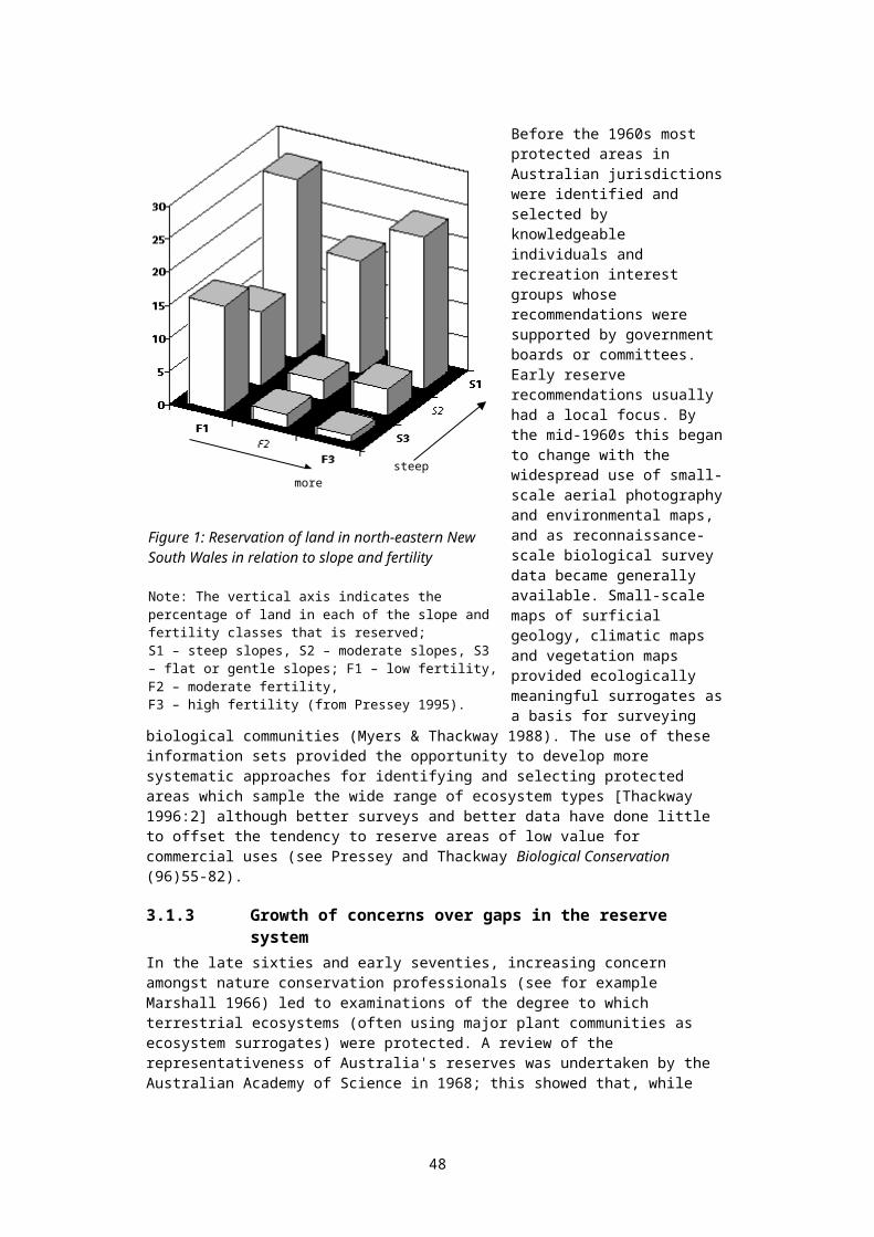
issued excessive extraction licences without adequate consideration of environmental flows;
failed to adopt a strategic approach to the management of the cumulative effects of small to medium-sized water infrastructure developments; and
adopted a cavalier attitude to the enforcement and auditing of statutory controls82 (Nevill 2001, 2003).
4.3 The roles of freshwater protected areasEssentially, protected areas are created to protect identified values, existing in a specific location, from identified threats – which may be both direct and indirect. Values can be both qualitative and quantitative, and can be measured by attributes, and assigned levels (see Appendix 7). As is the case in terrestrial and marine environments, there are a number of roles that protected areas can play in relation to inland aquatic ecosystems. These include:
at a national level, protection of biodiversity against threatening processes through the establishment of a comprehensive, adequate and representative system of protected areas containing examples of all major inland aquatic ecosystems in relatively undisturbed condition;
the facilitation - through a process of the identification of natural values, ecosystem condition, and threats - of broad strategic planning processes aimed at the protection biodiversity within the entire landscape;
provision for the conservation of special groups of organisms – for example, species with complex habitat requirements, or mobile or migratory species, or species vulnerable to disturbance and which may depend on reservation for their conservation, or species heavily dependent on particular (possibly threatened) habitats during certain life history stages;
provision for the special needs of rare, threatened or depleted species, and threatened or unique ecological communities;
provision of biodiversity ‘banks’ to recolonise damaged or degraded environments, whether such degradation has occurred by natural disaster, bad long-term management practices, or by accident (such as a major pollutant spill);
provision of scientific reference sites, either for research, or to provide benchmark indicators by which sustainable management may be judged;
protection of areas of high conservation value including those containing unusual diversity of habitats, communities or species; rare or threatened geological or geomorphological features; natural refugia for flora and fauna; and centres of species endemism;
protection of areas sufficiently large to allow extremely long term processes to take place, such as the evolution of species or landscapes;
assistance in the provision of ecosystem services: that is the provision of environments which sustain human life, including clean air and water, fertile soils, food, transport, flood mitigation, and the regulation of global weather patterns; and;
within the constraints of the above, provision for the recreational, aesthetic and cultural need of indigenous and non-indigenous people.
Outstanding examples of sites which need urgent reservation to protect site-specific values are the artesian springs associated with the Great Artesian Basin (mound springs). These unique habitats contain a diverse endemic fauna (fishes, invertebrates). While some springs are now protected in South Australia, virtually none of those in Queensland are protected, including the group with the largest endemic fauna (Edgbaston Springs). Increasing evidence of extraordinary endemism in some groups (especially molluscs and
48

crustaceans) shows that many taxa are confined to single streams or watersheds83. Reservation alone, of course, would be useless if developments in the region seriously deplete groundwater stocks and flows. The establishment of freshwater reserves would facilitate strategic catchment planning focused on the protection of specific aquatic ecosystem values. The designation of reserves should be accompanied by catchment and aquifer management programs.
4.3.1 Protection of biodiversityAll major biodiversity strategies worldwide are based on the principle of protecting biodiversity "in-situ". Biodiversity is generally defined at three levels: genes, species and ecosystems84. There are species which can be maintained by captive breeding programs, and to this extent these species, and their genes, can in theory be maintained without the existence of reserves protecting their habitat. These species represent, however, only a tiny fraction of the total number of species in existence. A large proportion of invertebrate and microbial species remain unidentified and undescribed to science. Estimates of the total number of species in existence range from 10 million to 100 million.
While most vertebrate and the majority of plant species have almost certainly been identified, full knowledge of their ecological requirements is available for comparatively few, and for most of these, captive breeding programs are impractical or uneconomic. There are many species where captive breeding programs are impossible. The American Passenger Pigeon died out in spite of intensive attempts at captive breeding programs - it is thought that this bird needed (in part) the presence of a large flock to stimulate breeding behaviour. Once the large flocks were destroyed by overharvesting, the remaining birds stopped breeding. Today, numbers of Pandas are declining worldwide, in spite of intensive efforts at captive breeding, and at first glance comparatively simple dietary requirements (bamboo shoots).
At the third level of biodiversity, 'captive breeding' programs for entire ecosystems is generally impractical or uneconomic, if not impossible. Even attempts to create simplified ecosystems to support small numbers of humans (biodomes) have been unsuccessful, although conducted at great expense85.
A cornerstone of biodiversity protection (first articulated in the international context in the World Charter for Nature 1982) is the tenet that, where ecosystems are subject to significant modification by humans (through harvesting, pollution, resource extraction, or the introduction of new species, for example) it is necessary to set aside representative examples of these ecosystems to provide biodiversity “banks”, and benchmarks against which human management of the ecosystems can be measured in the long term.
The “mirror” of this tenet states that actions should also be taken in managed (utilised) ecosystems to minimise human impacts by protecting natural values (including biodiversity) as far as practicable. Threatening processes in the broad landscape need to be identified and managed within the context of the current landuse. While representative reserves are vital, they will never be completely adequate to protect all biodiversity values86.
Where reserves are created to protect representative ecosystems, such reserves should be ecologically viable. They should be large enough to support species at the top of the food chain, such as the peak predators, and should be of sufficient size to permit ongoing evolutionary processes to occur. As discussed above, aquatic systems are dynamic, changing in both form and location within the landscape; reserves must be large enough to allow for these changes. Inventories of aquatic ecosystems may need to accommodate changes in wetland type which may take place over the medium to long term.
49
The above cornerstone is one of the key foundations of the international Convention on Biological Diversity, and has been broadly adopted by all national biodiversity strategies developed by signatory-nations to the Convention, including Australia's strategy. The Australian biodiversity program was established by the National Strategy for the Conservation of Biological Diversity 1996, to which all Australian States are signatories. This is referred to below in shorthand form as the national biodiversity strategy. This strategy was developed to provide a framework for Australia’s programs carried out in recognition of both international responsibilities87 and ongoing national responsibilities and programs (within the framework established by the Australian Constitution). These are discussed in the appendices in more detail.
In summary, the development of systems of representative reserves, protecting viable examples of all major ecosystems, is fundamental to the conservation of biodiversity. Where samples of ecosystems cannot be viably protected in the long-term, biodiversity losses will inevitably occur, as human use of these ecosystems modifies and simplifies their characteristics.
4.3.2 Protection of other ecological valuesWhile biodiversity is a major determinant of the need for reservation, other ecological values may also require protection. A recent publication by Phillips et al.88 reviews existing principles and tools associated with the protection of the ecological values of rivers. Ecological value can be considered the natural significance of ecosystem structures and functions, expressed in terms of their quality, rarity and diversity. While such values are a human construct, they incorporate inherent ecological components which are not directly expressed in some biodiversity measures, and may warrant further consideration.
Significance can arise from individual biological, physical or chemical features or a combination of features. Dunn89 surveyed a range of river researchers/managers to determine the key criteria which define the aspects of rivers that should be protected. A summary of criteria identified by the survey recipients is listed below.
rarity - what is the relative occurrence of river features? naturalness - how much has human occupation affected the river? diversity - what is the range of biological and physical features which define the
river? representativeness - how well does the river reflect its type? special features - are there distinctive features of a river which require specific
management?
Values and importance criteria are further discussed in Appendix 7.
Effective river protection or conservation must involve both ‘conservationists’ and those who exploit natural resources, together with researchers, planners, educators and the general public90. There is very little protection of rivers using protected area concepts being undertaken in Australia. This situation is not dissimilar to that in other countries. For example, Collier91 reported that, in New Zealand, conservation efforts had historically focussed largely on preserving fisheries values. Allan and Flecker92 claim that the strong global interest in biodiversity has concentrated efforts into ecosystems such as tropical moist forest, to the detriment of other systems such as aquatic environments, with perceived lower biodiversity levels or values.
Dunn93 described the status of river protection in Australia, with mostly indirect protection being achieved through compliance with the CoAG water reform framework agreed between State and Federal governments (this incorporates the National Water Quality Management Strategy94). This agreement commits all Australian jurisdictions to the
50

protection of the aquatic environment, explicitly including the provision of water allocations for maintenance of these values - where they are flow-dependent.
Protection of water quality is another indirect instrument for the protection of ecological values. Direct protection instruments, for example through protection of representative river ecosystems by special designation, are not generally applied. Historically, a good deal of river protection has been achieved as a secondary outcome of the need to prevent the erosion of farmland, or the need to implement sustainable land use practices etc (L. Penn (WA WRC) pers. comm. Sept 2000).
4.3.3 Provision of benchmarksRepresentative reserves provide benchmarks against which environmental changes in managed ecosystems can be measured. Benchmarks are also necessary to assess the value and condition of impaired ecosystems95.
For example, the AusRivAS macroinvertebrate sampling program provides important benchmarks and indicators for the measurement of river condition. In the long term, such benchmarks may be altered by aspects such as climate change. Without reference areas, there will be no reference standard by which to judge the implications of such long term changes.
Sustainable management programs cannot be validated without benchmarks. Without the benchmarks provided by representative reserves, programs aimed at achieving sustainability are likely to become, in the long term, vacuous attempts at window-dressing.
4.4 Assessing the effects of freshwater protected areasA question may be asked: “do freshwater protected areas work in practice?”. In Australia, for example, several discharge springs from the Great Artesian Basin (GAB) are listed as ‘threatened ecological communities’ under the Commonwealth Environment Protection and Biodiversity Conservation (EPBC) Act – one protective mechanism available under Commonwealth authority, albeit not very effective at present. While in theory the EPBC Act can protect against major new developments which may constitute a threat to an area’s values, it cannot force proactive biodiversity management, and it cannot control a multitude of small widespread activities draining water flows from a site. Many GAB springs, known to include endemics (Ponder 2004) are already extinct as a result of drawdown resulting from excessive use of artesian water96. A freshwater protected area without a guaranteed supply of appropriate environmental flows is unlikely to effectively protect biodiversity (Pringle 2001).
The scientific literature searchable through electronic means appears to contain relatively little addressing the issue of the biodiversity effects of freshwater protected areas, although there is abundant evidence of the benefits of large protected areas for terrestrial and marine biodiversity. The Ramsar Convention on Wetlands website (www.ramsar.org) contains considerable monitoring information on some of the world’s larger and more important freshwater protected areas. These reports are not peer-reviewed or independently-authored, and are open to interpretation of bias. While there are many successes documented, there are also considerable failings – and one could argue that the failings are likely to be understated.
Within the (relatively small) peer-reviewed literature of recent years dealing with the effectiveness of freshwater protected areas, the findings of Keith (2000:272) appear typical: “French natural protected areas are currently inefficient as far as fish conservation is concerned…”. Keith notes, however, the likelihood that aquatic birds and plants will tend to gain more tangible benefits from the protected areas examined – none of which were specifically declared to protect fish. Jackson et al. 2004, Madson & Clausen 1998, and Mathevet & Tamisier 2002 discuss protected areas for waterfowl: not surprisingly,
51
small areas are relatively ineffective. Keith also draws attention to a lack of focussed management, population monitoring, and research specific to aquatic conservation issues. Keith’s findings are not dissimilar to those of an earlier paper (Lyle & Maitland 1992) reporting an investigation of the same question in Britain.
Only one global review of freshwater protected area efficacy has appeared in recent electronically-searchable literature, that of Crivelli (2002) – focusing solely on one group: fishes. Available evidence suggests that fishes have, overall, tended to gain little from existing protected areas – almost all of which were established for reasons other than the protection of fishes. Fishes may well be the most sensitive group in this regard, as threats are often particularly pervasive, intractable, and expensive to manage. Other groups such as waterfowl, amphibians, aquatic and riparian plants, aquatic invertebrates, and reptiles are all likely to benefit more from protected areas. Smaller, more sedentary animals are likely to gain relatively more benefit, as are those whose life-cycles do not involve migrations between widely spaced habitats – which of course are more difficult to encompass in protected areas of limited size. Obviously fishes migrating between freshwater and coastal habitats are particularly vulnerable, especially if heavily harvested.
The key threats to freshwater fishes relate to: (a) extraction and regulation of freshwater flows, (b) habitat degradation from a variety of sources including impediments to fish passage, pollution, degradation of in-stream and riparian vegetation, siltation and sedimentation, channelisation, mining and quarrying, (c) unsustainable harvesting pressures, and (d) introduction of alien species (Cowx 2002). The essence of protected areas is threat management, and here freshwater protected areas suffer some notable disadvantages.
In some instances, alien game fishes have been deliberately introduced to protected areas to enhance recreational angling opportunities, with consequent negative impacts on local fishes. Dams upstream or downstream of a protected area can restrict the movement of fishes on critical life-stage migrations. Water extraction outside the boundaries of a protected area can damage or destroy ecosystems within the protected area (Pringle 2001; also note comment above relating to GAB springs). Changes to riparian vegetation (stemming for example from catchment agricultural development) can alter detritic energy flows, and agricultural runoff carrying nutrients or pesticides can damage downstream ecosystems within ‘protected’ areas. As Saunders et al. (2002) suggest, protecting an entire catchment is desirable but seldom feasible. It is generally agreed that the efficacy of freshwater protected areas depends in large part on the way the surrounding catchment can be managed (Saunders et al. 2002, Crivelli 2002, Collares-Pereira & Cowx 2004)
Available evidence suggests that the success of freshwater protected areas around the world has been variable. This is perhaps not surprising, as connectivity issues present obvious management difficulties. Saunders et al. (2002) have suggested several general approaches which are likely to assist in effective planning and management of freshwater protected areas. The application of such approaches must be refined on a site by site basis. A thorough and enthusiastic application of these approaches should certainly result in significant benefits for freshwater biodiversity from protected areas, although some groups of biota are likely to benefit more than others.
In spite of the reservations expressed above, there is no doubt that freshwater protected areas are an important component to biodiversity management programs, and their systematic expansion in Australia is long overdue (Kingsford et al. 2005). The size of the protected area, and the management of the surrounding catchment will be critical for success.
52
5. Inventories of freshwater ecosystems
5.1 Inventories: an introductionThe development of inventories of ecosystem assets is a requirement of the World Charter for Nature 1982 (article 16.) and the Ramsar Convention on Wetlands 1971, as well as being a core component of accepted resource management practices. This resourcebook aims to provide a brief overview of the development of State-wide inventories of freshwater ecosystems in Australia’s eight jurisdictions. All jurisdictions have inventories of biota97 or geomorphology at particular freshwater sites – however these are not the subject of this discussion: here we focus on State-wide inventories of particular freshwater ecosystem types. The purpose of the overview is to examine the current state of such inventories in Australia, focussing on (a) the existence of comprehensive classifications and mapping which might support the identification and selection of representative freshwater ecosystem reserves, and (b) the existence of inventories including value and condition data – needed to support Statewide planning and reporting frameworks.
When Watkins reviewed Australian wetland inventories in 1999, 17 inventories, mostly regional, were available (Watkins 1999). Inventories of river and subterranean ecosystems do not appear to have been similarly reviewed.
The definition of the term “wetlands” in this book is that used by Commonwealth of Australia (1997), not that used in the Ramsar convention. This latter definition encompasses both rivers and subterranean freshwater ecosystems. “Freshwater” is used in this book as a shorthand form of “aquatic inland”. The term “reserve” is used to encompass the first four of the IUCN’s six-part protected area classification. “Protected area” is used as defined by the IUCN. For further discussion of definitions, see appendices).
Estuaries98 are included briefly in the discussion below. Estuaries are amongst the most productive ecosystems in Australia, and in some cases the most vulnerable to human impact – absorbing both direct impacts from coastal development together with impacts from the development of their hinterland catchments. Rivers feed estuaries, and the two interact. Small coastal estuaries which open intermittently to the sea are particularly dependent (ecologically) on river flows. Estuaries and rivers should be treated as continuous systems. The continued focus on rivers to the neglect of estuaries seems to have come about because the old Departments of Water in each State were charged with the care of rivers (freshwater), while estuaries were left largely in the care of the immediate local government – a recipe for incremental degradation.
5.2 The need for inventories:No business could survive without inventories of assets. Businesses seek to maintain or increase the value of assets, while protecting or enhancing the productive capacity of those assets. Asset management is based on knowledge of where assets are located, what their values are, and what their condition is. Where the condition of valuable assets is declining, management efforts can be directed in efficient and effective ways only if management knows what is happening. Inventories enable effort to be focussed where it can be most effective.
Natural values are distributed across the landscape, and must be protected within the landscape. A full range of biodiversity values, for example, cannot be protected within ‘captive ecosystems’. Even if it were possible, it would, in almost all cases, be impractical or uneconomic. Biodomes – simplified ecosystems designed to support a small number
53

of humans – have proved impractical even when constructed at a cost of hundreds of millions of dollars.
Human activities also take place across the landscape. To varying extents, governments have designed frameworks (for the control and management of these activities) which seek to protect natural values. These frameworks can only be effective if knowledge is available of where natural values are located. Knowledge is also needed of pressures on these values (threats created by human activities, for example) and the way values are likely to respond to such pressures. This kind of knowledge must be available for particular areas or sites.
The values of freshwater ecosystems cannot be efficiently or effectively protected without inventories of freshwater ecosystems. Such inventories: should be comprehensive – they should include rivers, wetlands, estuaries and
subterranean ecosystems;
should contain information on the location of the ecosystems – where they start and finish, and where connections occur in terms of water flow;
should contain information on the values of particular sites;
should contain information on the condition of particular sites, re-assessed at intervals, and
should be readily accessible both to decision-makers (such as natural resource managers or local government planners) and to stakeholders inputting into the decision-making process.
Development assessment processes put in place by State governments generally work at one of two levels: (a) assessment of individual development proposals, and (b) assessment of developments within a strategic planning context. The first type needs information on values which may be affected in the vicinity of the development. Different levels of likely impact generally invoke different assessment processes. The second type of assessment process needs information on values in the planning region, to provide a background against which strategic limits on development may be imposed. Inventories can supply information to both kinds of assessment procedures; indeed, without this information the procedures and planning frameworks cannot work effectively.
Methods for assigning and measuring value have been developed. The National Directory of Important Wetlands, and the Ramsar framework both provide criteria of ‘importance’. Dunn (2000) and Bennett et.al. (2002) provide criteria, and general guidance on assigning and measuring the values of rivers and streams. The AusRivAS macro-invertebrate sampling program is focused not on value but on condition; however data from the program have been used in studies aimed at identifying rivers of high conservation value (Chessman 2002). The Commonwealth Government’s National Audit condition data should, by making this information generally accessible, assist in programs aimed at identifying and protecting high value rivers – simply because ‘naturalness’ (or lack of disturbance) is one of the values generally sought. Limitations on the scope of the Audit data, discussed below, imply a need for a layered approach in such studies.
5.3 Inventories and reserves:To what extent are representative examples of Australian freshwater ecosystems protected within existing networks of protected areas? This is an important question, and one of the key questions behind any process for freshwater reserve identification and selection. It is important to note that terrestrial protected areas do not always protect imbedded freshwater ecosystems – for example the Snowy Mountains Hydroelectric Scheme lies in part within Kosciusko National Park. Other key questions relate to feasibility: land ownership and control, catchment land use, and the presence of threatening processes and possibilities for their management.
54
We know where our protected areas are (national parks, for example) – but how are different types of freshwater ecosystem distributed across the Australian continent, and how are they distributed in relation to the reserve network? Comprehensive inventories need to be developed covering all freshwater ecosystems to answer this question.
Reserves also form a layer in the ‘value’ information held within inventories of freshwater ecosystems. For example, Victoria’s 11 Ramsar sites have a surrogate ‘highest value’ (international importance) rating amongst 159 designated wetlands of ‘national importance’ – which themselves sit within a larger dataset of the State’s 13,114 listed wetlands. Victoria’s planning framework takes these different levels of value into account when assessing development applications99.
5.4 Inventory constructionAt present there are no accepted national frameworks (either funding or theoretical) which seek to provide consistency across the Australian continent in regard to the development of comprehensive freshwater ecosystem inventories.
Inventories generally use methods of classification, or ways of allocating different ‘types’ to different ecosystems (or – at a lower level of detail – habitats). Classification theory depends on the assumption that areas can be grouped which are alike; ie: areas within each group are more similar to each other than they are to areas which have been placed in different groups. Measures of similarity and difference are made by examining attribute values (water depth, for example). Wetland attribute values, at a particular site, generally fall within predictable ranges. Typically, Australian’s highly variable climate results in characteristic variations in attribute values over time, at any particular site.
Ecosystem classification is a tool for studying, managing, and communicating information about particular types of ecosystem. It typically involves defining ecosystem types, to which individual ecosystems can be allocated. Classification is a fundamental component of inventory; underpinning mapping and reporting of ecosystem occurrence by type.
Various Australian authors have reviewed classification and inventory issues for wetland environments. Notable examples are Barson and Williams (1991) and Pressey and Adam (1995). More recently Duguid et al. (2003) have reviewed these issues with particular reference to arid zone wetlands. The following summary of some of the issues comes from Duguid et al. (2003).
Pressey and Adam (1995, p.87) included as classification “any attempts, intuitive or numerical, to group wetlands with common characteristics or to identify the types of environments and biota they contain”. They stated the importance of seeing classifications “in two ways: (1) as hypotheses about the way in which features of wetlands are arranged in space and time; and (2) as responses to the need for particular types of information for particular purposes, dependent also on the geographical scale of the study and the variability of the wetlands.” (Pressey & Adam, 1995, p.95).
Similarly, Barson and Williams (1991) listed the following uses of wetland classifications: description of ecological units – with certain homogeneous natural attributes; aiding resource management; inventory and mapping; and aiding communication by promoting consistent terminology.
Methods of classification depend on the availability of information about each ecosystem. More detailed knowledge can support more detailed classification approaches. Typically, such knowledge is not uniformly available. We may know a great deal about highly
55
visible ecosystems near centres of population, for example, but little about remote and inaccessible ecosystems.
The traditional approach to this dilemma is to use nested hierarchies of classification approaches. As more information becomes available, more detailed classifications are invoked. For example, a first cut may simply be to divide aquatic ecosystems into five broad categories: (a) rivers and streams, (b) inland wetlands, (c) estuaries, (d) shallow marine systems, and (e) aquifers (or subterranean ecosystems). To continue the example, rivers and streams could then be subdivided into five categories which take account of key ecosystem variables: tidal, lower catchment perennial, upper catchment perennial, undefined catchment perennial, and intermittent. In turn, each of these categories may be subdivided – for example by substrate type or dominant vegetation type.
The key environmental attributes that are generally used to classify the variety of wetland environments are: geomorphic – landform, size and substrate; hydrological regime (permanency, frequency, duration and depth of inundation); water and soil salinity; vegetation type and/or characteristic species. scale and spatial arrangement (including complexity or uniformity); and source of water;
Climate is usually excluded if analysis is conducted on a bioregional (or sub-bioregional) basis, on the assumption that climatic variation can be captured by protecting similar ecosystems across bioregions. It should be born in mind that bioregions defined according to the protocols of the Interim Bioregionalisation of Australia (IBRA) do not attempt to account for micro-climatic variation: there can be significant climatic differences on opposite sides of a mountain, for example. While the IBRA design principles attempt to capture regions of relatively homogenous climate, this may not always be achieved.
Continuing with examples, a freshwater permanent deep wetland could be subdivided into finer categories, depending on the biotic assemblages found in different locations. Faunal biota classifications might consider dominant or keystone species100. Floral classifications may refer to species dominating energy or nutrient pathways.
A discussion of different approaches to wetland classification may be found in Finlayson (1999). This book describes an outline of an approach for wetland inventory that overcomes some of the difficulties of classification. It supports the basic water regime and landform categorisations, with other detail added as necessary. Using this approach, core data are collected for each wetland and arranged in a database, free of classification categories. This data can then be analysed as needed in a variety of classification formats (or outside these formats as needed for a particular application). This approach has been used as the basis for the Asian Wetland Inventory (see www.wetlands.org). Many of the features are also included within the draft Ramsar framework for wetland inventory (see papers available on www.ramsar.org).
These approaches are multi-scalar with a hierarchical data format. That is, depending on the scale and/or objective chosen for the particular study, the inventory can be undertaken within a linked framework with cascading data fields. It can operate either top-down or bottom-up.
The classification system used by the Queensland Wetland Inventory Program (Blackman et.al. 1992) was the Australian forerunner of this approach101, and is the best example of the use of this technique in Australia. The Queensland handbook describes both the theory behind the classification method, as well as techniques for field data collection.
56
The Queensland Wetland Inventory, while not complete, is the most rigorous and comprehensive of any Australian State in terms of scope and structure.
An important question is: how large should a system of protected areas be to preserve most of a bioregion’s biodiversity? In other words, could 90% of the biodiversity be protected within a system of reserves holding 20% of the bioregion’s area? Information on the way in which biodiversity is distributed across the landscape is needed to answer this question. In this context biodiversity is difficult to measure directly102; the usual approach is to use the finest level of ecosystem information available (as a surrogate for measuring biodiversity) – which is usually habitat attribute103. Blackman’s work includes multivariate attribute analysis providing measures of difference between groups of wetland aggregations – a useful measure to address this issue.
The durability of reserves also needs to be considered. Island biogeographic theory predicts that small (and even medium sized) reserves will lose many species through local extinction events if they are isolated from similar habitat.
The NZ Department of Conservation has been undertaking studies of environmental differences for around 5 years now, where differences are mapped at a 30m pixel level using climatic and landform attributes. Again, these attributes (or groups of attributes) can be viewed as a surrogate for biodiversity. Such studies can indicate how biodiversity is likely to be distributed nationally, and with respect to the nation’s reserve framework (Department of Conservation NZ, 2001a, 2001b). Such data need to be checked against field surveys, of course. As a first step it provides a powerful tool for the strategic planning of biodiversity conservation measures.
If ecosystems within a bioregion are very similar, a high level of protection (for the region’s biodiversity) may be (theoretically) obtained by protecting a relatively small area. This is usually not the case, reinforcing the importance of off-reserve biodiversity protection measures.
Provisional classifications for Queensland wetlands and deepwater habitats (see Blackman reference above) are included at the close of this chapter. A list of different approaches to river classification can be found in Appendix 5 below.
5.5 National and regional inventories:At present Australia has three national inventories in the freshwater area. All are publicly accessible, and (in theory at least) readily accessible. These inventories are (in order of publication): (a) the national directory of important wetlands (full title below); (b) the wild rivers database, and (c) the national land and water resources audit.
Inventories developed covering the Murray-Darling Basin also warrant mention in the context of discussions of national inventories.
5.5.1 National Directory of Important WetlandsThe National Directory of Important Wetlands was compiled in response to commitments made by Australia under the Ramsar Convention: DEH (2001) Directory of important wetlands in Australia; (see references for full citation). This directory (although its stated aim is comprehensive) is not at this stage comprehensive in its approach or coverage. In line with the Ramsar definition of ‘wetlands’, its classification uses three primary categories: marine and coastal wetlands, inland wetlands, and human-made wetlands. The ‘inland wetlands’ classification encompasses both flowing and still surface waters, and subterranean ecosystems. Flowing surface waters are categorised in only four types, while subterranean ecosystems are divided into only two types – very basic categories. The Directory contains information on site value, but not condition.
57

The further development of the Directory (Chapter 10) is critical to ensuring that both local government land use planning and regional resource management planning are able to take freshwater ecosystem values into account.
5.5.2 Wild rivers database“Wild Rivers’ was a national program initiated by the Commonwealth Government in 1993, with the primary objectives of identifying and encouraging the protection of rivers that remained largely unaltered by European settlement (Stein et al., 2001). It did not specifically identify high-conservation-value ecosystems or include wetland ecosystems..
The Wild Rivers Project systematically identified Australia’s wild rivers, and developed guidelines for the management of wild rivers.
Although lists of wild rivers were produced for each jurisdiction, strategic protection of identified rivers and river reaches never eventuated. For more detail see Appendix 3, section A3.7 below.
5.5.3 National Land and Water Resources Audit:The two key National Land and Water Resources Audit (National Audit) reports (in the context of this paper) are: the Catchment, River and Estuary Assessment Report, and the Biodiversity Assessment Report. These reports are available at the Audit’s website: www.nlwra.gov.au. While these reports are limited in their Australia-wide coverage (with substantial areas without survey) this was an unavoidable result due to limitations on information supplied to the Audit by the States.
The Audit catchment report (2002) used a philosophy similar to that adopted by Victoria’s Index of Stream Condition (ISC) (Ladson et al. 1999) to develop a more general Assessment of River Condition (ARC) Index - which includes catchment disturbance data - to deliver a national framework for the assessment or river condition, reporting at a reach scale. The National Audit project used catchment disturbance data from the national Wild Rivers Database, and river health data from the National River Health Program along with much other data generated specifically for the project.
The Commonwealth-funded National River Health Program's (NRHP) objectives are to: provide a sound information base on which to establish environmental flows; undertake a comprehensive assessment of the health of inland waters, identify key areas for
the maintenance of aquatic and riparian health and biodiversity and identify stressed inland waters;
consolidate and apply techniques for improving the health of inland waters, particularly those identified as stressed;
develop community, industry and management expertise in sustainable water resources management and raise awareness of environmental health issues and the needs of our rivers.
The primary foci104 of the NRHP are: the development and implementation of procedures to monitor river health, and (b) the development of environmental flow methodologies and programs. The program is directed and funded (from Natural Heritage Trust funds) through the Department of the Environment and Heritage, the Commonwealth’s environmental agency.
It could be argued that the Commonwealth and State collaborative National River Health Program (NRHP) approaches inventory status. It certainly supplements existing spatial inventories of rivers by providing information on river condition. All jurisdictions have prepared reports under components of this program: the Monitoring River Health Initiative (MRHI) (1993-1996), the First National Assessment of River Health (FNARH) (1997) and the Australia Wide Assessment of River Health (1998-2000). See, for example, Read (2001). These datasets have been collated and presented by the National Land & Water
58

Resources Audit (NLWRA 2002), enabling an overview of several key river condition indicators at the national level.
The assessment incorporates a range of attributes that are considered to indicate key ecological processes at the river reach and basin levels. The two indices developed are an Aquatic Biota Index using macroinvertebrates, and an Environment Index with four sub-indices:
catchment disturbance; hydrological disturbance; physical habitat; and nutrient and suspended sediment load.
The presence of invasive species is not reported.
The NRHP collects macroinvertebrate data from river systems throughout Australia. Individual site data is grouped to characterise reference condition, then formalised using the AusRivAS (Australia) model software. Models are calibrated to allow comparison of macroinvertebrate assemblages between reference (relatively ‘pristine’) and impacted sites, and ratings are developed and reported. The NRHP data fed into the National Land and Water Resources Audit program.
The Audit’s national directory of biodiversity information also identifies some of the most important river and wetland habitats. This report aimed to extend information available in the National Directory of Important Wetlands by inventorying significant wetlands in each IBRA subregion. Such data are an important collation of existing State reports, and go some way towards providing an accessible database on freshwater ecosystem values. This database was not available on the web at the time of writing.
5.5.3b Australian approaches to waterway assessment:The national (Land and Water Australia) Guidelines for protecting Australian waterways 2002 offer comprehensive and detailed management-oriented advice on waterway classification and valuation, as well as the assessment of impact and prioritisation of management actions. These guidelines are in tune with current thinking on protection of ecosystem services and the valuation of ecological assets.
As discussed above, the National Audit catchment report (2002) developed a river health index (the ARC Index, or more correctly indices) which was similar to Victoria's Index of Stream Condition. Both the ISC and the ARC Index share a philosophy where waterway condition is assessed independently of any special values the waterway may have (unlike the approach taken by Bennett et al. 2002). Condition is assessed by the use of quantitative indicators which reflect both primary drivers of ecosystem health (such as hydrology) as well as indicators that represent direct measures of ecosystem function (such as invertebrate indices).
The ISC combines five indicators of river health: hydrology, water quality, physical form, the streamside zone, and aquatic life. The National Audit project reported an integrated ARC Index, also made up of five key indicator groups: hydrology (including change in seasonal period, seasonal amplitude, flow duration curve, mean annual discharge), water quality, physical habitat, catchment disturbance, and biota. The biota data in the initial Audit report was limited to AUSRIVAS macro-invertebrate data of the NRHP, but this framework is being expanded. The ARC Index was developed in the knowledge that a considerable amount of modelled data, rather than measured field data, would be used to obtain a reasonable degree of national coverage. A primary difference between the ARC and the ISC is that all five sub-indices are integrated to a single assessment in the ISC while the ARC combines the environmental sub-indices and keeps them separate from the biota index. Thus, the ARC reports the ARCE (environment) and the ARCB (biota) as the response variables.
59

Similar indices for wetlands and aquifers are not in general use in Australia, although Spencer et al. 1998 trialled a wetland condition index. This is an area where further work is needed. An Index of Wetland Condition (IWC) is under development in Victoria. According to Papas and Holmes 2004a: “Condition, based on the Ramsar definition of ecological character, will be measured against a reference, and the index will be structured on the primary components that define wetlands: soils, hydrology and biotic communities, and the wetland catchment. The IWC will be a standard rapid assessment method for wetland condition in Victoria, and will be straightforward and cost-effective to apply”. See also Papas and Holmes 2004b, and Holmes and Papas 2004.
The Audit project developed a nationally comparable system for assessing river condition, and provided the national data set through a public internet site. One aim of the Audit was to assist in identifying conservation management priorities for each basin in the intensive landuse zone.105 Outside areas of intensive land use there is at present insufficient data, generally speaking, to support either the ARC index or the ISC.
The Audit also funded a national assessment of water allocation and use in each major drainage basin. The extension and refinement of this dataset (as well as the development of a national freshwater ecosystem inventory) is essential to effective regional NRM planning. These data sets will be especially important with respect to the management of cumulative impacts of incremental water-based development – including farm dams, groundwater bores, levee banks and ground levelling, the drainage of wetlands, and the clearance of native vegetation. NRM planning offers a strong framework for cumulative impact management, and it is disappointing that the bilateral agreements underpinning Australian regional NRM planning fail to identify the strategic principles necessary for effective cumulative impact management (see updated version of Nevill 2003).
Table 5.1 below summarises several national and State approaches to waterway assessment.
Table 5.5.3.1 Summary of Australian methods for waterway assessmentAdapted from Dunn 2000, Qld EPA 2000, Phillips et al. 2001, Nevill 2001, and Bennett et al. 2002. Note that this table does not include methods for assessing environmental flow requirements; for this information see: Arthington and Zalucki 1998 for a summary of environmental flow assessment techniques, and King et al. 2003 for approaches to monitoring environmental flows. The table also excludes discussion of the National Water Quality Management Strategy due to its complexity (see discussion in section A3.15 below).
See Table A5.2, Appendix 5, below for overseas methods.
Method Method category
Technique Focus / criteria
National Land and Water Resources Audit.
Assessment of condition.
Uses an ecosystem framework to bring together biological data measured in the National River Health Program (AUSRIVAS) with measured and modelled data on catchment disturbance, hydrological change, habitat change and water quality to provide assessments at the reach scale. Use was made of the Wild Rivers Database. Ref http://www.nlwra.gov.au/ . Includes OzEstuaries Data (see below).
hydrology; water quality; physical habitat; catchment disturbance; biota (AUSRIVAS).
OzEstuaries Database.
classification (value) and condition.
Database developed by Geoscience Australia (GA) and extended by the Cooperative Research Centre for Coastal Zone, Estuary and Waterway Management (CRCCZEWM). Threat discussed in a pressure / response framework. Ref: Nevill and Phillips 2004 s.5.5.4, and national audit website (see above).
catchment disturbance aquatic disturbance implicit value
measurement through naturalness criteria.
60
National important wetlands directory.
Value and importance;
- collates State data.
The Directory of important wetlands in Australia ( DEH 2001) assembles State data on wetlands of national importance. Value and importance criteria are established. Ramsar wetlands form a small set of the total wetlands listed. Sparse condition data.
representativeness eco or hydro processes vulnerable life cycle critical habitat threatened species cultural / historic
National River Health Program – AUSRIVAS.
Biological condition.
Collects macroinvertebrate data from river systems throughout Australia. Individual site data is grouped to characterise reference (semi-‘pristine’) condition then formalised via AUSRIVAS model software. Models are calibrated to allow comparison of macroinvertebrate assemblages between reference and impacted sites. Ref http://www.lwa.gov.au/
Macroinvertebrates used to: assess river health; infer environmental
impact; provide an indirect ‘river
type’ reference.
National Wild Rivers Database.
Assessment of condition and naturalness value
Utilizes a ‘river wildness’ index comprising nation-wide data of various disturbance indicators, mostly collected from the States. Data are combined using a spatially referenced model to give all river sections across the country a score along a continuum of disturbance. Indices of catchment and in-stream (flow) disturbance form the basis of the overall score. Unlike other large-scale assessments it is weighted heavily to emphasise the pristine or wild end of the scale. Ref: river condition database at http://www.heritage.gov.au/anlr/code/arc.html
Assess naturalness using: catchment disturbance waterway disturbance.
61

Method Method category
Technique Focus / criteria
(National) Guidelines for protecting Australian waterways.
Ref: Bennet et al. 2002.
A 'toolbox' approach to classification & assessment of value and condition.
The guidelines aimed to provide:
• a systematic and adaptable approach to protecting waterways and floodplains; • implementation tools to support application of the approach; and• assistance with setting priorities for protection and repair.The guideline develops an action-oriented management framework aimed at protecting identified values, using value weight factors and action triggers or thresholds. Sustainability is assessed through concepts of ecosystem stability and vulnerability, attached to management response.
Assess value using:
naturalness representativeness diversity / richness rarity special features.
Assess condition by: measuring impacts (from
reference condition) of threatening processes on identified values.
(National) Interim Freshwater Regionalisation of Australia.
classification Tait (2002 and 2004) has proposed that the existing Interim Biogeographic Regionalisation of Australia, and Interim Marine and Coastal Regionalisation of Australia be expanded with a third regionalisation - aimed at identifying regions containing repeating patterns of similar freshwater ecosystems. Such a regionalisation would support the identification of CAR freshwater reserve systems. Based largely on Unmack 2001.
obligate freshwater vertebrates (mainly fish)
recognises potential to use macro-invertebrate data from AUSRIVAS;
does not generally accommodate existing IBRA regions.
Sustainable Rivers Audit of the MDB Commission.
Valley zone (upland transport, lowland) condition assessment.
Three initial indicator themes being implemented; six-yearly reporting cycle for all 23 valleys in the Murray-Darling Basin. Three additional themes to be further developed in first three years 2005-8. Site data collection are used as surrogates to assess condition of a valley zone; statistical confidence limits to detect change are based on power analysis to detect ‘effect size’. Will include basin-wide comparisons of condition (referenced against natural) and trend between valleys. Tool for setting priorities in natural resource management in the Basin. Ref: www.mdbc.gov.au/
Initial indicator themes:
fish; macroinvertebrates; hydrology.
Additional themes: physical form; riparian vegetation; floodplain health.
Index of Stream Condition (Victoria).
Assessment of condition and disturbance
A combined index of five sub-indices made up of measured indicators. Data for each indicator are scored, indexed and given numerical values based on a comparison with natural or reference conditions. The indicator scores are then combined to give an overall value. Most applicable to disturbed systems, but useful for naturalness value. Ref Ladson and White (1999).
hydrology physical form streamside zone aquatic life water quality
Land Conservation Council (Victoria) 1989-91
Natural, landscape and recreational value, with river type classification
Desktop evaluation and mapping of values by river basin. River types were classified into 39, then 16 major categories using hydrology and geomorphology overlays. Natural values mapped were characterised under three headings: (a) nature conservation – (a1) highly natural catchments, (a2) native fish rarity or diversity, (a3) botanical significance, (a4) geological or geomorphological significance. (b) landscape – (b1) high scenic value, (b2) waterfalls; (c) recreation – (c1) whitewater canoeing, (c2) car-based camping, (c3) recreational fishing for exotics, (c4) recreational fishing for natives. Ref: Land Conservation Council Victoria 1989: maps 11, 12 and 13; LCC 1991.
Classification: hydrology geomorphology limited ecological
considerations.
Values include: landscape natural recreation.
Stream regionalisations (Victoria) 2001.
classification Doeg (2001) and Metzeling et al.(2001) propose revisions of the 15 'representative rivers' identified by LCC 1991. Revisions based on ecological data, including AUSRIVAS and fish distribution data. Aimed at supporting a CAR freshwater reserve system.
vertebrate distributions macro-invertebrate
distributions; takes existing
regionalisation into account.
Victorian wetlands assessment.
Wetland classification
The Victorian Wetlands Database project classifies wetlands without attempting a conservation status analysis. Ref: Dept of Conservation and Environment Victoria (1992) An assessment of Victoria’s wetlands. DCE; Melbourne.
water salinity water permanence water depth. vegetation (sub-
categories).
62

Method Method category
Technique Focus / criteria
Ecological vegetation class (EVC) mapping.
classification (value).
The Victorian Wetlands Database (see above) is separate from current mapping of Ecological Vegetation Class across Victoria funded by the Department of Sustainability and Environment. There are more than 60 distinct wetland EVCs in Victoria to date (ref: King et al. 2001; DSEV 2004). Value implicit in rarity, resilience (size) and naturalness.
vegetation class.
Index of wetland condition (Victoria)
Wetland condition
The Department for Sustainability and Environment (Vic) are developing a rapid assessment index of wetland condition. Index values will relate to reference benchmarks. Ref: Papas and Holmes 2004, Holmes and Papas 2004.
hydrology soil type biotic communities catchment disturbance.
Riverstyles (Gary Brierley - Macquarie Uni).
Assessment or river geomorphic type, value & condition
A regional-scale method for defining river types based on geomorphic characteristics This approach has been applied in NSW and Tas, and potentially provides both a geomorphic template for assigning conservation value, as well as providing an assessment of inherent geomorphic value and condition. Brierley et al. 2002, Brierley and Fryirs 2004.
geomorphology hydrology geology
Stressed Rivers (NSW).
Assessment of condition and conservation value
A sub-catchment level approach in which categories are derived through measurement of environmental and hydrological stresses, resulting in a matrix of stress classifications and management categories. Also identified rivers of high conservation value, using a criteria-based analysis. Refs: Government of NSW (1998); Chessman (2002)106.
water extraction; species of significance; remnant habitats; geomorphology.
State of the Rivers (WA.)
Assessment of condition and naturalness value
A method for mapping major forms of degradation within the State. Rivers are assigned 1 of 5 categories defining river condition to determine the feasibility for rehabilitation (if required), and to assist in establishing detailed State government management objectives. Ref: http://www.wrc.wa.gov.au/ .
pressures on rivers waterway disturbance
Wetlands Inventory of Queensland (Blackman)
classification and condition.
Ecosystem-based inventory of tiered classifications. Uses a multi-scalar method with a hierarchical data format. A general and adaptable approach - will support development of a CAR freshwater reserve system. Includes estuaries. Refs: Blackman 1992, 1995, 1999.
geomorphology hydrology vegetation water chemistry soil type
Water Resource Environmental Planning (Qld) – conservation value guideline.
Assessment of conservation value.
Part of a comprehensive approach to waterways planning and management. Values include ecology, geomorphology, hydrology, recreation, landscape and cultural heritage. Conservation value derived using a numerical approach for ecological criteria. A weighting system is used for combining indicators. Refs: Qld EPA (2000). See also www.nrm.qld.gov.au, and www.epa.gov.au.
naturalness; condition; bio and geodiversity; rare and threatened; uniqueness / rarity; cultural heritage.
State of the Rivers (Qld) (the Anderson method).
Condition assessment
A rapid assessment or ‘drive by’ method using trained reporters. Describes the condition of rivers using physical and biological criteria, including riparian and in-stream measures, and a scenic and recreational assessment. Uses a site-based proforma, with sites chosen as representative of homogenous reaches. Ref: http://www.nrm.qld.gov.au/ ; Anderson 1993.
reach disturbance; riparian vegetation; bank stability; bed / bar stability; aquatic habitat quality; aquatic vegetation health; scenic and recreational
value.
Freshwater Ecosystem Health Monitoring Program (Qld).
Condition assessment
Developed by the Coastal Zone, Estuary and Waterway Management CRC initially for waterways of southeast Qld, the method uses five indicator groups. Ref: http://www.coastal.crc.org.au/ehmp/freshwater.html. Assessments are reported in a ‘traffic light’ (good, bad and in-between) approach relative to minimally disturbed reference sites.
physical and chemical measures;
ecosystem processes; nutrients; fish; invertebrates.
63

Method Method category
Technique Focus / criteria
Conservation of fresh water ecosystem values (Tas).
Ecosystem type, condition and value
Proposed CAR protected areas will be based on a tiered classification of freshwater ecosystems: the first tier comprises six classes: rivers (and streams), waterbodies (lakes and dams), wetlands, saltmarshes, estuaries and karst (underground freshwater ecosystems). The second tier of classification uses both physical and biological attributes. Assessment of freshwater values is based on three assessment criteria of naturalness, representativeness and distinctiveness. Condition measurement is based on naturalness. Ref: http://www.dpiwe.tas.gov.au/ .
representativeness threatened spp or
ecological communities high species diversity natural refugia centres of endemism geomorphic rarity.
Tasmanian estuary assessment.
classification value and condition
Study used both local and catchment land use disturbance indicators as well as water quality and biotic indicators where available to assess conservation significance of Tasmania’s estuaries. Ref: Edgar et al. 1999.
catchment disturbance aquatic disturbance implicit value
measurement through naturalness criteria.
5.5.4 National and State estuary inventories:National estuary inventories ignore very small ones, simply because there are so many of them. The first national inventory of Australia's estuaries was undertaken in 1987 and published two years later (Bucher and Saenger 1989). It listed 783 estuaries.
The Cooperative Research Centre for Coastal Zone, Estuary and Waterway Management (CRCCZEWM) undertook a review and expansion of this work for the National Land and Water Resources Audit, which published an updated Inventory of Estuaries in September 2001. This inventory undertook a general assessment of estuary condition, based on both terrestrial (catchment) and aquatic disturbance indicators, and found that around 50% of the 974 estuaries examined could be classified as 'near pristine', with another 22% classed as 'slightly modified'.
An estuary was classified as near pristine if it had: a high proportion of natural vegetation cover in the catchment minimal changes to hydrology in the catchment no changes to tidal regime minimal disturbance from catchment land use minimal changes to floodplain and estuary ecology low impact human use of the estuary, and minimal impacts from pests or weeds.
The other three categories of the assessment—largely unmodified, modified and severely modified—display increasing levels of changes for some or all of these key criteria.
The 'natural' estuaries are clustered mainly along Australia's tropical (far northern) coastline, and along the south west coast of Tasmania, adjacent to the World Heritage Area. The CRCCZEWM is continuing to work on a National Estuary Audit involving an assessment on the condition of around 980 estuaries around Australia.
The Estuary Audit uses a basis 7-category classification, developed by Geoscience Australia, reflecting the form and energy drivers of the estuary: wave-dominated estuary tide-dominated estuary wave-dominated river delta tide-dominated river delta
64
tidal creek flats, and strand plain.
A seventh category, 'other' includes drowned river valleys, embayments, and coastal lagoons.
The wetlands inventory developed by the Queensland EPA (see discussion below) uses a more detailed classification based on geomorphology and biology, dividing estuaries (the 'ecological system') into two subsystems (sub-tidal and inter-tidal), 13 classes, and 43 subclasses.
Only about 50 of Australia's 1000-odd estuaries have been intensively studied, and most of these have been highly modified. Although hindered by lack of data, the Estuary Audit used a pressure-state-response model to provide a general picture on estuary threats and condition. At this stage, no cohesive attempt has been made to develop value indicators on a national scale; however, it should be noted that some estuaries do have Ramsar classification.
The Audit developed a weighed index for both pressure (threat) and state (condition). The pressure index is comprised of a utilisation index (50% weighing) and a susceptibility index (50%). The state index is comprised of an ecosystem integrity index (70%), a water and sediment quality index (10%), a fish health index (10%), and a habitat condition index (10%).
The Coastal CRC is a collaborative joint venture between a number of Commonwealth, State (largely Queensland) and private organisations. The inventory can be accessed through the National Audit's website: www.nlwra.gov.au (checked September 2003). The CRC published a pamphlet in 2001 called " Australia's near pristine estuaries; assets worth protecting" which is (Sept 2003) available from their website: www.coastal_crc.org.au.
The Commonwealth government agency Geoscience Australia has also compiled a separate national estuary inventory, named OzEstuaries, which can be accessed through www.ga.gov.au. This inventory contains a general condition index based on disturbance.
Queensland has two developing GIS database inventories which include estuaries: CHRIS (Coastal Habitat Resources Information System) is funded by the Department of Fisheries, and the Wetland Inventory is funded by the Queensland Environment Protection Agency (see references by Blackman). The Wetland Inventory uses the Ramsar definition of 'wetland', so includes estuaries and other shallow marine ecosystems.
New South Wales (Department of Land and Water Conservation 2000a; Bell and Edwards 1980) has published a State estuary inventory, as have Victoria (Environment and Conservation Council 1999) and Tasmania (Edgar et al. 1999).
Western Australia, the Northern Territory and South Australia have not published State estuary inventories; however regional studies exist (see for example references by Hodgkin and Clark, and Pen 1997).
Estuarine protected areas have been surveyed by Kriwoken and Haward (1991) (Tasmania only) and by Ivanovici (1984). Both these references are now out of date.
5.5.5 Wetlands in the Murray-Darling:The Murray-Darling Basin Commission funded a project which mapped the maximum extent of wetlands within the Murray-Darling Basin over a ten-year period (1983-1993). The method used was based on the presence of standing surface water. Wetlands
65

greater than five hectares were identified using a combination of unsupervised classification of Landsat MSS imagery and additional wetland information to create information classes of four broad wetland groups: floodplain wetlands, freshwater lakes, saline lakes, and reservoirs on the basis of spectral signature, geomorphological characteristics and other data (generally at the 1:250,000 scale). According to the Commission, the mapped data will be used to assess the wetland resource in each catchment within the Murray-Darling Basin. The data are available (at a cost) as part of the Commission’s GIS line of products.
The River Murray Wetland Database (RMWD), which was initiated by the NSW Murray Wetlands Working Group in 1998, is currently funded by the MDBC. The foundation of the RMWD is the 7000 wetlands (rivers, creeks, billabongs, lakes and flood runners) between Lake Hume and the S.A. border identified by the MDBC River Murray Mapping (2nd edition) Wetlands GIS. It includes information on wetlands in the Edward-Wakool System but does not include the Barmah-Millewa Forest region, which has already been studied in detail (Barmah Millewa Forum 2001, Bren et.al. 1989).
The RMWD links spatial and descriptive information, such as wetland type, location, size, commence-to-flow level and location of regulatory structures. For some wetlands, the database also includes information on major environmental impacts or threats, such as whether the wetland is impacted by regulated flows, blockbanks and regulators, or if the wetland is used for cropping, grazing or the disposal of surplus irrigation water. Also for some wetlands, information on the major aquatic plant species, and if the wetland is a known waterbird breeding site has been recorded. The initial descriptive information for each wetland on the MDBC Wetlands GIS, which originated from the work of Pressey (1986), has been maintained. The RMWD will be incorporating new wetland mapping along the Billabong Creek and the Murray River above Lake Hume in 2003. Given additional funding, the RMWD could extend coverage into SA.
5.5.6 Inventories of subterranean freshwater ecosystemsAlthough generally under-studied, the fauna and communities living in subterranean freshwater ecosystems has received attention from academic scientists, especially related to karst systems, over the last 50 years. Groundwater estuaries are becoming a recognised area of important interaction (Moore W.S. 1999). Most research in Australia has been focused on specific localities, and a bibliography focused on NSW subterranean karst invertebrates and communities is available from Jane Gough, NSW National Parks and Wildlife Service. Bill Humphreys (WA) has been a particularly important contributor to this field of research.
Various reviews over regions and taxa have been undertaken – see: Eberhard et.al. (1991), Gillieson and Spate (in press), Greenslade (2002), Hamilton-Smith (1967), Hatton and Evans (1998), Horwitz (1990), Howarth (1988), Humphreys (1993), Humphreys (1996), Humphreys and Harvey (2001), McMichael (1967), Nicoll and Brush (1976), Osborne and Branagan (1991), Ponder (1997), Slaney and Weinstein (1995), Spate et.al. (1999), Thurgate et.al. (2001a), Thurgate et.al.(2001b), and Townsend and Watson (1998).
However, at this stage no comprehensive inventories of subterranean freshwater ecosystems (rather than inventories of species or communities at specific sites) have been undertaken. The methodology for the construction of such inventories is under discussion.
66
5.6 A note on bioregionalisation
5.6.1 Terrestrial bioregions:For terrestrial ecosystems, the approach used in Australia centres on the Interim Biogeographic Regionalisation of Australia (IBRA) which now divides the eight States and Territories into 85 bioregions (Thackway & Cresswell 1995) . More recently, the geomorphic units found within the bioregions have been identified and delineated as sub-regions. In the terrestrial environment, bioregions are identified using a land systems approach, taking into account geology, geomorphology and climate. The existence of broad native vegetation communities can assist in identifying the boundaries of bioregions, and is of increasing importance in delineating sub-regions. Bioregions contain repeating patterns of similar ecosystems, while sub-regions contain smaller arrays of such patterns.
The principle lying behind the selection of IBRA regions is the recognition that terrestrial ecosystems depend largely on geology, landform and climate, mediated by community succession, fire, and of course the impact of human activities107.
The IBRA framework was developed to assist the National Reserves System Program, and State governments, in identifying gaps in the developing system of representative terrestrial reserves. Its target is to develop and categorise biodiversity surrogates at the highest useful level. By necessity, it involves broad-scale amalgamations of information on geomorphology, geology, vegetation, climate and soil type. In its current form it represents extremely useful categorisations of habitat at the landscape and regional level. IBRA regions, for the most part, contain similar assemblages of terrestrial ecosystems. The recognition that geomorphology, to a lesser or greater extent, includes information on drainage formations is vital in understanding the relevance of the IBRA framework in relation to freshwater ecosystems. However, the IBRA framework provides no more than a useful base for categorising freshwater ecosystems, as it does not include information on hydrology, and the scale at which it has been developed is at least an order of magnitude above the scale necessary for categorising rivers, and most lakes and wetlands.
5.6.2 Marine bioregions:Marine reserves are supported under a different program run by the Commonwealth Oceans Office. Marine areas are targeted for protected area status based on the related Interim Marine and Coastal Regionalisation for Australia (IMCRA) which uses a similar broad-scale ecosystem-based approach, taking into account additional oceanographic variables such as depth, persistent and tidal currents, water temperature, and the distribution of groups of organisms. Where data could support multi-variate analysis techniques, these were used on defining IMCRA regions (R Thackway and I D Cresswell 1998).
At the broadest scale, classifications of marine ecosystems use a three-way division by substrate: rock, unconsolidated sediments, and seagrass. Marine bioregions, like terrestrial bioregions, contain repeating patterns (similar assemblages) of ecosystems. Marine sub-regions may be defined to delineate finer ecosystems of finer detail.
5.6.3 Freshwater bioregions:Hughes and James (1988) used hydrology as a key determinant regarding the development of a freshwater regionalisation for Victoria. The Land Conservation Council (LCC 1989) – through their consultants - used geomorphology and hydrology to define 39, then 16 Victorian river regions. Included in the LCC’s work was a geomorphic feature related to access by marine life-cycle fishes – whether rivers drained inland, or to the Victorian coast.
67

One could argue that the existing terrestrial bioregionalisation is adequate to guide freshwater system protection. This would be flawed on two grounds. The biodiversity elements that would underpin a freshwater bioregionalisation would be different from, and would not necessarily have the same boundaries as, terrestrial bioregionalisation. Secondly, freshwater systems are by their nature more connected that terrestrial systems. The connections are largely linear and directional. Terrestrial connections are non-linear and weakly directional. Selecting priority sites for freshwater protected areas needs to accommodate these, and other, unique aspects of freshwater biodiversity, ecology, and system function (Possingham, pers. comm. 12/4/2005)
Wells and Newall (1997) found that the terrestrial Interim Bioregionalisation of Australia (IBRA) was “not effective in representing aquatic ecosystem patterns across Victoria”, and suggested an approach to delineating aquatic bioregions based partly on physical and biological data, and partly on expert knowledge.
More recently Unmack (1999, 2001), Metzeling et al.(2001) and Doeg (2001) have used biological variables as key regionalisation determinants: Unmack used fishes, Metzeling used macro-invertebrates, and Doeg used both. A certain degree of regionalisation is inherent in the AusRivAS macroinvertebrate river condition monitoring approach, which establishes expected benchmarks (the occurrence of suites of macroinvertebrates) for pristine river types in different Australian regions. It should be noted that AusRivAS does not rely solely on pristine benchmarks: it uses 'best available' sites for each river type. In NSW, at least, some of these sites have quite significant human impacts.
According to Unmack: “My greatest concern is how well can a terrestrial biogeographic system (eg IBRA) represent freshwater areas. The factors that influence terrestrial and aquatic organisms are somewhat different, but more importantly the type of movement (or dispersal) each these organisms can make is fundamentally different as many aquatic organism are limited to movement within catchments. I very much doubt there would be more than just a couple of aquatic vertebrates that would be endemic to any of those IBRA regions, but there are many that are endemic to particular watersheds. Overall, to me it seems as if drainage catchments must be the units used, not terrestrial regions.” (Unmack, pers.comm. 4/8/03).
Unmack continues: “ An interesting thing that comes to mind is the suggestion that we should compare the terrestrial biogeographic system to the aquatic one. I think it would be far more interesting to see how well an aquatic reserve system could also provide a suitable coverage of terrestrial reserves. It seems to me that it would be far more likely that an aquatic system could be more representative of terrestrial ecosystems than visa versa.” (pers.comm. 6/8/03).
The distribution of freshwater crayfish has been examined by Whiting et al.; the authors do not propose a regionalisation but use IBRA bioregions (not sub regions) to colour-up crayfish richness and endemicity around Australia. Tait (2002) has reviewed approaches to freshwater regionalisation in Australia, and suggested that, while further development of the concept is long-overdue, there is enough information available to commence programs aimed at identifying gaps in existing systems of representative freshwater reserves.
Abell et.al.(2000) and (2002) have developed freshwater regionalisations for North America.
68
5.7 State inventories of ecosystems:
5.7.1 Associated inventories:All States have a variety of inventories focused on other issues which are related to, and helpful for, the establishment of comprehensive freshwater ecosystem inventories. These include inventories of endangered biota, inventories focused on single family biota (such as fishes or amphibians, for example), and ‘sites of scientific significance’ inventories. Brief reference to such inventories is made below where information is at hand; however no attempt has been made to seek further detail on such inventories. See, for example, the Tasmanian and Victorian sections below.
5.7.2 Australian Capital Territory
RiversAn inventory of the rivers of the ACT is contained in Hogg and Wicks (1989). While containing information on location and value, the inventory does not contain updated condition data, nor is the document readily accessible.
Wild rivers information is available as part of the national database.
WetlandsAn inventory of the wetlands of the ACT is contained in Hogg and Wicks (1989), supplemented by chapters in editions of the Directory of important wetlands in Australia (1993, 1996, 2001).
AquifersThe ACT contains no geothermal aquifer ecosystems, or karst aquifer ecosystems. Other types of subterranean aquifer ecosystem have not been subject to comprehensive study. A small number of springs do exist.
5.7.3 New South WalesIt should be noted that the NSW State government (through the Department of Infrastructure, Planning and Natural Resources (DIPNR) – which includes the former Department of Land and Water Conservation - DLWC has established a framework designed to facilitate public access to information held by State natural resource management agencies. This framework includes a website located at www.canri.nsw.gov.au, where electronic data, maps and metadata can be directly accessed from their source, covering a range of issues including inventories of ecosystems. Coverage of data at this site will be expanded.
Rivers
NSW at this stage does not have a comprehensive State-wide rivers inventory containing value and condition information in a form which is readily accessible to the public. However, information on the values of river ecosystems, as well as river condition, is currently being collected. Stressed rivers have been identified (see DLWC 1998) as have some high value rivers - which are subject to ongoing research. Reports on high value rivers are available for some regions of the State (NPWS 1998) while Chessman (2002) provides regional coverage of both the conservation value and the health of NSW rivers. The DIPNR Stressed Rivers Assessment Project is a (very preliminary) Statewide inventory of river condition and value that is readily available. As well as the overall report cited above, a series of reports on specific subcatchments across the State was generated. Some of the limitations of this exercise are discussed in Chessman 2002.
69

The Department of Land and Water Conservation (now DIPNR) undertook a preliminary analysis of the ability of a river typology using a River Styles approach (based on studies of river geomorphology pioneered by Gary Brierley at Macquarie university) to categorise river ecosystems. This analysis, which examined the eastern part of NSW, indicated that biotic assemblages show some correlation with geomorphic style and condition. However, the role of other factors such as flow regime, stream size, altitude and geographic region are also very important. Another study is being undertaken using data from the north coast and northern tablelands, examining the relationships in unregulated rivers between river flows and fish, invertebrates, macrophytes and diatom assemblages.
The DIPNR are at present developing a protocol for assessing the ‘geomorphological health’ of stream and river reaches. The method rests on the River Styles approach to classification (Fryirs, 2003). The current phase of the project is identifying reference reaches (sites) having relatively natural geomorphology. Attributes from these sites will be used as benchmarks in the following phase, which will assess the geomorphological health of rivers throughout NSW. This program could develop nationally, to mirror the river health indices obtained from macroinvertebrate data by the AusRivAS program.
Proposed river biota sampling for the Murray Darling Basin Commission’s Sustainable Rivers Audit will be widespread and comprehensive within the NSW portion of the Murray-Darling Basin. Detailed information on the regionalisation of fish communities will be collected as part of this project. Unfortunately no information will be collected from coastal rivers, wetlands or aquifers. A previous NSW Fisheries program, the NSW Rivers Survey, did collect information on fish communities throughout the rivers of NSW. The results of this program have been published in Harris and Gehrke (1997). The outcomes included a demonstration that at least 5 bioregions existed within fish communities within NSW.
WetlandsThe NSW National Parks and Wildlife Service has undertaken the development of an inventory of wetlands which can be mapped using satellite imagery. The final report of this project provides basic publicly accessible information on the position of all NSW wetlands capable of being monitored by Landsat imagery. Limited data on value and condition are being developed. The project was funded by the NSW State Government, assisted by the Commonwealth National Heritage Trust. Given the limitations of satellite data, a relatively simple classification system has been used:
Table 5.7.3.1 NSW GIS wetlands classifications (Kingsford et.al. 2004):Inland (draining to the Murray-Darling river) Coastal (draining to the Pacific ocean)Floodplain wetlands Floodplain wetlandsFreshwater lakes Freshwater lakesSaline lakes Estuarine and coastal lagoonsReservoirs Estuarine and coastal lakes
Reservoirs
The project relates these categories to classifications used in other major databases in north America and Europe:
Table 5.7.3.1 Part B: Global groups NSW CategoriesPalustrine and riverine Floodplain wetlandEstuarine Estuarine wetlandLacustrine Freshwater lake
Saline lakeCoastal lagoon and lake
Reservoir Reservoir
70

Rivers that flood are picked up as floodplains. This inventory thus does not include highland rivers, or aquifer ecosystems.
The inventory uses an 80m pixel for inland mapping, while more detailed data for coastal NSW (east of the Great Dividing Range) have been applied (30m pixel size). This has been done partly to delineate the finer structure of wetlands in this area. Geographic Information System (GIS) analysis has been applied to the data. The study has derived percentages of each ecosystem type already in protected sites. Percentages listed in the National Directory of Important Wetlands, and the NSW State Environment Protection Policy 14108, have also been derived. About three percent of the total area of NSW wetlands is protected within reserves (Ramsar sites or national parks, for example), State forests, marine parks, or on private land subject to Voluntary Conservation Agreements – or by listing under SEPP14. Fifteen percent of the coastal wetland area (coastal wetlands make up only 3% of the total wetland area) are protected by these mechanisms. NPWS reserves protect only 2% of the total area of wetland. Percentages of each category protected within each of the State’s IBRA regions could be derived; however this analysis has not yet been undertaken.
AquifersAt this stage NSW does not have a State-wide inventory of subterranean ecosystems. However, the Department of Infrastructure, Planning and Natural Resources is proposing a study which would aim to produce a state-wide inventory of subterranean aquatic ecosystems. This study is dependent on funding under the soon to be released Aquatic Biodiversity Strategy program. It would build on and extend various existing studies of subterranean sites, most of which have focused on limestone areas or river environs.
5.7.4 Northern Territory
RiversAlthough the NT has no comprehensive inventory of river ecosystems, the government is committed to develop such an inventory through the wetlands strategy 2000. There has been substantial recent work describing and classifying many of the main NT river systems (Daly River, Roper River – see Faulks references). Data on the Victoria River has been collected, however this information remains unpublished (Judy Faulks, pers. comm. July 2002109, May 2003).
Wild rivers information is available as part of the national database.
WetlandsThe Northern Territory does not have a comprehensive inventory of the jurisdiction’s wetland ecosystems. However the preparation of such an inventory is a stated aim of the NT’s wetlands strategy (Government of NT 2000), and work is progressing towards this end. A project has recently been completed surveying wetlands in the southern half of the NT (Duguid et.al. in prep.) – this provides a classification system somewhat different from that used in the National Directory. Significantly, subterranean ecosystems have been included.
Regional inventories have been prepared (Jaensch RP 1994) and the conservation status of wetlands has been assessed, at least at a preliminary level (Storrs MJ & Finlayson CM 1997). Wetlands of the Daly Basin have been inventoried (Begg et.al 2001). Australia’s first Ramsar wetland was declared at a site on the Coburg Peninsula, NT.
Comments by Peter Whitehead and Ray Chatto in the first edition of the national wetlands directory are worth repeating:
The NT regards this contribution to the Directory, and the resultant lists, as insignificant in themselves, but rather as small steps in a larger and much
71

more important process. That is, to derive conservation strategies that embed the conservation of the region’s extraordinary wetlands in sustainable management arrangements encompassing entire landscapes. To replace the spurious notion of relative importance, we look forward to recognition and further development of the Directory as a comprehensive inventory of all substantial wetlands. This will ultimately allow presentation to reflect functional wetland groupings, better indicate the role of wetland systems in the regional ecology, and the management actions needed to maintain that role. ( DEH 1996).
AquifersThe Northern Territory does not have an inventory of subterranean freshwater ecosystems, although data on specific sites is available. There are no plans at present to develop such an inventory.
5.7.5 Queensland
RiversThe Queensland Wetland Inventory Program, in progress now for over a decade, includes information on some river ecosystems. As is the case in other States, a variety of studies have collected data on river ecosystems on a site-by-site basis; much of this information has been collected by the Queensland Department of Natural Resources and Mines, and the Department of Fisheries. Limited information has been compiled on river condition, and is accessible through National Audit publications.
Wild rivers information is available as part of the national database.
An attempt has been made by Queensland’s Environment Protection Agency to identify rivers of high natural value; however the method used – that of the expert panel – has a number of problems, and the report from this exercise remains unpublished.
WetlandsAs mentioned above, Queensland’s Wetland Inventory Program has been collecting and consolidating data for some time. The inventory program remains under development, and uses IBRA bioregions and sub-regions as a spatial and ecological framework. The Inventory is GIS-based, enabling both thematic mapping and (theoretically) public access through the internet. Gaps remain, particularly with respect to the south-west of the State. According to Blackman: “The major priority is regional-scale identification and delineation of at least all major wetland aggregations to allow statewide assessment at the resolution of the present [national wetland] directory”110.
In terms of scope and information content, Queensland’s Wetlands Inventory is the most comprehensive and rigorous of any Australian State. It uses a definition of wetland which encompasses that used by Ramsar, thus including river, estuarine, and shallow marine areas (see attachment). Although the Inventory definition does theoretically include subterranean ecosystems, at this stage few have been surveyed. However, it has the potential to cover these in future, given continued funding. Unlike the Victorian wetlands inventory, it does not map the boundary of each wetland, mapping instead wetland aggregations, or clusters of similar wetlands. The inventory uses a hierarchical classification of wetland type, which is the most detailed of any Australian State (Blackman et.al. 1992).
In terms of the provision of information on wetland value and condition, comprehensive information is available only for those wetlands listed in the National Directory. This information is available both in hard copy (Blackman et.al. (1999) - a 430 page book) as well as being accessible (like the important wetland information from other States) on the internet through the Department of the Environment and Heritage website. The
72
Queensland information appears generally more comprehensive than that available for important wetlands in other States, although WA (for example) does supply a comparable level of detail.
The Department of Natural Resources and Mines, Queensland, is currently finalising a project that has involved mapping surface water bodies (as a surrogate for "wetlands") in the Queensland section of the Murray-Darling Basin using TM satellite imagery, and field assessments of the ecological condition of a random selection of floodplain wetlands in four areas within that region (157 floodplain wetlands in total). A brief description of the waterbody mapping component of that work is given by Jaensch (2002). This work is the start of a detailed DNRM inventory of wetlands in the Queensland portion of the Murray-Darling Basin.
Queensland’s Department of Primary Industries (QDPI) provide web-based inventory information through the Coastal Habitat Resources Information System (CHRIS). Areas of coastal wetland, seagrass and mangrove are mapped, as are management boundaries (Ramsar site and national park boundaries, for example). The URL is http://chrisweb.dpi.qld.gov.au/chris.
AquifersQueensland does not have an inventory of subterranean freshwater ecosystems at this stage, although the Wetlands Inventory could be expanded to include these ecosystems.
5.7.6 South Australia
RiversSouth Australia does not have a current state-wide inventory of river and stream ecosystems. Possessing only one major river (the Murray) and only one major city (Adelaide), the arid north of the State is characterised by ephemeral streams and wetlands. Recent inventory information so far has been focused on regional biodiversity management reports, which consider both terrestrial and inland-aquatic ecosystems.
Lloyd and Balla (1986) provided a rapid assessment of most permanent and semi-permanent streams in South Australia. This information is becoming out of date and requires review to be valuable as a wetland planning and management resource.
While there are no current plans to develop a State-wide inventory of stream ecosystems, such a program could develop from the State wetlands policy. Wild rivers information is available as part of the national database, and the Biodiversity Audit of the National Land and Water Audit provides information on regionally significant riverine ecosystems.
WetlandsAt present South Australia has no current State-wide inventory of wetland ecosystems, although one will be built up as the regional inventory program moves forward. As is the case in other States, considerable study of species and communities has taken place on a site or regional basis. Regional biodiversity reports, where they exist, provide links to key inventory information on wetlands in the report area – see for example Kahrimanis and Carruthers (2000). The only State-wide review of wetlands (Lloyd and Balla 1986) is now out-of-date and in need of revision. Morelli and DeJong (1996) provide limited information on important wetlands which supplements the National Directory.
As mentioned above, the SA State government released a draft wetlands strategy early in 2002, and the strategy was published in final form in March 2003. The final document does contain a commitment to the development of a comprehensive State wetland inventory. Depending on how this task might be approached, its scope could be extended to include the full range of ecosystems coming under the Ramsar definition of wetlands – thus including both streams and subterranean ecosystems. The strategy
73
discusses definitions of wetlands in an attachment, leaving open the opportunity to use the Ramsar definition when developing the State inventory. As mentioned above, detailed regional wetland inventories have been prepared and published.
Between August 2000 and February 2002 a series of regional wetland inventories were completed with funding from DEH and the SA Department for Environment and Heritage. These inventories document the conservation value of wetlands within the Eyre Peninsula, Kangaroo Island, the Northern Agricultural Districts, and the Mount Lofty Ranges (Seaman 2002a,b,c,d). These inventories are available at http://www.environment.sa.gov.au/biodiversity/ecocons.html
Currently a project is underway aimed at documenting and mapping (in GIS format) the habitats of the Lower Lakes and Coorong. In essence this is an inventory of all wetland/floodplain habitats in the designated Ramsar area of the Lower Lakes and Coorong, and is due for competition in late 2003.
Jensen et.al. (1996) Wetlands Atlas of the South Australian Murray Valley summarises Thompson's 1986 & Pressey's 1986 reports, as well as adding considerable new material.
There is also information in the National Land and Water Resources Audit Biodiversity Audit being conducted by Paul Sattler, which includes regionally significant wetlands at an IBRA subregion level. The threatened ecosystems section also highlights wetland ecosystems for each IBRA subregion. This report is due to be published soon by AFFA.
The SA Department of Water Resources has conducted surveys of mound springs in the past, and there may be an inventory of aquifers / subterranean ecosystems held either by DWR or PIRSA (Mines and Energy). [Jon to check]
AquifersSouth Australia at present has no State-wide inventory of subterranean freshwater ecosystems. See comments above relating to the State wetlands policy. The State has significant karst aquifers and arid mound springs. Some of these important sites have suffered significant deterioration of the last few decades, and in many cases this deterioration continues. Adequate protection of the larger aquifers feeding these sites is essential, as is the (more easily addressed) issue of their surface management111.
5.7.7 Tasmania
RiversWhile Tasmania has no State-wide inventory of river ecosystems at present, the State government is committed to its development. The State Budget 2002 contained an allocation for the development of a system of comprehensive, adequate and representative (CAR) freshwater protected areas, alongside a strategy for the protection of freshwater ecosystem values across the landscape (see Appendix 10 for a discussion of the Conservation of Freshwater Ecosystem Values (CFEV) Project). The proposed CAR protected areas will be based on a tiered classification of freshwater ecosystems: the first tier comprises six classes: rivers (and streams), waterbodies (lakes and dams), wetlands, saltmarshes, estuaries and karst (underground freshwater ecosystems). The second tier of classification used both physical and biological attributes. Condition data (termed “naturalness”) is also being complied using both physical and biological attributes. The existence of rare or threatened species, threatened geomorphic and limnological features, and areas of high species richness are also being mapped. Second tier ecosystems are examined for representativeness and distinctiveness (DPIWE 2004), with this data also available through the spatial database.
74
An NHT funded project, commenced in early 2000, has provided an inventory of rivers and streams on a geomorphic basis.
Wild rivers information (now a little out-of-date) is available as part of the national database.
WetlandsTasmania has a State-wide inventory of wetlands, although it is not at present comprehensive in coverage, nor readily accessible. This inventory was initiated in the early 1980s (see Atkinson 1991) and remains under development. It now contains over 8000 listed sites – a large proportion of the estimated number of sites in Tasmania112. As in other States, studies of wetland species and communities have been conducted on a site-by-site basis. Kirkpatrick and associates at the University of Tasmania have published material dealing with the conservation of wetland vegetation (see references).
The State government program to establish CAR freshwater system (see above) will see the further development of the wetlands inventory.
Freshwater ecosystems will be prioritised for protection on the basis of ecosystem value, which in turn is defined by the Conservation of Freshwater Ecosystem Values Project in terms of Naturalness, Representativeness and Distinctiveness (see Appendix 10).
AquifersAt present Tasmania has no State-wide inventory of subterranean freshwater ecosystems; however one will be developed as part of the Conservation of Freshwater Ecosystem Values Project (see above).
Related inventories:Tasmania has an electronic database called GTSPOT which contains an endangered species inventory, and a geoconservation database which contains fluvial geomorphological features of conservation significance. Tasmania also has a fish specie distribution database developed under the Regional Forests Agreement program, and a water quality and flow information database (similar to WA and Victoria).
5.7.8 Victoria
RiversWhile Victoria does not have a comprehensive State-wide inventory of river ecosystems, the State has in some respects been a pioneer on the national scene with regard to the publication of data on river value and condition.
As part of a ‘rivers and streams special investigation’ (LCC 1989) State-wide maps where published showing: location of rivers, streams and lakes (map 1) (Victoria has 3820 named watercourses
totalling around 56,000 km in length); water regulation and in-stream barriers (map 2); public land use, including stream frontage reserves (map 5); geomorphic units and hydrological regions (map 10); river values, characterised under three headings: (a) nature conservation – (a1)
highly natural catchments, (a2) native fish rarity or diversity, (a3) botanical significance, (a4) geological or geomorphological significance. (b) landscape – (b1) high scenic value, (b2) waterfalls; (c) recreation – (c1) whitewater canoeing, (c2) car-based camping, (c3) recreational fishing for exotics, (c4) recreational fishing for natives. Refer maps 11, 12 and 13;
aboriginal archaeological sites (map 16);
75

water use; irrigation, urban and hydroelectricity supply systems and drainage areas (map 17).
In the same year the LCC report was published, the Department of Water Resources published detailed basin-by-basin maps under the following headings: erosion hazards, flooding, vegetation and land use, roads, land types, riparian tree cover, adjacent land use, stream bank and verge characteristics, barriers to fish passage, stream management works, eductor dredging, point-source pollution, fish, invertebrates (Dept of Water Resources 1989).
Victoria developed the Index of Stream Condition (ISC) (Ladson et al. 1999) which has become a national benchmark for stream monitoring programs in other jurisdictions, and underlies the development of a national river condition index. Even prior to the development of the ISC, the Victorian government was publishing comprehensive information on stream condition (Mitchell 1989).
Having made such good progress in early years, Victoria appears now (given funding under their healthy rivers program) to be close to the development of a comprehensive and accessible electronic inventory of the State’s rivers. Such an inventory would include the information published in 1989 (updated as necessary) as separate layers on a geospatial database. A layer in the existing departmental database, called PLM100113, already contains heritage rivers and natural catchments protected under the Heritage Rivers Act 1992. Layers would need to be added containing the river reaches used in stream condition monitoring, as well as a separate layer for the State’s fifteen representative rivers. Appropriate links would need to be developed containing value and condition information. The wild rivers information which is already available as part of the national database would be updated and incorporated.
Victoria’s water management legislation places emphasis on the planning and management of the State’s natural resources within a catchment context. While this strategy has significant potential advantages, particularly with respect to the management of the cumulative effects of incremental development, the current absence of such an inventory to assist in catchment planning and local government approvals processes represents a significant failing.
WetlandsVictoria has a well developed State-wide inventory of wetland ecosystems (Victorian Wetland Database), however without condition data at this stage. Inventory information is primarily contained in VicDCE 1992, and two geospatial databases WETLANDS_1994 (estimated extent as at 1994) and WETLANDS_1788 (predicted pre-European extent) (information on accessing this data is available on the DSE website). The national directory of important wetlands supplements this information. The geospatial database is accessible to the public on a fee-for-use basis. According to the DSE website114 13,114 listed wetlands cover a total area of 535,453 ha, or around 2% of the State’s land surface area. While value information is not readily accessible for all listed wetlands, it is readily available for the State’s 159 designated wetlands of national importance, and within this set, the State’s 11 Ramsar sites.
The wetland data set is categorised into seven wetland classes: flooded river flat freshwater meadows; shallow freshwater marshes; deep freshwater marshes; permanent open freshwater wetlands; semi-permanent saline wetlands; and permanent saline wetlands.
76
Finer sub-categorisation, based in part on vegetation, is available for extant (1994) wetlands, although these sub-categories were developed to primarily characterise water bird habitat (NRE 1996).
These classes do not exactly correspond with the wetland classes used in the national directory of important wetlands; however a tabulation is provided covering only the 159 nationally important wetlands showing their classification under the directory classification method.
A failure of the current process of selecting important wetlands is illustrated by the fact that the most recent review of this list added a number of heritage rivers, but did not add the State’s fifteen representative rivers – in spite of the first of six criteria for inclusion being: “it is a good example of a wetland type occurring within a biogeographic region in Australia”.
More recently, extant and pre-1750 Ecological Vegetation Class (EVC) mapping has been completed for most of Victoria and is the ecosystem classification system now widely used for conservation planning. The EVC classification has the capacity to map all indigenous vegetation types as well as other natural features, including wetland ecosystems.
There are approximately 60 distinct wetland EVCs in Victoria to date (King et al. 2001) (not including parts of the Riverina and Mallee). Another 70 (approximately) wetland mosaics, complexes and combinations with other vegetation communities (e.g. Plains Gilgai Woodland) are also described which include short-term and temporarily inundated ecosystems (Robertson & Fitzsimons in prep).
While pre-1750 EVC wetland boundaries have broadly followed the boundaries delineated in the pre-1788 Victorian Wetland Database layer, mapping of extant EVCs significantly under-represents the areas of wetlands in existence (Robertson & Fitzsimons in prep). Thus depletion levels (and therefore the conservation status) for wetlands using the EVC classification is considerably higher than for the Victorian Wetland Database classification (Robertson & Fitzsimons in prep).
AquifersVictoria does not have a State-wide inventory of subterranean freshwater ecosystems. There are at present no proposals to develop such an inventory.
Victorian Water Resources Data WarehouseOne of the major initiatives which Victoria has undertaken to provide information on freshwater ecosystems to researchers and the general public in the Victorian Water Resources Data Warehouse. (www.vicwaterdata.net) (accessed 5/6/03). The VWRDW was launched in June 2000 and was initiated to provide a single site where all of Victoria's hydrographic, water quality and river health information could be made available to the public. The site includes historical data back as far as the 1890s, with regular updates from the current sampling runs.
The site provides both summary statistics and raw data for all government funded monitoring sites in Victoria, and includes all the results for the Index of Stream Condition (ISC) including site photographs and ratings for each component of this river health index. The site has been a success with over 30,000 downloads of data over the last 2 years of operation (before this was available our monitoring programs used to average only 400 requests for data per year.) The site is being expanded and now contains all groundwater observation bore records including hydrographs and lithology information and will soon contain community monitoring information collected by the Waterwatch network.
77
Related inventoriesVictoria has inventories of endangered flora and fauna, compiled under the provisions of the Flora and Fauna Guarantee Act 1988, as well as a series of Sites of Scientific Significance reports covering the State’s coastline.
5.7.9 Western AustraliaWestern Australia is Australia’s largest State, with most of its population concentrated in the relatively fertile south-west. For the most part WA’s rivers are seasonal or ephemeral, and the climate arid over all but the far north and the southwest corner, with the result that the State’s population relies heavily on groundwater and dams for water supply.
Western Australia and the Northern Territory are the only Australian jurisdictions to adopt the full Ramsar definition of the term ‘wetland’ in State government policy – thus including both rivers and subterranean freshwater ecosystems in its commitments to inventory and protect wetlands115.
The WA government has an internet water information database at http://www.wrc.wa.gov.au/waterinf/wrdata/index.html. (accessed 23/11/03).
RiversWA has no State-wide inventory of river ecosystems, although such an inventory might develop as an outcome of the as-yet unpublished Waterways WA Policy.
As is the case in most other States, considerable information is available on river ecosystems at specific locations – for example see Pen (1997). Also reflecting the situation in other States, AusRivAS invertebrate data have provided river condition information at a large number of sampling sites (Halse, S.A., Scanlon, M.D. and Cocking, J.C. 2001). A number of WA rivers are listed in the Directory of Important Wetlands in Australia.
Wild rivers information is available as part of the national database.
WetlandsWA lacks a State-wide inventory of wetland ecosystems. No systematic survey of wetlands or wetland values across the entire State has yet been conducted – nor is funding for such a survey imminent. At local and regional levels, there are numerous wetland classifications and inventories, though none has tackled the whole State. WA’s wetland conservation policy (1997) committed the State government to the development of comprehensive inventories, although without a target timeframe.
There has been fairly widespread use of the Semeniuk wetland classification approach116 in regional studies (although it has not been applied across the entire State). Stuart Halse (CALM WA) has also emphasised117 that Australia has excellent topographical map coverage across the nation, a resource which is sometimes overlooked by both scientists and planners on the matter of wetland identification. CALM’s biological survey program is a mechanism for achieving the wetland policy goals (Carnarvon Bain was inventoried mid-1990s, Wheatbelt late 1990s and written up now, Pilbara early 2000s and also includes stygofauna)118.
AquifersWhile WA has no State-wide inventory of subterranean freshwater ecosystems, Dr Bill Humphreys, of the WA Museum, is a recognised expert in this area, and has been responsible for pioneering studies which have highlighted the biodiversity significance of these ecosystems (Cooper et.al.; Humphreys 1999, 2000). There are no current proposals to develop a State-wide subterranean ecosystem inventory – however see the note above regarding CALM’s Pilbara survey.
78
The aquifers of the State have been well mapped and surveyed from a hydrological viewpoint. The Directory of Important Wetlands in Australia lists a number of WA aquifers.
5.7.10 OverviewGenerally speaking, all jurisdictions have developed State-wide inventories for important wetlands, although in every case except the ACT these inventories remain under development or review. Only the ACT, NSW and Victoria have developed detailed river inventories, although all other jurisdictions have initiated river inventory projects of some kind. The national wild rivers database was constructed from information supplied by State governments. Subterranean ecosystems (aquifers) have not been inventoried in any jurisdiction, although NSW has made plans to initiate an inventory project, subject to funding.
The condition of State inventories of freshwater ecosystems can be assessed using the four criteria discussed above: are they: comprehensive? – do they cover rivers, estuaries and subterranean ecosystems, as
well as wetlands? do they contain adequate information on ecosystem values to support State planning
and assessment frameworks? do they contain condition indices enabling ongoing reporting? Sustainability targets
depend on this data – without it the effectiveness of ‘sustainable’ resource management cannot be adequately assessed; and
are they readily accessible, not only to decision-makers, but to all relevant stakeholders?
National Heritage Trust funding, as well as funding through State river health programs and the Commonwealth Land and Water Australia / Department of Environment and Heritage river health programs has enabled considerable condition information to be collected using AusRivAS macroinvertebrate data, and condition indices like the Victorian Index of Stream Condition. The National Water Quality Management Strategy (formally backed by the CoAG water reform framework, and more recently the Commonwealth Government’s National Action Plan) has provided a nationally consistent framework for the collection and evaluation of water quality data.
At this stage information on the fine details of State inventory programs has proved difficult to obtain. It seems safe to say, however, that inventories of shallow inland wetlands are better developed than inventories or river or subterranean ecosystems. Inventory data on value are sparse in several States, but generally more available than data on condition. Public accessibility to inventory data varies considerably depending on the type and scale of the data, but is difficult in several jurisdictions. Some data held by State agencies (like the Queensland river value data, for example) have not been released at this stage – so are effectively totally inaccessible.
Victoria, New South Wales, Queensland and Tasmania all have State-wide wetland inventories, although in all cases except Victoria these inventories are incomplete (even with respect to location data) for smaller wetland types. None of these inventories contains comprehensive value or condition information.
Victoria, New South Wales and Queensland have funded projects specifically aimed at identifying rivers of high natural value. At this stage the report from the Queensland program remains unpublished, while both Victoria and NSW have published reports.
Only Victoria has a State-wide inventory of river ecosystems carrying data on value and condition – however even here data access is a problem, as information is contained in a variety of datasets, some of which are difficult to obtain or out-of-date. A comment by
79
Janet Stein is important: “almost all State assessments have focused on rivers and often only the largest rivers. Yet small streams and minor tributaries make up by far the most significant portion of the total stream length and of course have a major influence on the condition of the rivers. They represent very different types of aquatic ecosystems and should not be forgotten in conservation assessment. I would argue therefore, that no truly comprehensive inventories exist in any State” (Janet Stein, ANU, pers. comm. Oct 2002).
No jurisdiction has developed a State-wide inventory of subterranean ecosystems, and New South Wales is the only jurisdiction to propose the development of such an inventory.
Most States have developed, or are developing public internet databases for water flow and quality (see comments above for Victoria, WA and Tasmania).
5.7.11 Assessing State inventoriesState inventories of freshwater ecosystems need to be comprehensive. That is, they need to include State coverage of wetlands, rivers and subterranean aquifers. They need to provide accurate information on location in the first instance. The second phase of development needs to see inventories include value and condition information.
Inventories also need to be accessible, not only to decision-makers, but to all stakeholders. The following table attempts to provide general information on the current status of Australian inventories.
Table 5.7.11.1 State summary information: inventories of freshwater ecosystems.ACT NSW NT Qld SA Tas WA Vic MDB
Wetland location C Cs * cr * cr * cr cr * cr C CsWetland value c iw iw iw iw iw iw iw iwWetland condition c r r r r r r r rW’tld accessibility of v/c information1
p/p m/m m/m g/m m/m m/m m/m m/m
m/m
River location Ct Ct Ct Ct Ct Ct Ct Ct CtRiver value c cr * cr * cr * c cr * cr cRiver condition cr cr cr cr cr cr cr CR’vr accessibility of v/c information2
p/m e/e m/m p/m m/m m/m m/m m/m
Sub’tn location na lr * na na na na lr na naSub’tn value na lr na na na na lr na naSub’tn condition na na na na na na lr na naSub’tn accessibility of information
m
MDB Murray Darling Basin Commission
Codes:* State-wide inventories are under development.
C complete
c complete but out of date. Data needs to be revised in electronic format.
cr not complete, but comprehensive regional studies exist
Cs complete for those wetlands identifiable via satellite imagery.
Ct complete in the form of topographic maps.
e data, although preliminary, is available either from internet database, or internet-accessible report.
1 Related to value and condition.2 Related to value and condition.
80
g good – readily accessible data in electronic format; access may be by fee.
iw important wetlands only (in the National Directory of Important Wetlands)
lr limited regional or site studies exist
m available but inaccessible – data are available in hard copies but limited access.
na not available over the bulk of the State/Territory. Limited site studies are available.
p access is limited to only a small number of hard copies, or access is not available.
r Comprehensive information available only for Ramsar wetlands. Some site data are available on remaining wetlands.
5.8 Inventories in New Zealand – a note by Kevin Collier119 1. Several classifications for freshwater ecosystems have been proposed in NZ, and an integrative one was proposed by Ward & Lambie 2000 - as yet untested (see www.smf.govt.nz/results/5072_final.pdf). NZ Reference: Ward, J C and Lambie, J S (2000) Monitoring changes in wetland extent: an environmental performance indicator for wetlands. Final report project phase 1. Lincoln Environmental, Lincoln.
2. There are a couple of NZ wetland inventories but they are not comprehensive. The Wetland Resource Inventory (WERI) database is run by the Department of Conservation, but is now probably out of date.
Cromarty (1996) compiled a list of wetlands in NZ that met the Ramsar criteria. NZ Reference: Cromarty, P (compiler) (1996) A directory of wetlands in New Zealand. Department of Conservation, Wellington.
3. The River Environment Classification provides a powerful tool for mapping stream/river types and their condition (Snelder et al. 2002). http://www.niwa.co.nz/ncwr/tools
4. Most regional councils undertake State of the Environment reporting on a regional basis, and the Ministry for the Environment prepares a national overview (see http://www.mfe.govt.nz/monitoring/index.htm for further details).
5. Not much known about the biota of groundwaters or springs in NZ. While there is some understanding of the hydrogeology and water chemistry of many of groundwater aquifer types, there is little or no information on the biological resources held in these aquifers. That significant biodiversity exists in these systems is assured given research in overseas systems, and some limited research already carried out in sedimentary aquifers in New Zealand. Much of our groundwater resource is currently managed purely as a sustainable resource for human needs, with little or no regard paid to other dependent ecosystems.
6. Various schedules of protected waters, and wild and scenic rivers have been produced in NZ but these generally placed only minor emphasis on natural heritage values.
NZ References: Grindell, D S and Guest, P A (1986) A list of rivers and lakes deserving inclusion in a Schedule of Protected Waters: report of the Protected Waters Assessment Committee. Water & Soil Miscellaneous Publication no. 97, Water & Soil Directorate, Ministry of Works and Development, Wellington.
Grindell D S (1984) A national inventory of wild and scenic rivers. Water & Soil Miscellaneous Publication No. 68. Water & Soil Directorate, Ministry of Works and Development, Wellington.
7. There have been recent developments of lake condition indices in NZ. Burns et.al. (1999) developed the Trophic Level Index (TLI) based on concentrations of chlorophyll A, total phosphorus and nitrogen, and Secchi index and dissolved oxygen depletion rate. The TLI can be used to determine lake trophic status and to monitor trends over time; it ranges from 2 for oligotrophic lakes to 7 for supertrophic lakes.
81
Subsequently, Clayton et al. (2002) have developed LakeSPI, a management tool that uses Submerged Plant Indicators (SPI) for assessing the ecological condition of New Zealand lakes and for monitoring trends in lake ecological condition. Champion et.al. (2002) used another method to generate an Index of Biological Importance (IBI) for 33 Northland lakes based on submerged macrophytes, measuring diversity, vegetation cover, presence of alien species, and the bottom limit of plant distribution.
NZ References: Burns, N M, Rutherford, J C, Clayton, J S (1999) A monitoring and classification system for New Zealand lakes and reservoirs. Journal of Lake and Reservoir Management (15) 255-271.
Champion, P D, Dugdale, T, Taumoepeau, A (2002) The aquatic vegetation of 33 Northland lakes. NIWA client report NRC01203, February 2002. NIWA, Hamilton.
Clayton, J, Edwards, T, and Froude, V (2002) LakeSPI: A method for monitoring ecological condition in New Zealand Lakes. Technical Report, Version One, NIWA Client Report, HAM2002-011. NIWA, Hamilton. 81pp.
5.9 Recommendations regarding inventory development:All States need to take major steps to improve inventories in the interests of the sustainable management of natural values. The Commonwealth needs to provide additional focussed funding, particularly where opportunities exist to assist efforts to develop coordinated national approaches to inventory preparation and dissemination.
Consistency of approach across different States is an area where considerable improvements could be made – for example in relation to the collection and storage of ecosystem attribute data. Such data, collected and stored free of a particular classification system, would allow jurisdictions to pursue their own classification approaches, while also supporting the later development of a national classification system for wetlands, rivers and aquifers based directly on a data set of nationally consistent attributes. In this regard the wetland mapping program adopted in the Queensland Wetlands Inventory may offer a useful model, particularly with regard to data handling and inventory protocols. The Queensland classification model used in the Inventory embodies nested hierarchies, in some ways similar to other approaches both within Australia and overseas (see references by Blackman).
It is crucial that, as inventories develop, value and condition data be incorporated. This information is needed to support other decision frameworks – related to development planning and sustainable resource management programs. Public access to inventory data is an area where most jurisdictions could make significant improvements.
Condition indices are another example where there is room for improvement. The Victorian Index of Stream Condition (ISC) has become widely used, and has prompted developments which may see a national approach to the measurement of stream condition. Having progressed the issue with rivers, research now needs to be put into developing indices applicable to different types of wetland and subterranean ecosystem.
We also need to move towards a rural culture which considers catchments and bioregions as fundamental frameworks guiding local decision-making. We also need an urban culture comfortable with paying rural communities for the maintenance of ecosystem values and services120. Hopefully (over the next few years) motorists will start to see creek crossings labelled, not only with their catchment, but with their bioregion as well.
82

Figure 3Classification used by Queensland Wetland Inventory.
RF REEF
1 C oral3 W orm
RF REEF
1 C oral3 W orm
AB AQUATIC BED
1 A lga l3 R ooted Vascu lar6 U nkn own Su bm ergent
AB AQUATIC BED
1 A lga l2 R ooted Vascular6 U nknow n Subm ergen t
OW OPEN WATER
1 U nkn own Bo ttom
RS ROCKY SHORE
1 B edrock2 R ubble3 Ve getated No n-pioneer
US UNCONSOLIDATED SHORE
1 C obble /G rave l2 S and3 M ud6 Ve getated No n-p ioneer
UB UNCONSOLIDATED BOTTOM
1 C obble/Gravel2 S and3 M ud4 O rgan ic
RB RO CK BO TTOM
1 B edrock2 R ubble
RB ROCK BOTTOM
1 B edrock2 R ubble
UB UNCONSOLIDATED BOTTOM
1 C obble /Grave l2 S and3 M ud4 O rganic
RF REEF
2 M ollusc3 W orm
AB AQUATIC BED
1 A lga l3 R ooted Vascu lar4 F loating -leaved5 F loating Vascu lar6 U nknown Subm ergent7 U nknown Surface
OW OPEN WATER
1 U nkn own Bo ttom
RF REEF
2 M ollusc3 W orm
AB AQUATIC BED
1 A lga l3 R ooted Vascular6 U nknow n Subm ergen t7 U nknow n Surface
SS STREAMBED
1 C obb le/Gravel2 S and3 M ud4 O rganic
US UNCONSOLIDATED SHORE
1 C obb le/G ravel2 S and3 M ud4 O rganic5 Vegetated P ioneer6 Vegetated No n-pio neer
RS ROCKY SHORE
1 B edrock2 R ubble3 Ve getated No n-p ioneer
SS SCRUB-SHRUB
1 D eciduous2 E vergreen3 D ead
EM EM ERG ENT1
2 N on pers istent
US UNCONSOLIDATED SHORE
1 C obb le/Gravel2 S and3 M ud4 O rgan ic5 Vegeta ted P ioneer6 Vegeta ted Non-pio neer
AB AQUATIC BED
1 A lga l2 A qua tic M oss3 R ooted Vascular4 F loa ting -leaved5 F loa ting Vascular6 U nknown Subm ergent7 U nknown Surface
UB UNCONSO LIDATED BOTTOM
1 C obble /G rave l2 S and3 M ud4 O rganic
RB ROCK BOTTOM
1 B edrock2 R ubble
AB AQUATIC BED
1 A lga l2 A qua tic M oss3 R ooted Vascu lar4 F loating -leaved5 F loating Vascu lar6 U nkn own Su bm ergent7 U nkn own Su rface
UB UNCONSOLIDATED BOTTOM
1 C obb le/G ravel2 S and3 M ud4 O rganic
RB ROCK BO TTOM
1 B edrock2 R ubble
SS STREAMBED
1 C obble/Gravel2 S and3 M ud4 O rgan ic
RS ROCKY SHORE
1 B edrock2 R ubble
O W O PENWATER
1 U nknown Bo ttom
OW O PENWATER
1 U nknow n Bo ttom
US UNCO NSOLIDATED SHORE
1 C obble/Gravel2 S and3 M ud4 O rgan ic5 Vegeta ted P ioneer6 Vegeta ted Non-pio neer
AB AQUATIC BED
1 A lga l2 A qua tic M oss3 R ooted Vascula r4 Floating-leaved5 Floating Vascula r6 U nkn own Su bm ergent7 U nkn own Su rface
UB UNCONSO LIDATED BOTTOM
1 C obb le/G ravel2 S and3 M ud4 O rganic
RB ROCK BOTTOM
1 B edrock2 R ubble
RS ROCKY SHORE
1 B edrock2 R ubb le
EM EM ERGENT
2 N on pers isten t
OW OPENWATER
1 U nkn own Bo ttom
AB AQUATIC BED
1 A lga l2 A qua tic M oss3 R ooted Vascula r4 Floating-leaved5 Floating Vascula r6 U nkn own Su bm ergent7 U nkn own Su rface
UB UNCONSOLIDATED BOTTOM
1 C obble /G rave l2 S and3 M ud4 O rganic
RB ROCK BOTTOM
1 B edrock2 R ubble
US UNCO NSOLIDATED SHORE
1 C obb le/Gravel2 S and3 M ud4 O rgan ic5 Vegeta ted P ioneer6 Vegeta ted No n-pio neer
EM EM ERGENT
1 P ersisten t2 N on pers isten t
OW OPENWATER
1 U nknown Bo ttom
ML MOSS/LICHEN
1 M oss2 Lichen
FO FORESTED
1 D eciduous2 E vergreen3 D ead
SS SCRUB/SHRUB
1 D ecidu ous2 E vergreen3 D ead
MODIFYING TERMSIn order to m ore adequate ly describe w etlands an d aquatic hab ita ts , one or m ore of the w ate r reg im e, w ater chem is try, so il o r specia l
m od ifiers m ay be applied a t the c lass or low er leve l in the h ie ra rchy. T he farm ed m od ifier m ay a lso be app lied to the ecolog ica l sys tem .
WATER C HEM ISTRY SO IL
Tidal - Marine and Estuarine Systems
A S ubtida lB Irregula rly E xposedC R egu larly Flo odedD Irregula rly floodedE A rtificia lly Flo odedF U nknown
Tidal - Riverine, Lacustrine and Palustrine Systems
G P erm anently Floo ded - Tid alH R egular ly Flo oded - Tida lI S em iperm an ently Flooded - TidalJ S easonally Flooded - TidalK Tem porarily F looded - Tida lL A rtificia lly floodedM U nkn own
Nontidal - R iverine, Lacustrine and Palustrine Systems
N P erm anen tly Flooded U A rtific ia lly F loodedO In term ittently Exposed V U nknow nP S em iperm anently F loodedQ S easona lly F loodedR S atu ra tedS Tem porarily FloodedT In term ittently F looded
Coastal Salinity Inland salin ity pH Modifiers for a ll Fresh Water
01 Hyperhaline 08 H ypersa line a A cid02 Euhaline 09 E usaline b Circum neu tra l03 M icro haline (B rackish) 10 M icrosaline c A lka line04 Polyhaline 11 P olysaline05 M eso haline 12 M esosaline06 O ligoha line 13 O ligosa line07 Fresh 14 Fresh
d O rganice M inera l
f E xcavatedg D ike d Im p oundedh P artially D rained D itchedi art ific ia lj Fa rm edk Spoil
PROVISIONAL CLASSIFICATIONS FOR QUEENSLAND WETLANDS AND DEEPWATER HABITATS VER. 2: 29.9.92
M MARINE
E ESTUARINE
R RIVERINE
L LACUSTRINE
P PALUSTRINE
1 Subtidal 2 Intertidal
1 Tidal 2 Lower Perennial 3 Upper Perennial 4 Intermittent 5 Unknown Perennial
1EM E RG EN TS a re only fou nd in the
R iverine tidal and R iverine Lower Perren ia l Eco log ical S ubsystem s. A ll o the r c lasses a re found in a ll R iverine Ecological Subsystem s
1 Limnetic 2 Littoral
(No Subsystem)
1 Subtidal 2 Intertidal
FO FORESTED
1 D eciduous2 E vergreen3 D ead
EM EM ERG ENT
1 P ersistent2 N onpersisten t
SU BC LASS
CL ASS
EC O LO G IC AL SU BS YSTEMSYSTEMEC O LO G IC AL
EC O LO G IC AL SU BS YSTEM
EC O LO G IC AL SU BS YSTEM
EC O LO G IC AL SU BS YSTEM
SU BC LASS
CLASS
SU BC LASS
C LASS
SU BC LASS
C LASS
SU BC LASS
C LASS
SYSTEMEC O LO G IC AL
SYSTEMEC O LO G IC AL
SYSTEMEC O LO G IC AL
SYSTEMEC O LO G IC AL
SPECIAL M O D IFIER SWATER R EG IM E

6. Australian and New Zealand protection programs:
A more detailed discussion of the Australian context can be found in Appendices 2, 3 and 4. Australian approaches to waterway assessment are summarised above in Table 5.1 (s. 5.5.3b).
6.1 Australian national commitments
6.1.1 Policy backgroundAustralia signed the Ramsar Convention on Wetlands in 1974. In so doing, the nation committed itself to the wise use of wetlands, to establish wetland inventories, and to protect wetlands generally, but particularly to protect important examples. The Convention’s definition of wetlands (see Appendix 8 below) includes rivers and streams. To date, few Ramsar sites have been declared in Australia to protect important rivers, and wetland inventories remain incomplete especially with regard to river and subterranean ecosystems (see Chapter 5 above).
The protection of viable examples of ecosystems representing all major ecosystem types has been a central plank of the biodiversity conservation programs established by several major United Nations resolutions and treaties. These include the Stockholm Declaration 1972, the World Charter for Nature 1982 (a resolution of the United Nations General Assembly), the Rio Declaration 1992, the Convention on Biological Diversity 1992 and the Johannesburg Declaration 2002. These important statements were all supported by Australia, and committed the nation to the establishment of systems of protected areas encompassing all major ecosystem types, including terrestrial, marine and freshwater. This obligation has not yet been fulfilled, or even approached, for freshwater and marine biomes. The World Commission on Environment and Development (the Brundtland Report) 1987 recommended that at least 8% of the world’s terrestrial and freshwater habitats be set aside in protected area networks. This target is considered by many scientists today as far too small for marine environments (Nevill 2005b) and is out of step with the Commonwealth’s own target of 30% (Commonwealth of Australia 2001).
The Convention on Biological Diversity 1992, ratified by Australia in 1993, requires that signatories to the agreement identify, protect, and monitor the health of major ecosystems. The convention committed Australian governments to establish strategic systems of protected areas, including aquatic protected areas. This commitment to establish freshwater protected areas was reinforced in February 2004, when a revised program of work on inland waters was adopted by the 7th Conference of Parties to the Convention on Biological Diversity held in Malaysia. The adopted measures include Goal 1.2: “to establish and maintain comprehensive, adequate and representative systems of protected inland water ecosystems within the framework of integrated catchment/watershed/river-basin management” (Conference of the Parties 2004). This commitment was further reinforced by the 2004 resolution of the World Conservation Congress (Appendix 18) on freshwater protected areas.
The establishment of systems of representative reserves has been identified as a commitment of all Australian governments in several key national strategies, including the National Strategy for Ecologically Sustainable Development (Commonwealth of Australia 1992a), the InterGovernmental Agreement on the Environment (Commonwealth of Australia 1992b) and the National Strategy for the Conservation of Australia's Biological Diversity (Commonwealth of Australia 1996).
Objective 10.1 of the National Strategy for Ecologically Sustainable Development states that the objective for a nature conservation system is:
To establish across the nation a comprehensive system of protected areas which includes representative samples of all major ecosystems, both terrestrial and aquatic; manage the overall impacts of human use on protected areas; and restore habitats
84
and ameliorate existing impacts such that nature conservation values are maintained and enhanced. (Commonwealth of Australia 1992a; p. 54)
Item 13 of the InterGovernmental Agreement on the Environment schedule on Nature Conservation states that:
The parties agree that a representative system of protected areas encompassing terrestrial, freshwater, estuarine and marine environments is a significant component in maintaining ecological processes and systems. It also provides a valuable basis for environmental education and environmental monitoring. Such a system will be enhanced by the development and application where appropriate of nationally consistent principles for management of reserves. (Commonwealth of Australia 1992b; p. 40)
In the National Strategy for the Conservation of Australia's Biological Diversity, protected areas are to be integrated with other measures for achieving ecologically sustainable use of natural resources. Objective 1.4 states:
Establish and manage a comprehensive, adequate and representative system of protected areas covering Australia's biodiversity. (Commonwealth of Australia 1996; p. 9)
It is generally recognised that a system of protected areas needs to be representative of ecosystem biodiversity. As argued above, without systems of representative reserves, biodiversity will decline as ecosystems are modified and simplified by human use.
A detailed discussion of national agreements and programs is set out in Appendices 2 and 3.
6.1.2 The Environment Protection and Biodiversity Conservation ActThe EPBC Act Part 3 Division 1 (matters of national environmental significance) and Part 15 (protected areas) Division 2 (wetlands of international importance) provide for the protection of wetlands of international importance, and extend the very limited powers the Commonwealth has under the Australian constitution for area management. Under the Act, the Commonwealth has statutory power to designate wetlands for inclusion in the Ramsar Convention List (s 326). This provision applies broadly, and is not restricted to land owned or managed by the Commonwealth. Under ss 16-17 the Commonwealth can declare a wetland to be a ‘declared Ramsar wetland’ which is an interim listing while the wetland awaits formal designation under Article 2 of the Ramsar convention. The Commonwealth can only invoke these powers if it is convinced that the wetland is of international importance (according to Ramsar criteria – see Appendix 7) and that its ecological character is under threat (s 17A). Once an area is declared or designated, actions which will have, or are likely to have a significant detrimental impact on the wetland are prohibited, unless specific authorisations or exemptions apply (ss 16, 17B). These provisions thus provide an avenue for Commonwealth authority over State land which is absent under Constitutional arrangements alone. An important point to note here is that, implicitly, the Ramsar definition of ‘wetland’ applies, thus providing Commonwealth authority over both flowing water (rivers and streams) and shallow marine waters (eg: estuaries).
Amendments introduced to the EPBC Act in 2003 extend these provisions by allowing the Commonwealth to list places (including, for example, important freshwater ecosystems including rivers) under a list called the National Heritage List. Once on this list, a river could be protected under the Commonwealth powers invoked by the Act in a similar way to that described above.
This ability of the Commonwealth to protect important State sites without the consent of the States has not yet been used. Indirectly, however, the existence of the possibility of Commonwealth intervention provides an additional incentive for States to enter bilateral agreements with the Commonwealth directed at sustainable use of natural resources and conservation of nationally and internationally important sites – as exemption provisions can be written into bilateral agreements. The existence of these powers also provides an incentive for the States to cooperate with the Commonwealth in programs aimed at achieving a national approach to the conservation of Australia’s most important freshwater ecosystems, such as those outlined below in Chapter 10 (Recommendations).
85
Bilateral Commonwealth-State agreements and MoUs may however allow the Commonwealth to take action where required action is not being taken by the State. The legal action by the Commonwealth in relation to landowner clearing in the Gwydir Wetlands presents an example of Commonwealth legal action in a situation where the State government (NSW) has chosen not to enforce its own protective legislation. The substantial failure of the NSW government to enforce its native vegetation protection legislation was documented on the Australian Broadcasting Commission Radio National Background Briefing of 14/9/2003.
Several discharge springs from the Great Artesian Basin (GAB) and some other aquatic ecosystems are listed as ‘threatened ecological communities’ under the EPBC Act – another protective mechanism albeit not very effective at present. While in theory the EPBC Act can protect against major new developments which may constitute a threat to an area’s values, it cannot force proactive biodiversity management, and it cannot control a multitude of small widespread activities draining water flows from a site. Many GAB springs, known to include endemics (Ponder 2004) are already extinct as a result of drawdown resulting from over use of artesian water121.
An overview of the 2003 National Heritage List amendments, obtained from the Commonwealth's website, is included in Appendix 13. More details on the EPBC Act are found in section A3.5 below.
6.1.3 The MDBC native fish strategyThe Murray-Darling Basin Commission native fish strategy (MDBC 2003) was developed with extensive community consultation. Amongst a multi-pronged approach focused on managing both immediate and pervasive threats, the use of riverine protected areas are proposed. Riverine Management Zones, subdivided into smaller Demonstration Reaches and / or Habitat Management Areas will be developed, using zone management plans as a means of coordinating and focussing management tools which, in the main, already exist in the hands of river management agencies, local government, and catchment landholders. No new statutory mechanisms are contemplated, with an emphasis being placed on engendering cooperation through good will and funding incentives, as well as fostering coordination of catchment activities. The development of new statutory tools in an environment in which existing tools remain unused and untested (as pointed out in section 1 and Table 1.1 above, and by Hankinson and Blanch 2002) indeed appears unnecessary.
According to the Strategy (p. 2):Within Riverine Management Zones there may be demonstration reaches, varying from a few kilometres in length to larger sections of about 100 kilometres. The demonstration reaches will integrate all land and water programs to form comprehensive rehabilitation exercises on important and visible river reaches. The key purpose of a demonstration reach is to show the community the cumulative benefits of using a number of actions for rehabilitating native fish populations and communities. Riverine Management Zones may also include Habitat Management Areas that aim to protect remnant areas of healthy fish habitat. The Habitat Management Areas can range from those with limited human access to multiple-use areas, such as those which allow sustainable recreational angling.
6.1.4 Funding incentivesFunding arrangements have been put in place by the Commonwealth and the States which link Natural Heritage Trust funding to the preparation, by the States, of NRM regional management plans. These plans will be accredited against an agreed strategic template, enabling, in theory at least, such plans to protect aquatic ecosystems within catchments managed in an integrated way. Such plans may also be an appropriate vehicle to coordinate State and local government development programs, which are now under increasing scrutiny in the light of both Commonwealth and State sustainability policies.
86
The Wentworth Group of Concerned Scientists, in a document sponsored by the Worldwide Fund for Nature, called for radical reforms to achieve sustainable land and water management in Australia. In part, they recommended the establishment of payments to farmers for the provision of ecosystem services, and, importantly, for the protection of rivers:
There is also an urgent need for a National Water Plan focusing on improving the health of our damaged rivers, protecting our remaining healthy rivers and improving water use efficiency across Australia.
The overview from Wentworth Group (2002) is reproduced in Appendix 12 below. Whitten et al. (2002) provide a detailed assessment of incentive opportunities.
6.1.5 The Commonwealth: future directions
6.1.5.1 The National Reserves SystemIn spite of the commitments set out above, there is at present no national program specifically to assist the States in developing systems of representative freshwater protected areas. Perhaps a specific program is not needed; the National Reserves System program could be the appropriate vehicle to assist the States in the development of these protected areas. The National Reserves System does protect many wetland ecosystems (using the 'Australian' definition of wetland). Attempts have been made (or are currently under way) to assess their representative characteristics (in a systematic way in Victoria, the ACT and Tasmania, and in an ad hoc way in the remaining States). While some wetland types will be well protected with the NRS framework, others will not. At this stage we simply don't know exactly what the situation is. It seems safe to speculate, however, that the existing National Reserve System does not sample rivers and aquifer ecosystems in a representative manner, except in instances where these ecosystems form comparatively small components in large terrestrial reserves122.
Some years ago the NRS identified grasslands as an under-represented ecosystem type, and funded the States in surveying their grasslands. These surveys highlighted areas where particular grassland types were under-represented in the reserve network. Provided an appropriate national approach to the classification and inventory of wetlands types (using the Ramsar wetland definition) can be found, there seems to be no reason why the NRS could not focus funding on river and aquifer ecosystems in the same way. Developing a national approach to classification and inventory is also an issue which should receive the joint attention of the NRS and Land and Water Australia.
In summary, within the National Reserve System a variety of wetlands, rivers and aquifers are protected to varying extents. However, (as previously noted) a lack of consistency in the identification, classification, and mapping between the jurisdictions, as well as the general lack of ecosystem-quality data which would allow the classification of freshwater ecosystem types (as biodiversity surrogates) makes it difficult to allow accurate assessments of the comprehensiveness, adequacy and representativeness of the freshwater reserve system. For the NRSP to ensure that additions of aquatic ecosystems to the NRS actually improves the system’s comprehensiveness, adequacy and representativeness, a concerted effort to ensure greater jurisdictional consistency in the delineation of freshwater ecosystems, and a systematic national approach to classification and inventory development should be encouraged by targeted Commonwealth funds.
National Ramsar commitments and programs include the development of inventories and the establishment of protected areas. However (as previously discussed) such programs remain incomplete in all Australian jurisdictions except the Australian Capital Territory.
According to the minutes of the Land, Water and Biodiversity Committee of the Natural Resources Management Ministerial Council (NRMMC) Meeting 1, December 2001, the Council has considered establishing an inter-jurisdictional working group to explore the feasibility of creating a national reserves system for 'Inland Aquatic Ecosystems'. The establishment of this group will be further considered following the finalisation of the 2004
87

Directions Statement on the National Reserves System. The Directions Statement (NRMMC 2005) contained the following text123:
Direction 7:"Review the current understanding of freshwater biodiversity in relation to the NRS CAR reserve system, and finalise an agreed approach, which may include future amendments of the NRS Guidelines, to ensure freshwater ecosystems are appropriately incorporated within the NRS."
Given the commitments which have already been made by State governments (see below) it is to be hoped that a working group will be established to examine the implementation of existing commitments regarding the protection of freshwater ecosystems within the framework provided by the National Reserves System and State NRM programs. The development of a national framework including aquatic ecosystem inventories, an aquatic bioregionalisation, reserve identification and selection procedures, and funding to assist the establishment and management of aquatic protected areas appear to be crucial elements in any attempt to progress these issues (see Recommendations in Chapter 10 below).
6.1.5.2 Encouragement of sympathetic land managementAt a more general level, the Council of Australian Governments (CoAG) water reform framework has sought to promote a two-pronged approach to water reform since 1994 (see discussion below) stressing the need for both better economic and environmental management of the water resource. A third phase of the framework will be initiated at CoAG's first meeting in 2004. While the publication of this resourcebook precedes this meeting (planned for April) it is disturbing to note that the Communique issued by CoAG in August 2003 outlining the proposed National Water Initiative failed to address two critical issues highlighted by the Wentworth Group (see Appendix 12): firstly, the need to provide special protection for Australia's remaining high-value rivers, and secondly the need to better manage the cumulative effects of incremental water-related development (see Appendix 15). This last issue was referred to by the Wentworth Group under the heading: 'comprehensive water accounts'.
To date the Commonwealth has also failed to clearly address two key issues related to the encouragement of sympathetic and sustainable land management: firstly the need to pay large landholders for the provision of ecosystem services, and secondly the need to develop natural resource accounting procedures which would require large corporate landowners to report (annually or bi-annually) on the condition of natural resources124 under their stewardship (s.7.13.4 below, and Nevill 2001: chapter 7). Such annual reports would be prepared by corporations in much the same way that annual taxation reports are prepared - with the help of accredited environmental specialists, just as accredited tax accountants are used today.
With respect to the first point above, organisations wishing to buy land for the purposes of the provision of ecosystem services are currently offered little assistance by any of Australia's three levels of government - so much so that such land bought for such purposes usually becomes a financial burden to the owners. Nevertheless, organisations like the Bush Heritage Trust, the Australian Wildlife Conservancy, New Zealand's Landcare Trust, the Nature Conservation Trust of NSW, and Victoria's Trust for Nature (see s.7.8 below) are purchasing land for the provision of biodiversity conservation services (a part of the more general concept of ecosystem services). Newhaven Station, purchased by Birds Australia, is currently in the process of Ramsar listing. These organisations need far more encouragement by governments than is now available.
Land owned and under the control of Australia's indigenous people occupies large areas of Australia, especially in the Northern Territory and tropical Western Australia - including large Indigenous Protected Areas (IPAs). These areas currently make a major contribution to the provision of ecosystem services, without real recognition by the Commonwealth or State governments of the financial value of these services. Adequate methods of paying landowners for these services must be developed as a matter of urgency. Where there are opportunities for establishing joint (landowner / government) management of such areas125, these opportunities need to be explored along with more realistic funding provisions.
88
Whitten et al. (2002) provide a detailed assessment of incentive opportunities.
6.2 Australian State commitments The situation at the State level reflects the situation at the national level. Representative reserve commitments, for the most part, are in place, but programs to implement these commitments have, for the most part, not been actioned. These issues are discussed in some detail in Appendix 4. Both this appendix, and the summary table below, have been extracted from Nevill 2001.
Summaries, derived from the Appendix 4 analysis, follow:
6.2.1 Australian Capital TerritoryThe ACT, being Australia’s smallest jurisdiction (by a long way) is also in the position where all land is either Crown controlled, or leased from the Crown. Approximately half of the ACT is “reserved land’ which includes many of the ACT’s significant aquatic ecosystems. Given this unusual situation and a single State/Local Government administration, land management presents arguably less complex challenges here than in other jurisdictions.
The ACT Nature Conservation Strategy (NCS) 1998 takes the place of both a biodiversity strategy and a wetlands strategy. The NCS does not include specific commitments to the development of representative freshwater reserves, however, it does make clear commitments to establish comprehensive, adequate and representative (CAR) protection of all ecosystems, and states: “riverine systems are … an area of concern”.
This commitment has already been largely completed due to the small size of the ACT. The Cotter and Murrumbidgee are the two rivers of highest ecological value. The Murrumbidgee is largely protected in the series of reserves which form the Murrumbidgee River Corridor and the Molonglo River below Coppins Crossing is similarly protected. The great majority of the Cotter River is protected within Namadgi National Park.126
The NCS makes commitments: a) to complete the ecological survey of the ACT, and to identify deficiencies and gaps in the reserve system. This program should lead, in theory: firstly to the development of a comprehensive freshwater inventory, although this is not
identified as an outcome; and secondly, to the development of a system of representative reserves which includes
examples of all major aquatic ecosystems.
Action plans for threatened species and ecological communities prepared under the Nature Conservation Act 1980 are reviewed every 3 years and updated as necessary. CAR reserves (all ecosystems) are being reviewed and developed within an IBRA framework.
6.2.2 New South WalesNSW has three key strategies127 impacting on freshwater biodiversity, all fitting within the general framework created by the NSW Catchment Management Act 1989, the Water Management Act 2000, the Fisheries Management Act 1994, and the NSW Total Catchment Management Policy 1987. These are: the Rivers and Estuaries Policy 1993. the Wetlands Management Policy 1996, and the Biodiversity Strategy 1999.
All three strategies contain clear commitments to the establishment of representative freshwater protected areas. However, the NSW government has not allocated specific funds to any program focused on putting such a network of freshwater protected areas in place. Although Objective 2.2 of the Biodiversity Strategy is to: "establish a comprehensive, adequate and representative reserve system", the Strategy defers issues in the freshwater area by stating:
NSW Fisheries is preparing an additional component to the Biodiversity Strategy, dealing with the protection of … the fish and other organisms in our
89

streams, rivers and lakes. A draft will be released for public comment in late 1999.
This draft has not yet been released for public discussion (November 2003).
Aquatic reserves may be declared under the Fisheries Management Act (managed by NSW Fisheries). There are thirteen aquatic reserves in NSW, spanning some 2100 ha - but none as yet in freshwater. These reserves have generally been declared to protect small areas of habitat vulnerable to damage from high usage (tidal rock platforms, for example). Although such reserves could be declared over freshwater areas, all existing areas protect marine or estuarine locations (Hankinson and Blanch 2002).
The NSW State of the Environment Report 2001 reviewed the matter of freshwater reserves, and recommended (p.263) that existing management programs ‘… would be complemented by the development of a protected area system for riverine habitats’. The State Water Management Outcomes Plan 2003 (p.7) contains a target to establish aquatic reference sites based on biogeographical regions. The purpose of the sites is “to provide benchmarks for habitats and ecological flow response assessment”. If implemented, this target could provide a framework for establishing representative freshwater protected areas in each bioregion within NSW, although ‘reference sites’ could alternatively be interpreted in a more restrictive way simply as monitoring sites in unprotected areas.
Both the Water Management Act 2000 (WMA) and the Sydney Water Catchment Management Act 1998 (SWCMA) contain provisions which could be used to establish aquatic protected areas. Section 34 of the WMA provides for environmental protection provisions to be inserted in a management plan for a water management area. Such provisions can "identify zones in which development should be controlled in order to minimise any harm to water sources … or minimise any threat to the floodplain management provisions of the plan". Such provisions can require development consent (in some cases by the Minister) for activities specified in the plan. These provisions are yet to be used in NSW. The broader special area provisions of the SWCMA have been implemented to protect the integrity of water catchment areas, however they could, within the powers available under the Act, be implemented to protect the 'ecological integrity' of any area of land under the Authority's control (Act s.44). The Act's objectives include (broadly) the protection of the environment, thus opening the door for the establishment of protected areas.
For many years the NSW government has had the ability to list a river as a ‘wild river’ under the State’s National Parks and Wildlife Act (see appendix discussion below). The NSW Government prepared an internal discussion paper on the issue in 2004, and in 2005 announced the consideration of 10 rivers – all except the Paroo being small rivers or river segments already protected within parks128. In December 2005 the government determined to list five of these rivers: the Brogo River on the South-Coast (Bega Catchment), Kowmung River (Hawkesbury -Nepean catchment) in the Sydney drinking water supply area and three rivers on the North Coast: Upper Hastings River (Hastings Catchment), Forbes River (Hastings Catchment) and Washpool Creek (Clarence Catchment) (Nevill 2005a).
The Murray River shares its catchment with five Australian jurisdictions, complicating management. Although degraded, it contains valuable habitat which needs protective management. For example, the Murray between Yarrawonga and Cobram or Tocumwall, contains the only natural, reproducing population of the critically endangered Trout Cod, as well as a healthy population of the nationally vulnerable Murray Cod, and the IUCN red list species Murray Crayfish (vulnerable) (Dr M Lintermans, pers. comm. 27/5/05).
6.2.3 Northern TerritoryThe National Parks and Wildlife Commission of the Northern Territory has produced two strategies: the first (1999) dealing with threatened species and communities129, the second (2000) dealing with wetlands130. The NT has no plans to develop a Biodiversity Strategy.
Both of the NT's strategies follow similar formats: a goal and guiding principles lead to objectives, and action statements addressing the objectives. Both strategies acknowledge
90

international and national biodiversity protection frameworks. For the purposes of policy implementation, the NT government regards the NT wetlands strategy as including rivers and streams131.
The wetlands strategy contains a commitment to the establishment of representative wetland reserves:
Objective five: To enhance the system of National Parks and other protected areas to maintain the full range of wetland types and ecological functions.
Action statements follow, and include the following: identify wetlands in each biogeographic region of the Northern Territory; undertake biological and environmental surveys of wetlands; develop a geographical information system wetland inventory; and examine the range of wetland types included in the current reserve system, and identify
gaps in representation.
This framework provides an good basis on which to develop CAR wetland reserves, and could easily be expanded by a minor policy statement to include riverine as well as the more traditional “still water” wetlands. This places the NT in much the same position as most other Australian jurisdictions: the commitments have been made, but not yet implemented.
The NT Government is currently showing interest in protecting key rivers, after community concern over the future of the Daly River. On 9 November 2003, the Chief Minister announced that an Integrated Land Use Plan would be developed for the Daly which would include commitments to no dams on the river, and no cotton farms to be established132.
The NT Government commenced the development of a Northern Territory Parks and Conservation Masterplan in late 2004. The 2005 draft plan included an action to: “establish mechanisms for the classification, prioritisation and conservation of Northern Territory rivers and ensure priority freshwater ecosystems are incorporated within the Northern Territory protected area system”. This policy appears to complement earlier commitments, and it is to be hoped that a strategic and systematic program to implement these commitments will be funded in the near future.
6.2.4 QueenslandQueensland's key strategy in this area is the Wetlands Strategy 1999 . Importantly, the Ramsar definition of wetlands (in a slightly modified form) is used, covering static or flowing waters.
The Strategy has four central objectives, of which objectives two and three are particularly important: 2. Ensure a comprehensive and adequate representation of wetlands in the conservation
reserve system; 3. Base the management and use of natural wetlands on ecologically sustainable
management and integrated catchment management practices.
The Strategy commits the Queensland government to the development of representative freshwater reserves through Objective 2. Disappointingly, however, initiatives 1.1, 1.3 & 1.5 do not identify the need for a comprehensive State inventory of wetlands which would lay the foundations for the development of CAR freshwater reserves, and initiative 2.1 merely re-states the objective.
Under the Queensland government’s wetlands program considerable progress has been made in assembling inventory material over the last three decades. Although the Wetlands Inventory program includes rivers, the limited data collected does not appear to have been used in a systematic way to help identify rivers of high conservation value.
91
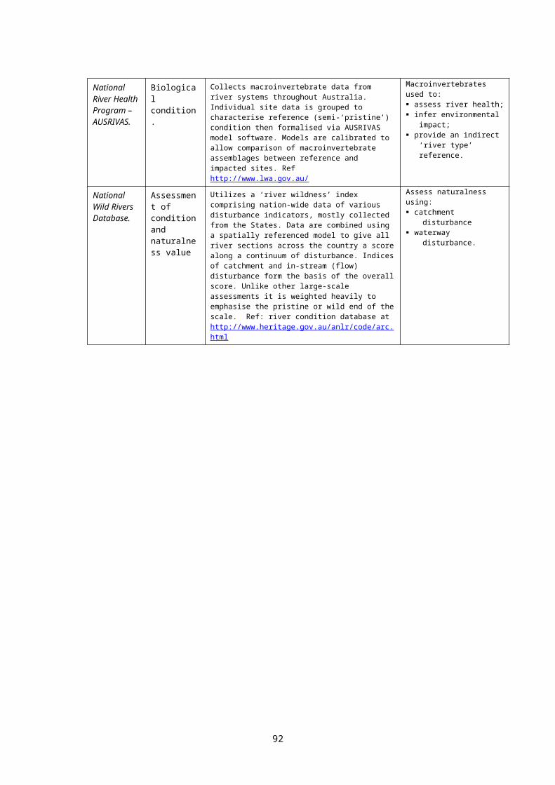
Fish Habitat Areas can be declared under the provisions of Queensland’s Fisheries Act 1994. Although around 10,000 km2 of estuarine habitat is protected under these provisions, they have not yet been applied to significant freshwater areas.
The Queensland Government initiated a Draft Queensland Rivers Policy in 2001. This initiative resulted in a pre-election promise in January 2004 to introduce legislative protection for pristine rivers in Queensland. According to the Government’s website 2004133:
A re-elected Beattie Government will introduce stand-alone legislation to ensure our wild rivers are protected via:
Allowing limited agricultural, urban and industrial development, eg smallscale “eco-friendly” tourism development would be encouraged;
Strictly limited and regulated water allocations or water extractions from wild rivers;
No new dams or weirs permitted on a wild river or its main tributaries; Flow control activities such as stream alignment, de-snagging (other than for
safety reasons) and levee banks will not be permitted; Further developments on floodplains must not restrict floodplain flows; Protection of associated wetlands; No stocking of wild rivers with non-endemic species; No use of exotic plant species in ponded pastures; New off-stream storages to be limited in capacity, for example for stock and
domestic purposes;
No new in-stream mining activities. Any out-of-stream mining in the region will be subject to Environmental Impact Assessments.
In cases where existing development control powers do not exist, for example in wetlands, a State Planning Policy under the Integrated Planning Act 1997 will be used to require local governments to assess future development applications against this policy.
Catchment management is a vital part of protecting the health and well-being of our waterways.
Development in the catchments of our wild rivers will need to be assessed on the basis of its impact on the rivers, and managed so that any effect is minimised in order to preserve their natural values.
Examples of Queensland’s rivers which could be designated as Wild Rivers include the following:
Archer River system Coleman River systemDucie River system Fraser Island streamsGregory (Nicholson basin) Hinchinbrook Island streamsHolroyd River system Jacky Jacky CreekJardine River Jeannie RiverLockhart River Morning Inlet streamsOlive & Pascoe Rivers Settlement Creek systemStaaten River Stewart RiverWatson River Wenlock River
The Queensland Wild Rivers Act 2005 (proclaimed 14 October 2005) provides for the declaration of a river as a 'wild river'. Six rivers were nominated for declaration in early 2006, however when a check was made (just after the Beattie government were returned in the State election of September 2006) none had been declared (www.nrm.qld.gov.au/wildrivers/. It is to be hoped that many rivers will be declared, and that the protective measures provided for under the Act will be fully implemented and effective.
Queensland's Water Act 2000 is one of the most advanced of any Australian State, possibly second only to the NSW Act (see Appendix 4). Water Resource Plans become subordinate legislation under Queensland's Act. The Water Resource (Cooper Creek) Plan 2000, for example, contains important environmental controls, capping irrigation licences at current
92
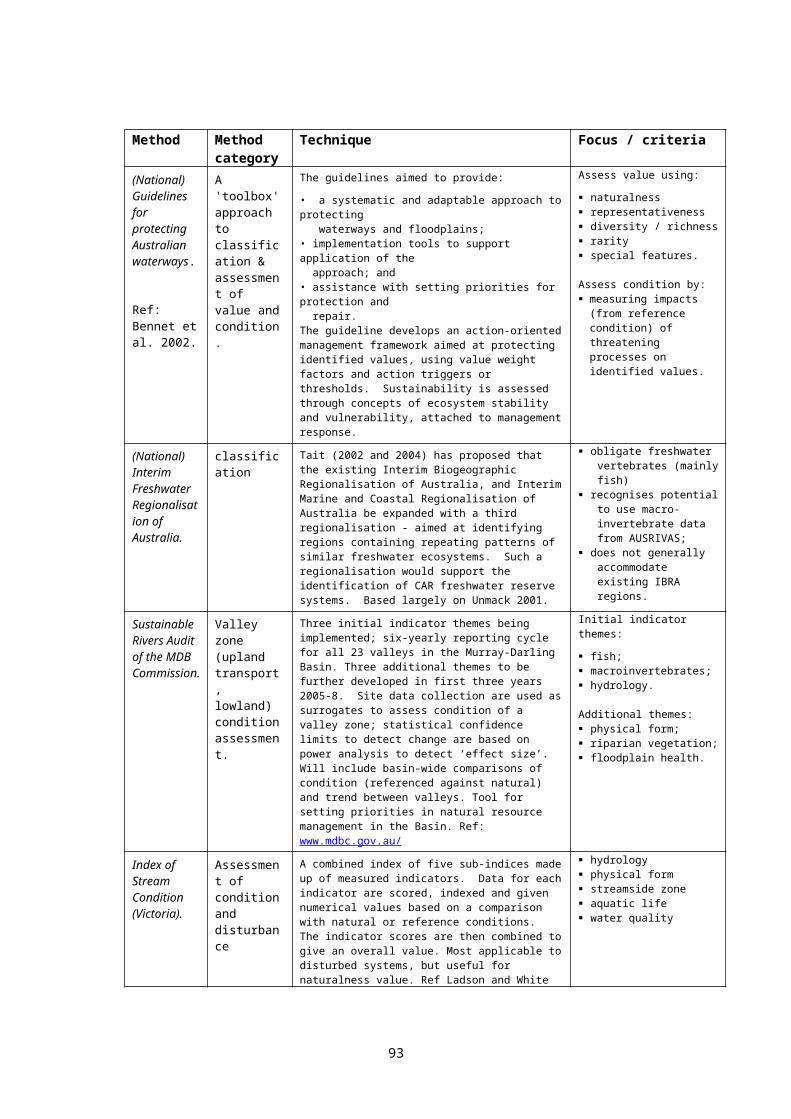
levels, limiting annual groundwater extraction to no more than annual recharge, and banning new large in-stream dams.
Queensland’s Nature Conservation Act 1992 provides for the declaration of protected areas, including ‘international agreement areas’ (s 59). So far no Ramsar wetlands have been specifically declared under this provision, although, at first glance, this would seem to have been one of the intentions behind the creation of this provision.
The Queensland Environment Protection Agency “is developing a Mapping and Classification and Information Database for Queensland Wetlands, a project jointly funded by the Queensland and Australian Governments under the Natural Heritage Trust Queensland Wetlands Programme. This project will map and classify Queensland wetland types, including springs and freshwater, estuarine and marine wetlands. Detailed wetland maps and inventory data sets will be developed for the Great Barrier Reef catchment by mid-2006 and for the entire State by mid-2007” – letter from Ross MacLeod, Office of the Minister for the Environment, Queensland, 1/6/2005.
6.2.5 South AustraliaThe Wetlands Strategy for South Australia (2003) provides a mandate for the development of both a comprehensive wetland inventory (p.16) and reserves protecting comprehensive, adequate and representative examples of wetland types (p.22):recognised and protected
Objective 5. To identify those wetlands which are important at the regional, state, national and international levels, and ensure appropriate recognition, management and protection of these sites.
Actions:
5.1 Establish a comprehensive, adequate and representative system of protected areas to contribute to the conservation of South Australia’s native biodiversity associated with wetlands.
5.2 Ensure that key wetland sites are identified in the State Wetlands Databank (see Action 6.1) defining their importance at the regional, state, national and international levels. Collate monitoring, survey, and management information for wetlands across the state and link these data to information from associated water resources that wetlands rely upon.
The use of the term “important” within the strategy rests partly on the Ramsar ‘importance’ criteria (see Appendix 7 below) of which criterion 1 underlines the value of representative sites:
Criterion 1: A wetland should be considered internationally important if it contains a representative, rare or unique example of a natural or near-natural wetland type found within the appropriate biogeographic region.
National Parks and Wildlife SA has a policy document titled "A Comprehensive, Adequate and Representative Reserve System Strategy for South Australia" 1997. This paper was presented to the Community Forums on the NRS at Perth in 1998 and in Adelaide in 1999. While not officially published, it guides the further development of the reserve system in South Australia. Two ecosystems / habitats have been identified for priority acquisition in South Australia: grassy ecosystems and wetlands134.
South Australia has a wetlands inventory program, where inventories are being developed region by region with the intention of achieving full State coverage; this program is being developed within a limited budget. At present around 3,800 wetlands, mostly small, are protected within the State’s terrestrial protected areas. There are no plans at present to establish a comprehensive inventory of freshwater ecosystems, including both flowing and still waters. The State is however, progressing the development of a broad-scale inventory of terrestrial ecosystems, within the IBRA framework, and this may ultimately be extended to cover freshwater ecosystems, particularly given the use of the Ramsar definition of wetlands within the State wetlands strategy.
93

The State has no threatened species legislation. Prior to the publication of the wetlands strategy, there were no requirements for local government, within the State's landuse planning framework, to take biodiversity or wetlands inventories into account when considering development proposals or changes to landuse zoning135. This has changed under Objective 5 of the strategy (p.23):
Actions:5.4 Ensure that all relevant local government and state agencies, catchment water management boards and similar bodies are made aware of those wetlands recognised as being of regional, state, national or international importance and their respective management and ‘duty of care’ * responsibilities for each site.
5.5 Ensure wetlands of regional, state, national or international importance are identified in Planning Strategy and Development Plans. Such areas should be supported by appropriate strategies and objectives/principles of development control and included within a Conservation Zone. Surrounding zones should include provisions to minimise threats on such areas (eg minimising introduction of pest species, land division and fire management).
6.2.6 TasmaniaTasmania, one of Australia’s smallest jurisdictions, retains around 40% of its surface area in various types of protected area. The most western two of the State’s nine IBRA bioregions are largely protected within World Heritage Areas, including the Franklin-Gordon Wild Rivers National Park.
The Tasmanian State government is currently progressing five strategies designed to protect ecological values, including freshwater ecological values. The Department of Primary Industries, Water and Environment (DPIWE) has primary carriage of these strategies: the development of the Conservation of Freshwater Ecosystem Values project (see
below); declaration and management of the RFA CAR reserves to protect their natural values.
Whilst the RFA reserves are based on pre-European terrestrial vegetation communities, some do include important freshwater ecosystems by default;
an assessment of protected environmental values for the purpose of establishing water quality objectives;
protected environmental values are also being assessed for the purpose of establishing freshwater environmental flow objectives, and (more importantly) the supporting studies to establish actual environment flow requirements;
the development of the Nature Conservation Strategy and programs under this strategy; The DPIWE Biodiversity Unit has been established and the Nature Conservation Strategy programs will be developed under the guidance of this Unit. The Tasmanian government could have given the strategy legislative 'teeth' by its development into a State Policy proclaimed under the State Policies and Projects Act. No action is being taken at present to pursue this course of action.
The final version of Tasmania's Nature Conservation Strategy 2002-2006 contained a 'priority recommendation' (p.ii):
Improve protection for freshwater environments. As a priority, identify and establish freshwater CAR reserves and complete integrated catchment planning for natural resource management. (Expanded by Actions 15, 47).
Conservation of Freshwater Ecosystem Values ProjectThe Conservation of Freshwater Ecosystem Values (CFEV) Project has been initiated by the Tasmanian Government as part of the Water Development Plan for Tasmania. The Department of Primary Industries, Water and Environment (DPIWE) is responsible for the Plan. The development and implementation of a strategic framework for the management and
94
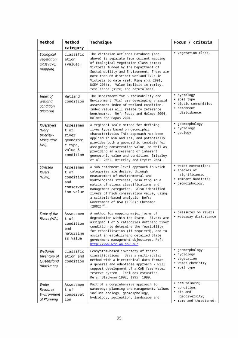
conservation of the State’s streams, waterways, and wetlands is identified as an integral part of the Water Development Plan.
The project will consider in its scope the following ecosystem types: rivers, lakes and wetlands, saltmarshes, estuaries, and groundwater dependent ecosystems.
The project aims to develop a Freshwater Conservation System for Tasmania, based on the reserve-design principles of comprehensive, adequate and representative protection (CAR Principles), in order to achieve the following outcomes: a coordinated system for the recognition and conservation of freshwater ecosystem
values that can be used for water management planning;
increased conservation of high priority freshwater ecosystem values in areas under both Crown control and private land;
increased confidence on behalf of government, industry and the community that high priority freshwater ecosystem values are appropriately considered in the development and management of the State’s water resources; and
increased ability for Tasmania to meet national obligations for protection of freshwater ecosystems.
A comprehensive inventory of Tasmania's freshwater ecosystems is under development as an adjunct to this project. Tasmania's wetland inventory has been expanded from around 1000 sites in 1999 to currently contain information on 8000 sites. See Appendix 10 for more information on the CFEV project.
6.2.7 VictoriaVictoria has been, and remains, a leader with regard to the protection of representative examples of freshwater ecosystems, in spite of significant failings in the implementation of policy. The Reference Areas Act 1978 was, at the time, benchmark legislation with regard to the protection of representative terrestrial ecosystems. The State Conservation Strategy 1987 established the need for representative protected areas covering both rivers and wetlands. The recommendations of the Land Conservation Council Rivers and Streams Investigation in 1991 resulted in the designation of 15 representative rivers, and the development of protective management plans for 11 of these. The LCC’s recommendations also resulted in the passage of the Heritage Rivers Act 1992 (see Appendix 16) which provided limited statutory protection for 4 rivers and 14 river reaches (the 18 'Heritage River Areas') and 26 small but relatively undisturbed catchments of high natural value ('Essentially Natural Catchments'). The Heritage Rivers Act represents benchmark river protection legislation in the Australian context. Although attempts have been made by other Australian jurisdictions to develop similar legislation, all have failed. Victoria’s Biodiversity, (the State's biodiversity strategy) released in 1997, re-iterated earlier commitments towards representative reserves covering both wetlands and rivers. The Victorian Healthy Rivers Strategy 2002 identifies the need for the protection of representative river ecosystems, and includes the development of a strategic target.
This record surpasses that of any other Australian State. However, Victoria failed to carry through aspects of the State Conservation Strategy 1987 and the 1997 biodiversity strategy which would have seen the development of a comprehensive and representative protected area network covering wetlands. In addition, although the Victorian government instructed136 its departments to implement protective management for the designated representative rivers in 1992, after 10 years, four of those 15 rivers remain without management plans. The implementation of the 11 management plans which have been prepared has not been publicly reported.
Doeg (2001) in a commissioned review of representative rivers, took account of the distribution of both fish and macroinvertebrates (the earlier LCC representative rivers were chosen mainly on geomorphology and hydrology variables). His work on macroinvertebrates was partly based on Metzeling's (2001) work. He identified 22 biophysical regions, and suggested that 16 rivers (13 of which are already partially 'protected' by either heritage or representative river designations) could be chosen so as to represent 21 of the 22 regions.
95
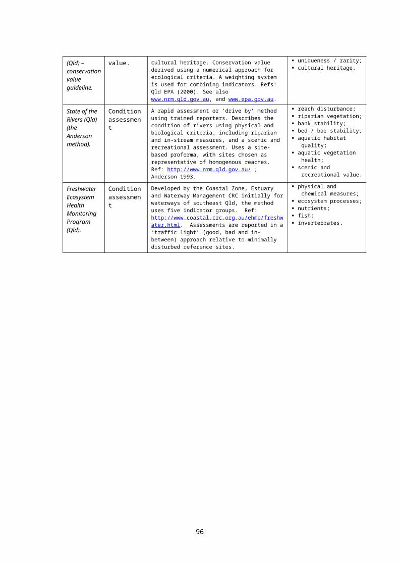
The Victorian Government, through the Victorian River Health Strategy (launched August 2002) is committed to review representative rivers in view of their ecological attributes. This review will apparently be undertaken by the Victorian Environment Assessment Council (VEAC) (the successor to the LCC and the ECC), with relevant Catchment Management Authorities required to prepare management plans for the rivers. The (VRHS) strategic target is that identified representative river reaches should be ecologically healthy by 2021. These arrangements will hopefully lead to a more detailed and comprehensive system for identifying and managing representative rivers in Victoria.
The VEAC is the logical vehicle to resuscitate earlier (1987) plans by the LCC to examine the issue of representative wetlands. The Victorian Government is understood to be considering this option, although at this stage no action has been taken.
On the subject of protected areas, Victoria's Catchment and Land Protection Act 1994 contains provisions enabling the designation and protection of special areas. Section 28 provides that a special area plan may be prepared to deal with specific land management issues in a special area - in other words, to manage threats. Section 32 then requires that land managers must "have regard to" any relevant special area plan. Although not powerful, these provisions could nevertheless assist in the development of riverine or other aquatic protected areas.
In summary, Victoria has developed the most comprehensive policies of any Australian State relating to the protection of freshwater ecosystems. However, major failings to implement policy are of serious concern, and include the failure to use existing legislative provisions within the Flora and Fauna Guarantee Act 1988 and the Fisheries Act 1995 to protect freshwater areas. The fact that all 18 Heritage River management plans remain in draft form after 13 years, and that 4 of the 15 required representative river management plans have not even been drafted (again, after 13 years) highlights serious shortcomings of senior management within the State bureaucracy.
6.2.8 Western AustraliaThe Western Australian Government published a Wetlands Conservation Policy in 1997, divided into two main sections, a Statement of Policy and a second section on Policy Implementation. The Statement of Policy uses the full Ramsar definition of wetlands, and thus applies to virtually all Western Australian freshwater ecosystems - rivers, lakes, floodplain wetlands, estuaries, and underground karst environments. Given that State wetland policies are in part designed to facilitate the fulfilment of Australia's international commitments under the Ramsar Convention, this approach appears logical and courageous, and one that other Australian States could do well to follow.
Moreover, the Policy provides a commitment that should provide the foundations for the development of a system of comprehensive, adequate and representative freshwater ecosystem reserves. Objective 2 commits the State Government to the protection of “viable representatives of all major wetland types” - again, using the full Ramsar definition of wetlands. However, the policy implementation plans - the second part of the Policy - are limited to “still” waters only. The logic for this division provides for the values of "flowing" water wetlands (ie: rivers) to be protected under the programs developed by the then WA Water and Rivers Commission.
At this stage WA does not have a biodiversity strategy. Draft versions of A Nature Conservation Strategy for Western Australia and a Wildlife Conservation Bill to replace the WA Wildlife Conservation Act 1950 were released for public comment in 1992. Since then successive State governments have committed to develop a Biodiversity Conservation Strategy and, similarly, to comprehensive biodiversity conservation legislation to replace the Wildlife Conservation Act137. Work towards these initiatives continues.
Comprehensive strategic inventories of the State's freshwater ecosystems, and the procedures necessary to support effective integration of land use planning and environmental assessment procedures, are in early stages of development. Under the Wetlands
96
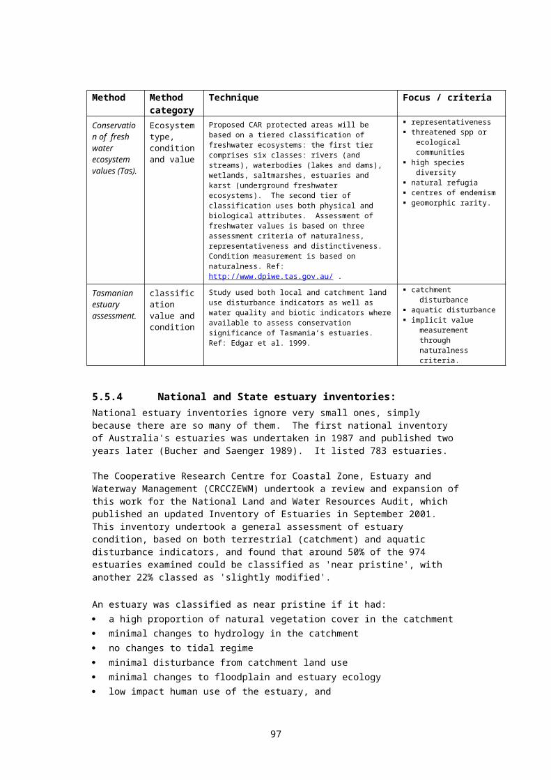
Conservation Policy, catchment-based inventories of “still” wetlands are being prepared by the Department of Conservation and Land Management. The scope and coverage of these inventories vary from catchment to catchment - an appropriate early response in such a large State where threats and pressures vary significantly with distance from the main population centres. Initial emphasis has been on the Swan Coastal Plain, and the Jurien to Dongara, Augusta to Walpole, and the South Coast areas. A waterways classification framework has been proposed, but has not been fully developed.
WA also has an Environmental Protection Policy for the Swan Coastal Plain Wetlands, which aims to protect the 20% of remaining conservation category wetlands from the effects of land development.
A draft Statement of Planning Policy for Natural Resource Management has been released for public comment. This initiative aims to provide the mechanisms for natural resource management issues to be embedded into local government planning schemes and thus development decisions. The draft SPP includes a sub-component dealing with wetlands.
Waterways Policy:The WA government released the Draft Waterways WA Policy in November 2000 for comment. In many ways a progressive document, the draft failed138 to pick up and expand the existing policy statements relevant to waterways set by the Wetlands Conservation Policy 1997. In this respect, the most important missing element relates to the development of representative freshwater reserves. The final version of this policy has not been released, because the government hoped to develop a draft waterways strategy (which could include a commitment to protect near-pristine rivers of high conservation value) and release both the policy and strategy together in 2003. The WA government website was checked on 14/11/03 – information indicated that neither the final policy nor the strategy had been released.
Ramsar sites:As of the close of 2004, WA had 12 of the nation’s 64 Ramsar sites. Further wetlands being considered for nomination include: the Cape Range Subterranean Waterways, Ellen Brook Swamps System, Lake MacLeod, Spearwood Creek, lake Ballard, Lake Gregory, Millstream Pools, and East Hamelin Pool at Shark Bay.
Vegetation clearance controls:The Environmental Protection Act 1986 includes provisions applicable to environmental harm and also includes provisions for the regulation of the clearing of native vegetation. In particular, ‘defined’ freshwater wetlands are declared as environmentally sensitive areas, and as such have increased protection from exempt vegetation clearing activities.
97

6.2.9 Summary table: State freshwater biodiversity program components
(Source: adapted from Nevill 2001)
Issue WA NT SA Qld NSW Vic ACT Tas
Cumulative effects: policy or statute exists to support catchment-based caps on water-related development139.
yes part140
yes141
yes142
yes part143
yes no144
Cumulative effects: caps are being developed well before allocations approach catchment capacity145.
possible146
possible147
no no no148 no yes149
no
Representative reserves: policy commitments to develop systems of representative freshwater reserves.
yes yes yes150
yes yes yes yes151
yes
Representative reserves: the above policy has been implemented152.
no no n/a no no part153
part154
no155
Representative reserves: comprehensive inventories of all freshwater ecosystems, capable of supporting the identification of RRs, are under development156.
yes yes yes yes yes yes yes yes157
Representative reserves: comprehensive inventories are substantially complete.
no no no no no no yes no
Programs are in place to identify and protect rivers of high ecological value.
no no no yes158
yes159
yes160
yes no
A policy or statute exists encouraging integrated surface / groundwater management.161
no162
no part163
part164
yes165
no166
yes167
no
Integrated management of surface / groundwater exists recognising conservation targets in both and the need for dual demand management.
yes168
no no no yes no yes169
no
Comprehensive compliance auditing programs exist, including air-photo recognisance of illegal dams and levees.
no170
no no171
no172
no173 no n/a174
no
Effective action to detect and assess all significant non-compliance.
no no no no no no yes175
no
Policy / statute provides for environmental flows
yes yes176
yes yes yes yes yes yes
Environmental flows are being implemented.
yes no177
yes yes yes178
yes yes yes
Management of surface flows179 is addressed by policy and statute
yes no180
yes yes yes no181
yes182
yes183
Surface flows are being managed. no no no184
no185
yes n/a yes186
no
Fish passage needs have been identified in policy, and are being effectively implemented187.
weak
weak
weak
strong
strong
strong
strong188
weak
Aquatic intrinsic values are clearly acknowledged.
no189
no no no yes190
no yes191
no
State threatened species legislation (see notes for refs to other Acts)
no192
no193
no194
no195
yes196
,197
yes198
no199
yes200
98

Issue WA NT SA Qld NSW Vic ACT Tas
Policies discouraging on-stream farm dams exist.
no no yes201
no no uc202
no203
no204
State biodiversity strategy (ud - under development)
ud no ud205
no206
yes207
yes208
yes209
ud
State statutory controls on veg clearance210, 211
yes212
no yes213
yes214
yes215
yes216
yes217
yes & no218
State wetlands strategy (ud - under development)
yes219
yes220
ud yes221
yes222
yes223
yes224
ud
State natural resource accounting framework.
no no no no no no no no
State has an enforceable water quality policy. (ud - under development)
no225
no ud yes226
no yes227
no yes228
The above table illustrates that all States are committed to the cornerstone concept articulated by Principle 8 of the National Strategy for the Conservation of Australia's Biological Diversity 1996 - that is, that programs of biodiversity conservation need to rest on (a) the development of systems of representative reserves, and (b) sympathetic management of utilised ecosystems to protect biodiversity as far as practical outside the reserve system. Table 7.2.1 lists the key components of these "sympathetic management" programs across the jurisdictions.
The following table lists State commitments to the development of systems of representative freshwater reserves, and the programs developed to put these commitments in place.
6.2.10 Summary table: Staterepresentative reserve commitments & programs
Commitment contained in: Specific implementation program
National
National Strategy for Ecologically Sustainable Development 1992Intergovernmental Agreement on the Environment 1992National Strategy for the Conservation of Australia’s Biological Diversity 1996
National Reserve System ProgramNRS Directions Statement (NRMMC 2005) targets freshwater representation.
ACT Nature Conservation Strategy 1998 Nature Conservation Program - effectively complete.
NSW Rivers and Estuaries Policy 1992;
Wetlands Management Policy 1996;
Biodiversity Strategy 1999;
None. The State Aquatic Biodiversity Strategy, due for release in 1999, has not yet been published.
NT A Strategy for Conservation of the Biological Diversity of Wetlands, 2000
None. Conservation strategies under review 2005
Qld Strategy for the conservation and management of Queensland wetlands 1999
None, however a comprehensive State wetland inventory under preparation should enable identification of poorly represented freshwater ecosystems. The wild rivers program, although a separate commitment, seems likely to assist in meeting systematic conservation objectives.
SA Wetlands Strategy 2003. The policy has an explicit commitment to representative wetland reserves, set against a wide interpretation of the meaning of 'wetland'.
None – however efforts are being made within the Parks program to purchase poorly represented wetland types (Nevill and Phillips 2004).
99
Commitment contained in: Specific implementation program
Tas Nature Conservation Strategy (2000) State Water Development Plan 2002, Conservation of Freshwater Ecosystem Values (CFEV) Project (design phase 2002-2004)
State budget 2002 funded the CFEV project (see Appendix 10 of Nevill and Phillips 2004). No specific funds allocated for project implementation in the 2004 or 2005 State budgets.
Vic A Conservation Strategy for Victoria (CS)1987;
Biodiversity strategy 1997a, 1997b, 1997c
Healthy Rivers Strategy 2002
Heritage Rivers Programrepresentative wetlands component of the CS incomplete although progressing slowly.
Healthy Rivers Program
WA Wetlands Conservation Policy 1997.
This commitment was not reinforced by the draft Waterways WA Policy 2002 (Nevill and Phillips 2004).
None. The Waterways WA Policy, due for publication initially in 2003, has not yet been released.
In summary: all States are committed to the InterGovernmental Agreement on the Environment 1992, and the national biodiversity strategy 1996 (where the development of representative reserves covering all ecosystems is a key commitment). All states (recently including Tasmania and South Australia) have amplified this comment by specific policy statements relating to the development of systems of representative freshwater reserves.
All States have programs in place designed to meet Ramsar commitments - these commitments include the development of ecosystem inventories, and the establishment of systems of reserves covering the full range of wetlands included in the Ramsar definition of the term. In no State are these programs complete. Existing wetland inventories, although acknowledging the Ramsar definition of wetlands, are in practice largely restricted to lentic (slow moving) wetlands229.
The only jurisdictions to establish reasonably comprehensive freshwater ecosystems inventories are the Australian Capital Territory and Victoria, and the ACT is the only jurisdiction to establish a reasonably comprehensive system of freshwater reserves. The ACT and Victoria are, in fact, the only jurisdictions to attempt to directly action their "representative reserve" commitments, although the Tasmanian CFEV program, if implemented, should see action develop in that State. The Victorian program, while ambitious, has not been completed, and is now in urgent need of review. It should be acknowledged, however, that Victoria is the only State to establish legislation specifically to protect catchments and rivers of high cultural or natural value, and Victoria has put in place mechanisms to protect some of the 15 'representative rivers' identified in the 1991 LCC final report of the rivers and streams investigation (see detail in the Appendices below). It should also be noted that Queensland is planning to have wild rivers legislation in place by 2005, to protect some of that State’s high conservation value rivers.
In all other jurisdictions, action has not yet been taken to put in place either comprehensive inventories, or systems of representative freshwater reserves. Instead, these States have concentrated on the broader bioregional framework of the NRS, which itself did not highlight the freshwater reserve issue until 2004. Moreover, no action has been taken within the NRS to establish a nationally agreed approach to the classification of freshwater ecosystems into categories or types which could provide a framework for the long-term development of a national system of representative freshwater reserves.
6.3 New Zealand freshwater programs
6.3.1 State of NZ freshwater biodiversityAs is the case in Australia, freshwater ecosystems in NZ have generally been degraded by human activities over the last 2 centuries. Over 90% of wetland areas have been destroyed
100
or highly degraded. Only a couple of complete river systems still lie within unmodified catchments and remain free of introduced species. One third of NZ’s 29 species of indigenous freshwater fish are classified as threatened. (Government of NZ 2000:46). Very few rivers are protected for all or even most of their length, although eight water conservation orders (four more are pending) protect the waters of outstanding rivers or lakes (Government of NZ 2000:47).
According to the Government, …”the existing network of protected areas includes some freshwater bodies, but is far from representative of the full range of freshwater ecosystems and habitats. In addition: information about protection priorities is deficient, but key areas known to be poorly
represented include lowland lakes and rivers, floodplain wetlands, mid-altitude wetlands, and geothermal systems;
the gap between land and freshwater environments in achieving representative protected areas suggests that a different approach is required in protecting freshwater ecosystems, with a special focus on the sympathetic management of freshwater and surrounding areas; and
protecting freshwater biodiversity requires a high level of coordination between management agencies to ensure protection mechanisms are applied in a complementary and integrated way” (Government of NZ 2000:49)
6.3.2 NZ policy commitmentsNew Zealand, like Australia, has accepted an international obligation to protect representative examples of all major ecosystems – under the Convention on Biological Diversity 1992.
Like Australia, NZ has built this commitment into national policy. The NZ Biodiversity Strategy contains an objective: “Protection and sustainable management of freshwater ecosystems [including] the protection of a full range of remaining natural freshwater ecosystems and habitats to conserve indigenous biodiversity, using a range of appropriate mechanisms”. The Strategy contains two action statements of particular note: Action B: “develop and apply a comprehensive classification system for freshwater
ecosystems … to help identify protection priorities”, and Action C: “progressively protect priority representative freshwater habitats, using a suite
of protective mechanisms” (Government of New Zealand 2000:52).
The “suite of protective mechanisms” includes area-specific strategies which meet the definition of ‘reserves’ used in this book – ie: meeting the IUCN definition of Protected Areas classes 1 to 4.
With respect to Action C, the Department of Conservation is designated in the Strategy as the lead agency, supported by the Ministry for the Environment, the department of local government, Regional Councils, covenanting bodies (the Landcare Trust and the QEII Trust), the NZ department of fisheries and game, and Maori and community groups.
It should be noted that NZ has a three-tiered government structure: national level, regional council level, and local level.
Regional Councils have important natural resource management responsibilities under national legislation, and RC boundaries for the most part correspond with major catchment boundaries.
Regional councils control the effects of land use on water resources and the allocation/use of water resources. Through their Regional Plans, Regional Councils are able to identify significant areas and features and set management objectives for them with corresponding rules and policies. See Appendix 6 for extracts from NZ’s Resource Management Act 1991.
101

6.3.3 NZ programs and protected areasLike Victoria and Tasmania, a high proportion of the NZ land surface is Crown land rather than freehold. In NZ, about one third of all land is under management by the Department of Conservation – either directly or by delegation. In Australia, the only State in a comparable situation is Tasmania (the special case of the Australian Capital Territory aside).
The conservation estate in NZ is increasing in size. Over 2 million hectares of land now held under pastoral lease (mainly on the South Island) is subject to a voluntary ‘conversion to freehold’ process. This process involves an assessment of the land’s conservation values, including freshwater ecosystem values, and where these values are high, this land can be retained under government ownership for conservation purposes.
It is estimated that up to 40% of this land may be retained by the Crown in this manner.
Like Australia, NZ today has an inheritance of conservation programs and protected areas. This inheritance includes knowledge of environmental values and ecosystems, programs to expand and apply this knowledge, and a variety of protected areas including major national parks and protected Ramsar wetlands.
There are five Ramsar Wetlands in New Zealand: Farewell Spit (Nelson), Waituna Wetland (Southland), Kopuatai Peat Dome (Waikato), Whangamarino Wetland (Waikato) and Firth of Thames (Waikato). All of these wetlands except the Firth of Thames are under Department of Conservation management. A recent audit of New Zealand’s Ramsar estate found significant short-comings230.
This inheritance of protected areas has, of course, favoured the protection of inaccessible or infertile habitats, as has been the case in Australia. Highland forests and streams are better protected than grasslands and floodplain wetlands.
Both NZ and Australia have sought to protect representative ecosystems in terrestrial environments. The identification of representative areas depends on the development of classification methods capable of identifying areas containing repeating patterns of major ecosystems. Ecosystems themselves are complex and difficult to map, and as a result a variety of methods using a variety of ecosystem (or biodiversity) surrogates have been developed in both countries.
The approach used in Australia centres on the use of the Interim Bioregionalisation of Australia (IBRA) which divides the eight States and Territories into 85 bioregions. More recently, the geomorphic units found within the bioregions have been identified and delineated as sub-regions. Representation of ecosystems can then be assessed with framework provided by the bioregions, as can (at a finer level of detail) particular values which occur within a single bioregion.
The NZ approach involves the mapping (at a pixel level) of environmental distinctiveness, and identification of environmental domains having similar characteristics. The resulting data set is called LENZ (Land Environments of New Zealand). The work was being carried out by John Leathwick (now NIWA Hamilton) and Jake Overton from the government agency Landcare Research.
“Environmental domain analysis identifies discrete areas that have similar environments, while environmental distinctiveness provides a continuous measure of ecosystem dissimilarity. A surface of distinctiveness relative to the entire nation identifies areas with environmental combinations that are rare in NZ. A surface of distinctiveness relative to the reserve network identifies area that are most different from existing protected areas”. (Dept of Conservation 2001a:5).
Once environmental distinctiveness is identified at a pixel level, environmental domains can be described given a chosen level of environmental distance.
102
Environmental distinctiveness is based on primary climatic and geomorphic variables which (a) are drivers for the development of particular ecosystems, and (b) can be readily and reliably measured and mapped.
Variables need to represent fundamental drivers for terrestrial vegetation. The chosen variables for the initial ‘proof of concept’ terrestrial domain mapping were:
mean annual temperature mean winter minimum temperature mean annual solar radiation minimum winter solar radiation annual root zone water deficit mean rainfall to potential evapo-transpiration October vapour pressure deficit base geology drainage, and slope.
These variables have now been replaced by a larger set – now numbering 15. To a considerable extent many of these variables also influence freshwater ecosystems, although more specific hydrological and geomorphological variables are needed.
The LENZ data has a number of uses. It is being used for the terrestrial environment to identify areas outside the conservation estate which are likely to contain ecosystems poorly represented within the existing conservation estate. Within the conservation estate the data is also being used to prioritise management effort.
On-site field investigations are carried out in high-priority areas to identify the condition of particular ecosystems – which may be highly degraded by human use or exotic infestations. The costs and benefits of reservation and/or other protective strategies can then be assessed (Dept of Conservation 2001b). Strategies for the protection of land would generally impart some legal protection to all water bodies within the land area.
Lakes, estuaries and large wetlands are being mapped as part of the current phase of development of the LENZ data. The Ministry for Environment have contracted the National Institute of Water and Atmosphere (NIWA) to develop a river environment classification (REC)231. NIWA has completed development of a GIS-based classification of New Zealand’s rivers for the Ministry of the Environment with the involvement of a number of regional councils. The River Environment Classification (REC) (Snelder et al. 2002) is a tool for ecosystem-based resource management providing a context for inventories of river resources, and a spatial framework for effects assessment, policy development, developing monitoring programs and interpretation of monitoring data and state-of-environment reporting. REC has been used to classify all the rivers of New Zealand at a 1:50,000 mapping scale. The area classified comprises 267,000 km2 and 426,000 km of river network. REC introduces two major differences to other landscape classifications or ‘regionalisations’.
The REC is more scalable than existing regionalisations, delineating patterns at a range of scales from approximately 104 km2 to 1 km2.
The REC is based on a network of ‘sections’ that are associated with their upstream catchments. The mapped classification appears as a linear mosaic showing longitudinal spatial patterns that are typical of patterns of many properties of river ecosystems.
NIWA has been involved with MfE and various regional councils in using River Environment Classification (REC) as a spatial framework for broad scale environmental assessments. Such assessments are intended to support regional water plan development and state of environment assessment and reporting.
The Department of Conservation is contracting NIWA to develop a multi-variate REC which builds upon the existing REC and LENZ datasets and will allow the measurement of distinctiveness. This project is 2-3 years from completion.
103
Funding is currently restricting progress towards protecting vulnerable and poorly protected freshwater ecosystems, as no additional money has been provided by the NZ government to support the freshwater objective and actions listed in the NZ Biodiversity Strategy (see discussion above). Purchase of land (for the purposes of protecting freshwater ecosystems) additional to the existing conservation estate is extremely difficult given current financial arrangements, leaving the South Island pastoral lease tenure review process as the most important ‘acquisition’ tool available.
However, if existing programs are continued, data should be available at the close of 2005 which will enable the mapping – at least at a broad scale – of representative freshwater domains. Existing effort is focusing on riverine ecosystems.
This work will be used in conjunction with current Ramsar and wetland conservation programs run by the Department of Conservation and the Regional Councils.
The existing NZ wetland classification system is a nomenclature system, dividing wetlands into broad types (not a GIS mapping system like LENZ or REC). It is being developed by Landcare Research and others to facilitate the development of measures of wetland condition (Bev Clarkson, Landcare Hamilton, pers. comm. 2002). There are similar nomenclature classifications for riverine communities in use in NZ (Rosgen 1996).
The example of the 1968 USA legislation supported a Wild and Scenic Rivers campaign starting in New Zealand in 1976, and resulted in Water Conservation Order legislation being passed in 1981. With minor amendments, National WCOs have been investigated and gazetted as 'protected waters' since then. To date 13 river catchments and 2 standalone coastal lakes are largely protected. Ramsar candidate sites (i.e. meeting Ramsar criteria) in NZ total 103 at this stage and include many rivers, some of which are already protected in WCOs and/or terrestrial reserves and other protected areas. New Zealand embarked on a Water Bodies of National Importance project in 2003, with the objective of "water bodies with nationally significant natural, social and cultural heritage values are protected", which should see many major river systems protected.
the WCO legislation was originally introduced as a 1981 amendment to the Water and Soil Conservation Act 1967. When that statute (and 20 other planning and resource allocation statutes) was replaced by the Resource Management Act 1991, the WCO provisions were transferred across with a few amendments (mainly removing the Local Conservation Notice category of nationally gazetted protection and replacing it with the ability for Regional Councils to put equivalent rules in place in a Regional Water Plan) and saving the National Water Conservation Orders gazetted under the earlier legislation. Indeed there were several applications made under the original legislation in the mid 1980's that eventually emerged from protracted Appeal processes to get gazetted over the last couple of years.
The New Zealand government developed a ‘Water Programme of Action’ in 2003, which included a Waters of National Importance component. See Appendix 17 for more information.
6.3.4 New Zealand summaryIn summary, NZ has taken on similar international obligations, and has responded at a policy level in a similar way compared with Australia.
However, while Australia (at a national level) has failed to take effective action even to develop the necessary classification systems to support the development of representative freshwater protected areas, NZ has moved ahead in this regard. New Zealand is working towards completing these systems, and while they remain unfinished the lack of secure funding remains a problem. Such funding difficulties not only threaten the completion of the datasets, but also imperil implementing programs aimed at putting protective measures in place.
104

The use of environmental domain mapping in NZ, rather than bioregions, represents a different approach which may well be considerably better at mapping the finer detail of freshwater ecosystems.
Another point of difference of some significance is that NZ has moved to increase the level of protection afforded to freshwater ecosystems encased within terrestrial national parks. For example, native fish within NZ national parks are in most cases fully protected, and their harvesting is banned. This is not generally the case in Australia, even in national parks large enough to provide a high level of protection to included freshwater ecosystems.
Bearing in mind the thrust of the Waters of National Importance project, New Zealand appears likely to develop an effective system of representative freshwater reserves well ahead of Australia (see Appendix 17 for more details on the Water Programme of Action).
105

7. Protecting high value rivers: elements of a national framework:
7.1 Introduction:Australia has hundreds of rivers, but only a handful are well protected (Nevill 2005a). The National Audit reports 2001 show extensive and continuing degradation of Australia's rivers and estuaries. Inventories of river and estuarine ecosystems remain incomplete in all States except Victoria and the Australian Capital Territory. Even where such inventories have been completed, they lack current information on value and condition (see Chapter 5 above). Existing water planning, land use planning, and development assessment frameworks are not providing adequate protection for Australia's freshwater ecosystems (Nevill 2001, Wentworth Group 2003). The need for additional protection for the nation's rivers and estuaries is urgent and long overdue. The advantages (and disadvantages) of a national approach to protecting high conservation value (HCV) rivers and estuaries needs discussion.
The protection of rivers and their catchments has received a good deal of debate worldwide, but little action. In the USA, for example, protected rivers were advocated as far back as 1889 (Lichatowich 1999:136-138). Amongst hundreds of major rivers in Australia, only a handful are already protected, and none of these are pristine. At least five major Australian rivers are highly protected, with almost all of their catchments lying in protected areas, no dams or weirs, and no significant water extraction. These are the Shannon River (Shannon River National Park, Western Australia), the Prince Regent (Prince Regent River Biosphere Reserve, WA), the South Alligator River (Kakadu Ramsar site and Kakadu National Park, Northern Territory), the Jardine River (Jardine River National Park, Queensland), and the Franklin River (Southwest World Heritage Area, Tasmania) (Nevill 2005).
Dunn (2000), Nevill (2001) and Georges and Cottingham (2001) called for the establishment of systems of representative reserves for freshwater ecosystems, in line with Australia's international commitments under the Convention on Biological Diversity 1992. Morton et al. (2002) and the Wentworth Group (2002) called for special protection for Australia's major rivers where ecosystems remain substantially intact. Cullen 2002 recommended the establishment of a four-tiered river classification, including 'heritage rivers' and 'conservation rivers' which would both receive special protection. These views were taken up by the Wentworth Group (2003)232. Mark Latham, the leader of the Opposition in federal parliament, supported this initiative during the election campaign in May 2004233. Any discussion of a national framework for the protection of Australia's high conservation value rivers and estuaries sits against this backdrop.
The purpose of this chapter is twofold: firstly to draw attention to the fact that a framework already exists, but is under-used (the
Ramsar convention framework), and secondly, to present a broad description of how an expanded hypothetical national
framework might work, briefly describing significant possible elements.
A national framework would have the advantage of encouraging a ‘best practice’ approach to the conservation of special rivers across Australian’s eight States and Territories. Such an approach should produce efficiencies where mapping and classification methods were harmonised across jurisdictions. From the Commonwealth’s perspective, such a national framework would enable effective application of funding programs targeted at aquatic biodiversity. A similar comment applies to the Commonwealth’s use of the EPBC Act (discussed further below) in that could provide direction to application of the Act. A national framework without adequate flexibility could have disadvantages for States already undertaking conservation programs if a significant change of direction was required in order to comply with the framework. Additionally, some States might be uncomfortable if a framework was perceived to be unduly restrictive, particularly if significant Commonwealth funds were not made available.
106

7.2 Summary:‘Rivers’ in the discussion below are defined as including estuaries. At the simplest possible level, a national framework for the protection of HCV rivers will consist of three essential elements:
agreement by Australia governments on how HCV rivers234 should be identified and selected;
a list of HCV rivers developed from that agreement; and ways of linking that list with environmental assessment, control and planning
mechanisms, as well as protected area reservation programs235.
Australia’s endorsement of the Ramsar convention on the protection of wetlands has provided a national framework for the protection of high conservation value inland aquatic ecosystems, including rivers. An advantage of expanding this framework (rather than developing a new one) is that it is already accepted by all Australian States, and to some extent protective mechanisms already exist in both Commonwealth and State legislation.
In a more general context, a framework needs to relate to threats facing rivers and estuaries236. While a wide variety of threats exists, the three most important are probably: (a) invasive species (pests and weeds), (b) water extraction, drainage and diversion, and (c) catchment land use changes.
A framework also needs to meet certain criteria: it needs to be logical, cost-effective, simple, and flexible. It should also be responsive to issues of scale. As well, a staged approach may be necessary: if the proposed framework contains elements which are entirely new, or which require considerable community debate, such elements need to be developed in a second phase.
Both on-reserve and off-reserve protection will be important. The framework should extend the concept of aquatic protected areas past the current river programs in Victoria and the Australian Capital Territory. Aquatic reserves protecting wetlands are well accepted across Australia, and some small marine reserves protecting parts of estuaries have been established by most States; however most States have not established riverine protected areas, or protected catchments (Victoria and the ACT being notable exceptions).
In conclusion, there are strong arguments for (a) expanding the existing Ramsar frameworks in States to include rivers, and (b) developing additional river protection initiatives modelled either on Canada’s Heritage Rivers System, or Victoria’s Heritage Rivers Act 1992.
7.3 The existing Ramsar framework:Australia endorsed the Ramsar convention (see section A2.6.2 below) in 1974. Under the convention, parties are required to:
• nominate suitable sites as Wetlands of International Importance and to manage those sites (and all wetlands in their jurisdiction) to maintain their ecological values;
• formulate and implement land-use planning procedures to include wetland conservation considerations;
• develop national systems of wetland reserves; and
• to co-operate with other nations in promoting the wise use of wetlands, where wetlands and their resources, such as migratory birds, are shared.
After 30 years, these obligations have not yet been fully met, partly as Australia’s actions to implement the convention have been coloured by the Australian use of the word ‘wetland’. Generally speaking, Australians describe an area of still or very slow-moving water as a wetland. However, the Ramsar convention uses the term to describe ‘wet land’ which includes rivers and streams (the definition is discussed in more detail below).
107

As discussed above, a national framework for the protection of HCV rivers must consist of three essential elements: agreement by Australia governments on how HCV rivers237 should be identified and
selected; a list of HCV rivers developed from that agreement; and ways of linking that list with environmental assessment, control and planning
mechanisms, as well as protected area reservation programs238.
Taking the first point, all States have agreed to implement the Ramsar convention (and in fact all have made considerable progress in so doing). This convention contains agreed criteria for identifying and selecting Ramsar areas. These criteria are set out in Appendix 7 below, and are directly relevant to rivers and streams.
Taking the second point, Ramsar sites effectively comprise a sub-section of a well-accepted national list: the Directory of Important Wetlands of Australia ( DEH 2001). International frameworks for allocating heritage value use three value levels: international importance, national importance, and State importance. Ramsar sites, listed within the Directory, are explicitly allocated as internationally important. The remaining sites within the directory are important at the national level. Victoria, for example, lists 11 Ramsar sites and 159 nationally important sites within a wetland inventory containing 13,114 sites (Victoria was thought to contain around 17,000 wetlands over 1 ha in size at the time of European settlement).
Taking the third point, Ramsar sites provide a head of action within the Commonwealth’s Environment Protection and Biodiversity Conservation Act 1999 (section 16 of the Act). Australian States have also implemented legislation, policy and programs specifically focused on protecting Ramsar sites. Victoria provides an example, where their statutory Environment Protection Policy (Waters of Victoria) 2003 specifically seeks to provide additional protection to Ramsar sites. The Victorian State Government is at present considering review or replacement of the Water Act 1989. It seems likely that this re-examination of the Act may result in Ramsar sites being added to the heads of consideration listed under section 40 of the existing Act, which would provide additional protection for environmental flows affecting Ramsar sites.
In summary, Australia’s endorsement of the Ramsar convention on the protection of wetlands has provided a national framework for the protection of high conservation value rivers. An advantage of expanding this framework (rather than developing a new one) is that it is already accepted by all Australian States, and to some extent protective mechanisms already exist in both Commonwealth and State legislation. There are, of course, many other management strategies which need to be applied in tandem with the Ramsar framework (see below).
7.4 International context:Many nations have developed freshwater protected area programs, partly in response to commitments under the Ramsar Convention 1971 and the World Charter for Nature 1982 (discussed Appendix 2). The United States of America was the first nation to develop a program for protecting rivers of high conservation value, under their Wild and Scenic Rivers Program (based on the US federal Wild and Scenic Rivers Act 1968). Canada initiated a Canadian Heritage Rivers System (www.chrs.ca) in 1984, and now has around 40 designated rivers. Given similarities of broad government structures and responsibilities between Canada and Australia, the Canadian system may be the most interesting international model.
The Canadian Heritage Rivers System (CHRS) was created by an agreement between the Federal and State and Territory governments in 1984. The purpose (in essence) of the agreement was to create an administrative structure, based on jurisdictional cooperation rather than legal or funding arrangements, which would protect Canada’s outstanding rivers. The CHRS aims to use and strengthen existing legislation and management arrangements.
There is only a single category: "heritage river". Listing as a heritage river is achieved by a two-step process: nomination and designation.
108
While the first heritage rivers were nominated by provincial governments or their river management agencies, nominations now come from mainly from the community. Nomination submissions must demonstrate that the river in question meets criteria for 'outstanding value' . Nominations must demonstrate strong community support, and must have the support of the provincial government. A nominated river will not be designated until a management plan has been developed which seeks to protect the values for which the river has been nominated.
Provincial governments monitor heritage river condition and value at one year (short report) and ten year (long report) intervals. A river can be de-listed if the values for which it was listed degrade.
The advantages to the community of heritage river listing are the strengthening of existing river protection frameworks, as well as providing a 'benchmark' which enhances tourism and recreation activities related to the river. Limited special federal funding is provided for the management of heritage rivers (see below). According to Don Gibson (CEO CHRS):
CHRS is a model of increased intergovernmental cooperation in conservation. Intergovernmental charters among all jurisdictions are a rare achievement in Canada, especially in heritage conservation, and this charter was a major step forward. The program fosters close cooperation and consensus building between federal and provincial governments which, like Australia, are sometimes conflicting jurisdictions.
One of the greatest strengths of the system is the community support it receives from local citizens who want to be proactive in protecting and promoting the heritage values of their community rivers. Significant and diverse support for the System has come from every level of government; national and grassroots non-governmental organizations; Aboriginal organizations, rural and urban communities, and industry including tourism, agriculture, forestry and local businesses.
CHRS is a tool of community revitalization and increased quality of life for residents. It is a designation which communities can use to market their river as tourism destinations. Communities such as St. Stephen, New Brunswick and Cambridge, Ontario have used the designation as an important component of their long-term economic development strategies. Economic impact studies on the CHRS have been very positive and demonstrate that the program is an excellent investment for governments.
The Canadian Heritage Rivers System is discussed in more detail in Appendix 14.
7.5 Natural values:Generally speaking, Western societies do not act to protect natural ecosystems for their own sake, although such action has had its advocates for several centuries. Australia is no exception, in spite of an eloquent statement contained in the National Strategy for the Conservation of Australia’s Biological Diversity239 (Commonwealth of Australia 1996:2). Protective actions are based on values which we perceive in the environment in question.
Values relating to aquatic environments which might be conserved include biodiversity, geodiversity, recreation, landscape (scenic), historic, cultural and spiritual. Table 1.1 above compares the focus of different protective mechanisms on different values.
Value, importance (or significance), condition and threat are related concepts. Importance is usually seen as a level of value (see Appendix 7). The pressure-state-response model has been used in various ways to connect the concepts in assessment exercises, although (in the Australian context) more often in estuarine rather than freshwater environments (National Land and Water Resources Audit (2001d, 2002a).
Value is related to condition, but is not the same thing. Value is often defined to include relative disturbance, but can extend far beyond that (see below). For example, a wetland may have high value as the last remaining habitat of the endangered western swamp turtle (Pseudemydura umbrina), yet, if it is infested with weeds, its condition may be poor, and the long-term prognosis for the turtle uncertain.
109

In a world of limited resources, it is desirable to try to obtain the most effective and efficient outcome (in this case ecosystem protection) for money spent. If a site has high value, good condition, and is not likely to be under threat, there are arguments for spending money elsewhere. On the other hand, if a site has high value, deteriorating condition, and increasing threat, this may be an important location to direct funds, provided that threats can be managed with reasonable economy. The problem with this philosophy is that it directs funds towards crisis situations, ignoring locations where the most economical long-term protective measures might be put into place. Over a long period of time, such an approach may see catchment after catchment pushed towards over-exploitation, with pervasive loss of values. High-value low-threat sites are thus good candidates for protected area establishment where this can be effected economically.
Comprehensive inventories of aquatic ecosystems are need to prioritize funding programs. Ideally, it is important to have information about where: different types of values exist; where such values are highest (where significant or important sites exist); where values are under threat (where condition and subsequently value is, or is likely to
deteriorate); and where the most effective and efficient opportunities exist to protect values.
The ability of Australian regional NRM planning frameworks to obtain and integrate this information is critical, and is likely to be the Achilles heel of current NRM programs.
Theoretically, such programs need to identify (a) concordance of high conservation values with high condition as the most effective areas for proactive conservation management, and (b) concordance of high value with low ecological condition as potentially priority rehabilitation areas (subject to availability of funds and the feasibility of rehabilitation). The form of threatening processes, and their manageability, need to be considered in detail in this equation.
Existing frameworks for the conservation of natural river values generally include recreational and scenic values (eg: Victoria240, the USA241, and Canada242). Victoria's Heritage Rivers were also selected partly on the basis of geomorphic values (see Appendix 4).
7.6 Australian models for a national framework:The ACT has created river reserves by establishing a string of terrestrial reserves under their Land (Planning & Environment) Act 1991, and Tasmania is presently developing protective mechanisms under its Conservation of Freshwater Ecosystem Values project. However, the most important current model is provided by Victoria.
Victoria passed its Heritage Rivers Act in 1992. While both NSW and WA attempted to develop similar legislation, both attempts failed, although in both cases existing legislation was modified to enhance the protective mechanisms available to government. For example, New South Wales modified its National Parks and Wildlife Service Act to allow the designation of ‘wild rivers’. In practice, this has done little to protect undamaged rivers.
Victoria’s 18 Heritage Rivers were selected after an extensive public investigation by the Land Conservation Council. The LCC examined and mapped rivers according to a variety of attributes, one of which was value. Values considered were:
nature conservation – (a1) highly natural catchments, (a2) native fish rarity or diversity, (a3) botanical significance, (a4) geological or geomorphological significance.
landscape – (b1) high scenic value, (b2) waterfalls; and
recreation – (c1) whitewater canoeing, (c2) car-based camping, (c3) recreational fishing for exotics, (c4) recreational fishing for natives. Refer maps 11, 12 and 13;
110

The Act sought to protect Heritage Rivers by preventing further dam construction or water diversion, and by controlling certain activities, like timber harvesting, in the river’s catchment. Sections 9 and 10 of the Act state:
Section 9. Contents of management plans
A management plan for a heritage river area or natural catchment area must state the way in which the managing authority is to undertake its duties and exercise its powers under this Act and the management plan must be consistent with the purpose of this Act, the authority's duties and powers and any Land Conservation Council recommendations in respect of which notice has been given under section 10(3) of the Land Conservation Act 1970.
Section 10. Land and water uses which are not permitted in heritage river areas
(1) An impoundment, artificial barrier or structure that impedes the passage of water fauna must not be constructed in a heritage river area specified in Column 1 of Schedule 3 unless the Governor in Council by notice published in the Government Gazette, approves its construction in that area.
(2) There must not be a new water diversion in a heritage river area specified in Column 2 of Schedule 3 unless it is approved by the Governor in Council by notice published in the Government Gazette.
(3) Any new water diversion from a waterway upstream from the lowest point of a heritage river area specified in Column 3 of Schedule 3 must not significantly impair the nature conservation, recreation, scenic or cultural heritage attributes of the area.
(4) Sub-section (3) does not apply to a water diversion approved by the Governor in Council by notice published in the Government Gazette.
(5) Timber harvesting is not to be carried out in any heritage river area specified in Column 4 of Schedule 3.
If the general principles of Victoria’s approach were applied elsewhere, the management plan could be expanded to encompass two distinct levels: (a) strict controls over the area of public land under the direct influence of the managing authority, and (b) a wider plan covering both public and private land in the river’s catchment, developed after consultation with landowners and other stakeholders, and implemented through controls and incentives available to:
the State government through water legislation;
the relevant local government(s) through land use planning provisions, and
regional catchment or natural resource management plans through incentive funding.
7.7 Framework requirements:A national framework should be logical, cost-effective, simple, flexible, responsive to scale, and should be capable of being phased, or introduced in a number of stages.
A framework should be logical (it should have a clear aim and a path to achieve that aim), cost-effective (in a world of limited funds, it should be able to focus expenditure where it will be most effective in protecting identified values), as simple as possible (in a complex world), and it should be flexible enough to cater for different existing State river protection frameworks, and varying data availability.
Flexibility is also an issue regarding the availability of data. River and estuarine classification, as well as the determination of value, condition and threat, depend on having a certain amount of basic data. However, available data is often inadequate. Methods developed as part of the framework do need to be sufficiently robust to allow a 'best guess' approach in the absence of detailed site information243 (subject to revision as data becomes available).
River ecologies and threatening processes both operate on a variety of scales. The connections between rivers, wetlands, estuaries and groundwater (including subterranean aquatic ecosystems) have been ignored in the past by management processes unable to recognise the scale at which both the ecosystems themselves, and the threats, operate. It is important that a national framework be responsive to issues of scale.
It should also, perhaps, adopt a two-stage phased approach. Phase one should aim to consolidate and focus existing programs, using existing administrative mechanisms as far as
111

practical. Where different State approaches create difficulties in achieving a cohesive approach, the first step is to agree on key principles. In some cases, this is all the framework can hope to achieve244 in the first phase. Such statements, however, can be extremely valuable in guiding the way a program changes over time. More adventurous ideas, like natural resource accounting (which has no Australian model) should be left to phase two.
7.8 Framework should be logical:Management strategies must be able to control threats to the values of special places. A wide variety of threatening processes impacts on rivers and estuaries (Section 4.2). The three most significant are probably: pests and weeds, water extraction, and the effects of changing catchment land use.
Taking the first major threat: what tools are already available to combat pests and weeds? Prevention of infestation is the first strategy. Past infestation, a wide variety of controls are available; unfortunately most techniques are technically difficult, expensive and often ineffective. At a general level existing controls can be grouped under the headings of prohibitions and incentives. However, what we are seeking at the level of our framework is some means of focusing efforts to protect key areas. We also need to use existing tools and processes as far as possible.
Reserves245 will form a component of the framework, so it is useful to think in terms of on-reserve and off-reserve management approaches. Where a protected area can be managed in an effective way by a single agency246, the development of management plans provides a vehicle for focussing programs for the control of threats. Considering off-reserve programs, perhaps the most effective overall approach may be to use catchment (or NRM) plans, which can include (and coordinate) a variety of protective strategies.
Where special rivers and estuaries exist, there needs to be a higher degree of control of threatening processes. There are arguments for variable levels of control depending on the importance of the values at risk. Two levels of classification may be useful247. So… once these rivers have been identified (the first logical step) they need to be listed in catchment management plans to allow particular pest and weed control strategies to be applied. Particular strategies which might be promoted include landholder agreements, buffer zones, and (where local values are particularly high) aquatic reserves. Catchment plans provide a mechanism for focusing effort where there will be the most reward in terms of conservation outcomes. Where an aquatic protected area is established, catchment plans will also need to promote upstream threat management activities.
Biodiversity surrogates must be used, in the absence of detailed biodiversity data, to identify and select important areas. Existing terrestrial and marine bioregionalisations do not serve the purpose of providing broad biodiversity surrogates for freshwater ecosystems, and the development of an 'interim freshwater bioregionalisation for Australia' would be useful (Tait 2002, and above section 5.6).
Framework elements and sub-elements:A. The identification of special rivers: we must have comprehensive State inventories of aquatic ecosystems including value, condition and threat information248.
A1. Agreed classification methods or at least principles (the Qld EPA's system is suitably generic, for example) to define types of major aquatic ecosystems.A2. An Interim Freshwater Bioregionalisation of Australia.A3. Methods for assessing value, condition and threat.
A4. Development of comprehensive State inventories of river ecosystems.
A5. Methods of identifying ('listing') two tiers or special rivers: of (a) international importance, and (b) of national importance.
In the literature 'threat' is sometimes referred to as 'pressure', while 'condition' is sometimes referred to as 'state'. Value is related to condition, but is not the same thing. Value is often defined to include relative disturbance, but can extend far beyond that (see Appendix 7). For
112

example, a wetland may have a high value as the last remaining habitat of the western swamp turtle, yet, if it is infested with weeds, its condition may be poor.
A3. Methods for assessing value, condition and threat249.
A3a. Assess value: model approach on methods used by Victoria, Tasmania and Queensland?
A3b. Assess condition: rivers, use Index of Stream Condition or similar (Vic, Qld, Tas approach?). Use the National Audit, and Wild Rivers databases / methods?
A3c. Assess condition: estuaries, use multifactorial index including catchment disturbance (see existing CRCCZEWM protocols).
A3d. Assess threats: protocols are already established? Refs? Rivers? Estuaries - CRCCZEWM has preliminary assessment.
B. Catchment / NRM plans to incorporate "listed" rivers.
Special strategies to include:
B1. Accreditation arrangements (see discussion of NRM frameworks) for regional NRM plans should emphasise the need to maintain the special values of designated rivers.
B2. Landholder agreements, reinforced by "payments for ecosystem services", or tax breaks, or conditional NAP funds etc.
B3. Buffer zones around rivers, where special efforts are focused on pest and weed control.
B4. Designation of riparian or aquatic reserves, owned by the Crown.
B5. Identify acceptable limits to ecosystem change.
B6. Investigate new statutory controls which could prohibit the introduction of certain invasive species into high conservation value catchments.
B7. Examine catchment / NRM plans as vehicles for gaining stakeholder commitments, and / or introducing 'hard' limits on developments like in-stream weirs, or the expansion of irrigated land. See discussion of the Paroo Agreement above.
Joint management areas.Victorian legislation provides examples of the use of landowner agreements. The Trust for Nature (Victoria) is a statutory corporation which operates under the Victorian Conservation Trust Act 1972. The Trust purchases land of high conservation value to manage as private conservation reserves, as well as entering into legally-binding conservation covenants with private landholders. Both the Victorian Conservation Trust Act 1972 and the Wildlife Act 1975 provide for statutory joint management areas. These areas are created where a landowner enters into an agreement with either the Minister for Sustainability and Environment (in the case of the Wildlife Act) or the Trust for Nature (in the case of the Victorian Conservation Trust Act) to manage freehold land for the purposes of conservation. The Minister or the Trust are then empowered to spend money assisting conservation measures identified in an agreed management plan.
The voluntary, non-binding Land for Wildlife program (run by Victorian Department of Sustainability and Environment and the Bird Observers Club of Australia) had over 5,800 private properties registered at September 2003 constituting an area of some 156,000 ha managed for conservation. While government / landholder agreements underpin this program, they are informal (they have no penalty provisions, and they are not registered on the land title). A similar situation exists in NSW, where the same name (Land for Wildlife) is used for land under informal agreements. Proclamations by the State government under the NSW National Parks and Wildlife Act 1974 underpin both Wildlife Refuges, and land under Conservation Agreements (referred to as VCAs or Voluntary Conservation Agreements) - both hinge on a landholder wishing to enter into an agreement with the State to provide protection to the natural values of the property. In the case of the VCA, the agreement is registered on the property title, and binds future landowners. The VCA provides added
113

incentive to the government to provide funds to assist the landowner in conservation works. Property Vegetation Plans under the NSW Native Vegetation Act 2003 can be either formal or informal. Informal plans may be 'approved' by the Minister (s.26) and may provide for clearance of native vegetation on some parts of a property. At a landowner's request, an approved plan may become a 'registered plan' (under s.31) which then runs with the title and binds subsequent owners of the property. This is a tool for landowners to protect natural values.
Aquatic protected areas.All Australian jurisdictions are committed, by the InterGovernmental Agreement on the Environment 1992, to the establishment of comprehensive, adequate and representative networks of protected areas in terrestrial, marine and freshwater environments. All States have endorsed that commitment through policy statements (see s. 1.3 and Table 1.1 above) and Victoria, the ACT and Tasmania have funded programs to establish freshwater reserves.
B3. Designation of riparian and/or aquatic reserves, owned by the Crown
B3a. Jurisdictions to assess the degree to which existing reserves protect representative aquatic ecosystems.
B3b. Programs to be developed to identify, select and manage reserves to fill identified gaps in the existing reserve network.
B3c. Identification of critical habitat for threatened species, keystone species.
7.9 Framework should be cost-effective:In a world of limited government funds and seemingly endless calls on those funds, it is important that a framework be cost-effective. It will need to use "smart" management approaches which, as far as practical: commit to 'quality assurance' principles through adaptive management; encourage and empower landholder conservation; enable coordination of overlapping government and landholder programs; utilise market forces; and provide focus on areas where available funds can be used most effectively.
Considering this last point, a framework will identify certain objectives which must be achieved. These may, for example, include the protection of certain key biodiversity values or areas, like: representative examples of major ecosystems; critical habitat for threatened species; areas sufficiently large for evolutionary processes to continue; critical life-history locations (eg: nurseries); and refuges from both short and long-term climatic variations.
Doeg (2001) provides an example of how careful selection of protected areas might seek to minimise funding requirements. In a commissioned review of representative rivers, he took account of the distribution of both fish and macroinvertebrates250 in identifying freshwater biophysical regions to be used as biodiversity surrogates. He identified 22 biophysical regions, and suggested that 16 rivers (13 of which are already partially 'protected' by either 'heritage' or 'representative river' designations) could be chosen so as to represent 21 of the 22 regions. Clearly, the existence of an already-protected river flowing through several bioregions is a distinct advantage.
Beyond these goals, the consideration of a value / condition / threat matrix can provide a mechanism for focusing limited management funds. The amenability of threats to control must also be considered in such an exercise. The basic principle is that of maximising conservation outcomes by focusing funding where threats are manageable and the protection of higher values possible.
As a simple example, take the case where value, condition and threat each have only two categories: 'high' and 'low'. In this case a three-dimensional matrix will have eight cells:
114

value 'h' condition 'h' threat 'h' value 'l' condition 'h' threat 'h'value 'h' condition 'h' threat 'l' value 'l' condition 'h' threat 'l'value 'h' condition 'l' threat 'h' value 'l' condition 'l' threat 'h'value 'h' condition 'l' threat 'l' value 'l' condition 'l' threat 'l'
Where value is high, but condition low, and threat high (perhaps the southwest of Western Australia, for example – here most streams have been degraded by human impacts although biodiversity values are high due to high endemism) spending funds may achieve little real gain in biodiversity protection. On the other hand where value is high, condition high, and threat low but increasing (the north of the Northern Territory, for example, where major agricultural expansion threatens relatively pristine aquatic environments), spending funds may achieve considerable gains. There are, however, difficulties in this approach (see section 7.5 above).
7.10 Framework should be simple:The second major threat to consider is water extraction, drainage or diversion. In all States water extraction is controlled by legislation, usually going under a name like the "Water Act 1999". In addition, Victoria (like the USA) has special purpose legislation applying strict controls (eg: 'no dams') to a few designated rivers (and catchments).
To keep things simple, we need to modify existing statutes to apply special controls to the 'listed' rivers and estuaries. In the long term, special purpose laws (like Victoria's Heritage Rivers Act 1992) could possibly be enacted, but that needs to be seen as a 'phase two' activity.
Several of Australia's State water statutes already incorporate special controls. For example, Victoria's Water Act 1989 applies more rigorous assessment processes to water extraction or diversions if such extractions could affect a designated Ramsar wetland or Heritage River (see section 40 of the Act).
Here is an opportunity to simplify the special river classification system. All States already recognise Ramsar wetlands. If we were to promote a 'Ramsar River' category, this would automatically link into existing State protective controls. A similar argument relates to extending the Directory of Important Wetlands in Australia.
A4. Methods of identifying ('listing') two tiers or special rivers: of (a) international importance, and (b) of national importance
A4a. Provide a web-based 'toolbox' containing access to graphic and supporting inventory data, as well as methods and data for establishing value, measuring and reporting condition, and estimating threat. Authorised users would be able to input data; the general public would have access rights only.
A4b. Consider extending existing wetland classifications to rivers. "Ramsar Rivers", and "Important Rivers". These become 'listed' rivers. Designation criteria are already established (see Appendix Seven).
All States already have mechanisms within their water statutes which allow catchment-based limits on water extraction to be imposed. So far these limits have only been applied to catchments in crisis, such as the Murray-Darling. Here is an opportunity: such controls need to be extended to catchments which are not yet in crisis, and the obvious front-runners for such an approach are catchments supporting 'listed' rivers or estuaries of high conservation importance.
There is also an opportunity here to use catchment / NRM plans as the stakeholder consultation vehicle for implementing development limits on water extraction. Moreover, limits on other catchment developments affecting water could be promoted within the same mechanism: controls on the draining of wetlands, or the construction of levee banks, for example.
115

C. Water legislation to apply an added degree of scrutiny where listed rivers are involved.
C1. Where water legislation applies controls over water extraction, drainage, or the construction of farm dams, for example, provisions need to be made to increase scrutiny of development proposals if they may affect a listed river.
C2. Water legislation could be extended to apply controls (and catchment limits) over other activities (levee bank construction, for example) which have direct effects on the freshwater resource.
7.11 Framework should be flexible:The third main threat to high conservation value rivers and estuaries is disturbance of their catchments by changing land use. Although there is no linear relationship between catchment disturbance and aquatic ecosystem value or condition, a general correspondence does exist251: the greater the disturbance, the more ecosystem condition tends to be impaired.
Here again it is useful to think in terms of tools available to State agencies falling into two main groups: prohibitions and incentives. Controls over land use are imposed by both State statute and local government by-laws and regulations which gain their authority from State statute: these operate in the main through prohibition. While most legislation operates by establishing conditional prohibitions, legislation may also validate and enable funding programs (incentives).
Incentives can be offered by direct State or local funding or by tax/rate relief programs. Victoria and NSW, for example, provide for State funding to individual landholders subject to joint management agreements, which seek to protect designated values on privately-owned freehold land. Some, but not all, remaining Australian jurisdictions have similar legislation. Commonwealth funding may also be available to individual landholders or Landcare groups through the mechanism of regional NRM plans, approved under the National Action Plan for Salinity and Water Quality (or NAP for short).
D. Land use planning legislation needs to recognise listed rivers and estuaries, and to seek to protect the values for which such areas were listed.
D1. Land use planning legislation needs to require the consideration of listed rivers and estuaries during the development of strategic land use plans. Such plans should seek to protect the values for which such areas were listed.
D2. Development assessment and approval processes need to be extended to key aspects of the water environment, such as the draining of wetlands, the construction of levee banks, the clearing of deep-rooted vegetation, and the extension of irrigated land.
E. All activities directly affecting the water cycle need to have both strategic (catchment) contexts as well as clear assessment and approval processes, either within land use or water legislation. Such legislation needs to be authorised to establish catchment-based development caps.
E1. Strategic limits on catchment developments affecting the water cycle need to be put in place through mechanisms with established stakeholder involvement paths. Catchment or NRM plans are the obvious vehicle for setting such caps, so they need to have clear statutory authority.
E2. The establishment of catchment caps needs to occur within a framework which embodies five key elements (see below).
E3. The links between rivers, estuaries, wetlands and aquifers need to be recognised, and where uncertainties exist, precautionary decisions, particularly with regard to the allocation of the groundwater resource, need to be taken.
Nevill (2003) has argued that cumulative effects will not be effectively controlled unless State governments set in place management processes containing four critical elements:
116
the need to establish strategic development caps on a catchment basis must be formally recognised in water resource legislation, and appropriate management procedures (with adequate community consultation) must be established to set and implement the caps;
caps must be comprehensive, covering: water extraction from both surface and groundwaters; the construction of farm dams (number and volume), agricultural drains, impediments to fish passage, and levee banks; the development of irrigated pasture; the clearance of deep-rooted vegetation, and activities (eg: stock access) capable of degrading riparian vegetation.
the caps on development must be set well ahead of the point where the catchment enters a stressed or crisis situation; and
the caps must be set in a precautionary way.
A fifth critical element overlooked by the above analysis relates to the identification of both catchment conservation targets and acceptable levels of change. Where monitoring reveals degradation beyond the identified acceptable level of change, catchment plans need to provide for urgent review and program re-direction252.
F. Incentive programs need to recognise listed rivers and estuaries, and to seek to protect the values for which such areas were listed.
F1. The agreed template for the preparation of catchment / NRM plans should specifically require applicants to address the protection of any listed river or estuary within the area of the plan.
F2. Tax and rate-relief programs should specifically require applicants to address the protection of any listed river or estuary within property under consideration.
G. Where catchment planning statutory frameworks exist (currently SA, Vic and NSW), these frameworks need to recognise listed rivers and estuaries, and to seek to protect the values for which such areas were listed.
G1. Catchment plans should identify listed rivers and estuaries, and seek to protect their values.
G2. Assessment processes under the control of the catchment agency should be required to scrutinise development applications affecting listed rivers and estuaries, and in making approval decisions, authorities should be required to seek to protect listed values.
H. Pollution control legislation should recognise the existence of listed rivers and estuaries, and should seek to achieve higher ambient standards if this will help to protect listed values.
H1. Pollution control legislation may need to be extended to apply additional controls to non-point source pollution in the catchments of listed rivers and estuaries.
H2. State water quality policies, where they exist, should contain provisions for the implementation of extra high objectives to protect very high conservation value waters. See the Victorian water quality policy as an example.
H3. Point source pollution controls may need special provisions relating to tighter controls over exceptions (such as conditions relating to extreme events) in the catchments of listed rivers and estuaries.
I. Threatened species legislation. I1. Threatened species legislation should have the ability to declare river reaches, or whole rivers or estuaries, as critical habitat.
All legislation affecting rivers needs to embody clear objectives and principles. The NSW Water Management Act 2000 provides a good example, containing a statement of principles relating to such important issues as: strategic catchment management, the control of cumulative effects, adaptive management to ensure achievement of objectives, and compliance auditing and enforcement.
117

7.12 Responsive to issues of scale:The functioning of aquatic ecosystems, as well as the results of human activities, need to be understood in terms of both physical and temporal scale.
Connectivities are crucial and reflect both the structurally and functionally dynamic nature of aquatic environments. Floodplain wetlands depend on river flows. Aquifers feed, and are fed by rivers, streams, lakes and wetlands. Riparian vegetation depends on the groundwater surrounds of rivers and streams. The ecologies of estuaries depend on the flows of freshwater streams and aquifers, and many native fish have life-cycles involving both marine and fresh waters.
The water of shallow and deep aquifers, of streams and rivers, of estuaries, wetlands and lakes, is all ultimately connected at some level. These linkages all have spatial and temporal dimensions that manifest themselves through patterns and rates of change across the landscape - from the shrinking of an ephemeral desert pool to the infilling of a huge lake. The draining of an artesian aquifer can destroy a desert spring fed by that aquifer. Erosion resulting from agricultural development can destroy deep river holes, and can increase the natural infill rates of wetlands and estuaries.
The need to identify bioregions relates to the difficulty of defining and measuring biodiversity. Biodiversity (the diversity of living things) is usually conceived of as existing at (at least) three levels: genes, species and ecosystems. Practically, biodiversity cannot be effectively monitored in all its complexity, so biodiversity surrogates are used, such as bioregions, ecosystems and habitats. Bioregions can be thought of as areas containing repeating patterns of similar ecosystems253. Ecosystems can be thought of as areas containing both repeating patterns of similar habitats, and distinctive nutrient and energy pathways. Habitats themselves contain repeating patterns of similar micro-habitats.
In the freshwater world, certain concepts can aid discussions of issues of scale. River order, for example, allocates higher orders to streams consisting of combinations of smaller streams254. Streams exist within subcatchments, which lie in catchments, which themselves may lie in continental river basins.
The critical principle relating to issues of both physical and temporal scale is that dependencies and connectivities need to be recognised by management systems, irrespective of administrative and jurisdictional boundaries relating to those management processes. Assessment and management frameworks should be hierarchical to work at the required scale, and protection tools include a full spectrum from catchment-scale protection to site-based management arrangements. Where protected areas are considered, the viability of managing linkages and connectivities outside the site must be evaluated prior to site selection.
Another critical aspect of a framework is that it must consider the dynamic and linear nature of riverine ecosystems, and their connectivity requirements, in choosing effective conservation management units. Aquatic ecosystems are far more dynamic than terrestrial ecosystems. Over time, a river will tend to move around a floodplain, creating channels and billabongs in different places. Any selection of protected areas must take this dynamic nature into account, and recognise that the nature of habitats at any particular place can change completely over moderately long periods of time.
We have discussed the main threats to freshwater ecosystems: (a) water extraction, diversion and drainage, (b) impacts from surrounding land use, and (c) the effects of invasive species. There are, however, a wide variety of threats which lie outside large-scale pervasive processes. Overfishing, destruction of riparian and aquatic vegetation, and various effects from recreational activities (eg: lead pollution from gun-shot) are examples of threats which may apply to quite limited areas. Legislation and administrative processes designed to control such activities need to be responsive to the existence of particularly valuable aquatic ecosystems.
118
State legislation needs to be able to apply strict controls over the ecosystems themselves, as well as more moderate controls over large buffers around such ecosystems (which, depending on the threat and the value concerned, may extend to entire catchments).
J. State fisheries legislation.
J1. Fisheries legislation needs to have the ability to declare and protect discrete areas from a wide variety of threatening processes at a very high level, and
J2. Legislation needs to be able to apply tighter levels of activity control over general areas (catchments or river basins, for example) containing freshwater ecosystems identified as having particularly high value.
7.13 A phased approach:A number of strategies could be left for the longer term: heritage river legislation, bilateral State / Commonwealth agreements, and the introduction of natural resource accounting. These are briefly discussed below.
7.13.1 Victoria's Heritage River Act 1992:To summarise information presented in Chapter 6 and Appendix 4: Victoria (until the passage of Queensland’s Wild Rivers Act 2005) was the only Australian State to possess specific legislation focused on the protection of rivers of special value: in this case the Heritage Rivers Act 1992. Rivers designated under this Act complement rivers and wetlands protected (through both reservation and land-use planning mechanisms255) within the framework of the Victorian government’s wider system of terrestrial reserves, and its biodiversity and wetlands256 strategies.
Victoria's State Conservation Strategy 1987 set out the aims of the Heritage Rivers Program: they were to: protect those rivers and streams that essentially remain in their natural condition; ensure that rivers and streams of special scenic, recreational, cultural, and conservation
value are maintained in at least their present condition; and ensure that representative257 examples of stream types in the State are protected.
The Heritage Rivers Program was initiated in 1989 to apply both to Crown land and freehold land. It was initially envisaged that the program would be put into effect through management plans covering Crown Land, controls on private land implemented through land-use planning mechanisms258, and in some cases formal agreements with private landholders.
The selection of rivers listed in the Victorian Heritage Rivers Act, as well as the system of representative rivers, was based on an investigation and public inquiry process run by Victoria’s Land Conservation Council (LCC).
The LCC inquiry took into account geomorphological, ecological, scenic, cultural and recreational values. The initial report, provided for public consultation, included maps of: public land use, water use, aboriginal sites, geomorphic units and hydrological regions, water regulation and in-stream barriers. From this background data, maps were developed of “river basin values” covering natural, landscape and recreational values. These latter maps represent a major resource in themselves; however, although this data could continue to be used in local water planning mechanisms if it was kept up-to-date, it appears to have no formal role in current processes.
Following the LCC’s final recommendations, the Victorian government attempted to protect 18 key Victorian “heritage river areas” - as well as 26 relatively undisturbed river catchments - under the Heritage Rivers Act 1992. As required by the Act, management plans are ‘being prepared’259 for these rivers and catchments. Draft management plans were released for comment in 1997, but – after many years – are still to be finalised (in spite of a commitment to have the final management plans in place by 1998). While progress has been extremely slow, the Act, at least in theory, does set in place a management regime designed to provide
119
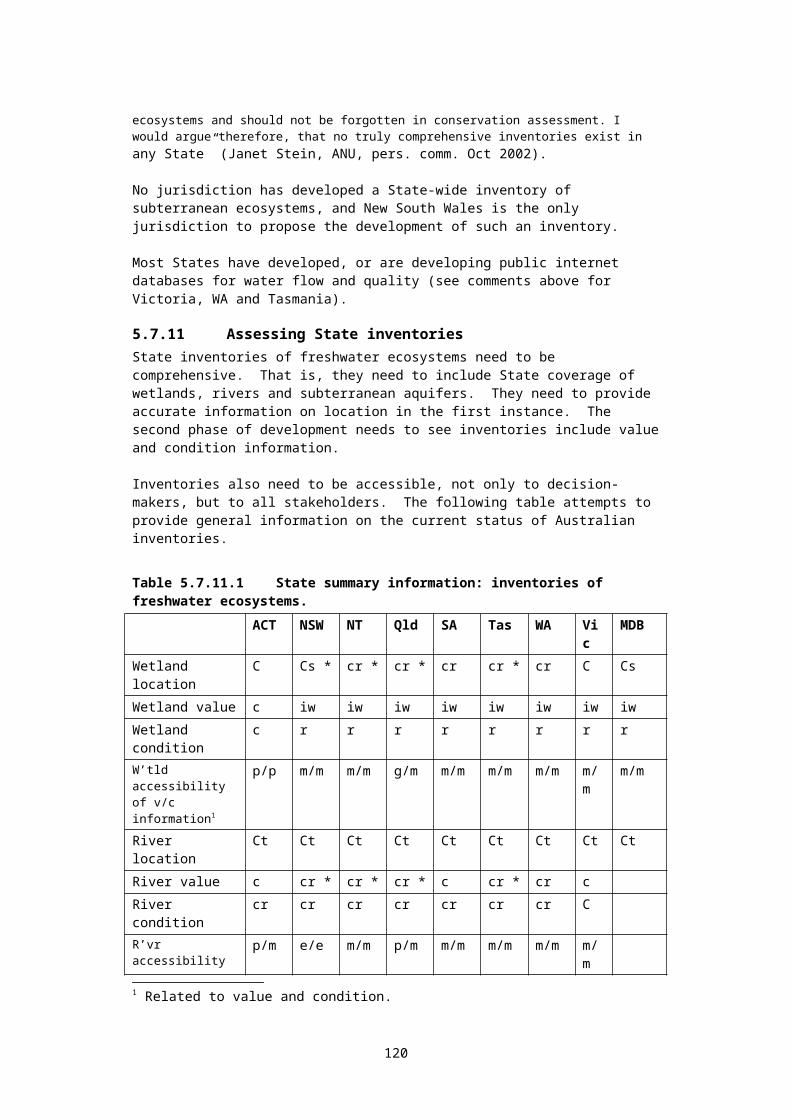
special protection for these rivers, and the rivers protected by the Act do receive special consideration in current catchment planning mechanisms260.
7.13.2 Bilateral agreements relating to overlap of State and Commonwealth powers
To repeat points made above, the Wentworth Group of Concerned Scientists (2002) as well as Cullen (2002) have argued for the identification, designation and protection of Australian rivers of national importance, or "heritage rivers". In addition, the recent report to the Prime Minister’s Science, Engineering and Innovation Council261 on Sustaining our Natural Systems and Biodiversity called for the establishment of a Heritage River system to protect high-value rivers.
Recent amendments to the Environment Protection and Biodiversity Conservation (EPBC) Act will allow the Commonwealth Government to list places, including rivers, under a new list called the National Heritage List262. Once on this list, a river could be protected under the Commonwealth powers invoked by the Act. These provisions amplify existing provisions in the Act relating to Ramsar sites (see section 6.1.2 above).
This is a potentially powerful tool for the Commonwealth, and may cause concern amongst State water management agencies. It will not be in the interests of water management agencies to have Commonwealth powers superimposed over their own management programs. In addition, the EPBC Act requires permits for some activities that effect listed species in inland waters263.
As a consequence, State water agencies could enter into dialogue with the Commonwealth in this regard. It is possible that bilateral memoranda of understanding may eventuate from such discussions, and it is also possible that such MoUs will contain commitments by the States to identify and apply special protection to particularly important rivers and estuaries (wetlands, to some extent, are already covered by Ramsar agreements, and by the statutory assessment and planning provisions linked to listing in the Directory of Important Wetlands). As mentioned above, some jurisdictions, like Victoria and the ACT (and shortly Tasmania) already have such protective arrangements in place.
Such MoUs may also allow (or require) the Commonwealth to take action where required action is not being taken by the State. The recent legal action by the Commonwealth in relation to illegal landowner clearing in the Gwydir Wetlands presents an example of Commonwealth legal action in a situation where the State government (NSW) has chosen not to enforce its own protective legislation. The substantial failure of the NSW government to enforce its land clearing legislation is documented on the Australian Broadcasting Commission's Background Briefing of September 14, 2003.
7.13.3 A national system of CAR freshwater reserves.To summarise information presented in Chapters 1, 2, 3 and 4 above: a cornerstone of biodiversity protection (first articulated in the international context in the World Charter for Nature 1982) is the tenet that, where ecosystems are subject to significant modification by humans (through harvesting, pollution, resource extraction, or the introduction of new species, for example) it is necessary to set aside representative examples of these ecosystems to provide biodiversity “banks”, and benchmarks against which human management of the ecosystems can be measured in the long term.
The “mirror” of this tenet states that actions should also be taken in managed (utilised) ecosystems to minimise anthropogenic impacts by protecting natural values (including biodiversity) as far as practicable. Threatening processes need to be identified and managed as far as practicable everywhere, not just within the reserve system.
The above cornerstone is one of the key foundations of the international Convention on Biological Diversity 1992, and has been broadly adopted by all national biodiversity strategies developed by signatory-nations to the Convention, including Australia's strategy. The Australian biodiversity program was established by the National Strategy for the Conservation
120
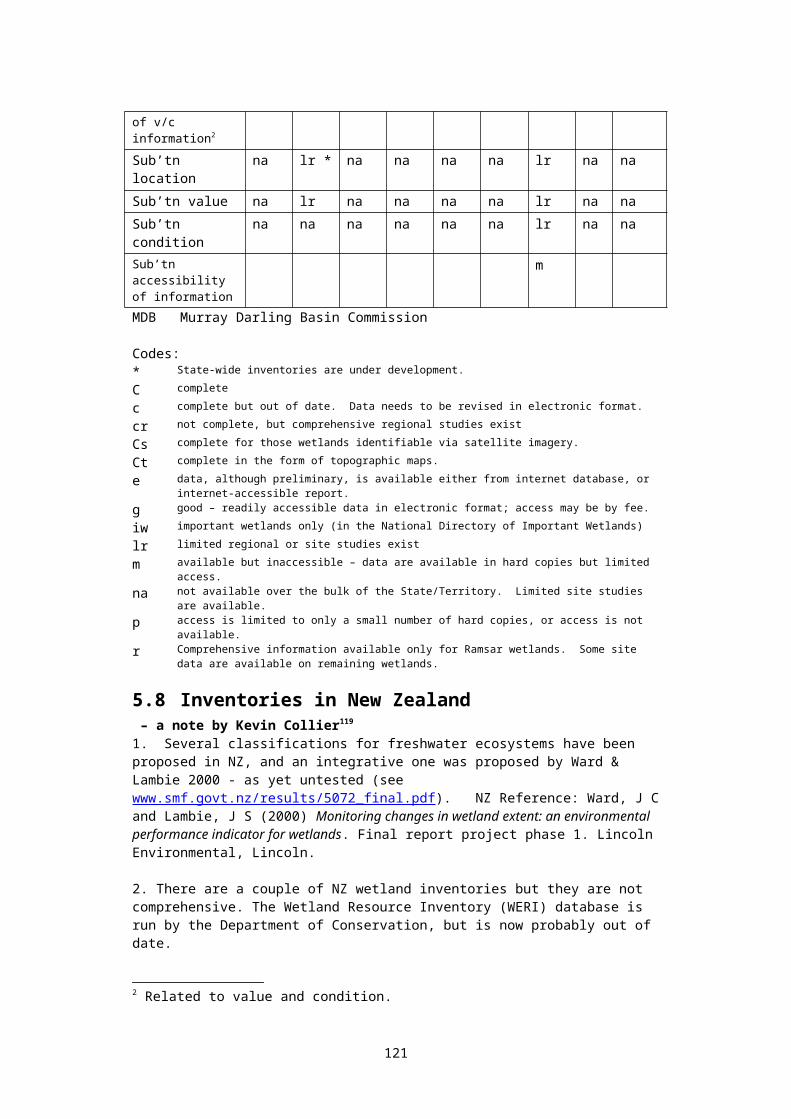
of Biological Diversity 1996, to which all Australian States are signatories. This strategy built on two existing inter-State agreements: the InterGovernmental Agreement on the Environment (1992) and the National Strategy for Ecologically Sustainable Development (1992).
Item 13 of the InterGovernmental Agreement on the Environment 1992 (to which all States are signatories) contains a schedule on Nature Conservation, which states that:
The parties agree that a representative system of protected areas encompassing terrestrial, freshwater, estuarine and marine environments is a significant component in maintaining ecological processes and systems. It also provides a valuable basis for environmental education and environmental monitoring. Such a system will be enhanced by the development and application where appropriate of nationally consistent principles for management of reserves. (Commonwealth of Australia 1992b; p. 40)
In summary, Australia signed the international Convention on Biological Diversity in 1992. This convention committed signatories to the development of representative reserve systems in terrestrial, marine and freshwater environments. The Council of Australian Governments (the Commonwealth and all State and Territory governments) committed themselves to the development of such reserve systems in the InterGovernmental Agreement on the Environment 1992. This commitment was reinforced in 2004, when a revised programme of work on inland waters was adopted by the 7th Conference of Parties to the Convention on Biological Diversity recently held in Malaysia. Among a raft of key expectations it has of parties, the revised program states that each signatory should establish “....comprehensive, adequate and representative systems of protected inland water ecosystems …”
All State and Territory governments have funded programs for the development of CAR reserve systems in terrestrial and marine environments. Only Victoria, Tasmania and the Australian Capital Territory have funded programs for the development of CAR reserves in freshwater environments. Such reserve systems remain incomplete in Victoria and Tasmania. Although the remaining States and the Northern Territory are committed at the policy level, funding the development of such reserve programs has yet to commence. It should be noted that all jurisdictions have established significant reserves, such as the Ramsar sites, protecting some freshwater environments.
A detailed discussion of national agreements and programs is set out in Appendices 2 and 3.
In the medium to long term, a national framework to protect high conservation value rivers and estuaries could be extended to encompass the development of CAR freshwater reserves, thus including a variety of ecosystems, such as subterranean ecosystems, not presently adequately protected.
7.13.4 Natural resource accounting:In the long term, a State's natural resource accounting framework would start with the explicit recognition that (a) natural assets belong both to the present and the future, and (b) ecosystems services supplied by these assets need to be paid for.
Outside Crown reserves, aboriginal land, and urban and rural-residential areas, Australia's rural land lies in the hands of a relatively small group of landholders and lease holders. There are only about 150,000 properties over 10,000 ha in size264 across the continent. Any program developed by governments to pay these agriculturists for ecosystem services should incorporate the concept of natural resource accounting.
To manage any resource, it is necessary to keep track of stocks and flows. Audits must be undertaken at regular intervals, and reports prepared. Stock inventories must include information on condition. Reports must reconcile and explain changes which have taken place.
Within a bioregional framework, a State could prepare a comprehensive inventory of all freshwater ecosystems, encompassing value benchmarks, condition indices, catchment
121
boundaries, and environmental flow requirements. The inventory would be utilised by State-of-the-Environment reports, and by the State’s EIA and landuse planning frameworks.
Where they are inter-connected, surface water and groundwater resources need to be managed together, as a single resource. Stocks and flows of both resources need to be measured and estimated. Aquifer recharge areas should be identified and protected, and flow rates estimated. The interchanges between surface and groundwater flows should be studied and modelled, and the quality of groundwater monitored and reported.
Corporations which use significant natural resources, including farming operations, would be required to include "earth accounts" in every annual report.
For example an early application might well identify the Murray-Darling as a priority area. Natural resource accounting could be phased-in initially based only on salinity. Managers of land over a prescribed size could be required to submit an annual salinity report, reporting on salinity levels in soils, near-surface aquifers, and in drainage from their properties. The report would need a similar standing to the standard annual tax return, with prescribed time lines, enforcement and sanctions. Over time, this approach could be extended to all landholders, and to other issues such as nutrient budgets. Much farther down the track, pest control, native vegetation, and wetland management could be introduced, depending on the success and acceptance of the program. (Refer to Whitten et al. (2002) for an overview of incentive opportunities).
It is important that such an approach be developed in tandem with payments made to large rural landholders for ecosystem services. For example, since 1997, the government of Costa Rica has been paying landowners for several ecosystem services: carbon sequestration and protection of watersheds, biodiversity, and scenic beauty. The payments, about US$50/ha-year, are financed in part by a tax on fossil fuels and are resulting in significant forest conservation and restoration. Costa Rica has also sold carbon sequestration credits to several European nations (Castro et al. 2000 quoted in Daily et al. 2000). The development of these types of payment in Australia is urgent.
It is also worth noting that a core recommendation emerging from the 1992 United Nations Rio Conference on Environment and Development was that nations should “promote the development and application of methods such as national resource and environmental accounting that reflect changes in value resulting from uses of coastal and marine areas…” (Agenda 21 chapter 17).
122
8. The direction of current programs and the need for action
8.1 To recapitulate: a historical perspectiveThe development of systems of representative freshwater reserves needs to be understood in light of the development of representative reserves in terrestrial and marine environments.
The creation of terrestrial reserves preceded the creation of marine reserves by around one hundred years. Freshwater reserves, in their own right, have been an even more recent development265. For most of the last century, terrestrial reserves were created for a variety of reasons, and were mostly established by ad hoc or opportunistic pressures. Even though Australia made an international commitment to the establishment of representative ecosystem reserves 20 years ago, it is only in the last 10 years that most nature conservation agencies have embraced the goal of representing the wide range of ecosystems within each jurisdiction in a system of protected areas.
Within the Australian context, both Commonwealth and State governments are now firmly committed to the establishment of comprehensive, adequate and representative systems of terrestrial reserves, and these programs have now been funded for the best part of a decade. Pressey, however, notes that: "Stating the goal of representativeness in policies and media releases is easy. Applying it to the landscapes that most need protection is difficult, and for the most part, still avoided" (Bob Pressey, pers. comm. June 2001).
Given the slow start that these programs have had, it is understandable that priority has been given to planning at the regional and landscape level. However, these broad-scale programs are now sufficiently well established, we argue, for matters of finer detail to be considered - such as freshwater ecosystems. Pressey has noted that the lack of detailed data and analysis has also been a flaw in the planning of terrestrial reserves (Bob Pressey, pers. comm. June 2001), and this issue clearly needs to be taken into account in regard to the planning of networks of representative freshwater reserves.
It is true that existing systems of terrestrial reserves protect many important freshwater ecosystems. Currently, States and Territories are required to report biennially to the Commonwealth Department of Environment & Heritage (as part of the National Reserve System Program) on the development of the comprehensiveness, adequacy and representativeness of their respective reserve systems. We recommend that DEH include an additional request relating to the next biennial assessment which would require the States to focus reporting on freshwater ecosystems, particularly rivers and aquifer ecosystems. Such information should be made accessible to the public to determine the current state of reservation for freshwater ecosystems. Furthermore, more intensive bioregional analyses, such the one conducted by Fitzsimons & Robertson (2003) for wetlands in the Wimmera bioregion in Victoria, are required Australia-wide in order to assess existing reservation levels for freshwater ecosystems and issues of reserve design.
During the 1990s, all Australian States made policy commitments relating to the establishment of systems of representative freshwater reserves. In the case of Tasmania and South Australia, these commitments remain in draft form at June 2002. However, it must be said that (the special case of the Australian Capital Territory aside) these commitments266 have not been met. Moreover, an examination of State funding programs (discussed in appendices below) indicates that, in general, there has been no concerted effort by State governments to meet strategic biodiversity objectives in the freshwater area.
These commitments remain unfunded perhaps due to the finer scale of freshwater ecosystems, which has allowed them to slip through the net provided by the NRS methodology. Given the slow start that the terrestrial and marine programs have had, it is understandable that priority has been given in the past to planning at the regional and
123

landscape level. However, these broad-scale programs are now sufficiently well established, we argue, for matters of finer detail to be considered.
8.2 Difficulties in managing aquatic protected areasGenerally speaking, the three most important threats to freshwater ecosystems are catchment disturbance, alteration of natural flow regimes, and exotic pests (Saunders et al. 2002, Kingsford et al. 2005). Ideally, protected area management should aim to protect catchments from disturbance, deliver natural flow regimes, and eradicate exotic species. While these strategies present obvious difficulties, such objectives can be approached in many situations (refer to the seminal paper by Saunders et al. 2002 for discussion of general strategies). In the Australian scene, a number of issues and problems need to be addressed:
8.2.1 Linear connected reserves – special issuesThe fundamental element of representative reserve management is the separation, as far as possible, of the protected ecosystem from the processes which threaten it. The issue of how the catchment of a reserve might be protected provides an obvious complication with regard to freshwater reserves that does not generally apply to terrestrial or marine reserves267. The use of land and water upstream of the reserve will affect the viability of the reserve itself. The existence of downstream dams and weirs will inhibit or prevent fish passage.
Dunn (2000) 268 discussed potential barriers and constraints to river conservation in some detail. A summary of the main points of her discussion follows:
Rivers are linear, so that management needs to consider issues in relation to upstream, downstream and lateral elements of the river.
Water is essential to life and thus has multiple interest groups competing for its use. There may be conflict between State and national perspectives. There is a plethora of State legislation with potential conflicting approaches to river
management. This may also be reflected by multiple management responsibilities. Where more than one agency has responsibility, no-one takes responsibility.
Implementation of river management strategies may be recommended at a national or state level, but require action at a local or even property level.
Interstate boundary issues exist, with different management priorities and strategies potentially being applied to each bank of the river, or to the aquifer which feeds the river.
Where freehold land abuts a watercourse, many landowners are firmly committed to their riparian rights to water.
The general community may have unrealistic expectations for river management. It is often claimed that there is insufficient communication between researchers and river
ecologists with those who manage rivers. Rivers are conceptually difficult systems to understand and describe in the necessary
complexity. Funding issues are likely to restrict the effectiveness of river management. Economic pressures on river systems may result in conflicting demands for a limited
resource.
These difficulties are real, and must be acknowledged and taken into account. This aspect means that creation and management of the reserve must bear catchment issues in mind – and in some cases, seek to influence activities within the catchment in order to protect the values of the reserve. However, this complication is just that: a complication. It does not imply that the concept of a representative freshwater reserve is somehow different in principle to a terrestrial or a marine reserve. The essence of all reserves is that boundaries can be drawn, and management plans and programs prepared, to effectively protect the target ecosystem.
124
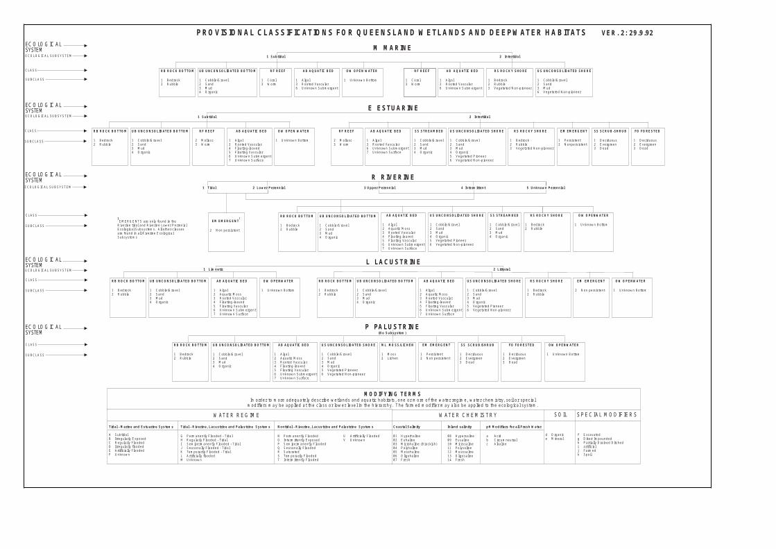
Fitzsimons & Robertson (2003) found that of the 232 wetlands that were at least part covered by a reserve in the Wimmera bioregion, Victoria, only 53 of these had their total area reserved. Further, it was found that while some 18.7% of the total wetland area in the Wimmera was reserved, the area of individual wetlands that were fully protected constituted only 4.5% of the total reserved area. By only reserving a portion of a wetland, it is likely that degrading processes occurring in unprotected areas will ultimately impact on the reserved portion of the wetland.
All reserves are affected to some extent by activities outside their boundaries; an example is the Great Barrier Reef - with current impacts from land use in very large coastal catchments. The management of representative freshwater reserves is difficult, but it is not impossible. The bottom line is a commitment to the protection of our freshwater biodiversity, as well as the wider values which representative reserves can protect.
In the case of short upper-catchment rivers, and wetlands and aquifers with relatively small catchments, efforts should be made to fully protect the entire catchment. It should be noted that Victoria's Heritage Rivers Act provides a high degree of protection to a number of small catchments, mostly catchments of small highland streams already within State Forest or National Parks (see discussion in the Appendices).
8.2.2 Protected area identification and selectionIn terms of general principles and approaches, the six stages identified in section 3.3 are largely transportable between terrestrial, freshwater and marine habitats. However, in a continent with large arid regions subject to unreliable and widely fluctuating rainfall, a number of points are of particular interest.
At locations where permanent water has been a feature of the landscape over long periods of time, habitats often display a narrow-range of locally endemic aquatic invertebrates (snails, crustaceans, flatworms etc.) that are poor dispersers and lack the capacity for active dispersal and desiccation resistant stages in their life cycles. Typical habitats are springs or spring-fed streams.
Species (such as those above) can have very small distributions and most may not be catered for in systems of protected areas, unless each critical site and its water supply can be fully protected. However, in many cases such ecosystems can be protected to a considerable extent outside reserves by maintaining water flow, riparian vegetation and exclusion of invasive exotics. This can be an issue of particular concern in forestry areas, and in pastoral and other rural areas, as well as some urban environments.
By far the largest amount of information regarding the distributions of aquatic animals is in museum collections. For most invertebrate groups this information is not yet databased. Undertaking this task to enable the accessing of this information as part of a national virtual aquatic biodiversity information system would be a cost effective way to generate a large amount of point data that is currently unavailable for many taxa. These data can then be subjected to spatial analysis, and used as biodiversity surrogates for mapping and protected area identification..
8.3 Key questionsAssuming that each jurisdiction will (at some stage) make funds available to implement existing government commitments, the discussion so far has raised a number of important questions:
What approaches are most suitable for classifying a full range of freshwater ecosystems? – including river, wetland, lake, estuarine and aquifer ecosystems?
What are the data requirements of such approaches, and to what extent is the necessary data available in each State? To what extent can it be made available using existing survey programs?
125

Should a consistent approach to classification be adopted across all eight jurisdictions, given the different size and resource base of the jurisdictions? Should a tiered or staged approach be developed which could be applied to delineate finer detail as more comprehensive supporting data becomes available?
What is the magnitude of the problem? To what extent do existing terrestrial reserves protect representative examples of freshwater ecosystems?
What principles should be used in reserve identification and selection? To what extent can those developed for terrestrial and marine ecosystems (see section 3.3) be applied to the freshwater scene?
What management approaches and guidelines are already available (for example the Wild Rivers Project run by the Commonwealth has produced a management guideline document in 1999 which is widely applicable to the management of connected linear reserves);
How should unique ecosystems be protected? For example a representative approach appears unsuited to the protection of subterranean or mound spring ecosystems where discrete habitats contains endemic species;
What kinds of protected areas are needed? How many are needed? How large should reserves be? How can issues of scales and connectivity be addressed in selecting and managing reserves and their catchments? How are ecosystems framed, and how do terrestrial links (landscapes) tie to aquatic concerns? Ecosystem fragmentation raises a whole set of issues, as does the integration of biophysical processes within management regimes.
Are new legislative approaches useful? Can the Victorian Heritage Rivers Act provide a useful model?
In terms of management approaches outside protected areas, why is there so little effective action being taken to address basic problems? (for example, grazing damage to riparian zones, and the management of the cumulative effects of incremental developments?)
The purpose of this resourcebook is not to attempt to find definitive answers to all these questions. However, in some cases this book does seek to identify useful approaches to answer specific questions, while in other cases the book seeks only to identify mechanisms through which such questions can be explored.
126

9. ConclusionsIt is clear that Australian freshwater ecosystems are under increasing threat. Additional information on the conservation status of species and ecosystems is urgently required. In 2003, seven of the Murray Darling Basin’s 26 native fish species were listed by the IUCN as threatened. A study of three aquatic invertebrate families in the southwest of WA (using IUCN criteria) found that 37% were threatened (Sutcliffe 2003). Few similar audits of conservation status are available269. Many threats to freshwaters are pervasive and intractable. Systems of terrestrial reserves have been established, and the largest of these, and those specifically targeted at wetland areas (such as Ramsar sites) undoubtedly protect some representative samples of major freshwater ecosystems. Urgent action is required to expand freshwater protected areas in all jurisdictions except the Australian Capital Territory.
As is the case in terrestrial and marine environments, there are a number of roles that representative freshwater reserves can play. These include (see section 4.3): protection of biodiversity against threatening processes through the establishment of
a comprehensive, adequate and representative system of reserves; provision for the conservation of special groups of organisms – for example, species
with complex habitat requirements, or mobile or migratory species, or species vulnerable to disturbance and which may depend on reservation for their conservation;
provision for the special needs of rare, threatened or depleted species, and threatened ecological communities;
provision of biodiversity ‘banks’ to recolonise damaged or degraded environments, whether such degradation has occurred by natural disaster, bad long-term management practices, or by accident;
provision of scientific reference sites, either for research, or to provide benchmark indicators by which sustainable management may be judged; and
protection of areas of high conservation value including those containing high species diversity, natural refugia for flora and fauna, and centres of species endemism;
assistance in the provision of ecosystem services: that is the provision of environments which sustain human life, including clean air and water, fertile soils, food, transport, flood mitigation, and the regulation of global weather patterns; and
within the constraints of the above, provision for the recreational, aesthetic and cultural need of indigenous and non-indigenous people.
However, in spite of international, national and State-level commitments to the establishment of representative systems of freshwater reserves, only Victoria and the Australian Capital Territory have made serious attempts to establish such reserves. Tasmania initiated a program in 2002 designed to protect comprehensive, adequate and representative examples of freshwater ecosystems, both by reservation and by alternative approaches.
The Australian Capital Territory has inherent advantages due to its small size, and the large amount of public land within its jurisdiction, and here some impressive reserves have been created. Victoria led the nation with its 1987 Nature Conservation Strategy, the subsequent Rivers and Streams Investigation by the Land Conservation Council, and the eventual passage of the Heritage Rivers Act 1992. However, the initial vision of the Victorian program has not been realised, and the issue is now in need of urgent review in that State (discussed above and in the appendices).
Australia's remaining five jurisdictions have not moved to implement their commitments. This delay should be seen within the perspective of the need to establish the broader bioregional National Reserves System, which has occupied most Australian nature conservation agencies over the last decade. This has, by necessity, focused attention at the bioregional and landscape level. An implicit assumption appears to have been made that protecting
127
representative terrestrial ecosystems will, by default, protect representative aquatic ecosystems. While this assumption is unlikely to be correct, the result has been that the protection of representative freshwater ecosystems escaped priority attention within the National Reserves System up until the 2004 review.
It is time for this approach to change. Sufficient progress has been made at broad planning levels now to justify turning attention to ecosystems of finer detail within the broad bioregional framework - in particular, rivers, lakes, wetlands and aquifers. Freshwater ecosystems should now be highlighted within the National Reserve System framework. Progress in this direction appears imminent (see discussion in section 6.1.4 above).
No Australian State has met its full Ramsar Convention obligations in relation to the preparation of comprehensive wetland inventories, using the Ramsar definition of ‘wetlands’ (see above). Partial inventories have been established, and these are valuable. They should now be expanded, using nationally agreed classification methods, to encompass all major freshwater ecosystems. These inventories can then be used to identify gaps in the existing reserve system. It is to be expected that the most significant gaps will relate to large lowland rivers, some types of floodplain wetlands, and aquifers with multiple recharge and discharge zones. Classification and assessment methods of potential relevance to the development of comprehensive freshwater inventories are set out in chapter 5 and Appendix 4.
There will be obvious difficulties involved in management issues due to the dependence of freshwater ecosystems on the condition and management of their catchments; however, just because something is difficult does not mean that it cannot be done.
Successful implementation of national and State commitments to freshwater reserve systems rests on two fundamental premises. First, Australia needs to supplement its bioregional planning and management framework with more detailed information applicable to specific small-scale habitats, such as those found in freshwater ecosystems. Second, that in implementing NRM strategic catchment management processes designed to protect freshwater values, it is essential to involve the wider community and all stakeholders early in the process of identifying and selecting areas for reservation.
While there is widespread support for extending the reach of voluntary conservation agreements and other landholder incentive mechanisms to complement on-reserve conservation management, there is a clear need to strengthen the role which regional planning agencies can play in the conservation of biodiversity. The development over the last five years of regional natural resource management agencies, driven in part by bilateral agreements between the Commonwealth and the States (see the discussion above and in the appendices) offers a major opportunity in this regard which may be lost if governments do not support the accelerated development of ecosystem inventories (see Chapter 5).
In regard to assessing the adequacy of existing reserves, and identifying and selecting additional reserves, basic requirements are:
a classification of freshwater ecosystem types that can be supported with data which is either available, or foreseeable within existing survey program budgets; and
targets for the protection of biodiversity pattern and process – this will involve the selection and use of biodiversity measurement surrogates.
These are basic requirements. The development of reserve identification, selection and management approaches should begin with the template of the ‘six stages’ set out in s. 3.3.
It is also worth noting the use of percentage targets by the National Forests Policy, and the bilateral Regional Forest Agreements which followed. The RFAs established a reservation target of 15% (of pre-European coverage) for major forest ecosystem types, with threatened ecosystems having higher targets. The use of such targets needs detailed consideration as programs for aquatic reservation develop over the next few years.
128
10. RecommendationsTo recapitulate, there are a small number of urgent issues. Firstly, although some representative examples of freshwater ecosystems are contained within existing protected areas, no systematic national review has been conducted to identify gaps in the reserve network. It is likely that many freshwater ecosystem types are not adequately protected – particularly those of riverine or subterranean nature. Secondly, although all jurisdictions are developing inventories of freshwater ecosystems, these remain incomplete. Nowhere are they comprehensive in the sense of containing up-to-date data on value, condition and threat over wetlands, rivers and subterranean ecosystems. The acceleration of work on inventories is urgent to underpin both protected area gap analysis studies, and developing regional NRM strategies. Thirdly, river degradation is ubiquitous and increasing over much of temperate Australia; the identification and protection of remaining rivers of high conservation value is urgent. In all three areas, the Commonwealth needs to play a leading role, particularly with respect to promoting and funding inter-State working groups to address these issues in a coordinated way. Fourthly, the sympathetic management of biodiversity outside protected area frameworks is essential, and urgent action needs to be taken to encourage and support biodiversity conservation measures on freehold and agricultural land. Fifthly, both terrestrial and freshwater reserves, such as Ramsar sites, are threatened by cumulative alterations in hydrologic connectivity within the greater landscape (Pringle 2001). It is essential that the management of cumulative effects be managed in a much stronger and more integrated fashion, with far greater attention to five key management principles (Appendix 15).
The long-term benefits of creating freshwater protected areas far outweigh short term costs. Many marine protected areas have been shown to enhance fisheries outside the protected zone (Gell & Roberts 2003). Some freshwater protected areas will have similar effects, with consequent benefits for recreational fishers. Australian hunter’s organisations have helped fund the purchase of freshwater areas which provide breeding grounds for ducks and other waterbirds. Farmers will benefit from the protection of aquifer recharge areas. Indigenous groups supported the formation of the first listed Ramsar site in the world: Coburg Peninsula in the Northern Territory. All Australians will benefit from the protection of our living freshwater environments – which have huge cultural, recreational, educational and spiritual values.
10.1 Development of a national freshwater protected area framework
We believe that Australian nature conservation programs are now at the point where effort needs to be focused toward programs protecting existing high-value freshwater ecosystems . Given the continuing decline of inland aquatic ecosystems over much of the Australian continent, it is now urgent that the development of comprehensive, adequate and representative inland aquatic protected areas be elevated, nationwide, as a high priority. In addition to the protection of representative ecosystems, unique and vulnerable aquatic ecosystems need to be identified and protected. A national freshwater protected area framework needs to be developed.
Our three central recommendations on this issue are that:1) National protocols be established for the collection and storage of freshwater
ecosystem attribute data to support the development of nationally compatible ecosystem classifications and inventories. The development of national and state freshwater ecosystem inventories is an Australian responsibility under the Ramsar convention270, and for the Commonwealth “a comprehensive national inventory remains a long-term goal”271. States are currently using different classification approaches of varying sophistication. Different approaches to classification can be useful, and no ideal classification exists to suit all purposes. Collecting and storing attribute data free of classification not only allows States to continue using existing classifications, but such an approach also opens an opportunity to use such data to develop separate national classifications and inventories. Such inventories would utilise nested hierarchies of ecosystem classifications, allowing the allocation of freshwater ecosystems into
129
(‘representative’) categories. Using nested hierarchies allows a staged approach, with initial work confined to the simpler categories supported by existing data. As more data becomes available, more sophisticated analysis can be undertaken. This approach to classification could underpin the development of a national inventory of freshwater ecosystems, including rivers, wetlands and aquifers (see section 5.9 above). The development of an ‘interim freshwater bioregionalisation of Australia’ would complement and extend the utility of such an approach;
2) A national approach be developed to enable the identification of gaps in the existing protected area system relating specifically to freshwater ecosystems. Such an approach would incorporate methods for identifying and selecting potential inland aquatic protected areas; and
3) Programs be funded to establish and manage a comprehensive, adequate and representative network of inland aquatic protected areas (which would be developed as an outcome of the implementation of the first two recommendations). This network would sit within a national framework, most probably as part of an expanded National Reserves System, and would utilise both State and Commonwealth funding.
These actions, we believe, should be initiated within the cooperative frameworks of the National Reserve System (NRS) and the NRM Ministerial Council, assisted by agencies such as the Commonwealth Department of Fisheries, Forests and Agriculture, and the Department of the Environment and Heritage (wetlands program). The National Audit, and Land and Water Australia (including the National Rivers Consortium) have much to contribute and need to be involved. The principles used in terrestrial and marine reserve identification and selection (see section 3.3) should provide a base for the development of national approaches.
As concerns developed three decades ago that the terrestrial reserves network should protect representative examples of terrestrial ecosystems, Specht (1975) recommended that at least one large sample of each major terrestrial ecosystem in each biogeographic division of each State should be incorporated into an ecological reserve, either by designating the whole or part of existing national parks and other nature conservation reserves as ecological reserves or, where necessary, by acquisition of land. The same logic can be applied today in relation to freshwater ecosystems, bearing in mind comments made above about the development of regionalisations applicable to freshwater ecosystems. All we need to do is replace the word “terrestrial” in Specht’s recommendation with the word “freshwater”.
It is instructive to note that various freshwater protection tools exist under State water, catchment and fisheries legislation, but that these provisions have generally not been used (to date) by jurisdictions with any enthusiasm (see Table 1.1 and Appendix 4). This is apparently due to the reluctance of the relevant management authorities to accept environmental responsibilities which they now have within their mandate, but have historically been the province of nature conservation agencies. Such agencies have generally not seen nature conservation, particularly relating to site reservation or protection, as part of their core business. As a consequence, these legislative protection tools lie largely unused at this point in time.
10.2 Protection of rivers of high conservation value:Given the development of national databases containing information on freshwater ecosystems, it is now feasible to develop a national framework for the protection of high conservation value (HCV) rivers.
Four measures are recommended for immediate action:
4) the Commonwealth should fund, under a inter-State steering committee, the identification of where the highest river values exist, where they are most at threat, and where such values might be most effectively and efficiently protected. Refer to the discussion of values in Appendix 7.
5) the Commonwealth should initiate, fund and convene an inter-State working group to discuss and develop mechanisms to protect high conservation value rivers, with particular focus on the possibility of adapting the Canadian Heritage Rivers System
130

to the Australian situation. Refer to Chapter 7 discussing mechanisms, and Appendix 14 on the Canadian system.
6) bearing in mind the wide definition of ‘wet land’ contained within the Ramsar Convention and national directory frameworks, immediate steps (coordinated and partly funded by the Commonwealth) should be taken to accelerate the use the existing Ramsar framework to identify, select and protect rivers of high conservation value (rivers of international importance). Until more rigorous quantitative criteria are developed for identifying and selecting rivers of HCV than are provided for by the Ramsar criteria and the Ramsar strategic framework guidelines272, these criteria provide a useful interim approach;
7) Commonwealth funds should be provided to the States to accelerate the assessment of rivers against the importance criteria which underpin listing in the Directory of Important Wetlands in Australia (rivers of national importance), and States should be encouraged to add important rivers to the Directory;
Additional information on the protection of high conservation value rivers is provided in Chapter 7, which outlines a variety of measures which might be taken in the medium or long term. These need to be considered by all three levels of government, as well as by regional natural resource management agencies.
10.3 Sympathetic management of utilised ecosystems:Australian governments, at all three levels, need to do much more to encourage the sympathetic management of land outside networks of protected areas (see s.6.1.5.2). Key strategies which need urgent attention, especially by Commonwealth and State governments, relate to:
8) developing effective strategic approaches within regional NRM planning frameworks to address the impacts of cumulative water-related development within individual catchments. Comprehensive inventories of freshwater ecosystems are essential to support NRM planning processes (see above); in addition, the precautionary principle (see Appendix 15) needs much stronger emphasis;
9) adequate financial compensation to landholders for the provision of ecosystem services; (refer to Whitten et al. 2002 on incentive programs) and
10) together with the above, a gradual phasing in of natural resource accounting requirements targeted at large corporate landholders (see section 7.13.4).
Bearing in mind the importance of the CoAG water reform framework in encouraging more effective management of the water resource by State governments (Appendix 3 and 4), and bearing in mind the recommendations of the Wentworth Group (Appendix 12) it is essential that the 2004 revision of the CoAG framework incorporate:11) mechanisms to encourage States to identify and protect rivers of special
importance (see discussion above and Chapter 7); and
12) mechanisms to encourage the States to implement effective procedures for the strategic management of the cumulative effects of incremental water developments (referred to in the Wentworth report as the need for ‘comprehensive water accounts’). Refer to Appendix 15 for additional information on the management of cumulative effects.
Urgent work is also needed to extend existing thinking on freshwater protected area management strategies, and to develop guidelines specific to different types of Australian freshwater ecosystems. The seminal work by Saunders et al. (2002) provides a starting point for such studies.
131

11. BibliographyIn order to shorten the length of this document please access the bibliography at http://www.onlyoneplanet.com/ASL_bibliography.htm .
12. AbbreviationsACT The Australian Capital Territory.AFFA (Commonwealth Department of) Agriculture, Forestry and Fisheries Australia.AGPS Australian Government Publishing Service.AHC Australian Heritage Commission.ANZECC Australian and New Zealand Environment and Conservation Council.ARMCANZ Agriculture and Resource Management Council of Australia and New Zealand.ASL Australian Society for Limnology.Audit (the) The National Land and Water Resources Audit.AWRC Australian Water Resource Council.CALM WA Department of Conservation and Land Management.CAMBA China – Australia Migratory birds Agreement.CAR Comprehensive, adequate and representative.CEs Cumulative effects of incremental water infrastructure development.CITES Convention on International Trade in Endangered Species (of Wild Fauna and Flora).CFEV Conservation of Freshwater Ecosystem Values (CFEV) Project, Tasmania.CoAG Council of Australian Governments.CRCCZEWM Cooperative Research Centre for Coastal Zone, Estuary and Waterway Management
(CSIFE Comprehensive State Inventory of Freshwater Ecosystems.CSIRO Commonwealth Scientific and Industrial Research Organisation.Cumulative effects: short for: “cumulative effects of incremental water infrastructure
development”.DEH Department of the Environment and Heritage, Australia (Commonwealth Department)DIPNR Department of Infrastructure, Planning and Natural Resources (NSW).DLWC Department of Land and Water Conservation (NSW) now called DIPNRDNR Department of Natural Resources (Qld).DSR Victorian Department of Sustainability and EnvironmentECC Environment Conservation Council (Victoria).EIA Environmental impact assessment.EPP Environment Protection Policy (statutory policy under Qld’s Environment Protection
Act).ERIN Environmental Resource Information Network (EA)ERISS Environmental Research Institute of the Supervising ScientistESD Ecologically sustainable development.EWP Environmental water provision (used by the WRC in WA)EWR Ecological water requirement (used by the WRC in WA)FHA Fish habitat area (Qld Fisheries Act 1994).GDE Groundwater-dependent ecosystem.GL Gigalitre.GSL Great Southern Land: see the section titled: "Hypothetical case study".HCV High conservation value.IBRA Interim Bioregionalisation of Australia.ICM Integrated Catchment Management (equivalent to TCM).IGAE InterGovernmental Agreement on the Environment.IMCRA Interim Marine and Coastal Regionalisation for Australia.IPA Indigenous Protected Area.JAMBA Japan – Australia Migratory birds Agreement.LCC Land Conservation Council, Victoria.LUP Land use planning.LWRRDC Land and Water Resources Research and Development Corporation, now Land and
Water Australia.LWA Land and Water Australia.MDBC Murray-Darling Basin Commission.ML Megalitre.National biodiversity strategy: National Strategy for the Conservation of Australia’s Biological
Diversity 1996.
132

NCC National Competition Council.NCS Nature Conservation Strategy (ACT)NGO Non-Government Organisation.NHT Natural Heritage Trust.NLWRA National Land and Water Resources Audit.NPWS Natonal Parks and Wildlife ServiceNRC National Rivers ConsortiumNRHP National River Health ProgramNRM Natural Resource Management (a framework similar to the ICM concept).NRS National Reserves System.NRSMPA National Reserve Program for Marine Protected AreasNRSP National Reserves System ProgramNSW New South Wales.NSWF New South Wales Department of FisheriesNT The Northern Territory.NWQMS National Water Quality Management Strategy.NZ New Zealand.QFS Queensland Fisheries Service (part of Dept Primary Industries).Qld Queensland.RFA Regional Forest Agreement(s).RRs Representative Reserves.SA South Australia.SPP Statement of Planning Policy (WA).State used here to include all Australian States and Territories.Tas Tasmania.TCM Total Catchment Management (equivalent to ICM).UNESCO United Nations Economic, Social and Cultural Organisation.VCA Voluntary Conservation Agreement (under the NSW NPW Act 1974).Vic Victoria.WA Western Australia.WCP Wetlands conservation policy.wetlands Used in two meanings in this paper, depending on context. The Ramsar definition of
wetlands ('wet lands') includes rivers and streams; while the more common understanding of the term in Australia excludes rivers and streams. See discussion at section 2.4 and Appendix 8.
WISE Water Information System for the Environment (NSW).WRC Water and Rivers Commission, WA.WRMC Water resources management committee (WA)WWF Worldwide Fund for Nature (formerly World Wildlife Fund).
133
13. Appendices
Appendix 1.Summary and objectives of IUCN Protected Area Management Categories
CATEGORY Ia Strict Nature Reserve: Protected Area managed mainly for scienceArea of land and/or sea possessing some outstanding or representative ecosystems, geological or physiological features and/or species, available primarily for scientific research and/or environmental monitoring.
Objectives: to preserve habitats, ecosystems and species in as undisturbed state as possible; to maintain genetic resources in a dynamic and revolutionary state; to maintain established ecological processes; to safeguard structural landscape features or rock exposures; to secure examples of the natural environment for scientific studies, environmental
monitoring and education, including baseline areas from which all avoidable access is excluded;
to minimise disturbance by careful planning and execution of research and other approved activities;
to limit public access.
CATEGORY Ib Wilderness Area: Protected Area managed mainly for wilderness protectionLarge area of unmodified or slightly modified land and/or sea, retaining its natural character and influence, without permanent or significant habitation, which is protected and managed so as to preserve its natural condition.
Objectives: to ensure that future generations have the opportunity to experience understanding and
enjoyment of areas that have been largely undisturbed by human action over a long period of time;
to maintain the essential natural attributes and qualities of the environment over the long term;
to provide for public access at levels and of a type which will serve best the physical and spiritual well-being of visitors and maintain the wilderness qualities of the area for present and future generations;
to enable indigenous human communities living at low density and in balance with the available resources to maintain their lifestyle.
CATEGORY II National Park: Protected Area managed mainly for ecosystem conservation and recreationNatural area of land and/or sea, designated to (a) protect the ecological integrity of one or more ecosystems for this and future generations, (b) exclude exploitation or occupation inimical to the purposes of designation of the area and (c) provide a foundation for spiritual, scientific, educational, recreational and visitor opportunities, all of which must be environmentally and culturally compatible.
Objectives: to protect natural and scenic areas on national and international significance for spiritual,
scientific, educational, recreational or tourist purposes; to perpetuate, in as natural a state as possible, representative examples of physiographic
regions, biotic communities, genetic resources, and species, to provide ecological stability and diversity;
to manage visitor use for inspirational, educational, cultural and recreational purposes at a level which will maintain the area in a natural state or near natural state;
134
to eliminate and thereafter prevent exploitation or occupation inimical to the purposes of designation;
to maintain respect for the ecological, geomorphologic, sacred and aesthetic attributes which warranted designation; and
to take into account the needs of indigenous people, including subsistence, in so far as these will not adversely affect the other objectives of management.
CATEGORY III Natural Monument: Protected Area managed for conservation of specific natural featuresArea containing one or more specific natural or natural/cultural feature which is of outstanding value because of its inherent rarity, representative or aesthetic qualities or cultural significance.
Objectives: to protect or preserve in perpetuity specific outstanding natural features because of their
natural significance, unique or representational quality, and/or spiritual connotations; to an extant consistent with the foregoing objective, to provide opportunities for research,
education, interpretation and public appreciation; to eliminate and thereafter prevent exploitation or occupation inimical to the purpose of
designation; and to deliver to any resident population such benefits as are consistent with the other
objectives of management.
CATEGORY IV Habitat/Species Management Area: Protected Area managed mainly for conservation through management interventionArea of land and/or sea subject to active intervention for management purposes so as to ensure the maintenance of habitats and/or to meet the requirements of specific species.
Objectives: to secure and maintain the habitat conditions necessary to protect significant species,
groups of species, biotic communities or physical features of the environment where these require specific human manipulation for optimum management;
to facilitate scientific research and environmental monitoring as primary activities associated with sustainable resource management;
to develop limited areas for public education and appreciation of the characteristics of the habitats concerned and of the work of wildlife management;
to eliminate and thereafter prevent exploitation or occupation inimical to the purposes of designation; and
to deliver such benefits to people living within the designated areas as are consistent with the other objectives of management.
CATEGORY V Protected Landscape/Seascape: Protected Areas managed mainly for landscape/seascape conservation and recreationArea of land, with coast and seas as appropriate, where the interaction of people and nature over time has produced an area of distinct character with significant aesthetic, cultural and/or ecological value, and often with high biological diversity. Safeguarding the integrity of this traditional interaction is vital to the protection, maintenance and evolution of such an area.
Objectives: to maintain the harmonious interaction of nature and culture through the protection of
landscape and/or seascape and the continuation of traditional land uses, building practices and social and cultural manifestations;
to support lifestyles and economic activities which are in harmony with nature and the preservation of the social and cultural fabric of the communities concerned;
to maintain the diversity of landscape and habitat, and of associated species and ecosystems;
to eliminate where necessary, and thereafter prevent, land uses and activities that are inappropriate in scale and/or character;
to provide opportunities for public enjoyment through recreation and tourism appropriate in type and scale to the essential qualities of the areas;
135

to encourage scientific and educational activities which will contribute to the long term well-being of resident populations and to the development of public support for the environmental protection of such areas; and
to bring benefits to, and to contribute to the welfare of, the local community through the provision of natural products (such as forest and fisheries products) and services (such as clean water or income derived from sustainable forms of tourism).
CATEGORY VI Managed Resource Protected Areas: Protected Area managed mainly for the sustainable use of natural ecosystemsArea containing predominantly unmodified natural systems, managed to ensure long term protection and maintenance of biological diversity, while providing at the same time a sustainable flow of natural products and services to meet community needs.
Objectives: to protect and maintain the biological diversity and other natural values of the area in the
long term; to promote sound management practices for sustainable production purposes; to protect the natural resource base from being alienated for other land-use purposes that
would be detrimental to the area’s biological diversity; and to contribute to regional and national development.
Source: IUCN (1994). Guidelines for protected area management categories. Commission on National Parks and Protected Areas with the assistance of the World Conservation Monitoring Centre. IUCN, Gland, Switzerland.
136
Appendix 2:Freshwater biodiversity conservation: international and national agreements
Edited (updated) extract from Nevill 2001.
A2. International and national context
A2.1 The cornerstone: Effective protection of biodiversity depends on two key elements: sympathetic management of utilised ecosystems and the creation of protected areas.
A cornerstone of biodiversity protection (first articulated in the international context in the World Charter for Nature 1982) is the tenet that, where ecosystems are subject to significant modification by humans (through harvesting, pollution, resource extraction, or the introduction of new species, for example) it is necessary to set aside representative examples of these ecosystems to provide biodiversity “banks”, and benchmarks against which human management of the ecosystems can be measured in the long term.
The “mirror” of this tenet states that actions should also be taken in managed (utilised) ecosystems to minimise impacts by protecting natural values (including biodiversity) as far as practicable. Threatening processes need to be identified and managed over the entire landscape, not just within reserves.
Where reserves are created to protect representative ecosystems, such reserves should be ecologically viable. They should be large enough to support species at the top of the food chain, such as the peak predators, and should be of sufficient size to permit ongoing evolutionary processes to occur. In the words of the International Convention on Biological Diversity (UNEP 1992) they should be comprehensive, adequate and representative.
The above cornerstone is one of the key foundations of the International Convention on Biological Diversity, and has been broadly adopted by all national biodiversity strategies developed by signatory-nations to the Convention, including Australia's strategy. The Australian biodiversity program was established by the National Strategy for the Conservation of Biological Diversity 1996, to which all Australian States are signatories. This is referred to below in shorthand form as the national biodiversity strategy. This strategy was developed to provide a framework for Australia’s programs carried out in recognition of both international responsibilities273 and ongoing national responsibilities and programs (within the framework established by the Australian Constitution).
A2.2 Development of a national biodiversity strategyAustralia made a commitment to the development of systems of representative ecological reserves at least as far back as 1982, when Australian representatives at the United Nations supported the World Charter for Nature, a resolution of the General Assembly of the UN in October of that year. The reservation of representative examples of all ecosystems – terrestrial, marine and freshwater – is an important tenet of the Charter.
A decade later, the Australian Government ratified the international Convention on Biological Diversity 1992 on 18/6/93. This convention emerged from the Rio 1992 global environmental summit (the “Earth Summit”) and, among other things, laid the groundwork for the development of international and national systems of “protected areas”.
The commitments made by the Australian government in 1982 (and reinforced in 1992) to establish systems of reserves to protect representative ecosystems were expanded and re-enforced by the National Strategy for the Conservation of Australia’s Biological Diversity 1996, which listed this goal amongst its key objectives (Principle 8, page 6).
137
Principle 8Central to the conservation of Australia’s biological diversity is the establishment of a comprehensive, representative and adequate system of ecologically viable protected areas *, integrated with sympathetic management of all other areas, including agricultural and resource production systems.
* The use of the term “protected area” is derived from the work of the IUCN, reinforced by the international Convention on Biological Diversity, and applies equally to terrestrial, freshwater and marine ecosystems274.
The “reserves” aspect of this principle has been applied to Australia’s terrestrial ecosystems, principally through State conservation reserves, Regional Forest Agreements (RFAs), and funding from the National Reserve System (NRS) component of the Natural Heritage Trust program. As a result, most terrestrial forest ecosystems have a reasonable degree of protection, with many approaching the RFA’s 15% target275.
Funds from the NRS program have been used to acquire some wetland areas, but this has not been done on a systematic basis targeted at the development of 'comprehensive, adequate and representative' freshwater reserves. Nevertheless, the NRS Program has been successful in acquiring several major wetlands, particularly in NSW - as part of the terrestrial reserve program.
Principle Eight of the national biodiversity strategy is currently being applied to non-forest terrestrial ecosystems (such as grassy ecosystems) and to Australia’s marine ecosystems through the National Oceans Policy, Commonwealth and State marine reserve programs276, and other Commonwealth and State programs aimed at managing threatening processes in the marine environment.
However, with respect to freshwater ecosystems, the principle has either not been systematically applied by State governments, or attempts to apply the principle have not been effective. Western Australia, Queensland, Victoria, the Northern Territory, the Australian Capital Territory, and New South Wales have all, at one time or another, made policy statements committing to the development of systems of representative freshwater reserves. Tasmania seems likely to make this commitment in the near future. So far, only Victoria and the ACT have funded programs designed to put such a system in place. Unfortunately the Victorian program has not achieved its full objectives, and is in urgent need of review. Recent Victorian policy statements on protecting representative river ecosystems essentially re-state existing commitments which have remained without effective implementation since 1987.
In June 2001 the Commonwealth Government and five of the eight State and Territory jurisdictions launched the National Objectives and Targets for Biodiversity Conservation 2001-2005. The protection and restoration of freshwater ecosystems was identified as a priority, and a target was set “by 2005, all jurisdictions should have effective legislation and management plans in place to protect wetlands of national significance”. Given that some Ramsar management plans are still failing to deliver adequate environmental flows, that freshwater ecosystem inventories remain either incomplete or out-of-date in all jurisdictions, and that no jurisdiction except the ACT has implemented protective regimes for representative river ecosystems – it seems hard to argue that this target has been achieved.
Other international commitments are being implemented through the listing of large, especially important areas in the World Heritage Register, and the development of areas managed as Biosphere Reserves under the UNESCO Biosphere Reserves Program. At this stage Macquarie Island is Australia’s only formal biosphere reserve, although 12 areas have been nominated for reservation.
While considerable success has been achieved in protecting biodiversity at the terrestrial level, freshwater and marine ecosystem protection is lagging seriously behind. In Victoria, the Environment Conservation Council’s (ECC) figures show that at present only 0.05% of Victoria’s marine areas are currently protected. The ECC has recommended this be expanded to around 6%. (ECC 1999)277.
138
A2.3 CoAG Water Reform AgendaThe Council of Australian Governments (CoAG) Water Reform Agenda278 (a major national strategy formalised by a CoAG agreement in 1994) lists ecological sustainability as a central element of the agenda.
As part of the CoAG water reform agenda, all Australian States have revised, or are revising, water legislation. One aspect of this revision allows investors (within certain constraints) to build dams and sell water – not an option available to the private sector under previous arrangements in several States. In some States (notably Tasmania and Queensland) these changes have produced a flurry of interest by investors in the construction of new dams.
The agenda stresses that issues of sustainability, and the environmental needs of rivers must be taken into account in planning water infrastructure developments.
In regard to the CoAG requirements relating to the sustainable development of water resources, the Strategic Water Reform Framework (1994) declared that: ‘future investment in new schemes or extensions to existing schemes be undertaken only
after appraisal indicates it is economically viable and ecologically sustainable’ and
‘where significant future irrigation activity or dam construction is contemplated, appropriate measures are to be undertaken to…allow natural resource managers to satisfy themselves that the environmental requirements of the river systems would be adequately met before (my emphasis) any harvesting of the water resource occurs’.
As mentioned above, the agenda lists ecological sustainability as a central element of the agenda. An essential part of any ecological sustainability program is the protection of biological diversity, and, as discussed above, a system of representative protected areas is one of the two central themes of biodiversity conservation, world-wide. However, this logical link has not been incorporated into CoAG processes or programs, as these programs operate only through existing Commonwealth / State multilateral agreements, which are themselves deficient in this respect. See discussion below.
Overall, the agenda has been a powerful influence in both environmental and economic areas, and readers are referred to Fisher (2000) for an overview of the environmental outcomes of the agenda's microeconomic reform package.
The support which the CoAG water reform framework has provided for both catchment management and the National Water Quality Management Strategy has been crucial in furthering good land and water management practices and Government programs over the last few years, and it is critical that these elements be maintained and strengthened by the outcomes of the CoAG meeting planned for April 2004.
A2.4 Current Australian natural resource management frameworksThe community is becoming more aware of the need to manage cumulative effects, and administrative decisions are starting to reflect this awareness (see Attachment One, which describes such a decision in Victoria in 2002). The frameworks which have been established to manage natural resources have moved in a positive direction, but have not moved fast enough or far enough. This section provides an overview of Australian natural resource management (NRM) administrative arrangements.
Both the Commonwealth Government and the State Governments have strong interests in promoting good management of the nation’s natural resources. As previously mentioned, the Commonwealth lacks the constitutional powers (but has the funds), while the States possess the powers to manage those resources (but in general rely on the Commonwealth for funding). The Commonwealth has the ability to provide incentives (through targeted funding programs) and the ability to impose limited prohibitions (through the Environment Protection and Biodiversity Conservation Act 1999).
The principal Commonwealth programs targeting NRM are: the National Action Plan for Water Quality and Salinity (the NAP); and
139
the Natural Heritage Trust (NHT).
Bilateral agreements exist between the Commonwealth and the States which establish frameworks for funding within both the NAP and the NHT programs. These agreements set out the terms of cooperation between the parties; in particular, they provide for the accreditation by the Commonwealth of regional NRM plans developed by regional NRM authorities established under State legislation. These authorities are empowered to spend (and in some cases to raise) public money. Appropriate reporting and other accountability arrangements have also been established for these agencies by State governments. These bilateral agreements provide the heads of authority under which Commonwealth funds are allocated to State natural resource management projects.
Taking the Tasmanian situation as an example, the State Government established a NRM Council, and three “regional committees” through the Natural Resource Management Act 2003. The State is divided into three NRM regions, West, North and South.
A single non-statutory NAP region spans parts of the north and south NRM regions. This region has been created as a device to assist planning related to the achievement of NAP objectives.
Under this framework, the NRM regional committees established by the Act develop regional plans, working within existing State statutory, policy and administrative arrangements. These regional plans are aimed at meeting both State and Commonwealth natural resource management objectives. The plans provide for the development of regional investment strategies, which in turn will be executed through the activities of State and local government agencies, and through activities (which could be carried out by farmers, contractors or corporations, for example) funded by either (or both) Commonwealth or State funds. Under existing arrangements, the regional plans must be accredited by the Commonwealth, and accepted by the States, by June 2004.
Ideally, a national framework including the development of comprehensive freshwater ecosystem inventories, and the identification and selection of freshwater protected areas (emphasizing river and aquifer protected areas) should be in place before June 2004, to allow the NRM planning process to incorporate mechanisms for putting controls in place necessary to manage the wider catchments of these areas. Given the timeframe, this seems unlikely to happen.
A2.5 Freshwater biodiversity programs: an important “gap”It is worth noting that a cornerstone of the Convention on Biological Diversity, and the national biodiversity strategy (that is: the creation of representative reserves279) did not appear in the “Actions” listed later in the national biodiversity strategy (see section 2.5 Water, p.21). Under subsection 2.5.1 we find that the “recommended action” relates solely to “establishing inventories of the condition and extent of wetlands, floodplains and riparian ecosystems”. There is no mention of the use of such inventories in strategic conservation planning, or their use in developing a system of representative reserves based on such information – even though these actions were (and are) being applied to terrestrial ecosystems280. The words chosen in the strategy were taken directly from the 1992 National Strategy for Ecologically Sustainable Development (objective 18.2), continuing what appears to have been an oversight in this earlier document.
This oversight appears to be a major gap that merits attention in the context of the ongoing program to implement the national biodiversity strategy (including the National Reserves System, and the Australian Biological Resources Study), as well as the ongoing program to implement the Council of Australian Governments (CoAG) Water Reform Agenda (such as the National River Health Program)281.
140
A2.6 International agreements relating to wetlands
A2.6.1 International Convention on Biological Diversity 1992The Convention (discussed above), ratified by Australia in 1993, requires that signatories to the agreement identify and monitor major representative ecosystems. The scope of the definitions of "ecosystems" and "habitats" in the extract below includes terrestrial, freshwater, and marine environments:
Convention Annex IIDENTIFICATION AND MONITORING1.Ecosystems and habitats: containing high diversity, large numbers of endemic or threatened species, or wilderness; required by migratory species; of social, economic, cultural or scientific importance; or, which are representative, unique or associated with key evolutionary or other biological processes (my emphasis);2.Species and communities which are: threatened; wild relatives of domesticated or cultivated species; of medicinal, agricultural or other economic value; or social, scientific or cultural importance; or importance for research into the conservation and sustainable use of biological diversity, such as indicator species; and3.Described genomes and genes of social, scientific or economic importance.
To fulfil this obligation, Australian States need to classify rivers, lakes, wetlands and aquifers according to criteria which will allow representative values to be identified, and representative reserves selected. Victoria has made some progress in this regard, while other States have not developed comprehensive freshwater inventories which could allow such identification and selection.
The convention committed Australian governments to establish protected areas. The commitment to establish freshwater protected areas was reinforced in 2004, when a revised programme of work on inland waters was adopted by the 7th Conference of Parties to the Convention on Biological Diversity held in Malaysia. Among a raft of key expectations it has of parties, the revised program states that each signatory should establish “....comprehensive, adequate and representative systems of protected inland water ecosystems …”
A2.6.2 Ramsar conventionThe Australian Government, on behalf of all its States, is a party to a number of “special purpose” international conventions that require it to protect natural areas. The most directly relevant of these for freshwater ecosystems is the Convention on Wetlands – often called the Ramsar Convention – which the Australian government signed in 1974, and which came into effect in 1975. “Wise use” is a key principle of the Convention282.
Under the convention, parties are required to:• nominate suitable sites as Wetlands of International Importance and to manage
those sites (and all wetlands in their jurisdiction) to maintain their ecological values;
• formulate and implement land-use planning procedures to include wetland conservation considerations;
• develop national systems of wetland reserves; and
• to co-operate with other nations in promoting the wise use of wetlands, where wetlands and their resources, such as migratory birds, are shared.
Listing of a wetland on the Ramsar list means that the member country undertakes to take special measures to ensure protection of the values for which it was listed. Australia was the first country to become a party to the Convention and also the first to nominate a site to the Ramsar list. This was the Coburg peninsula, an Aboriginal Land and Wildlife Sanctuary in the Northern Territory, which then became the world’s first Wetland of International Importance. Australia now has 49 wetlands on the list.
It is important to note that Ramsar's Criteria for identifying wetlands of international importance283 starts with "representative or unique wetlands". This criteria cannot be
141

applied in the absence of comprehensive inventories which embody classifications of wetland type284. After 30 years, Australia has fulfilled only part of its obligations under the Convention. Comprehensive wetland inventories, and comprehensive national reserve systems remain uncompleted.
A2.6.3 CAMBA and JAMBAAustralia is also a signatory to the Japan-Australia Migratory Birds Agreement (JAMBA) and the China-Australia Migratory Birds Agreement (CAMBA) which call for the protection of species and their habitats listed in the Agreements.
A2.6.4 DefinitionsThe definition of “wetlands” used in the Ramsar convention is of great importance, as the original definition encompassed all freshwater ecosystems, other than groundwater or karst285 ecosystems, and, importantly, includes all flowing waterways286. In other words, Ramsar’s use of “wetlands” includes all rivers and streams, as opposed to the meaning more commonly attributed to the term in Australia, which excludes such water bodies. However, in order to fulfil Australia's obligations under Ramsar, programs need to be developed covering all those ecosystems which are encompassed by the full Ramsar definition. In this document I use the term “freshwater ecosystems” to include all wetlands and rivers, plus all groundwater ecosystems.
Definitions used by the Commonwealth and States, and their implications, are discussed below in the section dealing with State programs. The most important variation (in terms of our discussion) relates to the inclusion or exclusion of rivers and streams.
A2.6.5 Directory of Important Wetlands in AustraliaThe Directory of Important Wetlands in Australia has been developed in part fulfillment of Ramsar obligations. In the directory, Australian wetlands have been broadly categorised according to their importance: ie: at international (per Ramsar), national and State levels. It should be noted that the Directory is incomplete at this stage, but has the potential to incorporate freshwater sites generally (both flowing as well as still) when Australian programs expand to cover all Ramsar wetland categories.
The Directory provides criteria for the identification of important wetlands within recognised bioregions and also has the ability to include wetlands additional to the Ramsar system, such as rock pools.
142
Appendix 3.Freshwater biodiversity conservation: Commonwealth programs
Edited (updated) extract from Nevill 2001.
This section (Appendix 3) takes a brief overview of progress made at the Commonwealth level in the development of programs designed to protect freshwater biodiversity, both through the creation of inventories and reserves, and though “best practice” management of modified freshwater ecosystems.
A3.1 The Commonwealth’s role.The Commonwealth Government287 is the agent that enters into international agreements such as those mentioned above. However, as previously discussed, the Australian Constitution places the prime responsibility for the management of the nation’s natural resources with the States and Territories. The Commonwealth Government’s financial resources288 enable it to implement or coordinate particular programs (for example, those in fulfillment of international responsibilities) either by special purpose funding programs (such as the National Reserve System Program), or by reaching agreements with the States (such as the InterGovernmental Agreement on the Environment, the national biodiversity strategy, or the CoAG water reform agenda – all signed off at the State level by State Premiers289).
The Commonwealth has published both a biodiversity strategy (1996) (discussed above) and a wetlands policy (1997) (discussed below) . As well as providing specific commitments regarding Commonwealth programs (which, for the most part, are limited to the relatively small areas of Australia under direct Commonwealth control) these documents provide a general framework for the development of State policies and programs. It should be noted, however, that some States (Victoria and NSW, for example) developed their wetland policies some years ahead of the Commonwealth.
An important aspect of the national biodiversity strategy is that it clearly acknowledges the intrinsic values of the planet which forms our home, irrespective of values for humans. The development of a "planetary stewardship" ethic is, arguably290, one of the most important environmental issues today, and it is disappointing to note that so far only the Australian Capital Territory, and to some extent NSW, have endorsed the Commonwealth's lead in this regard (see discussion below).
One of the most important facets of the CoAG water reform agenda (from the point of view of this paper) is that, at least in principle, States must develop water management frameworks which focus on sustainability. Under the agenda, State water legislation must provide for environmental flows. Agreed “national principles” provide a framework for environmental flow programs (ANZECC 1996). In practice, all States are developing environmental flow requirements, with NSW programs perhaps the most effective291 at this time.
The Commonwealth government, in general, has made clear commitments to the protection of freshwater biodiversity though both its policies and its funding programs. These programs, however, are complex, and made up of many “planks”. I argue in this document that critical aspects of freshwater biodiversity protection have “slipped though” the gaps between these planks.
A3.2 Commonwealth Wetlands PolicyIn 1997 the Wetlands Policy of the Commonwealth Government of Australia was published as part of Australia’s fulfillment of its obligations under the Ramsar Convention. The policy applies only to places under Commonwealth Government jurisdiction, and to decisions made by the Commonwealth government and agencies. In the policy, the Commonwealth seeks to lead by example, and there is an expectation that a national approach to wetland conservation and management will be achieved through the States and Territories developing their own wetland policies.
143
Using a variant of the Ramsar definition292 which excludes rivers, the policy requires the development of a wetlands inventory on Commonwealth land293, and commits the Commonwealth to work with the States to develop a national inventory of wetlands294.
However, the policy does not identify the need for CAR wetland reserves, thus missing an important link with Principle 8 of the national biodiversity strategy. Also, the limited definition used (cf: Ramsar) constricts the application of the policy – of particular relevance if the policy is designed to meet Ramsar obligations.
Although EIA mechanisms are supported with respect to Commonwealth wetlands295, the policy does not recognise the difficulties created by cumulative effects, or the need for strategic biodiversity conservation planning within ICM frameworks296.
In spite of its inheritance, the policy provides scant recognition for intrinsic values of wetlands297.
The objectives of the Commonwealth policy are to:• conserve Australia’s wetlands particularly through the promotion of their ecological,
cultural, economic and social values;• manage wetlands in an ecologically sustainable way and with a framework of
integrated catchment management;• achieve informed community and private sector participation in the management of
wetlands through appropriate mechanisms;• raise community and visitor awareness of the values, benefits and range of types of
wetlands;• develop a shared vision between all spheres of Government and promote the
application of best practice for wetland management and conservation;• ensure a sound scientific and technological basis for the conservation, repair and
ecologically sustainable development of wetlands; and• meet Australia’s commitments, as a signatory to relevant international treaties, in
relation to the management of wetlands (Australia 1997).
The policy establishes a number of guiding principles, which are intended to ensure that wetland conservation is part of the every-day decision-making of the Commonwealth.
A3.3 Commonwealth environmental assessmentAs discussed above, the Australian constitution has placed almost all direct natural resource management responsibilities in the hands of Australia’s middle tier of government: the States and Territories. To varying extents, States have delegated these powers to local governments. The Commonwealth have direct powers in specific cases, for example if Commonwealth land is directly involved, or (until 1999) if a proposal was likely to need Commonwealth authority to export. This split of Commonwealth and State responsibilities led to a situation where, in some cases, two separate but overlapping planning assessment processes were in operation. For example, a proposal to establish a woodchip mill with export potential would (prior to 1992) be channelled through two environmental impact assessments – one under State control, the other under Commonwealth control.
Every State developed its own assessment legislation covering major projects, while the Australian (Commonwealth) government operated its assessments under the Environmental Protection (Impact of Proposals) Act 1974. A common thread behind these assessment processes is that the responsibility for identifying and evaluating likely environmental effects rests with the project proponent and its consultants. Responsibility for assessing the importance of such effects in the context of the greater public good rests with the government.
All Australian governments agreed that the double process involved unnecessary delays and expense, and during the 1990s agreements and procedures were put in place to simplify the situation. The InterGovernmental Agreement on the Environment (Commonwealth of
144

Australia 1992a) was the first major step, and the replacement of the Impact of Proposals legislation with the Environment Protection and Biodiversity Conservation Act 1999 was the second.
The InterGovernmental Agreement established a wide-ranging basis for the delegation of Commonwealth assessment responsibilities to the States. This was subsequently expanded by the Commonwealth with the development of general principles for environmental assessment, designed as the basis for such delegation (ANZECC 1993, 1996, 1997). The core principles are:
Participation - the process should include adequate participation of all stakeholders. Transparency – impact assessment should be conducted through an established process.
All elements of the process should be clearly understood by all participants. Certainty - the process should have clear objectives, be consistent, and be conducted
within agreed time-frames. Accountability - decision makers within government need to be able to provide clear and
detailed reasons for their decisions to all stakeholders. Appeal provisions to an independent authority should exist. The assessment process should cover the life of the proposal, through project design, construction, operation and finally decommissioning: project operators must be accountable for commitments made during project approval.
Integrity - decisions need to be based on the best available information, and all relevant factors need to be taken into account by decision-makers. Where impacts are uncertain, outcomes should rely on sound risk assessment and management.
Cost-effectiveness - the process should meet its objectives while imposing the least cost to participants.
Flexibility - the process should be able to accommodate proposals varying in type, scope of impact, and complexity. Flexibility is desirable in terms of the form of assessment process, issues to be addressed, process time-frames, and degree of public participation.
Practicality - the process should recognise community concerns, commercial realities, best practice technology, and scientific uncertainties.
Precautionary - Where there are threats of serious or irreversible environmental damage, lack of full scientific certainty should not be used as a reason for postponing measures to prevent environmental degradation.
When the Environment Protection and Biodiversity Conservation Act 1999 came into force it provided clearer delegation arrangements for assessment processes. From the perspectives of this book, it is noteworthy that this Act provides a number of triggers which can precipitate Commonwealth involvement: for example, if a proposal is likely to involve an issue of international importance. Likely impacts on threatened species, or on a site of international significance (such as a Ramsar site) are deemed to signal international importance.
A3.3.1 Cumulative effects and the need for strategic assessment frameworksAn issue which as not been adequately resolved in Australia is the question of the assessment of the indirect effects of major projects. Traditional assessment processes, including those outlined above, rest on the premise that the proponent of a major project has a responsibility to assess the direct, but not the indirect effects of the proposal. It has been, and largely still is assumed that the responsibility for the assessment of indirect or cumulative effects rests with the government.
The result has been that a proposed dam is likely to be assessed only on its direct effects, even though its financial viability rests entirely on the development of irrigated crops in the surrounding region, and the environmental effects of these future irrigation areas may be very substantial. The dam proponent will argue that it should not be called on to assess these indirect effects, and the State government will invariably provide no more than a cursory assessment of such effects in its study of the proposal.
While the difficulties inherent in this situation are obvious, attempts at developing strategic regional assessment frameworks (see Thackway 1992) have not so far been successful. Regional natural resource management planning frameworks have developed in all States over the last five years, partly as a result of Commonwealth government funding linked to bilateral cooperative agreements, and these certainly show early promise. However several
145

commentators have identified the failure of State governments to effectively manage the cumulative effects of incremental water infrastructure development as one of the nation’s most serious natural resource management issues. The Wentworth Group of Concerned Scientists, for example, have recommended the development of “comprehensive water accounts” (Wentworth Group 2003). Nevill (see Appendix 15) argues that the States need to develop frameworks based on a number of clear principles if incremental impacts are to be managed –suggesting that management frameworks must have five critical elements to be effective.
Models for the assessment of major water infrastructure proposals have been developed. The Centre for Water Policy Research (CWPR) for example, published assessment guidelines in 1999, which attempted to address the issue of indirect effects. Nevill (2000) published an extension of these guidelines, with increased emphasis on indirect effects.
A3.4 Commonwealth reserve programs
A3.4.1 National Reserve System Program (NRSP)The NRSP is one of the key mechanisms by which the Commonwealth seeks to meet its commitments under the Convention on Biological Diversity. It was originally established as a cooperative program with the States and Territories, but is now funded under the Natural Heritage Trust. The goal of the NRSP is “to establish a comprehensive, adequate and representative (CAR) system of protected areas to conserve Australia’s native biodiversity”298. The scope of the NRSP covers terrestrial and freshwater ecosystems.
The NRSP utilizes the national Interim Biogeographic Regionalisation for Australia (IBRA) - a framework developed in cooperation with the States and Territories (under the auspices of ANZECC) - to determine priority regions and ecosystems for reservation. Within the IBRA framework, the NRSP encourages States and Territories to address CAR principles in establishing a national system of protected areas. Within these limits, the NRSP is concerned with all types of ecosystems299.
The NRSP does target the reservation of wetlands of international and national importance to some degree. Although the program has funded a small number of wetland acquisitions, it has, in previous years, been largely biased towards the reservation of particular terrestrial vegetation communities. Faunal values have been recognised and addressed in recent revisions of the NRSP guidelines.
The principle lying behind the selection of IBRA regions is the recognition that ecosystems depend largely on geology, landform and climate, mediated by community succession, fire, and of course the impact of human activities300. IBRA regions, then, are derived principally from geomorphology, as are sub-regions which most often use land system mapping as the basis for their derivation.
The reservation of sites solely on the basis of geology or geomorphic values has not yet been recognised as part of IBRA, and such sites are only picked up indirectly.
Both public and private land can be considered for protected area status under a number of schemes run by different States.
Freshwater ecosystems are not adequately addressed in the broad-scale IBRA analyses. This is a result of the importance of fine-scale geomorphic variations in determining the structure and function of freshwater ecosystems - and the fact that the primary focus of ecosystem and vegetation mapping in many States has been on terrestrial floristic variation as the basis for differentiating between ecosystems and communities. Some States, such as Victoria, include a geomorphic component in the delineation of vegetation and ecosystem type, but finer scale analyses are required in developing a regionalisation framework suited particularly to freshwater ecosystems.
146
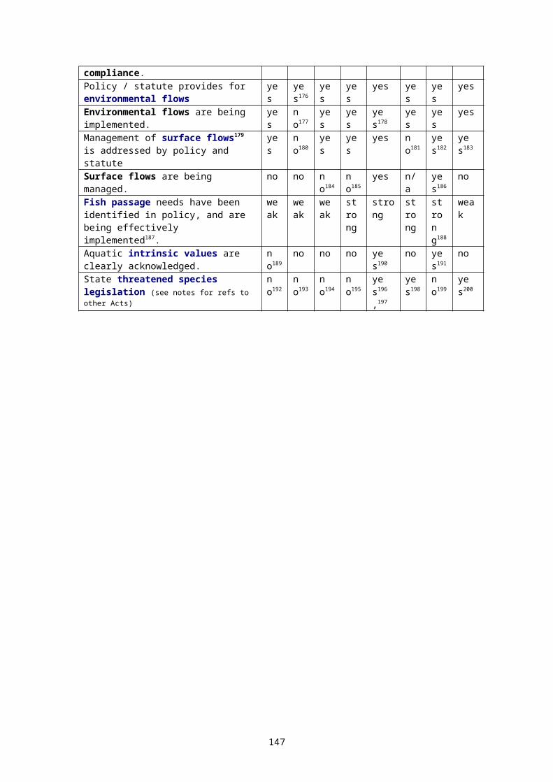
In summary, the IBRA framework was developed to assist the NRSP, and State governments, in identifying gaps in the developing system of representative terrestrial reserves. Its target is to develop and categorise biodiversity surrogates at the highest useful level. By necessity, it involves broad-scale amalgamations of information on geomorphology, geology, vegetation, climate and soil type. In its current form it represents extremely useful categorisations of habitat at the landscape and regional level. IBRA regions, for the most part, contain similar assemblages of terrestrial ecosystems. The recognition that geomorphology, to a lesser or greater extent, includes information on drainage formations is vital in understanding the relevance of the IBRA framework in relation to freshwater ecosystems. However, the IBRA framework provides no more than a useful base for categorising freshwater ecosystems, as it does not include information on hydrology, and the scale at which it has been developed is at least an order of magnitude above the scale necessary for categorising rivers, and most lakes and wetlands.
Marine reserves are supported under a different program run by the Commonwealth Oceans Office. Marine areas are targeted for protected area status based on the related Interim Marine and Coastal Regionalisation for Australia (IMCRA) which uses a similar broad-scale ecosystem-based approach.
The development of State systems of representative freshwater reserves should logically be carried out within this existing framework. As discussed below, Victoria, Western Australia, the Northern Territory, the Australian Capital Territory, and Queensland have made commitments (in the form of policy statements) to the establishment of systems of representative freshwater reserves. While New South Wales has made a commitment to the reservation of representative wetland types, this commitment is limited by the restricted definition of “wetlands” in the NSW Wetlands Management Policy. However, in spite of these commitments, no Australian State has moved to effectively implement such a system of reserves, and, at this stage, the NRS has not identified the development of such freshwater reserves in general as an important area for priority funding (having acknowledged above the NRSP targeting of wetlands of national importance).
I recommend that, as an urgent first step, viable examples (based on the CAR principles) of major distinct freshwater ecosystems should be identified and reserved within each IBRA region – in every State. Where no un-degraded representative examples exist, commitments should be made to the reservation and rehabilitation of at least one site within each IBRA region. The Commonwealth should take a lead in providing explicit “freshwater” funding within the NRSP program.
Moves should also be made to use the IBRA regions, and the principles lying behind their definition, to develop a regionalisation framework more specific to freshwater ecosystems.
The logic of Principle 8 of the national biodiversity strategy – with regard to freshwater - has not at this stage influenced funding for either the Commonwealth National Reserve System Program, or the Australian Biological Resources Study. While both programs are conceptually supportive of CAR freshwater reserves, neither is currently promoting the development of either comprehensive State freshwater inventories, or systems of CAR freshwater reserves.
A3.4.2 National Wetlands ProgramThe National Wetlands Program, like the NRS Program, runs within the budget of the Commonwealth Department of Environment and Heritage.
The National Wetlands Program funds actions related to Australia's international obligations under the Ramsar Convention (discussed above), such as policy development (eg: the Commonwealth's Wetlands Policy 1997 and related documents - discussed above).
The Directory of Important Wetlands in Australia is an important database developed by the program, which will be available online in its next edition.
147
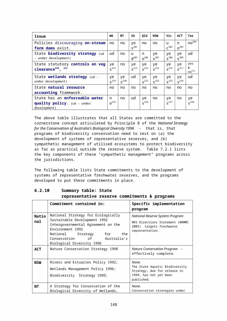
Wetlands on Commonwealth land are managed under this program. Management plans for these areas are developed and implemented with Ramsar obligations in mind.
A3.5 Environment Protection and Biodiversity Conservation Act Commonwealth legislation (the Environment Protection and Biodiversity Conservation Act 1999) has enlarged the Commonwealth’s potential involvement where a number of important issues (like threatened species, and Ramsar sites) are concerned (Environment Australia 1999).
This legislation (the EPBC Act) requires State governments to take more recognition and positive management of sites where listed species (that is: species listed under threatened species legislation - Commonwealth & State; or listed under international agreements – eg: JAMBA & CAMBA) occur. (JAMBA and CAMBA are referred to in the discussion below).
The Act defines matters of national environmental significance (Ramsar wetlands, listed migratory species, threatened species etc). The approval of Minister for Environment is required for actions likely to have a significant impact on these matters. The Act also contains environmental impact assessment provisions, and applies throughout Australia – not just on Commonwealth land. See section 6.1.2 above.
The Act also paves the way for more extensive use of bilateral environmental agreements between the Commonwealth and individual States, supplementing the use of multilateral agreements such as those underpinning biodiversity, ecologically sustainable development, and forest strategies, as well as the IGAE. Bilateral agreements are easier to negotiate, and are not constrained by the 'lowest common denominator' effect. They have the potential to provide "progressive" jurisdictions with additional Commonwealth assistance in some areas - giving both States and the Commonwealth some extra flexibility in program development (see section 8.10.2 above).
The EPBC Act provides an overarching assessments and approvals process for all activities which may impact on a Ramsar-listed wetland. Administrative Guidelines exist which assist in determining whether an action should be referred for assessment. In determining the impact of an action, other impacts and current condition can be considered, thus allow cumulative impacts to be taken into account. The EPBC website contains these guidelines and other useful information: http://www.environment.gov.au/epbc/ .
The Environment Protection and Biodiversity Conservation Act requires persons undertaking an activity that is likely to involve the killing, injuring, taking, trading, keeping or movement of a listed species in inland waters in a Commonwealth area to obtain a permit. It is possible that water infrastructure (such as irrigation works) which is likely to cause movement of a listed species may fall within these provisions.
A more detailed discussion of the implications of the EPBC Act for freshwater conservation is provided by Chapple (2000). However, the amendments to the Act passed in 2003 are of special importance, and are discussed in more detail in sections 6.1.2 and 7.13.2 above, and in Appendix 13. In brief, the 2003 amendments to the EPBC Act will allow the Commonwealth to list places, including rivers, under a new list called the National Heritage List. Once on this list, a river could be protected under the Commonwealth powers invoked by the Act.
A3.6 Freshwater reserves; the National Heritage frameworkThe freshwater reserve concept, while little used outside State wetland conservation programs (with the exception of the Victorian Heritage Rivers program discussed below) not only fits well within such programs as the National Reserve System Program, the National River Health Program, and the CoAG water reform agenda, but, in my view, is essential to adequately meet national and State commitments for the conservation of biodiversity.
There appear to be opportunities to use the 2003 amendments to the Commonwealth’s heritage regime to encourage the reservation and protection of representative freshwater
148
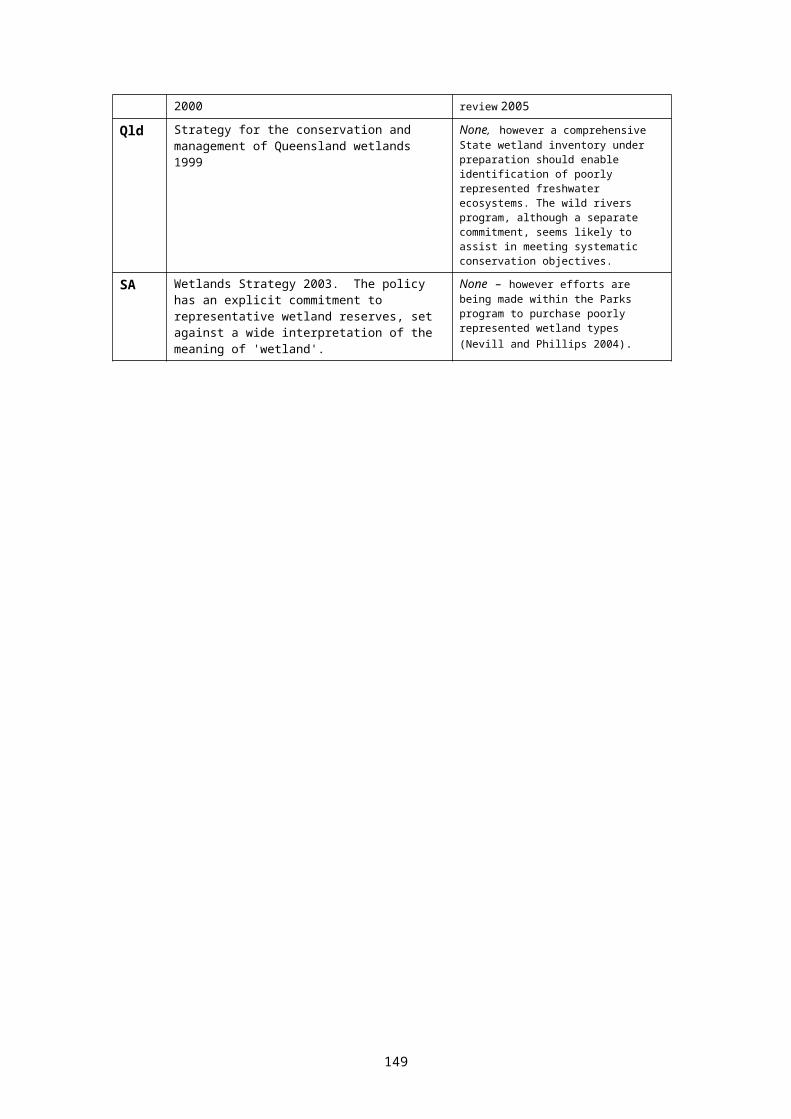
ecosystems. The Commonwealth has replaced the Australian Heritage Commission (AHC) with a new body, the Australian Heritage Council, using in part amendments to the Environment Protection and Biodiversity Conservation Act 1999301. The intent is to strengthen protection for places listed on two new lists: the National Heritage List, and the Commonwealth Heritage List. There is currently a Memorandum of Understanding between the Commonwealth Government and the AHC covering listing of places identified through Regional Forest Agreements. It is intended that the spirit of this memorandum will be met in the new heritage regime.
As discussed above, the RFAs, in part, seek to protect representative examples of terrestrial ecosystems. Logically, under the new heritage regime, areas reserved (or even simply identified) as significant representative freshwater (or marine) ecosystems should also be listed and protected through the same arrangements which apply to RFA reserves.
The use of these new tools warrants further consideration by both the Commonwealth and the States.
A3.7 National Wild Rivers ProgramWild Rivers’ was a national program initiated by the Commonwealth Government in 1993, with the primary objectives of identifying and encouraging the protection of rivers that remained largely unaltered by European settlement (Stein et al., 2001). It did not specifically identify high-conservation-value ecosystems or include wetland ecosystems.
The Wild Rivers Project systematically identified Australia’s wild rivers, and developed guidelines for the management of wild rivers.
A wild river, as defined by the project, is: a channel, channel network, or connected network of waterbodies, of natural origin and exhibiting overland flow (which can be perennial, intermittent or episodic) in which:
the biological, hydrological and geomorphological processes associated with river flow; and
the biological, hydrological and geomorphological processes in the river catchment with which the river is intimately linked,
have not been significantly altered since European settlement.
Wild rivers that may flow underground for all or part of their length (eg: through karst) are included.
Although lists of wild rivers were produced for each jurisdiction, strategic protection of identified rivers and river reaches never eventuated
The database was later revised on a low-key basis at the Department of Environment and Heritage, and is now entitled the Australian River Catchment and Condition database. This reflects that fact that the principal ongoing interest in the data-base is in its use as a strategic level indicator of condition across all watercourses on the continent, rather than the project's other brief of identifying significant rivers which were in particularly good condition302. The data was built on by the National Land and Water Resources Audit Assessment of River Condition project.
The original consultants (ANU CRES now incorporated within the Fenner School of Environment and Society) prefer to refer to it as the river disturbance database, as the link between the indices of anthropogenic disturbance and river condition is not fully understood, and in fact the full effect of these disturbances may not be evident in terms of river condition for many years (Stein et al. (1998); Stein et al. (2002)).
An upgrade to the wild rivers database sits within the continental landscape framework developed by the Fenner School to support the systematic identification of priority streams for conservation across Australia. The framework incorporates a hierarchical environmental classification with the disturbance indices as indicators of naturalness built upon a spatially
149

nested, hierarchical catchment reference system. The classification groups streams on the basis of the shared similarities of key abiotic attributes that drive hydrological, geomorphological and ecological processes and hence are responsible for observed patterns in stream characteristics at landscape scales. The consistent and comprehensive characterisation of streams that this framework provides enabled a review of the comprehensiveness and adequacy of the National Reserve System (Stein, 2006) and will assist other conservation assessment tasks including evaluation of ecological value criteria (eg: representativeness, uniqueness, naturalness) and the design of biological surveys. (Stein, 2006). The framework is currently being revised to reflect recent improvements in the drainage analysis on which it is based. Calculation of the wild rivers disturbance indices will incorporate more current disturbance information where it is readily available nationally. However, a more comprehensive revision of the wild rivers database will require additional resources.
Most rivers meeting the full "Wild Rivers" criteria in New South Wales, Victoria and Tasmania are those already protected by large terrestrial reserves. Due to the low level of development of Australia’s northern rivers, this is not true nationally – with only 13% of the length of the least disturbed streams falling in existing conservation reserves, 27% on Aboriginal managed land, 16% on vacant crown land and 36% on private land. Nearly 50% of streams flowing through nature conservation reserves were disturbed to some extent, for example, by upstream landuse.
The two most useful maps / datasets deal with (a) a catchment disturbance index, and (b) flow disturbance. Flow disturbance includes consideration of both weirs and dams, levee banks and water abstraction.
From the point of view of river management in general, perhaps the most important features of the wild river data are that the disturbance information can assist in identifying rivers of high ecological value, and assist in the reserve selection process once representative rivers and wetlands have been identified. Conversely, rivers with highly disturbed catchments and flows need priority attention in programs designed to manage cumulative impacts, or to rehabilitate ecosystems.
The Wild Rivers project published a guideline document) Conservation Guidelines for the Management of Wild River Values. Environment Australia, Canberra, 1998. The document addresses the conservation management of wild rivers (and in fact any river or stream with high natural values) by:
discussing the impacts of a range of activities on wild river values outlining some principles for wild river management, and providing a Code for wild river management.
The guidelines have been developed with the objective of assisting management authorities to maintain the integrity of Australia's remaining wild rivers, where a decision has been made to manage the rivers for their wild river values.
A3.8 Land and Water Australia (formerly LWRRDC)Given the roles and responsibilities of Australia's three levels of government (discussed above) it is important that research and development be guided and coordinated to: (a) focus available funds on the highest priority issues, and (b) minimise duplication of effort. With eight jurisdictions developing separate programs, the possibility for wasted effort is obvious.
Land and Water Australia (LWA) was established under Commonwealth funding and legislation in 1989. The focus of LWA relates to the productive and sustainable management of land, water and vegetation resources. According to the LWA annual report, the purpose of the organisation "is to utilise the full national research and development capability to help achieve the goal of sustainable management of the natural resources which underpin rural primary industries and regional communities".
150

Land and Water Australia funds a good deal of research focussing on sustainable management of water resources and ecosystems. The two most relevant projects to the issues under discussion in this paper are: (a) the report on protecting rivers of high ecological value (Dunn 2000) (discussed above and below), and (b) the project developing sustainable management planning systems for Queensland rivers, contracted to the Queensland Environment Protection Agency (Bennett et al. 2002). This latter project extended Dunn's work, and has produced model management processes and guidelines, capable of being used by all Australian jurisdictions.
Comprehensive freshwater inventories must include information on ecosystem condition. Edition 17 of LWA's riparian management newsletter Riprap contains several articles summarising recent development in monitoring and evaluation programs relevant to riparian lands and wider river ecosystems.
The LWA website is at http://www.lwa.gov.au . See also the associated website: http://www.rivers.gov.au/ .
A3.9 National Land and Water Resources AuditLike LWA, the National Land and Water Resources Audit (NLWRA) was established to provide coordination across Australia's different jurisdictions. The organisation is commonly referred to as "the Audit" in shortened form. The focus of the Audit is on monitoring, information storage and retrieval, and reporting frameworks. Funding is provided under Natural Heritage Trust funds until mid-2007.
The purpose of the Audit is to provide a comprehensive appraisal of Australia's natural resource base. Its outcomes are listed303 as: scientific assessments on the status of, and where possible, recent changes in, the
nation's land, vegetation and water resources to assist decision-makers in their efforts to achieve ecological sustainability - the assessments are also to serve as a baseline or benchmark for future trend analysis;
reports on the economic, environmental, and social assessments of land and water resource change (including land cover) and remedial actions;
integrated nationally compatible data sets to support audit processes, which are suitable for ongoing development and maintenance as a readily accessible national information system; and
a National Water Resource Assessment to show the extent of both the surface and groundwater resources, quality, supply capacity and use.
The Audit has commissioned a variety of studies focussing on different aspects of water sustainability. Importantly, guidelines for the assessment of environmental impacts of water infrastructure proposals have been developed304.
Traditional environmental impact studies have not assessed the sustainability (economically or ecologically) of irrigation proposals associated with major dams. In my view, guidelines also need to be developed to guide the assessment of such irrigation infrastructure proposals on which major water proposals depend for their economic viability. I understand that this issue has been considered, but further work in this area is not currently funded.
Among the Audit's first round of project funding, the Assessment of River Condition (ARC) Project is of particular interest to the issues discussed in this paper. The ARC project aimed to deliver a national framework for the assessment or rivers, reporting at a reach scale. The project developed a nationally comparable system for assessing river condition, making the national data set readily accessible, and identifying management priorities for each basin in the intensive landuse zone.305
The project builds on the Victorian Index of Stream Condition (ISC) work, as well as the Wild Rivers database of catchment and flow disturbance. The project was undertaken jointly by
151
the Cooperative Research Centre for Freshwater Ecology and the CSIRO Division of Land and Water.
The project reported an integrated ARC Index, made up of five key indicator groups: hydrology (amended annual flow deviation), water quality, catchment disturbance, physical habitat integrity, and biota. The biota data in the initial work will be limited to AusRivAS macro-invertebrate data, but this framework could be expanded at a later stage. The project also developied an algorithm for identifying river reaches using a digital elevation model, combined with basic modeling of hydraulic capacity.
The work promised to develop a national database to deliver some of the necessary information for identifying and selecting representative river reserves. Key questions in such an exercise are: (a) what river types are there in a region, and (b) what are the condition of rivers of each type?
The Audit is also funding a national assessment of water allocation and use in each major drainage basin. This, combined with information on river type and condition, are essential pre-requisites for the strategic infrastructure assessments advocated in this document as a means of managing the cumulative impacts of incremental water infrastructure development.
Through the development of the ISC and the ARC indices, considerable progress has been made in developing river condition frameworks. The development of comprehensive freshwater ecosystem inventories will need similar indices of both wetland condition and aquifer condition. Further work is needed in these areas.
The Audit website is at http://www.nlwra.gov.au .
A3.10 National River Health ProgramThe National River Health Program's (NRHP) objectives are to: provide a sound information base on which to establish environmental flows;
undertake a comprehensive assessment of the health of inland waters, identify key areas for the maintenance of aquatic and riparian health and biodiversity and identify stressed inland waters;
consolidate and apply techniques for improving the health of inland waters, particularly those identified as stressed;
develop community, industry and management expertise in sustainable water resources management and raise awareness of environmental health issues and the needs of our rivers.
The primary foci306 of the NRHP are currently: the development and implementation of procedures to monitor river health, and (b) the development of environmental flow methodologies and programs. The program is directed and funded (from NHT funds) through the Department of Environment and Heritage, the Commonwealth environmental agency.
The NRHP collects macroinvertebrate data from river systems throughout Australia. Individual site data is Similar grouped to characterise reference condition, then formalised using the AusRivAS (Australia) model software. Models are calibrated to allow comparison of macroinvertebrate assemblages between reference and impacted sites, and ratings are developed and reported.
The NRHP is also extending the use of the Index of Stream Condition (ISC) - developed in Victoria - to nation-wide assessments. The ISC combines five indicators of river health: hydrology, physical form, the riparian zone, water quality, and aquatic life. The development of the ISC underpinned, and appears likely to be replaced by the Assessment of River Condition (ARC) index now under development though a NLWRA project (see above).
Similar indexes for wetlands and aquifers are not in general use in Australia, although Spencer et al. 1998 have trialled a wetland index. This is an area where further work is
152
needed. However, the rivers audit program proposed by the Cooperative Research Centre for Freshwater Ecology does apply similar approaches to both rivers and wetlands.
A3.11 Murray-Darling Basin CommissionWith a catchment of over one million square kilometres, the Murray-Darling river system is Australia's largest river basin. The catchment spans five of Australia's eight jurisdictions: Queensland, New South Wales, the Australian Capital Territory, Victoria and South Australia. It is also one of the country's most degraded (see discussion under "threats to freshwater ecosystems" above). The loss of biodiversity in the region and degradation of its rivers is well documented. In particular, the native fish species of the Murray-Darling Basin have suffered serious declines in both distribution and abundance resulting in the threatened status of one-quarter of the thirty-five species present (MDBC 2002).
A recent snapshot of the condition of the Murray-Darling Basin classed 95 per cent of the river length as ‘degraded’, with 30 per cent modified substantially from the original condition (Norris et. al. 2001). In addition, 40 per cent of the river length assessed had significantly impaired biota. Blame for degraded fish populations in these rivers has been leveled mainly at anthropogenic disturbances such as changes to flow regimes, alien species, barriers to fish migration, loss of habitat, declining water quality and overfishing (Kearney et. al. 1999; MDBC 2002). These factors are not unique to Australia. They have been identified as the main threats to freshwater fish communities worldwide (Maitland 1995).
The Murray-Darling Basin Commission (MDBC) is founded on the need to apply coordinated cross-border solutions to the catchment's problems. The MDBC is steered by a ministerial council (the Murray-Darling Basin Council), is funded by the five jurisdictions plus the Commonwealth, and has close links with the Cooperative Research Centre for Freshwater Ecology, headed by Professor Peter Cullen at the Australian National University.
The MDBC placed a cap on further water allocations from the basin in 1994, as already mentioned. This cap is Australia's only serious attempt to manage cumulative effects of incremental water infrastructure development over a large area - and has been at least partially successful in slowing the degradation of freshwater ecosystems within the Basin. However, ecosystem health and water quality continue to decline307.
The MDBC published a Floodplain Wetlands Management Strategy in 1998. While the strategy seeks to protect the basin's wetlands, its strategic context is limited. There is no discussion of a "no net loss" or “net gain” approach308, there is no recognition of the intrinsic values of wetlands, there is no strategy developed for managing cumulative effects in wetland catchments, and there is no discussion of the role of representative reserves in providing sustainability benchmarks. The only reference to the latter issue can be found in Appendix Seven, where "representative" values of wetlands are identified amongst those values used for the selection of wetlands for rehabilitation.
The Murray Darling Basin Ministerial Council published "a draft statement of commitment by community and governments on the future management of the natural resources of the Murray-Darling Basin" in September 2000. The document attempts to establish a framework to facilitate consistency of management throughout a large river basin spanning five major jurisdictions.
The MDBC's Native Fish Strategy for the Murray-Darling Basin (2003) is discussed above in section 6.1.2.
A3.12 Border Catchments Ministerial ForumWhile the Murray-Darling Basin Commission was formed to coordinate good management of Australia’s largest river basin between the five resident jurisdictions, the Border Catchment Ministerial Forum (BCMF), formed by inter-government memorandum of understanding, provides a smaller scale focus, particularly on catchments which cross the Queensland-New South Wales border.
153
The Intergovernmental agreement on the Paroo River, between New South Wales and Queensland (BCMF 2003) is an agreement developed by the Forum. This agreement establishes a ‘vision’ then requires the two jurisdictions to work together to develop plans to give effect to this vision. While it has no legal standing, and thus no penalty provisions (and no dedicated budget funding from either jurisdiction) it nevertheless carries considerable weight, as a premier-to-premier agreement. It seeks to work by good will, emphasising the need for integrated management of the river, its catchment and floodplains, and dependent groundwaters.
Its stated vision is:By recognising the unique character of the Paroo River, its river flows, floodplains and catchment, the people of New South Wales, Queensland and Australia will ensure it continues to provide spiritual connection, ecological diversity and integrity and economic sustenance for future generations.
A3.13 DAFF and the National Action Plan for Salinity and Water QualityDAFF stands for 'Department of Agriculture, Forestry and Fisheries'. DAFF (formerly AFFA) is the Commonwealth agency charged with promoting the sustainable development of agriculture, forestry and fisheries, and runs a variety of program in these areas. Many of these programs are brought together by the recent Action Plan for Salinity and Water Quality (the 'Action Plan')309.
The stated purpose of the Action Plan is to identify "high priority, immediate actions to address salinity, particularly dryland salinity, and deteriorating water quality in key catchments and regions across Australia - to ensure that our land and water management practices will sustain productive and profitable land and water uses as well as our natural environments." The Action Plan is a potentially powerful and far-reaching document, embodying current concerns relating to: increased integration of different aspects of natural resource management, within
catchment frameworks where appropriate; using market mechanisms to target natural resource goals efficiently and effectively; and increasing community involvement as well as the transparency and accountability of
management programs. Aspects of the plan impact strongly on the issues under discussion in this paper: The Action Plan, amongst other matters, promotes: the establishment of performance targets relating to stream biodiversity. the implementation of natural resource management planning through catchment or
regional plans. "The Commonwealth and States/Territories will need to agree on targets and outcomes for each integrated catchment/region management plan, in partnership with the community, and accredit each plan for its strategic content, proposed targets and outcomes, accountability, performance monitoring and reporting".
drainage in catchments/regions where agreed by affected land managers, the downstream impacts are positive, and the overall benefits of the scheme provide substantial long-term results over other approaches.
caps to be set for all surface and groundwater systems identified as over-allocated or approaching full allocation.
introduction of a new approach to groundwater and surface water administration that recognises their interdependency and the need for their joint management for salinity and water quality outcomes.
a natural resource management trading "trust". The "trust" would be the market intermediary between private and public investors with interests in improved environmental management outcomes for salinity, carbon, biodiversity etc (such as lowered water tables, reduced stream salinity, cleaner water and air, nature conservation) and landholders who would provide those outcomes (for example through tree planting and habitat protection) in selected salinity/water quality impacted catchments/regions. These "credits" and unit shares would be tradable on private markets.
154

Under the provisions of the Action Plan: Commonwealth funding will only be made available to those States/Territories prepared
to implement the Action Plan as a package, that is including the governance and capacity building initiatives as well as the support for the development of integrated catchment/region management plans which address salinity and water quality and other related natural resource management issues in an integrated way;
Regional communities will need to be organised into appropriate catchment/regional based bodies, and be accountable for the expenditure of public funds including block funding and for reporting against well defined delivery requirements;
The Commonwealth and States and Territories will need a single Natural Resource Management Council that can sign off on the targets and standards, and establish arrangements for monitoring progress in achieving them.
A CoAG agreement should ensure that the Council has the necessary powers to undertake this role with rigour, transparency and decisiveness.
A new natural resource management council would replace existing Commonwealth/State/Territory councils on issues currently concerned with elements of salinity, water quality, biodiversity and other natural resource management and related environmental issues
This agenda targets some of the "ten key assumptions" listed earlier in the paper which are underwriting the continuing degradation of the nation's freshwater resources. It is encouraging to see renewed calls for the integrated management of ground and surface waters (see section 4.4 Nevill 2001), and for an increasing emphasis on quality assurance within management frameworks though goal-oriented planning, implementation (which must include compliance auditing), monitoring and review (see section 4.6 Nevill 2001).
Although the Action Plan acknowledges the need to manage cumulative impacts, it does so in way which, to a large extent, perpetuates the existing assumptions which have caused the problem. Note that, under the Action Plan, caps are proposed only when a catchment is either over-allocated (when it's already far too late) or when it's approaching full allocation. I have argued above that the effective management of cumulative effects will be extremely difficult or impossible under these conditions, and to be effective, caps must be negotiated and agreed long before a catchment reaches full allocation (see Chapter 4, Nevill 2001).
The Action Plan, however, in promoting integrated natural resource management within a catchment context, does at least sow the seeds for the management processes which can address cumulative impacts. It is to be hoped that, as the Action Plan proceeds, the issue of cumulative effects will be addressed in more courageous and effective ways.
In linking catchment performance targets to Commonwealth and State funds, the NAP also provides a potential vehicle for the promotion of freshwater reserves within strategic catchment and basin plans.
A3.14 National Rivers ConsortiumThe National Rivers Consortium (NRC) has its "home" within one of the program groups of the larger LWA funding structure, and comprises a 'club' of water-based agencies and academic institutions. NRC projects generally fall into three groups: projects with a national scope that promote best practice management for Australia's
rivers; knowledge exchange and capacity building projects to accelerate better river
management; and regionally-based projects that deliver integrated catchment outcomes.
Membership of the consortium is open to government departments, research institutions, and industry. Research conducted within the Consortium's program is funded through the annual membership contributions of these groups.
155
Completed research projects within this program, for example, are those by Dunn (mentioned above), by Koehn and Brierley (on river restoration) and by Maher (on river management frameworks).
A3.15 National Water Quality Management Strategy
Overview:The National Water Quality Management Strategy (NWQMS) is a strategy developed jointly by the Commonwealth and the States through working groups directed by ministerial councils. The strategy has been endorsed by key national agreements such as the CoAG Water Reform Agreement 1994. Following CoAG’s inclusion of the Agreement within the ambit of the National Competition Policy (April 1995), implementation of the NWQMS became a State commitment under the agreement, administered by the National Competition Council (NCC). Clauses 8(b) and 8(d) of the Agreement read:
Governments are to support ANZECC and ARMCANZ in developing the National Water Quality Management Strategy, by adopting market-based and regulatory measures, water quality monitoring, catchment management policies, town wastewater and sewerage disposal measures, and community consultation and awareness.
Governments are to demonstrate a high level of political commitment and jurisdictional response to the ongoing implementation of the principles contained in the National Water Quality Management Strategy guidelines, including on-ground action to achieving the policy objectives.
The NWQMS emphasizes sustainable use of water resources through their protection and enhancement. The main policy objective is: “to achieve sustainable use of the nation’s water resources by protecting and enhancing their quality while maintaining economic and social development”.
The NWQMS recommends a process for water quality management which involves the community working with government to set local environmental values and achieve water quality objectives for water bodies. The development of management plans for catchments, aquifers, estuarine areas, wetlands and coastal waters is fundamental to the strategy. Under the Australian constitution, management of water resources is mainly a State and Territory responsibility, and implementation of the NWQMS relies on State and Territory water policies, programs and community preferences, operating under the general framework provided by the NWQMS guideline documents.
The national guidelines developed under the NWQMS cover water management issues across the whole of the water cycle – protection of aquatic ecosystems, drinking water quality, water quality monitoring, groundwater management, rural land uses, stormwater, sewerage systems and effluent management for specific industries. A total of 19 guideline documents had been released by the close of 2003. Of these, one document is central: the water quality guidelines first published in 1992, and re-published in a revised version in 2000 (appendix 21).
State water quality policies:Victoria, Tasmania, Queensland, the Australian Capital Territory, South Australia and Western Australia have developed State water quality policies building on the national framework provided by the NWQMS. The first of these policies was Victoria’s State Environment Protection Policy (Waters of Victoria) 1988, which preceded the NWQMS. This policy has become the State Environment Protection Policy (Waters of Victoria) 2003, and is the most recent State water policy document. The new SEPP also includes regionalised water quality and biological objectives (based on the NWQMS process for setting objectives) and adopts the NWQMS's risk based approach. Notably Victoria’s revised policy – setting a benchmark amongst State water quality policies - seeks to provide additional protection to ‘areas of high conservation value’ defined in the document as:
156

Areas of high conservation value include those areas in the Aquatic Reserve segment and:(1) high value wetlands including wetlands of international importance listed under the Convention on Wetlands (Ramsar, Iran, 1971) and listed in A Directory of Important Wetlands in Australia (Environment Australia 2001);(2) Fisheries Reserves declared for conservation purposes under Section 88(2)(b)(i) and (ii) of the Fisheries Act 1995;(3) areas of significance for spawning, nursery, breeding, roosting and feeding areas of aquatic species and fauna listed under the China-Australia Migratory Bird Agreement and Japan-Australia Migratory Bird Agreement, the Convention on Migratory Species of Wild Animals (Bonn, Germany, 1979) and under the Flora and Fauna Guarantee Act 1988, and where waste discharge would create barriers to the passage of migratory species.The Aquatic Reserves segment consists of the surface waters in conservation reserves reserved or approved by Government for reservation, for the purposes of the conservation of their natural values under the Crown Land (Reserves) Act 1978, State Wildlife Reserves under the Wildlife Act 1975, areas proclaimed under the Reference Areas Act 1978, and areas listed in the Schedules of the National Parks Act 1975.
Heritage Rivers and Natural Catchments protected under Victoria’s Heritage Rivers Act 1992 are not included in this definition; neither are the fifteen Representative Rivers protected by management plans under the direction of the Victorian State Government in 1992. I understand the decision to exclude Heritage Rivers was made on the rationale that some Heritage Rivers (like the lower Goulburn) were declared primarily for recreational and cultural values, rather than ecological value (in fact this stretch of river is not in good ecological condition). The decision to exclude Representative Rivers appears to have been made on the basis that the State government intends to review both the designation and management of representative rivers (see Doeg 2001 and Government of Victoria 2002).
Section 53 of Victoria’s water quality SEPP repeats the ‘net gain’ provisions relating to native vegetation introduced by the Victorian government’s native vegetation management policy in 2002:
“Vegetation protection and rehabilitation: Aquatic, riparian and coastal vegetation needs to be protected and rehabilitated, to achieve the goal of net gain in extent and quality of coastal, aquatic and riparian vegetation over the lifetime of the Policy. To achieve this, relevant protection agencies, particularly the Department of Sustainability and Environment, Parks Victoria, catchment management authorities, regional coastal boards and municipal councils, need to work with communities to minimise the removal of, and rehabilitate, native vegetation within or adjacent to surface waters.”
South Australia’s water quality policy contains provisions to set water quality criteria for particular water bodies that are more stringent that those contained in Table 1 of Schedule 2 (mostly listed values of contaminants in concentrations) for the protection of sensitive aquatic environments (refer to s.2.4.2 of the supporting document). Similarly, this provision also allows the relaxation of criteria as well.
The urgent need for an effective strategic approach to the management of the cumulative effects of incremental water developments has been highlighted (Nevill 2003). It is noteworthy that Queensland’s Environment Protection (Water) Policy is the only Australian water quality policy to mention the need for management of cumulative impacts. However at this stage the Queensland government has not yet developed an agreed approach to assessing and managing cumulative effects in this context.
The Implementation Guideline:As part of the NWQMS, an implementation guideline was published in 1998. This guideline stressed the need for strategic management of water quality through the development of integrated catchment management plans. In this context, it is most important to note the emphasis placed on “catchment management policies” in Clause 8(b) of the CoAG Agreement quoted above. The implementation guideline fitted the statutory catchment planning frameworks being developed by Victoria, South Australia and New South Wales, and was put in place in those States. However, the guideline was substantially ignored (for one reason or another) by most other States (although Queensland moved towards a non-statutory catchment planning framework). This is now changing with State government endorsement of regional natural resource management (NRM) planning under the National
157

Action Plan for Salinity and Water Quality bilateral agreements (coupled with the supporting Natural Heritage Trust bilateral agreements).
Although the CoAG water reform agreement specifically endorsed the NWQMS as well as the concept of integrated catchment management, actions by jurisdictions in regard to the implementation guideline were not monitored by the National Competition Council (the body charged with monitoring the implementation of the CoAG reforms) until 2003. The NCC reported incomplete implementation by most States (NCC 2003:61).
Commonwealth funding flowing to the States through regional NRM bodies (established in response to bilateral agreements under The National Action Plan for Salinity and Water Quality (the NAP), and the Natural Heritage Trust) has provided a new impetus to the issue of integrated natural resource planning and management, and thus catchment management. It is noteworthy, however, that at this stage the Wentworth Group’s recommendations for ‘comprehensive water accounts’ (Wentworth Group 2003) as a key component for catchment planning do not appear to be gaining prominence, in spite of the urgent need to control and limit the cumulative impacts of incremental water resource development.
It is to be hoped that the NCC’s auditing of NWQMS implementation, combined with the regional NRM framework, will encourage enthusiasm by the States for the development of sustainable catchment strategies, where water-affecting developments will be capped before catchments enter a condition of crisis.
The National Water Quality Guidelines:
The first edition of the National Water Quality Guidelines (ANZECC 1992) included indicators for ecosystem protection. Two of the measures used in determining indicator levels related to biodiversity: that species richness not be altered, and that species composition remain similar to that of similar local, unimpacted systems.
When the NWQMS Guidelines were reviewed in 1999 a new approach, focused on ecologically-based management, was taken (Hart et al. 1999). The revision added three new dimensions to the guidelines, making them:
ecosystem-based (guidelines are ecosystem-specific as far as possible).
issue-based (guidelines focusing on problems caused by stressors rather than the individual indicators).
risk-based (the guidelines numbers are re-named ‘trigger values’ and a decision framework is proposed to assess the likelihood of adverse effects and the need for additional information).
The Guidelines recognise six environmental values, and establish recommended guideline trigger values (eg: levels of concentration for the contaminant in question) for the first four of those values. The six recognised environmental values involve the protection of water quality for:
aquatic ecosystems, primary industries, recreation and aesthetics, drinking water, industrial water, and cultural issues.
More detail on the guidelines may be found in Appendix 21 below.
More information on the NWQMS can be found at www.deh.gov.au.
158

A3.16 Commonwealth Scientific and Industrial Research OrganisationThe CSIRO has two Divisions working in areas of direct relevance to the issues under discussion in this paper: the Sustainable Ecosystems Division, and the Division of Land and Water Management.
These two arms of the CSIRO are undertaking research (generally funded through grants or contracts) on a variety of issues relating to freshwater biodiversity, including integrated catchment management, and groundwater / surface water interactions. The CSIRO has the scientific expertise to assist States in developing the programs recommended in this paper. However, such work depends almost completely on the existence of funding sources external to the CSIRO.
A3.17 National Framework for the Management and Monitoring of Native Vegetation
Environment Australia encourages better management of Australia’s native vegetation, and recognises that this requires a coordinated effort from all levels of government, private landholders, industry and the community. The Commonwealth, and State and Territory Governments have recognised the importance of such a coordinated approach, and have agreed to the National Framework for the Management and Monitoring of Australia’s Native Vegetation. The Framework, developed by the ANZECC (now replaced by the NRM Ministerial Council) provides a vehicle through which to implement the goal of reversing the long-term decline in the quality and extent of Australia’s native vegetation.
The Framework is linked to funding under the NAP (see above). As already mentioned, in linking catchment performance targets to Commonwealth and State funds, these mechanisms provide a potential vehicle for the promotion of freshwater reserves within strategic catchment and basin plans.
More information on the framework, the Native Vegetation Management Policy, and related issues can be found at: http://www.ea.gov.au/nrm/index.html .
159
Appendix 4.Freshwater biodiversity conservation: State programs
Edited (updated) extract from Nevill 2001.
This section takes a brief overview of progress made in Australian States to protect freshwater biodiversity, both through the creation of inventories and reserves, and though “best practice” management of modified freshwater ecosystems. An issue of particular importance relates to State programs aimed at protecting biodiversity in the face of the cumulative impacts of water infrastructure development (such as dams, diversions, abstractions, drains and levee banks).
A comprehensive description of State programs would require a separate paper and considerable additional research. The discussion below focuses on the key issues relating to the management of freshwater biodiversity in the context of the effects of water infrastructure development. The section is, to some extent, incomplete and lacking in consistency.
A4.1 Overview
A4.1.1 Water legislation – historical overviewIn general, environmental legislation operates by imposing blanket prohibitions on certain classes of activities, then establishing provisions (such as the issue of licences or permits by a government agency) which allow those activities under defined conditions. In the water area, this can be achieved by prohibiting the use, degradation or obstruction of water flows, then making specific provision for licences covering water allocation and use, and the construction of dams, bores, agricultural drains, and levee banks. Water pollution may also be controlled310.
Water legislation operating in Australian States prior to the mid-1980s followed this general pattern. Typically, legislation often included provision for the establishment of agencies to carry out certain functions - often at a local or regional level. These agencies were usually called Boards, or Trusts, and dealt with the supply of water (for urban, agricultural or industrial use) as well as the drainage of land for agriculture, or the development of irrigation or hydro-electric schemes. All Australian water legislation current in the 1980s contained provisions for the establishment, governance and funding of such Boards.
Pre-modern water legislation typically treated surface waters and groundwaters as distinct resources, and failed to acknowledge the obvious interconnections between surface aquifers and rivers. For example, until the recent Water Management Act was passed by the Tasmanian government in 1999, groundwater and surface water flows were managed by different State government departments, under different pieces of legislation and policy, for different objectives and within different government programs.
During the 1980s, the degradation of many important Australian rivers prompted concerns regarding the need for more holistic or integrated water management, and New South Wales was the first of three States to introduce legislation to foster integrated catchment management (referred to as Total Catchment Management in the NSW Catchment Management Act 1989).
During the 1990s, the reform of water legislation has seen a number of important new elements appear in legislation: the use of objects311 and principles312, and general duties linked to these; the use of tiered planning and management frameworks313; integration of the management of both surface and linked groundwaters314; recognition of the need for adaptive management (the quality assurance principle)315; recognition of the need to control the harvesting of surface flows outside watercourses316;
160
the water legislation in all jurisdictions now recognises the need to evaluate and provide for environmental flows.
Other more progressive developments have occurred in a few jurisdictions: Victoria, through the Heritage Rivers Act 1992, recognised the need to protect rivers of
special or representative significance; Tasmania, through the State's Resource Management and Planning System, has adopted
a whole-of-government approach to natural resource management; the need to manage cumulative effects has been explicitly recognised in the NSW Water
Management Act 2000, and in Queensland's Environmental Protection (Water Quality) Policy 1995;
A4.1.2 State water frameworks – overview of current legislation and policy All Australian States have statutes focusing on water management, and three have statutes to support integrated catchment management programs317: NSW: the Catchment Management Act 1989 Victoria: the Catchment and Land Protection Act 1994; and SA: the Water Resources Act 1997 (which subsumed the Catchment Management Act 1995).Queensland, WA and the ACT are developing (non-statutory) policy and funding frameworks for catchment management programs, which will be, at least to some extent, effective in promoting catchment-based natural resource management. The poorly planned ICM programs of Tasmania and the NT may have little beneficial effect.
Although no Australian State has established a CAR freshwater reserve system, it is important to acknowledge the value of existing terrestrial reserves. These reserves have been established to protect places of special importance (recreational, scientific and cultural), or to protect CAR terrestrial ecosystems (through the RFA and NRS programs). Where such terrestrial reserves incorporate freshwater ecosystems, and where they are sufficiently large to protect the catchments of these ecosystems, they provide good protection. The best example is provided by Tasmania’s extensive World Heritage Area in the south-west of the State, which is sufficiently large to virtually engulf (and thus protect) the western-most two of the State’s nine IBRA regions.
Several States have also developed legislation seeking to protect threatened species. The NSW legislation, for example, has the capacity, through the designation of “critical habitat” to provide limited protection over areas of private land. Public land, of course, tends to be more readily protected by State programs.
All States have begun developing environmental flow programs, under the CoAG water reform agenda (see above). NSW, for example, has implemented environmental flow provision in all regulated318 rivers, which has reduced historical usage by around 5 to 6% in most of these rivers319. However, in heavily-used river basins, water allocations have already eaten well into environmental flows, and winding allocations back in a substantial way has obvious social, economic and political difficulties.
How do State programs rate when compared with Principle 8 of the national biodiversity strategy? Principle 8 contains the two cornerstones of biodiversity protection: reserves, plus “sympathetic” management of modified ecosystems.
As already mentioned, only one State (Victoria) has made an attempt to establish a system of representative freshwater ecosystem reserves, and for this reason the Victorian situation is discussed in more detail below. The slow progress in implementing national commitments to such reserves (dating back to 1982) can partly be explained by apparent oversights in the national biodiversity strategy (and the earlier National Strategy for Ecologically Sustainable Development) already discussed. Currently, no Australian State has a comprehensive inventory of freshwater ecosystems, including both flowing and still waterbodies, and incorporating useful classifications of ecosystem ‘type’, as well as value and condition indices.
161
By way of overview, it should be said that, in some areas, considerable progress has been made. In partial fulfillment of international Ramsar commitments, all States have developed wetlands inventories (although all, to a lesser or greater degree, remain unfinished) and a wetlands directory exists at the national level which identifies particularly important wetlands (discussed above). Most States have (or are developing) wetland strategies. Most of these strategies rely heavily on voluntary conservation and education programs, although some (in NSW, for example) seek to protect wetlands through prescriptive land-use planning procedures. Such procedures rely, of course, on inventories or maps of those wetlands which must be taken into account by planning authorities.
Most States have, or are developing, biodiversity strategies (Queensland being the notable exception) and recent Commonwealth legislation seeks to strengthen planning actions related to developments which may affect threatened species (discussed above).
In terms of the assessment of the environmental effects of infrastructure developments, all States have environmental assessment procedures, active through land-use planning mechanisms, which seek to identify and ameliorate the environmental effects of proposed infrastructure developments (such as dams, for example)320. All of these procedures contain specific exemptions covering small developments deemed to have minimal impact, and while this makes sense in terms of the efficiency of the overall planning system, it introduces major difficulties in terms of managing the cumulative effects of small-scale incremental development (such as levee banks or farm dams, for example). In turn, various strategies have been developed by different States to overcome this problem. However, due partly to the absence of comprehensive inventories of freshwater ecosystems in each State (and the strategic programs such inventories could allow321), and partly due to difficulties inherent in planning systems (such as the tyranny of small decisions, for example322) these strategies remain substantially ineffective at this point in time.
Two further classes of legislation should be mentioned. Some States have developed environmental impact assessment procedures relating specifically to large projects (of 'State significance') - very large dams, for example. Additionally, all States have developed environmental impact procedures relating specifically to proposals affecting the water cycle (such as dams of a variety of sizes, or major irrigation proposals). However, again partly due to the lack of State-wide inventories of freshwater ecosystems and associated strategic conservation plans, such legislation has not been particularly effective in protecting freshwater biodiversity. These procedures do, however, provide a basis on which a more effective framework (based on integrated catchment management principles) could be built.
Differences and similaritiesFreshwater biodiversity programs in different States have many common features. As outlined above, strategic planning instruments tend to fall into four groups: wetland, river, and biodiversity strategies, and water management frameworks. A few States (eg: NSW) have groundwater policies encompassed within broader water framework strategies (see below).
In spite of the inheritance many of these programs owe to the national biodiversity strategy, there is a general absence of any acknowledgment that the natural world possesses intrinsic values (ie: values other than those related to humans). Again, in spite of their inheritance, few strategies explicitly list the precautionary principle amongst their key operating principles, even though most post-date the National Strategy for Ecologically Sustainable Development 1992.
Whilst most do deal with the need for representative reserves (acknowledging Principle 8 of the national biodiversity strategy), and most do deal with the need for comprehensive ecosystem inventories, the reality is that these programs are either under-funded or not funded at all in most States.
Few State strategies discuss the difficulties in dealing with the cumulative effects of incremental water infrastructure development, even though the example posed by the Murray-Darling Basin provides such a stark reminder of the results of this incremental process. Those State water management frameworks which have developed catchment management
162

programs outside statutory frameworks (like Tasmania and the Northern Territory, for example) will - in my view - find cumulative effects exceptionally difficult, if not impossible, to manage. The lack of ‘standing’ of these voluntary processes saps them of authority and credibility.
Another disappointing feature of most recent State water legislation323 is the perpetuation of the anachronistic concept of drainage agencies: publicly funded organisations which, in the past, have been responsible for massive wetland destruction in the name of agricultural development. I acknowledge that drainage functions are a necessary part of irrigation schemes, but here they should stay. There is no place today for bodies simply dedicated to draining land.
A4.2 Freshwater environments in the StatesBy way of national overview, Australia, by virtue of its size, contains a large variety of different freshwater ecosystems. Broadly, the north of the continent has a monsoonal rainfall pattern, while the south generally has a temperate, winter-rainfall pattern. In the far south, Tasmania (the smallest State) captures more than half of Australia’s total annual surface runoff324. The eastern seaboard and the extreme south west of the continent are reasonably well-watered, while the arid interior is characterised by rainfall which is extremely variable.
By world standards, Australia has only one large river system, the Murray-Darling, whose catchment drains the western slopes of the Great Dividing Range and the arid interior. The Murray-Darling Basin covers an area in excess of a million square kilometres (over one seventh, or 14%, of the entire continent) and occupies large areas of southern Queensland325, inland NSW326, and northern Victoria, as well as South Australia's south east. The Murray-Darling is also one of Australian’s most degraded river basins, an issue of special concern to South Australia327 – the State at the “bottom end” of the basin catchment.
Large areas of the basin have been seriously degraded through the effects of water diversions, salinity and waterlogging, wetland drainage, the construction of dams and weirs, and introduced aquatic pests. Water resources have been over-allocated. A cap has been placed on new water allocations. In some areas water usage has continued to increase slowly under the cap, due to the effects of “sleeping” water allocation licences, and non-compliance by State water management agencies328. In other areas reductions in water allocations and diversions have been achieved.
A4.3 Victoria
A4.3.1 Victorian freshwater protected areasVictoria receives special consideration in this sub-section, as it was the first State to make a concerted effort329 to establish a system of representative freshwater protected areas. While the Victorian program failed to achieve its full objectives, a framework was established which could now be extended. Victoria is also the only Australian State which has specific legislation focused on the protection of rivers of special value: in this case the Heritage Rivers Act 1992. River reserves designated under this Act complement rivers and wetlands protected (through both reservation and land-use planning mechanisms330) within the framework of the Victorian government’s wider system of terrestrial reserves, and its biodiversity and wetlands331 strategies.
Victoria’s Heritage Rivers Program was borne out of commitments to protect the values of the State’s rivers and wetlands - these commitments were contained in the 1987 State Conservation Strategy Protecting the Environment. The Strategy foreshadowed the referral of two freshwater issues to the Land Conservation Council: (a) rivers, and (b) wetlands. The first investigation (discussed below) was started in 1988 and finished in 1991. The second investigation (wetlands) which was to have commenced after the completion of the first investigation, was never started332.
The State Conservation Strategy sets out the aims of the Heritage Rivers Program: they were to:
163
protect those rivers and streams that essentially remain in their natural condition; ensure that rivers and streams of special scenic, recreational, cultural, and conservation
value are maintained in at least their present condition; and ensure that representative333 examples of stream types in the State are protected.
The Heritage Rivers Program was initiated in 1989 to apply both to Crown land and freehold land. It was initially envisaged that the program would be put into effect through management plans covering Crown Land, controls on private land implemented through land-use planning mechanisms334, and in some cases formal agreements with private landholders. Even the first part of this program, the preparation of management plans, has been delayed, and the second more difficult part of instituting controls over private land has never commenced in any focused way.
The selection of rivers listed in the Victorian Heritage Rivers Act, as well as the system of representative rivers, was based on an investigation and public inquiry process run by Victoria’s Land Conservation Council (LCC) (see references).
It is important to note that the two outcomes of (a) 'heritage rivers' and 'natural catchments' protected by the Heritage Rivers Act, and (b) the designation of representative rivers, protected within the scope of management plans335 - are conceptually distinct, and should not be confused - even though both originated within the Heritage Rivers Program. The first group are known as Heritage Rivers, and Essentially Natural Catchments, while the second group are known as Representative Rivers. The Heritage Rivers and Essentially Natural Catchments were selected on the basis of natural, landscape and recreational/cultural values, while the representative rivers were selected as good examples of the river type (classification) derived by the LCC from hydrological and geomorphological information. Neither the Heritage Rivers nor the Representative Rivers form a distinct reserve system in a formal way, as they overlay existing land status (in many cases parks and State forests). Management of both takes place within existing river management mechanisms.
The LCC inquiry took into account geomorphological, ecological, scenic, cultural and recreational values. The initial report, provided for public consultation, included maps of: public land use, water use, aboriginal sites, geomorphic units and hydrological regions, water regulation and in-stream barriers. From this background data, maps were developed of “river basin values” covering natural, landscape and recreational values. These latter maps represent a major resource in themselves; however, although this data could continue to be used in local water planning mechanisms if it was kept up-to-date, it appears to have no formal role in current water allocation and assessment processes.
Following the LCC’s final recommendations, the Victorian government protected 18 key Victorian “heritage river areas” - as well as 26 relatively undisturbed "natural catchment areas" - under the Heritage Rivers Act 1992. As required by the Act, management plans are being prepared336 for these rivers and catchments. Draft management plans have been released, but – after 8 years – are still to be finalised. While progress has been slow, the Act, at least in theory, does set in place a management regime designed to provide special protection for these rivers, and the rivers protected by the Act do receive special consideration in current catchment planning mechanisms337.
Although the LCC’s recommendations for the identification, selection and management of representative river reserves were based primarily on geomorphological and hydrological assessments, and only included very general ecological considerations, this represents a minor rather than a major limitation on the reserve system, due to the strong dependence of freshwater ecosystems on geomorphology and hydrology.
The major limitation of the current regime stems from the fact that the LCC did not recommend protection of the representative rivers under the Heritage Rivers Act. With the benefit of hind-sight, this may have been a mistake. Additionally, although the Victorian government endorsed the LCC's recommended representative rivers, and ordered338 that protective management prescriptions be put in place - perhaps due to an administrative oversight339 - the LCC's recommendations relating to the protection of representative rivers
164

through management plans and guidelines have never been fully carried out – with 4 of the 15 rivers still without explicit protective controls couched in management plans340.
It is important to note that the LCC did not recommend specific plans be prepared for representative rivers - only that "they be identified in management plans for land and water use, and guidelines for protection included" (LCC 1991:109). The issue is: have they been properly taken into account in planning processes or decisions? It would appear that these rivers may be generally protected where they occur in parks and State forest, but may not be adequately protected where they pass through public land water frontage areas. It is also not obvious that water management plans (or catchment management plans) relating to these rivers have taken necessary steps to protect the river sections since they were designated in 1992, as no public reports are available.
The outcome is that 4 of the 15 representative rivers do not appear to have protection through management plans of any kind, and, while the water infrastructure assessment frameworks which have been put in place by the Victorian government take special account of rivers listed in the schedule of the Act, these frameworks currently take no special account of rivers recommended for protection as representative reserves (other than those two of the fifteen which overlap with designated Heritage Rivers).
Moreover, given that the LCC's wetlands investigation was never commenced, there has been no opportunity to apply a representative ecosystem approach to the State's wetlands. The State’s wetland reserves do, of course, include several sites which have good representative values - however a structured and comprehensive investigation is still urgently needed. Without an examination, it cannot be assumed that existing wetland reserves meet “representative” criteria. An assessment of Victoria's wetlands was published in 1992 by the Department of Conservation and Environment (see references) and this work now needs to be re-visited to examine value, condition and representativeness.
Consequently, the Victorian reserve system does not (in its present form) represent adequate, comprehensive and representative coverage of the State’s freshwater ecosystems; river ecosystems and aquifer ecosystems are likely to be poorly protected by existing reserves. Victoria's protected areas do, however, go some way towards establishing such a system, and the reserve network could now be extended (if the Victorian government so chose) by revisiting the LCC’s study in the context of a consideration of representative ecological values within the framework provided by IBRA zones341, and by Tim Doeg's 2001 report which attempted a 'first cut' at identifying freshwater bioregions based on both fish and macroinvertebrate data.
Terrestrial reserves in Victoria protect significant freshwater ecosystems, especially wetland (slow-moving) ecosystems. These reserves are generally created under the provisions of either the National Parks Act 1975 or the Crown Land Reserves Act 1978. Other current Victorian legislation of interest includes measures: to prevent the release of fish into protected waters (Fisheries Regulations 1998);
for the declaration and management of ‘fisheries reserves’ (Fisheries Act 1995);
for the determination and protection of ‘critical habitat’ (Flora and Fauna Guarantee Act 1988);
for the control of noxious weeds and pest animals (Catchment and Land Protection Act 1994);
for the establishment of joint management areas, where the State and a private landholder enter into an agreement to manage part of a freehold property for the purposes of conservation (the Wildlife Act 1975, and the Victorian Conservation Trust Act 1972 – see below); and
the encouragement of community participation in the management of land and water resources (Catchment and Land Protection Act 1994).
165
The Reference Areas Act (ground-breaking legislation when it was passed in 1978) is still in force, and underpins around 140 designated reference areas.
The Trust for Nature (Victoria) is a statutory corporation which operates under the Victorian Conservation Trust Act 1972. The Trust purchases land of high conservation value to manage as private conservation reserves, as well as entering into legally-binding conservation covenants with private landholders. Both the Victorian Conservation Trust Act 1972 and the Wildlife Act 1975 provide for joint management areas. These areas are created where a landowner enters into an agreement with either the Minister for Conservation (in the case of the Wildlife Act) or the Trust for Nature (in the case of the Victorian Conservation Trust Act) to manage freehold land for the purposes of conservation. The Minister or the Trust are then empowered to spend money assisting conservation measures identified in an agreed management plan.
The voluntary, non-binding Land for Wildlife program (run by Victorian Department of Sustainability and Environment and the Bird Observers Club of Australia) had over 5,800 private properties registered at September 2003 constituting an area of some 156,000 ha managed for conservation.
All three types of private conservation lands protect often significant wetland ecosystems (Fitzsimons 1999). More recently, programs such as the BushTender Trial have offered funds for the protection and management of significant ecosystems on private land through an auction process (see Stoneham et al. 2002).
A4.3.2 Victoria's biodiversity strategyVictoria's biodiversity strategy is contained in a trio of documents released simultaneously in 1997:
Victoria's biodiversity - our living wealth;
Victoria's biodiversity - sustaining our living wealth; and
Victoria's biodiversity - directions in management.These policy documents provide a framework for the extension of programs which were already established under the Fauna and Flora Guarantee Act 1988, the Catchment and Land Protection Act 1995, and the Coastal Management Act 1995.
Victoria has a well-developed wetlands inventory, with over 13,000342 of the State's 17,000 wetlands (greater than 1 ha in size) listed343. Like other State inventories, it uses a restricted version of the Ramsar wetlands definition, so does not meet all of the State's needs in relation to achieving compliance with Ramsar commitments. The inventory is categorised into six general wetland categories344. This classification does not include reference to the IBRA frameworks which might assist in the identification of representative wetlands - although such an overlay could be applied relatively easily.
The Index of Stream Condition (ISC) was developed in Victoria. Not unexpectedly the State has used this index more extensively than other States. However the results of surveys indicate that "in areas outside national parks and State forests, the majority of streams are in poor or very poor condition, and only 5% rate as good or excellent"345.
The State's information systems are discussed in the strategy346. No mention is made of the use of GIS and related databases in catchment strategic planning, or the use of these information systems to develop a comprehensive inventory of freshwater ecosystems. However, Victoria probably has one of the best geospatial data libraries in Australia, and this is an integral part of day to day strategic catchment planning, particularly through the CMAs, DSE & DPI (James Fitzsimons, Deakin University, pers.comm. 1/12/03).
While the biodiversity strategy re-iterates earlier commitments to develop systems of representative wetland reserves347, these commitments are, as discussed, yet to be implemented.
166
Commitments to establish environmental flows for wetlands are expressed in terms of "encouragement" rather than "requirement"348
With regard to Representative Rivers, the biodiversity strategy provides a general commitment for the incorporation of "approved LCC recommendations for rivers and streams into relevant plans and strategies". Given that the Representative River recommendations were approved in 1992349, and that the biodiversity strategy was published in 1997, it is noteworthy that - eight years later - Representative River management programs remain incomplete (see discussion above) and several Heritage River management plans remain in draft form.
While one can blame a degree of oversight, stemming from organisational change, these long delays also suggest that there may be a lack of commitment to these issues at the most senior levels of the Victorian public service.
A4.3.3 Victorian River Health StrategyVictoria's Department of Natural Resources and Environment released the draft River Health Strategy for comment in February 2002. The document contained a good overview of the state of Victoria’s rivers, and summary information on threats to river ecosystems.
While the document failed to report on the implementation of management plans prepared by State government aimed at protecting the values of the fifteen representative rivers identified by the LCC, it takes a clear stand in recommending the protection of representative examples of river ecosystems. According to the draft paper:
The concept of representative rivers is an important one. Because many of our rivers are in a degraded state, we may not have good examples of all the river types that existed in Victoria prior to European settlement. This means we could be in danger of losing some of our ecological heritage. From a practical aspect, it also means that we have no benchmarks for those rivers in understanding how they function and their restoration potential. Rivers that are in good ecological condition that represent a particular river category are therefore of particular importance. (p.30).
A preliminary classification of rivers in Victoria has been undertaken to determine the major types of rivers in the State (Doeg 2001). This classification was undertaken by examining the fish and macroinvertebrate communities, the land type and systems, and the terrestrial biodiversity. The results are shown in Figure 2.3. (p.31).
167

Figure 2.3 PRELIMINARY CLASSIFICATION OF RIVER REGIONS FOR VICTORIA
The draft strategy, in establishing a target, clearly continues the Victorian government’s existing commitment to protecting representative river ecosystems: p42:
“By 2021: - one major representative river reach in ecologically healthy condition in each major river class.”
This commitment has been carried through to the final version of the strategy.
A4.3.4 State Environment Protection Policy (SEPP) Waters of VictoriaVictoria, Tasmania, Queensland, the Australian Capital Territory and Western Australia have developed State water quality policies building on the national framework provided by the National Water Quality Management Strategy. The first of these policies was Victoria’s State Environment Protection Policy (Waters of Victoria) 1988, which preceded the NWQMS. This policy has become the State Environment Protection Policy (Waters of Victoria) 2003, and is the most recent State water policy document. The new SEPP also includes regionalised water quality and biological objectives (based on the NWQMS process for setting objectives) and adopts the NWQMS's risk-based approach. Notably Victoria’s revised policy – alone amongst State water quality policies - seeks to provide additional protection to ‘areas of high conservation value’ defined in the document as:
Areas of high conservation value include those areas in the Aquatic Reserve segment and:(1) high value wetlands including wetlands of international importance listed under the Convention on Wetlands (Ramsar, Iran, 1971) and listed in A Directory of Important Wetlands in Australia (Environment Australia 2001);(2) Fisheries Reserves declared for conservation purposes under Section 88(2)(b)(i) and (ii) of the Fisheries Act 1995;(3) areas of significance for spawning, nursery, breeding, roosting and feeding areas of aquatic species and fauna listed under the China-Australia Migratory Bird Agreement and Japan-Australia Migratory Bird Agreement, the Convention on Migratory Species of Wild Animals (Bonn, Germany, 1979) and under the Flora and Fauna Guarantee Act 1988, and where waste discharge would create barriers to the passage of migratory species.The Aquatic Reserves segment consists of the surface waters in conservation reserves reserved or approved by Government for reservation, for the purposes of the conservation
168

of their natural values under the Crown Land (Reserves) Act 1978, State Wildlife Reserves under the Wildlife Act 1975, areas proclaimed under the Reference Areas Act 1978, and areas listed in the Schedules of the National Parks Act 1975.
Heritage Rivers and Natural Catchments protected under Victoria’s Heritage Rivers Act 1992 are not included in this definition; neither are the fifteen Representative Rivers protected by management plans under the direction of the Victorian State Government in 1992. I understand the decision to exclude Heritage Rivers was made on the rationale that some Heritage Rivers (like the lower Goulburn) were declared primarily for recreational and cultural values, rather than ecological value (in fact this stretch of river is not in good ecological condition). The decision to exclude Representative Rivers appears to have been made on the basis that the State government intends to review both the designation and management of representative rivers (see Doeg 2001 and Government of Victoria 2002).
Section 53 of Victoria’s water quality SEPP repeats the ‘net gain’ provisions relating to native vegetation introduced by the Victorian government’s native vegetation management policy in 2002:
“Vegetation protection and rehabilitation: Aquatic, riparian and coastal vegetation needs to be protected and rehabilitated, to achieve the goal of net gain in extent and quality of coastal, aquatic and riparian vegetation over the lifetime of the Policy. To achieve this, relevant protection agencies, particularly the Department of Sustainability and Environment, Parks Victoria, catchment management authorities, regional coastal boards and municipal councils, need to work with communities to minimise the removal of, and rehabilitate, native vegetation within or adjacent to surface waters.”
The urgent need for an effective strategic approach to the management of the cumulative effects of incremental water developments has been highlighted (Nevill 2003). It is noteworthy that Victoria’s policy, in spite of its otherwise progressive nature, does not tackle this issue. Queensland’s Environment Protection (Water) Policy 1997 is the only Australian water quality policy to mention the need for management of cumulative impacts. It should also be noted that Queensland’s Policy does (s.44) provide the Chief Executive, when making water plans, the option of considering special protection measures (eg water quality or water flow requirements) for waters of identified high conservation value.
A4.3.5 Victorian water management frameworkDuring 2000, the Victorian Government commissioned Marsden Jacob Associates to undertake a review350 of Victorian water legislation – with a view to introducing major amendments in line with the CoAG agenda. While the final report had been prepared at the time of writing, it had not been released – so comment will have to wait. It is to be hoped that the review will build on the recent progressive developments in other States (NSW, for example). Readers should refer to Maher, Nevill and Nichols (2002) for a detailed discussion of Victoria’s water legislation.
Briefly, the Water Act 1989 has been amended in an effort to comply with the requirements of the CoAG agenda. In addition, a more ‘modern’ catchment management framework has been established by the Catchment and Land Protection Act 1995, which saw the creation of the Victorian Catchment Management Council, and eight regional Catchment Management Authorities.
The objective of the Catchment and Land Protection Act 1994, is to establish a framework for the integrated and coordinated management of catchments. The aim is to maintain and enhance long-term land productivity while also conserving the environment, and to ensure that the quality of the State's land and water resources and their associated plant and animal life are maintained and enhanced.
This Act has several mechanisms. It places a general duty on landowners to avoid land degradation. It also declares areas 'catchment and land protection regions' and the boards for their management. Each region is to have a regional catchment strategy prepared the scope of which includes protection of catchments through land use planning and management. Planning schemes may be amended subject to these strategies.
169

The strategy may declare special areas within a catchment for which more detailed management plans are to be prepared (Special Areas Plans). These Plans may amend planning schemes, and they are binding on landowners. Public authorities must “have regard” to plans.
Streamflow management plans, developed within a consultative catchment framework, currently have no statutory basis, and proposals to build new irrigation and commercial dams may currently receive approval without a statutory requirement that would notify other affected parties.
Victoria is currently taking steps to remedy this situation, and introduce (rather belatedly) controls over the harvesting of surface flows (Farm Dams Review Committee 2000). The draft report of this committee has also recommended moves which could see farmers face up to the added costs of off-stream dams, by denying permits for on-stream dams351 - a very progressive suggestion.
Victoria is not currently taking effective steps towards the integration of surface and groundwater management, and serious deficiencies in a recent groundwater plan raise significant doubts as to DNRE’s capacity to guide and resource planning committees352.
The following material is extracted353 from Tim Fisher's paper Water: lessons from Australia's first practical experiment in integrated microeconomic and environmental reform - presented to the Productivity Commission's Workshop in Microeconomic Reform in September 2000. While Tim's analysis of the Victorian environmental flow program may be over-critical, he draws attention to a number of important issues.
The Victorian environmental flow program:In Victoria, there are three discrete processes through which environmental flows can be arrived at:
Bulk Water Entitlement processes
Streamflow Management Plans
Stressed Rivers Program
Firstly, Victoria’s Bulk Water Entitlement (BWE) program, which aims to determine bulk entitlements in regulated water supply systems, includes consideration of the rules and principles on which a BWE is arrived at. While the environmental flow needs of rivers are a matter which must be considered, BWE processes have a stated aim of maintaining the status quo in water diversions. Where environmental flow issues are given serious consideration, this has, so far, only resulted in minor adjustments to the security of water supplies that have never been explicitly quantified in BWE documentation.
The planned Wimmera BWE highlights the inadequacy of the ‘status quo’ approach. Here, a Ramsar-listed wetland (Lake Albacutya) and Wyperfeld National Park’s outlet creek, lakes, and redgum and black box floodplains could not possibly receive an adequate allocation of water without a significant claw-back from existing diversions. While the Wimmera River clearly qualifies as a ‘stressed’ river, it has not been incorporated into the stressed rivers program.
Where environmental flow allocations are incorporated into BWEs, the following criticisms generally apply:
environmental allocations sometimes appear to be a token re-labeling of passing flows (rather than flows for any specific ecological purpose), and are seriously deficient in meeting real ecological needs;
environmental allocations are often made available for consumptive use;
minimum flow rules are arbitrary, often far lower than levels recommended by independent scientific advice;
170
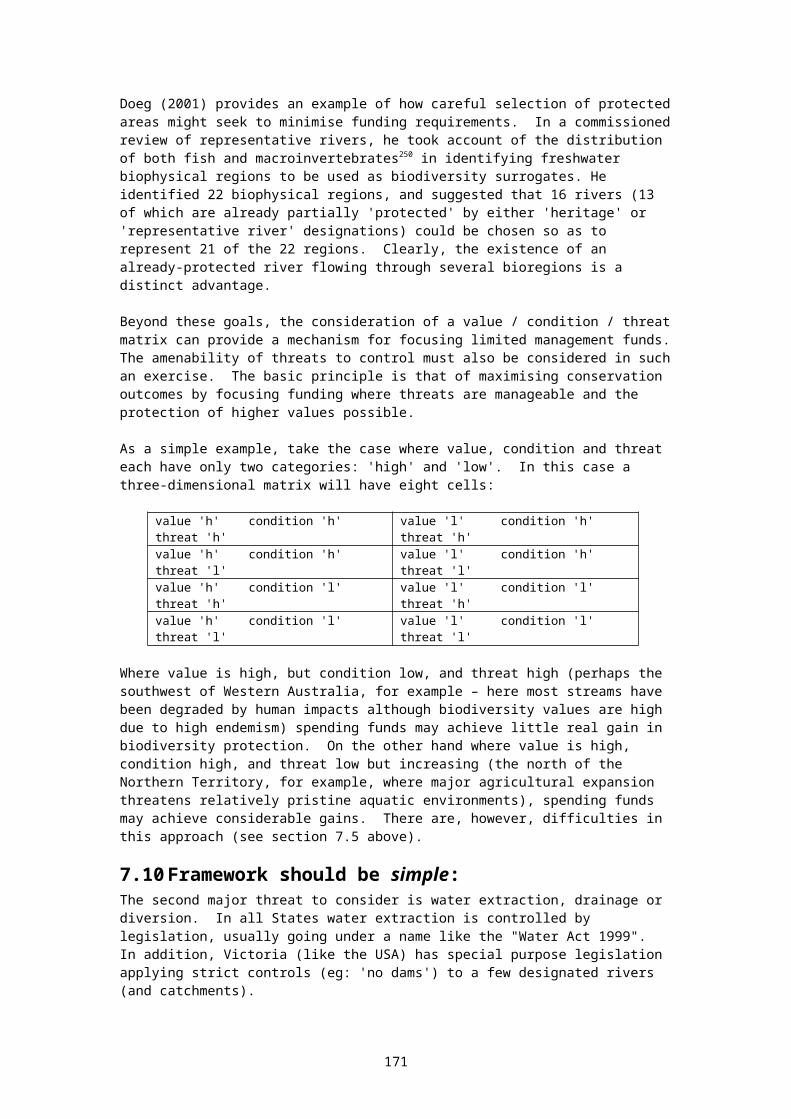
roles and responsibilities of water authorities and the Department of Natural Resources and Environment are confused in regard to the development of an operational plan for the use of environmental water;
monitoring of compliance is minimal, and measurement points are sometimes highly inappropriate;
no mechanisms or triggers exist for auditing and enforcement of environmental flow arrangements;
clear ecological objectives are only rarely articulated;
monitoring of ecological trends (including those in response to changed flow regimes) is minimal or non-existent;
provision for periodic review applies only in two cases in the State.
Victoria’s second program of concern is Streamflow Management Plans (SMPs), which apply to unregulated rivers. This process, currently under review, suffers from a series of major handicaps. Specifically,
SMPs are co-ordinated by Rural Water Corporations – a clear conflict of interest given the commercial interests of these same corporations in the sale of water for irrigated agriculture;
Only a handful of SMPs have either been completed or are in train since the program was introduced several years ago;
More generally, SMPs suffer from:
– a lack of input from freshwater ecology expertise;
– consultative processes that are ‘stacked’ with water users;
– are not formally linked to Stressed Rivers and BWE processes in the same river systems (this applies, for example to the Ovens R);
– focus on a single environmental flow objective of ‘minimum flows’, at the expense of numerous additional environmental flow objectives that might conceivably deliver desirable environmental outcomes; and
– a lack of metering and monitoring required to enforce SMPs.
The third program is Victoria’s Stressed Rivers Program, a program limited to only 5 of the several dozen stressed rivers that were initially short-listed for inclusion. In terms of shortcomings, the Stressed Rivers program: is limited in its scope – only a handful of ‘stressed rivers’ are included;
is the management responsibility of Catchment Management Authorities, which– suffer from a lack of expertise re freshwater ecology, hydrology, flow management, and public consultation;
– have no powers or responsibilities under the Water Act.
requires consent of Rural Water Authorities for flow issues to be considered, and
lacks input from environment NGOs.
More general concerns also apply to Victoria and its lack of procedural commitment to river health.
In effect, environmental flows have no workable recognition in legislation.
– their purpose is not stated
– obligations re environmental flows are not stated, and are not included in the charters or operating licences of water authorities and corporations.
– existing environmental flows can be amended administratively
– effective mechanisms for enforcement of flow rules (such as Operating Licences) are
171
lacking, and no audit or licensing arrangements exist to ensure compliance; and
– responsibility for monitoring the environmental condition of rivers is not set out by statute.
Flow needs of estuaries (eg. Gippsland Lakes) have not been considered to date;
Minimum flow rules don't hold in practice, and breaches have never been enforced or prosecuted;
The ecological justification of existing ‘environmental flows’ is highly questionable (eg. Wimmera, where the quality of water supplies to consumptive users is the main objective);
There is no monitoring of environmental outcomes in rivers with flow regimes;
No review provisions exist either in practice or in legislation. For example, recent correspondence from Victoria’s Department of Sustainability and Environment states that existing environmental flow arrangements in the Goulburn River would not be subject to review;
Concerning SMPs, the level of support for, and supervision of, SMP processes by the Department of Natural Resources and Environment is generally poor. There is an urgent need for a boost to DSE resources in this area.
While Victoria’s key environmental regulator – the Environment Protection Authority – has a mandate including water quality, it is not resourced to be involved and represent the flow needs of rivers.
Capacity for informed environment Non-Government Organisation participation is limited, and resourcing (including sitting fees) to support effective NGO participation is inadequate.
As was the case in relation to institutional reform, the National Competition Council again gave Victoria a clean (if qualified) bill of health in spite of these short-comings:
“Victoria has in place detailed procedures and policies that will permit allocations to be developed for the environment. The Council is also satisfied that the policies have regard to relevant scientific information. The Council will monitor the continued implementation of processes to provide water to the environment prior to the third tranche assessment. The Council will carefully assess environmental outcomes including in particular the creation of water rights to satisfy the needs of the environment. Where outcomes do not satisfy environmental requirements the Council would look to evidence that mechanisms (such as trading rules and the environment manager entering the water market) are used to improve environmental outcomes.”354
As is clearly the case in Victoria, commitment to process alone is not sufficient. Also at issue here is:
Who controls the process? (poacher or gamekeeper?)
How well is it resourced? (including money and science)
What monitoring and reporting arrangements exist?
How are flow rules enforced? and
What are the ecological outcomes? (need for public reporting and accountability)
A4.3.6 The Victorian situation needs review
Victoria's Heritage Rivers Act resulted from the work of the Land Conservation Council, following the 1987 Victorian Conservation Strategy. The LCC was subsequently replaced by the Environment and Conservation Council (the ECC), and this body has recently been replaced by the Victorian Environment Assessment Council (the VEAC).
The creation of this new body, with a slightly wider mandate, provides an opportunity for the Victorian government to re-visit the issue of representative freshwater reserves. Such a re-
172
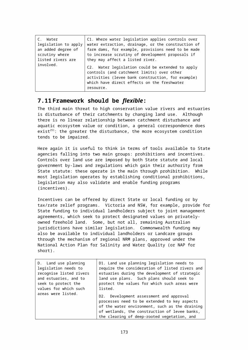
examination of the issue would provide an opportunity to undertake the wetlands review (planned in 1987 but never implemented), to complete the management framework for existing Representative Rivers (four of the fifteen remain - after eight years - without management prescriptions or guidelines), and to review the methodology for identification and selection of representative reserves in the light of the IBRA framework - which had not been developed at the time the Representative Rivers where put in place.
Such a review should also re-visit the difficult "boundary" issues which complicate the management of freshwater reserves355.
A4.4 New South Wales
A4.4.1 Strategies for protecting freshwater biodiversityNSW has four key strategies impacting on freshwater biodiversity, all fitting within the general framework created by the NSW Catchment Management Act 1989, the Water Act 2000, and the NSW Total Catchment Management Policy 1987: the Rivers and Estuaries Policy 1993. the Wetlands Management Policy 1996, the Biodiversity Strategy 1999, and the groundwater policies (framework, quality, flow, and groundwater-dependent
ecosystems).
The NSW Weirs Policy (1997) is also an important supporting policy to this group.
NSW Rivers and Estuaries PolicyThe objective of the Rivers and Estuaries Policy is (p.6):
To manage the rivers and estuaries of NSW in ways which: slow, halt or reverse the overall rate of degradation in their
systems; ensure the long-term sustainability of their essential biophysical functions,
and maintain the beneficial uses of these resources.
The objective is followed by a list of principles, which are more notable for what they don't contain than for what they do. They don't mention: the precautionary principle, the dependency of rivers on flow patterns and catchment landuse, the need to protect the integrity of natural aquatic ecosystems, or the need to manage cumulative impacts. Although the policy does discuss representative reserves (see below) the need for such reserves is not marked by a statement of principle.
On a more positive note, the policy does foreshadow a suite of supporting policy documents356
(p.7) including a subsidiary policy on wild and scenic rivers, and the catchment management framework within which the program sits (set by the Catchment Management Act 1989) does have strengths in its potential to consider and manage cumulative effects and biodiversity issues. The policy also establishes clear lines of responsibility (under the purview of the NSW Water Resources Council), and reporting mechanisms.
An important strength of the policy is the explicit recognition of the need for the conservation of representative areas (p.28) although the principles underlying this need are not discussed. This statement is strengthened by a similar commitment in the later Wetlands Policy (see below).
NSW Wetland Policy:The Wetlands Policy establishes management processes administered within an ICM framework. These processes require the preparation of annual Action Plans.
The policy does not use the Ramsar wetlands definition, instead limiting scope of the policy to slow or stationary water. Within this limitation, action statement 8.3: “representation of all wetland types within the reserve system will be secured” - when considered together with the
173
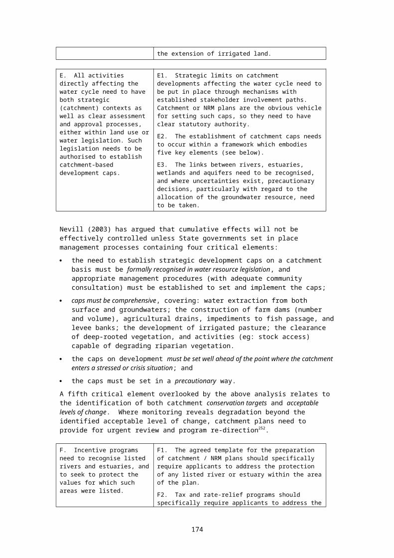
acknowledgment for the need for representative river and estuarine areas discussed above, commits the State to developing a system of representative freshwater reserves. The need for an inventory is also acknowledged by the policy's commitment to the “mapping of all wetlands”.
The NSW National Parks and Wildlife Service (NPWS) uses a bioregional approach to identify priority ecosystems for inclusion in a comprehensive, adequate and representative terrestrial reserve system . The reservation of wetland systems occurs within this broader framework ie. there is no separate program for identifying and establishing representative freshwater reserves. I believe this approach prejudices the development of an adequate representative freshwater reserve system.
However existing 'terrestrial' reserves do protect a number of important wetlands types, including for example the Narran Lakes, the Myall Lakes, parts of the Paroo channel country, alpine lakes and bogs in both Kosciusko and Barrington Tops National Parks, as well as karst systems (eg Yarrongobilly and Bungonia). The NPWS recently gazetted Peery Lake in Northwest NSW, a terminal playa lake which contains examples of important mound spring communities. The RFA processes have also resulted in the inclusion of significant estuarine wetlands within forest reserves. As the bioregional assessment process moves west, additional important wetland systems are likely to be incorporated into reserves.
In recognition of the fact that many important wetland systems are not represented within reserves, and because acquisitions require funding which is in short supply, the NSW NPWS has developed a strategy for nominating important wetlands on private land to the Ramsar Convention to complement its reserve acquisitions. These wetlands are managed for both productive use and conservation. Five landholders have signed up to Convention Agreements over the last 18 months.
NSW Biodiversity StrategyThe Biodiversity Strategy 1999 is a comprehensive extension of earlier policies. However, although the document has many strengths, it does not, in its current form, extend the earlier commitments to the establishment of representative wetland and river reserves. Although Objective 2.2 is to: "establish a comprehensive, adequate and representative reserve system", the Strategy defers development in the freshwater area by stating:
NSW Fisheries is preparing an additional component to the Biodiversity Strategy, dealing with the protection of … the fish and other organisms in our streams, rivers and lakes. A draft will be released for public comment in late 1999.
Preparation of this draft is running behind schedule, and had not been released at the time of writing.
In other ways the Biodiversity Strategy is a major move forward. It acknowledges intrinsic biodiversity values (p.4), and refers to both the precautionary principle and Principle 8 of the national biodiversity strategy (p.8).
It also establishes important links between catchment planning and biodiversity planning: a link missing in current programs in most other States. Core Objective 2 reads, in part:
Strengthen management of biodiversity on a bioregional basis while using existing catchment level (my emphasis) networks to focus on specific actions, including the integration of biodiversity conservation and natural resource management…
The Strategy also makes commitments to the establishment of comprehensive and accessible ecosystem inventory data within a bioregional framework. Although freshwater ecosystems are not targeted, they are included, and the need for detail at the "special sites" level is recognised within broader bioregional data-sets. The provision of data to assist catchment management strategies is specifically targeted (p.18) as are environmental flow programs (p.19) and programs to assist the conservation of wetlands on private land (p.19). The integration of catchment management and biodiversity planning is targeted in several objectives and action statements357 (pp.31, 33, 37, 38, 53, 57, and 64).
174
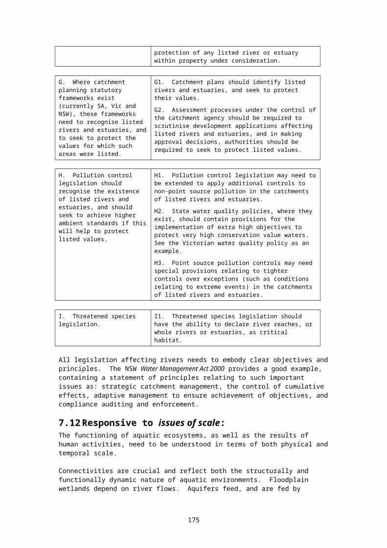
The planning framework set out in the Biodiversity Strategy, when considered within the larger NSW water framework, arguably provides the most comprehensive program for the protection of freshwater ecosystems in any Australian State - although WA, Qld, and Victoria all have some elements in their programs which individually appear more highly developed than the current NSW arrangements358. It should also be remembered that the ambitious arrangements described in the NSW Biodiversity Strategy have yet to be fully implemented.
Addendum: in a letter dated 12 April 2001 Michael Wright, Director Policy and Science, NSW NPWS, made a number of comments which help put the NSW program in perspective359.
NSW groundwater policiesNSW has also developed a suite of three groundwater policies dealing with quality (1998), flow, and groundwater-dependent ecosystems (GDEs) (drafts2000). These lie within a framework groundwater policy (1997) (see references). The framework document establishes clear commitments to: managing surface and groundwaters together where they are strongly linked, and the integration of landuse planning and catchment/water planning mechanisms (NSW
1997:7).
In no other Australian State are these important principles made clear by water planning legislation or policies.
In terms of statements of principle, the GDE policy's strongest points are its clear commitments to: the precautionary principle, the agreed national principles for the provision of water for ecosystems360, the management of land use within a catchment as an essential mechanism for the
protection of catchment water systems, and the management of groundwater yields within the sustainable capacity of the aquifer.
'Sustainability' is defined (naturally enough) to include the protection of GDEs, and the use of integrated water management plans covering both groundwater and surface flows is a key element of the policy's approach361. These are important strengths. The explicit recognition that many of the State's groundwater systems are over-allocated is also an important strength362. Too often government policies shy away from clear statements like this which are essential to underpin new management approaches.
The relationship between landuse planning (LUP) mechanisms and water management plans is briefly explored (p.27) - a matter picked up by the new Water Management Act 2000 (see below).
Many NSW aquifers are stressed. A recent assessment in NSW indicated that, of 93 aquifers across the State, 36 were classified as high risk; mainly from over allocation (DL&WC 1998).
A weakness the GDE policy shares with most other similar policies (in spite of its connections with the NSW and national biodiversity strategies) is its failure to acknowledge intrinsic ecosystem values.
The GDE policy does not discuss the difficulties or the importance of managing cumulative effects, although it does expand the existing water management framework which, potentially, could be effective in this regard.
The GDE policy has two other significant weaknesses; both have to do with inter-connections with the broad NSW freshwater policy framework. Firstly, although it lies within a broader framework committed to the establishment of representative freshwater ecosystem reserves, it makes no reference to the need for such reserves in regard to GDEs. Secondly, although it provides for an inventory of GDEs (referred to as a 'register363') it makes no reference to commitments or programs to establish a comprehensive inventory of all NSW freshwater ecosystems. As previously discussed, the development of such an inventory is essential for
175
the effective functioning of catchment planning, environmental assessment, and CAR reserve programs.
NSW environmental flows:According to Allan Lugg: "NSW has implemented environmental flow provisions in all 'regulated' rivers which has reduced historical usage by around 5 to 6% in most rivers. We are doing the same for unregulated rivers" (AL, pers.comm.5/5/00).
In relation to the NSW environmental flow program, Tim Fisher has this to say364:
In my experience… only one State: NSW, has demonstrated much more than lip service to the environmental flow policy requirements of the CoAG Water Resources Policy. In inland NSW, five major river system now have formal environmental flow regimes in place: the Murrumbidgee, Lachlan, Macquarie, Namoi and Gwydir. In each of these rivers, irrigator access to water resources was reduced. Planned legislation will give the environmental flow requirements statutory force. Environmental monitoring programs are underway, and each environmental flow program is scheduled for review after five years of operation.
NSW Weirs Policy The goal of the NSW State Weirs Policy 1997 is "to halt and, where possible, reduce and remediate the environmental impact of weirs".
The State Weirs Policy has three components. The first relates to the approval to build a new, or expand an existing weir. The second is a review of all existing weirs (Weir Review Program). The third addresses the provision of fishways.
The policy is developed around a list of eight core principles365. A weirs audit has been undertaken to give effect to the second component of the policy.
Freshwater inventories:While NSW does not, at this stage, have a comprehensive inventory of freshwater ecosystems, the State Biodiversity Survey Program provides a structure (management objectives and funding) which will see the eventual development of such an inventory. The State’s WISE water information system complements the survey by providing highly accessible data access.
The NSW National Parks and Wildlife Service also plays a number of important roles in the implementation of the NSW Water Reforms, one of which is to identify 'High Conservation Value Rivers' and to ensure that these are given priority consideration in the development of water management plans.
Aquatic reserves:Aquatic reserves may be declared under the Fisheries Management Act (managed by NSW Fisheries). There are thirteen aquatic reserves in NSW, spanning some 2100 ha - but none as yet in freshwater. These reserves have generally been declared to protect small areas of habitat vulnerable to damage from high usage (tidal rock platforms, for example). Although such reserves could be declared over freshwater areas, no such reserves have been declared as yet. The Fisheries Management Act provides for the development of Habitat Protection Plans, and one is currently in place on the Hawkesbury-Nepean River system.
The NSW State of the Environment Report 2001 reviewed the matter of freshwater reserves, and recommended (p.263) that existing management programs "… would be complemented by the development of a protected area system for riverine habitats". The current (June 2002) draft of the State Water Management Outcomes Plan contains a target which would establish aquatic reference sites in each major catchment. The draft has not yet been cleared by State Cabinet. If confirmed, this target could provide a framework for establishing representative freshwater reserves in each bioregion within NSW, although reference sites could alternatively be developed in a far more restricted way simply as monitoring sites.
176
Freshwater areas (eg: rivers, creeks, wetlands, floodplains, karst ecosystems and estuaries) are of course protected within National Parks and Wildlife Service reserve system. Most river reaches afforded a high level of protection in the reserve system occur in mountain and coastal areas. Therefore the lowland and foothill areas are often under-represented. Some estuarine ecosystems are protected by inclusion within marine protected areas, such as some of the estuarine areas in the Solitary Islands Marine Park. [Stuart Blanch NSW NPWS]
The Threatened Species Act 1995 provides for the identification and protection of ‘critical habitat’ through either Threat Abatement Plans or Recovery Plans. The Native Vegetation Conservation Act 1997 contains provision for the protection of habitat through joint management agreements. This Act also provides special protection for native vegetation within the riparian zone (defined as 20 m) beside listed streams (as well as protecting native vegetation on slopes steeper than 18 degrees).
Jurisdictional issues:An aquatic reserve declared pursuant to the Fisheries Management Act would not address key river management issues, such as flow (DIPNR jurisdiction), protection of non-fish biota (eg, fishing bats, waders, reeds, etc - NPW Act), and management of the riparian and floodplain areas (NPWS and DIPNR jurisdiction). By the same token, the National Parks and Wildlife Service does hot have jurisdiction over key river-related activities that occur in waterways in the National Park reserve system, such as stocking of trout, recreational fishing, re-snagging, speed boat access, boat speed limits, discharge of vessel sewage (Waterways Authority and EPA). No single agency has jurisdiction over all the matters that the State government will want to address with respect to aquatic reserves located in rivers, necessitating a cooperative approach between the 3 key agencies – NSWF, NPWS and DIPNR. So even though NSW Fisheries have the most obvious mechanism for establishing reserves in areas outside the formal reserve system (administered by the NPWS) ie, aquatic reserves under the Fisheries Management Act, this may not be the most efficient approach. [Stuart Blanch NSW NPWS]
Funding for the implementation of freshwater reserves could come through the Catchment Management Blueprints process now being developed by the NSW Department of Infrastructure, Planning and Natural Resources (under the provisions of NSW water and catchment management legislation) in line with Commonwealth National Action Plan guidelines. These plans have set broad aquatic conservation targets and need a lot of fleshing out. It is likely that NSW Fisheries, NPWS, and DIPNR are likely to obtain both funding and community support for setting up any future freshwater protected areas through this process. [Stuart Blanch NSW NPWS]
A4.4.2 NSW Water management frameworkNew South Wales and South Australia are probably the two Australian States with the most stressed freshwater resources, so perhaps it's not surprising to see that NSW takes the business of water planning fairly seriously. Due to the fact that water systems are already highly degraded west of the Dividing Range, and that the Murray-Darling Basin cap is in place, there are currently few large new infrastructure proposals, and those that have been proposed are likely to receive a high degree of scrutiny.
In keeping with approaches used in Australia across all jurisdictions, NSW has planning legislation covering the development of local government land use zoning schemes, and legislation requiring EIA procedures for significant infrastructure proposals. The Vegetation Conservation Act 1997 contains provisions which may be used to protect wetland vegetation, and the inclusion of riparian vegetation in "State Protected Land" under this Act represents a significant management tool. NSW was the first Australian State to develop a statutory framework for its ICM programs under the Catchment Management Act 1989. Now, in response to the CoAG water reform agenda, NSW has developed the Water Management Act 2000.
The Water Management Act is as close as any State has come to competent and comprehensive water legislation. Although it is a large document, it is fairly readable, unlike the WA legislation, for example. As expected, the new Act develops controls over the
177

harvesting, allocation and use of water, and over activities which have major effects on the water resource, such as the construction of dams, levee banks and agricultural drainage programs. The Act provides for private and public irrigation and drainage schemes, and water supply schemes - these also are general functions shared with water legislation in most other States.
What makes the NSW Act particularly interesting is that it provides for a planning framework which, depending on the way it's implemented, could provide a tiered planning structure, driven by high-level objectives and principles, which is keyed into the State's local government planning framework. Again, depending on the way the Act is to be implemented, the tiered management plans could be meshed with the State's existing catchment management framework in a way which would involve stakeholders without unnecessary committee overlap and duplication, and provide mechanisms which could address three of the four key issues which I have focused on in this paper, in effective ways. The Act also has the ability to address other issues highlighted in this document but not discussed in detail: such as the control of the harvesting of surface flows outside defined watercourses. Whether, in fact, it will be implemented to achieve these outcomes remains to be seen - but at least a reasonable statutory framework has been established. Let us examine these points in more detail.
Objects and principles:Given the establishment of the tiered planning structure which starts with the NSW Act, extends to a 'State Water Management Outcomes Plan' (the equivalent is called a 'State Water Plan' in SA and a ‘Water Development Plan’ in Tasmania) then fans out into numerous local 'Management Plans', it is essential that the tier be driven by consistent objectives and principles. Section 3 of the Act sets out the Objects of the Act. The list starts with "to apply the principles of ecologically sustainable development" - immediately locking in the precautionary principle. The list goes on to include the protection of ecosystems, biodiversity and water quality, fostering community partnerships, integrated management, and equitable sharing - all excellent objectives.
In terms of the issues discussed in this paper, the obvious omission relates to continual improvement366 - although this is partially recognised in one of the following principles 5(2)(h) which advocates adaptive management. An additional objective: "to encourage continual improvement through the provision of procedures for implementation, enforcement, evaluation, and review" - would provide a significant addition.
Section 5 lists 'water management principles'. Twenty-three principles are listed under seven headings. While the list is fairly comprehensive, there are some important omissions. The section would benefit by a new sub-heading: "in relation to environmental protection" and would include four new principles: recognise the complexity of natural processes and water-dependent ecosystems, and the
need for harmony, as far as possible, between these processes and imposed management regimes (the principle of minimal impact management);
a link to principle eight from the national biodiversity strategy367; a link to the national environmental flow principles368; and recognise that humans are but one of many species, and that other species, particularly
indigenous water-dependent species, have a right to coexistence with humans on this planet369.
In the 'water sharing' list, a principle needs to be added recognising that climatic variability must be explicitly accounted for in sharing arrangements. In the 'drainage' and 'floodplain' lists, principles need to be added recognising historic damage to wetlands through drainage and levee bank construction, with a view to avoiding future damage. Under the 'aquifer' list, a principle needs to be inserted to the effect that, where linked, surface and groundwater resources need to be managed together in integrated ways.
Section 9 creates a duty to "exercise functions in accordance with, and so as to promote, the water management principles" of the Act. This duty could be considerably strengthened by
178

including the objects of the Act along with its principles. The absence of a duty to further the objects of the Act immediately negates a duty to use the precautionary principle.
Statutory linkage between planning frameworks:There is the potential for links between water 'management plans', catchment management plans and local government planning schemes to be relatively smooth and effective. Firstly, the Act contains requirements for the planning committees, and the management plans, to be linked with the existing catchment management framework. Section 13 requires water management committees to include a person representing the relevant Catchment Board or Trust. Section 36 requires that draft water management plans be referred to the relevant Catchment Management Committee or Trust.
There is also a strong statutory link securing water management plans to the local government planning framework. Section 46 links regional environmental plans and local environmental plans, prepared under the Environmental Planning and Assessment Act 1979 to the water management plans, requiring modification of the former plans to comply with the environmental requirements of the latter plans.
This is an effective mechanism which is absent from the water legislation in all other Australian States370.
Cumulative effects:I have argued in this document that the only way to control cumulative effects is to place strategic caps on water developments within a catchment context, well before problems become evident. The last point is critical, and, although the new NSW framework provides mechanisms to control cumulative impacts, early indications suggest that the necessary controls will not be applied in time.
Even the statement of principle in the Act is weak. Section 5(2)(d) reads: "the cumulative impacts of water management licences and approvals and other activities on water sources and their dependent ecosystems should be considered and minimised". A stronger statement could have been worded: "the cumulative effects of all activities with significant impacts on water resources and dependent ecosystems must be assessed, managed, evaluated and reviewed".
The Act describes the provisions which must go, and might go, into management plans of different types. In relation to cumulative effects, sections 23(b) and 32(a) (for example) provide that cumulative effects must be identified in management plans dealing with water use and aquifer interference. The Act does not go on to require that management programs for these effects should be developed, although I believe this is clearly the intent of the Act - refer to the slightly stronger wording of sections 26(c) and 29(c). Additionally, section 34 provides the ability to identify zones in which activities need to be controlled (potentially capped) to protect water resources - and these provisions transfer directly to local government planning frameworks, providing a powerful mechanism for the control of cumulative impacts (from dams or levee banks, for example). Another effective mechanism for the management of cumulative impacts lies in the provisions of the Act allowing the minister to impose embargoes on applications for approvals or licences: see sections 110 and 111, for example.
In spite of these provisions, I have misgivings about the way the Act will be applied to manage cumulative effects. Section 7 of the Act provides for waters to be classified according to three factors: risk, stress, and value. Subsection 7(5) provides for this classification to be used, sensibly enough, in prioritising the preparation of bulk access regimes. However, my understanding of current NSW policy is that the application of caps to manage cumulative effects will only be applied to high risk or high stress catchments, as classified under this section. This runs directly counter to my arguments for cumulative effect management regimes to be developed well before catchments come under significant risk or stress.
Enforcement:
179

As discussed earlier, an assumption embedded in Australian water management frameworks prior to the CoAG water reform agenda was basically that cursory enforcement provisions were all that was required. This has resulted in a legacy of large numbers of illegal dams, bores and other water structures in most Australian States. Speaking from personal experience, compliance auditing has simply not been taken seriously. No Australia State, for example, has embarked on a serious program to identify and remove illegal farm dams.
However, section 10 of the NSW Act requires the minister to "ensure that the work and activities of the Department are reviewed at intervals of not more than 5 years for the purpose of determining whether they have been effective in giving effect to the water management principles of this Act, and the State Water Management Outcomes Plan". This provision, I suggest, will oblige the minister and his department to embark on a rigorous compliance auditing and enforcement program.
Having said this, I believe an area where the Act could be strengthened in this area relates to section 35, which sets out the format of management plans. In keeping with the principle of adaptive management (5(2)(h) the format should be extended by the inclusion of "implementation, enforcement, monitoring and review provisions".
Other important issues:Integrated management of surface and groundwaters: while the Act has little to say in this regard (see comments under 'principles' above) the management plan framework provided by the Act clearly enables integrated plans to be prepared. Existing NSW policy promotes such integrated management, which has recently been put into practice in the Apsley area.
According to the DIPNR web site, as part of the NSW water reform package, programs have been funded to map and classify aquifers by risk category. Aquifers will be assessed and classified according to whether they have a low, medium or high risk of over-extraction or pollution371. Water Management Plans, developed in consultation with community-based Catchment Management Committees, will then be prepared for high risk aquifers. For those aquifers with high risk of over-allocation, granting of new high yield licences will stop. As discussed above (under 'strategies') where aquifers and surface waters are strongly linked, Water Management Plans will be prepared for the total water resource in the catchment, covering surface and groundwaters.
Intrinsic values: The Act recognises intrinsic values: "habitats, animals and plants that benefit from water or are potentially affected by managed activities should be protected and (in the case of habitats) restored." (5(2)(b).
Surface flows: The harvesting of surface flows outside defined watercourses is not presently controlled in Victoria or the Northern Territory, although both States will hopefully remedy this situation shortly. In SA, Tasmania and WA, the harvesting of surface flows can be controlled in prescribed areas. NSW has, through the new Act, has adopted a 'carrot and stick' approach, giving landholders a right to harvest 10% of prescribed surface flows – harvesting in excess of this level would require formal approval. Time will tell which method of controlling surface flow harvesting is the most effective, but in terms of administrative efficiency, and the ability to 'cap' this harvesting, the NSW approach appears to have distinct advantages.
Pro-active planning:The Sydney Water Catchment Management Act 1998 and the State Environmental Planning Policy no 58 - Protecting Sydney's Water Supply appear to be, at least in part, examples of a government reacting to stressed catchments rather than planning effectively for them at an early stage. Unfortunately, as discussed above, it seems likely that the mistakes of the past will be repeated.
180

A4.5 Queensland
A4.5.1 Strategies for protecting freshwater biodiversityQueensland's key strategy in this area is the Wetlands Strategy 1999 - in many ways a far-sighted document. Importantly, the Ramsar definition of wetlands (in a slightly modified form) is used, covering static or flowing waters.
The Strategy has four central objectives, of which objectives two and three are particularly important:
1. avoid further loss or degradation of natural wetlands, unless overriding public interest can be shown;
2. ensure a comprehensive and adequate representation of wetlands in the conservation reserve system;
3. base the management and use of natural wetlands on ecologically sustainable management and integrated catchment management practices; and
4. develop community awareness of, and respect for, the values and benefits of wetlands, and involvement in their management.
Objective one, while clearly worded, falls short of applying the 'no net loss' principle used in NSW or the more imaginative “net gain” approach of the Victorian government. Nevertheless, it does provide a foundation on which this principle could be developed in the future.
The Strategy commits the Queensland government to the development of representative freshwater reserves through Objective 2. Disappointingly, however, initiatives 1.1, 1.3 & 1.5 do not identify the need for a comprehensive State inventory of wetlands which would lay the foundations for the development of CAR freshwater reserves, and initiative 2.1 merely re-states the objective. However, development of a Natural Rivers Policy could see these gaps covered (see below), particularly as considerable progress has already been made in assembling inventory material.
In terms of implementation, the Strategy relies heavily on voluntary adoption of wetland protection measures within a non-statutory NRM / ICM framework. While the opportunity provided by the Strategy to develop (or foreshadow the development of) statutory links between catchment planning and landuse planning was lost, the clear commitment to catchment planning is a vital component of an effective biodiversity protection system. Initiative 3.5 commits the government to "extend the integrated catchment management process to all Queensland catchments".
The Strategy, ignoring the lead provided by the national biodiversity strategy, does not acknowledge intrinsic wetland values.
Queensland has decided not to prepare a biodiversity strategy in 1999. Instead, controls are being developed targeting specific threatening processes. For example, vegetation clearance controls under land use planning mechanisms, and duty of care provisions under the Environment Protection Act 1994 (and common law), if enforced, may manage agricultural processes which are degrading catchment and riparian vegetation, with consequent effects on both surface and groundwaters.
The Wetlands Strategy 1999 contains commitments to the application of EIA to water infrastructure proposals (initiatives 1.4 and 1.15). However, the Strategy does not identify cumulative effects as an issue, and without a comprehensive State inventory of freshwater ecosystems, it is difficult to see how EIA programs could be effective - especially with regard to smaller proposals which escape Queensland's more detailed assessment procedures. In terms of the State's commitment to its own rhetoric, it is worth noting that, in 1999, the National Competition Council penalised Queensland for not applying EIA procedures to large infrastructure developments, in spite of commitments to do so.
181

In Queensland’s favour, their Environment Protection (Water) Policy is the only Australian water quality policy to mention the need for management of cumulative impacts. It should also be noted that Queensland’s Policy does (s.44) provide the Chief Executive, when making water plans, the option of considering special protection measures (eg water quality or water flow requirements) for waters of identified high conservation value.
Sattler and Williams (1999) provide a comprehensive discussion of the conservation status of Queensland's terrestrial bioregional ecosystems. While this work does not, in general, classify or discuss freshwater ecosystems, it does provide a sound bioregional framework for the further development of a comprehensive inventory of freshwater ecosystems, and the subsequent development of CAR freshwater reserves.
It will be interesting to see if the State government funds its commitments, or simply shelves them. The government's track record clearly leaves this question open.
The Queensland government planned to develop a Rivers Policy in 2000/2001 to provide a strategy for the use of river systems. This would have been a whole-of-government approach to identifying the social, economic and environmental values for all major river systems372.
According to Rob Whiddon, former Chief of Staff, Premier's Department373:
The Queensland Department of Natural Resources, in conjunction with the Environmental Protection Agency and the Department of Primary Industries (Queensland Fisheries Service), have recognised the need for the development and implementation of a policy for the strategic conservation and management of the natural values of all river systems. These agencies are currently preparing a draft Natural Rivers Policy for further consideration by the Queensland Government.
At this early stage it is proposed to: undertake a rapid assessment for initial identification of the status of rivers with respect
to their natural values followed by more rigorous investigations to confirm natural values of Queensland's rivers;
explore the possibility and practicality of placing a moratorium on water resource infrastructure development in largely unimpacted stream systems identified in the initial assessment;
build on Wild Rivers and other broad assessment work to determine a methodology for categorising the conservation values of river systems;
include 'representativeness' and 'uniqueness' among the criteria for assessment; and outline a strategy for the management (protection, rehabilitation and maintenance) of
stream systems to provide for the conservation of the natural values of the State's river systems.
Should the Government decide to proceed with such a policy it can be expected that one of the first steps will be to release an issues paper for public comment.
The Government's decision to suppress this draft proposal was an important benchmark by which the sincerity of its commitments to freshwater environments can be measured. Although the Queensland Government later passed the Wild Rivers Act 2005, by mid-2006 not a single ‘wild river’ had been designated, and the Government pushed forward dam-building plans which threaten habitat of the already endangered lungfish.
A4.5.1.1 Fish habitat areasThe Queensland Fisheries Service (QFS) of the Queensland Department of Primary Industries is responsible for the sustainable management of fisheries in Queensland, undertaking this responsibility primarily through a combination of harvest management (eg: limits on gear, fishing zones, seasonal closures and catch quotas) and fish habitat protection.
The declaration and management of Fish Habitat Areas (FHAs) is a key element of the QFS strategy for sustainable fisheries management. FHAs are multiple use areas designated
182
primarily to protect habitat: fishing is permitted within FHAs. Both inland and estuarine areas can be declared; however at this stage no substantial areas of freshwater habitat are protected within FHAs.
FHAs are declared under the provisions of the Fisheries Act 1994. Declaration is by amendment of the Fisheries Regulations 1995 – by the Executive Council of the Queensland Government (Cabinet) who consider the outcomes of a consultation process as well as the suitability of the site in meeting FHA objectives.
Queensland has eight coastal bioregions. By August 2002, 74 FHAs had been declared, covering 7140 km2, with an additional 7 identified which, if declared, would add an additional 2300 km2. The West Cape York bioregion (Cape York to Aurukun) is the only bioregion without FHAs, although both the Wet Tropic Coast and the Wellesley bioregion have less than 300 km2 each.
According to the QFS, “analysis of the FHA network shows that it is relatively comprehensive and includes substantial estuarine habitats from most of the eight coastal bioregions” (Queensland Government 2002).
Activities which may be authorised by permit include: limited impact private and public structures assessed as having an overriding requirement
to be on tidal land or within the FHA; construction of educational facilities (eg: boardwalks); scientific research; works related to public health or safety; restoration of fish habitats.
A4.5.1.2 Catchment controls over vegetationUnder Queensland’s Vegetation Management Act, clearing of remnant vegetation on freehold land requires a permit. In urban areas a permit is only needed for areas mapped as endangered regional ecosystems, or areas of high nature conservation. Clearing regrowth can be regulated if an area is declared high nature conservation value or vulnerable to land degradation. No declarations have yet been made (November 2003).
Under Chapter 5 Part 6 of Queensland’s Land Act, clearing on State Land (leasehold) requires a permit. This includes regrowth and non-native vegetation (other than declared weeds), however clearing regrowth vegetation that has occurred as a result of clearing under a permit issued since December 1989 is exempt.
Neither the Land Act or Vegetation Management Act regulates the clearing of native grasses. This combined with the absence of comprehensive controls on regrowth means that vegetation in the riverine zone which is important for protecting water quality and bank stability can be often by cleared without a permit. Neither Act seeks to protect the integrity of riverine vegetation through grazing controls.
Tree clearing in a defined riparian zone is controlled under the Land Act and Vegetation Management Act, based on performance requirements in the Broadscale Tree Clearing Policy for State Lands, and the State Policy for Vegetation Management on Freehold Land. These controls require the protection of vegetation to provide buffer zones from watercourses which vary from 25 - 200 metres based on the location of the watercourse and its size.
The State Policy for Vegetation Management on Freehold Land specifies performance requirements. To meet these requirements, watercourses and adjacent habitat must be protected by: maintaining bank stability by protecting against erosion and slumping; maintaining water quality by filtering sediments, nutrients and other pollutants; maintaining aquatic habitat; and maintaining wildlife habitat.
183

Queensland’s statutes provide further provisions addressing management responsibilities for the riverine zone. Under the Land Protection (Pest and Stock Route Management) Act 2002 owners have responsibilities to keep land, including riverine zones, free of certain classes of weeds.
Under Section 273 of the Water Act an owner can be notified to remove vegetation, litter, refuse, or other matter, if it appears these have or may: obstruct the flow of water; have a significantly adverse effect on the physical integrity of a watercourse, lake or spring; or significantly affect water quality.
There are also the general responsibilities under the Environment Protection Act 1994. Every person in the State has an environmental duty not to carry out an activity that may cause environmental harm without taking all reasonable and practicable measures to prevent or minimise the harm. A number of codes of practice exist to assist agricultural businesses comply with their environmental duty. The Land Act also has a duty of care for users of state owned land.
A4.5.2 Queensland's water management frameworkCompared to the water planning and allocation provisions of the former Water Resources Act 1989, Queensland's Water Act 2000 provides a significantly improved legal framework to protect freshwater ecosystems. The Act includes a statement of purpose (performing the same function as the statements of objectives in comparable NSW and Tasmanian statutes), as well as planning, implementation, monitoring and reporting requirements generally in line with the principle of quality assurance (‘adaptive management’). Principles of community involvement, transparency and accountability are all evident in the Act’s structure and contents374.
While the Act is a significant step forward, serious gaps and deficiencies remain. These are particularly evident when compared with the NSW Water Management Act – probably Australia’s most comprehensive water statute.
Planning framework:The Act provides for Ministerial involvement in the preparation of Water Resource Plans (key instruments setting overall planning objectives) while the chief executive prepares Resource Operation Plans designed to implement the Water Resource Plans and their objectives.
The Act contains a powerful provision enabling the Minister to prepare Water Use Plans, where there are risks that water use may cause negative effects on land and water resources (s.60). These plans become subordinate legislation (s.65). These plans may require, for example, that irrigators prepare (and submit for approval) Land and Water Management Plans and that activities may only be undertaken in compliance with approved plans.
These provisions, if wisely used, may provide an effective mechanism for sustainable irrigation management.
The planning framework, however, is weak in several places regarding the protection of water-based ecosystems: section 35(c) dealing with the chief executive’s planning responsibilities, could have listed
ecosystem protection375; section 41 requires that a community reference panel include representation for
environmental interests, but it fails to specify that person should have relevant expertise376;
while section 47(b) refers to: "national, State and regional objectives and priorities for promoting sustainable development" (Water Resource Plan matters of consideration) it fails to mention international conservation commitments (under Ramsar, for example);
links with the National Water Quality Management Strategy are oblique, appearing principally through connections with the Queensland water quality policy which itself is linked to NWQMS processes (see s.47(m) for example); and
section 62 (content of water use plans) lists objectives related to efficiency, water re-use and water quality, but fails to include ecosystem protection.
184

It is essential that the water planning framework should be integrated with catchment-based natural resource management strategies. According to DNR:
Catchment-based natural resource management occurs through non-statutory Integrated Catchment Management Committees. The role of the Catchment Committees and the possibility of a legislative framework for ICM is an evolving policy area. The linkage between catchment strategies and the Water Resource Planning process, as provided by Section 47(n), is not insignificant. In particular, note that section 48 requires that the Minister produce and publish a report summarising assessments and findings about all matters listed in Section 47 – including relevant catchment strategies. The purpose clause in section 10(2)(ix) also provides, as far as practicable, for the administration of the Act with other legislation dealing with natural resources377.
I am surprised that the Act does not include further mechanisms to enhance this integration. The Act does provide for the appointment of community reference panels, and membership specifications could have been used to establish more effective links. The NSW Act is stronger in this regard, establishing catchment planning and local government connections through such membership requirements;
Use of principles:The Act does not contain a list of principles to guide its planning framework. The statement of purpose (which covers only a part of the Act – Chapter 2) brings in “the principles of ecologically sustainable development” obliquely. Rather than make a clear commitment to these principles, followed by a general duty to apply them in the administration of the Act, the Act creates a duty (s12) to advance sustainable management and efficient use of water. “Sustainable management” is then defined, in part, to involve contribution to “the economic development of Queensland in accordance with the principles of ecologically sustainable development”. Although Queensland is committed to the National Strategy for Ecologically Sustainable Development (1992), no reference is made to the principles of this strategy, or to the principles listed in the InterGovernmental Agreement on the Environment (1992). Instead, six ‘re-worded’ principles are defined by s.11 as the principles of ecologically sustainable development378.
A better approach would involve the development of tiered statements of principle, as suggested below in Appendix 2. This approach would create a more comprehensive and cohesive planning framework, and would assist in the development of tiered plans within the framework, as the principles would provide an important guide. It would also assist significantly in matters of interpretation. Appendix 2 has been modeled from Victorian, NSW and Tasmanian legislation.
The Act makes no reference to the nationally agreed principles for the provision of water for ecosystems379. However, they are reflected in sections 3(d), 35(a), 38(3)(e), 38(4)(b)(ii), 38(5)(b)(ii), and 47(c) . This is commendable; however, due to an absence of clear commitment to principles 4 and 5, it appears that environmental flows do not necessarily have high priority in water sharing rules (compare, for example, the equivalent provisions of the NSW Act. Here, in times of drought, two classes of allocation have priority over others: these are environmental flows, and stock and domestic requirements).
Cumulative effects:The Act provides a framework within which the cumulative effects of water allocations can, in principle, be managed. Section 2 introduces the concept of limits to development to ensure sustainability. However, section 38 provides that the Minister may prepare a Water Resource Plan, which may provide for: definition of the availability of water for any purpose; a framework for the sustainable utilisation of water; identification of priorities and mechanisms for dealing with future water requirements; a framework for establishing water allocations; and a framework for reversing ecosystem degradation.
185

Cumulative effects can only be managed by placing caps on development, within a strategic framework. As I have argued above, to be effective, such caps must be placed well ahead of demand. Once the catchment is already stressed, it is too late.
While the provisions of s.38 will enable the Minister, if he/she so chooses, to implement such caps, the discretionary wording of the section gives cause for concern. A considerably stronger framework could have been provided. The Act, in its present form, does not acknowledge the pervasive nature of cumulative effects, nor does it list them in statements of purpose, principles, or lists of matters to be considered - in spite of the fact that it would have been relatively easy to do this within the structure that the Act has developed380. The need to assess and manage cumulative effects could have been acknowledged in the Act’s statement of purpose. This would then have led to cumulative effects being listed in the various ‘matters of consideration’ statements guiding the development of the various tiers of plans. As an important final step, an obligation could have been included for Water Resource Plans to set clear limits on water development in line with the purpose of sustainable management – well ahead of demand (see discussion on cumulative impacts – Chapter 4 in Nevill 2001).
This lost opportunity is particularly disappointing considering that Queensland was the first among Australia’s States381 to include cumulative effects as a consideration in its 1997 water quality policy382.
The only place cumulative effects rate a mention in the entire (400 page) Act is section 268, dealing with watercourse interference permits (to destroy riparian vegetation, or fill or excavate watercourses).
However, having said this, it is important to acknowledge that, at policy and operational levels, the Department (DNR) is aware of the need to manage cumulative effects, and is implementing control programs:
Water Resource Plans do in fact set clear limits on the water available for consumptive purposes. Additional water development is not permitted if these limits would be exceeded. Accordingly, the effects of cumulative development are addressed by Water Resource Plans. For examples of this, refer to the final water resource plans that have been released for the Fitzroy, Burnett and Boyne Basins. These are available from the DNR website. (DNR email 20/2/01).
Integration of surface and groundwaters:Given that integrated management of surface and linked groundwaters is part of the CoAG water reform agenda (see discussion above), this issue receives little prominence in the Act. As with cumulative effects, the issue could have appeared in the statement of purpose, or a following list of principles, then been carried through to the lists of ‘matters of consideration’.
While the Water Act 2000 contains provisions requiring single planning instruments for surface and groundwater (with the explicit and logical exception of artesian-related water) this requirement can be circumvented by simply not considering surface/groundwater interlinks within the plan. The Act does not require that Water Resource Plans develop integrated management for surface and interlinked groundwater. See for example sections 38(6), 47(k)&(l), 60(3) and 95(2). These provisions compare unfavourably with those developed by NSW in both statute and policy.
However, DNR policy appears to be ahead of the 'discretionary' wording of the Act:
The fact is that where [ground and surface] water resources are linked, their management will progressively be incorporated into a single Water Resource Plan covering both surface and groundwater. For example, previous to the Act, separate plans were being prepared for the Barron River system and the Atherton Groundwater Area. Section 1045 integrated these two proposed draft plans into a single process. (DNR email 20/2/01)
186

Compliance auditing and enforcement:Auditing and enforcing compliance is currently a major weak link in water management programs in all Australian States. Queensland’s Water Act contains important new provisions in this regard. Under the requirements of the Act, Water Resource Plans must establish monitoring and reporting programs, which extend to the assessment of ecosystems protected under the Plan.
Sections 53 and 54 oblige the Minister to report on the matters set out by the Plan, including “information about any non-compliance with the plan and its resource operations plan”. This provision should force the responsible departments (The Department of Natural Resources, and the Environment Protection Agency) to take compliance audits seriously.
Riverine Protection PermitsWhen deciding whether to grant or refuse an application for a Riverine Protection Permit under the Water Act, and in considering the conditions of the Permit, Section 268 of the Act states that the chief executive must consider:
the effects of the proposed activity on water quality; the quantity of vegetation to be destroyed or material to be excavated or placed; the type of vegetation to be destroyed or material to be excavated or placed; the seasonal factors influencing the watercourse, lake or spring from time to time; the position in the watercourse, lake or spring of the vegetation to be destroyed or the
proposed excavation or placing of fill; the reasons given by the applicant for wishing to carry out the activity; whether, and to what extent, the activity that the permit would allow may have an adverse
effect on the physical integrity of the watercourse, lake or spring; and the implications of granting the permit for the long-term sustainable use of the river
systems of Australia, and especially the cumulative effect of granting the application and likely similar applications.
Although this last point about cumulative effects is a point which could well be emulated by other States, at this stage Queensland’s resource agencies have not agreed on a method by which cumulative impacts should be assessed. It is also noteworthy that local or catchment biodiversity values are absent from this list of heads of consideration.
Management of overland flows:The Act deals explicitly with overland flow, providing the ability for the State to manage harvesting of these flows within the planning framework. Like NSW, the Act provides for an ‘as of right’ percentage take, to be set by Resource Operation Plans. Harvesting in excess of this level would require formal approval. See sections 20(4)&(6), 38(4). However, if the Water Resource Plan does not address the issue, overland flows remain uncontrolled within that region.
Other features:There are several other features of the Act worthy of note: the Act provides open legal standing for enforcement of offences against Chapter 2, with
a rule that each side pays its own costs; all Water Resource Plans (including Water Allocation and Management Plans – these are
a form of Water Resource Plan) must include ecological outcomes; on the 'down' side, section 24(3)(b) appears to reinforce landholders grazing rights over
Crown watercourses, in spite of the tremendous (and widely acknowledged) damage which grazing does to these wetlands and riparian areas;
according to Sean Hoobin383 (WWF), other problems with the current water management process include: (a) to date, water plans have not been sufficiently financed to fully identify catchment ecological values and needs; (b) the current water allocation process does not consider other threatening processes separate from water allocation; and (d) local government planning schemes do not include wetland mapping and conservation programs.
187
Summary of the Queensland situation:Considerable progress has been made, both in policy and statute, over recent years. While there are important gaps in current management frameworks, there are also important strengths, and the immediate task for Queensland’s water managers is to implement the existing framework, and fund existing commitments - for example: regarding the development of representative freshwater reserves, and the establishment of special protection for rivers of high ecological value. Once the existing framework is moving in the right direction, improvements can be made.
A4.6 South Australia:
A4.6.1 Strategies for protecting freshwater biodiversityThe State Water Plan 2000 foreshadowed the development of the Wetlands Strategy for South Australia, which was released for discussion as a draft in 2002, and published in final form in March 2003. Overall, SA has lost about 70% of pre-European wetlands, and most of the remaining wetlands are substantially impacted by human activities. While a central aim of the strategy is to halt and reverse this decline, the strategy stops short of providing clear endorsement for the “no net loss” or “net gain” concepts within State and municipal planning frameworks.
The Strategy does not provide a definition of the term “wetlands”. It does, however, refer to definitions in Appendix 2, including the Ramsar definition as well as that used by the SA Water Resources Act and the State Water Plan 2000. By implication, this provides an opportunity to interpret the strategy in various ways, including an expansion of the scope of the document past the more conventional exclusion of rivers and streams.
According to the forward by minister John Hill, the strategy "demonstrates the South Australian commitment to bring together wetland and groundwater and surface water management at state, regional and local levels. Cornerstones of the strategy (p.11) include adaptive and integrated catchment management, an environmental duty of care, and the precautionary principle.
The Strategy does provide a mandate for the development of both a comprehensive wetland inventory (p.16) and reserves protecting comprehensive, adequate and representative examples of wetland types (p.22):recognised and protected
Objective 5. To identify those wetlands which are important at the regional, state, national and international levels, and ensure appropriate recognition, management and protection of these sites.
Actions:
5.1 Establish a comprehensive, adequate and representative system of protected areas to contribute to the conservation of South Australia’s native biodiversity associated with wetlands.
5.2 Ensure that key wetland sites are identified in the State Wetlands Databank (see Action 6.1) defining their importance at the regional, state, national and international levels. Collate monitoring, survey, and management information for wetlands across the state and link these data to information from associated water resources that wetlands rely upon.
The use of the term “important” within the strategy rests partly on the Ramsar ‘importance’ criteria (see Appendix 7 below) of which criterion 1 underlines the value of representative sites:
Criterion 1: A wetland should be considered internationally important if it contains a representative, rare or unique example of a natural or near-natural wetland type found within the appropriate biogeographic region.
188

National Parks and Wildlife SA has a policy document titled "A Comprehensive, Adequate and Representative Reserve System Strategy for South Australia" 1997. This paper was presented to the Community Forums on the NRS at Perth in 1998 and in Adelaide in 1999. While not officially published, it guides the further development of the reserve system in South Australia. Two ecosystems / habitats have been identified for priority acquisition in South Australia: grassy ecosystems and wetlands384.
South Australian government applications for NRS NHT funds have emphasised wetland habitat since 1998. At least within the IBRA framework, SA’s representative reserves program has been expanding wetland reserves, and these reserves have representative values in the wider bioregional sense. Important recent acquisitions of land with wetland values include Mount Remarkable National Park, Caroona Creek, Carpenter Rocks and Lake St Clair385. It is important to note that South Australia's terrestrial representative reserve program targets wetlands as a priority in land acquisitions.
The development of a Biodiversity Strategy has been considered, but at this stage focus is on developing Regional Biodiversity Management Plans. One regional biodiversity plan has been published, and another four are in draft form, and will appear during 2001. These plans contain statements on threatening processes, and identify actions needed to ameliorate these threats. It seems more likely that the 'representative freshwater reserve' concept will get exposure in these regional plans, by way of recommendations, rather than in the politically more sensitive State strategies.
South Australia has a wetlands inventory program, where inventories are being developed region by region with the intention of achieving full State coverage; this program is being developed within a limited budget. There are no plans at present to establish a comprehensive inventory of freshwater ecosystems, including both flowing and still waters. The State is however, progressing the development of a broad-scale inventory of terrestrial ecosystems, within the IBRA framework, and this may ultimately be extended to cover freshwater ecosystems, particularly given the use of the Ramsar definition of wetlands within the State wetlands strategy.
The State has no threatened species legislation. Prior to the publication of the wetlands strategy, there were no requirements for local government, within the State's landuse planning framework, to take biodiversity or wetlands inventories into account when considering development proposals or changes to landuse zoning386. This has changed under Objective 5 of the strategy (p.23):
Actions:5.4 Ensure that all relevant local government and state agencies, catchment water management boards and similar bodies are made aware of those wetlands recognised as being of regional, state, national or international importance and their respective management and ‘duty of care’ * responsibilities for each site.
5.5 Ensure wetlands of regional, state, national or international importance are identified in Planning Strategy and Development Plans. Such areas should be supported by appropriate strategies and objectives/principles of development control and included within a Conservation Zone. Surrounding zones should include provisions to minimise threats on such areas (eg minimising introduction of pest species, land division and fire management).
In the extreme south-east of the State, two small freshwater sites of national significance, Ewens Ponds and Piccaninnie Ponds, appear to have suffered a massive reduction in the groundwater flows which feed them387. Nevertheless, the SA Government is still encouraging further exploitation of the surrounding aquifers388. It is not apparent that the precautionary principle is being applied to the protection of these important sites.
A4.6.2 South Australia's water management frameworkSouth Australia has relatively modern water legislation: the Water Resources Act 1997. The primary focus of the Act is the management of water quantities and flows, although it
189
recognises the need to manage water quality, and seeks to protect water-dependent ecosystems and their biodiversity.
The Act establishes hierarchical tiers of responsible authorities and planning instruments. The authorities are: the Minister for Water Resources, the Water Resources Council, Catchment Water Management Boards (currently six), and Water Resources Planning Committees. The planning instruments are: the Water Resources Act, the State Water Plan, Catchment Water Management Plans, and Water Allocation Plans. In addition, local government may establish controls through the preparation of a Local Water Management Plan.
These authorities and instruments must seek to advance the objectives of the Act, which include the protection of water dependent ecosystems and their biodiversity (WRA s.6(a)ii).
A commitment to establish a system of representative freshwater reserves, in my view, is essential to protect water-dependent ecosystems and their biodiversity. However, the current State Water Plan, recently revised389, does not contain this commitment, nor does it refer to Principle 8 in its brief discussion of the national biodiversity strategy.
The scope of the Water Resources Act covers both surface and groundwaters. Common law rights to water are removed, and replaced by wide riparian and landholder rights, which in turn can be constrained by the provisions of the planning instruments.
Section 17 of the Act places a duty on landholders whose land includes a watercourse or lake to take reasonable measures to prevent damage "to the ecosystems that depend on the watercourse or lake". Perhaps by oversight, this section does not place a similar duty on landholders to protect aquifer-dependent ecosystems.
Section 92 of the Act specifies the scope of a Water Management Plan. The Plan must include information on the health of the ecosystems that depend on water, and must assess the need for water of those ecosystems.
Catchment Water Management Boards have commissioned reports by consultants to fulfil these requirements. Surprisingly, the most recent report by the Onkaparinga Catchment Water Management Board excludes consideration of the water needs of fish, aquatic invertebrates, and aquatic flora, while considering the needs of terrestrial flora, birds, mammals, amphibians, reptiles and some macro-invertebrates390. This, in my mind, raises some questions about the way the Act is being implemented.
It is also noteworthy that, in spite of the clear commitments in the Act to the protection of water-dependent ecosystems, the five goals of the Onkaparinga Board do not mention the protection of "ecosystems" or "biodiversity", referring only to the need for rehabilitation and management of watercourses.
On the matter of harvesting surface water flows outside watercourses, the SA Act provides for the minister to declare an area a "surface water prescribed area" where harvesting of surface flows requires a licence.
A4.7 Western Australia
A4.7.1 Strategies for protecting freshwater biodiversityThe most important State strategies in this area are those relating to: (a) wetlands, (b) catchment management (going under the 'natural resource management' banner in Western Australia) and (c) waterways.
This section was written prior to the recent re-organisation of government departments, and refers to agencies by there previous names: the Department of Conservation and Land
190
Management (CALM), the Environment Protection Authority (EPA), the Department of Environmental Protection (DEP) and the Water and Rivers Commission (WRC).
Wetlands Conservation Policy:The Western Australian government published a Wetlands Conservation Policy in 1997. This is an interesting document because of its scope and structure. It is divided into two main sections, a Statement of Policy and a second section on Policy Implementation.
The Statement of Policy uses the full Ramsar definition of wetlands, and thus applies to virtually all Western Australian freshwater ecosystems - rivers, lakes, floodplain wetlands, estuaries, and underground karst environments. Given that State wetland policies are in part designed to facilitate the fulfillment of Australia's international commitments under the Ramsar Convention, I regard this approach as logical and courageous, and one that other Australian States could do well to follow.
Moreover, the Policy provides a commitment that should provide the foundations for the development of a system of comprehensive, adequate and representative freshwater ecosystem reserves. Objective 2 commits the State government to the protection of “viable representatives of all major wetland types” - again, using the full Ramsar definition of wetlands.
However, the policy implementation plans - the second part of the Policy - are limited to “still” waters only. The logic for this division provides for the values of "flowing" water wetlands (ie: rivers) to be protected under the programs developed by the WA Water and Rivers Commission.
The Policy, unfortunately, does not acknowledge intrinsic wetland values - a gap evident in the wetland policies of all other Australian jurisdictions except the Australian Capital Territory.
At this stage WA does not have a biodiversity strategy. A draft Biodiversity Conservation Strategy was targeted for release in late 2001. A Biodiversity Conservation Bill was being drafted in early 2001, intended to replace the WA Wildlife Conservation Act 1950. A check of the CALM website in June 2002 indicated that these initiatives have been shelved for the time being.
Under the Wetlands Conservation Policy, there are general commitments to provide protection for “still” wetlands through both land use planning procedures and through environmental assessment procedures. However, the management of the cumulative effects of incremental water infrastructure developments is not addressed (in any effective way) in the Policy. Cumulative effects are discussed again below in regard to recent legislative reforms.
Comprehensive strategic inventories of the State's freshwater ecosystems, and the procedures necessary to support effective integration of land use planning and environmental assessment procedures, are in early stages of development (see the discussion below). Under the Wetlands Conservation Policy, catchment-based inventories of “still” wetlands are being prepared. The scope and coverage of these inventories vary from catchment to catchment - an appropriate early response in such a large State where threats and pressures vary significantly with distance from the main population centres.
Integrated catchment management:Integrated Catchment Management (ICM) is being developed under WA's cabinet-endorsed policy on Natural Resource Management (NRM) (Government of Western Australia 2000). The NRM policy lies outside a statutory framework at this stage. In my view, the framework could have been developed in a more efficient and effective way if it had been incorporated within a new comprehensive NRM statute391, or failing that, within new comprehensive water management legislation covering ICM mechanisms. If this had been done, the NRM framework could have been clearly defined, and potential overlap and conflict between the development of regional NRM strategies and the new water committees (see below) avoided. The WRC holds a contrary view392.
191

The coordination of NRM planning with water allocation planning could have been achieved by the creation of a few large catchment management boards (as has been done in Victoria, with similar arrangements in NSW and SA) given broad NRM and water allocation responsibilities. NRM (as a vehicle for integrated catchment management) would gain the clarity, standing and legitimacy that could be provided by a statutory framework. NRM plans could meet objectives and principles set out in the enabling State legislation, and NRM plans, once endorsed by State government, could be formally included in land use planning procedures through a 'mandatory consideration' mechanism393. The WRC holds a contrary view394.
There is currently considerable interest in WA in developing further legislative reforms, so such developments may (or may not) eventuate in WA over the next decade. However, it is important to note that current WA catchment planning processes suffer the problems of "advisory only" status shared by catchment plans in Tasmania, - while Victoria, NSW, SA and Queensland have developed (in my view) stronger and more supportive frameworks for ICM processes.
Western Australia's current approach involves the development of community-based regional NRM groups, charged with the preparation of regional NRM strategies. Each NRM strategy must be defined on bioregional, catchment or basin boundaries395, and may cover up to four or five major catchments, with sub-regional committees developing catchment-specific plans. Water allocations are excluded from the scope of these strategies and plans, thus fragmenting important aspects of catchment planning. Instead, "local water resources management committees", which are separate from the NRM committees, are established under statute (see below) and provide a vehicle for public consultation on water allocation and management issues.
The existing WA policy requires such plans, once agreed on by the regional NRM planning group and the four key government agencies (see below) to be submitted for endorsement to either of two396 WA Cabinet Standing Committees - hardly a process guaranteed to produce consistent outcomes. However, both CALM and WRC have informed me that, in practice, all NRM strategies go through the Salinity Standing Committee. I also understand from discussions with government staff that consistency may not be valued as highly as flexibility and accurate representation of local stakeholder views397. While I recognise these values, I believe that strategic effectiveness and efficiency would be enhanced by providing regional groups with a more structured format, and increased guidance in relation to objectives and principles398.
The current NRM policy does, however, have several strong points. It encourages the development of regional strategies which are "visionary, inclusive, integrated, outcome-focussed, adaptive, communicative and credible399". Strategies must be consistent with other State strategies and policies, and must work within a set of "NRM principles". These principles include commitments to the protection of biodiversity, land productivity, and water quality. The policy endorses the principles of ecologically sustainable development (ESD)400, and the international framework for sustainable development provided by Agenda 21.
Apart from the general issues discussed above relating to the lack of clear statutory authority, the most important problems with the policy are: (a) its failure to incorporate accepted ESD principles, such as the precautionary principle, into the policy's list of NRM principles401 - which are then put forward as planning requirements; and (b) its failure to specifically target the management of cumulative effects as a focus of regional and sub-regional NRM planning (see chapter four, Nevill 2001).
Waterways Policy:The WA government released the Draft Waterways WA Policy (Water and Rivers Commission 2000b) in November 2000 for comment. In many ways a progressive document, the draft has at least three major failings402: firstly, the policy needs to pick up and expand the existing policy statements relevant to
waterways set by the WA Wetlands Conservation Policy 1997. In this respect, the most
192

important missing element relates to the development of representative freshwater reserves.
secondly, the policy's statement of principles needs to be revised to (a) recognise the relevance of existing commitments to ESD principles, and (b) identify critical waterway principles.
thirdly, the policy needs to handle the issues of fish passage, and the wider environmental issues associated with weirs (such as groundwater table alterations).
It remains to be seen whether the final version of this policy will pick these matters up in a useful way. The final version of this policy has not been released, because the government hoped to develop a draft waterways strategy (which could include a commitment to protect near-pristine rivers of high conservation value) and release both the policy and strategy together in 2003. The WA government website was checked on 14/11/03 – information indicated that neither the final policy or the strategy had been released.
A4.7.2 Western Australia's water management frameworkManagement of the State's freshwater resources is primarily in the hands of the Water and Rivers Commission (WRC), with the Environmental Protection Authority (the EPA, supported by the Department of Environmental Protection (DEP), the Department of Conservation and Land Management (CALM), and (to a reduced extent) the Department of Agriculture playing key supportive roles. A good (though a dated) overview of the WA framework can be found in Olsen and Skitmore 1992:139-150.
The Water and Rivers Commission is responsible for the "conservation, protection and management of Western Australia’s water resources". The Commission's web site gives the impression that their responsibilities are, to some extent, focused primarily on water allocation and quality issues403. Although managing water quantity and quality were the primary foci of the Commission, this emphasis has changed over the last few years, and agency programs now include broader coverage of catchment and waterway health issues.
The Department of Conservation and Land Management manages the State's terrestrial reserves, which of course include "still" wetland reserves and reserves containing freshwater karst systems404. Existing wetland inventories (mentioned above) were developed within CALM, and could be progressively expanded within a joint CALM / WRC program405. Expanded inventories should include wetland classifications which lay the groundwork for the identification and selection of representative reserves. CALM is also responsible for the conservation of biodiversity throughout the State (ie: both on and off reserves).
Both the DEP, CALM and the WRC participate in an inter-agency consultative committee involved in setting ecological water requirements. Environmental water provisions are formally assessed and subsequently approved by the Minister for the Environment (see discussion below).
Western Australia's water legislation retains the fragmentation which typified that of several other States prior to the conception of the CoAG water reform agenda. WA has taken406 the approach to 'patch up' existing legislation rather than to develop a comprehensive statute407. The relevant WA statutes are: the Rights in Water and Irrigation Act 1914 (modified to meet CoAG requirements in 2000), the Town Planning and Development Act 1928, the Waterways Conservation Act 1976, the Conservation and Land Management Act 1984, the Environment Protection Act 1986, and the Water and Rivers Commission Act 1995.
Rights in Water and Irrigation ActBriefly, the Rights in Water and Irrigation Act 1914 vests ownership of surface and ground waters in the Crown, and allows the State (through the WRC) to allocate water harvesting rights (by means of licences) from surface waters, artesian groundwaters, and non-artesian groundwaters in proclaimed groundwater protection areas. Riparian and domestic rights are exempted. Recent amendments to the Act reduce, but do not eliminate, rights to utilise the waters of wetlands and springs occurring solely within land owned by a single landowner.
193

In general, environmental legislation operates by imposing blanket prohibitions on certain classes of activities, then establishing provisions (such as licences or permits) which allow those activities under defined conditions. In the water area, this can be achieved by prohibiting the use, degradation or obstruction of water flows, then making specific provision for licences covering water allocation, use, drainage, and the construction of dams, bores and levee banks. Water pollution may also be controlled408.
The WA Act was developed well before current concerns about the protection of the water environment surfaced, and, even in its modified form, it suffers from some major drawbacks - clarity being the most obvious. The amended Act is riddled with cross-referencing and conditional provisions that make it unusually difficult to read. In my opinion, the WA government would have done well to replace existing water legislation with a new, integrated statute (as was done in Tasmania in 1999).
However, the recent WA amendments have introduced important changes. The Act now contains objectives reflecting commitments to sustainable use, the protection of aquatic ecosystems, community involvement, and integrated management. It provides a statutory duty for those involved in activities under the Act to further the objects of the Act. It formalises the three-tiered water planning framework currently in use (see below) and creates advisory committees called "water resources management committees" (WRMCs).
It provides for the development of statutory "local by-laws" which must undergo a consultative process utilising the WRMCs. While the intention of these local by-laws is to provide management flexibility across a large and diverse land, in practice they may increase confusion amongst stakeholders, and they could introduce inconsistencies in management, as by-laws may be made reversing general provisions of the Act itself (such as those relating to exemptions from licensing requirements). The main safeguards against inappropriate or inconsistent local by-laws are: the requirement that the local by-laws must be consistent with regulations and the Act
itself; drafts must be available for public consultation (and agency referral) public comments must be assembled and provided to the minister; and the by-laws are ultimately made by the Minister on the basis of reports prepared by the
Water and Rivers Commission.
In my view, establishing this second tier of statutory controls should not have been done without firmer guidelines contained within the Act itself. This could have been achieved by the development of a set of principles within the Act, and a requirement that local by-laws seek to further these principles409. Additionally, the three-tiered water management framework, and the development of the by-laws, could have been guided by the provision of a list of mandatory considerations410.
The Act does not attempt to provide a comprehensive statutory framework for water resource planning in WA, leaving other State water legislation in place. In spite of its commitments to integrated resource management, it increases the complexity of community involvement by adding statutory WRMCs to existing non-statutory NRM committees. In spite of references to the management of cumulative effects in background information411 distributed by the WRC prior to the drafting of the statutory amendments, the management of these crucial effects are not mentioned in the "purposes" statements relating to water plans412.
The CoAG requirement for increased integration of the management of surface and groundwaters (discussed above) has influenced the amended Act to some degree, however the Act provides no guidance or structure regarding the development of integrated surface / groundwater management plans. It does provide weak possibilities for the control of harvesting of surface flows outside watercourses, and the harvesting of non-artesian groundwater outside proclaimed areas (proclaimed areas will be progressively phased-out). Its basic controls over dam and levee bank construction are minimal413, and it contains no requirements obliging the Minister or the WRC to audit compliance414, or remove illegal structures.
194

The Act contains no requirement for WRMCs to include persons of expertise in aquatic ecosystems415. It does require that water users form a majority of committee members416. The establishment of committees of this nature argues for the type of guidance discussed above, so the absence of framework principles or mandatory considerations is of considerable concern.
Other WA ActsThe Waterways Conservation Act grew out of needs to coordinate the activities of State agencies and local government with regard to rivers and estuaries, and to engage the local community in planning and management decisions. The Act must have appeared progressive in 1976; today it looks clumsy, narrow in focus, and administratively inefficient. It creates a Rivers and Estuaries Council, and provides for the creation, at the recommendation of the Environment Protection Authority, of Waterway Management Authorities, funded largely by the Water and Rivers Commission, managing designated areas. Five such Authorities have been created over the last 25 years, managing areas which have only recently been defined on waterway catchments boundaries. It has been argued that the former practice of defining the management areas more tightly around the physical Crown boundaries of the waterways themselves was the intention of the Act417, and that catchment-wide boundaries may not withstand legal challenge.
While the Act has, at least, a broad statement of purpose, it lacks a clear objective, and does not contain a statement of principles. Its purview extends to matters of navigation, fisheries, agriculture, water supply, recreation, landscape, and public access, with considerations of river ecology, or sustainable use, noticeably absent418. The water industry was dominated by engineers in the mid-1970s, so it's not surprising to see the Act extend the powers of the Commission to river training, dredging, reclamation, structural works419 and waste disposal420. The Act is in urgent need of review.
While excuses can be found for the deficiencies of this relatively old Act, its less easy to excuse the same "engineering" slant in the much more recent Water and Rivers Commission Act 1995421, which similarly lacks clear objectives or principles, and avoids mention of the protection of aquatic ecosystems, the facilitation of community involvement, or the promotion of sustainable management in its list of functions422. It should be noted that this Act was developed after the InterGovernmental Agreement on the Environment, the National Strategy on Ecologically Sustainable Development, and the conception of the CoAG water reform agenda.
The Town Planning and Development Act 1928 provides for the declaration of zones to protect areas with special characteristics within Town Planning Schemes. These zones are used by State agencies (working in partnership with local government) to protect catchments. For example, the Perth Metropolitan Region Scheme contains water catchment reservations designed to protect key water supply catchment areas.
According to the WRC423: "it should also be noted that Statement of Planning Policies (SPPs) can be developed under the Town Planning and Development Act (1928). This has occurred in the Peel-Harvey Catchment, Jandakot Groundwater Mound. The Ministry for Planning, in conjunction with the key NRM agencies is discussing the development of a SPP on NRM. The Town Planning and Development Act (1928) is been rewritten and is currently out for public comment as the Urban and Regional Planning Bill 2000. This Bill consolidates and will replace some of the States existing planning legislation."
Water allocation:The Western Australian approach to ensuring that provision is made for the environment in water allocation decision-making uses the concepts of Ecological Water Requirements (EWRs) and Environmental Water Provisions (EWPs)424.
Ecological Water Requirements (EWRs) are the water regimes needed to sustain key ecological values of water-dependent ecosystems at a low level of risk. EWRs are determined on the basis of the best scientific information available and are used as the primary
195
consideration in the establishment of Environmental Water Provisions. They consider only ecological issues.
Environmental Water Provisions (EWPs) are the water regimes that are to be maintained. They are set by water allocation decisions that may involve some compromise between ecological, social and economic goals. That is, EWPs define water regimes that protect ecological and social values of water resources, to levels consistent with the allocation decisions made. The degree to which ecological, social and economic goals are met will vary from case to case.
According to the WRC, the provision of water for the environment is considered at each of the following three planning levels425: Regional Allocation Planning in which beneficial uses and environmental values are
assigned to regionally significant water resources, and a preliminary indication of the quantity of water that may be diverted from the region is provided.
Sub Regional Planning in which bulk water allocations to particular consumptive uses are specified, where the cumulative effect of potential developments on the environment can be assessed and EWPs can be more explicitly incorporated in planning and environmental decisions.
Management Area Planning in which a study area covering part of a single water resource is defined (eg. a groundwater sub-area), EWPs for the area are established, and the quantity of water that can be sustainably diverted determined. Allocations to specific future uses or purposes, and the future water allocation licensing can then be defined.
In other words, a tiered decision-making structure is established which ultimately determines the amount of water available, assesses the amount to be provided to the environment, then allocates the rest as "available for development". This process, by its nature, places a cap on water development within which existing and future water allocations can be provided. If applied with a precautionary approach, it should be effective in managing cumulative impacts.
The process which the WRC uses in allocating water is set out by government policy426: Key elements are: the WA Environmental Protection Authority has a key role in setting environmental
objectives and outcomes which guide the selection of key environmental values. Part IV of the WA Environment Protection Act provides for evaluation of the WRC's proposals;
the WRC has, in keeping with the precautionary principle, committed to a conservative approach in the estimation of EWRs and EWPs; and
ongoing review processes provide the opportunity to wind-back water allocations if overall environmental objectives are not being met.
This process appears reasonably sound on paper, although the consultation aspects of the process currently use a 'State-blanket' approach rather than honing in on the regional NRM planning processes - and this situation will become increasingly confused with the introduction of the new statutory LWRCs. However, the important question is: is the reality matching the rhetoric?
The Exmouth Groundwater Subarea Allocation Plan identifies two subareas as already over-allocated: Exmouth North and Exmouth Town427. Importantly, the plan makes no proposals to wind back existing allocations - in spite of policy commitments to wind back allocations where necessary. This contravenes two key management principles: sustainability and precaution. The fact that detailed on-ground planning fails to follow the rhetoric of State policy is of major concern, and casts a shadow over expectations that the government can in fact implement its policy commitments to sustainable and ecologically sound water use.
The WRC maintains a different viewpoint428.
Some of WA’s terrestrial protected areas do protect important creeks and rivers. The Prince Regent River in the far north is substantially protected within a large nature reserve, and the
196
Fitzgerald River National Park similarly protects the Fitzgerald River. Two Peoples Bay Nature Reserve protects the bulk of the catchment of two creeks in near-pristine condition.
Summary of the WA situation:Although the WA water management framework repeats many of the errors evident in other States, it does have significant high-points. The use of the full Ramsar definition of wetlands in an all-of-government wetlands policy is most important, as is the commitment to develop representative aquatic ecosystem reserves. The WRC is also committed to the assessment of ecological water requirements on a holistic basis, along the lines of the recommendations of Arthington et al.(1992)429. Moreover, the procedures in place to cap water usage within catchments well ahead of demand appear to represent Australia's most advanced program to handle cumulative effects - if they can be made to work.
There has been progress (if somewhat slow) with the identification and selection of representative freshwater reserves, with a government subcommittee now considering wetland classification methods. Meanwhile the State's CAR reserves program has been slowly expanding terrestrial reserves, some of which have focussed on wetland areas.
According to the WRC430 examples of integration of groundwater and surface water management occur in the Millstream / Fortescue system, and wetland protection at Wanneroo and Ellenbrook. Integrated surface water and groundwater allocation strategies have been developed at Lennard Brook where demand must shift from surface water to groundwater during times of low flow.
However, at this stage: strategies for the effective management of cumulative effects (of incremental water
infrastructure development) could be strengthened in important ways with stronger links between water allocation planning and the State's NRM processes. Currently NRM committees preparing 'catchment management' plans are specifically excluded from considering allocation issues;
no plans are in place to manage the harvesting of surface flows outside watercourses (although recent statutory amendments have established a framework which would make this possible through local by-laws); and
the State's enforcement and compliance auditing mechanisms need to be upgraded and incorporated into overall NRM and water planning procedures - for example: plans to detect and remove illegal farm dams and bores need to be developed.
There also appear to be problems in carrying management principles through to on-ground plans and programs (see the discussion of the Exmouth groundwater program above). Although considerable progress has been made, both in terms of management policies and on-ground programs, much remains to be done.
A4.8 TasmaniaApart from the ACT, Tasmania has the largest proportion of its land (32%) in ‘conservation’ reserves of any Australian jurisdiction, with 21% (about 1.5 million ha) in protected areas categories I and II (CAPAD2000). Of its nine biogeographic regions, the southwestern two are almost fully protected by World Heritage Areas. Some major rivers, however, within these Areas are dammed for hydro-electric purposes.
The Tasmanian State government has made various commitments regarding the development of biodiversity reserves, of which the Regional Forests Agreement CAR reserves are significant at the terrestrial level. The State of the Environment; Tasmania 1997 report recommended (p.98) “a program to systematically assess the adequacy of the reserve system, with a view to conserving more fully the range of biodiversity in terrestrial and marine environments”. Placing the word “terrestrial” in the context of the report’s discussion of biodiversity, it is clear that this term was meant to include freshwater systems on Tasmania’s land mass.
197
During 2000, the Tasmanian Department of Primary Industries, Water and the Environment published two discussion papers: (a) a discussion paper on a proposed wetlands strategy, and (b) a discussion paper and a series of information leaflets on a proposed nature conservation strategy. This later strategy431 is Tasmania’s equivalent to the biodiversity strategies developed by several other States in fulfillment of obligations under the international Convention on Biological Diversity and subsequent commitments in the national biodiversity strategy.
While the discussion paper on wetlands did not canvas the concept of representative freshwater reserves, the draft Wetlands Strategy, if it re-surfaces, seems likely to include a commitment to this concept, given commitments in the Nature Conservation Strategy and the subsequent development of the Conservation of Freshwater Ecosystem Values project.
The Nature Conservation Strategy discussion paper suggested a goal and a series of guiding principles. This list of principles included both the precautionary principle and a principle reflecting Principle Eight of the national biodiversity strategy: “Successful protection depends upon a system of ecologically viable protected areas combined with the wise management of other areas”. The discussion paper, in amplifying these principles, explicitly identified the need for both representative (CAR) freshwater reserves, and a comprehensive freshwater ecosystem inventory.
The final version of the Nature Conservation Strategy was published early in 2003, and contained a 'priority recommendation' (p.ii):
Improve protection for freshwater environments. As a priority, identify and establish freshwater CAR reserves and complete integrated catchment planning for natural resource management. (Expanded by Actions 15, 47)
While Tasmania has no comprehensive State-wide inventory of freshwater ecosystems at present, the State government is committed to its development. The State Budget 2002 contained an allocation for the development of a system of comprehensive, adequate and representative (CAR) freshwater protected areas, alongside a strategy for the protection of freshwater ecosystem values across the landscape (see Appendix 10). The CAR protected areas (reflecting terminology used in both the international Convention on Biological Diversity, and Australia’s terrestrial and marine protected area programs) will include rivers and streams, wetlands, lakes, estuaries, saltmarshes and underground freshwater ecosystems. The existing State inventory of wetlands is currently being expanded under this program.
Terrestrial reserves, if sufficiently large, will protect freshwater ecosystems within their boundaries. In the two most western of Tasmania’s nine IBRA regions, extensive protected areas guarantee the protection of most contained freshwater ecosystems, with the exception of a few large rivers affected by hydro-electric dams.
A4.8.1 An inventory of freshwater ecosystemsFluvial sites are presently being assessed (largely under an existing NHT grant) and listed in the Tasmanian Geoconservation Database. Given additional funding support, these sites could be assessed to include biotic information, with a view to identifying representative freshwater ecosystems for inclusion in the reserve system at an appropriate level. Protection may also be provided in Tasmania under private covenanting, management agreement, or reservation schemes under the Nature Conservation Act 2002 or the National Parks and Reserves Management Act 2002.
A4.8.2 Existing Tasmanian strategies impacting on freshwater biodiversityThe Tasmanian State government is currently progressing five strategies designed to protect ecological values, including freshwater ecological values: the development of the Conservation of Freshwater Ecosystem Values project;
198
declaration and management of the RFA CAR reserves to protect their natural values. Whilst the RFA reserves are based on pre-European terrestrial vegetation communities, some do include important freshwater ecosystems by default;
an assessment of protected environmental values for the purpose of establishing water quality objectives;
protected environmental values are also being assessed for the purpose of establishing freshwater environmental flow objectives, and (more importantly) the supporting studies to establish actual environment flow requirements;
the development of the Nature Conservation Strategy and programs under this strategy; The DPIWE Biodiversity Unit has been established and the Nature Conservation Strategy programs will be developed under the guidance of this Unit. The Tasmanian government could have given the strategy legislative 'teeth' by its development into a State Policy proclaimed under the State Policies and Projects Act. No action is being taken at present to pursue this course of action.
A4.8.3 Options for protection through reservation in TasmaniaLand can be declared a protected area to conserve conservation values under the Nature Conservation Act 2002, the National Parks and Reserves Management Act 2002, the Forestry Act 1920 (Forest Reserve) and the Crown Lands Act 1976 (Public Reserve). The Nature Conservation Act and the National Parks and Reserves Management Act include all land covered by sea or water, and the part of the sea or waters covering that land. The Nature Conservation Act covers all wildlife across all tenures and includes freshwater fish, but not marine fish. The Act may prescribe plants that are to be ‘protected plants’ and therefore would be covered by the Act across all tenures.
Fauna reserves can be declared under Tasmania's Inland Fisheries Act 1995, on either public or private land. The Act provides wide-ranging powers to protect such reserves. As yet these provisions have not been used.
The Tasmanian Threatened Species Protection Act 1995 covers all listed threatened species of flora and fauna on any land tenure. Vegetation communities are not covered by this Act and therefore are not protected by this Act on private land. The Aboriginal Relics Act 1975 applies to all pre-1876 Aboriginal relics across all tenures.
Private land can also be protected under the NPW Act as a private reserve, or covered by a conservation covenant or management agreement - these offer different levels of security of tenure. Any agreements entered into with landowners are voluntary and co-operative. Management plans may be developed for the area in conjunction with the landowner, and are binding for the life of that plan and only with the designated owner. Incentives may be available through other schemes to encourage landowners to enter into such agreements. These are usually funded through the Natural Heritage Trust and administered by NGOs. Few incentives currently exist at State or local government levels, although the exemption of land tax for landowners with conservation covenants was a recent concession on the part of the State government.
Non-legislative options for temporary physical protection of natural conservation values can be found under NHT-funded schemes such as Bushcare, and Greening Australia.
A4.8.4 Tasmanian Water Legislation6.8.4.1 Whole of government natural resource management: The name Resource Management and Planning System is used in Tasmania to signify the development of interlinking resource management statutes, all driven by a commitment to sustainable management. Interlinking is achieved by the use of a general statement of statutory objectives, which appears in key natural resource management statutes. In the Water Management Act 1999 (WMA), this objective is contained in Schedule 1. The same words are used in the Land Use Planning and Approvals Act, and the Environmental Management and Pollution Control Act.
Section 6 of the WMA extends this general objective by several sentences targeted specifically at management of the water resource.
199

The WMA is administered by the Department of Primary Industries, Water and the Environment. The current minister is David Llewellyn.
A4.8.4.2 The Water Management Act 1999: The Tasmanian Water Management Act 1999 (WMA) was developed within the requirements of the CoAG water reform agenda.
The WMA is well structured, and the use of section headings makes the Act relatively easy to read. The Act is constructed in 16 parts:a) preliminaryb) objectives of the Actc) administrationd) water management planse) rights in respect to waterf) licensing and allocation of waterg) wells and damsh) construction of damsi) water districtsj) trustsk) metersl) authorised officersm) enforcementn) review of decisions and appealso) miscellaneous and supplemental, and p) miscellaneous amendments and repeals.
Water allocations and environmental flows:The Act provides for the development of Water Management Plans (which are essentially water flow allocation plans). The determination and inclusion of environmental flow requirements is incorporated in the water management planning process.
Water quality:Water quality management is largely the province of the statutory State Water Quality Management Policy 1997 (SWQMP). This Policy was developed within the National Water Quality Management Strategy (NWQMS) framework. Both the WMA and the SWQMP lie within the “sustainability” framework provided by the National Strategy for Ecologically Sustainable Development 1992, as does the State’s Resource Management and Planning System (RMPS). As mentioned above, the RMPS is a suite of legislation (including the WMA) each having complementary objectives – all including sustainability and environmental goals.
The State Policy on Water Quality Management 1997 is a policy proclaimed by State parliament under the provisions of the State Policies and Projects Act 1993.
The Policy’s purpose is the protection of the sustainable use of surface and groundwaters through the protection of water quality. The Policy provides for the determination, by State government in consultation with the community, of environmental values relating to water. These values, know as “protected environmental values” or PEVs, are listed in five key categories: protection of aquatic ecosystems; recreational water quality and aesthetics; raw water for drinking water supplies; agricultural water uses; and industrial water supply.
200
These values lie within the broader framework of the National Water Quality Management Strategy, and provide a basis for the determination of water quality targets, goals and objectives (ANZECC 2000).
Catchment management in Tasmania:In developing water management frameworks, SA, Victoria and NSW have chosen tiered planning and management structures, based on catchment or basin boundaries. WA and Queensland have chosen tiered planning structures, while to a large extent retaining centralised management (advised by local catchment or NRM committees).
Tasmania and the NT do not utilise tiered planning or management structures in legislation, although the initiation of the Tasmanian Water Development Plan (see below) creates a tiered planning structure which was not foreshadowed by the WMA.
Catchment planning in Tasmania has no statutory or policy basis, and has been developing in a largely ad-hoc fashion, spurred on in recent years by NHT funding. The scope and quality of catchment plans which have appeared over the last two years varies considerably, and these plans are marked by a lack of consistency, and considerable variation in the degree to which they have been driven by local issues. The preparation of most of these plans has ignored NWQMS guidelines on catchment planning, and most contain no links with either water allocation management (under the WMA) or water quality management (under the State policy referred to above).
Tasmania assured the National Competition Council that the State government was developing an Integrated Catchment Management (ICM) policy. Given that the draft ICM policy was due in October 1999432, and has not appeared, it would appear that work has halted work on the development of this policy, in spite of the fact that the development of the policy remains an important commitment under the CoAG agenda. This issue may, however, be picked up by a recent policy initiative examining natural resource management across the State. This recent initiative, in part, responds to the Commonwealth's National Action Plan on Salinity and Water Quality.
Dam construction in Tasmania:In most Australian jurisdictions, proposals to construct significant agricultural dams are assessed under State assessment legislation - resting at the local government level for medium sized dams, and at the State level for large sized dams.
Tasmania is alone amongst the States in creating a statutory committee whose specific purpose is to assess and permit dam construction activities. Given that Tasmania has chosen, so far, to avoid the creation of statutory catchment planning agencies, it could be argued that this provides an ability to develop strategic assessments for individual catchments based on yield and environmental needs - which would be difficult to achieve if dams were assessed by local government. The committee could, in theory, develop strategic plans for the State's major catchments, and use this strategic framework to assess and permit dam proposals.
Water districts:Tasmania has retained the provisions of earlier legislation which provided for the declaration of water districts, and the creation of water trusts, to carry out specific functions. Five functional categories are established by Parts 9 and 10 of the WMA: water supply irrigation riverworks drainage, and generation of hydro-electricity.
Riverworks and drainage districts raise environmental questions. The term 'riverworks' has in the past been associated with channel dredging, snag removal, and river training - all
201

activities designed to improve the ability of the river or creek to carry water, but all activities which, in general, have caused significant degradation of aquatic habitat.
Many would also argue that enough wetlands have already been drained in the name of agricultural development, and it is time to develop incentives and management programs to reverse existing wetland degradation.
A4.8.5 Water Development Plan:The State government initiated a ‘Water Development Plan’ for Tasmania in mid-2000, with completion forecast for mid-2001.. The objective of the plan is “to provide a strategic context for sustainable water use and development … by analyzing strategic issues, highlighting strategic choices, and providing a framework for Government and community action.” While this is an important task, predicting the strategic impacts of water developments on the State’s freshwater biodiversity would appear to be extremely difficult in the absence of a comprehensive inventory of freshwater ecosystems. Given the timeframe of the Plan, it appears likely that freshwater biodiversity issues will not receive the protection they deserve.
It is also of considerable concern that the mistakes of the past, with respect to ignoring the links between surface and groundwaters, may be repeated. The ‘environment’ component of the Plan focuses on rivers, without mentioning groundwater. With respect to the management of cumulative effects, oblique references to catchment caps in the Plan’s scoping documents suggest that Tasmania will use the same approach used in every Australian State except WA and the ACT – that of applying caps to catchment water allocations only when catchments under stress. This approach, is likely to fail to effectively protect catchment natural values, and is the exact reverse of the desirable approach (Nevill, Maher and Nichols 2001).
A4.8.6 Proposals to construct new damsProposals have been put forward by private companies for the construction of a dozen or so large agricultural dams in the 10 to 100 GL range. These dams would, if constructed, increase Tasmania’s total agricultural dam capacity by around 200% - a massive increase by any assessment.
Rather than develop a program to support the regional assessment of such large proposals (as has been done, for example, in Queensland) the Tasmanian government has chosen to press ahead with their immediate assessment – in spite of the fact that neither (statutory) water management plans nor (non-statutory) catchment management plans are sufficiently developed to properly support the planning of such large proposals.
The situation is made more complicated by the fact that the State is in the early stages of a process of establishing water-based environmental values (under the umbrella of the SWQMP). Furthermore, the fact that Tasmania has no inventory of freshwater ecosystems (even the wetlands inventory is incomplete) makes a full assessment of the impact of these proposals nearly impossible within the timeframe which both the developers and the Tasmanian government are expecting.
The situation in Tasmania raises questions concerning the degree to which the State is meeting its commitments under the CoAG Water Reform Agenda (see above). The NCC were assured that Tasmania was developing an Integrated Catchment Management (ICM) policy. Given that the draft ICM policy was due in October 1999433, and has not appeared, it would appear that the Minister has halted work on the development of this policy, in spite of the fact that the development of the policy remains an important commitment under the CoAG agenda. As argued above, an effective ICM framework is necessary to provide a framework for the management of the cumulative effects of incremental water infrastructure development.
A4.8.7 Fish passageFish passage is an issue in Tasmania, even though the State does not have the large and ‘glamorous’ native species typical of the mainland. The Inland Fisheries Act provides the government with a powerful tool for ensuring fish passage “rights” in Tasmanian streams
202

(although the wording of the Act implies it would come into action after a dam or weir had been built). However, these provisions are not used to any significant effect.
The situation is that, in this State, no adequate guidelines exist in regard to ensuring the passage of native fish (or ‘desirable’ introduced species such as trout) past on-stream farm dams. And the construction of on-stream farm dams has been, and remains, current practice. Although off-stream dams are “encouraged” by un-written policy, cost and topographic factors work strongly against their construction.
The Tasmanian Farm Dam Working Group’s 1997 Final Report suggested that NHT funding be sought for a project to develop fish passage policy and guidelines. However due to pressures on staff time, and difficulties reconciling the project with NHT funding guidelines, this recommendation was not acted upon.
Generally speaking, the current situation is that, when a farm dam is permitted on a stream where fish passage is an issue, the farmer is required: “to construct a spillway of 1:15 gradient or less, with sufficient resting pools for fish”. The farmer may receive no further written guidelines on the spacing or depth or shape of the pools, nor are there guidelines on the width, depth or shape of the connecting passages between the resting pools. The farmer is given an Inland Fisheries Commission contact name and phone number for the provision of further advice; however in practice he has no incentive to seek this advice, and seldom does. There are no guidelines on the maintenance of these “fish passage spillways”, on the management of resting pools, or guidelines on ensuring useful spillway flow.
Consequently, there are good reasons to believe these spillways, even when constructed, are either inadequate for fish passage, or are so poorly maintained as to rapidly loose effectiveness over a period of a few years – as erosion, stock access, or the growth of vegetation in and around the resting pools take their toll. And, of course, the use of spillways to provide fish passage assumes that water does actually flow over the spillway during those months of each year that fish move upstream in their breeding cycle. However, many dams are too big for this to occur on a regular basis . In many cases the size of the dams in relation to their catchments are such that significant spillway flow is likely to occur only once in 5 or 10 years: quite inadequate in regard to fish passage needs.
A4.8.8 In summary: the Tasmanian situationTasmania does not have a system of representative freshwater reserves, and, although committed to the development of CAR freshwater reserves, currently lacks the necessary consolidated data (particularly: a comprehensive State freshwater ecosystems inventory) to support the development of such a system. Work on development of the inventory is progressing, largely driven by the Conservation of Freshwater Ecosystem Value Project.
The State has in place certain statutes and programs designed, in part, to protect biodiversity in the face of infrastructure development. However, lacking an overview of freshwater ecosystem types and values, these mechanisms cannot provide a reliable basis for the protection of freshwater biodiversity. In spite of Tasmania’s commitment “on paper” to the precautionary principle434, decisions on whether to permit specific infrastructure developments always (in my experience) err on the side of the developer, not on the side of environmental caution.
The State has no clearly enunciated policy on the assessment of cumulative effects, so the tyranny of small decisions holds sway. Bit by bit, dam by dam, the State’s freshwater biodiversity has been, and is being, eroded. Now, with a suite of very large dam proposals in the pipeline, it is possible, perhaps likely, that every large river in the State’s midland and north-east will see a major dam constructed, effectively blocking fish passage and producing major alterations in flow patterns.
The development of a comprehensive freshwater ecosystem inventory, however rough, is an urgent priority. Such an inventory would provide the basis for a regional overview of freshwater biodiversity, and would allow biodiversity considerations to be built into the States ICM planning framework, when such a framework becomes effective. In my view, at least one
203

major river, as well as a scattering of smaller streams, needs to be set aside in each of the State’s IBRA regions. Protection of wetlands needs to be understood and coordinated taking both IBRA boundaries and catchment boundaries into account.
A4.9 Northern Territory
A4.9.1 Strategies for protecting freshwater biodiversityThe NT has the smallest proportion of its land in protected areas (2.24% - CAPAD2000) of any Australian jurisdiction, and probably has the least effective water management legislation (Maher, Nevill & Nichols 2002).
The National Parks and Wildlife Commission of the Northern Territory has produced two strategies of freshwater interest: the first (1999) dealing with threatened species and communities435, the second (2000) dealing with wetlands436. The NT has no plans to develop a Biodiversity Strategy.
Both of the NT's strategies follow similar formats: a goal and guiding principles lead to objectives, and action statements addressing the objectives. Both strategies acknowledge international and national biodiversity protection frameworks.
Surprisingly, neither strategy lists either Principle 8 of the national biodiversity strategy, or the precautionary principle, two critically important principles for biodiversity conservation.
Although both the goal statement437 and the list of principles of the 'threatened communities' strategy identify the need to prevent communities becoming threatened, the strategy does not explicitly acknowledge the need for comprehensive ecosystem inventories, the IBRA framework, or the need to establish systems of comprehensive, adequate and representative reserves.
These deficiencies are partially addressed in the more recent 'wetlands' strategy. Here we find a clear commitment to the establishment of representative wetland reserves. Objective five:
To enhance the system of National Parks and other protected areas to maintain the full range of wetland types and ecological functions.
Action statements follow, and include the following: identify wetlands in each biogeographic region of the Northern Territory; undertake biological and environmental surveys of wetlands; develop a geographical information system wetland inventory; and examine the range of wetland types included in the current reserve system, and identify
gaps in representation.
This framework provides an reasonable basis on which to develop CAR freshwater reserves, and places the NT in the same position as most other Australian jurisdictions: the commitments have been made, but not yet implemented.
A4.9.2 The Northern Territory's water management frameworkThe Northern Territory (formerly operating under South Australian water legislation) put in place the present Water Act in 1992. The NT has been particularly slow to embrace the CoAG water reform agenda438. The Water Act has recently (June 2000) been amended with the aim of meeting CoAG water reform agenda commitments.
In keeping with revisions to water legislation in other States, the Water Act abolishes common law rights to water, vesting water ownership in the State. Statutory rights are established to riparian water and groundwater for stock and domestic use.
The Act relies heavily on the judgement and discretion of the responsible minister (currently the Minister for Lands, Planning and the Environment) and his appointee, the Controller of
204

Water Resources - both have unconstrained powers of delegation. The minister and the controller are responsible for the designation of Water Control Districts, and the development of Water Allocation Plans applying to those districts.
The Act provides little guidance on how allocation plans are to be prepared, although s.22B does contain the important requirement that "water is allocated within the estimated sustainable yield for beneficial uses" - including an allocation for the environment.
According to the Controller of Water Resources, the NT manages environmental flows in accordance with the ARMCANZ/ANZECC "National Principles for the Provision of Water for Ecosystems"439. While it is encouraging to see this commitment clearly re-stated, the fact that the NT has not published environmental flow guidelines ten years after the publication of such guidelines by some other States (1989 in the case of Victoria) raises questions relating to the commitment and enthusiasm lying behind this policy position.
The districts and the allocation plans form the only statutory planning framework for the management of the water resource. Although the Department of Lands, Planning and Environment (DLPE) prepares Water Resource Management Strategies, and encourages the development of Integrated Catchment Management Plans, neither has any statutory base - a similar situation to that existing in Tasmania.
Several important elements found in revised water legislation in other States are absent from the NT's statute. For example, the Act does not follow the precedents of the Tasmanian, Queensland, NSW and South Australian legislation, in having a clearly stated object, and in requiring the minister and other responsible agents to further the object of the Act in reaching decisions on the management of the resource. The minister and the controller have wide discretion in issuing permits to construct works or to drill bores, and similar wide discretion in issuing licences to harvest and use surface water or groundwater440. Statutes in other Australian jurisdictions commonly require that such permits or licences should only be issued after certain matters441 have been taken into account, and consultation procedures followed.
Section 40 of the Act provides loose, and arguably ineffective, controls over both drainage and the harvesting of surface waters outside watercourses442.
Under the Act, the minister can seek advice from a Water Resources Review Panel, or from Water Advisory Committees. In both cases these advisory groups are set up by the minister, of the minister's nominees. There are no statutory links with catchment planning groups or other government agencies, or requirements relating to expertise.
The absence of statutory links between the Act's water allocation plans (which can be prepared without community involvement) and the mechanisms of integrated catchment planning (which, if the national Implementation Guidelines are followed, rely heavily on community input) is - in my view - a serious weakness of both the NT and the Tasmanian water management regimes. The absence of statutory links robs the catchment planning processes of authority, and thus effect. In my view, the lack of tiered authorities and plans, keyed to ‘sustainable’ objectives and principles, and linked with statutory catchment planning processes, will prove to be a fatal weakness in years to come.
Summary: the NT framework:The NT's framework, relying so heavily on discretion and judgement, may produce both very good results, or very bad ones. A framework so heavily dependent on the competence of program managers is considerably more vulnerable than the prescribed frameworks typified by that of NSW. In my view, cumulative effects will prove difficult or impossible to manage (over the long term) within this framework.
A4.10 Australian Capital TerritoryThe ACT must be included in this comparison as it is one of Australia's eight States and Territories. Its inclusion, however, creates an anomaly, for in many respects the ACT is in a very different situation from the other jurisdictions. It was created to 'house' Australia's administrative capital, Canberra, at the time of Federation. Its land area (around Canberra,
205
as well as another small area at Jervis Bay) is tiny compared to other jurisdictions (236,227 ha), being about the scale of a small local government area in rural WA. Not only is the matter of scale different, but much of the land outside urban Canberra is designated as park or conservation reserve (52% of the total land area is managed for conservation purposes443 all classed by the NT government as protected area category II). Additionally, the administration of the Territory is comparatively well-financed by State standards.
So - while the ACT 'shines' to some extent in the State comparison (see the Table A4.1 below) its comparative advantages must be borne in mind. The ACT Nature Conservation Strategy (NCS) 1998 takes the place of both a biodiversity strategy and a wetlands strategy. The NCS does not include specific commitments to the development of representative freshwater reserves, however, is does make clear commitments to establish CAR protection of all ecosystems, and states: “riverine systems are … an area of concern”. This commitment has already been largely completed due to the small size of the ACT. The Cotter and Murrumbidgee are the two rivers of highest ecological value. The Murrumbidgee is largely protected in the series of reserves which form the Murrumbidgee River Corridor and the Molonglo River below Coppins Crossing is in the process of being similarly protected. The great majority of the Cotter River is protected within Namadgi National Park444; however it is dammed for water supply purposes. According to the Directory of Important Wetlands of Australia, “the vast majority of its remaining wetlands are protected in nature reserves or national parks”445. According to Dr Mark Lintermanns (pers. comm. 10/4/05) “The large proportion of land already in reserves provides good protection for the range of aquatic ecosystems in the ACT. The only system that is not well protected (and in fact no longer exists in the ACT) would be chain of ponds stream systems, that were originally present in lowland areas at the time of early European settlement. Examples of this sort of aquatic system are now in very short supply in the southern tablelands.”
Intrinsic values are acknowledged, using the simple and eloquent statement used in the national biodiversity strategy.446 Like WA and NSW, the ACT's water statute (the Water Resources Act 1998) does seek to protect intrinsic values447. Action plans prepared under the NCS are reviewed and updated bi-annually. CAR reserves (all ecosystems) are being reviewed and developed on an IBRA basis. The “aquatic” section of the NCS makes no reference to a need for specific freshwater reserves - which is perhaps understandable in view of the extensive reservation which already exists.
The ACT's Water Resources Act 1998 provides for environmental flows, and allows for change or withdrawal of allocation on environmental grounds. The ACT has established general Environmental Flow Guidelines 1999 - pertinent to all developments and applications that involve water. Under their Water Resources Management Plan 1999, once necessary environmental flows have been set, water resources available for diversion or abstraction can be allocated. The Water Resources Act needs to be read in conjunction with the Territory Plan, the Nature Conservation Act and the Environment Protection Act.
The ACT's Future Water Supply Strategy was developed following public consultation. The Strategy takes an ‘ecologically sustainable’ approach to water supply planning, provision and use - focusing on: education and awareness, water pricing, water conservation practices, supply security, alternative water supply sources, efficient supply systems and monitoring.
The ACT has a statutory requirement for the integrated management of interlinked surface and groundwater. This requirement has been put into practice within the framework of water allocation plans. The ACT has essentially only two main types of aquifer: fractured rock, and alluvial.
Infrastructure proposals are subjected to EIA through the provisions of Environment Assessment Act 1994. This is Commonwealth legislation and is only relevant to the National Capital Authority’s interests. Environment assessments are carried out by the ACT under the Land (Planing and Environment) Act 1991448. At this stage biodiversity considerations are not included in the Territory's ICM planning, but could be following further development of the ecological survey. Neither EIA processes or the NCS handle cumulative effects in any useful way.
206
The NCS makes commitments: a) to complete the ecological survey of the ACT, and to identify deficiencies and gaps in the reserve system. This program should lead, in theory: firstly to the development of a comprehensive freshwater inventory, although this is not
identified as an outcome; and secondly, to the development of a system of representative reserves which includes all
aquatic ecosystems (however, see comments above – one ecosystem type is extinct).
The ACT is currently (July 2002) developing a wetlands policy statement that will build on the strategic directions established by the ACT Nature Conservation Strategy by establishing more specific goals and principles for conservation of aquatic resources in the ACT.
In summary: the ACT, being Australia’s smallest jurisdiction (by a long way) is also in the position where most land is either Crown controlled, or leased from the Crown. Given this unusual situation, land management presents somewhat different challenges here than in other jurisdictions. Management of cumulative effects remains an important issue, although here catchment caps developed through policy instruments rather than legislation seem likely to provide flexible and effective outcomes.
207
A4.11 Summary tabulationFRESHWATER MANAGEMENT: STATE REPORT CARDTable A4.1 State by State summary of action being taken on eight important water
management issues.This table is based on material presented in this document as well as the perusal of additional material published by States. If you believe this summary is incomplete, unfair, or inaccurate, please email me ([email protected]). I will do my best to incorporate your comments in the updated versions of this document.
Issue WA NT SA Qld NSW Vic ACT TasCumulative effects: policy or statute exists to support catchment-based caps on water-related development449.
yes part450
yes451
yes452
yes part453
yes part454
Cumulative effects: caps are being developed well before allocations approach catchment capacity455.
in theory
no no no no456 in theory
yes457
no
Representative reserves: policy commitments to develop systems of representative freshwater reserves.
yes 1997
yes 2000
yes2003
yes 1999
yes 1993
yes1987
yes458
1998
yes 2000
Representative reserves: the above policy has been implemented459.
no no no no no part460
part461
part462
Representative reserves: comprehensive inventories of all freshwater ecosystems, capable of supporting the identification of RRs, are under development463.
yes yes yes yes yes yes yes yes464
Programs in place to identify and protect rivers of high ecological value.
yes no no yes465
yes466 yes467
yes yes
A policy or statute exists encouraging integrated surface / groundwater management.468
part469
no part470
part471
yes472 part473
yes474
part
Integrated management of surface / groundwater exists recognising conservation targets in both and the need for dual demand management.
yes475
no yes part yes part yes476
part
Comprehensive compliance auditing programs exist, including air-photo recognisance of illegal dams and levees.
no477
no no478
no479
no480 no n/a481
no
Effective action to detect and assess all significant non-compliance.
no no no no no no yes482
no
Policy / statute provides for environmental flows
yes yes483
yes yes yes yes yes yes
Environmental flows are being implemented. yes part484
yes yes yes485 yes yes yes
Management of surface flows486 is addressed by policy and statute
yes no487
yes yes yes part488
yes489
yes490
Surface flows are being managed. part no part491
part492
yes part yes493
part
Policies discouraging on-stream farm dams exist.
no no yes494
no no uc495
no496
part497
Fish passage needs have been identified in policy, and are being effectively implemented498.
weak
weak
weak
strong
strong
strong
strong499
weak
Aquatic intrinsic values are clearly acknowledged.
no500
no no no yes501 no yes502
no
208
Very briefly: in regard to the management of cumulative effects, the catchment management programs
of Victoria, New South Wales and South Australia all have statutory foundations. In my view such programs provide much greater potential for the effective management of cumulative effects than programs loosely based on policy or voluntary cooperation.
in regard to systems of representative freshwater reserves, although all States except South Australia have made policy commitments, only Victoria has made a focused attempt to implement its commitment. The ACT presents a special case.
in regard to the integrated management of surface and groundwater, there has been significant progress in both legislation, policy and program implementation on the part of some States over the last one to two years. Tasmania, the NT, and Victoria appear to be lagging behind.
In regard to effective compliance auditing and enforcement, New South Wales and Queensland have recently taken steps laying the legislative foundations for such programs. The ACT, again, presents a special case. It is to be hoped that all States will take effective action on this issue.
209

Appendix 5.Methods for waterway classification and assessment
Extract from Nevill 2001.
Assessments for river classification, as well as management and rehabilitation principles, stress the importance of baseline geomorphic characterisation of rivers. Geomorphic studies provide a base for an assessment of freshwater conservation values from a biophysical perspective503. Such studies can be followed by prioritisation of river management and rehabilitation works, looking at recovery potential both from geomorphological and biological points of view.
For freshwater systems, It appears important to initially apply a “geomorphic template” as the basis of: ecosystem characterisation, assessment of conservation value, and the development of management priorities.
Reserves along rivers need to be assessed and managed for their representative (or special) geomorphological and ecological values, while some sites can be used as geomorphological benchmark sites which may be used to guide future rehabilitation works and management programs.
The following tables provide information on classification and assessment studies and methods potentially applicable to the development of freshwater ecosystem inventories and reserve systems.
Table A5.1Classifications which may be used for Australian inland aquatic ecosystemsAdapted from Dunn 2000.
Classification focus Scope Source
River type or characterisation
Identified 39, then 16 river types in Victoria, using hydrology and geomorphology overlays. Used to establish representative river reserves.
LCC, Victoria 1989, 1991
River type or characterisation
Broad class of rivers in landscape context: 4-11 types for each drainage division in WA.
WA Water Resources Council 1992, Water and Rivers Commission 1997.
River styles Means of characterising catchments and river sections, developed for NSW.
Brierley 1996, 1999
Geomorphic characteristics
Hierarchical approach to describing valley forms.
Frissell 1986
Stream order Classification of stream by catchment area. Strahler 1957
Hydrology Require hydrogeomorphic characterisation of Australian rivers
Naiman 1992
Habitat types Typology of functional in-stream habitats. Selected habitats used in AusRivAS sampling protocol.
Harper 1995
Classification focus Scope SourceSubstrate types Size of substrate units Harper 1995
210
In-stream functional habitats
In-stream flora, including algae and non-vascular plants.
Harper 1995
Riparian habitats Based on vegetation and geomorphic structures.
Harper 1995
Riparian vegetation communities
River habitat survey and manual developed for UK; uses broad riparian architecture categories.
Raven 1998
Riparian vegetation communities
Foreshore assessment of condition. No Australia-wide classifications.
Pen and Scott 1995
Macroinvertebrate communities
AusRivAS provides information on expected communities for region and river type.
Simpson 1999
Wetlands Classifications of freshwater wetlands into 20 types.
Ramsar Convention Bureau 1996; DEH 1997
Wetlands Defined 7 types of wetlands for the Paroo River based on hydrology.
Kingsford & Porter 1999
Table A5.2Summary of methods for waterway assessment used overseas.See Table 5.1, Chapter 5 above for Australian approaches to waterway assessment.(Table adapted from Qld EPA 2000, Dunn 2000, and Phillips et al. 2001)
Name of Method
Category of Method
Technique Focus/Criteria
SERCON (UK) (System for Evaluating Rivers for Conservation)
Ecological value
A broadly based technique for assessing conservation value. Uses six criteria which are relevant to nature conservation assessment. River Habitat Survey forms part of method, followed by a scoring system with weightings.
Naturalness Representativen
ess Physical
diversity Species richness Rarity Special features
River Habitat Survey (UK)
Condition assessment
Assesses habitat quality of rivers and streams based on their physical structure. Uses a data base of habitat requirements, site/reach classifications and association of flora/fauna with different habitats. [Note: currently being integrated with SERCON].
Bank and channel physical attributes Land use Understorey
vegetation Riparian trees Channel
Dimensions Additional
Features
RIVPACS (UK)
Conditionassessment
The RIVPACS software package predicts the macroinvertebrate fauna to be expected at a river site in the absence of environmental stress. The model compares the observed with the expected fauna, to assess the biological quality of a site. [Note: RIVPACS was the basis for AusRivAS].
Macroinvertebrates used to:
Assess biological quality
Infer environmental impact
Wild and Scenic Rivers (US)
Conservation and recreation value
Applies to rivers in a free-flowing condition, and evaluated on the basis of one or more outstanding scenic, recreation, geologic, fish and wildlife, historic, or cultural values.
Wild (naturalness)
Scenic Recreational
Heritage Rivers
(Canada)
Conservation and recreation value
A co-operative program developed by the Canadian provincial, and territorial governments to identify and preserve rivers of importance. The criteria for preservation range from natural heritage (physical
Physical attributes
Significant flora and fauna
Historical
211

Name of Method
Category of Method
Technique Focus/Criteria
attributes, geography, flora, fauna etc) to indicators of Canadian history and recreational appeal. See Appendix 14 for more details.
Recreational Naturalness
Pusey et al.(1999)
Ecological value
Developed for rivers in the wet tropics of Queensland, the method uses 10 criteria, 7 of which relate to nominated flora and fauna groups. Uses an unweighted rating system and reports the overall conservation value as green, red or amber, based on rules of combination.
Ecosystem function
Flora and fauna of conservation interest
Invertebrate diversity
Flow regime
‘Expert System’ approach to the assessment of rivers (South Africa)
Conservation value
A method for assessing the major conservation attributes of rivers and communicating these in a conceptually simple manner
Naturalness/condition
Diversity or richness
Rarity/uniqueness
Special features
A protocol for assessing natural values of New Zealand rivers (NZ)
Ecological value
Provides a description of ecological values using a numerical, expert panel assessment method.
Naturalness/condition
Diversity or richness
Representativeness
Rarity/uniqueness
Special features
212

Table A5.3Possible sources and methods of information collection in regard to ecosystem representativeness.After Dunn 2000.
Attribute Indicator / evidence Information sources
Representative river system or section.
River system or section typical of bioregion. Remote sensing, airborne video, river styles assessment, river habitat survey.
Representative river features.
River features typical of river type or style. River styles assessment, river habitat survey.
Representative hydrological processes.
Fluvial and hydrological characteristics typical of that class of river processes.
Long-term, continuous and consistent datasets only available for certain river types.
Representative aquatic macroinvertebrate communities.
Biota typical of macroinvertebrate communities for the river type and region.
AusRivAS, surveys.
Representative in-stream or riparian flora or communities.
In-stream or riparian macrophyte communities typical of biota for the river type and region.
AusRivAS, surveys.
Representative in-stream fish communities.
Fish communities typical of the river type and region.
Biotic Index (fish) NSW.
213
Appendix 6.New Zealand Resource Management Act 1991: extracts
The role and responsibilities of regional councils and territorial authorities.
30. Functions of regional councils under this Act. (1) Every regional council shall have the following functions for the purpose of giving effect to this Act in its region:
(a) The establishment, implementation, and review of objectives, policies, and methods to achieve integrated management of the natural and physical resources of the region:(b) The preparation of objectives and policies in relation to any actual or potential effects of the use, development, or protection of land which are of regional significance:(c) The control of the use of land for the purpose of-
(i) Soil conservation:(ii) The maintenance and enhancement of the quality of water in water bodies and coastal water:(iii) The maintenance of the quantity of water in water bodies and coastal water:(iv) The avoidance or mitigation of natural hazards:(v) The prevention or mitigation of any adverse effects of the storage, use, disposal, or transportation of hazardous substances:
(d) In respect of any coastal marine area in the region, the control (in conjunction with the Minister of Conservation) of-
(i) Land and associated natural and physical resources:[(ii) The occupation of space on land of the Crown or land vested in the regional council, that is foreshore or seabed, and the extraction of sand, shingle, shell, or other natural material from that land:](iii) The taking, use, damming, and diversion of water:(iv) Discharges of contaminants into or onto land, air, or water and discharges of water into water:[(iva) The dumping and incineration of waste or other matter and the dumping of ships, aircraft, and offshore installations:](v) Any actual or potential effects of the use, development, or protection of land, including the avoidance or mitigation of natural hazards and the prevention or mitigation of any adverse effects of the storage, use, disposal, or transportation of hazardous substances:(vi) The emission of noise and the mitigation of the effects of noise:(vii) Activities in relation to the surface of water:
(e) The control of the taking, use, damming, and diversion of water, and the control of the quantity, level, and flow of water in any water body, including-
(i) The setting of any maximum or minimum levels or flows of water:(ii) The control of the range, or rate of change, of levels or flows of water:(iii) The control of the taking or use of geothermal energy:
(f) The control of discharges of contaminants into or onto land, air, or water and discharges of water into water:(g) In relation to any bed of a water body, the control of the introduction or planting of any plant in, on, or under that land, for the purpose of-
(i) Soil conservation:(ii) The maintenance and enhancement of the quality of water in that water body:(iii) The maintenance of the quantity of water in that water body:
214
(iv) The avoidance or mitigation of natural hazards:(h) Any other functions specified in this Act.
(2) The functions of the regional council and the Minister of Conservation [under subparagraph (i) or subparagraph (ii) or subparagraph (vii) of subsection (1)(d)] do not apply to the control of the harvesting or enhancement of populations of aquatic organisms, where the purpose of that control is to conserve, [use, ... enhance, or develop any fisheries resources controlled under the Fisheries Act 1996]
31. Functions of territorial authorities under this Act. Every territorial authority shall have the following functions for the purpose of giving effect to this Act in its district:
(a) The establishment, implementation, and review of objectives, policies, and methods to achieve integrated management of the effects of the use, development, or protection of land and associated natural and physical resources of the district:[(b) The control of any actual or potential effects of the use, development, or protection of land, including for the purpose of the avoidance or mitigation of natural hazards and the prevention or mitigation of any adverse effects of the storage, use, disposal, or transportation of hazardous substances:](c) The control of subdivision of land:(d) The control of the emission of noise and the mitigation of the effects of noise:(e) The control of any actual or potential effects of activities in relation to the surface of water in rivers and lakes:(f) Any other functions specified in this Act.
215
Appendix 7. Value and importance criteriaIn a world of limited resources, managing natural resources efficiently and effectively depends on: understanding what values exist in specific locations (values are used to identify and
describe ecological assets); being able to control at least some of the processes which threaten those values (see
section 4.3 above); and being able to monitor changes to the condition (or health) of managed ecosystems
(assets) over time, as well as changes to value.
Value, importance (significance), condition and threatThese words are used in different ways in the literature relating to aquatic ecosystems, and it is thus not possible to refer to ‘general usage’ by way of explanation. To make matters more confusing, the terms actually overlap – both logically and in practice. It is, however, important that as authors we try to be clear about what we mean by these terms.
Here is one way to look at it: (significance here is equivalent to importance)
TERM MEANING MEASUREMENT COMMENTS
value an aspect of the ecosystem which is valued by humans
by defined criteria, eg: habitat for endangered species.
see discussion below.
importance benchmark levels of value
In Australia: four classes are in common use – see comments.
international, national, State, (sometimes ‘regional’ is added) local
condition degree to which the ecosystem approaches ‘natural’ or ‘pristine’ functioning
In Australia: by methods specific for broad ecosystem type: eg rivers – see comments.
Eg: AusRivAS invertebrate data, or the more general Index of Stream Condition – see box below.
threat a process likely to degrade identified ecosystem values
The degradation of ecosystem values by human ecosystem modification or alien introduction has been well documented, and supports ‘informed judgement’ which is the most commonly used method for identifying threats. Quantitative measurement of threatening processes is usually not attempted.
Sometimes referred to as ‘pressure’ – particularly in studies using a ‘pressure/state/response approach.
Measurement of conditionBoth the ISC and the Australian River Condition (ARC) Index share a philosophy where waterway condition is assessed independently of any special values the waterway may have (unlike the approach taken by Bennett et al. 2002). Condition is assessed by the use of quantitative indicators which reflect both primary drivers of ecosystem health (such as hydrology) as well as indicators that represent measures of ecosystem function (such as invertebrate indices).
216
Measurement of condition (continued from previous page)The ISC combines five indicators of river health: hydrology, water quality, physical form, the streamside zone, and aquatic life. The National Audit project reported an integrated ARC Index, also made up of five key indicator groups: hydrology (including change in seasonal period, seasonal amplitude, flow duration curve, mean annual discharge), water quality, physical habitat, catchment disturbance, and biota. The biota data in the initial Audit report was limited to AUSRIVAS macro-invertebrate data of the NRHP, but this framework is being expanded. The ARC Index was developed in the knowledge that a considerable amount of modelled data, rather than measured field data, would be used to obtain a reasonable degree of national coverage. A primary difference between the ARC and the ISC is that all five sub-indices are integrated to a single assessment in the ISC while the ARC combines the environmental sub-indices and keeps them separate from the biota index. Thus, the ARC reports the ARCE (environment) and the ARCB (biota) as the response variables.
Similar indices for wetlands and aquifers are not in general use in Australia, although Spencer et al. 1998 trialled a wetland condition index. This is an area where further work is needed. An Index of Wetland Condition (IWC) is under development in Victoria. According to Papas and Holmes 2004a: “Condition, based on the Ramsar definition of ecological character, will be measured against a reference, and the index will be structured on the primary components that define wetlands: soils, hydrology and biotic communities, and the wetland catchment. The IWC will be a standard rapid assessment method for wetland condition in Victoria, and will be straightforward and cost-effective to apply”. See also Papas and Holmes 2004b, and Holmes and Papas 2004.
This issues, and some of the dilemmas involved in using the concepts to prioritise the funding of conservation or rehabilitation programs, are discussed in this Appendix, as well as in section 7.5 above and Appendix 19 below.
Assessing the value of freshwater ecosystems:Value and condition overlap, but are separate concepts (see also section 7.5 above). For example, the wetlands in southwest Australia which now provide the only habitat for the western swamp turtle (Pseudemydura umbrina an endangered species) are valuable on that account; however, due to the degrading effects of surrounding urban and agricultural development, the condition of these wetlands is poor. Where threats are high and values are high, action should be taken to protect the condition of the ecosystem – otherwise values will degrade. Indices of condition have been developed for both streams and wetlands, aimed at enabling consistent monitoring and reporting over time (see discussion above relating to the ISC and ARC Index).
Value, or importance, can exist in both qualitative and quantitative measures. Consistent and transparent management and reporting frameworks depend on repeatable measurements over time, so there is a strong incentive to develop quantitative measures. The reality, however, is that most ecosystem management frameworks depend, to a greater or lesser extent, on qualitative concepts relating to both value and condition.
A review of discussions of aquatic ecosystem values (eg: Dunn 2000, Bennett et. al 2002, Government of Victoria 2002:s2.4.2) suggests that such values can be expressed through seven general concepts:
a) the waterway and its catchment is largely undisturbed by the influence of modern human activity;
b) it is a good representative example of its ecological type or class;
c) it is the habitat of rare or threatened species or communities, or is the location of rare or threatened geomorphic or geological features;
d) it demonstrates unusual diversity and/or abundance of features, habitats, communities or species;
217

e) it provides evidence of the course or pattern of the evolution of Australia’s landscape or biota;
f) it provides important resources for particular life-history stages of biota, or contains a unique ecosystem;
g) it performs important functions within the landscape (e.g. provides an ecological refuge, or it sustains associated ecosystems, or it is of sufficient size to allow evolutionary processes to take place…).
Kingsford et al. (2005) contains a discussion of these criteria. This discussion has been re-worked slightly in Appendix 19 below to expand its scope from surface water ecosystems to include, in addition, subterranean ecosystems.
Assessing importance or significance:Placing levels of importance on these values, again, should be quantitative (enabling transparent and repeatable reporting), but in reality is often done in general or qualitative ways. In Australia, the most commonly accepted importance (or significance) classification involves the use of three levels:
international importance;
national importance, and
State importance.
Occasionally ‘regional’ or ‘local’ levels are added to this hierarchy.
Generally speaking, these levels are seldom defined in a strictly measurable way, but criteria can be developed and are in use (see below). The hierarchy is referred to in the Commonwealth’s Environment Protection and Biodiversity Conservation Act 1999 (international and national levels). The hierarchy is implicit in the term ‘national park’ which has achieved global acceptance. Many other frameworks use the hierarchy, such as Commonwealth and State threatened specie legislation and policy, cultural heritage conservation, and land use planning at regional or local government levels, including natural resource management (NRM). South Australia's Fisheries Act 1982 uses 'national significance' as a criteria for the designation of a marine park.
Victoria’s wetland classification system illustrates how ‘international’, ‘national’ and ‘State’ importance classification levels have be applied in practice. Victoria was believed to contain around 17,000 wetlands (using the traditional Australian definition of wetland which excludes rivers and streams) over one hectare in size at the time of European settlement. Victoria’s 11 Ramsar sites have a surrogate ‘highest value’ or international importance. These sites sit within Victoria’s 159 wetlands listed in the Directory of Important Wetlands in Australia, resulting in 148 wetlands implicitly rated as ‘nationally significant’. All these sit within a larger dataset of the State’s 13,114 listed wetlands, the remainder implicitly having State, regional or local importance. Of the 4000 ‘missing’ wetlands… the remaining wetlands have not been included in the wetland inventory – and most will never be included due to small size and/or degraded condition. However, some large floodplain wetlands are likely to be added.
Ramsar criteria for designating Wetlands of International ImportanceCriteria for designating Wetlands of International Importance under the Ramsar Convention on WetlandsAustralia uses the agreed criteria for designating wetlands as internationally important (as last amended by the 7th Ramsar Convention Conference of the Contracting Parties, San Jose, Costa Rica, 1999 which are as follows:
Criterion 1: A wetland should be considered internationally important if it contains a representative, rare or unique example of a natural or near-natural wetland type found within the appropriate biogeographic region.
218

Criterion 2: A wetland should be considered internationally important if it supports vulnerable, endangered, or critically endangered species or threatened ecological communities.
Criterion 3: A wetland should be considered internationally important if it supports populations of plant and/or animal species important for maintaining the biological diversity of a particular biogeographic region.
Criterion 4: A wetland should be considered internationally important if it supports plant and/or animal species at a critical stage in their life cycles, or provides refuge during adverse conditions.
Criterion 5: A wetland should be considered internationally important if it regularly supports 20,000 or more waterbirds.
Criterion 6: A wetland should be considered internationally important if it regularly supports 1% of the individuals in a population of one species or subspecies of waterbird.
Criterion 7: A wetland should be considered internationally important if it supports a significant proportion of indigenous fish subspecies, species or families, life history stages, species interactions and/or populations that are representative of wetland benefits and/or values and thereby contributes to global biological diversity.
Criterion 8: A wetland should be considered internationally important if it is an important source of food for fishes, spawning ground, nursery and/or migration path on which fish stocks, either within the wetland or elsewhere, depend.
Criterion 9: A wetland should be considered internationally important if it regularly supports 1% of the individuals in a population of one species or subspecies of wetland-dependent non-avian animal species
Directory of Important Wetlands in Australia inclusion criteriaCriteria for determining important wetlands: A Directory of Important Wetlands in AustraliaAustralian jurisdictions use the following criteria for adding listings to the Directory, as agreed by the ANZECC Wetlands Network in 1994504:
it is a good example of a wetland type occurring within a biogeographical region in Australia;
it is a wetland which plays an important ecological or hydrological role in the natural functioning of a major wetland system or complex;
it is a wetland which is important as the habitat for animal taxa at a vulnerable stage in their life-cycles, or provides a refuge when adverse conditions such as drought prevail;
the wetland supports 1% or more of the national population of any native plant or animal taxa;
the wetland supports native plant or animal taxa or communities which are considered endangered or vulnerable at the national level; and
the wetland is of outstanding historical or cultural significance.
219
Appendix 8. Definitions of “wetland” International:
At the international level the Ramsar Convention on Wetlands uses the following definition of the term ‘wetland’:
areas of marsh, fen, peatland or water, whether natural or artificial, permanent or temporary, with water that is static or flowing, fresh, brackish or salt, including areas of marine water the depth of which at low tide does not exceed six metres.
The Ramsar Convention’s Wise Use ‘toolkit’ contains as Handbook 7 “Strategic framework and guidelines for the future development of the List of Wetlands of International Importance”. This contains specific guidance and advice for how Parties should apply each of the above criteria.
In addition, the Ramsar Convention, through Article 2.1 of its text, provides that
‘wetlands’ “may incorporate riparian and coastal zones adjacent to wetlands, and islands or bodies or marine water deeper than six metres at low tide lying within the wetlands.”
Commonwealth:
It is notable that when the Wetlands Policy of the Commonwealth Government of Australia was adopted in January 1997 a number of specific qualifications were placed on the Ramsar typology system which it uses as follows:
i. ‘Rocky marine shores, including rocky offshore islands and sea cliffs’ are not considered as wetlands unless they form an integral part of a larger wetland continuum associated with one of the other marine and coastal wetland types listed in the classification;
ii. the main in-channel elements of ‘permanent rivers and streams, including waterfalls’ are not considered wetlands; and
iii. ‘Human-made wetlands’ are acknowledged as being capable of providing valuable functions and addressing specific environmental management issues and their creation should be encouraged where suitable technology is available and it is not possible to restore previously existing wetlands. However, human-made, or purpose-built wetlands, should not be considered as replacement, or compensation, for natural wetlands proposed for destruction without expert supporting advice. Except where such purpose-built wetlands qualify as wetlands of international or national importance, the conservation of these sites is of secondary importance to the conservation of natural wetlands.
State:The Western Australian Wetlands Policy 1997 uses the full Ramsar definition, while wetland strategies and policies of all other States and Territories use definitions which are essentially slight variants of the Commonwealth definition above. For the purposes of policy implementation, however, the NT government regards the NT wetlands strategy as including rivers and streams505.
220
Appendix 9. Wetland classification – national directory This section contains an extract from chapter two: Environment Australia (2001) A Directory of Important Wetlands in Australia. Environment Australia; Canberra.
Wetland classification systemThe definition of a wetland used in the Directory continues to be that adopted by the Ramsar Convention under Article 1.1, namely:
“wetlands are areas of marsh, fen, peatland or water, whether natural or artificial, permanent of temporary, with water that is static or flowing, fresh, brackish or salt, including areas of marine water the depth of which at low tide does not exceed six metres.”
Within this broad definition, the wetland classification system used in the Directory identifies 40 different wetland types in three categories: A—Marine and Coastal Zone wetlands, B—Inland wetlands, and C—Human-made wetlands (refer below). This system has not been altered since it was agreed to by the then ANZECC Wetlands Network1 in 1994, hence it remains the same as that used in the second edition.
The system is based on that used by the Ramsar Convention in describing Wetlands of International Importance, but was modified slightly to suit the Australian situation in describing wetlands of national importance. Notable alterations to the Ramsar classification system included the addition of non-tidal freshwater forested wetlands (A12) and rock pools (B17). Inland karst systems were also added (B19), although the Ramsar classification system now includes karst systems under all categories.
A—Marine and Coastal Zone wetlands1 Marine waters—permanent shallow waters less than six metres deep at low tide; includes sea bays, straits2 Subtidal aquatic beds; includes kelp beds, seagrasses, tropical marine meadows3 Coral reefs4 Rocky marine shores; includes rocky offshore islands, sea cliffs5 Sand, shingle or pebble beaches; includes sand bars, spits, sandy islets6 Estuarine waters; permanent waters of estuaries and estuarine systems of deltas7 Intertidal mud, sand or salt flats8 Intertidal marshes; includes saltmarshes, salt meadows, saltings, raised salt marshes, tidal brackish and freshwater marshes9 Intertidal forested wetlands; includes mangrove swamps, nipa swamps, tidal freshwater swamp forests10 Brackish to saline lagoons and marshes with one or more relatively narrow connections with the sea11 Freshwater lagoons and marshes in the coastal zone12 Non-tidal freshwater forested wetlands
B—Inland wetlands1 Permanent rivers and streams; includes waterfalls2 Seasonal and irregular rivers and streams3 Inland deltas (permanent)4 Riverine floodplains; includes river flats, flooded river basins, seasonally flooded grassland, savanna and palm savanna5 Permanent freshwater lakes (> 8 ha); includes large oxbow lakes6 Seasonal/intermittent freshwater lakes (> 8 ha), floodplain lakes7 Permanent saline/brackish lakes8 Seasonal/intermittent saline lakes9 Permanent freshwater ponds (< 8 ha), marshes and swamps on inorganic soils; with emergent vegetation waterlogged for at least most of the growing season10 Seasonal/intermittent freshwater ponds and marshes on inorganic soils; includes sloughs, potholes; seasonally flooded meadows, sedge marshes
221

11 Permanent saline/brackish marshes12 Seasonal saline marshes13 Shrub swamps; shrub-dominated freshwater marsh, shrub carr, alder thicket on inorganic soils14 Freshwater swamp forest; seasonally flooded forest, wooded swamps; on inorganic soils15 Peatlands; forest, shrub or open bogs16 Alpine and tundra wetlands; includes alpine meadows, tundra pools, temporary waters from snow melt17 Freshwater springs, oases and rock pools18 Geothermal wetlands19 Inland, subterranean karst wetlands
C—Human-made wetlands1 Water storage areas; reservoirs, barrages, hydro-electric dams, impoundments (generally > 8 ha)2 Ponds, including farm ponds, stock ponds, small tanks (generally < 8 ha)3 Aquaculture ponds; fish ponds, shrimp ponds4 Salt exploitation; salt pans, salines5 Excavations; gravel pits, borrow pits, mining pools6 Wastewater treatment; sewage farms, settling ponds, oxidation basins7 Irrigated land and irrigation channels; rice fields, canals, ditches8 Seasonally flooded arable land, farm land9 Canals
Criteria for determining important wetlandsThe criteria for determining nationally important wetlands in Australia, and hence inclusion in the Directory, are those agreed to by the ANZECC Wetlands Network in 1994 and used in the second edition.
A wetland may be considered nationally important if it meets at least one of the following criteria:
1. It is a good example of a wetland type occurring within a biogeographic region in Australia.2. It is a wetland which plays an important ecological or hydrological role in the natural functioning of a major wetland system/complex.3. It is a wetland which is important as the habitat for animal taxa at a vulnerable stage in their life cycles, or provides a refuge when adverse conditions such as drought prevail.4. The wetland supports 1% or more of the national populations of any native plant or animal taxa.5. The wetland supports native plant or animal taxa or communities which are considered endangered or vulnerable at the national level.6. The wetland is of outstanding historical or cultural significance.
Many of the sites in the Directory meet more than one of the criteria. Application of the criteria to individual wetland sites involves a degree of subjectivity. Not only may certain aspects of a site’s significance be interpreted differently by different investigators, but information gaps often exist which make it difficult to judge whether or not a site meets a particular criterion.
The Interim Biogeographic Regionalisation for Australia (IBRA) is used as the framework for applying Criterion 1, which identifies wetlands that are unique or representative within a biogeographic region in Australia.
222

Appendix 10. Tasmania: Conservation of Freshwater Ecosystem Values Project
Jessemy LongDepartment of Primary Industries, Water and Environment, TasmaniaJuly 30, 2003.
The Conservation of Freshwater Ecosystem Values (CFEV) Project has been initiated by the Tasmanian Government as part of the Water Development Plan for Tasmania. The Department of Primary Industries, Water and Environment (DPIWE) is responsible for the Plan. The development and implementation of a strategic framework for the management and conservation of the State’s streams, waterways, and wetlands is identified as an integral part of the Water Development Plan.
The project will consider in its scope the following ecosystem types: rivers, lakes and wetlands, saltmarshes, estuaries, and groundwater dependent ecosystems.
The project aims to develop a Freshwater Conservation System for Tasmania, based on the reserve-design principles of comprehensive, adequate and representative protection (CAR Principles), in order to achieve the following outcomes: a coordinated system for the recognition and conservation of freshwater ecosystem
values that can be used for water management planning;
increased conservation of high priority freshwater ecosystem values in areas under both Crown control and private land;
increased confidence on behalf of government, industry and the community that high priority freshwater ecosystem values are appropriately considered in the development and management of the State’s water resources; and
increased ability for Tasmania to meet national obligations for protection of freshwater ecosystems.
Primary goalThe project aims to develop a Freshwater Conservation System for Tasmania that will: identify areas of significant conservation value and prioritise the implementation of their
protection through a range of management tools; promote an active conservation ethic within the full range of management mechanisms for
the State's freshwater dependent ecosystems; provide a strategic framework for the conservation of freshwater dependent values that
integrates with existing planning and regulatory instruments (eg water management and NRM planning);
recommend a range of management tools to conserve a full range of natural aquatic plant and animal species, physical features and ecological processes; and
be utilised by Tasmania's water management decision-making bodies to enable future water developments to proceed with confidence that significant freshwater values are not being degraded.
(Ref: DPIWE website 16/9/03)
Currently protected areas occupy 40% of the land area of Tasmania. The extent that management of existing protected areas conserves Tasmania’s freshwater ecosystem values is not well understood. High priority freshwater ecosystem values also occur outside existing protected areas and on private lands. While the design of the project’s Freshwater Conservation System will be based on CAR Principles, the establishment of reserves will only be one management component of conservation. Implementation of the Freshwater Conservation System will be achieved using a full range of management prescriptions on both Crown and private land. This includes, for example, the integration with existing planning and regulatory instruments such as water management and natural resource management (NRM)
223
planning; the creation of formal reserves; and the negotiation of voluntary conservation agreements with private landowners through covenanting of titles.
The conservation of freshwater dependent ecosystem values will require consideration of local activities, upstream activities and catchment management. An analysis of threats will identify the appropriate scale and type of management required for the protection of individual and grouped freshwater dependent ecosystem values.
The CFEV Project commenced in late 2002 and has received funding from both the State Government and the Commonwealth through the National Action Plan for Salinity and Water Quality. This funding will enable the project to:
undertake a statewide audit of freshwater dependent values through the development of a GIS database;
to identify areas of significant conservation value; and
to recommend appropriate management tools.
Implementation is expected to commence in mid-2004. Further funding will need to be sought post-2004 to enable full-scale implementation, in particular, the continuation of the negotiation of voluntary conservation agreements with private landowners, as this will be the most resource-consuming form of implementation.
Additional goalsThe development of a Freshwater Conservation System is guided by a series of environmental, social and economic goals, which include: to provide a Freshwater Conservation System that takes into account a broad spectrum of
activities, including recreation, tourism and the use of resources;
to protect threatened, rare or endangered species, ecological communities, and the habitats critical for their survival;
to provide for special biological and physical values;
to protect areas of special significance including:1. High species diversity;2. Natural refugia for flora and fauna;3. Centres of endemism;4. Geomorphic diversity; and
to facilitate the restoration of degraded ecosystems of high conservation value.(Ref: DPIWE website 16/9/03)
There are three phases in the establishment of a Freshwater Conservation System for Tasmania: Identification, Selection and Implementation. The project is currently progressing along the first phase.
Identification will largely involve the statewide audit of freshwater dependent values and the establishment of a GIS database. This includes the development of a robust scientific classification of the State's freshwater dependent ecosystems based on information about the biology, hydrology and geomorphology. The project will be using existing environmental data where practical to undertake this classification and will undertake data modeling where sufficient data is not available. Any significant gaps in available data will be identified by the project and recommended for future inclusion.
As part of the audit, the project will then undertake the assessment of freshwater values based on the assessment criteria of Naturalness, Representativeness and Distinctiveness. These criteria were derived from Dunn (2000) and developed in consultation with the project’s Reference Group, whose membership includes scientific consultants and stakeholder representatives from Hydro Tasmania, Forestry Tasmania, Tasmania’s Farmers and Grazier’s Association, Tasmanian Conservation Trust, Tasmanian Fishing Industry Council, Tasmanian Aquaculture Council and Inland Fisheries Service. The project is currently in the process of
224

conducting the statewide audit and in the assessment of current protection and threats to the State’s freshwater values. From this information and from the statewide audit the project can then identify appropriate protection tools and identify targets for conservation.
The second phase of Selection will involve the selection of appropriate management prescriptions for a full-range of freshwater values (from degraded to pristine systems) identified by the statewide audit, and the selection of areas of significant conservation value. The Freshwater Conservation System will therefore identify where freshwater ecosystem values exist and highlight appropriate management prescriptions for a range of values, thereby allowing future developments to proceed with confidence that significant freshwater values will not be degraded. Conservation of significant freshwater values can be achieved through different levels of protection, from joint management that recognises existing uses to formal reservation.
The final stage of Implementation will involve the development of a staged implementation strategy that prioritises the implementation of management prescriptions for areas of significant conservation value. The project will also be required to develop a process for ongoing management and review of the Freshwater Conservation System and GIS database. Representatives of key stakeholder groups will provide input into the prioritisation of implementation and have been actively involved in the design of the Freshwater Conservation Systems since the beginning of the project through their attendance at regular meetings of the project’s Reference Groups.
The project team has made a number of partnerships within the Tasmanian Government framework. For example, GIS support needed to undertake the statewide audit of freshwater ecosystem values is to be provided by the GIS & Information Management Unit (DPIWE). Technical advice from specialists, from both within and outside Government, is regularly provided to the project through their involvement in a number of Scientific Working Groups and through meetings of the project's Departmental Working Group. The project has also formed a partnership with the Protected Areas on Private Land Program (operated by the DPIWE) to assist with the negotiation of voluntary conservation agreements with private landowners. It is anticipated that implementation will also be undertaken in partnerships Tasmania’s newly created NRM Regional Committees.
225
Appendix 11. Membership: ASL representative reserves working & reference groups
WORKING GROUP
Convenor: Jon Nevill
Core editors:Jon NevillNgaire Phillips
Final editor:Bruce Gray
Policy officer:Deb Nias
Members: Bruce GrayCatherine ThruppHugh RobertsonJames FitzsimonsJane LloydJim BarrettJon NevillKerryn O'ConnorMax Finlayson (withdrew June 2003)Ngaire PhillipsPeter E DaviesPeter GellStuart Blanch
REFERENCE GROUP
Members: Amy HankinsonAndrea KeleherAndrew BoultonAngela ArthingtonBarry HartBernice CohenBill HumphriesBill O'ConnorBill PhillipsBill TalbotBob PresseyBrendan EbnerBruce CummingsBryan PierceCathy EllisChristine JonesColin CreightonREFERENCE GROUP (continued)
David ForsythDavid RobertsGary BrierleyHugh PossinghamJackie McKeonJane DoolanJanet SteinJen GuiceJohn BraidJohn KoehnJohn WhittingtonJo WearingKate SmithKaren EdyvaneKeith WalkerKim McClymontLarissa CordnerLuisa MacmillanMark LintermansMartine KinlochMaxine RowleyMichael EvansMonique KahrimanisNaomi ReaPaul McEvoyPeter CoadPierre HorwitzRichard KingsfordRobert WalshRoss OkeSally BryantSarah MunksSean HoobinStuart HalseTim BondTim FisherTony Ladson
226
Appendix 12. The Wentworth Group's 2002 recommendationsBlueprint for a Living Continent sets out what we believe are the key changes that need to be made now, to deliver a sustainable future for our continent and its people. To live in harmony with the environment there is a need to:
1. Clarify water property rights and the obligations associated with those rights to give farmers some certainty and to enable water to be recovered for the environment.
2. Restore environmental flows to stressed rivers, such as the River Murray and its tributaries.
3. Immediately end broadscale landclearing of remnant native vegetation and assist rural communities with adjustment. This provides fundamental benefits to water quality, prevention of salinity, prevention of soil loss and conservation of biodiversity.
4. Pay farmers for environmental services (clean water, fresh air, healthy soils). Where we expect farmers to maintain land in a certain way that is above their duty of care, we should pay them to provide those services on behalf of the rest of Australia.
5. Incorporate into the cost of food, fibre and water the hidden subsidies currently borne by the environment, to assist farmers to farm sustainably and profitably in this country.
The Council of Australian Governments has the opportunity to make three significant changes immediately, by ending broadscale clearing of remnant vegetation, by requiring the clarification of water property rights, and by agreeing to purchase urgently needed environmental flows for the Murray River and its tributaries.
Achieving reform also requires fundamental changes in our approach to engaging with farmers and rural communities:
1. It is vital that we cut the bureaucratic red tape that is strangling on-ground action in Australia by:
creating accountable institutions that are owned by rural communities most affected by the problems;
providing funding directly to farmers and regional communities to help them implement nationally accredited priorities, supported by world class scientific advice; and
establishing a business-like national Natural Resource Management Commission (the environmental equivalent of the Productivity Commission) to oversee this process.
2. There is also an urgent need for a National Water Plan focusing on improving the health of our damaged rivers, protecting our remaining healthy rivers and improving water use efficiency across Australia.
Despite water being our most scarce natural resource, we treat rivers as drains. If we keep doing this, neither our rivers nor the rural communities who depend on them have viable futures. Everything we do in the landscape impacts in some way on water quality – even in the driest parts of the continent.
3. To implement these steps it is vital that Commonwealth and State governments signal an in-principle, long-term commitment to an investment strategy to help the restoration work over the next 10 to 20 years, so that regional communities can face the challenge with confidence that the nation is behind them.

Appendix 13. The 2003 amendments to the EPBC Act 1999.According the Department of Environment and Heritage Australia website (accessed on 18/9/03) the current (2003) amendments to the Environment Protection and Biodiversity Conservation Act will:
establish, for the first time, a truly national scheme for the conservation of Australia's unique heritage assets;
significantly enhance the protection of nationally significant heritage places;
through an open and transparent process, create a new National Heritage List containing places of truly national heritage significance;
provide, for the first time, substantive protection for places on the new National Heritage List;
contain provisions requiring management plans for nationally-listed places;
ensure the assessment of heritage significance will be carried out by an independent body of heritage experts, the Australian Heritage Council, established under its own legislation;
apply an efficient and timely approval process in relation to actions that may have a significant impact on a National Heritage place;
develop a list of heritage places in Commonwealth areas;
require Commonwealth agencies to develop heritage strategies and processes for identifying and protecting heritage places in Commonwealth areas;
ensure that when a Commonwealth agency sells or leases land containing a National or Commonwealth Heritage place, the heritage values of the place are protected; and
ensure the existing Register of the National Estate continues to be recognised for the purposes of public education and the promotion of heritage conservation generally.
A National Heritage List will be established in 2004 to list places of outstanding heritage significance to Australia. The list is not yet open for nominations.
Each place in the List would be assessed by the Australian Heritage Council as having national heritage values which can be protected and managed under a range of Commonwealth powers. A place entered in the National Heritage List would be a national heritage place.
Places on the list would be protected under the Environment Protection and Biodiversity Conservation Act 1999. This requires that approval is obtained before any action takes place which has, will have, or is likely to have, a significant impact on the national heritage values of a listed place. Proposals for actions which could affect such values would be rigorously assessed.
The National Heritage List would be compiled and maintained by this Department on an electronic database that will be available through this website.

Appendix 14. The Canadian Heritage Rivers System
A14.0 National policy backgroundLike Australia, Canada has a multi-level government structure: a Federal jurisdiction; ten Provincial and three Territory jurisdictions, and a large number of local / city governments.
Like Australia, Canada is a signatory to the Convention on Biological Diversity 1992, and the Canadian Biodiversity Strategy 1995 commits the nation to the development of fully representative protected area systems. The federal Fisheries Act contains commitments and provisions to establish fish habitat areas, largely through cooperative federal/provincial programs. Such programs are being developed alongside stakeholder consulation and education programs, together with programs aimed at encouraging the voluntary adoption of codes of good management relating to urban development, as well as agriculture, aquaculture, mining and forest industries. Such codes aim in part to minimise human impacts on aquatic ecosystems.
However, again like Australia, Canadian provinces have been slow to establish freshwater protected areas, which have lagged well behind the development of terrestrial and marine protected area networks. In most provinces, the majority of aquatic areas are not being effectively managed to protect aquatic ecosystem values. Quebec, for example, has a Water Policy which endorses the establishment of aquatic protected areas. Under the Policy lies the Aquatic Reserve Program, which in part aims to protect representative examples of all Quebec’s aquatic ecosystems. An objective of the reserve program is to protect a minimum of 8% of rivers, lakes, wetlands and adjacent lands within the protected area system by the close of 2005. By the end of 2004, Quebec had only established three freshwater protected areas – all on important salmon rivers (Ontario Nature’s website www.ontarionature.org, accessed 12/3/05).
A14.1 OverviewThe Canadian Heritage Rivers System (CHRS) was created by an agreement between the Federal and State and Territory governments in 1984. This agreement took the form of a document titled: Canadian Heritage Rivers System Objectives, Principles and Procedures, which was signed by the chief ministers from the participating jurisdictions.
The purpose (in essence) of the agreement was to create an administrative structure, based on jurisdictional cooperation rather than legal or funding arrangements, which would protect Canada’s outstanding rivers. The CHRS aims to use and strengthen existing legislation and management arrangements.
Over the 20-year life of the CHRS, its purpose has remained essentially unchanged, while objectives and operating procedures have evolved. There are many aspects of the CHRS which might perhaps be transported to the Australian scene, including a blending of top-down and bottom-up action which relies on a high level of community involvement.
Perhaps the most obvious difference between Canada and Australia is that Canada is rather wet, and Australia rather dry. Australia is the driest inhabited continent, where Canada receives one fifth of the entire global freshwater run-off. Relatively speaking, this places comparatively more demand on Australia’s few major rivers for water supply to rural industry and urban centres.
The first heritage river was the French River in Ontario, nominated in 1986. By January 2003 there were 39 designated heritage rivers, with a number of nominations pending. Rivers listed include a wide range, such as those of the Arctic barrens, southern Ontarios's fertile farmlands, Newfoundland's rocky hills, and the mountains and glaciers of the Yukon.
There is only a single category: "heritage river". Listing as a heritage river is achieved by a two-step process: nomination and designation.

While the first heritage rivers were nominated by provincial governments or their river management agencies, nominations now come from mainly from the community. Nomination submissions must demonstrate that the river in question meets criteria for 'outstanding value' (more below). Nominations must demonstrate strong community support, and must have the support of the provincial government. A nominated river will not be designated until a management plan has been developed which seeks to protect the values for which the river has been nominated.
Provincial governments monitor heritage river condition and value at one year (short report) and ten year (long report) intervals. A river can be de-listed if the values for which it was listed degrade.
The advantages to the community of heritage river listing are the strengthening of existing river protection frameworks, as well as providing a 'benchmark' which enhances tourism and recreation activities related to the river. Limited special federal funding is provided for the management of heritage rivers (see below). According to Don Gibson (CEO CHRS):
CHRS is a model of increased intergovernmental cooperation in conservation. Intergovernmental charters among all jurisdictions are a rare achievement in Canada, especially in heritage conservation, and this charter was a major step forward. The program fosters close cooperation and consensus building between federal and provincial governments which, like Australia, are sometimes conflicting jurisdictions.
One of the greatest strengths of the system is the community support it receives from local citizens who want to be proactive in protecting and promoting the heritage values of their community rivers. Significant and diverse support for the System has come from every level of government; national and grassroots non-governmental organizations; Aboriginal organizations, rural and urban communities, and industry including tourism, agriculture, forestry and local businesses.
CHRS is a tool of community revitalization and increased quality of life for residents. It is a designation which communities can use to market their river as tourism destinations. Communities such as St. Stephen, New Brunswick and Cambridge, Ontario have used the designation as an important component of their long-term economic development strategies. Economic impact studies on the CHRS have been very positive and demonstrate that the program is an excellent investment for governments.
The term 'river', used with respect to rivers or river reaches nominated for listing, refers to either the entire length or a segment of a river and its immediate environment and includes the lakes, ponds, estuaries, canals or other bodies of water through which it flows. More information is available from the CHRS website: www.chrs.ca.
A14.2 Administration of the CHRSThe CHRS is administered by the Canadian Heritage Rivers Board. The Board has two federal and 13 provincial/territorial representatives. The Board receives federal and provincial funding focused (apart from the running expenses of the Board) on supporting community involvement in the nomination and designation processes pertaining to listing heritage rivers. The Board provides funding to communities as outlined below. Parks Canada (a federal agency) supplies a secretariat to the Board, and funds the preparation of some consultancy studies to the Board.
The document which sets out the 'constitution' of the Board is Policies and guidelines of the Canadian Heritage Rivers System, revised in January 2000. This document has three main parts: the CHRS Charter; CHRS policies and principles; and CHRS operational guidelines.

A14.3 Potential benefits of the CHRSDesignation provides enhanced recognition and status for a river and the area through which it flows. Designation is an excellent opportunity for the local community to help determine a river’s future and to improve the quality of life of people living along or near it.
Limited Federal assistance is available (November 2003 figures, Canadian dollars): $45,000 towards the completion of a river management plan on a 50-50 cost shared basis
with the provinces. $12,000 towards the completion of a ten year monitoring report on the designated river on a
50-50 cost shared basis with the provinces, and, Technical and professional planning advice through a national network of heritage river
planners.
According to Brian Gromsey (CHRS, Parks Canada) benefits are likely to include:
Improved business opportunities.A heritage river can be a definite focal point for economic growth and development. Many businesses situated along heritage rivers market themselves on the basis of the river’s heritage designation. Tourism operators may find that designation offers them an attractive promotional message to include in advertising material. By helping to attract visitors, new residents, money and/or jobs, designation can help to increase employment opportunities, particularly in the service and retail sectors.
Improved recreational activities and facilities.Opportunities for recreation, especially outdoor water-based recreation, may be enhanced through designation. A river’s management plan could encourage facilities for recreational activities that are compatible with the natural environment and scenery. Opportunities for culture-based recreation may also be emphasized.
Coordinated river management and protection.Coordinating planning and management activities of agencies having environmental, heritage or recreational responsibilities inevitably results in improved coordination of existing programs, reduced conflicts among different river users, and creates more effective new programs for the river. Whether it be environmental research, water quality monitoring, tourism development, fishery enhancement, reforestation or wildlife studies, government agencies can and have used designation as a deciding factor in choosing where to locate a program.
Greater public awareness of the river’s heritage assets.Designation can foster increased public awareness, appreciation and understanding of the biophysical, human and recreational heritage values of a river. Heightened public consciousness can, in turn, generate the support and interest needed to get people more involved in heritage site preservation and river stewardship.
New opportunities for local, regional and provincial development.Designation should make a region more attractive to visitors, existing and new residents as well as businesses. Appropriate and responsible development should accordingly be attracted to the region. With a strong emphasis on public involvement and consultation, the designation process gives stakeholders a real voice in the future of their river. In turn, this helps to develop a sense of ownership, responsibility and community pride among those whose lives are touched by the river.
Increased local support and community commitment to improving river health.Designation can encourage greater local support and volunteer community-based efforts aimed at river management, improving river health and river restoration.
Collective direction.Designation involves the establishment of a vision for a river that is shared by a diverse group of stakeholders who collectively agree to work towards a common end. With designation comes a

plan for managing the river ‘s outstanding natural, cultural/historical and recreational values and ensuring its integrity.
Greater predictability and reduced user conflicts.Designation highlights a river’s long-term potential to recognize and benefit from its heritage. It helps to set common objectives for future river stewardship to further the attainment of these objectives. A management plan offers stability and a set of basic ground rules for river stewardship under which public and private interests can operate with greater predictability and reduced user conflicts.
Heritage appreciation.Along with conservation, education can be an important element of a management plan. Designation can provide opportunities for local residents and visitors to learn about a river’s natural and cultural heritage, including the traditions and cultures that characterize an area.
Greater environmental protection and improved water quality.Designation provides an opportunity for local governments and provincial agencies to adopt policies for greater environmental protection and improved water quality. Some possible measures include green space zoning of riverbanks and property tax rate adjustments to encourage stewardship of private lands. Designation requires that the managing agencies monitor the integrity of river’s ecosystem, including water quality, and the status of its natural and cultural features. Designation also provides the impetus to stimulate community involvement in river system restoration projects. Designation may also provide a chance to address specific environmental issues such as vegetation destruction, bank erosion, garbage, floodplain development or fish stock depletion, as well as enforcement measures for their resolution. Monitoring programs on water quality have also been started or upgraded as a direct result of a river’s designation.
A stronger commitment to existing legislation and regulatory standards. By raising the profile of a river based on its outstanding heritage values and recreational opportunities, designation could encourage a greater commitment to a high level of stewardship provided by existing legislation and regulatory standards. Appreciation of a river by its resident community is the best way of ensuring its long-term protection.
A14.4 The CHRS CharterThe Charter was signed by Ministers of all provincial and territorial governments in 1997.The first four parts (the 'working' parts) of the Charter are reproduced below. these are: the preamble, followed by (a) vision, (b) purpose, (c) principles, and (d) administration.
WHEREAS freshwater is essential to life on earth and Canada is blessed with more than one-fifth of the World's freshwater supply; and
WHEREAS rivers are a priceless and irreplaceable part of our national heritage and identity; and
WHEREAS participating governments on the Canadian Heritage Rivers Board have agreed to renew and strengthen their participation in the Canadian Heritage Rivers System by operating the program through a strategic plan, which will take precedence as the principal operating document for the Board; and
WHEREAS this Charter will be completely reviewed by all Ministers responsible for the Canadian Heritage Rivers System during the fiscal year commencing April 1, 2006, in regard to any required revisions, and its renewal; THEREFORE, IT IS UNDERSTOOD that the federal, provincial and territorial Ministers responsible for the Canadian Heritage Rivers System, do, by this Charter, reaffirm their governments' commitment to the Canadian Heritage Rivers System and by this Charter describe its main principles of operation, and its core officers, bodies, and responsibilities, as follows:
I VISIONThis charter affirms the vision of the Canadian Heritage Rivers Board that:
Canada's outstanding rivers will be nationally recognized and managed through the support and stewardship of local people and provincial, territorial and federal governments to ensure the long-term conservation of the rivers' natural, cultural and recreational values and integrity.
II PURPOSE OF THE CANADIAN HERITAGE RIVERS SYSTEMThis Charter defines a framework for cooperation between Canada and the Provinces and Territories (hereinafter referred to as "the parties") to recognize, protect and manage, in a sustainable manner, Canada's important rivers and their natural heritage, human (cultural/historical) heritage and recreational values.
IIIPRINCIPLES OF THE CANADIAN HERITAGE RIVERS SYSTEMThis Charter serves to emphasize the following principles, which form (or will form) part of the Strategic Plan of the Canadian Heritage Rivers Board:
i) Participation in the Canadian Heritage Rivers System is voluntary.
ii)Participants in the Canadian Heritage Rivers System will retain their traditional jurisdictional powers over rivers included in the System including ownership of land, the choice to nominate a river to the System and the right to continue to operate and manage designated rivers in accordance with the objectives of the System.
iii) All participants in the Canadian Heritage Rivers System will respect the rights and concerns of communities, Aboriginal Peoples, land owners and other stakeholders in the nomination, designation and management of Canadian Heritage Rivers.
iv) Rivers, or sections of rivers, included in the Canadian Heritage Rivers System will meet the spirit of the heritage and recreational value selection guidelines as set out by the Canadian Heritage Rivers Board.
v) River nominations and designations will be jointly approved, on the recommendation of the Canadian Heritage Rivers Board, by the Minister(s) of the nominating jurisdiction(s) and the Minister responsible for Parks Canada.
vi) Parks Canada will continue to be the lead federal agency in the Canadian Heritage Rivers System and will, through a Secretariat operated on behalf of the Board, provide support for the promotion of the System at the national and international levels and coordination of the ongoing monitoring of designated rivers. Parks Canada will also provide assistance to provinces and territories for the preparation of studies and plans leading to the nomination and designation of rivers to the System.
vii) Provincial and territorial governments will continue to make a substantial commitment to the Canadian Heritage Rivers System through assuming the long-term operational and management costs of having rivers within their jurisdictions designated to the System.
IV THE CANADIAN HERITAGE RIVERS BOARDThe Canadian Heritage Rivers System is administered by the Canadian Heritage Rivers Board, comprised of members appointed by the federal, provincial and territorial governments and, as such, is responsible to the people of Canada. The parties hereby affirm the role of the Board in overseeing the development and operation of the national Canadian Heritage Rivers System program through the adoption and monitoring of a strategic plan. The Board may develop its procedures and carry out its operations as it determines, consistent with the Charter.
Source: Canadian Heritage Rivers Board (2000).
A14.5 Objectives and operating principles of the CHRSObjectives and operating principles are as follows:
Objectives
The objectives of the Canadian Heritage Rivers3 System4 are to give national recognition to representations of Canada's outstanding natural and cultural rivers and to ensure their future management such that:
the natural heritage which they represent is conserved and interpreted;
the cultural heritage which they represent is conserved and interpreted;
the opportunities they possess for recreation and heritage appreciation are realized for the benefit of Canadians.
Operating PrinciplesThe Canadian Heritage Rivers System will be operated in accordance with the following principles:
The System will be a cooperative one in which federal, provincial and territorial governments equally and voluntarily participate in the administration of the System;
For a river to be included in the System, the support of local First Nations and communities and other stakeholders must be demonstrated by nominating jurisdictions;
Rivers will be included in the System on the advice of the Canadian Heritage Rivers Board by Ministers responsible for their management and the Minister responsible for Parks Canada;
The CHRS will be a one-category System, "Canadian Heritage River". There will be three values recognized in the selection of rivers to the System: natural heritage of outstanding Canadian value5,
cultural heritage of outstanding Canadian value, and
recreational opportunities6 of outstanding Canadian value.A river which is judged outstanding for either its natural or cultural heritage will qualify for inclusion in the System.
The management of Canadian Heritage Rivers will respect the objectives of the System and the rights of local First Nations, property owners and other stakeholders.
Parks Canada will serve as the lead federal agency in the program and will participate in and encourage the establishment, growth and public awareness of the Canadian Heritage Rivers System. Parks Canada will also financially assist nominating agencies in the carrying out of studies and the preparation of plans related to the nomination and/or management of rivers.
Jurisdictions participating in the CHRS will consult with each other on nominations and designations of rivers crossing provincial and territorial boundaries.
When the nomination of the Canadian portion of a river comprising or crossing an international boundary is being considered, appropriate consultations with
3 Throughout this document the term "river" refers to either the entire length or a segment of a river and its immediate environment and includes the lakes, ponds, estuaries, canals or other bodies of water through which it flows.4 Generally referred to herein as the CHRS.5 Outstanding value is defined in the Selection Principles in Part 2, Section 3 of of the Canadian Heritage Rivers Board 2000 document.6 Recreational opportunities could include activities related to tourism.

U.S. agencies will take place in order to help ensure the integrity of the river system.
Each participating government will have primary responsibility for monitoring the values of its own rivers which are included in the System and, whenever feasible, will use independent agencies to assess the condition of values of their rivers.
Source: Canadian Heritage Rivers Board (2000).
A14.6 Principle procedures of nomination and designationIn summary, the Canadian heritage river system works roughly like this:
Administrative and strategic background:The CHR Board is responsible for administration of the CHRS, and is comprised of 15 representatives: two from federal departments (Parks Canada, and the Department of Indian Affairs and Northern Development) and one representative from each participating jurisdiction (nominated by that jurisdiction).
River management agencies of the provinces and territories prepare river inventories containing (amongst other matters) information on river value and condition. Some of this information relates to the values relevant to the CHRS, and this allows the CHRS secretariat (funded by Parks Canada) to develop two 'CHRS national framework' documents, one relating to natural values, and the other relating to cultural and recreational values.
These framework documents map the occurrence of the key CHRS values, but these values are not enough to justify listing. A river must also meet integrity criteria (see below) which, in essence, try to ensure that the listed rivers or river reaches are sufficiently large to encompass surrounding ecosystems and landscapes linked to the river's values, and necessary to buffer and protect the river against changes which may occur over the passage of time.
Most importantly, a river must have strong community support for a listing to proceed. Even if a river has high natural and cultural values, and can meet integrity criteria, a listing cannot proceed without grass-roots support. This is something which, to a large extent, is outside government control.
Provincial and territorial governments may (and some have) develop CHR system plans. These provide an avenue for second-tier governments to provide detailed information to the public and other government agencies. These plans also provide a vehicle for setting government policies and priorities with respect to heritage rivers at this level.
Nomination:If a community group wishes to nominate a river for listing, they first check the information they have on river value and integrity, and compare it to information in the two national framework documents, and the provincial system plan. They examine the criteria which the CHR Board uses to assess nominations, and they study the Board's 10 year strategic plan (which the Board reviews annually).
If the river is wholly on crown land, the nomination initiative would originate and be led by the appropriate managing jurisdiction at the federal, provincial or territorial level.
Although the CHRS recognises three distinct areas of value (natural, cultural and recreational) a river must possess either natural or cultural (or both) value to be nominated; it cannot be nominated on recreational value alone.
As jurisdictional support is necessary at a later stage, the group will contact the person who represents the jurisdiction on the CHR Board; their support must be obtained.
At this point a background study must be prepared, detailing and assessing, in a comprehensive way, the rivers natural, cultural, recreational and economic values, its integrity, and its suitability for management as a heritage river. If the nominating group can demonstrate strong community support, the Board will provide financial assistance for the preparation of the background study. The preparation of the study will be guided by Board policies and principles, the strategic plan, a CHR system plan if it exists, and the CHRS national framework documents.
If the background study suggests the nomination should be taken further, the group will prepare a nomination document which will follow a standard format provided by the Board. The background study will be the principle reference for the nomination document, and the Board may assist the group financially in the development of the nomination document.
The nomination document does not go directly to the Board, but to the Board's Technical Planning Committee. This committee has representatives from federal, provincial and territorial agencies. The Committee generally comments on the nomination document, and requests that it be reviewed in the light of these comments. After review and modification, the nomination document is submitted to the Board. A river will not be accepted into the nomination process without the support of the jurisdiction(s) involved.
The Board reviews the nomination document to ascertain if the river: meets value criteria; meets integrity criteria; can be effectively managed to protect the designated values and integrity; has the support of the managing agency, whether government or private or both; and has strong community support as a heritage river.
If the river is accepted as a nominated heritage river, it must then be designated.
Designation:Designation is the formal proclamation of a river to the CHRS based on an approved management plan (often referred to as a heritage strategy). Before a designation request can go to the Board, host government approval must be given to a management plan that sets forth a shared vision of the river and agreed upon strategic direction. More specifically, the plan is required to present the policies and practices to be followed to ensure that the river’s development, management and use are consistent with CHRS objectives and guidelines. The plan’s implementation schedule must demonstrate a commitment by the host government and concerned stakeholders to conserve the river’s heritage and recreational values. The approved plan is normally lodged with the Board within 1-3 years after the river’s nomination. Upon the Board’s acceptance of the designation request, the Board Chair will recommend, to the Minister responsible for Parks Canada, that the designation be approved. A successful designation request sets the stage for a future plaque unveiling ceremony.
In the past, most CHRS management plans were government-prepared. While public input was sought, government control over the process was strong. Today, plans are increasingly community-developed. The federal, provincial and territorial governments are playing more of a facilitation role, providing guidance, encouragement, technical support and financial assistance. However, for a CHRS management plan to be validated, the host government must still give it its final approval. Financial assistance is available through the Board for the preparation of a management plan.
Management and monitoring:Canadian Heritage Rivers are regularly monitored to ensure they are being managed according to their management plan. Rivers in the System should also have their original nomination values maintained.

Checkups are performed annually and every ten years. It is important to be aware of any changes to a river’s heritage and integrity values on a yearly basis. Related activities, issues and management actions that could affect these values should also be known. Every ten years, following designation, a comprehensive and detailed report is prepared for Board review and discussion, assessing present and past initiatives and changes, and reporting on the status of plan implementation. Responsibility for monitoring rests with the managing jurisdiction(s) and the Board. Financial assistance is available through the Board for the preparation of 10-Year Monitoring Reports.
These procedures are described in more detail in the extracts below.
A14.7 Nomination guidelinesExtract from Canadian Heritage Rivers Board (2000):
3. NOMINATION OF CANADIAN HERITAGE RIVERS3.1 Selection PrinciplesThe Canadian Heritage Rivers System provides for the recognition and conservation of rivers and sections of rivers deemed to be of outstanding Canadian heritage value. This value is obtained when it has been determined that a river is an outstanding representative of or unique in Canada or a province or territory. By the inclusion of such rivers in a single national system, they become representative of Canada's river heritage as a whole, thus reflecting a "Canadian value".
Rivers will be selected according to the following principles:
The outstanding value of Canadian Heritage Rivers shall be determined according to three sets of "Selection Guidelines": selection guidelines for natural heritage values, selection guidelines for cultural values, selection guidelines for recreational values.
A nominated river shall be included in the Canadian Heritage Rivers System if it meets one or more of the natural or cultural selection guidelines, as well as a set of "Integrity Guidelines".
While there is no formal limit on the total number of rivers included in the System or on the number of rivers any individual jurisdiction can nominate for inclusion, the purpose of the System is not to provide for the conservation of all rivers of interest, importance or value, but only for the most outstanding of these from a Canadian viewpoint.
The Board will apply the selection guidelines in a manner which will allow all of the provinces and territories of Canada to participate in the Canadian Heritage Rivers System.
3.2 Selection Guidelines3.2.1 Natural Heritage Values. Outstanding Canadian natural heritage value will be recognized when a river and its immediate environment: Is an outstanding example of river environments as they are affected by the major stages and
processes in the earth's evolutionary history which are represented in Canada; or Contains outstanding representations of significant ongoing fluvial, geomorphological and
biological processes; or Contains along its course unique, rare or outstanding examples of biotic and abiotic natural
phenomena, formations or features; or Contains along its course habitats of rare or endangered species of plants and animals,
including outstanding concentrations of plants and animals of Canadian interest and significance.
3.2.2 Cultural Values. Outstanding Canadian cultural value will be recognized when a river and its immediate environment: Is of outstanding importance owing to its influence, over a period of time, on the historical
development of Canada through a major impact upon the region in which it is located or beyond; or
Is strongly associated with persons, events or beliefs of Canadian significance; or

Contains historical or archaeological structures, works or sites which are unique, rare or of great antiquity; or
Contains concentrations of historical or archaeological structures, works or sites which are representative of major themes in Canadian history.
3.2.3 Recreational Values. Outstanding Canadian recreational value will be recognized when a river and its immediate environment possesses a combination of river-related recreational opportunities and related natural values which together provide a capability for an outstanding recreational experience. Recreational opportunities include water-based activities such as canoeing and other forms of
boating, swimming and angling, and other activities such as camping, hiking, wildlife viewing, and natural and cultural appreciation which may be part of a river-touring experience;
Natural values include natural visual aesthetics, and physical assets such as sufficient flow, navigability, rapids, accessibility and suitable shoreline.
3.3 Integrity GuidelinesIn addition to meeting specific heritage value guidelines, a river and its immediate environment must meet Integrity Guidelines in order to be admitted to the Canadian Heritage Rivers System.
3.3.1 Natural Integrity Values. In addition to meeting one or more of the above natural heritage value guidelines, for a river to be judged to have outstanding Canadian natural heritage value, it must possess all of the following natural integrity values: The nominated area is of sufficient size and contains all or most of the key interrelated and
interdependent elements to demonstrate the key aspects of the natural processes, features, or other phenomena which give the river its outstanding natural value;
The nominated area contains those ecosystem components required for the continuity of the species, features or objects to be protected;
There are no man-made impoundments within the nominated section; All key elements and ecosystem components are unaffected by impoundments located
outside the nominated section; Natural values for which the river is nominated have not been created by impoundments; The natural aesthetic value of the river is not compromised by human developments.
3.3.2 Cultural Integrity Values. In addition to meeting one or more of the above cultural heritage value guidelines, for a river to be judged to have outstanding Canadian cultural value, it must possess all of the following cultural integrity values: The nominated area is of sufficient size and contains all or most of the key interrelated and
interdependent elements to demonstrate the key aspects of the features, activities or other phenomena which give the river its outstanding cultural value;
The visual appearance of the nominated section of river enables an appreciation of at least one of the periods of the river's historical importance;
The key artifacts and sites comprising the values for which the river is nominated are unimpaired by impoundments and human land uses;
The water quality of the nominated section does not detract from the aesthetic appearance or the cultural experience provided by its cultural values.
3.3.3 Recreational Integrity Values. In addition to meeting both of the recreational value guidelines, for a river to be judged to have outstanding Canadian recreational value it must possess all of the following recreational integrity values: The river possesses water of a quality suitable for contact recreational activities7 including
those recreational opportunities for which it is nominated; The river's visual appearance is capable of providing river travellers with a continuous natural
experience, or a combined natural and cultural experience, without significant interruption by modern human intrusions;
7 Contact recreational activities are defined in the document Canadian Water Quality Guidelines prepared by the Task Force on Water Quality Guidelines of the Canadian Council of Resource and Environment Ministers, March 1987.
The river is capable of supporting increased recreational uses without significant loss of or impact on its natural, cultural or aesthetic values.
3.4 Procedures for NominationThe nomination of Canadian Heritage Rivers will follow the general steps described in detail in Part 3, Guideline 6 of this document: 1. Involving First Nations, local non-government organisations and other interested agencies
and individuals to the extent possible, participating federal, provincial and territorial agencies will carry out research to determine if a river within its jurisdiction is worthy of nomination to the CHRS.
2. Nominating jurisdictions will seek a consensus of local communities, First Nations, non-government organisations and other stakeholders before proceeding with a nomination8.
3. At least two months in advance of a Board meeting, federal, provincial and territorial agencies9 will submit to the Technical Planning Committee a draft of a completed nomination form10 and supporting documentation. This document will contain all the information necessary to demonstrate that the river is of "outstanding Canadian value", as defined by the Selection Guidelines described in Section 3.2 above.
4. The Technical Planning Committee will review the draft nomination document and will, where necessary, request clarifications, additional information or supporting documentation. Where feasible, the nominating jurisdiction(s) will make changes recommended by the Technical Planning Committee, obtain the signatures of representatives of nominating jurisdictions, and prepare a final nomination document.
5. At least one month in advance of the Board meeting the nominating jurisdiction(s) will distribute copies of the final nomination document to all Board members.
6. At its meeting, the Board will receive any presentations which the nominating jurisdiction(s) may make and review the nomination document to determine if the nominated river meets the spirit of the selection guidelines. A Board decision will be made by simple majority vote.
7. The Board Chair will recommend to the Minister responsible for the nominating jurisdiction(s) that the nomination be accepted, deferred or rejected. If accepted, and the Minister agrees, the nomination will be referred to the Minister responsible for Parks Canada for approval. A river whose nomination is accepted by the Board but not approved by appropriate representatives of managing agencies will be considered to be pending and will have no official status.
8. Once the appropriate Ministers have approved a nomination, a press advisory will be issued by the Minister of the nominating agency to declare the river a candidate Canadian Heritage River.
A14.8 Designation guidelinesExtract from Canadian Heritage Rivers Board (2000):
4. DESIGNATION OF CANADIAN HERITAGE RIVERS
8 Principles of consensus building to be followed are described in Guiding Principles for Consensus Processes approved by the National Round Table on the Environment and Economy in 1993. 9 Rivers in the Yukon, Northwest Territories and Nunavut under the administration of the Department of Indian Affairs and Northern Development (DIAND) will be nominated jointly by DIAND and the Government of the Territory in which the river is located. 10 A standard nomination form will be used for this purpose. Available supporting documentation or material, including indications of support from private citizens, First Nations, community groups and other stakeholders, will be appended.
Within a period of three years of a river becoming a Candidate Canadian Heritage River, managing jurisdictions11 will lodge with the Board a designation document demonstrating a commitment to managing the river's outstanding Canadian values according to CHRS objectives. Extensions to the three year period will be granted where evidence of significant effort is presented by nominating agencies.
4.1 Commitment to River ManagementBefore formal designation to the CHRS, the jurisdiction which has nominated a river will submit a designation document to the Canadian Heritage Rivers Board. With the involvement of local communities, First Nations and other stakeholders, this document will be prepared and approved by the appropriate federal, provincial or territorial jurisdictions which have ultimate responsibility for the planning and management of that river.
The title and specific contents of the document will be the prerogative of the managing agencies alone and will not be "approved" or "disapproved" by the Board. However, the Board will have the right to review documents lodged to ensure that they meet the spirit of the Board's definition of a designation document.12
An acceptable designation document will:
identify a river management area which is to be included in the CHRS; set out policies, system-based management objectives, strategic directions and actions for
the river's management consistent with the objectives of the System. clearly demonstrate the commitment on the part of the nominating jurisdiction and
stakeholders to protect and interpret the river's heritage values and realize its recreational values.
4.2 Designation ProcessThe following steps will be followed for submission of the designation document to the Board and the formal designation of the river to the System:1. Prior to tabling a designation document with the Board, the managing jurisdiction will seek the
advice of the Technical Planning Committee on how well the designation document appears to meet Board requirements.
2. The designation document will be reviewed by the Technical Planning Committee to determine the extent to which its technical content meets Board's requirements for managing the river.
3. At least one month prior to a Board meeting, the managing jurisdiction will submit to Board members copies of the designation document.
4. The Board will review the designation document, giving consideration to the comments of the Technical Planning Committee, to determine if it constitutes an appropriate commitment to manage the river's values according to CHRS objectives. If so judged, the Board Chair will accordingly notify the Minister of the nominating jurisdiction, and subsequently the Minister responsible for Parks Canada to seek their approval to formally designate the river to the Canadian Heritage Rivers System. If the Board judges the document does not constitute an appropriate commitment, the document will be returned for revision to the nominating jurisdiction.
5. A joint public announcement, by the Minister responsible for Parks Canada and the Minister responsible for future management of the river, will be made at the time of designation.
6. A commemorative plaque will be unveiled by Ministers or their representatives at a ceremony held in the vicinity of the river to formally and publicly announce the designation of the river as a Canadian Heritage River. A CHRS registry book will be signed by the Ministers at this event.
11 Designation documents for rivers in the Yukon, Northwest Territories and Nunavut under the administration of DIAND will be jointly forwarded by DIAND and the Government of the Territory in which the river is located.12 See Operational Guideline No. 3, in Part 3 of the Canadian Heritage Rivers Board 2000 document.
A14.9 Management and monitoring guidelinesExtract from Canadian Heritage Rivers Board (2000):
5. MANAGEMENT OF CANADIAN HERITAGE RIVERS Management of Canadian Heritage Rivers will be the responsibility of jurisdictions committed through the designation document. Responsible Board members will ensure that policies, strategic directions and actions identified in the document are pursued by appropriate agencies.
5.1 Monitoring Canadian Heritage RiversIn order to ensure that all Canadian Heritage Rivers continue to possess the outstanding heritage values for which they were originally nominated and thus continue to merit this designation, the Board will periodically review the status of rivers within the system. This monitoring will take place in the following manner13.
13 These procedures are described in more detail in Guideline 5, in Part 3 of the Canadian Heritage Rivers Board 2000 document.1 Principle Eight: “Central to the conservation of Australia’s biological diversity is the establishment of a comprehensive, representative and adequate system of ecologically viable protected areas, integrated with sympathetic management of all other areas, including agricultural and resource production systems.”2 This phrase (CAR) may have originated in Objective 1.4 of The National Strategy for the Conservation of Australia's Biological Diversity 1996. The terms are defined in JANIS 1996.3 Although at present Australia has no equivalent to Canada’s Heritage River System, there does not appear to be any reason why such an approach would not be successful in Australia (see Nevill and Phillips 2004, Appendix 14).4 Using the accepted Australian definition of a wetland as an area of low water movement (discussed in more detail in Appendix 8).5 That is controls over a defined, or designated, area (the protected area) which aim to manage threats in that area.6 That is controls are available on activities which take place outside the designated area, which seek to controls threats to values inside the designated area.7 The Murrumbidgee River Corridor contains four nature reserves that include segments of the Murrumbidgee River (i.e. ACT River reserves). They are established under the provisions of the Land (Planning & Environment) Act 1991 with prescribed management objectives for conservation of the natural environment. The enabling Act is not specific to aquatic areas. 8 Reserves may be established over leased or unleased land/water – typically the latter.9 The ACT Nature Conservation Strategy contains general statements about the protection of aquatic habitats. The Land (Planning & Environment) Act 1991 provides for the reservation of areas of land/water with prescribed management objectives for environmental conservation. Categories are: national park, nature reserve and wilderness area. The Nature Conservation Act 1980 provides management authority for regulation and protection of areas reserved under the LPE Act and which have prescribed management objectives for environmental conservation. Areas reserved under the LPE Act are required to have a management plan which sets out how the prescribed management objectives are to be achieved.10 The Canadian Heritage River System (CHRS) operates through a multilateral Federal / Provincial / Territory agreement, and depends on management plans having authority through provincial and territorial statutes (see Appendix 14).11 The CHRS operates through existing legislation and management arrangements (Federal / P&T / landholder).12 The CHRS operates through existing legislation and management arrangements.13 Stream reaches containing impoundments cannot be nominated for Heritage River status.14 Nomination procedures require landholder / landowner support, as well as strong community support.15 Refer to Hankinson and Blanch 2002 for a full discussion.16 The minister may proclaim regulations which:
(a) prohibit or regulate the taking of fish or marine vegetation from aquatic reserves, and (b) provide for the management, protection and development of aquatic reserves, and (c) classify areas within an aquatic reserve for different uses (such as recreational uses or as a sanctuary).
17 Mining in an aquatic reserve is prohibited. As well, the minister may arrange for a management plan, after public consultation.18 The landowner’s permission is required for private land to be declared an aquatic reserve.19 Section 123 prohibits removal, destruction or damage to marine plants. Section 124 allows the Chief Executive to rehabilitate a declared FH area.

Yearly monitoring of Canadian Heritage Rivers will take place by the managing jurisdiction and the Board through the production and review of annual report submissions using framework-based checklists prepared for each river;
The Board will review each designation at least every ten years in conjunction with the responsible agency, which will sponsor an independent assessment whenever feasible;
The Board Chair, at the direction of the Board, will convey any concerns regarding loss of Canadian Heritage River values to the Minister responsible for Parks Canada and the appropriate Minister(s) of the managing jurisdiction(s).
5.2 Removal of Rivers from the System
20 Section 155. A person must not – (a) take or remove from, place on or in, or introduce in, a fauna reserve or within 100 metres of the edge of the fauna reserve any animal, fish, plant or other living organism without the Director's approval.21 Section 155. A person must not – (c) do any act which, in the opinion of the Director, is likely to – (i) disturb or pollute the fauna reserve; or (ii) alter the character of the fauna reserve; or (iii) have a deleterious effect on, or alter the nature of, any animal or vegetation in the fauna reserve.22 See endnote above: prohibition of disturbance, pollution or cause a deleterious effect.23 Section 154. (1) The Minister, on the recommendation of the Director, may declare any inland waters to be a fauna reserve. (2) The Minister must not make an order in respect of inland waters in which there is a private fishery without the consent of the owner of that fishery.24 The Act may authorise the expenditure of funds on designated works.25 The Act may authorise the preparation of a management plan.26 Section 1(b): It is hereby declared to be the policy of the United States that certain selected rivers of the Nation which, with their immediate environments, possess outstandingly remarkable scenic, recreational, geologic, fish and wildlife, historic, cultural, or other similar values, shall be preserved in free-flowing condition, and that they and their immediate environments shall be protected for the benefit and enjoyment of present and future generations. The Congress declares that the established national policy of dam and other construction at appropriate sections of the rivers of the United States needs to be complemented by a policy that would preserve other selected rivers or sections thereof in their free-flowing condition to protect the water quality of such rivers and to fulfill other vital national conservation purposes.27 Reserves created under the terrestrially focused Land Administration Act may, by virtue of s.32 of the Water Conservation Act 1976, be placed under the control of the Water and Rivers Commission (having authority under the Water and Rivers Commission Act 95). Note that treatment of WA in this table needs to be brought up to date with recent changes to WA legislation.28 Section 89: fishing may be prohibited or regulated in a fisheries reserve.29 Section 88. Fisheries reserves: (1) The Governor in Council may by Order in Council declare any specified waters which are not reserved under the National Parks Act 1975 to be a fisheries reserve. The reserve must be proclaimed following recommendation of the LCC (now the Victorian Environment Assessment Council).30 A recent election promise by the NSW Carr Government ear-marked 9 river reaches for designation under the Wild River provisions. Although these streams (other than the Paroo) are generally already well protected within existing nature reserves, this is a welcome move, as it may signal an increasing interest in NSW in protecting high value rivers. The NPWS was actively examining the issue in Feb. 2004. (Thomas Williams, NPWS, pers. comm.)31 Sections 47 and 48 of the Fisheries Act 1982 (SA) provide for the declaration of both aquatic reserves and marine parks. I believe that (at this stage) no aquatic reserves have been declared over freshwaters. The declaration of marine parks under this legislation is limited to areas of "national significance".32 Sydney Water Catchment Management Act 1998.33 Catchment and Land Protection Act 1994.34 In other words, a nationally consistent means of identifying and selecting rivers and estuaries of high conservation value (see the six-stage planning process described by Margules and Pressey 2000 - discussed in section 3.3);35 This would be the first step in achieving nationally consistent means of protecting these rivers and estuaries. New tools, like special-purpose legislation (modeled perhaps on Victoria’s Heritage Rivers Act 1992) will take time to develop.36 This study defines rivers as including dependent estuaries, riparian zones and 1-in-20 year floodplains.
A Canadian Heritage River may be de-designated from the CHRS where the managing jurisdiction has formally requested that it be de-designated or where the river has deteriorated to a point where it no longer meets the Guidelines for the Selection of Canadian Heritage Rivers. In cases where the managing jurisdiction makes formal notification to the Minister responsible
for Parks Canada of its intention to remove one of its rivers from the System, removal is automatic. The Minister responsible for Parks Canada will duly inform the Board of this action.
Where the Board has information that a Canadian Heritage River is threatened or no longer appears to possess the values for which it was designated and may no longer meet the selection guidelines.
37 The order in which these appear needs to be reconsidered.38 See the discussion of joint management areas in section 7.8.39 The order in which these appear needs to be reconsidered.40 See the discussion of joint management areas in section 7.8.41 Ramsar Convention: at http://www.ramsar.org/ .42 After Pressey and McNeil 1996:243 Most reserves are surrounded by more extensive areas that are not managed in the same way – the ‘unreserved matrix’ of Franklin (1993). Much of the unreserved matrix is managed for the extraction of natural resources, either for subsistence or profit, and some of the matrix is simply covered over by human developments. Parts of the matrix vary in the extent to which their management promotes the persistence of species, communities and ecosystems, and thereby complements the management of reserves.44 The terms “comprehensive, adequate and representative” were adopted by the International Convention on Biological Diversity (UNEP 1992), and have subsequently been incorporated into the National Reserves System Program, and the Marine Protected Area National Reserve System Program.45 Gary Brierley, pers. comm. September 2001.46 Western Australian Museum, media release 29/8/2000.47 More general groundwater issues are discussed by Hatton & Evans 1997.48 Terminology: lentic and lotic (‘still’ and ‘flowing’) freshwater environments.49 Peter Whitehead and Ray Chatto “Wetlands of the Northern Territory” in Environment Australia (2001) A directory of important wetlands in Australia. Environment Australia; Canberra.50 Wilson Ponder, Australian Museum, pers. comm. mid-2000.51 Stuart McCallum, Charles Barton, pers. comm. 18/12/2003.52 See also the Hansard reports of the hearing of the Senate Rural and Regional Affairs and Transport Reference Committee into the Plantation Forest Industry, late 2003, regarding evidence from Bill Mannings, a former employee of the Forest Practices Board, the government agency charged with overseeing compliance by Forestry Tasmania (a corporatised government body) with government statutes and regulations. Hansard reports: www.aph.gov.au.53 Victoria's Heritage Rivers Act 1992 protects both natural values and the scenic and recreational values which form the cornerstone of the USA's Wild and Scenic Rivers Act.54 The Register of the National Estate is Australia's national inventory of natural and cultural heritage places which are worth keeping for the future. It is compiled by the Australian Heritage Commission - the Commonwealth Government's adviser on the National Estate. There are now more than 12,000 natural, historic and indigenous places in the Register. They come from all parts of Australia and are owned variously by Commonwealth, State and local governments, by businesses, voluntary and other organisations and by private individuals. All places entered in the Register are strictly assessed against publicly available criteria outlining national estate values. The Commonwealth Government is the only body whose actions are formally constrained as a result of listings in the Register of the National Estate; however many listed sites are echoed in State registers, which are generally associated with development restrictions imposed by State planning and development legislation.
55 Refer http://www.unep.ch/bio/bio-intr.html (accessed 28/5/2001).56 Such as the National Reserves System Program, Regional Forest Agreements, and the National Representative System of Marine Protected Areas.57 Thackway and Cresswell 1995.58ANZECC Standing Committee on Conservation 1997:2

Appendix 15. Managing the cumulative effects of incremental development
Extract from a discussion paper by Jon Nevill available on www.onlyoneplanet.com.au.
Overview:Managing cumulative effects is one of the most important and intractable problems facing the water resource industry today, with ramifications for a wide range of conservation issues (Pringle 2001). All Australian States have put in place statutory impact assessment procedures for assessing the likely effects of large (‘State significance’) development proposals . All States also have strategic landuse planning procedures specifically designed to control the cumulative effects of small developments, such as housing.
59 As discussed below, the Victorian Representative Rivers were established on the basis of a river typology which assumed that river ecologies depended substantially on river geomorphology and hydrology. A more detailed river typology would take into account major variables relating to river ecology: eg: the ability for fish and other aquatic organisms to access the particular site under consideration.
60 JANIS 1996 Report: Nationally Agreed Criteria for the Establishment of a Comprehensive, Adequate and Representative Reserve System for Forests in Australia”, by the Joint ANZECC/MCFFA National Forests Policy Statement Implementation Sub-committee. Definitions are:“Comprehensiveness” covers the full range of forest communities recognised by an agreed national scientific classification at appropriate hierarchical levels;“Adequacy” covers the maintenance of ecological viability and integrity of populations, species and communities. Adequacy also addresses the difficult question of extent and what is the level of reservation that will ensure viability and integrity of populations, species and communities; and“Representativeness” covers those sample areas of the forest that are selected for inclusion in reserves that should reasonably reflect the biotic diversity of the communities. This principle is designed to ensure that the diversity within each forest ecosystem is sampled with in the reserve system.
61 National Forest Policy Statement 1992, 1995.62 In NSW the 15% was treated as a baseline, with targets for may forest ecosystems ramped up according to rarity and vulnerability to clearing (Bob Pressey, pers. comm. June 2001).63 Environment Australia NRS website page, accessed 6/10/2000.64 The difficulties in managing the cumulative effects of incremental development is further discussed in chapter 4 of Nevill (2001).65 Section 1.3. Document accessed from www.ea.gov.au, November 2002.66 Commonwealth of Australia 1998:2267 Commonwealth of Australia 1998:2268 Murray-Darling Basin Ministerial Council 1998; Murray-Darling Basin Commission 1998.69 According to Stuart Blanch (Inland Rivers Network) pers.comm. 6/9/00: thermal pollution affects about 3000 km of the Murray-Darling Basin; of the 26 native fish in the Basin, seven are listed by the IUCN as threatened; three fish species have become extinct in the Murrumbidgee, with another handful
threatened; introduced carp comprise 80% of fish biomass in the Basin;70
? In spite of dramatic declines in water pressure of the Great Artesian Basin (GAB) the largest artesian basin the in world, there are still hundreds of large uncontrolled bores which have simply been "left running" to supply stock with drinking water. While the principles of the GAB Strategic Management include the need to provide environmental flows for dependent ecosystems, the precautionary principle is not listed or discussed in the Strategy. According to Endersbee (1999) 80% of the entire yield of the GAB is wasted.

The cumulative effects of fishing effort on fisheries resources are also specifically recognised and controlled by all State governments.
However, water developments generally ‘slip through’ such procedures, and their cumulative effects are poorly controlled in all States. Although most developments affecting water resources take place through small and medium sized projects (farm dams, levee banks, weirs etc.) the need to manage the cumulative effects of these projects is generally not specifically recognised in State water resource legislation. Moreover, in those States which have developed statutory catchment planning frameworks, these frameworks have not implemented effective mechanisms for managing cumulative effects, even though these effects are seriously degrading the catchment resource.
Under the general guidance of the Natural Resource Management Ministerial Council’s National Action Plan for Salinity and Water Quality (the NAP) and the Council of Australian Governments (CoAG) water reform
The Northern Territory, even under water reforms brought in during 2000, requires no licence or other controls over bores running at less that 15 L/s (Ref: NT Land, Planning and Environment web site, accessed February 2001). Fifteen L/s is equivalent to nearly 500 ML/year.
71 Bailey & James 1999.72 Boulton and Brooks, 1999.73 Marshall et al, 2000.74 Blanch, 1999.75 Commonwealth of Australia 1997:7.76 Kingsford 2000.77 Margaret Brock, pers.comm. 4/9/2000.78
? Jim Puckridge, Adelaide University, pers. comm. 5/9/2000.
79 Boulton AJ and Brock MA (1999) Australian Freshwater Ecology, Processes and Management. Gleneagles Publishing, Glen Osmond, South Australia.
80 Marshall J, Negus P, Marshall C, Choy S, Bell D and Gooda M (2001) Development of empirical relationships between flow regime and ecological condition in Queensland rivers. Freshwater Biological Monitoring Report No. 29. Queensland Department of Natural Resources.
81 Blanch S (1999) Environmental flows: present and future. Paper presented at the Australian National Committee on Large Dams 199 Conference on 15 - 16 November, Jindabyne, New South Wales.82 State government water agencies in all States tend to turn a blind eye to illegal dams. An exception is provided by a recent campaign by the Victorian government, including an advertising campaign and a moratorium from prosecution. This campaign (see Weekly Times 13 August 2003) resulted in farmers applying to licence thousands of illegal dams. A similar situation exists regarding the illegal clearing of native vegetation. The Australian Broadcasting Commission's Background Briefing of 14 September 2003 details the almost complete failure of the NSW State government to enforce its legislation controlling land clearing.83 Pers. comm. Winston Ponder, Australian Museum, 3/8/2000.84 These levels can be expanded, however. Refer Commonwealth of Australia 1997b: 7.85 Warshall, Peter (1996) ‘Lessons from Biosphere 2’. Whole Earth Review 89 (Spring 1996):22-27.86 Refer to Principle 8, National Strategy for the Protection of Australia's Biological Diversity (Commonwealth of Australia 1996).87 Articulated in the Convention on Biological Diversity, and through the Ramsar Convention and other associated wetland agreements.88 Phillips, N. Bennett, J and Moulton D (2001) Principles and tools for protecting Australian rivers. Land and Water Australia.
89 Dunn, Helen (2000) Identifying and protecting rivers of high ecological value; LWRDDC Occasional Paper 01/00. Land and Water Resources Research and Development Corporation, Canberra

agenda, regional natural resource management plans are now being developed and implemented in all Australian States. CoAG has also proposed the development of a National Water Initiative. However, without a rigorous approach to the management of cumulative effects, and without the necessary information on the value and condition of freshwater ecosystems, we argue that these approaches will fail to effectively control the degrading affects of the cumulative impacts of water resource development on aquatic ecosystems.
This paper argues that, as a matter of urgency, cumulative effects within the water resource industry must be taken much more seriously, and that controls must have five critical elements:
the need to establish strategic development caps on a catchment basis must be formally recognised in water resource legislation, and appropriate procedures must be established to set and implement the caps in consultation with stakeholders;
90 Boon P J and Baxter J M (1999) Issues in aquatic conservation: past, present and future. An introduction. Aquatic Conservation: Marine and Freshwater Ecology 9: 495 – 496.91 Collier, K.J., (1993) Towards a Protocol for Assessing the Natural Value of New Zealand Rivers. Science and Research Series No.58 Department of Conservation, Wellington, New Zealand.92 Allan, J.D.and Flecker, A.S. (1993) Biodiversity Conservation in Running Waters: Identifying the major factors that threaten destruction of riverine species and ecosystems. Bioscience, 43(1) 32-43.93 Dunn, Helen (2000) Identifying and protecting rivers of high ecological value; LWRDDC Occasional Paper 01/00. Land and Water Resources Research and Development Corporation, Canberra.94 ARMCANZ & ANZECC (1994)95Reynoldson, TB; Norris, RH; Resh, VH; Day, KE; Rosenberg, DM (1997). The reference condition: a comparison of multimetric and multivariate approaches to assess water-quality impairment using benthic macroinvertebrates. Journal of the North American Benthological Society 16, 833-852.96 Many GAB stock bores have a wastage rate of 90% or more (see http://www.gab.org.au/about/managementgab.html#key)97 According to Buz Wilson, Australian Museum (email 6/10/02) “An inventory, in my view, should also include a complete known species list for sections of each drainage. At the moment, this has not be done for any Australian River. The River Murray has only a partial job done, thanks to the work in the 1980's”.98 Note that a technical group has formed under the Cooperative Research Centre for Coastal Zone, Estuaries and Waterway Management (CRC CZEWM) to continue collation and standardisation of estuary assessment activity. Contact: Roger Shaw.99 For example, a development proposal undergoing environmental impact assessment will be placed under additional scrutiny if a Ramsar wetland is likely to be affected, compared with a wetland of only ‘local’ value. In terms of water use, section 40 of Victoria’s Water Act 1989 provides a number of ‘triggers’ increasing the level of scrutiny of water allocation decisions. Impact on a designated heritage river is among the listed triggers. Strangely, reference to Victoria’s 15 representative rivers is not included in s.40. This appears to be an oversight in the drafting of the Act, and should, in my opinion, be corrected as soon as practical. Ramsar sites also need to be added to the heads of consideration within s.40. Victoria’s water quality policy contains provisions for the protection of ecosystems of high ecological value (Ramsar sites are included under this term).100 A keystone species is a species which, although possibly not dominant on a biomass basis, plays a key ecological role. Sea otters, for example, are a keystone species in Californian kelp forests, as they prey on sea urchins which in turn feed on kelp. 101 Based on US inventory classification methods developed in the 1970s.102 Biodiversity is usually defined in terms of genes, species and ecosystems.103 Where sufficient information on the distribution of habitat attributes is not available, higher order biodiversity surrogates will need to be used – such as mapped boundaries of habitat types or (at a higher level again) ecosystem types.104 The program has two additional major components: Support for Water Reform – providing additional scientific input to underpin the sustainable management of Australia’s water resources. Inputs include: establishing adequate environmental flows; ensuring water resource development
caps must be comprehensive and inclusive, stakeholder consultation programs must establish caps covering: water extraction from both surface and groundwaters; the construction of farm dams (number and volume), agricultural drains, impediments to fish passage, and levee banks; the development of irrigated pasture; the clearance of deep-rooted vegetation, and activities (eg: stock access) capable of degrading riparian vegetation;
adaptive management principles must be rigorously incorporated within catchment planning processes;
the caps on development must be set well ahead of the point where the catchment enters a stressed or crisis situation; and
last but not least, the caps must be set in a precautionary way.
Plans to protect catchment ecosystems cannot be effective without adequate knowledge of the relative value and the current condition of these ecosystems. There is an urgent need to develop comprehensive State inventories of inland aquatic ecosystems, incorporating both value and condition data. Such inventories are
is sustainable; developing strategies to reduce withdrawals in over-allocated systems and supporting integrated catchment management.
Groundwater - including a research project to identify groundwater dependent ecosystems throughout Australia, and the best methods to identify the environmental water requirements for these groundwater systems.
105 Pers. comm. Janet Stein ANU Feb 2004: "The project developed some interesting methods but the data was not available at suitable resolutions to produce useful results at the reach scale. It was however useful as an overview for the intensive land use zone."106 Chessman (2002) was a trial of a more detailed, standardised and objective process than the original Stressed Rivers process (which was a desktop assessment based partly on opinion and partly on patchy existing data of limited scope and sometimes uncertain quality). Chessman’s proposal used the same general framework which was based on both 'river health' and conservation significance.107 As discussed below, the Victorian Representative Rivers were established on the basis of a river typology which assumed that river ecologies depended substantially on river geomorphology and hydrology. A more detailed river typology would take into account major variables relating to river ecology: eg: the ability for fish and other aquatic organisms to access the particular site under consideration.
108 NSW statutes require local government authorities to take account of the need to protect wetlands identified in SEPP 14 when considering applications for development planning approvals.109 “A study of the Victoria River and its major tributaries, along the same lines as that conducted for the Daly and Roper River Catchments, did take place during 1996 but a report has not been produced. The data has been entered into a database that eventually will be in a centralised location and can be accessed to varying degrees by others” – email from Judy Faulks, 31/7/02. 110 Blackman JG “Queensland wetlands” in: A Directory of Important Wetlands in Australia 2001.111 See the section of the discussion paper dealing with South Australia.112 Blackhall, McEntee and Rollins, Tasmanian wetlands, in: A Directory of Important Wetlands in Australia 2001.113 PLM100 – public land management mapped at an equivalent resolution of 1:100,000.114 Accessed 24/7/2002.115 See above sections in this report.
116 Stuart Halse, CALM WA, email 12/12/05: “Semeniuk’s lentic water classification is widely used in WA. The original reference is Semeniuk CA (1987) Wetlands of the Darling system - a geomorphic approach to habitat classification. Journal of the Royal Society of Western Australia 69, 95-111. A practical use of the Semeniuk system was Hill AL, Semeniuk CA, Semeniuk V, Del Marco A (1996) 'Wetlands of the Swan Coastal Plain. Vol 2. Wetland mapping, classification and evaluation.' (Water and Rivers Commission: Perth). The system is about to be adopted as the official wetland classification system for WA.”
117 Stuart Halse, CALM WA, email 31/7/02.118 Stuart Halse, CALM WA, email 31/7/02.119 National Institute for Water and Air (the NZ equivalent to Australian's CSIRO).

slowly developing across Australia, but could benefit greatly by the development of a national framework attached to Commonwealth funding.
Published reference: Nevill, Jon (2003) Managing the cumulative effects of incremental development in freshwater resources. Environmental and Planning Law Journal 20 (2) 85-94 (April 2003).
120 It can be argued that roads and rivers (both ‘drainage’ systems) are equally important to the nation. However, rivers “have always been there”, and are less visible to an urban population highly concentrated on the nation’s coastal fringe. According to Luke Pen (pers. comm. WA WRC July 2000) the nation spends more than 10% of its GDP on maintaining and upgrading the road network, yet less than 1% on maintaining and upgrading its river network. The attitudes behind this paradox must change if we are to see a reversal in the general decline of river ecosystems across Australia. Luke Pen died in 2002 without finishing the paper on this subject which he had started.
121 Many GAB stock bores have a wastage rate of 90% or more (see http://www.gab.org.au/about/managementgab.html#key)122 Commenting on an earlier version of this sentence, Bruce Cummings, Assistant Director, National Reserves System Section, Environment Australia, (email 2/7/02) stated: “Your statement that: "It seems safe to speculate, however, that the NRS does not do a great deal to protect representative rivers and aquifer ecosystems, except in instances where these ecosystems form comparatively small components in very large terrestrial reserves" is erroneous and misleading. NRS has funded some excellent wetland applications, plus applications in floodplain environments etc which contain mosaics of aquatic, wetland and terrestrial ecosystems. Unfortunately a few key wetland/riverine applications funded through the program have not proceeded because of market forces have seen the proponent outbidden at auction or sold to other interests. These are however the normal difficulties faced by any voluntary land acquisition program and will always impede the development of a CAR formal reserve system.”
123 plus references to freshwtaer systems on pages: 9, 10, 13, 15-16, and 19.124 Primarily soil fertility, water quality and quantity, and biodiversity. A phased approach to the introduction of natural resource accounting would see only water quality monitored in the initial stage.125 One example is provided by the Coburg Peninsula National Park in the NT, where a draft management plan has been prepared jointly by the NT Parks Service and the indigenous landowners. 126 Brian Wilkinson, ACT govt, email 28/2/01.127 The groundwater policies (framework, quality, flow, and groundwater-dependent ecosystems), and the Weirs Policy (1997) are important supporting policies to this group.128 Mark Conlon, pers. comm. 27 Sept 2004.129 Government of the Northern Territory (1999).130 Government of the Northern Territory (2000)131 Email from Michael Butler, on behalf of the Minister for Environment NT, 17/7/02.132 Source: www.ipe.nt.gov.au/whatwedo/dalyregion/index.html accessed 23/2/04.133 www.teambeattie.com, accessed 3/2/04.134 Tim Bond, SA DEH; pers.comm. 29/9/00, 16/2/01.135 " While there is no statutory requirement, local government can be encouraged to consider biodiversity issues as part of the rezoning/policy development process. For example, areas of natural significance can be zoned as ‘Conservation Zones’. The Plan Amendment process requires local government to ensure policies are consistent with the State’s Planning Strategy. The Strategy has a section on Environment/Natural Resources". Gary Mavrinac, email 26/2/01.
136 Order by (Deputy) Governor in Council, 7 July 1992, read in conjunction with the LCC Rivers and Streams Investigation Final Recommendations 1991.137 CALM website checked 14/6/02.
Appendix 16. Extracts from Victoria’s Heritage Rivers Act
1. PurposeThe purpose of this Act is to make provision for Victorian heritage rivers by providing for the protection of public land in particular parts of rivers and river catchment areas in Victoria which have significant nature conservation, recreation, scenic or cultural heritage attributes and to make related amendments to other Acts.
5. Heritage river areas
138 For more detail, see http://www.onlyoneplanet.com/Submission_WA_waterways.doc .139 See Table 4.2 in the text.140 Water Allocation Plans could, in theory, implement catchment caps – essential for the management of cumulative effects; see s.22B which requires that allocations must be within the sustainable yield of the catchment. However the heavy reliance on the discretion and judgement of the Minister and the Controller of Water Resources makes the NT framework exceptionally vulnerable to pressure from short-term or vested interests.141 The SA Water Resources Act 1997 establishes tiered levels of management, and tiered management instruments, duty-linked to the objects of the Act. Encompassing ICM, this framework has the potential to develop and impose the necessary limits to manage cumulative effects. The framework is not, however, utilising this capability. 142 Although the basic framework to control cumulative effects is present in Queensland’s Water Act, the issue is entirely ignored in this statute, except in relation to permits to interfere with watercourses (s.268).143 At present Victoria has no provisions allowing State control applicable to overland flows; however the Catchment and Land Protection Act 1995 does provide a good framework within which programs to manage cumulative effects might be developed..144 In spite of commitments made in 1999, partly in compliance with the CoAG agenda, a State ICM policy has not been developed.145 See section 4.7 of the text.146 Western Australia has a legislative and policy framework which, in theory, will allow sustainable catchment water usage caps to be set well ahead of a catchment entering a 'stressed' condition. This framework is not being applied in this way at present. The WRC's explanation is that shortages of staff (ie funding) mean that focus can only be applied, at this stage, on stressed catchments.147 The situation in the NT is similar to the situation in WA (see endnote above).148 Both statute and policy limit the application of catchment caps to catchments where available water is over-allocated, or where available water is nearly fully allocated, and catchments are showing signs of stress.149 See Water Resource Management Plan 1999, the Territory Plan and the Environment Protection Act.150 While SA had no formal commitment to develop representative freshwater reserves prior to the State’s Wetland Stategy 2003, it is important to note that its terrestrial representative reserve program targets wetlands as a priority in land acquisitions (see the discussion in the text).151 See text of section dealing with the ACT.152 See, however, the discussion of the incorporation of wetlands within the terrestrial CAR reserve system.153 Fifteen Representative River Reserves exist. Representative coverage of existing wetland reserves has yet to be assessed.154 Freshwater ecosystem classification has not been finalised which would allow 'representative' freshwater ecosystems to be identified and selected as reserves; however, water ecosystems are being extensively protected within the IBRA terrestrial reserves framework.155 Two applications were made by the Tasmanian State government for NHT funds to establish projects which would see the development of a comprehensive freshwater inventories. One project, focussing on river geomorphology, was funded by the Commonwealth. The second, focusing specifically on establishing the basis for a system of representative reserves, was not
Each area of land described in a part of Schedule 1 is a heritage river area under the name specified in that part.
6. Natural catchment areasEach area of land described in a part of Schedule 2 is a natural catchment area under the name specified in that part.
7. Powers and duties of managing authorities(1) A managing authority of a heritage river area must, in so far as it is consistent with the authority's duty to manage the area responsibly
(a) take all reasonable steps to ensure that the significant nature conservation, recreation, scenic or cultural heritage attributes of the area are protected; and
funded.156 The most obvious problems here are national consistency and funding. There is no agreed approach to the classification of ecosystem type (that is: river, lake, wetland and aquifer ecosystem type) within a bioregional framework. All State inventory programs are under-funded.157 Progress on expanding the existing inventories is slow, given failure to obtain requested NHT funds.158 The Queensland program is in the planning phase.159 NSW's new Water Management Act 2000 has provided a statutory framework for the identification and classification of watercourses according to three criteria: ecological value, stress, and risk (see discussion in text).160 Victoria's Heritage Rivers Act 1992 protects a number of Heritage Rivers selected for their high natural, cultural (eg: landscape) or recreational values. These rivers are additional to the 15 Representative Rivers protected by government Order in Council.161 See Table 4.1 in the text.162 The WA WRC believes such a policy is unnecessary, as the few catchments where strong surface / groundwater links exist are already under integrated management programs (Rod Banyard, pers.comm 23/1/01).163 South Australia's legislation requires coordination between plans, not within plans.164 While the Water Act 2000 contains provisions requiring single planning instruments for surface and groundwater (with the explicit exception of artesian-related water) this requirement can be circumvented by simply not considering surface/groundwater interlinks. In other words, neither the Act, nor current policy, require that Water Resource Plans develop integrated management for surface and interlinked groundwater. However, the Qld govt now has an policy of integrated ground/surface water planning, and this approach has commenced in the Atherton / Barron River area.165 Requirement by policy rather than statute (see text above).166 The current Victorian Water Act 1989 provides for the preparation of groundwater management plans. The Victorian Government’s Farm Dam Discussion Paper 2000 floats the concept of statutory streamflow management plans, but does not propose the integration of groundwater and streamflow management plans.167 See ACT Water Resources Management Plan 1999 section 5.4.168 Integration of groundwater and surface water management occurs in the Millstream / Fortescue system and wetland protection at Wanneroo and Ellenbrook. Integrated surface water and groundwater allocation strategies have been developed at Lennard Brook where demand must shift from surface water to groundwater during times of low flow (Rod Banyard, pers.comm 23/1/01).169 Policy (see above footnote) has commenced implementation.170 The need for such programs has, however, been recognised by the WRC (Rod Banyard, pers.comm 23/1/01).171 Compliance is, however, being addressed more thoroughly. A Compliance Unit was established in late 2000 within the Department for Water Resources SA (Env Institute of Aust Newsletter Feb 2001:16).172 The new Water Act 2000 contains strong provisions which will encourage compliance auditing and enforcement.173 The new Water Management Act 2000 contains strong provisions which will encourage compliance auditing and enforcement.174 Not applicable: Brian Wilkinson (ACT gov): "There is an appropriate approach to compliance. The small size of the ACT and the large area of national parks and reserves means that routine air-photo interpretation
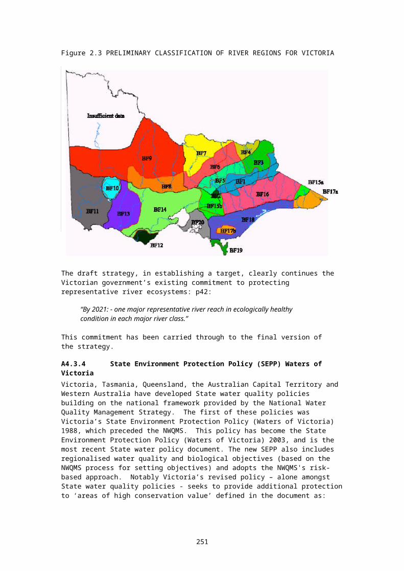
(c) take all reasonable steps to ensure that that part of the river which is in the area is maintained without further interference with its free flowing state except as otherwise provided in this Act.
(2) A managing authority of a natural catchment area must, in so far as it is consistent with the authority's duty to manage the area responsibly, take all reasonable steps to ensure that the area is maintained in an essentially natural condition.
8. Management plans(1) A managing authority of a heritage river area or natural catchment area must prepare a management plan for the area within 5 years of the area having been brought under the Act. (5) A management plan made or adopted under this section does not take effect until it is approved by the Minister.
is not warranted. However, it is a tool used as appropriate." Email 28/2/01.175 Brian Wilkinson (ACT gov) pers.comm. 26/2/01, 28/2/01.176 The NT Water Act s.22B provides that, where the Minister declares a Water Allocation Plan in respect of a Water Control District, the plan must include an allocation for the environment.177 While many NT streams remain substantially unregulated, specific environmental flows, calculated in accordance with agreed national principles, have not yet been established as a component of Water Allocation Plans under s.22B of the Water Act 2000.178 Tim Fisher (2000) has suggested that NSW is the only State to implement environmental flows enthusiastically and effectively.179 "Surface flow" here means the capture of catchment runnoff away from defined watercourses.180 The provisions of the NT Water Act s.40(2) are so weak as to provide no effective control.181 Being addressed by the current Vic policy / statute improvement program.182 The Act defines 'surface' water to include overland flow (s.4) so the provisions of the Act applying to surface water can be used to regulate harvesting of overland flow.183 Water Management Act 1999, s.14 - for example.184 This is, however, likely to eventuate in the near future.185 However, this issue has been addressed by recent revisions in both policy and statute, and surface flows in southern Qld catchments feeding the Murray-Darling should soon come under State control.186 The ACT's water allocation and licensing procedures include surface flow controls (Brian Wilkinson, ACT gov, email 28/2/01).187 "Weak" means that fish passage provisions are set in policy or statute, but not effectively implemented. Tasmania, for example, has strong fish passage provisions in the Inland Fisheries Act, however they are not effectively implemented - in a political climate that places a high priority on encouraging the building of dams. Fish passage is included in the assessment criteria for medium and large dam proposals. "Strong" means that an effective implementation program is underway. Key elements of implementation include: (a) accurate mapping and auditing of dams, weirs, and other impediments; (b) a program for the identification and removal of unnecessary impediments; (c) readily available written guidelines on fish passage provisions for small and medium dams are available; (d) policy requires all new major on-stream dams must have fish passage facilities. 188 Brian Wilkinson (ACT govt) email 28/2/01: "Fish passage needs are being addressed adequately. Whilst the ACT does not have a formal fish passage policy (because of the small number of barriers), the requirements for fish passage are addressed in the Threatened Species Action Plans, and management plans for the MRC. They were covered in: Lintermans, M. (2000). The Status of Fish in the Australian Capital Territory: A Review of Current Knowledge and Management Requirements (Technical Report 15, Environment ACT, Canberra). The ACT has constructed fish ladders on two barriers in the last year and has just commence planning for a third. There are only a small number of fish barriers in the ACT some of which are required to prevent passage of pest species."189 The draft Waterways WA Policy does acknowledge intrinsic values, although in a somewhat muted way.190 NSW Biodiversity Strategy p.4, and the Water Management Act 2000, 5(2)B.191 Refer to: Government of the Australian Capital Territory (1998) Nature Conservation Strategy; page 4.192 Limited protection provided by the Wildlife Conservation Act 1950.193 But the NT does have a threatened species strategy: Government of the Northern Territory (1999) A Strategy for the Conservation of Threatened Species and Ecological Communities in the Northern Territory of Australia; National Parks and Wildlife Commission of the NT; Darwin.

9. Contents of management plansA management plan for a heritage river area or natural catchment area must state the way in which the managing authority is to undertake its duties and exercise its powers under this Act and the management plan must be consistent with the purpose of this Act, the authority's duties and powers and any Land Conservation Council recommendations in respect of which notice has been given under section 10(3) of the Land Conservation Act 1970.
10. Land and water uses which are not permitted in heritage river areas(1) An impoundment, artificial barrier or structure that impedes the passage of water fauna must not be constructed in a heritage river area specified in Column 1 of Schedule 3 unless the
194 Limited protection provided by the National Parks and Wildlife Act 1972.195 Queensland has no specific threatened species legislation. However, (Karen Vella email 6/6/01) General protection provisions exist through environmental impact assessment under the Commonwealth Environment Protection and Biodiversity Act. Limited protection through the Queensland Nature Conservation Act 1992 (establishes reserves and protection mechanisms for endangered/concerned/threatened etc species). Impact assessment procedures also under other legislation ie: Integrated Planning Act 1997.196 Threatened Species Conservation Act 1995.197 Fisheries Management Act 1994; Fisheries Management and Environmental Assessment Legislation Amendment Act 2000 - these provide for schedules of threatened aquatic species, which allow strict management prescriptions to be developed.198 Flora and Fauna Guarantee Act 1988.199 Limited protection provided by the Nature Conservation Act 1980.200 Threatened Species Protection Act 1995.201 "The252 State Water Plan … discourages on-stream dams. In addition, some of the catchment water management plans contain policies for ‘water affecting activities’ which includes dams. As an author of the policies, I know that they do discourage on-stream dams, as well as addressing capacity and environmental flows." Gary Mavrinac, email 26/2/01.202 UC - under consideration. Refer Farm Dams (Irrigation) Review Committee (December 2000) Draft Report: recommendation 13.203 An informal departmental policy exists discouraging on-stream dams "where inappropriate" (B.Wilkinson email 28/2/01). However, there is no written policy, and no reference to the need to encourage off-stream dams in departmental farmer extension material (see "Information sheet 4: Water Resources Act 1998: Information about dams).204 As in the ACT, an informal departmental policy exists discouraging on-stream dams, although there is no written policy, and no reference to the need to encourage off-stream dams in departmental farmer extension material.205 Most activity in SA is being channelled into the development of Regional Biodiversity Strategies.206 Although Queensland is not intending to develop a biodiversity strategy (Karen Vella email 6/6/01): There are strategies for Wet Tropics World Heritage Area and Great Barrier Reef Marine Park Area. There are other localised strategies around. There is a State Strategy for the management and protection of coastal resources released in 2000, and strategies for biodiversity issues in the Moreton Bay Marine Park, and for different catchments.207 NSW Biodiversity Strategy 1999. An aquatic biodiversity strategy is currently under development.208 Victoria's biodiversity strategy is contained in a trio of documents released simultaneously in 1997: Victoria's biodiversity - our living wealth; Victoria's biodiversity - sustaining our living wealth; and Victoria's biodiversity - directions in management.
209The ACT Nature Conservation Strategy 1998 takes the place of both a biodiversity strategy and a wetlands strategy.210 Not including controls which are at the discretion of local governments under State landuse planning legislation.211 Additional references: Binning, C., M. Young, et al. (1998). Beyond Roads, Rates and Rubbish: Opportunities for Local Government to Conserve Native Vegetation. Canberra, CSIRO Wildlife and Ecology: Resource Futures Program. ALSO: Cripps, E., C. Binnings, et al. (1998). Opportunity Denied: Review of the
Governor in Council by notice published in the Government Gazette, approves its construction in that area. (2) There must not be a new water diversion in a heritage river area specified in Column 2 of Schedule 3 unless it is approved by the Governor in Council by notice published in the Government Gazette. (3) Any new water diversion from a waterway upstream from the lowest point of a heritage river area specified in Column 3 of Schedule 3 must not significantly impair the nature conservation, recreation, scenic or cultural heritage attributes of the area. (4) Sub-section (3) does not apply to a water diversion approved by the Governor in Council by notice published in the Government Gazette. (5) Timber harvesting is not to be carried out in any heritage river area specified in Column 4 of Schedule 3.
Legislative Ability of Local Government to Conserve Native Vegetation. Canberra, CSIRO Wildlife and Ecology: Resource Futures Program.212 Licences to clear native vegetation are required within proclaimed water catchment protection areas. In other areas (by far the bulk of the State) landholders wishing to clear more than 10 ha must notify their local government authority of their intention. This information is passed by local government to the State department of Conservation and Land Management, who may object. 213 Native Vegetation Act 1991.214 Queensland's Vegetation Management Act 1999; see http://www.dnr.qld.gov.au/resourcenet/veg/215 Native Vegetation Conservation Act 1997 - allows prescriptions to be developed eg: for riparian vegetation.216 Native Vegetation Retention Regulations 1989 (under the Planning and Environment Act 1987) allow clearance of native vegetation (houseblock size) without a permit. Above that level, and below 10 ha, Local Government can issue a permit. Above 10 ha, the Dept of Natural Resources and Environment becomes a referral agent when LG are considering a permit. LG must follow DNRE recommendations. DNRE issued Planning Guidelines for Native Vegetation Retention Controls in 1996, and in 2000 published a Draft Native Vegetation Management Framework. Under the P&E Act, LG Councils can provide environmental zones in planning schemes, and these zones can have additional overlays. Overlays may, for example, place additional restrictions to prevent the clearing of habitat for species listed as threatened under Victoria's Flora and Fauna Guarantee Act, or the Commonwealth's Environment and Biodiversity Protection Act 1999. The Minister for Planning may require Councils to include specific information or requirements in zones or overlays.217 Clearance of native vegetation is controlled through planning legislation. Permits are required for clearing native vegetation in excess of a certain size.218 Although Tasmania lack an overall State framework for managing the clearance of native vegetation, some local government areas have developed strategies and development approval requirements which control the clearing of native vegetation.219 Wetlands Conservation Policy 1997.220 Government of the Northern Territory (2000) A Strategy for Conservation of the Biological Diversity of Wetlands in the Northern Territory of Australia. Parks and Wildlife Commission of the NT; Darwin.221 Strategy for the Conservation and Management of Queensland’s Wetlands, 1999.222 New South Wales wetlands management policy 1996.223 Wetlands Conservation Program 1988.224 The ACT Nature Conservation Strategy 1998 takes the place of both a biodiversity strategy and a wetlands strategy.225 WA is, however, developing a State Water Quality Management Strategy. 226 Environmental Protection (Water Quality) Policy 1997 - subordinate legislation under the Environment Protection Act 1994..227 Parliament of Victoria (1988) State Environment Protection Policy: Waters of Victoria. Government Gazette (Victoria) s.13, 26/2/1988.228 Parliament of Tasmania (1997) State Policy on Water Quality Management (September 1997); available at http://www.delm.tas.gov.au/env/waterpol.html.229 Slow-moving or still.230 NZ has recently been audited on its Ramsar implementation performance, and that the Auditor General concluded that:- the current national framework for planning and monitoring for wetland conservation and protection is inadequate; - there is inadequate policy direction for wetland protection;

12. Land and water uses which are not permitted in natural catchment areasThe carrying out of the following uses and activities must not be permitted or take place in a natural catchment area--
(a) the clearing of indigenous flora; (b) the harvesting of timber; (c) the establishment of plantations; (d) mining; (e) mineral exploration, except in accordance with any recommendation of the Land Conservation Council in respect of which notice has been given under section 10(3) of the Land Conservation Act 1970; (f) extractive industries;
- responsibility for wetland protection and management had been fragmented across agencies which led to a lack of accountability for results;- there is inadequate reporting to government on progress with implementing the Ramsar convention.
231 Ton Snelder is the lead NIWA scientist.232 Wentworth Group 2003:9: Preventing environmental damage is vastly cheaper than trying to repair it. We need to identify the rivers and groundwater systems that have not been degraded and develop management strategies to protect them. This would have little impact on existing water use, such as normal stock and domestic use, while preventing inappropriate development and changes in water use. Benefits will include: giving future generations the opportunity to enjoy healthy Australian rivers; supporting recreation, tourism and other compatible uses; providing a baseline for assessing working rivers with altered flow regimes; and protecting native plants and wildlife that can be reintroduced elsewhere to improve the health of other rivers. Australia needs a national river classification system comparable to our national reserve system. As a general guide:• rivers with less than 5% of their water diverted for human use should be classified as Heritage Rivers; and• rivers with 5% to 15% water use should be classified as Conservation Rivers.We need to work hard to restore the remainder of our rivers to the status of healthy Working Rivers. In Heritage and Conservation Rivers, the classification and management system should ensure that public and private land and water use is consistent with maintaining the values of each river’s environmental assets. There should be no increase in diversion of water for human use, and timing and patterns of water use should take account of environmental impacts and requirements. States already have designated such rivers in their water planning but we need a national designation to provide protection beyond the five-year framework used in State water planning.The Commonwealth Government should provide funding to assist with the survey and assessment of Heritage and Conservation Rivers, and assist the States with management to ensure these rivers are not degraded. 233 Mark Latham's Fraser speech 28/5/04: "The Murray/Darling is our largest river system and the most at risk, but it's not the only river that needs attention. Labor will implement a national system for classifying Australia's major rivers, ensuring that we identify and protect those of high conservation value."234 In other words, a nationally consistent means of identifying and selecting rivers and estuaries of high conservation value (see the six-stage planning process described by Margules and Pressey 2000 - discussed in section 4.3);235 This would be the first step in achieving nationally consistent means of protecting these rivers and estuaries. New tools, like special-purpose legislation (modeled perhaps on Victoria’s Heritage Rivers Act 1992) will take time to develop.236 This study defines rivers as including dependent estuaries, riparian zones and 1-in-20 year floodplains.237 In other words, a nationally consistent means of identifying and selecting rivers and estuaries of high conservation value (see the six-stage planning process described by Margules and Pressey 2000 - discussed in section 4.3);238 This would be the first step in achieving nationally consistent means of protecting these rivers and estuaries. New tools, like special-purpose legislation (modeled perhaps on Victoria’s Heritage Rivers Act 1992) will take time to develop.239 Commonwealth of Australia 1996:2 “There is in the community a view that the conservation of biological diversity also has an ethical basis. We share the earth with many other life forms which warrant our respect, whether or not they are of benefit to us. Earth belongs to the future as well as the present; no single species or generation can claim it as its own.”240 The Heritage Rivers Programs (see Heritage Rivers Act 1992).241 The Wild and Scenic Rivers Program (see Wild and Scenic Rivers Act 1968).242 The Heritage Rivers Program.

(g) the construction of new water storages or new water diversions; (h) the carrying out of waterway management; (i) the grazing of domestic animals; (j) the making of new roads or the upgrading of existing roads; (k) the discharging of effluent; (l) the introduction of non-indigenous species of fauna; (m) the stocking of the area with indigenous fauna, except for the purpose of conserving an indigenous species of fauna which would otherwise be at risk; (n) the use of powered water craft.
17. Power to enter into agreements
243 Hierarchical systems of using data mean that broadscale data can be applied using the upper hierarchical levels. Detailed data (if available) enables finer, more accurate assessments.244 Most States have already developed their individual approaches to river and estuary classification, for example. An entirely cohesive national approach may be impossible to achieve in the short or medium term.245 Reserves are defined here as areas meeting the criteria established by the IUCN for categories 1 to 4 of the six-part IUCN protected area definition.246 For example, most of the 'natural catchments' protected under Victoria's Heritage Rivers Act 1992 lie in the headwaters of streams, within State reserves.247 The existing framework for protecting wetlands uses two levels: (a) Ramsar listing, and (b) listing in the Directory of Important Wetlands. Cullen (2002) argues for two levels of listing for special rivers: 'heritage river' and 'conservation river'. Victoria's Heritage River Program, as defined in 1987, used three categories: 'heritage river', 'natural catchment', and 'representative river' (Appendix 4). The ACT's program uses one category, that of 'river reserve'. 248 "In the absence of comprehensive state inventories which are in many instances years away, we need robust remote sensing approaches to assess value and condition" (J Tait, pers.comm 7/10/03).249 A nationally consistent approach here is likely to save considerable time and money.250 The earlier Land Conservation Council representative rivers were chosen mainly on geomorphology and hydrology variables. Doeg's work on macroinvertebrates was largely based on Metzeling's (2001) work.251 Jim Tait, pers.comm. 7/10/03: "relationships depend on the ecosystem under study, but most likely would be exponential or poly threshold".252 Which could include, for example, review of water available for irrigation, commercial or industrial consumption.253 Sub-regions are areas within a region which contain concentrations of similar, or particular, ecosystems. 254 Stream order numbering is incremented downstream. Thus headwater streams are described as first order. Wherever two streams of the same order join the order is incremented for the downstream link. This is the Strahler stream ordering scheme. The Shreve system is similar except that the order number is incremented at each junction. Strahler is usually assumed if not specifically stated (courtesy Janet Stein).
255 Note that there is no statewide planning policy for wetlands, although this had been proposed under the Victorian Wetlands Program. This recommendation was not implemented by an incoming coalition government in 1992. Planning on private (and public) land in Victoria is subject to the Victorian Planning Provisions which allow local government to use local planning policies, zoning, environmental and other overlays as appropriate to achieve planning objectives, including biodiversity conservation - but there is no specific policy regarding wetland conservation.256 Wetland conservation reserves have been incorporated into the park and reserve system in Victoria essentially as a result of the LCC process. There are about 300 wildlife reserves, the majority of which are wetlands, about 100 lake reserves, and 264 streamside reserves. Wetlands are also included in scheduled parks, eg Lake Albacutya, Hattah-Kulkyne Lakes, part of Barmah Forest. Although this process was not based on bioregional planning as such, Victoria has a reasonably good representation of wetland types (using Corrick’s definition) in its

(1) A managing authority may enter an agreement with any other managing authority, municipality, government department or public statutory body of Victoria, the Commonwealth or any other State or Territory of the Commonwealth with respect to the exercise of its powers under this Act. (2) The Minister must cause notice in the prescribed form of the making of an agreement to be laid before each House of Parliament within 10 sitting days after it is made. (3) The agreement has no effect if either House of Parliament passes a resolution declaring it be of no effect within 10 sitting days after notice of the making of the agreement is laid before the House. (4) The Minister must publish notice of the resolution of the House in the Government Gazette. The Victorian Heritage Rivers Act, in summary, attempts to maintain the high natural values of the designated rivers and catchments by requiring management arrangements compatible with the
protected area network. Corrick used a six-category classification based on water depth, whether water remained permanently or temporarily on the wetland, and water salinity: freshwater meadow, shallow freshwater marsh, deep freshwater marsh, permanent open freshwater wetland, semi-permanent saline wetland, and permanent saline wetland. These are also listed in: Government of Victoria 1997c:120.257 While a fundamental aim of the Heritage Rivers Program was to protect “representative” rivers, it should be noted that the term “representative” does not have exactly the same meaning allocated to the term in this paper. The term as used in the Strategy, and later by the LCC, includes only representative values relating to hydrology and geomorphology. However, as discussed above, stream geomorphology and hydrology provide the physical base on which the stream ecology rests. Furthermore, when one examines the method used by the LCC to identify river types on which to develop a representative list (LCC 1989: 112-117), one key ecological variable was taken into account: whether the river system drained to the sea (thus providing fish with an estuarine or marine phase in their life-cycle access to the rivers) or to the inland Murray-Darling Basin (in which case these species have no effective access). The 37-unit river classification initially used by the LCC was derived by overlaying a 29-unit geomorphic regionalisation with a 5-unit hydrological regionalisation. This was later modified by reducing the complexity of the geomorphic regionalisation to 9 categories (LCC (1991: 105-113) yielding a 16-unit river classification.Nevertheless, the exclusion of the matter of representative ecosystems from explicit consideration in the Victorian study presents a limitation to the program and its outcomes.258 The use of planning mechanisms for the protection of catchment and waterway values was addressed in Bennett (1989) and summarised in LCC (1989:14-17).259 By the Department of Natural Resources and Environment, Victoria.260 Under section 40 of the Victorian Water Act 1989, they are included in a list of heads of consideration.261 Morton et al., (2002) Sustaining our Natural Systems and Biodiversity: An independent report to the Prime Minister’s Science, Engineering and Innovation Council. CSIRO and Environment Australia, Canberra.262 Not to be confused with the "Commonwealth Heritage List" which is a list of heritage places owned or managed by the Commonwealth Government.263 The Australian Government under the Environment Protection and Biodiversity Conservation Act 1999 now requires persons undertaking an activity that is likely to involve the killing, injuring, taking, trading, keeping or movement of a listed species in inland waters in a Commonwealth area to obtain a permit. Commonwealth areas are lands owned or leased by the Commonwealth. For a permit application form, go to http://www.deh.gov.au/epbc/permits/species/standard.html .264 John Fenton, pers. comm. (ABS figures need to be checked).265 With the exception of rivers protected under the USA’s Wild and Scenic Rivers Act 1968.266 That is, commitments to establish representative systems of freshwater reserves.267 With the obvious exception of marine reserves encompassing estuaries.268 Dunn, Helen (2000) Identifying and protecting rivers of high ecological value; LWRDDC Occasional Paper 01/00. Land and Water Resources Research and Development Corporation, Canberra.269 See Arthington and Hegerl 1988, Australian Society for Fish Biology 2001, Clark and Spier 2000, Horwitz 1990, Ponder 1997, Sattler and Williams 1999, and Storrs and Finlayson 1997, Wedderburn 2000, and Yen and Butcher 1997.270 Refer: Ramsar Conference of Parties No.7 Resolution VII.17.
protection of the area's designated values in the long term and prohibiting or controlling threatening activities. The maintenance of river flow, and free flow, are key aspects to these arrangements. These provisions provide a model, which might be used in developing a national framework.
271 DEH 2002 page 111 (Australia’s national report to Ramsar CoP8).272 Available from the Ramsar website: www.ramsar.org. (accessed November 2003).273 Articulated in the Convention on Biological Diversity, and through the Ramsar Convention and other associated wetland agreements.274 According to Article 2 of the Convention on Biological Diversity: "Protected area means a geographically defined area which is designated or regulated and managed to achieve specific conservation objectives." Article 2 also defines "Biological diversity [meaning] the variability among living organisms from all sources including, inter alia, terrestrial, marine and other aquatic ecosystems and the ecological complexes of which they are part; this includes diversity within species, between species and of ecosystems." Read together, it is clear that protected areas, under this definition, can apply to terrestrial, marine, and inland aquatic ecosystems.The IUCN (1994) defines protected area as "an area of land and/or sea especially designated to the protection and maintenance of biological diversity, and of natural and associated cultural resources, and managed through legal or other effective means". Given the backdrop to the IUCN's definition, there is little doubt that the intention of the IUCN's definition is to cover inland aquatic ecosystems, as is the case with the Convention on Biological Diversity.
275 The RFA target (in brief) is the establishment of a system of comprehensive, adequate and representative reserves aimed at protecting 15% of all major forest ecosystems (defined by major vegetation communities) existing prior to European presence (Commonwealth of Australia 1992 National Forest Policy Statement).
276 ANZECC (1999) Strategic plan of action for the national representative system of marine protected areas. Environment Australia; Canberra.277 Several submissions to the ECC investigation have recommended that this figure should be closer to the 15% used in the RFA.278 More correctly referred to as the "CoAG Water Reform Framework".279 See Principle 8 referred to above.
280 The words chosen in subsection 2.5.1 (relating to the water environment) also fail to carry forward the import of an earlier action statement (Action 1.1.1) which specifically sets out the need for inventories to identify representative values:“Identify the terrestrial, marine and other aquatic components of biological diversity that are important for its conservation and ecologically sustainable use, including (a) ecosystems and habitats that contain high diversity, large numbers of endemic or threatened species, or wilderness, that are required by migratory species, that are of social, economic, scientific or cultural importance, or that are representative, unique or associated with key evolutionary or other biological processes…”
281 Helen Dunn, in her recent paper Identifying and Protecting Rivers of High Ecological Value, highlights the need for consideration of representative values (section 3.4.3). One of her key recommendations is (6.3.4): A national system of river reserves should be a core strategy for protection.
282 The Convention defines “wise use” as: “sustainable utilisation for the benefit of humankind in a way compatible with the maintenance of the natural properties of the ecosystem” Commonwealth of Australia (1997:iii).
Appendix 17. The NZ ‘Waters of National Importance’ project.In early 2003 the New Zealand Ministry for the Environment, as part of a wider (whole of government) Water Programme of Action, initiated a project called the New Zealand Waters of National Importance Project (including both inland and marine waters). Policy commitments to ensure sustainable development underpin the Programme. The primary task of the project is the identification of waters of national importance. Protection for biodiversity values forms a component of this project. Within the Programme, three projects are of particular interest:
PROJECT 3: POTENTIAL WATER BODIES OF NATIONAL IMPORTANCE
283 According to the Ramsar strategic framework for site designation, a wetland is identified as being of international importance if it meets at least one of a list of criteria. The first item on the list is:
Criteria for representative or unique wetlandsA wetland should be considered internationally important if: (a) it is a particularly good representative example of a natural or near-natural wetland,
characteristic of the appropriate biogeographical region; (b) it is a particularly good representative example of a natural or near-natural wetland, common
to more than one biogeographic region;(c) it is a particularly good representative example of a wetland which plays a substantial
hydrological, biological, or ecological role in the natural functioning of a major river basin or coastal system, especially where it is located in a transborder position; or
(d) it is an example of a specific type of wetland, rare or unusual in the appropriate biogeographic region.
Source: Commonwealth of Australia 1997:38
284 The criteria are listed and discussed in Dunn (2000) section 2.4, with additional reference to marine programs.
285 At the sixth Ramsar Conference in Brisbane (Australia) in March 1996, “karst system wetlands” were formally recognised within the Convention’s classification system. Commonwealth of Australia 1997:29. The word “karst” means limestone formations such as caves, or underground streams.
286 The Ramsar Convention on Wetlands of International Importance, to which Australia and 99 other nation states are signatories, defines wetlands as:
“areas of march, fen, peatland or water, whether natural or artificial, permanent or temporary, with water that is static or flowing, fresh, brackish or salt, including areas of marine water the depth of which at low tide does not exceed six metres”.
This definition has been generally accepted by the Australian Commonwealth and States, with one important modification made by the Commonwealth, Victoria and New South Wales: the exclusion of permanent rivers and streams. For further discussion of the question of definition, see Commonwealth of Australia 1997:29,47.
287 For the benefit of overseas readers, Australia has a 3-level system of government: (1) Commonwealth, (2) State and Territory, and (3) local. There are 6 States (Western Australia, South Australia, Queensland, New South Wales, Victoria and Tasmania) and 2 Territories (the Northern Territory, and the Australian Capital Territory, the latter occupying a comparatively small area). In this paper, the word “States” is used to include the two Territories.
Readers unfamiliar with the Australian system of government should refer to Commonwealth of Australia (1998:12-13) for further information.
This project will develop a list of water bodies that may be considered to have nationally important values, both now and in the future. Water bodies will be assessed against the following values: tourism irrigation energy generation industrial uses recreation natural heritage, and cultural heritage.
PROJECT 4: HOW TO DETERMINE THE NATIONAL INTERESTIf something is ‘in the interests of all sections of the community at the national scale, now and in the future’, then it’s considered to be in the national interest. This project will draw together the results of the three strands of the Water Programme of Action – water allocation, water quality, and the potential water bodies of national importance projects. Principles and processes for determining the national interest in water, and how they can be used in decision making will be recommended.
This project will:
288 Only the Commonwealth government may levy income tax.289For the benefit of international readers: the State Premier is the leader of the State Government in that State – effectively the State government CEO.
290 See the discussion and reference links under “planetary stewardship” on the OnlyOnePlanet website.291 According to Fisher 2000.292 Wetlands Policy of the Commonwealth Government of Australia; p.29.293 Wetlands Policy of the Commonwealth Government of Australia; p.13.294 Wetlands Policy of the Commonwealth Government of Australia; p.19.295 Wetlands Policy of the Commonwealth Government of Australia; p.14.
296 The policy does, however, provide general support for the CoAG water reforms, and the ICM process in particular.297 While an acknowledgment of intrinsic values is absent from section 2.1 (p.6) of the policy (the importance of the wetland resource), intrinsic values do appear briefly in section 2.3 (goal).
298ANZECC Standing Committee on Conservation 1997:2299ANZECC Standing Committee on Conservation 1997:2
300 As discussed below, the Victorian Representative Rivers were established on the basis of a river typology which assumed that river ecologies depended substantially on river geomorphology and hydrology. A more detailed river typology would take into account major variables relating to river ecology: eg: the ability for fish and other aquatic organisms to access the particular site under consideration.
301 “Proposed New Commonwealth Heritage Regime”: flyer published by Environment Australia, June 2000.302 Jonathan Miller, pers. comm. 5/12/00.303 See the NLWRA website.
304 Centre for Water Policy Research, University of New England, and the Australian Centre for Tropical Freshwater Research, James Cook University (1999) Integrated assessment process and guidelines for water resource development projects. National Land and Water Resources Audit; Canberra. These guidelines have been taken into account by Jon Nevill when preparing a model dam environmental impact statement scoping guideline: available on the Only One Planet website.
identify how we can determine the national interest in water and how we can get the best results from water management;
encourage partnerships and sector participation in determining the national interest; assess how the needs of different groups should be recognised in determining the national
interest; and identify how the national interest would feed into decision making – now and in the future.
PROJECT 6: IDENTIFY WATER BODIES OF NATIONAL IMPORTANCEThis follows on from project three, which developed lists of potential water bodies of national importance. This project will identify the ‘Water Bodies of National Importance’ and agree on the values to be secured in those water bodies. The process for the project will be heavily consultative and will rely on partnerships with major sectors.
Elements include: identifying complementary values and mutually exclusive values for each candidate water
body; identifying the risks to the values if there was no Crown intervention; agreeing on the overall list of Water Bodies of National Importance and the values to be
secured; and developing options for new tools, or changes to existing tools to secure the values of the
Water Bodies of National Importance.
Source: Ministry for the Environment, New Zealand (Nov 2003) The Water Programme of Action. Four-page leaflet. Ministry for the Environment; Wellington.

Appendix 18. World Conservation Congress resolution on freshwater protected areas
IUCN Congress reference: CGR3.RES039 – Rev1 November 2004
RECALLING Recommendation 19.38 Targets for Protected Areas Systems, of the 19th Session of the IUCN General Assembly (Buenos Aires, 1994), as well as Recommendation 16 of the IVth World Parks Congress (Caracas, 1992), which urged governments to ensure that protected areas should cover a minimum of 10 percent of each biome by the year 2000;
RECALLING that Recommendation 17.38 Protection of the Coastal and Marine Environment, adopted by the 17th Session of the IUCN General Assembly (San Jose, 1988), Recommendation 1.37 Marine Protected Areas, adopted by the 1st Session of the World Conservation Congress (Montreal, 1996), and Resolution 2.20 Conservation of marine biodiversity, adopted by the 2nd Session of the World Conservation Congress (Amman, 2000), support the establishment of protected areas in marine aquatic environments;
RECALLING that Resolution 2.47 Conservation of the last wild rivers of Europe, adopted by the 2nd Session of the World Conservation Congress (Amman, 2000), urges IUCN to review and promote development of an international classification of river categories according to their degree of naturalness;
RECALLING that Recommendation V.31 Protected Areas, freshwater and integrated river basin management frameworks, noted by the Vth IUCN World Parks Congress (Durban, 2003), supports the establishment and implementation of integrated river basin management in which networks of protected areas and regimes of protection are a key development strategy;
RECALLING that Decision VII/2 of the 7th Meeting of the Conference of the Parties to the Convention on Biological Diversity – CBD (Kuala Lumpur, 2004) adopts a goal of establishing and maintaining comprehensive, adequate and representative systems of protected inland water ecosystems within the framework of integrated catchment/watershed/river basin management;
CONCERNED that the use of freshwater resources and the rate of degradation of freshwater habitats are increasing;
ALSO CONCERNED that the World Wide Fund For Nature’s Living Planet Index indicates that freshwater biodiversity has fallen at a greater rate than in either the forest or marine biomes, declining by 55 percent from 1970-2000;
FURTHER CONCERNED that an estimated 17 percent of freshwater fish species in the 20 countries for which assessments were most complete are classified by the IUCN Red List of Threatened Species as threatened with extinction;
COMMITTED to the adoption of integrated river basin management as an essential means of achieving sustainable use of freshwater ecosystems and of maintaining aquatic biological diversity;
ACKNOWLEDGING there is an urgent need to ensure that a substantial portion of all ecosystems is conserved to act as reference, replenishment and refuge areas;
CONVINCED that freshwater protected areas represent an important method for conserving marine biodiversity and contributing to the sustainable use of freshwater resources;
NOTING that the IUCN Guidelines for Protected Area Management Categories identify a range of protected area types and that systems of protected areas in freshwater environments should be complemented by systems of integrated river basin management; and
NOTING further that wetlands may be specifically protected through listing under the Ramsar Convention on Wetlands, a treaty focused on conservation and wise use of a particular biome and encompassing the world’s largest protected areas network for wetlands;
The World Conservation Congress at its 3rd Session in Bangkok, Thailand, 17-25 November 2004:
1. RECOMMENDS that all states:
(a) establish protected areas representative of all freshwater ecosystems, including but not limited to riverine, lacustrine, wetland, estuarine and groundwater-dependent ecosystems, in cooperation with local communities and resource users, so as to safeguard the biodiversity of each of their freshwater ecosystems, and set targets for protection where useful and appropriate;
(b) establish their systems of freshwater protected areas within an integrated river basin management approach taking advantage of the full range of governance types;
(c) as part of their overall programs, establish viable freshwater protected areas, to ensure the inclusion of areas which meet the protection criteria for IUCN Management Categories I and II;
(d) that are Parties to the Convention on Biological Diversity (CBD) implement the targets adopted in the CBD Program of Work on Protected Areas in relation to freshwater habitat, including enhanced implementation of the Ramsar Convention on Wetlands; and
(e) develop and implement national action plans on these issues;
2. RECOMMENDS that the World Commission on Protected Areas develop guidance on the application of the IUCN Guidelines for Protected Area Management Categories in freshwater environments; and
3. FURTHER RECOMMENDS that IUCN strengthens its work with the Ramsar Convention on Wetlands in order to facilitate better management and assessment, monitoring and reporting on freshwater protected areas, including through application of IUCN’s Guidelines for Protected Area Management Category System.

Appendix 19. Criteria for protected area identification and selection
After Kingsford et al. 2005.
Value, condition and importance can be measured qualitatively or quantitatively – see Appendix 7 above. Consistent, transparent management and reporting frameworks depend on repeatable measurements over time, so there is a strong incentive to develop quantitative measures. In reality, however, most ecosystem management frameworks depend to some extent on qualitative concepts relating to value, importance and condition. Kingsford et al. (2005) have reviewed the
305 Pers. comm. Janet Stein ANU Feb 2004: "The project developed some interesting methods but the data was not available at suitable resolutions to produce useful results at the reach scale. It was however useful as an overview for the intensive land use zone."306 The program has two additional major components: Support for Water Reform – providing additional scientific input to underpin the sustainable management of Australia’s water resources. Inputs include: establishing adequate environmental flows; ensuring water resource development is sustainable; developing strategies to reduce withdrawals in over-allocated systems and supporting integrated catchment management.
Groundwater - including a research project to identify groundwater dependent ecosystems throughout Australia, and the best methods to identify the environmental water requirements for these groundwater systems.
307 Murray-Darling Ministerial Council (2000:1).308 A ‘net gain’ approach to the management of native vegetation was introduced by the Victorian government in their native vegetation management policy of 2002, and repeated in their State Environment Protection Policy (Waters of Victoria) 2003 (section 53): “53. Vegetation protection and rehabilitation: Aquatic, riparian and coastal vegetation needs to be protected and rehabilitated, to achieve the goal of net gain in extent and quality of coastal, aquatic and riparian vegetation over the lifetime of the Policy. To achieve this, relevant protection agencies, particularly the Department of Sustainability and Environment, Parks Victoria, catchment management authorities, regional coastal boards and municipal councils, need to work with communities to minimise the removal of, and rehabilitate, native vegetation within or adjacent to surface waters.”
309 Available at http://www.affa.gov.au/docs/nrm/actionplan/index.html .310 Water pollution controls are often found in multiple State statutes, and Tasmania is no exception. Here pollution is now primarily controlled through the provisions of the Environmental Management and Pollution Control Act 1994, and the associated Water Quality Policy 1995. However the Water Management Act 1999 does contain provisions designed to prevent the discharge of unauthorised waste into aquifers.311 See the water legislation of Tasmania, WA, NSW, and SA, for example.312 The NSW Water Management Act 2000 provides the best Australian example.313 The SA and NSW water Acts provide the best examples.314 ACT, Qld and SA provide the best examples (see Nevill, Maher and Nichols 2001).315 NSW, SA and Qld have strong adaptive management provisions in recent water legislation (Nevill 2001).316 All jurisdictions except Victoria now have legislative provision for surface water controls. However the only State to implement these controls on a significant scale is NSW.317 More detail can be found in Maher 1999: 86-89.318 That is: rivers with major dams.319 Allan Lugg, pers.comm.5/5/00.
320At a general level, a National framework for environmental impact assessment (EIA) has been developed. Guidelines, established in consequence to the InterGovernmental Agreement on the Environment 1992, have been provided (ANZECC 1996). According to these guidelines, EIA should assess:
application of the seven criteria described earlier, and although their review was written with Australian surface waters in mind, it can be refined to include subterranean waters as well:
Seven criteria are recommended :
Criterion 1: The ecosystem and its catchment is largely undisturbed by the direct influence of modern human activity.
Criterion 2: The ecosystem is a good representative example of its type or class within a bioregion or sub-bioregion.
character of the receiving environment; potential impacts of the proposal; resilience of the environment to cope with change; confidence of prediction of impacts; presence of planning or policy framework, or other procedures which provide mechanisms for
managing potential environmental impacts; other statutory decision-making processes which may provide a forum to address the relevant
issues of concern; and degree of public interest.
These criteria are expanded in the above document. Each State has developed EIA procedures through State legislation aimed in part at meeting these recommendations.
321 Without comprehensive freshwater ecosystem inventories, while the local impacts of infrastructure proposals may be predicted, the relative importance, and thus meaning, of these impacts can only be derived by comparison to natural resources values over national and State scales.
322 See discussion above, and Odum 1982 (references).323 See, for example, Tasmania's Water Management Act 1999, and South Australia's Water Resources Act 1997.324 On average. See Australian Rainfall and Runoff.
325 Queensland currently has a program aimed at developing a State Rivers Policy for protecting rivers of high ecological value (prior to mid-2000 this program was known as the "Natural Rivers Policy").
The Queensland Government has moved in a somewhat piece-meal way to implement the CoAG Water Reform Framework in the last six years. Although technically committed to the process since the 1994 CoAG agreement, all elements of the reform have not been consistently implemented. The National Competition Council suspended $15m in National Competition Policy payments (25% of the total) in the second tranche assessment for failure to adequately assess the impacts of dam proposals.
Central to the Queensland government's implementation program has been the development of a Water Allocation and Management Planning (WAMP) process that provides for environmental flows in each river system. The development of a tradeable water entitlements system is another key initiative.
In 1996, the Government of the time established a Water Infrastructure Task Force to prepare an overall strategy for the development of water infrastructure throughout Queensland for the following 15 years. The strategy recommended a number of projects for immediate progression (in contravention of the CoAG water reform agenda), but it also recommended certain catchment/regional planning and assessment studies and environmental flow research projects. At the same time an improved impact assessment process for water infrastructure proposals was established.

Criterion 3: The ecosystem is the habitat of rare or threatened species or communities, or is the location of rare or threatened or significant geomorphic or geological feature(s), or contains one of only a few known habitats of an organism of unknown distribution506.
Criterion 4: The ecosystem demonstrates unusual diversity and/or abundance of features, habitats, communities or species.
Criterion 5: The ecosystem provides evidence of the course or pattern of the evolution of Australia’s landscape or biota.
Under the program the Queensland Environmental Protection Agency is being funded to develop a methodology by which the conservation values of watercourses can be determined. This work will assist/direct the State in its water infrastructure development planning and will also inform the WAMP process. Research on fisheries and fishways has also been funded under the program. The “intractable” issues of: cumulative effects, the protection of special or representative freshwater sites, and fish passage - all feature in the Queensland program.
In summary: there is considerable interest in water infrastructure development in Queensland, with the current emphasis being on the development of the information systems to support the decision-making structures. This is consistent with the State’s commitments to meet the environmental provisions of the CoAG Water Reform Agenda. The aim is to create an economically viable/ecologically sustainable water infrastructure development program.
However, at this stage the situation is not too dissimilar to the Tasmania situation. Queensland has no system of freshwater reserves, and no comprehensive State inventory of freshwater ecosystems. As a consequence, it suffers the same fundamental problems confronting Tasmania.
The main difference is that State funds have been allocated to the development of a program which would provide both an inventory of at least the most important freshwater ecosystems, as well as a program for the development, through various means, of a system of freshwater reserves.
326 New South Wales published a Wetlands Management Policy in 1996 which committed the State government to the development of representative wetland reserves. NSW, like Victoria, uses a narrow definition of the term wetlands; however unlike Victoria, NSW’s Rivers and Estuaries Policy does not contain commitments to the establishment of representative river reserves.
While there does not appear to be a State program focused on achieving the limited objective of establishing representative freshwater reserves, progress has been made in extending the State’s wetland inventory through the current Biodiversity Survey Program.
There are large areas of National Park, Wilderness and Fauna Reserve along the Great Dividing Range and the coast in particular which protect many streams and wetlands as well as their catchments. Unfortunately there are few such reserves on the western slopes and plains – where most land is private property. Nevertheless, there are a few notable reserves here (such as Macquarie Marshes Nature Reserve, Moira Lake Fauna Reserve, and Menindee and Cawndilla Lakes in the Kinchega National Park) which protect important aquatic systems (Allan Lugg; pers.comm.)
The rivers of the well-watered seaboard of NSW flow from the ridge of the Great Dividing Range eastwards towards the South Pacific Ocean. These rivers flow through the most densely populated area of the State; however, most of the State’s high capability arable land actually lies on the other (western) side of the range. As a result many of these coastal rivers remain little used (exceptions are the Snowy, Hawkesbury-Nepean and Hunter – all of which feed cropping or

Criterion 6: The ecosystem provides important resources for particular life-history stages of biota.
Criterion 7: The ecosystem performs important functions or services within the landscape (e.g., refugia, sustaining associated ecosystems).
Rationale of proposed identification criteria:Criterion 1: The ecosystem and its catchment is largely undisturbed by the direct influence of modern human activity. A large-scale aquatic ecosystem that has a natural or near-natural flow regime and relatively little catchment disturbance is highly likely to retain important natural features, processes, and biota. Adjacent components such as riparian zone vegetation that remain largely unaltered, even if they lie within highly altered catchments, will also retain important natural features, processes and biota. As well as being areas of high conservation
urban/industrial areas). Some (like the Shoalhaven) have been dammed for urban water supply rather than for irrigation, however many of the smaller rivers remain un-dammed in their lower reaches. Several eastern catchments are currently subject to dam embargoes, although these may be lifted depending on the outcome of the water management planning process.
By far the majority of the State lies west of the Great Dividing Range, an area containing most of the State’s arable land, but receiving the least rainfall. Extensive dam construction has occurred. Rivers over this area flow generally south west, forming the largest river system in Australia: the Murray-Darling.
As you might expect, few major dam proposals have been put forward in recent times, making the situation here distinctly different from that in Tasmania and Queensland. Exceptions relate to controversial proposals to service the cotton industry. In summary, NSW is generally in the position of trying to wind back, rather than expand, water usage for agricultural purposes.
327 Freshwater ecosystems have suffered massive degradation over much of South Australia. SA has only one major river, the Murray, which drains the south east of the State, where most of the State’s arable land lies. Two centuries ago this region contained extensive riverine wetlands. Today, less than 4% of south-east wetlands remain in anything like their natural condition (Robert Walsh, pers.comm.11/5/00). In the Adelaide region, wetlands have been extensively drained for urban and industrial development, and less than 1% remain. Coastal wetlands have been extensively drained for agriculture, with 3-4% left (mainly around the Coorong). The Naracoorte karst wetlands have been degraded by major abstraction of groundwater for agriculture. The extensive ephemeral wetlands and saline wetlands of the arid interior of the State (Lake Eyre, for example) have been degraded by grazing pressures. The wetlands to fare best are probably the karst wetlands of the Nullarbor Plains – which have suffered only minor problems from grazing and groundwater abstraction.
328 Senator Hill (the Commonwealth Minister for the Environment) told the 10th World Water Congress in Melbourne in April 2000 that: “Lack of compliance in both New South Wales and Queensland undermines the integrity of the cap, and threatens the ecological health of the river and the security of supply for water users… these States are doing their irrigators no favours in maintaining the pretence that they are immune from the implications of their actions”. Source: Environmental Institute of Australia Newsletter April 2000.
329 ie: funded a program with a specific “representative freshwater reserves” goal.
330 Note that there is no statewide planning policy for wetlands, although this had been proposed under the Victorian Wetlands Program. This recommendation was not implemented by an incoming coalition government in 1992. Planning on private (and public) land in Victoria is subject to the Victorian Planning Provisions which allow local government to use local planning policies, zoning, environmental and other overlays as appropriate to achieve planning objectives, including biodiversity conservation - but there is no specific policy regarding wetland conservation.
value, these undisturbed systems provide important unaltered reference systems (Downes et al. 2002) by which we can assess the condition (‘health’) of those ecosystems affected by change and deliberate modification. Rivers that remain undisturbed from source to mouth are particularly valued, as they are rare even at a global scale. However, so pervasive are anthropogenic impacts (e.g., exotic species, climate change), it is unlikely any truly pristine ecosystems exist. Therefore this criterion applies to ecosystems that are predominantly natural rather than pristine.
This criteria implicitly acknowledges the current lack of detailed understanding of the role, structure and function of ecosystems. By preserving undisturbed ecosystems we will protect many values as yet unrecognised, such as those relating to the smaller ecosystem components: invertebrates and microbes.
331 Wetland conservation reserves have been incorporated into the park and reserve system in Victoria essentially as a result of the LCC process. There are about 300 wildlife reserves, the majority of which are wetlands, about 100 lake reserves, and 264 streamside reserves. Wetlands are also included in scheduled parks, eg Lake Albacutya, Hattah-Kulkyne Lakes, part of Barmah Forest. Although this process was not based on bioregional planning as such, Victoria has a reasonably good representation of wetland types (using Corrick’s definition) in its protected area network. Corrick used a six-category classification based on water depth, whether water remained permanently or temporarily on the wetland, and water salinity: freshwater meadow, shallow freshwater marsh, deep freshwater marsh, permanent open freshwater wetland, semi-permanent saline wetland, and permanent saline wetland. These are also listed in: Government of Victoria 1997c:120.
332 By this time (October 1992) a new State government (the Kennett government) had taken office in Victoria. This government had different priorities with respect to the LCC's program, and later replaced the body with the Environment and Conservation Council.
333 While a fundamental aim of the Heritage Rivers Program was to protect “representative” rivers, it should be noted that the term “representative” does not have exactly the same meaning allocated to the term in this paper. The term as used in the Strategy, and later by the LCC, includes only representative values relating to hydrology and geomorphology. However, as discussed above, stream geomorphology and hydrology provide the physical base on which the stream ecology rests. Furthermore, when one examines the method used by the LCC to identify river types on which to develop a representative list (LCC 1989: 112-117), one key ecological variable was taken into account: whether the river system drained to the sea (thus providing fish with an estuarine or marine phase in their life-cycle access to the rivers) or to the inland Murray-Darling Basin (in which case these species have no effective access).
The 37-unit river classification initially used by the LCC was derived by overlaying a 29-unit geomorphic regionalisation with a 5-unit hydrological regionalisation. This was later modified by reducing the complexity of the geomorphic regionalisation to 9 categories (LCC (1991: 105-113) yielding a 16-unit river classification.
Nevertheless, the exclusion of the matter of representative ecosystems from explicit consideration in the Victorian study presents a limitation to the program and its outcomes.
334 The use of planning mechanisms for the protection of catchment and waterway values was addressed in Bennett (1989) and summarised in LCC (1989:14-17).335 The preparation of these management plans, encompassing protective management regimes, was an explicit requirement of the Order by Governor in Council 7/7/92 through which the State Government formally accepted the LCC’s recommendations.336 By the Department of Natural Resources and Environment, Victoria.337 Under section 40 of the Victorian Water Act 1989, they are included in a list of heads of consideration.338 Flowing from the State Government’s Order by Governor-in-Council 7 July 1992.339 This oversight presumably occurred in 1992/93 - a time of considerable structural change in the Victorian departments responsible for carrying out the recommendations.
Disturbance has been used as a core indicator in major freshwater ecosystem mapping projects – see comments above relating to New Zealand, as well as the Tasmanian Conservation of Freshwater Ecosystem Values (CFEV) project (Appendix 10) and the Australian Wild Rivers project (Appendix 11). Several of the other assessment and classification approaches listed in Appendix 8 use disturbance or naturalness as core criteria.
Most of Australia’s least-disturbed rivers lie to the north (Appendix 12) and a similar situation exists with regard to lentic ecosystems.
Criterion 2: The ecosystem is a good representative example of its type or class within a bioregion. Protecting the diversity of ecosystems within systems of reserves is one of the cornerstones of global biodiversity conservation strategies (Convention on Biological Diversity
340 Of the 15 Representative Rivers, four remain without the management prescriptions or guidelines which the LCC recommendations foreshadowed. These four are: Avoca River, Cornella Creek, McCallum Creek and Tarra River. Those with management plans are (partially overlapping designated Heritage Rivers): Upper Big River, Snowy Creek, Dargo River, Macalister River, Buchan River, Thurra River, Nicholson River, Lerderderg River, Gellibrand River, Kennedy Creek, and Moorabool River.
341 The definition of IBRA regions was not available, of course, to the earlier LCC program.342 The 13,114 wetlands listed in 1997 occupied around 2% of the land area of Victoria; Government of Victoria 1997c:119.343 37% of the State's wetlands have been lost, primarily due to drainage: Government of Victoria 1997c:121.
344 Government of Victoria 1997c:120: (i)freshwater meadows, (ii) shallow freshwater marshes, (iii) deep freshwater marshes, (iv) permanent open freshwater wetlands, (v) semi-permanent saline wetlands, and (vi) permanent saline wetlands.
345 Government of Victoria 1997a:18.346 Government of Victoria 1997c:19-20.347 Government of Victoria 1997c:124-125.348 Government of Victoria 1997c:125.349 Order by (Deputy) Governor in Council, 7 July 1992.350 Marsden Jacobs (2000).351 See recommendation 13 in the draft report.352 See http://www.onlyoneplanet.com/Submission_Wy_Yung_groundwater.htm .353 I have edited Tim's text slightly to improve readability.
354 P. 372-3, Second Tranche Assessment of Governments’ Progress with Implementing National Competition Policy and Related Reforms, 1999, National Competition Council, Melbourne.
355 Bill O'Connor, a Victorian fisheries scientist, has offered the following personal comments:It is essential that the water for streams needs to be protected as well as the boundaries of the stream reserve – for example in Victoria as a representative large Murray River tributary , the undammed Ovens River needs (as a matter of urgency) to be made into the river equivalent of a National Park…this would mean protecting the relatively natural streamflow regime.
There might need to be ‘covenants’ to protect the water (that no dams/further water extraction ever be permitted), as well as protecting the reserved catchment area. This could probably only be achieved with new legislation specifically with this purpose in mind. Since many of these streams and rivers would flow at least partly through agricultural areas, I would envisage that streams such as the Ovens River would need strong specific legislation.
The reserves must also include degraded areas of the catchment which will have to be restored by stock exclusion to riparian areas and riparian replanting. There are numerous such streams throughout Victoria eg. the Gellibrand, Aire, Mitchell and Bemm Rivers and Hughes Creek (in Strathbogies) to name just a handful. These ‘reserves’ would need to not just include the rivers which get most attention, but also smaller creeks eg. Main Ck on the Mornington Peninsula.
A reserve system for rivers / creeks will not function unless all riparian areas and water quantity are protected- no more dams should be allowed. The boundary of the reserve should include the entire catchment. In agricultural zones the
1992; principle 8 of the National strategy for the conservation of Australia’s biological diversity 1996).
Aquatic ecosystems that represent a type of ecosystem not otherwise protected within the existing reserve system will make them candidates for protection under this framework, as well as giving them a high importance rating. However, we need to understand how the components inter-relate, at what scale we decide a type of ecosystem contributes to ‘diversity’, and then develop a national ecosystem inventory, encompassing nationally agreed data collection strategies and evaluation, classification, and prioritisation techniques. For this, ecosystem classification methods adopted overseas (e.g., the SERCON system discussed in Boon et al. 1998) are suitable starting places and complement information already gathered for State
riparian areas and water can be protected, even if some of the catchment can’t be.
356 The policy on sand and gravel extraction was published in 1992 (see references).
357 For example, Action Statement 36: "Ensure that environmental planning instruments and strategies, Catchment Plans, Regional Vegetation Management Plans, council plans of management for community land, and property plans identify and protect significant native vegetation, wildlife corridors and other environmentally sensitive areas such as waterways and wetlands".
358 WA, for example, is the only State committed, by policy statement, to the protection of wetlands using the full Ramsar definition. Queensland is trialing new methods for assessing waterway values. Victoria and the ACT are the only jurisdictions to establish representative river reserves, and arguably have the most comprehensive inventories relating to both rivers and wetlands.
359 Michael Wright, 12/4/01: [While] the NPWS program for developing the NSW reserve system does not specifically target freshwater ecosystems… the inclusion of a comprehensive range of freshwater ecosystems within the NPWS reserve system is, along with the inclusion of a comprehensive range of all ecosystems, a key objective of the NPWS State Reserve System Program.
The NSW Government has, over the past six years, added 1,354,431 hectares to the formal reserve system managed by the NPWS. A further 150,000 hectares of land purchased by the NPWS in recent years awaits reservation in the near future.
These land acquisitions include a diverse array of environments from nearly all parts of NSW. Whilst not specifically targeting freshwater ecosystems, these additions to the NSW reserve system have included an equally wide array of freshwater ecosystems typical of these regions.
As part of the Government’s funding for the State Biodiversity Strategy, the NPWS is also undertaking an audit of the conservation status of all ecosystems in NSW. This audit will include freshwater ecosystems and will enhance the Government’s capacity to target those particular ecosystems in most need of conservation.
360 NSW Government (2000) pages 3 and 7.361 NSW Government (2000) pages 8 and 9.362 NSW Government (2000) page 14.363 NSW Government (2000) page 35: The proposed details of the Register of GDEs provides no indication on what information fields are to be stored under "location". In order to establish representative reserves, it is critical that this category include references to IBRA regions. Additionally, to facilitate catchment planning mechanisms, it is critical that references be included to allow identification of catchment basin and sub-basin. It seems safe to assume that latitude and longitude, local map references, and land category (freehold/nature conservation reserve/other Crown reserve) would be included.
inventories (e.g., Blackman et al. 1992; 1995, DIWA 2001), or national audits of the condition of freshwaters (e.g., the Assessment of River Condition, Norris et al. 2001).
Ephemeral and intermittent aquatic ecosystems should of course be included.
Criterion 3: The ecosystem is the habitat of rare or threatened species or communities, or is the location of rare or threatened or significant geomorphic or geological feature(s), or contains one of only a few known habitats of an organism of unknown distribution. Protection of rare and threatened species and communities is essential to biodiversity conservation. Entire communities may be threatened where they exist in specialized environments or in places where critical elements of habitat, such as fresh water, are important for human use and are under threat. In an arid country such as Australia, these critical habitat elements are often under heavy pressure and
364 Fisher (2000:s3.4.1).365 The eight principles of the NSW Weirs Policy are: 1. The construction of new weirs, or enlargement of existing weirs, shall be discouraged. 2. Weirs that are no longer providing significant benefits to the owner or user shall be removed, taking into consideration the environmental impact of removal. 3. Where retained, owners shall be encouraged to undertake structural changes to weirs to reduce their environmental impact on the environment. 4. Where retained, owners of weirs with regulatory works shall prepare and adhere to operational plans to reduce the environmental impact of those weirs. 5. Where retained, gates, offtake structures and fishways on all weirs shall be maintained in good working order. 6. Wetlands and riparian vegetation adjacent to weirs should be protected from permanent inundation. 7. Areas of environmental degradation caused by the impacts of weirs upstream and downstream of weir pools, should where possible be rehabilitated. 8. A respect for the environmental impact of weirs should be encouraged in all agencies and individuals who own, manage or derive benefits from weirs.
366 Continual improvement is one of the core principles of environmental management systems, along with producer responsibility and quality control (see the discussion of environmental principles on the Only One Planet website).367 See section 3.2 above, which quotes principle eight.368 See ANZECC 1996. Curiously, these principles are completely absent from the NSW Act.369 Refer to the discussion of intrinsic values above, particularly in regard to the ACT NCS and the national biodiversity strategy 1996.370 See, however, the provisions of the Queensland Act creating a Water Use Plan as sub-ordinate legislation.371 The programs will presumably extend the 'snapshot' aquifer risk assessments conducted in April 1998.372 Refer: summary: Queensland Government (2000). This project (formerly called the Natural Rivers Policy) is in its infancy, and is being led by the Department of Natural Resources in collaboration with the Environment Protection Agency.
373 Rob Whiddon, pers. comm. 23/10/2000.374 For a more detailed discussion of environmental principles, refer to the OnlyOnePlanet website.375 Although s.35(a) requires the Minister to consider ecosystem protection, I believe this issue should have been listed in s.35(c) to focus the chief executive's responsibilities.
376 DNR hold a different view: "Your suggestion that section 41 of the Act is deficient as it does not specify that the person should have relevant expertise ignores the intended role of the panel. The role of this panel is to provide the Minister with advice on community views with respect to cultural, economic and environmental issues. The panel is not required to perform technical assessment and accordingly ‘expertise’ in a particular discipline is not necessarily a prerequisite for membership on a community reference panel. (Note that the nature of technical assessments proposed to be undertaken as part of the preparation of the draft plan are detailed in the information report that the Minister is required to publish under Section 39 of the Act. This is a specific expertise-based technical advisory panel established specifically for dealing with environmental issues.)". Email from DNR 20/2/01.
377 Email from DNR 20/2/01378 The list of principles, according to the Act's explanatory notes, are based on both the National ESD strategy and the EPBC Act.
there are numerous examples of localized extinctions of Australian freshwater species or communities (Boulton & Brock, 1999). Even in well-watered areas, damming has led to extinction (e.g., the loss of at least seven endemic macroinvertebrate species in Lake Pedder, southwest Tasmania, for the controversial Gordon River Power Development Scheme (McComb & Lake, 1990)).
Rare and threatened species and communities may be found in highly disturbed ecosystems as well as in undisturbed systems. However, those populations found in highly disturbed systems are at greater risk of localized extinction (Pressey & Taffs, 2001). Protecting threatened species and communities in undisturbed aquatic ecosystems provides an increased chance of maintaining viable populations in natural settings. The concept of rare or threatened geomorphic or geological features is less familiar. The possibility of regenerating such features within human
379 ANZECC 1996.380 Tiered plans with matters of consideration and assessment criteria provide an ideal framework for the management of cumulative effects, if combined with clear abilities and obligations to cap water development. In addition, like the equivalent NSW statute, the Water Act enables (catchment) development moratoriums on development to be set.381 That is: States having developed water quality policies.382 Environmental Protection (Water) Policy 1997 (subordinate legislation).
383 Sean Hoobin, WWF, email 26/2/01.384 Tim Bond, SA DEH; pers.comm. 29/9/00, 16/2/01.385 Several other sites will be the subject of NHT applications in the next few months. SA is trying to be more specific with its CAR strategy for wetlands by holding meeting with regional staff to identify wetlands likely to have high representative values, as well as those which are under serious threat. This is being done with the aim of better prioritising the type of wetlands to be targeted at a regional level.
386 " While there is no statutory requirement, local government can be encouraged to consider biodiversity issues as part of the rezoning/policy development process. For example, areas of natural significance can be zoned as ‘Conservation Zones’. The Plan Amendment process requires local government to ensure policies are consistent with the State’s Planning Strategy. The Strategy has a section on Environment/Natural Resources". Gary Mavrinac, email 26/2/01.
387 Brenton Grear’s comments: “Both sites could be referred to as "freshwater rising springs". The Water Allocation Plan for the Comaum-Caroline Prescribed Wells Area sets out quite stringent guidelines for management of the underground water resources of the eastern portion of the Lower South East. Adherence to the monitoring and extraction objectives are not being satisfactorily implemented by the DWR (now DWLBC) and the SECWMB. Very worrisome proposals do exist to further exploit the confined (deeper) aquifer. I'm not sure of a quantification of "massive" but there has been a significant downward trend in outflow volumes from Eight Mile Creek and the Piccaninny Pond outlet creek.” 388 According to the Department of Environment and Heritage's web site: "The South East Region of South Australia has extensive groundwater resources and is regarded as one of the State's most important natural assets. Fifty percent of the State's irrigation water is pumped from the South East limestone aquifers. With only half of the available groundwater resources allocated, the confined and unconfined aquifers of the Lower South East offer on of the few significant opportunities for further development of natural water resources in the State".
389 See the SA State Water Plan 2000, section on "Managing the health of water-dependent ecosystems".390 Onkaparinga Catchment Water Management Board (2000) Executive summary, p.iii.391 As advocated by Alex Gardner (2000).392 WRC informed me (email 19/1/01) that: "NRM is covered by four different agencies: Agriculture WA, the WRC, the DEP, and CALM, with the Ministry for Planning, and the Department of Land Administration also having roles. It is therefore impossible to consider NRM as coming under one piece of statute and one agency only. The approach being used in WA is to work with a range of acts and agencies to use currently available legislative tools to achieve good NRM."
393 In other words, once a NRM Plan had been examined and endorsed by State government, both State and local government would be obliged to take into account the contents and recommendations incorporated in the plan when considering development approvals, or when preparing local or regional
time scales is unlikely. While such features are not usually associated with the provision of ecosystem services, they nevertheless retain high intrinsic value for science and education. The last section of the criteria provides a precautionary approach, particularly for subterranean ecosystems, which are not adequately surveyed at a national scale.
Criterion 4: The ecosystem demonstrates unusual diversity and/or abundance of features, habitats, communities or species. Protection and conservation of ‘biodiversity hot spots’ or sites with highly diverse features is considered one of the most cost-effective ways to conserve a large number of species as well as to protect important ecological processes (Myers et al., 2000; Linke & Norris, 2003). However, processes that yield high species richness (e.g., highly diverse structural habitats in close proximity) may be quite different from processes which produce high site endemism (e.g., geographic or geomorphic isolation, evolutionary refuges). South-western
planning strategies.
394 The WRC informed me (email 19/1/01): "The Commission's view is that the NRM groups and the new water management committees should not be integrated. The water management committees will be dealing specifically with allocation issues and could be likened to ‘Bank Boards of Management’. This is not the same as NRM and there could be considerable conflict if the two issues were combined, especially when dealing with the issue of environmental water provisions and licensing".
395 Government of WA (2000:8)396 Either the Rangelands Committee, or the Salinity Committee -Government of WA (2000:8).
397 The WRC informed me (email 19/1/01): "The approach that has been used is a bottom-up one, where regional groups have essentially set themselves up (with considerable government agency assistance, and the agencies are represented on all groups). The State believes this has allowed much more ownership of both the process and the groups by the community, as opposed to statutory authorities such as the Victorian CMAs, which are not generally popular".
398 Refer to the discussion of statutory objectives and principles in the Model Water Management Frameworks section of the Only One Planet website.399 Government of WA (2000:8)400 Presumably those set out in the National Strategy for Ecologically Sustainable Development, endorsed by the WA government in 1992.401 This is an important oversight, particularly as the policy endorses these principles in an earlier section. For a discussion of the importance of sustainability principles, see the section on environmental principles at http://www.onlyoneplanet.com.au/ .402 For more detail, see http://www.onlyoneplanet.com/Submission_WA_waterways.doc .403 WRC website Nov 2000: Immediately following the WRC goal statement, we find an emphasis only on water quality: " The Commission is developing a series of documents to provide guidance in water quality management issues. The policy and guideline documents below are part of a series being prepared by the Commission and forms part of the following hierarchy of documents for water quality protection".
404 Some of which may be amongst the world's most biologically diverse and important.405 This has not yet commenced, but appears the logical progression of the 1997 commitments.406 After an abortive attempt to develop consolidated water legislation in 1990.407 It is worth noting that the CoAG agenda has motivated significant change primarily in water allocation legislation, rather than in legislation dealing with water quality, or (in those States that have it) catchment management. In my view the fragmentation of catchment management frameworks from water allocation frameworks remains a major stumbling block for efforts to control cumulative effects.
408 Water pollution controls are often found in multiple State statutes, and WA is no exception. Here pollution is now primarily controlled through the provisions of the Environmental Protection Act, despite the existence of provisions in the Waterways Conservation Act.409 This has been achieved in NSW's Water Management Act 2000. See also the discussion of environmental principles at www.onlyoneplanet.com.au . In particular, note the use of environmental principles in a recent Victorian Bill.

Western Australia is recognized as one of the world’s regional hotspots of terrestrial biodiversity, and evolutionary isolation is a relevant factor in this case.
There is little information in published literature about Australian freshwater biodiversity hotspots. However, studies of subterranean fauna in limestone aquifers of Western Australia have shown unusually high diversity and endemism (Leys et al. 2003; Watts and Humphreys 2003, 2004), and isolated artesian mound springs in Australia’s arid interior are local hotspots of invertebrate endemism (Ponder & Colgan, 2002). At this stage, no freshwater protected areas have been established in Australia solely on the basis of elevated diversity or richness.
Criterion 5: The ecosystem provides evidence of the course or pattern of the evolution of Australia’s landscape or biota. This is an unusual criterion but in an island continent whose evolutionary history has led to remarkable adaptive radiation of species groups over long periods of isolation, protection of the evidence of this process is important. Taxa that are endemic or have 410 See s.40 of the Victorian Water Management Act 1989, and the Model Water Management Framework discussed on at www.onlyoneplanet.com.au . While Schedule 1 clause 7 lists matters that the Commission is to have regard to when considering licence applications, this does not provide a sufficient framework to guide the preparation of management plans. However, at least a start has been made which may provide a footing for subsequent amendment of the Act.
411 Water and Rivers Commission 1998:33.412 See, for example, section 26GX.413 Compared, for example, with those introduced in Tasmania's recent Act.414 As the NSW Water Management Act 2000 does.415 Any ecosystem expertise will do, under the provisions of the amended Act.416 Where water use is the prime focus of the committee.
417 Gardner and Setter 1998.418 Note the "have regard to" list in section 24(4).419 See section 25(2)(b), and section 28(3)(b).420 See section 47 - creating overlap with powers of both the EPA and local government.421 It should be understood that the Water and Rivers Commission Act 1995 is merely a statute to establish the Water and Rivers Commission and was not intended to be a resource management statute. It does establish a Board so as to ensure community values are incorporated at a high level but leaves consultation prescriptions to the functional legislation (Rob Banyard 22/1/01).
422 See section 10.423 Email from WRC 19/1/01.424 The following two paragraphs are extracted from WRC (1999a:2).425 The following three paragraphs are extracted from WRC (1999a:3).426 See WRC (2000:6).427 WRC (1999b:2).
428 Email 19/1/01: "The Allocation Plan was produced in 1999 prior to the release of the Environmental Water Provisions Policy for Western Australia (2000). In addition, there was an expectation that a large user of one of these supplies would move from the area thereby substantially reducing over-allocation. The Commission recognises its responsibilities in accordance with its EWP policy (2000). Accordingly, the Commission has a program in place to address EWPs on a priority basis, to review previous plans and establish new allocation plans as resources become available."
429 The WRC began using holistic methods in 1990 (WRC email 19/1/01).430 Pers. comm. Rod Banyard 22/1/01.431 Government of Tasmania 2000.432 According to the Minister for Primary Industries, Water and Environment, David Llewellyn, in a letter written to the Tasmanian Conservation Trust. 433 According to the Minister for Primary Industries, Water and Environment, David Llewellyn, in a letter written to the Tasmanian Conservation Trust.
Gondwanan affinities are considered to have particular value. Some taxa, such as the lungfish (Neoceratodus forsteri) and the mountain shrimp (Anaspides tasmaniae) are of special phylogenic interest and have a very limited natural range, which has been further reduced by anthropogenic impacts.
Protection of evidence of landscape evolution is also important, especially where this has occurred through riverine or subterranean action. Even evidence of water table changes from the structure and formation of carbonate-based materials in caves would satisfy this criterion, although Australia has a poor history of protection of its cave waters (Hamilton-Smith & Eberhard, 2000).
434 Tasmania is committed to the precautionary principle through international, national and State policy. The precautionary principle is a key principle listed in:
INTERNATIONALThe Rio Declaration on Environment and Development 1992. Ratified by the Australian Government 1992.
NATIONALInterGovernmental Agreement on the Environment 1992.Endorsed by the Premier of Tasmania on 1 May 1992.
The National Strategy on Ecologically Sustainable Development 1992.Endorsed by the Council of Australian Governments (including the Premier of Tasmania) at its meeting on 7 December 1992.
The National Strategy for the Conservation of Australia’s Biological Diversity 1996.Endorsed by the Premier of Tasmania 1996.
STATEEnvironmental Management and Pollution Control Act 1994. An Act of the Tasmanian Parliament; refer to schedule 1 part 2 section 3(h).
State Coastal Policy 1996; section 2.1.5A policy passed by the Tasmanian Parliament under the provisions of the State Policies and Projects Act 1993.
State Policy on Water Quality Management 1997; section 6.1(e)A policy passed by the Tasmanian Parliament under the provisions of the State Policies and Projects Act 1993.
Draft State Policy on the Protection of Agricultural Land 1999; Attachment: Guidelines to Implementation, Clause 6.5.This Draft Policy replaced the 1998 State Policy on the Protection of Agricultural Land, and has been declared an Interim State Policy in accordance with the provisions of section 12 of the State Policies and Projects Act 1993, with immediate effect.
435 Government of the Northern Territory (1999).436 Government of the Northern Territory (2000)
437 The goal: "to enable those species and ecological communities threatened with extinction to survive and prosper in their natural habitats, and to minimise the chance of more species or communities becoming threatened".438 In discussing water and sewage legislation (June 2000), the National Competition Council had this to say: "Not only is there the failure to have legislation before the Parliament, or even drafted, but in addition the Council has not been provided with advice that the NT Government has endorsed a clear reform path. This is the third assessment where the Council has assessed that the NT has not met institutional reform commitments. Given the failure to make significant further progress on this 1998 commitment, the Council is of the view that a suspension of NCP payments is the only appropriate recommendation" (Supplementary Second Tranche Assessment, p.136).

Criterion 6: The ecosystem provides important resources for particular life-history stages of biota. Aquatic ecosystems provide necessary resources (e.g., food, habitat) for particular fauna during certain seasons or critical stages in breeding or migration. Estuarine fish nursery areas (Blackman et al. 1999) and waterbird feeding and breeding grounds in numerous floodplain wetlands, especially across the arid zone (Kingsford, 1995) are key examples of critical habitat for aquatic fauna. Australia has international obligations to protect critical habitat for migrating birds, established by bilateral agreements such as the China Australia Migratory Birds Agreement, and the Japan Australia Migratory Birds Agreement.
Criterion 7: The ecosystem performs important functions and services within the landscape (e.g., refugia, sustaining associated ecosystems). Aquatic ecosystems provide important functions and services at a landscape level, and the identification and recognition of such services is important. Aquatic ecosystems assist in flood mitigation and water supply (for example
439 Ian Smith, Controller of Water Resources NT, email 23/2/2001.440 Under current administrative practice, no extraction licence is required for groundwater bores drawing less than 15 litres per second. That’s 473 megalitre per year.
441 Relating, for example, to environmental, equity or sustainability concerns. See for example s.40 of Victoria's Water Act.
442 The owner or occupier of land may, under s.40(2) (a) drain the land in accordance with "this Act" and the Soil Conservation and Land Utilization Act, or (b) for the retention or conservation of water for use on the land, construct, operate, maintain, repair or alter a dam or other water storage or works (other than prescribed works) not in a waterway, - if the flow or likely flow of water in or into a waterway is not materially [my emphasis] diminished or increased thereby. In my view, the use of the term materially, in its common law definition, makes this provision so loose that it will, in practice, be un-enforceable (comment from Jon Nevill).
443 Lintermans, M (2001) Wetlands of the Australian Capital Territory. In: Environment Australia (2001) A directory of important wetlands in Australia. Commonwealth of Australia; Canberra.444 Brian Wilkinson, ACT govt, email 28/2/01.445 Environment Australia (2001) A directory of important wetlands in Australia Third edition. Commonwealth of Australia; Canberra p.31.446 Nature Conservation Strategy 1998: “A respect for nature ethos. There is a widely held ethical basis for conserving our biodiversity. It is expressed in the National Strategy for the Conservation of Australia's Biological Diversity in the following terms: 'We share the earth with many other life forms that warrant our respect, whether or not they are of benefit to us. Earth belongs to the future as well as the present; no single species or generation can claim it as its own”.
447 Water Resources Act 1998; Section 3. ObjectsThe objects of this Act are—(a) to ensure that the use and management of the water resources of the Territory sustain the
physical, economic and social well being of the people of the Territory while protecting the ecosystems that depend on those resources; …
448 Brian Wilkinson, ACT govt, email 28/2/01.449 See Table 4.2 in the text.450 Water Allocation Plans could, in theory, implement catchment caps – essential for the management of cumulative effects; see s.22B which requires that allocations must be within the sustainable yield of the catchment. However the heavy reliance on the discretion and judgement of the Minister and the Controller of Water Resources makes the NT framework exceptionally vulnerable to pressure from short-term or vested interests.451 The SA Water Resources Act 1997 establishes tiered levels of management, and tiered management instruments, duty-linked to the objects of the Act. Encompassing ICM, this framework has the potential to develop and impose the necessary limits to manage cumulative effects. The framework is not, however, utilising this capability. 452 Although the basic framework to control cumulative effects is present in Queensland’s Water Act, the issue is entirely ignored in this statute, except in relation to permits to interfere with watercourses (s.268).

through groundwater recharge). Aquatic ecosystems reduce levels of nutrients and other organic pollutants through vegetative uptake and sedimentation. They produce food, such as duck and fish. They can produce livestock fodder and timber, and provide habitat for predators of agricultural pests (ibis and grasshoppers, for example).
In an arid continent such as Australia, freshwaters provide crucial refuge environments within the landscape. Even in relatively well-watered areas, refuges during drought or the seasonal dry months in monsoonal tropical Australia enable aquatic biota to persist (Woinarski et al., 2000). These refuges also sustain terrestrial fauna in inhospitable environments because of the presence of water and abundant riparian and floodplain vegetation. Such areas may be threatened both by surface and groundwater extraction. Increasingly, the importance of aquatic
453 At present Victoria has no provisions allowing State control applicable to overland flows; however the Catchment and Land Protection Act 1995 does provide a good framework within which programs to manage cumulative effects might be developed..454 In spite of commitments made in 1999, partly in compliance with the CoAG agenda, a State ICM policy has not been developed.455 See section 4.7 of the text.456 Both statute and policy limit the application of catchment caps to catchments where available water is over-allocated, or where available water is nearly fully allocated, and catchments are showing signs of stress.457 See Water Resource Management Plan 1999, the Territory Plan and the Environment Protection Act.458 See text of section dealing with the ACT.459 See, however, the discussion of the incorporation of wetlands within the terrestrial CAR reserve system.460 Fifteen Representative River Reserves exist. Representative coverage of existing wetland reserves has yet to be assessed.461 Freshwater ecosystem classification has not been finalised which would allow 'representative' freshwater ecosystems to be identified and selected as reserves; however, water ecosystems are being extensively protected within the IBRA terrestrial reserves framework.462 Two applications were made by the Tasmanian State government for NHT funds to establish projects which would see the development of a comprehensive freshwater inventories. One project, focussing on river geomorphology, was funded by the Commonwealth. The second, focusing specifically on establishing the basis for a system of representative reserves, was not funded.463 The most obvious problems here are national consistency and funding. There is no agreed approach to the classification of ecosystem type (that is: river, lake, wetland and aquifer ecosystem type) within a bioregional framework. All State inventory programs are under-funded.464 Progress on expanding the existing inventories is slow, given failure to obtain requested NHT funds.465 The Queensland program is in the planning phase.466 NSW's new Water Management Act 2000 has provided a statutory framework for the identification and classification of watercourses according to three criteria: ecological value, stress, and risk (see discussion in text).467 Victoria's Heritage Rivers Act 1992 protects a number of Heritage Rivers selected for their high natural, cultural (eg: landscape) or recreational values. These rivers are additional to the 15 Representative Rivers protected by government Order in Council.468 See Table 4.1 in the text.469 The WA WRC believes such a policy is unnecessary, as the few catchments where strong surface / groundwater links exist are already under integrated management programs (Rod Banyard, pers. comm 23/1/01).470 South Australia's legislation requires coordination between plans, not within plans.471 While the Water Act 2000 contains provisions requiring single planning instruments for surface and groundwater (with the explicit exception of artesian-related water) this requirement can be circumvented by simply not considering surface/groundwater interlinks. In other words, neither the Act, nor current policy, require that Water Resource Plans develop integrated management for surface and interlinked groundwater. However, the Qld govt now has an policy of integrated ground/surface water planning, and this approach

corridors (both lateral and longitudinal) for distribution and recolonisation of biota are being acknowledged, even in wetlands that only connect occasionally (Jenkins & Boulton, 2003).

Appendix 20. Protected area logic and managementJon Nevill.
A20.1 What are “protected areas”?Setting aside the IUCN definitions for a moment, what meanings are contained in this phrase – these two words?
The term AREA implies boundaries and permanence. The area can be defined on a map, and it will be there tomorrow, and into the future. The term PROTECTED implies intent and action. Intent can be understood if the area has an agreed management plan guiding the programs of the managing authority. Action, directed towards the goal of protection, needs to be effective or it is
has commenced in the Atherton / Barron River area.472 Requirement by policy rather than statute (see text above).473 The current Victorian Water Act 1989 provides for the preparation of groundwater management plans. The Victorian Government’s Farm Dam Discussion Paper 2000 floats the concept of statutory streamflow management plans, but does not propose the integration of groundwater and streamflow management plans.474 See ACT Water Resources Management Plan 1999 section 5.4.475 Integration of groundwater and surface water management occurs in the Millstream / Fortescue system and wetland protection at Wanneroo and Ellenbrook. Integrated surface water and groundwater allocation strategies have been developed at Lennard Brook where demand must shift from surface water to groundwater during times of low flow (Rod Banyard, pers. comm 23/1/01).476 Policy (see above footnote) has commenced implementation.477 The need for such programs has, however, been recognised by the WRC (Rod Banyard, pers. comm 23/1/01).478 Compliance is, however, being addressed more thoroughly. A Compliance Unit was established in late 2000 within the Department for Water Resources SA (Env Institute of Aust Newsletter Feb 2001:16).479 The new Water Act 2000 contains strong provisions which will encourage compliance auditing and enforcement.480 The new Water Management Act 2000 contains strong provisions which will encourage compliance auditing and enforcement.481 Not applicable: Brian Wilkinson (ACT Gov): "There is an appropriate approach to compliance. The small size of the ACT and the large area of national parks and reserves means that routine air-photo interpretation is not warranted. However, it is a tool used as appropriate." Email 28/2/01.482 Brian Wilkinson (ACT Gov) pers. comm. 26/2/01, 28/2/01.483 The NT Water Act s.22B provides that, where the Minister declares a Water Allocation Plan in respect of a Water Control District, the plan must include an allocation for the environment.484 While many NT streams remain substantially unregulated, specific environmental flows, calculated in accordance with agreed national principles, have not yet been established as a component of Water Allocation Plans under s.22B of the Water Act 2000.485 Tim Fisher (2000) has suggested that NSW is the only State to implement environmental flows enthusiastically and effectively.486 "Surface flow" here means the capture of catchment runnoff away from defined watercourses.487 The provisions of the NT Water Act s.40(2) are so weak as to provide no effective control.488 Being addressed by the current Vic policy / statute improvement program.489 The Act defines 'surface' water to include overland flow (s.4) so the provisions of the Act applying to surface water can be used to regulate harvesting of overland flow.490 Water Management Act 1999, s.14 - for example.491 This is, however, likely to eventuate in the near future.492 However, this issue has been addressed by recent revisions in both policy and statute, and surface flows in southern Qld catchments feeding the Murray-Darling should soon come under State control.493 The ACT's water allocation and licensing procedures include surface flow controls (Brian Wilkinson, ACT Gov, email 28/2/01).

worthless. Effectiveness can only be understood if monitoring takes place to find out if the management regime is actually protecting the area against threats to its values (natural values in our case).
A “protected area” then (under the most basic understanding of the words themselves) needs three critical elements past its core objective: security of tenure, an agreed management plan, and a monitoring program to ascertain effectiveness.
If we examine the IUCN’s definitions and categories for protected areas, are these three elements there? My reading is ‘yes’ they are there, either explicitly or implicitly. For example, their use of the term ‘effective’ implies the existence of a monitoring program – how else can effectiveness be gauged? At a basic level the IUCN’s definitions hold inherent and important logic.
494 "The279 State Water Plan … discourages on-stream dams. In addition, some of the catchment water management plans contain policies for ‘water affecting activities’ which includes dams. As an author of the policies, I know that they do discourage on-stream dams, as well as addressing capacity and environmental flows." Gary Mavrinac, email 26/2/01.495 UC - under consideration. Refer Farm Dams (Irrigation) Review Committee (December 2000) Draft Report: recommendation 13.496 An informal departmental policy exists discouraging on-stream dams "where inappropriate" (B.Wilkinson email 28/2/01). However, there is no written policy, and no reference to the need to encourage off-stream dams in departmental farmer extension material (see "Information sheet 4: Water Resources Act 1998: Information about dams).497 As in the ACT, an informal departmental policy exists discouraging on-stream dams, although there is no written policy, and no reference to the need to encourage off-stream dams in departmental farmer extension material.498 "Weak" means that fish passage provisions are set in policy or statute, but not effectively implemented. Tasmania, for example, has strong fish passage provisions in the Inland Fisheries Act, however they are not effectively implemented - in a political climate that places a high priority on encouraging the building of dams. Fish passage is included in the assessment criteria for medium and large dam proposals. "Strong" means that an effective implementation program is underway. Key elements of implementation include: (a) accurate mapping and auditing of dams, weirs, and other impediments; (b) a program for the identification and removal of unnecessary impediments; (c) readily available written guidelines on fish passage provisions for small and medium dams are available; (d) policy requires all new major on-stream dams must have fish passage facilities. 499 Brian Wilkinson (ACT govt) email 28/2/01: "Fish passage needs are being addressed adequately. Whilst the ACT does not have a formal fish passage policy (because of the small number of barriers), the requirements for fish passage are addressed in the Threatened Species Action Plans, and management plans for the MRC. They were covered in: Lintermans, M. (2000). The Status of Fish in the Australian Capital Territory: A Review of Current Knowledge and Management Requirements (Technical Report 15, Environment ACT, Canberra). The ACT has constructed fish ladders on two barriers in the last year and has just commence planning for a third. There are only a small number of fish barriers in the ACT some of which are required to prevent passage of pest species."500 The draft Waterways WA Policy does acknowledge intrinsic values, although in a somewhat muted way.501 NSW Biodiversity Strategy p.4, and the Water Management Act 2000, 5(2)B.502 Refer to: Government of the Australian Capital Territory (1998) Nature Conservation Strategy; page 4.503 Macmillan and Kunert’s 1990 review of river classifications outlines the following associations of stream flow and geologic and topographic features, which relate to ecological factors: Flow, gradient and geology determine the nature of the substrate; Flow and substrate are fundamental in determining biological habitats; In terms of the frequency and extent of flooding, flow is an important determinant in the development of
riparian, particularly floodplain, vegetation; Stream chemistry (under natural conditions) is primarily related to catchment geology; Flow rate, substrate, water chemistry, and temperature are the most important factors regulating the
occurrence and distribution of stream invertebrates; and

A20.2 History: where did protected areas come from?In my view, any general discussion of the role of protected areas needs to look back, at least to the Stockholm UN Conference on the Human Environment in 1972.
The Stockholm Declaration states: (Principle 2) “The natural resources of the earth, including the air, water, land, flora and fauna and especially representative samples of natural ecosystems, must be safeguarded for the benefit of present and future generations through careful planning or management as appropriate.” (my emphasis)
This simple but fundamental concept has been repeated in the Convention on Biological Diversity 1992, Agenda 21 from the UN Conference on Environment and Development (Rio de Janeiro 1992), and the UN World Summit on Sustainable Development (Johannesburg 2002). It has become one of the core principles of conservation biology, and more widely of natural resource management in general. This principle is one of the core drivers of the terrestrial protected area programs of all nations – even though it has not found expression in those nations’ freshwater protected area programs. Having made this comment, it should be pointed out that both the Australian and New Zealand national governments have clear policy commitments to the development of representative freshwater protected areas, although, to date, these commitments have not been funded or actioned in any comprehensive way.
A20.3 Do Australian reporting frameworks reflect protected area logic?The essential logic behind the IUCN protected area scheme is reflected in the Ramsar Secretariat’s reporting requirements, if not the Ramsar programs of the various party nations. The Secretariat emphasises the need for sites to have management plans and funded programs, and that these should contain provisions for monitoring changes in the site’s values over time, and in the face of identified threats.
It is illuminating to see that, within Australia’s Ramsar program, major management gaps are apparent. The latest Ramsar CoP report on the Ramsar website is the 1999 CoP7 report – the current report (CoP8) has not yet been mounted. In preparing the 1999 report, the Secretariat asked participating parties to report specifically on management and monitoring arrangements – fundamental aspects (as noted above) to any protected area program.
Australia’s CoP7 report (dated 1999) showed that, of the then 49 sites, only 15 had agreed management plans, with a further 26 plans in preparation or proposed. Of these 41 existing or proposed management plans, only 15 incorporated a monitoring component! This could be typical of other parties to the convention, noting that (I have been told) Australia was the first party to sign up to the [Ramsar] Convention on Wetlands 1971, and Cobourg Peninsula in Australia’s Northern Territory was the first site accepted and listed on the Ramsar Wetlands of International Importance database.
Progress since the CoP7 report has, perhaps, not been encouraging (hard to tell until the CoP8 report becomes available). For example, the CoP7 report states:
“The Lake Albacutya Ramsar site is included in the Wimmera Heritage River. In 1997, draft management plans were published for each of the (18) Heritage Rivers. The plans will be finalised in 1998.”
At the close of 2005, none of the 18 Draft Heritage River Management Plans have been finalised, in spite of implementation under the Heritage Rivers Act 1992 (Victoria) depending on ministerial
Streams with very similar non-biological features will usually have parallel and ecologically similar faunas.
504Environment Australia 2001 A directory of important wetlands in Australia; third edition. Environment Australia; Canberra. Page 11.505 Email from Michael Butler, on behalf of the Minister for Environment NT, 17/7/02.506 See comments above on stygofauna and subterranean ecosystems.
endorsement of the plan!
A20.4 Do Australian management frameworks reflect protected area logic?A cursory examination of the Australian Ramsar webpage suggests that management frameworks may (in some cases) fail to follow basic protected area logic – even where such frameworks exist, and even where they are funded.
Take the Cobourg Peninsula (Gurig National Park) Ramsar site, for example. According to Australia’s Ramsar webpage (http://www.deh.gov.au/cgi-bin/wetlands/report.pl accessed 20 Nov 2005) threats to the park (item 24) are identified, as well as “conservation measures taken” (item 25). Logically, you would expect to find a connection here: conservation measures would be expected to address identified threats. However, there is in fact little connection between the two entries. The “Wilderness Resort” is listed under ‘threats’ and “visitor numbers are restricted to about 15 vehicles per day” is listed under ‘measures taken’ but here the connection ends. A decline in dugong numbers due to prawn trawling bycatch, an extremely serious issue given the threatened status of the dugong, receives no mention under item 25. Moreover the listing contains no information on programs for monitoring park values, or the reporting of such monitoring if it exists.
While a more detailed examination of management frameworks would need to be made before firm conclusions could be drawn, based upon my discussions with site managers I believe that such an examination would find many examples where the fundamental logic of area protection was missing from Ramsar management frameworks, and perhaps from Australia’s protected area management in general.
Appendix 21. Water quality guideines: a risk-based approach:In the following text, wherever Guidelines is spelt with a capital ‘G’ reference is being made to the water quality guideline document (ANZECC & ARMCANZ 2000); wherever it has a lower case ‘g’ reference is made to a particular guideline level (trigger level) within the Guideline document. The discussion focuses on the environmental ‘value’ of ecosystem protection – other values such as potable water supply could have been used equally well in this example. The overview below is drawn from the more detailed explanation available in ANZECC & ARMCANZ (2000).
The first edition of the National Water Quality Guidelines (ANZECC 1992) included indicators for ecosystem protection. Two of the measures used in determining indicator levels related to biodiversity: that species richness not be altered, and that species composition remain similar to that of similar local, un-impacted systems.
When the NWQMS Guidelines were reviewed from 1996 to 1999 a new approach, focusing on ecologically-based management, was taken (Hart et al. 1999). The revision added three new dimensions to the guidelines, making them:
ecosystem-based (guidelines are ecosystem-specific as far as possible). issue-based (guidelines focusing on problems caused by stressors rather than the individual indicators). risk-based (the guidelines numbers are re-named ‘trigger values’ and a decision framework is proposed
to assess the likelihood of adverse effects and the need for additional information).
Figure 1.0 demonstrates the general format of the hierarchical risk-based decision framework. A key feature to note is that the guideline trigger levels are equivalent to the single value guidelines of the earlier edition of the Guidelines. These guideline trigger levels represent the maximum ‘acceptable’ bioavailable concentration of a pollutant in the absence of site/ecosystem-specific information (the ‘default’ values).
Figure A21.0: Generic hierarchical decision framework for assessing physico-chemical stressors and toxicants in water or sediment:
To use the frameworks, the ambient concentration of a contaminant at a particular site is compared initially with the guideline trigger level. This initial measurement of ambient concentration may be a relatively simple, low cost measurement (e.g. total concentration). If the trigger level is not exceeded, the risk of an impact is regarded as low and no further action is required. However, if the trigger level is exceeded, there is some risk of an impact either occurring or having occurred. At this stage and if it is decided that no remedial action is to be taken yet, additional information on local environmental factors needs to be incorporated, and the trigger value adjusted through successive more complex steps. In the case of a proposed development, a prospective approach would be used.
At each step in the process, the ambient concentration is compared with the new guideline and decisions made on whether an impact is likely, and on whether the guideline should be modified further. The final guideline should, therefore, better reflect the real hazard to the particular ecosystem.
In general, each step through the decision framework becomes more resource intensive so that the user should consider costs versus benefits for each step. At any stage, the decision tree process can be concluded and the most recently modified trigger level applied as the guideline.
In using the hierarchical decision framework, it should be noted that, where there is no background information on a particular system to which the guidelines are to be applied, and no program in place for its acquisition, the precautionary approach is recommended: that is, to apply the guideline trigger levels (the conservative default values) as guidelines.
The Guidelines recognise six environmental values, and establish recommended guideline trigger values (eg: levels of concentration for the contaminant in question) for the first four of those values. The six recognised environmental values involve the protection of water quality for:
aquatic ecosystems (conservation levels 1 (high), 2 (medium) and 3 (low)), primary industries, recreation and aesthetics, drinking water, industrial water, and cultural issues.
In summary, the process on which the Guidelines are built follows five consecutive logical steps as illustrated below:
This process is illustrated with the following hypothetical example relating to treated effluent from a piggery discharged into a high conservation value stream:
1. Define the PRIMARY MANAGEMENT AIMS, (including environmental values, management goals and level of protection). Simplified examples follow in boxes:
Aim: to maintain near-pristine ecological values in a defined river reach. Environmental value: protection of aquatic ecosystems. Ecosystem in question: upper perennial temperate riverine (derived from Queensland Wetland Inventory classification system). Issue in question: nutrient pollution. Environmental goal: to maintain or enhance the quality of the aquatic ecosystems in the river reach. Level of protection: to achieve the highest level of protection for high conservation / ecological value systems where management would be expected to ensure there is no change in biological diversity, relative to a suitable reference site condition.
2. Determine the appropriate WATER QUALITY GUIDELINES (tailored to local environmental conditions).
The ‘default’ values in the ANZECC/ARMCANZ Guideline document for total phosphorus and total nitrogen for freshwater aquatic ecosystems, for high conservation value are 0.04 mg/L and 0.008 mg/L respectively14. These default values are not used in this case as specific studies have been carried out on this waterbody, in accordance with the risk-based approach set out in the guidelines. These studies have provided the following maximum levels: total phosphorus: 0.05 mg/L; total nitrogen: 0.01 mg/L defined from research applicable to the most sensitive components of the aquatic ecosystem in question. Pressure / response data are available for the ecosystem type and contaminants under consideration.
3. Define the ambient WATER QUALITY OBJECTIVES (specific water quality to be achieved) taking account of social, cultural, political and economic concerns where necessary.
Total phosphor us: 0.05 mg/L limit to be met by 90% of all samples; total nitrogen: 0.01 mg/L limit to be met by 80% of all samples, 0.03 mg/L limit to be met by all samples. If real-time monitoring is available, these would be re-defined as a percentage of total time. These are equivalent to target reference points. Limit reference points could be defined as total phosphorus exceeding 0.30 mg/L and/or total nitrogen exceeding 0.10 mg/L.
4. Establish a MONITORING AND ASSESSMENT PROGRAM (focused on water quality objectives) after defining acceptable performance.
5. Plan and implement an appropriate MANAGEMENT RESPONSE (based on attaining or maintaining water quality objectives). Actions necessary if objectives are not met need to be defined in advance – the decision rules.
Decision rules relating to effluent discharge from upstream piggery are defined. Effluent from the piggery undergoes routine storage and treatment before discharge to the river. Decision rule No.1: if either target reference point is exceeded, the licensed limit on discharge load must be reduced by 50% until water quality rises above the target levels. Decision rule No.2: if either limit reference point is exceeded, the discharge load must be reduced to zero, with all effluent to be trucked to alternative approved disposal.
More information on the NWQMS can be found at www.deh.gov.au.
14 These are not actual values and have been inserted for illustrative purposes only.
14. Endnotes