from mobile to soa:
DESCRIPTION
TRANSCRIPT

From Mobile to SOA:A Guide for Optimized Application Deployment
Tom Myers • Senior Product Manager, Pitney Bowes MapInfo
W H I T E PA P E R

From Mobile to SOA:A Guide for Optimized Application Deployment
W H I T E PA P E R
CUSTOMER NEED HAS BEEN AN IMPORTANT FACTOR IN THE EMERGENCE OF MULTIPLE COMPUTING TIERS. TODAY’S APPLICATION
DEVELOPERS AND IT ADMINISTRATORS HAVE THE ABILITY TO DEVELOP AND DEPLOY THEIR SOLUTIONS TO MOBILE, DESKTOP,
MIDDLE, SERVICES ORIENTED ARCHITECTURE (SOA), AND DATABASE TIERS. THESE OPTIONS PRESENT MANY OPPORTUNITIES:
COMPUTING UBIQUITY; SHORTER DEVELOPMENT CYCLES; HARDWARE AND SOFTWARE MAXIMIZATION; AND, OVERALL, THE ABILITY
FOR ORGANIZATIONS TO BETTER LEVERAGE EXISTING PEOPLE AND INFRASTRUCTURE INVESTMENTS. BUT ALONG WITH THE
OPPORTUNITIES HAVE COME CHALLENGES, THE MOST SIGNIFICANT OF WHICH IS THE QUESTION OF “WHERE?” IN OTHER WORDS,
GIVEN A CUSTOMER’S REQUIREMENTS, WHERE SHOULD THE PIECES OF A SOLUTION BE DEVELOPED AND DEPLOYED?
2 ABSTRACT
www.mapinfo.com
These same opportunities and challenges exist when
it comes to geographic information systems (GIS)—
applications that bring location intelligence to an
organization. Because these applications often rely on
extensive data stores, have complex computing “ecosystems,”
and require intelligent design in meeting user performance
and usability expectations, the challenges can be even more
significant. This paper is a guide to help you answer the
question of "where?"
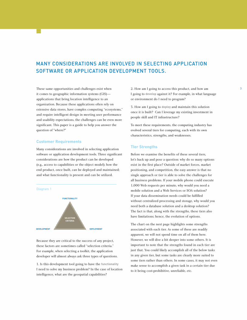
Customer Requirements
Many considerations are involved in selecting application
software or application development tools. Three significant
considerations are how the product can be developed
(e.g., access to capabilities or the object model); how the
end product, once built, can be deployed and maintained;
and what functionality is present and can be utilized.
Diagram 1
Because they are critical to the success of any project,
these factors are sometimes called “selection criteria.”
For example, when selecting a toolkit, the application
developer will almost always ask three types of questions.
1. Is this development tool going to have the functionality
I need to solve my business problem? In the case of location
intelligence, what are the geospatial capabilities?
2. How am I going to access this product, and how am
I going to develop against it? For example, in what language
or environment do I need to program?
3. How am I going to deploy and maintain this solution
once it is built? Can I leverage my existing investment in
people skill and IT infrastructure?
To meet these requirements, the computing industry has
evolved several tiers for computing, each with its own
characteristics, strengths, and weaknesses.
TIer Strengths
Before we examine the benefits of these several tiers,
let’s back up and pose a question: why do so many options
exist in the first place? Outside of market forces, market
positioning, and competition, the easy answer is that no
single approach or tier is able to solve the challenges for
all business problems. If your mobile phone could execute
1,000 Web requests per minute, why would you need a
mobile solution and a Web Services or SOA solution?
If your data dissemination needs could be fulfilled
without centralized processing and storage, why would you
need both a database solution and a desktop solution?
The fact is that, along with the strengths, these tiers also
have limitations; hence, the evolution of options.
The chart on the next page highlights some strengths
associated with each tier. As some of these are readily
apparent, we will not spend time on all of them here.
However, we will dive a bit deeper into some others. It is
important to note that the strengths found in each tier are
just that. You could likely accomplish all of the below tasks
in any given tier, but some tasks are clearly more suited to
some tiers rather than others. In some cases, it may not even
make sense to accomplish a given task in a certain tier due
to it being cost-prohibitive, unreliable, etc.
3
MANY CONSIDERATIONS ARE INVOLVED IN SELECTING APPLICATION SOFTWARE OR APPLICATION DEVELOPMENT TOOLS.
FUNCTIONALITY
SELECTIONCRITERIA
DEVELOPMENT DEPLOYMENT

OO vs. RR vs. SQL
Objected Oriented (OO) programming encompasses many
popular programming languages such as Java, C# and
VB.NET in which a developer can solve a business problem
by building a data model consisting of objects, classes,
methods, and variables. These third-generation languages
are powerful in that, through proper design, they can solve
large problems with less code, particularly when compared
with procedural languages of the past. For this reason,
they are the language of choice for the building of business
logic—the intelligence behind all application software
and solutions.
A Request/Response (RR) environment such as Web Services
is very different. A Web service is an interface that provides
programmatic access to capabilities via well-defined and
open interfaces. Web services include standards such as
XML to assist with the exchange of commands and data.
Although it is infinitely more procedural than OO, the
openness and proliferation of XML means that completely
foreign agents (e.g., any programming language, application
software, or device) can leverage a Web Service or be built
for this task. This idea is relatively new in computing circles
and is referred to as services oriented architecture (SOA).
At its heart, SOA promises to connect disparate systems,
software, data, and functions.
Regardless of your language of choice, at some stage your
enterprise solution will access a database and hence
require the writing of SQL. This has essentially made SQL
a ubiquitous language.
From Mobile to SOA:A Guide for Optimized Application Deployment
W H I T E PA P E R
4
www.mapinfo.com
DESKTOP/MOBILE TIER MIDDLE/WEB TIER SOA TIER DATABASE TIER
Standard Strengths Standard Strengths Standard Strengths Standard Strengths
Object Oriented Object Oriented Request/Response Oriented SQL
Applications Applications Web Services Enterprise Data Depot
Stateful Stateful Stateless Stateless
Supports needs of one user Supports needs of many Supports needs of many Supports needs of many
application users software agents software agents
Orchestration tier Orchestration tier Platform tier Platform tier
Portable/Embeddable Portable/Embeddable Centralization Centralization
Display device output Browser output Browser output Limited output
Data Read/Write Data Read Data Read Data Write
Miscellaneous Strengths Miscellaneous Strengths Miscellaneous Strengths Miscellaneous Strengths
Application/business logic tier Application/business logic tier Simplified APIs accessible to any Enterprise Data Dissemination
application or business process
May or may not be portable device Business logic can access Proliferated XML Data management
data locally

Stateful vs. Stateless
Stateful servers keep track of events and data for individual
users within a multi-user environment. These servers are
often more efficient than stateless servers because duplicate
events and data within a user session do not need to be
recomputed with each request. To help us illustrate this,
let’s consider a common spatial operation such as the
building of a thematic map, for example, a color coded map
of demographics by ZIP code (postal code) for the entire
United States. User A asks for a ZIP code map based on
median household income. User B asks for the same map
but based on population. Both users want to zoom in on
that map to get a closer look.
• We need to make sure that User A gets the income map
and not the population map.
• We don’t want to recalculate the theme for all 43,000 ZIP
codes; instead, we want to re-use that work and simply
zoom in on the map.
By maintaining the original theme computation in memory
and keeping track of both User A and User B, a single server
side application has to do less work and can therefore
complete the task more quickly.
Stateless servers, on the other hand, dispose of events and
data associated with particular users in a multi-user or
multi-application environment. Stateless servers are able
to treat each request generically and are often more
scalable than stateful servers because there is no overhead
associated with user session management. Stateless servers
throw away all the hard work between requests, but when
properly utilized that work is either trivial or often not
needed for re-use. A common spatial operation such as a
geocode (determining a latitude and longitude for a street
address) is an ideal stateless Web service because the
processing required is minimal and there is little value
in holding on to geocodes between requests.
The Support of Agents vs. Users
Much of the excitement centered on SOA comes from this
new, service-focused paradigm. And anything that can read
and write XML—any programming language, application
software or device—can be serviced using SOA. Web services
provide the application developer with tools to build an
infrastructure to serve multiple applications or agents.
While this may sound expensive, it doesn’t need to be.
Web services enable an organization to consolidate data
and functionality in a single place and provide access to
many different departments, partners, and customers.
No wonder then that Web services are viewed as an answer
to closed, under-utilized legacy systems.
The benefits of this are even more apparent on the receiving
end. The software applications/agents that access these
services do not require a deep understanding of the
technology or, for that matter, an investment in the
maintenance of that technology. They just need to access it.
One good example in GIS can be found through data Web
services such as satellite imagery. An application developer
wishing to add a satellite image to a map could go out and
acquire the data, store it, maintain and integrate it into
their application. Or they could leave much of that up to
a service provider and simply access the data through a
series of Web requests.
In the SOA model, the support of agents and applications is
the primary focus. Again, it is services oriented. At the end
of the day, however a user needs a graphical interface, local
data to access and interrogate, and business logic to aid
in their decision-making. Although SOAs can help support
the overall solution, they are not built to meet these
requirements. This is largely the job of the OO application
developer, whose solution will be deployed in the middle,
desktop, or mobile tier. In this tier, we find powerful tools
for the development of business logic and user interfaces,
5
AT ITS HEART, SOA PROMISES TO CONNECT DISPARATE SYSTEMS, SOFTWARE, DATA, AND FUNCTIONS.

From Mobile to SOA:A Guide for Optimized Application Deployment
W H I T E PA P E R
6
www.mapinfo.com
support for the access of local data sources, and the
management of state for the efficient execution of complex
operations. In a nutshell, the goal of SOA is to serve agents
and applications, which are often written in OO or a similar
language, and ultimately serve end users.
Orchestration Tier vs. Platform Tier
Inherent in much of what we’ve discussed above is the
fact that SOA and database tiers are the platform for many
disparate systems, while applications in the middle and
desktop/mobile tiers need to be portable, often serving as
building blocks embedded in a larger solution. The platform
tiers do not need to be mobile and do not need to be
subsumed by larger solutions—but they can be. Most IT
groups will play to the strengths of these “platform” tiers:
their ability to be centralized and their ability to serve many
agents, largely foreign, throughout an organization.
The business logic that gets built as the application is that
much closer to the user. It is that last mile that some have
labeled the “orchestration” tiers. Because users are unique
and never stay in one place, development in these tiers
require a lot of choreography. Applications are user-centric
and hence they rely on a variety of capabilities and data that
can be brought together in these tiers. Because there are so
many users with so many distinct needs in so many different
places, solutions built in these tiers must be portable.
Another example from the GIS world helps bring this point
home. Asset tracking is an area that has received a lot of
recent attention. Such systems are often comprised of three
major components: a device that can be attached to a
person, car, truck, train, or object; a network for transmitting
the location of the device; and the software for visualizing
and then acting on this information. Users of this technology
will vary, but they are often decision-makers tasked with
making sure people and goods reach their destination on
time and within cost. A decision support system needs to
be available in many places (e.g., desktop, mobile, via a Web
browser), needs to present real-time data, and absolutely
needs to be able to compare this data to a backdrop of
customer, infrastructure, and geographic data. Finally,
the intelligence behind the system involves software for
scheduling, reporting, charting, geographic analysis,
and display. All of this can best be composed in the
“orchestration” tiers, perhaps relying on services but
certainly relying on a database for management of locations.
Reading and Writing
As these tiers have evolved, all have proven to excel at the
execution of commands. The same cannot be said when
it comes to the reading and writing of data. Within the
database tier there exists a combined centuries of knowledge
regarding the writing of data. Database systems have
sophisticated operations for transaction control, user access
control, and versioning to ensure the integrity of a data
store. These systems can handle long transactions and are
particularly good at helping users manage volumes of data.
Outside of this tier we find a similar if less sophisticated
capability. In the desktop tier, these same operations are
available on “less intelligent” data sources such as system
files. In the middle and SOA tiers, we have similar logic but
the additional challenge of multi-user access. Suffice to say,
reading and writing is available in all four tiers; however,
the support of these operations varies greatly. In the GIS
world, the support of multi-user writes often requires a
spatial database.

The Emergence of the Browser Tier
With sophisticated Web browser-based technology and
approaches, it is now quite common to have processing
in what was once referred to as thin clients (our Web
browsers). Technologies such as Flash, Silverlight (formerly
Microsoft Windows Presentation Foundation Everywhere),
and JavaScript—combined with innovative approaches such
as AJAX and mash-ups—have created a new tier of
computing. With the advent of the so-called Web 2.0, users
now expect a full desktop experience from their Web browser.
But getting there requires processing on the client. As an
extension to the above discussion, the browser tier has
many strengths including easy to use and scripting
languages, simple user interfaces, statefullness, and
browser-based output. When considering the diagram above,
one might visualize a third dimension where the browser
tier resides above all others and has direct access to them.
Mash-ups in particular take this approach. Whether the data
or service resides on the local desktop, in the middle tier,
or a Web service, mash-ups strive to unite all of these
elements. Suffice to say, this is a tier under recent and
rapid development.
Use Scenarios
When it comes to GIS and location intelligence, discussions
of tier choices will always return to Diagram 1 above.
Will the choice have the functionality required and leverage
existing investments in people and infrastructure? As we
also outlined above, certain operations are well-suited to a
particular development or deployment type (e.g., you might
be able to squeeze your servlet container onto your PDA,
but is it really suited for that?).
One recent success story helps illustrate this point. The
deployment included the need for both the centralization of
core capabilities (SOA) and the distribution of applications
that consume these capabilities (middle tier). The customer
built a Web application that compared, analyzed, and
displayed sales territories relative to customer locations.
The application called out to a central server for geocodes
and a street network backdrop. By using the central server,
they made data and services maintenance much easier.
By exposing the services through open and easy-to-use Web
services, these core capabilities could be utilized by any
agent or application in an organization and not just the
first application that was deployed. For example, that central
data was useful to other departments such as marketing and
production. Building the business logic in the middle tier
also made sense because there was clearly a need for
sophisticated business logic to compose both disparate and
local data and capabilities. Other strong suits in this tier
include session-state management and portability.
Here are a handful of other examples based on common
customer needs.
7
IN THE GIS WORLD, THE SUPPORT OF MULTI-USER WRITES OFTENREQUIRES A SPATIAL DATABASE.

From Mobile to SOA:A Guide for Optimized Application Deployment
W H I T E PA P E R
8 EMERGENCY RESPONSE SYSTEM (MOBILE TIER)
A customer wanted to provide police officers with a mapping
and spatial analysis application that would help them
manage and respond to incidents. The application needed to
be deployed in squad cars on disconnected mobile devices
and laptop computers running both Linux and Windows.
Key requirements:
• The application was intended for a single purpose and
single user
• The customer was skilled in Java programming
• Target machines would be disconnected
• Target machines would be multi-platform and have
minimal system resources
• The application needed to bring together a variety
of local data sets and technology
• The application had to both read and write data
Given all of these requirements, the natural choice was
to build the solution based on a Java SDK and desktop
deployment. This application is successfully running and has
helped the police department respond quicker to incidents
and better plan where to place assets based on historical data.
FIELD FORCE MANAGEMENT (MIDDLE/WEB TIER)
In this case, a customer needed a tool to help manage a large
team of field technicians. At corporate headquarters,
a team of customer service representatives needed a view on
where technicians were, where they planned on going, and
which of those technicians were available when unplanned
calls came in.
Key requirements:
• The application needed to service multiple users over an
intranet (Web browser required)
• The application was intended for a single department
• The application needed to bring together a variety of local
data sets
• For the sake of efficiency, complex spatial operations
(e.g., searches within regions and shortest path street
network analysis) required that state be maintained
between user requests
The customer had a significant investment in .NET, both
as it relates to IT infrastructure and people skillset, so a
middle tier .NET Web deployment was the right choice for
their solution. Now, customer service representatives have
the information they need at their fingertips and their
customers are receiving significantly better service.
RISK ANALYSIS (SOA TIER)
An insurance company needed to provide their underwriters
with information on natural and man-made hazards, along
with information on how much insured properties in a given
location might be at risk from such hazards. The customer
needed to distribute the information to a number of
applications throughout their enterprise, some as simple as
word-processing applications and others that were more
complex decision support systems.
Key requirements:
• The system needed to perform a number of operations
such as mapping, spatial analysis, geocoding, and routing
• These operations would be accessed by multiple
departments and a variety of applications
• Application developers would need open programming
interfaces as their solutions would be written in many
different languages on many different systems
• Core capabilities needed to be centralized so as not to
duplicate efforts in multiple departments
• The system needed to be highly scalable due to the sheer
number of operations
All of this—combined with an existing investment in Web
services—made an SOA deployment the right choice for
this customer. As a result, they are now quoting more
accurate policies based on risk assessment, thus lowering
their exposure to a catastrophic event.
Bringing it All Together
When enterprise developers do their work, they rely on
multiple tiers both to simplify design and to facilitate
division of labor. The designs that work best are the ones
that encapsulate the details of the underlying tier's
implementation and simply answer the needs of the calling
tier. One simple example lies in the details of a Web service
that returns driving directions. Such a service can expose
the essentials (e.g., a GetDirections Web request that
requires start and destination addresses) but it will hide
the network analysis algorithm run on the street network
data that produces the driving directions. Although simple
applications may not require computing in multiple tiers, it is
hard to find an application these days that works in isolation
within a single tier. The fact is, no one tier can solve the need
of developing truly scalable enterprise-wide applications.
9
CUSTOMER SERVICE REPRESENTATIVES HAVE THE INFORMATION THEY NEED AT THEIR FINGERTIPS.

From Mobile to SOA:A Guide for Optimized Application Deployment
W H I T E PA P E R
Pitney Bowes MapInfo Solutions
For many organizations, desktop, middle tier, and SOA
tier deployments are an absolute necessity, as are .NET- and
Java-compliant development kits. For these reasons, vendors
will continue to offer products with multiple development
and deployment options.
Pitney Bowes MapInfo has what it takes to meet these
requirements. In addition to what is listed below, we offer
support for both the mobile and spatial database tiers via
MapX Mobile and SpatialWare, respectively.
We have MapXtreme 2005, a single .NET SDK for both
desktop and Web-based development and deployment.
The MapXtreme 2005 object model is 100% .NET, and
as a result we are able to provide a very familiar and highly
usable product through tight integration with Visual
Studio .NET.
We also have MapXtreme Java, a 100% Java engine that can
be used for both desktop and Web deployments. Being Java,
it is highly embeddable and portable to virtually any device.
Finally, we have our Envinsa platform, built exclusively for
those looking to leverage a Services Oriented Architecture
and take the latest approach to enterprise computing.
A decade after the launch of MapInfo’s first software
development kit, we continue to meet the demands
of application developers with location-enabled toolkits
and applications.
ABOUT THE AUTHOR: MR. MYERS IS A SENIOR PRODUCT MANAGER AT PITNEY BOWES
MAPINFO. HE HAS RESPONSIBILITY FOR PITNEY BOWES MAPINFO’S
DEVELOPMENT TOOLS INCLUDING MAPXTREME AND ENVINSA.
MR. MYERS HAS BEEN WITH PITNEY BOWES MAPINFO FOR OVER NINE YEARS.
IN PREVIOUS ROLES HE HAS SERVED AS BOTH TECHNICAL MANAGER AND LEAD
DEVELOPER OF INTERNET SERVICES BASED ON THE PRODUCTS HE NOW MANAGES.
PRIOR TO JOINING PITNEY BOWES MAPINFO, HE RAN A SUCCESSFUL IT SOLUTIONS
FIRM FOR SEVERAL YEARS AND HELD POSITIONS AT THE UNIVERSITY OF
WASHINGTON, UNIVERSITY AT ALBANY AND ROCKEFELLER COLLEGE.
MR. MYERS STARTED HIS CAREER AS A NASA FUNDED ANALYST WITH THE
CONSORTIUM FOR INTERNATIONAL EARTH SCIENCE INFORMATION NETWORK
(CIESIN) WHERE HE HELPED PIONEER THE INTEGRATION OF GEOGRAPHIC
INFORMATION SYSTEMS WITH WEB BASED TECHNOLOGY. HE HAS GRADUATE
DEGREES IN LAND USE PLANNING (MRP) AND GEOGRAPHY (MA) AND HAS OVER
17 YEARS OF INDUSTRY EXPERIENCE.
10

11

©2008 Pitney Bowes MapInfo Corporation. All rights reserved. 92033-802MapInfo and the Pitney Bowes MapInfo logo are registered trademarks of Pitney Bowes MapInfo Corporation. All other product and service names mentioned herein are trademarks of their respective owners.
UNITED STATES
One Global View
Troy, NY 12180-8399
main: 518.285.6000
1.800.327.8627
fax: 518.285.6070
www.mapinfo.com
CANADA
26 Wellington Street East
Suite 500
Toronto, Ontario
M5E 1S2
main: 416.594.5200
fax: 416.594.5201
www.mapinfo.ca
EUROPE/UNITED KINGDOM
Minton Place
Victoria Street, Windsor
Berkshire SL4 1EG UK
main: +44 (0)1753 848200
fax: +44 (0)1753 621140
www.mapinfo.co.uk
ASIA-PACIFIC/AUSTRALIA
Level 7
Elizabeth Plaza
North Sydney
NSW 2060
main: 61.2.9437.6255
fax: 61.2.9439.1773
www.mapinfo.com.au