from partial to full strain partitioning along the indo
TRANSCRIPT
www.elsevier.com/locate/margeo
Marine Geology 209 (2004) 303–327
From partial to full strain partitioning along the Indo-Burmese
hyper-oblique subduction
C. Nielsena,1, N. Chamot-Rookea,*, C. Ranginb,the ANDAMAN Cruise Team2
aLaboratoire de Geologie, CNRS, UMR 8538, Ecole normale superieure, 24 rue Lhomond, 75231, Paris, FrancebCNRS, UMR 6535, College de France, CEREGE, Aix-en-Provence, France
Received 7 August 2003; received in revised form 5 April 2004; accepted 4 May 2004
Abstract
The Andaman–Nicobar Trench and its onshore prolongation—the Indo-Burmese wedge—is the least studied segment of the
India–Australia subduction. New offshore geological and geophysical data have recently been collected along the Burma scarp
during a marine survey conducted with the R/V Marion Dufresne (Andaman Cruise). Swath bathymetric mapping combined
with shallow and deep seismic show that the dominant active tectonics is dextral strike-slip faulting accompanied by various
amounts of shortening. The southern portion of the Burma scarp is transpressive (north Andaman Islands), the central portion is
pure strike-slip on NNE-oriented segments (southern Myanmar), the northern portion shows sedimentary wedge growth along
NW segments, both onshore and offshore (Arakan Yoma prism). Further north, the wedge bends to the west, while dextral shear
faults more or less parallel to the Sagaing Fault develop within the internal part of the wedge and elongated NS folds form in its
external part, abutting onto the Shillong Plateau. We propose a simple kinematic model involving evolution from partial to full
partitioning from south to north along the West Burma Scarp (WBS), and we test it quantitatively using the most recent geodetic
results. In the south, half of the 3.5 cm/year of India motion is taken at the trench itself, the other half being accommodated onto
a single shear fault, the Sagaing Fault in Myanmar. In the north, where the Bangladesh fold system developed, dextral strike-slip
faults are activated within the Arakan Yoma belt and at the accretionary prism–backstop contact, resulting in full partitioning
there. Faults accommodating the oblique component of motion of India are progressively migrating in space from far field faults
(Andaman–Sagaing) to near trench faults (Arakan Yoma belt and trench itself), the Burma sliver being ‘‘buttressed’’ by the
Eastern Himalayas. This kinematic extends back to 4 Ma, which is the time of initiation of the last pulse of oceanic accretion in
the Andaman Basin.
D 2004 Elsevier B.V. All rights reserved.
Keywords: Myanmar geology; Arakan Yoma belt; West Burma Scarp; accretionary wedge; oblique subduction; plate kinematics
0025-3227/$ - see front matter D 2004 Elsevier B.V. All rights reserved.
doi:10.1016/j.margeo.2004.05.001
* Corresponding author. Fax: +33-1-44-32-20-00.
E-mail address: [email protected] (N. Chamot-Rooke).1 Now at Total, Paris la Defense.2 E. Bourdon, U. Min Han, U. Tin Tun Aung, U. Kyaw Htin,
U. Min Swe, F. Farcy and D. Tsang Hin Sun.
1. Introduction
Northward motion of India with respect to SE Asia
is accommodated along three main trenches: Java,
Sumatra and Andaman–Nicobar. The curvature of
these trenches implies a progressive increase of the

C. Nielsen et al. / Marine Geology 209 (2004) 303–327304
obliquity of convergence, ranging from pure normal
subduction at Java to oblique subduction at Sumatra
and highly oblique motion towards the Andaman
Islands and Myanmar (Fig. 1). The upper plate itself
is shaped by this variation of obliquity. Off Sumatra, a
large piece of crustal sliver is detached from the
Sunda margin along the Great Sumatran, or Sem-
angko, Fault. Northward, where obliquity becomes
high, the Andaman Basin opened behind the Anda-
man–Nicobar Trench in a pull-apart setting between
the northern tip of the Semangko Fault and the
Sagaing Fault in Myanmar. The Andaman–Nicobar
Trench is the least studied segment of the India–
Australia subduction. The trench appears as a contin-
uous trough from the northern tip of Sumatra to the
southern extension of the Arakan Yoma accretionary
prism, off Myanmar. It then vanishes towards the
Bangladesh fold system.
Based on early versions of global plate kinematic
models, Curray proposed the existence of an inde-
pendent Burmese platelet absorbing the oblique mo-
tion of India with respect to SE Asia (Curray et al.,
1979). The supposedly large NE motion of India (10
cm/year) was resolved, or partitioned (Fitch, 1972),
into two large components: dextral strike-slip on the
Sagaing Fault (>5 cm/year) and high rate normal
subduction along the Indo-Burmese trench (>4 cm/
year). Since these pioneering works, new constraints
have been obtained from seismology, mantle tomog-
raphy and GPS measurements. Seismicity and tomog-
raphy delineate an eastward dipping Indian slab down
to at least 250 km below the Andaman–Nicobar–
Myanmar system (Verma et al., 1976a,b; Guzman-
Speziale et al., 1987; Mukhopadhyay and Das Gupta,
1988; Guzman-Speziale and Ni, 1996). Seismicity
distribution over the Burmese platelet and within
the slab below indicate a more or less N–S trending
P axis, suggesting that the entire area is subjected to
north–south compression in relation to the nearby
Himalayan Syntaxis (Le Dain et al., 1984; Guzman-
Speziale and Ni, 1996). Virtually none of these
studied focal mechanisms seemed to relate to the
E–W subduction inferred by Curray. This absence
of subduction earthquakes led Rao and Kumar (Rao
and Kumar, 1999) to propose that although a deep
lithospheric slab is indeed present at depth, subduc-
tion is now inactive. However, a recent re-examina-
tion of the seismicity suggests a still active oblique
subduction (Satyabala, 2003). Satyabala further
shows that the variation of slip vectors azimuths is
compatible with a slip partitioning process similar to
other oblique subductions, a conclusion that we share
as will be shown later in this paper.
New kinematics constraints have recently been
obtained through Global Positioning System (GPS)
measurements. A major output of the GEODYSSEA
Program was the discovery of a significant motion
of a large Sundaland Block (Sumatra, Java, Viet-
nam, SE China, Borneo) with respect to Eurasia
(Chamot-Rooke and Le Pichon, 1999; Simons et al.,
1999; Michel et al., 2001). Global kinematics
obtained by GPS (Holt et al., 2000; Kreemer et
al., 2000a; Paul et al., 2001; Kreemer et al., 2003)
as well as recent revision of India kinematics for
the last 3 Myears (Gordon et al., 1999) also point to
a slower than predicted motion of India. Finally, a
local GPS network in Myanmar tied to other
stations in SE Asia established a velocity of about
20 mm/year across the Sagaing Fault (Vigny et al.,
2003), thus suggesting that only part of the motion
of India is accommodated along the fault. A similar
geological estimate was reached using the offset of
a Quaternary volcano built on the fault (Bertrand et
al., 1998; Bertrand, 1999).
Eastward motion of Sundaland, the new kinemat-
ics for India and slow shear on the Sagaing Fault put
new kinematics constraints on the recent geodynam-
ics of the Indo-Burma Trench. We report in this
paper additional constraints based on a marine sur-
vey conducted along the Burma front (Andaman
Cruise). The Burma scarp was surveyed in great
detail between 14jN and 20jN, using swath map-
ping, shallow seismic and measurements of the
gravity and magnetic fields. This new data set was
combined with existing multichannel industrial lines
from Compagnie Generale de Geophysique (CGG).
We first describe the morphology of the Burma scarp
and show that at present, the scarp is a major dextral
strike-slip fault zone. Based on the pattern of active
faults mapped both offshore and onshore (Myanmar),
we further suggest that the degree of strain partition-
ing gradually increases from south Myanmar to north
Myanmar, shearing being accommodated not only on
the Sagaing Fault but also on additional strike-slip
faults within the Arakan Yoma belt. We finally
reconsider the general kinematic framework based

Fig. 1. Myanmar geodynamic setting. India–Sundaland convergence and shear motion on the Sagaing Fault are taken from the latest geodetic
measurements (Vigny et al., 2003). The rectangle locates the Andaman Cruise survey along the Indo-Burma Margin. Focal mechanisms are
from the HARVARD Catalogue and bibliographic references (Le Dain et al., 1984; Guzman-Speziale and Ni, 1996; Holt et al., 2000). AI:
Andaman Islands. CI: Coco Islands. ChI: Cheduba Island. RI: Ramree Island.
C. Nielsen et al. / Marine Geology 209 (2004) 303–327 305

C. Nielsen et al. / Marine Geology 209 (2004) 303–327306

Fig. 3. Profile Andaman 45 and its interpretation. Track is located in Figs. 2 and 4. The Andaman seismic is a ‘‘light’’ seismic acquired at 10
knots (six channels, threefold). All Andaman profiles shown are migrated sections.
C. Nielsen et al. / Marine Geology 209 (2004) 303–327 307
on the most recent plate tectonics models constrained
by GPS measurements.
2. Morphology of the Indo-Burma trench along the
West Burma Scarp (WBS)
The Andaman survey along the West Burma Scarp
covers the Indo-Burma trench north of the Andaman
Islands and south of the Arakan Yoma wedge in
Myanmar (Fig. 1). The surveyed area is a 6–7-mile-
wide strip extending from 14jN to 18j30VN (Fig. 2).
A single ship track was also run along the trench axis
further South, so that the total length of trench
surveyed is over 700 km. Morphologically, the
WBS is a narrow and steep scarp between the flat
3000-m-deep Bengal Basin to the west and the bathy-
metric highs of the Coco Ridge to the east (Coco
Islands and their extension, see Fig. 1). East of the
Coco Ridge, the Ayerrawady platform and basins
system is largely blanketed by fast infill of the
prograding Ayerrawady delta.
A set of bathymetric sections across the West
Burma Scarp (Fig. 2) clearly shows that the mor-
Fig. 2. Andaman Cruise multibeam mapping along the Western Burma S
survey were merged with the GEBCO database. Seismic tracks are show
Western Burma Scarp are displayed to the left (sections A–I, dotted lines o
seismic profiles.
phology is not typical of a trench. Most of these
sections reveal the presence of a narrow and sharp
slope break. Cross-sections B–H present wall mor-
phology at short distance from the flat Bengal Basin.
The slope of this narrow front is unusually high for a
stable sedimentary wedge (12–15j), at contrast withthe gentle slope observed at other accretionary
prisms with a similar thick incoming section. Direct
comparisons can be made with the Barbados and
Eastern Mediterranean prisms, both being fed by
large deltas (the Amazon and the Nile cones, respec-
tively). The taper for those prisms does not exceed a
few degrees (Lallemand et al., 1994; Chaumillon and
Mascle, 1997). The steep gradient of the WBS
actually shows more similarities with strike-slip
dominated margins, such as the Puysegur Trench
(Delteil et al., 1996; Lamarche and Lebrun, 2000;
Lebrun et al., 2000) and the Hikurangi Trench
(Collot et al., 1996, 2001) in New Zealand. The
Burmese scarp swings south to north from a N40jEdirection immediately north of the Andaman Islands
to a N40jW trend at the location where the Arakan
Yoma belt widens. This south to north swing coin-
cides with three main tectonic styles, from trans-
carp, contoured every 25 m. Contours lines outside the multibeam
n as thick black lines. A series of bathymetric profiles across the
n the map). Notice that some, but not all, of these sections follow the

C. Nielsen et al. / Marine Geology 209 (2004) 303–327308
pressive to pure dextral strike-slip in the south to
accretion combined with dextral shear in the north.
2.1. The southern part of West Burma Scarp: a
transpressive segment
South of 14j40VN, the WBS morphology is char-
acterized by a set of three N10j–N35jE en echelon
highs. These blocks are bounded eastward by N30jEtrending basins. One of these highs was imaged by
seismic profile Andaman 45 (bathymetric section I in
Fig. 2 and seismic line in Fig. 3). Thrusting onto the
flat cover of the Bengal fan is suggested by the discrete
flexure of the sediment pile deposited on the down-
going plate. The deepest reflector identified within the
trench gently dips eastward and the section above
shows clear fanning in relation to active thrusting
(Fig. 3). The frontal thrust at the very base of the slope
is buried beneath a sedimentary talus and thus does not
break to the surface, the talus being probably fed by the
unstable steep slope hanging above. The internal
structure of the hanging wall shows rare eastward
dipping reflectors. Although we cannot totally rule
out that this tilting corresponds to the inherited struc-
ture of the upper margin (such as tilted blocks), a link
with the recent activity of the bounding thrust is more
likely. The simplest interpretation is that this set of en
echelon highs are faulted wrenched anticlines. En
echelon folds in a similar position (frontal wedge)
and with similar orientation of their elongated axis
have been observed south and north, although they all
show less severe deformation. Estimate of the amount
of shortening is difficult to obtain. On seismic line
Andaman 45 (Fig. 3), the rare reflectors seen within
the hanging wall may correspond to the well-stratified
reflectors recognized in the trench, but the poor quality
of the seismic does not allow a direct and reliable
correlation. Furthermore, part of the hanging wall has
clearly been eroded. The Neogene to Quaternary
sedimentation rates in the area remain largely specu-
lative. Based on multi-channel seismic data across the
Bay of Bengal at 13jN latitude (150 km south of our
survey), Gopala Rao et al. (1994) estimated a 250 m
Ma� 1 accumulation rate. Borehole data in the south-
ern Bangladesh at 22jN latitude (about 400 km away
from the northern tip of our survey) indicate a mean
rate of 520 m Ma� 1 for the post-Pliocene period
(Alam et al., 2003). Using these rates as lower and
upper bounds, and taking the sound velocity in the
sediment in the range 1800–2000 m/s, the deepest
reflector recognized on line Andaman 45 would be 5–
10 Myears old (i.e., Early Pliocene or Late Miocene).
The entire sequence above this reflector shows regular
fanning towards the trench and upward folding at the
slope break. This pattern is compatible with steady
state thrusting since at least this age. The systematic en
echelon disposition of those large anticlines (Figs. 2
and 4) strongly suggests that this portion of the WBS is
an active transpressive dextral zone.
Between 14jN and 15j40VN (Fig. 4), the WBS is a
N40jE trending wall linking the flat Bengal Basin
with the very shallow Burma shelf. North of 14j30VN,the toe of the slope is affected by N10jE trending folds
and thrusts with again an en echelon geometry (Fig. 5).
The WBS is crosscut there by seismic profiles Anda-
man 46, 47 and 48 (Figs. 6, 8 and 9). We also show in
Fig. 7 the line drawing of an unpublished CGG
multichannel profile.
Along the east–west trending Andaman 46 profile
(Fig. 6), a narrow elongated slice (slice A), thrust
bounded west and east, occupies the base of the scarp.
The internal structure of this slice shows again a series
of small-scale en echelon folds trending N10jE. TheCGG multichannel profile (Fig. 7) has a much better
penetration than Andaman seismic lines, close to 3
twtt. The entire front of the wedge is affected by steep
thrusts with double vergence. This reverse fault system
is interpreted as the trace of a major N35jE trending
dextral strike-slip fault. Part of this fault system is
buried, as shown by dotted lines in Fig. 6, below 0.8–1
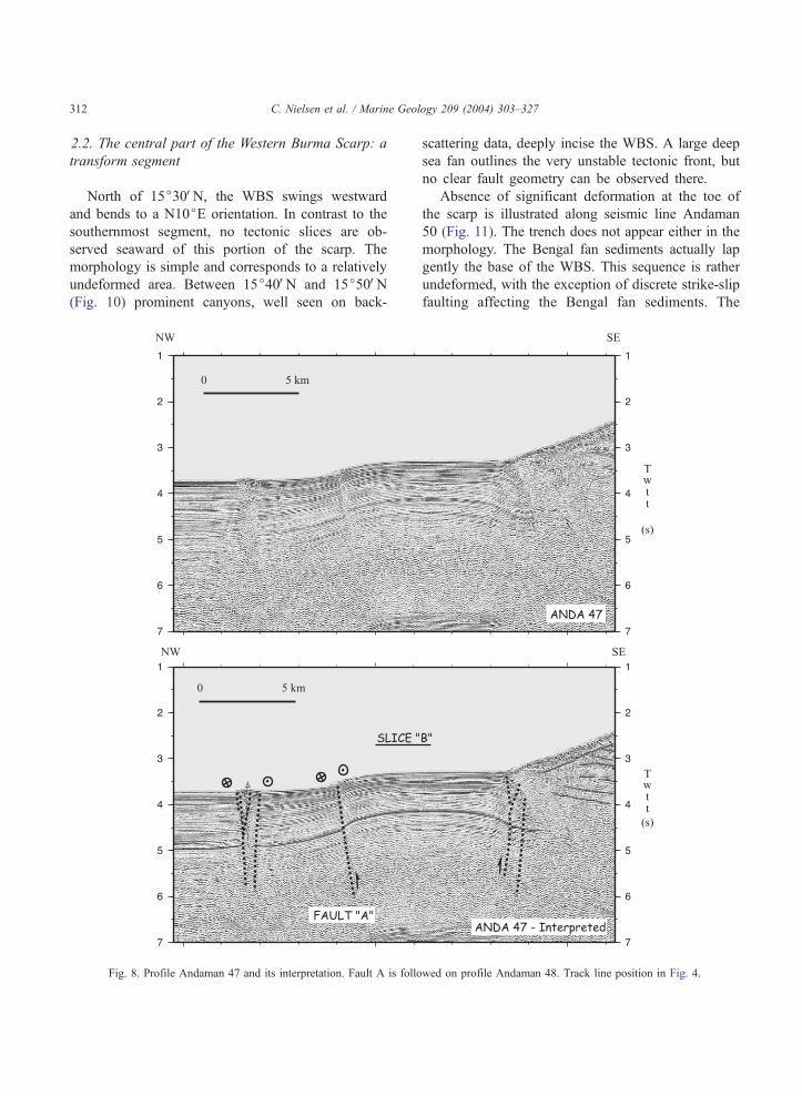
s twtt thick sediments. Profile Andaman 47 (Fig. 8)
shows another pop-up structure (tectonic slice B). A
small mound associated with a nascent strike-slip fault
west of tectonic slice B is interpreted as a mud
volcano. Although sediments are actively deformed
at the toe of the slope, undeformed sediments blanket
the scarp immediately east of the slope break, pointing
again to localized deformation at the very base of the
Burma scarp.
We interpret tectonic slices A and B (Fig. 5) as
the surface expression of a dextral wrenched fault
system at depth. The area thus appears as a positive
flower structure, presently active only at the base of
the scarp. The abyssal plain of the Bengal Basin is
moderately affected by the en echelon structures.
This could be the result of high sedimentation rate

C. Nielsen et al. / Marine Geology 209 (2004) 303–327 309
versus low deformation rate. In any case, the shear-
ing component seems to be higher than the frontal
accretionary component.
Profile Andaman 48 (Fig. 9) is very oblique to the
trend of the WBS. Its orientation parallels the trend of
the scarp and helps to better confirm the fault dips.
The westernmost fault (fault A) is subvertical, at least
in the top of the section, and shows a minor thrust
Fig. 4. Tectonic sketch for the southernmost portion of the surveyed W
component towards the east close to the mudline.
This fault is more or less in line with the westernmost
fault identified on profile Andaman 47, but with
opposite vergence. Another active fault can be ob-
served immediately east of fault A in the middle part
of profile Andaman 48 (Fig. 9) and is also probably a
vertical strike-slip fault, marked by a discrete mud
volcano.
estern Burma Scarp. Bathymetric data are contoured every 20 m.

C. Nielsen et al. / Marine Geology 209 (2004) 303–327310
Fault zone B below the lower terrace has a clear
strike-slip component as indicated by its change of
vergency approaching the surface. Eastward, the
profile crosscuts fault zone C, which seems to be
less active than fault zone B on profile Andaman
48. However, the bathymetric map confirms that
fault zone C becomes the active one northward.
Active deformation is thus concentrated along the
Fig. 5. Extract of the southern area showing en echelon tectonic slices at th
extract in Fig. 4.
two frontal en echelon duplex, less than 20 km
wide, located at the base of the slope. Steepness
and localization of the active structures support the
fact that the deformation is concentrated in a
narrow band at the base of the slope. The inter-
pretation is that fault zones A, B and C are part of
a larger en echelon dextral strike-slip system trend-
ing N35jE.
e base of the slope of the Western Burma Scarp. See location of the
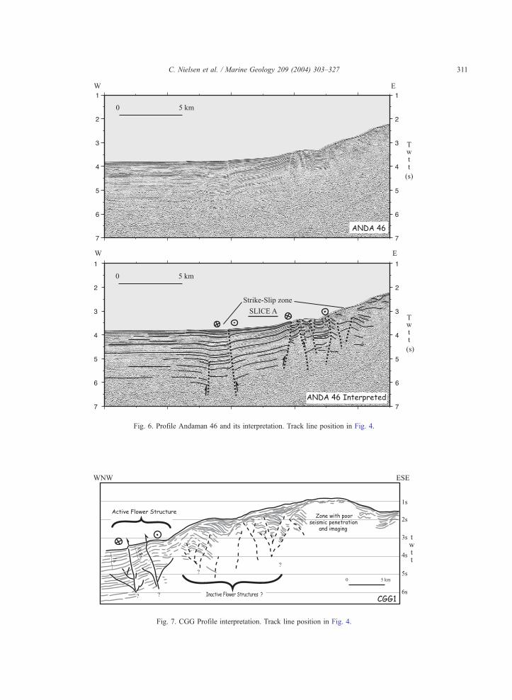
Fig. 6. Profile Andaman 46 and its interpretation. Track line position in Fig. 4.
Fig. 7. CGG Profile interpretation. Track line position in Fig. 4.
C. Nielsen et al. / Marine Geology 209 (2004) 303–327 311
Geology 209 (2004) 303–327
2.2. The central part of the Western Burma Scarp: a
transform segment
North of 15j30VN, the WBS swings westward
and bends to a N10jE orientation. In contrast to the
southernmost segment, no tectonic slices are ob-
served seaward of this portion of the scarp. The
morphology is simple and corresponds to a relatively
undeformed area. Between 15j40VN and 15j50VN(Fig. 10) prominent canyons, well seen on back-
C. Nielsen et al. / Marine312
Fig. 8. Profile Andaman 47 and its interpretation. Fault A is follo
scattering data, deeply incise the WBS. A large deep
sea fan outlines the very unstable tectonic front, but
no clear fault geometry can be observed there.
Absence of significant deformation at the toe of
the scarp is illustrated along seismic line Andaman
50 (Fig. 11). The trench does not appear either in the
morphology. The Bengal fan sediments actually lap
gently the base of the WBS. This sequence is rather
undeformed, with the exception of discrete strike-slip
faulting affecting the Bengal fan sediments. The
wed on profile Andaman 48. Track line position in Fig. 4.

Fig. 9. Profile Andaman 48 and its interpretation. Track line position in Fig. 4.
C. Nielsen et al. / Marine Geology 209 (2004) 303–327 313
sequence below is flexed upslope. This sequence
was followed landward on a CGG multichannel line
(Fig. 11) and forms the western flank of a high
poorly imaged on seismic profiles.
A single active thrust was mapped east of the
shelf break (CGG2, Fig. 11). The main orientation of
this thrust is not well constrained due to poor spatial
distribution of available seismic data. However, the
regional tectonic orientations of the thrusts mapped
northward, as well as correlation with onshore
mapped structures along the Indo-Burma mountain
ranges, indicate that this structure corresponds to a
dogleg compressive arm (restraining bend) oriented
in N140jE to 150jE, consistent with a N30jE to
N40jE convergence.
Deformation is present north of 16j20VN where
the WBS is clearly framed by dominos with N160jEand N40jE segments. Andaman 52 seismic line (Fig.
11) indicates that sediments are thrusted westward
onto the Bengal Basin along the largest N160jEsegments. Several potential decollement levels are
observed within the Bengal sediments, possibly
merging along a single main decollement at depth.
Clear and intense deformation is found further
upslope, at the northeastern end of profile Andaman
52. Active folding associated with N160jE trending
thrusts affects the recent sediments supplied by the
Ayerawaddy delta. Despite discontinuous bathymet-
ric mapping due to shallow waters, folds appear
rather sigmoid in shape and connect with the
N40jE trending structures interpreted as strike-slip
faults. The northwestward part of this ‘‘domino’’
pattern is relayed northward (between 16j30VN and
16j40VN, Fig. 10) by a rather continuous and narrow
strike-slip zone marked by en echelon folds and mud
volcanoes. Here, the deformation takes place along

Fig. 10. Tectonic sketch of the central portion of the surveyed West Burma Scarp. Bathymetric data are contoured every 20 m.
C. Nielsen et al. / Marine Geology 209 (2004) 303–327314
short dogleg segments composed of N160jE trend-
ing thrusts and N40jE trending strike-slip faults. The
same organization is followed northward where it
guides the shape of the wall. Consequently, the entire
central segment of the WBS corresponds to a multi-
scale dogleg system consistent at larger scale with a
rather straight N35jE dextral shear zone in a N35–
40jE convergence.
2.3. The northern part of the West Burma Scarp: from
transform to accretion
This northernmost part of our survey covers the
very southern tip of the Arakan Yoma wedge (Fig.
12). Structurally, it coincides offshore with the first
clear evidences of significant wedge type accretion.
We name it the Ramree lobe, from the nearby

Fig. 11. Interpretations of seismic profiles Andaman 50, Andaman 52 and CGG2 multichannel line.
C.Nielsen
etal./Marin
eGeology209(2004)303–327
315

Fig. 12. (a) Tectonic sketch and bathymetric map of the northern portion of the Western Burma Scarp. Data are contoured every 20 m.
(b) Interpretation of CGG3 multichannel line.
C. Nielsen et al. / Marine Geology 209 (2004) 303–327316

C. Nielsen et al. / Marine Geology 209 (2004) 303–327 317
Ramree Island off Myanmar main coast. This is also
the place of widespread mud diapirism and major
gravity collapses, such as the Watthe Avalanche
named from the closest city in Myanmar.
2.3.1. The Watthe Avalanche
Between 17jN and 17j35VN, an important cinder
cone abruptly cuts the linearity of the Western Burma
Scarp. The area shows debris flows that poured out of
Fig. 13. Focus on the Watthe Avalanche and its debris cone. Mud volcano
strike-slip fault that generated the avalanche, and grey dotted lines are fol
large canyons. Bathymetric mapping reveals kilome-
ter-size blocks lying on the flat seafloor of the Bengal
Basin (Fig. 13). In addition to this blocky morphology,
several mud volcanoes were identified on 3.5-kHz
profiles. They appear as smoother bathymetric mounds
within the Bengal plain. Our interpretation is that a
large debris avalanche, the Watthe Avalanche, recently
affected the steep and rather unstable slope of the
Western Burma Scarp. Sudden loading of the non-
es are in grey, black dotted lines are normal faults, black line is the
d axis. Bathymetric data are contoured every 20 m.
C. Nielsen et al. / Marine Geology 209 (2004) 303–327318
compacted sediments of the Bengal fan probably
resulted in the eruption of the mud volcanoes. Fast
blanketing due to high sedimentation influx lead to
rapid filling and progressive embedding of some of the
debris, responsible for the peculiar ‘‘flat and blocks’’
morphology recognized by multibeam. Mud volcanoes
are irregularly arranged into several N30jE trending
ridges. Assuming that mud escaped through tension
gashes, this orientation is compatible with stress ori-
entation expected onto a more or less NS dextral strike-
slip fault.
Similar avalanches have been observed along the
Hikurangi Margin (Collot et al., 2001). The Ruatoria
Debris Avalanche in New Zealand presents the same
morphology, constituted by debris flows, with an
almost circular indentation bounded by strike-slip
scarp parallel to the Pacific Plate/Kermadec Arc
convergence. The avalanche is interpreted there as
resulting from the oblique subduction of a large
seamount. The Watthe Avalanche seems to have
occurred in a different tectonic setting, since the
WBS shows no seamount-related indentation. The
Avalanche would rather be the result of the high
instability of the WBS along the main shearing
segments. A similar instability, a large submarine
olistostrome associated with the subduction motion,
has been reported southward along the Sunda Arc
subduction zone, facing the Andaman Islands (Moore
et al., 1976).
2.3.2. The Ramree lobe
Offshore Ramree and Cheduba Islands, the West-
ern Burma Scarp is a short accreting segment com-
posed of imbricate folds and thrusts (Fig. 12). This
portion of the WBS is the first clear evidence for
wedge type accretion. The bathymetry shows a large
semi-circular lobe sharply bounded to the southeast
by a N55jE trending fault. Sigmoid folds there
indicate sinistral motion compatible with the pro-
gressive outward growth of the wedge at the expense
of the thick Bengal plain sediments. The main
orientation of thrusting is N120jE, and a statistical
study of the orientation of the imbricate slices and
folds suggests a N35jE growth convergence.
North of 18jN (Fig. 14), although the overall
course of the WBS generally trends northward, bathy-
metric details show dogleg segments with N140jEtrending thrusts (accreting segments) and N10–20jE
trending transfer faults (dextral strike-slip segments).
However, the transfer faults do not show sharply in
the bathymetry due to the soft and thick sediment
cover.
Deformation also affects the flat sediments of the
Bengal Basin, indicating outward propagation of the
decollement level. The Bengal Plain facing this
portion of the WBS is actually covered with mud
volcanoes, either isolated or remarkably aligned
along N70jE to EW trends. These mud ridges are
particularly abundant in the northernmost part of the
surveyed area. Notice that mud expulsion is also
abundant upslope towards the continental margin,
with Ramree and Cheduba Islands being the culmi-
nating points of larger mud volcano fields (Bender,
1983).
3. Tectonic interpretation of the Western Burma
Scarp
The structures observed along a 700-km-long por-
tion of the West Burma Scarp typically depict a dextral
shear zone with wrenched accretionary wedge. The
active tectonics evolves from transpression in the
south to a multiscale restraining bend geometry in
the north, connected by a localized strike-slip fault
zone (Fig. 15). We do not see abrupt changes in the
tectonic style, but subtle variations occur along the
West Burma Scarp from south to north:
(1) In the south, the dominant tectonic process is
dextral strike-slip faulting localized at the base
of the slope, accompanied with significant
shortening. Multiscale en echelon folds with
axis trending N10jE to N35jE are compatible
with NE convergence of the Indian plate with
respect to the Burma margin.
(2) Further north, the WBS is shaped by a domino
pattern framed by short N160jE and long N40jEsegments. Motion along the N40jE trending
segments is pure strike-slip.
(3) The WBS then swings N10jW, towards the
Watthe Avalanche and N40jW towards the
Ramree lobe. The WBS there shows a combina-
tion of N20jE dextral faults and NW–SE thrusts.
The Ramree lobe itself shows discrete dogleg
structures in its internal pattern.

Fig. 14. Western flank of the Ramree Lobe, controlled by N10–20jE trending dextral strike-slip faults and N120–140jE trending thrusts.
Bathymetric data are contoured every 20 m.
C. Nielsen et al. / Marine Geology 209 (2004) 303–327 319
(4) Previous work on the offshore part of the Indo
Burma wedge (Nielsen et al., 2001) also indicat-
ed, on the basis of industrial seismic data, that the
same dogleg organization extends north outside
the Andaman survey, up to 19j40VN (Fig. 15). In
this area, the Burma margin is controlled by

Fig. 15. Summary of the main tectonic features along the slope of the Western Burma Scarp. Arrows indicate inferred relative convergence
between India and Burma margin.
C. Nielsen et al. / Marine Geology 209 (2004) 303–327320
C. Nielsen et al. / Marine Geology 209 (2004) 303–327 321
N130jE thrust linked by NS to N20jE trending
dextral transform segments, suggesting a N10–
20jE relative convergence between India and
Burma.
The mean N35jE trend of the pure shear segments,
together with the N130–140jE trending thrusts, are
compatible with a N30–40j convergence of India
with respect to the Burma platelet. In details, the
relative direction of convergence may evolve from
N50j in the south to N20j in the north. We interpret
those variations as resulting from latitudinal variations
of the motion of the upper plate (or upper margin)
with respect to India, either as an effect of rigid body
rotation of the Burma platelet or as a result of internal
deformation within it. The mean N30–40j conver-
gence is to be compared to the predicted N10F 5jmotion of India with respect to Sundaland. The main
conclusion is that although the 20–30j clockwise
rotation of the convergence vector does imply some
amount of shear partitioning (if not relative conver-
gence would be N10j), the degree of partitioning is
rather small, at least along the portion of trench
covered by the Andaman survey. We will show in a
latter section that this observation is in agreement with
reduced shearing motion on the Sagaing Fault.
4. Correlation of offshore data with seismicity and
onshore structural fabric of the Indo-Burma range
Superficial as well as internal structures of the
offshore Indo-Burmese wedge are poorly known.
The active tectonic setting is mainly constrained by
information provided by focal mechanisms of largest
earthquakes (Harvard CMT and Engdahl catalogue)
and some scarce morphological studies (Basu et al.,
1992; Gopala Rao and Krishna, 1997). Off the Anda-
man Islands, seismicity indicates EW shortening, but
strike-slip faulting is dominant. A few interplate
earthquakes (i.e., slip on low-angle and east-dipping
plane, see Fig. 1) suggest EW subduction (Kreemer et
al., 2003). A recent model of the tsunami generated by
the large 31/12/1881 submarine earthquake south of
the Andaman Islands (Mw 7.9–10jN latitude) con-
cludes to pure thrust slip onto an east-dipping plane
(Ortiz and Bilham, 2003). Full partitioning would thus
be reached there, in relation with the opening of the
Andaman basin (Ortiz and Bilham, 2003). Immedi-
ately north of the Andaman Islands, major seismic
events are absent, suggesting a seismic gap below the
entire surveyed area. This gap was interpreted as
further evidence for ‘‘locking’’ of the lower Indian
and upper Burman plates (Le Dain et al., 1984;
Guzman-Speziale and Ni, 1996). One large earth-
quake did occur recently quite close to the southern
tip of our survey. This 13/09/2002 earthquake (Mw
6.5–13jN latitude), located west of the northern tip of
the Andaman, is interpreted as oblique subduction of
the Indian plate in a more or less northeast direction
(Kayal et al., 2004). The subduction motion obtained
solely from earthquakes would thus indicate gradual
increase of the obliquity from southern to northern
Andaman Islands.
North of 21jN in northern Myanmar, the core of
the Arakan Yoma wedge is affected by strike-slip
faults (Le Dain et al., 1984; Ni and Guzman-Speziale,
1989; Guzman-Speziale and Ni, 1996; Rao and
Kumar, 1999). Faults seem to be distributed within
the Arakan Yoma belt, but major ones may coincide
with the main geological contacts (from west to east,
Neogene prism-metamorphic Paleogene prism-Back-
stop formed by the Central Myanmar basin). At the
same latitude, the toe of the Arakan Yoma wedge is
exposed onshore and is characterized by NS trending
folds and thrusts. Orientation of the maximum hori-
zontal compressive stress from borehole breakouts
suggests E–W compression in the external part of
the Bangladesh fold system, although the data are
somewhat scattered (Gowd et al., 1992). The E–W
compression seems to be restricted to the sedimentary
pile, since the mean P axis of earthquakes is only
slightly east of north (Gowd et al., 1992, 1998). This
would imply decoupling of the Tripura fold-and-thrust
belt from the underlying basement.
Field studies at the latitude of the Andaman survey
have shown that the dogleg structural organization
recognized at sea is also observed on land along the
southern part of the Indo-Burma range (Fig. 16). In its
southernmost part, this range is mainly framed by
N30jE trending dextral strike-slip faults and rare
thrust faults, as far north as 18jN. North of this
latitude, the N20jE dextral faults are combined with
N120jE northeastward and southwestward vergent
thrusts. The deformed area widens and changes ori-
entation gradually, forming a major restraining bend.
C. Nielsen et al. / Marine Geology 209 (2004) 303–327322

C. Nielsen et al. / Marine Geology 209 (2004) 303–327 323
North of 20jN, the active structures are more linear
and are represented by N–S to N170jE trending steep
strike-slip faults that dissect the internal part of the
range. The shallow seismicity outlines these strike-
slip faults, which are sub-parallel to the Sagaing Fault.
The main conclusion from land studies is that
dextral strike-slip faulting within the core of the
Arakan Yoma wedge gradually increases northwards,
while the relative convergence vector at the toe of the
wedge becomes gradually purely frontal forming the
Bangladesh folds. Our general interpretation is that
partitioning along the Indo-Burma margin progres-
sively evolves from poorly partitioned in the Anda-
man survey area to highly partitioned in the north. We
next test this hypothesis through a simple kinematic
model.
5. From partial to full partitioning along the
Indo-Burma margin
Partitioning is a major mechanism of accommo-
dation of oblique convergence (Mc Caffrey, 1994)
at SE Asia trenches (including the Sunda trenches,
and also the Philippine Trench and Nankai Trough).
Sumatra, in particular, was long recognized as a
case study, oblique motion of the Indo-Australian
plate being resolved into trench-normal and arc-
parallel components (Mc Caffrey, 1991; Bellier and
Sebrier, 1995). Partitioning at Sumatra is active as
far north as the northern tip of the Semangko Fault,
where the fault enters into the Andaman Sea and
connects to the active Andaman spreading centers.
The Andaman Basin itself is generally considered
as a pull-part basin between the Semangko and the
Sagaing Fault, thus suggesting that partitioning
observed at Sumatra is more or less transferred to
Myanmar. This rather simple scheme is challenged
by a number of complexities. First, the offshore
tectonic pattern shows significant amount of shear-
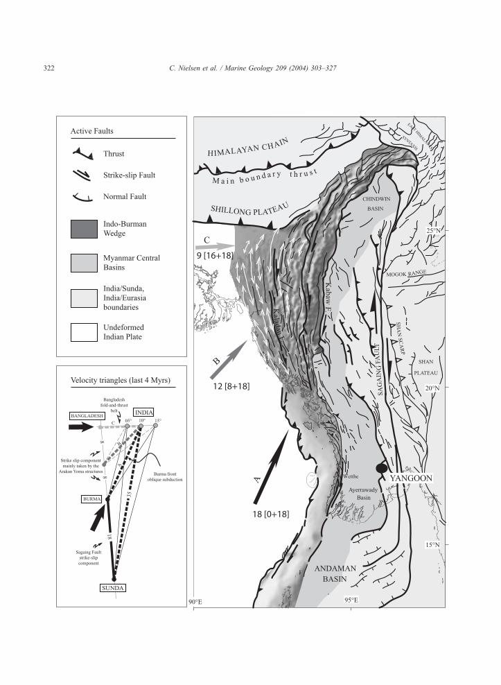
Fig. 16. Combined offshore and onshore structural map of Myanmar and
Indian plate, highly deforming and westward prograding Arakan Yoma
Central Basins, undeforming Sunda Block. Arrows (and numbers next to th
margin (all rates in mm/year), progressively rotating from 035j/18 mm/yea
and thrusts belt). This is the result of progressive evolution from partial (
Fault only (south) to shear on Sagaing Fault plus NS dextral strike-slip fa
amount of dextral shear taken in the Arakan belt (first number, 0–8 and 16
mm/year rate assumed). These numbers were derived from the velocity tr
ing along a sizeable portion of the trench itself,
indicating that full partitioning does not hold there.
Second, the rate of motion on the Sagaing Fault is
only two thirds of the rate on the northern Sem-
angko Fault. A geological velocity of 10–25 mm/
year was proposed using the offset of a Quaternary
volcano built right on the fault (Bertrand et al.,
1998; Bertrand, 1999). This is in good agreement
with geodetic estimates. A local GPS geodetic
network in Myanmar tied to other stations in SE
Asia established an instantaneous velocity of about
18 mm/year around the ancient city of Mandalay
(Vigny et al., 2003). Full transfer of the 26 mm/
year Semangko motion to the Sagaing Fault thus
does not seem to apply. Third, the series of NS
elongated folds in Bangladesh suggest that conver-
gence is back to trench-normal there. The degree of
partitioning thus strongly varies with latitude.
Fourth, vertical partitioning may also be important,
stress indicators (borehole breakouts and P axis of
earthquakes) show that at least the frontal portion
of the Arakan prism is decoupled from the under-
lying basement.
Regardless of the mechanisms at work, we find
that a simple kinematic model involving evolution
from partial to full partitioning from south to north
along the West Burma Scarp is compatible not only
with the offshore tectonic style, but also with the
reduced amount of shearing on the Sagaing Fault and
the activation of additional dextral strike-slip faults
within the core of the Arakan Yoma belt. We take as a
basis to our model the most recent up-to-date for the
motion of India with respect to Sundaland (Chamot-
Rooke et al., 1998; Chamot-Rooke and Le Pichon,
1999; Simons et al., 1999; Becker et al., 2000; Holt et
al., 2000; Kreemer et al., 2000b; Vigny et al., 2003).
Geodetic measurements confirmed that Sundaland
acts as an individual plate, so that the India/Eurasia
kinematics inaccurately describes subduction motion
at Sundaland trenches. Global kinematics obtained by
surroundings. Schematically, the main units from west to east are:
Range and Bangladesh folds and thrust belt, deforming Myanmar
em) indicate relative convergence of India with respect to the upper
r (South Myanmar) to due East–West/9 mm/year (Bangladesh folds
south) to full partitioning (north), in relation with shear on Sagaing
ults in the Arakan Yoma (north). Numbers in brackets indicate the
mm/year) and onto the Sagaing Fault (second number, constant 18
iangles shown to the left.

C. Nielsen et al. / Marine Geology 209 (2004) 303–327324
GPS also point to a slower than expected motion of
India. NUVEL-1A estimation at the latitude of Myan-
mar was about 50 mm/year (DeMets et al., 1990,
1994) where GPS measurements as slow as 35 mm/
year have been reported (Holt et al., 2000; Kreemer et
al., 2000a; Paul et al., 2001). A recent revision of the
kinematics of India for the last 3 Myears, using up-to-
date magnetic anomaly identification, also concludes
to a slower motion of India (Gordon et al., 1999).
Taking into account these revisions, the India–Sunda-
land convergence vector at the latitude of Myanmar is
close to 35 mm/year, in a N10F 5j direction.
We test in Fig. 16 velocity triangles that may apply
to the Indo-Burma region. Since geodetic (instanta-
neous) and geologic (finite motion for the last 3–4
Ma) estimates of India motion converge to similar
values, we infer that the kinematic we describe here is
valid for the last 4 Ma. The 4-Ma period also
corresponds to the last pulse of oceanic accretion in
the Andaman basin (Chamot-Rooke et al., 2001).
India–Sunda motion is set to 35 mm/year, but we
allow for the direction to vary in the range N5j to
N15j. Shearing on the Sagaing Fault is constrained to
18 mm/year. The basic idea is that partitioning
evolves from partial in the south (i.e., shearing on
the Sagaing Fault only) to full partitioning in the north
(i.e., shearing on the Sagaing Fault plus additional
strike-slip faults active within the Arakan Yoma).
Shearing on the Sagaing Fault alone leads to predicted
convergence motion at the Burma Trench in the range
N10j to N40j, in agreement with the structures
described along the WBS. Dextral shearing on addi-
tional faults west of the Sagaing progressively re-
orientates clockwise the direction of convergence to
reach pure shortening in the very north (Bangladesh).
The model requires an integrated rate of shear within
the Arakan Yoma increasing northward (from small to
16 mm/year, see Fig. 16) which adds to the shear on
the Sagaing Fault. We do not know at present whether
this shear is located onto specific faults or distributed
throughout the wedge. Major geologic discontinuities
are likely to be activated. The Kabaw fault puts into
contact the metamorphic rocks of the Paleogene
accretionary complex with the Upper Cretaceous–
Tertiary sediments of the Central basin. The fault is
known to be reverse but with a strong right-lateral
component (Pivnik et al., 1998). Other faults are
active within the Indo-Burman Ranges, such as the
Kaladan thrust, at the contact between the Paleogene
accretionary complex and the Neogene accretionary
prism, and additional east-dipping thrusts limiting
successive slices of the accretionary prism (Sikder
and Alam, 2003). We infer that these faults have a
significant dextral strike-slip component.
Implicit in our kinematic model is that this addi-
tional shearing is taken in the Arakan Yoma belt rather
than on the Sagaing Fault. If taken along the Sagaing
Fault only, then the rate of strike-slip motion on it
should increase northward. GPS measurements are
restricted to Mandalay City, and at present, we do
not know if the geodetic rate is constant along the
entire Sagaing Fault. However, a northward rate
increase would imply stretching of the Burma sliver,
which is opposite to the observations. The Central
basin in Myanmar is affected by transpression (see
Fig. 16) active since Pliocene or Pleistocene time
(Pivnik et al., 1998). This recent transpression fol-
lowed a long period of extension, which led Pivnik et
al. to suggest that northward motion of the Burma
sliver is resisted by the Eastern Himalayas, following
a ‘‘buttressing’’ model initially proposed by Beck
(Beck et al., 1993). The entire variation that we see
along the Burma front may actually be the result of
this buttressing effect. Away from the Himalayas,
obliquity of the subduction is fully accommodated
by the opening of the Andaman basin. In Myanmar,
motion of the sliver is resisted by the Himalayas, so
that only half of the Andaman opening is transmitted
to the Sagaing Fault. The remaining oblique compo-
nent is then accommodated at the trench itself (this
WBS study). In northern Myanmar, motion of the
sliver may eventually drop, thus de-activating the
Sagaing Fault. Dextral shearing would then migrate
westward, re-activating major discontinuities found in
the Arakan Yoma belt. In this extreme scenario,
oblique motion of India is progressively transferred
from a remote fault system (Andaman basin and
eastern margin of the Central basin, i.e., the Sagaing
Fault) to a close to trench fault system (Arakan belt
and trench itself).
6. Conclusions
The West Burma Scarp is an active dextral strike-
slip boundary accommodating part of the India–

C. Nielsen et al. / Marine Geology 209 (2004) 303–327 325
Sunda motion. Detailed multibeam mapping and seis-
mic imaging of the active structures found along the
scarp suggests a relative convergence between India
and Burma around N30j, implying pure strike-slip to
pure shortening depending on the local orientation of
the various segments of the margin. At a more
regional scale, the Burma front progressively evolves
to pure shortening northward towards the Bangladesh
fold system. We infer that the evolution from shear
(Burma scarp) to shortening (Bangladesh wedge) is
the result of a gradual evolution from partial to full
partitioning. Partial partitioning in the south is com-
patible with estimated motion of the Sagaing Fault,
obtained from both instantaneous (GPS) and Quater-
nary (geological) fault slip rates (about 2 cm/year).
The Sagaing Fault thus takes only half of the total
India–Sundaland shear component of motion. Full
partitioning in the north is the result of additional
active strike-slip faults within the Arakan Yoma,
localized at the prism–backstop contact but also
within the Arakan Yoma belt. Faults accommodating
the oblique component of motion of India are pro-
gressively migrating in space from far field faults (i.e.,
Andaman transforms/rift system and Sagaing Fault) to
near trench faults (Arakan Yoma belt and the trench
itself), as a result of the buttressing effect of the
Eastern Himalayas that resist free escape of the Burma
sliver.
Acknowledgements
We are particularly grateful to the people of the
Institut Polaire Franc�ais Paul Emile Victor for their
logistic support of the Andaman Cruise, in particular,
G. Jugie and Y. Balut. Captain G. Foubert (Compag-
nie Maritime d’Affretement) took us safely through
the dangerous mounds of the Burma scarp, we warmly
thank him and the entire crew of theMarion Dufresne.
Swath bathymetry was successfully operated by B.
Ollivier, chief of marine operators, and his team R.
Cagna and X. Morin. We also thank G. Le Beuz and
Y. Penaud, GENAVIR-Ifremer, for operating the
seismic system. CGG and Total made available to us
some of their industrial seismic lines, thanks to M. Le
Vot. We also thank Serge Lallemand and Heidrun
Kopp for their useful comments, and David Piper for
his careful reading.
References
Alam, M., Alam, M.M., Curray, J.R., Chowdhury, A.L.R., Gani,
M.R., 2003. An overview of the sedimentary geology of the
Bengal Basin in relation to the regional tectonic framework
and basin-fill history. Sediment. Geol. 155 (3–4), 179–208.
Basu, P.C., Bandyopadhaya, A., Bandyopadhaya, R.R., 1992. Ba-
thymetry and echosignatures over parts of the accretionary
wedge west of Andaman–Nicobar islands. Spec. Publ.-Geol.
Surv. India 29, 219–228.
Beck, M.E., Rojas, C., Cembrano, J., 1993. On the nature of but-
tressing in margin-parallel strike-slip fault systems. Geology 21,
755–758.
Becker, M., Reinhart, E., Nordin, S.B., Angermann, D., Michel, G.,
Reigber, C., 2000. Improving the velocity field in South and
South-East Asia: the third round of GEODYSSEA. Earth Plan-
ets Space 52 (10), 721–726.
Bellier, O., Sebrier, M., 1995. Is the slip rate variation on the great
Sumatran fault accommodated by forearc stretching? Geophys.
Res. Lett. 22 (15), 1969–1972.
Bender, F., 1983. Geology of Burma. Beitrage zur regionalen geo-
logie der erde, vol. 16, Borntraeger, Stuttgart.
Bertrand, G., 1999. Tectonique Cenozoıque de l’Escarpement du
Plateau Shan (Myanmar). Universite Pierre et Marie Curie Paris
VI, Paris.
Bertrand, G., Rangin, C., Maury, R., Htun, H.M., Bellon, H.,
Guillaud, J.P., 1998. Les basaltes de Singu (Myanmar): nou-
velles contraintes sur le taux de decrochement recent de la
faille de Sagaing. C. R. Acad. Sci., Paris 327, 479–484.
Chamot-Rooke, N., Le Pichon, X., 1999. GPS determined eastward
Sundaland motion with respect to Eurasia confirmed by earth-
quakes slip vectors at Sunda and Philippine trench. Earth Planet.
Sci. Lett. 173 (4), 439–455.
Chamot-Rooke, N., Le Pichon, X., Rangin, C., Huchon, P.,
Pubellier, M., Vigny, C., Walpersdorf, A., 1998. Sundaland
motion in a global reference frame detected from GEODYSSEA
GPS measurements: implications for relative motions at its
boundaries with the Australia – Indian plates and the South
China Block. In: Wilson, P., Michel, G. (Eds.), Scientific
Technical Report STR98/14. GeofroschungsZentrum, Potsdam,
pp. 39–75.
Chamot-Rooke, N., Rangin, C., Nielsen, C., 2001. Timing and
Kinematics of Andaman Basin Opening. Eos. Trans. AGU 82
(20) (Spring Meet. Suppl., Abstract T42B-08, Boston).
Chaumillon, E., Mascle, J., 1997. From foreland to forearc
domains: new multichannel seismic reflection survey of the
Mediterranean ridge accretionary complex (Eastern Mediterra-
nean). Mar. Geol. 138, 237–259.
Collot, J.Y., Delteil, J., Lewis, K., Davy, B., Lamarche, G., Audru,
J.-C., Barnes, P., Chanier, F., Chaumillon, E., Lallemand, S.,
Mercier de Lepinay, B., Orpin, A., Pelletier, B., Sosson, M.,
Toussaint, B., Uruski, C., 1996. From oblique subduction to
intra-continental transpression: structures of the southern Kerma-
dec–Hikurangi margin from multibeam bathymetry, side-scan
sonar and seismic reflection. Mar. Geophys. Res. 18, 357–381.
Collot, J.Y., Lewis, K., Lamarche, G., Lallemand, S., 2001. The
giant Ruatoria debris avalanche on the northern Hikurangi mar-
C. Nielsen et al. / Marine Geology 209 (2004) 303–327326
gin, New Zealand: result of oblique seamount subduction.
J. Geophys. Res. 19, 271–297.
Curray, J.R., Moore, D.G., Lawver, L.A., Emmel, F.J., Raitt, R.W.,
Henry, M., Kieckhefer, R., 1979. Tectonics of the Andaman
Sea and Burma. In: Watkins, J.S., Montadert, L., Dickerson,
P.W. (Eds.), Geology and Geophysics of Continental Margins.
American Association of Petroleum Geologists Memoir 53,
189–198.
Delteil, J., Collot, J.-Y., Wood, R., Herzer, R., Calmant, S., Chris-
toffel, D., Coffin, M., Ferriere, J., Lamarche, G., Lebrun, J.-F.,
Mauffret, A., Pontoise, B., Popoff, M., Ruellan, E., Sosson, M.,
Sutherland, R., 1996. From strike-slip faulting to oblique sub-
duction: a survey of the Alpine Fault –Puysegur Trench transi-
tion, New Zealand, results of cruise Geodynz-sud Leg 2. Mar.
Geophys. Res. 18, 383–399.
DeMets, C., Gordon, R.G., Argus, D.F., Stein, S., 1990. Current
plate motions. Geophys. J. Int. 101, 425–478.
DeMets, C., Gordon, R.G., Argus, D.F., Stein, S., 1994. Effects of
recent revisions to the geomagnetic reversal time scale on
estimates of current plate motions. Geophys. Res. Lett. 21,
2191–2194.
Fitch, T.J., 1972. Plate convergence, transcurrent faults, and internal
deformation adjacent to Southeast Asia and the western Pacific.
J. Geophys. Res. 77, 4432–4460.
Gopala Rao, G.C., Krishna, K.S., 1997. Crustal evolution and sed-
imentation history of the Bay of Bengal since the Cretaceous. J.
Geophys. Res. 102 (B8), 17747–17768.
Gopala Rao, G.C., Bhattacharya, M.V., Ramana, V., Subrahmanyam
T., Ramprasad, T., Krishna, K.S., Chaubey, A.K., Murty, G.P.S.,
Srinivas, K., Desa, M., 1994. Analysis of multi-channel seismic
reflection and magnetic data along 13jN latitude across the Bay
of Bengal. Mar. Geophys. Res. 16, 225–236.
Gordon, R.G., Argus, D.F., Heflin, M.B., 1999. Revised estimate of
the angular velocity of India relative to Eurasia. Eos. Trans.
AGU 80 (46) Fall Meet. Suppl., F273, San Francisco.
Gowd, T.N., Srirama Rao, S.V., Gaur, V.K., 1992. Tectonic stress
field in the Indian subcontinent. J. Geophys. Res. 97 (8),
11879–11888.
Gowd, T.N., Rao, S.V.S., Chary, K.B., 1998. Seismotectonics of
northeastern India. Curr. Sci. 74 (1), 75–80.
Guzman-Speziale, M., Ni, J.F., 1996. Seismicity and active tecton-
ics of the western Sunda Arc. In: Yin, A., Harrison, M. (Eds.),
The Tectonic Evolution of Asia, Cambridge University Press,
pp. 63–84.
Guzman-Speziale, M., Ni, J.F., Holt, W.E., Wallace, T., 1987. Seis-
motectonics of the Burma subduction zone. EOS, 1444.
Holt, W., Chamot-Rooke, N., Le Pichon, X., Haines, J., Shen-Tu,
B., Ren, J., 2000. Velocity field in Asia inferred from Quater-
nary fault slip rates and Global Positioning System observa-
tions. J. Geophys. Res. 105 (B8), 19185–19209.
Kayal, J.R., Gaonkar, S.G., Chakraborty, G.K., Singh, O.P., 2004.
Aftershocks and seismotectonic implications of the 13 Septem-
ber 2002 earthquake (M-w 6.5) in the Andaman Sea basin. Bull.
Seismol. Soc. Am. 94 (1), 326–333.
Kreemer, C., Haines, A.J., Holt, W.E., Blewitt, G., Lavallee, D.,
2000a. On the determination of a global strain rate model. Earth
Planets Space 52, 765–770.
Kreemer, C., Holt, W.E., Goes, S., Govers, R., 2000b. Active de-
formation in eastern Indonesia and the Philippines from GPS
and seismicity data. J. Geophys. Res. 105 (B1), 663–680.
Kreemer, C., Holt, W.E., Haines, A.J., 2003. An integrated global
model of present-day plate motions and plate boundary defor-
mation. Geophys. J. Int. 154, 8–34.
Lallemand, S.E., Schnurle, P., Malavieille, J., 1994. Coulomb the-
ory applied to accretionary and nonaccretionary wedges—pos-
sible causes for tectonic erosion and or frontal accretion.
J. Geophys. Res. Solid Earth 99 (B6), 12033–12055.
Lamarche, G., Lebrun, J.-F., 2000. Transition from strike-slip fault-
ing to oblique subduction: active tectonics at the Puysegur Mar-
gin, South New Zealand. Tectonophysics 316, 67–89.
Lebrun, J.-F., Lamarche, G., Collot, J.-Y., Delteil, J., 2000. Abrupt
strike-slip fault to subduction transition: the Alpine Fault–Puy-
segur Trench connection, New Zealand. Tectonics 19 (4),
688–706.
Le Dain, A.Y., Tapponnier, P., Molnar, P., 1984. Active faulting and
tectonics of Burma and surrounding regions. J. Geophys. Res.
89, 453–472.
Mc Caffrey, R., 1991. Slip vectors and stretching of the Sumatran
fore arc. Geology 19, 881–884.
Mc Caffrey, R., 1994. Global variability in subduction thrust zone–
forearc systems. Pure Appl. Geophys. 142 (1), 173–224.
Michel, G.W., Yu, Y.Q., Zhu, S.Y., Reigber, C., Becker, M.,
Reinhart, E., Simons, W., Ambrosius, B.A.C., Vigny, C., Cha-
mot-Rooke, N., Le Pichon, X., Morgan, P., Matheussen, S., 2001.
Crustal motion and block behaviour in SE-Asia from GPS meas-
urements. Earth Planet. Sci. Lett. 187 (3–4), 239–244.
Moore, D.G., Curray, J.R., Emmel, F.J., 1976. Large submarine
slide (Olistostrome) associated with Sunda-Arc Subduction
Zone, northeast Indian-Ocean. Mar. Geol. 21 (3), 211–226.
Mukhopadhyay, M., Das Gupta, S., 1988. Deep structure and tec-
tonics of the Burmese arc: constraints from eathquake and gra-
vity data. Tectonophysics 149, 299–322.
Ni, J.F., Guzman-Speziale, M., 1989. Accretionary tectonics of
Burma and the three dimensional geometry of the Burma sub-
duction zone. Geology 17, 68–71.
Ortiz, M., Bilham, R., 2003. Source area and rupture parameters of
the 31 December 1881 M-w= 7.9 Car Nicobar earthquake esti-
mated from tsunamis recorded in the Bay of Bengal. J. Geophys.
Res. Solid Earth 108 (B4) DOI:10.1029/2002JB001941.
Paul, J., Buergmann, R., Gaur, V.K., Bilham, R., Larson, K.M.,
Ananda, M.B., Jade, S., Mukal, M., Anupama, T.S., Satyal,
G., Kumar, D., 2001. The motion and active deformation of
India. Geophys. Res. Lett. 28 (4), 647–650.
Pivnik, D.A., Nahm, J., Tucker, R.S., Smith, G.O., Nyein, K.,
Nyunt, M., Maung, P.H., 1998. Polyphase deformation in a
fore-arc/back-arc basin, Salin subbasin, Myanmar (Burma).
AAPG Bull.-Am. Assoc. Pet. Geol. 82 (10), 1837–1856.
Rao, P., Kumar, R., 1999. Evidences for cessation of Indian plate
subduction in the Burmese arc region. Geophys. Res. Lett. 26
(20), 3149–3152.
Satyabala, S.P., 2003. Oblique plate convergence in the Indo-Burma
(Myanmar) subduction region. Pure Appl. Geophys. 160 (9),
1611–1650.
Sikder, A.M., Alam, M.M., 2003. 2-D Modelling of the anticlinal

C. Nielsen et al. / Marine Geology 209 (2004) 303–327 327
structures and structural development of the eastern fold belt of
the Bengal Basin, Bangladesh. Sediment. Geol. 155 (3–4),
209–226.
Simons, W.J.F., Ambrosius, B.A.C., Noomen, R., Angermann, D.,
Wilson, P., Becker, M., Reinhart, E., Walpersdorf, A., Vigny,
C., 1999. Observing plate motions in SE Asia: geodetic results
of the GEODYSSEA project. Geophys. Res. Lett. 26 (14),
2081–2084.
Verma, R.K., Mukhopadhyay, M., Ahluwalia, M.S., 1976a. Earth-
quake mechanisms and tectonic features of northern Burma.
Tectonophysics 32, 387–399.
Verma, R.K., Mukhopadhyay, M., Ahluwalia, M.S., 1976b. Seis-
micity, gravity and tectonics of northeast India and northern
Burma. Bull. Seismol. Soc. Am. 66, 1683–1694.
Vigny, C., Socquet, A., Rangin, C., Chamot-Rooke, N., Pubellier,
M., Bouin, M.N., Bertrand, G., Becker, M., 2003. Present-day
crustal deformation around Sagaing fault, Myanmar. J. Geo-
phys. Res. 108 (B11) DOI:10.1029/2002JB001999.