from training to projects: wireless sensor …wireless.ictp.it/papers/ghtc2012-paper.pdffrom...
TRANSCRIPT

From Training to Projects:Wireless Sensor Networks in Africa
Marco ZennaroTelecommunications/
ICT for Development LaboratoryThe Abdus Salam
International Centre for Theoretical PhysicsTrieste, Italy
Email: [email protected]
Antoine BagulaISAT Laboratory
Department of Computer ScienceUniversity of Cape TownCape Town, South Africa
Email: [email protected]
Mayamiko NkolomaDepartment of Electrical Engineering
Malawi PolytechnicBlantyre, Malawi
Email: [email protected]
Abstract—Wireless Sensor Networks have a great role to playin Developing Countries. This paper reports on training work-shops jointly organized by the Abdus Salam International Centrefor Theoretical Physics and the University of Cape Town in SouthAfrica (March 2010), Kenya (June 2011) and Ghana (December2011) on Wireless Sensor Networks. The trainings were 4 dayslong and targeted 20 participants, composed of researchers,professionals and students from both computer science and otherscientific faculties. The training activities were regional onesand used open wireless sensors for the advantages they present.The lectures were organized with theoretical lectures in themorning and laboratory sessions in the afternoon. Participantsfrom the workshops have deployed wireless sensor networks intheir own countries and have come up with some interestingapplications.We will describe an application deployed in Malawi.
I. INTRODUCTION AND PURPOSE
A Wireless Sensor Network (WSN) is a self-configuringnetwork of small nodes, also known as motes, deployed inquantities to sense the physical world and report to specificcentre where the remote information is analyzed and pro-cessed. These tiny electronic devices can easily be integratedin our daily life to support a wide number of applicationsranging from environmental, agriculture, and health care todisaster monitoring. Currently, they form the backbone of anew Internet called ”Internet-of-the-Things (IoT)” that extendsIP communication to enable access to IP based smart objects.For some applications such as weather monitoring for droughtprediction, sensor technology is proposing a low cost weatherboard alternative to the static weather stations which is notonly competitively much cheaper but also more flexible as itcan be deployed as a fixed device or mounted on a vehicle asa mobile weather station.
We advocate the use of WSN for Development as they havemany potential applications that can benefit poor communitiesfor instance in; water quality monitoring, intelligent irrigation,landslide monitoring and many others and at the same timehelp in bridging the scientific divide [1].
The number of scientists in Africa, according to a 2007 re-port [2], is 60 for every million inhabitants. Western countrieshave about 5000 scientists per million inhabitants. The same
report states that scientists across the whole of Africa publishabout 27,000 papers in international journals per year, whichis only about the same volume as those from Netherlands. Ifthe digital divide is defined as the gap between those withregular and effective access to digital technologies and thosewithout, then the scientific divide can be defined as the gapbetween those with access to scientific data and those without.We believe that the use of WSN in Developing Countries canhelp fill this gap with the use of low-cost and state-of-the-artsolutions.
To realize these benefits, a broad portfolio of deploymentswill be needed as a proof of concept. It is important that thedeployed networks are appropriate to the environment beinginvestigated. They should consider both the potential scientificimpact as well as the one on local society. Wider disseminationis needed to engage a greater audience for sensor developmentactivities.
The use of WSN will also enhance Computer Sciencecurricula in academic institutions of Developing Countries.Long-term data from sensor networks will be valuable foreducational purposes and the associated tools for curriculadevelopment should be encouraged. The nodes come with thebasics of a general purpose platform, but the nature of eachapplication determines the sensing hardware specifics. Thussensor design is a fundamental area within WSN. The abilityto perform direct measurements of necessary magnitudes, toidentify pattern recognition strategies and exploit computa-tional resources appropriately represent engineering challengesthat can be addressed in academia
While high-end network equipment is too expensive forhands-on training for scientists and engineers of the Devel-oping World, the emergence of off-the-shelf low cost sensornetwork equipment has enabled a new training model whereknowledge is acquired on real devices. This model also allowsscientists and engineers, both students and professionals, tobe exposed to engineering design by having planning andconfiguration combined with fine-tuning of equipment duringthe training period to meet deployment requirements. There istherefore the need for training activities focussed on the useof WSN, with a strong hands-on component, to be organized
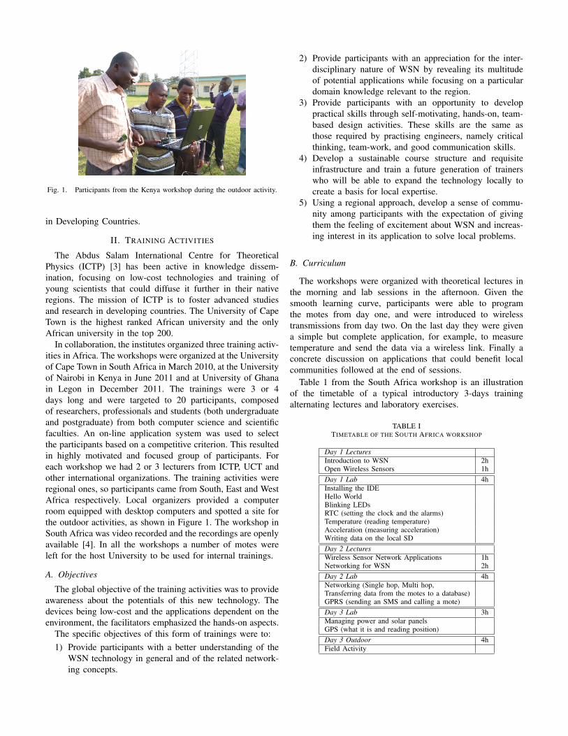
Fig. 1. Participants from the Kenya workshop during the outdoor activity.
in Developing Countries.
II. TRAINING ACTIVITIES
The Abdus Salam International Centre for TheoreticalPhysics (ICTP) [3] has been active in knowledge dissem-ination, focusing on low-cost technologies and training ofyoung scientists that could diffuse it further in their nativeregions. The mission of ICTP is to foster advanced studiesand research in developing countries. The University of CapeTown is the highest ranked African university and the onlyAfrican university in the top 200.
In collaboration, the institutes organized three training activ-ities in Africa. The workshops were organized at the Universityof Cape Town in South Africa in March 2010, at the Universityof Nairobi in Kenya in June 2011 and at University of Ghanain Legon in December 2011. The trainings were 3 or 4days long and were targeted to 20 participants, composedof researchers, professionals and students (both undergraduateand postgraduate) from both computer science and scientificfaculties. An on-line application system was used to selectthe participants based on a competitive criterion. This resultedin highly motivated and focused group of participants. Foreach workshop we had 2 or 3 lecturers from ICTP, UCT andother international organizations. The training activities wereregional ones, so participants came from South, East and WestAfrica respectively. Local organizers provided a computerroom equipped with desktop computers and spotted a site forthe outdoor activities, as shown in Figure 1. The workshop inSouth Africa was video recorded and the recordings are openlyavailable [4]. In all the workshops a number of motes wereleft for the host University to be used for internal trainings.
A. Objectives
The global objective of the training activities was to provideawareness about the potentials of this new technology. Thedevices being low-cost and the applications dependent on theenvironment, the facilitators emphasized the hands-on aspects.
The specific objectives of this form of trainings were to:1) Provide participants with a better understanding of the
WSN technology in general and of the related network-ing concepts.
2) Provide participants with an appreciation for the inter-disciplinary nature of WSN by revealing its multitudeof potential applications while focusing on a particulardomain knowledge relevant to the region.
3) Provide participants with an opportunity to developpractical skills through self-motivating, hands-on, team-based design activities. These skills are the same asthose required by practising engineers, namely criticalthinking, team-work, and good communication skills.
4) Develop a sustainable course structure and requisiteinfrastructure and train a future generation of trainerswho will be able to expand the technology locally tocreate a basis for local expertise.
5) Using a regional approach, develop a sense of commu-nity among participants with the expectation of givingthem the feeling of excitement about WSN and increas-ing interest in its application to solve local problems.
B. Curriculum
The workshops were organized with theoretical lectures inthe morning and lab sessions in the afternoon. Given thesmooth learning curve, participants were able to programthe motes from day one, and were introduced to wirelesstransmissions from day two. On the last day they were givena simple but complete application, for example, to measuretemperature and send the data via a wireless link. Finally aconcrete discussion on applications that could benefit localcommunities followed at the end of sessions.
Table 1 from the South Africa workshop is an illustrationof the timetable of a typical introductory 3-days trainingalternating lectures and laboratory exercises.
TABLE ITIMETABLE OF THE SOUTH AFRICA WORKSHOP
Day 1 LecturesIntroduction to WSN 2hOpen Wireless Sensors 1hDay 1 Lab 4hInstalling the IDEHello WorldBlinking LEDsRTC (setting the clock and the alarms)Temperature (reading temperature)Acceleration (measuring acceleration)Writing data on the local SDDay 2 LecturesWireless Sensor Network Applications 1hNetworking for WSN 2hDay 2 Lab 4hNetworking (Single hop, Multi hop,Transferring data from the motes to a database)GPRS (sending an SMS and calling a mote)Day 3 Lab 3hManaging power and solar panelsGPS (what it is and reading position)Day 3 Outdoor 4hField Activity
C. Laboratory ComponentFrom the laboratory component of the trainings, a number
of standard projects were developed for implementation bythe participants. The following projects were given and suc-cessfully executed by the participants as tasks related to theapplications of sensors as fixed and/or mobile devices.
• Project 1. Monitor fridge temperature and send measure-ments at a predetermined interval to a computer or amobile phone via text messages (SMS). Furthermore thisactivity was enhanced by sending a special alert if certaintemperature ranges are attained.
• Project 2. It has been reported that in some developingcountries the theft of containers during transportationfrom the shore to the city is common practice. Conse-quently, one exercise was to check container movementsas it follows it’s predefined itinerary. That is to say ifduring transportation it diverts from it’s itinerary then theapplication should send an SMS alert with the container’sGPS position and acceleration to the one in charge.
• Project 3. Check if a motor is behaving properly bymeasuring it’s acceleration four times per second andsend the information via SMS or another wireless methodto a PC.
• Project 4. Measure the pollution in the city where thetraining is taking place. Read data every 30 seconds froma Gas Sensor board and store it on the SD card with date,time and position while sending SMSs to a given numberwhen pollution reaches given threshold values.
• Project 5. Monitor weather to support meteorology andagriculture in the city where the training is taking place.Read data every 2 minutes from a weather board andstore it on the SD card with date, time and positionwhile sending SMSs to a given number when weatherconditions in the area reach given threshold values.
The tasks involved in these projects are both indoor andoutdoor and require designing the WSN and implementinga WSN prototype. These tasks successfully executed by theparticipants using the Waspmote platform reveal how sensorscan be used as fixed and mobile devices sending and receivingSMS and uploading data on a web portal.
D. TechnologyIt was decided to use open wireless sensors for the advan-
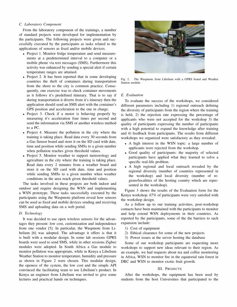
tages they present: low cost, customization and independencefrom one vendor [5]. In particular, the Waspmote from Li-belium [6] was adopted. The advantage it offers is that itis built with a modular design. In some lab sessions GPRSboards were used to send SMS, while in other sessions Zigbeemodules were adopted. In South Africa a Gas module tomonitor pollution was appropriate, while in Kenya a LibeliumWeather Station to monitor temperature, humidity and pressureas shown in Figure 2 were chosen. This modular design,the openess of the system, the low cost and the simple APIconvinced the facilitating team to use Libelium’s product. InKenya an engineer from Libelium was invited to give somelectures and practical hands on techniques.
Fig. 2. The Waspmote from Libelium with a GPRS board and WeatherStation module.
E. Evaluation
To evaluate the success of the workshops, we considereddifferent parameters including 1) regional outreach definingthe diversity of participants from the region where the trainingis held, 2) the rejection rate expressing the percentage ofapplicants who were not accepted for the workshop 3) thequality of participants expressing the number of participantswith a high potential to expand the knowledge after trainingand 4) feedback from participants. The results from differentworkshops we organized were satisfactory as they revealed:
• A high interest in the WSN topic: a large number ofapplicants were rejected from the workshop.
• Good quality of participants: the majority of selectedparticipants have applied what they learned to solve aspecific real-life problem.
• A high regional and local outreach revealed by theregional diversity (number of countries represented inthe workshop) and local diversity (number of re-gions/localities of the hosting country which are repre-sented in the workshop).
Figure 3 shows the results of the Evaluation form for theKenya workshop. 67% of participants were very satisfied withthe workshop design.
As a follow up to our training activities, post-workshopcontacts have been maintained with the participants to monitorand help extend WSN deployments in their countries. Asreported by the participants, some of the the barriers to suchexpansion include:
1) Cost of equipment2) Ethical clearance for some of the new projects3) Power issues at the server hosting the databaseSome of our workshop participants are requesting more
workshops to support new ideas relevant to their region. Asan example, we had requests about tea and coffee monitoringin Africa, WSN to monitor fire in the equatorial rain forest inDRC and WSN to monitor exotic fruit growth.
III. PROJECTS
After the workshops, the equipment has been used bystudents from the host Universities that participated to the
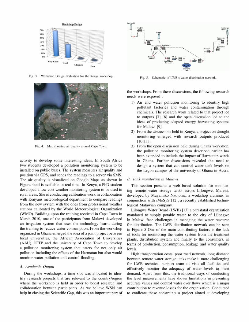
Fig. 3. Workshop Design evaluation for the Kenya workshop.
Fig. 4. Map showing air quality around Cape Town.
activity to develop some interesting ideas. In South Africatwo students developed a pollution monitoring system to beinstalled on public buses. The system measures air quality andposition via GPS, and sends the readings to a server via SMS.The air quality is visualized on Google Maps as shown inFigure 4and is available in real time. In Kenya, a PhD studentdeveloped a low cost weather monitoring system to be used inrural areas. She is conducting calibration work in collaborationwith Kenyans meteorological department to compare readingsfrom the new system with the ones from professional weatherstations calibrated by the World Meteorological Organization(WMO). Building upon the training received in Cape Town inMarch 2010, one of the participants from Malawi developedan irrigation system that uses the technology learnt duringthe training to reduce water consumption. From the workshoporganized in Ghana emerged the idea of a joint project betweenlocal universities, the African Association of Universities(AAU), ICTP and the university of Cape Town to developa pollution monitoring system that caters for not only airpollution including the effects of the Harmatan but also wouldmonitor water pollution and control flooding.
A. Academic Output
During the workshops, a time slot was allocated to iden-tify research projects that are relevant to the country/regionwhere the workshop is held in order to boost research andcollaboration between participants. As we believe WSN canhelp in closing the Scientific Gap, this was an important part of
Fig. 5. Schematic of LWB’s water distribution network.
the workshops. From these discussions, the following researchneeds were exposed :
1) Air and water pollution monitoring to identify highpollutant factories and water contamination throughchemicals. The research work related to that project ledto outputs [7] [8] and the open discussion led to theideas of producing adapted energy harvesting systemsfor Malawi [9].
2) From the discussions held in Kenya, a project on droughtmonitoring emerged with research outputs produced[10][11].
3) From the open discussion held during Ghana workshop,the pollution monitoring system described earlier hasbeen extended to include the impact of Harmattan windsin Ghana. Further discussions revealed the need todesign a system that can control water tank levels onthe Legon campus of the university of Ghana in Accra.
B. Tank monitoring in Malawi
This section presents a web based solution for monitor-ing remote water storage tanks across Lilongwe, Malawi,developed by Mayamiko Nkoloma, a workshop alumnus, inconjunction with iMoSyS [12], a recently established techno-logical Malawian company.
Lilongwe Water Board (LWB) [13] a parastatal organizationmandated to supply potable water to the city of Lilongwein Malawi face challenges in managing the water resourcefor distribution. The LWB distribution network can be seenin Figure 5 One of the main contributing factors is the lackof tools for monitoring the water system from the treatmentplants, distribution system and finally to the consumers, interms of production, consumption, leakage and water qualitylevels.
High transportation costs, poor road network, long distancebetween remote water storage tanks make it more challengingfor LWB technical support team to visit all facilities andeffectively monitor the adequacy of water levels to meetdemand. Apart from this, the traditional ways of conductingthe level measurements have shown limitations in presentingaccurate values and control water over flows which is a majorcontribution to revenue losses for the organization. Conductedto eradicate these constraints a project aimed at developing
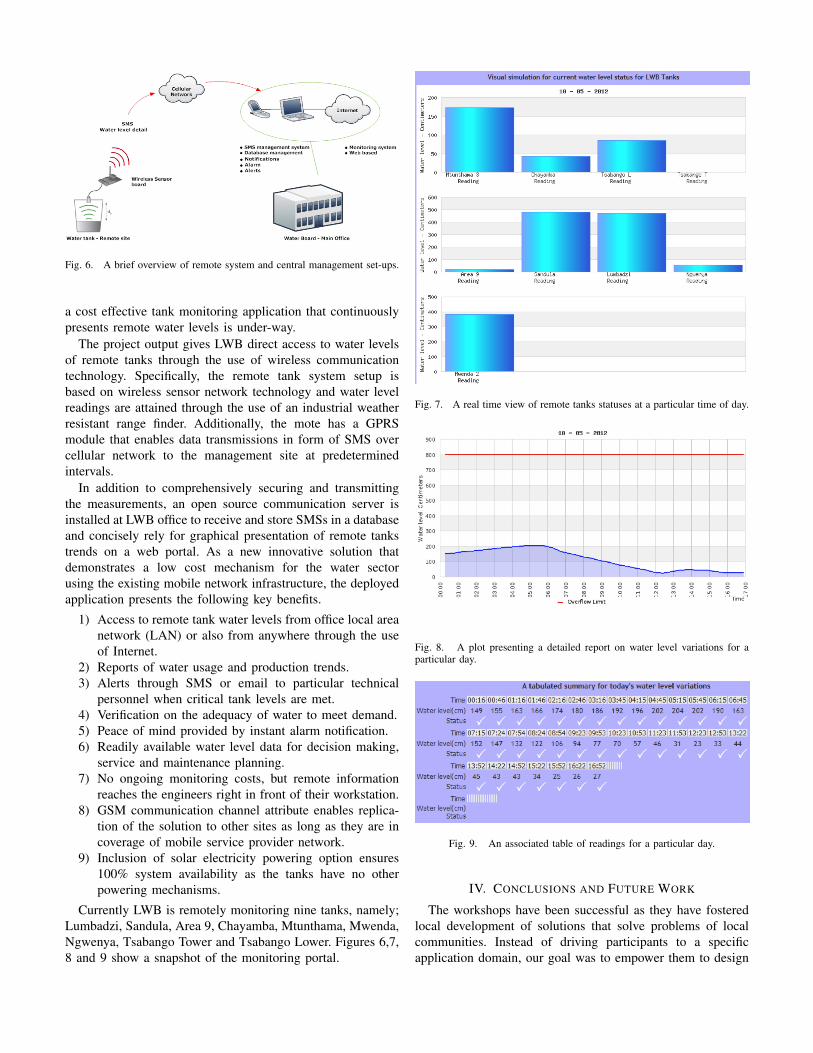
Fig. 6. A brief overview of remote system and central management set-ups.
a cost effective tank monitoring application that continuouslypresents remote water levels is under-way.
The project output gives LWB direct access to water levelsof remote tanks through the use of wireless communicationtechnology. Specifically, the remote tank system setup isbased on wireless sensor network technology and water levelreadings are attained through the use of an industrial weatherresistant range finder. Additionally, the mote has a GPRSmodule that enables data transmissions in form of SMS overcellular network to the management site at predeterminedintervals.
In addition to comprehensively securing and transmittingthe measurements, an open source communication server isinstalled at LWB office to receive and store SMSs in a databaseand concisely rely for graphical presentation of remote tankstrends on a web portal. As a new innovative solution thatdemonstrates a low cost mechanism for the water sectorusing the existing mobile network infrastructure, the deployedapplication presents the following key benefits.
1) Access to remote tank water levels from office local areanetwork (LAN) or also from anywhere through the useof Internet.
2) Reports of water usage and production trends.3) Alerts through SMS or email to particular technical
personnel when critical tank levels are met.4) Verification on the adequacy of water to meet demand.5) Peace of mind provided by instant alarm notification.6) Readily available water level data for decision making,
service and maintenance planning.7) No ongoing monitoring costs, but remote information
reaches the engineers right in front of their workstation.8) GSM communication channel attribute enables replica-
tion of the solution to other sites as long as they are incoverage of mobile service provider network.
9) Inclusion of solar electricity powering option ensures100% system availability as the tanks have no otherpowering mechanisms.
Currently LWB is remotely monitoring nine tanks, namely;Lumbadzi, Sandula, Area 9, Chayamba, Mtunthama, Mwenda,Ngwenya, Tsabango Tower and Tsabango Lower. Figures 6,7,8 and 9 show a snapshot of the monitoring portal.
Fig. 7. A real time view of remote tanks statuses at a particular time of day.
Fig. 8. A plot presenting a detailed report on water level variations for aparticular day.
Fig. 9. An associated table of readings for a particular day.
IV. CONCLUSIONS AND FUTURE WORK
The workshops have been successful as they have fosteredlocal development of solutions that solve problems of localcommunities. Instead of driving participants to a specificapplication domain, our goal was to empower them to design
their own solution. In this sense, we talk about knowledge co-creation. We gave the specific example of Malawi, where asolution was designed from local needs.
In the future workshops we will focus on IPv6 and SensorNetworks, as the interest in this new aspect of WSN isgrowing. Wireless sensors will become fully part of the globalIPv6 network and will be accessible from everywhere in theworld.
REFERENCES
[1] M. Zennaro,B. Pehrson,and A. Bagula, Wireless Sensor Networks: a greatopportunity for researchers in Developing Countries, in Proceedings ofWCITD2008 Conference, Pretoria, South Africa, October 2008.
[2] Nature: African nations vow to support science, http://www.nature.com/news/2010/100623/full/465994a.html
[3] R. Struzak et al., Wireless Sensor Networks for Environmental Monitoringin Developing Countries: A Report on the 2011 ITU-ICTP Workshop andConference, Radio Science Bulletin No 339 (December 2011).
[4] First Workshop on Wireless Sensor Networks with Applications inEnvironment Monitoring, http://www.ws4all.org/training/
[5] M. Zennaro, A. Bagula, H. Ntareme, G. Inggs and S. Scott, On therelevance of Open Wireless sensors for NGN, in Proceedings of the ITU-TKaleidoscope conference, August/Sept. 2009.
[6] Libelium Waspmote, http://www.libelium.com/products/waspmote[7] A. Bagula, M. Zennaro, G. Inggs, S. Scott and D. Gascon, Ubiq-
uitous Sensor Networking for Development (USN4D): An Applicationto Pollution Monitoring, in Sensors, 2012, 12(1):391-414 available athttp://www.mdpi.com/1424-8220/12/1/391/pdf
[8] A. Bagula, G. Inggs, S. Scott and M. Zennaro, Community SensorNetworks: An Application to Pollution Maps, in Proceedings of the Inter-national Wireless Communication and Information Conference, Berlin-Germany, ISBN: 978-3-940317-81-0, October 2010.
[9] M. Nkoloma, M. Zennaro and A. Bagula, SM2: Solar Monitoring Systemin Malawi, in Proceedings of ITU Kaleidoscope 2011, South Africa.
[10] M. Muthoni and A. Bagula, A Framework for Integrating IndigenousKnowledge With Wireless Sensors in Predicting Droughts in Africa inProceedings of Indigenous Knowledge Technology Conference 2011(IKTC2011), 2-4 November 2011, Windhoek, Namibia.
[11] M. Muthoni, W. James and A. Bagula, Using NLIDB to Make WeatherInformation Relevant to Kenyan Farmers in Proceedings of the 2011African Conference on Software Engineering and Applied Computing,Cape Town/South Africa, September 19-23, 2011.
[12] Intelligent Monitoring System (iMoSyS), http://www.imo-sys.com[13] Lilongwe Water Board, http://www.lwb.mw/