fronts. fronts are the boundaries between two air masses
TRANSCRIPT

Fronts

Fronts are the boundaries between two air masses.

Fronts are classified as to which type of air mass (cold or warm) is replacing the other.

For example, a cold front marks the leading edge of a cold air mass displacing a warmer air mass.

A warm front is the leading edge of a warmer air mass replacing a colder air mass.

If the front is essentially not moving (i.e. the air masses are not moving) it is called a stationary front.

Warm fronts typically have a gentle slope so the air rising along the frontal surface is gradual.

This usually favors the development of widespread layered or stratus cloudiness and precipitation along and to the north of the front.

Cirrus clouds will be the first indication of a warm front.

Stratus clouds form as warm fronts approach


Symbolically, a warm front is represented by a solid line with semicircles pointing towards the colder air and in the direction of movement.

An abrupt temperature change over a short distance is a good indication that a front is located somewhere in between.

The slope of cold fronts are more steep and air is forced upward more abruptly.

This usually leads to a narrow band of showers and thunderstorms along or just ahead of the front, especially if the rising air is unstable.


A sudden change in wind direction is commonly observed with the passage of a cold front.
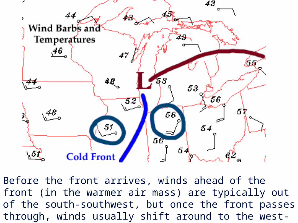
Before the front arrives, winds ahead of the front (in the warmer air mass) are typically out of the south-southwest, but once the front passes through, winds usually shift around to the west-northwest (in the colder air mass).

Cold fronts typically move faster than warm fronts, so in time they "catch up" to warm fronts.

As the two fronts merge, an occluded front forms.

In the occluded front, the cold air undercuts the cooler air mass associated with the warm front, further lifting the already rising warm air.


When a warm or cold front stops moving, it becomes a stationary front. Once this boundary resumes its forward motion, it once again becomes a warm front or cold front. A stationary front is represented by alternating blue and red lines with blue triangles pointing towards the warmer air and red semicircles pointing towards the colder air.
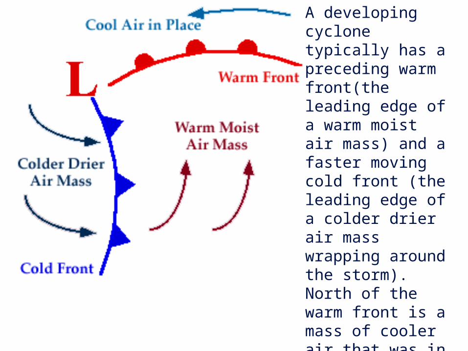
A developing cyclone typically has a preceding warm front(the leading edge of a warm moist air mass) and a faster moving cold front (the leading edge of a colder drier air mass wrapping around the storm). North of the warm front is a mass of cooler air that was in place before the storm even entered the region.

A cyclone is an area of low pressure around which the winds flow counterclockwise in the Northern Hemisphere and clockwise in the Southern Hemisphere.

Low pressure centers also represent the centers of cyclones.

A high pressure center is represented on a weather map by a blue "H" and air diverges outward from a surface high. With air moving away from this region, air must sink from above to replace it. This sinking motion leads to generally fair skies and no precipitation near the high.

What kind of front is this?

What kind of front is this?

What kind of front is this?

What kind of front is this?

What kind of front is this?

What kind of front is this?

What kind of front is this?
