fs4 ahf consents for coastal...
TRANSCRIPT
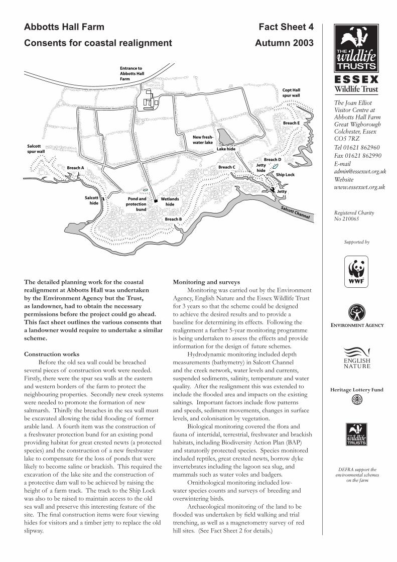
Abbotts Hall Farm Fact Sheet 4Consents for coastal realignment Autumn 2003
Entrance toAbbotts HallFarm
Salcottspur wall
Copt Hallspur wall
New fresh-water lake
Breach B
Breach A Breach C
Breach D
Breach E
Pond andprotection
bund
Salcotthide
Wetlandshide
Jettyhide
Lake hide
Jetty
Salcott Channel
Ship Lock
The detailed planning work for the coastal realignment at Abbotts Hall was undertaken by the Environment Agency but the Trust, as landowner, had to obtain the necessary permissions before the project could go ahead. This fact sheet outlines the various consents that a landowner would require to undertake a similar scheme.
Construction worksBefore the old sea wall could be breached
several pieces of construction work were needed. Firstly, there were the spur sea walls at the eastern and western borders of the farm to protect the neighbouring properties. Secondly new creek systems were needed to promote the formation of new saltmarsh. Thirdly the breaches in the sea wall must be excavated allowing the tidal flooding of former arable land. A fourth item was the construction of a freshwater protection bund for an existing pond providing habitat for great crested newts (a protected species) and the construction of a new freshwater lake to compensate for the loss of ponds that were likely to become saline or brackish. This required the excavation of the lake site and the construction of a protective dam wall to be achieved by raising the height of a farm track. The track to the Ship Lock was also to be raised to maintain access to the old sea wall and preserve this interesting feature of the site. The final construction items were four viewing hides for visitors and a timber jetty to replace the old slipway.
Monitoring and surveysMonitoring was carried out by the Environment
Agency, English Nature and the Essex Wildlife Trust for 3 years so that the scheme could be designed to achieve the desired results and to provide a baseline for determining its effects. Following the realignment a further 5-year monitoring programme is being undertaken to assess the effects and provide information for the design of future schemes.
Hydrodynamic monitoring included depth measurements (bathymetry) in Salcott Channel and the creek network, water levels and currents, suspended sediments, salinity, temperature and water quality. After the realignment this was extended to include the flooded area and impacts on the existing saltings. Important factors include flow patterns and speeds, sediment movements, changes in surface levels, and colonisation by vegetation.
Biological monitoring covered the flora and fauna of intertidal, terrestrial, freshwater and brackish habitats, including Biodiversity Action Plan (BAP) and statutorily protected species. Species monitored included reptiles, great crested newts, borrow dyke invertebrates including the lagoon sea slug, and mammals such as water voles and badgers.
Ornithological monitoring included low-water species counts and surveys of breeding and overwintering birds.
Archaeological monitoring of the land to be flooded was undertaken by field walking and trial trenching, as well as a magnetometry survey of red hill sites. (See Fact Sheet 2 for details.)

Conditions The first planning permission was agreed with seven
conditions, some of which concerned the construction materials for the spur walls and jetty, and the safeguarding of trees, shrubs and other natural features not included in the works. Other conditions required plans to be submitted and agreed for hard and soft landscaping and for the timing of operations. The Trust was also required to employ a professionally qualified archaeologist to implement a watching brief during the excavations.
The second planning permission, for the creeks, breaches and tidal flooding had twelve conditions. Several of these were similar to those set for the first permission. There were also specific conditions designed to protect the continued well being of wildlife species, the landscape amenity value, and the
well being and scientific value of the designated areas. These required the Trust to implement the monitoring and mitigation programme in the Environmental Statement and to submit additional plans for a bund wall to protect the great crested newt pond from seawater intrusion, and a method statement for the construction and implementation works.
To address the concerns of the Blackwater Oystermen additional monitoring was required and a specialist advisor on oyster culture appointed to act as professional arbitor if required. Three conditions dealt with the timing of the breaches so as to minimise the impact on breeding birds, over-wintering birds and other wildlife species. To meet these conditions six further plans were submitted to the local authority.
����
����
����
���
���
���
���
���
���
���
���
���
���
���
���
���
���
���
���
���
���
���
���
���
���
���
���
���
���
���
���
���
���
���
���
���
���
���
���
��� ��������� ������� ���� ����
��
���
��
��
���
���
��
��
��
��
��
��
��
����� �������� �� ��� ����
��
���
��
��
���
��
���
���
�� ��� ��������
�����������
����������������
����������������
�������
����������������������
�����������
�����������
������������������
Landward consents
The construction works on the farm required planning permission from the local planning authority under the Town and Country Planning Act, 1990.
Two planning applications were made. The first covered the construction of the spur walls, hides and jetty, raising the track, and the excavation of the lake. The second planning application covered the excavation of the creek systems, the breaches to the sea wall and tidal flooding. Maps and drawings of the proposed constructions and excavations were submitted to support the planning applications, as well as the Environmental Statement.
For works that affect flood defences and coastal protection additional regulations apply. Consent for land drainage was required from the Environment Agency under the 1991 Water Resources Act, and from English Nature for coast protection works. The involvement of these organisations in the design of the scheme was very helpful. The Essex Local Flood Defence Committee and DEFRA also approved the realignment scheme proposed by the Environment Agency.
As well as obtaining planning approval for excavating the lake, the Trust had to obtain a Water Abstraction Licence from the Environment Agency under the Water Resources Act 1991, to fill it with freshwater from a local watercourse. This application had to be publicly advertised for one month.
Seaward consents
It is important to identify the limit of land ownership for coastal works, as the consent of a seaward landowner may be needed. For Abbotts Hall Farm the Crown Estate owns the land below the mean high water mark. Consent was also needed for the construction of the jetty as this extended below the mean high water mark. In this case the Crown Estate delegated its consent to English Nature.
Other seaward consents would be required for developments affecting navigation or the marine environment. For example a Food and Environmental Protection Act licence (FEPA, 1985) would be needed to dump excavated material at sea. At Abbotts Hall Farm there is no local navigation authority and the construction works were designed to re-use excavated material on site, so no further seaward consents were needed.
No rights of way were affected by the scheme at Abbotts Hall Farm so no application had to be made to divert footpaths. This would be a complication at most other coastal sites.
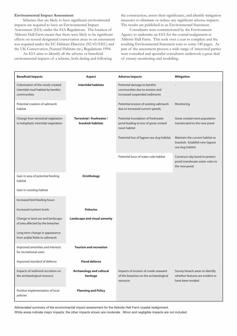
Environmental Impact AssessmentSchemes that are likely to have significant environmental
impacts are required to have an Environmental Impact Assessment (EIA) under the EIA Regulations. The location of Abbotts Hall Farm meant that there were likely to be significant effects on several designated conservation areas so an assessment was required under the EC Habitats Directive (92/43/EEC) and the UK Conservation (Natural Habitats etc.) Regulations 1994.
An EIA aims to identify all the adverse or beneficial environmental impacts of a scheme, both during and following
the construction, assess their significance, and identify mitigation measures to eliminate or reduce any significant adverse impacts. The results are published in an Environmental Statement.
Consultants were commissioned by the Environment Agency to undertake an EIA for the coastal realignment at Abbotts Hall Farm. This took over a year to complete and the resulting Environmental Statement runs to some 140 pages. As part of the assessment process a wide range of interested parties were consulted and specialist consultants undertook a great deal of estuary monitoring and modelling.
Beneficial Impacts Aspect Adverse Impacts Mitigation
Colonisation of the newly created
intertidal mud habitat by benthic
communities
Intertidal habitats Potential damage to benthic
communities due to erosion and
increased suspended sediments
-
Potential creation of saltmarsh
habitat
Potential erosion of existing saltmarsh
due to increased current speeds.
Monitoring
Change from terrestrial vegetation
to halophytic intertidal vegetation
Terrestrial / freshwater /
brackish habitats
Potential inundation of freshwater
pond leading to loss of great crested
newt habitat
Great crested newt population
translocated to the new pond
Potential loss of lagoon sea slug habitat Maintain the current habitat as
brackish. Establish new lagoon
sea slug habitat
Potential losss of water vole habitat Construct clay bund to protect
pond; translocate water voles to
the new pond.
Gain in area of potential feeding
habitat
Ornithology
Gain in roosting habitat
Increased bird feeding hours
Increased nutrient levels Fisheries
Change in land use and landscape
of area affected by the breaches
Landscape and visual amenity
Long term change in appearance
from arable fields to saltmarsh
Improved amenities and interests
for recreational users
Tourism and recreation
Improved standard of defence Flood defence
Impacts of sediment accretion on
the archaeological resource
Archaeology and cultural
heritage
Impacts of erosion of creeks seaward
of the breaches on the archaeological
resource
Survey breach areas to identify
whether features are evident or
have been eroded.
Positive implementation of local
policies
Planning and Policy
Abbreviated summary of the environmental impact assessment for the Abbotts Hall Farm coastal realignment.White areas indicate major impacts; the other impacts shown are moderate. Minor and negligible impacts are not included.
Further InformationBlackwater Esutary Management Plan, Maldon District Council and Colchester Borough Council, 1996Colchester Borough Local Plan, September 2000Environmental Statement - Sustainable Flood Defences, Managed Realignment at Abbotts Hall Essex, Royal Haskoning, Nov. 2001Essex and Southend-on-Sea Replacement Structure Plan, April 2001Essex Biodiversity Action Plan, Association of Essex Councils Steering Group, 1999, HMSO, LondonPlanning Applications F/COL/00/1344 and F/COL/01/1832, Colchester Borough Council Environmental Services
The first seedlings of marsh samphire, annual sea blite and lesser sea spurrey at Abbotts Hall Farm, May 2003
The sea wall was finally breached in four places in October 2002. Seeds flooded into the site on the high spring tides that followed. In Spring 2003 the first growth of saltmarsh plants covered the 200 acre area.
Timing the breachesOne of the most difficult issues was the timing of the
construction work and the breaching of the sea wall. Avoiding disturbance to both breeding birds and over-wintering birds left only a few months in early autumn in which the construction work could be undertaken. Even then construction could not take place during the spring tide cycle. After the second planning consent was granted in June there was still a lot of work to do to submit detailed plans to meet the planning conditions. For a while it looked as though the October window would be missed and the whole timetable put back by 6 months or even a year. However after several trials and tribulations the necessary permissions were obtained.
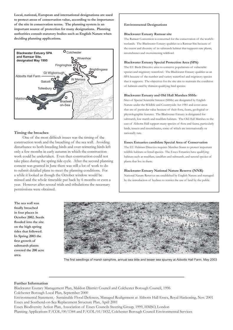
Colchester
Fingringhoe
Gt Wigborough
Salcott
Wivenhoe
Brightlingsea
W Mersea
Tollesbury
MaldonBradwellon-Sea
Abbotts Hall Farm
Blackwater Estuary SPAand Ramsar Site,designated May 1995
Environmental Designations
Blackwater Estuary Ramsar siteThe Ramsar Convention is concerned for the conservation of the world’s wetlands. The Blackwater Estuary qualifies as a Ramsar Site because of the extent and diversity of its saltmarsh habitat that supports rare plants, invertebrates and overwintering wildfowl.
Blackwater Estuary Special Protection Area (SPA)The EU Birds Directive aims to conserve populations of vulnerable species and migratory waterfowl. The Blackwater Estuary qualifies as an SPA because of the number and variety waterfowl and migratory species that it supports. The objectives for the site aim to maintain the condition of habitats used by thirteen qualifying bird species.
Blackwater Estuary and Old Hall Marshes SSSIsSites of Special Scientific Interest (SSSIs) are designated by English Nature under the Wildlife and Countryside Act 1981 and cover areas that are of particular value because of their flora, fauna, geological or physiolographic features. The Blackwater Estuary is designated for saltmarsh, low marsh and mudflats habitats. The Old Hall Marshes to the east of Abbotts Hall support many species of flora and fauna, particularly birds, insects and invertebrates, some of which are internationally or nationally rare.
Essex Estuaries candidate Special Area of ConservationThe EU Habitats Directive requires Member States to protect important wildlife habitats or listed species. The Essex Estuaries have qualifying habitats such as mudflats, sandflats and saltmarsh, and several species of plants that live in them.
Blackwater Estuary National Nature Reserve (NNR)National Nature Reserves are established by English Nature and managed by the introduciton of byelaws to restrict the use of land by the public.
Local, national, European and international designations are used to protect areas of conservation value, according to the importance of the site in conservation terms. The planning system is an important source of protection for many designations. Planning authorities consult statutory bodies such as English Nature when deciding planning applications.