fsveg - us forest service · grp_151 -160 number number of acres in the 151 -160 year age class...
TRANSCRIPT

FSVeg
DATA DICTIONARY
SECTION IV: VIEWS
February 2014

Views FSVeg Data Dictionary
TABLE OF CONTENTS NRV_AGE_CLASS_DISTRIBUTION_VM ............................................................................................... DDV-3 NRV_CHAR_AND_GRP_BY_VM ............................................................................................................... DDV-3 NRV_CLUSTER_PLOT_COVER_VM ..................................................................................................... DDV-10 NRV_CLUSTER_VM .................................................................................................................................. DDV-16 NRV_CLUSTER_PLOT_TREE_VM ........................................................................................................ DDV-21 NRV_CLUSTER_PLOT_TREE_CV_WD_VM ........................................................................................ DDV-30 NRV_CLUSTER_PLOT_WOOD_VM ...................................................................................................... DDV-41 NRV_CN_LIST_INFO_VM ........................................................................................................................ DDV-49 NRV_COVER_SUMMARY_VM ................................................................................................................ DDV-49 NRV_CSE_ALL_VM .................................................................................................................................... DDV-51 NRV_FFI_VM ............................................................................................................................................... DDV-60 NRV_FVS_PLOTINIT_VM ........................................................................................................................ DDV-84 NRV_FVS_STANDINIT_VM .................................................................................................................... DDV-86 NRV_FVS_TREEINIT_VM ........................................................................................................................ DDV-88 NRV_PLOT_VM .......................................................................................................................................... DDV-90 NRV_R8_FSVEG_STANDS_VM .............................................................................................................. DDV-93 NRV_SAMPDW_VM .................................................................................................................................. DDV-97 NRV_SAMP_SELCRIT_VM ...................................................................................................................... DDV-97 NRV_SETTING_ID_VM ............................................................................................................................. DDV-98 NRV_STAND_VM ....................................................................................................................................... DDV-99 NRV_STAND_PLOT_COVER_VM ....................................................................................................... DDV-104 NRV_STAND_PLOT_TREE_VM .......................................................................................................... DDV-110 NRV_STAND_PLOT_TREE_CV_WD_VM ......................................................................................... DDV-118 NRV_STAND_PLOT_WOOD_VM ........................................................................................................ DDV-129 NRV_TREE_VM ....................................................................................................................................... DDV-136
DDV-2

FSVeg Data Dictionary Views
NRV_AGE_CLASS_DISTRIBUTION_VM Supports the Acres by Age Class Report
Name Size Description FOREST_TYPE VC(251) Forest type, used to sum the acres in each age class by each
forest type GRP_1_10 NUMBER Number of acres in the 1-10 year age class GRP_11_20 NUMBER Number of acres in the 11-20 year age class GRP_21_30 NUMBER Number of acres in the 21-30 year age class GRP_31_40 NUMBER Number of acres in the 31-40 year age class GRP_41_50 NUMBER Number of acres in the 41-50 year age class GRP_51_60 NUMBER Number of acres in the 51-60 year age class GRP_61_70 NUMBER Number of acres in the 61-70 year age class GRP_71_80 NUMBER Number of acres in the 71-80 year age class GRP_81_90 NUMBER Number of acres in the 81-90 year age class GRP_91_100 NUMBER Number of acres in the 91-100 year age class GRP_101_110 NUMBER Number of acres in the 101-110 year age class GRP_111_120 NUMBER Number of acres in the 111-120 year age class GRP_121_130 NUMBER Number of acres in the 121-130 year age class GRP_131_140 NUMBER Number of acres in the 131-140 year age class GRP_141_150 NUMBER Number of acres in the 141-150 year age class GRP_151-160 NUMBER Number of acres in the 151-160 year age class GRP_161_PLUS NUMBER Number of acres in the 161 plus year age class GRP_NULL_AGE_CLASS NUMBER Number of acres that do not have stand age recorded PCT NUMBER Percentage of acres in each age class and each forest type TOTAL NUMBER Total number of acres in each age class and each forest type
NRV_CHAR_AND_GRP_BY_VM Combines the Nrv_characterizations and Nrv_group_by tables
Name Size Description CHAR_CN
Required VC(34) Nrv_characterizations.cn
CHAR_CREATED_BY Required
VC(30) Nrv_characterizations.created_by
CHAR_CREATED_DATE Required
DATE Nrv_characterizations.created_date
CHAR_CREATED_IN_INSTANCE Required
N(6) Nrv_characterizations.created_in_instance
CHAR_DATA_METHOD Required
VC(30) Nrv_characterizations.data_method
CHAR_DATA_SOURCE Required
VC(30) Nrv_characterizations.data_source
CHAR_SETTING_ID Required
VC(30) Nrv_characterizations.setting_id
CHAR_SUMMARY_NO Required
VC(10) Nrv_characterizations.summary_no
DDV-3
Views FSVeg Data Dictionary NRV_CHAR_AND_GRP_BY_VM (cont.)
Name Size Description GRPBY_CHAR_CN
Required VC(34) Nrv_group_by.char_cn
GRPBY_CN Required
VC(34) Nrv_group_by.cn
GRPBY_CREATED_BY Required
VC(30) Nrv_group_by.created_by
GRPBY_CREATED_DATE Required
DATE Nrv_group_by.created_date
GRPBY_CREATED_IN_INSTANCE Required
N(6) Nrv_group_by.created_in_instance
GRPBY_GROUP_1 Required
VC(24) Nrv_group_by.group_1
GRPBY_SUBGROUP_1 Required
VC(30) Nrv_group_by.subgroup_1
GRPBY_SUMMARY_NO Required
VC(10) Nrv_group_by.summary_no
CHAR_AGENCY VC(4) Nrv_characterications.agency CHAR_AGGREGATION_TYPE VC(1) Nrv_characterizations.aggregation_types CHAR_ANN_INCR_MEAN N(8,4) Nrv_characterizations.ann_incr_mean CHAR_ANN_INCR_PER N(8,4) Nrv_characterizations.ann_incr_per CHAR_ANN_INCR_PER_LN N(3) Nrv_characterizations.ann_incr_per_ln CHAR_ASPECT N(3) Nrv_characterizations.aspect CHAR_BASAL_AREA N(8,4) Nrv_characterizations.basal_area CHAR_BASAL_AREA_CV N(13,4) Nrv_characterizations.basal_area_cv CHAR_BASAL_AREA_SD N(13,4) Nrv_characterizations.basal_area_sd CHAR_BASAL_AREA_SE N(7,4) Nrv_characterizations.basal_area_se CHAR_BOUNDARY_SOURCE VC(30) Nrv_characterizations.boundary_source CHAR_CANOPY_BULK_DENSITY N(3) Nrv_characterizations.canopy_bulk_density CHAR_CANOPY_CLOSURE N(3) Nrv_characterizations.canopy_closure CHAR_CANOPY_CLOSURE_CROWNVEG N(3) Nrv_characterizations.canopy_closure_crownveg CHAR_CANOPY_CLOSURE_GRASSES N(3) Nrv_characterizations.canopy_closure_grasses CHAR_CANOPY_CLOSURE_HERBS N(3) Nrv_characterizations.canopy_closure_herbs CHAR_CANOPY_CLOSURE_NON_TREE N(3) Nrv_characterizations.canopy_closure_non_tree CHAR_CANOPY_CLOSURE_SHRUBS N(3) Nrv_characterizations.canopy_closure_shrubs CHAR_CANOPY_CLOSURE_TREES N(3) Nrv_characterizations.canopy_closure_trees CHAR_CANOPY_COVER N(4,1) Nrv_characterizations.canopy_cover CHAR_CAPABLE_GROW_AREA_PCT N(3) Nrv_characterizations.capable_grow_area_pct CHAR_COMPARTMENT_NO VC(10) Nrv_characterizations.compartment_no CHAR_CONDITION_CLASS VC(15) Nrv_characterizations.condition_class CHAR_COUNTY VC(3) Nrv_characterizations.county CHAR_COVER_BARE_SOIL N(3) Nrv_characterizations.cover_bare_soil CHAR_COVER_BARREN N(3) Nrv_characterizations.cover_barren CHAR_COVER_BASAL_VEG N(3) Nrv_characterizations.cover_basal_veg CHAR_COVER_BOULDER N(3) Nrv_characterizations.cover_boulder CHAR_COVER_COBBLE N(3) Nrv_characterizations.cover_cobble CHAR_COVER_DOMINANT VC(2) Nrv_characterizations.cover_dominant CHAR_COVER_GRAVEL N(3) Nrv_characterizations.cover_gravel CHAR_COVER_LITTER N(3) Nrv_characterizations.cover_litter CHAR_COVER_NON_VEG N(3) Nrv_characterizations.cover_non_veg
DDV-4

FSVeg Data Dictionary Views
NRV_CHAR_AND_GRP_BY_VM (cont.) Name Size Description CHAR_COVER_ROCK N(3) Nrv_characterizations.cover_rock CHAR_COVER_STONE N(3) Nrv_characterizations.cover_stone CHAR_COVER_WATER N(3) Nrv_characterizations.cover_water CHAR_CROWN_BASE_HEIGHT N(3) Nrv_characterizations.crown_base_height CHAR_CROWN_CONDITION VC(1) Nrv_characterizations.crown_condition CHAR_CROWN_CONDITION_REF VC(30) Nrv_characterizations.crown_condition_ref CHAR_CROWN_FIRE VC(2) Nrv_characterizations.crown_Fire CHAR_CROWNING_INDEX N(3) Nrv.characterizations.crowning_index CHAR_CUBIC_CULL N(11,4) Nrv_characterizations.cubic_cull CHAR_CURRENT_FLAG VC(1) Nrv_characterizations.current_flag CHAR_DATE_ACCURACY VC(5) Nrv_characterizations.char_date_accuracy CHAR_DBH N(5,2) Nrv_characterizations.dbh CHAR_DBH_BREAKPOINT N(5,2) Nrv_characterizations.dbh_breakpoint CHAR_DBH_TYPE VC(4) Nrv_characterizations.dbh_type CHAR_DENSITY_INDEX N(7,2) Nrv_characterizations.index CHAR_DENSITY_INDEX_REF VC(30) Nrv_characterizations.index_ref CHAR_DENSITY_INDEX_TYPE VC(30) Nrv_characterizations.index_type CHAR_DISTRICT_NO VC(2) Nrv_characterizations.district_no CHAR_DOWN_WOODY N(10,4) Nrv_characterizations.down_woody CHAR_DUFF_LITTER_DEPTH N(6,3) Nrv_characterizations.duff_litter_depth CHAR_ECOREGION_SUBSECTION VC(7) Nrv_characterizations.ecoregion CHAR_ELEVATION N(6,1) Nrv_characterizations.elevation CHAR_ELEVATION_MAX N(6,1) Nrv_characterizations.elevation_max CHAR_ELEVATION_MIN N(6,1) Nrv_characterizations.elevation_min CHAR_EV_CODE VC(10) Nrv_characterizations.ev_code CHAR_EV_REF_CODE VC(10) Nrv_characterizations.ev_ref_code CHAR_FIRE_REGIME N(1) Nrv_characterizations.fire_regime CHAR_FORAGE N(4) Nrv_characterizations.forage CHAR_FOREST_ADMIN VC(2) Nrv_characterizations.forest_admin CHAR_FOREST_PROC VC(2) Nrv_characterizations.forest_proc CHAR_FUEL_DEPTH N(3,1) Nrv_characterizations.fuel_depth CHAR_FUEL_MODEL VC(3) Nrv_characterizations.fuel_model CHAR_FUEL_PHOTO_REFERENCE VC(10) Nrv_characterizations.fuel_photo_reference CHAR_GIS_LINK VC(26) Nrv_characterizations.gis_link CHAR_HAB_STRUCT_STAGE_CODE VC(50) Nrv_characterizations.hab_struct_stage_code CHAR_HAB_STRUCT_STAGE_REF VC(30 Nrv_characterizations.hab_struct_stage_ref CHAR_HABITAT_EFFECT_INDEX VC(1) Nrv_characterizations.habitat_effect_index CHAR_HAZ_RATING VC(1) Nrv_characterizations.haz_rating CHAR_HORIZONTAL_CONTINUITY VC(1) Nrv_characterizations.horizontal_continuity CHAR_INVENTORY_STRATIFICATION VC(10) Nrv_characterizations.inventory_stratification CHAR_LANDFORM VC(2) Nrv_characterizations.landform CHAR_LATITUDE_DEG N(3) Nrv_characterizations.latitude_deg CHAR_LATITUDE_MIN N(2) Nrv_characterizations.latitude_min CHAR_LATITUDE_SEC N(4,2) Nrv_characterizations.latitude_sec CHAR_LOADER_VERSION VC(15) Nrv_characterizations.loader_version
DDV-5

Views FSVeg Data Dictionary NRV_CHAR_AND_GRP_BY_VM (cont.)
Name Size Description CHAR_LOCALLY_DEFINED_AT1 VC(30) Nrv_characterizations.locally_defined_at1 CHAR_LOCALLY_DEFINED_AT2 VC(30) Nrv_characterizations.locally_defined_at2 CHAR_LOCALLY_DEFINED_AT3 VC(30) Nrv_characterizations.locally_defined_at3 CHAR_LOCALLY_DEFINED_AT4 VC(30) Nrv_characterizations.locally_defined_at4 CHAR_LOCALLY_DEFINED_AT5 VC(30) Nrv_characterizations.locally_defined_at5 CHAR_LOCAL_AT1_DESCRIPTION VC(80) Nrv_characterizations.local_at1_description CHAR_LOCAL_AT2_DESCRIPTION VC(80) Nrv_characterizations.local_at2_description CHAR_LOCAL_AT3_DESCRIPTION VC(80) Nrv_characterizations.local_at3_description CHAR_LOCAL_AT4_DESCRIPTION VC(80) Nrv_characterizations.local_at4_description CHAR_LOCAL_AT5_DESCRIPTION VC(80) Nrv_characterizations.local_at5_description CHAR_LOCATION VC(16) Nrv_characterizations.location CHAR_LONGITUDE_DEG N(3) Nrv_characterizations.longitude_deg CHAR_LONGITUDE_MIN N(2) Nrv_characterizations.longitude_min CHAR_LONGITUDE_SEC N(4,2) Nrv_characterizations.longitude_sec CHAR_MANAGEMENT_PRODUCTIVITY VC(1) Nrv_characterizations.management_productivity CHAR_MANAGEMENT_TYPE_EV_CODE VC(50) Nrv_characterzations.management_type_ev_code CHAR_MANAGEMENT_TYPE_EV_REF VC(30) Nrv_characterizations.management_type_ev_ref CHAR_MANAGEMENT_TYPE_ SIREFCODE
VC(3) Nrv_characterizations.management_type_sirefcode
CHAR_MANAGEMENT_TYPE_ SISPECIES
VC(8) Nrv_characterizations.management_type_sispecies
CHAR_MANAGEMENT_TYPE_ SITEINDEX
N(4,1) Nrv_characterizations.management_type_siteindex
CHAR_MEASUREMENT_DATE DATE Nrv_characterizations.measurement_date CHAR_MERCH_BOARD_GROSS N(13,4) Nrv_characterizations.merch_board_gross CHAR_MERCH_BOARD_GROSS_SD N(15,4) Nrv_characterizations.merch_board_gross_sd CHAR_MERCH_BOARD_GROSS_SE N(7,4) Nrv_characterizations.merch_board_gross_se CHAR_MERCH_BOARD_NET N(13,4) Nrv_characterizations.merch_board_net CHAR_MERCH_BOARD_NET_SD N(15,4) Nrv_characterizations.merch_board_net_sd CHAR_MERCH_BOARD_NET_SE N(7,4) Nrv_characterizations.merch_board_net_se CHAR_MERCH_CUBIC_GROSS N(13,4) Nrv_characterizations.cubic_gross CHAR_MERCH_CUBIC_GROSS_SD N(13,4) Nrv_characterizations.cubic_gross_sd CHAR_MERCH_CUBIC_GROSS_SE N(7,4) Nrv_characterizations.cubic_gross_se CHAR_MERCH_CUBIC_NET N(13,4) Nrv_characterizations.merch_board_cubic_net CHAR_MERCH_CUBIC_NET_SD N(13,4) Nrv_characterizations.merch_board_cubic_net_sd CHAR_MERCH_CUBIC_NET_SE N(7,4) Nrv_characterizations.merch_board_cubic_net_se CHAR_MERIDIAN_CODE VC(2) Nrv_characterizations.meridian_code CHAR_MODIFIED_BY VC(30) Nrv_characterizations.modified_by CHAR_MODIFIED_DATE DATE Nrv_characterizations.modified_date CHAR_MODIFIED_IN_INSTANCE N(6) Nrv_characterizations.modified_in_instance CHAR_NFS_LAND_CLASS VC(3) Nrv_characterizations.nfs_land_class CHAR_PERM_CHAR_CN VC(34) Nrv_characterizations.cn CHAR_PHOTO_ID VC(20) Nrv_characterizations.photo_id via
setting_measurements.airph_cn CHAR_POLYGON_COVERAGE_ID VC(30) Nrv_characterizations.polygon_cover_id CHAR_PRODUCTIVITY_CLASS VC(2) Nrv_characterizations.productivity_class CHAR_PROJECT_NAME VC(25) Nrv_characterizations.project_name CHAR_PURPOSE_CODE VC(4) Nrv_characterizations.purpose_code
DDV-6
FSVeg Data Dictionary Views
NRV_CHAR_AND_GRP_BY_VM (cont.) Name Size Description CHAR_PV_CODE VC(10) Nrv_characterizations.pv_code CHAR_PV_REF_CODE VC(10) Nrv_characterizations.pv_ref_code CHAR_RANGE_CONDITION VC(1) Nrv_characterizations.range_condition CHAR_RANGE_TREND VC(1) Nrv_characterizations.range_trend CHAR_REFERENCE_DATE DATE Nrv_characterizations.reference_date CHAR_REFERENCE_DATE_ACCURACY VC(5) Nrv_characterizations.reference_date_accuracy CHAR_REGEN_EV_CODE VC(10) Nrv_characterizations.regen_ev_code CHAR_REGEN_EV_REF_CODE VC(10) Nrv_characterizations.regen_ev_ref_code CHAR_REGION_ADMIN VC(2) Nrv_characterizations.region_admin CHAR_REGION_PROC VC(2) Nrv_characterizations.region_proc CHAR_REMARKS VC(255) Nrv_characterizations.remarks CHAR_RESIDUE_DESC_CODE VC(10) Nrv_characterizations.residue_desc_code CHAR_RIPARIAN_POLYGON VC(1) Nrv_characterizations.riparian_polygon CHAR_SAF_COVER_TYPE VC(3) Nrv_characterizations.saf_cover_type CHAR_SECTION VC(2) Nrv_characterizations.section CHAR_SETMEAS_CN VC(34) Nrv_characterizations.setmeas_cn CHAR_SETTING_ORIGIN VC(2) Nrv_characterizations.setting_origin CHAR_SETTING_SIZE N(8,4) Nrv_characterizations.setting_size CHAR_SITE_INDEX N(4,1) Nrv_characterizations.site_index CHAR_SITE_INDEX_REF VC(10) Nrv_characterizations.site_index_ref CHAR_SITE_INDEX_SPP VC(8) Nrv_characterizations.site_index_spp CHAR_SLOPE N(3) Nrv_characterizations.slope CHAR_SLOPE_POSITION VC(2) Nrv_characterizations.slope_position CHAR_SRM_COVER_TYPE VC(3) Nrv_characterizations.srm_cover_type CHAR_STAND_CONDITION VC(2) Nrv_characterizations.stand_condition CHAR_STAND_CONDITION_REF VC(30) Nrv_characterizations.stand_condition_ref CHAR_STAND_FIA_EV_CALC VC(10) Nrv_characterizations.fia_ev_calc CHAR_STAND_FIA_TOTAL_STOCKING N(7,4) Nrv_characterizations.fia_total_stocking CHAR_STAND_VSS VC(6) Nrv_characterizations.stand_vss CHAR_STATE VC(2) Nrv_characterizations.state CHAR_STATE_PLANE_DATUM VC(10) Nrv_characterizations.state_plane_datum CHAR_STATE_PLANE_X N(12,3) Nrv_characterizations.state_plane_x CHAR_STATE_PLANE_Y N(12,3) Nrv_characterizations.state_plane_y CHAR_STATE_PLANE_ZONE VC(10) Nrv_characterizations.state_plane_zone CHAR_STOCKING_FLAG VC(1) Nrv_characterizations.stocking_flag CHAR_STOCKING_PERCENT N(3) Nrv_characterizations.stocking_percent CHAR_SUBCOMPARTMENT_NO VC(10) Nrv_characterizations.subcompartment_no CHAR_SURVEY_UNIT VC(2) Nrv_characterizations.survey_unit CHAR_TIMBER_SUIT_ RECOMMENDCODE
VC(50) Nrv_characterizations.timber_suit_recommendcode
CHAR_TIMBER_SUITABILITY_CODE VC(50) Nrv_characterizations.timber_suitability_code CHAR_TIMBER_SUITABILITY_REF VC(30) Nrv_characterizations.timber_suitability_ref CHAR_TORCHING_INDEX N(3) Nrv_characterizations.torching_index CHAR_TOTAL_CUBIC N(11,4) Nrv_characterizations.total_cubic CHAR_TOWNSHIP VC(5) Nrv_characterizations.pls_township CHAR_TPA N(10,4) Nrv_characterizations.tpa CHAR_TPA_CV N(13,4) Nrv_characterizations.tpa_cv CHAR_TPA_SD N(13,4) Nrv_characterizations.tpa_sd CHAR_TPA_SE N(7,4) Nrv_characterizations.tpa_se
DDV-7
Views FSVeg Data Dictionary NRV_CHAR_AND_GRP_BY_VM (cont.)
Name Size Description CHAR_TREE_HEIGHT_AVG N(13,4) Nrv_characterizations.tree_height_avg CHAR_TREE_LAYER_STRUCTURE VC(2) Nrv_characterizations.tree_layer_structure CHAR_TREE_SIZE_CLASS VC(2) Nrv_characterizations.tree_size_class CHAR_USGS_LANDUSE2 VC(2) Nrv_characterizations.usgs_landuse2 CHAR_UTM_DATUM VC(10) Nrv_characterizations.utm_datum CHAR_UTM_EASTING N(6) Nrv_characterizations.utm_easting CHAR_UTM_NORTHING N(7) Nrv_characterizations.utm_northing CHAR_UTM_ZONE N(2) Nrv_characterizations.utm_zone CHAR_YEAR_OF_ORIGIN N(4) Nrv_characterizations.year_of_origin GRPBY_ANN_INCR_PER N(8,4) Nrv_group_by.ann_incr_per GRPBY_ANN_INCR_PER_LEN N(3) Nrv_group_by.ann_incr_per_len GRPBY_BASAL_AREA N(8,4) Nrv_group_by.basal_area GRPBY_BASAL_AREA_CV N(13,4) Nrv_group_by.basal_area_cv GRPBY_BASAL_AREA_SD N(13,4) Nrv_group_by.basal_area_sd GRPBY_BASAL_AREA_SE N(7,4) Nrv_group_by.basal_area_se GRPBY_CONE_SEROTINY VC(1) Nrv_group_by.cone_serotiny GRPBY_COVER_DATA_TYPE VC(20) Nrv_group_by.cover_data_type GRPBY_COVER_DIAMETER N(6,3) Nrv_group_by.cover_diameter GRPBY_COVER_HEIGHT N(7,4) Nrv_group_by.cover_height GRPBY_COVER_HEIGHT_MAX N(7,4) Nrv_group_by.cover_height_max GRPBY_COVER_HEIGHT_MIN N((7,4) Nrv_group_by.cover_height_min GRPBY_COVER_LAYER VC(3) Nrv_group_by.cover_layer GRPBY_COVER_LAYER_CODE_LOCAL VC(2) Nrv_group_by.cover_layer_code_local GRPBY_COVER_LIFEFORM VC(2) Nrv_group_by.cover_lifeform GRPBY_COVER_SHRUB_AGE_CLASS VC(2) Nrv_group_by.cover_shrub_age_class GRPBY_COVER_SURFACE_CODE VC(4) Nrv_group_by.cover_surface_code GRPBY_CROWN_DIAMETER N(4,1) Nrv_group_by.crown_diameter GRPBY_CROWN_RATIO_COMP N(3) Nrv_group_by.crown_ratio_comp GRPBY_CROWN_RATIO_UNC N(3) Nrv_group_by.crown_ratio_unc GRPBY_DATA_METHOD VC(30) Nrv_group_by.data_method GRPBY_DATA_SOURCE VC(30) Nrv_group_by.source_type GRPBY_DECAY_CLASS VC(1) Nrv_group_by.decay_class GRPBY_DIAMETER N(7,4) Nrv_group_by.diameter GRPBY_DIAMETER_TYPE VC(4) Nrv_group_by.diameter_type GRPBY_DISTRIBUTION_TYPE VC(1) Nrv_group_by.distribution_type GRPBY_DOMINANT_SPECIES VC(8) Nrv_group_by.dominant_species GRPBY_FUEL_WEIGHT N(7,4) Nrv_group_by.fuel_weight GRPBY_GEOGRAPHICAL_AREA VC(5) Nrv_group_by.geographical_area GRPBY_GIS_LINK VC(26) Nrv_group_by.gis_link GRPBY_HEIGHT_GROWTH N(4,1) Nrv_group_by.height_growth GRPBY_HEIGHT_LENGTH_AVG N(4,1) Nrv_group_by.height_length_avg GRPBY_HEIGHT_LENGTH_MAX N(4,1) Nrv_group_by.height_length_max GRPBY_HEIGHT_LENGTH_MIN N(4,1) Nrv_group_by.height_length_min GRPBY_LANDFORM VC(2) Nrv_group_by.landform GRPBY_LAYER_HT_MAX N(3) Nrv_group_by.layer_ht_max GRPBY_LAYER_HT_MIN N(3) Nrv_group_by.layer_ht_min GRPBY_LOCALLY_DEFINED_AT6 VC(30) Nrv_group_by.locally_defined_at6 GRPBY_LOCALLY_DEFINED_AT7 VC(30) Nrv_group_by.locally_defined_at7
DDV-8

FSVeg Data Dictionary Views
NRV_CHAR_AND_GRP_BY_VM (cont.) Name Size Description GRPBY_LOCALLY_DEFINED_AT8 VC(30) Nrv_group_by.locally_defined_at8 GRPBY_LOCALLY_DEFINED_AT9 VC(30) Nrv_group_by.locally_defined_at9 GRPBY_LOCALLY_DEFINED_AT10 VC(30) Nrv_group_by.locally_defined_at10 GRPBY_LOCAL_AT6_DESCRIPTION VC(80) Nrv_group_by.local_at6_description. GRPBY_LOCAL_AT7_DESCRIPTION VC(80) Nrv_group_by.local_at7_description. GRPBY_LOCAL_AT8_DESCRIPTION VC(80) Nrv_group_by.local_at8_description. GRPBY_LOCAL_AT9_DESCRIPTION VC(80) Nrv_group_by.local_at9_description. GRPBY_LOCAL_AT10_DESCRIPTION VC(80) Nrv_group_by.local_at10_description. GRPBY_MERCH_BOARD_GROSS N(11,4) Nrv_group_by.merch_board_gross GRPBY_MERCH_BOARD_NET N(11,4) Nrv_group_by.merch_board_net GRPBY_MERCH_CUBIC_GROSS N(11,4) Nrv_group_by.merch_cubic_gross GRPBY_MERCH_CUBIC_NET N(11,4) Nrv_group_by.merch_cubic_net GRPBY_MODIFIED_BY VC(30) Nrv_group_by.grpby_modified_by GRPBY_MODIFIED_DATE DATE Nrv_group_by.grpby_modified_date GRPBY_MODIFIED_IN_INSTANCE N(6) Nrv_group_by.grpby_modified_in_instance GRPBY_NO_OF_PIECES N(5) Nrv_group_by.no_of_pieces GRPBY_NOXIOUS_WEED VC(1) Nrv_group_by.noxious_weed GRPBY_PLANTS N(9,4) Nrv_group_by.plants GRPBY_PLANTS_CV N(13,4) Nrv_group_by.plants_cv GRPBY_PLANTS_SD N(13,4) Nrv_group_by.plants_sd GRPBY_PLANTS_SE N(7,4) Nrv_group_by.plants_se GRPBY_PLANT_COVER N(4,1) Nrv_group_by.plant_cover GRPBY_POLYGON_COVERAGE_ID VC(30) Nrv_group_by.polygon_coverage_id GRPBY_RADIAL_GROWTH N(3) Nrv_group_by.radial_growth GRPBY_RADIAL_GROWTH_PERIOD N(3) Nrv_group_by.growth_period GRPYBY_SELECTION_CRITERIA_NO VC(3) Nrv_group_by.selection_criteria_no GRPBY_SHRUB_SHAPE VC(1) Nrv_group_by.shrub_shape GRPBY_SHRUB_SIZE VC(1) Nrv_group_by.shrub_size GRPBY_SHRUB_VIGOR VC(1) Nrv_group_by.shrub_vigor GRPBY_SNAGS N(9,4) Nrv_group_by.snags GRPBY_SPECIES_SYMBOL VC(8) Nrv_group_by.species_symbol GRPBY_TE_SPECIES VC(1) Nrv_group_by.te_species GRPBY_TOTAL_CUBIC N(11,4) Nrv_group_by.total_cubic GRPBY_TREE_SIZE_CLASS VC(2) Nrv_group_by.tree_size_class GRPBY_USER_OPS_ACCT VC(30) Nrv_group_by.user_ops_acct GRPBY_VEG_CLASS VC(2) Nrv_group_by.veg_class GRPBY_VIGOR VC(1) Nrv_group_by.vigor GRPBY_WEIGHT N(7,4) Nrv_group_by.weight GRPBY_YEAR_OF_ORIGIN N(4) Nrv_group_by.year_of_origin
DDV-9
Views FSVeg Data Dictionary
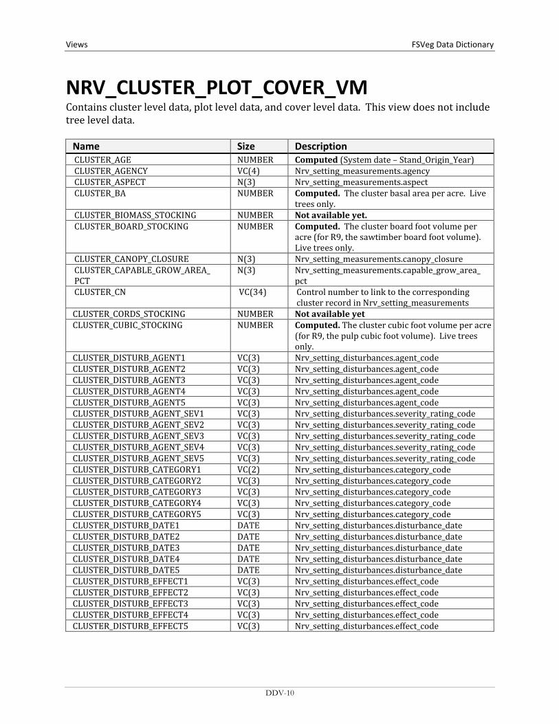
NRV_CLUSTER_PLOT_COVER_VM Contains cluster level data, plot level data, and cover level data. This view does not include tree level data.
Name Size Description CLUSTER_AGE NUMBER Computed (System date – Stand_Origin_Year) CLUSTER_AGENCY VC(4) Nrv_setting_measurements.agency CLUSTER_ASPECT N(3) Nrv_setting_measurements.aspect CLUSTER_BA NUMBER Computed. The cluster basal area per acre. Live
trees only. CLUSTER_BIOMASS_STOCKING NUMBER Not available yet. CLUSTER_BOARD_STOCKING NUMBER Computed. The cluster board foot volume per
acre (for R9, the sawtimber board foot volume). Live trees only.
CLUSTER_CANOPY_CLOSURE N(3) Nrv_setting_measurements.canopy_closure CLUSTER_CAPABLE_GROW_AREA_ PCT
N(3) Nrv_setting_measurements.capable_grow_area_ pct
CLUSTER_CN VC(34) Control number to link to the corresponding cluster record in Nrv_setting_measurements
CLUSTER_CORDS_STOCKING NUMBER Not available yet CLUSTER_CUBIC_STOCKING NUMBER Computed. The cluster cubic foot volume per acre
(for R9, the pulp cubic foot volume). Live trees only.
CLUSTER_DISTURB_AGENT1 VC(3) Nrv_setting_disturbances.agent_code CLUSTER_DISTURB_AGENT2 VC(3) Nrv_setting_disturbances.agent_code CLUSTER_DISTURB_AGENT3 VC(3) Nrv_setting_disturbances.agent_code CLUSTER_DISTURB_AGENT4 VC(3) Nrv_setting_disturbances.agent_code CLUSTER_DISTURB_AGENT5 VC(3) Nrv_setting_disturbances.agent_code CLUSTER_DISTURB_AGENT_SEV1 VC(3) Nrv_setting_disturbances.severity_rating_code CLUSTER_DISTURB_AGENT_SEV2 VC(3) Nrv_setting_disturbances.severity_rating_code CLUSTER_DISTURB_AGENT_SEV3 VC(3) Nrv_setting_disturbances.severity_rating_code CLUSTER_DISTURB_AGENT_SEV4 VC(3) Nrv_setting_disturbances.severity_rating_code CLUSTER_DISTURB_AGENT_SEV5 VC(3) Nrv_setting_disturbances.severity_rating_code CLUSTER_DISTURB_CATEGORY1 VC(2) Nrv_setting_disturbances.category_code CLUSTER_DISTURB_CATEGORY2 VC(3) Nrv_setting_disturbances.category_code CLUSTER_DISTURB_CATEGORY3 VC(3) Nrv_setting_disturbances.category_code CLUSTER_DISTURB_CATEGORY4 VC(3) Nrv_setting_disturbances.category_code CLUSTER_DISTURB_CATEGORY5 VC(3) Nrv_setting_disturbances.category_code CLUSTER_DISTURB_DATE1 DATE Nrv_setting_disturbances.disturbance_date CLUSTER_DISTURB_DATE2 DATE Nrv_setting_disturbances.disturbance_date CLUSTER_DISTURB_DATE3 DATE Nrv_setting_disturbances.disturbance_date CLUSTER_DISTURB_DATE4 DATE Nrv_setting_disturbances.disturbance_date CLUSTER_DISTURB_DATE5 DATE Nrv_setting_disturbances.disturbance_date CLUSTER_DISTURB_EFFECT1 VC(3) Nrv_setting_disturbances.effect_code CLUSTER_DISTURB_EFFECT2 VC(3) Nrv_setting_disturbances.effect_code CLUSTER_DISTURB_EFFECT3 VC(3) Nrv_setting_disturbances.effect_code CLUSTER_DISTURB_EFFECT4 VC(3) Nrv_setting_disturbances.effect_code CLUSTER_DISTURB_EFFECT5 VC(3) Nrv_setting_disturbances.effect_code
DDV-10
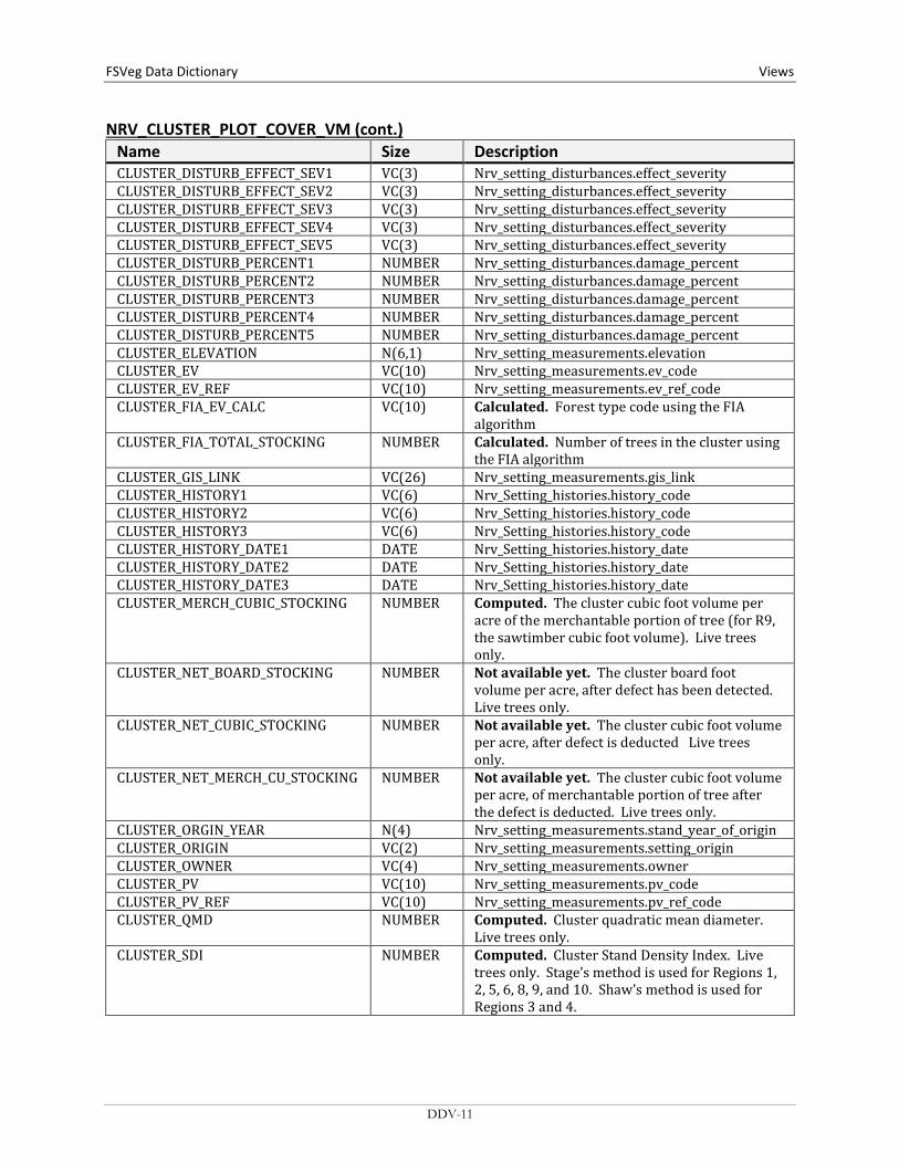
FSVeg Data Dictionary Views
NRV_CLUSTER_PLOT_COVER_VM (cont.) Name Size Description CLUSTER_DISTURB_EFFECT_SEV1 VC(3) Nrv_setting_disturbances.effect_severity CLUSTER_DISTURB_EFFECT_SEV2 VC(3) Nrv_setting_disturbances.effect_severity CLUSTER_DISTURB_EFFECT_SEV3 VC(3) Nrv_setting_disturbances.effect_severity CLUSTER_DISTURB_EFFECT_SEV4 VC(3) Nrv_setting_disturbances.effect_severity CLUSTER_DISTURB_EFFECT_SEV5 VC(3) Nrv_setting_disturbances.effect_severity CLUSTER_DISTURB_PERCENT1 NUMBER Nrv_setting_disturbances.damage_percent CLUSTER_DISTURB_PERCENT2 NUMBER Nrv_setting_disturbances.damage_percent CLUSTER_DISTURB_PERCENT3 NUMBER Nrv_setting_disturbances.damage_percent CLUSTER_DISTURB_PERCENT4 NUMBER Nrv_setting_disturbances.damage_percent CLUSTER_DISTURB_PERCENT5 NUMBER Nrv_setting_disturbances.damage_percent CLUSTER_ELEVATION N(6,1) Nrv_setting_measurements.elevation CLUSTER_EV VC(10) Nrv_setting_measurements.ev_code CLUSTER_EV_REF VC(10) Nrv_setting_measurements.ev_ref_code CLUSTER_FIA_EV_CALC VC(10) Calculated. Forest type code using the FIA
algorithm CLUSTER_FIA_TOTAL_STOCKING NUMBER Calculated. Number of trees in the cluster using
the FIA algorithm CLUSTER_GIS_LINK VC(26) Nrv_setting_measurements.gis_link CLUSTER_HISTORY1 VC(6) Nrv_Setting_histories.history_code CLUSTER_HISTORY2 VC(6) Nrv_Setting_histories.history_code CLUSTER_HISTORY3 VC(6) Nrv_Setting_histories.history_code CLUSTER_HISTORY_DATE1 DATE Nrv_Setting_histories.history_date CLUSTER_HISTORY_DATE2 DATE Nrv_Setting_histories.history_date CLUSTER_HISTORY_DATE3 DATE Nrv_Setting_histories.history_date CLUSTER_MERCH_CUBIC_STOCKING NUMBER Computed. The cluster cubic foot volume per
acre of the merchantable portion of tree (for R9, the sawtimber cubic foot volume). Live trees only.
CLUSTER_NET_BOARD_STOCKING NUMBER Not available yet. The cluster board foot volume per acre, after defect has been detected. Live trees only.
CLUSTER_NET_CUBIC_STOCKING NUMBER Not available yet. The cluster cubic foot volume per acre, after defect is deducted Live trees only.
CLUSTER_NET_MERCH_CU_STOCKING NUMBER Not available yet. The cluster cubic foot volume per acre, of merchantable portion of tree after the defect is deducted. Live trees only.
CLUSTER_ORGIN_YEAR N(4) Nrv_setting_measurements.stand_year_of_origin CLUSTER_ORIGIN VC(2) Nrv_setting_measurements.setting_origin CLUSTER_OWNER VC(4) Nrv_setting_measurements.owner CLUSTER_PV VC(10) Nrv_setting_measurements.pv_code CLUSTER_PV_REF VC(10) Nrv_setting_measurements.pv_ref_code CLUSTER_QMD NUMBER Computed. Cluster quadratic mean diameter.
Live trees only. CLUSTER_SDI NUMBER Computed. Cluster Stand Density Index. Live
trees only. Stage’s method is used for Regions 1, 2, 5, 6, 8, 9, and 10. Shaw’s method is used for Regions 3 and 4.
DDV-11

Views FSVeg Data Dictionary NRV_CLUSTER_PLOT_COVER_VM (cont.)
Name Size Description CLUSTER_SEEDLINGS NUMBER Computed. Cluster number of trees per acre. Live
trees less than 4.5 ft. tall only CLUSTER_SITE_INDEX N(4,1) Nrv_site_indexes.site_index CLUSTER_SITE_INDEX_CALC NUMBER Computed. Cluster site index CLUSTER_SITE_INDEX_REF VC(3) Nrv_site_index_ref_codes.reference_no CLUSTER_SITE_INDEX_REF_CALC VC(5) Computed. Reference used in the
cluster_site_index_calc field. This value is determined from cluster_site_index_species, Region, and Forest
CLUSTER_SITE_SPECIES VC(8) Nrv_site_indexes.site_species CLUSTER_SITE_SPECIES_CALC VC(8) Computed. For Regions 1, 5, 6, 8, 9, and 10: the
site species with the plurality of basal area in the cluster. For Regions 2, 3, and 4, the RMSTAND algorithm is used
CLUSTER_SIZE N(8,4) Nrv_setting_measurements.size CLUSTER_SLOPE N(3) Nrv_setting_measurements.slope CLUSTER_SLOPE_POSITION VC(2) Nrv_setting_measurements.slope_position CLUSTER_SLOPE_SHAPE_HORIZ VC(2) Nrv_setting_measurements.slope_shape_horiz CLUSTER_SLOPE_SHAPE_VERT VC(2) Nrv_setting_measurements.slope_shape_vert CLUSTER_STRATUM VC(6) Nrv_setting_measurements.stratum CLUSTER_STRATUM_EXPANSION_FAC N(9,1) Nrv_setting_measurements.stratum_expansion_f
actor CLUSTER_STRUCTURE VC(2) Nrv_setting_measurements.structure CLUSTER_SUBGROUP_CODE VC(4) Nrv_setting_measurements.subgroup_code CLUSTER_TPA NUMBER Computed. Cluster number of trees per acre.
Live trees only. CLUSTER_VSS VC(6) Computed for Regions 2, 3 and 4 only CLUSTR VC(10) Nrv_setting_measurements.level_1_id COMPARTMENT VC(10) Nrv_setting_measurements.compartment_no
(not populated for most stand exam data) CONSEC_PT_NUM VC(8) Nrv_setting_measurements.consec_pt_num COUNTY VC(3) Nrv_setting_measurements.county COVER_CN VC(34) The control number of the
Nrv_cover_measurements record. DISTRICT VC(2) Nrv_setting_measurements.district FOREST_ADMIN VC(2) Nrv_setting_measurements.forest_admin FOREST_PROC VC(2) Nrv_setting_measurements.forest_proc GEOGRAPHICAL_AREA VC(5) Nrv_setting_measurements.geographical_area LATITUDE_DEG NUMBER Nrv_setting_measurements.latitude_degree LATITUDE_MIN NUMBER Nrv_setting_measurements.latitude_min LATITUDE_SEC NUMBER Nrv_setting_measurements.latitude_sec LAT_LON_DATUM VC(8) Nrv_setting_measurements.lat_lon_datum LONGITUDE_DEG NUMBER Nrv_setting_measurements.longitude_deg LONGITUDE_MIN NUMBER Nrv_setting_measurements.longitude_din LONGITUDE_SEC NUMBER Nrv_setting_measurements.longitude_dec MEASUREMENT_DATE DATE Nrv_setting_measurements.measurement_date MEASUREMENT_NO VC(2) Nrv_setting_measurements.measurement_No NFS_LAND_CLASS VC(3) Nrv_setting_measurements.nfs_land_class
DDV-12
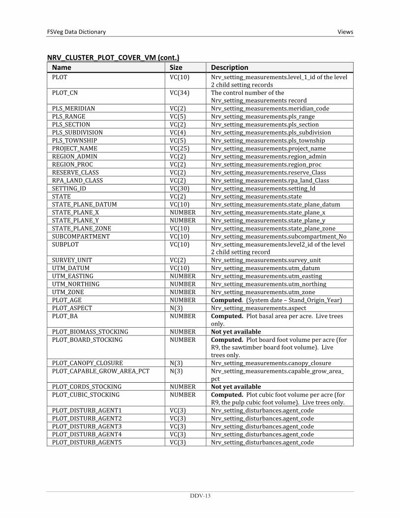
FSVeg Data Dictionary Views
NRV_CLUSTER_PLOT_COVER_VM (cont.) Name Size Description PLOT VC(10) Nrv_setting_measurements.level_1_id of the level
2 child setting records PLOT_CN VC(34) The control number of the
Nrv_setting_measurements record PLS_MERIDIAN VC(2) Nrv_setting_measurements.meridian_code PLS_RANGE VC(5) Nrv_setting_measurements.pls_range PLS_SECTION VC(2) Nrv_setting_measurements.pls_section PLS_SUBDIVISION VC(4) Nrv_setting_measurements.pls_subdivision PLS_TOWNSHIP VC(5) Nrv_setting_measurements.pls_township PROJECT_NAME VC(25) Nrv_setting_measurements.project_name REGION_ADMIN VC(2) Nrv_setting_measurements.region_admin REGION_PROC VC(2) Nrv_setting_measurements.region_proc RESERVE_CLASS VC(2) Nrv_setting_measurements.reserve_Class RPA_LAND_CLASS VC(2) Nrv_setting_measurements.rpa_land_Class SETTING_ID VC(30) Nrv_setting_measurements.setting_Id STATE VC(2) Nrv_setting_measurements.state STATE_PLANE_DATUM VC(10) Nrv_setting_measurements.state_plane_datum STATE_PLANE_X NUMBER Nrv_setting_measurements.state_plane_x STATE_PLANE_Y NUMBER Nrv_setting_measurements.state_plane_y STATE_PLANE_ZONE VC(10) Nrv_setting_measurements.state_plane_zone SUBCOMPARTMENT VC(10) Nrv_setting_measurements.subcompartment_No SUBPLOT VC(10) Nrv_setting_measurements.level2_id of the level
2 child setting record SURVEY_UNIT VC(2) Nrv_setting_measurements.survey_unit UTM_DATUM VC(10) Nrv_setting_measurements.utm_datum UTM_EASTING NUMBER Nrv_setting_measurements.utm_easting UTM_NORTHING NUMBER Nrv_setting_measurements.utm_northing UTM_ZONE NUMBER Nrv_setting_measurements.utm_zone PLOT_AGE NUMBER Computed. (System date – Stand_Origin_Year) PLOT_ASPECT N(3) Nrv_setting_measurements.aspect PLOT_BA NUMBER Computed. Plot basal area per acre. Live trees
only. PLOT_BIOMASS_STOCKING NUMBER Not yet available PLOT_BOARD_STOCKING NUMBER Computed. Plot board foot volume per acre (for
R9, the sawtimber board foot volume). Live trees only.
PLOT_CANOPY_CLOSURE N(3) Nrv_setting_measurements.canopy_closure PLOT_CAPABLE_GROW_AREA_PCT N(3) Nrv_setting_measurements.capable_grow_area_
pct PLOT_CORDS_STOCKING NUMBER Not yet available PLOT_CUBIC_STOCKING NUMBER Computed. Plot cubic foot volume per acre (for
R9, the pulp cubic foot volume). Live trees only. PLOT_DISTURB_AGENT1 VC(3) Nrv_setting_disturbances.agent_code PLOT_DISTURB_AGENT2 VC(3) Nrv_setting_disturbances.agent_code PLOT_DISTURB_AGENT3 VC(3) Nrv_setting_disturbances.agent_code PLOT_DISTURB_AGENT4 VC(3) Nrv_setting_disturbances.agent_code PLOT_DISTURB_AGENT5 VC(3) Nrv_setting_disturbances.agent_code
DDV-13

Views FSVeg Data Dictionary NRV_CLUSTER_PLOT_COVER_VM (cont.)
Name Size Description PLOT_DISTURB_AGENT_SEV1 VC(3) Nrv_setting_disturbances.severity_rating_code PLOT_DISTURB_AGENT_SEV2 VC(3) Nrv_setting_disturbances.severity_rating_code PLOT_DISTURB_AGENT_SEV3 VC(3) Nrv_setting_disturbances.severity_rating_code PLOT_DISTURB_AGENT_SEV4 VC(3) Nrv_setting_disturbances.severity_rating_code PLOT_DISTURB_AGENT_SEV5 VC(3) Nrv_setting_disturbances.severity_rating_code PLOT_DISTURB_CATEGORY1 VC(2) Nrv_setting_disturbances.category_code PLOT_DISTURB_CATEGORY2 VC(2) Nrv_setting_disturbances.category_code PLOT_DISTURB_CATEGORY3 VC(2) Nrv_setting_disturbances.category_code PLOT_DISTURB_CATEGORY4 VC(2) Nrv_setting_disturbances.category_code PLOT_DISTURB_CATEGORY5 VC(2) Nrv_setting_disturbances.category_code PLOT_DISTURB_DATE1 DATE Nrv_setting_disturbances.disturbance_date PLOT_DISTURB_DATE2 DATE Nrv_setting_disturbances.disturbance_date PLOT_DISTURB_DATE3 DATE Nrv_setting_disturbances.disturbance_date PLOT_DISTURB_DATE4 DATE Nrv_setting_disturbances.disturbance_date PLOT_DISTURB_DATE5 DATE Nrv_setting_disturbances.disturbance_date PLOT_DISTURB_EFFECT1 VC(3) Nrv_setting_disturbances.effect_code PLOT_DISTURB_EFFECT2 VC(3) Nrv_setting_disturbances.effect_code PLOT_DISTURB_EFFECT3 VC(3) Nrv_setting_disturbances.effect_code PLOT_DISTURB_EFFECT4 VC(3) Nrv_setting_disturbances.effect_code PLOT_DISTURB_EFFECT5 VC(3) Nrv_setting_disturbances.effect_code PLOT_DISTURB_EFFECT_SEV1 VC(3) Nrv_setting_disturbances.effect_severity PLOT_DISTURB_EFFECT_SEV2 VC(3) Nrv_setting_disturbances.effect_severity PLOT_DISTURB_EFFECT_SEV3 VC(3) Nrv_setting_disturbances.effect_severity PLOT_DISTURB_EFFECT_SEV4 VC(3) Nrv_setting_disturbances.effect_severity PLOT_DISTURB_EFFECT_SEV5 VC(3) Nrv_setting_disturbances.effect_severity PLOT_DISTURB_PERCENT1 NUMBER Nrv_setting_disturbances.damage_percent PLOT_DISTURB_PERCENT2 NUMBER Nrv_setting_disturbances.damage_percent PLOT_DISTURB_PERCENT3 NUMBER Nrv_setting_disturbances.damage_percent PLOT_DISTURB_PERCENT4 NUMBER Nrv_setting_disturbances.damage_percent PLOT_DISTURB_PERCENT5 NUMBER Nrv_setting_disturbances.damage_percent PLOT_ELEVATION N(6,1) Nrv_setting_measurements.elevation PLOT_EV VC(10) Nrv_setting_measurements.ev_code PLOT_EV_REF VC(10) Nrv_setting_measurements.ev_ref_code PLOT_HISTORY1 VC(6) Nrv_setting_histories.history_code PLOT_HISTORY2 VC(6) Nrv_setting_histories.history_code PLOT_HISTORY3 VC(6) Nrv_setting_histories.history_code PLOT_HISTORY_DATE1 DATE Nrv_setting_histories.history_date PLOT_HISTORY_DATE2 DATE Nrv_setting_histories.history_date PLOT_HISTORY_DATE3 DATE Nrv_setting_histories.history_date PLOT_MERCH_CUBIC_STOCKING NUMBER Computed. The plot cubic foot volume per acre
of the merchantable portion of tree (for R9, the sawtimber cubic foot volume). Live trees only.
PLOT_NET_BOARD_STOCKING NUMBER Not available yet. Plot board foot volume per acre, after defect has been detected. Live trees only.
PLOT_NET_CUBIC_STOCKING NUMBER Not available yet. Plot cubic foot volume per acre, after defect is deducted. Live trees only.
DDV-14
FSVeg Data Dictionary Views
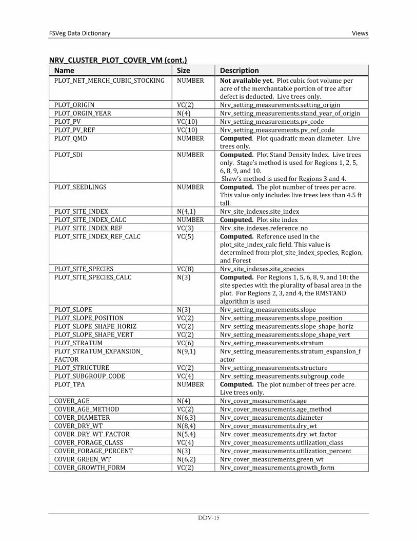
NRV_CLUSTER_PLOT_COVER_VM (cont.) Name Size Description PLOT_NET_MERCH_CUBIC_STOCKING NUMBER Not available yet. Plot cubic foot volume per
acre of the merchantable portion of tree after defect is deducted. Live trees only.
PLOT_ORIGIN VC(2) Nrv_setting_measurements.setting_origin PLOT_ORGIN_YEAR N(4) Nrv_setting_measurements.stand_year_of_origin PLOT_PV VC(10) Nrv_setting_measurements.pv_code PLOT_PV_REF VC(10) Nrv_setting_measurements.pv_ref_code PLOT_QMD NUMBER Computed. Plot quadratic mean diameter. Live
trees only. PLOT_SDI NUMBER Computed. Plot Stand Density Index. Live trees
only. Stage’s method is used for Regions 1, 2, 5, 6, 8, 9, and 10. Shaw’s method is used for Regions 3 and 4.
PLOT_SEEDLINGS NUMBER Computed. The plot number of trees per acre. This value only includes live trees less than 4.5 ft tall.
PLOT_SITE_INDEX N(4,1) Nrv_site_indexes.site_index PLOT_SITE_INDEX_CALC NUMBER Computed. Plot site index PLOT_SITE_INDEX_REF VC(3) Nrv_site_indexes.reference_no PLOT_SITE_INDEX_REF_CALC VC(5) Computed. Reference used in the
plot_site_index_calc field. This value is determined from plot_site_index_species, Region, and Forest
PLOT_SITE_SPECIES VC(8) Nrv_site_indexes.site_species PLOT_SITE_SPECIES_CALC N(3) Computed. For Regions 1, 5, 6, 8, 9, and 10: the
site species with the plurality of basal area in the plot. For Regions 2, 3, and 4, the RMSTAND algorithm is used
PLOT_SLOPE N(3) Nrv_setting_measurements.slope PLOT_SLOPE_POSITION VC(2) Nrv_setting_measurements.slope_position PLOT_SLOPE_SHAPE_HORIZ VC(2) Nrv_setting_measurements.slope_shape_horiz PLOT_SLOPE_SHAPE_VERT VC(2) Nrv_setting_measurements.slope_shape_vert PLOT_STRATUM VC(6) Nrv_setting_measurements.stratum PLOT_STRATUM_EXPANSION_ FACTOR
N(9,1) Nrv_setting_measurements.stratum_expansion_factor
PLOT_STRUCTURE VC(2) Nrv_setting_measurements.structure PLOT_SUBGROUP_CODE VC(4) Nrv_setting_measurements.subgroup_code PLOT_TPA NUMBER Computed. The plot number of trees per acre.
Live trees only. COVER_AGE N(4) Nrv_cover_measurements.age COVER_AGE_METHOD VC(2) Nrv_cover_measurements.age_method COVER_DIAMETER N(6,3) Nrv_cover_measurements.diameter COVER_DRY_WT N(8,4) Nrv_cover_measurements.dry_wt COVER_DRY_WT_FACTOR N(5,4) Nrv_cover_measurements.dry_wt_factor COVER_FORAGE_CLASS VC(4) Nrv_cover_measurements.utilization_class COVER_FORAGE_PERCENT N(3) Nrv_cover_measurements.utilization_percent COVER_GREEN_WT N(6,2) Nrv_cover_measurements.green_wt COVER_GROWTH_FORM VC(2) Nrv_cover_measurements.growth_form
DDV-15
Views FSVeg Data Dictionary NRV_CLUSTER_PLOT_COVER_VM (cont.)
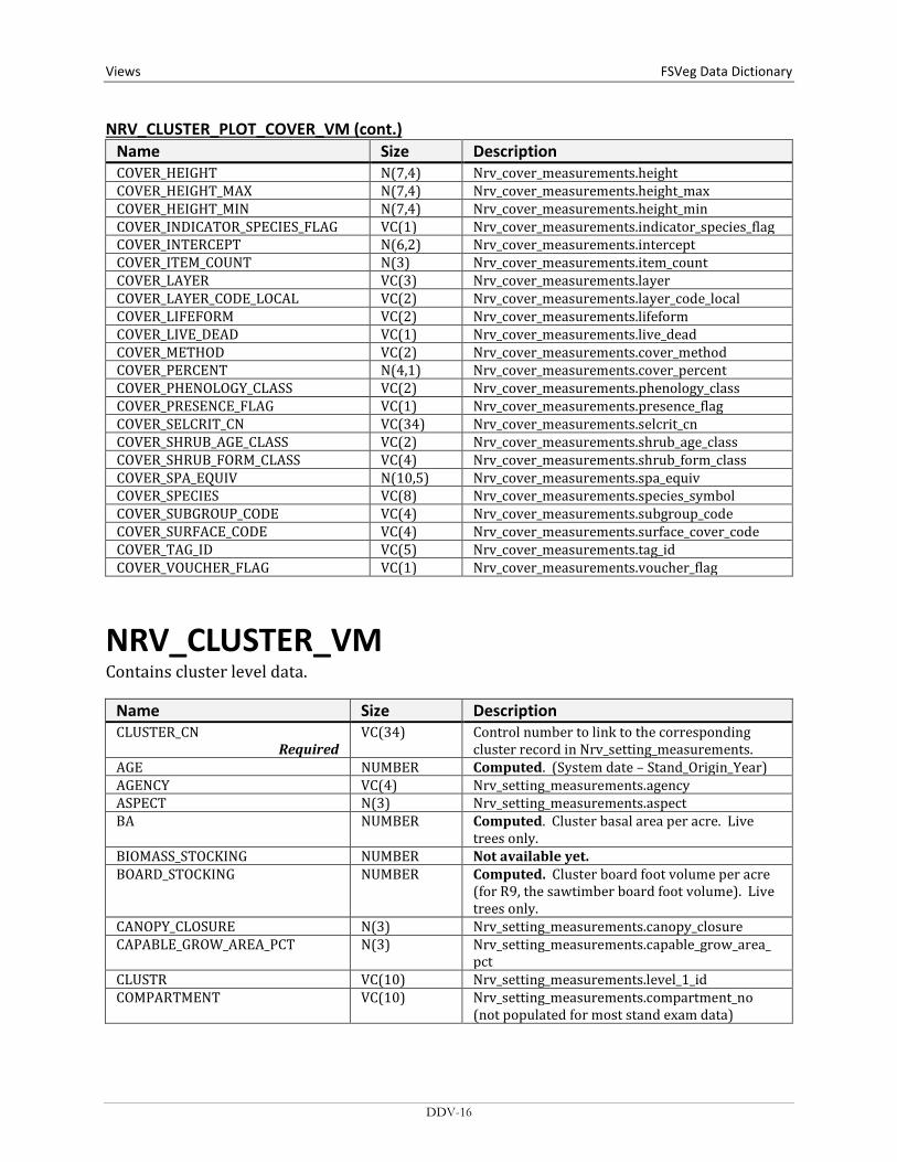
Name Size Description COVER_HEIGHT N(7,4) Nrv_cover_measurements.height COVER_HEIGHT_MAX N(7,4) Nrv_cover_measurements.height_max COVER_HEIGHT_MIN N(7,4) Nrv_cover_measurements.height_min COVER_INDICATOR_SPECIES_FLAG VC(1) Nrv_cover_measurements.indicator_species_flag COVER_INTERCEPT N(6,2) Nrv_cover_measurements.intercept COVER_ITEM_COUNT N(3) Nrv_cover_measurements.item_count COVER_LAYER VC(3) Nrv_cover_measurements.layer COVER_LAYER_CODE_LOCAL VC(2) Nrv_cover_measurements.layer_code_local COVER_LIFEFORM VC(2) Nrv_cover_measurements.lifeform COVER_LIVE_DEAD VC(1) Nrv_cover_measurements.live_dead COVER_METHOD VC(2) Nrv_cover_measurements.cover_method COVER_PERCENT N(4,1) Nrv_cover_measurements.cover_percent COVER_PHENOLOGY_CLASS VC(2) Nrv_cover_measurements.phenology_class COVER_PRESENCE_FLAG VC(1) Nrv_cover_measurements.presence_flag COVER_SELCRIT_CN VC(34) Nrv_cover_measurements.selcrit_cn COVER_SHRUB_AGE_CLASS VC(2) Nrv_cover_measurements.shrub_age_class COVER_SHRUB_FORM_CLASS VC(4) Nrv_cover_measurements.shrub_form_class COVER_SPA_EQUIV N(10,5) Nrv_cover_measurements.spa_equiv COVER_SPECIES VC(8) Nrv_cover_measurements.species_symbol COVER_SUBGROUP_CODE VC(4) Nrv_cover_measurements.subgroup_code COVER_SURFACE_CODE VC(4) Nrv_cover_measurements.surface_cover_code COVER_TAG_ID VC(5) Nrv_cover_measurements.tag_id COVER_VOUCHER_FLAG VC(1) Nrv_cover_measurements.voucher_flag
NRV_CLUSTER_VM Contains cluster level data.
Name Size Description CLUSTER_CN
Required VC(34) Control number to link to the corresponding
cluster record in Nrv_setting_measurements. AGE NUMBER Computed. (System date – Stand_Origin_Year) AGENCY VC(4) Nrv_setting_measurements.agency ASPECT N(3) Nrv_setting_measurements.aspect BA NUMBER Computed. Cluster basal area per acre. Live
trees only. BIOMASS_STOCKING NUMBER Not available yet. BOARD_STOCKING NUMBER Computed. Cluster board foot volume per acre
(for R9, the sawtimber board foot volume). Live trees only.
CANOPY_CLOSURE N(3) Nrv_setting_measurements.canopy_closure CAPABLE_GROW_AREA_PCT N(3) Nrv_setting_measurements.capable_grow_area_
pct CLUSTR VC(10) Nrv_setting_measurements.level_1_id COMPARTMENT VC(10) Nrv_setting_measurements.compartment_no
(not populated for most stand exam data)
DDV-16

FSVeg Data Dictionary Views
NRV_CLUSTER_VM (cont.) Name Size Description CORDS_STOCKING NUMBER Not available yet. COUNTY VC(3) Nrv_setting_measurements.county CUBIC_STOCKING NUMBER Computed. Cluster cubic foot volume per acre
(for R9, the pulp cubic foot volume). Live trees only.
DISTRICT VC(2) Nrv_setting_measurements.district DISTURB_AGENT1 VC(3) Nrv_setting_disturbances.agent_code DISTURB_AGENT2 VC(3) Nrv_setting_disturbances.agent_code DISTURB_AGENT3 VC(3) Nrv_setting_disturbances.agent_code DISTURB_AGENT4 VC(3) Nrv_setting_disturbances.agent_code DISTURB_AGENT5 VC(3) Nrv_setting_disturbances.agent_code DISTURB_AGENT_SEV1 VC(3) Nrv_setting_disturbances.severity_rating_code DISTURB_AGENT_SEV2 VC(3) Nrv_setting_disturbances.severity_rating_code DISTURB_AGENT_SEV3 VC(3) Nrv_setting_disturbances.severity_rating_code DISTURB_AGENT_SEV4 VC(3) Nrv_setting_disturbances.severity_rating_code DISTURB_AGENT_SEV5 VC(3) Nrv_setting_disturbances.severity_rating_code DISTURB_CATEGORY1 VC(2) Nrv_setting_disturbances.category_code DISTURB_CATEGORY2 VC(2) Nrv_setting_disturbances.category_code DISTURB_CATEGORY3 VC(2) Nrv_setting_disturbances.category_code DISTURB_CATEGORY4 VC(2) Nrv_setting_disturbances.category_code DISTURB_CATEGORY5 VC(2) Nrv_setting_disturbances.category_code DISTURB_DATE1 DATE Nrv_setting_disturbances.disturbance_date DISTURB_DATE2 DATE Nrv_setting_disturbances.disturbance_date DISTURB_DATE3 DATE Nrv_setting_disturbances.disturbance_date DISTURB_DATE4 DATE Nrv_setting_disturbances.disturbance_date DISTURB_DATE5 DATE Nrv_setting_disturbances.disturbance_date DISTURB_EFFECT1 VC(3) Nrv_setting_disturbances.effect_code DISTURB_EFFECT2 VC(3) Nrv_setting_disturbances.effect_code DISTURB_EFFECT3 VC(3) Nrv_setting_disturbances.effect_code DISTURB_EFFECT4 VC(3) Nrv_setting_disturbances.effect_code DISTURB_EFFECT5 VC(3) Nrv_setting_disturbances.effect_code DISTURB_EFFECT_SEV1 VC(3) Nrv_setting_disturbances.effect_severity DISTURB_EFFECT_SEV2 VC(3) Nrv_setting_disturbances.effect_severity DISTURB_EFFECT_SEV3 VC(3) Nrv_setting_disturbances.effect_severity DISTURB_EFFECT_SEV4 VC(3) Nrv_setting_disturbances.effect_severity DISTURB_EFFECT_SEV5 VC(3) Nrv_setting_disturbances.effect_severity DISTURB_PERCENT1 NUMBER Nrv_setting_disturbances.damage_percent DISTURB_PERCENT2 NUMBER Nrv_setting_disturbances.damage_percent DISTURB_PERCENT3 NUMBER Nrv_setting_disturbances.damage_percent DISTURB_PERCENT4 NUMBER Nrv_setting_disturbances.damage_percent DISTURB_PERCENT5 NUMBER Nrv_setting_disturbances.damage_percent DOWN_PIECES_5_MINUS NUMBER The stand level average downed woody material
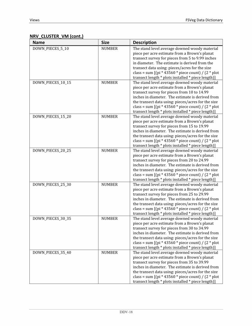
piece per acre estimate from a Brown’s planat transect survey for pieces from 3 to 4.99 inches in diameter. The estimate is derived from the transect data using: pieces/acres for the size class = sum [(pi * 43560 * piece count) / (2 * plot transect length * plots installed * piece length)]
DDV-17
Views FSVeg Data Dictionary NRV_CLUSTER_VM (cont.)
Name Size Description DOWN_PIECES_5_10 NUMBER The stand level average downed woody material
piece per acre estimate from a Brown’s planat transect survey for pieces from 5 to 9.99 inches in diameter. The estimate is derived from the transect data using: pieces/acres for the size class = sum [(pi * 43560 * piece count) / (2 * plot transect length * plots installed * piece length)]
DOWN_PIECES_10_15 NUMBER The stand level average downed woody material piece per acre estimate from a Brown’s planat transect survey for pieces from 10 to 14.99 inches in diameter. The estimate is derived from the transect data using: pieces/acres for the size class = sum [(pi * 43560 * piece count) / (2 * plot transect length * plots installed * piece length)]
DOWN_PIECES_15_20 NUMBER The stand level average downed woody material piece per acre estimate from a Brown’s planat transect survey for pieces from 15 to 19.99 inches in diameter. The estimate is derived from the transect data using: pieces/acres for the size class = sum [(pi * 43560 * piece count) / (2 * plot transect length * plots installed * piece length)]
DOWN_PIECES_20_25 NUMBER The stand level average downed woody material piece per acre estimate from a Brown’s planat transect survey for pieces from 20 to 24.99 inches in diameter. The estimate is derived from the transect data using: pieces/acres for the size class = sum [(pi * 43560 * piece count) / (2 * plot transect length * plots installed * piece length)]
DOWN_PIECES_25_30 NUMBER The stand level average downed woody material piece per acre estimate from a Brown’s planat transect survey for pieces from 25 to 29.99 inches in diameter. The estimate is derived from the transect data using: pieces/acres for the size class = sum [(pi * 43560 * piece count) / (2 * plot transect length * plots installed * piece length)]
DOWN_PIECES_30_35 NUMBER The stand level average downed woody material piece per acre estimate from a Brown’s planat transect survey for pieces from 30 to 34.99 inches in diameter. The estimate is derived from the transect data using: pieces/acres for the size class = sum [(pi * 43560 * piece count) / (2 * plot transect length * plots installed * piece length)]
DOWN_PIECES_35_40 NUMBER The stand level average downed woody material piece per acre estimate from a Brown’s planat transect survey for pieces from 35 to 39.99 inches in diameter. The estimate is derived from the transect data using: pieces/acres for the size class = sum [(pi * 43560 * piece count) / (2 * plot transect length * plots installed * piece length)]
DDV-18
FSVeg Data Dictionary Views
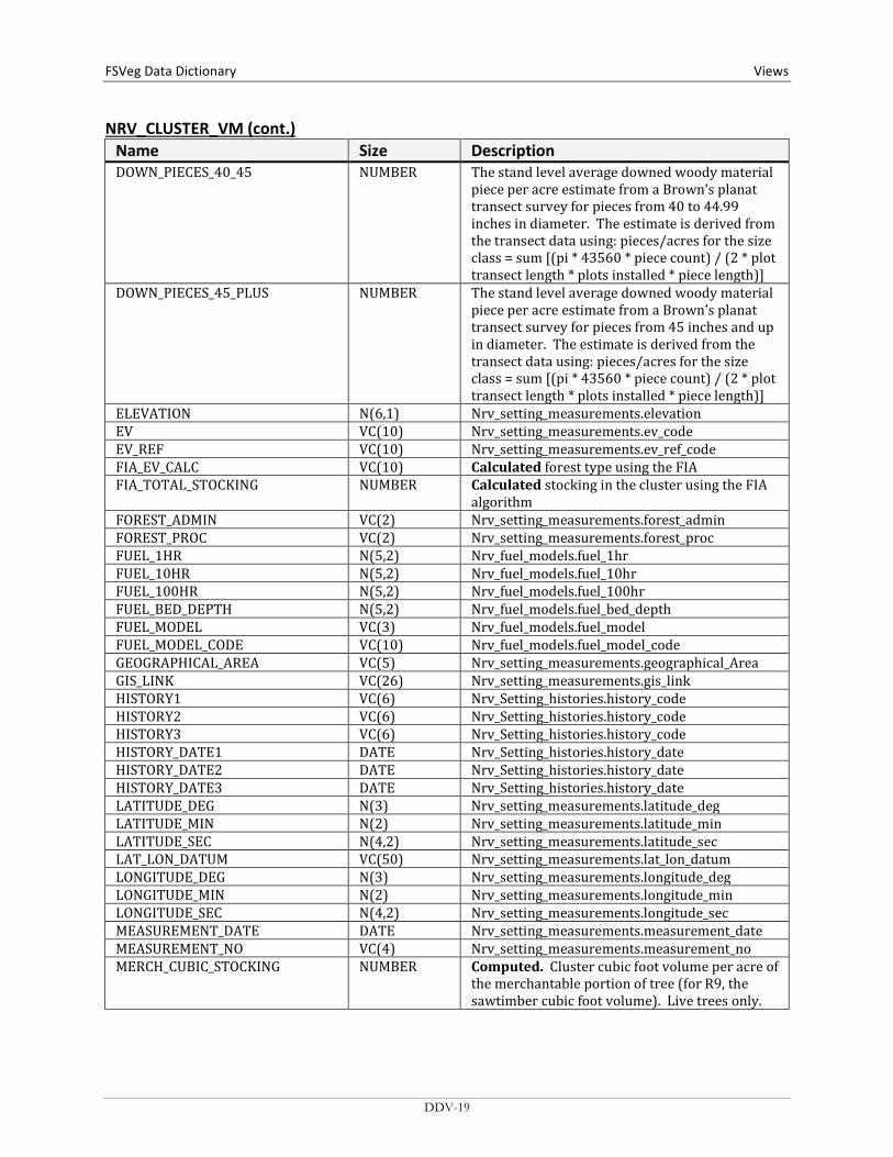
NRV_CLUSTER_VM (cont.) Name Size Description DOWN_PIECES_40_45 NUMBER The stand level average downed woody material
piece per acre estimate from a Brown’s planat transect survey for pieces from 40 to 44.99 inches in diameter. The estimate is derived from the transect data using: pieces/acres for the size class = sum [(pi * 43560 * piece count) / (2 * plot transect length * plots installed * piece length)]
DOWN_PIECES_45_PLUS NUMBER The stand level average downed woody material piece per acre estimate from a Brown’s planat transect survey for pieces from 45 inches and up in diameter. The estimate is derived from the transect data using: pieces/acres for the size class = sum [(pi * 43560 * piece count) / (2 * plot transect length * plots installed * piece length)]
ELEVATION N(6,1) Nrv_setting_measurements.elevation EV VC(10) Nrv_setting_measurements.ev_code EV_REF VC(10) Nrv_setting_measurements.ev_ref_code FIA_EV_CALC VC(10) Calculated forest type using the FIA FIA_TOTAL_STOCKING NUMBER Calculated stocking in the cluster using the FIA
algorithm FOREST_ADMIN VC(2) Nrv_setting_measurements.forest_admin FOREST_PROC VC(2) Nrv_setting_measurements.forest_proc FUEL_1HR N(5,2) Nrv_fuel_models.fuel_1hr FUEL_10HR N(5,2) Nrv_fuel_models.fuel_10hr FUEL_100HR N(5,2) Nrv_fuel_models.fuel_100hr FUEL_BED_DEPTH N(5,2) Nrv_fuel_models.fuel_bed_depth FUEL_MODEL VC(3) Nrv_fuel_models.fuel_model FUEL_MODEL_CODE VC(10) Nrv_fuel_models.fuel_model_code GEOGRAPHICAL_AREA VC(5) Nrv_setting_measurements.geographical_Area GIS_LINK VC(26) Nrv_setting_measurements.gis_link HISTORY1 VC(6) Nrv_Setting_histories.history_code HISTORY2 VC(6) Nrv_Setting_histories.history_code HISTORY3 VC(6) Nrv_Setting_histories.history_code HISTORY_DATE1 DATE Nrv_Setting_histories.history_date HISTORY_DATE2 DATE Nrv_Setting_histories.history_date HISTORY_DATE3 DATE Nrv_Setting_histories.history_date LATITUDE_DEG N(3) Nrv_setting_measurements.latitude_deg LATITUDE_MIN N(2) Nrv_setting_measurements.latitude_min LATITUDE_SEC N(4,2) Nrv_setting_measurements.latitude_sec LAT_LON_DATUM VC(50) Nrv_setting_measurements.lat_lon_datum LONGITUDE_DEG N(3) Nrv_setting_measurements.longitude_deg LONGITUDE_MIN N(2) Nrv_setting_measurements.longitude_min LONGITUDE_SEC N(4,2) Nrv_setting_measurements.longitude_sec MEASUREMENT_DATE DATE Nrv_setting_measurements.measurement_date MEASUREMENT_NO VC(4) Nrv_setting_measurements.measurement_no MERCH_CUBIC_STOCKING NUMBER Computed. Cluster cubic foot volume per acre of
the merchantable portion of tree (for R9, the sawtimber cubic foot volume). Live trees only.
DDV-19

Views FSVeg Data Dictionary NRV_CLUSTER_VM (cont.)
Name Size Description NET_BOARD_STOCKING NUMBER Not available yet. Cluster board foot volume
per acre after defect has been detected. Live trees only.
NET_CUBIC_STOCKING NUMBER Not available yet. Cluster cubic foot volume per acre, after defect is deducted. Live trees only.
NET_MERCH_CUBIC_STOCKING NUMBER Not available yet. Cluster cubic foot volume per acre of the merchantable portion of tree after defect is deducted. Live trees only.
NFS_LAND_CLASS VC(3) Nrv_setting_measurements.nfs_land_class ORGIN VC(2) Nrv_setting_measurements.setting_origin ORGIN_YEAR N(4) Nrv_setting_measurements.stand_year_of_origin OWNER VC(4) Nrv_setting_measurements.owner PLS_MERIDIAN VC(2) Nrv_setting_measurements.meridian_code PLS_RANGE VC(5) Nrv_setting_measurements.pls_range PLS_SECTION VC(2) Nrv_setting_measurements.pls_section PLS_SUBDIVISION VC(4) Nrv_setting_measurements.pls_subdivision PLS_TOWNSHIP VC(5) Nrv_setting_measurements.pls_township PROJECT_NAME VC(25) Nrv_setting_measurements.project_name PV VC(10) Nrv_setting_measurements.pv_code PV_REF VC(10) Nrv_setting_measurements.pv_ref_code QMD NUMBER Computed. Cluster quadratic mean diameter.
Live trees only. REGION_ADMIN VC(2) Nrv_setting_measurements.region_admin REGION_PROC VC(2) Nrv_setting_measurements.region_proc RPA_LAND_CLASS VC(2) Nrv_setting_measurements.rpa_land_class SDI NUMBER Computed. Cluster Stand Density Index. Live
trees only. Stage’s method is used for Regions 1, 2, 5, 6, 8, 9, and 10. Shaw’s method is used for Regions 3 and 4.
SEEDLINGS NUMBER Computed. Cluster number of trees per acre. Only includes live trees less than 4.5 feet tall.
SETTING_ID VC(30) Nrv_setting_measurements.setting_id SITE_INDEX N(4,1) Nrv_site_indexes.site_index SITE_INDEX_CALC NUMBER Computed. Cluster site index SITE_INDEX_REF VC(3) Nrv_site_indexes.reference_no SITE_INDEX_REF_CALC VC(5) Computed. Reference used in the
site_index_calc field. This value is determined from site_index_species, Region, and Forest
SITE_SPECIES VC(8) Nrv_site_index_ref_codes.site_species SITE_SPECIES_CALC VC(8) Computed. For Regions 1, 5, 6, 8, 9, and 10: the
site species with the plurality of basal area in the plot. For Regions 2, 3, and 4, the RMSTAND algorithm is used
SLOPE N(3) Nrv_setting_measurements.slope SLOPE_POSITION VC(2) Nrv_setting_measurements.slope_position SLOPE_SHAPE_HORIZ VC(2) Nrv_setting_measurements.slope_shape_horiz SLOPE_SHAPE_VERT VC(2) Nrv_setting_measurements.slope_shape_vert STAND_SIZE N(8,4) Nrv_setting_measurements.setting_size
DDV-20

FSVeg Data Dictionary Views
NRV_CLUSTER_VM (cont.) Name Size Description STATE VC(2) Nrv_setting_measurements.state STATE_PLANE_DATUM VC(10) Nrv_setting_measurements.state_plane_datum STATE_PLANE_X N(12,3) Nrv_setting_measurements.state_plane_x STATE_PLANE_Y N(12,3) Nrv_setting_measurements.state_plane_y STATE_PLANE_ZONE VC(10) Nrv_setting_measurements.state_plane_zone STRATUM VC(6) Nrv_setting_measurements.stratum STRATUM_EXPANSION_FACTOR N(9,1) Nrv_setting_measurements.stratum_expansion_f
actor STRUCTURE VC(2) Nrv_setting_measurements.structure SUBCOMPARTMENT VC(10) Nrv_setting_measurements.subcompartment_No SUBGROUP_CODE VC(4) Nrv_setting_measurements.subgroup_code SURVEY_UNIT VC(2) Nrv_setting_measurements.survey_Unit TPA NUMBER Computed. Cluster number of trees per acre.
Live trees only. UTM_DATUM VC(10) Nrv_setting_measurements.utm_datum UTM_EASTING N(6) Nrv_setting_measurements.utm_easting UTM_NORTHING N(7) Nrv_setting_measurements.utm_northing UTM_ZONE N(2) Nrv_setting_measurements.utm_zone VSS VC(6) Computed for Regions 2, 3 and 4 only
NRV_CLUSTER_PLOT_TREE_VM Contains cluster level data, plot level data, and tree level data.
Name Size Description CLUSTER_CN
Required VC(34) Control number to link to the corresponding
cluster record in Nrv_setting_measurements CLUSTR VC(10) Nrv_setting_measurements.level_1_id COMPARTMENT VC(10) Nrv_setting_measurements.compartment_No
(not populated for most stand exam data) CONSEC_PT_NUM VC(8) Nrv_setting_measurements.consec_Pt_Num COUNTY VC(3) Nrv_setting_measurements.county DISTRICT VC(2) Nrv_setting_measurements.district FOREST_ADMIN VC(2) Nrv_setting_measurements.forest_admin FOREST_PROC VC(2) Nrv_setting_measurements.forest_proc GEOGRAPHICAL_AREA VC(5) Nrv_setting_measurements.geographical_area HEIGTH_TO_BREAK N(7,4) Nrv_Tree_measurements.height_to_break LATITUDE_DEG NUMBER Nrv_setting_measurements.latitude_degree LATITUDE_MIN NUMBER Nrv_setting_measurements.latitude_min LATITUDE_SEC NUMBER Nrv_setting_measurements.latitude_sec LAT_LON_DATUM VC(8) Nrv_setting_measurements.lat_lon_datum LONGITUDE_DEG NUMBER Nrv_setting_measurements.longitude_deg LONGITUDE_MIN NUMBER Nrv_setting_measurements.longitude_min LONGITUDE_SEC NUMBER Nrv_setting_measurements.longitude_sec MEASUREMENT_DATE DATE Nrv_setting_measurements.measurement_date MEASUREMENT_NO VC(2) Nrv_setting_measurements.measurement_No
DDV-21

Views FSVeg Data Dictionary NRV_CLUSTER_PLOT_TREE_VM (cont.)
Name Size Description NFS_LAND_CLASS VC(3) Nrv_setting_measurements.nfs_Land_class PLOT VC(10) Nrv_setting_measurements.plot PLOT_CN VC(34) The control number of the
Nrv_setting_measurements record corresponding to the plot
PLS_MERIDIAN VC(2) Nrv_setting_measurements.meridian_Code PLS_RANGE VC(5) Nrv_setting_measurements.pls_range PLS_SECTION VC(2) Nrv_setting_measurements.pls_section PLS_SUBDIVISION VC(4) Nrv_setting_measurements.pls_subdivision PLS_TOWNSHIP VC(5) Nrv_setting_measurements.pls_township PROJECT_NAME VC(25) Nrv_setting_measurements.project_name REGION_ADMIN VC(2) Nrv_setting_measurements.region_admin REGION_PROC VC(2) Nrv_setting_measurements.region_proc RESERVE_CLASS VC(2) Nrv_setting_measurements.reserve_class RPA_LAND_CLASS VC(2) Nrv_setting_measurements.rpa_land_class SETTING_ID VC(30) Nrv_setting_measurements.setting_id STATE VC(2) Nrv_setting_measurements.state STATE_PLANE_DATUM VC(10) Nrv_setting_measurements.state_plane_datum STATE_PLANE_X NUMBER Nrv_setting_measurements.state_plane_x STATE_PLANE_Y NUMBER Nrv_setting_measurements.state_plane_y STATE_PLANE_ZONE VC(10) Nrv_setting_measurements.state_plane_zone SUBCOMPARTMENT VC(10) Nrv_setting_measurements.subcompartment_no SURVEY_UNIT VC(2) Nrv_setting_measurements.survey_unit TREE_CN VC(34) Control number of the Nrv_tree_measurements
record UTM_DATUM VC(10) Nrv_setting_measurements.utm_datum UTM_EASTING NUMBER Nrv_setting_measurements.utm_easting UTM_NORTHING NUMBER Nrv_setting_measurements.utm_northing UTM_ZONE NUMBER Nrv_setting_measurements.utm_zone CLUSTER_AGE NUMBER Computed (System date – Stand_Origin_Year) CLUSTER_AGENCY VC(4) Nrv_setting_measurements.agency CLUSTER_ASPECT N(3) Nrv_setting_measurements.aspect CLUSTER_BA NUMBER Computed. Cluster basal area per acre. Live
trees only. CLUSTER_BA_EQ NUMBER Computed. Cluater basal area per acre that this
tree represents CLUSTER_BIOMASS_STOCKING NUMBER Not available yet CLUSTER_BOARD_STOCKING NUMBER Computed. Cluster board foot volume per acre
(for R9, the sawtimber board foot volume). Live trees only.
CLUSTER_CANOPY_CLOSURE N(3) Nrv_setting_measurements.canopy_closure CLUSTER_CAPABLE_GROW_AREA_ PCT
N(3) Nrv_setting_measurements.capable_grow_area_ pct
CLUSTER_CORDS_STOCKING NUMBER Not available yet CLUSTER_CUBIC_STOCKING NUMBER Computed. Cluster cubic foot volume per acre
(for R9, the pulp cubic foot volume). Live trees only.
CLUSTER_DISTURB_AGENT1 VC(3) Nrv_setting_disturbances.agent_code
DDV-22
FSVeg Data Dictionary Views
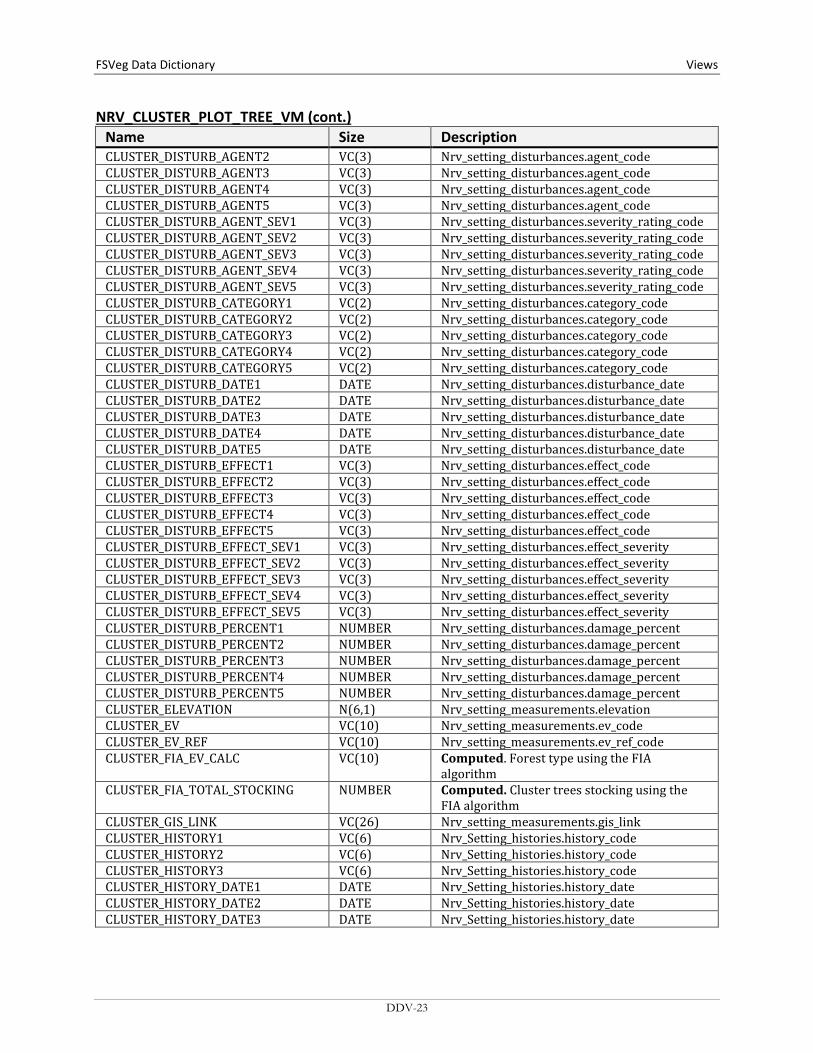
NRV_CLUSTER_PLOT_TREE_VM (cont.) Name Size Description CLUSTER_DISTURB_AGENT2 VC(3) Nrv_setting_disturbances.agent_code CLUSTER_DISTURB_AGENT3 VC(3) Nrv_setting_disturbances.agent_code CLUSTER_DISTURB_AGENT4 VC(3) Nrv_setting_disturbances.agent_code CLUSTER_DISTURB_AGENT5 VC(3) Nrv_setting_disturbances.agent_code CLUSTER_DISTURB_AGENT_SEV1 VC(3) Nrv_setting_disturbances.severity_rating_code CLUSTER_DISTURB_AGENT_SEV2 VC(3) Nrv_setting_disturbances.severity_rating_code CLUSTER_DISTURB_AGENT_SEV3 VC(3) Nrv_setting_disturbances.severity_rating_code CLUSTER_DISTURB_AGENT_SEV4 VC(3) Nrv_setting_disturbances.severity_rating_code CLUSTER_DISTURB_AGENT_SEV5 VC(3) Nrv_setting_disturbances.severity_rating_code CLUSTER_DISTURB_CATEGORY1 VC(2) Nrv_setting_disturbances.category_code CLUSTER_DISTURB_CATEGORY2 VC(2) Nrv_setting_disturbances.category_code CLUSTER_DISTURB_CATEGORY3 VC(2) Nrv_setting_disturbances.category_code CLUSTER_DISTURB_CATEGORY4 VC(2) Nrv_setting_disturbances.category_code CLUSTER_DISTURB_CATEGORY5 VC(2) Nrv_setting_disturbances.category_code CLUSTER_DISTURB_DATE1 DATE Nrv_setting_disturbances.disturbance_date CLUSTER_DISTURB_DATE2 DATE Nrv_setting_disturbances.disturbance_date CLUSTER_DISTURB_DATE3 DATE Nrv_setting_disturbances.disturbance_date CLUSTER_DISTURB_DATE4 DATE Nrv_setting_disturbances.disturbance_date CLUSTER_DISTURB_DATE5 DATE Nrv_setting_disturbances.disturbance_date CLUSTER_DISTURB_EFFECT1 VC(3) Nrv_setting_disturbances.effect_code CLUSTER_DISTURB_EFFECT2 VC(3) Nrv_setting_disturbances.effect_code CLUSTER_DISTURB_EFFECT3 VC(3) Nrv_setting_disturbances.effect_code CLUSTER_DISTURB_EFFECT4 VC(3) Nrv_setting_disturbances.effect_code CLUSTER_DISTURB_EFFECT5 VC(3) Nrv_setting_disturbances.effect_code CLUSTER_DISTURB_EFFECT_SEV1 VC(3) Nrv_setting_disturbances.effect_severity CLUSTER_DISTURB_EFFECT_SEV2 VC(3) Nrv_setting_disturbances.effect_severity CLUSTER_DISTURB_EFFECT_SEV3 VC(3) Nrv_setting_disturbances.effect_severity CLUSTER_DISTURB_EFFECT_SEV4 VC(3) Nrv_setting_disturbances.effect_severity CLUSTER_DISTURB_EFFECT_SEV5 VC(3) Nrv_setting_disturbances.effect_severity CLUSTER_DISTURB_PERCENT1 NUMBER Nrv_setting_disturbances.damage_percent CLUSTER_DISTURB_PERCENT2 NUMBER Nrv_setting_disturbances.damage_percent CLUSTER_DISTURB_PERCENT3 NUMBER Nrv_setting_disturbances.damage_percent CLUSTER_DISTURB_PERCENT4 NUMBER Nrv_setting_disturbances.damage_percent CLUSTER_DISTURB_PERCENT5 NUMBER Nrv_setting_disturbances.damage_percent CLUSTER_ELEVATION N(6,1) Nrv_setting_measurements.elevation CLUSTER_EV VC(10) Nrv_setting_measurements.ev_code CLUSTER_EV_REF VC(10) Nrv_setting_measurements.ev_ref_code CLUSTER_FIA_EV_CALC VC(10) Computed. Forest type using the FIA
algorithm CLUSTER_FIA_TOTAL_STOCKING NUMBER Computed. Cluster trees stocking using the
FIA algorithm CLUSTER_GIS_LINK VC(26) Nrv_setting_measurements.gis_link CLUSTER_HISTORY1 VC(6) Nrv_Setting_histories.history_code CLUSTER_HISTORY2 VC(6) Nrv_Setting_histories.history_code CLUSTER_HISTORY3 VC(6) Nrv_Setting_histories.history_code CLUSTER_HISTORY_DATE1 DATE Nrv_Setting_histories.history_date CLUSTER_HISTORY_DATE2 DATE Nrv_Setting_histories.history_date CLUSTER_HISTORY_DATE3 DATE Nrv_Setting_histories.history_date
DDV-23

Views FSVeg Data Dictionary NRV_CLUSTER_PLOT_TREE_VM (cont.)
Name Size Description CLUSTER_MERCH_CUBIC_STOCKING NUMBER Computed. Cluster cubic foot volume per acre
of the merchantable portion of tree (for R9, the sawtimber cubic foot volume). Live trees only.
CLUSTER_NET_BOARD_STOCKING NUMBER Not available yet. Cluster board foot volume per acre, after defect has been detected. Live trees only.
CLUSTER_NET_CUBIC_STOCKING NUMBER Not available yet. Cluster cubic foot volume per acre, after defect is deducted. Live trees only.
CLUSTER_NET_MERCH_CU_STOCKING NUMBER Not available yet. Cluster cubic foot volume per acre, of merchantable portion of tree after the defect is deducted. Live trees only.
CLUSTER_ORIGIN VC(2) Nrv_setting_measurements.setting_origin CLUSTER_ORGIN_YEAR N(4) Nrv_setting_measurements.stand_year_of_
origin CLUSTER_OWNER VC(4) Nrv_setting_measurements.owner CLUSTER_PV VC(10) Nrv_setting_measurements.pv_code CLUSTER_PV_REF VC(10) Nrv_setting_measurements.pv_ref_code CLUSTER_QMD NUMBER Computed. Cluster quadratic mean diameter.
Live trees only. CLUSTER_SDI NUMBER Computed. Cluster Stand Density Index. Live
trees only. Stage’s method is used for Regions 1, 2, 5, 6, 8, 9, and 10. Shaw’s method is used for Regions 3 and 4.
CLUSTER_SEEDLINGS NUMBER Computed. Cluster number of trees per acre. Only includes live trees less than 4.5 ft. tall.
CLUSTER_SITE_INDEX N(4,1) Nrv_site_indexes.site_index CLUSTER_SITE_INDEX_CALC NUMBER Computed. Cluster site index CLUSTER_SITE_INDEX_REF VC(3) Nrv_site_indexes.reference_no CLUSTER_SITE_INDEX_REF_CALC VC(5) Computed. Reference used in the
cluster_site_index_calc field. This value is determined from cluster_site_index_species, Region, and Forest
CLUSTER_SITE_SPECIES VC(8) Nrv_site_indexes.site_species CLUSTER_SITE_SPECIES_CALC VC(8) Computed. For Regions 1, 5, 6, 8, 9, and 10:
the site species with the plurality of basal area in the plot. For Regions 2, 3, and 4, the RMSTAND algorithm is used
CLUSTER_SLOPE N(3) Nrv_setting_measurements.slope CLUSTER_SLOPE_POSITION VC(2) Nrv_setting_measurements.slope_position CLUSTER_SLOPE_SHAPE_HORIZ VC(2) Nrv_setting_measurements.slope_shape_horiz CLUSTER_SLOPE_SHAPE_VERT VC(2) Nrv_setting_measurements.slope_shape_vert CLUSTER_STRATUM VC(6) Nrv_setting_measurements.stratum CLUSTER_STRATUM_EXPANSION N(9,1) Nrv_setting_measurements.stratum_expansion
_factor CLUSTER_STRUCTURE VC(2) Nrv_setting_measurements.structure CLUSTER_SUBGROUP_CODE VC(4) Nrv_setting_measurements.subgroup_code CLUSTER_TPA NUMBER Computed. Cluster number of trees per acre.
Live trees only.
DDV-24
FSVeg Data Dictionary Views
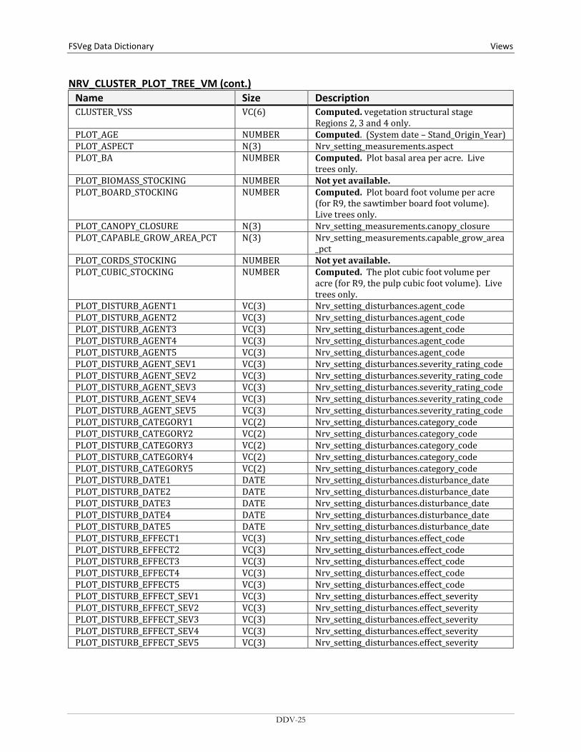
NRV_CLUSTER_PLOT_TREE_VM (cont.) Name Size Description CLUSTER_VSS VC(6) Computed. vegetation structural stage
Regions 2, 3 and 4 only. PLOT_AGE NUMBER Computed. (System date – Stand_Origin_Year) PLOT_ASPECT N(3) Nrv_setting_measurements.aspect PLOT_BA NUMBER Computed. Plot basal area per acre. Live
trees only. PLOT_BIOMASS_STOCKING NUMBER Not yet available. PLOT_BOARD_STOCKING NUMBER Computed. Plot board foot volume per acre
(for R9, the sawtimber board foot volume). Live trees only.
PLOT_CANOPY_CLOSURE N(3) Nrv_setting_measurements.canopy_closure PLOT_CAPABLE_GROW_AREA_PCT N(3) Nrv_setting_measurements.capable_grow_area
_pct PLOT_CORDS_STOCKING NUMBER Not yet available. PLOT_CUBIC_STOCKING NUMBER Computed. The plot cubic foot volume per
acre (for R9, the pulp cubic foot volume). Live trees only.
PLOT_DISTURB_AGENT1 VC(3) Nrv_setting_disturbances.agent_code PLOT_DISTURB_AGENT2 VC(3) Nrv_setting_disturbances.agent_code PLOT_DISTURB_AGENT3 VC(3) Nrv_setting_disturbances.agent_code PLOT_DISTURB_AGENT4 VC(3) Nrv_setting_disturbances.agent_code PLOT_DISTURB_AGENT5 VC(3) Nrv_setting_disturbances.agent_code PLOT_DISTURB_AGENT_SEV1 VC(3) Nrv_setting_disturbances.severity_rating_code PLOT_DISTURB_AGENT_SEV2 VC(3) Nrv_setting_disturbances.severity_rating_code PLOT_DISTURB_AGENT_SEV3 VC(3) Nrv_setting_disturbances.severity_rating_code PLOT_DISTURB_AGENT_SEV4 VC(3) Nrv_setting_disturbances.severity_rating_code PLOT_DISTURB_AGENT_SEV5 VC(3) Nrv_setting_disturbances.severity_rating_code PLOT_DISTURB_CATEGORY1 VC(2) Nrv_setting_disturbances.category_code PLOT_DISTURB_CATEGORY2 VC(2) Nrv_setting_disturbances.category_code PLOT_DISTURB_CATEGORY3 VC(2) Nrv_setting_disturbances.category_code PLOT_DISTURB_CATEGORY4 VC(2) Nrv_setting_disturbances.category_code PLOT_DISTURB_CATEGORY5 VC(2) Nrv_setting_disturbances.category_code PLOT_DISTURB_DATE1 DATE Nrv_setting_disturbances.disturbance_date PLOT_DISTURB_DATE2 DATE Nrv_setting_disturbances.disturbance_date PLOT_DISTURB_DATE3 DATE Nrv_setting_disturbances.disturbance_date PLOT_DISTURB_DATE4 DATE Nrv_setting_disturbances.disturbance_date PLOT_DISTURB_DATE5 DATE Nrv_setting_disturbances.disturbance_date PLOT_DISTURB_EFFECT1 VC(3) Nrv_setting_disturbances.effect_code PLOT_DISTURB_EFFECT2 VC(3) Nrv_setting_disturbances.effect_code PLOT_DISTURB_EFFECT3 VC(3) Nrv_setting_disturbances.effect_code PLOT_DISTURB_EFFECT4 VC(3) Nrv_setting_disturbances.effect_code PLOT_DISTURB_EFFECT5 VC(3) Nrv_setting_disturbances.effect_code PLOT_DISTURB_EFFECT_SEV1 VC(3) Nrv_setting_disturbances.effect_severity PLOT_DISTURB_EFFECT_SEV2 VC(3) Nrv_setting_disturbances.effect_severity PLOT_DISTURB_EFFECT_SEV3 VC(3) Nrv_setting_disturbances.effect_severity PLOT_DISTURB_EFFECT_SEV4 VC(3) Nrv_setting_disturbances.effect_severity PLOT_DISTURB_EFFECT_SEV5 VC(3) Nrv_setting_disturbances.effect_severity
DDV-25

Views FSVeg Data Dictionary NRV_CLUSTER_PLOT_TREE_VM (cont.)
Name Size Description PLOT_DISTURB_PERCENT1 NUMBER Nrv_setting_disturbances.damage_percent PLOT_DISTURB_PERCENT2 NUMBER Nrv_setting_disturbances.damage_percent PLOT_DISTURB_PERCENT3 NUMBER Nrv_setting_disturbances.damage_percent PLOT_DISTURB_PERCENT4 NUMBER Nrv_setting_disturbances.damage_percent PLOT_DISTURB_PERCENT5 NUMBER Nrv_setting_disturbances.damage_percent DISTURBANCE_AGENT1 VC(3) Nrv_tree_disturbances.agent_code DISTURBANCE_AGENT2 VC(3) Nrv_tree_disturbances.agent_code DISTURBANCE_AGENT3 VC(3) Nrv_tree_disturbances.agent_code DISTURBANCE_AGENT4 VC(3) Nrv_tree_disturbances.agent_code DISTURBANCE_AGENT5 VC(3) Nrv_tree_disturbances.agent_code DISTURBANCE_AGENT_SEV1 VC(3) Nrv_tree_disturbances.severity_rating_code DISTURBANCE_AGENT_SEV2 VC(3) Nrv_tree_disturbances.severity_rating_code DISTURBANCE_AGENT_SEV3 VC(3) Nrv_tree_disturbances.severity_rating_code DISTURBANCE_AGENT_SEV4 VC(3) Nrv_tree_disturbances.severity_rating_code DISTURBANCE_AGENT_SEV5 VC(3) Nrv_tree_disturbances.severity_rating_code DISTURBANCE_CATEGORY1 VC(2) Nrv_tree_disturbances.category_code DISTURBANCE_CATEGORY2 VC(2) Nrv_tree_disturbances.category_code DISTURBANCE_CATEGORY3 VC(2) Nrv_tree_disturbances.category_code DISTURBANCE_CATEGORY4 VC(2) Nrv_tree_disturbances.category_code DISTURBANCE_CATEGORY5 VC(2) Nrv_tree_disturbances.category_code DISTURBANCE_DATE1 DATE Nrv_tree_disturbances.disturbance_date DISTURBANCE_DATE2 DATE Nrv_tree_disturbances.disturbance_date DISTURBANCE_DATE3 DATE Nrv_tree_disturbances.disturbance_date DISTURBANCE_DATE4 DATE Nrv_tree_disturbances.disturbance_date DISTURBANCE_DATE5 DATE Nrv_tree_disturbances.disturbance_date DISTURBANCE_EFFECT1 VC(3) Nrv_tree_disturbances.effect_code DISTURBANCE_EFFECT2 VC(3) Nrv_tree_disturbances.effect_code DISTURBANCE_EFFECT3 VC(3) Nrv_tree_disturbances.effect_code DISTURBANCE_EFFECT4 VC(3) Nrv_tree_disturbances.effect_code DISTURBANCE_EFFECT5 VC(3) Nrv_tree_disturbances.effect_code DISTURBANCE_EFFECT_SEV1 VC(3) Nrv_tree_disturbances.effect_severity DISTURBANCE_EFFECT_SEV2 VC(3) Nrv_tree_disturbances.effect_severity DISTURBANCE_EFFECT_SEV3 VC(3) Nrv_tree_disturbances.effect_severity DISTURBANCE_EFFECT_SEV4 VC(3) Nrv_tree_disturbances.effect_severity DISTURBANCE_EFFECT_SEV5 VC(3) Nrv_tree_disturbances.effect_severity DISTURBANCE_TREE_PART1 VC(2) Nrv_tree_disturbances.tree_part_code DISTURBANCE_TREE_PART2 VC(2) Nrv_tree_disturbances.tree_part_code DISTURBANCE_TREE_PART3 VC(2) Nrv_tree_disturbances.tree_part_code DISTURBANCE_TREE_PART4 VC(2) Nrv_tree_disturbances.tree_part_code DISTURBANCE_TREE_PART5 VC(2) Nrv_tree_disturbances.tree_part_code PLOT_ELEVATION N(6,1) Nrv_setting_measurements.elevation PLOT_EV VC(10) Nrv_setting_measurements.ev_code PLOT_EV_REF VC(10) Nrv_setting_measurements.ev_ref_code PLOT_HISTORY1 VC(6) Nrv_setting_histories.history_code PLOT_HISTORY2 VC(6) Nrv_setting_histories.history_code PLOT_HISTORY3 VC(6) Nrv_setting_histories.history_code PLOT_HISTORY_DATE1 DATE Nrv_setting_histories.history_date PLOT_HISTORY_DATE2 DATE Nrv_setting_histories.history_date
DDV-26
FSVeg Data Dictionary Views
NRV_CLUSTER_PLOT_TREE_VM (cont.) Name Size Description PLOT_HISTORY_DATE3 DATE Nrv_setting_histories.history_date PLOT_MERCH_CUBIC_STOCKING NUMBER Computed. Plot cubic foot volume per acre of
the merchantable portion of tree (for R9, the sawtimber cubic foot volume). Live trees only.
PLOT_NET_BOARD_STOCKING NUMBER Not available yet. Plot board foot volume per acre, after defect has been detected. Live trees only.
PLOT_NET_CUBIC_STOCKING NUMBER Not available yet. Plot cubic foot volume per acre, after defect is deducted. Live trees only.
PLOT_NET_MERCH_CUBIC_ STOCKING
NUMBER Not available yet. Plot cubic foot volume per acre of the merchantable portion of tree after defect is deducted. Live trees only.
PLOT_ORIGIN VC(2) Nrv_setting_measurements.setting_origin PLOT_ORGIN_YEAR N(4) Nrv_setting_measurements.stand_year_of_
origin PLOT_PV VC(10) Nrv_setting_measurements.pv_code PLOT_PV_REF VC(10) Nrv_setting_measurements.pv_ref_code PLOT_QMD NUMBER Computed. Plot quadratic mean diameter.
Live trees only. PLOT_SDI NUMBER Computed. Plot Stand Density Index. Live
trees only. Stage’s method is used for Regions 1, 2, 5, 6, 8, 9, and 10. Shaw’s method is used for Regions 3 and 4.
PLOT_SEEDLINGS NUMBER Computed. Plot average number of trees per acre. Only includes live trees less than 4.5 ft tall.
PLOT_SITE_INDEX N(4,1) Nrv_site_indexes.site_index PLOT_SITE_INDEX_CALC NUMBER Computed. Plot site index PLOT_SITE_INDEX_REF VC(3) Nrv_site_indexes.reference_no PLOT_SITE_INDEX_REF_CALC VC(5) Computed. Reference used in the
plot_site_index_calc field. This value is determined from plot_site_index_species, Region, and Forest
PLOT_SITE_SPECIES VC(8) Nrv_Site_indexes.site_species PLOT_SITE_SPECIES_CALC VC8 Computed. For Regions 1, 5, 6, 8, 9, and 10:
the site species with the plurality of basal area in the plot. For Regions 2, 3, and 4, the RMSTAND algorithm is used
PLOT_SLOPE N(3) Nrv_setting_measurements.slope PLOT_SLOPE_POSITION VC(2) Nrv_setting_measurements.slope_position PLOT_SLOPE_SHAPE_HORIZ VC(2) Nrv_setting_measurements.slope_shape_horiz PLOT_SLOPE_SHAPE_VERT VC(2) Nrv_setting_measurements.slope_shape_vert PLOT_STRATUM VC(6) Nrv_setting_measurements.stratum PLOT_STRATUM_EXPANSION_ FACTOR
N(9,1) Nrv_setting_measurements.stratum_expansion_factor
PLOT_STRUCTURE VC(2) Nrv_setting_measurements.structure PLOT_SUBGROUP_CODE VC(4) Nrv_setting_measurements.subgroup_code PLOT_TPA NUMBER Computed. Plot number of trees per acre.
Live trees only with diameters > 0 AGE N(4) Nrv_tree_measurements.age
DDV-27

Views FSVeg Data Dictionary NRV_CLUSTER_PLOT_TREE_VM (cont.)
Name Size Description ANNUAL_HT_GROWTH NUMBER Nrvt_tree_measurements.height_growth ANNUAL_RADIAL_GROWTH NUMBER Nrv_tree_measurements.radial_growth AZIMUTH N(3) Nrv_tree_measurements.azimuth BA NUMBER Computed. Tree basal area, in square feet.
BA = 0.005454*diameter2 BARE_TOP_PERCENT N(3) Nrv_tree_measurements.bare_top_percent BIOMASS NUMBER Not available yet. BOARD_VOLUME NUMBER Computed. Tree board foot volume (for R9,
the sawtimber board foot volume). CLUSTER_TPA_EQ NUMBER Computed. The number of trees per acre, at
the cluster level, which this tree record represents.
CONE_SEROTINY VC(2) Nrv_Tree_measurements.cone_serotiny CORDS NUMBER Not available yet. CR N(3) Nrv_Tree_measurements.crown_ratio CROWN_BASE_HEIGHT N(6,3) Nrv_Tree_measurements.crown_base_height CROWN_CLASS VC(2) Nrv_Tree_measurements.crown_class CROWN_LENGTH N(6,3) Nrv_Tree_measurements.crown_length CROWN_WIDTH N(5,2) Nrv_Tree_measurements.crown_width CUBIC_VOLUME NUMBER Computed. Cubic foot volume of the whole
tree (for R9, the pulp cubic foot volume). DBH NUMBER Nrv_tree_measurements.diameter DEADWOOD_PERCENT N(3) Nrv_tree_measurements.deadwood_percent DIAMETER N(6,3) Nrv_tree_measurements.diameter or
Nrv_tree_measurements.diameter whichever is not NULL
DISTANCE N(6,3) Nrv_tree_measurements.distance DOWN_FLAG VC(1) Nrv_tree_measurements.down_flag DRC NUMBER Nrv_tree_measurements.diameter GROWTH_FORM VC(2) Nrv_tree_measurements.growth_form HEIGHT NUMBER Nrv_tree_measurements.height OR computed
if the height is missing HEIGHT_METHOD VC(7) Nrv_tree Measurements.height_method OR set
to ‘C’ if the height is calculated HEIGHT_TOPKILL N(7,4) Nrv_tree_measurements.height_topkill HEIGHT_TO_BREAK N(7,4) Nrv_tree measurements.height_to_break INDUSTRIAL_FLAG VC(1) Nrv_tree_measurements.industrial_flag LEAN_ANGLE N(2) Nrv_tree_measurements.lean_angle LIFE_FORM VC(2) Nrv_tree_measurements.life_form LIVE_DEAD VC(1) Nrv_tree_measurements.live_dead LOG_DECAY_CLASS VC(2) Nrv_tree_measurements.log_decay_class MERCH_CUBIC_VOLUME NUMBER Computed. Cubic foot volume of the
merchantable portion of the tree (for R9, the sawtimber cubic foot volume).
NET_BOARD_VOLUME NUMBER Not available yet. Board foot volume of the tree after defect is deducted.
NET_CUBIC_VOLUME NUMBER Not available yet. Cubic foot volume of the whole tree after defect is deducted.
DDV-28
FSVeg Data Dictionary Views
NRV_CLUSTER_PLOT_TREE_VM (cont.) Name Size Description NET_MERCH_CUBIC_VOLUME NUMBER Not available yet. Cubic volume of the
merchantable portion of the tree after defect is deducted.
OFF_PLOT_FLAG VC(1) Nrv_tree_measurements.off_plot_flag PLOT_BA_EQ N(8,4) Computed. The square feet of basal area per
acre represented by this tree record for the lowest-level sample element (i.e. plot, subplot, etc.) on which it was measured. This value represents the expansion factor for the record. If this record represents multiple trees, this value is their total square feet of basal area per acre. basal_area_equivalent =
0.005454*diamter2*tpa_equiv PLOT_TPA_EQ N(10,5) Computed. The number of trees per acre, at
the plot level, this tree represents. RECENT_MORTALITY_FLAG VC(1) Nrv_tree_measurements.recent_mortality_flag REMOVAL_CODE VC(3) Nrv_tree_measurements.removal_code REMOVAL_DATE DATE Nrv_tree_measurements.removal_date SITE_INDEX NUMBER Nrv_site_indexes.site_index SITE_INDEX_REF VC(5) Nrv_site_indexes.reference_no SITE_TREE_FLAG VC(1) Nrv_tree_measurements.site_tree_flag SNAG_DECAY_CLASS VC(2) Nrv_tree_measurements.snag_decay_class SPECIES VC(8) Nrv_tree_measurements.species_symbol HARDWOOD_SOFTWOOD VC(4) Computed. Valid values are “HARD” or “SOFT” STEMS N(3) Nrv_tree_measurements.no_of_stems STAND_SIZE N(8,4) Nrv_setting_measurements.setting_size SUBGROUP VC(4) Nrv_tree_measurements.subgroup_code TAG_ID VC(5) Nrv_tree_measurements.tag_id TOPKILL_PERCENT N(3) Nrv_tree_measurements.topkill_percent TREATMENT_OPTION_1 VC(2) Nrv_tree_measurements.first_treatment_
option TREATMENT_OPTION_2 VC(2) Nrv_tree_measurements.second_treatment_
option TREE_CLASS VC(2) Nrv_tree_measurements.tree_class TREE_COUNT N(4) Nrv_tree_measurements.tree_count TREE_FIA_STOCKING NUMBER Computed. Tree stocking using the FIA
algorithm TREE_STATUS VC(1) Nrv_tree_measurements.tree_status UNIQUE_NO N(5) Nrv_tree_measurements.unique_No WILDLIFE_USE VC(2) Nrv_tree_measurements.tree_usage X_COORDINATE N(7,2) Nrv_tree_measurements.x_coordinate Y_COORDINATE N(7,2) Nrv_tree_measurements.y_coordinate YEAR_OF_DEATH N(4) Nrv_tree_measurements.year_of_death YEAR_OF_ORIGIN N(4) Nrv_tree_measurements.year_of_origin
DDV-29
Views FSVeg Data Dictionary
NRV_CLUSTER_PLOT_TREE_CV_WD_VM Contains cluster level data, plot level data, tree level data, cover level data, and down woody data
Name Size Description BROWNS_1HR NUMBER The number of 1-hour size class intersections
tallied on the Brown’s transect for this plot BROWNS_10HR NUMBER The number of 10-hour size class intersections
tallied on the Brown’s transect for this plot BROWNS_100HR NUMBER The number of 100-hour size class
intersections tallied on the Brown’s transect for this plot
BROWNS_1000HR NUMBER The number of 1000-hour size class intersections tallied on the Brown’s transect for this downed woody piece (typically 1 since they are usually recorded individually)
BROWNS_1HR_TONS NUMBER Computed. Cluster 1-hour fuel tons per acre. BROWNS_10HR_TONS NUMBER Computed. Cluster 10-hour fuel tons per acre. BROWNS_100HR_TONS NUMBR Computed. Cluster 100-hour fuel tons per
acre. BROWNS_100HR_SOUND_TONS NUMBER Computed. Cluster 100-hour sound fuel tons
per acre. BROWNS_1000HR_SOUND_DIA_AVG NUMBER Computed. Cluster 1000-hour sound
average diameter. BROWNS_1000HR_ROTTEN_TONS NUMBER Computed. Cluster 1000-hour rotten fuel
tons per acre. BROWNS_1000HR_ROTTEN_DIA_AVG NUMBER Computed. Cluster 1000-hour rotten
average diameter. BROWNS_1HR_CUBIC NUMBER Computed. Cluster 1-hour fuel cubic foot
per acre. BROWNS_10HR_CUBIC NUMBER Computed. Cluster 10-hour fuel cubic foot
per acre. BROWNS_100HR_CUBIC NUMBER Computed. Cluster 100-hour fuel cubic foot
per acre. BROWNS_1000HR_SOUND_CUBIC NUMBER Computed. Cluster 1000-hour sound fuel
cubic foot per acre. BROWNS_1000HR_ROTTEN_CUBIC NUMBER Computed. Cluster 1000-hour rotten fuel
cubic foot per acre. BROWNS_DUFF_DEPTH_AVG NUMBER Computed. Cluster average duff depth. BROWNS_DUFF_TONS_AVG NUMBER Computed. The stand level average duff
tons per acre estimate from a Brown’s 1- or 2- sample point survey for duff. The estimate is derived using: duff tons/acre = (average duff depth * 10 tons/inch)
BROWNS_FUEL_DEPTH_AVG NUMBER Computed. Cluster average fuel depth. CLUSTR VC(10) Nrv_setting_measurements.level_1_id COMPARTMENT VC(10) Nrv_setting_measurements.compartment_n
o (not populated for most stand exam data)
DDV-30

FSVeg Data Dictionary Views
NRV_CLUSTER_PLOT_TREE_CV_WD_VM (cont.) Name Size Description CONSEC_PT_NUM VC(8) Nrv_setting_measurements.consec_pt_num COUNTY VC(3) Nrv_setting_measurements.county DISTRICT VC(2) Nrv_setting_measurements.district FOREST_ADMIN VC(2) Nrv_setting_measurements.forest_admin FOREST_PROC VC(2) Nrv_setting_measurements.forest_proc GEOGRAPHICAL_AREA VC(5) Nrv_setting_measurements.geographical_area HARDWOOD_SOFTWOOD VC(4) Computed. Valid values are “HARD” or “SOFT” HEIGTH_TO_BREAK NUMBER Nrv_tree_measurements.height_to_break LATITUDE_DEG NUMBER Nrv_setting_measurements.latitude_degree LATITUDE_MIN NUMBER Nrv_setting_measurements.latitude_min LATITUDE_SEC NUMBER Nrv_setting_measurements.latitude_sec LAT_LON_DATUM VC(8) Nrv_setting_measurements.lat_lon_datum LONGITUDE_DEG NUMBER Nrv_setting_measurements.longitude_deg LONGITUDE_MIN NUMBER Nrv_setting_measurements.longitude_min LONGITUDE_SEC NUMBER Nrv_setting_measurements.longitude_sec MEASUREMENT_DATE DATE Nrv_setting_measurements.measurement_date MEASUREMENT_NO VC(2) Nrv_setting_measurements.measurement_no NFS_LAND_CLASS VC(3) Nrv_setting_measurements.nfs_land_class PLOT VC(10) Nrv_setting_measurements.plot PLS_MERIDIAN VC(2) Nrv_setting_measurements.meridian_code PLS_RANGE VC(5) Nrv_setting_measurements.pls_range PLS_SECTION VC(2) Nrv_setting_measurements.pls_section PLS_SUBDIVISION VC(4) Nrv_setting_measurements.pls_subdivision PLS_TOWNSHIP VC(5) Nrv_setting_measurements.pls_township PROJECT_NAME VC(25) Nrv_setting_measurements.project_name REGION_ADMIN VC(2) Nrv_setting_measurements.region_admin REGION_PROC VC(2) Nrv_setting_measurements.region_proc RESERVE_CLASS VC(2) Nrv_setting_measurements.reserve_class RPA_LAND_CLASS VC(2) Nrv_setting_measurements.rpa_land_class SETTING_ID VC(30) Nrv_setting_measurements.setting_id STATE VC(2) Nrv_setting_measurements.state STATE_PLANE_DATUM VC(10) Nrv_setting_measurements.state_plane_datum STATE_PLANE_X NUMBER Nrv_setting_measurements.state_plane_x STATE_PLANE_Y NUMBER Nrv_setting_measurements.state_plane_y STATE_PLANE_ZONE VC(10) Nrv_setting_measurements.state_plane_zone SUBCOMPARTMENT VC(10) Nrv_setting_measurements.subcompartment_
no SURVEY_UNIT VC(2) Nrv_setting_measurements.survey_Unit UTM_DATUM VC(10) Nrv_setting_measurements.utm_datum UTM_EASTING NUMBER Nrv_setting_measurements.utm_easting UTM_NORTHING NUMBER Nrv_setting_measurements.utm_northing UTM_ZONE NUMBER Nrv_setting_measurements.utm_zone CLUSTER_AGE NUMBER Computed (System date – Stand_Origin_Year) CLUSTER_AGENCY VC(4) Nrv_setting_measurements.agency CLUSTER_ASPECT N(3) Nrv_setting_measurements.aspect
DDV-31

Views FSVeg Data Dictionary NRV_CLUSTER_PLOT_TREE_CV_WD_VM (cont.)
Name Size Description CLUSTER_BA NUMBER Computed. Cluster basal area per acre. Live
trees only. CLUSTER_BIOMASS_STOCKING NUMBER Not available yet. CLUSTER_BOARD_STOCKING NUMBER Computed. Cluster board foot volume per
acre (for R9, the sawtimber board foot volume). Live trees only.
CLUSTER_CANOPY_CLOSURE N(3) Nrv_setting_measurements.canopy_closure CLUSTER_CAPABLE_GROW_AREA_ PCT
N(3) Nrv_setting_measurements.capable_grow_area_pct
CLUSTER_CN VC(34) Control number to link to the corresponding cluster record in Nrv_setting_measurements
CLUSTER_CORDS_STOCKING NUMBER Not available yet. CLUSTER_CUBIC_STOCKING NUMBER Computed. Cluster cubic foot volume per acre
(for R9, the pulp cubic foot volume). Live trees only.
CLUSTER_DISTURB_AGENT1 VC(3) Nrv_setting_disturbances.agent_code CLUSTER_DISTURB_AGENT2 VC(3) Nrv_setting_disturbances.agent_code CLUSTER_DISTURB_AGENT3 VC(3) Nrv_setting_disturbances.agent_code CLUSTER_DISTURB_AGENT4 VC(3) Nrv_setting_disturbances.agent_code CLUSTER_DISTURB_AGENT5 VC(3) Nrv_setting_disturbances.agent_code CLUSTER_DISTURB_AGENT_SEV1 VC(3) Nrv_setting_disturbances.severity_rating_code CLUSTER_DISTURB_AGENT_SEV2 VC(3) Nrv_setting_disturbances.severity_rating_code CLUSTER_DISTURB_AGENT_SEV3 VC(3) Nrv_setting_disturbances.severity_rating_code CLUSTER_DISTURB_AGENT_SEV4 VC(3) Nrv_setting_disturbances.severity_rating_code CLUSTER_DISTURB_AGENT_SEV5 VC(3) Nrv_setting_disturbances.severity_rating_code CLUSTER_DISTURB_CATEGORY1 VC(2) Nrv_setting_disturbances.category_code CLUSTER_DISTURB_CATEGORY2 VC(3) Nrv_setting_disturbances.category_code CLUSTER_DISTURB_CATEGORY3 VC(3) Nrv_setting_disturbances.category_code CLUSTER_DISTURB_CATEGORY4 VC(3) Nrv_setting_disturbances.category_code CLUSTER_DISTURB_CATEGORY5 VC(3) Nrv_setting_disturbances.category_code CLUSTER_DISTURB_DATE1 DATE Nrv_setting_disturbances.disturbance_date CLUSTER_DISTURB_DATE2 DATE Nrv_setting_disturbances.disturbance_date CLUSTER_DISTURB_DATE3 DATE Nrv_setting_disturbances.disturbance_date CLUSTER_DISTURB_DATE4 DATE Nrv_setting_disturbances.disturbance_date CLUSTER_DISTURB_DATE5 DATE Nrv_setting_disturbances.disturbance_date CLUSTER_DISTURB_EFFECT1 VC(3) Nrv_setting_disturbances.effect_code CLUSTER_DISTURB_EFFECT2 VC(3) Nrv_setting_disturbances.effect_code CLUSTER_DISTURB_EFFECT3 VC(3) Nrv_setting_disturbances.effect_code CLUSTER_DISTURB_EFFECT4 VC(3) Nrv_setting_disturbances.effect_code CLUSTER_DISTURB_EFFECT5 VC(3) Nrv_setting_disturbances.effect_code
DDV-32

FSVeg Data Dictionary Views
NRV_CLUSTER_PLOT_TREE_CV_WD_VM (cont.) Name Size Description CLUSTER_DISTURB_EFFECT_SEV1 VC(3) Nrv_setting_disturbances.effect_severity CLUSTER_DISTURB_EFFECT_SEV2 VC(3) Nrv_setting_disturbances.effect_severity CLUSTER_DISTURB_EFFECT_SEV3 VC(3) Nrv_setting_disturbances.effect_severity CLUSTER_DISTURB_EFFECT_SEV4 VC(3) Nrv_setting_disturbances.effect_severity CLUSTER_DISTURB_EFFECT_SEV5 VC(3) Nrv_setting_disturbances.effect_severity CLUSTER_DISTURB_PERCENT1 NUMBER Nrv_setting_disturbances.damage_percent CLUSTER_DISTURB_PERCENT2 NUMBER Nrv_setting_disturbances.damage_percent CLUSTER_DISTURB_PERCENT3 NUMBER Nrv_setting_disturbances.damage_percent CLUSTER_DISTURB_PERCENT4 NUMBER Nrv_setting_disturbances.damage_percent CLUSTER_DISTURB_PERCENT5 NUMBER Nrv_setting_disturbances.damage_percent CLUSTER_ELEVATION N(6,1) Nrv_setting_measurements.elevation CLUSTER_EV VC(10) Nrv_setting_measurements.ev_code CLUSTER_EV_REF VC(10) Nrv_setting_measurements.ev_ref_code CLUSTER_FIA_EV_CALC VC(10) Computed. Forest type using the FIA
algorithm CLUSTER_FIA_TOTAL_STOCKING NUMBER Computed. Cluster trees stocking using the
FIA algorithm CLUSTER_FUEL_1HR N(5,2) Nrv_fuel_models.fuel_1hr CLUSTER_FUEL_10HR N(5,2) Nrv_fuel_models.fuel_10hr CLUSTER_FUEL_100HR N(5,2) Nrv_fuel_models.fuel_100hr CLUSTER_FUEL_BED_DEPTH N(5,2) Nrv_fuel_models.fuel_bed_depth CLUSTER_FUEL_MODEL VC(3) Nrv_fuel_models.fuel_model CLUSTER_FUEL_MODEL_CODE VC(10) Nrv_fuel_models.fuel_model_code CLUSTER_GIS_LINK VC(26) Nrv_setting_measurements.gis_link CLUSTER_HISTORY1 VC(6) Nrv_setting_histories.history_code CLUSTER_HISTORY2 VC(6) Nrv_setting_histories.history_code CLUSTER_HISTORY3 VC(6) Nrv_setting_histories.history_code CLUSTER_HISTORY_DATE1 DATE Nrv_setting_histories.history_date CLUSTER_HISTORY_DATE2 DATE Nrv_setting_histories.history_date CLUSTER_HISTORY_DATE3 DATE Nrv_setting_histories.history_date CLUSTER_MERCH_CUBIC_STOCKING NUMBER Not available yet. Cluster cubic foot volume
per acre of the merchantable portion of tree (for R9, the sawtimber cubic foot volume). Live trees only.
CLUSTER_NET_BOARD_STOCKING NUMBER Not available yet. Cluster board foot volume per acre, after defect has been detected. Live trees only.
CLUSTER_NET_CUBIC_STOCKING NUMBER Not available yet. Cluster cubic foot volume per acre, after defect is deducted. Live trees only.
CLUSTER_NET_MERCH_CU_STOCKING NUMBER Not available yet. Cluster cubic foot volume per acre, of merchantable portion of tree after the defect is deducted. Live trees only.
DDV-33

Views FSVeg Data Dictionary NRV_CLUSTER_PLOT_TREE_CV_WD_VM (cont.)
Name Size Description CLUSTER_ORIGIN VC(2) Nrv_setting_measurements.setting_origin CLUSTER_ORGIN_YEAR N(4) Nrv_setting_measurements.stand_year_of_
origin CLUSTER_OWNER VC(4) Nrv_setting_measurements.owner CLUSTER_PV VC(10) Nrv_setting_measurements.pv_code CLUSTER_PV_REF VC(10) Nrv_setting_measurements.pv_ref_code CLUSTER_QMD NUMBER Computed. Cluster quadratic mean diameter.
Live trees only. CLUSTER_SDI NUMBER Computed. Cluster stand density index. Live
trees only. Stage’s method is used for Regions 1, 2, 5, 6, 8, 9, and 10. Shaw’s method is used for Regions 3 and 4.
CLUSTER_SEEDLINGS NUMBER Computed. Cluster number of trees per acre. This value only includes live trees less than 4.5 ft. tall.
CLUSTER_SITE_INDEX N(4,1) Nrv_site_indexes.site_index CLUSTER_SITE_INDEX_CALC NUMBER Computed. Cluster site index CLUSTER_SITE_INDEX_REF VC(3) Nrv_site_indexes.reference_no CLUSTER_SITE_INDEX_REF_CALC VC(5) Computed. Reference used in the
cluster_site_index_calc field. This value is determined from cluster_site_index_species, Region, and Forest
CLUSTER_SITE_SPECIES VC(8) Nrv_site_indexes.site_species CLUSTER_SITE_SPECIES_CALC VC(8) Computed. For Regions 1, 5, 6, 8, 9, and 10:
the site species with the plurality of basal area in the plot. For Regions 2, 3, and 4, the RMSTAND algorithm is used
CLUSTER_SIZE N(8,4) Nrv_setting_measurements.size CLUSTER_SLOPE N(3) Nrv_setting_measurements.slope CLUSTER_SLOPE_POSITION VC(2) Nrv_setting_measurements.slope_position CLUSTER_SLOPE_SHAPE_HORIZ VC(2) Nrv_setting_measurements.slope_shape_horiz CLUSTER_SLOPE_SHAPE_VERT VC(2) Nrv_setting_measurements.slope_shape_vert CLUSTER_STRATUM VC(6) Nrv_setting_measurements.stratum CLUSTER_STRATUM_EXPANSION_FAC N(9,1) Nrv_setting_measurements.stratum_expansion
_factor CLUSTER_STRUCTURE VC(2) Nrv_setting_measurements.structure CLUSTER_SUBGROUP_CODE VC(4) Nrv_setting_measurements.subgroup_code CLUSTER_TPA NUMBER Computed. The cluster number of trees per
acre. Live trees only. CLUSTER_VSS VC(6) Computed. vegetation structural stage
Regions 2, 3 and 4 only PLOT_AGE NUMBER Computed. (System date – Stand_Origin_Year) PLOT_ASPECT N(3) Nrv_setting_measurements.aspect
DDV-34
FSVeg Data Dictionary Views
NRV_CLUSTER_PLOT_TREE_CV_WD_VM (cont.) Name Size Description PLOT_BA NUMBER Computed. The plot basal area per acre. Live
trees only. PLOT_BIOMASS_STOCKING NUMBER Not yet available PLOT_BOARD_STOCKING NUMBER Computed. Plot board foot volume per acre
(for R9, the sawtimber board foot volume). Live trees only.
PLOT_CANOPY_CLOSURE N(3) Nrv_setting_measurements.canopy_closure PLOT_CAPABLE_GROW_AREA_PCT N(3) Nrv_setting_measurements.capable_grow_area
_pct PLOT_CN VC(34) Plot level control number of the
Nrv_setting_measurements PLOT_CORDS_STOCKING NUMBER Not yet available PLOT_CUBIC_STOCKING NUMBER Computed. Plot cubic foot volume per acre
(for R9, the pulp cubic foot volume). Live trees only.
PLOT_DISTURB_AGENT1 VC(3) Nrv_setting_disturbances.agent_code PLOT_DISTURB_AGENT2 VC(3) Nrv_setting_disturbances.agent_code PLOT_DISTURB_AGENT3 VC(3) Nrv_setting_disturbances.agent_code PLOT_DISTURB_AGENT4 VC(3) Nrv_setting_disturbances.agent_code PLOT_DISTURB_AGENT5 VC(3) Nrv_setting_disturbances.agent_code PLOT_DISTURB_AGENT_SEV1 VC(3) Nrv_setting_disturbances.severity_rating_code PLOT_DISTURB_AGENT_SEV2 VC(3) Nrv_setting_disturbances.severity_rating_code PLOT_DISTURB_AGENT_SEV3 VC(3) Nrv_setting_disturbances.severity_rating_code PLOT_DISTURB_AGENT_SEV4 VC(3) Nrv_setting_disturbances.severity_rating_code PLOT_DISTURB_AGENT_SEV5 VC(3) Nrv_setting_disturbances.severity_rating_code PLOT_DISTURB_CATEGORY1 VC(2) Nrv_setting_disturbances.category_code PLOT_DISTURB_CATEGORY2 VC(3) Nrv_setting_disturbances.category_code PLOT_DISTURB_CATEGORY3 VC(3) Nrv_setting_disturbances.category_code PLOT_DISTURB_CATEGORY4 VC(3) Nrv_setting_disturbances.category_code PLOT_DISTURB_CATEGORY5 VC(3) Nrv_setting_disturbances.category_code PLOT_DISTURB_DATE1 DATE Nrv_setting_disturbances.disturbance_date PLOT_DISTURB_DATE2 DATE Nrv_setting_disturbances.disturbance_date PLOT_DISTURB_DATE3 DATE Nrv_setting_disturbances.disturbance_date PLOT_DISTURB_DATE4 DATE Nrv_setting_disturbances.disturbance_date PLOT_DISTURB_DATE5 DATE Nrv_setting_disturbances.disturbance_date PLOT_DISTURB_EFFECT1 VC(3) Nrv_setting_disturbances.effect_code PLOT_DISTURB_EFFECT2 VC(3) Nrv_setting_disturbances.effect_code PLOT_DISTURB_EFFECT3 VC(3) Nrv_setting_disturbances.effect_code PLOT_DISTURB_EFFECT4 VC(3) Nrv_setting_disturbances.effect_code PLOT_DISTURB_EFFECT5 VC(3) Nrv_setting_disturbances.effect_code PLOT_DISTURB_EFFECT_SEV1 VC(3) Nrv_setting_disturbances.effect_severity PLOT_DISTURB_EFFECT_SEV2 VC(3) Nrv_setting_disturbances.effect_severity PLOT_DISTURB_EFFECT_SEV3 VC(3) Nrv_setting_disturbances.effect_severity PLOT_DISTURB_EFFECT_SEV4 VC(3) Nrv_setting_disturbances.effect_severity PLOT_DISTURB_EFFECT_SEV5 VC(3) Nrv_setting_disturbances.effect_severity PLOT_DISTURB_PERCENT1 NUMBER Nrv_setting_disturbances.damage_percent PLOT_DISTURB_PERCENT2 NUMBER Nrv_setting_disturbances.damage_percent
DDV-35

Views FSVeg Data Dictionary NRV_CLUSTER_PLOT_TREE_CV_WD_VM (cont.)
Name Size Description PLOT_DISTURB_PERCENT3 NUMBER Nrv_setting_disturbances.damage_percent PLOT_DISTURB_PERCENT4 NUMBER Nrv_setting_disturbances.damage_percent PLOT_DISTURB_PERCENT5 NUMBER Nrv_setting_disturbances.damage_percent PLOT_ELEVATION N(6,1) Nrv_setting_measurements.elevation PLOT_EV VC(10) Nrv_setting_measurements.ev_code PLOT_EV_REF VC(10) Nrv_setting_measurements.ev_ref_code PLOT_FUEL_1HR N(5,2) Nrv_fuel_models.fuel_1hr PLOT_FUEL_10HR N(5,2) Nrv_fuel_models.fuel_10hr PLOT_FUEL_100HR N(5,2) Nrv_fuel_models.fuel_100hr PLOT_FUEL_BED_DEPTH N(5,2) Nrv_fuel_models.fuel_bed_depth PLOT_FUEL_MODEL VC(3) Nrv_fuel_models.fuel_model PLOT_FUEL_MODEL_CODE VC(10) Nrv_fuel_models.fuel_model_code PLOT_HISTORY1 VC(6) Nrv_setting_histories.history_code PLOT_HISTORY2 VC(6) Nrv_setting_histories.history_code PLOT_HISTORY3 VC(6) Nrv_setting_histories.history_code PLOT_HISTORY_DATE1 DATE Nrv_setting_histories.history_date PLOT_HISTORY_DATE2 DATE Nrv_setting_histories.history_date PLOT_HISTORY_DATE3 DATE Nrv_setting_histories.history_date PLOT_MERCH_CUBIC_STOCKING NUMBER Computed. Plot cubic foot volume per acre of
the merchantable portion of tree (for R9, the sawtimber cubic foot volume). Live trees only.
PLOT_NET_BOARD_STOCKING NUMBER Not available yet. Plot board foot volume per acre, after defect has been detected. Live trees only.
PLOT_NET_CUBIC_STOCKING NUMBER Not available yet. Plot cubic foot volume per acre, after defect is deducted. Live trees only.
PLOT_NET_MERCH_CUBIC_STOCKING NUMBER Not available yet. Plot cubic foot volume per acre of the merchantable portion of tree after defect is deducted. Live trees only.
PLOT_ORIGIN VC(2) Nrv_setting_measurements.setting_Origin PLOT_ORGIN_YEAR N(4) Nrv_setting_measurements.stand_Year_of_
Origin PLOT_PV VC(10) Nrv_setting_measurements.pv_code PLOT_PV_REF VC(10) Nrv_setting_measurements.pv_ref_code PLOT_QMD NUMBER Computed. Plot quadratic mean diameter.
Live trees only. PLOT_SDI NUMBER Computed. Plot Stand Density Index. Live
trees only. Stage’s method is used for Regions 1, 2, 5, 6, 8, 9, and 10. Shaw’s method is used for Regions 3 and 4.
PLOT_SEEDLINGS NUMBER Computed. Plot number of trees per acre, nly includes live trees less than 4.5 ft tall.
PLOT_SITE_INDEX N(4,1) Nrv_site_indexes.site_index PLOT_SITE_INDEX_CALC NUMBER Computed. Plot site index
DDV-36

FSVeg Data Dictionary Views
NRV_CLUSTER_PLOT_TREE_CV_WD_VM (cont.) Name Size Description PLOT_SITE_INDEX_REF VC(3) Nrv_site_indexes.reference_no PLOT_SITE_INDEX_REF_CALC VC(5) Computed. Reference used in the
plot_site_index_calc field. This value is determined from plot_site_index_species, Region, and Forest
PLOT_SITE_SPECIES VC(8) Nrv_site_indexes.site_species PLOT_SITE_SPECIES_CALC VC(8) Computed. For Regions 1, 5, 6, 8, 9, and 10: the
site species with the plurality of basal area in the plot. For Regions 2, 3, and 4, the RMSTAND algorithm is used
PLOT_SLOPE N(3) Nrv_setting_measurements.slope PLOT_SLOPE_POSITION VC(2) Nrv_setting_measurements.slope_position PLOT_SLOPE_SHAPE_HORIZ VC(2) Nrv_setting_measurements.slope_shape_horiz PLOT_SLOPE_SHAPE_VERT VC(2) Nrv_setting_measurements.slope_shape_vert PLOT_STRATUM VC(6) Nrv_setting_measurements.stratum PLOT_STRATUM_EXPANSION_ FACTOR
N(9,1) Nrv_setting_measurements.stratum_expansion_factor
PLOT_STRUCTURE VC(2) Nrv_setting_measurements.structure PLOT_SUBGROUP_CODE VC(4) Nrv_setting_measurements.subgroup_code PLOT_TPA NUMBER Computed. Plot number of trees per acre. Live
trees only. RECORD_CN VC(34) Control number of the Nrv_tree_measurements
record. TREE_AGE NUMBER Nrv_tree_measurements.age TREE_ANNUAL_HT_GROWTH NUMBER Nrv_tree_measurements.height_growth TREE_ANNUAL_RADIAL_GROWTH NUMBER Nrv_tree_measurements.radial_growth TREE_AZIMUTH NUMBER Nrv_tree_measurements.azimuth TREE_BA NUMBER The basal area of the tree, in square feet.
BA = 0.005454*diameter2 TREE_BARE_TOP_PERCENT NUMBER Nrv_tree_measurements.bare_top_percent TREE_BIOMASS NUMBER Not available yet. TREE_BOARD_VOLUME NUMBER Computed. Tree board foot volume (for R9, the
sawtimber board foot volume). TREE_CLASS VC(2) Nrv_Tree_measurements.tree_class TREE_CLUSTER_BA_EQ NUMBER Computed. Cluster basal area per acre, this
tree represents. TREE_CLUSTER_TPA_EQ NUMBER Computed. Cluster number of trees per acre,
this tree represents. TREE_CONE_SEROTINY VC(2) Nrv_tree_measurements.cone_serotiny TREE_CORDS NUMBER Not available yet. TREE_COUNT NUMBER Nrv_tree_measurements.tree_count TREE_CR NUMBER Nrv_tree_measurements.crown_ratio TREE_CROWN_BASE_HEIGHT NUMBER Nrv_tree_measurements.crown_base_Height TREE_CROWN_CLASS VC(2) Nrv_tree_measurements.crown_class TREE_CROWN_LENGTH NUMBER Nrv_tree_measurements.crown_length TREE_CROWN_WIDTH NUMBER Nrv_tree_measurements.crown_width TREE_CUBIC_VOLUME NUMBER Computed. Cubic foot volume of the whole tree
(for R9, the pulp cubic foot volume). TREE_DBH NUMBER Nrv_tree_measurements.diameter
DDV-37

Views FSVeg Data Dictionary NRV_CLUSTER_PLOT_TREE_CV_WD_VM (cont.)
Name Size Description TREE_DEADWOOD_PERCENT NUMBER Nrv_tree_measurements.deadwood_Percent TREE_DIAMETER NUMBER Nrv_tree_measurements.diameter (diameter
measured at DBH or DRC, whichever value is not NULL)
TREE_DISTANCE NUMBER Nrv_tree_measurements.distance TREE_DISTURB_AGENT1 VC(3) Nrv_tree_disturbances.agent_code TREE_DISTURB_AGENT2 VC(3) Nrv_tree_disturbances.agent_code TREE_DISTURB_AGENT3 VC(3) Nrv_tree_disturbances.agent_code TREE_DISTURB_AGENT4 VC(3) Nrv_tree_disturbances.agent_code TREE_DISTURB_AGENT5 VC(3) Nrv_tree_disturbances.agent_code TREE_DISTURB_AGENT_SEV1 VC(3) Nrv_tree_disturbances.severity_rating_code TREE_DISTURB_AGENT_SEV2 VC(3) Nrv_tree_disturbances.severity_rating_code TREE_DISTURB_AGENT_SEV3 VC(3) Nrv_tree_disturbances.severity_rating_code TREE_DISTURB_AGENT_SEV4 VC(3) Nrv_tree_disturbances.severity_rating_code TREE_DISTURB_AGENT_SEV5 VC(3) Nrv_tree_disturbances.severity_rating_code TREE_DISTURB_CATEGORY1 VC(2) Nrv_tree_disturbances.category_code TREE_DISTURB_CATEGORY2 VC(2) Nrv_tree_disturbances.category_code TREE_DISTURB_CATEGORY3 VC(2) Nrv_tree_disturbances.category_code TREE_DISTURB_CATEGORY4 VC(2) Nrv_tree_disturbances.category_code TREE_DISTURB_CATEGORY5 VC(2) Nrv_tree_disturbances.category_code TREE_DISTURB_DATE1 DATE Nrv_tree_disturbances.disturbance_date TREE_DISTURB_DATE2 DATE Nrv_tree_disturbances.disturbance_date TREE_DISTURB_DATE3 DATE Nrv_tree_disturbances.disturbance_date TREE_DISTURB_DATE4 DATE Nrv_tree_disturbances.disturbance_date TREE_DISTURB_DATE5 DATE Nrv_tree_disturbances.disturbance_date TREE_DISTURB_EFFECT1 VC(3) Nrv_tree_disturbances.effect_code TREE_DISTURB_EFFECT2 VC(3) Nrv_tree_disturbances.effect_code TREE_DISTURB_EFFECT3 VC(3) Nrv_tree_disturbances.effect_code TREE_DISTURB_EFFECT4 VC(3) Nrv_tree_disturbances.effect_code TREE_DISTURB_EFFECT5 VC(3) Nrv_tree_disturbances.effect_code TREE_DISTURB_EFFECT_SEV1 VC(3) Nrv_tree_disturbances.effect_severity TREE_DISTURB_EFFECT_SEV2 VC(3) Nrv_tree_disturbances.effect_severity TREE_DISTURB_EFFECT_SEV3 VC(3) Nrv_tree_disturbances.effect_severity TREE_DISTURB_EFFECT_SEV4 VC(3) Nrv_tree_disturbances.effect_severity TREE_DISTURB_EFFECT_SEV5 VC(3) Nrv_tree_disturbances.effect_severity TREE_DISTURB_TREE_PART1 VC(2) Nrv_tree_disturbances.tree_part_code TREE_DISTURB_TREE_PART2 VC(2) Nrv_tree_disturbances.tree_part_code TREE_DISTURB_TREE_PART3 VC(2) Nrv_tree_disturbances.tree_part_code TREE_DISTURB_TREE_PART4 VC(2) Nrv_tree_disturbances.tree_part_code TREE_DISTURB_TREE_PART5 VC(2) Nrv_tree_disturbances.tree_part_code TREE_DOWN_FLAG VC(1) Nrv_tree_measurements.down_flag TREE_DRC NUMBER Nrv_tree_measurements.diameter TREE_DRC_STEMS NUMBER Nrv_tree_measurements.no_of_stems TREE_FIA_STOCKING NUMBER Computed. Tree stocking using the FIA
algorithm TREE_GROWTH_FORM VC(2) Nrv_tree_measurements.growth_form
DDV-38

FSVeg Data Dictionary Views
NRV_CLUSTER_PLOT_TREE_CV_WD_VM (cont.) Name Size Description TREE_HEIGHT NUMBER Nrv_tree_measurements.height OR computed if
height is missing TREE_HEIGHT_METHOD VC(7) Nrv_tree Measurements.height_method OR set
to ‘C’ if height is calculated TREE_HEIGHT_TOPKILL NUMBER Nrv_tree_measurements.height_topkill TREE_INDUSTRIAL_FLAG VC(1) Nrv_tree_measurements.industrial_flag TREE_LEAN_ANGLE NUMBER Nrv_tree_measurements.lean_angle TREE_LIFE_FORM VC(2) Nrv_tree_measurements.life_form TREE_LIVE_DEAD VC(1) Nrv_tree_measurements.live_dead TREE_LOG_DECAY_CLASS VC(2) Nrv_tree_measurements.log_decay_class TREE_MERCH_CUBIC_VOLUME NUMBER Computed. Cubic foot volume of the
merchantable portion of the tree (for R9, the sawtimber cubic foot volume).
TREE_NET_BOARD_VOLUME NUMBER Not available yet. Board foot volume of the tree after defect is deducted.
TREE_NET_CUBIC_VOLUME NUMBER Not available yet. Cubic foot volume of the whole tree after defect is deducted.
TREE_NET_MERCH_CUBIC_VOLUME NUMBER Not available yet. Cubic volume of the merchantable portion of the tree after defect is deducted.
TREE_OFF_PLOT_FLAG VC(1) Nrv_tree_measurements.off_plot_flag TREE_PLOT_BA_EQ NUMBER Square feet of basal area per acre represented by
this tree record for the lowest-level sample element (i.e. plot, subplot, etc.) on which it was measured. This value represents the expansion factor for the record. If this record represents multiple trees, this value is their total square feet of basal area per acre. basal_area_equivalent =
0.005454*diamter2*tpa_equiv TREE_PLOT_TPA_EQ NUMBER Computed. Plot level number of trees per acre,
this tree represents. TREE_RECENT_MORTALITY_FLAG VC(1) Nrv_tree_measurements.recent_mortality_flag TREE_REMOVAL_CODE VC(3) Nrv_tree_measurements.removal_code TREE_REMOVAL_DATE DATE Nrv_tree_measurements.removal_date TREE_SITE_INDEX NUMBER Nrv_site_indexes.site_index TREE_SITE_INDEX_REF VC(5) Nrv_site_indexes.reference_no TREE_SITE_TREE_FLAG VC(1) Nrv_tree_measurements.site_tree_flag TREE_SNAG_DECAY_CLASS VC(2) Nrv_tree_measurements.snag_decay_class TREE_SPECIES VC(8) Nrv_tree_measurements.species_symbol HARDWOOD_SOFTWOOD VC(4) Computed. Valid values are “HARD” or “SOFT” TREE_STATUS VC(1) Nrv_tree_measurements.tree_status TREE_SUBGROUP VC(4) Nrv_tree_measurements.subgroup_code TREE_TAG_ID VC(5) Nrv_tree_measurements.tag_id TREE_TOPKILL_PERCENT N Nrv_tree_measurements.topkill_percent TREE_TREATMENT_OPTION_1 VC(2) Nrv_tree_measurements.first_treatment_option TREE_TREATMENT_OPTION_2 VC(2) Nrv_tree_measurements.second_treatment_
option
DDV-39
Views FSVeg Data Dictionary NRV_CLUSTER_PLOT_TREE_CV_WD_VM (cont.)
Name Size Description TREE_UNIQUE_NO NUMBER Nrv_tree_measurements.unique_no TREE_WILDLIFE_USE VC(2) Nrv_tree_measurements.tree_usage TREE_X_COORDINATE NUMBER Nrv_tree_measurements.x_coordinate TREE_Y_COORDINATE NUMBER Nrv_tree_measurements.y_coordinate TREE_YEAR_OF_DEATH NUMBER Nrv_tree_measurements.year_of_death TREE_YEAR_OF_ORIGIN NUMBER Nrv_tree_measurements.year_of_origin COVER_AGE NUMBER Nrv_cover_measurements.age COVER_AGE_METHOD VC(2) Nrv_cover_measurements.age_method COVER_DRY_WT NUMBER Nrv_cover_measurements.dry_wt COVER_DRY_WT_FACTOR NUMBER Nrv_cover_measurements.dry_wt_factor COVER_FORAGE_CLASS VC(4) Nrv_cover_measurements.forage_class COVER_FORAGE_PERCENT NUMBER Nrv_cover_measurements.forage_percent COVER_GREEN_WT NUMBER Nrv_cover_measurements.green_wt COVER_GROWTH_FORM VC(2) Nrv_cover_measurements.growth_form COVER_HEIGHT NUMBER Nrv_cover_measurements.height COVER_HEIGHT_MAX NUMBER Nrv_cover_measurements.height_max COVER_HEIGHT_MIN NUMBER Nrv_cover_measurements.height_min COVER_INDICATOR_SPECIES_FLAG VC(1) Nrv_cover_measurements.indicator_species_flag COVER_INTERCEPT NUMBER Nrv_cover_measurements.intercept COVER_ITEM_COUNT NUMBER Nrv_cover_measurements.item_count COVER_LAYER VC(3) Nrv_cover_measurements.layer COVER_LAYER_CODE_LOCAL VC(2) Nrv_cover_measurements.layer_code_local COVER_LIFEFORM VC(2) Nrv_cover_measurements.lifeform COVER_LIVE_DEAD VC(1) Nrv_cover_measurements.live_dead COVER_METHOD VC(2) Nrv_cover_measurements.cover_method COVER_PERCENT NUMBER Nrv_cover_measurements.cover_percent COVER_PHENOLOGY_CLASS VC(2) Nrv_cover_measurements.phenology_class COVER_PRESENCE_FLAG VC(1) Nrv_cover_measurements.presence_flag COVER_SHRUB_AGE_CLASS VC(2) Nrv_cover_measurements.shrub_age_class COVER_SHRUB_FORM_CLASS VC(4) Nrv_cover_measurements.shrub_form_class COVER_SPA_EQUIV NUMBER Nrv_cover_measurements.spa_equiv COVER_SPECIES VC(8) Nrv_cover_measurements.species_symbol COVER_SUBGROUP_CODE VC(4) Nrv_cover_measurements.subgroup_code COVER_SURFACE_CODE VC(4) Nrv_cover_measurements.surface_cover_code COVER_TAG_ID VC(5) Nrv_cover_measurements.tag_id COVER_VOUCHER_FLAG VC(1) Nrv_cover_measurements.voucher_flag WOOD_DECAY_CLASS VC(2) Nrv_down_woody_measurements.decay_class WOOD_DEPTH NUMBER Nrv_down_woody_measurements.depth WOOD_DEPTH2 NUMBER Nrv_down_woody_measurements.depth2 WOOD_DIAMETER NUMBER Nrv_down_woody_measurements.diameter WOOD_DIAMETER_LARGE_END NUMBER Nrv_down_woody_measurements.diameter_
large_end WOOD_DIAMETER_SMALL_END NUMBER Nrv_down_woody_measurements.diameter_
small_end WOOD_FUEL_BED_DEPTH NUMBER Nrv_down_woody_measurements.fuel_bed_
depth WOOD_HUMUS_DEPTH NUMBER Nrv_down_woody_measurements.humus_depth
DDV-40
FSVeg Data Dictionary Views
NRV_CLUSTER_PLOT_TREE_CV_WD_VM (cont.) Name Size Description WOOD_LENGTH NUMBER Nrv_down_woody_measurements.length WOOD_NO_OF_PIECES NUMBER Nrv_down_woody_measurements.no_of_pieces WOOD_SPECIES VC(8) Nrv_down_woody_measurements.species_symb
ol WOOD_SUBGROUP_CODE VC(4) Nrv_down_woody_measurements.subgroup_
code WOOD_VOLUME NUMBER Nrv_down_woody_measurements.volume WOOD_WEIGHT NUMBER Nrv_down_woody_measurements.weight
NRV_CLUSTER_PLOT_WOOD_VM Contains cluster level, plot level, and down woody data.
Name Size Description CLUSTER_CN
Required VC(34) The control number of the
Nrv_setting_measurements record corresponding to the cluster level record.
BROWNS_1HR NUMBER The number of 1-hour size class intersections tallied on the Brown’s transect for this plot
BROWNS_10HR NUMBER The number of 10-hour size class intersections tallied on the Brown’s transect for this plot
BROWNS_100HR NUMBER The number of 100-hour size class intersections tallied on the Brown’s transect for this plot
BROWNS_1000HR NUMBER The number of 1000-hour size class intersections tallied on the Brown’s transect for this downed woody piece (typically 1 since they are usually recorded individually)
BROWNS_1HR_TONS NUMBER Computed. Cluster 1-hour fuel tons per acre. BROWNS_10HR_TONS NUMBER Computed. Cluster 10-hour fuel tons per acre. BROWNS_100HR_TONS NUMBER Computed. Cluster 100-hour fuel tons per acre. BROWNS_1000HR_SOUND_TONS NUMBER Computed. Cluster 1000-hour sound fuel tons
per acre. BROWNS_1000HR_ROTTEN_TONS NUMBER Computed. Cluster 1000-hour rotten fuel tons
per acre. BROWNS_1HR_CUBIC NUMBER Computed. Cluster 1-hour fuel cubic foot per
acre. BROWNS_10HR_CUBIC NUMBER Computed. Cluster 10-hour fuel cubic foot per
acre. BROWNS_100HR_CUBIC NUMBER Computed. Cluster 100-hour fuel cubic foot
per acre. BROWNS_1000HR_SOUND_CUBIC NUMBER Computed. Cluster 1000-hour sound fuel cubic
foot per acre. BROWNS_1000HR_ROTTEN_CUBIC NUMBER Computed. Cluster 1000-hour rotten fuel cubic
foot per acre. BROWNS_DUFF_DEPTH_AVG NUMBER Computed. Cluster average duff depth.
DDV-41
Views FSVeg Data Dictionary NRV_CLUSTER_PLOT_WOOD_VM (cont.)
Name Size Description BROWNS_DUFF_TONS_AVG NUMBER Computed. The stand level average duff tons
per acre estimate from a Brown’s 1- or 2- sample point survey for duff. The estimate is derived using: duff tons/acre = (average duff depth * 10 tons/inch)
BROWNS_FUEL_DEPTH_AVG NUMBER Computed. Cluster average fuel depth. CLUSTR VC(10) Nrv_setting_measurements.level_1_id COMPARTMENT VC(10) Nrv_setting_measurements.compartment_no
(not populated for most stand exam data) CONSEC_PT_NUM VC(8) Nrv_setting_measurements.consec_pt_num COUNTY VC(3) Nrv_setting_measurements.county DISTRICT VC(2) Nrv_setting_measurements.district FOREST_ADMIN VC(2) Nrv_setting_measurements.forest_admin FOREST_PROC VC(2) Nrv_setting_measurements.forest_proc GEOGRAPHICAL_AREA VC(5) Nrv_setting_measurements.geographical_area LATITUDE_DEG NUMBER Nrv_setting_measurements.latitude_degree LATITUDE_MIN NUMBER Nrv_setting_measurements.latitude_min LATITUDE_SEC NUMBER Nrv_setting_measurements.latitude_sec LAT_LON_DATUM VC(8) Nrv_setting_measurements.lat_lon_datum LONGITUDE_DEG NUMBER Nrv_setting_measurements.longitude_deg LONGITUDE_MIN NUMBER Nrv_setting_measurements.longitude_min LONGITUDE_SEC NUMBER Nrv_setting_measurements.longitude_sec MEASUREMENT_DATE DATE Nrv_setting_measurements.measurement_date MEASUREMENT_NO VC(2) Nrv_setting_measurements.measurement_no NFS_LAND_CLASS VC(3) Nrv_setting_measurements.nfs_land_class PLOT VC(10) Nrv_setting_measurements.plot PLOT_CN VC(34) The control number of the
Nrv_setting_measurements record corresponding to the plot level.
PLS_MERIDIAN VC(2) Nrv_setting_measurements.meridian_code PLS_RANGE VC(5) Nrv_setting_measurements.pls_range PLS_SECTION VC(2) Nrv_setting_measurements.pls_section PLS_SUBDIVISION VC(4) Nrv_setting_measurements.pls_subdivision PLS_TOWNSHIP VC(5) Nrv_setting_measurements.pls_township PROJECT_NAME VC(25) Nrv_setting_measurements.project_name REGION_ADMIN VC(2) Nrv_setting_measurements.region_admin REGION_PROC VC(2) Nrv_setting_measurements.region_proc RESERVE_CLASS VC(2) Nrv_setting_measurements.reserve_class RPA_LAND_CLASS VC(2) Nrv_setting_measurements.rpa_land_class SETTING_ID VC(30) Nrv_setting_measurements.setting_id STATE VC(2) Nrv_setting_measurements.state STATE_PLANE_DATUM VC(10) Nrv_setting_measurements.state_plane_datum STATE_PLANE_X NUMBER Nrv_setting_measurements.state_plane_x STATE_PLANE_Y NUMBER Nrv_setting_measurements.state_plane_y STATE_PLANE_ZONE VC(10) Nrv_setting_measurements.state_plane_zone
DDV-42

FSVeg Data Dictionary Views
NRV_CLUSTER_PLOT_WOOD_VM (cont.) Name Size Description SUBCOMPARTMENT VC(10) Nrv_setting_measurements.subcompartment_
no SURVEY_UNIT VC(2) Nrv_setting_measurements.survey_unit UTM_DATUM VC(10) Nrv_setting_measurements.utm_datum UTM_EASTING NUMBER Nrv_setting_measurements.utm_easting UTM_NORTHING NUMBER Nrv_setting_measurements.utm_northing UTM_ZONE NUMBER Nrv_setting_measurements.utm_zone CLUSTER_AGE NUMBER Computed. (System date – Stand_Origin_Year) CLUSTER_AGENCY VC(4) Nrv_setting_measurements.agency CLUSTER_ASPECT N(3) Nrv_setting_measurements.aspect CLUSTER_BA NUMBER Computed. Cluster basal area per acre. Live
trees only. CLUSTER_BIOMASS_STOCKING NUMBER Not available yet. CLUSTER_BOARD_STOCKING NUMBER Computed. Cluster board foot volume per acre
(for R9, the sawtimber board foot volume). Live trees only.
CLUSTER_CANOPY_CLOSURE N(3) Nrv_setting_measurements.canopy_closure CLUSTER_CAPABLE_GROW_AREA_ PCT
N(3) Nrv_setting_measurements.capable_grow_area_pct
CLUSTER_CORDS_STOCKING NUMBER Not available yet. CLUSTER_CUBIC_STOCKING NUMBER Computed. The cluster cubic foot volume per
acre (for R9, the pulp cubic foot volume). Live trees only.
CLUSTER_DISTURB_AGENT1 VC(3) Nrv_setting_disturbances.agent_code CLUSTER_DISTURB_AGENT2 VC(3) Nrv_setting_disturbances.agent_code CLUSTER_DISTURB_AGENT3 VC(3) Nrv_setting_disturbances.agent_code CLUSTER_DISTURB_AGENT4 VC(3) Nrv_setting_disturbances.agent_code CLUSTER_DISTURB_AGENT5 VC(3) Nrv_setting_disturbances.agent_code CLUSTER_DISTURB_AGENT_SEV1 VC(3) Nrv_setting_disturbances.severity_rating_code CLUSTER_DISTURB_AGENT_SEV2 VC(3) Nrv_setting_disturbances.severity_rating_code CLUSTER_DISTURB_AGENT_SEV3 VC(3) Nrv_setting_disturbances.severity_rating_code CLUSTER_DISTURB_AGENT_SEV4 VC(3) Nrv_setting_disturbances.severity_rating_code CLUSTER_DISTURB_AGENT_SEV5 VC(3) Nrv_setting_disturbances.severity_rating_code CLUSTER_DISTURB_CATEGORY1 VC(2) Nrv_setting_disturbances.category_code CLUSTER_DISTURB_CATEGORY2 VC(3) Nrv_setting_disturbances.category_code CLUSTER_DISTURB_CATEGORY3 VC(3) Nrv_setting_disturbances.category_code CLUSTER_DISTURB_CATEGORY4 VC(3) Nrv_setting_disturbances.category_code CLUSTER_DISTURB_CATEGORY5 VC(3) Nrv_setting_disturbances.category_code CLUSTER_DISTURB_DATE1 DATE Nrv_setting_disturbances.disturbance_date CLUSTER_DISTURB_DATE2 DATE Nrv_setting_disturbances.disturbance_date CLUSTER_DISTURB_DATE3 DATE Nrv_setting_disturbances.disturbance_date CLUSTER_DISTURB_DATE4 DATE Nrv_setting_disturbances.disturbance_date CLUSTER_DISTURB_DATE5 DATE Nrv_setting_disturbances.disturbance_date CLUSTER_DISTURB_EFFECT1 VC(3) Nrv_setting_disturbances.effect_code CLUSTER_DISTURB_EFFECT2 VC(3) Nrv_setting_disturbances.effect_code CLUSTER_DISTURB_EFFECT3 VC(3) Nrv_setting_disturbances.effect_code CLUSTER_DISTURB_EFFECT4 VC(3) Nrv_setting_disturbances.effect_code CLUSTER_DISTURB_EFFECT5 VC(3) Nrv_setting_disturbances.effect_code
DDV-43

Views FSVeg Data Dictionary NRV_CLUSTER_PLOT_WOOD_VM (cont.)
Name Size Description CLUSTER_DISTURB_EFFECT_SEV1 VC(3) Nrv_setting_disturbances.effect_severity CLUSTER_DISTURB_EFFECT_SEV2 VC(3) Nrv_setting_disturbances.effect_severity CLUSTER_DISTURB_EFFECT_SEV3 VC(3) Nrv_setting_disturbances.effect_severity CLUSTER_DISTURB_EFFECT_SEV4 VC(3) Nrv_setting_disturbances.effect_severity CLUSTER_DISTURB_EFFECT_SEV5 VC(3) Nrv_setting_disturbances.effect_severity CLUSTER_DISTURB_PERCENT1 NUMBER Nrv_setting_disturbances.damage_percent CLUSTER_DISTURB_PERCENT2 NUMBER Nrv_setting_disturbances.damage_percent CLUSTER_DISTURB_PERCENT3 NUMBER Nrv_setting_disturbances.damage_percent CLUSTER_DISTURB_PERCENT4 NUMBER Nrv_setting_disturbances.damage_percent CLUSTER_DISTURB_PERCENT5 NUMBER Nrv_setting_disturbances.damage_percent CLUSTER_ELEVATION N(6,1) Nrv_setting_measurements.elevation CLUSTER_EV VC(10) Nrv_setting_measurements.ev_code CLUSTER_EV_REF VC(10) Nrv_setting_measurements.ev_ref_code CLUSTER_FIA_EV_CALC VC(10) Computed. Forest type using the FIA algorithm CLUSTER_FIA_TOTAL_STOCKING NUMBER Computed. Cluster trees stocking using the FIA
algorithm CLUSTER_FUEL_1HR N(5,2) Nrv_fuel_models.fuel_1hr CLUSTER_FUEL_10HR N(5,2) Nrv_fuel_models.fuel_10hr CLUSTER_FUEL_100HR N(5,2) Nrv_fuel_models.fuel_100hr CLUSTER_FUEL_BED_DEPTH N(5,2) Nrv_fuel_models.fuel_bed_depth CLUSTER_FUEL_MODEL VC(3) Nrv_fuel_models.fuel_model CLUSTER_FUEL_MODEL_CODE VC(10) Nrv_fuel_models.fuel_model_code CLUSTER_GIS_LINK VC(26) Nrv_setting_measurements.gis_link CLUSTER_HISTORY1 VC(6) Nrv_setting_histories.history_code CLUSTER_HISTORY2 VC(6) Nrv_setting_histories.history_code CLUSTER_HISTORY3 VC(6) Nrv_setting_histories.history_code CLUSTER_HISTORY_DATE1 DATE Nrv_setting_histories.history_date CLUSTER_HISTORY_DATE2 DATE Nrv_setting_histories.history_date CLUSTER_HISTORY_DATE3 DATE Nrv_setting_histories.history_date CLUSTER_MERCH_CUBIC_STOCKING NUMBER Computed. Cluster cubic foot volume per acre
of the merchantable portion of tree (for R9, the sawtimber cubic foot volume). Live trees only.
CLUSTER_NET_BOARD_STOCKING NUMBER Not available yet. Cluster board foot volume per acre, after defect has been detected. Live trees only.
CLUSTER_NET_CUBIC_STOCKING NUMBER Not available yet. Cluster cubic foot volume per acre, after defect is deducted. Live trees only.
CLUSTER_NET_MERCH_CU_STOCKING NUMBER Not available yet. Cluster cubic foot volume per acre, after defect has been detected. Live trees only.
CLUSTER_ORIGIN VC(2) Nrv_setting_measurements.setting_origin CLUSTER_ORGIN_YEAR N(4) Nrv_setting_measurements.stand_year_of_
origin CLUSTER_OWNER VC(4) Nrv_setting_measurements.owner
DDV-44

FSVeg Data Dictionary Views
NRV_CLUSTER_PLOT_WOOD_VM (cont.) Name Size Description CLUSTER_PV VC(10) Nrv_setting_measurements.pv_code CLUSTER_PV_REF VC(10) Nrv_setting_measurements.pv_ref_code CLUSTER_QMD NUMBER Computed. Cluster quadratic mean diameter.
Live trees only. CLUSTER_SDI NUMBER Computed. Cluster Stand Density Index. Live
trees only. Stage’s method is used for Regions 1, 2, 5, 6, 8, 9, and 10. Shaw’s method is used for Regions 3 and 4.
CLUSTER_SEEDLINGS NUMBER Computed. Cluster number of trees per acre. This value only live includes trees less than 4.5 ft. tall.
CLUSTER_SITE_INDEX N(4,1) Nrv_site_indexes.site_index CLUSTER_SITE_INDEX_CALC NUMBER Computed. Cluster site index CLUSTER_SITE_INDEX_REF VC(3) Nrv_site_indexes.reference_no CLUSTER_SITE_INDEX_REF_CALC VC(5) Computed. Reference used in the
cluster_site_index_calc field. This value is determined from cluster_site_index_species, Region, and Forest
CLUSTER_SITE_SPECIES VC(8) Nrv_site_indexes.site_species CLUSTER_SITE_SPECIES_CALC VC(8) Computed. For Regions 1, 5, 6, 8, 9, and 10: the
site species with the plurality of basal area in the plot. For Regions 2, 3, and 4, the RMSTAND algorithm is used
CLUSTER_SIZE N(8,4) Nrv_setting_measurements.size CLUSTER_SLOPE N(3) Nrv_setting_measurements.slope CLUSTER_SLOPE_POSITION VC(2) Nrv_setting_measurements.slope_position CLUSTER_SLOPE_SHAPE_HORIZ VC(2) Nrv_setting_measurements.slope_shape_horiz CLUSTER_SLOPE_SHAPE_VERT VC(2) Nrv_setting_measurements.slope_shape_vert CLUSTER_STRATUM VC(6) Nrv_setting_measurements.stratum CLUSTER_STRATUM_EXPANSION_FAC N(9,1) Nrv_setting_measurements.stratum_expansion_
factor CLUSTER_STRUCTURE VC(2) Nrv_setting_measurements.structure CLUSTER_SUBGROUP_CODE VC(4) Nrv_setting_measurements.subgroup_code CLUSTER_TPA NUMBER Computed. Cluster number of trees per acre.
Live trees only. CLUSTER_VSS VC(6) Computed. Vegetation structural stage for
Regions 2, 3 and 4 only. PLOT_AGE NUMBER Computed. (System date – Stand_Origin_Year) PLOT_ASPECT N(3) Nrv_setting_measurements.aspect PLOT_BA NUMBER Computed. Plot basal area per acre. Live trees
only. PLOT_BIOMASS_STOCKING NUMBER Not yet available PLOT_BOARD_STOCKING NUMBER Computed. Plot board foot volume per acre (for
R9, the sawtimber board foot volume). Live trees only.
DDV-45
Views FSVeg Data Dictionary NRV_CLUSTER_PLOT_WOOD_VM (cont.)
Name Size Description PLOT_CANOPY_CLOSURE N(3) Nrv_setting_measurements.canopy_closure PLOT_CAPABLE_GROW_AREA_PCT N(3) Nrv_setting_measurements.capable_grow_area_
pct PLOT_CORDS_STOCKING NUMBER Not yet available. PLOT_CUBIC_STOCKING NUMBER Computed. Plot cubic foot volume per acre (for
R9, the pulp cubic foot volume). Live trees only. PLOT_DISTURB_AGENT1 VC(3) Nrv_setting_disturbances.agent_code PLOT_DISTURB_AGENT2 VC(3) Nrv_setting_disturbances.agent_code PLOT_DISTURB_AGENT3 VC(3) Nrv_setting_disturbances.agent_code PLOT_DISTURB_AGENT4 VC(3) Nrv_setting_disturbances.agent_code PLOT_DISTURB_AGENT5 VC(3) Nrv_setting_disturbances.agent_code PLOT_DISTURB_AGENT_SEV1 VC(3) Nrv_setting_disturbances.severity_rating_code PLOT_DISTURB_AGENT_SEV2 VC(3) Nrv_setting_disturbances.severity_rating_code PLOT_DISTURB_AGENT_SEV3 VC(3) Nrv_setting_disturbances.severity_rating_code PLOT_DISTURB_AGENT_SEV4 VC(3) Nrv_setting_disturbances.severity_rating_code PLOT_DISTURB_AGENT_SEV5 VC(3) Nrv_setting_disturbances.severity_rating_code PLOT_DISTURB_CATEGORY1 VC(2) Nrv_setting_disturbances.category_code PLOT_DISTURB_CATEGORY2 VC(3) Nrv_setting_disturbances.category_code PLOT_DISTURB_CATEGORY3 VC(3) Nrv_setting_disturbances.category_code PLOT_DISTURB_CATEGORY4 VC(3) Nrv_setting_disturbances.category_code PLOT_DISTURB_CATEGORY5 VC(3) Nrv_setting_disturbances.category_code PLOT_DISTURB_DATE1 DATE Nrv_setting_disturbances.disturbance_date PLOT_DISTURB_DATE2 DATE Nrv_setting_disturbances.disturbance_date PLOT_DISTURB_DATE3 DATE Nrv_setting_disturbances.disturbance_date PLOT_DISTURB_DATE4 DATE Nrv_setting_disturbances.disturbance_date PLOT_DISTURB_DATE5 DATE Nrv_setting_disturbances.disturbance_date PLOT_DISTURB_EFFECT1 VC(3) Nrv_setting_disturbances.effect_code PLOT_DISTURB_EFFECT2 VC(3) Nrv_setting_disturbances.effect_code PLOT_DISTURB_EFFECT3 VC(3) Nrv_setting_disturbances.effect_code PLOT_DISTURB_EFFECT4 VC(3) Nrv_setting_disturbances.effect_code PLOT_DISTURB_EFFECT5 VC(3) Nrv_setting_disturbances.effect_code PLOT_DISTURB_EFFECT_SEV1 VC(3) Nrv_setting_disturbances.effect_severity PLOT_DISTURB_EFFECT_SEV2 VC(3) Nrv_setting_disturbances.effect_severity PLOT_DISTURB_EFFECT_SEV3 VC(3) Nrv_setting_disturbances.effect_severity PLOT_DISTURB_EFFECT_SEV4 VC(3) Nrv_setting_disturbances.effect_severity PLOT_DISTURB_EFFECT_SEV5 VC(3) Nrv_setting_disturbances.effect_severity PLOT_DISTURB_PERCENT1 NUMBER Nrv_setting_disturbances.damage_percent PLOT_DISTURB_PERCENT2 NUMBER Nrv_setting_disturbances.damage_percent PLOT_DISTURB_PERCENT3 NUMBER Nrv_setting_disturbances.damage_percent PLOT_DISTURB_PERCENT4 NUMBER Nrv_setting_disturbances.damage_percent PLOT_DISTURB_PERCENT5 NUMBER Nrv_setting_disturbances.damage_percent PLOT_ELEVATION N(6,1) Nrv_setting_measurements.elevation PLOT_EV VC(10) Nrv_setting_measurements.ev_code PLOT_EV_REF VC(10) Nrv_setting_measurements.ev_ref_code
DDV-46

FSVeg Data Dictionary Views
NRV_CLUSTER_PLOT_WOOD_VM (cont.) Name Size Description PLOT_FUEL_1HR N(5,2) Nrv_fuel_models.fuel_1hr PLOT_FUEL_10HR N(5,2) Nrv_fuel_models.fuel_10hr PLOT_FUEL_100HR N(5,2) Nrv_fuel_models.fuel_100hr PLOT_FUEL_BED_DEPTH N(5,2) Nrv_fuel_models.fuel_bed_depth PLOT_FUEL_MODEL VC(3) Nrv_fuel_models.fuel_model PLOT_FUEL_MODEL_CODE VC(10) Nrv_fuel_models.fuel_model_code PLOT_HISTORY1 VC(6) Nrv_setting_histories.history_code PLOT_HISTORY2 VC(6) Nrv_setting_histories.history_code PLOT_HISTORY3 VC(6) Nrv_setting_histories.history_code PLOT_HISTORY_DATE1 DATE Nrv_setting_histories.history_date PLOT_HISTORY_DATE2 DATE Nrv_setting_histories.history_date PLOT_HISTORY_DATE3 DATE Nrv_setting_histories.history_date PLOT_MERCH_CUBIC_STOCKING NUMBER Computed. Plot cubic foot volume per acre of
the merchantable portion of tree (for R9, the sawtimber cubic foot volume). Live trees only.
PLOT_NET_BOARD_STOCKING NUMBER Not available yet. Plot board foot volume per acre, after defect has been detected. Live trees only.
PLOT_NET_CUBIC_STOCKING NUMBER Not available yet. Plot cubic foot volume per acre, after defect is deducted. Live trees only.
PLOT_NET_MERCH_CUBIC_STOCKING NUMBER Not available yet. Plot cubic foot volume per acre of the merchantable portion of tree after defect is deducted. Live trees only.
PLOT_ORIGIN VC(2) Nrv_setting_measurements.setting_origin PLOT_ORGIN_YEAR N(4) Nrv_setting_measurements.stand_year_of_
origin PLOT_PV VC(10) Nrv_setting_measurements.pv_code PLOT_PV_REF VC(10) Nrv_setting_measurements.pv_ref_code PLOT_QMD NUMBER Computed. Plot quadratic mean diameter. Live
trees only. PLOT_SDI NUMBER Computed. Plot Stand Density Index. Live
trees only. Stage’s method is used for Regions 1, 2, 5, 6, 8, 9, and 10. Shaw’s method is used for Regions 3 and 4.
PLOT_SEEDLINGS NUMBER Computed. Plot number of trees per acre. This value only includes live trees less than 4.5 ft tall.
PLOT_SITE_INDEX N(4,1) Nrv_site_indexes.site_index PLOT_SITE_INDEX_CALC NUMBER Computed. Plot site index PLOT_SITE_INDEX_REF VC(3) Nrv_site_indexes.reference_no PLOT_SITE_INDEX_REF_CALC VC(5) Computed. Reference used in the
plot_site_index_calc field. This value is determined from plot_site_index_species, Region, and Forest
DDV-47
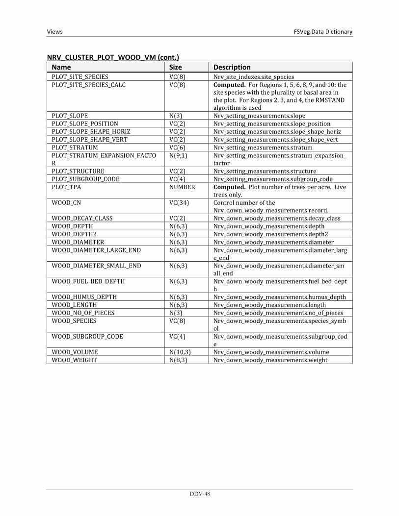
Views FSVeg Data Dictionary NRV_CLUSTER_PLOT_WOOD_VM (cont.)
Name Size Description PLOT_SITE_SPECIES VC(8) Nrv_site_indexes.site_species PLOT_SITE_SPECIES_CALC VC(8) Computed. For Regions 1, 5, 6, 8, 9, and 10: the
site species with the plurality of basal area in the plot. For Regions 2, 3, and 4, the RMSTAND algorithm is used
PLOT_SLOPE N(3) Nrv_setting_measurements.slope PLOT_SLOPE_POSITION VC(2) Nrv_setting_measurements.slope_position PLOT_SLOPE_SHAPE_HORIZ VC(2) Nrv_setting_measurements.slope_shape_horiz PLOT_SLOPE_SHAPE_VERT VC(2) Nrv_setting_measurements.slope_shape_vert PLOT_STRATUM VC(6) Nrv_setting_measurements.stratum PLOT_STRATUM_EXPANSION_FACTOR
N(9,1) Nrv_setting_measurements.stratum_expansion_factor
PLOT_STRUCTURE VC(2) Nrv_setting_measurements.structure PLOT_SUBGROUP_CODE VC(4) Nrv_setting_measurements.subgroup_code PLOT_TPA NUMBER Computed. Plot number of trees per acre. Live
trees only. WOOD_CN VC(34) Control number of the
Nrv_down_woody_measurements record. WOOD_DECAY_CLASS VC(2) Nrv_down_woody_measurements.decay_class WOOD_DEPTH N(6,3) Nrv_down_woody_measurements.depth WOOD_DEPTH2 N(6,3) Nrv_down_woody_measurements.depth2 WOOD_DIAMETER N(6,3) Nrv_down_woody_measurements.diameter WOOD_DIAMETER_LARGE_END N(6,3) Nrv_down_woody_measurements.diameter_larg
e_end WOOD_DIAMETER_SMALL_END N(6,3) Nrv_down_woody_measurements.diameter_sm
all_end WOOD_FUEL_BED_DEPTH N(6,3) Nrv_down_woody_measurements.fuel_bed_dept
h WOOD_HUMUS_DEPTH N(6,3) Nrv_down_woody_measurements.humus_depth WOOD_LENGTH N(6,3) Nrv_down_woody_measurements.length WOOD_NO_OF_PIECES N(3) Nrv_down_woody_measurements.no_of_pieces WOOD_SPECIES VC(8) Nrv_down_woody_measurements.species_symb
ol WOOD_SUBGROUP_CODE VC(4) Nrv_down_woody_measurements.subgroup_cod
e WOOD_VOLUME N(10,3) Nrv_down_woody_measurements.volume WOOD_WEIGHT N(8,3) Nrv_down_woody_measurements.weight
DDV-48
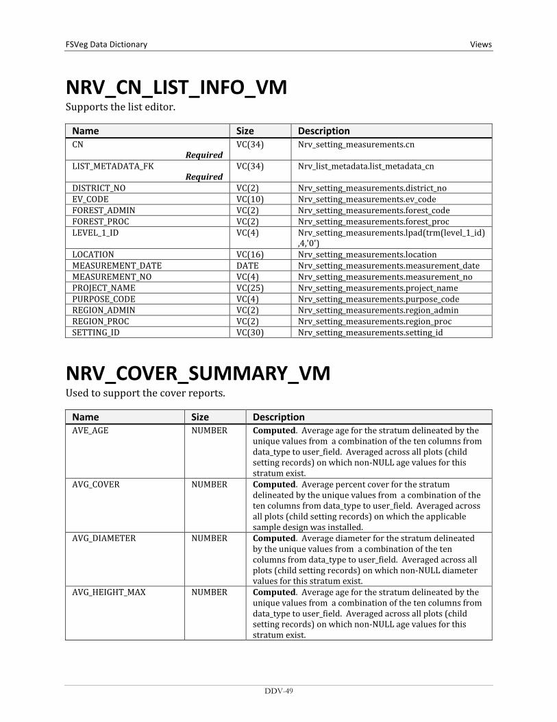
FSVeg Data Dictionary Views
NRV_CN_LIST_INFO_VM Supports the list editor.
Name Size Description CN
Required VC(34) Nrv_setting_measurements.cn
LIST_METADATA_FK Required
VC(34) Nrv_list_metadata.list_metadata_cn
DISTRICT_NO VC(2) Nrv_setting_measurements.district_no EV_CODE VC(10) Nrv_setting_measurements.ev_code FOREST_ADMIN VC(2) Nrv_setting_measurements.forest_code FOREST_PROC VC(2) Nrv_setting_measurements.forest_proc LEVEL_1_ID VC(4) Nrv_setting_measurements.lpad(trm(level_1_id)
,4,'0') LOCATION VC(16) Nrv_setting_measurements.location MEASUREMENT_DATE DATE Nrv_setting_measurements.measurement_date MEASUREMENT_NO VC(4) Nrv_setting_measurements.measurement_no PROJECT_NAME VC(25) Nrv_setting_measurements.project_name PURPOSE_CODE VC(4) Nrv_setting_measurements.purpose_code REGION_ADMIN VC(2) Nrv_setting_measurements.region_admin REGION_PROC VC(2) Nrv_setting_measurements.region_proc SETTING_ID VC(30) Nrv_setting_measurements.setting_id
NRV_COVER_SUMMARY_VM Used to support the cover reports.
Name Size Description AVE_AGE NUMBER Computed. Average age for the stratum delineated by the
unique values from a combination of the ten columns from data_type to user_field. Averaged across all plots (child setting records) on which non-NULL age values for this stratum exist.
AVG_COVER NUMBER Computed. Average percent cover for the stratum delineated by the unique values from a combination of the ten columns from data_type to user_field. Averaged across all plots (child setting records) on which the applicable sample design was installed.
AVG_DIAMETER NUMBER Computed. Average diameter for the stratum delineated by the unique values from a combination of the ten columns from data_type to user_field. Averaged across all plots (child setting records) on which non-NULL diameter values for this stratum exist.
AVG_HEIGHT_MAX NUMBER Computed. Average age for the stratum delineated by the unique values from a combination of the ten columns from data_type to user_field. Averaged across all plots (child setting records) on which non-NULL age values for this stratum exist.
DDV-49

Views FSVeg Data Dictionary NRV_COVER_SUMMARY_VM (cont.)
Name Size Description AVG_HEIGHT_MIN NUMBER Computed. Average minimum height for the stratum
delineated by the unique values from a combination of the ten columns from data_type to user_field. Averaged across all plots (child setting records) on which non-NULL minimum height values for this stratum exist.
AVG_HT NUMBER Computed. Average height for the stratum delineated by the unique values from a combination of the ten columns from data_type to user_field. Averaged across all plots (child setting records) on which non-NULL height values for this stratum exist.
AVG_MATURITY VC(2) Computed. Average maturity for the stratum delineated by the unique values from a combination of the ten columns from data_type to user_field. Averaged across all plots (child setting records) on which non-NULL maturity values for this stratum exist.
DATA_TYPE VC(15) A code used to indicate the type of data this compiled record represents; the value determines in which subreport this record would appear.
Code Description 'FORM 1 VEG COMP' v1.7+, CSE Form 1 Veg
Comp.* 'FORM 2 VEG COMP' v1.7+, CSE Form 2 Veg
Comp.* 'FORM 3 VEG COMP' v1.7+, CSE Form 3 Veg
Comp.* 'FORM 4 SURFACE' v1.7+, CSE Form 4 Surface.* 'VEGETATION' pre-v1.7 CSE and legacy
vegetation composition data. 'SURFACE' pre-v1.7 CSE and legacy
surface cover data. *New CSE Vegetation Composition and Surface Cover Protocols were developed in 2004 as part of the NRIS Common OCMA effort and were incorporated with FSVeg v.1.7 in 2005.
LAYER VC(3) Nrv_cover_measurements.layer LAYER_CODE_LOCAL VC(2) Nrv_cover_measurements.layer_code_local LIFEFORM_CODE VC(2) Nrv_cover_measurements.lifeform_code LIVE_DEAD VC(1) Nrv_cover_measurements.live_dead PARENT_CN VC(34) Nrv_setting_measurements.cn SELECTION_CRITERIA_NO VC(3) Nrv_selection_criteria.selection_criteria_no SPECIES_SYMBOL VC(8) Nrv_cover_measurements.species_symbol SURFACE_COVER_CODE VC(4) Nrv_cover_measurements.surface_cover_code USER_FIELD VC(10) Nrv_cover_measurements.data_code_1
DDV-50

FSVeg Data Dictionary Views
NRV_CSE_ALL_VM A view that displays all CSE data associated with a given setting.
Name Size Description STAND_CN VC(34) Foreign key to the stand record in Nrv_setting_measurements PLOT_CN VC(34) Foreign key to the plot record in Nrv_setting_measurements
record. SAMPLE_CN VC(34) Foreign key to the sample design record in Nrv_sample_design SELCRIT_CN VC(34) Foreign key to Nrv_selection_criteria. TREE_CN VC(34) Foreign key to the tree record in Nrv_tree_measurements
record GROUND_SURFACE_COVER_ CN
VC(0) Foreign key to the surface cover record in Nrv_cover_measurements
DOWN_WOODY_CN VC(34) Foreign key to down woody record in Nrv_down_woody_measurements
VEG_COMP_CN VC(34) Foreign key to the vegetation record in Nrv_cover_measurements
ADMIN_FOREST VC(2) Nrv_setting_measurements.forest_admin ADMIN_REGION VC(2) Nrv_setting_measurements.region_admin ARCHIVE_FLAG VC(1) Flag to indicate this setting measurement record does not
represent the current status of the vegetation. Y = Yes, this is an archived record.
BROWNS_1000HR_ROTTEN_CUBIC
NUMBER Computed. Stand 1000-hour rotten fuel cubic foot per acre.
BROWNS_1000HR_ROTTEN_DIA_AVG
NUMBER Computed. Stand 1000-hour rotten average diameter.
BROWNS_1000HR_ROTTEN_TONS
NUMBER Computed. Stand 1000-hour rotten fuel tons per acre.
BROWNS_1000HR_SOUND_CUBIC
NUMBER Computed. Stand 1000-hour sound fuel cubic foot per acre.
BROWNS_1000HR_SOUND_DIA_AVG
NUMBER Computed. Stand 1000-hour sound average diameter.
BROWNS_1000HR_SOUND_TONS
NUMBER Computed. Stand 1000-hour sound fuel tons per acre.
BROWNS_100HR_CUBIC NUMBER Computed. Stand 100-hour fuel cubic foot per acre. BROWNS_100HR_TONS NUMBER Computed. Stand 100-hour fuel tons per acre. BROWNS_10HR_CUBIC NUMBER Computed. Stand 10-hour fuel cubic foot per acre. BROWNS_10HR_TONS NUMBER Computed. Stand 10-hour fuel tons per acre. BROWNS_1HR_CUBIC NUMBER Computed. Stand 1-hour fuel cubic foot per acre. BROWNS_1HR_TONS NUMBER Computed. Stand 1-hour fuel tons per acre. BROWNS_DUFF_DEPTH_ AVG
NUMBER Computed. Stand average duff depth.
BROWNS_DUFF_TONS_AVG NUMBER Computed. The stand level average duff tons per acre estimate from a Brown’s 1- or 2- sample point survey for duff. The estimate is derived using: duff tons/acre = (average duff depth * 10 tons/inch)
BROWNS_FUEL_DEPTH_ AVG
NUMBER Computed. Stand average fuel depth.
DDV-51

Views FSVeg Data Dictionary NRV_CSE_ALL_VM (cont.)
Name Size Description DOWN_PIECES_5_MINUS NUMBER The stand level average downed woody material piece per
acre estimate from a Brown’s planat transect survey for pieces from 3 to 4.99 inches in diameter. The estimate is derived from the transect data using: pieces/acres for the size class = sum [(pi * 43560 * piece count) / (2 * plot transect length * plots installed * piece length)]
DOWN_PIECES_5_10 NUMBER The stand level average downed woody material piece per acre estimate from a Brown’s planat transect survey for pieces from 5 to 9.99 inches in diameter. The estimate is derived from the transect data using: pieces/acres for the size class = sum [(pi * 43560 * piece count) / (2 * plot transect length * plots installed * piece length)]
DOWN_PIECES_10_15 NUMBER The stand level average downed woody material piece per acre estimate from a Brown’s planat transect survey for pieces from 10 to 14.99 inches in diameter. The estimate is derived from the transect data using: pieces/acres for the size class = sum [(pi * 43560 * piece count) / (2 * plot transect length * plots installed * piece length)]
DOWN_PIECES_15_20 NUMBER The stand level average downed woody material piece per acre estimate from a Brown’s planat transect survey for pieces from 15 to 19.99 inches in diameter. The estimate is derived from the transect data using: pieces/acres for the size class = sum [(pi * 43560 * piece count) / (2 * plot transect length * plots installed * piece length)]
DOWN_PIECES_20_25 NUMBER The stand level average downed woody material piece per acre estimate from a Brown’s planat transect survey for pieces from 20 to 24.99 inches in diameter. The estimate is derived from the transect data using: pieces/acres for the size class = sum [(pi * 43560 * piece count) / (2 * plot transect length * plots installed * piece length)]
DOWN_PIECES_25_30 NUMBER The stand level average downed woody material piece per acre estimate from a Brown’s planat transect survey for pieces from 25 to 29.99 inches in diameter. The estimate is derived from the transect data using: pieces/acres for the size class = sum [(pi * 43560 * piece count) / (2 * plot transect length * plots installed * piece length)]
DOWN_PIECES_30_35 NUMBER The stand level average downed woody material piece per acre estimate from a Brown’s planat transect survey for pieces from 30 to 34.99 inches in diameter. The estimate is derived from the transect data using: pieces/acres for the size class = sum [(pi * 43560 * piece count) / (2 * plot transect length * plots installed * piece length)]
DOWN_PIECES_35_40 NUMBER The stand level average downed woody material piece per acre estimate from a Brown’s planat transect survey for pieces from 35 to 39.99 inches in diameter. The estimate is derived from the transect data using: pieces/acres for the size class = sum [(pi * 43560 * piece count) / (2 * plot transect length * plots installed * piece length)]
DDV-52

FSVeg Data Dictionary Views
NRV_CSE_ALL_VM (cont.) Name Size Description DOWN_PIECES_40_45 NUMBER The stand level average downed woody material piece per
acre estimate from a Brown’s planat transect survey for pieces from 40 to 44.99 inches in diameter. The estimate is derived from the transect data using: pieces/acres for the size class = sum [(pi * 43560 * piece count) / (2 * plot transect length * plots installed * piece length)]
DOWN_PIECES_45_PLUS NUMBER The stand level average downed woody material piece per acre estimate from a Brown’s planat transect survey for pieces from 45 inches and up in diameter. The estimate is derived from the transect data using: pieces/acres for the size class = sum [(pi * 43560 * piece count) / (2 * plot transect length * plots installed * piece length)]
FUEL_INIT_3 NUMBER Number of down woody pieces 3-6 inches in diameter FUEL_INIT_4 NUMBER Number of down woody pieces 6-12 inches in diameter FUEL_INIT_5 NUMBER Number of down woody pieces 12 + inches in diameter COUNTY VC(3) Nrv_setting_measurements.county DISTRICT VC(2) Nrv_setting_measurements.district EXAM_LEVEL_DW VC(1) Nrv_setting_measurements.sample_design_dw EXAM_LEVEL_SC VC(1) Nrv_setting_measurements.sample_design_sc EXAM_LEVEL_TREE VC(1) Nrv_setting_measurements.sample_design_tree EXAM_LEVEL_VEG VC(1) Nrv_setting_measurements.sample_design_veg EXAM_PURPOSE VC(4) Nrv_exam_purpose_codes.purpose_code GS_COVER_PERCENT NUMBER Nrv_cover_measurements.cover_percent GS_COVER_REMARKS VC(255) Nrv_cover_measurements.remarks GS_COVER_SURFACE_CODE VC(4) Nrv_surface_cover_types.surface_cover_code HARDWOOD_SOFTWOOD VC(4) Computed. Valid values are “HARD” or “SOFT” HEIGHT_TO_BREAK NUMBER Nrv_tree_measurements.height_to_break LOCATION VC(16) Nrv_setting_measurements.location MEASUREMENT_DATE DATE Nrv_setting_measurements.measurement_date MEASUREMENT_NO VC(2) Nrv_setting_measurements.measurement_no PHOTO_ID VC(4000) Nrv_arial_photos.photo_id via setting_measurements.airph_cn PROC_FOREST VC(2) Nrv_setting_measurements.forest_proc PROC_REGION VC(2) Nrv_setting_measurements.region_proc PROJECT_NAME VC(25) Nrv_setting_measurements.project_name SAMPLE_EXPANSION_ FACTOR
NUMBER Nrv_sample_designs.sample_expansion_factor
SAMPLE_REMARKS VC(255) Nrv_sample_designs.remarks SAMPLE_SELECT_METHOD_ TYPE
VC(3) Nrv_sample_design_subgroups.selection_method_type
SAMPLE_STARTING_AZIMUTH
NUMBER Nrv_tree_measurements.azimuth
SELCRIT_NUMBER VC(3) Nrv_selcrit_subgroups.selection_criteria_no SELCRIT_SUBPOP_FILTER VC(8) Nrv_selcrit_subgroups.subpop_code_value SELCRIT_SUBPOP_MAX_ VALUE
NUMBER Nrv_Selcrit_Subgroups.subpop_max_value
SELCRIT_SUBPOP_MIN_ VALUE
NUMBER Nrv_selcrit_subgroups.subpop_min_value
SELCRIT_SUBPOP_VARIABLE VC(3) Nrv_selcrit_subgroups.subpop SETTING_ID VC(30) Nrv_setting_measurements.setting_id
DDV-53

Views FSVeg Data Dictionary NRV_CSE_ALL_VM (cont.)
Name Size Description STAND VC(10) Nrv_setting_measurements.level_1_id STAND_ACRES N(8,4) Nrv_setting_measurements.setting_size STAND_ASPECT N(3) Nrv_setting_measurements.aspect STAND_BA NUMBER Computed. Stand level basal area per acre (live, on plot trees
only). STAND_BOARD_VOLUME NUMBER Computed. Stand level board foot volume per acre (live, on
plot trees only). STAND_CAPABLE_GROW_AREA_PCT
N(3) Nrv_setting_measurements.capable_grow_area_pct
STAND_CUBIC_VOLUME NUMBER Computed. Stand level cubic volume per acre (live, on plot trees only).
STAND_DISTURB_AGENT1 VC(3) Nrv_setting_disturbances.agent_code STAND_DISTURB_AGENT2 VC(3) Nrv_setting_disturbances.agent_code STAND_DISTURB_AGENT3 VC(3) Nrv_setting_disturbances.agent_code STAND_DISTURB_AGENT4 VC(3) Nrv_setting_disturbances.agent_code STAND_DISTURB_AGENT5 VC(3) Nrv_setting_disturbances.agent_code STAND_DISTURB_AGENT_ SEV1
VC(3) Nrv_setting_disturbances.severity_rating_code
STAND_DISTURB_AGENT_ SEV2
VC(3) Nrv_setting_disturbances.severity_rating_code
STAND_DISTURB_AGENT_ SEV3
VC(3) Nrv_setting_disturbances.severity_rating_code
STAND_DISTURB_AGENT_ SEV4
VC(3) Nrv_setting_disturbances.severity_rating_code
STAND_DISTURB_AGENT_ SEV5
VC(3) Nrv_setting_disturbances.severity_rating_code
STAND_DISTURB_CATEGORY1
VC(2) Nrv_setting_disturbances.category_code
STAND_DISTURB_CATEGORY2
VC(3) Nrv_setting_disturbances.category_code
STAND_DISTURB_CATEGORY3
VC(3) Nrv_setting_disturbances.category_code
STAND_DISTURB_CATEGORY4
VC(3) Nrv_setting_disturbances.category_code
STAND_DISTURB_CATEGORY5
VC(3) Nrv_setting_disturbances.category_code
STAND_DISTURB_EFFECT1 VC(3) Nrv_setting_disturbances.effect_code STAND_DISTURB_EFFECT2 VC(3) Nrv_setting_disturbances.effect_code STAND_DISTURB_EFFECT3 VC(3) Nrv_setting_disturbances.effect_code STAND_DISTURB_EFFECT4 VC(3) Nrv_setting_disturbances.effect_code STAND_DISTURB_EFFECT5 VC(3) Nrv_setting_disturbances.effect_code STAND_DISTURB_EFFECT_ SEV1
VC(3) Nrv_setting_disturbances.effect_severity
STAND_DISTURB_EFFECT_ SEV2
VC(3) Nrv_setting_disturbances.effect_severity
STAND_DISTURB_EFFECT_ SEV3
VC(3) Nrv_setting_disturbances.effect_severity
STAND_DISTURB_EFFECT_ SEV4
VC(3) Nrv_setting_disturbances.effect_severity
DDV-54
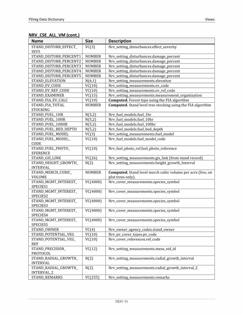
FSVeg Data Dictionary Views
NRV_CSE_ALL_VM (cont.) Name Size Description STAND_DISTURB_EFFECT_ SEV5
VC(3) Nrv_setting_disturbances.effect_severity
STAND_DISTURB_PERCENT1 NUMBER Nrv_setting_disturbances.damage_percent STAND_DISTURB_PERCENT2 NUMBER Nrv_setting_disturbances.damage_percent STAND_DISTURB_PERCENT3 NUMBER Nrv_setting_disturbances.damage_percent STAND_DISTURB_PERCENT4 NUMBER Nrv_setting_disturbances.damage_percent STAND_DISTURB_PERCENT5 NUMBER Nrv_setting_disturbances.damage_percent STAND_ELEVATION N(6,1) Nrv_setting_measurements.elevation STAND_EV_CODE VC(10) Nrv_setting_measurements.ev_code STAND_EV_REF_CODE VC(10) Nrv_setting_measurements.ev_ref_code STAND_EXAMINER VC(15) Nrv_setting_measurements.measurement_organization STAND_FIA_EV_CALC VC(10) Computed. Forest type using the FIA algorithm STAND_FIA_TOTAL STOCKING
NUMBER Computed. Stand level tree stocking using the FIA algorithm
STAND_FUEL_1HR N(5,2) Nrv_fuel_models.fuel_1hr STAND_FUEL_10HR N(5,2) Nrv_fuel_models.fuel_10hr STAND_FUEL_100HR N(5,2) Nrv_fuel_models.fuel_100hr STAND_FUEL_BED_DEPTH N(5,2) Nrv_fuel_models.fuel_bed_depth STAND_FUEL_MODEL VC(3) Nrv_setting_measurements.fuel_model STAND_FUEL_MODEL_ CODE
VC(10) Nrv_fuel_models.fuel_model_code
STAND_FUEL_PHOTO_ EFERENCE
VC(10) Nrv_fuel_photo_ref.fuel_photo_reference
STAND_GIS_LINK VC(26) Nrv_setting_measurements.gis_link (from stand record) STAND_HEIGHT_GROWTH_ INTERVAL
N(2) Nrv_setting_measurements.height_growth_Interval
STAND_MERCH_CUBIC_ VOLUME
NUMBER Computed. Stand level merch cubic volume per acre (live, on plot trees only).
STAND_MGMT_INTEREST_ SPECIES1
VC(4000) Nrv_cover_measurements.species_symbol
STAND_MGMT_INTEREST_ SPECIES2
VC(4000) Nrv_cover_measurements.species_symbol
STAND_MGMT_INTEREST_ SPECIES3
VC(4000) Nrv_cover_measurements.species_symbol
STAND_MGMT_INTEREST_ SPECIES4
VC(4000) Nrv_cover_measurements.species_symbol
STAND_MGMT_INTEREST_ SPECIES5
VC(4000) Nrv_cover_measurements.species_symbol
STAND_OWNER VC(4) Nrv_owner_agency_codes.stand_owner STAND_POTENTIAL_VEG VC(10) Nrv_pv_cover_types.pv_code STAND_POTENTIAL_VEG_ REF
VC(10) Nrv_cover_references.ref_code
STAND_PRECISION_ PROTOCOL
VC(12) Nrv_setting_measurements.meas_std_id
STAND_RADIAL_GROWTH_ INTERVAL
N(2) Nrv_setting_measurements.radial_growth_interval
STAND_RADIAL_GROWTH_ INTERVAL_2
N(2) Nrv_setting_measurements.radial_growth_interval_2
STAND_REMARKS VC(255) Nrv_setting_measurements.remarks
DDV-55

Views FSVeg Data Dictionary NRV_CSE_ALL_VM (cont.)
Name Size Description STAND_SLOPE N(3) Nrv_setting_measurements.slope STAND_SLOPE_POSITION VC(2) Nrv_setting_measurements.slope_position STAND_STRATUM VC(6) Nrv_setting_measurements.stratum STAND_STRUCTURE VC(2) Nrv_setting_measurements.structure STAND_TPA NUMBER Computed. Stand level trees per acre (live, on plot trees only). STAND_USER_CODE VC(4000) Nrv_data_code_setmeas.data STAND_VSS VC(6) Computed. Vegetation structural stage for Regions 2, 3 and 4
only. STATE VC(2) Nrv_setting_measurements.state PLOT_ASPECT N(3) Nrv_setting_measurements.aspect PLOT_BA NUMBER Computed. Plot level basal area per acre (live, on plot trees
only). PLOT_BOARD_VOLUME NUMBER Computed. Plot level board volume per acre (live, on plot
trees only). PLOT_CAPABLE_GROW_ AREA_PCT
N(3) Nrv_setting_measurements.capable_grow_area_pct
PLOT_COUNT_PLOTS_ INSTALLED
NUMBER Nrv_plot_counts.standard_no_plots
PLOT_CUBIC_VOLUME NUMBER Computed. Plot level cubic volume per acre (live, on plot trees only).
PLOT_ELEVATION N(6,1) Nrv_setting_measurements.elevation PLOT_EV_REF VC(10) Nrv_setting_measurements.ev_ref_code PLOT_EXISTING_VEG VC(10) Nrv_setting_measurements.ev_code PLOT_FUEL_1HR N(5,2) Nrv_fuel_models.fuel_1hr PLOT_FUEL_10HR N(5,2) Nrv_fuel_models.fuel_10hr PLOT_FUEL_100HR N(5,2) Nrv_fuel_models.fuel_100hr PLOT_FUEL_BED_DEPTH N(5,2) Nrv_fuel_models.fuel_bed_depth PLOT_FUEL_MODEL VC(3) Nrv_setting_measurements.fuel_model PLOT_FUEL_MODEL_CODE VC(10) Nrv_fuel_models.fuel_model_code PLOT_FUEL_PHOTO_CN VC(34) Nrv_fuel_photos.fuel_photo_cn PLOT_FUEL_PHOTO_ REFERENCE
VC(10) Nrv_fuel_photos.fuel_photo.reference
PLOT_FVS_DUFF N(5,1) Nrv_fuel_photos.fvs_duff PLOT_FVS_FUEL01 N(5,1) Nrv_fuel_photos.fvs_fuel01 PLOT_FVS_FUEL13 N(5,1) Nrv_fuel_photos.fvs_fuel13 PLOT_FVS_FUEL36 N(5,1) Nrv_fuel_photos.fvs_fuel36 PLOT_FVS_FUEL612 N(5,1) Nrv_fuel_photos.fvs_fuel612 PLOT_FVS_FUEL12P N(5,1) Nrv_fuel_photos.fvs_fuel12p PLOT_FVS_LITTER N(5,1) Nrv_fuel_photos.fvs_litter PLOT_GIS_LINK VC(26) Nrv_setting_measurement.gis_link (from plot record) PLOT_HISTORY_DATE1 DATE Nrv_Setting_histories.history_date PLOT_HISTORY_DATE2 DATE Nrv_Setting_histories.history_date PLOT_HISTORY_DATE3 DATE Nrv_Setting_histories.history_date PLOT_HISTORY1 VC(6) Nrv_Setting_histories.history_code PLOT_HISTORY2 VC(6) Nrv_Setting_histories.history_code PLOT_HISTORY3 VC(6) Nrv_Setting_histories.history_code PLOT_LATITUDE_DEG N(3) Nrv_setting_measurements.latitude_deg PLOT_LATITUDE_MIN N(2) Nrv_setting_measurements.latitude_min
DDV-56
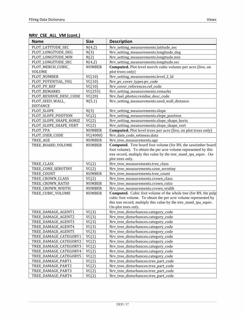
FSVeg Data Dictionary Views
NRV_CSE_ALL_VM (cont.) Name Size Description PLOT_LATITUDE_SEC N(4,2) Nrv_setting_measurements.latitude_sec PLOT_LONGITUDE_DEG N(3) Nrv_setting_measurements.longitude_deg PLOT_LONGITUDE_MIN N(2) Nrv_setting_measurements.longitude.min PLOT_LONGITUDE_SEC N(4,2) Nrv_setting_measurements.longitude.sec PLOT_MERCH_CUBIC_ VOLUME
NUMBER Computed. Plot level merch cubic volume per acre (live, on plot trees only)
PLOT_NUMBER VC(10) Nrv_setting_measurements.level_2_Id PLOT_POTENTIAL_VEG VC(10) Nrv_pv_cover_types.pv_code PLOT_PV_REF VC(10) Nrv_cover_references.ref_code PLOT_REMARKS VC(255) Nrv_setting_measurements.remarks PLOT_RESIDUE_DESC_CODE VC(20) Nrv_fuel_photos.residue_desc_code PLOT_SEED_WALL_ DISTANCE
N(5,1) Nrv_setting_measurements.seed_wall_distance
PLOT_SLOPE N(3) Nrv_setting_measurements.slope PLOT_SLOPE_POSITION VC(2) Nrv_setting_measurements.slope_position PLOT_SLOPE_SHAPE_HORIZ VC(2) Nrv_setting_measurements.slope_shape_horiz PLOT_SLOPE_SHAPE_VERT VC(2) Nrv_setting_measurements.slope_shape_vert PLOT_TPA NUMBER Computed. Plot level trees per acre (live, on plot trees only) PLOT_USER_CODE VC(4000) Nrv_date_code_setmeas.data TREE_AGE NUMBER Nrv_tree_measurements.age TREE_BOARD_VOLUME NUMBER Computed. Tree board foot volume (for R9, the sawtimber board
foot volume). To obtain the per acre volume represented by this tree record, multiply this value by the tree_stand_tpa_equiv. On-plot trees only.
TREE_CLASS VC(2) Nrv_tree_measurements.tree_class TREE_CONE_SEROTINY VC(2) Nrv_tree_measurements.cone_serotiny TREE_COUNT NUMBER Nrv_tree_measurements.tree_count TREE_CROWN_CLASS VC(2) Nrv_tree_measurements.crown_class TREE_CROWN_RATIO NUMBER Nrv_tree_measurements.crown_ratio TREE_CROWN_WIDTH NUMBER Nrv_tree_measurements.crown_width TREE_CUBIC_VOLUME NUMBER Computed. Cubic foot volume of the whole tree (for R9, the pulp
cubic foot volume. To obtain the per acre volume represented by this tree record, multiply this value by the tree_stand_tpa_equiv. On-plot trees only.
TREE_DAMAGE_AGENT1 VC(3) Nrv_tree_disturbances.category_code TREE_DAMAGE_AGENT2 VC(3) Nrv_tree_disturbances.category_code TREE_DAMAGE_AGENT3 VC(3) Nrv_tree_disturbances.category_code TREE_DAMAGE_AGENT4 VC(3) Nrv_tree_disturbances.category_code TREE_DAMAGE_AGENT5 VC(3) Nrv_tree_disturbances.category_code TREE_DAMAGE_CATEGORY1 VC(2) Nrv_tree_disturbances.category_code TREE_DAMAGE_CATEGORY2 VC(2) Nrv_tree_disturbances.category_code TREE_DAMAGE_CATEGORY3 VC(2) Nrv_tree_disturbances.category_code TREE_DAMAGE_CATEGORY4 VC(2) Nrv_tree_disturbances.category_code TREE_DAMAGE_CATEGORY5 VC(2) Nrv_tree_disturbances.category_code TREE_DAMAGE_PART1 VC(2) Nrv_tree_disturbances.tree_part_code TREE_DAMAGE_PART2 VC(2) Nrv_tree_disturbances.tree_part_code TREE_DAMAGE_PART3 VC(2) Nrv_tree_disturbances.tree_part_code TREE_DAMAGE_PART4 VC(2) Nrv_tree_disturbances.tree_part_code
DDV-57
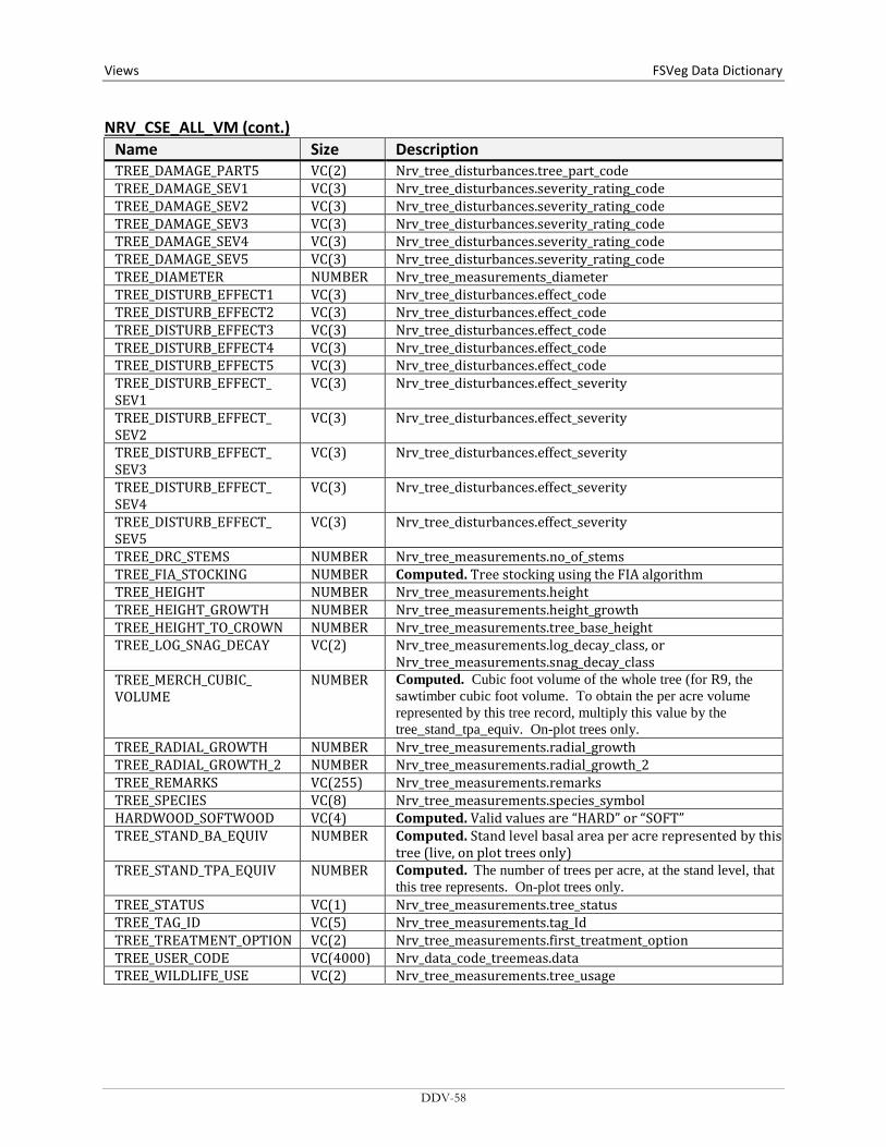
Views FSVeg Data Dictionary NRV_CSE_ALL_VM (cont.)
Name Size Description TREE_DAMAGE_PART5 VC(2) Nrv_tree_disturbances.tree_part_code TREE_DAMAGE_SEV1 VC(3) Nrv_tree_disturbances.severity_rating_code TREE_DAMAGE_SEV2 VC(3) Nrv_tree_disturbances.severity_rating_code TREE_DAMAGE_SEV3 VC(3) Nrv_tree_disturbances.severity_rating_code TREE_DAMAGE_SEV4 VC(3) Nrv_tree_disturbances.severity_rating_code TREE_DAMAGE_SEV5 VC(3) Nrv_tree_disturbances.severity_rating_code TREE_DIAMETER NUMBER Nrv_tree_measurements_diameter TREE_DISTURB_EFFECT1 VC(3) Nrv_tree_disturbances.effect_code TREE_DISTURB_EFFECT2 VC(3) Nrv_tree_disturbances.effect_code TREE_DISTURB_EFFECT3 VC(3) Nrv_tree_disturbances.effect_code TREE_DISTURB_EFFECT4 VC(3) Nrv_tree_disturbances.effect_code TREE_DISTURB_EFFECT5 VC(3) Nrv_tree_disturbances.effect_code TREE_DISTURB_EFFECT_ SEV1
VC(3) Nrv_tree_disturbances.effect_severity
TREE_DISTURB_EFFECT_ SEV2
VC(3) Nrv_tree_disturbances.effect_severity
TREE_DISTURB_EFFECT_ SEV3
VC(3) Nrv_tree_disturbances.effect_severity
TREE_DISTURB_EFFECT_ SEV4
VC(3) Nrv_tree_disturbances.effect_severity
TREE_DISTURB_EFFECT_ SEV5
VC(3) Nrv_tree_disturbances.effect_severity
TREE_DRC_STEMS NUMBER Nrv_tree_measurements.no_of_stems TREE_FIA_STOCKING NUMBER Computed. Tree stocking using the FIA algorithm TREE_HEIGHT NUMBER Nrv_tree_measurements.height TREE_HEIGHT_GROWTH NUMBER Nrv_tree_measurements.height_growth TREE_HEIGHT_TO_CROWN NUMBER Nrv_tree_measurements.tree_base_height TREE_LOG_SNAG_DECAY VC(2) Nrv_tree_measurements.log_decay_class, or
Nrv_tree_measurements.snag_decay_class TREE_MERCH_CUBIC_ VOLUME
NUMBER Computed. Cubic foot volume of the whole tree (for R9, the sawtimber cubic foot volume. To obtain the per acre volume represented by this tree record, multiply this value by the tree_stand_tpa_equiv. On-plot trees only.
TREE_RADIAL_GROWTH NUMBER Nrv_tree_measurements.radial_growth TREE_RADIAL_GROWTH_2 NUMBER Nrv_tree_measurements.radial_growth_2 TREE_REMARKS VC(255) Nrv_tree_measurements.remarks TREE_SPECIES VC(8) Nrv_tree_measurements.species_symbol HARDWOOD_SOFTWOOD VC(4) Computed. Valid values are “HARD” or “SOFT” TREE_STAND_BA_EQUIV NUMBER Computed. Stand level basal area per acre represented by this
tree (live, on plot trees only) TREE_STAND_TPA_EQUIV NUMBER Computed. The number of trees per acre, at the stand level, that
this tree represents. On-plot trees only. TREE_STATUS VC(1) Nrv_tree_measurements.tree_status TREE_TAG_ID VC(5) Nrv_tree_measurements.tag_Id TREE_TREATMENT_OPTION VC(2) Nrv_tree_measurements.first_treatment_option TREE_USER_CODE VC(4000) Nrv_data_code_treemeas.data TREE_WILDLIFE_USE VC(2) Nrv_tree_measurements.tree_usage
DDV-58

FSVeg Data Dictionary Views
NRV_CSE_ALL_VM (cont.) Name Size Description VEG_COMP_AVG_DIAMETER NUMBER Nrv_cover_measurements.diameter VEG_COMP_AVG_HEIGHT NUMBER Nrv_cover_measurements.height VEG_COMP_CANOPY_COVER NUMBER Nrv_characterizations.canopy_cover VEG_COMP_LAYER VC(3) Nrv_cover_layers.layer VEG_COMP_LIFEFORM VC(2) Nrv_cover_measurements.lifeform VEG_COMP_LIVE_DEAD VC(1) Nrv_cover_measurements.live_dead VEG_COMP_LOCAL_LAYER VC(2) Nrv_cover_measurements.layer_code_local VEG_COMP_MATURITY VC(2) Nrv_cover_measurements.shrub_age_class VEG_COMP_MAX_HEIGHT NUMBER Nrv_cover_measurements.height_max VEG_COMP_MIN_HEIGHT NUMBER Nrv_cover_measurements.height_min VEG_COMP_REMARKS VC(255) Nrv_cover_measurements.remarks VEG_COMP_SPECIES VC(8) Nrv_cover_measurements.species_symbol VEG_COMP_USER_CODE VC(10) Nrv_data_code_covmeas.data WOOD_DECAY_CLASS VC(2) Nrv_down_woody_measurements.decay_class WOOD_DIAMETER NUMBER Nrv_down_woody_measurements.diameter WOOD_DIAMETER_LARGE_ END
NUMBER Nrv_down_woody_measurements.diameter_large_end
WOOD_DIAMETER_SMALL_ END
NUMBER Nrv_down_woody_measurements.diameter_small_end
WOOD_FIRST_DUFF NUMBER Nrv_down_woody_measurements.litter_1 WOOD_FUEL_DEPTH NUMBER Nrv_down_woody_measurements.fuel_bed_depth WOOD_PIECE_COUNT NUMBER Nrv_down_woody_measurements.no_of_pieces WOOD_PIECE_LENGTH NUMBER Nrv_down_woody_measurements.length WOOD_SECOND_DUFF NUMBER Nrv_down_woody_measurements.litter_2 WOOD_VOLUME NUMBER Nrv_down_woody_measurements.volume WOOD_WEIGHT NUMBER Nrv_down_woody_measurements.weight
DDV-59
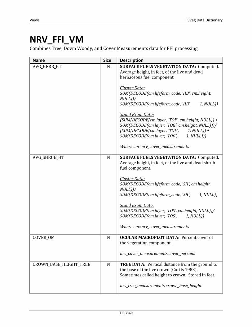
Views FSVeg Data Dictionary
NRV_FFI_VM Combines Tree, Down Woody, and Cover Measurements data for FFI processing.
Name Size Description AVG_HERB_HT N SURFACE FUELS VEGETATION DATA: Computed.
Average height, in feet, of the live and dead herbaceous fuel component. Cluster Data: SUM(DECODE(cm.lifeform_code, 'HB', cm.height, NULL))/ SUM(DECODE(cm.lifeform_code, 'HB', 1, NULL)) Stand Exam Data: (SUM(DECODE(cm.layer, 'TOF', cm.height, NULL)) + SUM(DECODE(cm.layer, 'TOG', cm.height, NULL)))/ (SUM(DECODE(cm.layer, 'TOF', 1, NULL)) + SUM(DECODE(cm.layer, 'TOG', 1, NULL))) Where cm=nrv_cover_measurements
AVG_SHRUB_HT N SURFACE FUELS VEGETATION DATA: Computed. Average height, in feet, of the live and dead shrub fuel component. Cluster Data: SUM(DECODE(cm.lifeform_code, 'SH', cm.height, NULL))/ SUM(DECODE(cm.lifeform_code, 'SH', 1, NULL)) Stand Exam Data: SUM(DECODE(cm.layer, 'TOS', cm.height, NULL))/ SUM(DECODE(cm.layer, 'TOS', 1, NULL)) Where cm=nrv_cover_measurements
COVER_OM N OCULAR MACROPLOT DATA: Percent cover of the vegetation component. nrv_cover_measurements.cover_percent
CROWN_BASE_HEIGHT_TREE N TREE DATA: Vertical distance from the ground to the base of the live crown (Curtis 1983). Sometimes called height to crown. Stored in feet. nrv_tree_measurements.crown_base_height
DDV-60

FSVeg Data Dictionary Views
NRV_FFI_VM (cont.) Name Size Description CROWN_RATIO_TREE N TREE DATA: The length of the live crown as
expressed as a percentage of total tree height. This is always an uncompacted crown ratio for Common Stand Exam data. nrv_tree_measurements.crown_ratio
DBH_TREE N TREE DATA: Predominant cross-sectional width of a tree measured through the center of the stem at 4.5 feet above the forest floor on the uphill side of the tree, in inches. nrv_stand_plot_tree_vm.dbh
DEAD_HERB_COVER N SURFACE FUELS VEGETATION DATA: Computed. Percent cover of the dead herbaceous fuel component. Cluster Data: AVG(DECODE(cm.live_dead, 'D', DECODE
(cm.lifeform_code, 'HB', cm.cover_percent, NULL), NULL))
Stand Exam Data: SUM(DECODE(cm.live_dead, 'D', DECODE(cm.layer,
'TOF', cm.cover_percent, NULL), NULL, DECODE(cm.layer, 'TOF', cm.cover_percent, NULL), NULL)) +
SUM(DECODE(cm.live_dead, 'D', DECODE(cm.layer, 'TOG', cm.cover_percent, NULL), NULL, DECODE(cm.layer, 'TOG', cm.cover_percent, NULL), NULL))
Where cm=nrv_cover_measurements
DDV-61

Views FSVeg Data Dictionary NRV_FFI_VM (cont.)
Name Size Description DEAD_SHRUB_COVER N SURFACE FUELS VEGETATION DATA: Computed.
Percent cover of the dead shrub fuel component. Cluster Data: AVG(DECODE(cm.live_dead, 'D',
DECODE(cm.lifeform_code, 'SH', cm.cover_percent, NULL), NULL))
Stand Exam Data: SUM(DECODE(cm.live_dead, 'D', DECODE(cm.layer,
'TOS', cm.cover_percent, NULL), NULL, DECODE(cm.layer, 'TOS', cm.cover_percent, NULL), NULL))
Where cm=nrv_cover_measurements
DECAY_CLASS_1000HR VC(2) DOWNED WOODY MATERIAL DATA, 1000-HR: Current condition of the downed woody material.
Code Description Use SO Sound RO Rotten 1 Decay class 1 CSE 2 Decay class 2 CSE 3 Decay class 3 CSE 4 Decay class 4 CSE 5 Decay class 5 CSE
nrv_down_woody_measurements.decay_class
DISTRICT VC(2) GENERAL DATA: Ranger District number of the administrator or owner for the setting (sample location). nrv_setting_measurements.district_no
DRC_TREE N TREE DATA: Predominant cross-sectional width of a tree measured through the center of the stem at the root collar, in inches. nrv_stand_plot_tree_vm.drc
DDV-62
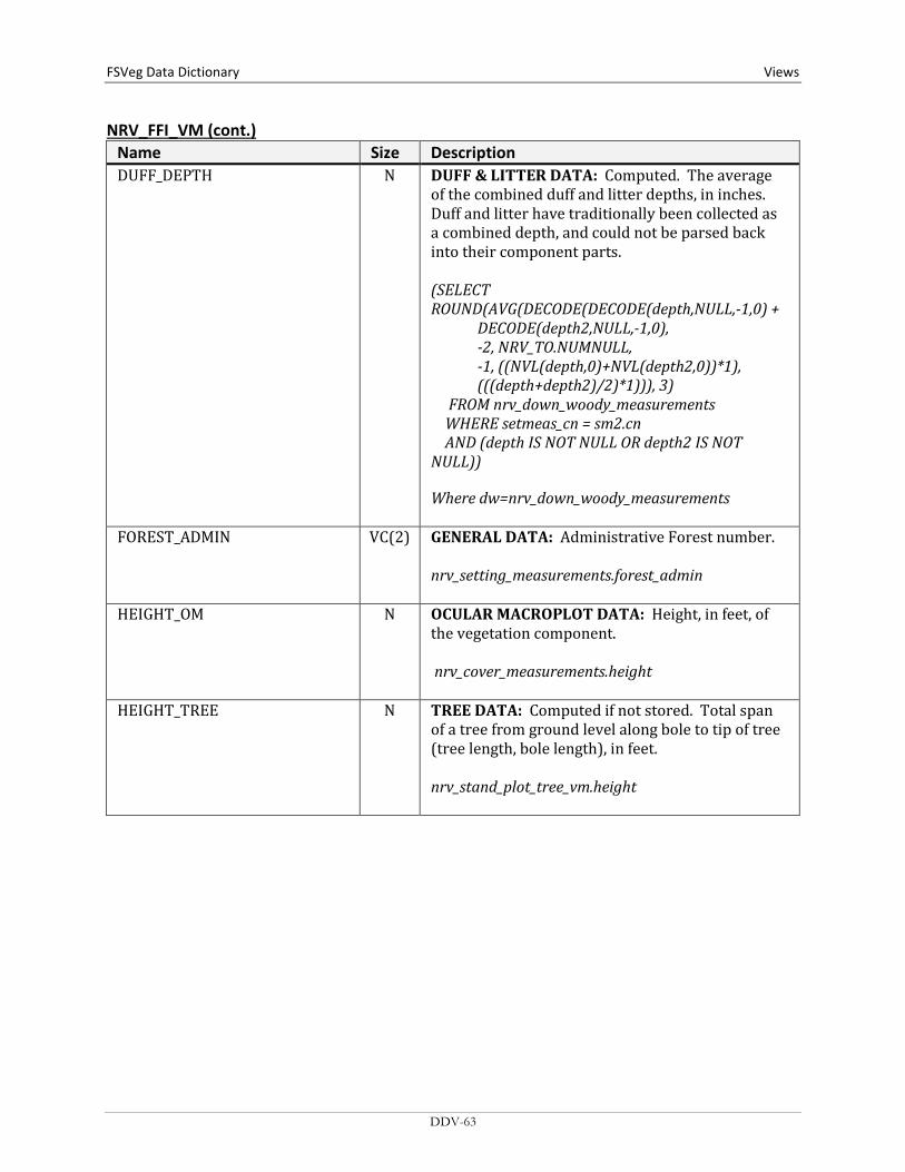
FSVeg Data Dictionary Views
NRV_FFI_VM (cont.) Name Size Description DUFF_DEPTH N DUFF & LITTER DATA: Computed. The average
of the combined duff and litter depths, in inches. Duff and litter have traditionally been collected as a combined depth, and could not be parsed back into their component parts. (SELECT ROUND(AVG(DECODE(DECODE(depth,NULL,-1,0) + DECODE(depth2,NULL,-1,0), -2, NRV_TO.NUMNULL, -1, ((NVL(depth,0)+NVL(depth2,0))*1), (((depth+depth2)/2)*1))), 3) FROM nrv_down_woody_measurements WHERE setmeas_cn = sm2.cn AND (depth IS NOT NULL OR depth2 IS NOT NULL)) Where dw=nrv_down_woody_measurements
FOREST_ADMIN VC(2) GENERAL DATA: Administrative Forest number. nrv_setting_measurements.forest_admin
HEIGHT_OM N OCULAR MACROPLOT DATA: Height, in feet, of the vegetation component. nrv_cover_measurements.height
HEIGHT_TREE N TREE DATA: Computed if not stored. Total span of a tree from ground level along bole to tip of tree (tree length, bole length), in feet. nrv_stand_plot_tree_vm.height
DDV-63

Views FSVeg Data Dictionary NRV_FFI_VM (cont.)
Name Size Description LEVEL_2_1000HR VC(10) DOWNED WOODY MATERIAL DATA, 1000-HR:
Used to uniquely identify each element within a sub sample. For stand exams, this is the plot. For grid inventories, this may be the parent plot number. For range or ecology plots this may be transect, microplot, or macroplot, depending on the design. FIA National Core Data: 1 = Center 2 = North 3 = Southeast 4 = Southwest nrv_setting_measurements.level_2_id (from the child setting record)
LEVEL_2_100HR VC(10) DOWNED WOODY MATERIAL DATA, 100-HR: Used to uniquely identify each element within a sub sample. For stand exams, this is the plot. For grid inventories, this may be the parent plot number. For range or ecology plots this may be transect, microplot, or macroplot, depending on the design. FIA National Core Data: 1 = Center 2 = North 3 = Southeast 4 = Southwest nrv_setting_measurements.level_2_id (from the child setting record)
LEVEL_2_10HR VC(10) DOWNED WOODY MATERIAL DATA, 10-HR: Used to uniquely identify each element within a sub sample. For stand exams, this is the plot. For grid inventories, this may be the parent plot number. For range or ecology plots this may be transect, microplot, or macroplot, depending on the design. FIA National Core Data: 1 = Center 2 = North 3 = Southeast 4 = Southwest nrv_setting_measurements.level_2_id (from the child setting record)
DDV-64
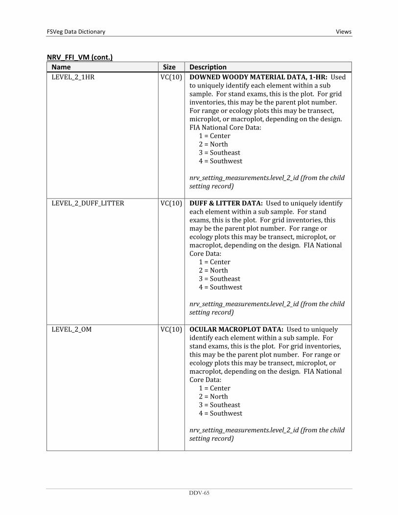
FSVeg Data Dictionary Views
NRV_FFI_VM (cont.) Name Size Description LEVEL_2_1HR VC(10) DOWNED WOODY MATERIAL DATA, 1-HR: Used
to uniquely identify each element within a sub sample. For stand exams, this is the plot. For grid inventories, this may be the parent plot number. For range or ecology plots this may be transect, microplot, or macroplot, depending on the design. FIA National Core Data: 1 = Center 2 = North 3 = Southeast 4 = Southwest nrv_setting_measurements.level_2_id (from the child setting record)
LEVEL_2_DUFF_LITTER VC(10) DUFF & LITTER DATA: Used to uniquely identify each element within a sub sample. For stand exams, this is the plot. For grid inventories, this may be the parent plot number. For range or ecology plots this may be transect, microplot, or macroplot, depending on the design. FIA National Core Data: 1 = Center 2 = North 3 = Southeast 4 = Southwest nrv_setting_measurements.level_2_id (from the child setting record)
LEVEL_2_OM VC(10) OCULAR MACROPLOT DATA: Used to uniquely identify each element within a sub sample. For stand exams, this is the plot. For grid inventories, this may be the parent plot number. For range or ecology plots this may be transect, microplot, or macroplot, depending on the design. FIA National Core Data: 1 = Center 2 = North 3 = Southeast 4 = Southwest nrv_setting_measurements.level_2_id (from the child setting record)
DDV-65
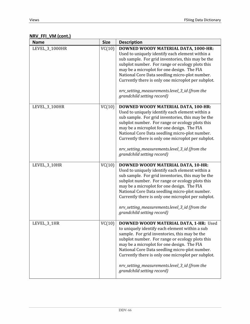
Views FSVeg Data Dictionary NRV_FFI_VM (cont.)
Name Size Description LEVEL_3_1000HR VC(10) DOWNED WOODY MATERIAL DATA, 1000-HR:
Used to uniquely identify each element within a sub sample. For grid inventories, this may be the subplot number. For range or ecology plots this may be a microplot for one design. The FIA National Core Data seedling micro-plot number. Currently there is only one microplot per subplot. nrv_setting_measurements.level_3_id (from the grandchild setting record)
LEVEL_3_100HR VC(10) DOWNED WOODY MATERIAL DATA, 100-HR: Used to uniquely identify each element within a sub sample. For grid inventories, this may be the subplot number. For range or ecology plots this may be a microplot for one design. The FIA National Core Data seedling micro-plot number. Currently there is only one microplot per subplot. nrv_setting_measurements.level_3_id (from the grandchild setting record)
LEVEL_3_10HR VC(10) DOWNED WOODY MATERIAL DATA, 10-HR: Used to uniquely identify each element within a sub sample. For grid inventories, this may be the subplot number. For range or ecology plots this may be a microplot for one design. The FIA National Core Data seedling micro-plot number. Currently there is only one microplot per subplot. nrv_setting_measurements.level_3_id (from the grandchild setting record)
LEVEL_3_1HR VC(10) DOWNED WOODY MATERIAL DATA, 1-HR: Used to uniquely identify each element within a sub sample. For grid inventories, this may be the subplot number. For range or ecology plots this may be a microplot for one design. The FIA National Core Data seedling micro-plot number. Currently there is only one microplot per subplot. nrv_setting_measurements.level_3_id (from the grandchild setting record)
DDV-66

FSVeg Data Dictionary Views
NRV_FFI_VM (cont.) Name Size Description LEVEL_3_DUFF_LITTER VC(10) DUFF & LITTER DATA: Used to uniquely identify
each element within a sub sample. For grid inventories, this may be the subplot number. For range or ecology plots this may be a microplot for one design. The FIA National Core Data seedling micro-plot number. Currently there is only one microplot per subplot. nrv_setting_measurements.level_3_id (from the grandchild setting record)
LITTER_1 N First layer of litter.
LITTER_2 N Second layer of litter.
LITTER_DEPTH N DUFF & LITTER DATA: Computed. Because duff and litter have traditionally been collected as a combined depth, this is currently populated as follows. Where duff and litter depths were not sampled, this field would be NULL, whereas if they were sampled, this field would be 0. In other words, if the duff_depth is NULL, then litter_depth is NULL. If the duff_depth is not NULL, then litter depth = 0. (SELECT ROUND(AVG(DECODE(DECODE(DECODE(depth,NULL, -1,0)+DECODE(depth2,NULL,-1,0), -2,NRV_TO.NUMNULL, -1,((NVL(depth,0)+NVL(depth2,0))*1), (((depth+depth2)/2)*1)), NULL, NRV_TO.NUMNULL, 0)), 3) FROM nrv_down_woody_measurements WHERE setmeas_cn = sm2.cn AND (depth IS NOT NULL OR depth2 IS NOT NULL)) Where dw=nrv_down_woody_measurements
DDV-67

Views FSVeg Data Dictionary NRV_FFI_VM (cont.)
Name Size Description LIVE_DEAD_TREE VC(1) TREE DATA: Indicates whether a tree is alive or
dead:
Code Description Use L Live tree CSE D Dead tree CSE
nrv_tree_measurements.live_dead
LIVE_HERB_COVER N SURFACE FUELS VEGETATION DATA: Computed. Percent cover of the live herbaceous fuel component. Cluster Data: AVG(DECODE(cm.live_dead, 'L', DECODE(cm.lifeform_code, 'HB', cm.cover_percent, NULL), NULL)) Stand Exam Data: SUM(DECODE(cm.live_dead, 'L', DECODE(cm.layer,'TOF', cm.cover_percent, NULL), NULL, DECODE(cm.layer, 'TOF', cm.cover_percent, NULL), NULL)) + SUM(DECODE(cm.live_dead, 'L', DECODE(cm.layer,'TOG',cm.cover_percent, NULL), NULL, DECODE(cm.layer, 'TOG', cm.cover_percent, NULL), NULL)) Where cm=nrv_cover_measurements
DDV-68
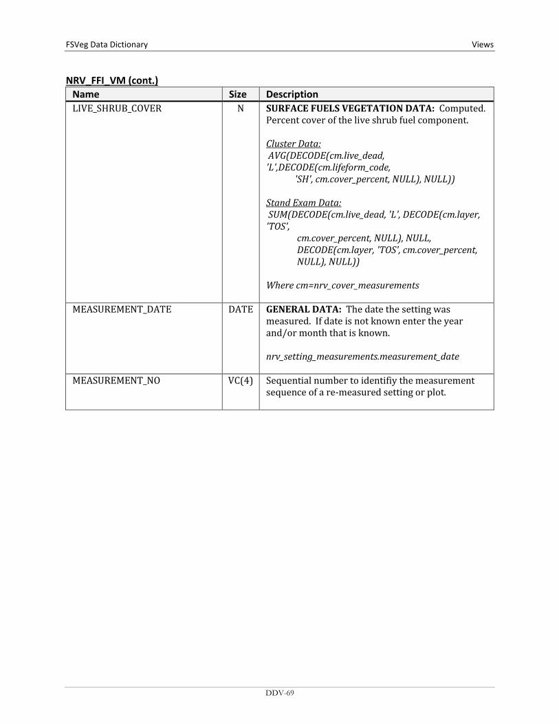
FSVeg Data Dictionary Views
NRV_FFI_VM (cont.) Name Size Description LIVE_SHRUB_COVER N SURFACE FUELS VEGETATION DATA: Computed.
Percent cover of the live shrub fuel component. Cluster Data: AVG(DECODE(cm.live_dead, 'L',DECODE(cm.lifeform_code, 'SH', cm.cover_percent, NULL), NULL)) Stand Exam Data: SUM(DECODE(cm.live_dead, 'L', DECODE(cm.layer, 'TOS', cm.cover_percent, NULL), NULL, DECODE(cm.layer, 'TOS', cm.cover_percent, NULL), NULL)) Where cm=nrv_cover_measurements
MEASUREMENT_DATE DATE GENERAL DATA: The date the setting was measured. If date is not known enter the year and/or month that is known. nrv_setting_measurements.measurement_date
MEASUREMENT_NO VC(4) Sequential number to identifiy the measurement sequence of a re-measured setting or plot.
DDV-69
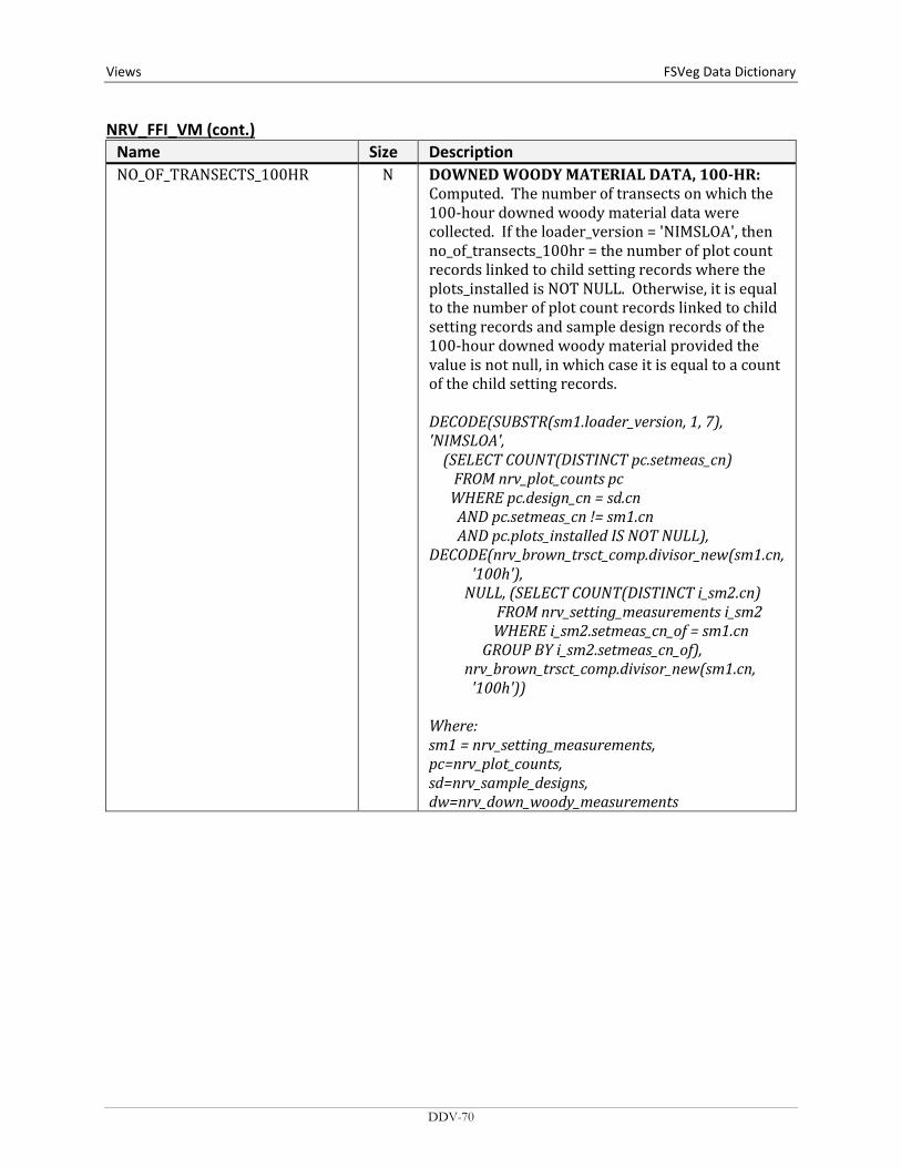
Views FSVeg Data Dictionary NRV_FFI_VM (cont.)
Name Size Description NO_OF_TRANSECTS_100HR N DOWNED WOODY MATERIAL DATA, 100-HR:
Computed. The number of transects on which the 100-hour downed woody material data were collected. If the loader_version = 'NIMSLOA', then no_of_transects_100hr = the number of plot count records linked to child setting records where the plots_installed is NOT NULL. Otherwise, it is equal to the number of plot count records linked to child setting records and sample design records of the 100-hour downed woody material provided the value is not null, in which case it is equal to a count of the child setting records. DECODE(SUBSTR(sm1.loader_version, 1, 7), 'NIMSLOA', (SELECT COUNT(DISTINCT pc.setmeas_cn) FROM nrv_plot_counts pc WHERE pc.design_cn = sd.cn AND pc.setmeas_cn != sm1.cn AND pc.plots_installed IS NOT NULL), DECODE(nrv_brown_trsct_comp.divisor_new(sm1.cn, '100h'), NULL, (SELECT COUNT(DISTINCT i_sm2.cn) FROM nrv_setting_measurements i_sm2 WHERE i_sm2.setmeas_cn_of = sm1.cn GROUP BY i_sm2.setmeas_cn_of), nrv_brown_trsct_comp.divisor_new(sm1.cn, '100h')) Where: sm1 = nrv_setting_measurements, pc=nrv_plot_counts, sd=nrv_sample_designs, dw=nrv_down_woody_measurements
DDV-70

FSVeg Data Dictionary Views
NRV_FFI_VM (cont.) Name Size Description NO_OF_TRANSECTS_10HR N DOWNED WOODY MATERIAL DATA, 10-HR:
Computed. The number of transects on which the 10-hour downed woody material data were collected. If the loader_version = 'NIMSLOA', then no_of_transects_10hr = the number of plot count records linked to child setting records where the plots_installed is NOT NULL. Otherwise, it is equal to the number of plot count records linked to child setting records and sample design records of the 10-hour downed woody material provided the value is not null, in which case it is equal to a count of the child setting records. DECODE(SUBSTR(sm1.loader_version, 1, 7), 'NIMSLOA', (SELECT COUNT(DISTINCT pc.setmeas_cn) FROM nrv_plot_counts pc WHERE pc.design_cn = sd.cn AND pc.setmeas_cn != sm1.cn AND pc.plots_installed IS NOT NULL), DECODE(nrv_brown_trsct_comp.divisor_new (sm1.cn,'10h'), NULL, (SELECT COUNT(DISTINCT i_sm2.cn) FROM nrv_setting_measurements i_sm2 WHERE i_sm2.setmeas_cn_of = sm1.cn GROUP BY i_sm2.setmeas_cn_of), nrv_brown_trsct_comp.divisor_new (sm1.cn,'10h')) Where: sm1 = nrv_setting_measurements, pc=nrv_plot_counts, sd=nrv_sample_designs, dw=nrv_down_woody_measurements
DDV-71
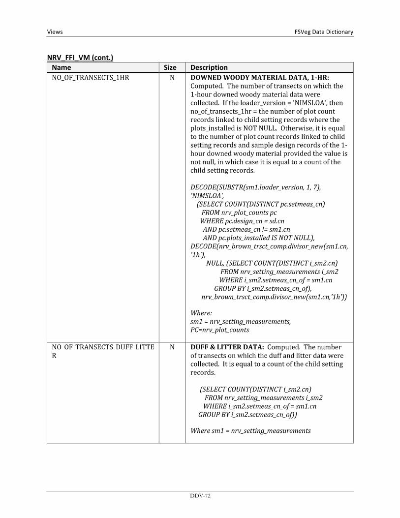
Views FSVeg Data Dictionary NRV_FFI_VM (cont.)
Name Size Description NO_OF_TRANSECTS_1HR N DOWNED WOODY MATERIAL DATA, 1-HR:
Computed. The number of transects on which the 1-hour downed woody material data were collected. If the loader_version = 'NIMSLOA', then no_of_transects_1hr = the number of plot count records linked to child setting records where the plots_installed is NOT NULL. Otherwise, it is equal to the number of plot count records linked to child setting records and sample design records of the 1-hour downed woody material provided the value is not null, in which case it is equal to a count of the child setting records. DECODE(SUBSTR(sm1.loader_version, 1, 7), 'NIMSLOA', (SELECT COUNT(DISTINCT pc.setmeas_cn) FROM nrv_plot_counts pc WHERE pc.design_cn = sd.cn AND pc.setmeas_cn != sm1.cn AND pc.plots_installed IS NOT NULL), DECODE(nrv_brown_trsct_comp.divisor_new(sm1.cn,'1h'), NULL, (SELECT COUNT(DISTINCT i_sm2.cn) FROM nrv_setting_measurements i_sm2 WHERE i_sm2.setmeas_cn_of = sm1.cn GROUP BY i_sm2.setmeas_cn_of), nrv_brown_trsct_comp.divisor_new(sm1.cn,'1h')) Where: sm1 = nrv_setting_measurements, PC=nrv_plot_counts
NO_OF_TRANSECTS_DUFF_LITTER
N DUFF & LITTER DATA: Computed. The number of transects on which the duff and litter data were collected. It is equal to a count of the child setting records. (SELECT COUNT(DISTINCT i_sm2.cn) FROM nrv_setting_measurements i_sm2 WHERE i_sm2.setmeas_cn_of = sm1.cn GROUP BY i_sm2.setmeas_cn_of)) Where sm1 = nrv_setting_measurements
DDV-72
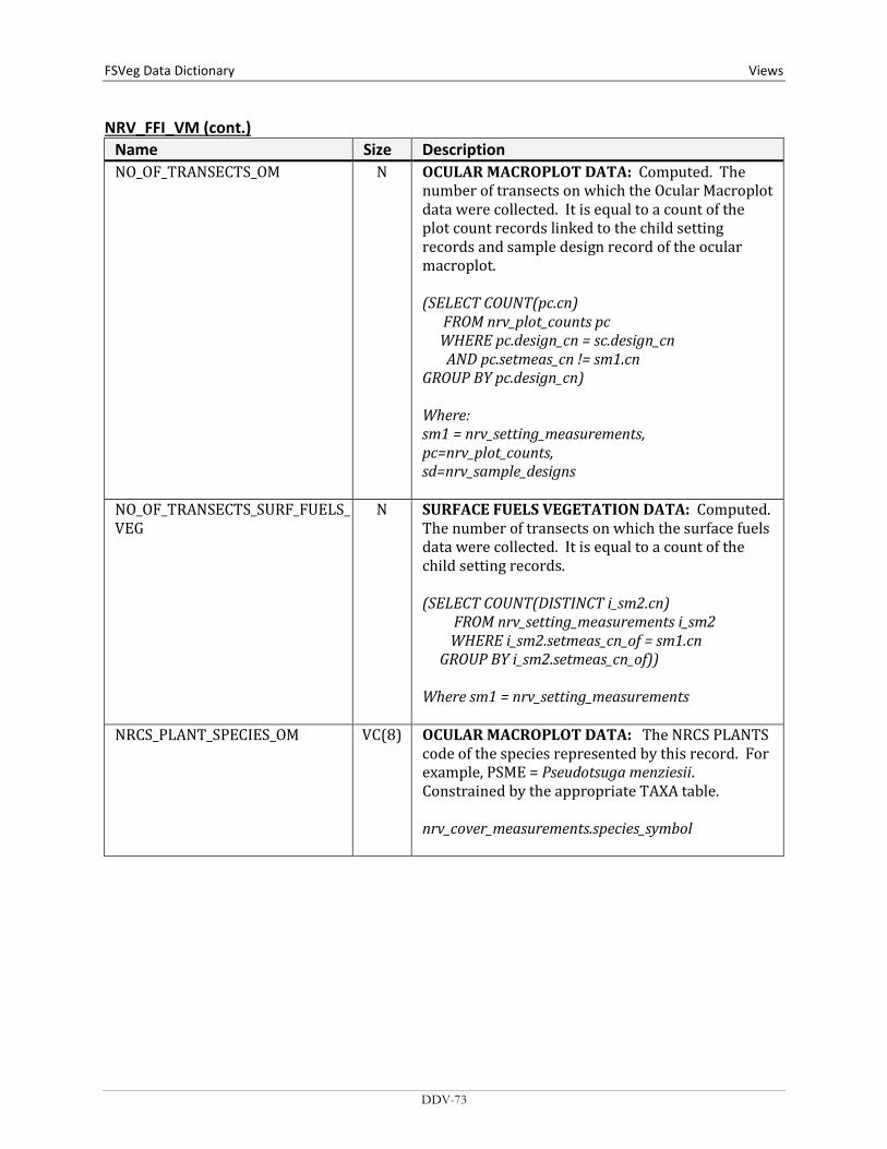
FSVeg Data Dictionary Views
NRV_FFI_VM (cont.) Name Size Description NO_OF_TRANSECTS_OM N OCULAR MACROPLOT DATA: Computed. The
number of transects on which the Ocular Macroplot data were collected. It is equal to a count of the plot count records linked to the child setting records and sample design record of the ocular macroplot. (SELECT COUNT(pc.cn) FROM nrv_plot_counts pc WHERE pc.design_cn = sc.design_cn AND pc.setmeas_cn != sm1.cn GROUP BY pc.design_cn) Where: sm1 = nrv_setting_measurements, pc=nrv_plot_counts, sd=nrv_sample_designs
NO_OF_TRANSECTS_SURF_FUELS_VEG
N SURFACE FUELS VEGETATION DATA: Computed. The number of transects on which the surface fuels data were collected. It is equal to a count of the child setting records. (SELECT COUNT(DISTINCT i_sm2.cn) FROM nrv_setting_measurements i_sm2 WHERE i_sm2.setmeas_cn_of = sm1.cn GROUP BY i_sm2.setmeas_cn_of)) Where sm1 = nrv_setting_measurements
NRCS_PLANT_SPECIES_OM VC(8) OCULAR MACROPLOT DATA: The NRCS PLANTS code of the species represented by this record. For example, PSME = Pseudotsuga menziesii. Constrained by the appropriate TAXA table. nrv_cover_measurements.species_symbol
DDV-73

Views FSVeg Data Dictionary NRV_FFI_VM (cont.)
Name Size Description NUMBER_OF_TRANSECTS_ 1000HR
N DOWNED WOODY MATERIAL DATA, 1000-HR: Computed. The number of transects on which the 1000-hour downed woody material data were collected. If the loader_version = 'NIMSLOA' then no_of_transects_1000hr = the number of plot count records linked to child setting records where the plots_installed is NOT NULL. Otherwise, it is equal to the number of plot count records linked to child setting records and sample design records of the 1000-hour downed woody material provided the value is not null, in which case it is equal to a count of the child setting records. DECODE(SUBSTR(sm1.loader_version, 1, 7), 'NIMSLOA', (SELECT COUNT(DISTINCT pc.setmeas_cn) FROM nrv_plot_counts pc WHERE pc.design_cn = sd.cn AND pc.setmeas_cn != sm1.cn AND pc.plots_installed IS NOT NULL), DECODE(nrv_brown_trsct_comp.divisor_new(sm1.cn, '1000h'), NULL, (SELECT COUNT(DISTINCT i_sm2.cn) FROM nrv_setting_measurements i_sm2 WHERE i_sm2.setmeas_cn_of = sm1.cn GROUP BY i_sm2.setmeas_cn_of), nrv_brown_trsct_comp.divisor_new(sm1.cn, '1000h')) Where: sm1 = nrv_setting_measurements, pc=nrv_plot_counts, sd=nrv_sample_designs, dw=nrv_down_woody_measurements
PARENT_CN VC(34) GENERAL DATA: Foreign key to the parent setting record in nrv_setting_measurements. nrv_setting_measurements.cn
DDV-74
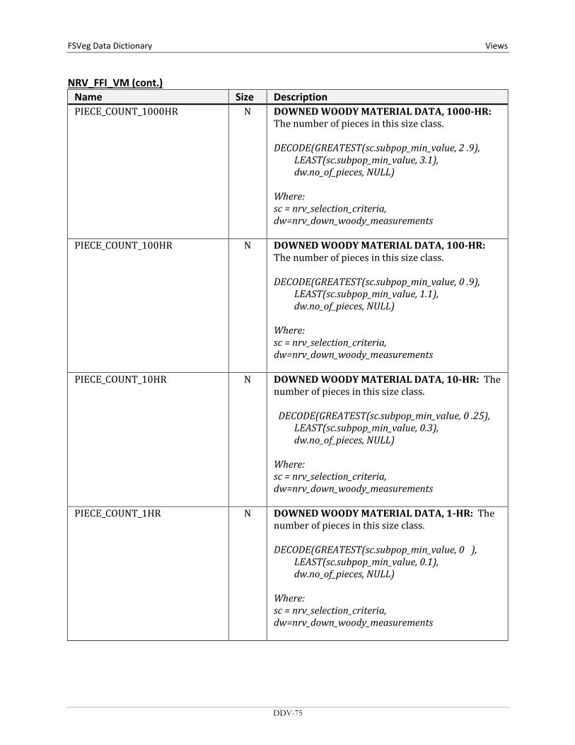
FSVeg Data Dictionary Views
NRV_FFI_VM (cont.) Name Size Description PIECE_COUNT_1000HR N DOWNED WOODY MATERIAL DATA, 1000-HR:
The number of pieces in this size class. DECODE(GREATEST(sc.subpop_min_value, 2 .9), LEAST(sc.subpop_min_value, 3.1), dw.no_of_pieces, NULL) Where: sc = nrv_selection_criteria, dw=nrv_down_woody_measurements
PIECE_COUNT_100HR N DOWNED WOODY MATERIAL DATA, 100-HR: The number of pieces in this size class. DECODE(GREATEST(sc.subpop_min_value, 0 .9), LEAST(sc.subpop_min_value, 1.1), dw.no_of_pieces, NULL) Where: sc = nrv_selection_criteria, dw=nrv_down_woody_measurements
PIECE_COUNT_10HR N DOWNED WOODY MATERIAL DATA, 10-HR: The number of pieces in this size class. DECODE(GREATEST(sc.subpop_min_value, 0 .25), LEAST(sc.subpop_min_value, 0.3), dw.no_of_pieces, NULL) Where: sc = nrv_selection_criteria, dw=nrv_down_woody_measurements
PIECE_COUNT_1HR N DOWNED WOODY MATERIAL DATA, 1-HR: The number of pieces in this size class. DECODE(GREATEST(sc.subpop_min_value, 0 ), LEAST(sc.subpop_min_value, 0.1), dw.no_of_pieces, NULL) Where: sc = nrv_selection_criteria, dw=nrv_down_woody_measurements
DDV-75
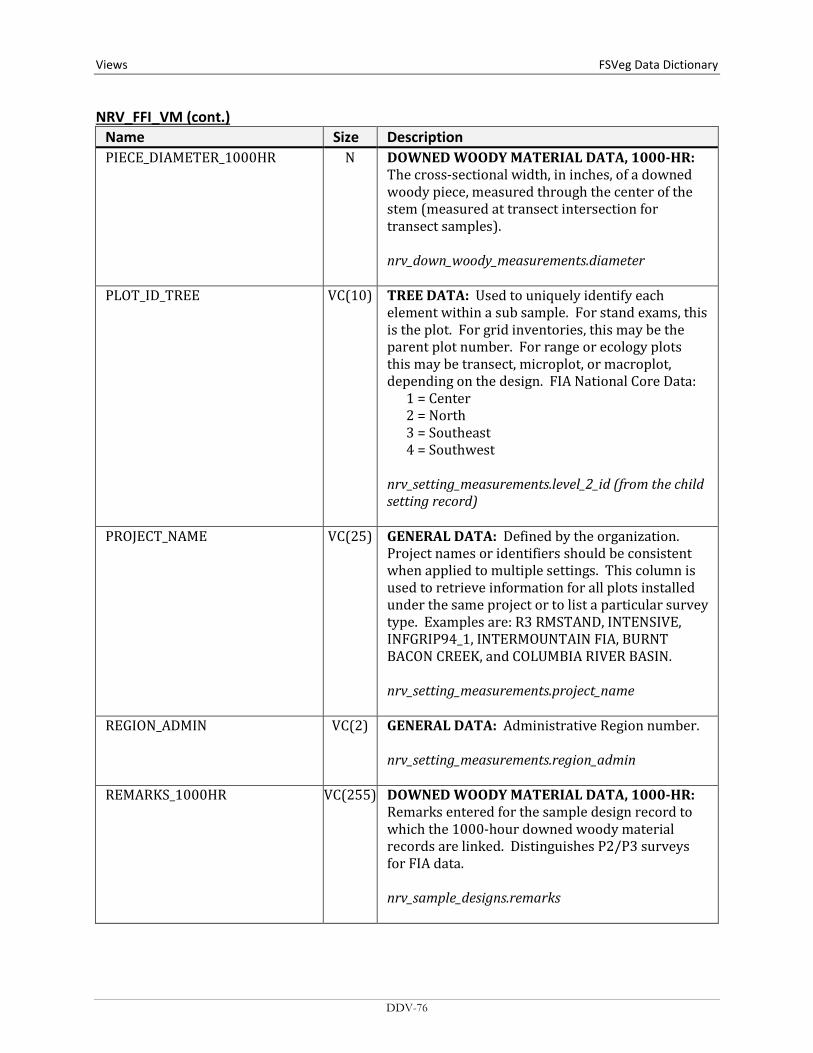
Views FSVeg Data Dictionary NRV_FFI_VM (cont.)
Name Size Description PIECE_DIAMETER_1000HR N DOWNED WOODY MATERIAL DATA, 1000-HR:
The cross-sectional width, in inches, of a downed woody piece, measured through the center of the stem (measured at transect intersection for transect samples). nrv_down_woody_measurements.diameter
PLOT_ID_TREE VC(10) TREE DATA: Used to uniquely identify each element within a sub sample. For stand exams, this is the plot. For grid inventories, this may be the parent plot number. For range or ecology plots this may be transect, microplot, or macroplot, depending on the design. FIA National Core Data: 1 = Center 2 = North 3 = Southeast 4 = Southwest nrv_setting_measurements.level_2_id (from the child setting record)
PROJECT_NAME VC(25) GENERAL DATA: Defined by the organization. Project names or identifiers should be consistent when applied to multiple settings. This column is used to retrieve information for all plots installed under the same project or to list a particular survey type. Examples are: R3 RMSTAND, INTENSIVE, INFGRIP94_1, INTERMOUNTAIN FIA, BURNT BACON CREEK, and COLUMBIA RIVER BASIN. nrv_setting_measurements.project_name
REGION_ADMIN VC(2) GENERAL DATA: Administrative Region number. nrv_setting_measurements.region_admin
REMARKS_1000HR VC(255) DOWNED WOODY MATERIAL DATA, 1000-HR: Remarks entered for the sample design record to which the 1000-hour downed woody material records are linked. Distinguishes P2/P3 surveys for FIA data. nrv_sample_designs.remarks
DDV-76

FSVeg Data Dictionary Views
NRV_FFI_VM (cont.) Name Size Description REMARKS_100HR VC(255) DOWNED WOODY MATERIAL DATA, 100-HR:
Remarks entered for the sample design record to which the 100-hour downed woody material records are linked. Distinguishes P2/P3 surveys for FIA data. nrv_sample_designs.remarks
REMARKS_10HR VC(255) DOWNED WOODY MATERIAL DATA, 10-HR: Remarks entered for the sample design record to which the 10-hour downed woody material records are linked. Distinguishes P2/P3 surveys for FIA data. nrv_sample_designs.remarks
REMARKS_1HR VC(255) DOWNED WOODY MATERIAL DATA, 1-HR: Remarks entered for the sample design record to which the 1-hour downed woody material records are linked. Distinguishes P2/P3 surveys for FIA data. nrv_sample_designs.remarks
SAMPLE_LOCATION_DUFF_ LITTER
N DUFF & LITTER DATA: Computed. If duff depth were collected, then it is the subsample number unless that is NULL, in which case it is 0. TO_NUMBER(DECODE((SELECT AVG(depth) FROM nrv_down_woody_measurements WHERE setmeas_cn = sm2.cn), NULL, NULL, NVL(dw.subsample, 0))) Where dw=nrv_down_woody_measurements
DDV-77

Views FSVeg Data Dictionary NRV_FFI_VM (cont.)
Name Size Description SAMPLE_LOCATION_SURF_FUELS_VEG
VC(10) SURFACE FUELS VEGETATION DATA: Used to uniquely identify each element within a sub sample. For stand exams, this is the plot. For grid inventories, this may be the parent plot number. For range or ecology plots this may be transect, microplot, or macroplot, depending on the design. FIA National Core Data: 1 = Center 2 = North 3 = Southeast 4 = Southwest nrv_setting_measurements.level_2_id (from the child setting record)
SETTING_ID VC(30) GENERAL DATA: Uniquely identifies the setting where the data are collected. This field may contain the following information: For stand exams - Region, Forest, District, Location, and Stand Number. For annual FIA data – State(2)//Survey Unit(2)//County(3)//Plot(5) rv_setting_measurements.setting_id
SETTING_TPA_TREE N TREE DATA: Computed. The number of trees per acre, at the stand level, that a tree record represents. nrv_stand_plot_tree_vm.stand_tpa_eq
SIZE_CLASS_OM VC OCULAR MACROPLOT DATA: NULL. Not currently filled.
SPECIES_TREE VC(8) TREE DATA: The NRCS PLANTS code of the species represented by this record. For example, PSME = Pseudotsuga menziesii. Constrained by the appropriate TAXA table. nrv_tree_measurements.species_symbol
DDV-78
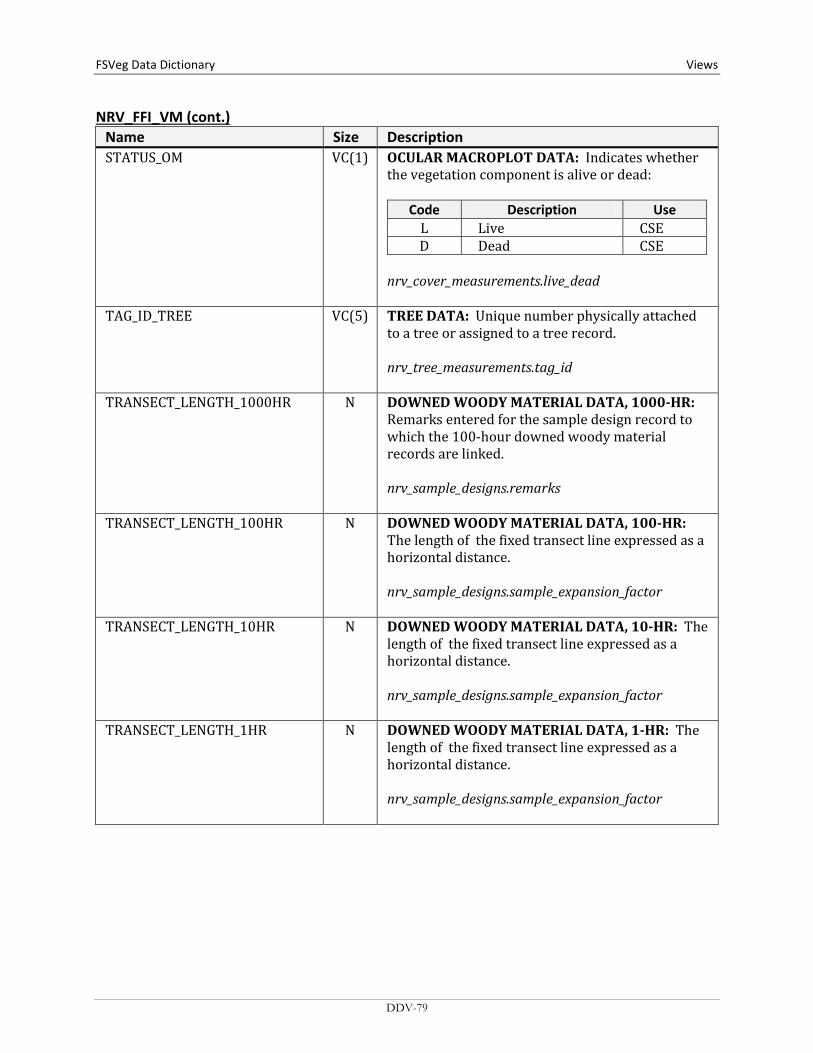
FSVeg Data Dictionary Views
NRV_FFI_VM (cont.) Name Size Description STATUS_OM VC(1) OCULAR MACROPLOT DATA: Indicates whether
the vegetation component is alive or dead:
Code Description Use L Live CSE D Dead CSE
nrv_cover_measurements.live_dead
TAG_ID_TREE VC(5) TREE DATA: Unique number physically attached to a tree or assigned to a tree record. nrv_tree_measurements.tag_id
TRANSECT_LENGTH_1000HR N DOWNED WOODY MATERIAL DATA, 1000-HR: Remarks entered for the sample design record to which the 100-hour downed woody material records are linked. nrv_sample_designs.remarks
TRANSECT_LENGTH_100HR N DOWNED WOODY MATERIAL DATA, 100-HR: The length of the fixed transect line expressed as a horizontal distance. nrv_sample_designs.sample_expansion_factor
TRANSECT_LENGTH_10HR N DOWNED WOODY MATERIAL DATA, 10-HR: The length of the fixed transect line expressed as a horizontal distance. nrv_sample_designs.sample_expansion_factor
TRANSECT_LENGTH_1HR N DOWNED WOODY MATERIAL DATA, 1-HR: The length of the fixed transect line expressed as a horizontal distance. nrv_sample_designs.sample_expansion_factor
DDV-79

Views FSVeg Data Dictionary NRV_FFI_VM (cont.)
Name Size Description TRANSECT_SLOPE_1000HR N DOWNED WOODY MATERIAL DATA, 1000-HR:
For FIA data, the average percent slope within the condition, with NULL values converted to 0. Valid values are 0 through 200. Before 2000, the field crew measured condition slope. Beginning in 2000, slope is collected on subplots but no longer collected for conditions. For plots taken after 2000, the slope from the subplot representing the greatest percentage of the condition will be assigned as a surrogate. NULL for stand exam data. NVL((SELECT mc.slope FROM nrv_fia_mapped_conditions mc WHERE mc.setmeas_cn = sm1.cn AND mc.cn = dw.mapcond_cn), 0) Where: sm1 = nrv_setting_measurements, dw=nrv_down_woody_measurements
TRANSECT_SLOPE_100HR N DOWNED WOODY MATERIAL DATA, 100-HR: For FIA data, the average percent slope within the condition, with NULL values converted to 0. Valid values are 0 through 200. Before 2000, the field crew measured condition slope. Beginning in 2000, slope is collected on subplots but no longer collected for conditions. For plots taken after 2000, the slope from the subplot representing the greatest percentage of the condition will be assigned as a surrogate. NULL for stand exam data. NVL((SELECT mc.slope FROM nrv_fia_mapped_conditions mc WHERE mc.setmeas_cn = sm1.cn AND mc.cn = dw.mapcond_cn), 0) Where: sm1 = nrv_setting_measurements, dw=nrv_down_woody_measurements
DDV-80

FSVeg Data Dictionary Views
NRV_FFI_VM (cont.) Name Size Description TRANSECT_SLOPE_10HR N DOWNED WOODY MATERIAL DATA, 10-HR: For
FIA data, the average percent slope within the condition, with NULL values converted to 0. Valid values are 0 through 200. Before 2000, the field crew measured condition slope. Beginning in 2000, slope is collected on subplots but no longer collected for conditions. For plots taken after 2000, the slope from the subplot representing the greatest percentage of the condition will be assigned as a surrogate. NULL for stand exam data. NVL((SELECT mc.slope FROM nrv_fia_mapped_conditions mc WHERE mc.setmeas_cn = sm1.cn AND mc.cn = dw.mapcond_cn), 0) Where: sm1 = nrv_setting_measurements, dw=nrv_down_woody_measurements
TRANSECT_SLOPE_1HR N DOWNED WOODY MATERIAL DATA, 1-HR: For FIA data, the average percent slope within the condition, with NULL values converted to 0. Valid values are 0 through 200. Before 2000, the field crew measured condition slope. Beginning in 2000, slope is collected on subplots but no longer collected for conditions. For plots taken after 2000, the slope from the subplot representing the greatest percentage of the condition will be assigned as a surrogate. NULL for stand exam data. NVL((SELECT mc.slope FROM nrv_fia_mapped_conditions mc WHERE mc.setmeas_cn = sm1.cn AND mc.cn = dw.mapcond_cn), 0) Where: sm1 = nrv_setting_measurements, dw=nrv_down_woody_measurements
DDV-81

Views FSVeg Data Dictionary NRV_FFI_VM columns organized by data groups:
General Data: PARENT_CN REGION_ADMIN FOREST_ADMIN DISTRICT PROJECT_NAME SETTING_ID MEASUREMENT_DATE
Tree Data: PLOT_ID_TREE TAG_ID_TREE UNIQUE_NO_TREE LIVE_DEAD_TREE SETTING_TPA_TREE SPECIES_TREE DBH_TREE DRC_TREE HEIGHT_TREE CROWN_RATIO_TREE CROWN_BASE_HEIGHT_TREE
Downed Woody Material Data, 1-hr: REMARKS_1HR NO_OF_TRANSECTS_1HR TRANSECT_LENGTH_1HR LEVEL_2_1HR LEVEL_3_1HR TRANSECT_SLOPE_1HR PIECE_COUNT_1HR
Downed Woody Material Data, 10-hr: REMARKS_10HR NO_OF_TRANSECTS_10HR TRANSECT_LENGTH_10HR LEVEL_2_10HR LEVEL_3_10HR TRANSECT_SLOPE_10HR PIECE_COUNT_10HR
Downed Woody Material Data, 100-hr: REMARKS_100HR NO_OF_TRANSECTS_100HR TRANSECT_LENGTH_100HR LEVEL_2_100HR LEVEL_3_100HR TRANSECT_SLOPE_100HR PIECE_COUNT_100HR
DDV-82
FSVeg Data Dictionary Views
Downed Woody Material Data, 1000-hr: REMARKS_1000HR NUMBER_OF_TRANSECTS_1000HR TRANSECT_LENGTH_1000HR LEVEL_2_1000HR LEVEL_3_1000HR TRANSECT_SLOPE_1000HR PIECE_COUNT_1000HR PIECE_DIAMETER_1000HR DECAY_CLASS_1000HR
Duff & Litter Data: NO_OF_TRANSECTS_DUFF_LITTER LEVEL_2_DUFF_LITTER LEVEL_3_DUFF_LITTER SAMPLE_LOCATION_DUFF_LITTER DUFF_DEPTH LITTER_DEPTH
Surface Fuels Vegetation Data: NO_OF_TRANSECTS_SURF_FUELS_VEG SAMPLE_LOCATION_SURF_FUELS_VEG LIVE_HERB_COVER DEAD_HERB_COVER AVG_HERB_HT LIVE_SHRUB_COVER DEAD_SHRUB_COVER AVG_SHRUB_HT
Ocular Macroplot Data: LEVEL_2_OM NO_OF_TRANSECTS_OM NRCS_PLANT_SPECIES_OM STATUS_OM SIZE_CLASS_OM COVER_OM HEIGHT_OM
DDV-83
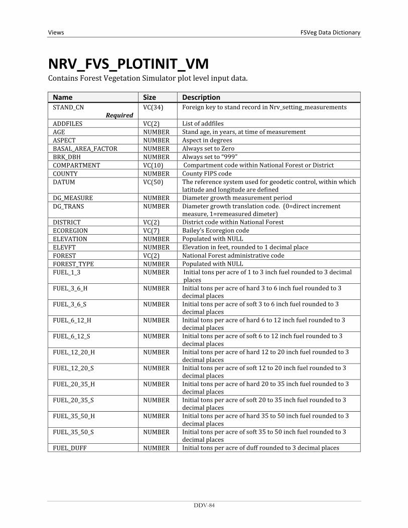
Views FSVeg Data Dictionary
NRV_FVS_PLOTINIT_VM Contains Forest Vegetation Simulator plot level input data.
Name Size Description STAND_CN
Required VC(34) Foreign key to stand record in Nrv_setting_measurements
ADDFILES VC(2) List of addfiles AGE NUMBER Stand age, in years, at time of measurement ASPECT NUMBER Aspect in degrees BASAL_AREA_FACTOR NUMBER Always set to Zero BRK_DBH NUMBER Always set to “999” COMPARTMENT VC(10) Compartment code within National Forest or District COUNTY NUMBER County FIPS code DATUM VC(50) The reference system used for geodetic control, within which
latitude and longitude are defined DG_MEASURE NUMBER Diameter growth measurement period DG_TRANS NUMBER Diameter growth translation code. (0=direct increment
measure, 1=remeasured dimeter) DISTRICT VC(2) District code within National Forest ECOREGION VC(7) Bailey’s Ecoregion code ELEVATION NUMBER Populated with NULL ELEVFT NUMBER Elevation in feet, rounded to 1 decimal place FOREST VC(2) National Forest administrative code FOREST_TYPE NUMBER Populated with NULL FUEL_1_3 NUMBER Initial tons per acre of 1 to 3 inch fuel rounded to 3 decimal
places FUEL_3_6_H NUMBER Initial tons per acre of hard 3 to 6 inch fuel rounded to 3
decimal places FUEL_3_6_S NUMBER Initial tons per acre of soft 3 to 6 inch fuel rounded to 3
decimal places FUEL_6_12_H NUMBER Initial tons per acre of hard 6 to 12 inch fuel rounded to 3
decimal places FUEL_6_12_S NUMBER Initial tons per acre of soft 6 to 12 inch fuel rounded to 3
decimal places FUEL_12_20_H NUMBER Initial tons per acre of hard 12 to 20 inch fuel rounded to 3
decimal places FUEL_12_20_S NUMBER Initial tons per acre of soft 12 to 20 inch fuel rounded to 3
decimal places FUEL_20_35_H NUMBER Initial tons per acre of hard 20 to 35 inch fuel rounded to 3
decimal places FUEL_20_35_S NUMBER Initial tons per acre of soft 20 to 35 inch fuel rounded to 3
decimal places FUEL_35_50_H NUMBER Initial tons per acre of hard 35 to 50 inch fuel rounded to 3
decimal places FUEL_35_50_S NUMBER Initial tons per acre of soft 35 to 50 inch fuel rounded to 3
decimal places FUEL_DUFF NUMBER Initial tons per acre of duff rounded to 3 decimal places
DDV-84

FSVeg Data Dictionary Views
NRV_FVS_PLOTINIT_VM (cont.) Name Size Description
FUEL_GT_50_H NUMBER Initial tons per acre of hard greater than 50 inch fuel rounded to 3 decimal places
FUEL_GT_50_S NUMBER Initial tons per acre of soft greater than 50 inch fuel rounded to 3 decimal places
FUEL_LITTER NUMBER Currently populated with NULL FUEL_MODEL NUMBER Fire behavior fuel model FUEL_0_25 NUMBER Initial tons per acre of 0 to 0.24 inch fuel rounded to 3 decimal
places FUEL_25_1 NUMBER Initial tons per acre of 0.25 to 0.99 inch fuel rounded to 3
decimal places FVSKEYWORDS VC(2) List of keywords GIS_LINK VC(26) FSVeg GIS Link Cn GROUPS VC(86) List of grouping codes HTG_MEASURE N(2) Height growth measurement period HTG_TRANS NUMBER Populated with 0 INV_PLOT_SIZE NUMBER Populated with 1.0 INV_YEAR NUMBER The stand inventory year LATITUDE NUMBER Latitude, in decimal degrees, rounded to 4 decimals LOCATION VC(0) Location identification code LONGITUDE NUMBER Longitude, in decimal degrees, rounded to 4 decimals MAX_BA NUMBER Populated with NULL MAX_SDI NUMBER Populated with NULL MODEL_TYPE NUMBER Populated with NULL MORT_MEASURE N(2) Mortality measurement period NONSTK_PLOTS NUMBER Number of non-stockable plots NUM_PLOTS NUMBER Number of plots (when sub-sampling, populated with 1) PHOTO_CODE VC(20) Photo code identifier PHOTO_REF VC(10) Photo series reference number PHYSIO_REGION NUMBER Populated with NULL PLOT_CN VC(34) Cn for child setting record PLOT_ID VC(10) Level_2_id for child setting record PROJECT_NAME VC(25) Defined by the organization PV_CODE VC(10) Potential vegetation code for the top-level setting (stand) PV_REF_CODE VC(10) Potential Vegetation Reference Code – the document from
which the PV_CODE was obtained REGION VC(2) National Forest administrative region SAM_WT NUMBER Sampling Weight used to compute average yield tables and
other weighted averages; populated with 1 SITE_INDEX NUMBER Site index rounded to 0 decimal places SITE_INDEX_BASE_AGE NUMBER The reference age on which site index is based SITE_INDEX_REFERENCE_CODE VC(3) Site Index reference identifier SITE_SPECIES VC(8) Site Species Code. NRCS plants code SLOPE NUMBER Slope in percent STAND_ID VC(30) Setting_id for parent setting record STANDPLOT_CN VC(39) Cn for parent setting record||4-digit 0-filled stand number STANDPLOT_ID VC(35) Setting id||4-digit 0-filled stand number STATE NUMBER State FIPS Code STK_PCNT NUMBER Stock-able percent VARIANT VC(11) Variant identification code. Multiple codes are possible
DDV-85
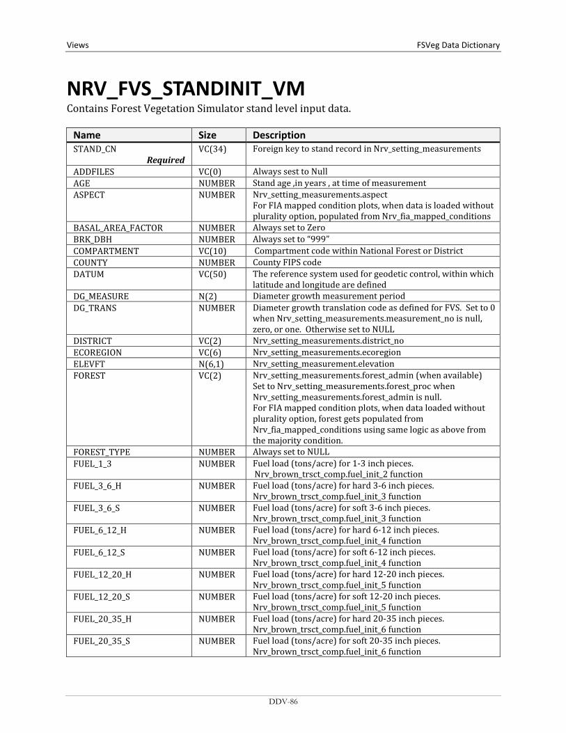
Views FSVeg Data Dictionary
NRV_FVS_STANDINIT_VM Contains Forest Vegetation Simulator stand level input data.
Name Size Description STAND_CN
Required VC(34) Foreign key to stand record in Nrv_setting_measurements
ADDFILES VC(0) Always sest to Null AGE NUMBER Stand age ,in years , at time of measurement ASPECT NUMBER Nrv_setting_measurements.aspect
For FIA mapped condition plots, when data is loaded without plurality option, populated from Nrv_fia_mapped_conditions
BASAL_AREA_FACTOR NUMBER Always set to Zero BRK_DBH NUMBER Always set to “999” COMPARTMENT VC(10) Compartment code within National Forest or District COUNTY NUMBER County FIPS code DATUM VC(50) The reference system used for geodetic control, within which
latitude and longitude are defined DG_MEASURE N(2) Diameter growth measurement period DG_TRANS NUMBER Diameter growth translation code as defined for FVS. Set to 0
when Nrv_setting_measurements.measurement_no is null, zero, or one. Otherwise set to NULL
DISTRICT VC(2) Nrv_setting_measurements.district_no ECOREGION VC(6) Nrv_setting_measurements.ecoregion ELEVFT N(6,1) Nrv_setting_measurement.elevation FOREST VC(2) Nrv_setting_measurements.forest_admin (when available)
Set to Nrv_setting_measurements.forest_proc when Nrv_setting_measurements.forest_admin is null. For FIA mapped condition plots, when data loaded without plurality option, forest gets populated from Nrv_fia_mapped_conditions using same logic as above from the majority condition.
FOREST_TYPE NUMBER Always set to NULL FUEL_1_3 NUMBER Fuel load (tons/acre) for 1-3 inch pieces.
Nrv_brown_trsct_comp.fuel_init_2 function FUEL_3_6_H NUMBER Fuel load (tons/acre) for hard 3-6 inch pieces.
Nrv_brown_trsct_comp.fuel_init_3 function FUEL_3_6_S NUMBER Fuel load (tons/acre) for soft 3-6 inch pieces.
Nrv_brown_trsct_comp.fuel_init_3 function FUEL_6_12_H NUMBER Fuel load (tons/acre) for hard 6-12 inch pieces.
Nrv_brown_trsct_comp.fuel_init_4 function FUEL_6_12_S NUMBER Fuel load (tons/acre) for soft 6-12 inch pieces.
Nrv_brown_trsct_comp.fuel_init_4 function FUEL_12_20_H NUMBER Fuel load (tons/acre) for hard 12-20 inch pieces.
Nrv_brown_trsct_comp.fuel_init_5 function FUEL_12_20_S NUMBER Fuel load (tons/acre) for soft 12-20 inch pieces.
Nrv_brown_trsct_comp.fuel_init_5 function FUEL_20_35_H NUMBER Fuel load (tons/acre) for hard 20-35 inch pieces.
Nrv_brown_trsct_comp.fuel_init_6 function FUEL_20_35_S NUMBER Fuel load (tons/acre) for soft 20-35 inch pieces.
Nrv_brown_trsct_comp.fuel_init_6 function
DDV-86
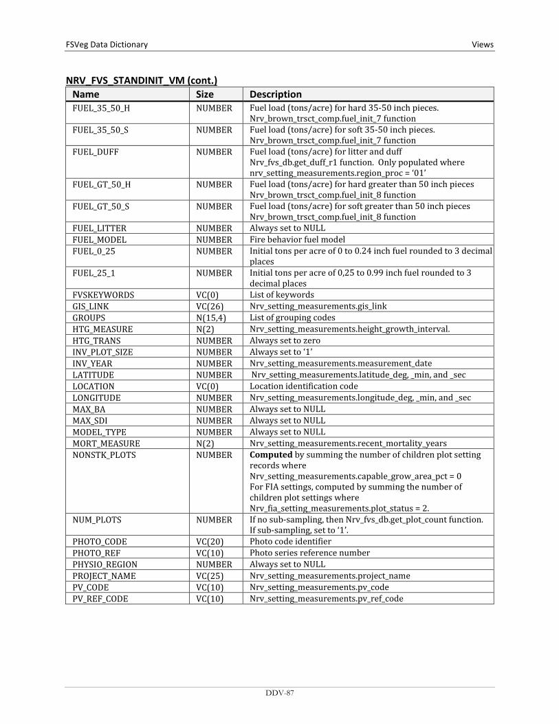
FSVeg Data Dictionary Views
NRV_FVS_STANDINIT_VM (cont.) Name Size Description FUEL_35_50_H NUMBER Fuel load (tons/acre) for hard 35-50 inch pieces.
Nrv_brown_trsct_comp.fuel_init_7 function FUEL_35_50_S NUMBER Fuel load (tons/acre) for soft 35-50 inch pieces.
Nrv_brown_trsct_comp.fuel_init_7 function FUEL_DUFF NUMBER Fuel load (tons/acre) for litter and duff
Nrv_fvs_db.get_duff_r1 function. Only populated where nrv_setting_measurements.region_proc = ‘01’
FUEL_GT_50_H NUMBER Fuel load (tons/acre) for hard greater than 50 inch pieces Nrv_brown_trsct_comp.fuel_init_8 function
FUEL_GT_50_S NUMBER Fuel load (tons/acre) for soft greater than 50 inch pieces Nrv_brown_trsct_comp.fuel_init_8 function
FUEL_LITTER NUMBER Always set to NULL FUEL_MODEL NUMBER Fire behavior fuel model FUEL_0_25 NUMBER Initial tons per acre of 0 to 0.24 inch fuel rounded to 3 decimal
places FUEL_25_1 NUMBER Initial tons per acre of 0,25 to 0.99 inch fuel rounded to 3
decimal places FVSKEYWORDS VC(0) List of keywords GIS_LINK VC(26) Nrv_setting_measurements.gis_link GROUPS N(15,4) List of grouping codes HTG_MEASURE N(2) Nrv_setting_measurements.height_growth_interval. HTG_TRANS NUMBER Always set to zero INV_PLOT_SIZE NUMBER Always set to ‘1’ INV_YEAR NUMBER Nrv_setting_measurements.measurement_date LATITUDE NUMBER Nrv_setting_measurements.latitude_deg, _min, and _sec LOCATION VC(0) Location identification code LONGITUDE NUMBER Nrv_setting_measurements.longitude_deg, _min, and _sec MAX_BA NUMBER Always set to NULL MAX_SDI NUMBER Always set to NULL MODEL_TYPE NUMBER Always set to NULL MORT_MEASURE N(2) Nrv_setting_measurements.recent_mortality_years NONSTK_PLOTS NUMBER Computed by summing the number of children plot setting
records where Nrv_setting_measurements.capable_grow_area_pct = 0 For FIA settings, computed by summing the number of children plot settings where Nrv_fia_setting_measurements.plot_status = 2.
NUM_PLOTS NUMBER If no sub-sampling, then Nrv_fvs_db.get_plot_count function. If sub-sampling, set to ‘1’.
PHOTO_CODE VC(20) Photo code identifier PHOTO_REF VC(10) Photo series reference number PHYSIO_REGION NUMBER Always set to NULL PROJECT_NAME VC(25) Nrv_setting_measurements.project_name PV_CODE VC(10) Nrv_setting_measurements.pv_code PV_REF_CODE VC(10) Nrv_setting_measurements.pv_ref_code
DDV-87
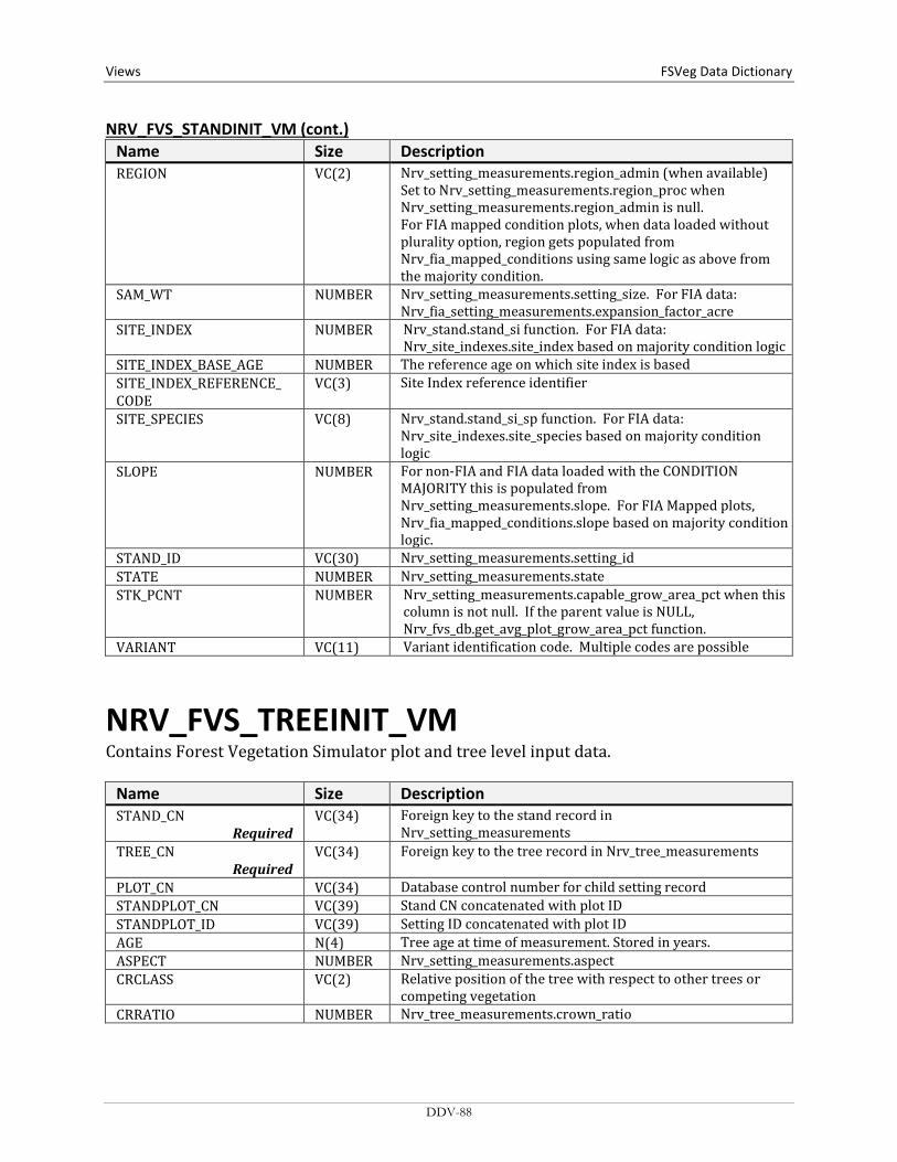
Views FSVeg Data Dictionary NRV_FVS_STANDINIT_VM (cont.)
Name Size Description REGION VC(2) Nrv_setting_measurements.region_admin (when available)
Set to Nrv_setting_measurements.region_proc when Nrv_setting_measurements.region_admin is null. For FIA mapped condition plots, when data loaded without plurality option, region gets populated from Nrv_fia_mapped_conditions using same logic as above from the majority condition.
SAM_WT NUMBER Nrv_setting_measurements.setting_size. For FIA data: Nrv_fia_setting_measurements.expansion_factor_acre
SITE_INDEX NUMBER Nrv_stand.stand_si function. For FIA data: Nrv_site_indexes.site_index based on majority condition logic
SITE_INDEX_BASE_AGE NUMBER The reference age on which site index is based SITE_INDEX_REFERENCE_ CODE
VC(3) Site Index reference identifier
SITE_SPECIES VC(8) Nrv_stand.stand_si_sp function. For FIA data: Nrv_site_indexes.site_species based on majority condition logic
SLOPE NUMBER For non-FIA and FIA data loaded with the CONDITION MAJORITY this is populated from Nrv_setting_measurements.slope. For FIA Mapped plots, Nrv_fia_mapped_conditions.slope based on majority condition logic.
STAND_ID VC(30) Nrv_setting_measurements.setting_id STATE NUMBER Nrv_setting_measurements.state STK_PCNT NUMBER Nrv_setting_measurements.capable_grow_area_pct when this
column is not null. If the parent value is NULL, Nrv_fvs_db.get_avg_plot_grow_area_pct function.
VARIANT VC(11) Variant identification code. Multiple codes are possible
NRV_FVS_TREEINIT_VM Contains Forest Vegetation Simulator plot and tree level input data.
Name Size Description STAND_CN
Required VC(34) Foreign key to the stand record in
Nrv_setting_measurements TREE_CN
Required VC(34) Foreign key to the tree record in Nrv_tree_measurements
PLOT_CN VC(34) Database control number for child setting record STANDPLOT_CN VC(39) Stand CN concatenated with plot ID STANDPLOT_ID VC(39) Setting ID concatenated with plot ID AGE N(4) Tree age at time of measurement. Stored in years. ASPECT NUMBER Nrv_setting_measurements.aspect CRCLASS VC(2) Relative position of the tree with respect to other trees or
competing vegetation CRRATIO NUMBER Nrv_tree_measurements.crown_ratio
DDV-88
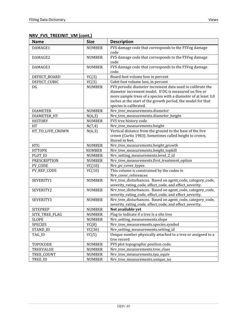
FSVeg Data Dictionary Views
NRV_FVS_TREEINIT_VM (cont.) Name Size Description DAMAGE1 NUMBER FVS damage code that corresponds to the FSVeg damage
code DAMAGE2 NUMBER FVS damage code that corresponds to the FSVeg damage
code DAMAGE3 NUMBER FVS damage code that corresponds to the FSVeg damage
code. DEFECT_BOARD VC(3) Board foot volume loss in percent DEFECT_CUBIC VC(3) Cubit foot volume loss, in percent DG NUMBER FVS periodic diameter increment data used to calibrate the
diameter increment model. If DG is measured on five or more sample trees of a species with a diameter of at least 3.0 inches at the start of the growth period, the model for that species is calibrated.
DIAMETER NUMBER Nrv_tree_measurements.diameter DIAMETER_HT N(6,3) Nrv_tree_measurements.diameter_height HISTORY NUMBER FVS tree history code HT N(7,4) Nrv_tree_measurements.height HT_TO_LIVE_CROWN N(6,3) Vertical distance from the ground to the base of the live
crown (Curtis 1983). Sometimes called height to crown. Stored in feet.
HTG NUMBER Nrv_tree_measurements.height_growth HTTOPK NUMBER Nrv_tree_measurements.height_topkill PLOT_ID NUMBER Nrv_setting_measurements.level_2_id PRESCRIPTION NUMBER Nrv_tree_measurements.first_treatment_option PV_CODE VC(10) Nrv_pv_cover_types PV_REF_CODE VC(10) This column is constrained by the codes in
Nrv_cover_references SEVERITY1 NUMBER Nrv_tree_disturbances. Based on agent_code, category_code,
severity_rating_code, effect_code, and effect_severity. SEVERITY2 NUMBER Nrv_tree_disturbances. Based on agent_code, category_code,
severity_rating_code, effect_code, and effect_severity. SEVERITY3 NUMBER Nrv_tree_disturbances. Based on agent_code, category_code,
severity_rating_code, effect_code, and effect_severity. SITEPREP NUMBER Not available yet SITE_TREE_FLAG NUMBER Flag to indicate if a tree is a site tree SLOPE NUMBER Nrv_setting_measurements.slope SPECIES VC(8) Nrv_tree_measurements.species.symbol STAND_ID VC(30) Nrv_setting_measurements.setting_id TAG_ID VC(5) Unique number physically attached to a tree or assigned to a
tree record TOPOCODE NUMBER FVS plot topographic position code. TREEVALUE NUMBER Nrv_tree_measurements.tree_class TREE_COUNT NUMBER Nrv_tree_measurements.tpa_equiv TREE_ID NUMBER Nrv_tree_measurements.unique_no
DDV-89
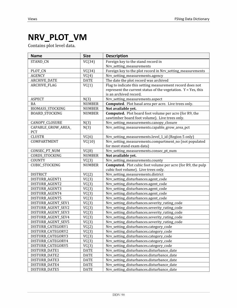
Views FSVeg Data Dictionary
NRV_PLOT_VM Contains plot level data.
Name Size Description STAND_CN VC(34) Foreign key to the stand record in
Nrv_setting_measurements PLOT_CN VC(34) Foreign key to the plot record in Nrv_setting_measurements AGENCY VC(4) Nrv_setting_measurements.agency ARCHIVE_DATE DATE The date the plot record was archived ARCHIVE_FLAG VC(1) Flag to indicate this setting measurement record does not
represent the current status of the vegetation. Y = Yes, this is an archived record.
ASPECT N(3) Nrv_setting_measurements.aspect BA NUMBER Computed. Plot basal area per acre. Live trees only. BIOMASS_STOCKING NUMBER Not available yet. BOARD_STOCKING NUMBER Computed. Plot board foot volume per acre (for R9, the
sawtimber board foot volume). Live trees only. CANOPY_CLOSURE N(3) Nrv_setting_measurements.canopy_closure CAPABLE_GROW_AREA_ PCT
N(3) Nrv_setting_measurements.capable_grow_area_pct
CLUSTR VC(6) Nrv_setting_measurements.level_1_id (Region 5 only) COMPARTMENT VC(10) Nrv_setting_measurements.compartment_no (not populated
for most stand exam data) CONSEC_PT_NUM VC(8) Nrv_setting_measurements.consec_pt_num CORDS_STOCKING NUMBER Not available yet. COUNTY VC(3) Nrv_setting_measurements.county CUBIC_STOCKING NUMBER Computed. Plot cubic foot volume per acre (for R9, the pulp
cubic foot volume). Live trees only. DISTRICT VC(2) Nrv_setting_measurements.district DISTURB_AGENT1 VC(3) Nrv_setting_disturbances.agent_code DISTURB_AGENT2 VC(3) Nrv_setting_disturbances.agent_code DISTURB_AGENT3 VC(3) Nrv_setting_disturbances.agent_code DISTURB_AGENT4 VC(3) Nrv_setting_disturbances.agent_code DISTURB_AGENT5 VC(3) Nrv_setting_disturbances.agent_code DISTURB_AGENT_SEV1 VC(3) Nrv_setting_disturbances.severity_rating_code DISTURB_AGENT_SEV2 VC(3) Nrv_setting_disturbances.severity_rating_code DISTURB_AGENT_SEV3 VC(3) Nrv_setting_disturbances.severity_rating_code DISTURB_AGENT_SEV4 VC(3) Nrv_setting_disturbances.severity_rating_code DISTURB_AGENT_SEV5 VC(3) Nrv_setting_disturbances.severity_rating_code DISTURB_CATEGORY1 VC(2) Nrv_setting_disturbances.category_code DISTURB_CATEGORY2 VC(3) Nrv_setting_disturbances.category_code DISTURB_CATEGORY3 VC(3) Nrv_setting_disturbances.category_code DISTURB_CATEGORY4 VC(3) Nrv_setting_disturbances.category_code DISTURB_CATEGORY5 VC(3) Nrv_setting_disturbances.category_code DISTURB_DATE1 DATE Nrv_setting_disturbances.disturbance_date DISTURB_DATE2 DATE Nrv_setting_disturbances.disturbance_date DISTURB_DATE3 DATE Nrv_setting_disturbances.disturbance_date DISTURB_DATE4 DATE Nrv_setting_disturbances.disturbance_date DISTURB_DATE5 DATE Nrv_setting_disturbances.disturbance_date
DDV-90

FSVeg Data Dictionary Views
NRV_PLOT_VM (cont.) Name Size Description DISTURB_EFFECT1 VC(3) Nrv_setting_disturbances.effect_code DISTURB_EFFECT2 VC(3) Nrv_setting_disturbances.effect_code DISTURB_EFFECT3 VC(3) Nrv_setting_disturbances.effect_code DISTURB_EFFECT4 VC(3) Nrv_setting_disturbances.effect_code DISTURB_EFFECT5 VC(3) Nrv_setting_disturbances.effect_code DISTURB_EFFECT_SEV1 VC(3) Nrv_setting_disturbances.effect_severity DISTURB_EFFECT_SEV2 VC(3) Nrv_setting_disturbances.effect_severity DISTURB_EFFECT_SEV3 VC(3) Nrv_setting_disturbances.effect_severity DISTURB_EFFECT_SEV4 VC(3) Nrv_setting_disturbances.effect_severity DISTURB_EFFECT_SEV5 VC(3) Nrv_setting_disturbances.effect_severity DISTURB_PERCENT1 NUMBER Nrv_setting_disturbances.damage_percent DISTURB_PERCENT2 NUMBER Nrv_setting_disturbances.damage_percent DISTURB_PERCENT3 NUMBER Nrv_setting_disturbances.damage_percent DISTURB_PERCENT4 NUMBER Nrv_setting_disturbances.damage_percent DISTURB_PERCENT5 NUMBER Nrv_setting_disturbances.damage_percent ELEVATION N(6,1) Nrv_setting_measurements.elevation EV VC(10) Nrv_setting_measurements.ev_code EV_REF VC(10) Nrv_setting_measurements.ev_ref_code FOREST_ADMIN VC(2) Nrv_setting_measurements.forest_admin FOREST_PROC VC(2) Nrv_setting_measurements.forest_proc FSVEG_ID VC(40) Nrv_setting_measurements.fsveg_id (from the plot record) GEOGRAPHICAL_AREA VC(5) Nrv_setting_measurements.geographical_area HISTORY1 VC(6) Nrv_setting_histories.history_code HISTORY2 VC(6) Nrv_setting_histories.history_code HISTORY3 VC(6) Nrv_setting_histories.history_code HISTORY_DATE1 DATE Nrv_setting_histories.history_date HISTORY_DATE2 DATE Nrv_setting_histories.history_date HISTORY_DATE3 DATE Nrv_setting_histories.history_date LATITUDE_DEG NUMBER Nrv_setting_measurements.latitude_deg LATITUDE_GIS N(11,6) Nrv_setting_measurements.latitude_gis (from the plot
record) LATITUDE_MIN NUMBER Nrv_setting_measurements.latitude_min LATITUDE_SEC NUMBER Nrv_setting_measurements.latitude_sec LAT_LON_DATUM VC(2) Nrv_setting_measurements.lat_lon_datum LONGITUDE_DEG NUMBER Nrv_setting_measurements.longitude_deg LONGITUDE_GIS N(11,6) Nrv_setting_measurements.longitude_gis (from the plot
record) LONGITUDE_MIN NUMBER Nrv_setting_measurements.longitude_min LONGITUDE_SEC NUMBER Nrv_setting_measurements.longitude_sec MEASUREMENT_DATE DATE Nrv_setting_measurements.measurement_date MEASUREMENT_NO VC(2) Nrv_setting_measurements.measurement_no MERCH_CUBIC_STOCKING NUMBER Computed. Plot cubic foot volume per acre of the
merchantable portion of tree (for R9, the sawtimber cubic foot volume). Live trees only.
NET_BOARD_STOCKING NUMBER Not available yet. Plot board foot volume per acre after defect has been detected. Live trees only.
NET_CUBIC_STOCKING NUMBER Not available yet. Plot cubic foot volume per acre, after defect is deducted. Live trees only.
DDV-91
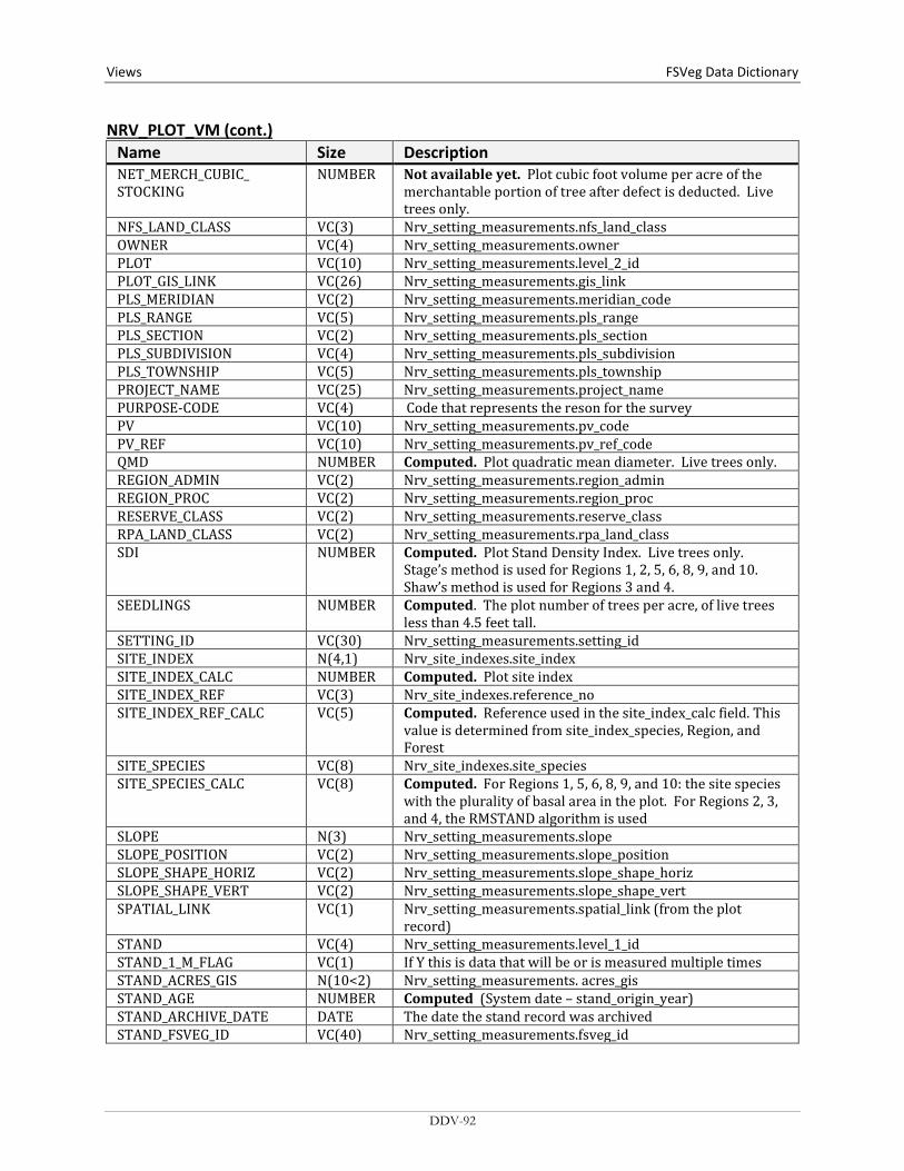
Views FSVeg Data Dictionary NRV_PLOT_VM (cont.)
Name Size Description NET_MERCH_CUBIC_ STOCKING
NUMBER Not available yet. Plot cubic foot volume per acre of the merchantable portion of tree after defect is deducted. Live trees only.
NFS_LAND_CLASS VC(3) Nrv_setting_measurements.nfs_land_class OWNER VC(4) Nrv_setting_measurements.owner PLOT VC(10) Nrv_setting_measurements.level_2_id PLOT_GIS_LINK VC(26) Nrv_setting_measurements.gis_link PLS_MERIDIAN VC(2) Nrv_setting_measurements.meridian_code PLS_RANGE VC(5) Nrv_setting_measurements.pls_range PLS_SECTION VC(2) Nrv_setting_measurements.pls_section PLS_SUBDIVISION VC(4) Nrv_setting_measurements.pls_subdivision PLS_TOWNSHIP VC(5) Nrv_setting_measurements.pls_township PROJECT_NAME VC(25) Nrv_setting_measurements.project_name PURPOSE-CODE VC(4) Code that represents the reson for the survey PV VC(10) Nrv_setting_measurements.pv_code PV_REF VC(10) Nrv_setting_measurements.pv_ref_code QMD NUMBER Computed. Plot quadratic mean diameter. Live trees only. REGION_ADMIN VC(2) Nrv_setting_measurements.region_admin REGION_PROC VC(2) Nrv_setting_measurements.region_proc RESERVE_CLASS VC(2) Nrv_setting_measurements.reserve_class RPA_LAND_CLASS VC(2) Nrv_setting_measurements.rpa_land_class SDI NUMBER Computed. Plot Stand Density Index. Live trees only.
Stage’s method is used for Regions 1, 2, 5, 6, 8, 9, and 10. Shaw’s method is used for Regions 3 and 4.
SEEDLINGS NUMBER Computed. The plot number of trees per acre, of live trees less than 4.5 feet tall.
SETTING_ID VC(30) Nrv_setting_measurements.setting_id SITE_INDEX N(4,1) Nrv_site_indexes.site_index SITE_INDEX_CALC NUMBER Computed. Plot site index SITE_INDEX_REF VC(3) Nrv_site_indexes.reference_no SITE_INDEX_REF_CALC VC(5) Computed. Reference used in the site_index_calc field. This
value is determined from site_index_species, Region, and Forest
SITE_SPECIES VC(8) Nrv_site_indexes.site_species SITE_SPECIES_CALC VC(8) Computed. For Regions 1, 5, 6, 8, 9, and 10: the site species
with the plurality of basal area in the plot. For Regions 2, 3, and 4, the RMSTAND algorithm is used
SLOPE N(3) Nrv_setting_measurements.slope SLOPE_POSITION VC(2) Nrv_setting_measurements.slope_position SLOPE_SHAPE_HORIZ VC(2) Nrv_setting_measurements.slope_shape_horiz SLOPE_SHAPE_VERT VC(2) Nrv_setting_measurements.slope_shape_vert SPATIAL_LINK VC(1) Nrv_setting_measurements.spatial_link (from the plot
record) STAND VC(4) Nrv_setting_measurements.level_1_id STAND_1_M_FLAG VC(1) If Y this is data that will be or is measured multiple times STAND_ACRES_GIS N(10<2) Nrv_setting_measurements. acres_gis STAND_AGE NUMBER Computed (System date – stand_origin_year) STAND_ARCHIVE_DATE DATE The date the stand record was archived STAND_FSVEG_ID VC(40) Nrv_setting_measurements.fsveg_id
DDV-92
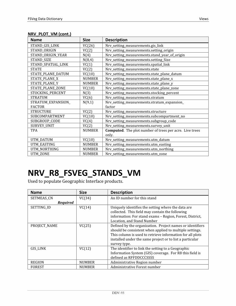
FSVeg Data Dictionary Views
NRV_PLOT_VM (cont.) Name Size Description STAND_GIS_LINK VC(26) Nrv_setting_measurements.gis_link STAND_ORIGIN VC(2) Nrv_setting_measurements.setting_origin STAND_ORIGIN_YEAR N(4) Nrv_setting_measurements.stand_year_of_origin STAND_SIZE N(8,4) Nrv_setting_measurements.setting_Size STAND_SPATIAL_LINK VC(1) Nrv_setting_measurements.spatial_link STATE VC(2) Nrv_setting_measurements.state STATE_PLANE_DATUM VC(10) Nrv_setting_measurements.state_plane_datum STATE_PLANE_X NUMBER Nrv_setting_measurements.state_plane_x STATE_PLANE_Y NUMBER Nrv_setting_measurements.state_plane_y STATE_PLANE_ZONE VC(10) Nrv_setting_measurements.state_plane_zone STOCKING_PERCENT N(3) Nrv_setting_measurements.stocking_percent STRATUM VC(6) Nrv_setting_measurements.stratum STRATUM_EXPANSION_ FACTOR
N(9,1) Nrv_setting_measurements.stratum_expansion_ factor
STRUCTURE VC(2) Nrv_setting_measurements.structure SUBCOMPARTMENT VC(10) Nrv_setting_measurements.subcompartment_no SUBGROUP_CODE VC(4) Nrv_setting_measurements.subgroup_code SURVEY_UNIT VC(2) Nrv_setting_measurements.survey_unit TPA NUMBER Computed. The plot number of trees per acre. Live trees
only. UTM_DATUM VC(10) Nrv_setting_measurements.utm_datum UTM_EASTING NUMBER Nrv_setting_measurements.utm_easting UTM_NORTHING NUMBER Nrv_setting_measurements.utm_northing UTM_ZONE NUMBER Nrv_setting_measurements.utm_zone
NRV_R8_FSVEG_STANDS_VM Used to populate Geographic Interface products.
Name Size Description SETMEAS_CN
Required VC(34) An ID number for this stand
SETTING_ID VC(14) Uniquely identifies the setting where the data are collected. This field may contain the following information: For stand exams – Region, Forest, District, Location, and Stand Number
PROJECT_NAME VC(25) Defined by the organization. Project names or identifiers should be consistent when applied to multiple settings. This column is used to retrieve information for all plots installed under the same project or to list a particular survey type.
GIS_LINK VC(12) The identifier to link the setting to a Geographic Information System (GIS) coverage. For R8 this field is defined as RFFDDCCCSSSS
REGION NUMBER Administrative Region number FOREST NUMBER Administrative Forest number
DDV-93

Views FSVeg Data Dictionary NRV_R8_FSVEG_STANDS_VM (cont.)
Name Size Description DISTRICT NUMBER Ranger district number of the administrator or owner for
the Stand COMPARTMENT NUMBER A 4-digit number to identify an area on the ground.
Corresponds to FSVeg: LOCATION STAND NUMBER A 4-digit number to identify an area on the ground.
Corresponds to FSVeg: LEVEL_1_ID FOREST_PROC NUMBER Proclaimed Forest number STATE VC(2) A 2-character State code. LOV: NRV_STATES COUNTY VC(3) A 3-digit county code. LOV: NRV_COUNTIES LAND_CLASS NUMBER Current land class used for NFS data. A classification that
indicates the basic land cover. Corresponds to FSVeg: NFS_LAND_CLASS
LAND_CLASS_LOC_QUAL VC(16) A code to expand LAND_CLASS. Set forest-by-forest. No LOV.
UEAM VC(16) Stand is managed as Un-Even Aged stand. Set forest-by-forest. No LOV.
OLD_GROWTH VC(16) Stand is considered Old Growth. Set forest-by-forest. No LOV.
STAND_CONDITION NUMBER R8-specific code for condition of the satnd. Stand Condition Class. R8 codes:
Code Description 1 In Regeneration 2 Damaged pole timber 3 Damaged sawtimber 4 Forest pest infestation 5 Sparse pole timber 6 Sparse sawtimber 7 Low quality pole timber 8 Low quality sawtimber 9 Mature pole timber
10 Mature sawtimber 11 Immature pole timber 12 Immature sawtimber 13 Seedling and sapling 14 Adequately stocked seedlings and saplings 15 Inadequately stocked/nonstocked 16 Group selection management 17 Individual tree selection management
AGE_YEAR NUMBER(4) The year the stand was reforested. Corresponds to FSVeg: STAND_YEAR_OF_ORIGIN
DDV-94
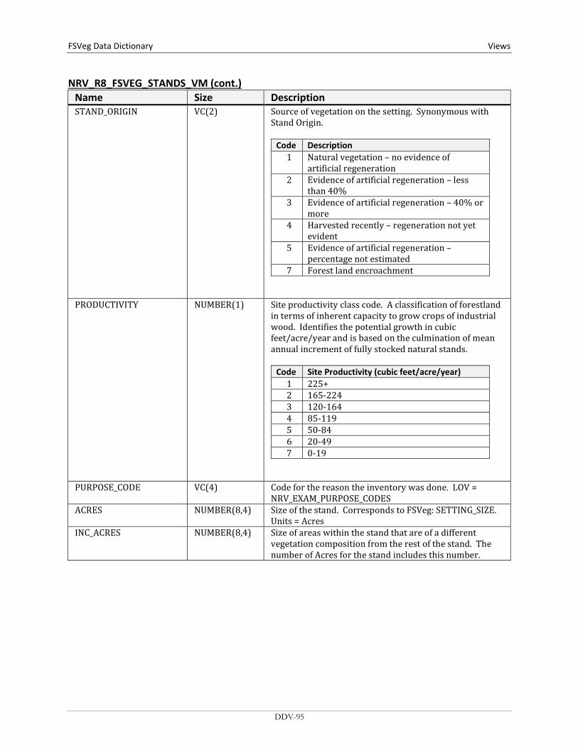
FSVeg Data Dictionary Views
NRV_R8_FSVEG_STANDS_VM (cont.) Name Size Description STAND_ORIGIN VC(2) Source of vegetation on the setting. Synonymous with
Stand Origin.
Code Description 1 Natural vegetation – no evidence of
artificial regeneration 2 Evidence of artificial regeneration – less
than 40% 3 Evidence of artificial regeneration – 40% or
more 4 Harvested recently – regeneration not yet
evident 5 Evidence of artificial regeneration –
percentage not estimated 7 Forest land encroachment
PRODUCTIVITY NUMBER(1) Site productivity class code. A classification of forestland in terms of inherent capacity to grow crops of industrial wood. Identifies the potential growth in cubic feet/acre/year and is based on the culmination of mean annual increment of fully stocked natural stands.
Code Site Productivity (cubic feet/acre/year) 1 225+ 2 165-224 3 120-164 4 85-119 5 50-84 6 20-49 7 0-19
PURPOSE_CODE VC(4) Code for the reason the inventory was done. LOV = NRV_EXAM_PURPOSE_CODES
ACRES NUMBER(8,4) Size of the stand. Corresponds to FSVeg: SETTING_SIZE. Units = Acres
INC_ACRES NUMBER(8,4) Size of areas within the stand that are of a different vegetation composition from the rest of the stand. The number of Acres for the stand includes this number.
DDV-95

Views FSVeg Data Dictionary NRV_R8_FSVEG_STANDS_VM (cont.)
Name Size Description INC_ACRES_TYPE VC(2) Type of Inclusion Acres.
Code Description
0 None 1 Hardwood inclusion 2 Softwood inclusion 3 Wildlife feature 4 Water feature 5 Rocks 6 Heritage feature 7 Insect/disease area 8 Opening 9 Other
10 Bogs and seeps
REMARKS VC(255) Remarks. Free format. No LOV. REMARKS_CODE VC(20) Remarks Code. Set forest-by-forest. No LOV. MANAGEMENT_AREA VC(20) Stands with similar management objectives and a
common management prescription. Set forest-by-forest. No LOV.
ANALYSIS_AREA VC(20) Land delineation subject to analysis of responses to proposed management practices. Set forest-by-forest. No LOV.
MEASUREMENT_DATE DATE Date that the stand was inventoried. FOREST_TYPE NUMBER An indicator of Forest Cover Type. Corresponds to FSVeg
Existing Vegetation Codes. LOV = F8HR8 MGT_TYPE NUMBER(3) Forest Type that is expected to occur after the next
regeneration of this stand. PREV_FOR_TYPE NUMBER Forest Type of the stand prior to its most recent
regeneration. FOR_TYPE_SI NUMBER(4,1) Site Index for the Forest Type. Units = Feet by Base Year MGT_TYPE_SI NUMBER(4,1) Site Index for the Management Type. Units = Feet by
Base Year FOR_TYPE_SI_SP VC(8) Species code for the species for which the Forest Type
Site Index applies. MGMT_TYPE_SI_SP VC(8) Species code for the species for which the Management
Type Site Index applies. BA_YEAR NUMBER(7,2) Year the stand was last inventoried. Corresponds to
Measurement Date BA_HARD_MAST VC(20) Basal Year of Hard Mast Species. Units = Square feet per
acre ARCHIVE_FLAG VC(1) Y = Stand is archived. Null = Stand is active. BA_PINE_POLE NUMBER Pine Pole Basal Area Per Acres for a Setting. Units =
Square feet per acre BA_PINE_SAW NUMBER Pine Sawtimber Basal Area Per Acres for a Setting. Units
= Square feet per acre
DDV-96

FSVeg Data Dictionary Views
NRV_R8_FSVEG_STANDS_VM (cont.) Name Size Description BA_HARD_POLE NUMBER Hardwood Pole Basal Area Per Acres for a Setting. Units
= Square feet per acre BA_HARD_SAW NUMBER Hardwood Sawtimber Basal Area Per Acres for a Setting.
Units = Sqpare feet per acre DBH_PINE_POLE NUMBER Pine Pole Average DBH for a Setting. Units = Inches DBH_HARD_POLE NUMBER Hardwood Pole Average DBH for a Setting. Units = Inches DBH_HARD_SAW NUMBER Hardwood Sawtimber Average DBH for a Setting. Units =
Inches
NRV_SAMPDW_VM Used to assist in entering data into the down woody form.
Name Size Description CN
Required VC(34) A system-generated sequence number to uniquely
identify a row of data in this table. SETMEAS_CN
Required VC(34) Foreign key to the setting record in
Nrv_setting_measurements SAMPLE_EXPANSION_FACTOR N(9,4) Nrv_sample_designs.sample_expansion_factor SELECTION_CRITERIA_NO VC(3) Nrv_selection_criteria.selection_criteria_no SELECTION_METHOD_TYPE VC(3) Nrv_sample_designs.selection_method_type SUBPOP VC(3) Nrv_selection_criteria.subpop SUBPOP_MAX_VAL UE N(13,4) Nrv_selection_criteria.subpop_max_value SUBPOP_MIN_VALUE N(13,4) Nrv_selection_criteria.subpop_min_value
NRV_SAMP_SELCRIT_VM Used to connect the sample design and selection criteria tables
Name Size Description SD_CN VC(34) A system-generated sequence number to uniquely
identify a row of data in this table. SD_SETMEAS_CN VC(34) Foreign key to the setting record in
Nrv_setting_measurements SAMPLE_EXPANSION_FACTOR N(9,4) Nrv_sample_designs.sample_expansion_factor SELECTION_CRITERIA_NO VC(3) Nrv_selection_criteria.selection_criteria_no SELECTION_METHOD_TYPE VC(3) Nrv_sample_designs.selection_method_type SUBPOP VC(3) Nrv_selection_criteria.subpop SUBPOP_CODE_VALUE VC(8) SUBPOP_MAX_VALUE N(13,4) Nrv_selection_criteria.subpop_max_value SUBPOP_MIN_VALUE N(13,4) Nrv_selection_criteria.subpop_min_value
DDV-97
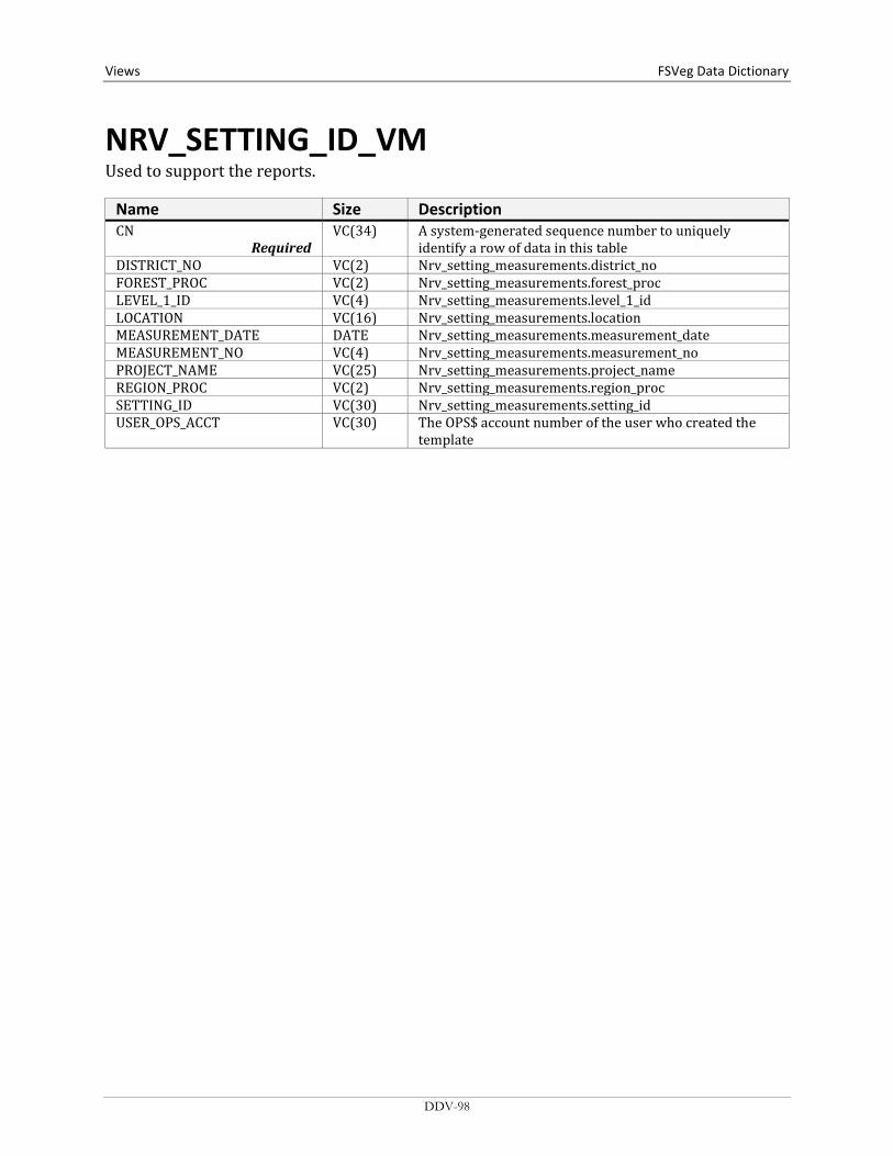
Views FSVeg Data Dictionary
NRV_SETTING_ID_VM Used to support the reports.
Name Size Description CN
Required VC(34) A system-generated sequence number to uniquely
identify a row of data in this table DISTRICT_NO VC(2) Nrv_setting_measurements.district_no FOREST_PROC VC(2) Nrv_setting_measurements.forest_proc LEVEL_1_ID VC(4) Nrv_setting_measurements.level_1_id LOCATION VC(16) Nrv_setting_measurements.location MEASUREMENT_DATE DATE Nrv_setting_measurements.measurement_date MEASUREMENT_NO VC(4) Nrv_setting_measurements.measurement_no PROJECT_NAME VC(25) Nrv_setting_measurements.project_name REGION_PROC VC(2) Nrv_setting_measurements.region_proc SETTING_ID VC(30) Nrv_setting_measurements.setting_id USER_OPS_ACCT VC(30) The OPS$ account number of the user who created the
template
DDV-98

FSVeg Data Dictionary Views
NRV_STAND_VM A multi-table view of stand level data.
Name Size Description STAND_CN
Required VC(34) Foreign key to the setting record in
Nrv_setting_measurements ACRES_GIS N(10,2) Nrv_setting_measurements.acres_gis AGE NUMBER Computed (System date – Stand_Origin_Year) AGENCY VC(4) Nrv_setting_measurements.agency ARCHIVE_DATE DATE The date the stand record was archived ARCHIVE_FLAG VC(1) Flag to indicate this setting measurement record does not
represent the current status of the vegetation. Y = Yes, this is an archived record.
ASPECT N(3) Nrv_setting_measurements.aspect BA NUMBER Computed. The stand basal area per acre. Live trees only. BIOMASS_STOCKING NUMBER Not available yet. BOARD_STOCKING NUMBER Computed. The plot board foot volume per acre (for R9,
the sawtimber board foot volume). Live trees only. CANOPY_CLOSURE N(3) Nrv_setting_measurements.canopy_closure CAPABLE_GROW_AREA_PCT N(3) Nrv_setting_measurements.capable_grow_area_pct COMPARTMENT VC(10) Nrv_setting_measurements.compartment_no (not
populated for most stand exam data) CORDS_STOCKING NUMBER Not available yet. COUNTY VC(3) Nrv_setting_measurements.county CUBIC_STOCKING NUMBER Computed. The stand cubic foot volume per acre (for R9,
the pulp cubic foot volume). Live trees only. DISTRICT VC(2) Nrv_setting_measurements.district DISTURB_AGENT1 VC(3) Nrv_setting_disturbances.agent_code DISTURB_AGENT2 VC(3) Nrv_setting_disturbances.agent_code DISTURB_AGENT3 VC(3) Nrv_setting_disturbances.agent_code DISTURB_AGENT4 VC(3) Nrv_setting_disturbances.agent_code DISTURB_AGENT5 VC(3) Nrv_setting_disturbances.agent_code DISTURB_AGENT_SEV1 VC(3) Nrv_setting_disturbances.severity_rating_code DISTURB_AGENT_SEV2 VC(3) Nrv_setting_disturbances.severity_rating_code DISTURB_AGENT_SEV3 VC(3) Nrv_setting_disturbances.severity_rating_code DISTURB_AGENT_SEV4 VC(3) Nrv_setting_disturbances.severity_rating_code DISTURB_AGENT_SEV5 VC(3) Nrv_setting_disturbances.severity_rating_code DISTURB_CATEGORY1 VC(2) Nrv_setting_disturbances.category_code DISTURB_CATEGORY2 VC(3) Nrv_setting_disturbances.category_code DISTURB_CATEGORY3 VC(3) Nrv_setting_disturbances.category_code DISTURB_CATEGORY4 VC(3) Nrv_setting_disturbances.category_code DISTURB_CATEGORY5 VC(3) Nrv_setting_disturbances.category_code DISTURB_DATE1 DATE Nrv_setting_disturbances.disturbance_date DISTURB_DATE2 DATE Nrv_setting_disturbances.disturbance_date DISTURB_DATE3 DATE Nrv_setting_disturbances.disturbance_date DISTURB_DATE4 DATE Nrv_setting_disturbances.disturbance_date DISTURB_DATE5 DATE Nrv_setting_disturbances.disturbance_date DISTURB_EFFECT1 VC(3) Nrv_setting_disturbances.effect_code DISTURB_EFFECT2 VC(3) Nrv_setting_disturbances.effect_code DISTURB_EFFECT3 VC(3) Nrv_setting_disturbances.effect_code
DDV-99

Views FSVeg Data Dictionary NRV_STAND_VM (cont.)
Name Size Description DISTURB_EFFECT4 VC(3) Nrv_setting_disturbances.effect_code DISTURB_EFFECT5 VC(3) Nrv_setting_disturbances.effect_code DISTURB_EFFECT_SEV1 VC(3) Nrv_setting_disturbances.effect_severity DISTURB_EFFECT_SEV2 VC(3) Nrv_setting_disturbances.effect_severity DISTURB_EFFECT_SEV3 VC(3) Nrv_setting_disturbances.effect_severity DISTURB_EFFECT_SEV4 VC(3) Nrv_setting_disturbances.effect_severity DISTURB_EFFECT_SEV5 VC(3) Nrv_setting_disturbances.effect_severity DISTURB_PERCENT1 NUMBER Nrv_setting_disturbances.damage_percent DISTURB_PERCENT2 NUMBER Nrv_setting_disturbances.damage_percent DISTURB_PERCENT3 NUMBER Nrv_setting_disturbances.damage_percent DISTURB_PERCENT4 NUMBER Nrv_setting_disturbances.damage_percent DISTURB_PERCENT5 NUMBER Nrv_setting_disturbances.damage_percent DOWN_PIECES_5_MINUS NUMBER The stand level average downed woody material piece
per acre estimate from a Brown’s planat transect survey for pieces from 3 to 4.99 inches in diameter. The estimate is derived from the transect data using: pieces/acres for the size class = sum [(pi * 43560 * piece count) / (2 * plot transect length * plots installed * piece length)]
DOWN_PIECES_5_10 NUMBER The stand level average downed woody material piece per acre estimate from a Brown’s planat transect survey for pieces from 5 to 9.99 inches in diameter. The estimate is derived from the transect data using: pieces/acres for the size class = sum [(pi * 43560 * piece count) / (2 * plot transect length * plots installed * piece length)]
DOWN_PIECES_10_15 NUMBER The stand level average downed woody material piece per acre estimate from a Brown’s planat transect survey for pieces from 10 to 14.99 inches in diameter. The estimate is derived from the transect data using: pieces/acres for the size class = sum [(pi * 43560 * piece count) / (2 * plot transect length * plots installed * piece length)]
DOWN_PIECES_15_20 NUMBER The stand level average downed woody material piece per acre estimate from a Brown’s planat transect survey for pieces from 15 to 19.99 inches in diameter. The estimate is derived from the transect data using: pieces/acres for the size class = sum [(pi * 43560 * piece count) / (2 * plot transect length * plots installed * piece length)]
DOWN_PIECES_20_25 NUMBER The stand level average downed woody material piece per acre estimate from a Brown’s planat transect survey for pieces from 20 to 24.99 inches in diameter. The estimate is derived from the transect data using: pieces/acres for the size class = sum [(pi * 43560 * piece count) / (2 * plot transect length * plots installed * piece length)]
DDV-100

FSVeg Data Dictionary Views
NRV_STAND_VM (cont.) Name Size Description DOWN_PIECES_25_30 NUMBER The stand level average downed woody material piece
per acre estimate from a Brown’s planat transect survey for pieces from 25 to 29.99 inches in diameter. The estimate is derived from the transect data using: pieces/acres for the size class = sum [(pi * 43560 * piece count) / (2 * plot transect length * plots installed * piece length)]
DOWN_PIECES_30_35 NUMBER The stand level average downed woody material piece per acre estimate from a Brown’s planat transect survey for pieces from 30 to 34.99 inches in diameter. The estimate is derived from the transect data using: pieces/acres for the size class = sum [(pi * 43560 * piece count) / (2 * plot transect length * plots installed * piece length)]
DOWN_PIECES_35_40 NUMBER The stand level average downed woody material piece per acre estimate from a Brown’s planat transect survey for pieces from 35 to 39.99 inches in diameter. The estimate is derived from the transect data using: pieces/acres for the size class = sum [(pi * 43560 * piece count) / (2 * plot transect length * plots installed * piece length)]
DOWN_PIECES_40_45 NUMBER The stand level average downed woody material piece per acre estimate from a Brown’s planat transect survey for pieces from 40 to 44.99 inches in diameter. The estimate is derived from the transect data using: pieces/acres for the size class = sum [(pi * 43560 * piece count) / (2 * plot transect length * plots installed * piece length)]
DOWN_PIECES_45_PLUS NUMBER The stand level average downed woody material piece per acre estimate from a Brown’s planat transect survey for pieces from 45 inches and up in diameter. The estimate is derived from the transect data using: pieces/acres for the size class = sum [(pi * 43560 * piece count) / (2 * plot transect length * plots installed * piece length)]
ELEVATION N(6,1) Nrv_setting_measurements.elevation EV VC(10) Nrv_setting_measurements.ev_code EV_REF VC(10) Nrv_setting_measurements.ev_ref_code FIA_EV_CALC VC(10) Computed. Forest type using the FIA algorithm FIA_TOTAL_STOCKING NUMBER Computed. Stand tree stocking using the FIA algorithm FOREST_ADMIN VC(2) Nrv_setting_measurements.forest_admin FOREST_PROC VC(2) Nrv_setting_measurements.forest_proc FSVEG_ID VC(40) Nrv_setting_measurements.fsveg_id FUEL_1HR N(5,2) Nrv_fuel_models.fuel_1hr FUEL_10HR N(5,2) Nrv_fuel_models.fuel_10hr FUEL_100HR N(5,2) Nrv_fuel_models.fuel_100hr FUEL_BED_DEPTH N(5,2) Nrv_fuel_models.fuel_bed_depth FUEL_MODEL VC(3) Nrv_fuel_models.fuel_model FUEL_MODEL_CODE VC(10) Nrv_fuel_models.fuel_model_code
DDV-101

Views FSVeg Data Dictionary NRV_STAND_VM (cont.)
Name Size Description GEOGRAPHICAL_AREA VC(5) Nrv_setting_measurements.geographical_area GIS_LINK VC(26) Nrv_setting_measurements.gis_link HISTORY1 VC(6) Nrv_setting_histories.history_code HISTORY2 VC(6) Nrv_setting_histories.history_code HISTORY3 VC(6) Nrv_setting_histories.history_code HISTORY_DATE1 DATE Nrv_setting_histories.history_date HISTORY_DATE2 DATE Nrv_setting_histories.history_date HISTORY_DATE3 DATE Nrv_setting_histories.history_date INCLUSION_ACRES N(8,4) Nrv_setting_measurements.inclusion_acres INCLUSION_ACRES_TYPE VC(2) Nrv_setting_measurements.inclusion_acres_type LATITUDE_DEG N(3) Nrv_setting_measurements.latitude_deg LATITUDE_MIN N(2) Nrv_setting_measurements.latitude_min LATITUDE_SEC N(4,2) Nrv_setting_measurements.latitude_sec LAT_LON_DATUM VC(50) Nrv_setting_measurements.lat_lon_datum LOCATION VC(16) Nrv_setting_measurements.location LONGITUDE_DEG N(3) Nrv_setting_measurements.longitude_deg LONGITUDE_MIN N(2) Nrv_setting_measurements.longitude_min LONGITUDE_SEC N(4,2) Nrv_setting_measurements.longitude_sec MANAGEMENT_PRODUCTIVITY N(1) Nrv_setting_measurements.management_productivity MANAGEMENT_TYPE N(3) Nrv_setting_measurements.management_type MANAGEMENT_TYPE_FLAG VC(1) MEASUREMENT_DATE DATE Nrv_setting_measurements.measurement_date MEASUREMENT_NO VC(4) Nrv_setting_measurements.measurement_no MERCH_CUBIC_STOCKING NUMBER Computed. Stand cubic foot volume per acre of the
merchantable portion of tree (for R9, the sawtimber cubic foot volume). Live trees only.
NET_BOARD_STOCKING NUMBER Not available yet. Stand board foot volume per acre after defect has been detected. Live trees only.
NET_CUBIC_STOCKING NUMBER Not available yet. Stand cubic foot volume per acre, after defect is deducted. Live trees only.
NET_MERCH_CUBIC_STOCKING NUMBER Not available yet. Stand cubic foot volume per acre of the merchantable portion of tree after defect is deducted. Live trees only.
NFS_LAND_CLASS VC(3) Nrv_setting_measurements.nfs_land_class ORIGIN VC(2) Nrv_setting_measurements.setting_origin ORGIN_YEAR N(4) Nrv_setting_measurements.stand_year_of_origin OWNER VC(4) Nrv_setting_measurements.owner PLS_MERIDIAN VC(2) Nrv_setting_measurements.meridian_code PLS_RANGE VC(5) Nrv_setting_measurements.pls_range PLS_SECTION VC(2) Nrv_setting_measurements.pls_section PLS_SUBDIVISION VC(4) Nrv_setting_measurements.pls_subdivision PLS_TOWNSHIP VC(5) Nrv_setting_measurements.pls_township PROJECT_NAME VC(25) Nrv_setting_measurements.project_name PURPOSE_CODE VC(4) Code that represents the reason for the survey PV VC(10) Nrv_setting_measurements.pv_code PV_REF VC(10) Nrv_setting_measurements.pv_ref_code QMD NUMBER Computed. Sand quadratic mean diameter. Live trees
only. REGION_ADMIN VC(2) Nrv_setting_measurements.region_admin REGION_PROC VC(2) Nrv_setting_measurements.region_proc
DDV-102

FSVeg Data Dictionary Views
NRV_STAND_VM (cont.) Name Size Description RPA_LAND_CLASS VC(2) Nrv_setting_measurements.rpa_land_class SDI NUMBER Computed. Stand Density Index. Live trees only.
Stage’s method is used for Regions 1, 2, 5, 6, 8, 9, and 10. Shaw’s method is used for Regions 3 and 4.
SEEDLINGS NUMBER Computed. Stand number of trees per acre, only includes live trees less than 4.5 feet tall.
SETTING_ID VC(30) Nrv_setting_measurements.setting_id SITE_INDEX N(4,1) Nrv_site_indexes.site_index SITE_INDEX_CALC NUMBER Computed. Site index based n site tree data collected on
the plot and the values computed for site_index_ref_calc and site_species_calc
SITE_INDEX_REF VC(3) Nrv_site_indexes.reference_no SITE_INDEX_REF_CALC VC(5) Computed. The referenced used to compute
site_index_calc, determined by a functin of site_species_calc, Region, and Forest.
SITE_SPECIES VC(8) Nrv_site_indexes.site_species SITE_SPECIES_CALC VC(8) Computed. For Regions 1, 5, 6, 8, 9, and 10; the site
species with the plurality of basal area in the setting. For Regions 2, 3, and 4; computed according to RMSTAND rules. Used to compute site_index_calc.
SLOPE N(3) Nrv_setting_measurements.slope SLOPE_POSITION VC(2) Nrv_setting_measurements.slope_position SLOPE_SHAPE_HORIZ VC(2) Nrv_setting_measurements.slope_shape_horiz SLOPE_SHAPE_VERT VC(2) Nrv_setting_measurements.slope_shape_vert SPATIAL_LINK VC(1) Nrv_setting_measurements.spatial_link STAND VC(10) Nrv_setting_measurements.level_1_id STAND_CONDITION N(2) Nrv_setting_measurements.stand_conditions STAND_SIZE N(8,4) Nrv_setting_measurements.setting_size STATE VC(2) Nrv_setting_measurements.state STATE_PLANE_DATUM VC(10) Nrv_setting_measurements.state_plane_datum STATE_PLANE_X N(12,3) Nrv_setting_measurements.state_plane_x STATE_PLANE_Y N(12,3) Nrv_setting_measurements.state_plane_y STATE_PLANE_ZONE VC(10) Nrv_setting_measurements.state_plane_zone STRATUM VC(6) Nrv_setting_measurements.stratum STRATUM_EXPANSION_FACTOR N(9,1) Nrv_setting_measurements.stratum_expansion_factor STRUCTURE VC(2) Nrv_setting_measurements.structure SUBCOMPARTMENT VC(10) Nrv_setting_measurements.subcompartment_no SURVEY_UNIT VC(2) Nrv_setting_measurements.survey_unit TPA NUMBER Computed. Stand number of trees per acre. Live trees
only. Greater than or equal to 4.5 feet in height. UTM_DATUM VC(10) Nrv_setting_measurements.utm_datum UTM_EASTING N(6) Nrv_setting_measurements.utm_easting UTM_NORTHING N(7) Nrv_setting_measurements.utm_northing UTM_ZONE N(2) Nrv_setting_measurements.utm_zone VSS VC(6) Computed. Vegetation structural stage for Regions 2, 3
and 4 only.
DDV-103

Views FSVeg Data Dictionary
NRV_STAND_PLOT_COVER_VM Contains stand level, plot level, and vegetative cover data.
Name Size Description STAND_CN
Required VC(34) Foreign key to the stand record in
Nrv_setting_measurements ARCHIVE_FLAG VC(1) Flag to indicate this setting measurement record does
not represent the current status of the vegetation. Y = Yes, this is an archived record.
COMPARTMENT VC(10) Nrv_setting_measurements.compartment_no (not populated for most stand exam data)
CONSEC_PT_NUM VC(8) Nrv_setting_measurements.consec_pt_num COUNTY VC(3) Nrv_setting_measurements.county DISTRICT VC(2) Nrv_setting_measurements.district FOREST_ADMIN VC(2) Nrv_setting_measurements.forest_admin FOREST_PROC VC(2) Nrv_setting_measurements.forest_proc GEOGRAPHICAL_AREA VC(5) Nrv_setting_measurements.geographical_area I_M_FLAG VC(1) Stand record only. If Y this is data that will be or is
measured multiple times LATITUDE_DEG NUMBER Nrv_setting_measurements.latitude_deg LATITUDE_MIN NUMBER Nrv_setting_measurements.latitude_min LATITUDE_SEC NUMBER Nrv_setting_measurements.latitude_sec LAT_LON_DATUM VC(8) Nrv_setting_measurements.lat_lon_datum LOCATION N(16) Nrv_setting_measurements.location LONGITUDE_DEG NUMBER Nrv_setting_measurements.longitude_deg LONGITUDE_MIN NUMBER Nrv_setting_measurements.longitude_min LONGITUDE_SEC NUMBER Nrv_setting_measurements.longitude_sec MEASUREMENT_DATE DATE Nrv_setting_measurements.measurement_date MEASUREMENT_NO VC(2) Nrv_setting_measurements.measurement_no NFS_LAND_CLASS VC(3) Nrv_setting_measurements.nfs_land_class PLOT VC(10) Nrv_setting_measurements.level_2_id PLOT_GIS_LINK VC(26) Nrv_setting_measurements.gis_link PLS_MERIDIAN VC(2) Nrv_setting_measurements.meridian_code PLS_RANGE VC(5) Nrv_setting_measurements.pls_range PLS_SECTION VC(2) Nrv_setting_measurements.pls_section PLS_SUBDIVISION VC(4) Nrv_setting_measurements.pls_subdivision PLS_TOWNSHIP VC(5) Nrv_setting_measurements.pls_township PURPOSE_CODE VC(4) Code that represents the reson for the survey PROJECT_NAME VC(25) Nrv_setting_measurements.project_name REGION_ADMIN VC(2) Nrv_setting_measurements.region_admin REGION_PROC VC(2) Nrv_setting_measurements.region_proc RESERVE_CLASS VC(2) Nrv_setting_measurements.reserve_class RPA_LAND_CLASS VC(2) Nrv_setting_measurements.rpa_land_class SETTING_ID VC(30) Nrv_setting_measurements.setting_id STAND VC(10) Nrv_setting_measurements.level_1_id STATE VC(2) Nrv_setting_measurements.state STATE_PLANE_DATUM VC(10) Nrv_setting_measurements.state_plane_datum STATE_PLANE_X NUMBER Nrv_setting_measurements.state_plane_x STATE_PLANE_Y NUMBER Nrv_setting_measurements.state_plane_y STATE_PLANE_ZONE VC(10) Nrv_setting_measurements.state_plane_zone
DDV-104

FSVeg Data Dictionary Views
NRV_STAND_PLOT_COVER_VM (cont.) Name Size Description SUBCOMPARTMENT VC(10) Nrv_setting_measurements.subcompartment_no SURVEY_UNIT VC(2) Nrv_setting_measurements.survey_Unit UTM_DATUM VC(10) Nrv_setting_measurements.utm_datum UTM_EASTING NUMBER Nrv_setting_measurements.utm_easting UTM_NORTHING NUMBER Nrv_setting_measurements.utm_northing UTM_ZONE NUMBER Nrv_setting_measurements.utm_zone STAND_ACRES_GIS N(10,2) Nrv_setting_measurements.acres_gis STAND_AGE NUMBER Computed (System date – Stand_Origin_Year) STAND_AGENCY VC(4) Nrv_setting_measurements.agency STAND_ARCHIVE_DATE DATE The date the stand record was archived STAND_ASPECT N(3) Nrv_setting_measurements.aspect STAND_BA NUMBER Computed. Stand basal area per acre. Live trees only. STAND_BIOMASS_STOCKING NUMBER Not available yet. STAND_BOARD_STOCKING NUMBER Computed. Stand board foot volume per acre (for R9,
the sawtimber board foot volume). Live trees only. STAND_CANOPY_CLOSURE N(3) Nrv_setting_measurements.canopy_closure STAND_CAPABLE_GROW_AREA_ PCT
N(3) Nrv_setting_measurements.capable_grow_area_pct
STAND_CORDS_STOCKING NUMBER Not available yet. STAND_CUBIC_STOCKING NUMBER Computed. Sand cubic foot volume per acre (for R9, the
pulp cubic foot volume). Live trees only. STAND_DISTURB_AGENT1 VC(3) Nrv_setting_disturbances.agent_code STAND_DISTURB_AGENT2 VC(3) Nrv_setting_disturbances.agent_code STAND_DISTURB_AGENT3 VC(3) Nrv_setting_disturbances.agent_code STAND_DISTURB_AGENT4 VC(3) Nrv_setting_disturbances.agent_code STAND_DISTURB_AGENT5 VC(3) Nrv_setting_disturbances.agent_code STAND_DISTURB_AGENT_SEV1 VC(3) Nrv_setting_disturbances.severity_rating_code STAND_DISTURB_AGENT_SEV2 VC(3) Nrv_setting_disturbances.severity_rating_code STAND_DISTURB_AGENT_SEV3 VC(3) Nrv_setting_disturbances.severity_rating_code STAND_DISTURB_AGENT_SEV4 VC(3) Nrv_setting_disturbances.severity_rating_code STAND_DISTURB_AGENT_SEV5 VC(3) Nrv_setting_disturbances.severity_rating_code STAND_DISTURB_CATEGORY1 VC(2) Nrv_setting_disturbances.category_code STAND_DISTURB_CATEGORY2 VC(3) Nrv_setting_disturbances.category_code STAND_DISTURB_CATEGORY3 VC(3) Nrv_setting_disturbances.category_code STAND_DISTURB_CATEGORY4 VC(2) Nrv_setting_disturbances.category_code STAND_DISTURB_CATEGORY5 VC(2) Nrv_setting_disturbances.category_code STAND_DISTURB_DATE1 DATE Nrv_setting_disturbances.disturbance_date STAND_DISTURB_DATE2 DATE Nrv_setting_disturbances.disturbance_date STAND_DISTURB_DATE3 DATE Nrv_setting_disturbances.disturbance_date STAND_DISTURB_DATE4 DATE Nrv_setting_disturbances.disturbance_date STAND_DISTURB_DATE5 DATE Nrv_setting_disturbances.disturbance_date STAND_DISTURB_EFFECT1 VC(3) Nrv_setting_disturbances.effect_code STAND_DISTURB_EFFECT2 VC(3) Nrv_setting_disturbances.effect_code STAND_DISTURB_EFFECT3 VC(3) Nrv_setting_disturbances.effect_code STAND_DISTURB_EFFECT4 VC(3) Nrv_setting_disturbances.effect_code STAND_DISTURB_EFFECT5 VC(3) Nrv_setting_disturbances.effect_code STAND_DISTURB_EFFECT_SEV1 VC(3) Nrv_setting_disturbances.effect_severity STAND_DISTURB_EFFECT_SEV2 VC(3) Nrv_setting_disturbances.effect_severity STAND_DISTURB_EFFECT_SEV3 VC(3) Nrv_setting_disturbances.effect_severity
DDV-105
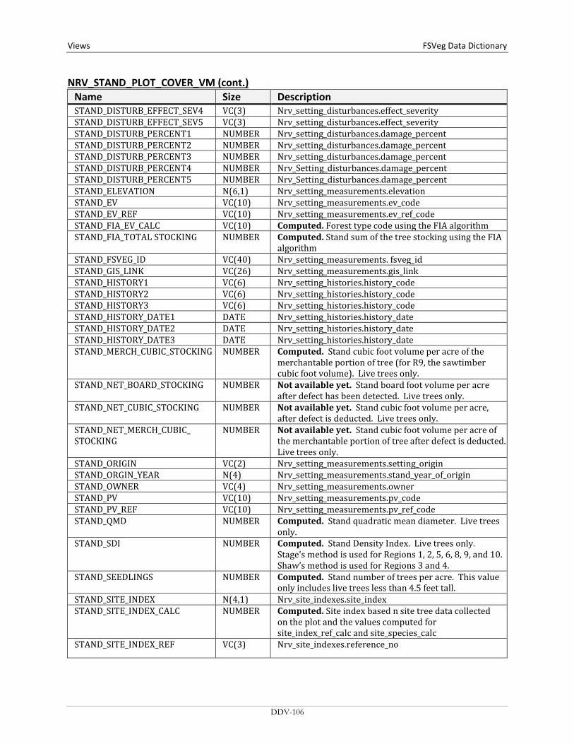
Views FSVeg Data Dictionary NRV_STAND_PLOT_COVER_VM (cont.)
Name Size Description STAND_DISTURB_EFFECT_SEV4 VC(3) Nrv_setting_disturbances.effect_severity STAND_DISTURB_EFFECT_SEV5 VC(3) Nrv_setting_disturbances.effect_severity STAND_DISTURB_PERCENT1 NUMBER Nrv_setting_disturbances.damage_percent STAND_DISTURB_PERCENT2 NUMBER Nrv_setting_disturbances.damage_percent STAND_DISTURB_PERCENT3 NUMBER Nrv_setting_disturbances.damage_percent STAND_DISTURB_PERCENT4 NUMBER Nrv_Setting_disturbances.damage_percent STAND_DISTURB_PERCENT5 NUMBER Nrv_Setting_disturbances.damage_percent STAND_ELEVATION N(6,1) Nrv_setting_measurements.elevation STAND_EV VC(10) Nrv_setting_measurements.ev_code STAND_EV_REF VC(10) Nrv_setting_measurements.ev_ref_code STAND_FIA_EV_CALC VC(10) Computed. Forest type code using the FIA algorithm STAND_FIA_TOTAL STOCKING NUMBER Computed. Stand sum of the tree stocking using the FIA
algorithm STAND_FSVEG_ID VC(40) Nrv_setting_measurements. fsveg_id STAND_GIS_LINK VC(26) Nrv_setting_measurements.gis_link STAND_HISTORY1 VC(6) Nrv_setting_histories.history_code STAND_HISTORY2 VC(6) Nrv_setting_histories.history_code STAND_HISTORY3 VC(6) Nrv_setting_histories.history_code STAND_HISTORY_DATE1 DATE Nrv_setting_histories.history_date STAND_HISTORY_DATE2 DATE Nrv_setting_histories.history_date STAND_HISTORY_DATE3 DATE Nrv_setting_histories.history_date STAND_MERCH_CUBIC_STOCKING NUMBER Computed. Stand cubic foot volume per acre of the
merchantable portion of tree (for R9, the sawtimber cubic foot volume). Live trees only.
STAND_NET_BOARD_STOCKING NUMBER Not available yet. Stand board foot volume per acre after defect has been detected. Live trees only.
STAND_NET_CUBIC_STOCKING NUMBER Not available yet. Stand cubic foot volume per acre, after defect is deducted. Live trees only.
STAND_NET_MERCH_CUBIC_ STOCKING
NUMBER Not available yet. Stand cubic foot volume per acre of the merchantable portion of tree after defect is deducted. Live trees only.
STAND_ORIGIN VC(2) Nrv_setting_measurements.setting_origin STAND_ORGIN_YEAR N(4) Nrv_setting_measurements.stand_year_of_origin STAND_OWNER VC(4) Nrv_setting_measurements.owner STAND_PV VC(10) Nrv_setting_measurements.pv_code STAND_PV_REF VC(10) Nrv_setting_measurements.pv_ref_code STAND_QMD NUMBER Computed. Stand quadratic mean diameter. Live trees
only. STAND_SDI NUMBER Computed. Stand Density Index. Live trees only.
Stage’s method is used for Regions 1, 2, 5, 6, 8, 9, and 10. Shaw’s method is used for Regions 3 and 4.
STAND_SEEDLINGS NUMBER Computed. Stand number of trees per acre. This value only includes live trees less than 4.5 feet tall.
STAND_SITE_INDEX N(4,1) Nrv_site_indexes.site_index STAND_SITE_INDEX_CALC NUMBER Computed. Site index based n site tree data collected
on the plot and the values computed for site_index_ref_calc and site_species_calc
STAND_SITE_INDEX_REF VC(3) Nrv_site_indexes.reference_no
DDV-106
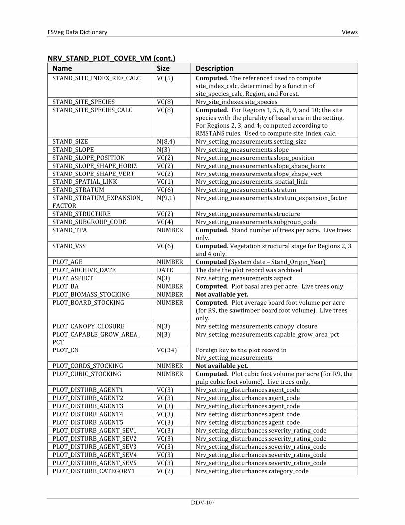
FSVeg Data Dictionary Views
NRV_STAND_PLOT_COVER_VM (cont.) Name Size Description STAND_SITE_INDEX_REF_CALC VC(5) Computed. The referenced used to compute
site_index_calc, determined by a functin of site_species_calc, Region, and Forest.
STAND_SITE_SPECIES VC(8) Nrv_site_indexes.site_species STAND_SITE_SPECIES_CALC VC(8) Computed. For Regions 1, 5, 6, 8, 9, and 10; the site
species with the plurality of basal area in the setting. For Regions 2, 3, and 4; computed according to RMSTANS rules. Used to compute site_index_calc.
STAND_SIZE N(8,4) Nrv_setting_measurements.setting_size STAND_SLOPE N(3) Nrv_setting_measurements.slope STAND_SLOPE_POSITION VC(2) Nrv_setting_measurements.slope_position STAND_SLOPE_SHAPE_HORIZ VC(2) Nrv_setting_measurements.slope_shape_horiz STAND_SLOPE_SHAPE_VERT VC(2) Nrv_setting_measurements.slope_shape_vert STAND_SPATIAL_LINK VC(1) Nrv_setting_measurements. spatial_link STAND_STRATUM VC(6) Nrv_setting_measurements.stratum STAND_STRATUM_EXPANSION_ FACTOR
N(9,1) Nrv_setting_measurements.stratum_expansion_factor
STAND_STRUCTURE VC(2) Nrv_setting_measurements.structure STAND_SUBGROUP_CODE VC(4) Nrv_setting_measurements.subgroup_code STAND_TPA NUMBER Computed. Stand number of trees per acre. Live trees
only. STAND_VSS VC(6) Computed. Vegetation structural stage for Regions 2, 3
and 4 only. PLOT_AGE NUMBER Computed (System date – Stand_Origin_Year) PLOT_ARCHIVE_DATE DATE The date the plot record was archived PLOT_ASPECT N(3) Nrv_setting_measurements.aspect PLOT_BA NUMBER Computed. Plot basal area per acre. Live trees only. PLOT_BIOMASS_STOCKING NUMBER Not available yet. PLOT_BOARD_STOCKING NUMBER Computed. Plot average board foot volume per acre
(for R9, the sawtimber board foot volume). Live trees only.
PLOT_CANOPY_CLOSURE N(3) Nrv_setting_measurements.canopy_closure PLOT_CAPABLE_GROW_AREA_ PCT
N(3) Nrv_setting_measurements.capable_grow_area_pct
PLOT_CN VC(34) Foreign key to the plot record in Nrv_setting_measurements
PLOT_CORDS_STOCKING NUMBER Not available yet. PLOT_CUBIC_STOCKING NUMBER Computed. Plot cubic foot volume per acre (for R9, the
pulp cubic foot volume). Live trees only. PLOT_DISTURB_AGENT1 VC(3) Nrv_setting_disturbances.agent_code PLOT_DISTURB_AGENT2 VC(3) Nrv_setting_disturbances.agent_code PLOT_DISTURB_AGENT3 VC(3) Nrv_setting_disturbances.agent_code PLOT_DISTURB_AGENT4 VC(3) Nrv_setting_disturbances.agent_code PLOT_DISTURB_AGENT5 VC(3) Nrv_setting_disturbances.agent_code PLOT_DISTURB_AGENT_SEV1 VC(3) Nrv_setting_disturbances.severity_rating_code PLOT_DISTURB_AGENT_SEV2 VC(3) Nrv_setting_disturbances.severity_rating_code PLOT_DISTURB_AGENT_SEV3 VC(3) Nrv_setting_disturbances.severity_rating_code PLOT_DISTURB_AGENT_SEV4 VC(3) Nrv_setting_disturbances.severity_rating_code PLOT_DISTURB_AGENT_SEV5 VC(3) Nrv_setting_disturbances.severity_rating_code PLOT_DISTURB_CATEGORY1 VC(2) Nrv_setting_disturbances.category_code
DDV-107
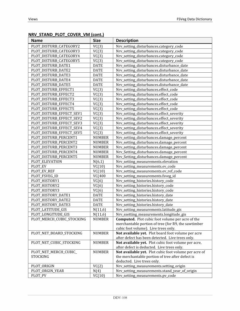
Views FSVeg Data Dictionary NRV_STAND_PLOT_COVER_VM (cont.)
Name Size Description PLOT_DISTURB_CATEGORY2 VC(3) Nrv_setting_disturbances.category_code PLOT_DISTURB_CATEGORY3 VC(3) Nrv_setting_disturbances.category_code PLOT_DISTURB_CATEGORY4 VC(3) Nrv_setting_disturbances.category_code PLOT_DISTURB_CATEGORY5 VC(3) Nrv_setting_disturbances.category_code PLOT_DISTURB_DATE1 DATE Nrv_setting_disturbances.disturbance_date PLOT_DISTURB_DATE2 DATE Nrv_setting_disturbances.disturbance_date PLOT_DISTURB_DATE3 DATE Nrv_setting_disturbances.disturbance_date PLOT_DISTURB_DATE4 DATE Nrv_setting_disturbances.disturbance_date PLOT_DISTURB_DATE5 DATE Nrv_setting_disturbances.disturbance_date PLOT_DISTURB_EFFECT1 VC(3) Nrv_setting_disturbances.effect_code PLOT_DISTURB_EFFECT2 VC(3) Nrv_setting_disturbances.effect_code PLOT_DISTURB_EFFECT3 VC(3) Nrv_setting_disturbances.effect_code PLOT_DISTURB_EFFECT4 VC(3) Nrv_setting_disturbances.effect_code PLOT_DISTURB_EFFECT5 VC(3) Nrv_setting_disturbances.effect_code PLOT_DISTURB_EFFECT_SEV1 VC(3) Nrv_setting_disturbances.effect_severity PLOT_DISTURB_EFFECT_SEV2 VC(3) Nrv_setting_disturbances.effect_severity PLOT_DISTURB_EFFECT_SEV3 VC(3) Nrv_setting_disturbances.effect_severity PLOT_DISTURB_EFFECT_SEV4 VC(3) Nrv_setting_disturbances.effect_severity PLOT_DISTURB_EFFECT_SEV5 VC(3) Nrv_setting_disturbances.effect_severity PLOT_DISTURB_PERCENT1 NUMBER Nrv_setting_disturbances.damage_percent PLOT_DISTURB_PERCENT2 NUMBER Nrv_setting_disturbances.damage_percent PLOT_DISTURB_PERCENT3 NUMBER Nrv_setting_disturbances.damage_percent PLOT_DISTURB_PERCENT4 NUMBER Nrv_Setting_disturbances.damage_percent PLOT_DISTURB_PERCENT5 NUMBER Nrv_Setting_disturbances.damage_percent PLOT_ELEVATION N(6,1) Nrv_setting_measurements.elevation PLOT_EV VC(10) Nrv_setting_measurements.ev_code PLOT_EV_REF VC(10) Nrv_setting_measurements.ev_ref_code PLOT_FSVEG_ID VC(400 Nrv_setting_measurements.fsveg_id PLOT_HISTORY1 VC(6) Nrv_setting_histories.history_code PLOT_HISTORY2 VC(6) Nrv_setting_histories.history_code PLOT_HISTORY3 VC(6) Nrv_setting_histories.history_code PLOT_HISTORY_DATE1 DATE Nrv_setting_histories.history_date PLOT_HISTORY_DATE2 DATE Nrv_setting_histories.history_date PLOT_HISTORY_DATE3 DATE Nrv_setting_histories.history_date PLOT_LATITUDE_GIS N(11,6) Nrv_setting_measurements.latitude_gis PLOT_LONGITUDE_GIS N(11,6) Nrv_ssetting_measurements.longitude_gis PLOT_MERCH_CUBIC_STOCKING NUMBER Computed. Plot cubic foot volume per acre of the
merchantable portion of tree (for R9, the sawtimber cubic foot volume). Live trees only.
PLOT_NET_BOARD_STOCKING NUMBER Not available yet. Plot board foot volume per acre after defect has been detected. Live trees only.
PLOT_NET_CUBIC_STOCKING NUMBER Not available yet. Plot cubic foot volume per acre, after defect is deducted. Live trees only.
PLOT_NET_MERCH_CUBIC_ STOCKING
NUMBER Not available yet. Plot cubic foot volume per acre of the merchantable portion of tree after defect is deducted. Live trees only.
PLOT_ORIGIN VC(2) Nrv_setting_measurements.setting_origin PLOT_ORGIN_YEAR N(4) Nrv_setting_measurements.stand_year_of_origin PLOT_PV VC(10) Nrv_setting_measurements.pv_code
DDV-108
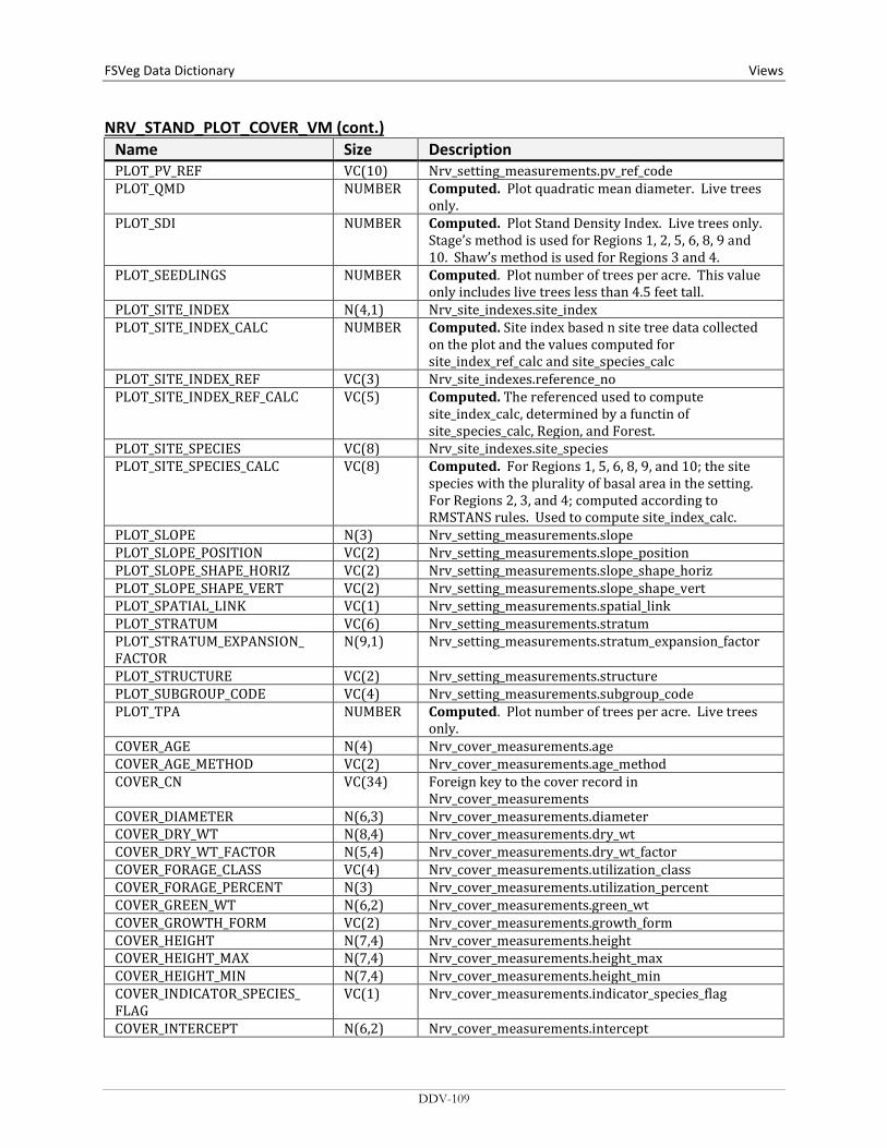
FSVeg Data Dictionary Views
NRV_STAND_PLOT_COVER_VM (cont.) Name Size Description PLOT_PV_REF VC(10) Nrv_setting_measurements.pv_ref_code PLOT_QMD NUMBER Computed. Plot quadratic mean diameter. Live trees
only. PLOT_SDI NUMBER Computed. Plot Stand Density Index. Live trees only.
Stage’s method is used for Regions 1, 2, 5, 6, 8, 9 and 10. Shaw’s method is used for Regions 3 and 4.
PLOT_SEEDLINGS NUMBER Computed. Plot number of trees per acre. This value only includes live trees less than 4.5 feet tall.
PLOT_SITE_INDEX N(4,1) Nrv_site_indexes.site_index PLOT_SITE_INDEX_CALC NUMBER Computed. Site index based n site tree data collected
on the plot and the values computed for site_index_ref_calc and site_species_calc
PLOT_SITE_INDEX_REF VC(3) Nrv_site_indexes.reference_no PLOT_SITE_INDEX_REF_CALC VC(5) Computed. The referenced used to compute
site_index_calc, determined by a functin of site_species_calc, Region, and Forest.
PLOT_SITE_SPECIES VC(8) Nrv_site_indexes.site_species PLOT_SITE_SPECIES_CALC VC(8) Computed. For Regions 1, 5, 6, 8, 9, and 10; the site
species with the plurality of basal area in the setting. For Regions 2, 3, and 4; computed according to RMSTANS rules. Used to compute site_index_calc.
PLOT_SLOPE N(3) Nrv_setting_measurements.slope PLOT_SLOPE_POSITION VC(2) Nrv_setting_measurements.slope_position PLOT_SLOPE_SHAPE_HORIZ VC(2) Nrv_setting_measurements.slope_shape_horiz PLOT_SLOPE_SHAPE_VERT VC(2) Nrv_setting_measurements.slope_shape_vert PLOT_SPATIAL_LINK VC(1) Nrv_setting_measurements.spatial_link PLOT_STRATUM VC(6) Nrv_setting_measurements.stratum PLOT_STRATUM_EXPANSION_ FACTOR
N(9,1) Nrv_setting_measurements.stratum_expansion_factor
PLOT_STRUCTURE VC(2) Nrv_setting_measurements.structure PLOT_SUBGROUP_CODE VC(4) Nrv_setting_measurements.subgroup_code PLOT_TPA NUMBER Computed. Plot number of trees per acre. Live trees
only. COVER_AGE N(4) Nrv_cover_measurements.age COVER_AGE_METHOD VC(2) Nrv_cover_measurements.age_method COVER_CN VC(34) Foreign key to the cover record in
Nrv_cover_measurements COVER_DIAMETER N(6,3) Nrv_cover_measurements.diameter COVER_DRY_WT N(8,4) Nrv_cover_measurements.dry_wt COVER_DRY_WT_FACTOR N(5,4) Nrv_cover_measurements.dry_wt_factor COVER_FORAGE_CLASS VC(4) Nrv_cover_measurements.utilization_class COVER_FORAGE_PERCENT N(3) Nrv_cover_measurements.utilization_percent COVER_GREEN_WT N(6,2) Nrv_cover_measurements.green_wt COVER_GROWTH_FORM VC(2) Nrv_cover_measurements.growth_form COVER_HEIGHT N(7,4) Nrv_cover_measurements.height COVER_HEIGHT_MAX N(7,4) Nrv_cover_measurements.height_max COVER_HEIGHT_MIN N(7,4) Nrv_cover_measurements.height_min COVER_INDICATOR_SPECIES_ FLAG
VC(1) Nrv_cover_measurements.indicator_species_flag
COVER_INTERCEPT N(6,2) Nrv_cover_measurements.intercept
DDV-109

Views FSVeg Data Dictionary NRV_STAND_PLOT_COVER_VM (cont.)
Name Size Description COVER_ITEM_COUNT N(3) Nrv_cover_measurements.item_count COVER_LAYER VC(3) Nrv_cover_measurements.layer COVER_LAYER_CODE_LOCAL VC(2) Nrv_cover_measurements.layer_code_local COVER_LIFEFORM VC(2) Nrv_cover_measurements.lifeform COVER_LIVE_DEAD VC(1) Nrv_cover_measurements.live_dead COVER_METHOD VC(2) Nrv_cover_measurements.cover_method COVER_PERCENT N(4,1) Nrv_cover_measurements.cover_percent COVER_PHENOLOGY_CLASS VC(2) Nrv_cover_measurements.phenology_class COVER_PRESENCE_FLAG VC(1) Nrv_cover_measurements.presence_flag COVER_SELCRIT_CN VC(34) Nrv_cover_measurements.selcrit_cn COVER_SHRUB_AGE_CLASS VC(2) Nrv_cover_measurements.shrub_age_class COVER_SHRUB_FORM_CLASS VC(4) Nrv_cover_measurements.shrub_form_class COVER_SPA_EQUIV N(10,5) Nrv_cover_measurements.spa_equiv COVER_SPECIES VC(8) Nrv_cover_measurements.species_symbol COVER_SUBGROUP_CODE VC(4) Nrv_cover_measurements.subgroup_code COVER_SURFACE_CODE VC(4) Nrv_cover_measurements.surface_cover_code COVER_TAG_ID VC(5) Nrv_cover_measurements.tag_id COVER_VOUCHER_FLAG VC(1) Nrv_cover_measurements.voucher_flag
NRV_STAND_PLOT_TREE_VM Contains stand level, plot level, and tree level data.
Name Size Description STAND_CN
Required VC(34) Foreign key to the stand record in
Nrv_setting_measurements ARCHIVE_FLAG VC(1) Flag to indicate this setting measurement record does
not represent the current status of the vegetation. Y = Yes, this is an archived record.
COMPARTMENT VC(10) Nrv_setting_measurements.compartment_no (not populated for most stand exam data)
CONSEC_PT_NUM VC(8) Nrv_setting_measurements.consec_pt_num COUNTY VC(3) Nrv_setting_measurements.county DISTRICT VC(2) Nrv_setting_measurements.district FOREST_ADMIN VC(2) Nrv_setting_measurements.forest_admin FOREST_PROC VC(2) Nrv_setting_measurements.forest_proc GEOGRAPHICAL_AREA VC(5) Nrv_setting_measurements.geographical_area I_M_FLAG VC(1) Stand record only. If Y this is data that will be or is
measured multiple times LATITUDE_DEG NUMBER Nrv_setting_measurements.latitude_deg LATITUDE_MIN NUMBER Nrv_setting_measurements.latitude_min LATITUDE_SEC NUMBER Nrv_setting_measurements.latitude_sec LAT_LON_DATUM VC(8) Nrv_setting_measurements.lat_lon_datum LOCATION VC(16) Nrv_setting_measurements.location LONGITUDE_DEG NUMBER Nrv_setting_measurements.longitude_deg LONGITUDE_MIN NUMBER Nrv_setting_measurements.longitude_min LONGITUDE_SEC NUMBER Nrv_setting_measurements.longitude_sec
DDV-110

FSVeg Data Dictionary Views
NRV_STAND_PLOT_TREE_VM (cont.) Name Size Description MEASUREMENT_DATE DATE Nrv_setting_measurements.measurement_date MEASUREMENT_NO VC(2) Nrv_setting_measurements.measurement_no NFS_LAND_CLASS VC(3) Nrv_setting_measurements.nfs_land_class PLS_MERIDIAN VC(2) Nrv_setting_measurements.meridian_code PLS_RANGE VC(5) Nrv_setting_measurements.pls_range PLS_SECTION VC(2) Nrv_setting_measurements.pls_section PLS_SUBDIVISION VC(4) Nrv_setting_measurements.pls_subdivision PLS_TOWNSHIP VC(5) Nrv_setting_measurements.pls_township PROJECT_NAME VC(25) Nrv_setting_measurements.project_name PURPOSE_CODE VC(4) Code that represents the reason for the survey REGION_ADMIN VC(2) Nrv_setting_measurements.region_admin REGION_PROC VC(2) Nrv_setting_measurements.region_proc RESERVE_CLASS VC(2) Nrv_setting_measurements.reserve_class RPA_LAND_CLASS VC(2) Nrv_setting_measurements.rpa_land_class SETTING_ID VC(30) Nrv_setting_measurements.setting_id STAND VC(10) Nrv_setting_measurements.level_1_id STATE VC(2) Nrv_setting_measurements.state STATE_PLANE_DATUM VC(10) Nrv_setting_measurements.state_plane_datum STATE_PLANE_X NUMBER Nrv_setting_measurements.state_plane_x STATE_PLANE_Y NUMBER Nrv_setting_measurements.state_plane_y STATE_PLANE_ZONE VC(10) Nrv_setting_measurements.state_plane_zone SUBCOMPARTMENT VC(10) Nrv_setting_measurements.subcompartment_no SURVEY_UNIT VC(2) Nrv_setting_measurements.survey_unit UTM_DATUM VC(10) Nrv_setting_measurements.utm_datum UTM_EASTING NUMBER Nrv_setting_measurements.utm_easting UTM_NORTHING NUMBER Nrv_setting_measurements.utm_northing UTM_ZONE NUMBER Nrv_setting_measurements.utm_zone STAND_CARES_GIS N(10,2) Nrv_setting_measurements.acres_gis STAND_AGE NUMBER Computed (System date – Stand_Origin_Year) STAND_AGENCY VC(4) Nrv_setting_measurements.agency STAND_ARCHIVE_DATE DATE The date the stand record was archived STAND_ASPECT N(3) Nrv_setting_measurements.aspect STAND_BA NUMBER Computed. Stand basal area per acre. Live trees only. STAND_BIOMASS_STOCKING NUMBER Not available yet. STAND_BOARD_STOCKING NUMBER Computed. Stand board foot volume per acre (for R9,
the sawtimber board foot volume). Live trees only. STAND_CANOPY_CLOSURE N(3) Nrv_setting_measurements.canopy_closure STAND_CAPABLE_GROW_AREA_ PCT
N(3) Nrv_setting_measurements.capable_grow_area_pct
STAND_CORDS_STOCKING NUMBER Not available yet. STAND_CUBIC_STOCKING NUMBER Computed. Stand cubic foot volume per acre (for R9, the
pulp cubic foot volume). Live trees only. STAND_DISTURB_AGENT1 VC(3) Nrv_setting_disturbances.agent_code STAND_DISTURB_AGENT2 VC(3) Nrv_setting_disturbances.agent_code STAND_DISTURB_AGENT3 VC(3) Nrv_setting_disturbances.agent_code STAND_DISTURB_AGENT4 VC(3) Nrv_setting_disturbances.agent_code STAND_DISTURB_AGENT5 VC(3) Nrv_setting_disturbances.agent_code STAND_DISTURB_AGENT_SEV1 VC(3) Nrv_setting_disturbances.severity_rating_code STAND_DISTURB_AGENT_SEV2 VC(3) Nrv_setting_disturbances.severity_rating_code
DDV-111
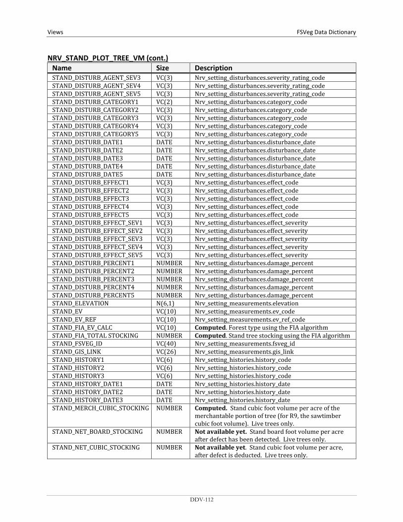
Views FSVeg Data Dictionary NRV_STAND_PLOT_TREE_VM (cont.)
Name Size Description STAND_DISTURB_AGENT_SEV3 VC(3) Nrv_setting_disturbances.severity_rating_code STAND_DISTURB_AGENT_SEV4 VC(3) Nrv_setting_disturbances.severity_rating_code STAND_DISTURB_AGENT_SEV5 VC(3) Nrv_setting_disturbances.severity_rating_code STAND_DISTURB_CATEGORY1 VC(2) Nrv_setting_disturbances.category_code STAND_DISTURB_CATEGORY2 VC(3) Nrv_setting_disturbances.category_code STAND_DISTURB_CATEGORY3 VC(3) Nrv_setting_disturbances.category_code STAND_DISTURB_CATEGORY4 VC(3) Nrv_setting_disturbances.category_code STAND_DISTURB_CATEGORY5 VC(3) Nrv_setting_disturbances.category_code STAND_DISTURB_DATE1 DATE Nrv_setting_disturbances.disturbance_date STAND_DISTURB_DATE2 DATE Nrv_setting_disturbances.disturbance_date STAND_DISTURB_DATE3 DATE Nrv_setting_disturbances.disturbance_date STAND_DISTURB_DATE4 DATE Nrv_setting_disturbances.disturbance_date STAND_DISTURB_DATE5 DATE Nrv_setting_disturbances.disturbance_date STAND_DISTURB_EFFECT1 VC(3) Nrv_setting_disturbances.effect_code STAND_DISTURB_EFFECT2 VC(3) Nrv_setting_disturbances.effect_code STAND_DISTURB_EFFECT3 VC(3) Nrv_setting_disturbances.effect_code STAND_DISTURB_EFFECT4 VC(3) Nrv_setting_disturbances.effect_code STAND_DISTURB_EFFECT5 VC(3) Nrv_setting_disturbances.effect_code STAND_DISTURB_EFFECT_SEV1 VC(3) Nrv_setting_disturbances.effect_severity STAND_DISTURB_EFFECT_SEV2 VC(3) Nrv_setting_disturbances.effect_severity STAND_DISTURB_EFFECT_SEV3 VC(3) Nrv_setting_disturbances.effect_severity STAND_DISTURB_EFFECT_SEV4 VC(3) Nrv_setting_disturbances.effect_severity STAND_DISTURB_EFFECT_SEV5 VC(3) Nrv_setting_disturbances.effect_severity STAND_DISTURB_PERCENT1 NUMBER Nrv_setting_disturbances.damage_percent STAND_DISTURB_PERCENT2 NUMBER Nrv_setting_disturbances.damage_percent STAND_DISTURB_PERCENT3 NUMBER Nrv_setting_disturbances.damage_percent STAND_DISTURB_PERCENT4 NUMBER Nrv_setting_disturbances.damage_percent STAND_DISTURB_PERCENT5 NUMBER Nrv_setting_disturbances.damage_percent STAND_ELEVATION N(6,1) Nrv_setting_measurements.elevation STAND_EV VC(10) Nrv_setting_measurements.ev_code STAND_EV_REF VC(10) Nrv_setting_measurements.ev_ref_code STAND_FIA_EV_CALC VC(10) Computed. Forest type using the FIA algorithm STAND_FIA_TOTAL STOCKING NUMBER Computed. Stand tree stocking using the FIA algorithm STAND_FSVEG_ID VC(40) Nrv_setting_measurements.fsveg_id STAND_GIS_LINK VC(26) Nrv_setting_measurements.gis_link STAND_HISTORY1 VC(6) Nrv_setting_histories.history_code STAND_HISTORY2 VC(6) Nrv_setting_histories.history_code STAND_HISTORY3 VC(6) Nrv_setting_histories.history_code STAND_HISTORY_DATE1 DATE Nrv_setting_histories.history_date STAND_HISTORY_DATE2 DATE Nrv_setting_histories.history_date STAND_HISTORY_DATE3 DATE Nrv_setting_histories.history_date STAND_MERCH_CUBIC_STOCKING NUMBER Computed. Stand cubic foot volume per acre of the
merchantable portion of tree (for R9, the sawtimber cubic foot volume). Live trees only.
STAND_NET_BOARD_STOCKING NUMBER Not available yet. Stand board foot volume per acre after defect has been detected. Live trees only.
STAND_NET_CUBIC_STOCKING NUMBER Not available yet. Stand cubic foot volume per acre, after defect is deducted. Live trees only.
DDV-112

FSVeg Data Dictionary Views
NRV_STAND_PLOT_TREE_VM (cont.) Name Size Description STAND_NET_MERCH_CUBIC_ STOCKING
NUMBER Not available yet. Stand cubic foot volume per acre of the merchantable portion of tree after defect is deducted. Live trees only.
STAND_ORIGIN VC(2) Nrv_setting_measurements.setting_origin STAND_ORGIN_YEAR N(4) Nrv_setting_measurements.stand_year_of_origin STAND_OWNER VC(4) Nrv_setting_measurements.owner STAND_PV VC(10) Nrv_setting_measurements.pv_code STAND_PV_REF VC(10) Nrv_setting_measurements.pv_ref_code STAND_QMD NUMBER Computed. Stand quadratic mean diameter. Live trees
only. STAND_SDI NUMBER Computed. Stand Density Index. Live trees only.
Stage’s method is used for Regions 1, 2, 5, 6, 8, 9, and 10. Shaw’s method is used for Regions 3 and 4.
STAND_SEEDLINGS NUMBER Computed. Stand number of trees per acre. This value only includes live trees less than 4.5 feet tall.
STAND_SITE_INDEX N(4,1) Nrv_site_indexes.site_index STAND_SITE_INDEX_CALC NUMBER Computed. Site index based n site tree data collected
on the plot and the values computed for site_index_ref_calc and site_species_calc
STAND_SITE_INDEX_REF VC(3) Nrv_site_indexes.reference_no STAND_SITE_INDEX_REF_CALC VC(5) Computed. The referenced used to compute
site_index_calc, determined by a functin of site_species_calc, Region, and Forest.
STAND_SITE_SPECIES VC(8) Nrv_site_indexes.site_species STAND_SITE_SPECIES_CALC VC(8) Computed. For Regions 1, 5, 6, 8, 9, and 10; the site
species with the plurality of basal area in the setting. For Regions 2, 3, and 4; computed according to RMSTAND rules. Used to compute site_index_calc.
STAND_SIZE N(8,4) Nrv_setting_measurements.setting_size STAND_SLOPE N(3) Nrv_setting_measurements.slope STAND_SLOPE_POSITION VC(2) Nrv_setting_measurements.slope_position STAND_SLOPE_SHAPE_HORIZ VC(2) Nrv_setting_measurements.slope_shape_horiz STAND_SLOPE_SHAPE_VERT VC(2) Nrv_setting_measurements.slope_shape_vert STAND_SPATIAL_LINK VC(1) Nrv_setting_measurements.spatial_link STAND_STRATUM VC(6) Nrv_setting_measurements.stratum STAND_STRATUM_EXPANSION_ FACTOR
N(9,1) Nrv_setting_measurements.stratum_expansion_factor
STAND_STRUCTURE VC(2) Nrv_setting_measurements.structure STAND_SUBGROUP_CODE VC(4) Nrv_setting_measurements.subgroup_code STAND_TPA NUMBER Computed. Stand number of trees per acre. Live trees
only. STAND_VSS VC(6) Computed. Vegetation structural stage for Regions 2, 3
and 4 only. PLOT VC(10) Nrv_setting_measurements.level_2_Id PLOT_AGE NUMBER Computed (System date – Stand_Origin_Year) PLOT_ARCHIVE_DATE DATE The date the plot record was archived PLOT_ASPECT N(3) Nrv_setting_measurements.aspect PLOT_BA NUMBER Computed. Plot basal area per acre. Live trees only. PLOT_BIOMASS_STOCKING NUMBER Not available yet.
DDV-113

Views FSVeg Data Dictionary NRV_STAND_PLOT_TREE_VM (cont.)
Name Size Description PLOT_BOARD_STOCKING NUMBER Computed. Plot board foot volume per acre (for R9,
the sawtimber board foot volume). Live trees only. PLOT_CANOPY_CLOSURE N(3) Nrv_setting_measurements.canopy_closure PLOT_CAPABLE_GROW_AREA_PCT
N(3) Nrv_setting_measurements.capable_grow_area_pct
PLOT_CN VC(34) Foreign key to the plot record in Nrv_setting_measurements
PLOT_CORDS_STOCKING NUMBER Not available yet. PLOT_CUBIC_STOCKING NUMBER Computed. Plot cubic foot volume per acre (for R9, the
pulp cubic foot volume). Live trees only. PLOT_DISTURB_AGENT1 VC(3) Nrv_setting_disturbances.agent_code PLOT_DISTURB_AGENT2 VC(3) Nrv_setting_disturbances.agent_code PLOT_DISTURB_AGENT3 VC(3) Nrv_setting_disturbances.agent_code PLOT_DISTURB_AGENT4 VC(3) Nrv_setting_disturbances.agent_code PLOT_DISTURB_AGENT5 VC(3) Nrv_setting_disturbances.agent_code PLOT_DISTURB_AGENT_SEV1 VC(3) Nrv_setting_disturbances.severity_rating_code PLOT_DISTURB_AGENT_SEV2 VC(3) Nrv_setting_disturbances.severity_rating_code PLOT_DISTURB_AGENT_SEV3 VC(3) Nrv_setting_disturbances.severity_rating_code PLOT_DISTURB_AGENT_SEV4 VC(3) Nrv_setting_disturbances.severity_rating_code PLOT_DISTURB_AGENT_SEV5 VC(3) Nrv_setting_disturbances.severity_rating_code PLOT_DISTURB_CATEGORY1 VC(2) Nrv_setting_disturbances.category_code PLOT_DISTURB_CATEGORY2 VC(3) Nrv_setting_disturbances.category_code PLOT_DISTURB_CATEGORY3 VC(3) Nrv_setting_disturbances.category_code PLOT_DISTURB_CATEGORY4 VC(3) Nrv_setting_disturbances.category_code PLOT_DISTURB_CATEGORY5 VC(3) Nrv_setting_disturbances.category_code PLOT_DISTURB_DATE1 DATE Nrv_setting_disturbances.disturbance_date PLOT_DISTURB_DATE2 DATE Nrv_setting_disturbances.disturbance_date PLOT_DISTURB_DATE3 DATE Nrv_setting_disturbances.disturbance_date PLOT_DISTURB_DATE4 DATE Nrv_setting_disturbances.disturbance_date PLOT_DISTURB_DATE5 DATE Nrv_setting_disturbances.disturbance_date PLOT_DISTURB_EFFECT1 VC(3) Nrv_setting_disturbances.effect_code PLOT_DISTURB_EFFECT2 VC(3) Nrv_setting_disturbances.effect_code PLOT_DISTURB_EFFECT3 VC(3) Nrv_setting_disturbances.effect_code PLOT_DISTURB_EFFECT4 VC(3) Nrv_setting_disturbances.effect_code PLOT_DISTURB_EFFECT5 VC(3) Nrv_setting_disturbances.effect_code PLOT_DISTURB_EFFECT_SEV1 VC(3) Nrv_setting_disturbances.effect_severity PLOT_DISTURB_EFFECT_SEV2 VC(3) Nrv_setting_disturbances.effect_severity PLOT_DISTURB_EFFECT_SEV3 VC(3) Nrv_setting_disturbances.effect_severity PLOT_DISTURB_EFFECT_SEV4 VC(3) Nrv_setting_disturbances.effect_severity PLOT_DISTURB_EFFECT_SEV5 VC(3) Nrv_setting_disturbances.effect_severity PLOT_DISTURB_PERCENT1 NUMBER Nrv_setting_disturbances.damage_percent PLOT_DISTURB_PERCENT2 NUMBER Nrv_setting_disturbances.damage_percent PLOT_DISTURB_PERCENT3 NUMBER Nrv_setting_disturbances.damage_percent PLOT_DISTURB_PERCENT4 NUMBER Nrv_setting_disturbances.damage_percent PLOT_DISTURB_PERCENT5 NUMBER Nrv_setting_disturbances.damage_percent PLOT_ELEVATION N(6,1) Nrv_setting_measurements.elevation PLOT_EV VC(10) Nrv_setting_measurements.ev_code PLOT_EV_REF VC(10) Nrv_setting_measurements.ev_ref_code PLOT_FSVEG_ID VC(40) Nrv_setting_measurements.fsved_id
DDV-114

FSVeg Data Dictionary Views
NRV_STAND_PLOT_TREE_VM (cont.) Name Size Description PLOT_GIS_LINK VC(26) Nrv_setting_measurements.gis_link PLOT_HISTORY1 VC(6) Nrv_setting_histories.history_code PLOT_HISTORY2 VC(6) Nrv_setting_histories.history_code PLOT_HISTORY3 VC(6) Nrv_setting_histories.history_code PLOT_HISTORY_DATE1 DATE Nrv_setting_histories.history_date PLOT_HISTORY_DATE2 DATE Nrv_setting_histories.history_date PLOT_HISTORY_DATE3 DATE Nrv_setting_histories.history_date PLOT_LATITUDE_GIS N(11,6) Nrv_setting_measurements. latitude_gis PLOT_LONGITUDE_GIS N(11,6) Nrv_setting_measurements.longitude_gis PLOT_MERCH_CUBIC_STOCKING NUMBER Computed. Plot cubic foot volume per acre of the
merchantable portion of tree (for R9, the sawtimber cubic foot volume). Live trees only.
PLOT_NET_BOARD_STOCKING NUMBER Not available yet. Plot board foot volume per acre after defect has been detected. Live trees only.
PLOT_NET_CUBIC_STOCKING NUMBER Not available yet. Plot cubic foot volume per acre, after defect is deducted. Live trees only.
PLOT_NET_MERCH_CUBIC_ STOCKING
NUMBER Not available yet. Plot cubic foot volume per acre of the merchantable portion of tree after defect is deducted. Live trees only.
PLOT_ORIGIN VC(2) Nrv_setting_measurements.setting_origin PLOT_ORIGIN_YEAR N(4) Nrv_setting_measurements.stand_year_of_origin PLOT_PV VC(10) Nrv_setting_measurements.pv_code PLOT_PV_REF VC(10) Nrv_setting_measurements.pv_ref_code PLOT_QMD NUMBER Computed. Plot quadratic mean diameter. Live trees
only. PLOT_SDI NUMBER Computed. Plot Stand Density Index. Live trees only.
Stage’s method is used for Regions 1, 2, 5, 6, 8, 9, and 10. Shaw’s method is used for Regions 3 and 4.
PLOT_SEEDLINGS NUMBER Computed. Plot number of trees per acre. This value only includes live trees less than 4.5 feet tall.
PLOT_SITE_INDEX N(4,1) Nrv_site_indexes.site_index PLOT_SITE_INDEX_CALC NUMBER Computed. Site index based n site tree data collected
on the plot and the values computed for site_index_ref_calc and site_species_calc
PLOT_SITE_INDEX_REF VC(3) Nrv_site_indexes.reference_no PLOT_SITE_INDEX_REF_CALC VC(5) Computed. The referenced used to compute
site_index_calc, determined by a function of site_species_calc, Region, and Forest
PLOT_SITE_SPECIES VC(8) Nrv_site_indexes.site_species PLOT_SITE_SPECIES_CALC VC(8) Computed. For Regions 1, 5, 6, 8, 9, and 10; the site
species with the plurality of basal area in the setting. For Regions 2, 3, and 4; computed according to RMSTAND rules. Used to compute site_index_calc.
PLOT_SLOPE N(3) Nrv_setting_measurements.slope PLOT_SLOPE_POSITION VC(2) Nrv_setting_measurements.slope_position PLOT_SLOPE_SHAPE_HORIZ VC(2) Nrv_setting_measurements.slope_shape_horiz PLOT_SLOPE_SHAPE_VERT VC(2) Nrv_setting_measurements.slope_shape_vert PLOT_SPATIAL_LINK VC(1) Nrv_setting_measurements.spatial_link PLOT_STRATUM VC(6) Nrv_setting_measurements.stratum
DDV-115
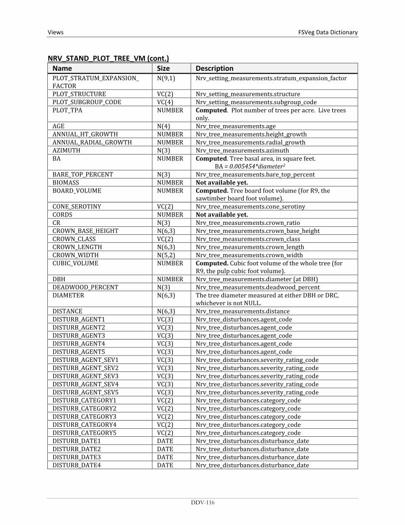
Views FSVeg Data Dictionary NRV_STAND_PLOT_TREE_VM (cont.)
Name Size Description PLOT_STRATUM_EXPANSION_ FACTOR
N(9,1) Nrv_setting_measurements.stratum_expansion_factor
PLOT_STRUCTURE VC(2) Nrv_setting_measurements.structure PLOT_SUBGROUP_CODE VC(4) Nrv_setting_measurements.subgroup_code PLOT_TPA NUMBER Computed. Plot number of trees per acre. Live trees
only. AGE N(4) Nrv_tree_measurements.age ANNUAL_HT_GROWTH NUMBER Nrv_tree_measurements.height_growth ANNUAL_RADIAL_GROWTH NUMBER Nrv_tree_measurements.radial_growth AZIMUTH N(3) Nrv_tree_measurements.azimuth BA NUMBER Computed. Tree basal area, in square feet.
BA = 0.005454*diameter2 BARE_TOP_PERCENT N(3) Nrv_tree_measurements.bare_top_percent BIOMASS NUMBER Not available yet. BOARD_VOLUME NUMBER Computed. Tree board foot volume (for R9, the
sawtimber board foot volume). CONE_SEROTINY VC(2) Nrv_tree_measurements.cone_serotiny CORDS NUMBER Not available yet. CR N(3) Nrv_tree_measurements.crown_ratio CROWN_BASE_HEIGHT N(6,3) Nrv_tree_measurements.crown_base_height CROWN_CLASS VC(2) Nrv_tree_measurements.crown_class CROWN_LENGTH N(6,3) Nrv_tree_measurements.crown_length CROWN_WIDTH N(5,2) Nrv_tree_measurements.crown_width CUBIC_VOLUME NUMBER Computed. Cubic foot volume of the whole tree (for
R9, the pulp cubic foot volume). DBH NUMBER Nrv_tree_measurements.diameter (at DBH) DEADWOOD_PERCENT N(3) Nrv_tree_measurements.deadwood_percent DIAMETER N(6,3) The tree diameter measured at either DBH or DRC,
whichever is not NULL. DISTANCE N(6,3) Nrv_tree_measurements.distance DISTURB_AGENT1 VC(3) Nrv_tree_disturbances.agent_code DISTURB_AGENT2 VC(3) Nrv_tree_disturbances.agent_code DISTURB_AGENT3 VC(3) Nrv_tree_disturbances.agent_code DISTURB_AGENT4 VC(3) Nrv_tree_disturbances.agent_code DISTURB_AGENT5 VC(3) Nrv_tree_disturbances.agent_code DISTURB_AGENT_SEV1 VC(3) Nrv_tree_disturbances.severity_rating_code DISTURB_AGENT_SEV2 VC(3) Nrv_tree_disturbances.severity_rating_code DISTURB_AGENT_SEV3 VC(3) Nrv_tree_disturbances.severity_rating_code DISTURB_AGENT_SEV4 VC(3) Nrv_tree_disturbances.severity_rating_code DISTURB_AGENT_SEV5 VC(3) Nrv_tree_disturbances.severity_rating_code DISTURB_CATEGORY1 VC(2) Nrv_tree_disturbances.category_code DISTURB_CATEGORY2 VC(2) Nrv_tree_disturbances.category_code DISTURB_CATEGORY3 VC(2) Nrv_tree_disturbances.category_code DISTURB_CATEGORY4 VC(2) Nrv_tree_disturbances.category_code DISTURB_CATEGORY5 VC(2) Nrv_tree_disturbances.category_code DISTURB_DATE1 DATE Nrv_tree_disturbances.disturbance_date DISTURB_DATE2 DATE Nrv_tree_disturbances.disturbance_date DISTURB_DATE3 DATE Nrv_tree_disturbances.disturbance_date DISTURB_DATE4 DATE Nrv_tree_disturbances.disturbance_date
DDV-116
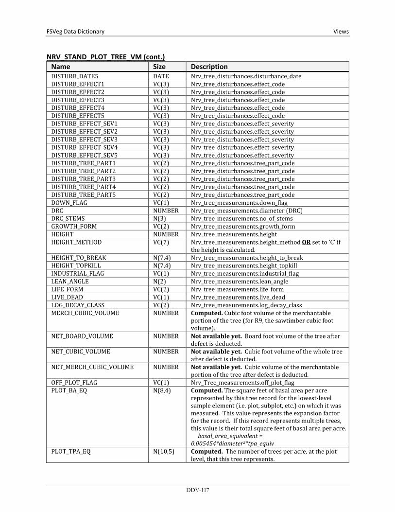
FSVeg Data Dictionary Views
NRV_STAND_PLOT_TREE_VM (cont.) Name Size Description DISTURB_DATE5 DATE Nrv_tree_disturbances.disturbance_date DISTURB_EFFECT1 VC(3) Nrv_tree_disturbances.effect_code DISTURB_EFFECT2 VC(3) Nrv_tree_disturbances.effect_code DISTURB_EFFECT3 VC(3) Nrv_tree_disturbances.effect_code DISTURB_EFFECT4 VC(3) Nrv_tree_disturbances.effect_code DISTURB_EFFECT5 VC(3) Nrv_tree_disturbances.effect_code DISTURB_EFFECT_SEV1 VC(3) Nrv_tree_disturbances.effect_severity DISTURB_EFFECT_SEV2 VC(3) Nrv_tree_disturbances.effect_severity DISTURB_EFFECT_SEV3 VC(3) Nrv_tree_disturbances.effect_severity DISTURB_EFFECT_SEV4 VC(3) Nrv_tree_disturbances.effect_severity DISTURB_EFFECT_SEV5 VC(3) Nrv_tree_disturbances.effect_severity DISTURB_TREE_PART1 VC(2) Nrv_tree_disturbances.tree_part_code DISTURB_TREE_PART2 VC(2) Nrv_tree_disturbances.tree_part_code DISTURB_TREE_PART3 VC(2) Nrv_tree_disturbances.tree_part_code DISTURB_TREE_PART4 VC(2) Nrv_tree_disturbances.tree_part_code DISTURB_TREE_PART5 VC(2) Nrv_tree_disturbances.tree_part_code DOWN_FLAG VC(1) Nrv_tree_measurements.down_flag DRC NUMBER Nrv_tree_measurements.diameter (DRC) DRC_STEMS N(3) Nrv_tree_measurements.no_of_stems GROWTH_FORM VC(2) Nrv_tree_measurements.growth_form HEIGHT NUMBER Nrv_tree_measurements.height HEIGHT_METHOD VC(7) Nrv_tree_measurements.height_method OR set to ‘C’ if
the height is calculated. HEIGHT_TO_BREAK N(7,4) Nrv_tree_measurements.height_to_break HEIGHT_TOPKILL N(7,4) Nrv_tree_measurements.height_topkill INDUSTRIAL_FLAG VC(1) Nrv_tree_measurements.industrial_flag LEAN_ANGLE N(2) Nrv_tree_measurements.lean_angle LIFE_FORM VC(2) Nrv_tree_measurements.life_form LIVE_DEAD VC(1) Nrv_tree_measurements.live_dead LOG_DECAY_CLASS VC(2) Nrv_tree_measurements.log_decay_class MERCH_CUBIC_VOLUME NUMBER Computed. Cubic foot volume of the merchantable
portion of the tree (for R9, the sawtimber cubic foot volume).
NET_BOARD_VOLUME NUMBER Not available yet. Board foot volume of the tree after defect is deducted.
NET_CUBIC_VOLUME NUMBER Not available yet. Cubic foot volume of the whole tree after defect is deducted.
NET_MERCH_CUBIC_VOLUME NUMBER Not available yet. Cubic volume of the merchantable portion of the tree after defect is deducted.
OFF_PLOT_FLAG VC(1) Nrv_Tree_measurements.off_plot_flag PLOT_BA_EQ N(8,4) Computed. The square feet of basal area per acre
represented by this tree record for the lowest-level sample element (i.e. plot, subplot, etc.) on which it was measured. This value represents the expansion factor for the record. If this record represents multiple trees, this value is their total square feet of basal area per acre. basal_area_equivalent = 0.005454*diameter2*tpa_equiv
PLOT_TPA_EQ N(10,5) Computed. The number of trees per acre, at the plot level, that this tree represents.
DDV-117

Views FSVeg Data Dictionary NRV_STAND_PLOT_TREE_VM (cont.)
Name Size Description RECENT_MORTALITY_FLAG VC(1) Nrv_tree_measurements.recent_mortality_flag REMOVAL_CODE VC(3) Nrv_tree_measurements.removal_code REMOVAL_DATE DATE Nrv_tree_measurements.removal_date SITE_INDEX NUMBER Nrv_site_indexes.site_index SITE_INDEX_REF VC(5) Nrv_site_indexes.reference_no SITE_TREE_FLAG VC(1) Nrv_tree_measurements.site_tree_flag SNAG_DECAY_CLASS VC(2) Nrv_tree_measurements.snag_decay_class SPECIES VC(8) Nrv_tree_measurements.species_symbol HARDWOOD_SOFTWOOD VC(4) Computed. Valid values are “HARD” or “SOFT” STAND_BA_EQ NUMBER Computed. The basal area per acre, at the stand level,
that this tree represents. STAND_TPA_EQ NUMBER Computed. The number of trees per acre, at the stand
level, that this tree represents. SUBGROUP VC(4) Nrv_tree_measurements.subgroup_code TAG_ID VC(5) Nrv_tree_measurements.tag_id TOPKILL_PERCENT N(3) Nrv_tree_measurements.topkill_percent TREATMENT_OPTION_1 VC(2) Nrv_tree_measurements.first_treatment_option TREATMENT_OPTION_2 VC(2) Nrv_tree_measurements.second_treatment_option TREE_CLASS VC(2) Nrv_tree_measurements.tree_class TREE_CN VC(34) Foreign key to Nrv_tree_measurements TREE_COUNT N(4) Nrv_tree_measurements.tree_count TREE_FIA_STOCKING NUMBER Computed. Tree stocking using the FIA algorithm TREE_STATUS VC(1) Nrv_tree_measurements.tree_status UNIQUE_NO N(5) Nrv_tree_measurements.unique_no WILDLIFE_USE VC(2) Nrv_tree_measurements.tree_usage X_COORDINATE N(7,2) Nrv_tree_measurements.x_coordinate Y_COORDINATE N(7,2) Nrv_tree_measurements.y_coordinate YEAR_OF_DEATH N(4) Nrv_tree_measurements.year_of_death YEAR_OF_ORIGIN N(4) Nrv_tree_measurements.year_of_origin
NRV_STAND_PLOT_TREE_CV_WD_VM Contains stand level, plot level, tree level, cover, and down woody data
Name Size Description ARCHIVE_FLAG VC(1) Flag to indicate this setting measurement record does
not represent the current status of the vegetation. Y = Yes, this is an archived record.
BROWNS_1HR NUMBER The number of 1-hour size class intersections tallied on the Brown’s transect for this plot
BROWNS_10HR NUMBER The number of 10-hour size class intersections tallied on the Brown’s transect for this plot
BROWNS_100HR NUMBER The number of 100-hour size class intersections tallied on the Brown’s transect for this plot
DDV-118

FSVeg Data Dictionary Views
NRV_STAND_PLOT_TREE_CV_WD_VM (cont.) Name Size Description BROWNS_1000HR NUMBER The number of 1000-hour size class intersections
tallied on the Brown’s transect for this downed woody piece (typically 1 since they are usually recorded individually)
BROWNS_1HR_CUBIC NUMBER Computed. Stand level 1-hour fuel cubic foot per acre. BROWNS_10HR_CUBIC NUMBER Computed. Stand level 10-hour fuel cubic foot per acre. BROWNS_100HR_CUBIC NUMBER Computed. Stand level 100-hour fuel cubic foot per
acre. BROWNS_1HR_TONS NUMBER Computed. Stand level 1-hour fuel tons per acre. BROWNS_10HR_TONS NUMBER Computed. Stand level 10-hour fuel tons per acre. BROWNS_100HR_TONS NUMBER Computed. Stand level 100-hour fuel tons per acre. BROWNS_1000HR_ROTTEN_ CUBIC
NUMBER Computed. Stand level 1000-hour rotten fuel cubic foot per acre.
BROWNS_1000HR_ROTTEN_ DIA_AVG
NUMBER Computed. Stand level 1000-hour rotten average diameter.
BROWNS_1000HR_ROTTEN_ TONS
NUMBER Computed. Stand level 1000-hour rotten fuel tons per acre.
BROWNS_1000HR_SOUND_ CUBIC
NUMBER Computed. Stand level 1000-hour sound fuel cubic foot per acre.
BROWNS_1000HR_SOUND_DIA_AVG
NUMBER Computed. Stand level 1000-hour sound average diameter.
BROWNS_1000HR_SOUND_TONS NUMBER Computed. Stand level 1000-hour sound fuel tons per acre.
BROWNS_DUFF_DEPTH_AVG NUMBER Computed. Stand level average duff depth. BROWNS_DUFF_TONS_AVG NUMBER Computed. The stand level average duff tons per acre
estimate from a Brown’s 1- or 2- sample point survey for duff. The estimate is derived using: duff tons/acre = (average duff depth * 10 tons/inch)
BROWNS_FUEL_DEPTH_AVG NUMBER Computed. Stand level average fuel depth. COMPARTMENT VC(10) Nrv_setting_measurements.compartment_no (not
populated for most stand exam data) CONSEC_PT_NUM VC(8) Nrv_setting_measurements.consec_pt_num COUNTY VC(3) Nrv_setting_measurements.county DISTRICT VC(2) Nrv_setting_measurements.district FOREST_ADMIN VC(2) Nrv_setting_measurements.forest_admin FOREST_PROC VC(2) Nrv_setting_measurements.forest_proc GEOGRAPHICAL_AREA VC(5) Nrv_setting_measurements.geographical_area I_M_FLAG VC(1) Stand record only. If Y this is data that will be or is
measured multiple times. LATITUDE_DEG NUMBER Nrv_setting_measurements.latitude_deg LATITUDE_MIN NUMBER Nrv_setting_measurements.latitude_min LATITUDE_SEC NUMBER Nrv_setting_measurements.latitude_sec LAT_LON_DATUM VC(8) Nrv_setting_measurements.lat_lon_datum LITTER_1 NUMBER First layer of litter LITTER_2 NUMBER Second layer of litter LOCATION VC(16) Nrv_setting_measurements.location LONGITUDE_DEG NUMBER Nrv_setting_measurements.longitude_deg LONGITUDE_MIN NUMBER Nrv_setting_measurements.longitude_min LONGITUDE_SEC NUMBER Nrv_setting_measurements.longitude_sec MEASUREMENT_DATE DATE Nrv_setting_measurements.measurement_date
DDV-119
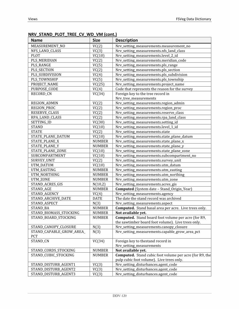
Views FSVeg Data Dictionary NRV_STAND_PLOT_TREE_CV_WD_VM (cont.)
Name Size Description MEASUREMENT_NO VC(2) Nrv_setting_measurements.measurement_no NFS_LAND_CLASS VC(3) Nrv_setting_measurements.nfs_land_class PLOT VC(10) Nrv_setting_measurements.level_2_id PLS_MERIDIAN VC(2) Nrv_setting_measurements.meridian_code PLS_RANGE VC(5) Nrv_setting_measurements.pls_range PLS_SECTION VC(2) Nrv_setting_measurements.pls_section PLS_SUBDIVISION VC(4) Nrv_setting_measurements.pls_subdivision PLS_TOWNSHIP VC(5) Nrv_setting_measurements.pls_township PROJECT_NAME VC(25) Nrv_setting_measurements.project_name PURPOSE_CODE VC(4) Code that represents the reason for the survey RECORD_CN VC(34) Foreign key to the tree record in
Nrv_tree_measurements REGION_ADMIN VC(2) Nrv_setting_measurements.region_admin REGION_PROC VC(2) Nrv_setting_measurements.region_proc RESERVE_CLASS VC(2) Nrv_setting_measurements.reserve_class RPA_LAND_CLASS VC(2) Nrv_setting_measurements.rpa_land_class SETTING_ID VC(30) Nrv_setting_measurements.setting_id STAND VC(10) Nrv_setting_measurements.level_1_id STATE VC(2) Nrv_setting_measurements.state STATE_PLANE_DATUM VC(10) Nrv_setting_measurements.state_plane_datum STATE_PLANE_X NUMBER Nrv_setting_measurements.state_plane_x STATE_PLANE_Y NUMBER Nrv_setting_measurements.state_plane_y STATE_PLANE_ZONE VC(10) Nrv_setting_measurements.state_plane_zone SUBCOMPARTMENT VC(10) Nrv_setting_measurements.subcompartment_no SURVEY_UNIT VC(2) Nrv_setting_measurements.survey_unit UTM_DATUM VC(10) Nrv_setting_measurements.utm_datum UTM_EASTING NUMBER Nrv_setting_measurements.utm_easting UTM_NORTHING NUMBER Nrv_setting_measurements.utm_northing UTM_ZONE NUMBER Nrv_setting_measurements.utm_zone STAND_ACRES_GIS N(10,2) Nrv_setting_measurements.acres_gis STAND_AGE NUMBER Computed (System date – Stand_Origin_Year) STAND_AGENCY VC(4) Nrv_setting_measurements.agency STAND_ARCHIVE_DATE DATE The date the stand record was archived STAND_ASPECT N(3) Nrv_setting_measurements.aspect STAND_BA NUMBER Computed. Stand basal area per acre. Live trees only. STAND_BIOMASS_STOCKING NUMBER Not available yet. STAND_BOARD_STOCKING NUMBER Computed. Stand board foot volume per acre (for R9,
the sawtimber board foot volume). Live trees only. STAND_CANOPY_CLOSURE N(3) Nrv_setting_measurements.canopy_closure STAND_CAPABLE_GROW_AREA_ PCT
N(3) Nrv_setting_measurements.capable_grow_area_pct
STAND_CN VC(34) Foreign key to thestand record in Nrv_setting_measurements
STAND_CORDS_STOCKING NUMBER Not available yet. STAND_CUBIC_STOCKING NUMBER Computed. Stand cubic foot volume per acre (for R9, the
pulp cubic foot volume). Live trees only. STAND_DISTURB_AGENT1 VC(3) Nrv_setting_disturbances.agent_code STAND_DISTURB_AGENT2 VC(3) Nrv_setting_disturbances.agent_code STAND_DISTURB_AGENT3 VC(3) Nrv_setting_disturbances.agent_code
DDV-120
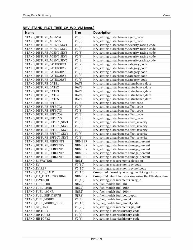
FSVeg Data Dictionary Views
NRV_STAND_PLOT_TREE_CV_WD_VM (cont.) Name Size Description STAND_DISTURB_AGENT4 VC(3) Nrv_setting_disturbances.agent_code STAND_DISTURB_AGENT5 VC(3) Nrv_setting_disturbances.agent_code STAND_DISTURB_AGENT_SEV1 VC(3) Nrv_setting_disturbances.severity_rating_code STAND_DISTURB_AGENT_SEV2 VC(3) Nrv_setting_disturbances.severity_rating_code STAND_DISTURB_AGENT_SEV3 VC(3) Nrv_setting_disturbances.severity_rating_code STAND_DISTURB_AGENT_SEV4 VC(3) Nrv_setting_disturbances.severity_rating_code STAND_DISTURB_AGENT_SEV5 VC(3) Nrv_setting_disturbances.severity_rating_code STAND_DISTURB_CATEGORY1 VC(2) Nrv_setting_disturbances.category_code STAND_DISTURB_CATEGORY2 VC(3) Nrv_setting_disturbances.category_code STAND_DISTURB_CATEGORY3 VC(3) Nrv_setting_disturbances.category_code STAND_DISTURB_CATEGORY4 VC(3) Nrv_setting_disturbances.category_code STAND_DISTURB_CATEGORY5 VC(3) Nrv_setting_disturbances.category_code STAND_DISTURB_DATE1 DATE Nrv_setting_disturbances.disturbance_date STAND_DISTURB_DATE2 DATE Nrv_setting_disturbances.disturbance_date STAND_DISTURB_DATE3 DATE Nrv_setting_disturbances.disturbance_date STAND_DISTURB_DATE4 DATE Nrv_setting_disturbances.disturbance_date STAND_DISTURB_DATE5 DATE Nrv_setting_disturbances.disturbance_date STAND_DISTURB_EFFECT1 VC(3) Nrv_setting_disturbances.effect_code STAND_DISTURB_EFFECT2 VC(3) Nrv_setting_disturbances.effect_code STAND_DISTURB_EFFECT3 VC(3) Nrv_setting_disturbances.effect_code STAND_DISTURB_EFFECT4 VC(3) Nrv_setting_disturbances.effect_code STAND_DISTURB_EFFECT5 VC(3) Nrv_setting_disturbances.effect_code STAND_DISTURB_EFFECT_SEV1 VC(3) Nrv_setting_disturbances.effect_severity STAND_DISTURB_EFFECT_SEV2 VC(3) Nrv_setting_disturbances.effect_severity STAND_DISTURB_EFFECT_SEV3 VC(3) Nrv_setting_disturbances.effect_severity STAND_DISTURB_EFFECT_SEV4 VC(3) Nrv_setting_disturbances.effect_severity STAND_DISTURB_EFFECT_SEV5 VC(3) Nrv_setting_disturbances.effect_severity STAND_DISTURB_PERCENT1 NUMBER Nrv_setting_disturbances.damage_percent STAND_DISTURB_PERCENT2 NUMBER Nrv_setting_disturbances.damage_percent STAND_DISTURB_PERCENT3 NUMBER Nrv_setting_disturbances.damage_percent STAND_DISTURB_PERCENT4 NUMBER Nrv_setting_disturbances.damage_percent STAND_DISTURB_PERCENT5 NUMBER Nrv_setting_disturbances.damage_percent STAND_ELEVATION N(6,1) Nrv_setting_measurements.elevation STAND_EV VC(10) Nrv_setting_measurements.ev_code STAND_EV_REF VC(10) Nrv_setting_measurements.ev_ref_code STAND_FIA_EV_CALC VC(10) Computed. Forest type using the FIA algorithm STAND_FIA_TOTAL STOCKING NUMBER Computed. Stand tree stocking using the FIA algorithm STAND_FSVEG_ID VC(40) Nrv_setting_measurements.fsveg_id STAND_FUEL_1HR N(5,2) Nrv_fuel_models.fuel_1hr STAND_FUEL_10HR N(5,2) Nrv_fuel_models.fuel_10hr STAND_FUEL_100HR N(5,2) Nrv_fuel_models.fuel_100hr STAND_FUEL_BED_DEPTH N(5,2) Nrv_fuel_models.fuel_bed_depth STAND_FUEL_MODEL VC(3) Nrv_fuel_models.fuel_model STAND_FUEL_MODEL_CODE VC(10) Nrv_fuel_models.fuel_model_code STAND_GIS_LINK VC(26) Nrv_setting_measurements.gis_link STAND_HISTORY1 VC(6) Nrv_setting_histories.history_code STAND_HISTORY2 VC(6) Nrv_setting_histories.history_code STAND_HISTORY3 VC(6) Nrv_setting_histories.history_code
DDV-121
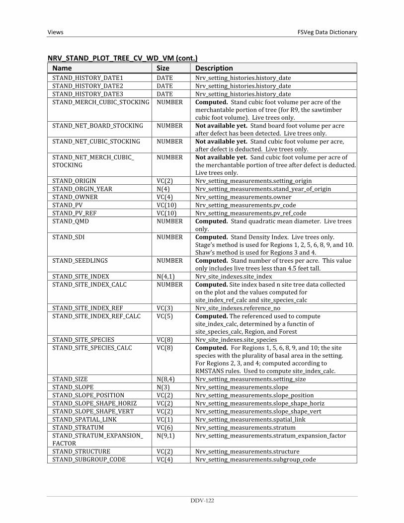
Views FSVeg Data Dictionary NRV_STAND_PLOT_TREE_CV_WD_VM (cont.)
Name Size Description STAND_HISTORY_DATE1 DATE Nrv_setting_histories.history_date STAND_HISTORY_DATE2 DATE Nrv_setting_histories.history_date STAND_HISTORY_DATE3 DATE Nrv_setting_histories.history_date STAND_MERCH_CUBIC_STOCKING NUMBER Computed. Stand cubic foot volume per acre of the
merchantable portion of tree (for R9, the sawtimber cubic foot volume). Live trees only.
STAND_NET_BOARD_STOCKING NUMBER Not available yet. Stand board foot volume per acre after defect has been detected. Live trees only.
STAND_NET_CUBIC_STOCKING NUMBER Not available yet. Stand cubic foot volume per acre, after defect is deducted. Live trees only.
STAND_NET_MERCH_CUBIC_ STOCKING
NUMBER Not available yet. Sand cubic foot volume per acre of the merchantable portion of tree after defect is deducted. Live trees only.
STAND_ORIGIN VC(2) Nrv_setting_measurements.setting_origin STAND_ORGIN_YEAR N(4) Nrv_setting_measurements.stand_year_of_origin STAND_OWNER VC(4) Nrv_setting_measurements.owner STAND_PV VC(10) Nrv_setting_measurements.pv_code STAND_PV_REF VC(10) Nrv_setting_measurements.pv_ref_code STAND_QMD NUMBER Computed. Stand quadratic mean diameter. Live trees
only. STAND_SDI NUMBER Computed. Stand Density Index. Live trees only.
Stage’s method is used for Regions 1, 2, 5, 6, 8, 9, and 10. Shaw’s method is used for Regions 3 and 4.
STAND_SEEDLINGS NUMBER Computed. Stand number of trees per acre. This value only includes live trees less than 4.5 feet tall.
STAND_SITE_INDEX N(4,1) Nrv_site_indexes.site_index STAND_SITE_INDEX_CALC NUMBER Computed. Site index based n site tree data collected
on the plot and the values computed for site_index_ref_calc and site_species_calc
STAND_SITE_INDEX_REF VC(3) Nrv_site_indexes.reference_no STAND_SITE_INDEX_REF_CALC VC(5) Computed. The referenced used to compute
site_index_calc, determined by a functin of site_species_calc, Region, and Forest
STAND_SITE_SPECIES VC(8) Nrv_site_indexes.site_species STAND_SITE_SPECIES_CALC VC(8) Computed. For Regions 1, 5, 6, 8, 9, and 10; the site
species with the plurality of basal area in the setting. For Regions 2, 3, and 4; computed according to RMSTANS rules. Used to compute site_index_calc.
STAND_SIZE N(8,4) Nrv_setting_measurements.setting_size STAND_SLOPE N(3) Nrv_setting_measurements.slope STAND_SLOPE_POSITION VC(2) Nrv_setting_measurements.slope_position STAND_SLOPE_SHAPE_HORIZ VC(2) Nrv_setting_measurements.slope_shape_horiz STAND_SLOPE_SHAPE_VERT VC(2) Nrv_setting_measurements.slope_shape_vert STAND_SPATIAL_LINK VC(1) Nrv_setting_measurements.spatial_link STAND_STRATUM VC(6) Nrv_setting_measurements.stratum STAND_STRATUM_EXPANSION_ FACTOR
N(9,1) Nrv_setting_measurements.stratum_expansion_factor
STAND_STRUCTURE VC(2) Nrv_setting_measurements.structure STAND_SUBGROUP_CODE VC(4) Nrv_setting_measurements.subgroup_code
DDV-122

FSVeg Data Dictionary Views
NRV_STAND_PLOT_TREE_CV_WD_VM (cont.) Name Size Description STAND_TPA NUMBER Computed. Stand number of trees per acre. Live trees
only. STAND_VSS VC(6) Computed. Vegetation structural stage for Regions 2, 3
and 4 only PLOT_AGE NUMBER Computed (System date – Stand_Origin_Year) PLOT_ARCHIVE_DATE DATE The date the plot record was archived PLOT_ASPECT N(3) Nrv_setting_measurements.aspect PLOT_BA NUMBER Computed. Plot basal area per acre. Live trees only. PLOT_BIOMASS_STOCKING NUMBER Not available yet. PLOT_BOARD_STOCKING NUMBER Computed. Plot board foot volume per acre (for R9,
the sawtimber board foot volume). Live trees only. PLOT_CANOPY_CLOSURE N(3) Nrv_setting_measurements.canopy_closure PLOT_CAPABLE_GROW_AREA_ PCT
N(3) Nrv_setting_measurements.capable_grow_area_pct
PLOT_CN VC(34) Foreign key to the plot record in Nrv_setting_measurements
PLOT_CORDS_STOCKING NUMBER Not available yet. PLOT_CUBIC_STOCKING NUMBER Computed. Plot cubic foot volume per acre (for R9, the
pulp cubic foot volume). Live trees only. PLOT_DISTURB_AGENT1 VC(3) Nrv_setting_disturbances.agent_code PLOT_DISTURB_AGENT2 VC(3) Nrv_setting_disturbances.agent_code PLOT_DISTURB_AGENT3 VC(3) Nrv_setting_disturbances.agent_code PLOT_DISTURB_AGENT4 VC(3) Nrv_setting_disturbances.agent_code PLOT_DISTURB_AGENT5 VC(3) Nrv_setting_disturbances.agent_code PLOT_DISTURB_AGENT_SEV1 VC(3) Nrv_setting_disturbances.severity_rating_code PLOT_DISTURB_AGENT_SEV2 VC(3) Nrv_setting_disturbances.severity_rating_code PLOT_DISTURB_AGENT_SEV3 VC(3) Nrv_setting_disturbances.severity_rating_code PLOT_DISTURB_AGENT_SEV4 VC(3) Nrv_setting_disturbances.severity_rating_code PLOT_DISTURB_AGENT_SEV5 VC(3) Nrv_setting_disturbances.severity_rating_code PLOT_DISTURB_CATEGORY1 VC(2) Nrv_setting_disturbances.category_code PLOT_DISTURB_CATEGORY2 VC(3) Nrv_setting_disturbances.category_code PLOT_DISTURB_CATEGORY3 VC(3) Nrv_setting_disturbances.category_code PLOT_DISTURB_CATEGORY4 VC(3) Nrv_setting_disturbances.category_code PLOT_DISTURB_CATEGORY5 VC(3) Nrv_setting_disturbances.category_code PLOT_DISTURB_DATE1 DATE Nrv_setting_disturbances.disturbance_date PLOT_DISTURB_DATE2 DATE Nrv_setting_disturbances.disturbance_date PLOT_DISTURB_DATE3 DATE Nrv_setting_disturbances.disturbance_date PLOT_DISTURB_DATE4 DATE Nrv_setting_disturbances.disturbance_date PLOT_DISTURB_DATE5 DATE Nrv_setting_disturbances.disturbance_date PLOT_DISTURB_EFFECT1 VC(3) Nrv_setting_disturbances.effect_code PLOT_DISTURB_EFFECT2 VC(3) Nrv_setting_disturbances.effect_code PLOT_DISTURB_EFFECT3 VC(3) Nrv_setting_disturbances.effect_code PLOT_DISTURB_EFFECT4 VC(3) Nrv_setting_disturbances.effect_code PLOT_DISTURB_EFFECT5 VC(3) Nrv_setting_disturbances.effect_code PLOT_DISTURB_EFFECT_SEV1 VC(3) Nrv_setting_disturbances.effect_severity PLOT_DISTURB_EFFECT_SEV2 VC(3) Nrv_setting_disturbances.effect_severity PLOT_DISTURB_EFFECT_SEV3 VC(3) Nrv_setting_disturbances.effect_severity PLOT_DISTURB_EFFECT_SEV4 VC(3) Nrv_setting_disturbances.effect_severity PLOT_DISTURB_EFFECT_SEV5 VC(3) Nrv_setting_disturbances.effect_severity
DDV-123

Views FSVeg Data Dictionary NRV_STAND_PLOT_TREE_CV_WD_VM (cont.)
Name Size Description PLOT_DISTURB_PERCENT1 NUMBER Nrv_setting_disturbances.damage_percent PLOT_DISTURB_PERCENT2 NUMBER Nrv_setting_disturbances.damage_percent PLOT_DISTURB_PERCENT3 NUMBER Nrv_setting_disturbances.damage_percent PLOT_DISTURB_PERCENT4 NUMBER Nrv_setting_disturbances.damage_percent PLOT_DISTURB_PERCENT5 NUMBER Nrv_setting_disturbances.damage_percent PLOT_ELEVATION N(6,1) Nrv_setting_measurements.elevation PLOT_EV VC(10) Nrv_setting_measurements.ev_code PLOT_EV_REF VC(10) Nrv_setting_measurements.ev_ref_code PLOT_FSVEG_ID VC(40) Nrv_setting_measurments.fsveg_id PLOT_FUEL_1HR N(5,2) Nrv_fuel_models.fuel_1hr PLOT_FUEL_10HR N(5,2) Nrv_fuel_models.fuel_10hr PLOT_FUEL_100HR N(5,2) Nrv_fuel_models.fuel_100hr PLOT_FUEL_BED_DEPTH N(5,2) Nrv_fuel_models.fuel_bed_depth PLOT_FUEL_MODEL VC(3) Nrv_fuel_models.fuel_model PLOT_FUEL_MODEL_CODE VC(10) Nrv_fuel_models.fuel_model_code PLOT_FUEL_PHOTO_CN VC(34) Nrv_fuel_photos.fuel_photo.cn PLOT_FUEL_PHOTO_REFERENCE VC(10) Nrv_fuel_photos.fuel_photo_reference PLOT_FVS_DUFF N(5,1) Nrv_fuel_photos.fvs_duff PLOT_FVS_FUEL01 N(5,1) Nrv_fuel_photos.fvs_fuel01 PLOT_FVS_FUEL13 N(5,1) Nrv_fuel_photos.fvs_fuel13 PLOT_FVS_FUEL36 N(5,1) Nrv_fuel_photos.fvs_fuel36 PLOT_FVS_FUEL612 N(5,1) Nrv_fuel_photos.fvs_fuel612 PLOT_FVS_FUEL12P N(5,1) Nrv_fuel_photos.fvs_fuel12p PLOT_FVS_LITTER N(5,1) Nrv_fuel_photos.fvs_litter PLOT_GIS_LINK VC(26) Nrv_setting_measurements.gis_link PLOT_HISTORY1 VC(6) Nrv_setting_histories.history_code PLOT_HISTORY2 VC(6) Nrv_setting_histories.history_code PLOT_HISTORY3 VC(6) Nrv_setting_histories.history_code PLOT_HISTORY_DATE1 DATE Nrv_setting_histories.history_date PLOT_HISTORY_DATE2 DATE Nrv_setting_histories.history_date PLOT_HISTORY_DATE3 DATE Nrv_setting_histories.history_date PLOT_MERCH_CUBIC_STOCKING NUMBER Computed. Plot cubic foot volume per acre of the
merchantable portion of tree (for R9, the sawtimber cubic foot volume). Live trees only.
PLOT_NET_BOARD_STOCKING NUMBER Not available yet. Plot board foot volume per acre after defect has been detected. Live trees only.
PLOT_NET_CUBIC_STOCKING NUMBER Not available yet. Plot cubic foot volume per acre, after defect is deducted. Live trees only.
PLOT_LATITUDE_GIS N(11,6) Nrv_setting_measurements.latitude_gis PLOT_LONGITUDE_GIS N(11,6) Nrv_setting_measurements_longitude_gis PLOT_NET_MERCH_CUBIC_ STOCKING
NUMBER Not available yet. Plot cubic foot volume per acre of the merchantable portion of tree after defect is deducted. Live trees only.
PLOT_ORIGIN VC(2) Nrv_setting_measurements.setting_Origin PLOT_ORIGIN_YEAR N(4) Nrv_setting_measurements.stand_Year_of_Origin PLOT_PV VC(10) Nrv_setting_measurements.pv_code PLOT_PV_REF VC(10) Nrv_setting_measurements.pv_ref_code PLOT_QMD NUMBER Computed. Plot quadratic mean diameter. Live trees
only.
DDV-124
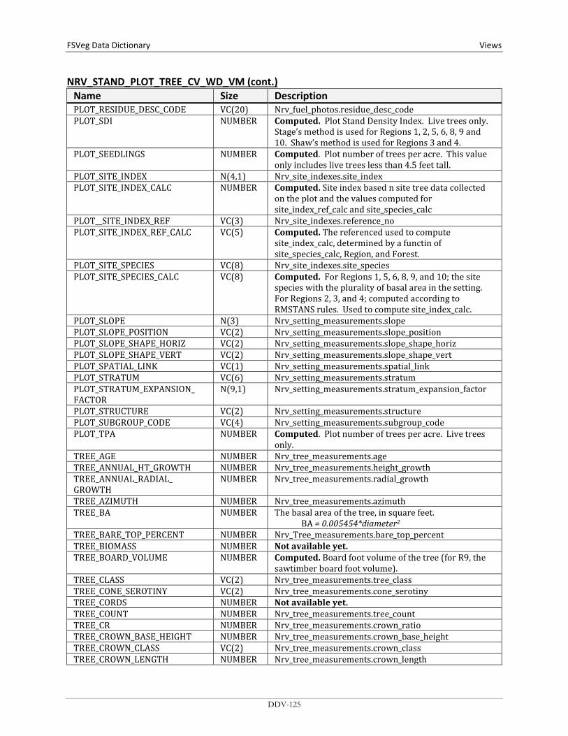
FSVeg Data Dictionary Views
NRV_STAND_PLOT_TREE_CV_WD_VM (cont.) Name Size Description PLOT_RESIDUE_DESC_CODE VC(20) Nrv_fuel_photos.residue_desc_code PLOT_SDI NUMBER Computed. Plot Stand Density Index. Live trees only.
Stage’s method is used for Regions 1, 2, 5, 6, 8, 9 and 10. Shaw’s method is used for Regions 3 and 4.
PLOT_SEEDLINGS NUMBER Computed. Plot number of trees per acre. This value only includes live trees less than 4.5 feet tall.
PLOT_SITE_INDEX N(4,1) Nrv_site_indexes.site_index PLOT_SITE_INDEX_CALC NUMBER Computed. Site index based n site tree data collected
on the plot and the values computed for site_index_ref_calc and site_species_calc
PLOT__SITE_INDEX_REF VC(3) Nrv_site_indexes.reference_no PLOT_SITE_INDEX_REF_CALC VC(5) Computed. The referenced used to compute
site_index_calc, determined by a functin of site_species_calc, Region, and Forest.
PLOT_SITE_SPECIES VC(8) Nrv_site_indexes.site_species PLOT_SITE_SPECIES_CALC VC(8) Computed. For Regions 1, 5, 6, 8, 9, and 10; the site
species with the plurality of basal area in the setting. For Regions 2, 3, and 4; computed according to RMSTANS rules. Used to compute site_index_calc.
PLOT_SLOPE N(3) Nrv_setting_measurements.slope PLOT_SLOPE_POSITION VC(2) Nrv_setting_measurements.slope_position PLOT_SLOPE_SHAPE_HORIZ VC(2) Nrv_setting_measurements.slope_shape_horiz PLOT_SLOPE_SHAPE_VERT VC(2) Nrv_setting_measurements.slope_shape_vert PLOT_SPATIAL_LINK VC(1) Nrv_setting_measurements.spatial_link PLOT_STRATUM VC(6) Nrv_setting_measurements.stratum PLOT_STRATUM_EXPANSION_ FACTOR
N(9,1) Nrv_setting_measurements.stratum_expansion_factor
PLOT_STRUCTURE VC(2) Nrv_setting_measurements.structure PLOT_SUBGROUP_CODE VC(4) Nrv_setting_measurements.subgroup_code PLOT_TPA NUMBER Computed. Plot number of trees per acre. Live trees
only. TREE_AGE NUMBER Nrv_tree_measurements.age TREE_ANNUAL_HT_GROWTH NUMBER Nrv_tree_measurements.height_growth TREE_ANNUAL_RADIAL_ GROWTH
NUMBER Nrv_tree_measurements.radial_growth
TREE_AZIMUTH NUMBER Nrv_tree_measurements.azimuth TREE_BA NUMBER The basal area of the tree, in square feet.
BA = 0.005454*diameter2 TREE_BARE_TOP_PERCENT NUMBER Nrv_Tree_measurements.bare_top_percent TREE_BIOMASS NUMBER Not available yet. TREE_BOARD_VOLUME NUMBER Computed. Board foot volume of the tree (for R9, the
sawtimber board foot volume). TREE_CLASS VC(2) Nrv_tree_measurements.tree_class TREE_CONE_SEROTINY VC(2) Nrv_tree_measurements.cone_serotiny TREE_CORDS NUMBER Not available yet. TREE_COUNT NUMBER Nrv_tree_measurements.tree_count TREE_CR NUMBER Nrv_tree_measurements.crown_ratio TREE_CROWN_BASE_HEIGHT NUMBER Nrv_tree_measurements.crown_base_height TREE_CROWN_CLASS VC(2) Nrv_tree_measurements.crown_class TREE_CROWN_LENGTH NUMBER Nrv_tree_measurements.crown_length
DDV-125
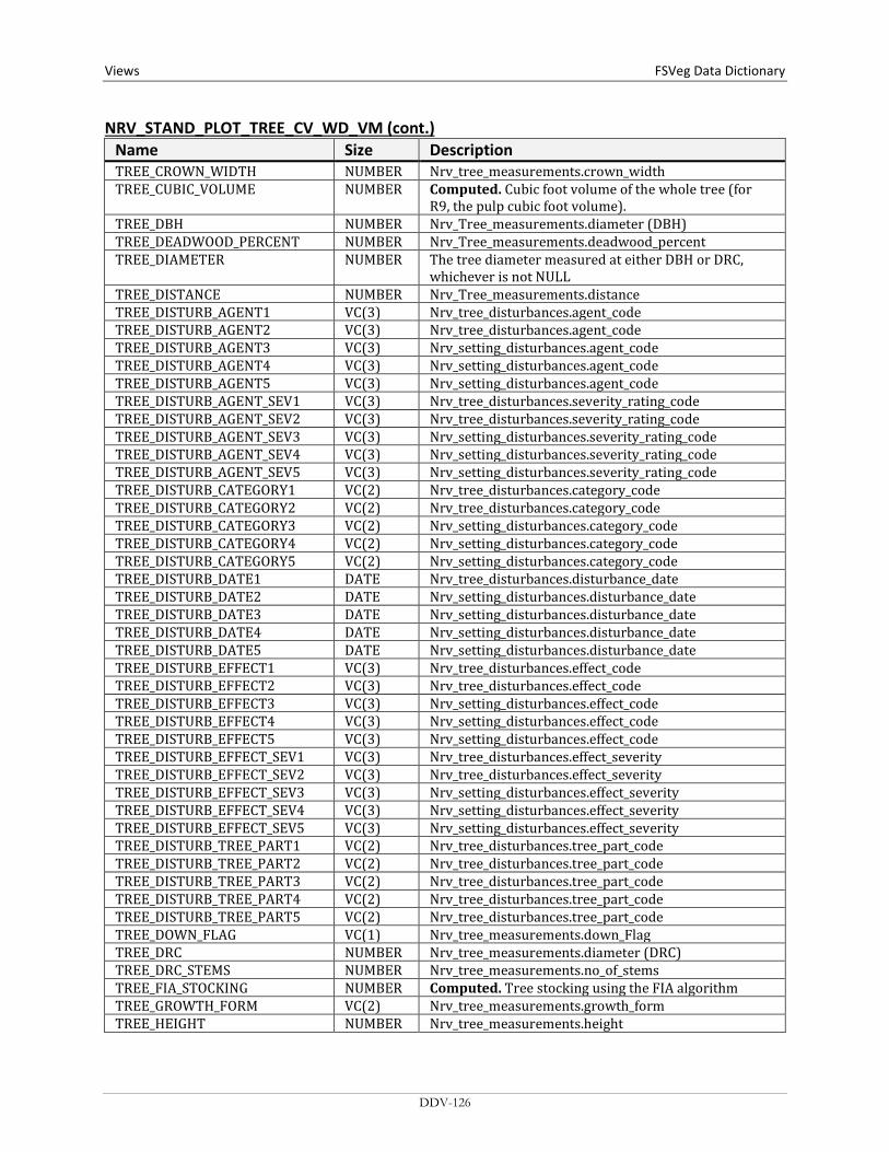
Views FSVeg Data Dictionary NRV_STAND_PLOT_TREE_CV_WD_VM (cont.)
Name Size Description TREE_CROWN_WIDTH NUMBER Nrv_tree_measurements.crown_width TREE_CUBIC_VOLUME NUMBER Computed. Cubic foot volume of the whole tree (for
R9, the pulp cubic foot volume). TREE_DBH NUMBER Nrv_Tree_measurements.diameter (DBH) TREE_DEADWOOD_PERCENT NUMBER Nrv_Tree_measurements.deadwood_percent TREE_DIAMETER NUMBER The tree diameter measured at either DBH or DRC,
whichever is not NULL TREE_DISTANCE NUMBER Nrv_Tree_measurements.distance TREE_DISTURB_AGENT1 VC(3) Nrv_tree_disturbances.agent_code TREE_DISTURB_AGENT2 VC(3) Nrv_tree_disturbances.agent_code TREE_DISTURB_AGENT3 VC(3) Nrv_setting_disturbances.agent_code TREE_DISTURB_AGENT4 VC(3) Nrv_setting_disturbances.agent_code TREE_DISTURB_AGENT5 VC(3) Nrv_setting_disturbances.agent_code TREE_DISTURB_AGENT_SEV1 VC(3) Nrv_tree_disturbances.severity_rating_code TREE_DISTURB_AGENT_SEV2 VC(3) Nrv_tree_disturbances.severity_rating_code TREE_DISTURB_AGENT_SEV3 VC(3) Nrv_setting_disturbances.severity_rating_code TREE_DISTURB_AGENT_SEV4 VC(3) Nrv_setting_disturbances.severity_rating_code TREE_DISTURB_AGENT_SEV5 VC(3) Nrv_setting_disturbances.severity_rating_code TREE_DISTURB_CATEGORY1 VC(2) Nrv_tree_disturbances.category_code TREE_DISTURB_CATEGORY2 VC(2) Nrv_tree_disturbances.category_code TREE_DISTURB_CATEGORY3 VC(2) Nrv_setting_disturbances.category_code TREE_DISTURB_CATEGORY4 VC(2) Nrv_setting_disturbances.category_code TREE_DISTURB_CATEGORY5 VC(2) Nrv_setting_disturbances.category_code TREE_DISTURB_DATE1 DATE Nrv_tree_disturbances.disturbance_date TREE_DISTURB_DATE2 DATE Nrv_setting_disturbances.disturbance_date TREE_DISTURB_DATE3 DATE Nrv_setting_disturbances.disturbance_date TREE_DISTURB_DATE4 DATE Nrv_setting_disturbances.disturbance_date TREE_DISTURB_DATE5 DATE Nrv_setting_disturbances.disturbance_date TREE_DISTURB_EFFECT1 VC(3) Nrv_tree_disturbances.effect_code TREE_DISTURB_EFFECT2 VC(3) Nrv_tree_disturbances.effect_code TREE_DISTURB_EFFECT3 VC(3) Nrv_setting_disturbances.effect_code TREE_DISTURB_EFFECT4 VC(3) Nrv_setting_disturbances.effect_code TREE_DISTURB_EFFECT5 VC(3) Nrv_setting_disturbances.effect_code TREE_DISTURB_EFFECT_SEV1 VC(3) Nrv_tree_disturbances.effect_severity TREE_DISTURB_EFFECT_SEV2 VC(3) Nrv_tree_disturbances.effect_severity TREE_DISTURB_EFFECT_SEV3 VC(3) Nrv_setting_disturbances.effect_severity TREE_DISTURB_EFFECT_SEV4 VC(3) Nrv_setting_disturbances.effect_severity TREE_DISTURB_EFFECT_SEV5 VC(3) Nrv_setting_disturbances.effect_severity TREE_DISTURB_TREE_PART1 VC(2) Nrv_tree_disturbances.tree_part_code TREE_DISTURB_TREE_PART2 VC(2) Nrv_tree_disturbances.tree_part_code TREE_DISTURB_TREE_PART3 VC(2) Nrv_tree_disturbances.tree_part_code TREE_DISTURB_TREE_PART4 VC(2) Nrv_tree_disturbances.tree_part_code TREE_DISTURB_TREE_PART5 VC(2) Nrv_tree_disturbances.tree_part_code TREE_DOWN_FLAG VC(1) Nrv_tree_measurements.down_Flag TREE_DRC NUMBER Nrv_tree_measurements.diameter (DRC) TREE_DRC_STEMS NUMBER Nrv_tree_measurements.no_of_stems TREE_FIA_STOCKING NUMBER Computed. Tree stocking using the FIA algorithm TREE_GROWTH_FORM VC(2) Nrv_tree_measurements.growth_form TREE_HEIGHT NUMBER Nrv_tree_measurements.height
DDV-126

FSVeg Data Dictionary Views
NRV_STAND_PLOT_TREE_CV_WD_VM (cont.) Name Size Description TREE_HEIGHT_METHOD VC(7) Nrv_tree_measurements.height_method OR ‘C’ if height
is calculated HEIGHT_TO_BREAK N(7,4) Nrv_tree_measurements.height_to_break TREE_HEIGHT_TOPKILL NUMBER Nrv_tree_measurements.height_topkill TREE_INDUSTRIAL_FLAG VC(1) Nrv_tree_measurements.industrial_flag TREE_LEAN_ANGLE NUMBER Nrv_tree_measurements.lean_angle TREE_LIFE_FORM VC(2) Nrv_tree_measurements.life_form TREE_LIVE_DEAD VC(1) Nrv_tree_measurements.live_dead TREE_LOG_DECAY_CLASS VC(2) Nrv_tree_measurements.log_decay_class TREE_MERCH_CUBIC_VOLUME NUMBER Computed. Cubic foot volume of the merchantable
portion of the tree (for R9, the sawtimber cubic foot volume).
TREE_NET_BOARD_VOLUME NUMBER Not available yet. Board foot volume of the tree after defect is deducted.
TREE_NET_CUBIC_VOLUME NUMBER Not available yet. Cubic foot volume of the whole tree after defect is deducted.
TREE_NET_MERCH_CUBIC_ VOLUME
NUMBER Not available yet.
TREE_OFF_PLOT_FLAG VC(1) Nrv_Tree_measurements.off_Plot_Flag TREE_PLOT_BA_EQ NUMBER The square feet of basal area per acre represented by
this tree record for the lowest-level sample element (i.e. plot, subplot, etc.) on which it was measured. This value represents the expansion factor for the record. If multiple trees are represented by this record, this value is their total square feet of basal area per acre. basal_area_equivalent = 0.005454*diameter2*tpa_equiv
TREE_PLOT_TPA_EQ NUMBER Computed. The number of trees per acre, at the plot level, that this tree represents.
TREE_RECENT_MORTALITY_ FLAG
VC(1) Nrv_tree_measurements.recent_mortality_flag
TREE_REMOVAL_CODE VC(3) Nrv_tree_measurements.removal_code TREE_REMOVAL_DATE DATE Nrv_tree_measurements.removal_date TREE_SITE_INDEX NUMBER Nrv_site_indexes.site_index TREE_SITE_INDEX_REF VC(3) Nrv_site_indexes.reference_no TREE_SITE_TREE_FLAG VC(1) Nrv_tree_measurements.growth_sample_tree_flag TREE_SNAG_DECAY_CLASS VC(2) Nrv_tree_measurements.snag_decay_class TREE_SPECIES VC(8) Nrv_tree_measurements.species_symbol HARDWOOD_SOFTWOOD VC(4) Computed. Valid values are “HARD” or “SOFT” TREE_STAND_BA_EQ NUMBER Computed. The basal area per acre, at the stand level,
that this tree represents. TREE_STAND_TPA_EQ NUMBER Computed. The number of trees per acre, at the stand
level, that this tree represents. TREE_STATUS VC(1) Nrv_Tree_measurements.tree_status TREE_SUBGROUP VC(4) Nrv_Tree_measurements.subgroup_code TREE_TAG_ID VC(5) Nrv_Tree_measurements.tag_Id TREE_TOPKILL_PERCENT NUMBER Nrv_tree_measurements.topkill_percent TREE_TREATMENT_OPTION_1 VC(2) Nrv_tree_measurements.first_treatment_option TREE_TREATMENT_OPTION_2 VC(2) Nrv_tree_measurements.second_treatment_option TREE_UNIQUE_NO NUMBER Nrv_tree_measurements.unique_no
DDV-127
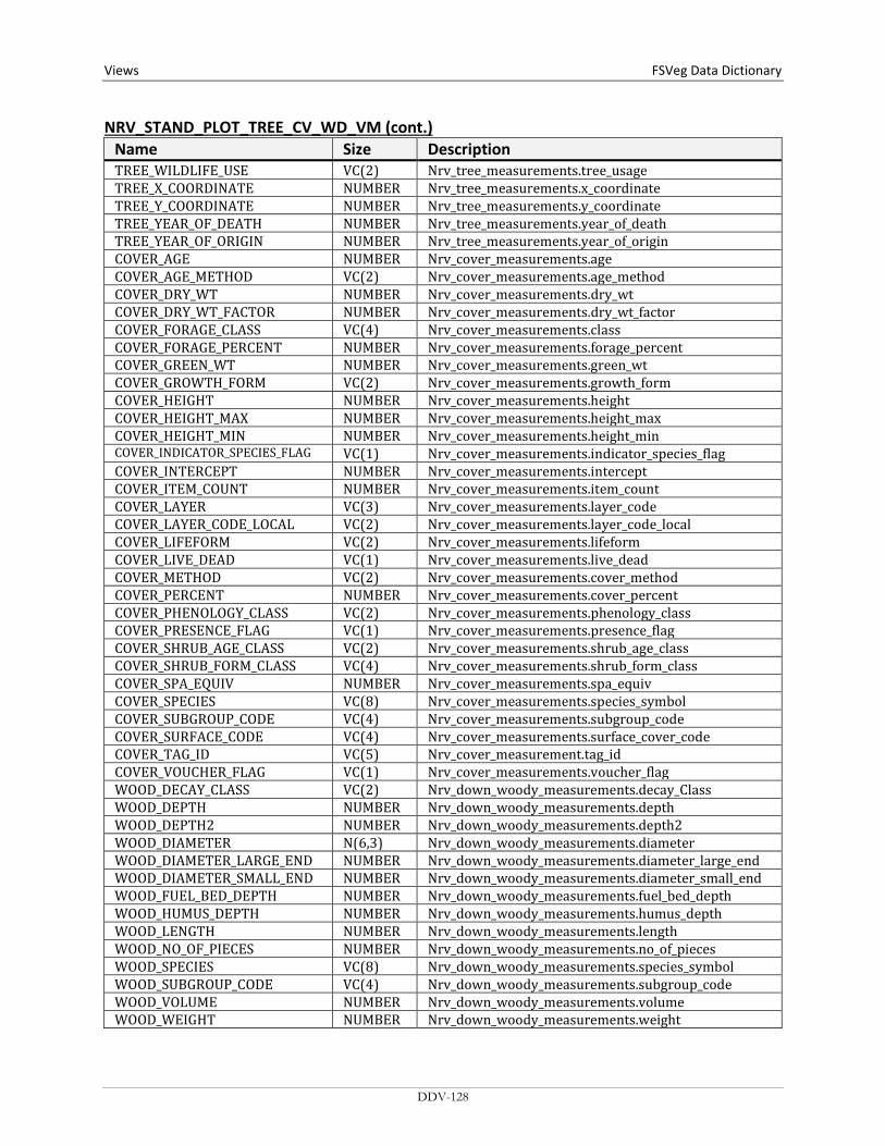
Views FSVeg Data Dictionary NRV_STAND_PLOT_TREE_CV_WD_VM (cont.)
Name Size Description TREE_WILDLIFE_USE VC(2) Nrv_tree_measurements.tree_usage TREE_X_COORDINATE NUMBER Nrv_tree_measurements.x_coordinate TREE_Y_COORDINATE NUMBER Nrv_tree_measurements.y_coordinate TREE_YEAR_OF_DEATH NUMBER Nrv_tree_measurements.year_of_death TREE_YEAR_OF_ORIGIN NUMBER Nrv_tree_measurements.year_of_origin COVER_AGE NUMBER Nrv_cover_measurements.age COVER_AGE_METHOD VC(2) Nrv_cover_measurements.age_method COVER_DRY_WT NUMBER Nrv_cover_measurements.dry_wt COVER_DRY_WT_FACTOR NUMBER Nrv_cover_measurements.dry_wt_factor COVER_FORAGE_CLASS VC(4) Nrv_cover_measurements.class COVER_FORAGE_PERCENT NUMBER Nrv_cover_measurements.forage_percent COVER_GREEN_WT NUMBER Nrv_cover_measurements.green_wt COVER_GROWTH_FORM VC(2) Nrv_cover_measurements.growth_form COVER_HEIGHT NUMBER Nrv_cover_measurements.height COVER_HEIGHT_MAX NUMBER Nrv_cover_measurements.height_max COVER_HEIGHT_MIN NUMBER Nrv_cover_measurements.height_min COVER_INDICATOR_SPECIES_FLAG VC(1) Nrv_cover_measurements.indicator_species_flag COVER_INTERCEPT NUMBER Nrv_cover_measurements.intercept COVER_ITEM_COUNT NUMBER Nrv_cover_measurements.item_count COVER_LAYER VC(3) Nrv_cover_measurements.layer_code COVER_LAYER_CODE_LOCAL VC(2) Nrv_cover_measurements.layer_code_local COVER_LIFEFORM VC(2) Nrv_cover_measurements.lifeform COVER_LIVE_DEAD VC(1) Nrv_cover_measurements.live_dead COVER_METHOD VC(2) Nrv_cover_measurements.cover_method COVER_PERCENT NUMBER Nrv_cover_measurements.cover_percent COVER_PHENOLOGY_CLASS VC(2) Nrv_cover_measurements.phenology_class COVER_PRESENCE_FLAG VC(1) Nrv_cover_measurements.presence_flag COVER_SHRUB_AGE_CLASS VC(2) Nrv_cover_measurements.shrub_age_class COVER_SHRUB_FORM_CLASS VC(4) Nrv_cover_measurements.shrub_form_class COVER_SPA_EQUIV NUMBER Nrv_cover_measurements.spa_equiv COVER_SPECIES VC(8) Nrv_cover_measurements.species_symbol COVER_SUBGROUP_CODE VC(4) Nrv_cover_measurements.subgroup_code COVER_SURFACE_CODE VC(4) Nrv_cover_measurements.surface_cover_code COVER_TAG_ID VC(5) Nrv_cover_measurement.tag_id COVER_VOUCHER_FLAG VC(1) Nrv_cover_measurements.voucher_flag WOOD_DECAY_CLASS VC(2) Nrv_down_woody_measurements.decay_Class WOOD_DEPTH NUMBER Nrv_down_woody_measurements.depth WOOD_DEPTH2 NUMBER Nrv_down_woody_measurements.depth2 WOOD_DIAMETER N(6,3) Nrv_down_woody_measurements.diameter WOOD_DIAMETER_LARGE_END NUMBER Nrv_down_woody_measurements.diameter_large_end WOOD_DIAMETER_SMALL_END NUMBER Nrv_down_woody_measurements.diameter_small_end WOOD_FUEL_BED_DEPTH NUMBER Nrv_down_woody_measurements.fuel_bed_depth WOOD_HUMUS_DEPTH NUMBER Nrv_down_woody_measurements.humus_depth WOOD_LENGTH NUMBER Nrv_down_woody_measurements.length WOOD_NO_OF_PIECES NUMBER Nrv_down_woody_measurements.no_of_pieces WOOD_SPECIES VC(8) Nrv_down_woody_measurements.species_symbol WOOD_SUBGROUP_CODE VC(4) Nrv_down_woody_measurements.subgroup_code WOOD_VOLUME NUMBER Nrv_down_woody_measurements.volume WOOD_WEIGHT NUMBER Nrv_down_woody_measurements.weight
DDV-128
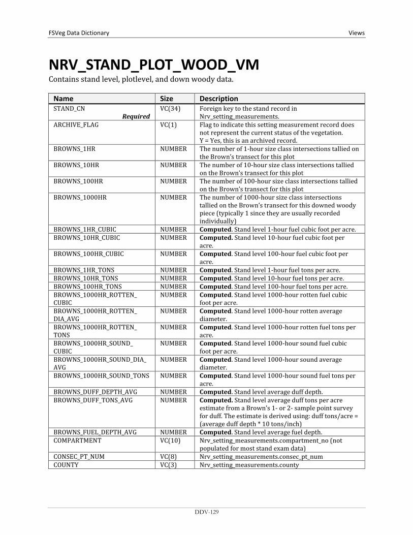
FSVeg Data Dictionary Views
NRV_STAND_PLOT_WOOD_VM Contains stand level, plotlevel, and down woody data.
Name Size Description STAND_CN
Required VC(34) Foreign key to the stand record in
Nrv_setting_measurements. ARCHIVE_FLAG VC(1) Flag to indicate this setting measurement record does
not represent the current status of the vegetation. Y = Yes, this is an archived record.
BROWNS_1HR NUMBER The number of 1-hour size class intersections tallied on the Brown’s transect for this plot
BROWNS_10HR NUMBER The number of 10-hour size class intersections tallied on the Brown’s transect for this plot
BROWNS_100HR NUMBER The number of 100-hour size class intersections tallied on the Brown’s transect for this plot
BROWNS_1000HR NUMBER The number of 1000-hour size class intersections tallied on the Brown’s transect for this downed woody piece (typically 1 since they are usually recorded individually)
BROWNS_1HR_CUBIC NUMBER Computed. Stand level 1-hour fuel cubic foot per acre. BROWNS_10HR_CUBIC NUMBER Computed. Stand level 10-hour fuel cubic foot per
acre. BROWNS_100HR_CUBIC NUMBER Computed. Stand level 100-hour fuel cubic foot per
acre. BROWNS_1HR_TONS NUMBER Computed. Stand level 1-hour fuel tons per acre. BROWNS_10HR_TONS NUMBER Computed. Stand level 10-hour fuel tons per acre. BROWNS_100HR_TONS NUMBER Computed. Stand level 100-hour fuel tons per acre. BROWNS_1000HR_ROTTEN_ CUBIC
NUMBER Computed. Stand level 1000-hour rotten fuel cubic foot per acre.
BROWNS_1000HR_ROTTEN_ DIA_AVG
NUMBER Computed. Stand level 1000-hour rotten average diameter.
BROWNS_1000HR_ROTTEN_ TONS
NUMBER Computed. Stand level 1000-hour rotten fuel tons per acre.
BROWNS_1000HR_SOUND_ CUBIC
NUMBER Computed. Stand level 1000-hour sound fuel cubic foot per acre.
BROWNS_1000HR_SOUND_DIA_AVG
NUMBER Computed. Stand level 1000-hour sound average diameter.
BROWNS_1000HR_SOUND_TONS NUMBER Computed. Stand level 1000-hour sound fuel tons per acre.
BROWNS_DUFF_DEPTH_AVG NUMBER Computed. Stand level average duff depth. BROWNS_DUFF_TONS_AVG NUMBER Computed. Stand level average duff tons per acre
estimate from a Brown’s 1- or 2- sample point survey for duff. The estimate is derived using: duff tons/acre = (average duff depth * 10 tons/inch)
BROWNS_FUEL_DEPTH_AVG NUMBER Computed. Stand level average fuel depth. COMPARTMENT VC(10) Nrv_setting_measurements.compartment_no (not
populated for most stand exam data) CONSEC_PT_NUM VC(8) Nrv_setting_measurements.consec_pt_num COUNTY VC(3) Nrv_setting_measurements.county
DDV-129
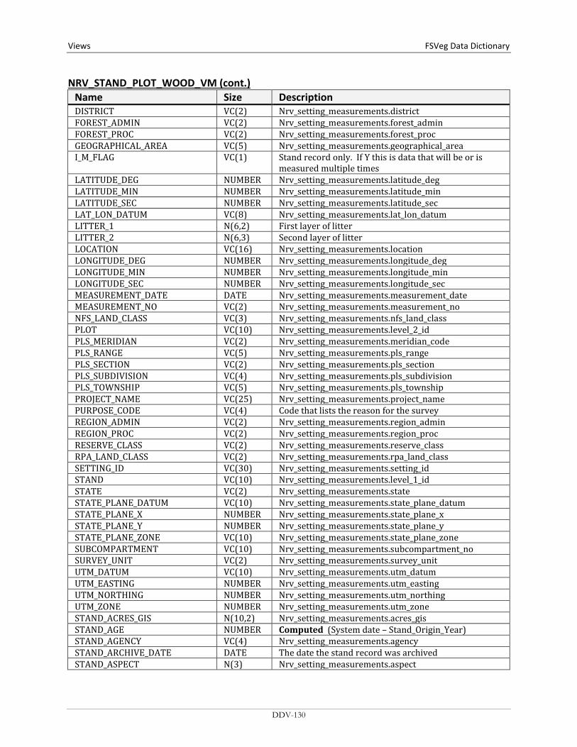
Views FSVeg Data Dictionary NRV_STAND_PLOT_WOOD_VM (cont.)
Name Size Description DISTRICT VC(2) Nrv_setting_measurements.district FOREST_ADMIN VC(2) Nrv_setting_measurements.forest_admin FOREST_PROC VC(2) Nrv_setting_measurements.forest_proc GEOGRAPHICAL_AREA VC(5) Nrv_setting_measurements.geographical_area I_M_FLAG VC(1) Stand record only. If Y this is data that will be or is
measured multiple times LATITUDE_DEG NUMBER Nrv_setting_measurements.latitude_deg LATITUDE_MIN NUMBER Nrv_setting_measurements.latitude_min LATITUDE_SEC NUMBER Nrv_setting_measurements.latitude_sec LAT_LON_DATUM VC(8) Nrv_setting_measurements.lat_lon_datum LITTER_1 N(6,2) First layer of litter LITTER_2 N(6,3) Second layer of litter LOCATION VC(16) Nrv_setting_measurements.location LONGITUDE_DEG NUMBER Nrv_setting_measurements.longitude_deg LONGITUDE_MIN NUMBER Nrv_setting_measurements.longitude_min LONGITUDE_SEC NUMBER Nrv_setting_measurements.longitude_sec MEASUREMENT_DATE DATE Nrv_setting_measurements.measurement_date MEASUREMENT_NO VC(2) Nrv_setting_measurements.measurement_no NFS_LAND_CLASS VC(3) Nrv_setting_measurements.nfs_land_class PLOT VC(10) Nrv_setting_measurements.level_2_id PLS_MERIDIAN VC(2) Nrv_setting_measurements.meridian_code PLS_RANGE VC(5) Nrv_setting_measurements.pls_range PLS_SECTION VC(2) Nrv_setting_measurements.pls_section PLS_SUBDIVISION VC(4) Nrv_setting_measurements.pls_subdivision PLS_TOWNSHIP VC(5) Nrv_setting_measurements.pls_township PROJECT_NAME VC(25) Nrv_setting_measurements.project_name PURPOSE_CODE VC(4) Code that lists the reason for the survey REGION_ADMIN VC(2) Nrv_setting_measurements.region_admin REGION_PROC VC(2) Nrv_setting_measurements.region_proc RESERVE_CLASS VC(2) Nrv_setting_measurements.reserve_class RPA_LAND_CLASS VC(2) Nrv_setting_measurements.rpa_land_class SETTING_ID VC(30) Nrv_setting_measurements.setting_id STAND VC(10) Nrv_setting_measurements.level_1_id STATE VC(2) Nrv_setting_measurements.state STATE_PLANE_DATUM VC(10) Nrv_setting_measurements.state_plane_datum STATE_PLANE_X NUMBER Nrv_setting_measurements.state_plane_x STATE_PLANE_Y NUMBER Nrv_setting_measurements.state_plane_y STATE_PLANE_ZONE VC(10) Nrv_setting_measurements.state_plane_zone SUBCOMPARTMENT VC(10) Nrv_setting_measurements.subcompartment_no SURVEY_UNIT VC(2) Nrv_setting_measurements.survey_unit UTM_DATUM VC(10) Nrv_setting_measurements.utm_datum UTM_EASTING NUMBER Nrv_setting_measurements.utm_easting UTM_NORTHING NUMBER Nrv_setting_measurements.utm_northing UTM_ZONE NUMBER Nrv_setting_measurements.utm_zone STAND_ACRES_GIS N(10,2) Nrv_setting_measurements.acres_gis STAND_AGE NUMBER Computed (System date – Stand_Origin_Year) STAND_AGENCY VC(4) Nrv_setting_measurements.agency STAND_ARCHIVE_DATE DATE The date the stand record was archived STAND_ASPECT N(3) Nrv_setting_measurements.aspect
DDV-130
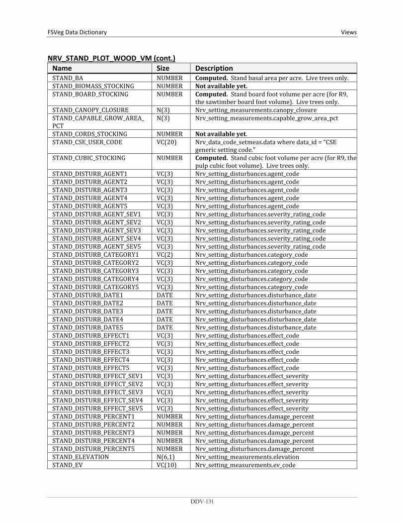
FSVeg Data Dictionary Views
NRV_STAND_PLOT_WOOD_VM (cont.) Name Size Description STAND_BA NUMBER Computed. Stand basal area per acre. Live trees only. STAND_BIOMASS_STOCKING NUMBER Not available yet. STAND_BOARD_STOCKING NUMBER Computed. Stand board foot volume per acre (for R9,
the sawtimber board foot volume). Live trees only. STAND_CANOPY_CLOSURE N(3) Nrv_setting_measurements.canopy_closure STAND_CAPABLE_GROW_AREA_ PCT
N(3) Nrv_setting_measurements.capable_grow_area_pct
STAND_CORDS_STOCKING NUMBER Not available yet. STAND_CSE_USER_CODE VC(20) Nrv_data_code_setmeas.data where data_id = “CSE
generic setting code.” STAND_CUBIC_STOCKING NUMBER Computed. Stand cubic foot volume per acre (for R9, the
pulp cubic foot volume). Live trees only. STAND_DISTURB_AGENT1 VC(3) Nrv_setting_disturbances.agent_code STAND_DISTURB_AGENT2 VC(3) Nrv_setting_disturbances.agent_code STAND_DISTURB_AGENT3 VC(3) Nrv_setting_disturbances.agent_code STAND_DISTURB_AGENT4 VC(3) Nrv_setting_disturbances.agent_code STAND_DISTURB_AGENT5 VC(3) Nrv_setting_disturbances.agent_code STAND_DISTURB_AGENT_SEV1 VC(3) Nrv_setting_disturbances.severity_rating_code STAND_DISTURB_AGENT_SEV2 VC(3) Nrv_setting_disturbances.severity_rating_code STAND_DISTURB_AGENT_SEV3 VC(3) Nrv_setting_disturbances.severity_rating_code STAND_DISTURB_AGENT_SEV4 VC(3) Nrv_setting_disturbances.severity_rating_code STAND_DISTURB_AGENT_SEV5 VC(3) Nrv_setting_disturbances.severity_rating_code STAND_DISTURB_CATEGORY1 VC(2) Nrv_setting_disturbances.category_code STAND_DISTURB_CATEGORY2 VC(3) Nrv_setting_disturbances.category_code STAND_DISTURB_CATEGORY3 VC(3) Nrv_setting_disturbances.category_code STAND_DISTURB_CATEGORY4 VC(3) Nrv_setting_disturbances.category_code STAND_DISTURB_CATEGORY5 VC(3) Nrv_setting_disturbances.category_code STAND_DISTURB_DATE1 DATE Nrv_setting_disturbances.disturbance_date STAND_DISTURB_DATE2 DATE Nrv_setting_disturbances.disturbance_date STAND_DISTURB_DATE3 DATE Nrv_setting_disturbances.disturbance_date STAND_DISTURB_DATE4 DATE Nrv_setting_disturbances.disturbance_date STAND_DISTURB_DATE5 DATE Nrv_setting_disturbances.disturbance_date STAND_DISTURB_EFFECT1 VC(3) Nrv_setting_disturbances.effect_code STAND_DISTURB_EFFECT2 VC(3) Nrv_setting_disturbances.effect_code STAND_DISTURB_EFFECT3 VC(3) Nrv_setting_disturbances.effect_code STAND_DISTURB_EFFECT4 VC(3) Nrv_setting_disturbances.effect_code STAND_DISTURB_EFFECT5 VC(3) Nrv_setting_disturbances.effect_code STAND_DISTURB_EFFECT_SEV1 VC(3) Nrv_setting_disturbances.effect_severity STAND_DISTURB_EFFECT_SEV2 VC(3) Nrv_setting_disturbances.effect_severity STAND_DISTURB_EFFECT_SEV3 VC(3) Nrv_setting_disturbances.effect_severity STAND_DISTURB_EFFECT_SEV4 VC(3) Nrv_setting_disturbances.effect_severity STAND_DISTURB_EFFECT_SEV5 VC(3) Nrv_setting_disturbances.effect_severity STAND_DISTURB_PERCENT1 NUMBER Nrv_setting_disturbances.damage_percent STAND_DISTURB_PERCENT2 NUMBER Nrv_setting_disturbances.damage_percent STAND_DISTURB_PERCENT3 NUMBER Nrv_setting_disturbances.damage_percent STAND_DISTURB_PERCENT4 NUMBER Nrv_setting_disturbances.damage_percent STAND_DISTURB_PERCENT5 NUMBER Nrv_setting_disturbances.damage_percent STAND_ELEVATION N(6,1) Nrv_setting_measurements.elevation STAND_EV VC(10) Nrv_setting_measurements.ev_code
DDV-131

Views FSVeg Data Dictionary NRV_STAND_PLOT_WOOD_VM (cont.)
Name Size Description STAND_EV_REF VC(10) Nrv_setting_measurements.ev_ref_code STAND_FIA_EV_CALC VC(10) Computed. Forest type using the FIA algorithm STAND_FIA_TOTAL_STOCKING NUMBER Computed. Stand tree stocking using the FIA algorithm STAND_FSVEG_ID VC(40) Nrv_setting_measurements.fsveg_id STAND_FUEL_1HR N(5,2) Nrv_fuel_models.fuel_1hr STAND_FUEL_10HR N(5,2) Nrv_fuel_models.fuel_10hr STAND_FUEL_100HR N(5,2) Nrv_fuel_models.fuel_100hr STAND_FUEL_BED_DEPTH N(5,2) Nrv_fuel_models.fuel_bed_depth STAND_FUEL_MODEL VC(3) Nrv_fuel_models.fuel_model STAND_FUEL_MODEL_CODE VC(10) Nrv_fuel_models.fuel_model_code STAND_GIS_LINK VC(26) Nrv_setting_measurements.gis_link STAND_HISTORY1 VC(6) Nrv_setting_histories.history_code STAND_HISTORY2 VC(6) Nrv_setting_histories.history_code STAND_HISTORY3 VC(6) Nrv_setting_histories.history_code STAND_HISTORY_DATE1 DATE Nrv_setting_histories.history_date STAND_HISTORY_DATE2 DATE Nrv_setting_histories.history_date STAND_HISTORY_DATE3 DATE Nrv_setting_histories.history_date STAND_MERCH_CUBIC_STOCKING NUMBER Computed. Stand cubic foot volume per acre of the
merchantable portion of tree (for R9, the sawtimber cubic foot volume). Live trees only.
STAND_NET_BOARD_STOCKING NUMBER Not available yet. Stand board foot volume per acre after defect has been detected. Live trees only.
STAND_NET_CUBIC_STOCKING NUMBER Not available yet. Stand cubic foot volume per acre, after defect is deducted. Live trees only.
STAND_NET_MERCH_CUBIC_ STOCKING
NUMBER Not available yet. Stand cubic foot volume per acre of the merchantable portion of tree after defect is deducted. Live trees only.
STAND_ORGIN_YEAR N(4) Nrv_setting_measurements.stand_year_of_origin STAND_ORIGIN VC(2) Nrv_setting_measurements.setting_origin STAND_OWNER VC(4) Nrv_setting_measurements.owner STAND_PV VC(10) Nrv_setting_measurements.pv_code STAND_PV_REF VC(10) Nrv_setting_measurements.pv_ref_code STAND_QMD NUMBER Computed. Stand quadratic mean diameter. Live trees
only. STAND_SDI NUMBER Computed. Stand Density Index. Live trees only.
Stage’s method is used for Regions 1, 2, 5, 6, 8, 9, and 10. Shaw’s method is used for Regions 3 and 4.
STAND_SEEDLINGS NUMBER Computed. Stand number of trees per acre. This value only includes live trees less than 4.5 feet tall.
STAND_SITE_INDEX N(4,1) Nrv_site_indexes.site_index STAND_SITE_INDEX_CALC NUMBER Computed. Site index based n site tree data collected
on the plot and the values computed for site_index_ref_calc and site_species_calc
STAND_SITE_INDEX_REF VC(3) Nrv_site_indexes.reference_no STAND_SITE_INDEX_REF_CALC VC(5) Computed. The referenced used to compute
site_index_calc, determined by a functin of site_species_calc, Region, and Forest
STAND_SITE_SPECIES VC(8) Nrv_site_indexes.site_species
DDV-132

FSVeg Data Dictionary Views
NRV_STAND_PLOT_WOOD_VM (cont.) Name Size Description STAND_SITE_SPECIES_CALC VC(8) Computed. For Regions 1, 5, 6, 8, 9, and 10; the site
species with the plurality of basal area in the setting. For Regions 2, 3, and 4; computed according to RMSTANS rules. Used to compute site_index_calc.
STAND_SIZE N(8,4) Nrv_setting_measurements.setting_size STAND_SLOPE N(3) Nrv_setting_measurements.slope STAND_SLOPE_POSITION VC(2) Nrv_setting_measurements.slope_position STAND_SLOPE_SHAPE_HORIZ VC(2) Nrv_setting_measurements.slope_shape_horiz STAND_SLOPE_SHAPE_VERT VC(2) Nrv_setting_measurements.slope_shape_vert STAND_SPATIAL_LINK VC(1) Nrv_setting_measurements.spatial_link STAND_STRATUM VC(6) Nrv_setting_measurements.stratum STAND_STRATUM_EXPANSION_ FACTOR
N(9,1) Nrv_setting_measurements.stratum_expansion_factor
STAND_STRUCTURE VC(2) Nrv_setting_measurements.structure STAND_SUBGROUP_CODE VC(4) Nrv_setting_measurements.subgroup_code STAND_TPA NUMBER Computed. Stand number of trees per acre. Live trees
only. STAND_VSS VC(6) Computed. Vegetation structural stage for Regions 2, 3
and 4 only. PLOT_AGE NUMBER Computed (System date – Stand_Origin_Year) PLOT_ARCHIVE_DATE DATE The date the plot record was archived PLOT_ASPECT N(3) Nrv_setting_measurements.aspect PLOT_BA NUMBER Computed. Plot basal area per acre. Live trees only. PLOT_BIOMASS_STOCKING NUMBER Not available yet. PLOT_BOARD_STOCKING NUMBER Computed. Plot board foot volume per acre (for R9,
the sawtimber board foot volume). Live trees only. PLOT_CANOPY_CLOSURE N(3) Nrv_setting_measurements.canopy_closure PLOT_CAPABLE_GROW_AREA_ PCT
N(3) Nrv_setting_measurements.capable_grow_area_pct
PLOT_CN VC(34) Foreign key to the plot record in Nrv_setting_measurements
PLOT_CORDS_STOCKING NUMBER Not available yet. PLOT_CSE_USER_CODE VC(20) Nrv_data_code_setmeas.data where data_id = “CSE
generic plot code.” PLOT_CUBIC_STOCKING NUMBER Computed. Plot cubic foot volume per acre (for R9, the
pulp cubic foot volume). Live trees only. PLOT_DISTURB_AGENT1 VC(3) Nrv_setting_disturbances.agent_code PLOT_DISTURB_AGENT2 VC(3) Nrv_setting_disturbances.agent_code PLOT_DISTURB_AGENT3 VC(3) Nrv_setting_disturbances.agent_code PLOT_DISTURB_AGENT4 VC(3) Nrv_setting_disturbances.agent_code PLOT_DISTURB_AGENT5 VC(3) Nrv_setting_disturbances.agent_code PLOT_DISTURB_AGENT_SEV1 VC(3) Nrv_setting_disturbances.severity_rating_code PLOT_DISTURB_AGENT_SEV2 VC(3) Nrv_setting_disturbances.severity_rating_code PLOT_DISTURB_AGENT_SEV3 VC(3) Nrv_setting_disturbances.severity_rating_code PLOT_DISTURB_AGENT_SEV4 VC(3) Nrv_setting_disturbances.severity_rating_code PLOT_DISTURB_AGENT_SEV5 VC(3) Nrv_setting_disturbances.severity_rating_code PLOT_DISTURB_CATEGORY1 VC(2) Nrv_setting_disturbances.category_code PLOT_DISTURB_CATEGORY2 VC(3) Nrv_setting_disturbances.category_code PLOT_DISTURB_CATEGORY3 VC(3) Nrv_setting_disturbances.category_code PLOT_DISTURB_CATEGORY4 VC(3) Nrv_setting_disturbances.category_code
DDV-133
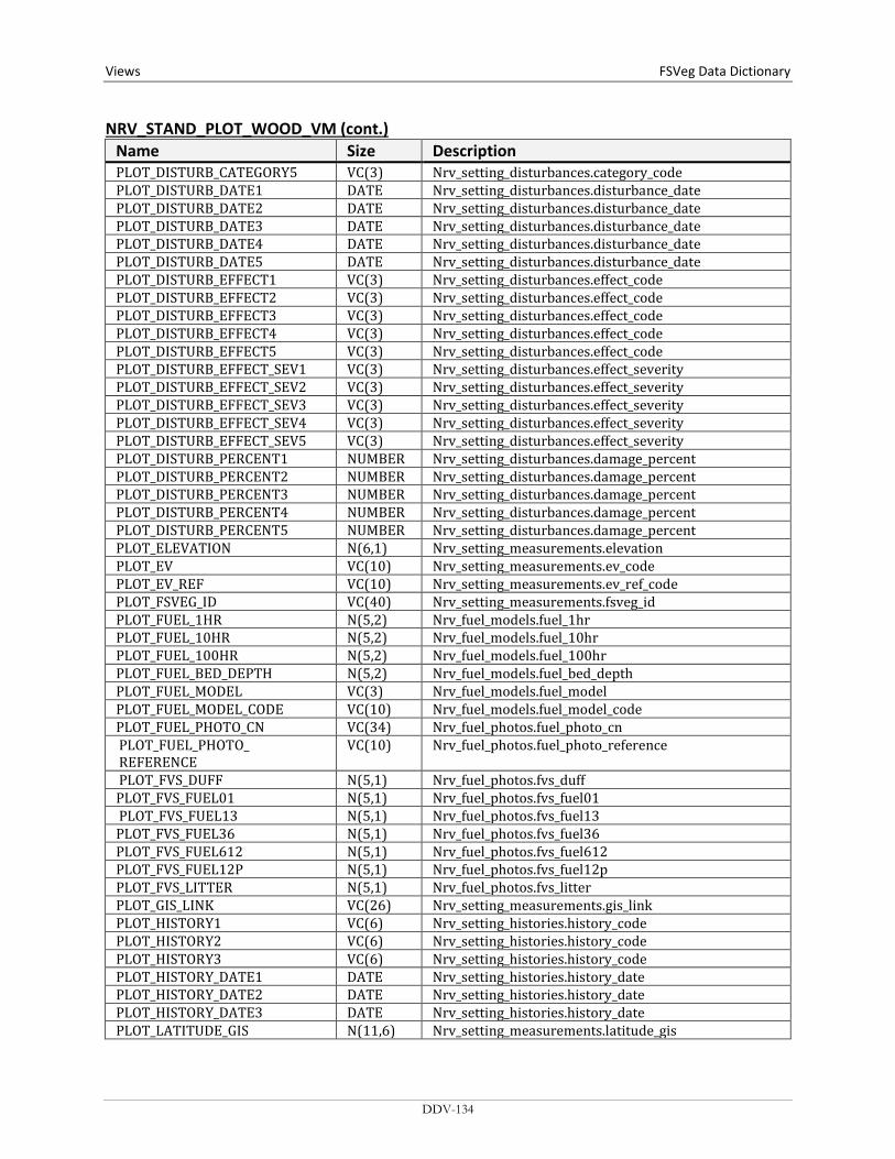
Views FSVeg Data Dictionary NRV_STAND_PLOT_WOOD_VM (cont.)
Name Size Description PLOT_DISTURB_CATEGORY5 VC(3) Nrv_setting_disturbances.category_code PLOT_DISTURB_DATE1 DATE Nrv_setting_disturbances.disturbance_date PLOT_DISTURB_DATE2 DATE Nrv_setting_disturbances.disturbance_date PLOT_DISTURB_DATE3 DATE Nrv_setting_disturbances.disturbance_date PLOT_DISTURB_DATE4 DATE Nrv_setting_disturbances.disturbance_date PLOT_DISTURB_DATE5 DATE Nrv_setting_disturbances.disturbance_date PLOT_DISTURB_EFFECT1 VC(3) Nrv_setting_disturbances.effect_code PLOT_DISTURB_EFFECT2 VC(3) Nrv_setting_disturbances.effect_code PLOT_DISTURB_EFFECT3 VC(3) Nrv_setting_disturbances.effect_code PLOT_DISTURB_EFFECT4 VC(3) Nrv_setting_disturbances.effect_code PLOT_DISTURB_EFFECT5 VC(3) Nrv_setting_disturbances.effect_code PLOT_DISTURB_EFFECT_SEV1 VC(3) Nrv_setting_disturbances.effect_severity PLOT_DISTURB_EFFECT_SEV2 VC(3) Nrv_setting_disturbances.effect_severity PLOT_DISTURB_EFFECT_SEV3 VC(3) Nrv_setting_disturbances.effect_severity PLOT_DISTURB_EFFECT_SEV4 VC(3) Nrv_setting_disturbances.effect_severity PLOT_DISTURB_EFFECT_SEV5 VC(3) Nrv_setting_disturbances.effect_severity PLOT_DISTURB_PERCENT1 NUMBER Nrv_setting_disturbances.damage_percent PLOT_DISTURB_PERCENT2 NUMBER Nrv_setting_disturbances.damage_percent PLOT_DISTURB_PERCENT3 NUMBER Nrv_setting_disturbances.damage_percent PLOT_DISTURB_PERCENT4 NUMBER Nrv_setting_disturbances.damage_percent PLOT_DISTURB_PERCENT5 NUMBER Nrv_setting_disturbances.damage_percent PLOT_ELEVATION N(6,1) Nrv_setting_measurements.elevation PLOT_EV VC(10) Nrv_setting_measurements.ev_code PLOT_EV_REF VC(10) Nrv_setting_measurements.ev_ref_code PLOT_FSVEG_ID VC(40) Nrv_setting_measurements.fsveg_id PLOT_FUEL_1HR N(5,2) Nrv_fuel_models.fuel_1hr PLOT_FUEL_10HR N(5,2) Nrv_fuel_models.fuel_10hr PLOT_FUEL_100HR N(5,2) Nrv_fuel_models.fuel_100hr PLOT_FUEL_BED_DEPTH N(5,2) Nrv_fuel_models.fuel_bed_depth PLOT_FUEL_MODEL VC(3) Nrv_fuel_models.fuel_model PLOT_FUEL_MODEL_CODE VC(10) Nrv_fuel_models.fuel_model_code PLOT_FUEL_PHOTO_CN VC(34) Nrv_fuel_photos.fuel_photo_cn PLOT_FUEL_PHOTO_ REFERENCE
VC(10) Nrv_fuel_photos.fuel_photo_reference
PLOT_FVS_DUFF N(5,1) Nrv_fuel_photos.fvs_duff PLOT_FVS_FUEL01 N(5,1) Nrv_fuel_photos.fvs_fuel01 PLOT_FVS_FUEL13 N(5,1) Nrv_fuel_photos.fvs_fuel13 PLOT_FVS_FUEL36 N(5,1) Nrv_fuel_photos.fvs_fuel36 PLOT_FVS_FUEL612 N(5,1) Nrv_fuel_photos.fvs_fuel612 PLOT_FVS_FUEL12P N(5,1) Nrv_fuel_photos.fvs_fuel12p PLOT_FVS_LITTER N(5,1) Nrv_fuel_photos.fvs_litter PLOT_GIS_LINK VC(26) Nrv_setting_measurements.gis_link PLOT_HISTORY1 VC(6) Nrv_setting_histories.history_code PLOT_HISTORY2 VC(6) Nrv_setting_histories.history_code PLOT_HISTORY3 VC(6) Nrv_setting_histories.history_code PLOT_HISTORY_DATE1 DATE Nrv_setting_histories.history_date PLOT_HISTORY_DATE2 DATE Nrv_setting_histories.history_date PLOT_HISTORY_DATE3 DATE Nrv_setting_histories.history_date PLOT_LATITUDE_GIS N(11,6) Nrv_setting_measurements.latitude_gis
DDV-134
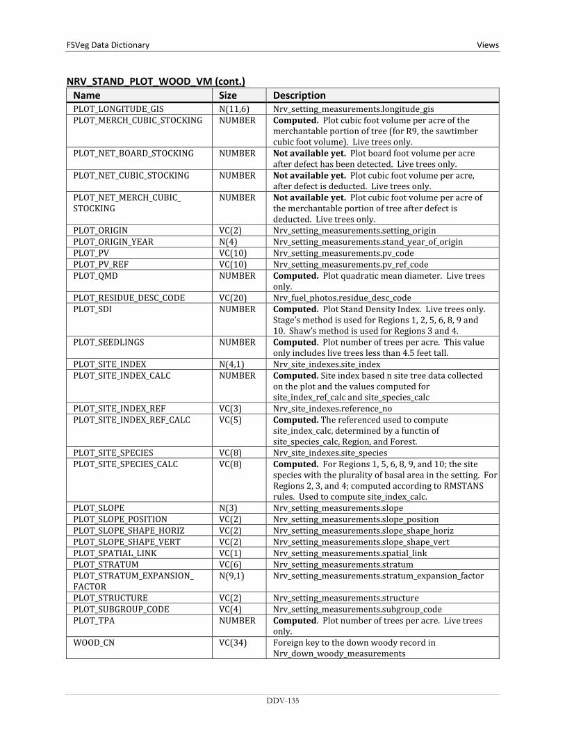
FSVeg Data Dictionary Views
NRV_STAND_PLOT_WOOD_VM (cont.) Name Size Description PLOT_LONGITUDE_GIS N(11,6) Nrv_setting_measurements.longitude_gis PLOT_MERCH_CUBIC_STOCKING NUMBER Computed. Plot cubic foot volume per acre of the
merchantable portion of tree (for R9, the sawtimber cubic foot volume). Live trees only.
PLOT_NET_BOARD_STOCKING NUMBER Not available yet. Plot board foot volume per acre after defect has been detected. Live trees only.
PLOT_NET_CUBIC_STOCKING NUMBER Not available yet. Plot cubic foot volume per acre, after defect is deducted. Live trees only.
PLOT_NET_MERCH_CUBIC_ STOCKING
NUMBER Not available yet. Plot cubic foot volume per acre of the merchantable portion of tree after defect is deducted. Live trees only.
PLOT_ORIGIN VC(2) Nrv_setting_measurements.setting_origin PLOT_ORIGIN_YEAR N(4) Nrv_setting_measurements.stand_year_of_origin PLOT_PV VC(10) Nrv_setting_measurements.pv_code PLOT_PV_REF VC(10) Nrv_setting_measurements.pv_ref_code PLOT_QMD NUMBER Computed. Plot quadratic mean diameter. Live trees
only. PLOT_RESIDUE_DESC_CODE VC(20) Nrv_fuel_photos.residue_desc_code PLOT_SDI NUMBER Computed. Plot Stand Density Index. Live trees only.
Stage’s method is used for Regions 1, 2, 5, 6, 8, 9 and 10. Shaw’s method is used for Regions 3 and 4.
PLOT_SEEDLINGS NUMBER Computed. Plot number of trees per acre. This value only includes live trees less than 4.5 feet tall.
PLOT_SITE_INDEX N(4,1) Nrv_site_indexes.site_index PLOT_SITE_INDEX_CALC NUMBER Computed. Site index based n site tree data collected
on the plot and the values computed for site_index_ref_calc and site_species_calc
PLOT_SITE_INDEX_REF VC(3) Nrv_site_indexes.reference_no PLOT_SITE_INDEX_REF_CALC VC(5) Computed. The referenced used to compute
site_index_calc, determined by a functin of site_species_calc, Region, and Forest.
PLOT_SITE_SPECIES VC(8) Nrv_site_indexes.site_species PLOT_SITE_SPECIES_CALC VC(8) Computed. For Regions 1, 5, 6, 8, 9, and 10; the site
species with the plurality of basal area in the setting. For Regions 2, 3, and 4; computed according to RMSTANS rules. Used to compute site_index_calc.
PLOT_SLOPE N(3) Nrv_setting_measurements.slope PLOT_SLOPE_POSITION VC(2) Nrv_setting_measurements.slope_position PLOT_SLOPE_SHAPE_HORIZ VC(2) Nrv_setting_measurements.slope_shape_horiz PLOT_SLOPE_SHAPE_VERT VC(2) Nrv_setting_measurements.slope_shape_vert PLOT_SPATIAL_LINK VC(1) Nrv_setting_measurements.spatial_link PLOT_STRATUM VC(6) Nrv_setting_measurements.stratum PLOT_STRATUM_EXPANSION_ FACTOR
N(9,1) Nrv_setting_measurements.stratum_expansion_factor
PLOT_STRUCTURE VC(2) Nrv_setting_measurements.structure PLOT_SUBGROUP_CODE VC(4) Nrv_setting_measurements.subgroup_code PLOT_TPA NUMBER Computed. Plot number of trees per acre. Live trees
only. WOOD_CN VC(34) Foreign key to the down woody record in
Nrv_down_woody_measurements
DDV-135
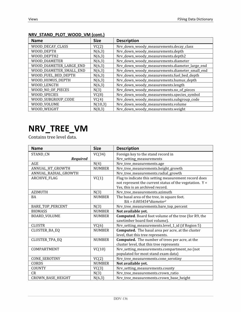
Views FSVeg Data Dictionary NRV_STAND_PLOT_WOOD_VM (cont.)
Name Size Description WOOD_DECAY_CLASS VC(2) Nrv_down_woody_measurements.decay_class WOOD_DEPTH N(6,3) Nrv_down_woody_measurements.depth WOOD_DEPTH2 N(6,3) Nrv_down_woody_measurements.depth2 WOOD_DIAMETER N(6,3) Nrv_down_woody_measurements.diameter WOOD_DIAMETER_LARGE_END N(6,3) Nrv_down_woody_measurements.diameter_large_end WOOD_DIAMETER_SMALL_END N(6,3) Nrv_down_woody_measurements.diameter_small_end WOOD_FUEL_BED_DEPTH N(6,3) Nrv_down_woody_measurements.fuel_bed_depth WOOD_HUMUS_DEPTH N(6,3) Nrv_down_woody_measurements.humus_depth WOOD_LENGTH N(6,3) Nrv_down_woody_measurements.length WOOD_NO_OF_PIECES N(3) Nrv_down_woody_measurements.no_of_pieces WOOD_SPECIES VC(8) Nrv_down_woody_measurements.species_symbol WOOD_SUBGROUP_CODE VC(4) Nrv_down_woody_measurements.subgroup_code WOOD_VOLUME N(10,3) Nrv_down_woody_measurements.volume WOOD_WEIGHT N(8,3) Nrv_down_woody_measurements.weight
NRV_TREE_VM Contains tree level data.
Name Size Description STAND_CN
Required VC(34) Foreign key to the stand record in
Nrv_setting_measurements AGE N(4) Nrv_tree_measurements.age ANNUAL_HT_GROWTH NUMBER Nrv_tree_measurements.height_growth ANNUAL_RADIAL_GROWTH Nrv_tree_measurements.radial_growth ARCHIVE_FLAG VC(1) Flag to indicate this setting measurement record does
not represent the current status of the vegetation. Y = Yes, this is an archived record.
AZIMUTH N(3) Nrv_tree_measurements.azimuth BA NUMBER The basal area of the tree, in square feet.
BA = 0.005454*diameter2 BARE_TOP_PERCENT N(3) Nrv_tree_measurements.bare_top_percent BIOMASS NUMBER Not available yet. BOARD_VOLUME NUMBER Computed. Board foot volume of the tree (for R9, the
sawtimber board foot volume). CLUSTR VC(6) Nrv_setting_measurements.level_1_id (if Region 5) CLUSTER_BA_EQ NUMBER Computed. The basal area per acre, at the cluster
level, that this tree represents. CLUSTER_TPA_EQ NUMBER Computed. The number of trees per acre, at the
cluster level, that this tree represents COMPARTMENT VC(10) Nrv_setting_measurements.compartment_no (not
populated for most stand exam data) CONE_SEROTINY VC(2) Nrv_tree_measurements.cone_serotiny CORDS NUMBER Not available yet. COUNTY VC(3) Nrv_setting_measurements.county CR N(3) Nrv_tree_measurements.crown_ratio CROWN_BASE_HEIGHT N(6,3) Nrv_tree_measurements.crown_base_height
DDV-136
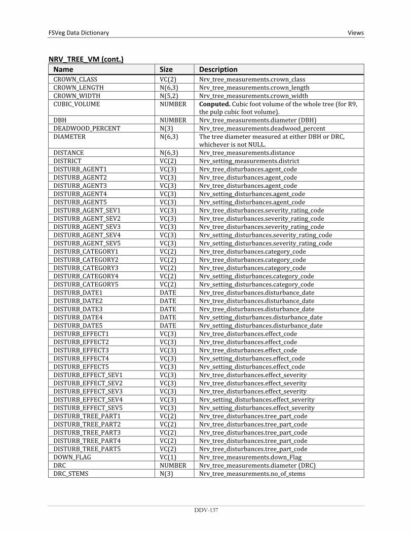
FSVeg Data Dictionary Views
NRV_TREE_VM (cont.) Name Size Description CROWN_CLASS VC(2) Nrv_tree_measurements.crown_class CROWN_LENGTH N(6,3) Nrv_tree_measurements.crown_length CROWN_WIDTH N(5,2) Nrv_tree_measurements.crown_width CUBIC_VOLUME NUMBER Conputed. Cubic foot volume of the whole tree (for R9,
the pulp cubic foot volume). DBH NUMBER Nrv_tree_measurements.diameter (DBH) DEADWOOD_PERCENT N(3) Nrv_tree_measurements.deadwood_percent DIAMETER N(6,3) The tree diameter measured at either DBH or DRC,
whichever is not NULL. DISTANCE N(6,3) Nrv_tree_measurements.distance DISTRICT VC(2) Nrv_setting_measurements.district DISTURB_AGENT1 VC(3) Nrv_tree_disturbances.agent_code DISTURB_AGENT2 VC(3) Nrv_tree_disturbances.agent_code DISTURB_AGENT3 VC(3) Nrv_tree_disturbances.agent_code DISTURB_AGENT4 VC(3) Nrv_setting_disturbances.agent_code DISTURB_AGENT5 VC(3) Nrv_setting_disturbances.agent_code DISTURB_AGENT_SEV1 VC(3) Nrv_tree_disturbances.severity_rating_code DISTURB_AGENT_SEV2 VC(3) Nrv_tree_disturbances.severity_rating_code DISTURB_AGENT_SEV3 VC(3) Nrv_tree_disturbances.severity_rating_code DISTURB_AGENT_SEV4 VC(3) Nrv_setting_disturbances.severity_rating_code DISTURB_AGENT_SEV5 VC(3) Nrv_setting_disturbances.severity_rating_code DISTURB_CATEGORY1 VC(2) Nrv_tree_disturbances.category_code DISTURB_CATEGORY2 VC(2) Nrv_tree_disturbances.category_code DISTURB_CATEGORY3 VC(2) Nrv_tree_disturbances.category_code DISTURB_CATEGORY4 VC(2) Nrv_setting_disturbances.category_code DISTURB_CATEGORY5 VC(2) Nrv_setting_disturbances.category_code DISTURB_DATE1 DATE Nrv_tree_disturbances.disturbance_date DISTURB_DATE2 DATE Nrv_tree_disturbances.disturbance_date DISTURB_DATE3 DATE Nrv_tree_disturbances.disturbance_date DISTURB_DATE4 DATE Nrv_setting_disturbances.disturbance_date DISTURB_DATE5 DATE Nrv_setting_disturbances.disturbance_date DISTURB_EFFECT1 VC(3) Nrv_tree_disturbances.effect_code DISTURB_EFFECT2 VC(3) Nrv_tree_disturbances.effect_code DISTURB_EFFECT3 VC(3) Nrv_tree_disturbances.effect_code DISTURB_EFFECT4 VC(3) Nrv_setting_disturbances.effect_code DISTURB_EFFECT5 VC(3) Nrv_setting_disturbances.effect_code DISTURB_EFFECT_SEV1 VC(3) Nrv_tree_disturbances.effect_severity DISTURB_EFFECT_SEV2 VC(3) Nrv_tree_disturbances.effect_severity DISTURB_EFFECT_SEV3 VC(3) Nrv_tree_disturbances.effect_severity DISTURB_EFFECT_SEV4 VC(3) Nrv_setting_disturbances.effect_severity DISTURB_EFFECT_SEV5 VC(3) Nrv_setting_disturbances.effect_severity DISTURB_TREE_PART1 VC(2) Nrv_tree_disturbances.tree_part_code DISTURB_TREE_PART2 VC(2) Nrv_tree_disturbances.tree_part_code DISTURB_TREE_PART3 VC(2) Nrv_tree_disturbances.tree_part_code DISTURB_TREE_PART4 VC(2) Nrv_tree_disturbances.tree_part_code DISTURB_TREE_PART5 VC(2) Nrv_tree_disturbances.tree_part_code DOWN_FLAG VC(1) Nrv_tree_measurements.down_Flag DRC NUMBER Nrv_tree_measurements.diameter (DRC) DRC_STEMS N(3) Nrv_tree_measurements.no_of_stems
DDV-137
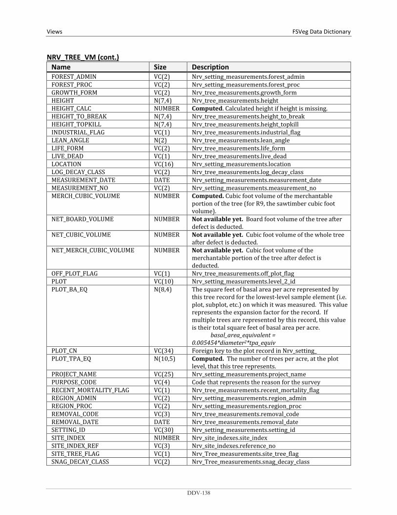
Views FSVeg Data Dictionary NRV_TREE_VM (cont.)
Name Size Description FOREST_ADMIN VC(2) Nrv_setting_measurements.forest_admin FOREST_PROC VC(2) Nrv_setting_measurements.forest_proc GROWTH_FORM VC(2) Nrv_tree_measurements.growth_form HEIGHT N(7,4) Nrv_tree_measurements.height HEIGHT_CALC NUMBER Computed. Calculated height if height is missing. HEIGHT_TO_BREAK N(7,4) Nrv_tree_measurements.height_to_break HEIGHT_TOPKILL N(7,4) Nrv_tree_measurements.height_topkill INDUSTRIAL_FLAG VC(1) Nrv_tree_measurements.industrial_flag LEAN_ANGLE N(2) Nrv_tree_measurements.lean_angle LIFE_FORM VC(2) Nrv_tree_measurements.life_form LIVE_DEAD VC(1) Nrv_tree_measurements.live_dead LOCATION VC(16) Nrv_setting_measurements.location LOG_DECAY_CLASS VC(2) Nrv_tree_measurements.log_decay_class MEASUREMENT_DATE DATE Nrv_setting_measurements.measurement_date MEASUREMENT_NO VC(2) Nrv_setting_measurements.measurement_no MERCH_CUBIC_VOLUME NUMBER Computed. Cubic foot volume of the merchantable
portion of the tree (for R9, the sawtimber cubic foot volume).
NET_BOARD_VOLUME NUMBER Not available yet. Board foot volume of the tree after defect is deducted.
NET_CUBIC_VOLUME NUMBER Not available yet. Cubic foot volume of the whole tree after defect is deducted.
NET_MERCH_CUBIC_VOLUME NUMBER Not available yet. Cubic foot volume of the merchantable portion of the tree after defect is deducted.
OFF_PLOT_FLAG VC(1) Nrv_tree_measurements.off_plot_flag PLOT VC(10) Nrv_setting_measurements.level_2_id PLOT_BA_EQ N(8,4) The square feet of basal area per acre represented by
this tree record for the lowest-level sample element (i.e. plot, subplot, etc.) on which it was measured. This value represents the expansion factor for the record. If multiple trees are represented by this record, this value is their total square feet of basal area per acre. basal_area_equivalent = 0.005454*diameter2*tpa_equiv
PLOT_CN VC(34) Foreign key to the plot record in Nrv_setting_ PLOT_TPA_EQ N(10,5) Computed. The number of trees per acre, at the plot
level, that this tree represents. PROJECT_NAME VC(25) Nrv_setting_measurements.project_name PURPOSE_CODE VC(4) Code that represents the reason for the survey RECENT_MORTALITY_FLAG VC(1) Nrv_tree_measurements.recent_mortality_flag REGION_ADMIN VC(2) Nrv_setting_measurements.region_admin REGION_PROC VC(2) Nrv_setting_measurements.region_proc REMOVAL_CODE VC(3) Nrv_tree_measurements.removal_code REMOVAL_DATE DATE Nrv_tree_measurements.removal_date SETTING_ID VC(30) Nrv_setting_measurements.setting_id SITE_INDEX NUMBER Nrv_site_indexes.site_index SITE_INDEX_REF VC(3) Nrv_site_indexes.reference_no SITE_TREE_FLAG VC(1) Nrv_Tree_measurements.site_tree_flag SNAG_DECAY_CLASS VC(2) Nrv_Tree_measurements.snag_decay_class
DDV-138

FSVeg Data Dictionary Views
NRV_TREE_VM (cont.) Name Size Description SPECIES VC(8) Nrv_Tree_measurements.species_symbol HARDWOOD_SOFTWOOD VC(4) Computed. Valid values are “HARD” or “SOFT” STAND VC(4) Nrv_setting_measurements.level_1_id STAND_BA_EQ NUMBER Computed. The basal area per acre, at the stand level,
that this tree represents. STAND_TPA_EQ NUMBER Computed. The number of trees per acre, at the stand
level, that this tree represents. STATE VC(2) Nrv_setting_measurements.state SUBCOMPARTMENT VC(10) Nrv_setting_measurements.subcompartment_no SUBGROUP VC(4) Nrv_tree_measurements.subgroup_code TAG_ID VC(5) Nrv_tree_measurements.tag_id TOPKILL_PERCENT N(3) Nrv_tree_measurements.topkil_percent TREATMENT_OPTION_1 VC(2) Nrv_tree_measurements.first_treatment_option TREATMENT_OPTION_2 VC(2) Nrv_tree_measurements.second_treatment_option TREE_CLASS VC(2) Nrv_tree_measurements.tree_class TREE_CN VC(34) Foreign key to the tree record in
Nrv_tree_measurements TREE_COUNT N(4) Nrv_tree_measurements.tree_count TREE_FIA_STOCKING NUMBER Computed. Tree stocking using the FIA algorithm TREE_STATUS VC(1) Nrv_tree_measurements.tree_status UNIQUE_NO N(5) Nrv_tree_measurements.unique_no WILDLIFE_USE VC(2) Nrv_tree_measurements.tree_usage X_COORDINATE N(7,2) Nrv_tree_measurements.x_coordinate Y_COORDINATE N(7,2) Nrv_tree_measurements.y_coordinate YEAR_OF_DEATH N(4) Nrv_tree_measurements.year_of_death YEAR_OF_ORIGIN N(4) Nrv_tree_measurements.year_of_origin
DDV-139