future land use element - dunedin, florida
TRANSCRIPT

FUTURE LAND USE ELEMENT

TABLE OF CONTENTS Introduction 1 Inventory 1 Analysis 3 Planning Area Analysis 37 Summary 44 Appendix 45 LIST OF TABLES 1 Existing Land Use, 2006 1 2 Residential Acreage by Housing Type and the Number of Units by Type, 2006 3 3 Major Shopping Centers in the City of Dunedin and Dunedin Planning Area 3 4 Functional Population Projections 8 5 Summary of Additional Acreage Required by Land Use Category and Intensity: Through Development of Vacant Land 14 6 Summary of Additional Acreage Required by Land Use Category and Intensity: Through Annexation of Developed and Vacant Enclaves 16 7 Regionally Significant Transportation 19 8 Regionally Significant Natural Features 20 9 Evaluation of Land Uses 27 10 Development Controls 33 11 Existing Land Use: Planning Area, 2006 38 12 Summary of Additional Acreage Required by Land Use Category and Intensity: Through Annexation of Developed and Vacant Parcels in the Planning Area 40 13 Land Use Classification Review Criteria 46 LIST OF FIGURES 1 Existing Land Use 2 2 Municipal Buildings 4 3 Public Education Facilities 5 4 Vacant Developable Land 6 5 Unincorporated Enclaves 12 6 Working Waterfront Related Activity 36 7 Commercial Recreation Land Use 37

1 DUNEDIN 2025-THE COMPREHENSIVE PLAN Future Land Use Element
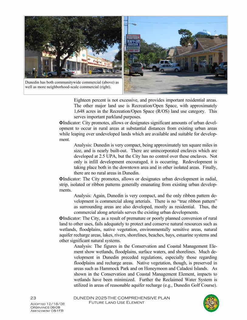
Introduction The Future Land Use Element is designed to examine the patterns that have emerged over the last decade or so with regard to the use of the land. These patterns run the gamut from residen-tial development to historic resources to vacant land to urban sprawl indicators. The element pulls information from many sources, including other comprehensive plan elements. This chapter also projects these trends out to the interim and target years, resulting in an estimate of needed land by land use category. Inventory The most logical place to begin is with the land itself. Table 1 and Figure 1 present the ex-isting land use acreages and location. Following them is Table 2, which summarizes the type and acreage of residential development in the City. Table 3 summarizes the major commercial develop-ments in Dunedin. As can be seen in Figure 2, the largest conglomerations of commercial uses are in the downtown (with 65 retail establishments and 82 ser-vice establishments), along SR 580, Alternate US 19, Patricia Avenue and Douglas Avenue. However, recreation and open space uses and right-of-way make up more land area separately than all the commercial combined. Recreation and open space lands include City parks, golf courses, county facilities, and state parks, and right-of-way includes City, county and state transportation facilities. Industrial land comprises less than one per-cent of the existing land use. There is no heavy in-dustry, the actual enterprises centering on citrus juice processing, metal fabrication, cabinet making, ma-chine shops and the like. Coca-Cola North America is the major industrial employer. There is one small industrial park near Martin Luther King Jr. Avenue and San Christopher Drive, and several other light industrial establishments along Douglas Avenue. Al-though the regulatory land use is industrial, the par-cels previously owned by Nielsen Media Research were vacated in the early 2000s. Efforts have been undertaken since to have that property reoccupied. Agricultural lands are non-existent within the city limits, such uses on the Existing Land Use Map located within the enclaves. The most common use is the raising of horses. Conservation lands consist of rivers, bays, lakes, wetlands, estuarine systems, flood-plains, nature preserves, environmentally sensitive areas and water management district property. Public and semi-public uses include government offices, fa-cilities and land. The only local government centers
TABLE 1 EXISTING LAND USE, 2006
LAND USE ACRES PERCENT
Residential:
Single Family 2,108.09 31.52
Duplex/Triplex 80.38 1.20
Multi-family 587.15 8.78
Mobile Home 171.14 2.56
Commercial 265.45 3.97
Industrial 56.04 0.84
Public/Semi-Public: 324.48 4.85
Recreation/Open Space/Preservation
1,806.97 27.02
Major Water Bodies 77.78 1.16
Vacant 109.43 1.64
Agricultural 0 0
Other (Right-of-Way) 1057.20 15.81
Total 6,688.08 100.0
Source: Pinellas County Planning Department; Pinellas County GIS; Dunedin Planning & Devel-opment, 2006
Urban Support 27.69 .41
Miscellaneous 16.28 .24

3 DUNEDIN 2025-THE COMPREHENSIVE PLAN Future Land Use Element
are City of Dunedin offices; municipal buildings are shown in Figure 2. (Please note that although the new Community Center, which now houses Lei-sure Services Administration, did not open until 2007.) Other such uses include health facili-ties (Mease Hospital being the only major health facility), over 20 churches, and four public elementary schools, one public middle school, one public high
school, and several private schools and day care facilities. Schools are shown in Figure 3. Most of the historic resources are in the downtown area, with one listed on the National Register of Historic Places. A second National Register landmark is located at the entrance to Ham-mock park. Those few known archaeological sites are located near the coast. There is little vacant and undeveloped land remaining in Dunedin. And much that is vacant is either approved for development or currently under active development. Vacant developable land is shown in Figure 4. Urban Support includes such uses as parking lots and retention or detention facilities. Mis-cellaneous is a category utilized by the Pinellas County Property Appraisers Office; it has been in-cluded here to ensure that the percentages total correctly. The City has an abundance of natural resources, beginning with a mild sub-tropical climate that averages 61.7° F. in January to 83.4° F. in August. The topography gently slopes from zero feet to 70 feet above sea level. Surface water is found in creeks, canals, lakes and wetland areas. While there are four major drainage basins, most of the City has moderate to well drained soils that are not subject to flooding. Wetlands are extensive in Dunedin, and include coastal and estuarine systems on Honey-moon and Caladesi Islands, tidal flats and grass beds along St. Joseph’s Sound, the Curlew Creek-Jerry Branch basin, the Cedar Creek channel and Hammock Park wetlands, freshwater marshlands in the vicinity of Virginia Street and Keene Road, SWFWMD’s Jerry Lake and surrounding wet-lands in the Planning Area. Being a National Flood Insurance Program (NFIP) community, the City’s delineated flood zones include A, B, C, D, V and X. There are no rock or mineral resources and no harvestable for-est land in the City. Groundwater comes from surficial and Floridan aquifers. Analysis The analysis begins with a review of population estimates and projections. The Introduction provided the background for the population projections for 2025 and the interim years. A summary of the functional population is provided in Table 4. For numerous reasons, the economic outlook for Dunedin is considered good in terms of employment and stability. Dunedin will continue as a “bedroom” community, since the amount of commercial within the City is relatively small. There is an abundance of facilities and services to take care of the modest population increase as well as the employment. In terms of transportation, existing (2006) deficiencies include Alternate US 19 and US 19.
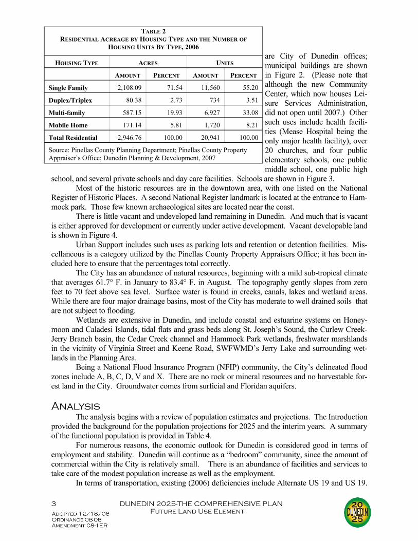
HOUSING TYPE ACRES UNITS
AMOUNT PERCENT AMOUNT PERCENT
Single Family 2,108.09 71.54 11,560 55.20
Duplex/Triplex 80.38 2.73 734 3.51
Multi-family 587.15 19.93 6,927 33.08
Mobile Home 171.14 5.81 1,720 8.21
Total Residential 2,946.76 100.00 20,941 100.00
Source: Pinellas County Planning Department; Pinellas County Property Appraiser’s Office; Dunedin Planning & Development, 2007
TABLE 2 RESIDENTIAL ACREAGE BY HOUSING TYPE AND THE NUMBER OF
HOUSING UNITS BY TYPE, 2006


7 DUNEDIN 2025-THE COMPREHENSIVE PLAN Future Land Use Element
Mass transit is adequate, with most of the City within one-quarter mile of a transit route. Transit shelters along SR 580 have been supple-mented with shelters built along other routes. On the negative side, the City has a minimal bicycle trail system. The sidewalk network has improved as newer developments have constructed walkways, but gaps still remain in older areas. The deteriorating wastewa-ter collection pipe condition is a problem, and inflow/infiltration can be too high at times during the wet season, although this has not oc-curred in recent years. Although septic tank use continues in unin-corporated areas, it has been re-duced through the annexation of properties and through assessment programs like that which occurred in Spanish Trails allowing the resi-dents to hook up to the wastewater system. The Wastewater Treatment Plant condition was upgraded dur-ing the 1990s. The collection and disposal of solid waste has no major prob-lems or deficiencies. Stormwater drainage, though, has proven chal-lenging over the years. The Master Drainage Plan (MDP) study com-pleted in 2003 resulted in a number of recommended improvements, most notably the upsizing of the system in key areas. Additionally, stormwater enters St. Joseph’s Sound through outfalls, causing a
deterioration of water quality in the Sound. While retrofitting is a very expensive proposition, the increase in the Stormwater Utility Capital Improvement Fee has provided a source of funding for such work. The MDP suggested a number of water quality improvements, including placing skim-mers with sumps and pollution control boxes on these outfalls. The conservation of potable water has been a great success over the last few years. Al-though the City can provide over 140 gallons per capita per day (gpcpd), consumption has been re-duced to less than 100 gpcpd through the use of reclaimed water and conservation activities. In
TABLE 3 MAJOR SHOPPING CENTERS IN DUNEDIN AND
PLANNING AREA
NAME UNITS PARKING SPACES
TOTAL LEAS-ABLE SQUARE
FOOTAGE
CITY OF DUNEDIN 580 Plaza 8 53 12,000
Ace Hardware 1 117 44,000
Andros Plaza 11 120 40,100
Bayshore Plaza 2 54 14,000
Brother’s Tavern, et al 9 50 14,000
Caladesi Shopping Center 18 375 105,100 Causeway Plaza 27 566 116,800
Coastal Plaza 23 329 85,200 Concord Plaza 13 51 14,600 Country Boy Plaza 14 106 24,000 CVS 1 77 11,000 Dunedin Plaza 14 362 108,000 Granada Plaza 20 378 81,100 Heather Square 15 60 14,100 Independence Square 18 224 70,000 Subway, et al 11 55 15,100
Walgreen’s (Main Street) 1 73 15,000
Walgreen’s (Patricia Avenue) 1 80 15,100
Weathersfield Shopping Center 18 340 81,000
DUNEDIN PLANNING AREA Bare Wood, et al 10 81 26,000 Columbia Plaza 15 66 14,200 Country Villa Plaza 29 115 37,100 Doggie Day Care, et al 7 62 12,700 Eckerd’s (formerly) 1 58 14,400 Hodusa Plaza 10 100 21,300 Home Depot, et al 14 683 220,000 Source: Dunedin Planning & Development, 2007

8 DUNEDIN 2025-THE COMPREHENSIVE PLAN Future Land Use Element
terms of actual infrastructure, there are few areas with under-sized and aging pipes. The wells themselves are completely inter-connected to one central treatment facility. While potable water usage reduction dimin-ishes the need for aquifer recharge, the vast majority of the City is composed of land allowing ten inches or fewer of recharge per year. The potential for growth within the City is severely hampered by the amount of remaining vacant and undeveloped land. Table 1 shows that there was less than 110 acres of vacant developable land remaining in 2006. There appear to be no major de-
velopment constraints represented by soils, geology or topography. Natural resources, though, could pose problems, but most vacant land is not near significant wetlands, rivers or lakes. There are several instances where vacant land is near ecologically-sensitive areas, most notably near Cur-lew Creek, Hammock Park, St. Joseph’s Sound, Tooke’s Lake/Howell Swamp (in the enclaves), Jerry Lake, and wetlands near the northern City boundary and Alternate US 19. All of these vacant lands have residential land uses assigned, with all but two having den-sities limited to 7.5 units per acre (UPA) or less. The few exceptions are limited to 15 UPA and occur either along St. Joseph’s Sound or near Main Street where the Jerry Branch of Curlew Creek intersects it.. The City has not utilized spoil sites on any sort of permanent basis. Dredged material is dried on-site in a temporary upland spoil site. The material is then transported to the Pinellas County landfill for their use, spoil material being utilized as a necessary component of landfill technology. Conversely, Intracoastal Waterway Dredging, which falls under auspices of US Army Corps of Engineers, utilizes spoil islands sprin-kled throughout St. Joseph’s Sound. Another potential limit on development and redevelopment is the issue of hazard mitigation. Hazard mitigation seeks to reduce the negative impacts of known perils. In 2004, Pinellas County, along with its municipalities, adopted a Local Mitigation Strategy (LMS) that addressed hazard identification and vulnerability assessment. Dunedin was assessed as having a moderate to high vulnerability to the following natural and manmade hazards: ΦCoastal Erosion ΦCoastal Flooding ΦRainfall Flooding ΦHurricane/Tropical Storm ΦSinkholes ΦTornado
2010 2015 2020 2025 Permanent 38,626 38,973 39,214 39,381 Seasonal 2,933 2,960 2,978 2,991 Tourist 2,389 2,409 2,423 2,432 Functional 43,948 44,341 44,615 44,804 Source: Pinellas County MPO; Dunedin Planning & Devel-opment, 2007
TABLE 4 FUNCTIONAL POPULATION PROJECTIONS
Open Space and landscaping make a developed Residential High parcel look much less dense.

9 DUNEDIN 2025-THE COMPREHENSIVE PLAN Future Land Use Element
ΦHazardous Materials Transportation The LMS developed a set of goals and objectives that would assist in offsetting the effects of the identified dangers. Dunedin adopted this LMS as its Floodplain Management Plan, and added an action plan that not only implemented the goals and objectives of the overlying LMS, but also addressed specific Citywide issues. The subjects and the specific approaches of this action plan are listed below: ΦPreventive activities keep flood problems from getting worse. Continue the extensive use of open space throughout the City and particu-
larly within the floodplain. This includes Hammock Park, Fisher Field, the Dunedin Country Club and St. Andrews Links.
Continue the enforcement of Chapter 122 of the Uniform Development Code entitled “Stormwater Management,” particularly as it relates to the construction of systems regulating stormwater runoff.
Continue the maintenance of the City’s drainage system. This includes rou-tine inspection, removal of debris, repairs, top and slope mowing, and aquatic maintenance.
ΦProperty protection activities are usually undertaken by property owners on a building-by-building or parcel basis.
Continue the mail-out of floodproofing information to the residents of each repetitive loss area.
Encourage the elevation/retrofitting of structures to FEMA requirements through the enforcement of the 50% rule, through the distribution of infor-mation to repetitive loss areas, and through obtaining federal funds for such structural work.
Continue providing information on the “dry floodproofing barrier” for use in repetitive loss areas.
ΦNatural resource protection activities preserve or restore natural areas or the natu-ral functions of floodplain and watershed areas.
Determine the necessity and most efficacious manner of stabilizing the Edgewater Drive Shoreline.
Continue to apply the Recreation/Open Space land use designation on all of Caladesi Island and on the vast majority of Honeymoon Island.
ΦEmergency services measures are taken during a flood to minimize its impact. Continue the cooperative implementation of the Comprehensive Emergency
Management Plan with Pinellas County. Send letters to owners of structures or facilities in the floodplain which pro-
duce, use or store highly volatile, flammable, explosive, toxic and/or water-reactive materials. These letters should encourage the owners or operators to follow proper procedures in the event of an impending disaster.
Continue the annual distribution of the All Hazards Guide or Hurricane Guide for as long as it is produced and made available to residents and local governments.
Continue advising the Florida Department of Transportation of the critical nature of the Alternate US 19/Curlew Road intersection. Request that some

10 DUNEDIN 2025-THE COMPREHENSIVE PLAN Future Land Use Element
type of improvement to the elevation conditions at this location be made. ΦStructural projects keep floodwaters away from an area with a levee, reservoir, or
other flood control measure. Continue the permitting of erosion protection projects as outlined in Article
VIII of Chapter 98 of the Uniform Development Code. Continue the enforcement of Chapter 122 of the Uniform Development
Code entitled “Stormwater Management,” particularly as it relates to the construction of systems regulating stormwater runoff.
ΦPublic information activities advise property owners, potential property owners, and visitors about the hazards, ways to protect people and property from the haz-ards, and the natural and beneficial functions of local floodplains.
Continue to provide the Map Determination Service, including the publiciz-ing of the service.
Continue to develop and send brochures and reproducible forms to real es-tate agencies regarding information relating to flood hazards of property.
Continue to maintain and publicize the Flood Library documents available at the Dunedin Public Library.
Continue to provide technical assistance where possible on flood issues. Continue to publish, update and make available the Urban Stormwater Im-
provement Guidance booklet. The only strategy that impacts the comprehensive plan is the one relating to the Edgewater Drive Shoreline revetment. Toward that end, the policy in the Conservation and Coastal Manage-ment Element is being revised to reflect the need for a study. Since the City is nearly built out, it should be apparent that any significant changes to either the population or to the existing structures will involve redevelopment. Redevelopment has already been a major factor in the downtown area, where a Community Redevelopment Agency (CRA) was established to address blighted conditions. Public funds have been used to upgrade infrastructure, which has lead to private development investing in their properties. For example, Main Street be-tween Alternate US 19 and Milwaukee was streetscaped in phases during the 1990s. Two public parking lots were constructed (one serving the Pinellas Trail as well), and water lines have been re-placed. While the streetscape has helped to revitalize Main Street businesses, parcel size remains relatively small. This can inhibit development, but the land development regulations allow for a 1.0 impervious surface ratio (ISR), as long as the requisite stormwater retention can be handled (with 100% lot coverage, this would result in a vault underneath the structure to handle retention). One objective in the Future Land Use Element calls for the encouragement of development or redevelopment which results in the elimination or reduction of uses inconsistent with character and the Regulatory Land Use Plan map. The City is primarily residential and recreation/open space in nature, with a very modest amount of commercial and industrial. The close to build-out status will ensure that land use will remain close to these parameters. As has been noted, the City being a coastal municipality, there is the potential for flooding during severe storms. This, in turn, can affect development and redevelopment. Flood-prone areas are designated as V-zones and A-zones, and are located mostly along and near the shoreline. While most vacant land is not located within the floodplain, there are some large tracts that are. For ex-ample along Dunedin Causeway and Alternate US 19, there is 3.45 acres of vacant land with a com-mercial designation, and 14.2 acres of vacant land with Residential Medium (15 UPA) designation.

11 DUNEDIN 2025-THE COMPREHENSIVE PLAN Future Land Use Element
Within the CRD, there are less than two acres of the District’s 145 (non-ROW) acres in zones V or A. Although great strides have been made in eliminating enclaves, they are still peppered throughout the City. Shown in Figure 5, there are 26 enclaves comprising nearly 370 acres. The City’s current Regulatory Land Use Plan Map contains 23 categories that, along with the underlying zoning, determines what can be built on any particular parcel. These categories break down into the following: Residential ΦResidential Suburban (RS) (0 to 2.5 UPA). ΦResidential Low (RL) (2.6 to 5.0 UPA). ΦResidential Urban (RU) (5.1 to 7.5 UPA). ΦResidential Low Medium (RLM) (7.6 to 10.0 UPA). ΦResidential Medium (RM) (10.1 to 15.0 UPA). ΦResidential High (RH) (15.0 to 30.0 UPA) Mixed Use ΦResidential/Office General (R/OG). This category allows residential den-
sity not to exceed 15.0 UPA or a percentage distribution of 50%. The land use provides for residential dwelling units as accessory use to commercial units within the General Office zoning district, creating housing opportuni-ties in neighborhood commercial areas and reducing what little urban sprawl the City has.
ΦResidential/Office Retail (R/O/R). This category, which is well repre-sented along US 19 in the City’s Planning Area, was added as part of the 2025 update to facilitate any annexations that might occur. R/O/R allows for a density of 15 UPA, again, with the residential portion not to exceed a distribution of 50%.
ΦResort Facilities Medium (RFM). This category was added as part of the 2025 update to foster additional mixed use projects, in particular those with transient accommodation uses. RFM allows for a residential density of 15 UPA, and a transient accommodation use not exceeding 30 UPA.
ΦPlanned Redevelopment-Mixed Use (PRMU). The specific use and loca-tional characteristics, as well as the density and intensity standards, are set by individual special area plans. The intent of the PRMU is to facilitate in-fill and redevelop areas with a desirable mix of residential and non-residential uses that compliment one another.
Commercial ΦCommercial Neighborhood (CN). This category was added as part of the
2025 update to recognize small scale commercial uses. Intended to be pri-marily commercial, it would allow a residential density not to exceed 10 UPA or a percentage distribution of 50%.
ΦCommercial Limited (CL). This category is intended to be primarily com-mercial, but allows a residential density not to exceed 15.0 UPA or a per-centage distribution of 50%. Similar to R/OG, this provides for residential dwelling units as accessory use to commercial units within General Office and Neighborhood Business zoning districts.


13 DUNEDIN 2025-THE COMPREHENSIVE PLAN Future Land Use Element
ΦCommercial General (CG). Again, like CL, this category allows residen-tial density not to exceed 15.0 UPA or a percentage distribution of 50%.
ΦCommercial Recreation (CR). Industrial ΦIndustrial Limited (IL). ΦIndustrial General (IG). Public/Semi-Public ΦPreservation (P). ΦRecreation/Open Space (R/OS). ΦInstitutional (I). ΦTransportation/Utility (TU). Special Designation ΦCommunity Redevelopment District (CRD). CRD allows for mixed use
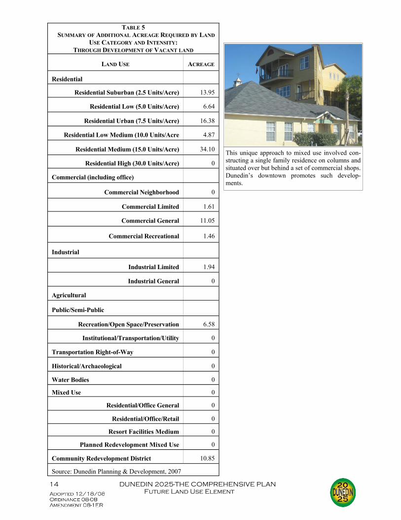
consistent with the downtown redevelopment plan. ΦWater/Drainage Feature (WDF). ΦScenic/Non-Commercial Corridor (SNCC). For a more complete overview of these categories, please refer to Table 13 in the Appendix. Since comprehensive plans look to the future, it is important to provide projections of antici-pated growth. Population projections were provided earlier, and this portion of the analysis will examine anticipated growth, or non-growth, as the case may be, in land use. The analysis, the re-sults of which appear in Table 4, is based on the Pinellas County Metropolitan Planning Organiza-tion’s population projections. Vacant parcels were analyzed and presumed to be built to their over-lying land use plan category. The annexation of all enclaves was also examined, and a separate ta-ble constructed showing how the City would grow through these annexations. The future residential land use increase was projected by assuming that all existing residen-tial land will remain, that all remaining vacant land in the City having residential regulatory land use and zoning will be developed into residential uses, and that the residential component of Residen-tial/Office General, Commercial Limited and Commercial General will be negligible. In other words, the highest and best use on office or commercial property will be office or commercial de-velopment. As is shown in Table 5, the amount of additional residentially developed land needed by 2025 totals 76 acres. The amount of land anticipated to be annexed by 2025 and used for residential
purposes totals 162.21 acres. For more in-formation, please refer to the discussion be-low on affordable housing as well as to the Housing Element itself. The increase in future commercial land use was projected by assuming that all existing commercial land will remain, and that all remaining vacant land in the City having commercial regulatory land use and zoning will be developed into commercial uses. This results in an additional 14.12 acres by 2025. The amount of commercial land anticipated to be annexed by 2025 to-
Newly constructed Dunedin Elementary is one of three ele-mentary schools in the City. A middle school, high school and two charter schools also create great educational opportu-nities.
14 DUNEDIN 2025-THE COMPREHENSIVE PLAN Future Land Use Element
TABLE 5 SUMMARY OF ADDITIONAL ACREAGE REQUIRED BY LAND
USE CATEGORY AND INTENSITY: THROUGH DEVELOPMENT OF VACANT LAND
LAND USE ACREAGE
Residential
Residential Suburban (2.5 Units/Acre) 13.95
Residential Low (5.0 Units/Acre) 6.64
Residential Urban (7.5 Units/Acre) 16.38
Residential Low Medium (10.0 Units/Acre 4.87
Residential Medium (15.0 Units/Acre) 34.10
Residential High (30.0 Units/Acre) 0
Commercial (including office)
Commercial Neighborhood 0
Commercial Limited 1.61
Commercial General 11.05
Industrial
Industrial Limited 1.94
Industrial General 0
Agricultural
Public/Semi-Public
Recreation/Open Space/Preservation 6.58
Institutional/Transportation/Utility 0
Transportation Right-of-Way 0
Historical/Archaeological 0
Water Bodies 0
Mixed Use 0
Residential/Office General 0
Residential/Office/Retail 0
Community Redevelopment District 10.85
Source: Dunedin Planning & Development, 2007
Commercial Recreational 1.46
Planned Redevelopment Mixed Use 0
Resort Facilities Medium 0
This unique approach to mixed use involved con-structing a single family residence on columns and situated over but behind a set of commercial shops. Dunedin’s downtown promotes such develop-ments.

15 DUNEDIN 2025-THE COMPREHENSIVE PLAN Future Land Use Element
tals 3.78 acres. Projecting future industrial land involved assuming that existing industrial sites will con-tinue to exist and that no new land will become available or is suitable for industrial land use given the nearly built-out nature of the City. In addition to the minimal 1.94 acres of vacant land with an industrial land use, no additional industrial land is expected to be annexed from the enclaves by 2025. No change in water bodies was derived by assuming no loss of major water bodies and that minor water bodies will be built for retention purposes. This means that while no new water bodies would be constructed, the City would still annex 11 acres by the year 2025. Since the City has no agricultural land use, projections were easy. Since it is doubtful that higher uses will be changed to agricultural, and that there will be a great need for agricultural uses in basically an urbanized setting, there will be no additional such acreage needed by 2025. In the Public/Semi-Public Land Use classification, no change was forecast for future Institu-tional/Transportation/Utility by assuming that existing land used for public and semi-public land use can accommodate building and facility expansions for those land uses. Additionally, it was pre-sumed that the existing schools have the capacity to be expanded on existing sites if necessary. Ad-ditional land needed by 2025 thus totals zero acres; additional land anticipated to be annexed by 2025 is projected at 12.38 acres A very minor increase in recreation, open space and preservation land use was projected by first assuming no loss of existing parks and recreation land. One planned—but not yet developed—future park (Countryside Heights) will add one acre to the Recreation/Open Space total. Addition-ally, in June of 2007, the City purchased a total of 5.32 undeveloped low lying acres to be added to Hammock Park. A portion of that acreage already had an existing land use of preservation, but 4.21 acres was considered vacant. Factoring this in results in an additional 6.58 acres of R/OS through the “development” of vacant parcels. An additional 39.79 acres of preservation lands will be ac-quired through the annexation of enclaves. Projecting future transportation land use involved comparing the estimated existing road-way right-of-way with the required right-of-way to implement the necessary roadway improvement by the year 2025 (based on the Pinellas County MPO Long Range Transportation Plan (LRTP)). There is essentially only one project left to complete the implementation of the LRTP: the multi-laning of Curlew Road from west of CR 1 to Alternate US 19. Since most of this ROW appears to be approximately 100 feet in width, no additional acreage is being estimated here. Future historic and archaeological sites were forecast by first assuming no loss of existing historic property, and that the existing inventory of historic sites and property will remain complete. This resulted in no additional acreage in this category. No annexations of historic/archaeological sites are anticipated as there appear to be none in the enclaves. The future of mixed land uses was derived by assuming no loss of office uses in the Com-mercial category, and assuming that most new office will occur as part of the Commercial category projections. There were no vacant parcels with a Residential/Office General land use, and there were no R/OG parcels located in the enclaves. This resulted in the estimated need for no additional mixed use acreage by 2025. No future changes to the Community Redevelopment District (CRD) land use is anticipated because there is no anticipated expansion of the redevelopment district boundaries. The current regulations make it very difficult to expand or add to a CRD. Realizing that it is very difficult to project redevelopment activities, the entire CRD focuses on redevelopment activities, which, by definition, means replacing existing activities with new activities. Vacant land in the CRA District

16 DUNEDIN 2025-THE COMPREHENSIVE PLAN Future Land Use Element
TABLE 6 SUMMARY OF ADDITIONAL ACREAGE REQUIRED BY LAND USE CATEGORY AND INTENSITY:THROUGH ANNEXATION OF
DEVELOPED AND VACANT PARCELS
LAND USE ACREAGE
Residential
Residential Suburban (2.5 Units/Acre) 162.21
Residential Low (5.0 Units/Acre) 68.66
Residential Urban (7.5 Units/Acre) 26.38
Residential Low Medium (10.0 Units/Acre 3.82
Residential Medium (15.0 Units/Acre) 3.10
Residential High (30.0 Units/Acre) 0
Commercial (including office)
Commercial Neighborhood .33
Commercial Limited 0
Commercial General 3.45
Industrial 0
Industrial Limited 0
Industrial General 0
Agricultural 0
Public/Semi-Public
Recreation/Open Space/Preservation 39.79
Institutional/Transportation/Utility 12.38
Transportation Right-of-Way 37.57
Historical/Archaeological 0
Water Bodies 10.99
Mixed Use 0
Residential/Office General 0
Residential/Office/Retail 0
Community Redevelopment District 0
Source: Dunedin Planning & Development, 2007
Commercial Recreational 0
Planned Redevelopment Mixed Use 0
Resort Facilities Medium 0
The Pinellas Trail, shown here in the northern portion of the City not only provides great recrea-tional opportunities, but also ties Dunedin to Palm Harbor and Tarpon Springs to the north and to Clearwater, Largo, Seminole and St. Petersburg to the south.
17 DUNEDIN 2025-THE COMPREHENSIVE PLAN Future Land Use Element
totals less than 11 acres. Downtown Core Zoning, of which much of the CRD is composed, allows both commercial and residential uses. Because the annexation of enclaves is a significant issue, Table 6 inventories the land uses that would result in the annexations of these unincorporated parcels. As can be seen, most of the enclaves are residential in nature, with a minimum of commercial. This would add approximately 370 acres to the City. The above projections, however, cannot take into account the possibility of land use plan amendments. As development pressures change, vacant land or underutilized land may be more valuable with a different land use designation. City staff cannot forecast these land use plan amend-ments, but the Evaluation and Appraisal Report showed that the number of land use amendments occurring during the 1997 to 2005 period were relatively small both in terms of parcel size and shifts in categories. According to the EAR, ΦThe size of the amendments ran from .21 acres to 50.90 acres, with an average
parcel size of 4.94 acres. ΦThe amendments broke down as follows: Commercial to Residential: 7 Residential to Commercial: 4 Residential to Mixed Use: 1 Residential to Residential: 8 Non-Residential to Residential: 1 Non-Residential to Commercial: 1 Non-Residential to Non-Residential: 4 ΦTen amendments were intensity increases, three had no intensity changes and 13
were reductions in intensity. Just as in the past, future amendments will be evaluated based on appropriateness, concurrency is-sues, and matters of compatibility Rule Chapter 9J-5, FAC, states that the Florida Department of Community Affairs (DCA) “recognizes private property rights created by law and guaranteed by the State and Federal Consti-tutions and the existence of legitimate and often competing public and private interests in land use regulations and other government action. Local governments may include appropriate provisions in their plans for the recognition of statutory and common law vested rights.” Dunedin’s City Attor-ney advises that this is a difficult issue and one that the comprehensive plan should probably avoid. The UDC, though, does provide for vested rights in the Concurrency Management System Chapter 163, Florida Statutes (FS), states that “A local government may include in its com-prehensive plan a provision allowing the use of a parcel of property solely as a homestead by an individual who is the grandparent, parent, stepparent, adopted parent, sibling, child, stepchild, adopted child or grandchild of the person who conveyed the parcel to said individual, notwithstand-ing the density or intensity of use assigned to the parcel in the plan. Such a provision shall apply only once to any individual.” Dunedin’s City Attorney advises that there would be no benefit to the City to establish policies with regard to family homestead. As this concept is understood, if a per-son had a house in an industrial zone creating a non-conforming use, the family homestead would allow the owner to pass it along once to a relative. The UDC does not provide for any amortization of non-conformities; rather, grandfathered non-conformities are eliminated when a substantial im-provement (the cost of improving or restoring the structure would equal or exceed 50 percent of the

18 DUNEDIN 2025-THE COMPREHENSIVE PLAN Future Land Use Element
market value of the structure before the improvement or damage occurred) occurs. The subject of affordable housing has become more and more of an issue, as has been pre-sented in the Housing Element. The Shimberg Center for Affordable Housing in 2006 suggested that nearly 30% of households within the City paid 30% or more for their housing. The EAR de-fined affordable housing as an issue and developed the following data points: ΦThe decreasing vacant land supply means higher land costs. ΦConstruction costs are rising, with “some components…over 40% higher than
a year ago.” Φ“Changes in Public Housing [and] reduction in State [and] Federal funding”
have resulted in a loss of traditional “safety nets.” ΦThere has also been a loss of lower-end rental market housing such as mobile
home units, duplexes and small apartment complexes. ΦThere is a high number of cost-burdened in households in Pinellas County,
with “10,000 renters and 17,000 owners paying over 50% for housing.” Φ68,000 new jobs are expected to be created countywide over the next five
years, with “72% currently projected in service [and] retail sectors.” ΦThere has been a tremendous “disparity between housing costs [and] income
growth”: between 1993 and 2003 housing prices have gone up 73% while in-comes have climbed only 11%.
This issue is discussed in much more detail in the Housing Element. In order to promote
affordable housing, the City will ensure the following:: ΦContinued participation in the Community Development Block Grant Program.
ΦContinued support of Pinellas County Housing Authority and Dunedin Housing Authority.
ΦContinued allowance of mobile home parks, manufactured housing and manufac-tured (or modular) buildings.
ΦContinued support of programs such as Habitat for Humanity. ΦContinued research into reducing review time for proposed development. ΦParticipation in Pinellas County’s housing trust fund and community land trust.
Both of these activities directly target the delivery of affordable housing. ΦShould Pinellas County adopt a countywide inclusionary housing ordinance, the
City should participate in it. With regard to historic preservation, the City currently has 58 listed historical or archaeo-logical sites or buildings. Many are merely sites, and have been replaced with newer structures. The vast majority of the sites are privately-owned, meaning that while historic structures or sites may be identified, owners are free to modify them as they see fit. Dunedin does not have the funds to acquire these structures and preserve them in the public trust. Restoration and preservation ef-forts on these privately-owned structures must be on a voluntary basis. The City provided impetus and assistance for this work by preparing and adopting a Historic Preservation Ordinance in 2003. The HPO establishes criteria for granting a historical structure designation, along with a historic preservation overlay district. The ordinance also establishes parameters for restoration work, and requires that any modifications to the building receive a Certificate of Appropriateness from the
19 DUNEDIN 2025-THE COMPREHENSIVE PLAN Future Land Use Element
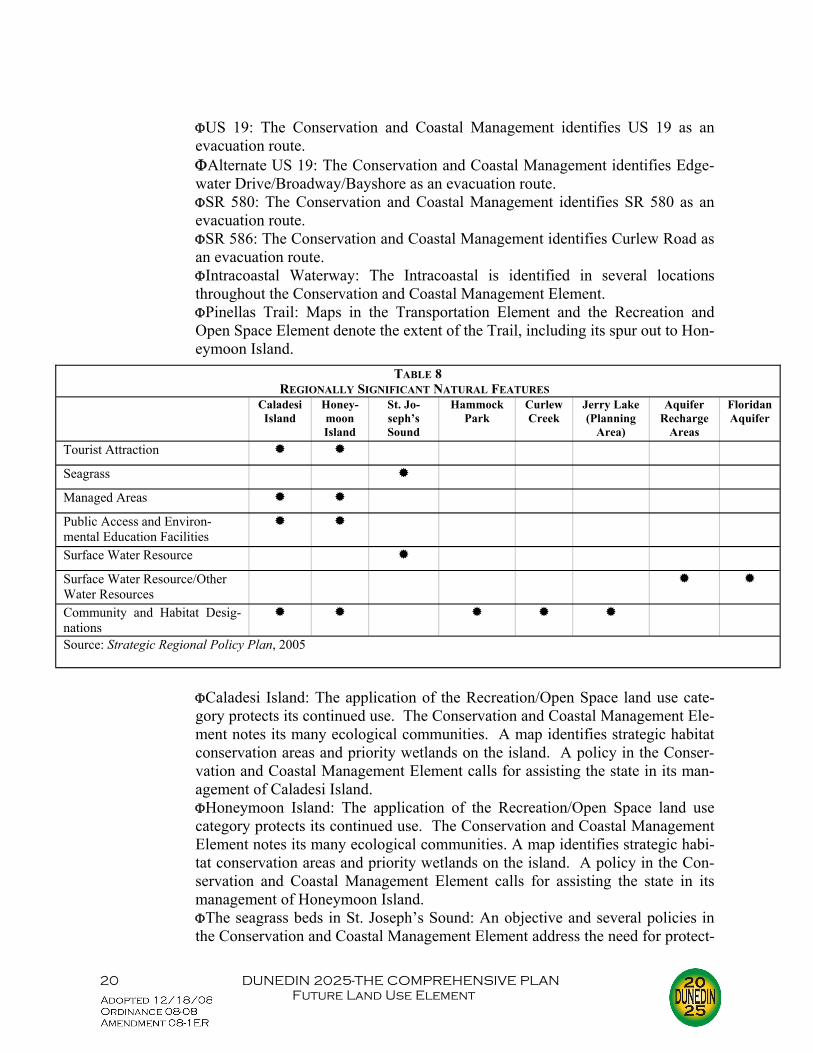
City Manager before the work takes place. The HPO, similar to Pinellas County’s Historic Preser-vation Ordinance, allows for ad valorem tax exemptions for the improvements made to the histori-cally designated structure. As detailed in the Intergovernmental Coordination Element the City works closely with nu-merous agencies and local governments ranging from the City of Clearwater to the Pinellas County Planning Department to the Southwest Florida Water Management District. Dunedin currently has numerous interlocal agreements with such agencies. While there are no specific joint planning agreements in this list, the numerous levels of cooperation (municipal, county, regional) ensure that larger issues (e.g., transportation, water demand) are addressed. The Tampa Bay Regional Planning Council’s Future of the Region: A Strategic Regional Policy Plan (SRPP) “replaces” the Comprehensive Regional Policy Plan (CRPP). The SRPP de-notes those facilities that are regionally significant or locally significant. A regionally significant natural resource, for example, “is a natural resource or system of interrelated natural resources, that due to its function, size, rarity or endangerment retains or provides benefit of regional significance to the human or natural environment regardless of ownership.” Locally significant facilities are important but have a smaller range of impacts. Many facilities are significant in more than one category, and Tables 7 and 8 denote these. There are several other facilities — and events — that TBRPC considers as significant: ΦKnology Park: A sports facility of regional significance. ΦThe City’s Potable Water System: the municipal water supply system is identi-
fied as a regionally significant natural resource. ΦDunedin Fine Arts Center: A museum of local significance. ΦDunedin Historical Society: A museum of local significance. ΦHighland Games and Scottish Festival: A festival of local significance. Dunedin 2015-The Comprehensive Plan recognized the importance of the following identified regionally or locally significant items:
TABLE 7 REGIONALLY SIGNIFICANT TRANSPORTATION
US 19 Alternate US 19
SR 580 SR 586 Intracoastal Waterway
Pinellas Trail
Regional Roadways Hurricane Evacuation Routes Major Transit Corridors Multi-Use Trails 1 Strategic Intermodal System Corridor
Barrier Island Access Causeway/ Bridges
2
Public Access and Environ-mental Education Facilities
Deep Water Port Facility/ Wa-terway
1Denoted as Planned; Curlew Road bike lanes completed in early 2006. 2Dunedin Causeway only Source: Strategic Regional Policy Plan, 2005
20 DUNEDIN 2025-THE COMPREHENSIVE PLAN Future Land Use Element
ΦUS 19: The Conservation and Coastal Management identifies US 19 as an
evacuation route. ΦAlternate US 19: The Conservation and Coastal Management identifies Edge-
water Drive/Broadway/Bayshore as an evacuation route. ΦSR 580: The Conservation and Coastal Management identifies SR 580 as an
evacuation route. ΦSR 586: The Conservation and Coastal Management identifies Curlew Road as
an evacuation route. ΦIntracoastal Waterway: The Intracoastal is identified in several locations
throughout the Conservation and Coastal Management Element. ΦPinellas Trail: Maps in the Transportation Element and the Recreation and
Open Space Element denote the extent of the Trail, including its spur out to Hon-eymoon Island.
ΦCaladesi Island: The application of the Recreation/Open Space land use cate-gory protects its continued use. The Conservation and Coastal Management Ele-ment notes its many ecological communities. A map identifies strategic habitat conservation areas and priority wetlands on the island. A policy in the Conser-vation and Coastal Management Element calls for assisting the state in its man-agement of Caladesi Island.
ΦHoneymoon Island: The application of the Recreation/Open Space land use category protects its continued use. The Conservation and Coastal Management Element notes its many ecological communities. A map identifies strategic habi-tat conservation areas and priority wetlands on the island. A policy in the Con-servation and Coastal Management Element calls for assisting the state in its management of Honeymoon Island.
ΦThe seagrass beds in St. Joseph’s Sound: An objective and several policies in the Conservation and Coastal Management Element address the need for protect-
TABLE 8 REGIONALLY SIGNIFICANT NATURAL FEATURES
Caladesi Island
Honey-moon Island
St. Jo-seph’s Sound
Hammock Park
Curlew Creek
Jerry Lake (Planning
Area)
Aquifer Recharge
Areas
Floridan Aquifer
Tourist Attraction
Seagrass
Managed Areas
Public Access and Environ-mental Education Facilities
Surface Water Resource
Surface Water Resource/Other Water Resources
Community and Habitat Desig-nations
Source: Strategic Regional Policy Plan, 2005

21 DUNEDIN 2025-THE COMPREHENSIVE PLAN Future Land Use Element
ing and improving the seagrass beds in the Sound. Also, various locations within the Sound are identified as significant wetlands.
ΦHammock Park: The Major Findings Section of the adopted Goals, Objectives and Policies document states, “Dunedin is the home of Hammock Park, an 80-acre wetland hardwood hammock, which has been designated a state natural feature.” The Conservation and Coastal Management Element also notes the wetland hard-wood hammock nature of its ecological community. A map identifies strategic habitat conservation areas and priority wetlands in and around the park. A Rec-reation/Open Space land use protects its function.
ΦCurlew Creek: For almost its entire length within the incorporated city, Curlew Creek is shown as a significant wetland. A map identifies strategic habitat con-servation areas and priority wetlands at points along its length.
ΦJerry Lake: Although Jerry Lake is not within the corporate limits of the city, a policy in the Recreation and Open Space Element states, “Support the Southwest Florida Water Management District’s (SWFWMD) position to maintain the Jerry Lake tract for stormwater management preservation purposes.”
ΦAquifer Recharge and the Floridan Aquifer: The Natural Groundwater Aquifer Recharge Sub-element addresses many aspects of the aquifer, including its pro-tection and preservation.
ΦKnology Park: The Recreation and Open Space Element identifies this facility as a quasi-public park. An adopted policy in the Recreation and Open Space Element states, “The City would like to continue to have a major league base-ball team conduct their spring training in Dunedin; however, it should be cost effective.”
ΦThe City’s Potable Water System: The entire Potable Water Sub-element iden-tifies the importance of this resource.
ΦDunedin Fine Arts Center: This center’s importance seems to be defined only as it relates to Highlander Park.
ΦDunedin Historical Society: Although the museum is mentioned in the Conser-vation and Coastal Management Element, its importance is not singled out.
ΦHighland Games and Scottish Festival: While not specifically mentioning these two games, policies in the Recreation and Open Space Element promote City- and joint-sponsored recreational programs.
The Dunedin 2025 version has added language in the Conservation and Coastal Management Element noting the significance of the Dunedin Fine Arts Center and the Dunedin Historical Museum in order to be fully compliant with the SRPP. Chapter 163 and 1013, FS, were modified to provide for the siting of public educational fa-cilities and the collocation of public facilities with schools. Dunedin 2015 was modified in 1996 to allow for the siting of schools within all residential land uses (including Residential/Office Gen-eral) and the Institutional land use. This essentially mirrors development of schools in Dunedin prior to school siting requirements. The general criteria for reviewing proposed school locations includes compatibility tests, environmental constraints, impacts on historic sites, City services sup-porting the school, location with respect to 100-year floodway or CHHA, parking and vehicle queu-ing requirements and public shelter requirements. Since the City’s Zoning Code allows public and semi-public uses as a permitted use or use by special exception, land use categories allowing

22 DUNEDIN 2025-THE COMPREHENSIVE PLAN Future Land Use Element
schools should reflect this. They include Commercial Limited, Commercial General, Commercial Recreation, Transportation/Utility, and Community Redevelopment District. Criteria were estab-lished for the location of different types of schools, and call for adequate access and buffering of effects if necessary. In early 2008, the City and the School Board entered into an interlocal agreement re-garding school siting. Disagreement over wording within the goals, objectives and policies within Dunedin 2015 lead to this issue languishing for over a decade. However, a City Attor-ney opinion that special exceptions for schools could not be denied as long as the proposed lo-cation was consistent with the comprehensive plan mitigated the situation. The interlocal agreement provides for the City to hold the public hearing for any proposed new schools. Also in early 2008, pursuant to changes in growth management regulations, the City adopted a Public School Facilities Element (PSFE). Among other things, the goals, objectives and policies established a level of service standard and referenced a uniform approach to con-currency management with regard to schools that was adopted in 2007 as part of an interlocal agreement between the City, Pinellas County, other local municipalities and the Pinellas County School Board. Since the City is limited in the amount of vacant land remaining, and the vast majority of the City’s public facilities are currently in place, it is questionable whether any additional public schools will be located within the City given current number and availability of adequate parcels. This creates problems with regard to siting certain facilities (open space, community centers, librar-ies) contiguous or near schools. This is referred to as collocation. While the City does have poli-cies referencing collocation, the overarching criteria is the surrounding land uses and the avail-ability of adequate land near the school. The establishment of the city in its entirety as an existing urban service area has been of sig-nificant value. Based on the definition of the existing urban service area found in Chapter 163, FS, the land within the corporate limits of the City of Dunedin was designated as such an existing urban service area by policy. The effects of transportation concurrency have been reduced by allowing “proposed urban redevelopment...not to be subject to concurrency requirements...for up to 110 per-cent of the transportation impact generated by the previously existing development.” Another area designation that the City makes use of is the Urban Redevelopment Overlay area. This area met the criteria and was established in 1998. Policies were added to the Future Land Use Element to provide for the delineation and analysis of the urban redevelopment area, and the Regulatory Land Use Plan Map was amended to show the area geographically. Located along Alternate US 19 between Wilson Street and Lee Street, the area has seen a good deal of residential construction in the last few years. An urban sprawl analysis is required of each local government and is described in Rule Chapter 9J-5.006(5), FAC. Each indicator identified in the FAC has been evaluated to determine the presence of urban sprawl. The results are presented below: ΦIndicator: City promotes, allows or designates for development substantial areas
of the jurisdiction to develop as low-intensity, low-density, or single-use develop-ment or uses in excess of demonstrated need.
Analysis: Dunedin is primarily a residential community, with approximately 334 acres designated as 2.5 UPA or less (this is approximately 11% of the total of all residential land uses). Further, about 561 acres are designated as 5.0 UPA or less (approximately 18% of the total of all residential land uses).
23 DUNEDIN 2025-THE COMPREHENSIVE PLAN Future Land Use Element
Eighteen percent is not excessive, and provides important residential areas. The other major land use is Recreation/Open Space, with approximately 1,648 acres in the Recreation/Open Space (R/OS) land use category. This serves important parkland purposes.
ΦIndicator: City promotes, allows or designates significant amounts of urban devel-opment to occur in rural areas at substantial distances from existing urban areas while leaping over undeveloped lands which are available and suitable for develop-ment.
Analysis: Dunedin is very compact, being approximately ten square miles in size, and is nearly built-out. There are unincorporated enclaves which are developed at 2.5 UPA, but the City has no control over these enclaves. Not only is infill development encouraged, it is occurring. Redevelopment is taking place both in the downtown area and in other isolated areas. Finally, there are no rural areas in Dunedin.
ΦIndicator: The City promotes, allows or designates urban development in radial, strip, isolated or ribbon patterns generally emanating from existing urban develop-ments.
Analysis: Again, Dunedin is very compact, and the only ribbon pattern de-velopment is commercial along arterials. There is no “true ribbon pattern” as surrounding areas are also developed, mostly as residential. Thus, the commercial along arterials serves the existing urban developments.
ΦIndicator: The City, as a result of premature or poorly planned conversion of rural land to other uses, fails adequately to protect and conserve natural resources such as wetlands, floodplains, native vegetation, environmentally sensitive areas, natural aquifer recharge areas, lakes, rivers, shorelines, beaches, bays, estuarine systems and other significant natural systems.
Analysis: The figures in the Conservation and Coastal Management Ele-ment show wetlands, floodplains, surface waters, and shorelines. Much de-velopment in Dunedin preceded regulations, especially those regarding floodplains and recharge areas. Native vegetation, though, is preserved in areas such as Hammock Park and on Honeymoon and Caladesi Islands. As shown in the Conservation and Coastal Management Element, impacts to wetlands have been minimized. Further the Reclaimed Water System is utilized in areas of reasonable aquifer recharge (e.g., Dunedin Golf Course).
Dunedin has both communitywide commercial (above) as well as more neighborhood-scale commercial (right).

24 DUNEDIN 2025-THE COMPREHENSIVE PLAN Future Land Use Element
The City enjoys two creeks and over 20 lakes. The shoreline, however, has suffered through fingerfill developments and seawalls, and runoff pollutants have damaged St. Joseph’s Sound. Some recharge areas (Dunedin Golf Course, Vanech Recreational Complex) have been preserved, but areas of higher elevation have been built on (mostly residential, though). A minor beach has been preserved along the Causeway. The floodplains were con-structed on prior to FEMA regulations. The City enforces FEMA require-ments on all new construction or significant reconstruction
ΦIndicator: The City fails adequately to protect adjacent agricultural areas and ac-tivities, including silviculture, and including active agricultural and silvicultural ac-tivities as well as passive agricultural activities and dormant, unique and prime farmlands and soils.
Analysis: The1989 comprehensive plan reported only 160 acres of agricul-tural land remaining. Dunedin 2010 also stated that all agricultural land would be converted to other incarnations due to “intense development pres-sures.” In an urban environment, agricultural uses are not as important as in rural areas. There exists some minor agricultural uses (horse farms, live-stock) in unincorporated enclaves, but pressures to develop them exist. “Failing to protect agricultural activities” maximizes urbanization within the compact confines of the City. Dunedin recognizes its urban status and, as such, promotes it. This is not an issue because extensive agricultural areas serve minimal purposes in the City. Extensive recreation/open space land, on the other hand, provides significant useful acreage.
ΦIndicator: The City fails to maximize use of existing public facilities and services. Analysis: The level of service discussions earlier show that facilities and
services are being utilized more than adequately. Water, wastewater and solid waste operating Levels of Service are all in acceptable ranges. The interim stormwater LOS standards are being met except for two chan-nels. Several roadways are overutilized; most, however, are operating at LOS C or better. The parkland to population ratio is fully realized with the inclusion of privately-owned open space.
ΦIndicator: The City fails to maximize the use of future public facilities and ser-vices.
Analysis: Water and Wastewater Treatment Facilities do not appear to be overbuilt based on existing population projections. Even if population pro-jections were revised to the upper-40,000s, the existing capacity would be needed. Solid waste vehicles and routes are modified to include new devel-opment as necessary. Future drainage LOS standards show a 25-year, 24-hour storm event, which is hardly excessive. Finally, if privately-owned mini-parks included, there are no future parkland deficiencies.
ΦIndicator: The City allows for land use patterns or timing which disproportionately increase the cost in time, money and energy, of providing and maintaining facilities and services, including roads, potable water, sanitary sewer, stormwater manage-ment, law enforcement, education, health care, fire and emergency response, and general government.
Analysis: Development fees for fire, police, water, sewer and parkland (in

25 DUNEDIN 2025-THE COMPREHENSIVE PLAN Future Land Use Element
effect since the early 1980s) have forced development to pay for its impacts on City services. Further, developments must construct their own utilities and then hook to City services. Water, sewer and roadways run throughout the City, allowing adequate connections. Post-development/pre-development stormwater runoff standards are strictly enforced. The City currently has six public educational facilities, and concurrency requirements now make the City obtain approval from the Pinellas County School Board for residential developments 25 and units and greater. There is one major hospital in the City over which the local government has no jurisdiction. Thus, Dunedin is able to provide adequate overall governmental levels of service to its citizens. Divisions or sections (not previously mentioned) in-clude Building/Permitting, Occupational Licenses, Community Redevelop-ment, Planning, Fire, Utility Billing, Engineering Services, Facilities, Ma-rina, Stadium and Library. While the older and substandard condition of some water and wastewater pipes has created problems, this is being ad-dressed through the application of capital improvements.
ΦIndicator: The City fails to provide a clear separation between rural and urban uses.
Analysis: Dunedin is clearly urban in nature, being primarily residential, but does allow less intense areas to function as recreation or open space. Fur-ther, all of Pinellas County is considered urbanized.
ΦIndicator: The City discourages or inhibits infill development or the redevelop-ment of existing neighborhoods and communities.
Analysis: With vacant parcels scattered throughout the City and proximate to existing development, infill development is nearly all that is left. The downtown area is actively courting redevelopment through the works of the CRA. Other redevelopment elsewhere (along SR 580, Causeway) has oc-curred.
ΦIndicator: The City fails to encourage an attractive and functional mix of uses. Analysis: Again, Dunedin consists primarily of residential and recreation/
open space land uses. Commercial is appropriately located primarily along arterials and major collectors and serves the surrounding residential uses. Minor industrial uses provide manufacturing and research. In this way, Dunedin’s land use mix is both attractive and efficient.
ΦIndicator: The City’s efforts result in poor accessibility among linked or related land uses.
Analysis: Commercial along arterials serves surrounding residential uses. Local roads and collectors funnel residential traffic to arterials. The com-pact nature of the City contributes to linkages, and the primary industrial areas exist near major roadway facilities. Finally, the CRA promotes mixed use developments.
ΦIndicator: The City’s efforts result in the loss of significant amounts of functional open space
Analysis: With the inclusion of privately-owned open space, Dunedin meets its LOS standards. The Land Dedication Ordinance requires open space for larger residential developments. While there have been five land use plan

26 DUNEDIN 2025-THE COMPREHENSIVE PLAN Future Land Use Element
amendments since 1999 that have reduced the R/OS acreage, they totaled only 55.97 acres. This represents 3% of the remaining R/OS land. It should also be mentioned that the vast majority of the altered acreage was taken to an Institu-tional designation to better represent Pinel-las County School Board-owned property.
The foregoing assessment indicates only two areas of possible concern. First, al-though the degradation of some natural re-sources has occurred, the City continues to protect what exists through the Concurrency Management System, stormwater controls, and site plan review. Second, the upgrading of the existing infrastructure has presented a chal-lenge. Dunedin utilizes capital improvement funds to replace substandard water and wastewater lines. The City has upgraded its Water and Wastewater Treatment Plants, and tremendously ex-panded the Reclaimed Water System. Overall, then, there appears no overwhelming evidence of urban sprawl within Dunedin. Table 9 provides a land use evaluation for all of Dunedin’s land use categories. An assess-ment suggests first of all that residential land uses comprise approximately one-half of all uses (when rights-of-way are excluded). Second, overall, good compatibility and suitability has been achieved, although there are some areas of concern (e.g., industrial near residential, residential driveways on arterials), and development of the floodplain is not ideal. It cannot be emphasized enough, though, that much construction occurred before regulations were in existence and that the City enforces FEMA requirements currently. Third, there are good provisions for commercial and recreation and open space as support for residential establishments. Summarizing the local conditions suggests the following data points: ΦDunedin’s approximately ten square miles has very limited available vacant devel-
opable land scattered throughout City in small parcels. ΦThe City’s projected growth rate is based on the MPO’s most recent projections,
showing a functional population of 44,804 by 2025. ΦThe projected growth amounts displayed in Tables 5 and 6 above show the addi-
tional acreage required based on the preceding projections for Dunedin 2025. ΦBased on the above update of each comprehensive plan element, needed facilities
(e.g., water, sewer, roads, parks) are available, although some deficiencies exist. ΦThe existing pattern of development is primarily residential. In general, lower
densities are on or near the periphery of the city, and there exist very limited high density locations. The City consists mostly of moderate density residential. Com-mercial is confined primarily to arterials and some collectors; this serves the sur-rounding residential areas. Extensive recreation/open space is spread throughout the City, and the barrier islands are protected through state ownership and the Recrea-
Effective buffering allows the City’s Water Treatment Plant (to the left) to exist side-by-side with a single family devel-opment.
27 DUNEDIN 2025-THE COMPREHENSIVE PLAN Future Land Use Element
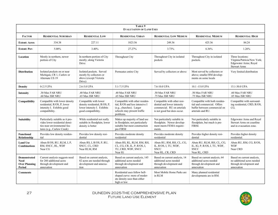
FACTOR RESIDENTIAL SUBURBAN RESIDENTIAL LOW RESIDENTIAL URBAN RESIDENTIAL LOW MEDIUM RESIDENTIAL MEDIUM RESIDENTIAL HIGH
Extent: Acres 334.38 227.11 1823.56 249.36 425.36 84.24
Extent: Per- 5.00% 3.40% 27.27% 3.73% 6.36% 1.26%
Location Mostly in northern, newer portion of City
In northern portion of City mostly; along Victoria Drive
Throughout City Throughout City in isolated pockets
Throughout City in isolated pockets.
Three locations: Virginia/Patricia/New York; Edgewater Arms; Royal Stewart Arms
Distribution Isolated pockets on or near Michigan, CR 1, Curlew or Alternate US 19
Isolated pockets. Served mostly by collectors or above (except Victoria Drive)
Permeates entire City Served by collectors or above Most served by collectors or above; smaller RM develop-ments on some locals
Very limited distribution
Density 0-2.5 UPA 2.6-5.0 UPA 5.1-7.5 UPA 7.6-10.0 UPA 10.1 -15.0 UPA 15.1-30.0 UPA
Intensity .30 Max FAR NRU .60 Max ISR NRU
.40 Max FAR NRU
.65 Max ISR NRU .40 Max FAR NRU .65 Max ISR NRU
.50 Max FAR NRU
.75 Max ISR NRU .50 Max FAR NRU .75 Max ISR NRU
.60 Max FAR NRU
.85 Max ISR NRU Compatibility Compatible with lower density
residential, R/OS, P, lower intensity I. Exhibits good compatibility.
Compatible with lower density residential, R/OS, P, lower intensity I. Exhibits good compatibility.
Compatible with other residen-tial, R/OS and less intensive I (e.g., churches). Larger schools may present traffic problems.
Compatible with other resi-dential and lower intensity commercial. RU on arterials is not good but does occur.
Compatible with both residen-tial and commercial. Offers buffer between commercial on arterials and RU.
Compatible with surround-ing residential, CRD, R/OS, CG.
Suitability Particularly suitable as it pro-vides lower residential densi-ties near environmental fea-tures (e.g., Curlew Creek)
While residential not really suitable in floodplain, lower density is better
Makes up majority of land use in floodplain; not particularly suitable but most construction pre-FIRM
Not particularly suitable in floodplain. Newer develop-ment meets FEMA require-ments.
Not particularly suitable in floodplain, but much is pre-FIRM.
Edgewater Arms and Royal Stewart Arms on coastline and in evacuation zone.
Functional Relationship
Provides low density residen-tial
Provides low density resi-dential
Provides moderate density residential
Provides moderate density residential
Provides higher density resi-dential
Provides higher density residential.
Land Use Combinations
Abuts R/OS, RU, RLM, I, P, RM, SNCC, RL, WDF Near CG
Abuts RS, I, R/OS, P, RU, SNCC, CL, CRD Near RLM, RM
Abuts RS, RL, RLM, RM, RH, CL, CG, CR, IL, P, R/OS, I, TU, CRD, WDF, SNCC Near IG
Abuts RU, RM, RH, CL, CG, IL, R/OS, I, TU, WDF, SNCC Near RL, CR, CRD
Abuts RU, RLM, RH, CL, CG, IL, IG, P, R/OS, I, TU, WDF, SNCC Near RL, CRD
Abuts RU, RM, CG, R/OS, WDF Near CRD
Demonstrated Need Over Planning Period
Current analysis suggests need for 260 additional acres through development and annexation
Based on current analysis, 82 acres are needed through development and annexa-tion
Based on current analysis, 145 additional acres needed through development and annexation
Based on current analysis, 14 additional acres needed through development and annexation
Based on current analysis, 64 additional acres needed through development and annexation
Based on current analysis, no additional acres needed through development and annexation
Comments Residential uses follow bell-shaped curve: more of moder-ate density uses than either high or low
Most Mobile Home Parks are in RLM
Many planned residential developments are in RM.
TABLE 9 EVALUTAITON OF LAND USES

28 DUNEDIN 2025-THE COMPREHENSIVE PLAN Future Land Use Element
FACTOR RESIDENTIAL/OFFICE GENERAL RESIDENTIAL/OFFICE/ RESI-DENTIAL
RESORT FACILITIES MEDIUM
PLANNED REDEVELOPMENT MIXED USE
Extent: Acres 4.46 0 0 0
Extent: Percent .07% 0% 0% 0%
Location Belcher South of Main None None None
Distribution One location None None None
Density 15.0 UPA Max 15.0 UPA Max 18 UPA Resdential 30 UPA Transient Accommodations
By special area plan
Intensity .50 FAR .75 ISR
.50 FAR
.75 ISR .65 FAR .78 ISR
By special area plan
Compatibility Compatible with surrounding residential in unincorporated County
Compatible with both com-mercial and residential
More compatible with commercial but could act as buffer between com-mercial and residential
More compatible with higher density residential and com-mercial
Suitability Suitable given nature of site and limitation of SNCC
Suitable for more intense mixed uses
Suited for both hotels and motels Suited for more intense mixed uses
Functional Relationship
Provide locations for office uses and residential uses not to exceed 15.0 UPA
To promote mixed uses; facilitate Planning Area annexation
To promote mixed uses To promote mixed uses
Land Use Combinations
Abuts SNCC Near CG
None None None
Demonstrated Need Over Planning Period
Additional two acres projected for R/OG; most office included in CL and CG projections (since most office uses are in CL or CG cur-rently)
None Expected limited use in future Expected limited use in future
Comments Category added for future use Category added for future use Category added for future use
TABLE 9 (CONTINUED)
29 DUNEDIN 2025-THE COMPREHENSIVE PLAN Future Land Use Element
FACTOR COMMERCIAL NEIGHBORHOOD
COMMERCIAL LIMITED COMMERCIAL GENERAL COMMERCIAL RECREATION INDUSTRIAL LIMITED INDUSTRIAL GENERAL
Extent: Acres 0 34.84 235.12 8.14 32.39 30.71
Extent: Percent 0% .52% 3.52% .12% .48% .46%
Location None Scattered throughout City in isolated locations
Mostly located on SR 580, Alternate US 19, Curlew and Douglas
Four locations: Three on Alternate US 19; one on Causeway Boulevard
Two locations: Patricia/Scotsdale; San Christopher/ Highland
One location: San Chris-topher/Highland
Distribution None On collectors or above Limited primarily to col-lectors and above
On arterials only Very limited; on collec-tors or above
Very limited; on collec-tors or above
Density N/A N/A N/A N/A N/A N/A
Intensity .45 FAR .85 ISR
.45 FAR
.85 ISR .55 FAR .90 ISR
.55 FAR
.90 ISR .65 FAR .85 ISR
.75 FAR
.95 ISR
Compatibility Compatible with both residen-tial and commercial.
Compatible with both residential and commer-cial.
Compatible with higher density residential
More compatible with com-mercial than with residential. Higher density residential buffers CR from lower den-sity residential.
More compatible with commercial than with residential or R/OS. Buffering for noise and visual impacts required.
More compatible with CR, TU and CG than with residential
Suitability Suitable given that CL serves less intense demand than CG. Non-neighborhood intrusive makes it suitable.
Suitable location on col-lectors and above. Serves residential land uses
Two sites are private marinas; one site is vacant; one site is motel. Very suitable.
Good transportation access
Pre-FIRM structures in flood zones A and B not suitable. Good transpor-tation access.
Functional Relationship
Provide low intensity commercial and residential uses not to exceed 15.0 UPA
Provides moderate to high intensity commercial and residential uses not to exceed 15.0 UPA
Provides commercial associ-ated with recreational activi-ties (e.g., motel, marina)
Provide areas for low intensity manufactur-ing, assembly and research
Provide areas for intense manufacturing and com-mercial uses
Land Use Combinations
Abuts RU, RLM, RM, CG, CR, R/OS, WDF Near P, CRD
Abuts RU, RLM, RM, RH, CL, CR, IL, P, R/OS, I, TU, WDF, SNCC Near RS, R/OG, CRD
Abuts RU, CG, RM Near RLM, IG
Abuts RU, RM, CG, RLM, R/OS Near IG
Abuts TU, RM, WDF Near IL, RU, R/OS, CR, CG
Demonstrated Need Over Planning Period
Based on current analysis, five additional acres needed through development and annexation
Based on current analysis, five additional acres needed through develop-ment and annexation
Based on current analysis, 26 additional acres should be developed or annexed
Based on current analysis, two acres need to be devel-oped
Based on current analy-sis, no additional IL acres needed
Based on current analy-sis, no additional IG needed
Comments Category added for future use
TABLE 9 (CONTINUED)

30 DUNEDIN 2025-THE COMPREHENSIVE PLAN Future Land Use Element
FACTOR PRESERVATION RECREATION/OPEN SPACE INSTITUTIONAL TRANSPORTATION/UTILITY Extent: Acres 17.51 1647.83 236.97 26.21
Extent: Percent .26% 24.64% 3.54% .39%
Location Throughout City Throughout City, on barrier islands
Throughout City Five locations scattered throughout City
Distribution Primarily on drainage ROW or easements or environmentally sensi-tive lands
On open space, on ease-ments, on environmental sensitive lands, on recrea-tional facilities
Primarily on collectors or above, but some on locals
On collectors or above
Density N/A N/A 3 Beds/DU (at 12.5 UPA)
N/A
Intensity .10 FAR .10 ISR
.25 FAR
.60 ISR .65 FAR .85 ISR
.70 FAR
.90 ISR Compatibility More compatible with R/
OS and residential than with commercial but purpose is to protect affected land
More compatible with P and residential than with com-mercial but purpose is to retain open space and envi-ronmental sensitive areas
Compatible with residen-tial and commercial uses; no industrial/institutional conflicts
Reasonably compatible with residential if buffered
Suitability Very suitable given purpose
Superbly suitable for barrier islands
Very suitable for schools and churches
Very suitable for City and other utilities
Functional Relationship
Preserve natural features and resources
Provide land to be used for recreation or open space purposes; protect environ-mental features; protect aquifer recharge areas
Provide for uses such as schools, churches, civic organizations, cemeteries
Recognize transport or public and private utility services
Land Use Combinations
Abuts RU, R/OS, CG, RS, RL, RLM, RM, WDF Near CL
Abuts RS, RL, RU, RLM, RM, RH, CL CG, P, I, TU, WDF, SNCC, IL Near CRD, IG
Abuts RS, RL, RU, RLM, RM, RH, CG, WDF, SNCC Near CRD
Abuts RU, RLM, RM, CG, IG, R/OS, WDF, SNCC
Demonstrated Need Over Planning Period
P lumped in with R/OS in existing projections
Based on current analysis, 37 acres of needed through development and annexa-tion
Based on existing analy-sis, 17 acres needed through development and annexation
Based on current analysis, T/U lumped in with I
Comments
TABLE 9 (CONTINUED)
Dunedin is home to many religious institutions as well as this newly constructed fraternal organiza-tion lodge.
31 DUNEDIN 2025-THE COMPREHENSIVE PLAN Future Land Use Element
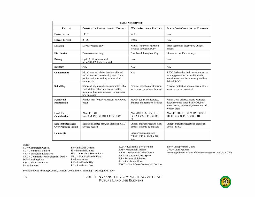
FACTOR COMMUNITY REDEVELOPMENT DISTRICT WATER/DRAINAGE FEATURE SCENIC/NON-COMMERCIAL CORRIDOR
Extent: Acres 143.51 69.18 N/A
Extent: Percent 2.15% 1.03% N/A
Location Downtown area only Natural features or retention facilities throughout City
Three segments: Edgewater, Curlew, Belcher
Distribution Downtown area only Distributed throughout City Limited to specific roadways
Density Up to 30 UPA residential; up to 50 UPA for hotel/motel
N/A N/A
Intensity N/A N/A N/A
Compatibility Mixed uses and higher densities allowed and encouraged to redevelop area. Com-patible with surrounding residential and commercial
N/A SNCC designation limits development on abutting properties: primarily nothing more intense than lower density residen-tial and R/OG
Suitability Slum and blight conditions warranted CRA District designation and concurrent tax increment financing revenues for rejuvena-tion purposes
Provides retention of stormwa-ter for any type of development
Provides protection of more scenic attrib-utes in urban environment
Functional Relationship
Provide area for redevelopment activities to occur
Provide for natural features, drainage and retention facilities
Preserve and enhance scenic characteris-tics; discourage other than R/OS, P or lower density residential; discourage off-premise signs
Land Use Combinations
Abuts RL, RH Near RM, CL, CG, RU, I, RLM, R/OS
Abuts RU, RLM, RM, RH, CG, P, R/OS, I, TU, IG, RS, CL
Abuts RS, RL, RU, RLM, RM, R/OS, I, TU, R/OG, CG, CRD, WDF, RH
Demonstrated Need Over Planning Period
Based on adopted plan, no additional CRD acreage needed
Current analysis suggests eight acres of water to be annexed
Current analysis suggests no additional acres of SNCC
Comments Category not completely “filled” with all eligible fea-tures
TABLE 9 (CONTINUED)
Source: Pinellas Planning Council, Dunedin Department of Planning & Development, 2007
Notes: CG = Commercial General CL = Commercial Limited CR = Commercial Recreation CRD = Community Redevelopment District DU = Dwelling Unit FAR = Floor Area Ratio I = Institutional
IG = Industrial General IL = Industrial Limited ISR = Impervious Surface Ratio NRU = Non-Residential Uses P = Preservation RH = Residential High RL = Residential Low
RLM = Residential Low Medium RM = Residential Medium R/OG = Residential/Office General R/OS = Recreation/Open Space RS = Residential Suburban RU = Residential Urban SNCC = Scenic/Non-Commercial Corridor
T/U = Transportation Utility UPA = Units Per Acre Percentages based on sum of land use categories only (no ROW)

32 DUNEDIN 2025-THE COMPREHENSIVE PLAN Future Land Use Element
tion/Open Space land use designation (there is only one development on the leeward side of Honeymoon Island).
ΦPrevious projected growth trends agree well with those made for this update. As was illustrated in the Introduction Element, the estimates for 2015 made for this up-date differ from the previously made estimates by only 12%.
ΦThe City is a full-service municipality, providing water, sewer, solid waste collec-tion, stormwater drainage, roads, and parks. An annual budget and capital improve-ment program are adopted each year. The annual budget is cost feasible, and the Capital Improvement Program (CIP) lays out specific direction for the subsequent five years and general direction for the following fifteen years. This and previous comprehensive plans provide direction for projects in the CIP based on existing and anticipated deficiencies. In order to implement these projects, the City utilizes many different revenue sources, including ad valorem taxes, gas and sales taxes, develop-ment fees, user fees, grants, and bonds. Problems have occurred with revenues not being sufficient to meet needs at times, resulting in lower priority items having had to be deferred on occasion.
ΦExtra-jurisdictional and regional growth characteristics suggest that Pinellas County is still the most densely populated county in Florida, with 24 municipalities and one county government. For transportation purposes, the most recent county-wide population projections were lower than previous projections, showing an over-all declining growth rate. The largest amount of undeveloped land is in the East Lake Tarpon area, well to the north and east of Dunedin.
ΦThe transportation analysis above suggests reasonably good compatibility between land use and roadways, although the non-grid/non-radial pattern can cause some continuity problems. Major roadways are well-utilized, with deficiencies existing on only a few roads (most notably US 19 Alternate US 19). And while residential uses are primarily on locals and collectors, there are arterial segments with residen-tial driveways.
ΦGeography, topography and various natural features are a mixed blessing. Dune-din is a coastal community with tremendous access to water activities, but it is pro-tected only by undeveloped barrier islands. The floodplain was developed prior to FEMA regulations, meaning that many structures are subject to flooding during se-vere storms. While the City preserves natural features through ownership, ease-ments, and land use designations, many lakes, creeks, and open water have been degraded through contaminated stormwater runoff.
ΦTable 10 shows the development controls currently available to the City. While the 15 different controls enjoy varying degrees of success, most appear to be rea-sonably effective.
ΦThe City allows for innovative and flexible planning and development strategies, including the following:
Clustering, in which developments with zero-lot-lines are allowed. Open space provisions, with the Land Dedication Ordinance requiring land
or fees for open space on residential developments of five units or greater. Mixed use development, particularly in the Community Redevelopment
District where redevelopment and mixed use are promoted as tools to reju-

33 DUNEDIN 2025-THE COMPREHENSIVE PLAN Future Land Use Element
CONTROL IN COMPREHENSIVE PLAN?
IN UDC ? ELSEWHERE? DISCUSSION EFFECTIVENESS
Open Space Re-quirements
No Yes N/A Land Dedication ordi-nance sets down park-land requirements for developments of five units or more
Has generated open space or funds for purchase of parkland
Development Clus-tering Require-ments
No No N/A
Other Develop-ment Strategies
Yes Yes N/A UDC allows zero-lot line developments; comprehensive plan defines illustrative uses including townhouses and garden apartments
Only one zero-lot line development cur-rently; one other zero-lot line site plan has been approved
Phasing of Devel-opment Require-ments
No Yes N/A UDC allows develop-ment to be built in phases
Several larger devel-opments have been built in phases (Royal Stewart Arms, Chesa-peake Apartments)
Land Use Loca-tional Criteria
Yes Yes N/A Comprehensive plan defines illustrative uses and proper locations; UDC specifies permit-ted uses
Compatibility is weighed greatly in land use plan amend-ments and on site plans
Infrastructure Extension Controls
No Yes N/A UDC mandates that development shall install own utilities and hook to City for ser-vices
Very effective imple-mentation reduces costs to City
Allocation of Fu-ture Development Costs
No No N/A
Extent New Devel-opment Pays Its Way
No Yes County Transpor-tation Impact Fees
Development/Impact Fees are charged for sewer, water, fire, parks (in lieu of land) and police
Although generating hundreds of thou-sands of dollars im-pact fees do not fully cover costs associated with development
Transfer of Devel-opment Rights
No Yes PPC’s County-wide Rules
Unbuildable upland land can transfer out at rate of one UPA or 5% FAR per acre
Not used very often
TABLE 10 DEVELOPMENT CONTROLS
Purchase of Devel-opment Rights
No Yes N/A UDC allows purchase or donation of land necessary for ease-ments (e.g., ROW, construction, utility, drainage)
Very effective for easement acquisition
Planned Unit De-velopment Re-quirements
No Yes N/A Planned Residential-1 and -2 categories in Zoning Code
Over a dozen planned residential develop-ments in the City
Traditional Neighborhood Development Re-quirements
No No No
Land Use Func-tional Linkages and Mixed Uses
Yes Yes PPC’s County-wide Rules
CRD land use promotes redevelopment and mixed uses
Downtown has en-joyed a resurgence

34 DUNEDIN 2025-THE COMPREHENSIVE PLAN Future Land Use Element
CONTROL IN COMPREHENSIVE PLAN?
IN UDC ? ELSEWHERE? DISCUSSION EFFECTIVENESS
Jobs-to-Housing Balance Require-ments
No No N/A
Criteria for Desig-nating New Urban Lands
No No N/A
Provision for New Towns, Rural Villages or Rural Activity Centers
No No N/A
Functional Buffer-ing Requirements
No Yes No UDC provides for visual and noise buffer-ing of commercial and industrial activities from lower intensity uses
Very effective in protecting residential from effects of indus-trial activities
Urban Area Ex-pansion Restric-tions
No No Florida Statutes Restriction on annexa-tions: contiguous and cannot create enclaves
Annexations have been minimal in recent years
Planning Strategies that Protect Agri-cultural Areas and Environmentally Sensitive Lands
Yes Yes Yes Comprehensive Plan policies, concurrency requirements and site plan review protect wetlands and aquifer recharge areas
Minimal impact on wetlands
Urban Service Areas
Yes No Yes City has defined a water service area, a sewer service area, a solid waste collection area; with existing services and facilities, entire City should qualify as an existing urban service area
Water and solid waste served effectively; may be a need for a sewer extension plan
Urban Growth Boundaries
Yes No City entered into an Inerlocal Agreement with Pinellas County for planning purposes in the Planning Area
Planning Area limits maximum extent City can expect to annex land
Access Manage-ment Controls
No Yes FDOT Site plan review allows for adjusting of ingress/egress points; develop-ment on state roads must receive access permits from FDOT
Mixed effectiveness: older developments can present concerns (e.g., residential on Alternate US 19), but SR 580 functions well
Source: Dunedin Planning & Development, 2007
TABLE 10 (CONTINUED)
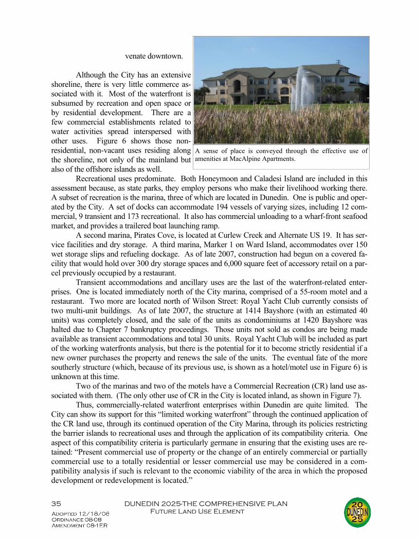
35 DUNEDIN 2025-THE COMPREHENSIVE PLAN Future Land Use Element
venate downtown. Although the City has an extensive shoreline, there is very little commerce as-sociated with it. Most of the waterfront is subsumed by recreation and open space or by residential development. There are a few commercial establishments related to water activities spread interspersed with other uses. Figure 6 shows those non-residential, non-vacant uses residing along the shoreline, not only of the mainland but also of the offshore islands as well. Recreational uses predominate. Both Honeymoon and Caladesi Island are included in this assessment because, as state parks, they employ persons who make their livelihood working there. A subset of recreation is the marina, three of which are located in Dunedin. One is public and oper-ated by the City. A set of docks can accommodate 194 vessels of varying sizes, including 12 com-mercial, 9 transient and 173 recreational. It also has commercial unloading to a wharf-front seafood market, and provides a trailered boat launching ramp. A second marina, Pirates Cove, is located at Curlew Creek and Alternate US 19. It has ser-vice facilities and dry storage. A third marina, Marker 1 on Ward Island, accommodates over 150 wet storage slips and refueling dockage. As of late 2007, construction had begun on a covered fa-cility that would hold over 300 dry storage spaces and 6,000 square feet of accessory retail on a par-cel previously occupied by a restaurant. Transient accommodations and ancillary uses are the last of the waterfront-related enter-prises. One is located immediately north of the City marina, comprised of a 55-room motel and a restaurant. Two more are located north of Wilson Street: Royal Yacht Club currently consists of two multi-unit buildings. As of late 2007, the structure at 1414 Bayshore (with an estimated 40 units) was completely closed, and the sale of the units as condominiums at 1420 Bayshore was halted due to Chapter 7 bankruptcy proceedings. Those units not sold as condos are being made available as transient accommodations and total 30 units. Royal Yacht Club will be included as part of the working waterfronts analysis, but there is the potential for it to become strictly residential if a new owner purchases the property and renews the sale of the units. The eventual fate of the more southerly structure (which, because of its previous use, is shown as a hotel/motel use in Figure 6) is unknown at this time. Two of the marinas and two of the motels have a Commercial Recreation (CR) land use as-sociated with them. (The only other use of CR in the City is located inland, as shown in Figure 7). Thus, commercially-related waterfront enterprises within Dunedin are quite limited. The City can show its support for this “limited working waterfront” through the continued application of the CR land use, through its continued operation of the City Marina, through its policies restricting the barrier islands to recreational uses and through the application of its compatibility criteria. One aspect of this compatibility criteria is particularly germane in ensuring that the existing uses are re-tained: “Present commercial use of property or the change of an entirely commercial or partially commercial use to a totally residential or lesser commercial use may be considered in a com-patibility analysis if such is relevant to the economic viability of the area in which the proposed development or redevelopment is located.”
A sense of place is conveyed through the effective use of amenities at MacAlpine Apartments.

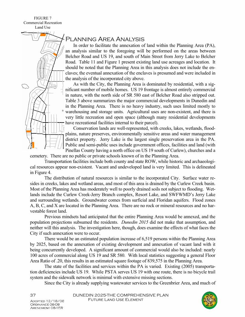
37 DUNEDIN 2025-THE COMPREHENSIVE PLAN Future Land Use Element
Planning Area Analysis In order to facilitate the annexation of land within the Planning Area (PA), an analysis similar to the foregoing will be performed on the areas between Belcher Road and US 19, and south of Main Street from Jerry Lake to Belcher Road. Table 11 and Figure 1 present existing land use acreages and location. It should be noted that the Planning Area in this analysis does not include the en-claves; the eventual annexation of the enclaves is presumed and were included in the analysis of the incorporated city above. As with the City, the Planning Area is dominated by residential, with a sig-nificant number of mobile homes. US 19 frontage is almost entirely commercial in nature, with the north side of SR 580 east of Belcher Road also stripped out. Table 3 above summarizes the major commercial developments in Dunedin and in the Planning Area. There is no heavy industry, such uses limited mostly to warehousing and storage units. Agricultural uses are non-existent, and there is very little recreation and open space (although many residential developments have recreational facilities internal to their parcel). Conservation lands are well-represented, with creeks, lakes, wetlands, flood-plains, nature preserves, environmentally sensitive areas and water management district property. Jerry Lake is the largest single preservation area in the PA. Public and semi-public uses include government offices, facilities and land (with Pinellas County having a north office on US 19 south of Curlew), churches and a
cemetery. There are no public or private schools known of in the Planning Area. Transportation facilities include both county and state ROW, while historic and archaeologi-cal resources appear non-existent. Vacant and undeveloped land is very limited. This is delineated in Figure 4. The distribution of natural resources is similar to the incorporated City. Surface water re-sides in creeks, lakes and wetland areas, and most of this area is drained by the Curlew Creek basin. Most of the Planning Area has moderately well to poorly drained soils not subject to flooding. Wet-lands include the Curlew Creek-Jerry Branch complex, Resort Lake, and SWFWMD’s Jerry Lake and surrounding wetlands. Groundwater comes from surficial and Floridan aquifers. Flood zones A, B, C, and X are located in the Planning Area. There are no rock or mineral resources and no har-vestable forest land. Previous mindsets had anticipated that the entire Planning Area would be annexed, and the population projections subsumed the residents. Dunedin 2015 did not make that assumption, and neither will this analysis. The investigation here, though, does examine the effects of what faces the City if such annexation were to occur. There would be an estimated population increase of 6,519 persons within the Planning Area by 2025, based on the annexation of existing development and annexation of vacant land with it being concurrently developed. A significant amount of commercial would also be included: nearly 100 acres of commercial along US 19 and SR 580. With local statistics suggesting a general Floor Area Ratio of .20, this results in an estimated square footage of 839,575 in the Planning Area. The state of the facilities and services within the PA is varied. Existing (2005) transporta-tion deficiencies include US 19. While PSTA serves US 19 with one route, there is no bicycle trail system and the sidewalk network is minimal with extensive missing sections. Since the City is already supplying wastewater services to the Greenbrier Area, and much of
FIGURE 7 Commercial Recreation
Land Use

38 DUNEDIN 2025-THE COMPREHENSIVE PLAN Future Land Use Element
the Planning Area is outside the City’s wastewa-ter service boundary, only an estimated additional 160 persons requiring sewer would be added through the annexation of the Planning Area. These persons can be easily handled without ex-ceeding the WWTP capacity. Utilities, Inc. (whose service area includes all areas east of Belcher) would continue operation, thus supple-menting the City’s capacity. The hauling capac-ity for solid waste would need to be increased through route restructuring and vehicle acquisi-tion. The solid waste commercial demand would significantly increase. But while collection re-sponsibilities would shift to the City, the county would still be responsible for disposal. Since much of the PA is already developed and produc-ing solid waste, the county should be able to han-dle this. Drainage, though is much more prob-lematic. If the City were to subrogate Pinellas County’s system, the costs involved for upgrad-ing and maintenance could be overwhelming. Pinellas County currently provides pota-ble water service to developments in the Planning Area; this arrangement would continue even in the event of annexation. Thus, even if the entire Planning Area were annexed, similar to wastewa-ter, only 160 additional persons would be added to the 2025 functional potable water population. Such an addition would not cause the Consump-tive Use Permit limitations to be exceeded. Estimates suggest a total of 43 acres of vacant or undeveloped land within the PA. Soils do not represent major development constraints, and neither does the geology of the area. Most of the vacant land is not near significant wetlands, rivers or lakes, but there are several instances where vacant land is near ecologically-sensitive areas such as Curlew Creek and Jerry Lake. There appear to be no historic or archaeological sites on va-cant or undeveloped land. The county’s current Future Land Use Plan Map contains 15 categories represented in the Dunedin Planning Area. These include the following: Residential ΦResidential Estate (RE) (0 to 1.0 UPA) ΦResidential Suburban (RS) (1 to 2.5 UPA) ΦResidential Low (RL) (2.6 to 5.0 UPA) ΦResidential Urban (RU) (5.1 to 7.5 UPA) ΦResidential Low Medium (RLM) (7.6 to 10.0 UPA) ΦResidential Medium (RM) (10.1 to 15 UPA)
TABLE 11 EXISTING LAND USE: PLANNING AREA, 2006
LAND USE ACRES PERCENT
Residential:
Single Family 383.18 39.39
Duplex/Triplex 25.01 2.57
Multi-family 10.93 1.12
Mobile Home 103.84 10.67
Commercial 98.71 10.15
Industrial 12.12 1.25
Public/Semi-Public: 30.32 3.12
Recreation/Open Space/Preservation
83.85 8.62
Urban Support 1.75 .18
Major Water Bodies 53.52 5.50
Vacant 42.70 4.39
Agricultural 0 0
Other (Right-of-Way) 126.82 13.04
Total 972.75 100.00
Source: Pinellas County Planning Department; Pinellas County GIS; Dunedin Planning & Development, 2007

39 DUNEDIN 2025-THE COMPREHENSIVE PLAN Future Land Use Element
Mixed Use ΦResidential/Office Limited (R/OL) ΦResidential/Office General (R/OG) ΦResidential/Office/Retail (R/O/R). As noted above, the extensive use of
R/O/R, particularly along US 19, has prompted the City to include this cate-gory within its Regulatory Land Use Plan Map categories.
Commercial ΦCommercial General (CG) Industrial ΦIndustrial Limited (IL) Public/Semi-Public ΦPreservation (P) ΦInstitutional (I) Special Designation ΦWater/Drainage Feature (WDF) ΦScenic/Non-Commercial Corridor (SNCC) The projections presented in Table 12 are based simply on what the current Future Land Use Plan designation is. Vacant parcels were analyzed and presumed to be built to their overlying land use plan category. Finally, the annexation of the entire Planning Area is presumed for this analysis only. As with the examination done for the City, the urban sprawl analysis for the Planning Area is based on the criteria found in Rule Chapter 9J-5.006(5), FAC. The analysis presented here in-cludes the potential impacts that could be significant if the Planning Area is annexed into the City. ΦIndicator: The Planning Area promotes, allows or designates for development sub-
stantial areas of the jurisdiction to develop as low-intensity, low-density, or single-use development or uses in excess of demonstrated need.
Analysis: The PA is primarily residential, with approximately 34 acres des-ignated as 2.5 UPA or less, which amounts to approximately 6% of the total of all residential land uses. In total 313 acres are designated as 5.0 UPA or less, constituting approximately 56% of the total of all residential land uses. Although 56% may be excessive, it does provide important residential areas. The other major land use is commercial, with around 100 acres of existing commercial uses.
ΦIndicator: The Planning Area promotes, allows or designates significant amounts of urban development to occur in rural areas at substantial distances from existing urban areas while leaping over undeveloped lands which are available and suitable for development.
Analysis: Approximately 1.52 square miles in size, the PA is not only very compact, but nearly built-out. Less than 4.5% remains vacant. Infill devel-opment has been encouraged by Pinellas County and is occurring. There are no rural areas in the Planning Area.
ΦIndicator: The Planning Area promotes, allows or designates urban development in radial, strip, isolated or ribbon patterns generally emanating from existing urban developments.

40 DUNEDIN 2025-THE COMPREHENSIVE PLAN Future Land Use Element
TABLE 12 SUMMARY OF ADDITIONAL ACREAGE REQUIRED BY LAND USE
CATEGORY AND INTENSITY: THROUGH ANNEXATION OF DEVELOPED AND VACANT PARCELS IN
THE PLANNING AREA
LAND USE ACREAGE
Residential
Residential Estate (1.0 Units/Acre)* 0.62
Residential Suburban (2.5 Units/Acre) 32.88
Residential Low (5.0 Units/Acre) 279.50
Residential Urban (7.5 Units/Acre) 188.90
Residential Low Medium (10.0 Units/Acre 49.61
Residential Medium (15.0 Units/Acre) 6.51
Mixed Use/Commercial (including office)
Residential/Office Limited (ROL)* 1.66
Residential/Office General (ROG) 11.34
Residential/Office/Retail (ROR) 99.13
Commercial General 10.57
Industrial
Industrial Limited 9.32
Public/Semi-Public
Recreation/Open Space/Preservation 79.22
Institutional/Transportation/Utility 23.50
Transportation Right-of-Way 126.82
Water 53.19
Total 972.75
*Would have to be converted to the most appropriate available cate-gory. Source: Pinellas County Planning Department; Pinellas County GIS; Dunedin Planning & Development, 2007
The Planning Area is home to extensive and intensive commercial development along US 19 (above) and to exclusively residential uses in the Greenbrier area (below).

41 DUNEDIN 2025-THE COMPREHENSIVE PLAN Future Land Use Element
Analysis: While the PA is very compact, the only ribbon pattern develop-ment is commercial along arterials, most notably US 19. Although this is a “true ribbon pattern,” the surrounding areas are also developed, mostly as residential. US 19 commercial serves the existing urban developments, not only in Dunedin but also from surrounding areas (i.e., extensive passerby trips are attracted to this frontage commercial).
ΦIndicator: The Planning Area, as a result of premature or poorly planned conver-sion of rural land to other uses, fails adequately to protect and conserve natural re-sources such as wetlands, floodplains, native vegetation, environmentally sensitive areas, natural aquifer recharge areas, lakes, rivers, shorelines, beaches, bays, estua-rine systems and other significant natural systems
Analysis: Figures in the Conservation and Coastal Management Element show wetlands, floodplains, and surface waters. There is one creek with two branches and three major lakes in the PA. Runoff pollutants can dam-age Curlew Creek and other water bodies. As mentioned above, the areas of higher elevation have been built on, thus impacting the aquifer recharge po-tential of the land. Floodplains are minimal in the Planning Area, with lower intensity development near creeks. Pinellas County enforces FEMA requirements on all new construction or significant reconstruction. The im-plementation of Total Maximum Daily Loads (TMDLs) for Curlew Creek is not anticipated until after 2011, leading to a conclusion that while surface water runoff could be better, the lack of severity is such that this is a low priority currently.
ΦIndicator: The Planning Area fails adequately to protect adjacent agricultural areas and activities, including silviculture, and including active agricultural and silvicul-tural activities as well as passive agricultural activities and dormant, unique and prime farmlands and soils.
Analysis: As in the City, there are no agricultural uses in the Planning Area. “Failing to protect agricultural activities” maximizes urbanization within the compact confines of the Planning Area. The urban status of the PA is recog-nized, and, as such, is promoted. Again, this is not an issue because exten-sive agricultural areas serve minimal purposes in the Planning Area. There are privately-owned recreational facilities spread throughout the PA.
ΦIndicator: The Planning Area fails to maximize use of existing public facilities and services.
Analysis: The level of service discussions earlier show that facilities and services are being utilized more than adequately. Water, wastewater and solid waste operating LOS is acceptable. US 19 is overutilized and is part of a Transportation Concurrency Management Area. The parkland to popula-tion ratio is fully realized with the inclusion of privately-owned open space. Finally, as noted in previous elements, however, despite the compact nature of the Planning Area, considerable cost would be incurred by the City in ex-tending water lines and subrogating drainage facilities.
ΦIndicator: The Planning Area fails to maximize use of future public facilities and services.
Analysis: If the entire PA was annexed, Water and Wastewater Treatment

42 DUNEDIN 2025-THE COMPREHENSIVE PLAN Future Land Use Element
Plant capacity and water storage capacity would not be exceeded. Solid waste routes, at a minimum, would have to be restructured, and extra vehi-cles may be required, especially to handle the additional commercial. Pinel-las County drainage LOS standards show a 25-year, 24-hour storm event, which is hardly excessive. If privately-owned mini-parks are included, no future deficiencies are projected.
ΦIndicator: The Planning Area allows for land use patterns or timing which dispro-portionately increase the cost in time, money and energy, of providing and maintain-ing facilities and services, including roads, potable water, sanitary sewer, stormwa-ter management, law enforcement, education, health care, fire and emergency re-sponse, and general government.
Analysis: Development fees for fire, police, water, sewer and parkland have been in existence since the early 1980s, and have forced development to pay for its impacts on City services. Existing development within the PA, if hooking up to City services would pay hook-up charges. As noted above, some services may come from other entities even though a property is under the City’s jurisdiction otherwise. Most of the PA is already developed, some of it prior to development fees. Any redevelopment would be subject to fees and connection charges. Post-development/pre-development runoff standards are strictly enforced. There appear to be no public or private schools in the Planning Area, and neither are there any major hospitals. The City would be able to provide an adequate overall governmental level of ser-vice to its citizens.
ΦIndicator: The Planning Area fails to provide a clear separation between rural and urban uses.
Analysis: Although the Planning Area is clearly urban in nature, being pri-marily residential, and secondarily commercial, it does allow less intense areas to function as recreation or open space. Again, all of Pinellas County is considered urbanized in nature.
ΦIndicator: The Planning Area discourages or inhibits infill development or the re-development of existing neighborhoods and communities.
Analysis: With vacant parcels scattered throughout the Planning Area and proximate to existing development, infill development is nearly all that is left.
ΦIndicator: The Planning Area fails to encourage an attractive and functional mix of uses.
Analysis: Again, the PA is primarily residential and commercial in nature, the latter located primarily along arterials and serving the surrounding resi-dential uses and passersby from other areas. This land use mix is reasonably efficient.
ΦIndicator: The Planning Area efforts result in poor accessibility among linked or related land uses.
Analysis: The commercial along arterials serves surrounding residential uses, with locals and collectors funneling residential traffic to major roads. The compact nature of the PA contributes to these linkages also.
ΦIndicator: The Planning Area efforts result in the loss of significant amounts of
43 DUNEDIN 2025-THE COMPREHENSIVE PLAN Future Land Use Element
functional open space. Analysis: With the inclusion of privately-owned open space, the Planning
Area would meet the City’s LOS standards. Additionally, the Land Dedica-tion Ordinance would require open space for larger residential developments on currently vacant property.
The above assessment indicates only four areas of possible concern. First is the degradation of some natural resources. The Concurrency Management System, stormwater controls, and site plan review would protect existing natural resources from future impacts but does nothing to ame-liorate current conditions. Second, the upgrading of the existing infrastructure would present a chal-lenge. The extension of water lines could be very costly, and the subrogation of the stormwater drainage system from the county could be prohibitively expensive. Third is the ribbon pattern along US 19, which is somewhat ameliorated because the surrounding areas are also developed. Last is that extensive lower density (5.0 UPA or less) has been promoted in the PA. This, though, is some-what offset by fact that most of the Planning Area has been developed.. The residential areas pro-vide important housing in an extremely urbanized setting. Despite these negative indicators, overall, there appears no overwhelming evidence of urban sprawl. Summarizing the local conditions within the Planning Area suggest the following: Φ The Planning Area is approximately 1.52 square miles, and available vacant de-
velopable land is very small and scattered throughout. ΦThe projected growth rate, based on the most recent projections, shows an esti-
mated functional population of 6,519 by 2025. However, the City is already provid-ing some services to many of these county residents (e.g., wastewater services to Greenbrier area residents).
ΦTable 12 above shows the additional acreage by land use type that could be antici-pated if the entire Planning Area is annexed.
ΦBased on the above update of each comprehensive plan element, needed facilities (e.g., water, sewer, roads, parks) are available, although some deficiencies exist.
ΦThe existing pattern of development is primarily residential, generally with lower densities, mostly 7.5 UPA or lower, with patches of 10 UPA developments. Com-mercial is confined primarily to arterials and some collectors and serves the sur-rounding residential areas and passerby traffic. There is also extensive privately-owned recreation/open space spread throughout the PA. Public/semi-public uses exist in the form of churches and government services.
ΦThe City would provide only some services if annexation were to occur, including wastewater, solid waste collection, roads, and parks. The service area boundaries would be honored, meaning that while sanitary sewer would be provided to the Greenbrier area (indeed, it currently is being provided), it would be granted to other developments even if annexed. Utilities, Inc. would continue to provide sewer ser-vice to those developments within its service area. Also, Pinellas County would continue to provide water to customers in its water service area. There could be sig-nificant costs associated with the subrogation of stormwater drainage facilities.
ΦExtra-jurisdictional and regional growth characteristics show that Pinellas County is the most densely populated county in Florida with 24 municipalities and one

44 DUNEDIN 2025-THE COMPREHENSIVE PLAN Future Land Use Element
county government. ΦThe Transportation Element analysis suggests reasonably good compatibility be-
tween land use and the roadway system. The non-grid/non-radial pattern can cause some continuity problems. Major roadways are well-utilized, with deficiencies on US 19. Residential uses are primarily on locals and collectors, but there are some driveways on arterials.
ΦThe geography, topography and various natural features within the PA are very similar to the City. The Planning Area slopes upland from a low point of approxi-mately 40 feet to a high point of approximately 70 feet above sea level. As with the city, much of the floodplain was developed prior to FEMA regulations.
Summary Dunedin is a city of approximately 42,900 persons (2006) estimated to increase less than five percent by 2025. It is composed of primarily residential and recreational uses with a modicum of commercial that supports the residential aspects. The City is essentially built out, with less than two percent of the land both vacant and developable. If all the enclaves are annexed, this will result in an additional 370 acres being added to the City’s roughly 6,700 acres. The City anticipates being able to supply the necessary facilities and services to its current and future residents. While annexations are expected to occur, currently unincorporated residents may need to obtain their water and wastewater services from other providers due to the boundaries of the various service areas. Dunedin will continue its compact growth, infill development and redevelopment being the only two types of expansion left. As such, it will retain its small-town atmosphere while meeting the demands of its modestly growing population.

45 DUNEDIN 2025-THE COMPREHENSIVE PLAN Future Land Use Element
Appendix Table 13 presents the criteria by which land use plan amendments should be reviewed. The table presents density and intensity standards as well as use, locational, and transportation character-istics.

46 DUNEDIN 2025-THE COMPREHENSIVE PLAN Future Land Use Element
TABLE 13
LAND USE CLASSIFICATION REVIEW CRITERIA
TYPE DENSITY/INTENSITY PURPOSE USE CHARACTERISTICS LOCATIONAL CHARACTERISTICS
TRANSPORTATION CHARACTERISTICS OTHERS/COMMENTS
Residential Use Classification Residential Suburban (RS)
0 to 2.5 UPA 3 beds/DU REUS 0.30 FAR NRU 0.60 ISR NRU 3 acre ANRTU threshold 5 acre I threshold
To show those parcels in the City that are currently devel-oped, or appropriate to be developed, in a suburban low intensity residential manner.
Primary: Residential. Secondary: Residential Equiva-lent; Institutional; Public Edu-cational Facility; Ancillary Non-Residential; Recreation/Open Space.
In areas where use and devel-opment characteristics are suburban residential in nature; and in areas serving as a tran-sition between more rural and more urban residential areas.
Areas served by and accessed from minor and collector road-ways which connect to the arterial and thoroughfare high-way network.
Residential Low (RL)
2.6 to 5.0 UPA 3 beds/DU REUS 0.40 FAR NRU 0.65 ISR NRU 3 acre ANRTU threshold 5 acre I threshold
To show those parcels in the City that are currently devel-oped, or appropriate to be developed, in a low density residential manner.
Primary: Residential Secondary: Residential Equiva-lent; Institutional; Public Edu-cational Facility; Ancillary Non-Residential; Recreation/Open Space.
In areas where use and devel-opment characteristics are low density residential in nature; and in areas serving as a tran-sition between more suburban and more urban residential areas.
Areas served by and accessed from minor and collector road-ways which connect to the arterial network.
Residential Urban (RU)
5.1 to 7.5 UPA 3 beds/DU REUS 0.40 FAR NRU 0.65 ISR NRU 3 acre ANRTU threshold 5 acre I threshold
To show those parcels in the City that are currently devel-oped, or appropriate to be developed, in an urban low density residential manner.
Primary: Residential Secondary: Residential Equiva-lent; Institutional; Public Edu-cational Facility; Ancillary Non-Residential; Recreation/Open Space.
In areas removed from, but in close proximity to urban activity centers; in areas where use and develop-ment characteristics are urban residential in nature; and in areas serving as a transition between more suburban and more urban residential areas.
Areas served by and accessed from minor and collector road-ways which connect to the arterial network.
Residential Low Medium (RLM)
7.6 to 10.0 UPA 3 beds/DU REUS 0.50 FAR NRU 0.75 ISR NRU 3 acre ANRTU threshold 5 acre I threshold
To show those parcels in the City that are currently devel-oped, or appropriate to be developed, in a low to moder-ately intensive residential manner.
Primary: Residential Secondary: Residential Equiva-lent; Institutional; Public Edu-cational Facility; Ancillary Non-Residential; Recreation/Open Space.
In areas in close proximity to urban activity centers; in areas where use and development char-acteristics are low medium resi-dential in nature; and in areas serving as a transition between low density and high density residential areas.
Areas served by and accessed from minor and collector road-ways which connect to the arterial network.
Residential Medium (RM)
10.1 to 15.0 UPA 3 beds/DU REUS 0.50 FAR NRU 0.75 ISR NRU 3 acre ANRTU threshold 5 acre I threshold
To show those parcels in the City that are currently devel-oped, or appropriate to be developed, in a moderately intensive residential manner.
Primary: Residential Secondary: Residential Equiva-lent; Institutional; Public Edu-cational Facility; Ancillary Non-Residential; Recreation/Open Space.
In areas within or in close prox-imity to urban activity centers; in areas where use and development characteristics are medium density residential in nature; and in areas serving as a transition between less urban and more urban residential and mixed use areas.
These areas are typically in close proximity to and may have direct access from the arterial network.
Residential High (RH)
15.1 to 30 UPA 3 beds/DU REUS 0.60 FAR NRU 0.85 ISR NRU 3 acre ANRTU threshold 5 acre I threshold
To show those parcels in the City that are currently devel-oped, or appropriate to be developed, in a highly inten-sive residential manner.
Primary: Residential Secondary: Residential Equiva-lent; Institutional; Public Edu-cational Facility; Ancillary Non-Residential; Recreation/Open Space.
In areas within or in close prox-imity to urban activity centers; in areas where use and development characteristics are high density residential in nature; and in areas serving as an urban center.
These areas are typically in close proximity to and may have direct access from the arterial network and are served by mass transit in a manner that provides an alternative to individual automobile use.
This designation is gen-erally not appropriate for coastal high hazard and evacuation level “A” areas.
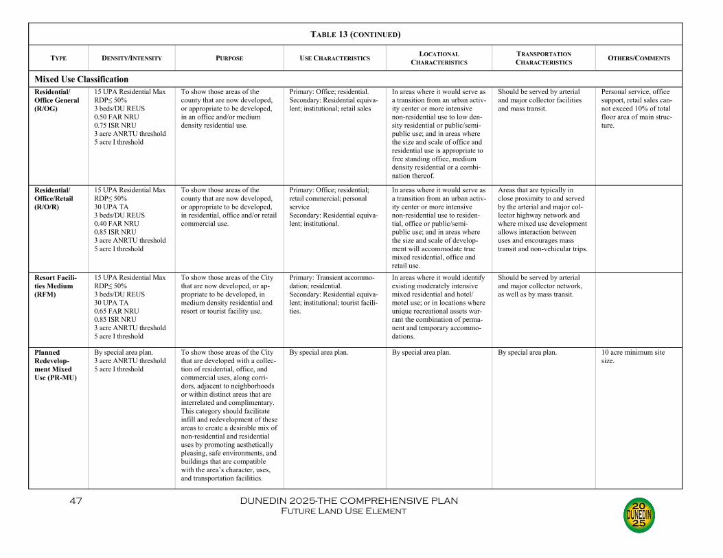
47 DUNEDIN 2025-THE COMPREHENSIVE PLAN Future Land Use Element
TABLE 13 (CONTINUED)
TYPE DENSITY/INTENSITY PURPOSE USE CHARACTERISTICS LOCATIONAL CHARACTERISTICS
TRANSPORTATION CHARACTERISTICS OTHERS/COMMENTS
Mixed Use Classification Residential/Office General (R/OG)
15 UPA Residential Max RDP≤ 50% 3 beds/DU REUS 0.50 FAR NRU 0.75 ISR NRU 3 acre ANRTU threshold 5 acre I threshold
To show those areas of the county that are now developed, or appropriate to be developed, in an office and/or medium density residential use.
Primary: Office; residential. Secondary: Residential equiva-lent; institutional; retail sales
In areas where it would serve as a transition from an urban activ-ity center or more intensive non-residential use to low den-sity residential or public/semi-public use; and in areas where the size and scale of office and residential use is appropriate to free standing office, medium density residential or a combi-nation thereof.
Should be served by arterial and major collector facilities and mass transit.
Personal service, office support, retail sales can-not exceed 10% of total floor area of main struc-ture.
Residential/Office/Retail (R/O/R)
15 UPA Residential Max RDP≤ 50% 30 UPA TA 3 beds/DU REUS 0.40 FAR NRU 0.85 ISR NRU 3 acre ANRTU threshold 5 acre I threshold
To show those areas of the county that are now developed, or appropriate to be developed, in residential, office and/or retail commercial use.
Primary: Office; residential; retail commercial; personal service Secondary: Residential equiva-lent; institutional.
In areas where it would serve as a transition from an urban activ-ity center or more intensive non-residential use to residen-tial, office or public/semi-public use; and in areas where the size and scale of develop-ment will accommodate true mixed residential, office and retail use.
Areas that are typically in close proximity to and served by the arterial and major col-lector highway network and where mixed use development allows interaction between uses and encourages mass transit and non-vehicular trips.
Resort Facili-ties Medium (RFM)
15 UPA Residential Max RDP≤ 50% 3 beds/DU REUS 30 UPA TA 0.65 FAR NRU 0.85 ISR NRU 3 acre ANRTU threshold 5 acre I threshold
To show those areas of the City that are now developed, or ap-propriate to be developed, in medium density residential and resort or tourist facility use.
Primary: Transient accommo-dation; residential. Secondary: Residential equiva-lent; institutional; tourist facili-ties.
In areas where it would identify existing moderately intensive mixed residential and hotel/motel use; or in locations where unique recreational assets war-rant the combination of perma-nent and temporary accommo-dations.
Should be served by arterial and major collector network, as well as by mass transit.
Planned Redevelop-ment Mixed Use (PR-MU)
By special area plan. 3 acre ANRTU threshold 5 acre I threshold
To show those areas of the City that are developed with a collec-tion of residential, office, and commercial uses, along corri-dors, adjacent to neighborhoods or within distinct areas that are interrelated and complimentary. This category should facilitate infill and redevelopment of these areas to create a desirable mix of non-residential and residential uses by promoting aesthetically pleasing, safe environments, and buildings that are compatible with the area’s character, uses, and transportation facilities.
By special area plan. By special area plan. By special area plan. 10 acre minimum site size.

48 DUNEDIN 2025-THE COMPREHENSIVE PLAN Future Land Use Element
TABLE 13 (CONTINUED)
TYPE DENSITY/INTENSITY PURPOSE USE CHARACTERISTICS LOCATIONAL CHARACTERISTICS
TRANSPORTATION CHARACTERISTICS OTHERS/COMMENTS
Commercial Use Classification Commercial Neighborhood (CN)
10 UPA Residential Max RDP≤ 50% 3 beds/DU REUS 0.40 FAR NRU 0.80 ISR NRU 5 acre ITU threshold
To show those areas of the City that are now developed, or appropriate to be devel-oped, in a manner designed to provide local, neighborhood scale, convenience commer-cial goods and services.
Primary: Office; personal service; retail commercial; commercial/business service. Secondary: Residential; resi-dential equivalent; institu-tional.
In areas adjacent to and on the periphery of large, definable residential neighborhoods; in areas distant from other com-mercially designated proper-ties and situated so as to pre-clude strip-like commercial development.
These areas are generally located on a collector roadway and oriented to a specific and limited geographic neighbor-hood as distinct from through traffic on an arterial.
Commercial Limited (CL)
15 UPA Residential Max RDP≤ 50% 3 beds/DU REUS 0.45 FAR NRU 0.85 ISR NRU 5 acre ITU threshold
To show those areas of the City that are now developed, or appropriate to be devel-oped, in a manner designed to provide limited, roadway oriented commercial goods and services.
Primary: Office; personal service; retail commercial; commercial/business service. Secondary: Residential; resi-dential equivalent; institu-tional.
In areas adjacent to and front-ing on those arterial and major collector roadways.
On arterials or major collec-tors.
Commercial Recreation (CR)
3 beds/DU REUS (at 12.5 UPA Max) 0.55 FAR NRU 0.90 ISR NRU 40 UPA TA 5 acre ITU threshold
To show those areas of the City that are now developed, or appropriate to be devel-oped, in a manner designed to provide commercial recreation activities.
Primary: Marina; transient accommodation; restaurant; retail commercial. Secondary: Residential equiva-lent; institutional.
In areas adjacent to activity centers or areas designated for commercial use; in water-dependent locations for marina and boat service use.
Should have good access to major transportation facilities so as to serve the commercial recreation facility needs of the resident and tourist population of the City.
Commercial General (CG)
15 UPA Residential Max RDP≤ 50% 3 beds/DU REUS 0.55 FAR NRU 0.90 ISR NRU 40 UPA TA 5 acre ITU threshold
To show those areas of the County that are now devel-oped, or appropriate to be developed, in a manner de-signed to provide community and countywide commercial goods and services.
Primary: Retail commercial; office; personal service; com-mercial/business service; transient accommodation; restaurant; financial institu-tion; Secondary: Residential; resi-dential equivalent; institu-tional.
In areas in and adjacent to activity centers where sur-rounding land uses support and are compatible with inten-sive commercial use; in areas supported by arterial or major collector roadways.
On arterials or major collec-tors; at intersection of two major collectors
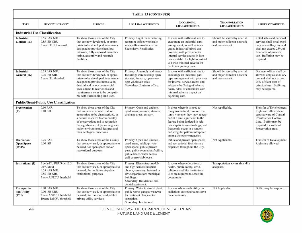
49 DUNEDIN 2025-THE COMPREHENSIVE PLAN Future Land Use Element
TABLE 13 (CONTINUED)
TYPE DENSITY/INTENSITY PURPOSE USE CHARACTERISTICS LOCATIONAL CHARACTERISTICS
TRANSPORTATION CHARACTERISTICS OTHERS/COMMENTS
Industrial Use Classification Industrial Limited (IL)
0.65 FAR NRU 0.85 ISR NRU 5 acre ITU+ threshold
To show those areas of the City that are now developed, or appro-priate to be developed, in a manner designed to provide clean, low intensity, fully enclosed manufac-turing, assembly and research facilities.
Primary: Light manufacturing; research; office; wholesale sales; office machine repair. Secondary: Retail sales.
In areas with sufficient size to encourage an industrial park arrangement, as well as inte-grated industrial/mixed use projects, with provision for internal service access in loca-tions suitable for light industrial use with minimal adverse im-pact on adjoining uses.
Should be served by arterial and major collector network and mass transit.
Retail sales and personal services shall be allowed only as ancillary use and shall not exceed 25% of floor area of principal use. Buffering may be required.
Industrial General (IG)
0.75 FAR NRU 0.95 ISR NRU 5 acre ITU threshold
To show those areas of the City that are now developed, or appro-priate to be developed, in a manner designed to provide intensive in-dustrial and heavy commercial uses subject to restrictions and requirements so as to be compati-ble with surrounding land uses.
Primary: Assembly and manu-facturing; warehousing; open storage; foundry; open stor-age; wholesale sales Secondary: Business office.
In areas with sufficient size to encourage an industrial park type arrangement with provision for internal service access and adequate buffering of adverse noise, odor, or emissions; with minimal adverse impact on adjoining uses.
Should be served by arterial and major collector network and mass transit.
Business offices shall be allowed only as ancillary use and shall not exceed 25% of floor area of principal use. Buffering may be required.
Public/Semi-Public Use Classification Preservation (P)
0.10 FAR 0.10 ISR
To show those areas of the City that are now characterized, or appropriate to be characterized, as a natural resource feature worthy of preservation; and to recognize the significance of preserving such major environmental features and their ecological functions.
Primary: Open and undevel-oped areas; swamps; streams; drainage areas; estuary.
In areas where it is need to recognize natural resource fea-tures wherever they may appear and at a size significant to the feature being depicted in rela-tionship to its surroundings; will frequently occur in a random and irregular pattern interposed among the other categories.
Not Applicable. Transfer of Development Rights are allowed ex-cept seaward of Coastal Construction Control Line. Buffer may be required for wetland Preservation areas
Recreation/Open Space (R/OS)
0.25 FAR 0.60 ISR
To show those areas of the County that are now used, or appropriate to be used, for open space and/or recreational purposes.
Primary: Open and undevel-oped areas; public/private open space; public/private park; public recreation facility; public beach/water access; golf course/clubhouse.
Public and private open spaces and recreational facilities are dispersed throughout the City.
Not Applicable. Transfer of Development Rights are allowed.
Institutional (I) 3 beds/DU REUS (at 12.5 UPA Max) 0.65 FAR NRU 0.85 ISR NRU 3 acre ANRTU threshold
To show those areas of the City that are now used, or appropriate to be used, for public/semi-public institutional purposes.
Primary: Elementary, middle and high schools; hospital, church; cemetery; fraternal or civic organization; municipal buildings. Secondary: Residential; resi-dential equivalent.
In areas where educational, health, public safety, civic, religious and like institutional uses are required to serve the community.
Transportation access should be adequate.
Transporta-tion/Utility (T/U)
0.70 FAR NRU 0.90 ISR NRU 3 acre ANRTU threshold 10 acre IANRU threshold
To show those areas of the City that are now used, or appropriate to be used, for transport and public/private utility services.
Primary: Water treatment plant; public works garage; wastewa-ter treatment plan; electric substation.. Secondary: Institutional.
In areas where such utility in-stallations are required to serve the community.
Not Applicable. Buffer may be required.
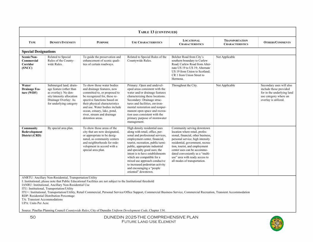
50 DUNEDIN 2025-THE COMPREHENSIVE PLAN Future Land Use Element
TABLE 13 (CONTINUED)
TYPE DENSITY/INTENSITY PURPOSE USE CHARACTERISTICS LOCATIONAL CHARACTERISTICS
TRANSPORTATION CHARACTERISTICS OTHERS/COMMENTS
Special Designations
Community Redevelopment District (CRD)
By special area plan.
To show those areas of the city that are now designated, or appropriate to be desig-nated, as community centers and neighborhoods for rede-velopment in accord with a special area plan.
High density residential uses along with retail, office, per-sonal and professional services, employment center, financial, tourist, recreation, public/semi-public, appropriate industrial and specialty good uses; the intent is to have establishments which are compatible for a mixed use approach conducive to increased pedestrian activity and encouraging a “people oriented” downtown.
Community serving downtown location where retail, profes-sional, financial, other business, personal service, high intensity residential, government, recrea-tion, tourist, and employment center uses can be accommo-dated conveniently as a “multi-use” area with ready access to all modes of transportation.
ANRTU: Ancillary Non-Residential, Transportation/Utility I: Institutional; please note that Public Educational Facilities are not subject to the Institutional threshold IANRU: Institutional, Ancillary Non-Residential Use ITU: Institutional, Transportation/Utility ITU+: Institutional, Transportation/Utility, Retail Commercial, Personal Service/Office Support, Commercial Business Service, Commercial Recreation, Transient Accommodation RDP: Residential Distribution Percentage TA: Transient Accommodations UPA: Units Per Acre Source: Pinellas Planning Council Countywide Rules; City of Dunedin Uniform Development Code, Chapter 134.
Water/Drainage Fea-ture (WDF)
Submerged land; drain-age feature (other than as overlay): No den-sity/intensity allocation Drainage Overlay: As for underlying category
To show those water bodies and drainage features, now committed to, or proposed to be recognized for, these re-spective functions based on their physical characteristics and use. Water bodies include ocean, estuary, lake, pond, river, stream and drainage detention areas.
Primary: Open and undevel-oped areas consistent with the water and/or drainage features characterizing these locations. Secondary: Drainage struc-tures and facilities, environ-mental restoration and nonper-manent open space and recrea-tion uses consistent with the primary purpose of stormwater management.
Throughout the City. Not Applicable Secondary uses will also include those provided for in the underlying land use category where an overlay is utilized.
Scenic/Non-Commercial Corridor (SNCC)
Related to Special Rules of the County-wide Rules.
To guide the preservation and enhancement of scenic quali-ties of certain roadways.
Related to Special Rules of the Countywide Rules.
Belcher Road from City’s southern boundary to Curlew Road; Curlew Road from Alter-nate US 19 to US 19; Alternate US 19 from Union to Scotland; CR 1 from Union Street to Hermosa.
Not Applicable