future of land imaging presentation to the usgs executive...
TRANSCRIPT
Jeff Sloan USGS-Geosciences & Environmental Change Science Center UAS National Project Office Denver, Colorado USA July 16, 2014
uas.usgs.gov
Outline
• Background • Current United States (FAA) UAS Aviation Policies • Interest in UAS Technology • Data Acquisition and Processing • Missions • Future

Department of the Interior
507 million acres of land - 1 out of every 5 acres in U.S. is the Dept. of the Interior’s management responsibility
U.S. Geological Survey, Bureau of Land Management, Bureau of Indian Affairs,
Office of Surface Mining Reclamation and Enforcement, Bureau of Reclamation, National Park Service, U.S. Fish & Wildlife Service

Sources of Remote Sensing Data
Landsat 8 (30 meter)
NAIP 2010 (1 meter)
UAS at 400 ft (5 cm)
UAS at 200 ft (2.5cm)
Low altitude role of small UAS in data acquisition
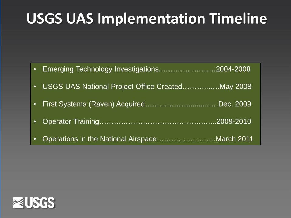
USGS UAS Implementation Timeline
• Emerging Technology Investigations.…………..………2004-2008
• USGS UAS National Project Office Created………...….May 2008
• First Systems (Raven) Acquired………………...........…Dec. 2009
• Operator Training…………………………………….…...2009-2010
• Operations in the National Airspace……………...….…March 2011

Why So Much Interest in UAS Technology?
• U.S. Universities involved with UAS related Programs ……… 175 • Countries involved with UAS manufacturing……………………. 65 • U.S. UAS related manufactures ………………………………………… 200 • Global UAS related manufactures ……………………………………. 715 • Global UAS platforms………………………………………………………. 2,400
• AUVSI predicts 3 years after NAS integration of UAS 70,000 U.S. jobs could be created and more than $13 Billion into the U.S. Economy
Sources: AUVSI, Teal Group, RPA

UAS Production Process
Platform Cameras Collect Data Process Data

UAS Production Process
Platform Cameras Collect Data Process Data
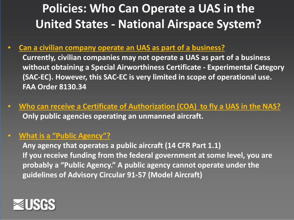
Policies: Who Can Operate a UAS in the United States - National Airspace System?
• Can a civilian company operate an UAS as part of a business? Currently, civilian companies may not operate a UAS as part of a business without obtaining a Special Airworthiness Certificate - Experimental Category (SAC-EC). However, this SAC-EC is very limited in scope of operational use.
FAA Order 8130.34 • Who can receive a Certificate of Authorization (COA) to fly a UAS in the NAS?
Only public agencies operating an unmanned aircraft. • What is a “Public Agency”?
Any agency that operates a public aircraft (14 CFR Part 1.1) If you receive funding from the federal government at some level, you are probably a “Public Agency.” A public agency cannot operate under the guidelines of Advisory Circular 91-57 (Model Aircraft)
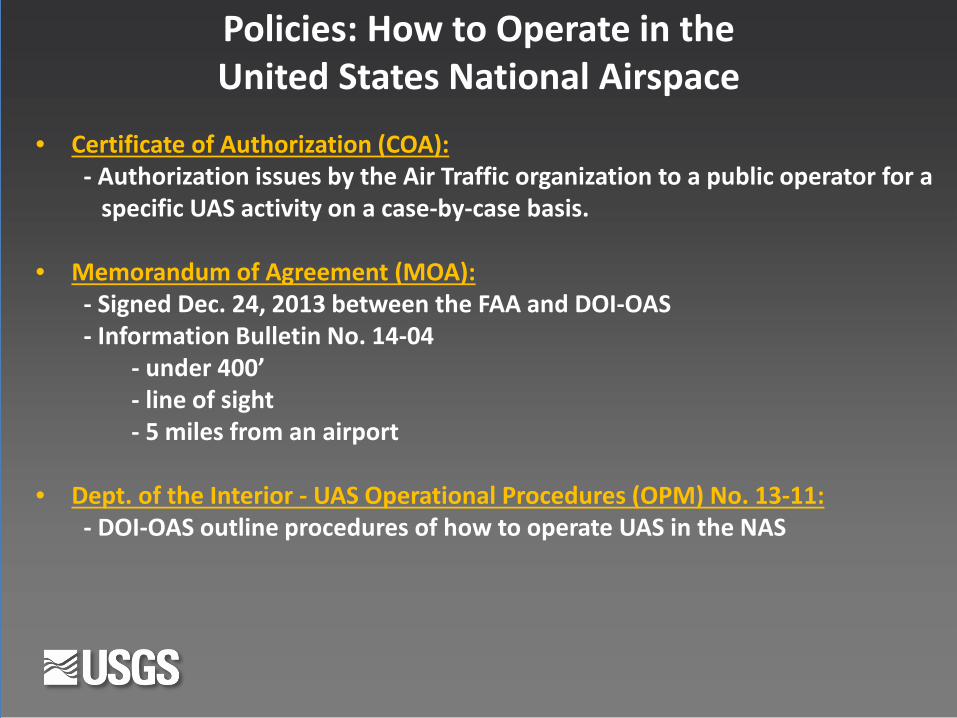
Policies: How to Operate in the United States National Airspace
• Certificate of Authorization (COA): - Authorization issues by the Air Traffic organization to a public operator for a specific UAS activity on a case-by-case basis.
• Memorandum of Agreement (MOA): - Signed Dec. 24, 2013 between the FAA and DOI-OAS
- Information Bulletin No. 14-04 - under 400’ - line of sight - 5 miles from an airport • Dept. of the Interior - UAS Operational Procedures (OPM) No. 13-11: - DOI-OAS outline procedures of how to operate UAS in the NAS

• Spectrum: - Currently on military frequencies - Future: On a civilian government frequencies or encrypted public freq.
• Range or private owner approvals: - Dept. of the Interior guidelines ask that we get the range (refuge, park management agency) and/or private land owner approvals • Airworthiness: - Annual check of the systems by DOI-OAS for individual aircraft airworthiness - American Society for Testing & Materials (ASTM) International (Committee F38) www.astm.org - NASA testing
Policies: How to Operate in the United States National Airspace

• NOTAMs & Notices: - Must issue a Notice to Airmen at least 48 hrs. in advance (COA or MOA) - Contact the nearest Air Traffic Control Tower and Military Base if necessary • UAS Operators - Currency – have flown or been on a simulator in the past 90 days - Proficiency – must be checked by an OAS instructor once a year - Class 2 Medical – good for one year as issued by FAA approved physician
Policies: How to Operate in the United States National Airspace
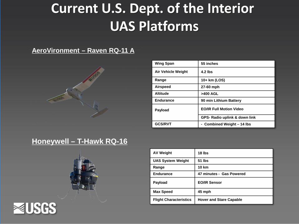
Current U.S. Dept. of the Interior UAS Platforms
AeroVironment – Raven RQ-11 A
Wing Span 55 inches
Air Vehicle Weight 4.2 lbs
Range 10+ km (LOS)
Airspeed 27-60 mph
Altitude >400 AGL
Endurance 90 min Lithium Battery
Payload
EO/IR Full Motion Video
GPS- Radio uplink & down link
GCS/RVT - Combined Weight – 14 lbs
AV Weight 18 lbs
UAS System Weight 51 lbs
Range 10 km
Endurance 47 minutes - Gas Powered
Payload EO/IR Sensor
Max Speed 45 mph
Flight Characteristics Hover and Stare Capable
Honeywell – T-Hawk RQ-16
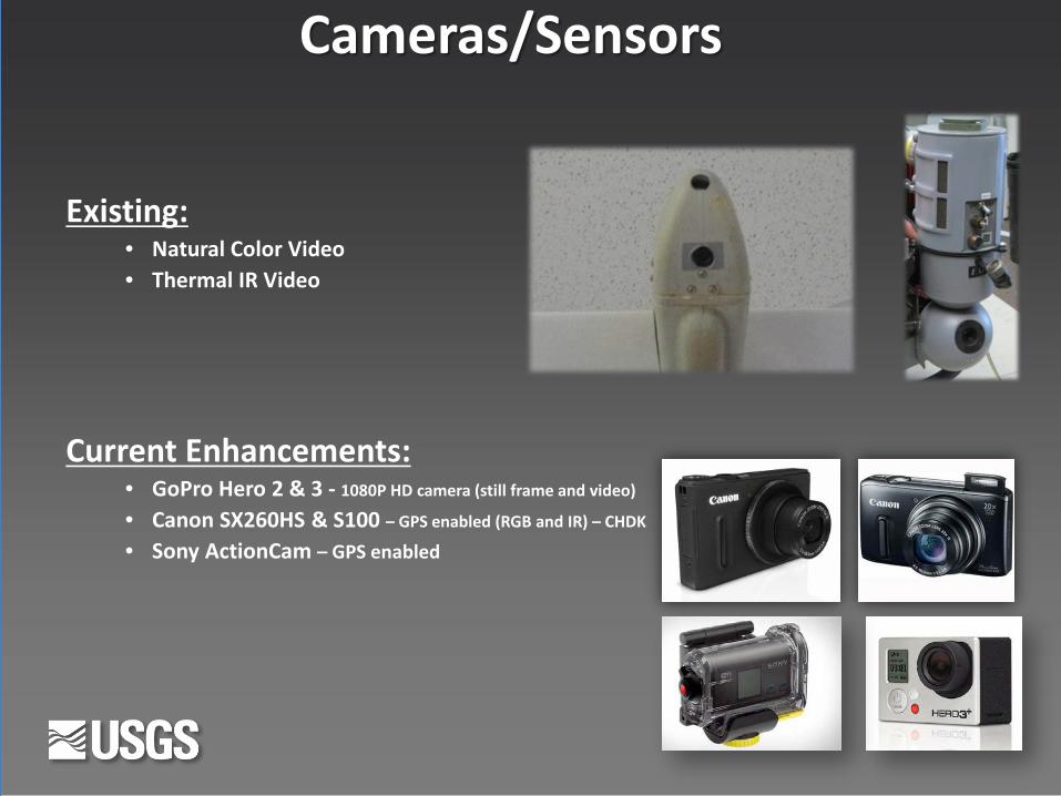
Existing: • Natural Color Video • Thermal IR Video
Cameras/Sensors
Current Enhancements: • GoPro Hero 2 & 3 - 1080P HD camera (still frame and video)
• Canon SX260HS & S100 – GPS enabled (RGB and IR) – CHDK
• Sony ActionCam – GPS enabled

Sandhill Crane Population Estimates Monte Vista, Colorado – First UAS Mission in NAS
March 2011
Developing methods to estimate Sandhill Crane abundance for natural resource management.
Execution of this UAS mission cost $2,645, compared to similar fixed wing manned aircraft surveys that cost $4,310 up to $35,000 if contracted privately.
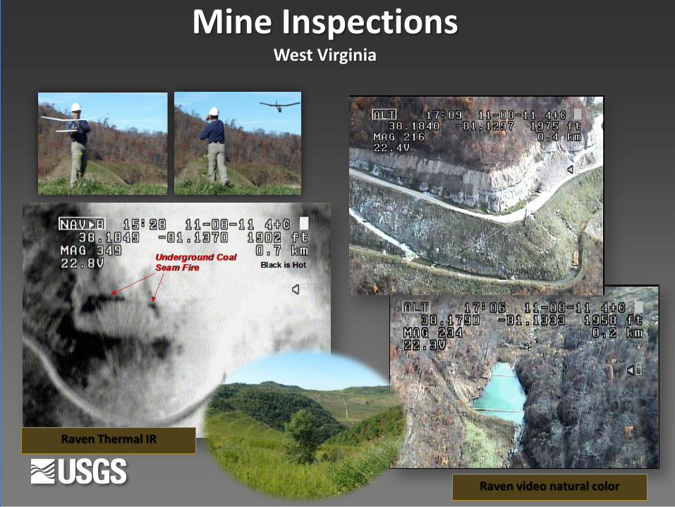
Raven video natural color
Raven Thermal IR
Mine Inspections West Virginia
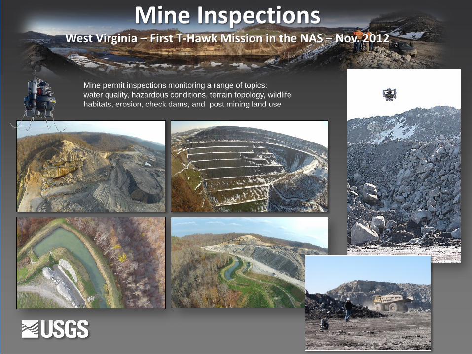
Mine Inspections West Virginia – First T-Hawk Mission in the NAS – Nov. 2012
Mine permit inspections monitoring a range of topics: water quality, hazardous conditions, terrain topology, wildlife habitats, erosion, check dams, and post mining land use
Arizona NAIP 2010 Arizona UAS GoPro 400Ft. AGL Arizona UAS GoPro 200 ft AGL
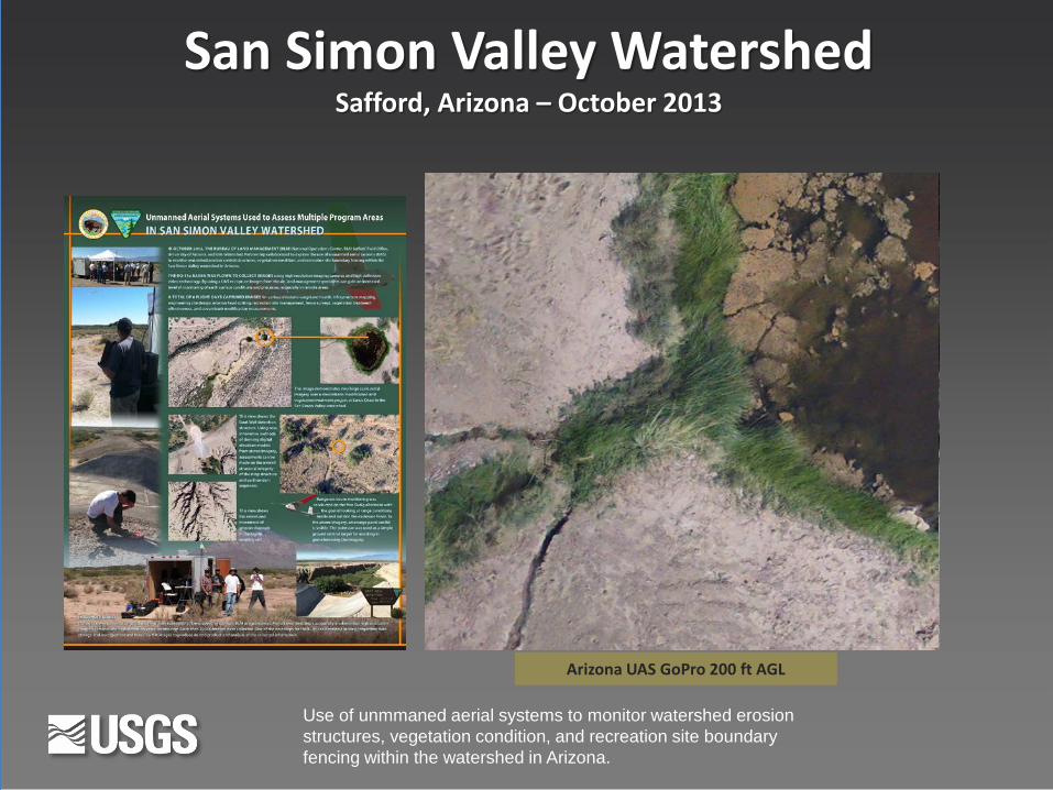
San Simon Valley Watershed Safford, Arizona – October 2013
Use of unmmaned aerial systems to monitor watershed erosion structures, vegetation condition, and recreation site boundary fencing within the watershed in Arizona.

Falcon-UAS
Orthophotography derived from 360 feet (110 m) above ground level
Gravel Pit & Landfill Operations Volumetric Compliance Inspections
Grand Junction, Colorado – 2013
Photogrammetric derived dense point cloud with RGB values
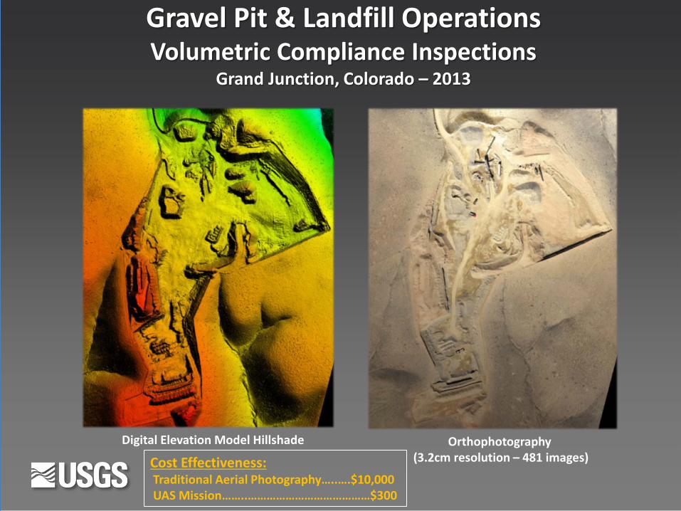
Digital Elevation Model Hillshade Orthophotography (3.2cm resolution – 481 images)
Gravel Pit & Landfill Operations Volumetric Compliance Inspections
Grand Junction, Colorado – 2013
Cost Effectiveness: Traditional Aerial Photography…..….$10,000 UAS Mission……..…………………………………$300

Debeque Landslide Debeque, Colorado
June 2013
October 2013
Temporal series of Landslide models monitoring geomorphic processes.

Point cloud comparison and calculations (using Cloud Compare)
Green indicates possible movement
Debeque Landslide Debeque, Colorado

Pleistocene Trackway Mapping White Sands National Monument, NM January 6-10, 2014
Mammoth Trackway
Photogrammetric documentation using a UAS to aerial survey extremely fragile fossilized footprints from the late Ice Age.

Elwha Dam Removal and River Restoration Olympic National Park, Washington
Monitoring sediment volumes eroded from the reservoir and deposited downstream, where the mobile sediment can potentially affect salmon habitat.
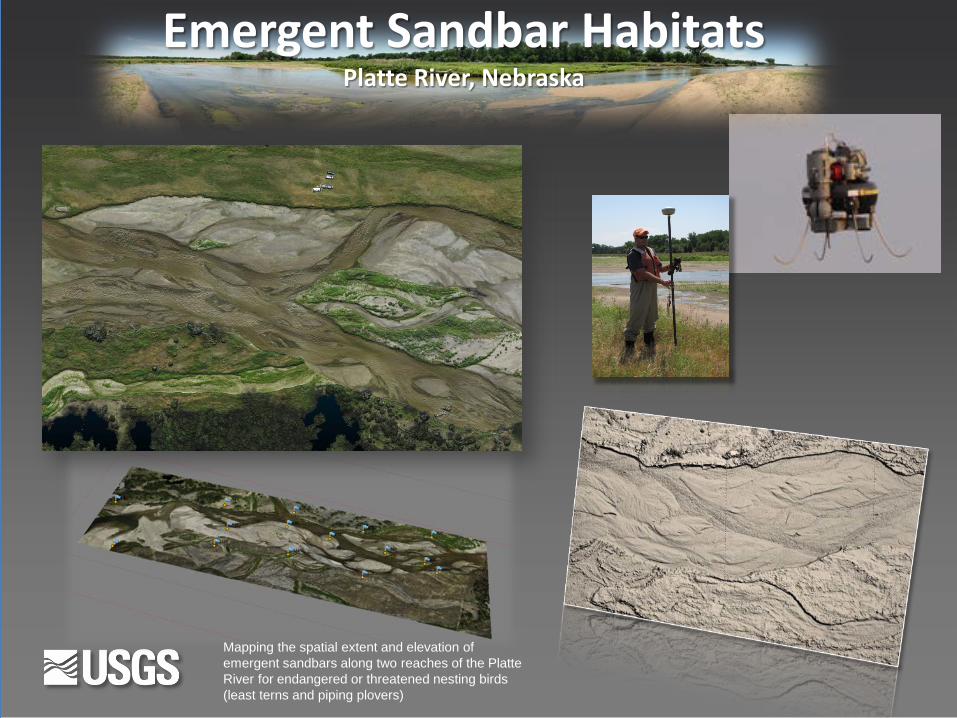
Emergent Sandbar Habitats Platte River, Nebraska
Mapping the spatial extent and elevation of emergent sandbars along two reaches of the Platte River for endangered or threatened nesting birds (least terns and piping plovers)

Boundary/Fenceline Inspections Haleakala National Park, Maui
Infrastructure inspections maintaining 65 miles of fence line to exclude pigs, axis deer, predatory mammals, and invertebrate threats to the native resources
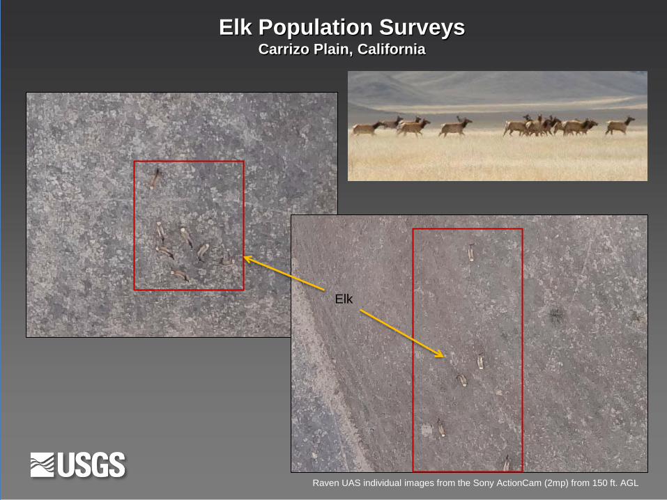
Elk Population Surveys Carrizo Plain, California
Elk
Raven UAS individual images from the Sony ActionCam (2mp) from 150 ft. AGL

Pelican Nesting Habitats Chase Lake, North Dakota June 9-13, 2014
Raven UAS image mosaic from the Sony ActionCam (2mp) from 400 ft. AGL.
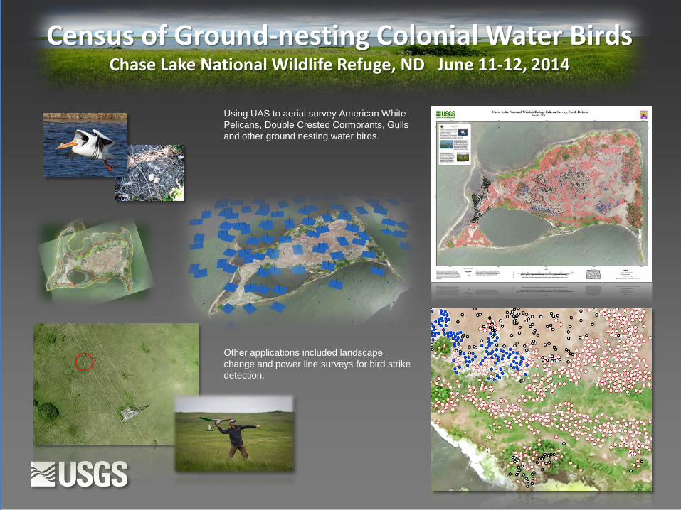
Census of Ground-nesting Colonial Water Birds Chase Lake National Wildlife Refuge, ND June 11-12, 2014
Using UAS to aerial survey American White Pelicans, Double Crested Cormorants, Gulls and other ground nesting water birds.
Other applications included landscape change and power line surveys for bird strike detection.
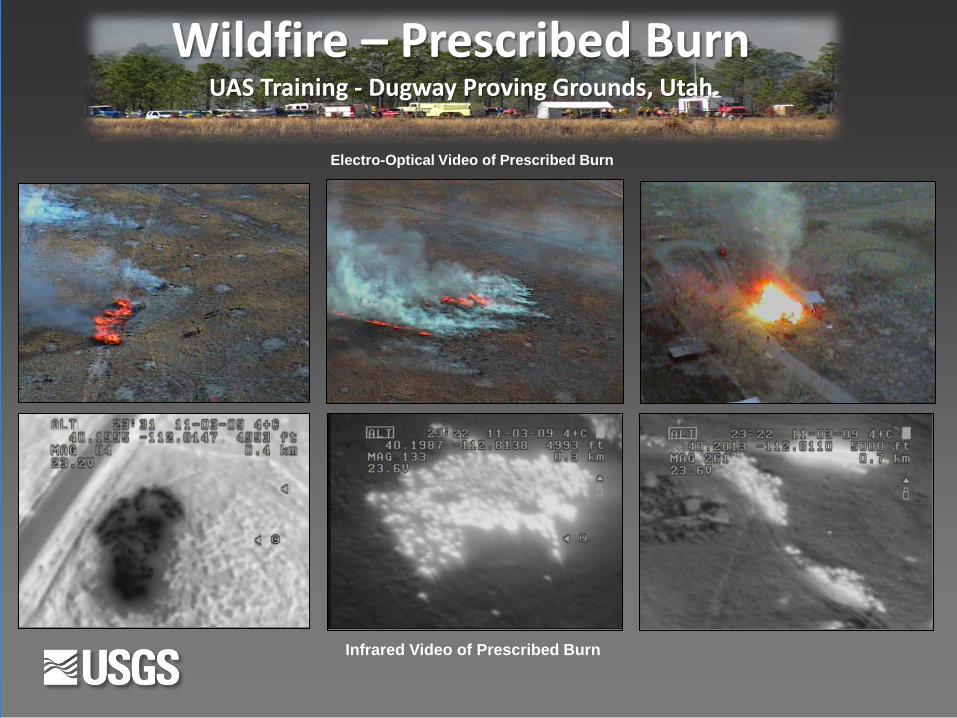
Infrared Video of Prescribed Burn
Electro-Optical Video of Prescribed Burn
Wildfire – Prescribed Burn UAS Training - Dugway Proving Grounds, Utah
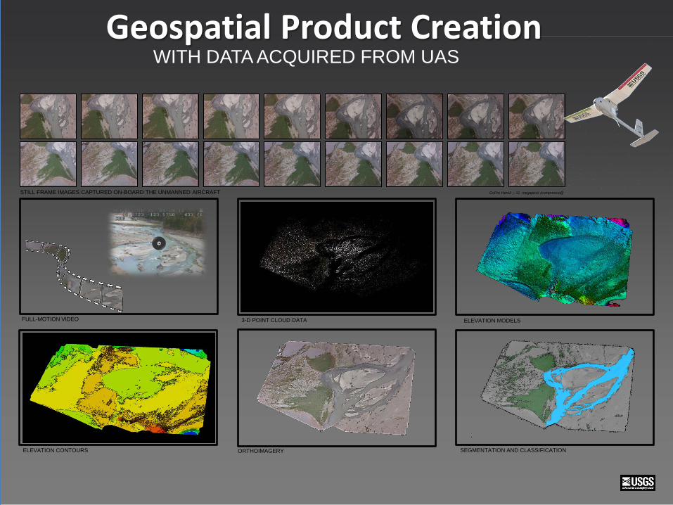
STILL FRAME IMAGES CAPTURED ON-BOARD THE UNMANNED AIRCRAFT GoPro Hero2 – 11 megapixel (compressed)
ORTHOIMAGERY ELEVATION CONTOURS
3-D POINT CLOUD DATA ELEVATION MODELS FULL-MOTION VIDEO
SEGMENTATION AND CLASSIFICATION
WITH DATA ACQUIRED FROM UAS Geospatial Product Creation

2011 NAIP 2013 UAS CIR 2013 UAS NDVI
UAS Color Infrared
1.5 inch ground sample distance from 400 feet above ground level
1.5”
1.5”
100 ft 200 ft 300 ft 400 ft
Canon Powershot SX260 and S100
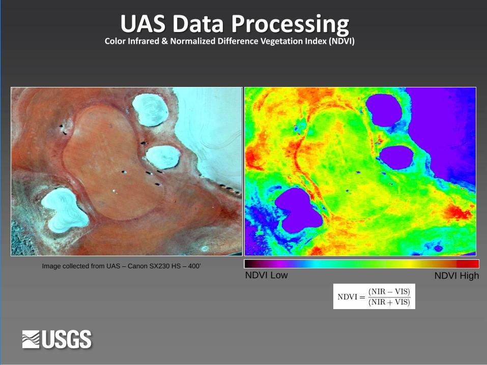
NDVI Low NDVI High
NDVI Low NDVI High
Color Infrared & Normalized Difference Vegetation Index (NDVI)
UAS Data Processing
Image collected from UAS – Canon SX230 HS – 400’
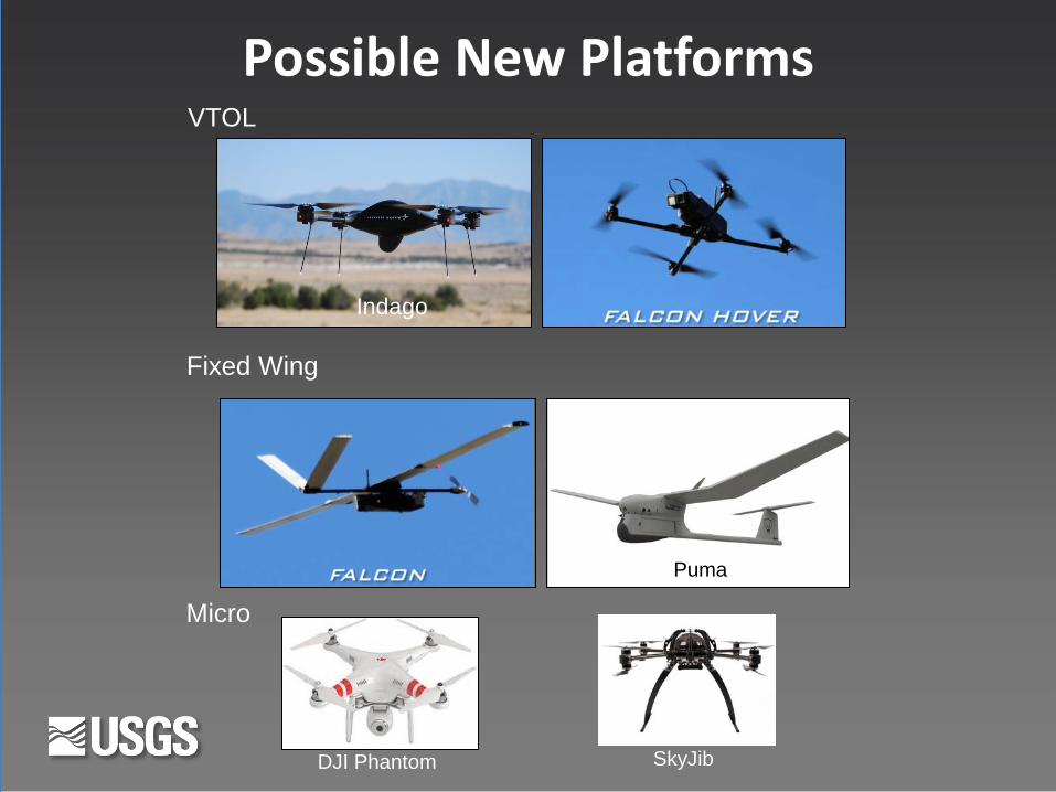
Possible New Platforms VTOL
Fixed Wing
Micro
Indago
DJI Phantom
Puma
SkyJib
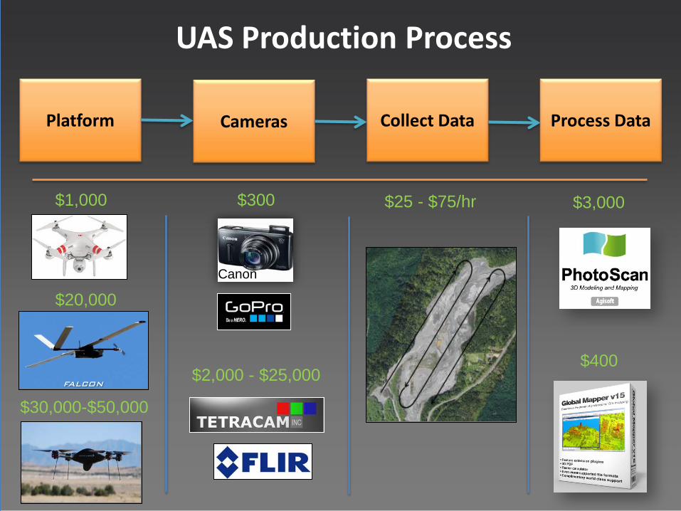
UAS Production Process
Platform Cameras Collect Data Process Data
$1,000 $300 $25 - $75/hr $3,000
$30,000-$50,000
$2,000 - $25,000 $400
$20,000 Canon
Future • Updated RoadMap (Published Open File Report)
• New, better, more versatile, lower cost UAS platforms
• Work on airworthiness standards acceptable to FAA and OAS
• Working with Universities to stay up on latest technology
• Would like a DOI contract mechanism for tapping other UAS technology
• Continue to support proof-of-concept missions
• Continually looking at new sensors
• More emphasis on the end data products vs. the platforms

USGS UAS National Project Office Contacts
uas.usgs.gov