futures dynamic simulation of forest management normative
TRANSCRIPT

HAL Id hal-01362857httpshal-univ-tlse2archives-ouvertesfrhal-01362857
Submitted on 12 Sep 2016
HAL is a multi-disciplinary open accessarchive for the deposit and dissemination of sci-entific research documents whether they are pub-lished or not The documents may come fromteaching and research institutions in France orabroad or from public or private research centers
Lrsquoarchive ouverte pluridisciplinaire HAL estdestineacutee au deacutepocirct et agrave la diffusion de documentsscientifiques de niveau recherche publieacutes ou noneacutemanant des eacutetablissements drsquoenseignement et derecherche franccedilais ou eacutetrangers des laboratoirespublics ou priveacutes
Dynamic simulation of forest management normativescenarios the case of timber plantations in the southern
ChileNicolas Maestripieri Thomas Houet Martin Paegelow Gilles Selleron Dario
Toro Balbontin Nicolas Saez Villalobos
To cite this versionNicolas Maestripieri Thomas Houet Martin Paegelow Gilles Selleron Dario Toro Balbontin et alDynamic simulation of forest management normative scenarios the case of timber plantations in thesouthern Chile Futures Elsevier 2015 101016jfutures201510013 hal-01362857
1
FUTURES
Dynamic simulation of forest management normative scenarios the case of timber
plantations in the southern Chile
Nicolas MAESTRIPIERI Thomas HOUET Martin PAEGELOW Gilles
SELLERON Dario TORO BALBONTIN Nicolas SAEZ VILLALOBOS 5
Laboratoire GEODE
CNCR Chili
Universidad de los Lagos Chili
Abstract
Accounting for spatial issues (spatially explicit simulation geographical amenities and advantages of land use 10
and cover changes etc) to build prospective scenarios is a crucial issue for better assessment of possible impacts
on the environment Such spatialized scenarios and their implications allow societies to reduce the uncertainty of
the future by exploring various strategies for land use changes Despite the wide diversity in existing scenario-
building techniques two different approaches can be distinguished (exploratory vs normative) for their
methodological implications The originality in this study comes from the use of a relevant exploratory 15
(dynamic) approach to map normative scenarios which in most cases are represented throughout the
combination of narratives and synchronic land use and cover maps The objective of the article is to apply this
dynamic exploratory simulation approach to spatialize normative scenarios within the framework of forest
management in southern Chile In the results two contrasting images of the future are compared with the
preservation of native forests on one hand and the spread of exotic timber plantations on the other 20
Keywords
Modeling normative scenarios exploratory approach multicriteria evaluation southern Chile
2
25
1 Introduction
The promulgation of Decree Law 701 (DL 701) under the military government of Augusto Pinochet has
caused profound land use and cover changes in southern Chile The main one concerns the increase in large-30
scale pine (Pinus radiata) and eucalyptus (Eucalyptus globulus) plantations on cleared land but also on areas of
second growth native forests (Armesto et al 2010) From 1975 to 2007 more than 95 000 ha per year of forest
were planted (afforested and reforested) nationally reaching 22 million ha in 2007 (INFOR 2008) The initial
goal was to both protect eroded soil and to encourage the landowners to forest their land DL 701 turned out to
be a major driving force in intensive forestry practices oriented towards the international pulp market 35
Environmental and socio-economic impacts of intensive forestry in southern Chile are well known in the
scientific community They include poverty and the expulsion of the indigenous population (the Mapuche
meaning ―people of the land) (Lara 1985 Leyton Vasquez 2009) a loss of biodiversity (Donoso Otero 2005)
and soil and water acidification (Cannell 1999) The conversion of native forest into timber plantations remains
the most important threat in this highly recognized eco-region (Cavelier Tecklin 2005 Echeverria et al 2006 40
Altamirano Lara 2010)
However some uncertainties remain regarding the regionrsquos future ie future land use and cover
changes (LUCC) and their impacts Decision making whether in private lives or public affairs depends on our
degree of knowledge and the level of confidence we have in this knowledge (Sigel et al 2010) This state of
mind reflects the extent of uncertainty that people or societies have and can use a posteriori to face 45
environmental and socio-economic issues (LUCC silvicultural yields climate hazards economic crises etc)
Uncertainty leads a society to project its plans into the future and to find points of reference in order to better
control the present and to optimize its choicesstrategies for the future Thus apprehension of differing possible
futures (Phdungsilp 2011) plausible (Wilkinson 2009 Amer et al 2013) or undesirable ones (Godet 2010)
makes it possible to deal with uncertain events (extreme or not) to the extent that each future may be 50
accompanied by targeted adaptation measures
Scenario-building methods have been generalized across the world in order to confront complex and
uncertain phenomena The method and the prospective for scenarios are closely linked to environmental and
3
socio-political issues Scenario approaches are used to guide land use policies to anticipate the impact of city
development and urban planning (Phdungsilp 2011) and land use change (Ontildeate-Valdivieso and Bosque Sandra 55
2010 Moraacuten-Ordoacutentildeez et al 2011) or to assess the international environment (Zurek and Henrichs 2007) La
prospective (Godet 1986 Hatem 1993 Roubelat 1994) highlights environmental and socio-economic issues at
multiple scales The future is a policy ―space exploratory or normative built by and for individuals (or groups
of individuals) However though scenarios can be applied at diverse spatial scales they cannot simulate and
localize the processes involved Therefore the geacuteoprospective (Gourmelon et al 2012 Voiron-Canicio 2012 60
Houet and Gourmelon 2014) offers societies a means to organize and cope with complex and dynamic
environments The use of spatially explicit models is essential in the projection and exploration of alternative
future scenarios (Mas et al 2011) Four models are usually used in the quantification and spatial allocation of
future LUCC IDRISI CA_MARKOV CLUE-SDyna-CLUE DINAMICA EGO and Land Change Modeler
(Mas et al 2014) 65
The aim of this paper is to demonstrate the relevance and performance of a dynamic and spatially
explicit model based on an exploratory time path in order to simulate normative prospective scenarios (unlike a
standard synchronic approach) Some studies have attempted to adapt this approach For instance PRELUDE
(Prospective Environmental analysis of Land Use Development in Europe) has adopted it with the specific aim 70
of constructing qualitative spatially-explicit land-use change scenarios (stories) for Europe the scenarios are
quantified using spatially explicit data from land-use simulation models (European Environment Agency 2007)
The model makes use of trends which were calculated by fitting linear regression lines through the observed data
(Ewert et al 2005) Likewise ACCLIMAT (Adaptation au Changement CLIMatique de lrsquoAgglomeacuteration
Toulousaine) (Masson et al 2014) presents a systemic modeling approach to urban expansion by extrapolating 75
past tendencies
The model combines a Markovian procedure (Markovian probability maps) and a multicriteria
evaluation (MCE) approach for the spatial allocation of future LUCC Beyond the methodological aspects the
aim is to raise the awareness of citizens politicians and forestry stakeholders through a reflective model (as 80
opposed to a decision-making model) This model gives the opportunity to easily project and map trends and
normative (desirable or undesirable) scenarios to better understand the future forest cover changes and related
impacts of current decision making
4
2 Materials and methods 85
21 Study area and context
The municipality of San Juan de la Costa is located in the northwest of the 10th
Lake Region (73deg47rsquondash
73deg18rsquoW and 40deg14rsquondash40deg44rsquoS) in the province of Osorno in southern Chile (Fig 1) Even if the rate of 90
afforestation with exotic species (Pinus radiata DDon and Eucalyptus globulus Labill) is considerably lower
than those measured in the 8th
and 9th
Regions the ecological equilibrium is threatened Indeed more than 70
of the municipalityrsquos area is covered by native forest (Nothofagus pumilio Nothofagus dobeyi Fitzroya
cupressoides) The Valdivian Rainforest Ecoregion (35degSndash48degS) is among the highest priority ecosystems for
conservation worldwide due to its rich diversity degree of endemism and critical conservation status 95
(Nahuelhual et al 2007) Another major problem is that of land tenure since the 90rsquos lands have been
accumulated and concentrated in the hands of major landowners and forest companies The forestry sector is
dominated by four companies Forestal Tornagaleones SA (Nueva Group) Forestal Anchile Ltda (Daio Paper
Corporation) Forestal Valdivia SA and the Forestal Los Lagos SA (Angelini Group) Together these
companies hold 14 000 ha while 880 small landowners live on 7 430 ha of fragmented lands 100
The land tenure issue the lack of territorial development strategies in San Juan de la Costa and the
support for afforestation through DL 701 affect the living conditions of the small landowners and Mapuche
communities The municipality is described as one of the poorest in Chile with the countryrsquos lowest Human
Development Index (HDI) in 2003 (0510) (PNUD 2004)
105
5
Fig 1 Municipality of San Juan de la Costa (10th
Lake Region - Chile)
22 Methodological approach
110
221 Land use and cover changes (LUCC) processes and driving factors
The monitoring of timber plantations and native forests at multiple scales is essential to a better
understanding of the forest industry in southern Chile Even if scenarios are constructed on a communal scale it
is necessary to relocate these local dynamics within the trends of a regional and national context Medium 115
(MODIS) (Paegelow et al 2012) and high (LANDSAT) (Selleron 2001 Maestripieri and Paegelow 2013)
resolution satellite imagery have been used for this Indeed the broad patterns observed at a regional scale do not
highlight the multiplicity and complexity of variables which influence timber plantation dynamics (land tenure
topography soil quality land cover and road network) at the local level
The main results show a concentration of timber plantations to the west of the Pan-American Highway 120
and along the Pacific Ocean due to the presence of ports Monoculture expansion follows a north-south gradient
6
along the Pre-Costal Range (or Piedmont) with a high frequency of change (Echeverria et al 2006 Paegelow et
al 2012) In San Juan de la Costa plantations present the largest increase (+95) between 1986 and 2008
covering almost 10000 ha in 2008 (Maestripieri et al 2013) These dynamics are driven by multiple processes
and influenced by environmental social political economic and technical factors operating on multiple levels 125
These driving forces are identified and ranked through a systemic analysis coupled with participative interviews
Among other events the enactment of DL 701 in 1974 (and its updating in 1998) led to a boom in the forestry
sector due to the creation of support mechanisms and forestry insurance for small landowners From an
economic point of view the low profitability of the native forests as a marketable resource (Cruz and Schmidt
2007) afforestation costs property taxes and land ownership have always played an important role Indeed it 130
affects (directly or indirectly) the sale and or the rental of small and medium holdings by forest enterprises
222 Scenarios
Multiple scenario typologies exist giving rise to possible semantic confusion Numerous authors 135
(Bishop et al 2007 Stewart 2008) have confirmed this including van Notten et al (2003 p424) who stated
that ―one drawback of existing typologies is that their categorization of scenarios is rather broad Consequently
a variety of scenario types are often clustered within the same category One such type however the
explorative scenario (abductive inference) can be recognized due to the inferential base of its scenario
construction It begins with a given situation in the present and moves forward into the future responding to the 140
question ―What may happen if helliprdquo (Teixera et al 2009 Liu et al 2013) According Fabrice Hatem (1993 p
231) it allows us ―to highlight in a systematic way the most likely tendencies The normative scenario
(inductive inference) describes a probable or desirable (or undesirable) future and moves backward to the
present ie retrospectively It responds to the question ldquoHow can a specific target be reachedrdquo (Fig 2)
145
7
Inference
Scenario method
Present Future Present Future
Retrospective
Image of the future
GIS
Explorative
Image of the future
MCE
Abduction Induction
Explorative Normative
Hypothesis
Markovian chains and multicriteria
evaluation (MCE)
Path time
Spatial representation
methods
Explorative
Hypothesis Image of the future
FORECASTING BACKCASTING
Fig 2 Inference time path and spatial representation of prospective scenarios
Authorrsquos note Non-coupled models (independent) can only represent an exploratory dynamic approach (Mas et
al 2014)
150
In this study two normative and contrasting scenarios are presented each with strong disruptions and a
low degree of occurrence Each hypothesis is developed based on (i) ground-level knowledge of the Chilean
forestry sector (ii) participatory interviews with stakeholders (iii) expert analysis (iv) informal discussions and
rumors and (v) tempered imagination Spatial rendering is also based on this modeling approach Finally the
scenarios could only be built thanks to the stakeholdersrsquo involvement 155
Ecocentric normative scenario
The ecocentric normative scenario is one of conservation Forest production as it existed in 2008 is
finished An economic recession at the international and national level causes a decline in the forest sector 160
marked by a strong increase in forest product prices At Pricewaterhouse Coopersrsquo 22nd Annual Global Forest amp
Paper Industry Conference held in May 2009 in Vancouver a clear concern was expressed concerning the
international economic recession using terms such as ―economic tsunami ―pessimistic forecasts ―the dismal
year or ―survive the downturn (PwC 2009 Global Forest) The Chilean myth (Latin Americarsquos ―jaguar)
based on the neoliberal economic model cannot counter the devastating effects of the economic crisis Large 165
landowners such as timber companies sell their land which is redistributed among indigenous Mapuche people
(Indigenous Law Ndeg 19253 art 20 a) b) and c) page 19 (CONADI 2008) Forested areas with native species
8
are expanding throughout the municipality and for the most part are under sustainable management Only
fragments of exotic species plantations remain in the Piedmont In this scenario the time horizon is 2035 so as to
take into account the growth of native tree species (30 years for Nothofagus dombeyi) (Cubbage et al 2007) 170
Intensiverdquo normative scenario
In this scenario the forest sector is booming worldwide and the countryrsquos forest policy (DL 701)
encourages owners (both small owners and multinationals) to increase production The 10th
Lake Region has 175
seen the commissioning of the Coastal Road (Ruta Costera) and the construction of a new cellulose plant (Fig
3) This Coastal Road is a project that may according to the Ministry of Public Works (Ministerio de Obras
Publicas - MOP) generate significant benefits such as greater access to isolated areas reduction in travel time
and contributions to the development of tourism in the area Conversely the road encourages deforestation in the
Piedmont of the Coast Range (Maestripieri and Paegelow 2013) and plays a major role in the dynamics of 180
LUCC particularly the spread of monocultures Its absence is the reason why (i) native vegetation remains
relatively unexploited and is deteriorating and (ii) industrial plantations are not expanding in Coast Range areas
The expansion of plantations in this scenario is extremely great whereas native forest degradation is
systematic The time horizon is set for 2026 which corresponds to two rotation cycles of eucalyptus from the 185
last available date (2008)
9
Fig 3 Hypothetical implantation of cellulose plant in the 10th
Region
190
223 Mapping the scenarios
Normative scenarios are of inductive inference (non-demonstrative) they are narrative qualitative and
the spatial representation of the hypothesis is synchronic For instance Houet et al (2008) used a Geographic
Information System (GIS) to map a normative scenario According to the authors the GIS facilitates the transfer 195
of knowledge between stakeholders and managers Such tools can help to locate and represent land cover and
landscape pattern changes with multicriteria attributive andor spatial queries Therefore we use IDRISIrsquos
CA_MARKOV model which is based on an inductive pattern approach (Mas et al 2014) but in our study their
spatial representation responds to an abduction inference Both scenarios follow an exploratory spatial modeling
process (from present to future) while the assumptions of future LUCC are derived from a participatory approach 200
for the normative scenarios Trend assumptions are often derived from the model itself
CA-Markov is a predictive model (Houet and Hubert-Moy 2006 Paegelow et al 2015) combining
Markovian chain analysis multicriteria evaluation and spatial filtering techniques and is described as a cellular
10
automata procedure (CA) (Eastman 2006) Markovian chains analyze two land cover images at different times 205
and produce two transition matrices (probability and surface area in pixels for persistence and transition) and a
set of conditional probability images They are used to estimate a future state based on the observed past changes
(Antoni 2006) Estimated changes are allocated using the MCE procedure to estimate the probability maps of
the transitions from one land cover to another (Paegelow and Camacho Olmedo 2005) The model is calibrated
to the San Juan de la Costa study site using two supervised land cover classifications for 1986 (t0) and 1999 (t1) 210
and has been validated by comparing the 2008 simulation with an existing 2008 land cover map (t2) (Maestripieri
and Paegelow 2013)
Mapping scenario hypotheses depends on the MCE procedure and more specifically on the weight
attributed to each driving factor in the modeling The objective of the MCE is to generate suitability or 215
probability maps integrating a set of measurable and mappable criteria These maps can be used to develop
specific land use strategies The modeler controls the process by identifying and characterizing the driving forces
with an expert approach
224 Multicriteria evaluation technique 220
Eleven criteria divided into three groups are integrated within the multicriteria process The first group
(3 factors) represents socio-economic parameters (1) Distance from Road Network (DRoNet) ndash (2) Land Tenure
(LdTen) and (3) Distance from Coastal Road (DCoRo)1 The second group expresses environmental parameters
(6 factors) (4) Land Use (LU) ndash (5) Distance from Existing Land Cover features (DExLC) ndash (6) Altitude (ALT) 225
ndash (7) Slope (SLP) ndash (8) Coast Range (CoR) ndash and (9) Pre-Coast Range (Pre-CoR) Finally the last group is
formed by two constraining criteria (10) Urban Area (UA) ndash and (11) Hydrological Network (HydNet) A
constraint means that concerned land cannot be used for a land cover change objective while other factors
express variable land cover change suitabilities
230
Because each factor is expressed in its proper unit they must be standardized using fuzzy membership
functions to become comparable Standardization signifies the recoding of original values (degrees meters per
cent) to suitability values on a common scale from 0 (lowest suitability) to 255 (best suitability) (Paegelow and
1 This criterion is exclusively used in the intensive scenario
11
Camacho Olmedo 2005) Factors may be standardized by linear sigmoid j-shaped or empirical functions that
may be individually implemented to fit the relationship between original values and their related suitabilities 235
For instance in order to model the suitability values of plantations in our calibration model
(Maestripieri and Paegelow 2013) distance from road network (DRoNet) is standardized using a monotonically
decreasing sigmoidal function with two control points established at 260 m (min) and 2900 m (max) These
points are determined through retrospective analysis (between 1999 and 2008) using observed LUCC and their
driving forces This function is better than the j-shaped function because values reach 0 at 2900 meters (Fig 4) 240
Thus areas located near existing roads (from 0 to 260 m) have a value of 255 (here membership function is
equal to 1 which is to say that the probability of any change in LUCC is equal to 100) From 260 m to 2900
m the value decreases gradually from 255 to 0 (the membership function decreases gradually from 1 to 0) and
once beyond 2900 m is equal to 0
245
Fig 4 Standardization of distance from road network
The weighting factor is based on the technique of pairwise comparison within a context of decision
making called Analytical Hierarchy Process (AHP) (Saaty 1977) Each type of land cover (timber plantations 250
native forest and other) is an objective Weights reflect the importance of one factor over all others and they
control how each of these factors contributes to the land cover change allocation (Eastman 2006) The relative
weight of each factor is calculated by the eigenvalue method indicating the priority level for each element in the
hierarchy (Wolfslehner et al 2005) The pairwise comparison matrix (Tab 1) allows each pairwise comparison
to be rated Usually variables are ranked on a 9-point scale but we chose a 17-point scale in order to refine and 255
detail the comparison between factors Each cell represents the rating of the row factor relative to the column
factor (Eastman 2009) We discussed these values with the interviewees who determine the importance of
12
comparing one factor to another In addition we analyzed the interactions between changes observed (for
instance in native forest to timber plantation) and driving forces (land tenure proximity to road and so on)
(Maestripieri and Paegelow 2013) 260
LU LdTen CoR Pre-CoR DExLC DRoNet SLP ALT DCoRo
LU 1 LdTen 9 1 CoR 2 13 1 Pre-CoR 6 12 2 1 DExLC 6 13 3 12 1 DRoNet 3 14 2 1 12 1 SLP 12 13 12 12 13 13 1 ALT 14 17 12 14 14 13 13 1 DCoRo 5 12 3 2 3 2 3 3 1 Eigenvalue 004 027 006 014 013 010 005 003 019 Consistency ratio 008 (acceptable)
Tab 1 Pairwise comparison matrix ndash Intensive scenario (objective PLANTATION)
Finally an Ordered Weighted Averaging technique (OWA) is applied With this technique
compensation between factors and the level of risk-taking can be controlled thus providing control over the 265
degree of optimism (risk attitude) Attitude to risk ranges from 1 (no risk taken and no compensation between
factors) to 5 (maximum risk taken and no compensation) by way of average risk taken and total compensation
between factors (between AND and OR Boolean) (Fig 5) The weighting is applied differently to each pixel
according to the classification of skills the lowest (1st row) to the highest (last row) (Paegelow and Camacho
Olmedo 2005) For a more detailed procedure of multicriteria evaluation and OWA see Gemitzi et al (2007) 270
13
Fig 5 Decision strategy space
3 Results 275
31 Exploratory approach
311 Ecocentric normative scenario
280
This scenario (Fig 6) excludes the creation of new exotic plantations and expects existing plantations to
be reforested after clearcutting The lowest suitability value (0) was therefore assigned to pixels corresponding to
land owned by forestry companies A very low suitability (20) was assigned to small and medium landowners
and a rather low suitability (75) to big landowners
285
The pessimistic strategy is chosen for the stated objective PLANTATION (ndeg2 ndash Fig 5) (Tab 2 and
3) An area of 5400 ha is allocated to plantations in 2035 Native forest does not change within big and very big
(forestry companies) properties but change can occur in small and medium properties (suitability 255) The
objective NATIVE FOREST opts for optimistic strategy (ndeg4) by giving greater order weight to the pixels
having a value of high suitability such as properties and distance from existing native forests Finally the 290
objective OTHER incorporates the land tenure and gives a high suitability for forestry companies to promote the
emergence of non-forested areas Strategy ndeg4 is applied to give greater weight to the land tenure factor
LU LU CoR Pre-CoR DExLC DRoNet SLP ALT
LU 1
LdTen 7 1
CoR ⅓ 17 1
Pre-CoR ⅓ 17 2 1
DExLC ⅓ 16 4 frac12 1
DRoNet frac12 16 3 2 2 1
SLP ⅓ 16 2 ⅓ 2 frac12 1
ALT frac14 17 ⅓ frac14 frac12 frac12 ⅓ 1
Eigenvalue 01504 04577 00430 00896 00627 00999 00656 00312
Consistency ratio 008 (acceptable)
Tab 2 Pairwise comparison matrix ndash Ecocentric scenario (objective PLANTATION)
295
14
Order Weight 04 025 015 01 006 003 001 0
Rank 1st 2nd 3rd 4th 5th 6th 7th 8th
Tab 3 Order weight assignment ndash Ecocentric scenario (objective PLANTATION) ndash
Low level of risk low trade off
300
Fig 6 Land cover in 2008 (left) and preservation normative scenario in 2035 (right)
312 Intensive normative scenario
In this scenario (Fig 7) the stated objective PLANTATION gives a maximum suitability for all types of 305
properties (LdTen) and opts for the optimistic strategy (ndeg4) giving order weight to the pixels having a value of
very high suitability The determination of the surface area is based on the average annual rate of afforestation
and reforestation between 1999 and 2008 (998 per year) This variation allows projection of their area 18
years later (54973 ha in 2026)
310
The same operation is performed by integrating the factor Coastal Road (DCoRo) in the model and
assigning a high order weight For instance Land Tenure (LdTen) has an eigenvector of 027 while Costal Road
has 019 (Tab 1 and 4) The objective NATIVE FOREST assigns a lower suitability to the land use other
reducing the likelihood of seeing native forest
15
315
Order Weight 0 001 003 005 007 009 015 025 035
Rank 1st 2nd 3rd 4th 5th 6th 7th 8th 9th
Tab 4 Order weight assignment ndash Intensive scenario (objective PLANTATION) ndash
High level of risk low trade off
320
Fig 7 Land cover in 2008 (left) and intensive normative scenario in 2026 (right)
32 Scenarios analysis and comparison
The ―ecocentric scenario shows the expansion of native forest in the foothills of the Coast Range (to 325
the east) and replaces mainly areas categorized as other (+19824 ha) (Fig 8) Some of the exotic plantations
are replaced by native species (-2855 ha) and others LUC (-1633 ha) After having recovered their lands the
autochthonous communities systematically reforested their parcels with native species and have implemented a
sustainable management policy in order to develop the value of forest resources
Inversely the intensive scenario offers a perfect demonstration of the invasion of timber plantations in 330
the Coast Range foothills leaving few lands unforested (Fig 9) The major change is a conversion of both native
forest and other LUC to timber plantation (22039 ha and 23045 ha respectively) The construction of the
Coastal Road located on the west side of the municipality reinforces the existing road network and improves
16
accessibility to surrounding lands for timber companies a process that generates the development of large timber
plantations within the Coast Range (+3000 ha) This scenario highlights the environmental (habitat 335
fragmentation) and social (Mapuche territory) damages that can be caused
The factor ―Land Tenure is decisive in both scenarios Alone the land-tenure factor alone does not
explain all forest dynamics yet it carries a decisive weight In southern Chile landowners are in a situation of
oligopsony which is to say that they are totally dependent on the demand by a small number of processing
industries owned by large forest groups In addition due to market conditions (competitiveness increase in land 340
prices etc) small landowners have to sell or rent their land Thus due to capitalization and land concentration
five very large landowners share 14201 ha while 880 small landowners live on 7430 hectares of fragmented
lands The land-tenure variable thus allows the spatial representation of the emergence of new industrial
plantations in the future (sale spatial dynamics)
Available digital data indicate a concentration of lands in the coastal foothills which influences the 345
spatial allocation of native forest and plantations in this area Conversely the Coast Range is very weakly
affected by this variable but depends heavily on the development of new transportation infrastructure
Fig 8 LUCC between 2008 and 2035 (ecocentric scenario) 350
17
Fig 9 LUCC between 2008 and 2035 (intensive scenario)
4 Discussion and conclusion 355
41 Modeling recommendations
The simulated maps provide a better image of the assumptions presented in each scenario yet several
limitations have been identified Implementation of an exploratory approach to spatialize a normative scenario 360
does not affect its relevance However it may be legitimate to consider these scenarios as exploratory in an
extreme situation that does not break away from past trends According to Boumlrjeson et al (2006) a marginal
adjustment in a current development is insufficient and a trend break is necessary to reach the target In this
sense the exploratory approach is limited because the modeler is dependent on the ability of the model to vary
the simulation parameters (for eg rotation cycles and deforestation in real time) 365
We have seen that multicriteria evaluation enables factors to be weighted in order to integrate
hypotheses but especially to approach a desired image as closely as possible Moreover when compared to other
methods this approach encourages the participation of stakeholders and provides a great flexibility in modeling
For instance with Land Change Modeler (LCM) the user introduces relevant drivers while the type and strength 370
of the LUCCs are determined with a multilayer perceptron which is an automatic machine learning algorithm
18
(Paegelow et al 2015) Even if LCM can update variables at each simulation step this neuronal network
excludes the stakeholders and does furnish sufficient flexibility when weighing different factors
The image of the ecocentric scenario forest cover projected for 2035 clearly provides a learning
experience though it does not completely break with the land usecover logic observed in 2008 The conception 375
of normative scenarios is not a problem yet its spatial rendering still depends on the available data and the
performance of the model used
This approach can therefore be seen as a combination of a qualitative and narrative-based normative
approach for the building of scenarios and also of the exploratory approach to account for various hypotheses
and to map the scenario The model fulfills our expectations because it can spatially represent normative 380
scenarios
In a prospective approach the choice of model is an important step (Mas et al 2014) and should take
into account several criteria Thus after developing the image of a desired future and having presented the
different assumptions the modeler must be sure to have an available and complete database that will ensure the 385
spatial representation of each assumption stated
During the simulation process the model must be developed to break with the land usecover observed
at the last known date in order to differentiate itself from contrasting exploratory scenarios This implies a real
time intervention in the simulation process to modify the parameters In addition it is important to incorporate
new or updated variables (for eg cadastral parcels) at key moments of the simulation and which have been 390
predetermined
42 Conservation implications
In southern Chile the conservation implications of this study are highly significant for forest 395
management The Valdivian forests in Chile (and in Argentina) are the only temperate rainforests in South
America and are part of the 25 biodiversity hotspots for conservation priorities (Myers Mittermeier et al 2000)
Even though we can observe and quantify pressures on the native forest in San Juan de la Costa the heritage of
this forest will remain a faunistic and floristic ecological continuum for at least 30 years However
fragmentation and forest degradation may have a strong impact on ―the flora and fauna existing in the remnant 400
19
forests due to change in composition of assemblage and change in ecological processes (Echeverria et al
2006)
Decree Law 701 has promoted the expansion of timber plantations particularly amongst big landowners
and to a very small extent amongst small and medium landowners Gonzaacutelez (2008) states that it is an
interpretative element from a combination of several variables such as economic incentives trade and sectoral 405
policies and stabilization policies The reasons and these sales are many belong to both the problem of
unproductive soil marked by crop rotation (Cruz and Schmidt 2007) and the inability of small land owners
(pine and eucalyptus plantations) to earn profits from their crops
Policy issues regarding land tenure will have to be dealt with in the short and medium terms The
Chilean government seeks to develop and optimize the forest sector on a regional (South American) and 410
international scale but must take into account the rights of indigenous peoples (Indigenous and Tribal
Peoples Convention 169) Indeed the conditions of the Mapuche as a socio-economic and cultural group are
threatened by this capitalization and accumulation of land that is taking place to their detriment
These models too must be seen as a tool for reflection and debate and not a turnkey solution Spatial
evaluation of normative and contrasting scenarios shows a strong interest in the anticipation of future LUCC 415
They highlight the areas that require conservation priorities in order to maintain a strong ecological connectivity
We maintain that policy debate and ―projects of long-term conservation and short-term sustainable
forest production should be undertaken in agreement with local stakeholders (small landowners and indigenous
communities) According to Donato Bergandi (2014) ―heedless of philosophical-political references an
international politico-economical oligarchic caste is largely united around dealing with environmental issues 420
based on the sustainable development model which is an expression of a utilitarian anthropocentric
perspective Therefore it is essential to force the political class to reconnect with a bottom-up approach rather
than a top-down approach Programs of biodiversity conservation have emerged in the 10th
Lake Region such as
the Private Protected Area Program (Aacutereas Protegidas Privadas) focused on the protection of natural areas the
conservation of biodiversity and the enjoyment of nature (Sepuacutelveda Villarroel et al 2006) 425
Acknowledgments
20
The authors acknowledge with gratitude the ECOS-Sud Chile project ndeg C07H03 entitled
La forecirct de la cordillegravere cocirctiegravere continentale dans le sud du Chili Dynamiques contemporaines et modeacutelisations 430
prospectives We wish to thank the reviewers for their constructive comments and John Olsen for his help in
translation
References
435
Altamirano A Lara A 2010 Deforestacioacuten en ecosistemas templados de la precordillera andina del centro-sur
de Chile Revista Bosque 31 53-64 httpdxdoiorg104067S0717-92002010000100007
Amer M Daim TU Jetter A 2013 A review of scenario planning Futures 46 23-40
httpdxdoiorg101016jfutures201210003 440
Antoni J-P 2006 Calibrer un modegravele drsquoeacutevolution de lrsquooccupation du sol urbain Lrsquoexemple de Belfort
Cybergeo European Journal of Geography Systegravemes Modeacutelisation Geacuteostatistiques article 347
httpcybergeorevuesorg2436
445
Armesto JJ Manuschevich D Mora A Smith-Ramirez Rozzi R Abarzuacutea AM Marquet PA 2010
From the Holocene to the Anthropocene A historical framework for land cover change in southwestern South
America in the past 15000 years Land Use Policy 27 148-160
httpdxdoiorg101016jlandusepol200907006
450
Batty M Torrens PM 2005 Modelling and prediction in a complex world Futures 37 745ndash766
httpdxdoiorg101016jfutures200411003
Bishop P Hines A Collins T 2007 The current state of scenario development an overview of techniques
Foresight 9 5-25 httpdxdoiorg10110814636680710727516 455
Blecic I Cecchini A 2008 Design beyond complexity Possible futuresmdashPrediction or design (and
techniques and tools to make it possible) Futures 40 537ndash551 httpdxdoiorg101016jfutures200711004
21
Boumlrjeson L Houmljer M Dreborg K-H Ekvall T Finnveden G 2006 Scenario types and techniques Towards 460
a users guide Futures 38 723-739 httpdxdoiorg101016jfutures200512002
Cannell MGR 1999 Environmental impacts of forest monocultures water use acidification wildlife
conservation and carbon storage New Forests 17 239ndash262 DOI 101023A1006551018221
465
Catellin S 2004 Labduction Une pratique de la deacutecouverte scientifique et litteacuteraire Critique de la raison
numeacuterique HERMEgraveS ndeg39 CNRS Editions Paris 179-184
Cavelier J Tecklin D 2005 Conservacioacuten de la Cordillera de la Costa un desafiacuteo urgente en la Ecorregioacuten
Valdiviana in Smith-Ramiacuterez C Armesto JJ Valdovinos C (Eds) Historia biodiversidad y ecologiacutea de los 470
bosques costeros de Chile Edicioacuten Universitaria Bosque Nativo Santiago de Chile pp 632-644
CONADI 2008 Ley Indiacutegena Ndeg 19253 Establece Normas Sobre Proteccioacuten Fomento y Desarrollo de los
Indiacutegenas y Crea la Corporacioacuten Nacional de Desarrollo Indiacutegena Temuco 49 p
475
Cruz G Schmidt H 2007 Silvicultura en bosques nativos in Hernandez PJ Luz De la Maza CA (Eds)
Biodiversidad Manejo y conservacioacuten de recursos forestales Edicioacuten Universitaria Santiago de Chile pp 279-
307
Cubbage F Mac Donagh P Sawinski Juacutenior J Rubilar R Donoso P Ferreira A Hoeflich V Morales 480
Olmos V Ferreira G Balmelli G Siry J Baacuteez MN Alvarez J 2007 Timber investment returns for
selected plantations and native forests in South America and the Southern United States New Forests 33 237-
255 DOI 101007s11056-006-9025-4
Eastman JR 2006 IDRISI Andes Guide to GIS and Image Processing Clark University Worcester 485
Eastman JR 2009 The Land Change Modeler for Ecological Sustainability IDRISI Andes Guide to GIS and
Image Processing Worcester
22
Echeverria C Coomes D Salas J Rey-Benayas JM Lara A Newton A 2006 Rapid deforestation and 490
fragmentation of Chilean Temperate Forests Biological Conservation 130 481-494
httpdxdoiorg101016jbiocon200601017
European Environment Agency 2000 Scenarios as tools for international environmental assessments
Environmental issue report ndeg 24 31 p 495
European Environment Agency 2007 Land-use scenarios for Europe qualitative and quantitative analysis on a
European scale EEA Technical report Copenhagen
Ewert F Rousevell MDA Reginster I Metzger MJ Leemans R 2005 Future scenarios of European 500
agricultural land use I Estimating changes in crop productivity Agriculture Ecosystems and Environment 107
101-116 httpdxdoiorg101016jagee200412003
Gemitzi A Tsihrintzis VA Voudrias E Petalas C Stravodimos G 2007 Combining geographic
information system multicriteria evaluation techniques and fuzzy logic in siting MSW landfills Environ Geol 505
51 797-811 DOI 101007s00254-006-0359-1
Godet M 1986 Introduction agrave la Prospective Seven key ideas and one scenario method Futures 18 134-157
httpdxdoiorg1010160016-3287(86)90094-7
510
Godet M 1992 De lanticipation agrave laction Dunod Paris
Godet M 1993 Anticipation and scenarios are not synonymous Futures 25 350-351
httpdxdoiorg1010160016-3287(93)90143-H
515
Godet M 2010 Future memories Technological Forecasting amp Social Change 77 1457-1463
httpdxdoiorg101016jtechfore201006008
23
Gourmelon F Houet T Voiron-Canicio C Joliveau T 2012 La geacuteoprospective Points de vue conceptuels
et applicatifs de lrsquoapport du spatial agrave la prospective LrsquoEspace Geacuteographique 2 97-98 520
Hatem F 1993 La Prospective Pratiques et Meacutethodes Economica Gestion Paris
Houet T Hubert-Moy L 2006 Modelling and projecting land-use and land-cover changes with a cellular
automaton considering landscape trajectories an improvement for simulation of plausible future states In 525
EARSeL eProceedings ndeg5 63-76
Houet T Hubert-Moy L Tissot C 2008 Modeacutelisation prospective spatialiseacutee agrave lrsquoeacutechelle locale approche
meacutethodologique Revue Internationale de Geacuteomatique 18 345-373
530
Houet T Gourmelon F 2014 La geacuteoprospective ndash Apport de la dimension spatiale aux approches
prospectives Cybergeacuteo European Journal of Geography httpcybergeorevuesorg26194
INFOR 2008 Anuario Forestal 2008 Centro de Informacioacuten Forestal (CIF) 169 p
535
Lara A 1985Los ecosistemas forestales en el desarrollo de Chile Comiteacute Nacional pro Defensa de la Fauna y
Flora (CODEFF) 17 p
Leyton Vasquez JI 2009 Tenencia forestal en Chile FAO 37 p
540
Liu Y Goodrick SL Stanturf JA 2013 Future US wildfire potential trends projected using a dynamically
downscaled climate change scenario Forest Ecology and Management 294 120-135
httpdxdoiorg101016jforeco201206049
Maestripieri N Paegelow M 2013 Validation spatiale de deux modegraveles de simulation lrsquoexemple des 545
plantations industrielles au Chili Cybergeacuteo European Journal of Geography httpcybergeorevuesorg26042
24
Makropoulos CK Butler D 2006 Spatial ordered weighted averaging incorporating spatially variable
attitude towards risk in spatial multi-criteria decision-making Environmental Modelling amp Software 21 69-84
httpdxdoiorg101016jenvsoft200410010 550
Mas JF Puig H Palacio JL Sosa-Loacutepez A 2004 Modelling deforestation using GIS and artificial neural
networks Environmental Modelling amp Software 19 461ndash471 httpdxdoiorg101016S1364-8152(03)00161-
0
555
Mas JF Kolb M Houet T Paegelow M Camacho Olmedo M 2011 Eacuteclairer le choix des outils de
simulation des changements des modes drsquooccupation et drsquousages des sols Une approche comparative Revue
Internationale de Geacuteomatique 21 405-430 httpdoi103166rig15405-430
Mas JF Kolb M Paegelow M Camacho Olmedo MT Houet T 2014 Modelling Land use cover 560
changes a comparison of conceptual approaches and softwares Environmental Modelling and Software 51 94-
111 httpdxdoiorg101016jenvsoft201309010
Masini EB Meacutedina Vasquez J 2000 Scenarios as Seen from a Human and Social Perspective Technological
Forecasting and Social Change 65 49ndash66 httpdxdoiorg101016S0040-1625(99)00127-4 565
Masson V Marchadier C Adolphe L Aguejdad R Avner P Bonhomme M Bretagne G Briottet X
Bueno B de Munck C Doukari O Hallegatte S Hidalgo J Houet T Le Bras J Lemonsu A Long N
Moine MP Morel T Nolorgues L Pigeon G Salagnac J-L Viguieacute V Zibouche K 2014 Adapting
cities to climate change A systemic modelling approach Urban Climate 10 407ndash429 570
httpdxdoiorg101016juclim201403004
Medina Vaacutesquez J Ortegoacuten E 2006 Manual de prospectiva y decisioacuten estrateacutegica bases teoacutericas e
instrumentos para Ameacuterica Latina y el Caribe CEPAL Santiago
575
25
Moraacuten-Ordoacutentildeez A Suaacuterez-Seoane S Calvo L de Luis E 2011 Using predictive models as a spatially
explicit support tool for managing cultural landscapes Applied Geography 31 839-848
httpdxdoiorg101016japgeog201009002
Myers N Mittermeier RA Mittermeier CG da Fonseca GAB Kent J 2000 Biodiversity hotspots for 580
conservation priorities Nature 403 853-858
Nahuelhual L Donoso P Lara A Nuacutentildeez D Oyarzuacuten C Neira E 2007 Valuing ecosystem services of
chilean temperate rainsforests Environment Development and Sustainability 9 481-499
DOI 101007s10668-006-9033-8 585
Ontildeate-Valdivieso F Bosque Sendra J 2010 Application of GIS and remote sensing techniques in generation
of land use scenarios for hydrological modeling Journal of Hydrology 395 256-263
httpdxdoiorg101016jjhydrol201010033
590
Paegelow M Camacho Olmedo MT 2005 Possibilities and limits of prospective GIS land cover
modellingmdasha compared case study Garrotxes (France) and Alta Alpujarra Granadina (Spain) International
Journal of Geographical Information Science 19 697-722 DOI 10108013658810500076443
Paegelow M Maestripieri N Saacuteez Villalobos N Toro Balbotiacuten D 2012 Deacutetection des plantations 595
forestiegraveres par imagerie satellite MODIS dans le Sud du Chili
httpmappemondemgmfrnum34articlesart12204html
Paegelow M Camacho Olmedo MT Mas JF Houet T 2015 Benchmarking of LUCC modelling tools by
various validation techniques and error analysis Cybergeo European Journal of Geography 600
httpcybergeorevuesorg26610
Phdungsilp A 2011 Futures studiesrsquo backcasting method used for strategic sustainable city planning Futures
43 707-714 httpdxdoiorg101016jfutures201105012
605
26
PNUD 2004 Las trayectorias del Desarrollo Humano en las comunas de Chile (1994-2003) Ndeg 11 Temas de
Desarrollo Humano Sustentable 150 p
PwC 2009 Global Forest Paper amp Packaging Industry Survey wwwpwccomfpp 36 p
610
Roubelat F 1994 La prospective aux Etats-Unis De la rigueur au divertissement Rapport technique 9 p
Saaty T 1977 A scaling method for priorities in hierarchical structures Journal of mathematical psychology
15 234-281 httpdxdoiorg1010160022-2496(77)90033-5
615
Selleron G 2001 Deforestacioacuten y reforestacioacuten de las laderas de la Regioacuten de Los Lagos de Chile por
teledeteccioacuten Revista LIDER 9 7 p
Sepuacutelveda C Villarroel P Letelier E Tacoacuten A Seeberg C 2006 Conservacioacuten en tierras privadas de la
Deacutecima Regioacuten la importancia de los pequentildeos y medianos propietarios in Catalaacuten R Wilken P Kandzior 620
A Tecklin D Burshel H (Eds) Bosques y comunidades del sur de Chile Editorial Universitaria Santiago de
Chile pp 163-176
Sigel K Klauer B Pahl-Wostl C 2010 Conceptualising uncertainty in environmental decision-making The
example of the EU water framework directive Ecological Economics 69 502ndash510 625
httpdxdoiorg101016jecolecon200911012
Stewart CC 2008 Integral scenarios Reframing theory building from practice Futures 40 160ndash172
httpdxdoiorg101016jfutures200711013
630
Teixeira AM Soares-Filho BS Freitas SR Metzger JP 2009 Modeling landscape dynamics in an
Atlantic Rainforest region Implications for conservation Forest Ecology and Management 257 1219-1230
httpdxdoiorg101016jforeco200810011
27
van Notten PWF Rotmans J 2003 An updated scenario typology Futures 35 423-443 635
httpdxdoiorg101016S0016-3287(02)00090-3
Verburg PH Kok K Pontius Jr RG Veldkamp A 2006 Modeling Land-Use and Land-Cover Change
Land-Use and Land-Cover Change Local Processes and Global Impacts Springer New YorkBerlin
640
Voiron-Canicio C 2012 Lrsquoanticipation du changement en prospective et des changements spatiaux en
geacuteoprospective LEspace geacuteographique 2 99-110
Wilkinson A 2009 Scenarios Practices In Search of Theory Journal of Futures Studies 13 107-114
645
Wolfslehner B Vacik H Lexer MJ 2005 Application of the analytic network process in multi-criteria
analysis of sustainable forest management Forest Ecology and Management 207 157-170
httpdxdoiorg101016jforeco200410025
Zurek M Henrichs T 2007 Linking scenarios across geographical scales in international environmental 650
assessments Technological Forecasting amp Social Change 74 1282ndash1295
httpdxdoiorg101016jtechfore200611005
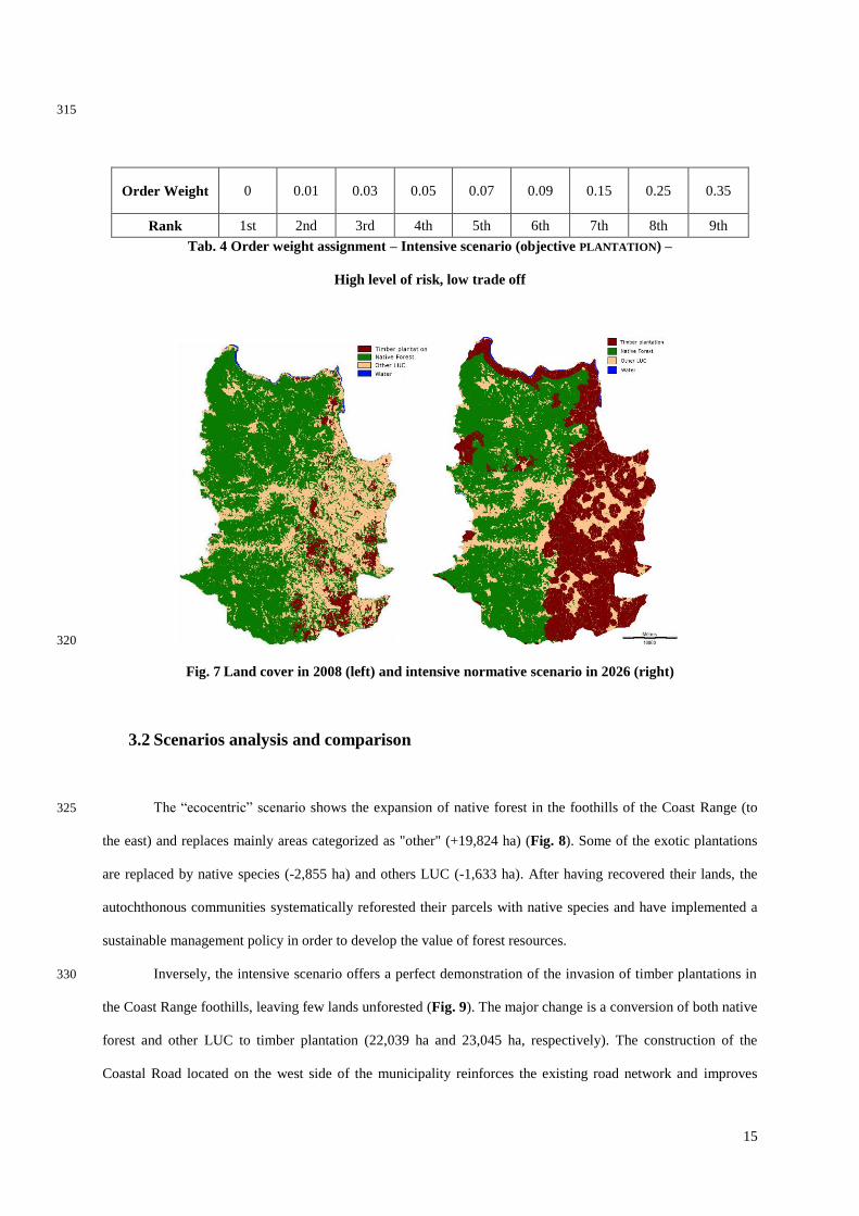