fy-4 satellite user readiness - €¦ · fy-4 satellite user readiness . national satellite...
TRANSCRIPT
FANG Xiang
National Satellite Meteorological Center, China Meteorological Administration
(NSMC/CMA)
FY-4 Satellite User Readiness
National Satellite Meteorological Center ,CMA
Outline
The current status of FY-4A
System upgrade
User preparation
Training activities
Summary
AOMSUC-7, Inchon, Korea Oct 24-28, 2016
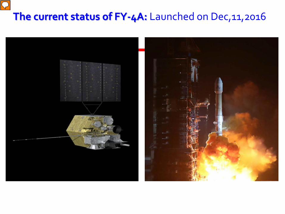
The current status of FY-4A: Launched on Dec,11,2016
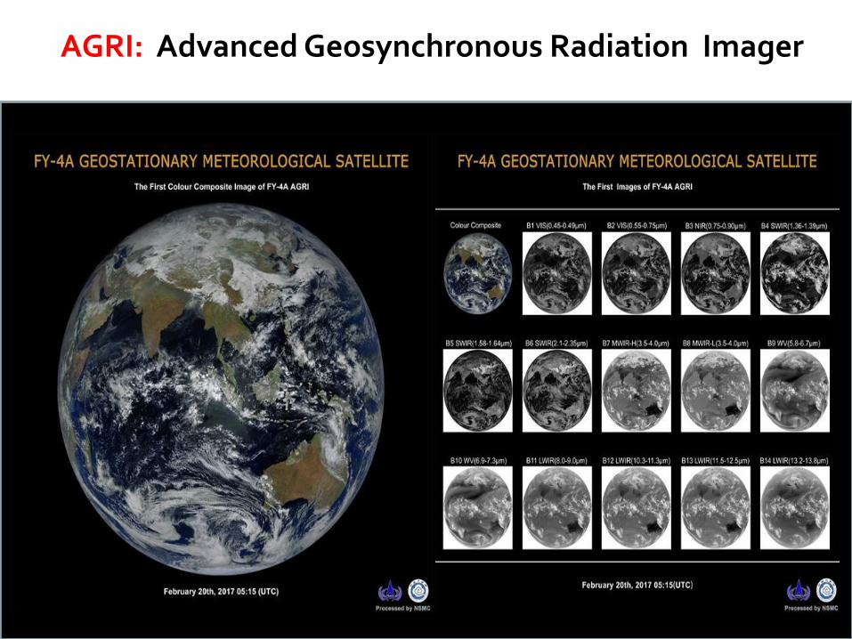
AGRI: Advanced Geosynchronous Radiation Imager
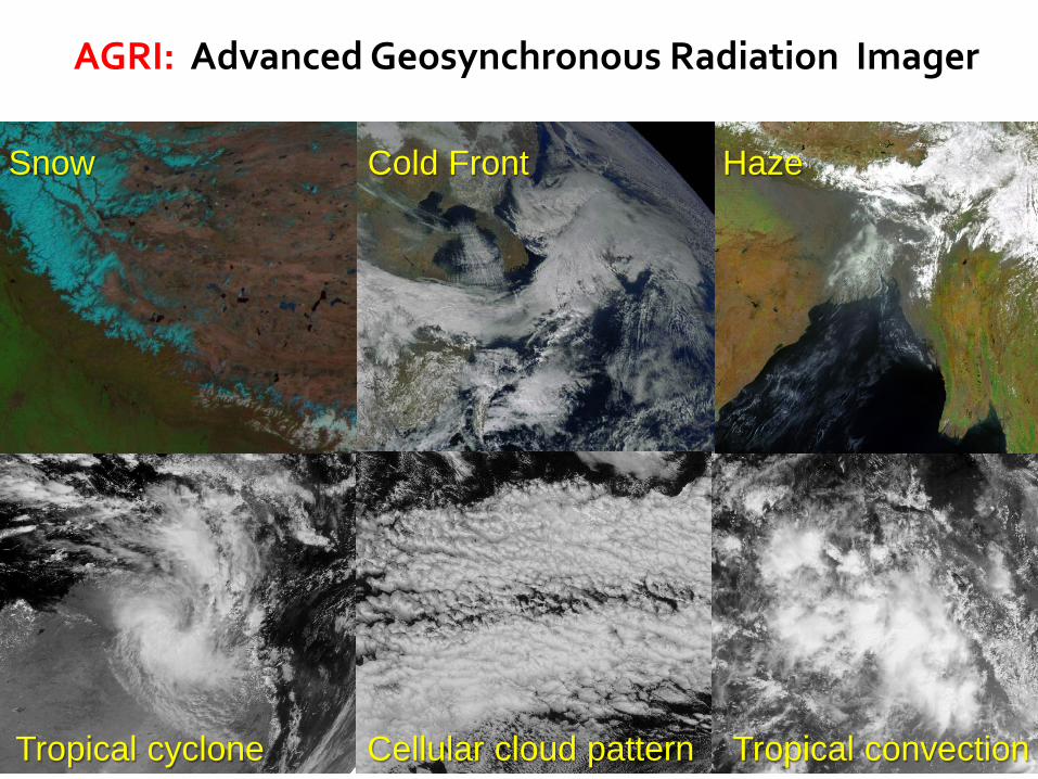
Haze Snow Cold Front
Tropical cyclone Cellular cloud pattern Tropical convection
AGRI: Advanced Geosynchronous Radiation Imager
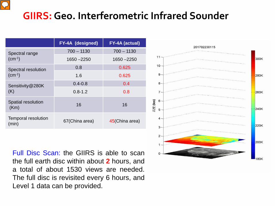
GIIRS: Geo. Interferometric Infrared Sounder
FY-4A (designed) FY-4A (actual)
Spectral range (cm-1)
700 – 1130 700 – 1130
1650 –2250 1650 –2250
Spectral resolution (cm-1)
0.8 0.625
1.6 0.625
Sensitivity@280K (K)
0.4-0.8 0.4
0.8-1.2 0.8
Spatial resolution (Km) 16 16
Temporal resolution (min) 67(China area) 45(China area)
Full Disc Scan: the GIIRS is able to scan the full earth disc within about 2 hours, and a total of about 1530 views are needed. The full disc is revisited every 6 hours, and Level 1 data can be provided.
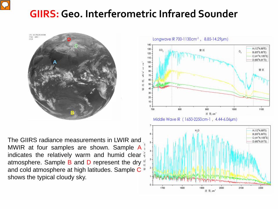
The GIIRS radiance measurements in LWIR and MWIR at four samples are shown. Sample A indicates the relatively warm and humid clear atmosphere. Sample B and D represent the dry and cold atmosphere at high latitudes. Sample C shows the typical cloudy sky.
GIIRS: Geo. Interferometric Infrared Sounder
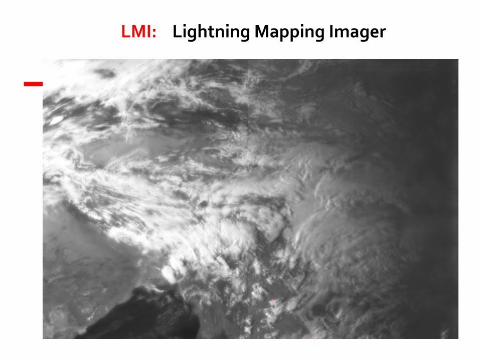
LMI: Lightning Mapping Imager
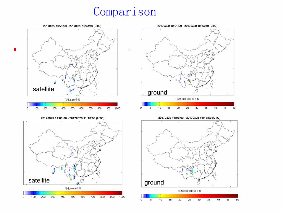
Comparison
satellite
satellite
ground
ground
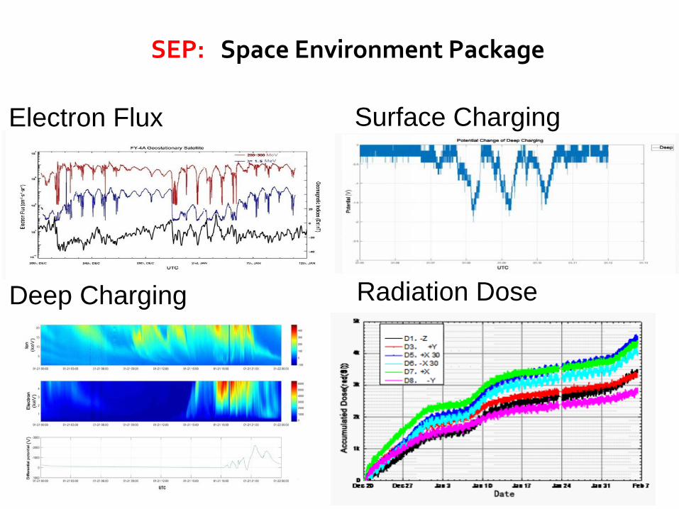
Electron Flux
Deep Charging
Surface Charging
Radiation Dose
SEP: Space Environment Package
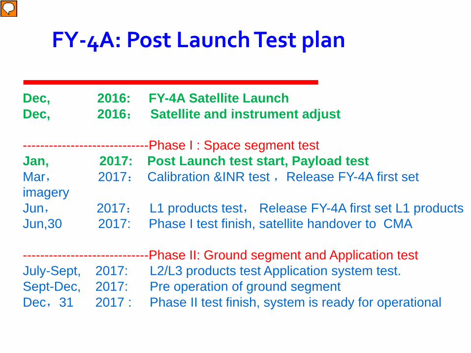
Dec, 2016: FY-4A Satellite Launch Dec, 2016: Satellite and instrument adjust -----------------------------Phase I : Space segment test Jan, 2017: Post Launch test start, Payload test Mar, 2017: Calibration &INR test ,Release FY-4A first set imagery Jun, 2017: L1 products test, Release FY-4A first set L1 products Jun,30 2017: Phase I test finish, satellite handover to CMA -----------------------------Phase II: Ground segment and Application test July-Sept, 2017: L2/L3 products test Application system test. Sept-Dec, 2017: Pre operation of ground segment Dec,31 2017 : Phase II test finish, system is ready for operational
FY-4A: Post Launch Test plan
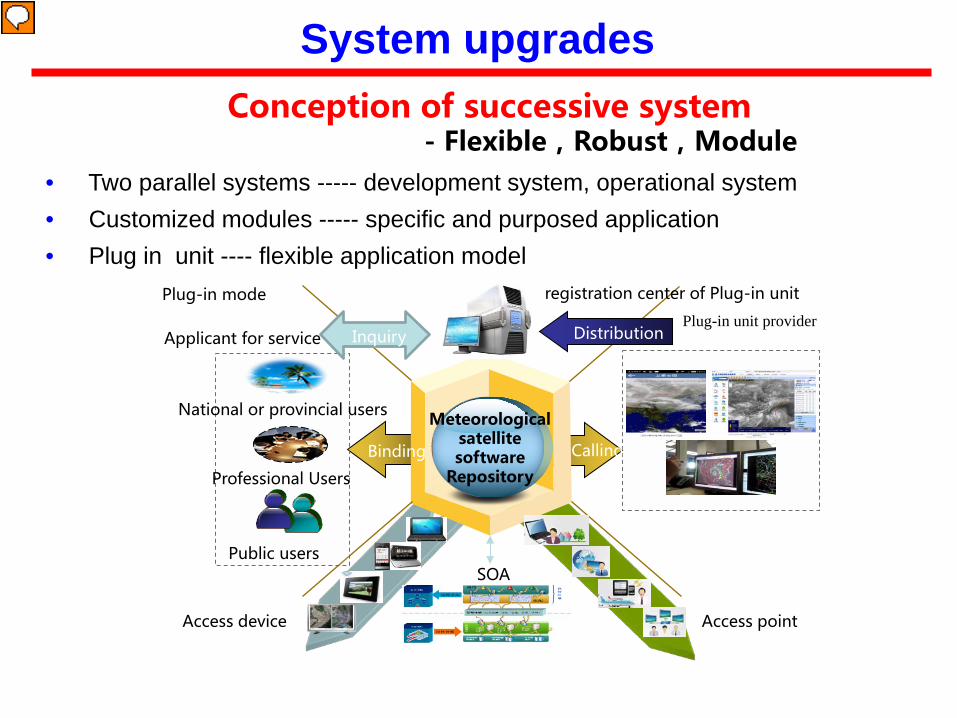
Plug-in mode
Meteorological satellite software
Repository
Access device Access point
Plug-in unit provider
registration center of Plug-in unit
Professional Users
National or provincial users
Public users
Applicant for service Distribution Inquiry
Binding Calling
SOA
Conception of successive system - Flexible,Robust,Module
• Two parallel systems ----- development system, operational system • Customized modules ----- specific and purposed application • Plug in unit ---- flexible application model
System upgrades
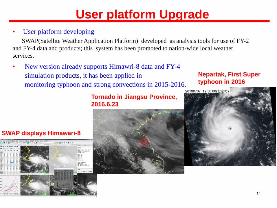
User platform Upgrade • User platform developing SWAP(Satellite Weather Application Platform) developed as analysis tools for use of FY-2 and FY-4 data and products; this system has been promoted to nation-wide local weather services.
• New version already supports Himawri-8 data and FY-4 simulation products, it has been applied in monitoring typhoon and strong convections in 2015-2016.
14
SWAP displays Himawari-8
Tornado in Jiangsu Province, 2016.6.23
Nepartak, First Super typhoon in 2016
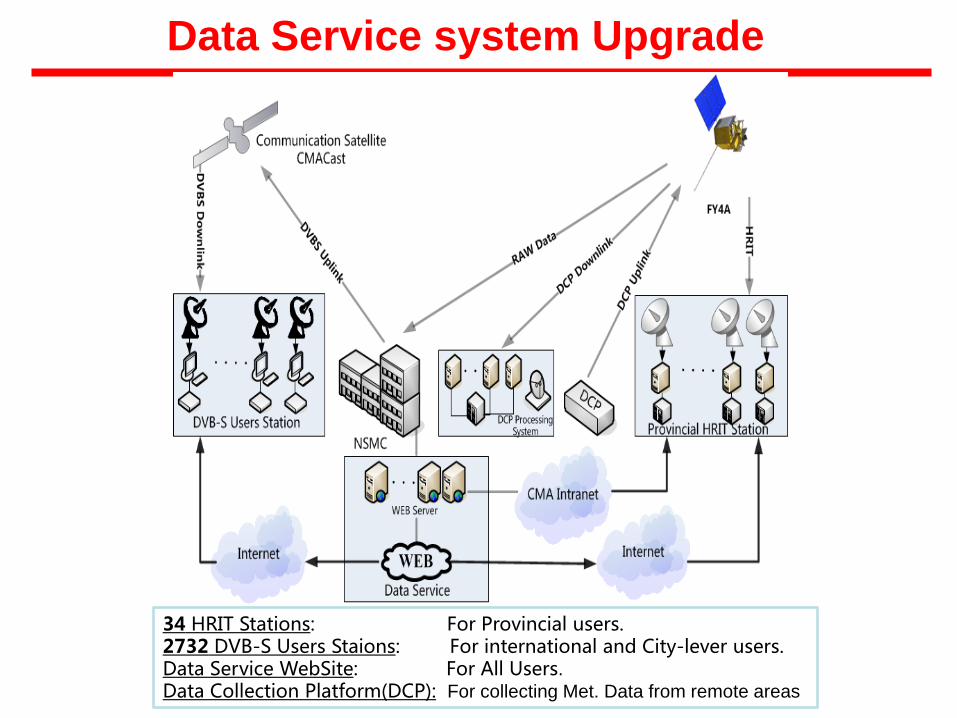
34 HRIT Stations: For Provincial users. 2732 DVB-S Users Staions: For international and City-lever users. Data Service WebSite: For All Users. Data Collection Platform(DCP): For collecting Met. Data from remote areas
Data Service system Upgrade
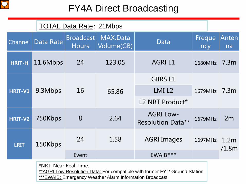
FY4A Direct Broadcasting
*NRT: Near Real Time. **AGRI Low Resolution Data: For compatible with former FY-2 Ground Station. ***EWAIB: Emergency Weather Alarm Information Broadcast
TOTAL Data Rate: 21Mbps
Channel Data Rate Broadcast
Hours MAX.Data
Volume(GB) Data
Frequency
Antenna
HRIT-H 11.6Mbps 24 123.05 AGRI L1 1680MHz 7.3m
HRIT-V1 9.3Mbps 16 65.86
GIIRS L1
1679MHz 7.3m LMI L2
L2 NRT Product*
HRIT-V2 750Kbps 8 2.64 AGRI Low-
Resolution Data** 1679MHz 2m
LRIT 150Kbps 24 1.58 AGRI Images 1697MHz 1.2m
/1.8m Event EWAIB***
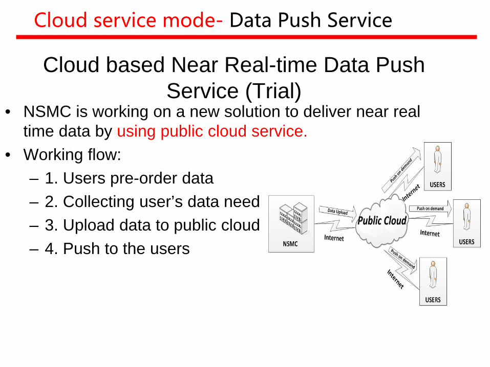
Cloud based Near Real-time Data Push Service (Trial)
• NSMC is working on a new solution to deliver near real time data by using public cloud service.
• Working flow: – 1. Users pre-order data – 2. Collecting user’s data need – 3. Upload data to public cloud – 4. Push to the users
Cloud service mode- Data Push Service
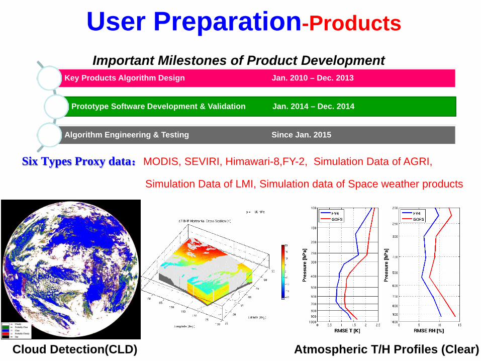
Key Products Algorithm Design Jan. 2010 – Dec. 2013
Prototype Software Development & Validation Jan. 2014 – Dec. 2014
Algorithm Engineering & Testing Since Jan. 2015
Cloud Detection(CLD) Atmospheric T/H Profiles (Clear)
Important Milestones of Product Development
User Preparation-Products
Six Types Proxy data:MODIS, SEVIRI, Himawari-8,FY-2, Simulation Data of AGRI,
Simulation Data of LMI, Simulation data of Space weather products
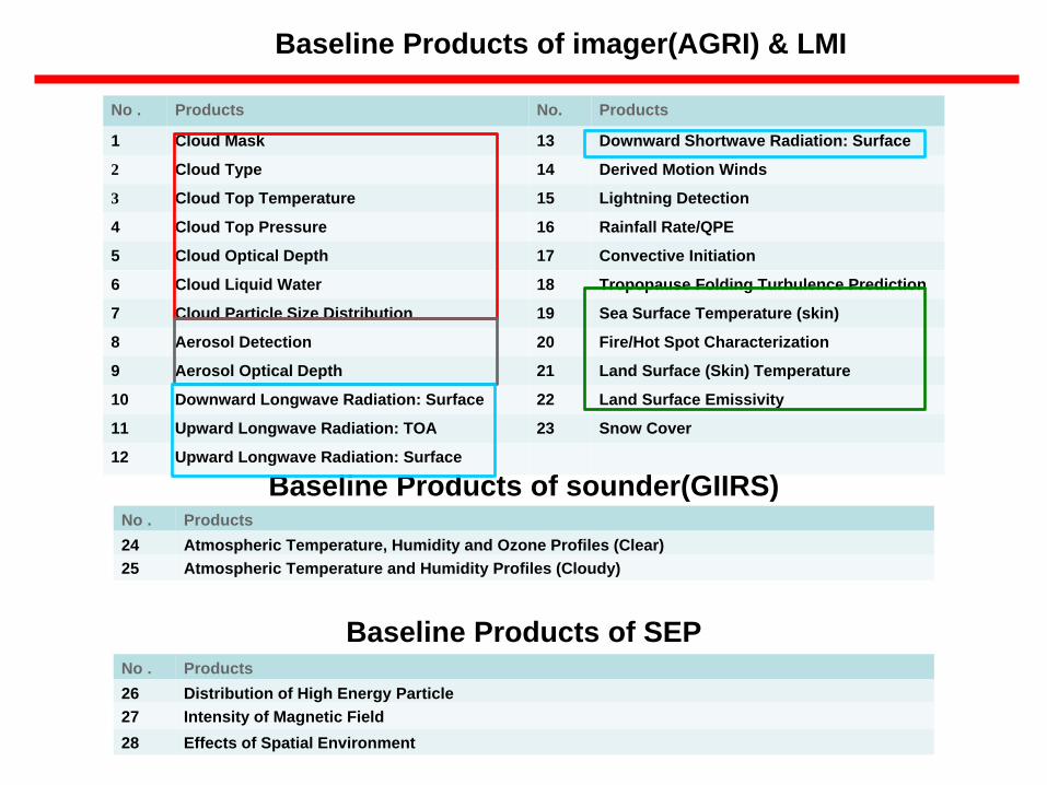
No . Products No. Products
1 Cloud Mask 13 Downward Shortwave Radiation: Surface
2 Cloud Type 14 Derived Motion Winds
3 Cloud Top Temperature 15 Lightning Detection
4 Cloud Top Pressure 16 Rainfall Rate/QPE
5 Cloud Optical Depth 17 Convective Initiation
6 Cloud Liquid Water 18 Tropopause Folding Turbulence Prediction
7 Cloud Particle Size Distribution 19 Sea Surface Temperature (skin)
8 Aerosol Detection 20 Fire/Hot Spot Characterization
9 Aerosol Optical Depth 21 Land Surface (Skin) Temperature
10 Downward Longwave Radiation: Surface 22 Land Surface Emissivity
11 Upward Longwave Radiation: TOA 23 Snow Cover
12 Upward Longwave Radiation: Surface
Baseline Products of imager(AGRI) & LMI
Baseline Products of sounder(GIIRS) No . Products 24 Atmospheric Temperature, Humidity and Ozone Profiles (Clear) 25 Atmospheric Temperature and Humidity Profiles (Cloudy)
Baseline Products of SEP No . Products 26 Distribution of High Energy Particle 27 Intensity of Magnetic Field 28 Effects of Spatial Environment
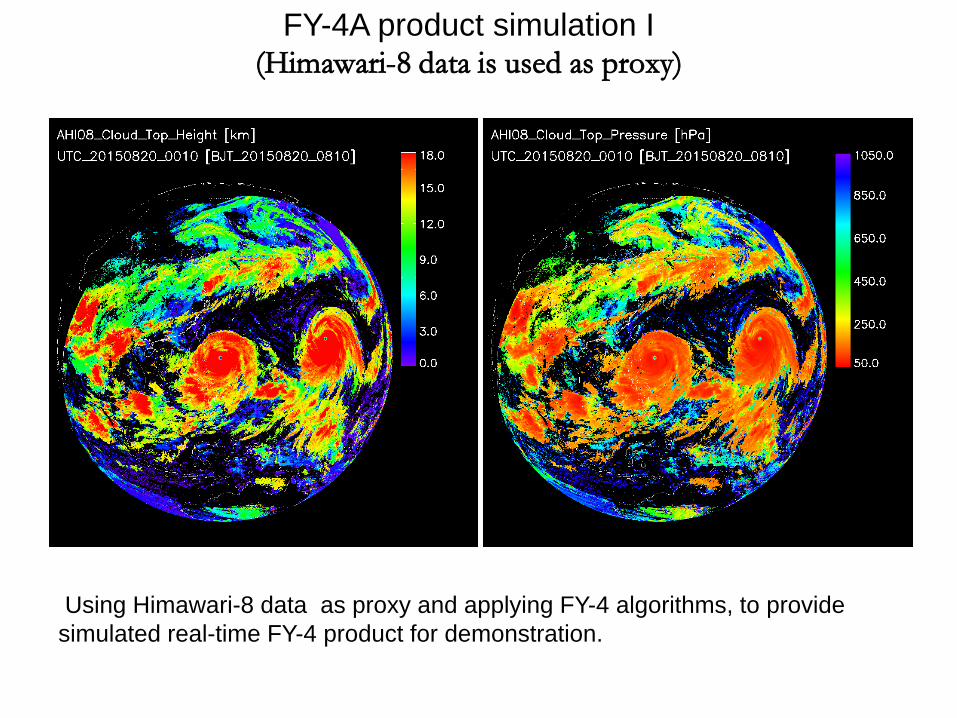
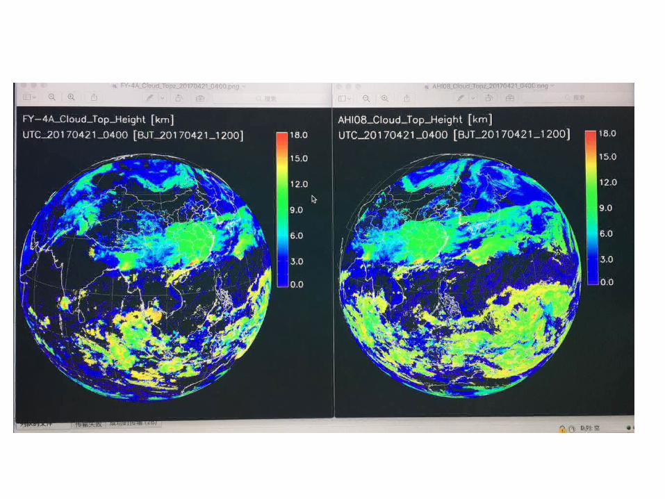
FY-4A product simulation I (Himawari-8 data is used as proxy)
Using Himawari-8 data as proxy and applying FY-4 algorithms, to provide simulated real-time FY-4 product for demonstration.
22
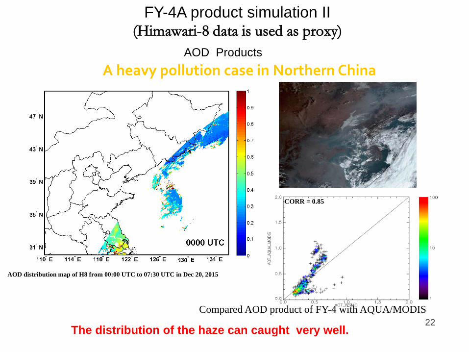
A heavy pollution case in Northern China
The distribution of the haze can caught very well.
AOD distribution map of H8 from 00:00 UTC to 07:30 UTC in Dec 20, 2015
FY-4A product simulation II (Himawari-8 data is used as proxy)
AOD Products
CORR = 0.85
Compared AOD product of FY-4 with AQUA/MODIS
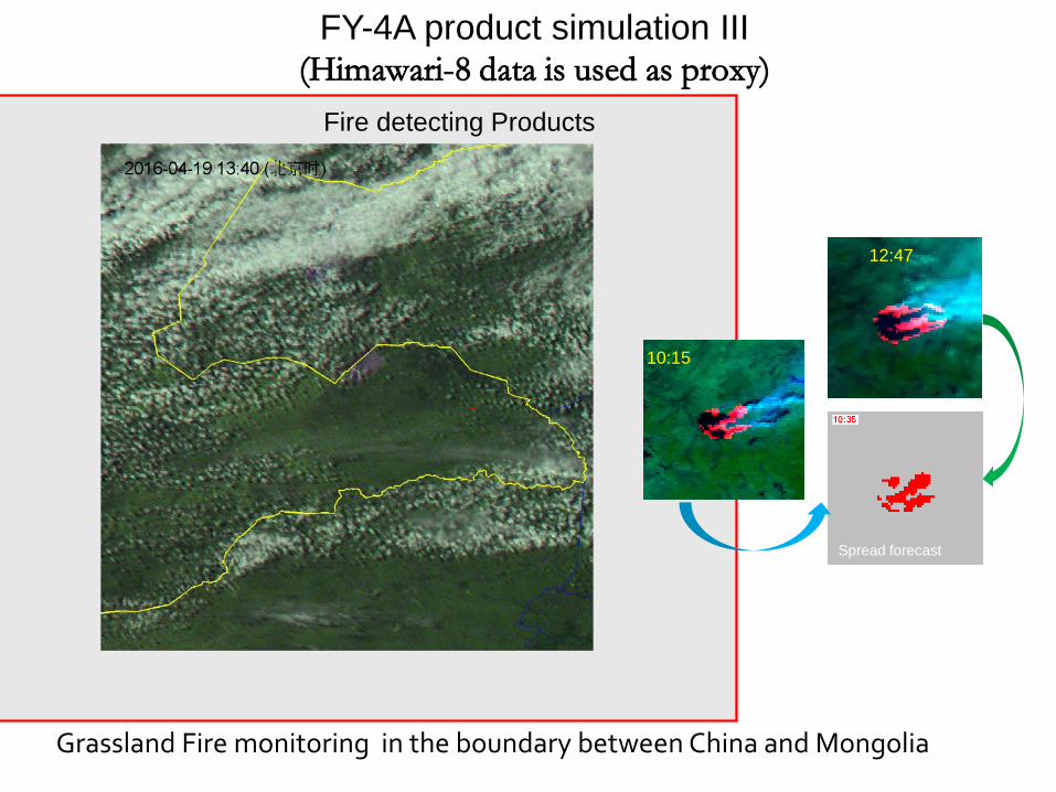
10:15
12:47
Spread forecast
FY-4A product simulation III (Himawari-8 data is used as proxy)
Grassland Fire monitoring in the boundary between China and Mongolia
Fire detecting Products
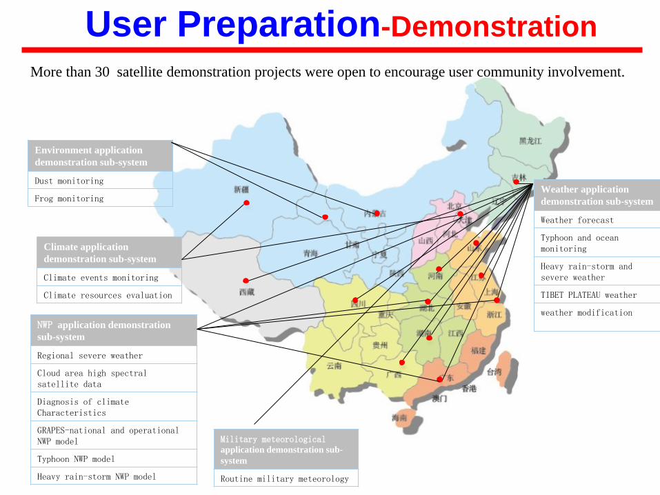
Climate application demonstration sub-system
Climate events monitoring
Climate resources evaluation
NWP application demonstration sub-system
Regional severe weather
Cloud area high spectral satellite data
Diagnosis of climate Characteristics
GRAPES-national and operational NWP model
Typhoon NWP model
Heavy rain-storm NWP model
Weather application demonstration sub-system
Weather forecast
Typhoon and ocean monitoring
Heavy rain-storm and severe weather
TIBET PLATEAU weather
weather modification
Environment application demonstration sub-system
Dust monitoring
Frog monitoring
Military meteorological application demonstration sub-system
Routine military meteorology
More than 30 satellite demonstration projects were open to encourage user community involvement.
User Preparation-Demonstration
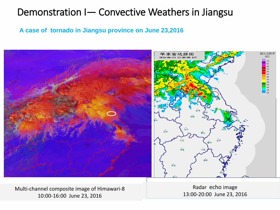
Multi-channel composite image of Himawari-8 10:00-16:00 June 23, 2016
Demonstration I— Convective Weathers in Jiangsu
A case of tornado in Jiangsu province on June 23,2016
Radar echo image 13:00-20:00 June 23, 2016
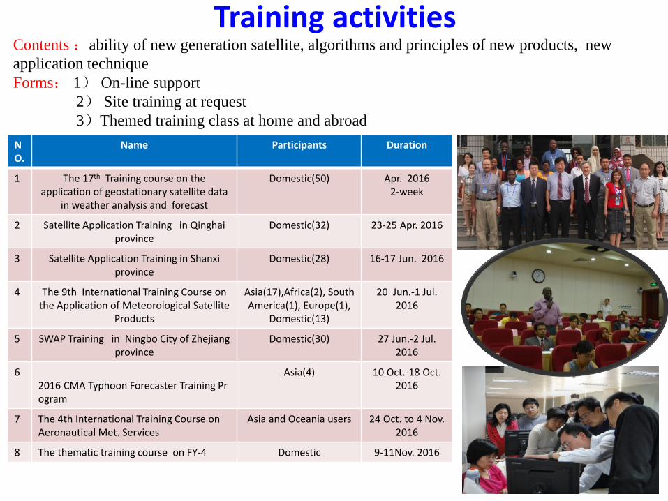
Training activities
28
NO.
Name Participants Duration
1 The 17th Training course on the application of geostationary satellite data
in weather analysis and forecast
Domestic(50) Apr. 2016 2-week
2 Satellite Application Training in Qinghai province
Domestic(32) 23-25 Apr. 2016
3 Satellite Application Training in Shanxi province
Domestic(28) 16-17 Jun. 2016
4 The 9th International Training Course on the Application of Meteorological Satellite
Products
Asia(17),Africa(2), South America(1), Europe(1),
Domestic(13)
20 Jun.-1 Jul. 2016
5 SWAP Training in Ningbo City of Zhejiang province
Domestic(30) 27 Jun.-2 Jul. 2016
6 2016 CMA Typhoon Forecaster Training Program
Asia(4) 10 Oct.-18 Oct. 2016
7 The 4th International Training Course on Aeronautical Met. Services
Asia and Oceania users 24 Oct. to 4 Nov. 2016
8 The thematic training course on FY-4 Domestic 9-11Nov. 2016
Contents :ability of new generation satellite, algorithms and principles of new products, new application technique Forms: 1) On-line support 2) Site training at request 3)Themed training class at home and abroad
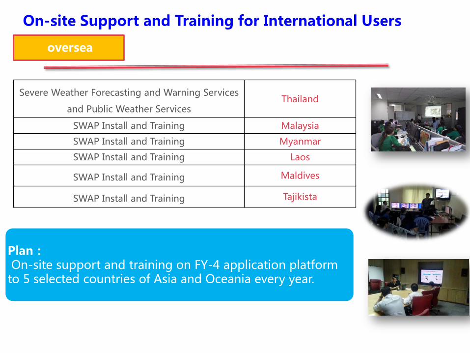
Severe Weather Forecasting and Warning Services
and Public Weather Services Thailand
SWAP Install and Training Malaysia
SWAP Install and Training Myanmar
SWAP Install and Training Laos
SWAP Install and Training Maldives
SWAP Install and Training Tajikista
oversea
On-site Support and Training for International Users
Plan: On-site support and training on FY-4 application platform to 5 selected countries of Asia and Oceania every year.
summary CMA has carried out lots of work on FY-4 readiness and make some progress: • Upgraded the application software and data service system.
Proposed a new data transmission solution (plan) using public cloud service.
• Developed 28 FY-4 baseline products and produced them in real time using FY-2 and H8 as proxy data.
• Set up more than 30 demonstration projects and gained several outcomes.
• Organized a series of training activities for domestic and international users.

Thanks for your attention!