g z s newsletter february 2008 - geologicalsociety.org.zw
TRANSCRIPT

Geological Society of Zimbabwe Newsletter February, 2008
Geological Society of Zimbabwe
GS
Z Newsletter
February 2008
Limpopo granulites in the rain, January 2008 Photo: PMB
THE GEOLOGICAL SOCIETY OF ZIMBABWE, P.O. BOX CY 1719, CAUSEWAY, HARARE

Geological Society of Zimbabwe Newsletter February, 2008
2
Contents EDITORIAL ……………………………………………………………………………………………. 3 CHAIRMAN’S CHAT …………………………………………………………………………………. 3 ARTICLES AND REPORTS ……………………………………………………………………… … 4 Summary - Geological Society of Zimbabwe, Summer Symposium 30th November 2007 Keith A. Viewing ……………………………………… 4 Abstracts from the Geological Society of Zimbabwe’s Summer Symposium ………… 11 Contribution – The Applied Geochemistry Research Group of Imperial College London : Memoried in the Mist – 1 K.A. Viewing ……………………………… 20
NEWS ………………………………………………………………………………….……… 24
Geology Department, University of Zimbabwe ……………………………………… 24 The Geological Survey of Zimbabwe ………………………………………………… 25 Mining Industry News ……………………………………………………………….. 26 RESEARCH FUNDING OPPORTUNITIES ………………………………………………….27 GSZ Research and Development Fund …………………………………………………..27 SEG Timothy Nutt Memorial Fund …………………………………………………… . 27 CONTACT DETAILS OF MEMBERS OF THE EXECUTIVE COMMITTEE …………… 28 INSTITUTIONAL MEMBERS, 2007 …………………………………………………… …. 28
The Committee, on behalf of the Geological Society of Zimbabwe, would like to offer a sincere vote of thanks to Marion de Beer of Cadline for preparing and printing our Phaup and Bond Award certificates for 2007 -- free of charge. This is a wonderful gesture of Marion’s time and skills and we can only encourage all you geologists and mining houses to steer your Autocad mapping work in her direction and to take advantage of at least 30 years of hard-won cartographic experience. Cadline also offers monochrome printing and scanning services in formats up to A0. Their telephone contact is 04-2917261/60 Tel/Fax is 04-301855 and the address is 94B Pendennis Road, Mount Pleasant in Harare.

Geological Society of Zimbabwe Newsletter February, 2008
3
Editorial
The most pressing activity for you now is to attend the Society’s AGM at 17.00 on Friday 29th February at the CFX Country Club at the end of Brompton Road in Highlands. Dr Francis Podmore will present the pre-dinner talk and the dinner will cost you Z$40m per head. Respond ASAP to Gayle Hanssen on [email protected] or Tel: 882601 or Cell: 011-601973. Come and join us and be amongst friends. The Committee announces the quarterly subscription increase for 2008. The fees are now: Individual and Associate Membership Z$50,000,000.00 Institutional Membership Z$500,000,000.00 Extraterritorial Membership $US20.00 or Rand/Pound/Euro equivalent Pay soon at a snitch, for the price is bound to go up. I‘m sure we can pre-empt the AGM and wish Collins Mwatahwa all the very best for his term as our Chairman in 2008. It is for certain that he will need all the support he can get during these trying times, especially in the task of trying to keep Zimbabwe geologists as a cohesive group. With your support, we can make 2008 another successful year for your Society. Keep it up – under the circumstances. Tim Broderick
Chairman's Chat K. Musiwa
I would like to take this opportunity to thank the out-going committee for a job well done and our membership for their continued support during these hard times. This committee’s term ends on 29 February 2008 when our AGM will be held. The committee leaves office when almost all the mining-related departments at our Institutions of higher learning, including the Geology Department and those of Mining and Metallurgy at UZ, continue to lose staff. The Mining Industry has also not been spared by the exodus of qualified personnel to the region and overseas. The Society continues to appeal to the Mining Industry and to its own Membership for ideas to save these departments from folding. On behalf of the GSZ I would like to thank Zimplats for donating fourteen million Zimbabwean Dollars towards the three Geology Department field trips, Cannister Resources for donating two thousand litres of diesel for the these trips and our foreign membership for donating one hundred and eighty US Dollars to the Geology Department. I would also like to thank those of our members who have agreed assist during the field trips. I hope to see all of you at the AGM.

Geological Society of Zimbabwe Newsletter February, 2008
4
Articles and Reports
Summary - Geological Society of Zimbabwe, Summer Symposium 30th November 2007
Keith A. Viewing, Roma, 8th January 2008 The programme included 14 contributions led by HE Xavier Marchal, Head of the Delegation to the European Community and a member of our Society. He presented an interesting and detailed background to the Kimberley Process and an outline of the recent review in Zimbabwe. Two cancellations to the programme did little to affect a day that covered the wide scope in which geologists now operate. The attendance improved dramatically from an early start and the Jan Kramers Museum became packed tight as students joined a very attentive and interested audience. All were encouraged by HE Marchal and by Dr Francis Gudyanga, the newly appointed Permanent Secretary in the Ministry of Science and Technology, and both were presented with Geological Society tankards. The sugar-buns that followed were to a standard unseen for months and were offered gratis! Lunch was under canvas on the lawn and altogether a delightful setting and experience. Four of the initial contributions dealt with staff vacancies in the Mining Industry and the dreadful circumstances that affect many students at UZ. These result from resignations of the academic and technical staff in departments that support the mining industry, including Geology. Three presentations were concerned with advances in mineral exploration and two with the environment. A series of individual presentations were concerned with the Great Dyke, Diamonds, Dinosaurs, and the Geological Heritage of yet another endangered species. The Geological Society was recommended to adopt a formal classification of mineral reserves and resources that could be used by members consistent with the international trends. Retiring Chairman Kudzie Musiwa had reviewed the activities for the year with the focus of the Committee upon fund-raising, and the promotion of geological training at University level. Experience of Industry and of the Geological Survey, indicated that an honours degree followed by 2 years on-the-job training was important, often essential, and consistent with all other practice in applied science and engineering disciplines. The reviews in detail given by Mrs Meck, the sole remaining academic of 16 posts in Geology, and Keith Viewing for the wider academic support to Industry as a whole, begged the serious question of WHY the present state of the teaching and staff vacancies had developed beyond the point of no return from Zimbabwean sources. The opinion was for enhanced opportunities elsewhere and salaries at SADC levels seemed essential. Some had crossed the rubicon as their best efforts to contain the crisis over the years went unrewarded and unrecognised. The only solution seemed to be a silent departure, spared of yet another display of failure not of their-own making. We wished them well. What was the solution? Significant pledges were made by two sectors of the industry, presumably as separate special funds to be administered by the University. Others thought that some form of Management Committee was needed that included the Chamber of Mines, similar perhaps to the management of the Zimbabwe School of Mines. Arrangements for the IMR were mentioned that had worked well over two decades; Vice-Chancellor, Chairman; Registrar, Bursar, Dean of Science, Prof. Geology, Prof. Chemistry; Sec. for Mines, Dir. Geological Survey, Dir. Govt. Dept. Metallurgy. This committee had met twice a year to receive the Accounts and Annual Report in January, and to consider progress and agree the budget in September. The purpose of such committees is to source and manage finance, to build

Geological Society of Zimbabwe Newsletter February, 2008
5
confidence, encourage links and sources of teaching and research staff, support external examiners (annually), and recover the undoubted success of the past. Support by Industry implied a fair reward consistent with the difficulties of the times. By contrast there was a view that those who had devoted a substantial part of their lives to the cause and received say US$2.00 per month as pension, should now return and teach for a similar or smaller sum, and provide their own transport. One university however, had financed short-term expatriate teaching staff with suitable benefits and accommodation! Mrs Meck, occupant, but not appointed as Chairperson of Geology, gave a crystal-clear exposition of the problem in her valiant effort to recover the detailed teaching curricula of 15 academics and to operate four different field courses that required the administration of 5000 litres of fuel, camp and other accommodation. That level of responsibility upon the incumbent seemed unfair, an administrative nightmare, and all concerned wished her strength. The numbers drew comment. Mrs Meck spoke of short field courses for groups of 3, 14, 21 and 30 students for whom there was no instructor. Geology had a complement of 16 academics yet that department had operated with two at the start in 1954, and four for some years afterwards. Other experience confirmed that two instructors could produce first class graduates at honours level in external degrees. But now a pattern was set for specialists in each facet of the discipline but many were amazed that geomorphology, geochemistry, and palaeontology were not included at UZ! Had a mineral deposit been discovered by geophysics in Zimbabwe, despite the substantial sums spent in education and the search by those techniques? And how many geologists were required to support a mining group? An example from 1993 revealed a team of 17. A geologist in each of 4 nickel mines, another to support three chromite mines, and another to service the first open-cast heap-leach gold mine in the Group. New mines have to be found so that 5 had formed a re-constructed prospecting team, with an additional responsibility for special fluxes to two different smelters. Intensive investigations at Damba-Silwane, Hunters Road and at Unki had reached the project stage and another 3 geologists were involved. The combined experience of 3 more in Head Office amounted to more than a hundred years, and that included expert knowledge in geo-mechanics and in applied geochemistry. Whether that significant and widespread level of activity would be resuscitated by a single mining group in Zimbabwe remained to be seen. Clearly the platinum industry could support a new phase of exploration, but the mines were in the process of development and expansion and there was a moratorium on exclusive prospecting reservations, and concern for foreign owned operations. News from Mazda and Nissan had indicated large reductions in PGM requirements for catalytic converters. The best advice on offer was to keep right on to the end of the road, do your best, and enjoy the Sunrises as and when these appeared. Expatriates were expected to fill the gaps, but the problem of professional recognition for Zimbabweans remained. All understood that the first degree could be rewarded by employment, and all knew that membership of an internationally respected professional institute or society was necessary in mid-career. For present incumbents the cost in hard currency is a problem. For example the fees in 2008 for one relevant Institute are; US$140 for a Technician Member; US$170 for Graduates, and US$240 for Professional Members. These annual fees are well beyond the reach of most Zimbabweans and the question is ‘what can we do?’ Allan Matanga from the CGME gave a clear account of the National Certificates of Competency

Geological Society of Zimbabwe Newsletter February, 2008
6
awarded by that Office under the Mines and Minerals Act. In each case the standard was set by the relevant professional associations, as for example the Association of Mine Managers, the Assoc. Mine Surveyors and the Assoc. Mine Engineers. The practice was very well established with the Surveyor Certificate in 1948-1950, Mine Diploma 1969-1971, Mine Manager 1983 and the Mine Engineer Diploma 1998-2001. The syllabus for the Mine Engineer Certificate was in progress with a target for 2008. In each case, the CGME consults with the professional associations to set the syllabus, source and nominate the examiners and in this way, effectively maintains the standard in written, practical, and oral examinations. The Geological Society might wish to contribute to a new certificate, say for Mine Geology that could include Geo-mechanics, now a vital component of any underground and surface mine. There was need also for recognition as a Competent Person in reports of Mineral Reserves and Resources. Thus the advantage was to support and to strengthen an existing National Institution where other traditional sources, over which the Society had no input or influence, might fail. As an example, the IMMM, founded here in 1931, (the IMM until the merger), was dormant and thus the metallurgists had no local professional society. Yet many are responsible for huge concentrators, smelters and refineries. The way forward seemed clear to some, but others were less concerned with professional structures as yet another hurdle in a difficult environment. The fact is that internationally recognised professional societies have strength in numbers, are self-regulating to maintain their standards and are willing always to accept new members, provided always that they have kept log books, AND have done their home-work. Hillary Gumbo (code-name ‘The SQUID’) told of new techniques in mineral exploration. These covered the familiar fields of applied geochemistry, geophysics, and remote sensing. The wide range of development was impressive, although much of the work was concerned with the special problems of the glaciated terrain and transported over-burden. The talk was no longer concerned with large dogs trained to bark aggressively upon the discovery of sulphur-rich glacial boulders, but rather of very sophisticated techniques designed for well-defined targets. The concern for base metals had surpassed the search for gold. In geochemistry selective extraction techniques were revisited with little success, but much depended upon the nature of the target and the weathering history. The greatest impact appeared to be in computer-based modelling of mineral deposits with drill holes sited to provide geological data to develop the model. The ingrained need for successful intersections seemed less important to win approval from the masters, and as this was explained there came from the shades, visions of Peter Cotterill at Shurugwi and Ben Worst at Tsumeb, both of whom had commanded several large drill rigs for that purpose. That philosophy indicated an unusually supportive role and the will and capability to take considerable financial risks in exploration. The use of isotopes was set to increase and seismic-pumping was a mechanism to concentrate copper in fault structures. But to a large extent the developments were in geophysical methods with high resolution SQUID magnetics, airborne EM with a sensitivity that approached ground observations, airborne gravity and down-the-hole gravity, and down-the-hole seismic imaging. The Titan-24 system of IP surveys from two sites only, permitted radial arrays from 0.75 km to 1.5 km. The need for close interval observations on close interval extended traverses seemed eliminated forever. Significant improvements in chemical analysis and computer recognition had led to NAA (neutron activation) down the hole scanning of core with data capture, all linked direct to the
Geological Society of Zimbabwe Newsletter February, 2008
7
geological model. Some of the new technology was derived from oil exploration and great benefits were assured for those with sufficient resources and courage to grasp these opportunities. Hyperspectral, (as in hyper-market) remote sensing had come of age so that specific wavelengths could be selected from pixels of about a metre square. This technology required dedicated aircraft, was expensive, but in reconnaissance could make teams on the ground much more effective, particularly when constrained by short field seasons of few months in each year. More good news followed with a description by Jaco le Roux ([email protected]) of a new version of the NITON-hand held X-RF analyser. In some circumstances, for example in damp (less than 15%), metallurgical samples the contact time was about 30 seconds at 1000 determinations/d. Soil and sediment samples are dried to less than 5% and analysed as minus 1-mm in thin plastic bags. The limit of detection for Au and Pt was about 30 ppm and much less for Cu, Ni, Fe, and Sn, and so the technique had great advantages in grade control and in scanning drill core to reveal barren or low-grade intersections. Mike Kellow followed up with positive results from his use of the NITON analyser, complete with GPS capture and a capability to store observations, including ratios, and generate clusters in EXCEL for correlation co-efficients, for those in need. Several applications were mentioned as one recalled the cadmium and other isotope powered of the past used successfully for grade control of tin in Cornwall and of copper underground at Mangula. The older units were at disadvantage between iron and nickel, as at Empress, and cobalt was uncertain. You wondered afterwards whether radiation from the isotope would have some long-term effect. By contrast, NITON used rechargeable batteries and a converter in the camp could restore peace to evening. The Kellow-Niton field lab. analysed from 200-300 samples/day, every day, with no need for the paraphernalia of wet chemistry in the field, commonplace from 1953-1963. AAS was in use by 1963, but the labs have remained town-based and those in the bush could wait for weeks to plot the results. These could be of high precision, high accuracy, with little or no bias and ratios of total metal to part-extraction were readily available. You needed patience and there was no advantage in morale; try Jaco on + 27 (0) 11 793 5555, or + 27 (0) 82 338 0193! Feasibility exercises will not go away, and the demanding responsibility of Mineral Reserves and Resources remains squarely upon the geologist. Training in the practice starts young for those in mining geology, but may come late for those in exploration. Keith Viewing recommended a mix of both experiences to focus the report and convince investors-at any level. Those involved need a broad view of industry to explain the impact of geological science in the mining and metallurgical process, including the EIA. The geologist needs to explain the probable impact of geological structures, geo-mechanics and aquifers to Mining Engineers, weathering history and ground water to Civil Engineers, mineralogy to Metallurgists and Analytical Chemists, and the geochemistry of the environment to EIA practitioners. Most of all is the subjective judgment of the continuity of the metal content, and the homogeneity of valuable and gangue minerals and their liberation between intersections. Then there is the dreaded decision to sink the shafts and extend the life of the mine by another 6 years or more based upon many factors, but geology is fundamental to the choice. The professional institutions had tried to define different classes of reserves and resources since

Geological Society of Zimbabwe Newsletter February, 2008
8
1904, and that concern had gained momentum and international acceptance to the present. The classification recommended by the IMM (London) in1982 was adopted by two meetings in Zimbabwe in 1983, but some preferred the Australasian IMM classification of 1981. The significant difference was the use of the term ‘Inferred Resource’. The IMM at the time had insisted upon ‘A mineral potential’, with no metal content or tonnage mentioned, and this was bad news for stock markets. The IMM had reviewed the requirements in 2001 and agreed to include Inferred Resources. The 1982 rules were expanded by common consent of the Geological Society of London, the Federation of European Geologists, and the Geological Society of Ireland from 4 pages to 34 pages of explanation and definitions. These include a valuable and extensive check-list for practitioners and definitions for feasibility and pre-feasibility reports as required by UN Agencies. Another review is to be published as the Pan European Reporting Code, PERC, probably early in 2008. Two examples were given of the conflict between management and reality on the ground. Management is concerned to safeguard share value at all costs, and may not actually understand the technical view of the reserves and resources. In one case, huge fines were paid, the senior staff lost their jobs, and the geologist was on public record for his statement that ‘he could stand the lies no longer’. In the other, management insists that the life of the mine is yet another 40 years, whereas the data indicate say, 6 years unless difficult and expensive decisions are made. All of this implies and now requires that persons who report upon Ore Reserves and Resources should be competent and be held responsible for their signatures. The rules of 1982 included 17 paragraphs, but in 2001 the rules are more flexible and practical, and the good news is that management is required to be a signatory too! ‘The truth is great, and shall endure.’ For the many reasons expressed in the Summer Symposium, the Geological Society was recommended to adopt one of the internationally accepted classifications of Mineral Reserves and Resources, acceptable also to the CGME. Those concerned will have direct access to the check-list and the rules, can learn from them, and as a result enhance their professional knowledge, and the image of mining in Zimbabwe. All of this serious stuff was followed by Tony Lampard in a down-to-earth exposition of how to control your waste water contaminated by oil and fuel spillage. Did he see guilt in those of us who had cheerfully dug waste pits to cover their sins? His solution was a brick-lined oblong pit of twice the length to the width and a metre deep. Two thirds is filled by coarse sand that rests upon a filter-cloth and a base of pea-gravel and rounded stone. A perforated drain at the base is inclined upward so that the product water is decanted as contaminated water enters the system. Selected plants, probably bulrushes, are encouraged in the sand-bed to promote the biological degradation of the waste. A litre of oil could contaminate 1 million litres of ground water and the serious face of the Natural Resources Department could be imagined. Better by far to prepare for the EMP and build a GREY WATER pit before you were shut down. Try [email protected] for a dedicated design and probably for a swimming pool that could be put to better use. Lunch was followed by Manford Ngara who described an irregular contact between the mafic and ultramafic zones of the Great Dyke at Ngezi Mine. The irregularities are above the MSZ, from 5 to 50 m, and are not related to the ultramafic rocks below. Several mechanisms were suggested to account for the phenomena, and the paragenesis of the structures. The next phase

Geological Society of Zimbabwe Newsletter February, 2008
9
was to search for alterations of the mineral phases that could be linked to late-phase intrusions. Some of these structures were exposed in the walls of the box-cuts and one at least was remarkable for a separation of several metres wide within a raft-like horizon of the mafic zone. The expression ‘pull-apart’ is uncommon in geology, but the somewhat irregular nature of the boundary on each flank of the separation was so similar as to invite that description. The mechanism could be due to wholesale shrinkage of the unit in the largest sub-chamber. But, why only at Ngesi? Considerable detail was given in the abstract and Manford was congratulated upon a careful study of a difficult problem. Diamonds continue to demand attention and at last some details of the RTZ discovery at Murowa were revealed by Lovemore Chimuka, a member of the discovery team in 1997, and now involved at senior level. Not many of us have the good fortune to take part in an important discovery and to see the fruits of our labours as these develop into an important mine. This was the real thing; five blow-out kimberlite pipes spaced along a dilation fracture, strike about NNE, controlled probably by sheared zones whose strike is about NNW. Three of the five pipes are economic and there are several dykes in the vicinity, about 0.5 Ga in age. The host rocks are granites of the 2.6 Ga-old Chibi Batholith. The target zone is of about 10 km2, and a somewhat similar field at Sese lies about 30 km to the east. Both kimberlite fields relate to the south margin of the Zimbabwe Craton and therefore, to the NMZ of the Limpopo Mobile Belt. Surface mines had operated with contractors in 2005 to produce 200,000 tpa with 10 tph water in the DMS plant and sorting by on-stream X-Ray equipment. Lovemore mentioned that diamonds were produced in India, 400 BC, by Brazil in 1730 AD, and South Africa from 1870. Tim Broderick recounted the discoveries of dinosaur foot prints and even of new track-ways in the Dande Sandstone of the Chewore, or as Geoff. Bond used to say ‘search in the second O of Sipolilo’ on the 1970 version of the 1:1 million scale geological map. The beds exposed along the Ntumbe River are the most favoured sites, at times exposed and in other seasons obscured by sediment. An expedition by Operation Raleigh in 1990, had identified 45 prints in a track-way, and a further 100 prints were recorded in 2001, many on different bedding planes. This year a party from our Society, including HE Marchal, had found more prints of a brachiosaur, 93 cm in diameter and with a style in which the back foot occupied, or almost so, the print of the front foot. At one site the prints of Allosaurus and Brachiosaurus crossed paths and a hunt could be imagined. More followed with the discovery of Jurassic fresh-water fish in the overlying horizon, suitable as hors d’oeuvres at any time. The renewed discovery of skeletal remains of Syntarsus (renamed Coelophysis) have stimulated joint expeditions for their recovery that include GSZ, National Parks, National Museums and The University of the Witwatersrand; see the abstract or refer to Tim for details. Endangered species, endangered geologists, and next came endangered geo-antiquities! Forbes Mugumbate spoke with customary eloquence concerning the need to preserve the cultural heritage of Zimbabwe. The record was spelt out in a remarkable way and we wondered that in this time of stress Forbes could think in such an abstract and informed way of what needs to be done. Check lists were mentioned earlier in the day, but now we have a check-list of geological antiquaries that raise our hopes and re-direct our energies in the future. This was a stout effort where so much was at risk, and a grand view of an important goal. Previous efforts by the Geological Society had preserved Diana’s Pool (orbicular granite), the basement unconformity of banded chert on granite near Zvishavane, and the Huntsman Quarry near Queen’s Mine. The Huntsman was reckoned as the oldest sign of life at the time, but now the stromatolites are no more and reduced probably, to 16 mm stone embedded in concrete.

Geological Society of Zimbabwe Newsletter February, 2008
10
Progress of a sort, and proof of the saying that ‘enthusiasm is at the root of all progress; without it there are only alibis’. We hoped that the Society would circulate Forbe’s check-list and that those interested could nominate their favourite geological sites for posterity and as research projects for the future. The final presentation was concerned with Biodiversity hot-spots, planned to build upon an explanation of the EIA process with which most are familiar for the catechism of relevant legislation. Some had heard of Bio-toxicity, and it all sounded as though more legislation was on the way. Susan Childes-Worsley gave as an example the highland country that extends at intervals from Nyanga to the Cape mountains. These form vital links, described as ‘stepping-stones’, for plants and animals to inter-breed in the highland environment, and when those links are destroyed, then whole groups of living things are at risk. In the Eastern Highlands, for example, there are 214 species, but 94 species are threatened, including intra-African bird migrants. The list seemed endless, but a round figure of 27% of all species on the red-list was a sobering thought and her plea for responsibility to our environment touched many. Those of us who are concerned for the natural world of rock and soil that we map in the bush and explore for mineral deposits, seldom consider the biological components other than the shade of a friendly tree on a hot day. Susan, in a few brief examples, told us much that we did not know, or had heard previously, and we thanked her for it. Once again the Society had produced an excellent day and the Chairman and Committee were thanked with enthusiasm.

Geological Society of Zimbabwe Newsletter February, 2008
11
Abstracts
Senior Staff Vacancies in the Mining Industry, July 2007 Keith A. Viewing
[email protected] The Mining Industry has reported serious shortages of experienced professional and technical staff that affect present operations and the potential for expansion, particularly in the platinum sector. Many factors are involved, but the key is that employment opportunities and remuneration need to be similar to those offered by other countries in the region. The vacancies for mining industry professionals number 166 with a potential to 233. Vacancies for senior technicians are 265 with a potential to 716. These figures do not include iron and steel fabrication, the cement industry, or Chemplex. The training institutions are under stress also and certain key disciplines cannot be taught or examined adequately. The numbers of vacancies were established by contact with the mining houses. These were classified and accepted. Data for expansion is included in some cases but in others there is no intention at present of significant investment either in exploitation or in exploration. The faculties of Engineering and Science at the University of Zimbabwe were taken as case studies of vacancies for academic staff. These may indicate the strengths of other training institutions. Statistics were obtained for the polytechnics. How can these weaknesses be strengthened and even eliminated where industry has a management input? As always, the factors of safety, health and production are paramount. There are three main options. The most obvious is to strengthen the affected departments by direct finance from industry, either acting individually or collectively. The number of vacancies is large and continuity could be affected by a slump in metal prices. Alternatively, expatriate staff could be recruited either through foreign aid or from our own resources. Several countries and institutions have assisted in the recent past. For example, Germany in mining and metallurgy, the Cambourne School of Mines in mining, Norway in metallurgy, the Free University of Amsterdam and Delft Institute of Technology, in geology. Many factors are involved and a contribution by industry is necessary. Industry may wish to provide professional staff to support the universities on a part-time basis, but newcomers to teaching may need to develop a course where no detailed curriculum exists. The concept of mentors drawn from retired persons has merit. A third option is to select suitable experienced persons in industry for fast track promotion and training at the Zimbabwe School of Mines. Under-graduates unable to complete their studies could be admitted by scholarship. Thus incumbents from both sources could complete their studies at HND level, and be examined for the National Certificates of Competency administered by the Chief Government Mining Engineer. At present, these certificates are for Mine Managers, Mine Engineers and Mine Surveyors, but they could be expanded to include Metallurgical Managers and Mining Geology (for mineral reserve and resource computation), and Geo-mechanics. The mines have entered new geological environments and all work at progressively greater depths. The Mining Industry has a well-established financial input and management capability to ZSOM, and provides examiners to the Government Certificates. The examiners are nominated by the professional societies and these societies need support; some may need to be re-activated. And external examiners are necessary to link to the university system and ensure that our standards are acceptable to self regulating professional institutions, probably in South Africa, SAIMM; Britain, IMMM; and Australasia Aus.IMM. Thus the normal aspiration of individuals for recognition of qualifications and experience can be encouraged by industry. The expense of

Geological Society of Zimbabwe Newsletter February, 2008
12
formal accreditation will be warranted in a stable environment and of special interest to platinum, nickel and gold producers who may wish to transfer staff for experience elsewhere. Thus any review of the curricula for the Certificates of Competency should consider the requirements of neighbouring countries. The study was proposed by Mr Jack Murehwa, President of the Chamber of Mines of Zimbabwe, was supported by Zimplats, and was greatly assisted by Mr D.Verdon of the Chamber, and Dr W. Mbizvo of the Ministry of Higher and Tertiary Education. The Geological Society had recognised the gravity of the problem for that discipline and remains an inspiration. The author is profoundly grateful to all of those who contributed to the task.
Niton Handheld XRF Jaco le Roux
In all stages of the mining process, decisions are made based on the elemental composition of representative samples. Whether the task is mining exploration, mine mapping, sorting, grading, extraction, or the prevention of environmental hazards as by-products of a mining operation, chemical data is used to guide mining operations at every step. Obtaining accurate geochemical data quickly in order to guide operations is one of the biggest obstacles to high-productivity operations. Maintaining permanent on-site laboratories or dispatching samples to off-site laboratories can be expensive, untimely and impractical. Quickly obtaining geochemical data for rapid delineation of ore boundaries and the in-depth, quantitative analysis of metal concentrations required for mine mapping and grade control is critically important for efficient mining operations. The new generation of Thermo Scientific NITON XL3t and XL3p 500 Series handheld x-ray fluorescence (XRF) analyzers are the ideal tools for these demanding jobs. Thermo Scientific NITON XL3t 500 Series analyzers, manufactured by Thermo Fisher Scientific, come with 50 kV miniature x-ray tubes and multiple primary filters – the most powerful and flexible XRF sources ever offered in handheld XRF instruments. NITON XL3t and XLt have both been designed to maximize productivity. The handheld NITON Series of portable XRF mining analyzers offers unprecedented performance at all stages of the mining process, often with little to no sample preparation required. Weighing less than 3 lbs (~1.3 kg) and made of durable GE Lexan plastics, NITON Series analyzers are the ideal tools for obtaining real-time geochemical data in the field. NITON analyzers provide users with real-time elemental sample analysis directly at the mine face, from bagged samples during survey or drilling operations, or from prepared samples. With the ability to easily set up multiple programs based on sample composition, NITON analyzers measure ores, soils, sediments and cores, concentrates, heads and tailings, coatings, and filter media, allowing for quick and easy delineation of ore boundaries, process adjustments and much more. Thermo Scientific NITON analyzers represent the state-of-the-art in elemental analysis for geochemical applications, allowing the user to perform rapid, on-the-spot screening for qualitative elemental identification with the simple pull of a trigger. Assaying samples in the field significantly reduces the cost, time and labor involved in exploration and survey activities. NITON XL3t and XLt 500 Series analyzers provide geochemical data within seconds, allowing for immediate ore flagging, avoidance of lab turnaround delays, and rapid delineation of ore boundaries.

Geological Society of Zimbabwe Newsletter February, 2008
13
The Life of the Mine, Your Reserves or Mine Keith A. Viewing
The concern for accurate reports of mineral deposits is age-old, but the image of Mark Twain persists. Mining professionals have attempted to dispel that image for 98 years and still the problem lives on, encouraged by an unshakeable belief in buried treasure at the rainbows end. To dispel such mysteries, mining professionals grapple with definitions of mineral reserves and resources that are acceptable to all, and in particular to stock exchanges. Mining investment is often taken seriously as 'blue chip', but some stock is as risky as a bet on horses or dogs and is forgiven where cash is applied to exploration. These problems had encouraged the Australasian IMM in 1971 to issue guidelines that were binding upon members, and helpful to the exchanges of Perth and Sydney. The ripple effect extended to Dublin, Toronto and Vancouver, and to London. The AIMM rules were reviewed in 1989, and at intervals of 3 to 4 years since then. These serve as an excellent basis for other professional groups. Zimbabwe had agreed to the principles of the Institution of Mining and Metallurgy (London) definitions of 1991. These were explained and discussed in each of two meetings at the Sheraton, late in 1992, that included guests from the local stock exchange and the Chartered Accountants. There was concern for use of the word 'ore' and for 'competent persons', as defined in the Act. Six large mining companies of the time used the AIMM rules, two the IMM rules and one the Quebec Securities Commission. The Council of Mining and Metallurgical Institutions of 1994 considered the distinction between 'Inferred Resources' (AIMM), and 'Mineral Potential' (IMM). The inclusion of an inferred tonnage and grade was seen by the IMM as potentially misleading to investors. In 2001, a new code was published for the 'Reporting of mineral exploration results, mineral resources and mineral reserves'. This code was prepared by the Institute of Materials, Minerals and Mining (IMMM) in conjunction with the European Federation of Geologists, the Geological Society of London and the Institute of Geologists of Ireland. The code is binding upon members of these institutions. The requirements are defined and explained in a document of 34 pages that is particularly helpful in the definition of the 'Competent Person'. The text includes a very useful checklist of 8 pages. The Pan European Resources Committee had adopted that code in 2006 and an up-date is expected this year. The Geological Society (and the MOM & MD) may wish to adopt a code for the benefit of members and students. Six codes exist; AIMM-2004, SAIMM-2000, IMMM-2001, SMME-1999, IME Chile - 2004, CIMM&P-2001, 2004.
An Irregular Mafic-Ultramafic Contact at Ngezi Mine’s South and East Box Cuts (Sebakwe Sub-Chamber) - “Evidence for Magmatic Slumping, a
Trapped Liquid or a Later Intrusion?” Manford K. Ngara

Geological Society of Zimbabwe Newsletter February, 2008
14
Mafic/Ultramafic relationship exposed at Ngezi Mine Photo: MKN
Ngezi Platinum Mine is located in the south-central portion of the Hartley Complex of the Great Dyke. This complex straddles the Darwendale and Sebakwe sub-chambers and it is the largest of the four erosional remnants of the Dyke in which the mafic sequence is still preserved. Ngezi Platinum Mine is located in the Sebakwe Sub chamber. Stratigraphically the Great Dyke is broadly divided into an upper Mafic and a lower Ultramafic sequence. The major lithologies in the Ngezi Mine area are gabbronorite (Mafic), websterite and bronzitite of the P1 Pyroxenite unit (Ultramafic). The PGM-bearing Main Sulphide Zone occurs in the bronzitite, 5 to 50 metres below the mafic-ultramafic contact. In the Ngezi area the Dyke consists of a simple flat synclinal structure that has been modified by cross-cutting faults. Mining at the Ngezi Mine has exposed an unusual contact between gabbronorite and websterite at the South and East box cuts. At this contact, websterite of the Ultramafic Sequence interdigitates with overlying gabbronorite of the Mafic Sequence. The structures so formed are analogous to ball and flame structures in sedimentary rocks. The same websterite also appears in joints and fractures in the gabbronorite, which can suggest the late-stage upward migration of volatiles. Hydrothermal alteration alomg fracture planes is in evidence as a material filling in fractures and as veins, forming a network in the gabbronorite. A variation in the gabbronorite also appears in the proximity of this contact. Immediately above the websterite contact at one locality (the ramp south of the South Box Cut), the gabbronorite, although extensively weathered, indicates a very high clinopyroxene content tending towards a feldspathic pyroxenite or melagabbronorite. Away from the contact the rock gradually lightens to feldspathic gabbronorite or anorthosite. If this layering observed in the gabbronorite is not due to variations in the pyroxene content, it may represent the migration of volatiles from the websterite along grain boundaries thus effecting alterations in the overlying gabbronorite with

Geological Society of Zimbabwe Newsletter February, 2008
15
the effects of the volatiles gradually decreasing away from the contact. Some hypotheses have been considered in this presentation in trying to deduce the paragenesis of these structures - these are the release of a trapped liquid, magmatic slumping or a later (post-genetic) intrusion.
The Murowa Kimberlite Field and Production History Lovemore Chimuka
The Murowa Diamond Mine is located near Zvishavane mining town in south-central Zimbabwe. Murowa Diamonds Private Limited (MDPL) is company-owned by Rio Tinto plc (78%) and RioZim (22%) and is a Zimbabwe-listed company. The Murowa Mine is managed by Rio Tinto. The Murowa kimberlites have been dated at 0.5Ga. The field comprises 6 kimberlite bodies covering a footprint of 10 km2 compared to the World average of 20 km2. The kimberlites post-date the igneous activity of the Great Dyke at 2.2Ga. The kimberlite bodies range from blow-out pipes (k1 to k5) to dykes and fissures ranging from 1 to 7 metres in width. It is theorised that the igneous activity of the Great Dyke led to the structural weaknesses in the Craton thus creating deep-seated conduits, which allowed kimberlites to intrude and extrude from a mantle source. The on-craton kimberlites intruded the 2.6 Ga Chibi Granite batholiths emplaced into 2.6-2.9 Ga gneisses and greenstone 10-20 km north of the boundary of the North Marginal Zone to the late Archaean Limpopo Mobile Belt. The Murowa kimberlites, which have been numbered K1 to K5, lie between two main structural features. Immediately to the west is a dolerite dyke, which is a south-easterly continuation of the Sebanga Poort Dyke. To the east is a north-north-easterly shear zone that can be traced across the granites up to the Tokwe Block and south towards the Buchwa Greenstone Belt. The shear contains abundant buckreef quartz along its length and this forms strong positive topographic relief where present. This feature is directly related to the emplacement control of the K2 body. Five kimberlite pipes were discovered in 1997. Feasibility studies and mine planning were conducted between 1998 and 2000. The two larger pipes comprise mining reserves of 19 million tonnes with a grade of approximately 0.9 carats per tonne. Out of the 5 pipes only 3 contain an economically exploitable resource. A number of requirements had to be addressed to enable production from the Murowa Diamond Mine to commence. These included relocating 926 people to 6 farms purchased by MDPL at Shashe near Mashava. Families were provided with new homes and newly prepared plots for seeding. At the mine site the treatment plant and security facilities were constructed and commissioning commenced in August 2004. Other infrastructure for the mine includes access roads, office buildings, a village and the power supply and these were established simultaneously. MDPL initially employed 90 people with 71 contractors providing mining and village services in a bibo (bus-in bus-out) commuter roster programme. The start of 2005 saw the onset of full-scale production at approximately 200,000 tonnes of ore per annum.

Geological Society of Zimbabwe Newsletter February, 2008
16
Jurassic Moments – Spielberg to the Rescue Tim Broderick
In October 2006 a visit to assess the geological controls of the spring in the Chitake River, Mana Pools National Park, led to a visit to Mike Raath’s 1970’s Syntarsus rhodesiensis bone bed where new material was found exposed by seasonal erosion in the Forest Sandstone cliff section. A second visit in January 2007 confirmed that these bones were liable to be lost to gravity processes as the river flooded and undercut the cliff. An application was made to the Parks and Wildlife Management Authority to rescue these fossils in collaboration with National Museums and the University of the Witwatersrand. The value of this fossil location is that it represents the scene of a mass death equivalent to that of Ghost Ranch, New Mexico where Coelophysis, to which genus Syntarsus has been added, occurs in a similar mode in an arid palaeoclimatic environment close to the Triassic/Jurassic boundary. A visit in July 2007 showed that some collapse had in fact taken place and that an articulated distal section of a caudal column and part of a maxilla, with teeth were now exposed. This put pressure on the need for the permit, which was granted at the end of August and an expedition was launched with Dr Eric Roberts from Wits and representation by way of technicians from both the Natural History Museum in Bulawayo and the Geology Department at UZ. The vulnerable parts of the bone bed were excavated and plaster-cast, and now await shipment to the Bernard Price Institute for Palaeontological Research for preparation. The presence of a basal conglomerate to the post-Karoo Dande red bed Formation was confirmed in the vicinity, both directly overlying the Forest Sandstone and in fault relationship with it. Isolated larger bone remains of Massospondylus were also confirmed as being present elsewhere in the Forest Sandstone in this area. Also in July 2007 the Ntumbe dinosaur trackways were revisited, this time in the company of Society Member Xavier Marchel and others. Upstream of the known Allosaurus tracks at the drift, discovered and reported in 1984 and measured by Operation Raleigh in 1990, and in the tributaries, described and measured by Lingham-Soliar, Broderick and Ait Kaci Ahmed in 2001, a new trackway comprising 16 clear prints and displaying cross tracks was found to be re-exposed. This trackway had been noted by Lingham-Soliar in 1990, but in 2001 it was obscured beneath river sand. In 2001 Ait Kaci had � ecognized and described five apparent mega-prints of the herbivore Brachiosaurus in the bed of a tributary stream, but on a subsequent visit the one classically formed print was found to have been destroyed by elephant that had drunk from an adjacent water source. In a right-bank re-entrant opposite the ‘new’ Allosaurus prints are exposed a new find of Brachiosaurus prints forming a trackway of six impressions, each more than 90 centimetres in diameter and about 1-metre apart. Apart from their addition to what now must be a ‘World-Class’ dinosaur trackway location, the significance is that these giant traces are seen to cross an Allosaurus track, confirming the co-existence of herbivores and carnosaurs in this ‘Jurassic Park’. Indeed, the Syntarsus bone rescue expedition was, in part, funded by Steven Spielberg’s Jurassic Foundation.

Geological Society of Zimbabwe Newsletter February, 2008
17
Three Sisters, Northern Cape Province Photo LMB, 2008
On the Need to Preserve Zimbabwe’s Geological Heritage Forbes Mugumbate [email protected]
Zimbabwe’s heterogeneous geological environment hosts some of the best exposed and information-packed rocks in the world, which have helped to elevate parts of the country into virtual natural geological laboratories where early-earth processes can be observed. For instance Archaean greenstone belts contain rock assemblages and structures that explain the tectonic systems by which the foundation of the earth was constructed as well as details of the origin of life and evolution of the atmosphere. Komatiites, pillow lavas, banded iron-formation, and stromatolites are some of the most curious rocks in this environment. Other monumental geological structures include the Limpopo Mobile Belt, one of the oldest such belts in the world, and the Great Dyke, a geological wonder hosting huge resources in mineral wealth. Several other features, including fossil locations, are exhibited throughout Zimbabwe’s geological record, and these give a testimony to past life forms, past geography, climate, and palaeoenvironment, the knowledge of which is important for understanding our dynamic earth. In addition to these geological environments of scientific, educational and economic significance, Zimbabwe has a profusion of varied topographical features including river gorges, waterfalls, rift-related escarpments, mountains, castle koppies, balancing rocks, and caves, some of which are renowned tourist destinations. This paper, which is a slight variation on one prepared for the Research Council of Zimbabwe symposium (Mugumbate, 2007), highlights attributes to selected geological environments in order to reiterate and raise an awareness of the rich and varied geological marvels in Zimbabwe and to instill a sense of appreciation in the scientific and aesthetic value of such features in order to promote preservation of typical sites for present and future generations to enjoy and to study for a better understanding of Earth.

Geological Society of Zimbabwe Newsletter February, 2008
18
Razi Granite, NMZ, Chivi District Photo LMB, January 2008
The EIA Process and Mining in Zimbabwe Debra Magwada
[email protected] The EIA policy was launched by the Minister of Environment and Tourism in 1994 but had no legal backing to it. This meant that developers could implement EIA processes by their own free will. The Environmental Management Act (Chapter 20:27) provided the legal framework. It is a requirement in terms of section 97 of the Environmental Management Act for all projects listed in the 1st schedule of the Act to have an EIA done prior to commencement. The fixed date for the Act was 17 March 2003. Statutory Instrument No. 7 of 2007 (EIA and Ecosystems Protection Regulations) consolidates the Act as it details specific requirements. EIA is a process that is aimed at predicting impacts of developmental projects and reducing those that are negative while enhancing the positive. This is in line with the principles of sustainable development that all development must embrace the environment, social and economic spheres of any society. Development cannot and should not be stopped but should proceed in a manner that does not compromise future generations from benefiting from that environment. It is a project management tool that can determine the direction that a project will take and includes improvements to project design, suggestions for alternative sites or alternative inputs where necessary. In Zimbabwe, the EIA process can still be described as being in its infancy with little tangible changes so far being made in the way that many mines operate and being used more as a tool for compliance. Thus, there is need for both the regulatory agencies and industry to seriously look at changing their ways of operating if this process is to achieve the desired results. Mining is an environmentally degrading activity, which despite the effects, cannot be abandoned as it has far-reaching positive benefits in our modern lives. To stop mining would be to take modern civilisation back to time immemorial, which is counterproductive. Zimbabwe is a country whose economy is based on primary activities in mining and agriculture. As such there is need to ensure that these activities are carried out in a sustainable way to keep the wheels of the economy running for future generations. Part of maintaining sustainability in the mining

Geological Society of Zimbabwe Newsletter February, 2008
19
industry includes ensuring that the environment is taken care of and that mining is carried out in line with the country’s regulatory framework. Not many proponents were undertaking the EIA process before Operation Chikorokoza Chapera/Isitsheketsha Sesiphelile and as such there were few projects that were assessed. Since the first EIA report was submitted in 1995 until the launch of this Operation, on 21 November 2006, there were on average 3 EIA’s submitted per month. Submission has since dramatically risen by over 5000% to on average 150 reports being received monthly with most of these projects being for small-scale mining. A total of 640 EIA reports had been recorded in the database prior to the Operation. Currently the database stands at 3000 entries, exceeding in just 1 year what had taken previously11 years to achieve. However, there is still an important need to really monitor those projects that have gained EIA acceptance.
Some Biodiversity Hotspots in Zimbabwe, in Relation to Geological and Edaphic Features
Susan Childes [email protected]
The aim of this paper is to highlight some of Zimbabwe’s important biodiversity areas, which are also of geological and edaphic interest. Biodiversity is a complex concept and is defined at genetic, species and landscape levels. At the landscape level, the Eastern Highlands form a vital link from the Eastern Arc mountains of East Africa to the Drakensberg and Cape mountains in the south. These mountains form “stepping stones” for plant and animal species to move and are therefore important for gene flow and genetic diversity. The Nyanga and Vumba mountains are largely granite with dolerite intrusions. The high rainfall means that the soils are highly leached and acidic. Impeded drainage on the mountain tops, coupled with low ground temperatures in winter has resulted in the formation of grasslands that contain a variety of endemics and restricted-range species. The grasslands are seriously threatened by the invasion of alien pine, wattle and blackwood. The moist evergreen forest covering the windward slopes and river valleys are home to a wide diversity of orchids, ferns and other taxa. The forests are contracting rapidly under the combined onslaught of clearing for agriculture and fire. The quartzites of the Chimanimani Mountains have given rise to pale, acidic, low nutrient sandy soils. Over time, some plants growing on these soils have evolved into new species and the Chimanimani Range has the greatest number of endemic plants (72) in Zimbabwe. Just off the edge of the central granite shield are the isolated peaks of Wedza, Bikita, Buchwa and the Nyoni Hills. These mountains form another important series of stepping stones linking the Eastern Highlands to the Matobo Hills. These sites are seriously threatened by deforestation. Little is known of their biodiversity. Perhaps the best known and most studied geological feature in Zimbabwe is the Great Dyke. The ultramafic rocks are high in chrome, nickel, magnesium and other minerals. The vegetation is an open grassland with scattered small trees and shrubs. There is also a high level of endemism in the plants, with 30 species being recorded. Despite the geological importance of the Dyke, very little is known of the biodiversity of this unique feature. Threats include habitat loss through mining and plant collecting.

Geological Society of Zimbabwe Newsletter February, 2008
20
Contribution
The Applied Geochemistry Research Group of Imperial College London : Memories in the Mist-1
K.A.Viewing, Hon. FIMMM AGRG 1960-1963. Roma, 11th January 2008
Visitors to the Royal School of Mines, Imperial College about 50 years ago had found an amazing diversity from the primary studies of Geology and Mining Geology, Mining Engineering and Metallurgical Engineering. The basement for example, housed a new and vibrant capability in Rock Mechanics (the strength of rocks and the prediction of failures), the Third Floor housed people who knew about oil and financial feasibility, and on the relatively new 4th Floor, there was Exploration Geophysics and Pure and Applied Geochemistry, supported by an extensive chemical analysis laboratory. The Pure Geochemistry Section was led by Dr John Butler whose principal interests lay in the chemical evolution of igneous rocks. Continental drift was an interesting idea but the mechanism was not clear and volcanic rocks of the mid-Atlantic ridge were of prime concern as were the evolution of the younger tin-bearing granites of Nigeria. Their labs housed an X-RF analyser that was a great help. The Applied Geochemistry Section was led by Dr John Webb with his Chief Chemist, Ronald Stanton. The aim of this group was to apply the principles of geology and chemistry to the distribution of the chemical elements in weathered rocks. The focus was to search for mineral deposits, at first by almost direct means in the study of one metal after another. John Webb had built his research group from experienced geologists and analytical chemists, almost all of whom had resigned from sound posts to take a chance with the new technology. There was no guarantee of a higher degree; the new-comer was accepted into the group, from four to eight students at any time, he registered a title for a Master’s thesis, and got on with it. The first six months required a review of the literature and training in trace metal analysis by colorimetric and spectroscopic techniques. You learned a lot about precision, accuracy and statistical controls, and that took the greater community some years to appreciate. Each project was planned around two investigations in the field, the first to gather the basic data and sample material, and identify the principal problems. The second was to investigate those problems in detail. Each phase extended for one year; six months on site, and six months mainly in the lab. A report was given to the Group in the first year to justify the time and expense of the second year. At thirty months you made space for the next project and the remaining six months was there to write a thesis, be examined and find a job. A thesis at D.Phil. level at IC was to be complete within three years. By 1960 the Group was active on Project 27 and an informal gathering in Vancouver, 1974, celebrated one hundred masters and doctors theses having been completed and examined. Much depended upon whether the methods tested in the laboratory would work in the field, whether this be in deciduous forest, rainforest or the outback. Each project was designed to discover the extent of the geochemical dispersion from a specific mineral deposit and to test the analytical method in that environment. The student mapped the deposit and the potential extensions, and collected and prepared the samples. A rudimentary laboratory was arranged under a tree or bivouac, the torsion balance and primus stove were levelled, the reagents and standards prepared, and the test tubes made ready within an afternoon. The target for the first

Geological Society of Zimbabwe Newsletter February, 2008
21
eight years, until AAS was re-discovered and practical by 1963, was to analyse 100 samples per man/day. You had to get your field lab right, you and your dozen or so porters who were away for six months at a time. You were on your own and there was no need for any additional motivation. A chance visit to the core yard at the great Mufulira Copper Mine, Zambia, one day in 1952 was a window in history. The concrete pad glittered under a hot sun at noon, but there was no sign of drill-core or of the enthusiasts associated with it. But the group from geology were found to be crowded in a small room with a rough wooden bench and a sink. Silence; a slight man, topped by dark hair and vivid brown eyes, shook two handfuls of test tubes back and forth from chest to shoulder, and the only sound was the swish of bubbles in the tubes and the gasp of breath from John Webb. The magic continued for two minutes exactly and that was the start of a strong bond with Rhodesian Selection Trust. That company was formed by Sir Alfred Chester Beatty to exploit the copper deposits of Zambia, and joint holdings with Anglo American Corporation on all six mines achieved a yield of some 650 000 t copper pa. The test-tubes on that day contained a green organic reagent, an aqueous buffer to control the pH, and a sample of soil sieved to minus 80-mesh. There were all shades from green to pink as the bubbles settled and we saw for the first time, a simple chemical analysis of copper in the range from say 25 to 500 ppm. This was magic indeed, a practical and cheap field method to reach beneath the overburden and indicate hidden deposits in the weathered rock, say 15 m below. The advance in technology was huge at the time for trace amounts of copper in termite mounds were estimated from tiny copper thiocyanate crystals counted under a microscope. Some of the ideas in exploration geochemistry were from antiquity, and many from a steady trickle of translations from Russia, for example by Fersman, and the now famous texts of Goldschmidt, the Norwegian and Rankama and Sahama of Finland. But the inspiration to John S. Webb was probably from Herbert Hawkes of the U.S. Geological Survey. John Webb had joined Hawkes in a test of drainage sampling in New Brunswick in a search for VMS deposits, and that was the start of a relationship that led to publication of their famous text books. The analytical methods in the USGS were well advanced at the time, but the application seemed slight. By contrast, a huge investment from pre-WWII continued in the USSR, but translations of the techniques seemed rare. Colonial Africa was untouched, and there was the opportunity. During this early phase of the work, John Webb and Ron Stanton had focused on copper and cobalt in Zambia. The conditions for trace element dispersions from the huge deposits of the Copperbelt were ideal. The residual overburden was thick, the seasonal rainfall heavy with a gentle run-off to very extensive wetlands that traversed the host rocks in a regular pattern. John Tooms, John Jay and Gerry Govett had studied the chemical dispersion of copper and cobalt, Alan Coope in Botswana, and Watts investigated vanadium from the carbonatite at Feira, close to the Zambezi. Arsenic as a pathfinder to gold followed fast with Cliff James in Zimbabwe, and with Alf Mather in Sierra Leone, where molybdenum in soil was included. The dispersion of both elements in water was tested high in the Sula Mountains by Ivor Elliott. Beryllium and chromium were studied in Zimbabwe by Adrian Debnam and Cliff James, respectively; lead in Tanzania by A. Ledward, copper in Uganda by Dick Cloos, tantalum in Nigeria by Dan Sampey, and manganese in Guyana by A. Jacobs. There were others, of course, whose names but not their faces have passed by. The philosophy was developed too. Deposits of precious and base metals are often within a mineral province and John Webb had proposed at the IGS conference in Mexico, that a geochemical province might be found to skirt both, and include for example deposits blind at the

Geological Society of Zimbabwe Newsletter February, 2008
22
surface. The advantage therefore, was inexpensive low-density drainage sampling and multi-element chemical analysis to discriminate between the geochemistry of the bedrock and discrete metal deposits. Arc-emission spectroscopy was quick, inexpensive, but semi-quantitative so that much depended upon the interpretation of the results and the emphasis was on populations and patterns in the data. Small and large scale tests in Zambia revealed traps for the unwary. John Fortesque examined archive drainage samples to discover that anomalous samples were due mainly to the high proportion of silica (minus 80-mesh), and the strong positive bias in emission spectroscopy. Significant differences were found by Geoff Harden between the total and part-extractable metal contents of weathered rocks when different lithologies were tested, also in Zambia. Sample attacks by different methods revealed significantly different results and the inexpensive and safe fusion technique by potassium bi-sulphate might be good for many applications, but not for weathered silicate rocks. Successful large scale tests of 17 chemical elements followed in 1960 that covered about 1000 square miles of central Sierra Leone, where tropical rainforest obscures most of the Archaean greenstone belt. The potential was for gold, chromium, copper and nickel, and that team was led by John Tooms as anchor-man, and Ian Nichol with Keith Viewing and Lloyd James in the jungle. Bob Garrett followed up to demonstrate that low-density sediment-sampling, about 1 sample per 100 km2, could reveal regional variations in the chromium content of Archaean serpentinites that include chromite deposits, and that background of the host rocks was enhanced. The concept of Primary Dispersions had resulted from the routine and patient chemical analyses of igneous rocks by S.R. Nockolds at Cambridge, complemented by the results of Wager and Deer in Greenland, and the fundamental theories of the chemical bond by Pauling, and demonstrations of chemical element substitution in the mineral lattice by others. The statistical examination of spectrochemical data by Louis Ahrens at Cape Town gave vital support and greatly enhanced accuracy and precision came from the development of X-Ray Fluorescence analysis of industrial siliceous-slag to silicate rocks. The process took about 20 years for the acceptance of International Reference Samples, stimulated by G-1 and W-1 from the USGS, and the invaluable Geostandards Newsletter from Gudinvari at Nancy. Litho-geochemical prospecting became practical by about 1975, and the development of NAA permitted the accurate analysis of trace element patterns in discrete mineral phases. At RSM, the focus moved back to Zambia where the density of drainage samples was reduced from, say 1 sample per km2 of drainage, to one sample per 200 km2. The Copperbelt was revealed as expected, but the cobalt pattern included mines that were not illustrated on the reference map, and extended to the south beyond the discoveries of the time. While all of this was in train, John Walker started work in Australia with litho-geochemical studies in tightly folded sediments of Broken Hill Mine. A first attempt in an arid terrain was by Bob Nichol in the Dugald River target, and in deep weathered overburden by Richard Mazzuccelli. Other single-element studies were in progress including radial drainage of a volcano on Fiji by Martin Baker, who had a collection of grass skirts to prove it. Cliff James worked on the draft for the first book and designed and built a mercury analyser unaffected by sulphur. Then there were studies of mercury dispersion as an individual chemical species in Eire and Peter Davenport had been a Russian translator in the RN. That was an exciting time, and more was to come as John Webb returned from lunch with Sir

Geological Society of Zimbabwe Newsletter February, 2008
23
Alfred Chester Beatty on another well remembered day in 1963. A mutual interest was found in the effects of trace metals upon animal health. Cobalt, copper, molybdenum and selenium were of real concern to animals and arsenic, lead and selenium of serious concern to man. There was a steady demand for new water reservoirs well clear of natural concentrations of heavy metals and industrial pollution so that the scope for multi-element geochemical maps in Great Britain and elsewhere was huge. Environmental Geochemistry took the lead and the regional geochemical maps of England and Wales, and of Northern Ireland, were planned, completed, and published as masterpieces of the art. A student of Cliff James at the BGS (J. Plant) followed up with a multi-element map of Scotland and minus 80-mesh was eclipsed. At RSM, several projects were devoted to orientation surveys for the England and Wales maps that were fundamental to the interpretation and Richard Howarth devised the statistical techniques to smooth the geochemical patterns for publication in the Atlas. It was mainly about pattern recognition for the precision of semi-quantitative spectro-chemical analysis was known from Sierra Leone, but would significant patterns be obscured? Richard had produced a series of maps from Devon and Cornwall that included an additional and progressive random error of up to +/- 200%, and still the patterns were there! Ian Thornton was concerned with epidemiology and later with impacts upon the environment in general. These geochemical mapping techniques were very successful and were applied and adapted in many countries, notably Austria, Canada, Chile, France, Malaysia, Scotland, South Africa, Uganda, U.S.A., W. Germany, Zambia, and Zimbabwe. Next and much more difficult, were the studies of metal dispersions on the ocean floor, led by David Cronan firstly in the Aegean and then to map the dispersions from the metal-rich brines in the Red Sea. The toxicity that affected oyster beds in Cornwall was derived from tailings washed down into tidal creeks below certain tin mines. And then there was the search through a cover of arid and even desert terrain using gas for detection. For example, how do you explore by geochemical methods the surface of an active sand dune? The dune-sand could obscure a mantle of leached soil and weathered rock to a thickness of 100 m or more. Alternatively, how do you deal with intensely leached iron oxide found as a few coarse grains of gossan that could indicate a great nickel-copper deposit below? The laboratories were expanded too, with Mike Thompson to research the new technology of ICP, and later, laser-ablation spectroscopy was under test. But eventually the focus settled on Environmental Geochemistry led by Ian Thornton. And all of that from a few small rooms on the 4th Floor of the Royal School of Mines; a leader in the field that moved with the times. At first a few test tubes in the bush, then the use of progressively more modern but practical equipment in a base laboratory. The fun of immediate results was lost, but now rigorous standard samples controlled the results and interpretation became an art beyond statistics, but of absorbing interest to the few. The basic science for this huge and very successful effort was developed mainly between the Wars, in Russia, Finland, Norway, the USA, and UK. Critical information was published early in the 1950’s, and this and translations, had to be digested and interpreted to develop and finance the research programme that started in 1952. This was done with masterly skill by John Webb and his team to link with the Commonwealth Development Corporation, CDC, and the international mining industry as the most promising partners. The application of the techniques in mineral exploration began in Zambia, extended to Zimbabwe, Botswana, Namibia, South Africa and Venezuela, and was adopted with enthusiasm in Australia, Canada, and the USA. Mineral discoveries led to new mining operations and new communities, and geochemistry is

Geological Society of Zimbabwe Newsletter February, 2008
24
now entrenched as a critical tool in mineral exploration, in the exploitation of metal deposits and in the environment. The knowledge is secure in successful texts and is passed on by enthusiastic academics some of whom had founded The Journal of Geochemical Exploration. Well done Professor Webb and your team, you saw an opportunity for the greater-good and made a difference! His Chair was awarded in 1962; he was President of the IMM in 1978 and the first meeting in his honour (Applied geochemistry in the 80’s) was at Imperial College in 1983. John passed away 2nd April 2007, and a posthumous meeting is mooted. Bravo too for John Sutton, Dean of the Royal School of Mines, and for Imperial College that encourages the closest connection with industry.
News
Geology Department, University of Zimbabwe
I am sure that you will agree that Mrs Meck is presently run off her feet trying to run the Department. She is presently involved in co-ordinating the Second and Third-Year field trips alluded to by the Chairman. On behalf of the Department and its staff, I’m certain that it is not inappropriate to extend their thanks for the magnanimous support given for the field trips by both Zimplats and Cannister Resources and for kind donations from our external membership given towards the well-being of their alma mater. Editor

Geological Society of Zimbabwe Newsletter February, 2008
25
Forbes Mugumbate
The year started with an unprecedented rise in enquiries on the country’s mineral potential by mainly Chinese companies, but also Western and South African companies. There is a high demand for information on base metals including iron ore, chrome ore, nickel, copper, molybdenum, tantalite and manganese, in addition to gold and platinum group metals. However, a large part of the country remains closed to exploration as it is clogged with EPO applications, some of them dating back to 2004. For some obscure reasons, there has been an apparent freeze on the granting of EPOs. This freeze has created a situation where those interested in accessing ground have to do so through third parties, mainly local prospectors and speculators, and a number of potential investors have ended up being deceived. The capacity of the Department to carry out the traditional functions of a Geological Survey continues to deteriorate as geoscientists and technicians keep on leaving for greener pastures. Six have left since our last report in the October 2007 issue of the Geological Society of Zimbabwe Newsletter. One of them resigned on completing a BSc Honours degree in geology at the University of Zimbabwe while two went away without leave. The departure of staff is regrettable in that it is happening at a time when enquiries on the country’s mineral potential have increased. Regional offices in Gweru and Bulawayo are on care and maintenance, as the incumbent geologists have left. The staffing problem is compounded by an inadequate budget presented in this highly inflationary environment. In our previous contribution, we reported that the former Chief Geophysicist resigned at a time the Department had recruited several inadequately trained graduates to fill the posts of Geophysicists. This is a problem that is seriously impacting on the future of the young men. They have not been trained as geophysicists and were looking forward to getting the training here. This problem is compounded by the fact that the University of Zimbabwe’s Physics Department is no longer able to offer the MSc degree in Exploration Geophysics. Perhaps mining companies, especially those conducting geophysical surveys, could assist by taking some of these trainees on short attachments. We welcome two members of staff who moved laterally from other government departments. These are a Zimbabwe School of Mines-trained technician and a holder of a BSc General degree from the University of Zimbabwe. The incumbents are currently going through an internal training programme. The presence of these will have some positive impact despite the lack of experience.

Geological Society of Zimbabwe Newsletter February, 2008
26
A delegation from the Tianjin Institute of Geological Sciences, a branch of the China Geological Survey, visited to follow up on a 2004 agreement entered into between the Governments of China and Zimbabwe to carry out a comprehensive geological survey of the south-eastern part of Zimbabwe covered by the Umkondo rocks. Their visit was to familiarise themselves with the project area and to collect a few samples for baseline studies prior to commencement of the project in April 2008.
Mining Industry News Fadzanayi Bornwell Mupaya
Mr Joseph Malaba has been appointed as the new Chief Executive Officer of the Chamber of Mines of Zimbabwe. He brings with him a wealth of worldly corporate experience. We wish him all the best in his endeavours aimed at bringing sanity to the Mining Industry. The firming of base metal prices on international markets has seen a sharp increase in the demand for exploration ground. The metals most sought after are iron ore, copper, nickel, lead, zinc and molybdenum. Companies are, however, frustrated as they cannot access this ground. The whole country has been virtually covered by EPO applications and the Ministry of Mines has not been granting EPO’s since 2004. The country is, therefore, forfeiting the chance of making new discoveries as there is virtually no systematic exploration on the ground. Despite the prevailing challenges, the importance of mining to the national economy was underscored when in 2007 the sector contributed US$1.002 billion (+60%) to the country’s total export earnings of US$1.68 billion. Gold sales, however, decreased by 24% relative to the 2006 figures, due to the adverse economic climate. The various interventions by the Reserve Bank of Zimbabwe appear not to have been effective. The guaranteed gold price was increased to Z$100,000,000.00 per gram in early February 2008, but this will not have the desired effect of stabilizing the industry due to the continued effects of inflation. The erratic electricity supply has been a major constraint on mineral production as have other challenges such as the shortage of spare parts and the drainage of skills. However, the scheme whereby companies can pay directly for electricity in foreign currency should bear fruit in the long-term. The delays experienced in payment of the US Dollar component of mineral exports by the Reserve Bank has seriously affected the smooth running of most gold mining companies. The Mines and Minerals Amendment Bill is before Parliament. However, if Parliament is not recalled to discuss this Bill before it is dissolved on March 28, the whole parliamentary process will have to be restarted. A number of potential investment projects are at a standstill whilst awaiting clarification on certain pertinent issues arising from the Bill. The Ministry of Mines and Mining Development has a serious challenge facing it, or else the country will continue to lose investors to neighbouring countries and will miss out on the potential for new mineral discoveries.

Geological Society of Zimbabwe Newsletter February, 2008
27
Research Funding Opportunities
GSZ Research and Development Fund
The objective of the Research and Development Fund is to give financial assistance for the development of earth science research and training in Zimbabwe. This financial assistance shall be in the form of annual Grants. Grants shall be made for activities over the course of up to one year. Those wishing to continue beyond one year must make subsequent and separate applications. The purpose of the Fund is to support:- - Research projects on earth science topics of interest (Note that grants from the Fund will not be made
to support projects which result in results that are not available to all members of the geological community in Zimbabwe);
- Scholarships for postgraduate study in earth sciences; - Field trips and short courses for the training of Zimbabweans in earth sciences; and - Travel to conferences to present earth science results. In recommending the award of Grants, the following shall be considered:- - The objective and purpose of the Fund; - Potential benefits of the proposed activity to the geological and mining communities in Zimbabwe, in
terms of development and/or the generation of new knowledge; - The availability of matching funds, source or provided by the applicants; and - The aim of awarding more than one Grant in a given year. Grants made from the Fund shall be on condition that:- - Results from the supported activity will be presented to the Society via a talk and an item or items in
the Newsletter; - Submission to the Fund Subcommittee of an annual report by 31 December of the year in which
funding is granted; and - Submission of a financial report to the Fund Subcommittee, with copies of receipts, by 31 December
of the year in which funding is granted All applicants for the award of Grants from the Fund shall be Members of the Society in good standing for the current membership year. Normally, the principal applicant should have been a member in good standing for at least twelve months.
Applicants for Grants should submit to the Research and Development Fund Subcommittee an application containing details of the applicants, summary of the activity, justification of the activity, proposed methodology, timeframe, budget for application and details of matching funds, if any. If you would like to apply for support, please contact the incoming Chairman, Collins Mwatahwa ([email protected]).
SEG Timothy Nutt Memorial Fund David Love
A fund in memory of Timothy Nutt has been established by the SEG Foundation at the request of his family and close friends. Tim was a prominent consulting economic geologist, a SEG Member and contributor to the Exploration Reviews pages of the SEG Newsletter. He worked extensively throughout Africa and had strong professional and emotional ties to the country of Zimbabwe. He was attacked and killed on April 12, 2003, while carrying out exploration work in Eritrea. He was 49.
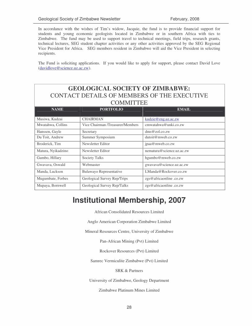
Geological Society of Zimbabwe Newsletter February, 2008
28
In accordance with the wishes of Tim’s widow, Jacquie, the fund is to provide financial support for students and young economic geologists located in Zimbabwe or in southern Africa with ties to Zimbabwe. The fund may be used to support travel to technical meetings, field trips, research grants, technical lectures, SEG student chapter activities or any other activities approved by the SEG Regional Vice President for Africa. SEG members resident in Zimbabwe will aid the Vice President in selecting recipients. The Fund is soliciting applications. If you would like to apply for support, please contact David Love ([email protected]).
GEOLOGICAL SOCIETY OF ZIMBABWE: CONTACT DETAILS OF MEMBERS OF THE EXECUTIVE
COMMITTEE NAME PORTFOLIO EMAIL
Musiwa, Kudzai CHAIRMAN [email protected] Mwatahwa, Collins Vice Chairman /Treasurer/Members [email protected]
Hanssen, Gayle Secretary [email protected] Du Toit, Andrew Summer Symposium [email protected]
Broderick, Tim Newsletter Editor [email protected]
Matura, Nyikadzino Newsletter Editor [email protected]
Gumbo, Hillary Society Talks [email protected]
Gwavava, Oswald Webmaster [email protected]
Manda, Luckson Bulawayo Representative [email protected]
Mugumbate, Forbes Geological Survey Rep/Trips zgs@africaonline .co.zw
Mupaya, Bornwell Geological Survey Rep/Talks zgs@africaonline .co.zw
Institutional Membership, 2007
African Consolidated Resources Limited
Anglo American Corporation Zimbabwe Limited
Mineral Resources Centre, University of Zimbabwe
Pan-African Mining (Pvt) Limited
Rockover Resources (Pvt) Limited
Samrec Vermiculite Zimbabwe (Pvt) Limited
SRK & Partners
University of Zimbabwe, Geology Department
Zimbabwe Platinum Mines Limited