gao-10-120 national airspace system: regional airport
TRANSCRIPT

GAO United States Government Accountability Office
Report to Congressional Requesters
NATIONAL AIRSPACE SYSTEM
Regional Airport Planning Could Help Address Congestion If Plans Were Integrated with FAA and Airport Decision Making
December 2009
GAO-10-120
What GAO Found
United States Government Accountability Office
Why GAO Did This Study
HighlightsAccountability Integrity Reliability
December 2009 NATIONAL AIRSPACE SYSTEM
Regional Airport Planning Could Help Address Congestion If Plans Were Integrated with FAA and Airport Decision Making Highlights of GAO-10-120, a report to
congressional requesters
The Federal Aviation Administration (FAA) predicts that the national airspace system will become increasingly congested over time, imposing costs of delay on passengers and regions. While transforming the current air-traffic control system to the Next Generation Air Transportation System (NextGen) may provide additional en route capacity, many airports will still face constraints at their runways and terminals. In light of these forecasts, GAO was asked to evaluate regional airport planning in metropolitan regions with congested airports. GAO (1) identified which airports are currently or will be significantly congested and the potential benefits of regional airport planning, (2) assessed how regions with congested airports use regional airport planning in decision making, and (3) identified factors that hinder or aid in the development and implementation of regional airport plans. GAO reviewed studies; interviewed FAA, airport, and other aviation and transportation officials; and conducted case studies in selected regions.
What GAO Recommends
GAO is recommending that the Secretary of Transportation direct FAA to create a review process for RASPs and use its existing authority to give priority to funding airport projects that are consistent with RASPs. The Department of Transportation generally agreed to consider the revised recommendations.
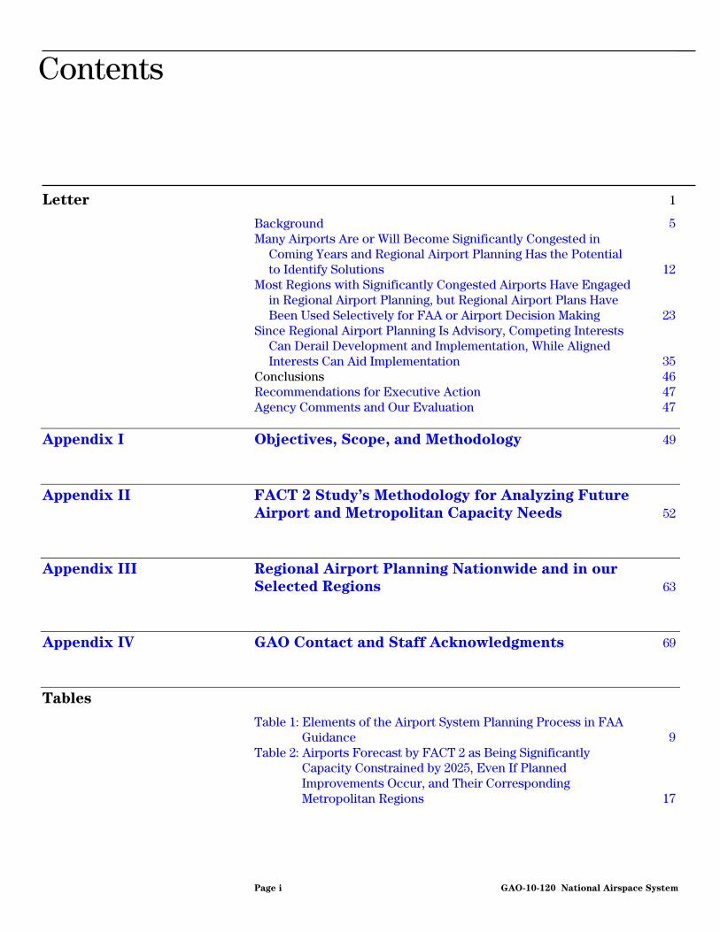
A number of airports are or will be significantly capacity constrained and thus congested within the next 16 years. However, many of them face environmental and other obstacles to developing additional airport capacity. In 2007, FAA identified 14 airports (in 10 metropolitan regions) that will be significantly capacity constrained by 2025, even assuming all currently planned improvements occur (see figure). Planned improvements include airport construction projects and implementation of NextGen technologies. Without these improvements, FAA predicts that 27 airports will be congested. According to the FAA assessment and other studies, regional airport planning may identify additional solutions, such as the increased use of alternate airports or other modes of travel, to help relieve airport congestion. Airports Forecast to Need Capacity in 2025 after Planned Improvements
Sources: GAO analysis of FAA data; Map Resources (base map).
Airports
SFOSFOSFO
OAKOAKOAK
PHXPHXPHX
LGBLGBLGBSNASNASNA
SANSANSAN
LASLASLAS
MDWMDWMDW
ATLATLATL
FLLFLLFLL
JFKJFKJFKEWREWREWR
PHLPHLPHL
LGALGALGA
ATL: Hartsfield-Jackson Atlanta InternationalEWR: Newark Liberty InternationalFLL: Fort Lauderdale-Hollywood InternationalJFK: John F. Kennedy InternationalLAS: McCarran InternationalLGA: LaGuardiaLGB: Long BeachMDW: Midway InternationalOAK: Oakland InternationalPHL: Philadelphia InternationalPHX: Phoenix Sky Harbor InternationalSAN: San Diego InternationalSFO: San Francisco InternationalSNA: John Wayne
From 1999 through 2008, 9 of the 10 metropolitan regions with airports forecast to be significantly capacity constrained by 2025 have received a total of $20 million in FAA funding for regional airport planning. Of those regions, 6 have developed or will develop regional airport system plans (RASP), which we found largely followed FAA’s guidance for airport system planning. The remaining 4 regions have engaged in less comprehensive planning. FAA does not formally review RASPs, and they have been used selectively by FAA and airports in decision making for the planning and funding of individual airport projects. A few airport sponsors have pursued select strategies outlined in plans, while one airport sponsor rejected the RASP for its decision making. Because regional airport planning is advisory, competing interests can derail development and implementation. Metropolitan planning organizations generally develop RASPs but have no authority over airport development. That authority rests with airports, which are not required to incorporate planning recommendations into their capital plans, and with FAA, which makes funding decisions on the basis of national priorities. In addition, airport, community, and airline interests may conflict in a region. For example, Philadelphia International does not support planning efforts that may divert traffic from its airport to alternate regional airports. By contrast, aligned interests and FAA involvement may aid regional planning and implementation, as has occurred in the Boston region.
View GAO-10-120 or key components. For more information, contact Gerald Dillingham, Ph.D., at (202) 512-2834 or [email protected].
Page i GAO-10-120
Contents
Letter 1
Background 5 Many Airports Are or Will Become Significantly Congested in
Coming Years and Regional Airport Planning Has the Potential to Identify Solutions 12
Most Regions with Significantly Congested Airports Have Engaged in Regional Airport Planning, but Regional Airport Plans Have Been Used Selectively for FAA or Airport Decision Making 23
Since Regional Airport Planning Is Advisory, Competing Interests Can Derail Development and Implementation, While Aligned Interests Can Aid Implementation 35
Conclusions 46 Recommendations for Executive Action 47 Agency Comments and Our Evaluation 47
Appendix I Objectives, Scope, and Methodology 49
Appendix II FACT 2 Study’s Methodology for Analyzing Future
Airport and Metropolitan Capacity Needs 52
Appendix III Regional Airport Planning Nationwide and in our
Selected Regions 63
Appendix IV GAO Contact and Staff Acknowledgments 69
Tables
Table 1: Elements of the Airport System Planning Process in FAA Guidance 9
Table 2: Airports Forecast by FACT 2 as Being Significantly Capacity Constrained by 2025, Even If Planned Improvements Occur, and Their Corresponding Metropolitan Regions 17
National Airspace System

Table 3: FAA Funding for Regional Airport Planning for Regions Forecast to Have Significantly Congested Airports by 2025, Even If Planned Improvements Occur, 1999–2008 24
Table 4: RASP Development in Regions with Potentially Congested Airports 25
Table 5: Regional Airport Planning in Those Regions with Potentially Congested Airports That Have Not Prepared RASPs 28
Table 6: FAA Funding for Conducting or Updating Metropolitan System Plan Studies, 1999–2008 63
Table 7: Aviation System Planning at Metropolitan Planning Organizations 64
Figures
Figure 1: Funding Process for Airport Improvement Projects 6 Figure 2: Airports Needing Capacity in 2015 and 2025, Even If
Planned Improvements Occur 13 Figure 3: Airports Needing Capacity in 2015 and 2025, If Planned
Improvements Do Not Occur 15 Figure 4: Potential Extent of Bay Fill for Runway Construction at
San Francisco International Airport (2000 Proposal) 21 Figure 5: Service Areas for the Primary Airports in the New York–
New Jersey Region, 2005 32
Page ii GAO-10-120 National Airspace System
Abbreviations
AAIA Airport and Airway Improvement Act of 1982 ACIP Airports Capital Improvement Plan ACRP Airport Cooperative Research Program AIP Airport Improvement Program ALP airport layout plan ASV annual service volume DFW Dallas–Forth Worth International Airport DOT Department of Transportation FAA Federal Aviation Administration FATE Future Air Traffic Estimator FDOT Florida Department of Transportation FHWA Federal Highway Administration FTA Federal Transportation Administration JFK John F. Kennedy International Airport LAX Los Angeles International Airport maglev magnetic levitation train MPO metropolitan planning organization NAS national airspace system NextGen Next Generation Air Transportation System NPIAS National Plan of Integrated Airport Systems OEP Operational Evolution Partnership RASP regional airport system plan SFO San Francisco International Airport TAF Terminal Area Forecast TIP Transportation Improvement Program
This is a work of the U.S. government and is not subject to copyright protection in the United States. The published product may be reproduced and distributed in its entirety without further permission from GAO. However, because this work may contain copyrighted images or other material, permission from the copyright holder may be necessary if you wish to reproduce this material separately.
Page iii GAO-10-120 National Airspace System

Page 1 GAO-10-120
United States Government Accountability Office
Washington, DC 20548
December 23, 2009
The Honorable John L. Mica Ranking Member Committee on Transportation and Infrastructure House of Representatives
The Honorable Thomas E. Petri Ranking Member Subcommittee on Aviation Committee on Transportation and Infrastructure House of Representatives
Constrained capacity at some U.S. airports reduces the efficiency of the national airspace system and results in congestion and flight delays throughout the country. A recent study found that congestion is concentrated in major metropolitan areas, such as Atlanta, Chicago, Miami, New York, Philadelphia, and San Francisco, and that the situation is worsening over time.1 In 2008, nearly one-in-four arriving flights was delayed more than 15 minutes at major U.S. airports, and, in the especially congested New York region, one-in-three flights was delayed.2 Flight delays inconvenience passengers as well as impose economic costs on passengers, airlines, airports, and the economy. Delays at one airport can also impact other airports, causing a ripple effect across the national airspace system. Congestion also has negative impacts on the environment, such as increased emissions from aircraft. GAO has previously reported that long-term solutions to alleviating congestion and delay should address underlying capacity constraints at airports.3 The federal government, through the Federal Aviation Administration (FAA), provided almost $3.5 billion in 2008 for airport planning and development through Airport Improvement Program (AIP) grants. Also, airports collect
1Adie Tomer and Robert Puentes, Expect Delays: An Analysis of Air Travel Trends in the
United States, Metropolitan Policy Program at Brookings (October 2009).
2The Bureau of Transportation Statistics within the U.S. Department of Transportation (DOT) measures congestion—or airport on-time arrival performance—by looking at the percentage of flights arriving within 15 minutes of their scheduled arrival time.
3GAO: Next Generation Air Transportation System: Status of Key Issues Associated with
the Transition to NextGen, GAO-08-1154T (Washington, D.C.: Sept. 11, 2008).
National Airspace System

almost another $3 billion in passenger facility charges annually that can be used for projects, including those aimed at increasing capacity in the national airspace system.4 FAA’s Operational Evolution Partnership (OEP) program aims at increasing capacity and improving efficiency at the nation’s busiest airports through the construction of new airfield infrastructure, such as new or extended runways and new taxiways.5 FAA is also planning to increase system capacity through technological improvements, such as those currently being planned and implemented in the Next Generation Air Transportation System (NextGen) program.6 In addition, some regions are looking at ways to optimize existing and new regional airport capacity, including the use of alternate regional airports, and the potential use of alternative modes to move passengers, such as high-speed rail.
Because of your interest in better meeting the nation’s transportation needs, you asked us to describe the role that regional airport planning could play in better managing airport capacity in heavily congested regions of the country. To address this issue, we (1) identified which airports are already significantly congested or are projected to be significantly congested and potential benefits that regional airport planning might offer, (2) assessed the extent to which regions with significantly congested airports engage in regional airport planning to help relieve congestion and how this planning has been used in decision making, and (3) identified factors that hinder or aid in the development and implementation of regional airport plans.
4The Passenger Facility Charge Program, authorized by 49 U.S.C. § 40117, allows for the collection of passenger facility fees up to $4.50 for every enplaned passenger at commerical service airports controlled by public agencies, with certain exceptions. Airports use these fees to fund FAA-approved, airport-related projects that enhance safety, security, or capacity; reduce noise or mitigate noise impacts; or enhance air carrier competition. See 14 C.F.R. §§ 158.15, 158.17.
5According to FAA, OEP airports are commercial airports with significant activity. These airports serve major metropolitan areas and also serve as hubs for airline operations. More than 70 percent of passengers travel through these airports. Delays at the 35 OEP airports have a ripple effect at other airports. The 35 OEP airports were compiled in 2000 on the basis of lists from FAA and Congress as well as a study that identified the most congested airports in the United States.
6The NextGen program aims at combining airport expansion with other approaches, including regional solutions and technological and operational improvements, to meet future demands for aviation. As part of this effort, the NextGen program will transform the current radar-based, air-traffic control system into a more automated aircraft-centered, satellite-based system.
Page 2 GAO-10-120 National Airspace System
To address these objectives, we relied primarily on FAA guidance on airport system planning, FAA’s assessment of airport capacity needs, our in-depth analysis of selected regions with congested airports, and our past studies. FAA has provided guidance to states and metropolitan areas on the development of airport system plans, noting that such plans should guide airport development needed in a specific area to establish a viable, balanced, and integrated system of public use airports.7 We considered airports that are currently congested or are forecast to be significantly congested using FAA’s 2007 report—Capacity Needs in the National
Airspace System, 2007–2025 (FACT 2)—which identified airports that will need additional capacity whether or not currently planned improvements are carried out.8 The FACT 2 report made forecasts for airports in 2015 and 2025, and, while this type of long-term modeling naturally faces uncertainties, we used FACT 2 to identify regions for our in-depth analysis because it forecast long-term capacity needs and included analyses of both demand and capacity. Because the FACT 2 report forecast future demand before 2007, the report may overstate the likely growth of demand, given the subsequent economic downturn. On the other hand, the analyses used fairly conservative measures to determine which airports would be the most capacity constrained and, as a result, may understate the number of airports that will be congested. For a complete discussion of the methodology used by FACT 2 and its implications, see appendix II. We identified regions for more detailed analysis after considering (1) existing and predicted aviation congestion based on FAA’s FACT 2 report; (2) whether regions had sought funding from FAA for regional airport planning, and the amount of the funding provided by FAA; (3) whether regional airport planning has occurred or is occurring in a region; and (4) whether regions were served by a single major commercial service airport or multiple airports and the extent to which multiple airports in a region were governed by the same sponsor.9
7FAA, The Airport System Planning Process, Advisory Circular 150/5070-7 (Washington, D.C.: Nov. 10, 2004).
8See FAA, Capacity Needs in the National Airspace System, 2007–2025: An Analysis of
Airports and Metropolitan Area Demand and Operational Capacity in the Future (Washington, D.C.: May 2007), a study prepared by The MITRE Corporation, Center for Advanced Aviation System Development. This report was intended to identify those airports that are forecast to be significantly congested, although other airports may also face capacity constraints. It may be found on the following FAA Web site: http://www.faa.gov/airports/resources/publications/reports/media/fact_2.pdf.
9For the purposes of this report, we refer to “airport sponsors” when discussing airport sponsors, authorities, operators, or owners.
Page 3 GAO-10-120 National Airspace System

Our analysis of selected regions forecast to have significantly congested airports included Los Angeles, New York, Philadelphia, San Diego, and San Francisco. We also assessed regional airport planning in Boston, although this region was not among those with airports that are forecast to be significantly capacity constrained by FACT 2, if planned improvements occur. FAA officials and experts have pointed to this region as having undertaken successful regional airport planning. Each of the regions we selected has received funding from FAA for regional airport planning, and regional airport planning has been undertaken in each region. Three of the regions are served by multiple airports—sometimes under the same sponsor—while Philadelphia and San Diego are in regions with one major airport. In the five regions we selected, we interviewed regional planning, airport, FAA,10 and state officials about the nature of the regional airport system; participants in such planning; the extent that regions have undertaken regional airport planning and how these plans may have been used; and factors that aided or hindered planning or implementation. We also examined FAA guidance on airport system planning; interviewed FAA planning and forecasting officials; and interviewed industry experts, academics, planners, and trade association representatives. We also utilized our prior work on the NextGen program, on the airspace redesign project in New York/New Jersey/Philadelphia, and on metropolitan planning organizations (MPO). We also reviewed relevant studies, including ongoing research being developed for the Airport Cooperative Research Program of the Transportation Research Board and studies by the Massachusetts Institute of Technology regarding the role of regional airport planning in addressing airport congestion. Appendix I contains a more detailed description of our objectives, scope, and methodology.
We conducted this performance audit from September 2008 to December 2009, in accordance with generally accepted government auditing standards. Those standards require that we plan and perform the audit to obtain sufficient, appropriate evidence to provide a reasonable basis for our findings and conclusions based on our audit objectives. We believe that the evidence obtained provides a reasonable basis for our findings and conclusions based on our audit objectives.
10We spoke with FAA regional and airport district office officials in the Western-Pacific Region—covering Los Angeles, San Diego, and San Francisco—and in the Eastern Region—covering New Jersey, New York, and Pennsylvania.
Page 4 GAO-10-120 National Airspace System

FAA’s mission is to provide a safe and efficient airspace system. As part of this mission, the agency uses airport system planning to better understand the interrelationship of airports at the national, state, and regional levels. FAA guidance states that the overall goals of airport system planning are to ensure that the air transportation needs of a state or metropolitan area are adequately served by its airports, and that planning results in products that can be used by the planning organization, airports, and FAA to determine future airport development needs.11
Background
There are several types and levels of planning involving individual airports or airport systems, including the National Plan of Integrated Airport Systems (NPIAS), state and regional system plans, and airport-level plans. The NPIAS identifies over 3,400 airports as being nationally significant to the national airspace system, including all of the nation’s commercial service and reliever airports and some general aviation airports.12 Most states periodically develop state airport system plans to inventory airports using a set of criteria developed by FAA. While not required, some regions choose to carry out regional airport planning—which may include the development of regional airport system plans (RASP) or other regional airport plans—to identify critical regional airport issues and to integrate aviation with other modes in a region’s transportation system.13 At the airport level, two types of plans support airport improvements at individual airports, the airport layout plan (ALP), which is required for
11
The Airport System Planning Process.
12A “commercial service airport” is a publicly owned airport in a state that the Secretary of Transportation determines has at least 2,500 passenger boardings each year and receives scheduled passenger aircraft service. See 49 U.S.C. § 47102(7). “Reliever airports” are airports designated by the Secretary to relieve congestion at commercial service airports and to provide more general aviation access to the overall community. See 49 U.S.C. § 47102(22). Finally, the remaining airports are commonly described as “general aviation airports.” The NPIAS is designated by the Secretary and according to FAA, to be included in the NPIAS, general aviation airports must have at least 10 locally based aircraft and be located at least 20 miles from the nearest NPIAS airport. The general aviation category also includes privately owned, public use airports that enplane 2,500 or more passengers annually and receive scheduled airline service.
13For the purposes of this report, we refer to the airport system plans that are developed on a metropolitan or regional level as “regional airport system plans.” These plans may be referred to differently in individual regions. For example, in the San Diego region, regional planners are developing a Regional Aviation Strategic Plan, while the plan developed in the Los Angeles region is part of the MPO Regional Transportation Plan.
Page 5 GAO-10-120 National Airspace System

federal funding, and the airport master plan.14 Figure 1 provides additional information about these plans and illustrates the role of each in the FAA funding process for airport improvement projects in the AIP.
in the FAA funding process for airport improvement projects in the AIP.
Figure 1: Funding Process for Airport Improvement Projects Figure 1: Funding Process for Airport Improvement Projects
Airport Layout Plans (ALP)and airport master plans
ALPs are a graphical depiction of current and future airport facilities. All
NPIAS airports must have an FAA-approved ALP to receive federal
funding. Airport master plans are optional and supplement ALPs with
detailed information, such as forecasts of passenger demand and
long-range development plans.
Airports Capital ImprovementPlans (ACIP)
FAA regional offices review airport-level capital improvement plans, which are based on ALPs and airport master plans, and may consider other plans—such as state plans or RASPs—to develop a plan of recommended
projects. FAA headquarters scores these recommended projects using national criteria
for inclusion on a candidate list for AIP discretionary funding. FAA regional offices have some discretion in finalizing the list of
projects included in the ACIP.
National Plan of IntegratedAirport Systems (NPIAS)
The NPIAS is an inventory of airports that meet national criteria. Inclusion in the NPIAS makes an airport eligible to receive Airport
Improvement Program (AIP) grants.
RASPs are voluntary. These plans contain elements laid out for airport system planning by FAA, such as an inventory of the regional airport system and forecasts of regional demand. They may also prioritize
airport improvements from a regional perspective.
Regional Airport System Plans (RASP)
Other regional plans do not necessarily contain elements laid out for system planning by FAA. These plans may include special studies to
analyze or address issues such as compatible land use, zoning implementation, or airport ground access.
Other regional airport plans
State airport system plans recommend airports for inclusion in the NPIAS. They may also identify state aviation funding priorities.
State Airport System Plans
Source: GAO analysis of FAA documents.
Establishing eligibility Planning for eligible airports Decision making for federal funding
Regional airport planning may complement other airport planning
Airports in the NPIAS become eligible to apply for FAA’s AIP grants, which provided almost $3.5 billion for capital projects in fiscal year 2008.15 AIP funding is available for eligible projects, which include projects such as airfield construction or equipment purchases, terminal or terminal access improvements, land acquisition, noise compatibility projects, and regional airport planning. AIP grants generally consist of two types—
14The ALP must be approved by the Secretary of Transportation, as must any revision or modification of the plan, before the Secretary will approve a project grant application. See 49 U.S.C. § 47107(a)(16). An airport owner or operator is not permitted to make any modification to the airport or its facilities that does not comply with the ALP. Airport master plans are not required, but provide additional information for airport capital improvement planning.
15The current AIP was established by the Airport and Airway Improvement Act of 1982, Pub. L. No. 97-248, § 502(a), 96 Stat. 324, 671.
Page 6 GAO-10-120 National Airspace System

entitlement funds that are apportioned to airports or states by formula each year based upon statutory criteria, and discretionary funds that FAA approves based on a project's priority. To ensure that the highest priorityprojects nationally are funded, discretionary funds are awarded using a national priority rating system that awards points on a variety of factorsincluding airport size; the purpose of the project (e.g., capacity related, planning, environmental, and safety); and the type of project (e.g., termiimprovement and equipment purchase). Airports apply directly to FAA through FAA regional offices for AIP discretionary funding, anprojects are scored using the national priority rating system.
,
nal
d proposed
o
d
g to develop plans to serve as a guideline for the allocation of funding.
gions
funded with AIP grants includes special studies to analyze or address new
16 Furthermore, the Airport and Airway Improvement Act of 1982 (AAIA)—which established the current AIP—provided FAA with the authority tgive priority to airport improvement projects that are consistent with integrated airport system plans,17 such as RASPs. In the guidance providedby FAA for airport system planning, airport sponsors are also encourageto use findings and recommendations from regional airport plannin
While no specific amount is currently set aside for system planning in theAIP program, approximately 2 percent of funds made available annually for AIP grants since 1970 have been used for these purposes.18 Most of thisfunding is used for planning at the state or airport level, but some rehave also applied for and received AIP funding for regional airport planning. This funding has been used for a variety of planning efforts by states, airport sponsors, and regional planning bodies—primarily MPOs—and includes the development of RASPs.19 Other regional airport planning
16Commercial service airports can also use passenger facility charges for all AIP-eligible and certain other types of projects that meet established criteria. Larger commercial service airports also rely on their own funding sources—in particular, long-term debt supported by airport revenues—to fund capital projects.
17Pub. L. No. 97-248, § 509(b)(9), 96 Stat. 324, 685 (1982), codified as amended at 49 U.S.C. § 47120.
18A set-aside was established for system-planning grants in the AIP in the AAIA in 1982. Pub. L. No. 97-248, § 508(d)(4), 96 Stat. 324, 682. The AAIA set-aside was originally set at no less than 1 percent. The amount of the set-aside was subsequently amended before being eliminated by the Federal Aviation Reauthorization Act of 1996, Pub. L. No. 104-264, 110 Stat. 3213, 3219 (1996).
19Typical agencies authorized to conduct metropolitan or regional planning are MPOs, councils of government, and regional planning councils or commissions. We refer to such regional planning agencies as “MPOs”.
Page 7 GAO-10-120 National Airspace System

or unique issues, such as compatible land uses around airports, zoning implementation, or airport ground access.
There are a number of stakeholders with interests in the airport planning process. They include FAA, states, and airports and may also include MPOs, airlines, and local communities. The FAA’s Office of Airport Planning and Programming provides guidance about airport system planning, while FAA regional offices administer grants and provide technical support to airports and others developing airport plans at the airport, regional, and state levels. The range of involvement by a particular stakeholder group varies by the type of plan under development, among other things. Thus, FAA, airports, and sometimes airlines are typically most involved in the development of ALPs and airport master plans and the resulting capital plans. States work with airports—notably, general aviation or reliever airports, not typically major commercial airports—to identify airports and improvements for inclusion in state airport system plans. MPOs may work with airport sponsors, local jurisdictions, state authorities, and FAA when developing RASPs or carrying out other regional airport planning. FAA accepts plans developed by states or MPOs and reviews and approves ALPs. In addition to federal and state aviation officials, other stakeholders in the process include the following:
• Airport sponsors: Airport sponsors can be any one of a number of different types of public entities, such as cities, counties, airport authorities, ports, intermodal agencies, or private owners.
• MPOs: MPOs may lead or participate in regional airport planning, but their primary role is carrying out regional surface transportation planning in urbanized areas, including the development of long-range and short-range transportation plans. To receive federal surface transportation funding, any project in an urbanized area must emerge from the relevant MPO and state department of transportation planning process.20
• Airlines: Airlines play a key role in the functioning of airport systems, since they make decisions about which airports to serve and how frequently to provide service. Airlines may consider a number of factors in making these decisions, such as the location of regional business, economic indicators, the travel patterns of area residents, the
20See 23 U.S.C. §§ 134, 135; 49 U.S.C. §§ 5303, 5304. FAA-funded projects do not require inclusion in the regional transportation planning process.
Page 8 GAO-10-120 National Airspace System

cost of establishing service at particular airports, the effects on their service network, and the service provided by competing carriers.
FAA guidance on airport system planning identifies eight key elements of the planning process, including inventorying the airport system, identifying air transportation needs, considering alternative airport systems, and preparing an implementation plan (see table 1). The guidance states that the end result should be “the establishment of a viable, balanced, and integrated system of airports to meet current and future demand.” FAA does not approve airport master plans, state airport system plans, or RASPs. For those plans developed with FAA funding, however, FAA is involved in developing the scope of work covered under the grant, reviewing draft documents, approving aviation forecasts, and then accepting the final plan.
Table 1: Elements of the Airport System Planning Process in FAA Guidance
Element Description
Exploration of issues that impact aviation in the study area
A list of major aviation issues, problems, questions, and opportunities should be developed, ranked in order of importance, and presented with strategies to address each. The report may include issues of a national nature as well as concerns specific to an individual state, metropolitan region, local community, or even multistate area.
Inventory of the current system The inventory should include information about the condition and activity of individual airports; environmental features and conditions as well as land-use considerations and applicable laws; navigational aids and other aspects of aircraft approaches; statewide or regional socioeconomic data and airport financial information; historical weather data; surface transportation; and terminal, airfield, and airspace capacity.
Identification of air transportation needs Broad system goals and performance measures ensure the implementation of a successful aviation system, while specific goals vary depending on the planning area. Examples include having a system of airports readily accessible to the population, providing emergency medical access to the population, providing a safe and efficient system of airports, and preserving the existing airport system with a high degree of stable ownership. Performance measures should tie the level of service of the system and the performance of individual airports to the goals.
Forecast of system demand Forecasts define an airport’s role within the system and prioritize airport development. FAA-prepared forecasts should be used when they meet the requirements of the system planning effort. Factors that can be considered include socioeconomic data, demographics, disposable income, geographic attributes, and external factors such as fuel costs and local attitudes toward aviation. Forecasts are submitted to FAA for approval.
Page 9 GAO-10-120 National Airspace System

Element Description
Consideration of alternative airport systems
If the assessment of airport system capacity shows that expansion of facilities is necessary to accommodate projected demand, an investigation of alternatives should be conducted. Criteria to compare alternatives can include capital costs, aviation safety, airspace utilization, ability to address need, environmental impacts, delay and other operational costs, consistency with local area comprehensive and transportation plans, and land-use availability and compatibility. The evaluation of system alternatives is usually a more complex activity for large metropolitan or regional areas, given scarcities in airspace and land, challenges to airport accessibility, and potential environmental effects. Therefore, the analysis of feasible alternatives should attempt to balance the need for airfield capacity and use of airspace with the need to minimize environmental impacts.
Definition of airport roles and policy strategies
The existing role of each airport should be identified using definitions provided by FAA for NPIAS airports. If alternate definitions are used, these should be linked to the airport categories used in the NPIAS. Using standard definitions will help maximize the system benefits of airport investments as well as ensure the rationalization of federal priorities across airport categories.
Recommendation of system changes, funding strategies, and airport development
State plans can identify priorities among existing airports, and MPOs can provide recommendations. Some states and regional planning organizations define priority indices with relative weightings, establishing their own priority rankings for proposed airport development projects. In general, these rankings should be consistent with FAA’s AIP priorities, if federal funds are sought. A cost-effective plan of action should be prepared for 5-, 10-, and 20-year planning horizons.
Preparation of an implementation plan Development that is eligible for AIP funding should be identified so it can be easily incorporated into the NPIAS and FAA’s Airport Capital Improvement Plan as well as into the airport’s master plan and ALP.
Source: GAO presentation of FAA Airport System Planning guidance.
When considering alternative airport systems (the fifth of the eight elements), regional planners may identify alternate, underutilized airports in a region as having the potential to relieve pressure on congested airports. FAA’s airport system planning guidance states that the development of such alternate airports should only be undertaken when a full assessment has been done of various market factors. The guidance states that it is important to understand the nature of demand within a region, including factors that would divert demand to other airports, and any potential political, economic, or institutional barriers to developing an airport system. It also recommends that planners assess the ability of the airport to offer adequate service—in terms of convenience, schedules, and fares—and the effect on airlines, noting that the development of alternate airports should enhance airline profitability and be compatible with their route systems.
In addition to the development of RASPs, other types of regional airport planning, including special studies whose scope of work does not fully correspond with the elements described in the airport system planning guidance, may be undertaken with AIP grants, according to FAA’s airport
Page 10 GAO-10-120 National Airspace System

system planning guidance. Special studies can include but are not limited to work in such areas as air service, air cargo operations, environmental or drainage inventories, surface access, economic impact, obstruction analysis or photogrammetry, general aviation security, and pavement management.21
FAA’s airport system planning guidance states that MPOs can receive FAA support to conduct regional airport planning in areas that include large- or medium-hub airports (1) when such agencies have the interest in and capabilities to conduct such planning and (2) when regional FAA, state aviation, and local airport officials determine that MPOs should have a role. The guidance continues that the regional airport planning carried out by MPOs should complement—rather than guide—the planning done by FAA, states, and individual airports. According to the guidance, MPO-led regional airport planning may enhance the integration of the entire regional transportation system by promoting aviation enhancement and preservation, identifying critical regional aviation issues, and acting as the contact point for regional surface access, air quality, and land-use planning studies. MPOs can also act as a catalyst in implementing system planning recommendations—which may involve several stakeholders—by resolving local conflicts, promoting airport development funding priorities, and proposing the distribution of grants among eligible projects. The guidance states that an MPO’s ability to implement regional airport planning recommendations is limited to the extent that it can influence airport development through persuasion; leadership; or nonaviation incentives, such as surface transportation improvements that may improve airport access. This stands in contrast to state aviation agencies, which can implement system planning recommendations using legislative and funding mechanisms, including AIP funds, whereas MPOs do not receive AIP funds, other than for planning purposes.
21See section 304 of the FAA Advisory Circular 150/5070-7 for a fuller description of these special studies.
Page 11 GAO-10-120 National Airspace System
Many Airports Are or Will Become Significantly Congested in Coming Years and Regional Airport Planning Has the Potential to Identify Solutions
FAA Has Identified 14 Airports That May Become Significantly Congested by 2025, Even If Planned Improvements Occur, and 27 Airports If They Do Not Occur
FAA’s FACT 2 report forecast that 14 airports will be significantly capacity constrained—and thus potentially congested—by 2025, even if currently planned improvements are carried out.22 According to FAA, some airports are already significantly capacity constrained, and increased demand is expected to increase delays going forward. Six of these 14 airports will be significantly capacity constrained as early as 2015, according to the report. (See fig. 2.)
The FACT 2 study was designed to produce a conservative list of congested airports, according to FAA officials, and identified those airports that will have the greatest need for future additional capacity. FAA officials noted that airports not designated as capacity constrained by the study may also have capacity issues in the future and may need capacity-enhancing projects. (See app. II for a discussion of the FACT 2 report and implications of its design.) The demand forecasts included in FACT 2, however, were conducted before 2007 and do not take into account the reduction in demand resulting from the recent economic downturn. As a result, potential capacity constraints may occur on a different timeline than previously forecast.
22The FACT 2 report used measures of demand and capacity to identify those airports forecast to face significant capacity constraints by 2025 and 2015. For its analysis, FAA focused on 56 of the nation’s 291 commercial service airports, including the 35 airports—primarily large-hub facilities—included in the FAA’s OEP and an additional 21 airports identified for more detailed analysis on the basis of airport operation levels and assumptions about fleet mix at these facilities.
Page 12 GAO-10-120 National Airspace System
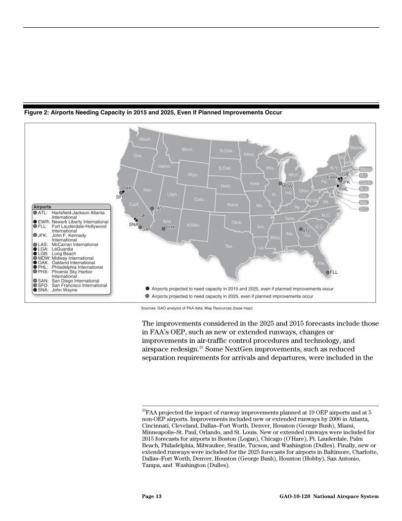
Figure 2: Airports Needing Capacity in 2015 and 2025, Even If Planned Improvements Occur
SFOSFOSFO
OAKOAKOAK
PHXPHXPHX
LGBLGBLGB
SNASNASNASANSANSAN
LASLASLAS
MDWMDWMDW
ATLATLATL
FLLFLLFLL
JFKJFKJFKEWREWREWR
PHLPHLPHL
Sources: GAO analysis of FAA data; Map Resources (base map).
LGALGALGA
Airports projected to need capacity in 2025, even if planned improvements occur
Airports projected to need capacity in 2015 and 2025, even if planned improvements occur
Pa.
Ore.
Nev.
Idaho
Mont.
Wyo.
Utah
Ariz.N.Mex.
Colo.
N.Dak.
S.Dak.
Nebr.
Tex.
Kans.
Okla.
Minn.
Iowa
Mo.
Ark.
La.
Ill.
Miss.
Ind.
Ky.
Tenn.
Ala.
Fla.
Ga.
S.C.
N.C.
Va.
Ohio
N.H.
Mass.Mich.
Calif.
Wash.
Wis. N.Y.
Maine
Vt.
W.Va.
R.I.
Conn.N.J.
Del.Md.D.C.
ATL: Hartsfield-Jackson Atlanta InternationalEWR: Newark Liberty InternationalFLL: Fort Lauderdale-Hollywood InternationalJFK: John F. Kennedy InternationalLAS: McCarran InternationalLGA: LaGuardiaLGB: Long BeachMDW: Midway InternationalOAK: Oakland InternationalPHL: Philadelphia InternationalPHX: Phoenix Sky Harbor InternationalSAN: San Diego InternationalSFO: San Francisco InternationalSNA: John Wayne
Airports
The improvements considered in the 2025 and 2015 forecasts include those in FAA’s OEP, such as new or extended runways, changes or improvements in air-traffic control procedures and technology, and airspace redesign.23 Some NextGen improvements, such as reduced separation requirements for arrivals and departures, were included in the
23FAA projected the impact of runway improvements planned at 19 OEP airports and at 5 non-OEP airports. Improvements included new or extended runways by 2006 in Atlanta, Cincinnati, Cleveland, Dallas–Fort Worth, Denver, Houston (George Bush), Miami, Minneapolis–St. Paul, Orlando, and St. Louis. New or extended runways were included for 2015 forecasts for airports in Boston (Logan), Chicago (O’Hare), Ft. Lauderdale, Palm Beach, Philadelphia, Milwaukee, Seattle, Tucson, and Washington (Dulles). Finally, new or extended runways were included for the 2025 forecasts for airports in Baltimore, Charlotte, Dallas–Fort Worth, Denver, Houston (George Bush), Houston (Hobby), San Antonio, Tampa, and Washington (Dulles).
Page 13 GAO-10-120 National Airspace System
2025 analysis for the 35 airports included in the OEP program and Oakland International Airport.24
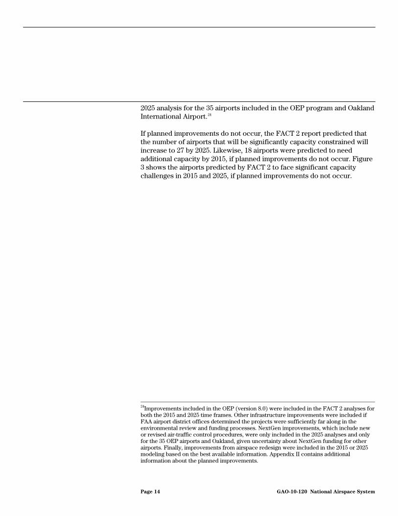
If planned improvements do not occur, the FACT 2 report predicted that the number of airports that will be significantly capacity constrained will increase to 27 by 2025. Likewise, 18 airports were predicted to need additional capacity by 2015, if planned improvements do not occur. Figure 3 shows the airports predicted by FACT 2 to face significant capacity challenges in 2015 and 2025, if planned improvements do not occur.
24Improvements included in the OEP (version 8.0) were included in the FACT 2 analyses for both the 2015 and 2025 time frames. Other infrastructure improvements were included if FAA airport district offices determined the projects were sufficiently far along in the environmental review and funding processes. NextGen improvements, which include new or revised air-traffic control procedures, were only included in the 2025 analyses and only for the 35 OEP airports and Oakland, given uncertainty about NextGen funding for other airports. Finally, improvements from airspace redesign were included in the 2015 or 2025 modeling based on the best available information. Appendix II contains additional information about the planned improvements.
Page 14 GAO-10-120 National Airspace System

Figure 3: Airports Needing Capacity in 2015 and 2025, If Planned Improvements Do Not Occur
SEASEASEA
SFOSFOSFO
OAKOAKOAK
PHXPHX
TUSTUS
PHX
TUS
LGBLGBLGBLAXLAXLAX
SNASNASNASANSANSAN
LASLASLAS
MSPMSPMSP
ORDORDORDMDWMDWMDW
SATSATSAT HOUHOUHOU
IAHIAHIAH
ATLATLATL
CLTCLTCLT
FLLFLLFLLPBIPBIPBI
BOSBOSBOSPVDPVDPVD
JFKJFKJFKEWREWREWR
PHLPHLPHLIADIADIAD
Sources: GAO analysis of FAA data; Map Resources (base map).
LGALGALGA
Airports projected to need capacity in 2025, if planned improvements do not occur
Airports projected to need capacity in 2015 and 2025, if planned improvements do not occur
Pa.
Ore.
Nev.
Idaho
Mont.
Wyo.
Utah
Ariz.N.Mex.
Colo.
N.Dak.
S.Dak.
Nebr.
Tex.
Kans.
Okla.
Minn.
Iowa
Mo.
Ark.
La.
Ill.
Miss.
Ind.
Ky.
Tenn.
Ala.
Fla.
Ga.
S.C.
N.C.
Va.
Ohio
N.H.
Mass.Mich.
Calif.
Wash.
Wis. N.Y.
Maine
Vt.
W.Va.
R.I.
Conn.
N.J.
Del.Md.
D.C.
ATL: Hartsfield-Jackson Atlanta InternationalBOS: Boston Logan InternationalCLT: Charlotte Douglas InternationalEWR: Newark Liberty InternationalFLL: Fort Lauderdale-Hollywood InternationalHOU: William P. HobbyIAD: Washington Dulles InternationalIAH: George Bush IntercontinentalJFK: John F. Kennedy InternationalLAS: McCarran InternationalLAX: Los Angeles InternationalLGA: LaGuardiaLGB: Long BeachMDW: Midway InternationalMSP: Minneapolis-Saint Paul InternationalOAK: Oakland InternationalORD: O’Hare InternationalPBI: Palm Beach InternationalPHL: Philadelphia InternationalPHX: Phoenix Sky Harbor InternationalPVD: T.F. GreenSAN: San Diego InternationalSAT: San Antonio InternationalSEA: Seattle-Tacoma InternationalSFO: San Francisco InternationalSNA: John WayneTUS: Tucson International
Airports
The NextGen program is intended to transform the nation’s navigation system into a satellite-based system, but faces challenges to implementation for both airlines and FAA. Benefits from the program are expected to include increased safety with a reduction in the number of runway incursions; greater design flexibility with the reduction of separation requirements between runways, which may allow for new runways or improved airport layouts; better use of existing capacity with reduced separation standards for aircraft and improved access to airports with mountainous terrain or other obstacles; and reduced environmental impacts since aircraft will be able to descend using the shortest routes at minimum power settings. As we have previously reported, FAA has made some progress in implementing the NextGen program, but still faces some challenges. For example, aircraft operators must purchase equipment to implement NextGen capabilities, but some airlines have been reluctant to do so until FAA specifies requirements, addresses funding concerns, and
Page 15 GAO-10-120 National Airspace System
demonstrates benefits.25 FAA must also determine that new technologies will operate in a real-life environment with a desired level of confidence and approve their use as well as issue rules for the use of procedures before midterm implementation can occur. Finally, the transformation to NextGen will also depend on the ability of airports to handle greater capacity. Since runways and airspace issues are not the only causes of congestion, improved efficiency in these areas—which may result from implementation of NextGen improvements—may exacerbate capacity constraints involving taxiways, terminal gates, or parking areas.
There are 4 airports that were already considered capacity constrained under the FACT 2 methodology, including 2 in the New York/New Jersey region—Newark Liberty International (Newark) and LaGuardia (LaGuardia)—as well as Chicago’s O’Hare International (O’Hare) and Fort Lauderdale/Hollywood International in Southern Florida. In the New York region, FAA has set limitations on the number of takeoffs and landings during peak operating hours at Newark, John F. Kennedy International Airport (JFK), and LaGuardia, to minimize congestion and reduce flight delays. However, these airports are still routinely found to be among the most congested in the country and are on FAA’s list of airports needing additional capacity by both 2015 and 2025.26 Improvements at O’Hare and Fort Lauderdale/Hollywood International will take them off the list of significantly congested airports by 2015, according to the FACT 2 report.
All 14 of the airports forecast by FAA as needing additional capacity by 2025 or 2015 are located in major metropolitan areas with at least 1 large-hub airport. Nine of the airports forecast to be congested are in regions
25For more information about the challenges facing the implementation of NextGen, see GAO, Next Generation Air Transportation System: Issues Associated with Midterm
Implementation of Capabilities and Full System Transformation, GAO-09-481T (Washington, D.C.: Mar. 25, 2009).
26According to the Bureau of Transportation Statistics, the 3 major airports in the New York region ranked among the 4 worst major U.S. airports for their on-time arrival performance in 2008. See the following Web address: http://www.bts.gov/programs/airline_information/airline_ontime_tables/.
Page 16 GAO-10-120 National Airspace System
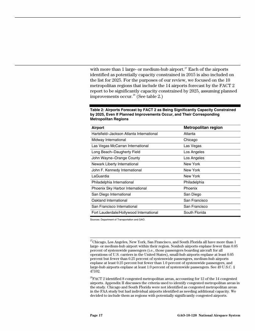
with more than 1 large- or medium-hub airport.27 Each of the airports identified as potentially capacity constrained in 2015 is also included on the list for 2025. For the purposes of our review, we focused on the 10 metropolitan regions that include the 14 airports forecast by the FACT 2 report to be significantly capacity constrained by 2025, assuming planned improvements occur.28 (See table 2.)
Table 2: Airports Forecast by FACT 2 as Being Significantly Capacity Constrained by 2025, Even If Planned Improvements Occur, and Their Corresponding Metropolitan Regions
Airport Metropolitan region Hartsfield–Jackson Atlanta International Atlanta
Midway International Chicago
Las Vegas McCarran International Las Vegas
Long Beach–Daugherty Field Los Angeles
John Wayne–Orange County Los Angeles
Newark Liberty International New York
John F. Kennedy International New York
LaGuardia New York
Philadelphia International Philadelphia
Phoenix Sky Harbor International Phoenix
San Diego International San Diego
Oakland International San Francisco
San Francisco International San Francisco
Fort Lauderdale/Hollywood International South Florida
Sources: Department of Transportation and GAO.
27Chicago, Los Angeles, New York, San Francisco, and South Florida all have more than 1 large- or medium-hub airport within their region. Nonhub airports enplane fewer than 0.05 percent of systemwide passengers (i.e., those passengers boarding aircraft for all operations of U.S. carriers in the United States), small-hub airports enplane at least 0.05 percent but fewer than 0.25 percent of systemwide passengers, medium-hub airports enplane at least 0.25 percent but fewer than 1.0 percent of systemwide passengers, and large-hub airports enplane at least 1.0 percent of systemwide passengers. See 49 U.S.C. § 47102.
28FACT 2 identified 8 congested metropolitan areas, accounting for 12 of the 14 congested airports. Appendix II discusses the criteria used to identify congested metropolitan areas in the study. Chicago and South Florida were not identified as congested metropolitan areas in the FAA study but had individual airports identified as needing additional capacity. We decided to include them as regions with potentially significantly congested airports.
Page 17 GAO-10-120 National Airspace System

Developing new airport capacity can be costly, complex, and time-consuming. Historically, airports, metropolitan regions, and FAA have looked to airport expansion and facility improvements—such as the construction of new runways—to provide new capacity, but increasingly airport expansion faces obstacles, especially in congested regions. Through the cooperative efforts of the aviation industry, airports, and FAA, 20 airfield projects have opened since 2000 at 18 OEP airports, including new runways at O’Hare, Seattle-Tacoma International, and Washington Dulles International in 2008.29 However, projects involving new runways often take a decade or more to complete because of legal and other obstacles. In addition, the last major new commercial service airport in the United States was opened in Denver in 1995 and is 1 of only 2 new major airports built in over 40 years.30 That said, proposals for a new airport in Peotone, Illinois, in the Chicago region and for a new airport to supplement Las Vegas McCarran International Airport are currently in the early stages of FAA environmental review.31
Many Regions Face Obstacles to Developing New Airport Capacity
Going forward, the development of new infrastructure—including the construction or extension of runways as well as new airports—faces many challenges. FACT 2 points out that expanding airport capacity is unlikely in some locations. According to ongoing research being developed for the Airport Cooperative Research Program (ACRP), adverse community reaction to aircraft noise and pollutant emissions at and near major airports continues to impede the development of new airport infrastructure, and this resistance is unlikely to decrease.32 Another study noted that lawsuits are filed in opposition to virtually every expansion of a
29These airfield projects include 14 new runways, 3 taxiways, 1 runway extension, 1 completed airfield reconfiguration, and 1 airfield reconfiguration under way. According to FAA, the projects have provided these airports with the potential to accommodate 1.9 million more annual operations, decrease average delay per operation at these airports by about 5 minutes, and reduce the potential for runway incursions.
30Dallas–Fort Worth International, which opened in 1974, was the other major commercial airport opened during this time period. In addition, a medium-hub airport opened in Fort Myers, Florida, in 1983, and a small-hub airport opened in Fayetteville, Arkansas, in 1998.
31In addition to the airports proposed for Peotone and Las Vegas, 2 new primary commercial service airports are scheduled to open within the next 5 years in St. George, Utah, and Panama City, Florida. These airports will replace existing commercial service airports, although neither is currently predicted to face congestion in the FACT 2 report. (Primary airports are those that have more than 10,000 passenger boardings each year.)
32Ongoing research entitled Innovative Approaches to Addressing Aviation Capacity
Issues in Coastal Mega-Regions, ACRP 3-10, is in the process of being finalized.
Page 18 GAO-10-120 National Airspace System

major airport, generally challenging the right of airport officials to override local zoning rules or increase noise or air pollution.33 According to this study, while such legal challenges are usually unsuccessful, projects often take longer than originally anticipated. We have also previously reported that new runway construction from initial planning to completion takes a median of 10 years, but delays can add an additional 4 years to the median time.34 While we found that the level of challenges that airports faced varied, in part depending on the proximity of the airport to a major city and the amount of community opposition to the runway, some common themes emerged in our 2002 survey of airports that had built or planned to build runways between 1991 and 2010. Challenges identified by those airports included reaching stakeholder agreement on the purpose and need for the new runway, completing required environmental reviews, reaching agreement on how to mitigate the impact of noise and other issues, and designing and constructing the runways in light of weather and site preparation issues. The conversion of former or joint-use military airfields for civilian use is an alternate approach to providing new or additional capacity, but this approach has also faced obstacles similar to those posed with the construction of new facilities. Voters recently rejected the proposed conversion of military airfields at Miramar and El Toro, current and former Marine Corps air stations, respectively.35
In our discussions with regional and airport officials, we found that environmental constraints, including land-use issues or community concerns about airport noise or the redesign of airspace around congested airports; physical constraints; and local legal constraints are also obstacles to the development of new capacity through airport or runway expansion. Environmental issues have been a constraint on development in the San Francisco region at San Francisco International Airport (SFO) and at Oakland International Airport, for example, where the construction of new runways would involve extensive filling in the San Francisco Bay. A proposal to build a new runway at SFO was dropped due to environmental
33Jeffrey P. Cohen and Cletus C. Coughlin, Congestion at Airports: The Economics of
Airport Expansions, The Federal Reserve Bank of St. Louis (May/June 2003).
34GAO, Aviation Infrastructure: Challenges Related to Building Runways and Actions to
Address Them, GAO-03-164 (Washington, D.C.: Jan. 20, 2003).
35A former military airport replaced an existing airfield in Austin, Texas. The new airport in Austin is categorized as a medium-hub airport. Military airfields have also been converted to civilian use in Alexandria, Louisiana; Marquette, Michigan; and Portsmouth, New Hampshire. Each of these new airports is categorized as a nonhub airport, serving less than 0.05 percent of systemwide passengers.
Page 19 GAO-10-120 National Airspace System
issues and cost constraints. As conceived, the project would have been the largest construction project in the bay for over 50 years and would have involved dredging and filling up to 2 square miles of the bay. (Fig. 4 shows the 2000 proposal for construction at SFO.) More recent planning has not included runway construction, focusing instead on a terminal development program and other alternatives. Noise concerns have also been a limiting factor for many airports. Proposals for runway expansion in Philadelphia led to a lawsuit filed by surrounding communities seeking to block the development, for example. Likewise, officials at SFO pointed to encroaching neighborhoods as state land-use policies encourage the development of previously industrial areas. Efforts to redesign the airspace around the New York/New Jersey/Philadelphia region also led to community opposition, with several surrounding communities filing lawsuits that, thus far, have been resolved in favor of FAA.36 Physical constraints on expansion or new construction can also be obstacles. For example, San Diego International has one runway, sits on only 661 acres, and the surrounding terrain limits the slope for departing aircraft, particularly heavier aircraft. The San Diego County Regional Airport Authority is developing a proposal to reconfigure the airport’s terminals, given the lack of room for a new runway. Finally, legal agreements or requirements hamper the use of existing capacity at some airports, including those in the Los Angeles region—in Orange County and Long Beach. Westchester County Airport in White Plains, New York, also has legal limits on airport operations, according to an air service demand study. Other airports have community agreements limiting capacity or growth. For example, Los Angeles International Airport (LAX) has imposed a cap of 78.9 million annual passengers on its operations as part of a settlement agreement with surrounding communities, according to regional officials. Likewise, according to an airport official, Bob Hope Airport is prevented from expanding the footprint of its existing terminal until 2012 by an agreement with the City of Burbank. The airport also recently sought FAA approval to make a voluntary nighttime curfew permanent. This application was denied by FAA, however, based in part on concerns that the curfew would result in congestion and delay in the region and potentially have ripple effects throughout the national airspace system.
36The lawsuits were consolidated in the D.C. Circuit Court of Appeals, and the court ruled in favor of FAA. County of Rockland v. FAA, 2009 U.S. App. LEXIS 12513 (D.C. Cir. 2009). A petition was filed on November 16, 2009, before the United States Supreme Court, asking the court to hear the case and determine whether the D.C. Circuit Court properly ruled on the matters before it.
Page 20 GAO-10-120 National Airspace System

Figure 4: Potential Extent of Bay Fill for Runway Construction at San Francisco International Airport (2000 Proposal)
10 miles10 miles10 miles
SanFrancisco
Bay
1 mile1 mile1 mile
San FranciscoInternational
Airport
San M
ateo
-Hay
ward
Bridge
Runwayreconstruction
alternative
Sources: San Francisco International Airport and GAO.
San Francisco
SanFrancisco
Bay
SanJose
OaklandSanFrancisco
San PabloBay
Regional Airport Planning Has the Potential to Identify Solutions for Congestion
Regional airport planning can identify solutions for airports and regions seeking to determine how best to manage available capacity and address the challenges posed by congestion. A 2003 study for the Office of the Assistant Secretary for Transportation Policy at the Department of Transportation looked at the potential for alternative airports to meet regional capacity needs and found that the use of these airports can make more efficient use of existing resources and better use of limited funds for airport development.37 According to the report, to make better use of alternate airports, regional airport planning should focus on both airport development and access issues. The study concluded that as metropolitan areas grow and become more congested and complex, FAA needs to
37GRA Incorporated, Alternative Airports Study, prepared for the Office of the Assistant Secretary for Transportation Policy, Office of the Assistant Secretary for Aviation and International Affairs, Department of Transportation (Washington, D.C.: Apr. 15, 2003).
Page 21 GAO-10-120 National Airspace System
promote regional airport planning. Likewise, according to ongoing research being developed for the ACRP, there are important opportunities to improve aviation system capacity and airport operations by embracing more collaborative and cooperative regional airport planning.38 The research has found that proactively seeking ways to use commercial airport capacity more efficiently will be important to maintaining the viability of air travel while accommodating forecast growth in demand for air travel. According to the research, airport managers and governing bodies will need to embrace the concept of capacity sharing with other airports in their market areas to maintain this viability and accommodate demand and will also need to look at other potential approaches. Such approaches may include the expansion of high-speed rail in some corridors or the use of demand-management strategies, such as peak pricing or restrictions on the use of congested airports by smaller aircraft.39
FAA’s FACT 2 report and its 2009–2013 FAA Flight Plan also noted the potential for regional airport planning to identify options to relieve congestion.40 The FACT 2 report identified regional options that could help meet the future capacity needs of the nation’s airports, among them, continuing to study regional traffic and development alternatives and planning for high-density corridors and multiple modes, including high-speed rail. Likewise, one of the initiatives in the Flight Plan is the use of AIP funding to reduce capacity constraints and provide greater access to alternate airports in the metropolitan areas and corridors where congestion at primary airports creates delays throughout the national airspace system.41 Finally, FAA’s NextGen program identifies regional airports as having potential to provide additional capacity in 15
38Transportation Research Board of the National Research Council, Airport Cooperative
Research Program 3-10: Innovative Approaches to Addressing Aviation Capacity Issues
in Coastal Mega-Regions, draft final report (Washington, D.C.: Summer 2009).
39As we have recently reported, a number of factors make it difficult to determine the economic viability of any high-speed rail corridor. For more information about high-speed rail, see GAO, High Speed Passenger Rail: Future Development Will Depend on
Addressing Financial and Other Challenges and Establishing a Clear Federal Role, GAO-09-317 (Washington, D.C.: Mar. 19, 2009).
40The 2009–2013 FAA Flight Plan serves as the strategic plan for FAA. See FAA, 2009–
2013 FAA Flight Plan (Washington, D.C.).
41The 7 metropolitan areas and corridors identified by FAA for fiscal year 2009 were Charlotte, North Carolina; Chicago; Las Vegas; Los Angeles; New York; Philadelphia; and San Francisco.
Page 22 GAO-10-120 National Airspace System

metropolitan areas, including Atlanta, Charlotte, Chicago, Houston, Las Vegas, Los Angeles, Minneapolis, New York, Philadelphia, Phoenix, San Diego, San Francisco, Seattle, South Florida, and Washington/Baltimore.
Most Regions with
Significantly Congested Airports Have Engaged in Regional Airport Planning, but Regional Airport Plans Have Been Used Selectively for FAA or Airport Decision Making
Nearly All Regions Forecast to Have Significantly Congested Airports Have Received FAA Funding for Regional Airport Planning
Nine of the 10 regions forecast by FAA to have one or more significantly congested airports in 2025 received FAA funding from 1999 through 2008 in support of regional airport planning (see table 3). In all, FAA provided $34 million in AIP grants for metropolitan system planning during this period, and the 9 aforementioned regions received $20 million of the total. According to FAA’s AIP Handbook, metropolitan areas are eligible for funding under FAA’s AIP program if airport problems in the region require a higher level of effort to address them than would be provided as part of a statewide analysis.42 Such regional problems typically arise in association with large- or medium-hub airports, according to the handbook. Each of the 10 regions forecast to be significantly capacity constrained by 2025 had at least one airport categorized as a large hub in 2008.43
42FAA, Airport Improvement Program Handbook, Order 5100.38C (Washington, D.C.: June 28, 2005).
43While Palm Beach International Airport in South Florida was categorized as a medium-hub airport in 2008, Fort Lauderdale/Hollywood International qualified as a large-hub airport in the same region.
Page 23 GAO-10-120 National Airspace System
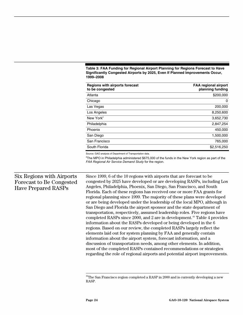
Table 3: FAA Funding for Regional Airport Planning for Regions Forecast to Have Significantly Congested Airports by 2025, Even If Planned Improvements Occur, 1999–2008
Regions with airports forecast to be congested
FAA regional airport planning funding
Atlanta $200,000
Chicago 0
Las Vegas 200,000
Los Angeles 8,250,600
New Yorka 3,652,730
Philadelphia 2,847,254
Phoenix 450,000
San Diego 1,500,000
San Francisco 765,000
South Florida $2,516,250
Source: GAO analysis of Department of Transportation data. aThe MPO in Philadelphia administered $675,000 of the funds in the New York region as part of the FAA Regional Air Service Demand Study for the region.
Six Regions with Airports Forecast to Be Congested Have Prepared RASPs
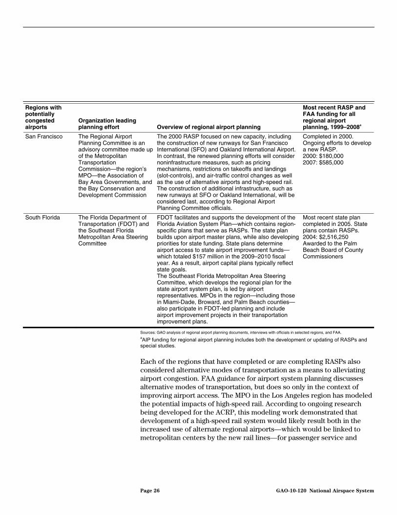
Since 1999, 6 of the 10 regions with airports that are forecast to be congested by 2025 have developed or are developing RASPs, including Los Angeles, Philadelphia, Phoenix, San Diego, San Francisco, and South Florida. Each of these regions has received one or more FAA grants for regional planning since 1999. The majority of these plans were developed or are being developed under the leadership of the local MPO, although in San Diego and Florida the airport sponsor and the state department of transportation, respectively, assumed leadership roles. Five regions have completed RASPs since 2000, and 2 are in development.44 Table 4 provides information about the RASPs developed or being developed in the 6 regions. Based on our review, the completed RASPs largely reflect the elements laid out for system planning by FAA and generally contain information about the airport system, forecast information, and a discussion of transportation needs, among other elements. In addition, most of the completed RASPs contained recommendations or strategies regarding the role of regional airports and potential airport improvements.
44The San Francisco region completed a RASP in 2000 and is currently developing a new RASP.
Page 24 GAO-10-120 National Airspace System

Table 4: RASP Development in Regions with Potentially Congested Airports
Regions with potentially congested airports
Organization leading planning effort Overview of regional airport planning
Most recent RASP and FAA funding for all regional airport planning, 1999–2008a
Los Angeles The Southern California Council of Governments, the region’s MPO
The MPO looked at each of the region’s airports to identify capacity constraints, such as those posed by terminal facilities or the inability to construct new runways. The plan highlighted a decentralization strategy that aimed at moving traffic to alternate airports, including those in Palmdale and Ontario. The RASP pointed to a need for better access to alternate regional airports. Forecasting done by the MPO predicted how changes at individual airports may impact the region as a whole and allowed planners to see the potential impact of new airport construction or capacity improvements on other regional airports.
Completed in 2008. Updates are regularly done for the Regional Transportation Plan. 1999: $3,227,400 2001: $790,200 2002: $1,500,000 2003: $1,400,000 2004: $833,000 2005: $500,000
Philadelphia The Delaware Valley Regional Planning Commission, the region’s MPO
The 2006 RASP update recognized that Philadelphia International Airport will remain the primary airport in the region and recommended improvements, including a possible new parallel runway. The RASP also recommended increasing service at Trenton Mercer and New Castle airports to relieve pressure on Philadelphia International, suggesting terminal improvements to facilitate their increased use.
Updated in 2006. A draft has been prepared for 2009. Updates are regularly done as part of the region’s long-range plan. 1999: $239,600 2000: $200,000 2001: $383,670 2002: $410,310 2003: $200,000 2004: $300,000 2005: $281,000 2006: $400,000 2007: $243,504 2008: $189,170
Phoenix The Maricopa Association of Governments, the region’s MPO
The MPO received a FAA grant in 2002 to update its RASP. When a draft plan called for extensive airspace modeling—which FAA did not support—FAA closed out the grant. The MPO subsequently completed the plan without FAA involvement, although the plan was not formally adopted by the MPO.
Completed in 2006. 1999: $300,000 2002: $150,000
San Diego The San Diego County Regional Airport Authority, sponsor of San Diego International Airport
The airport sponsor is working with regional airports and others to assess regional options to relieve congestion at San Diego International Airport. The plan is a follow-on to redevelopment plans for San Diego International Airport, which aim to redesign terminal facilities to improve capacity.
Ongoing as the result of a state mandate. The RASP is to be completed by June 2011. 2001: $1,500,000
Page 25 GAO-10-120 National Airspace System
Regions with potentially congested airports
Organization leading planning effort Overview of regional airport planning
Most recent RASP and FAA funding for all regional airport planning, 1999–2008a
San Francisco The Regional Airport Planning Committee is an advisory committee made up of the Metropolitan Transportation Commission—the region’s MPO—the Association of Bay Area Governments, and the Bay Conservation and Development Commission
The 2000 RASP focused on new capacity, including the construction of new runways for San Francisco International (SFO) and Oakland International Airport. In contrast, the renewed planning efforts will consider noninfrastructure measures, such as pricing mechanisms, restrictions on takeoffs and landings (slot-controls), and air-traffic control changes as well as the use of alternative airports and high-speed rail. The construction of additional infrastructure, such as new runways at SFO or Oakland International, will be considered last, according to Regional Airport Planning Committee officials.
Completed in 2000. Ongoing efforts to develop a new RASP. 2000: $180,000 2007: $585,000
South Florida The Florida Department of Transportation (FDOT) and the Southeast Florida Metropolitan Area Steering Committee
FDOT facilitates and supports the development of the Florida Aviation System Plan—which contains region-specific plans that serve as RASPs. The state plan builds upon airport master plans, while also developing priorities for state funding. State plans determine airport access to state airport improvement funds—which totaled $157 million in the 2009–2010 fiscal year. As a result, airport capital plans typically reflect state goals. The Southeast Florida Metropolitan Area Steering Committee, which develops the regional plan for the state airport system plan, is led by airport representatives. MPOs in the region—including those in Miami-Dade, Broward, and Palm Beach counties—also participate in FDOT-led planning and include airport improvement projects in their transportation improvement plans.
Most recent state plan completed in 2005. State plans contain RASPs. 2004: $2,516,250 Awarded to the Palm Beach Board of County Commissioners
Sources: GAO analysis of regional airport planning documents, interviews with officials in selected regions, and FAA. aAIP funding for regional airport planning includes both the development or updating of RASPs and special studies.
Each of the regions that have completed or are completing RASPs also considered alternative modes of transportation as a means to alleviating airport congestion. FAA guidance for airport system planning discusses alternative modes of transportation, but does so only in the context of improving airport access. The MPO in the Los Angeles region has modeled the potential impacts of high-speed rail. According to ongoing research being developed for the ACRP, this modeling work demonstrated that development of a high-speed rail system would likely result both in the increased use of alternate regional airports—which would be linked to metropolitan centers by the new rail lines—for passenger service and
Page 26 GAO-10-120 National Airspace System

cargo and in air-rail substitution by some passengers as they chose to take the train in lieu of flying.45 Likewise, San Diego has used its regional airport planning process to identify intermodal solutions. The airport sponsor worked with the region’s MPO to develop a new plan for SaDiego International Airport, which includes considerations of an intermodal facility at the airport. The new RASP is also being developed concert with an air-rail study being undertaken by the MPO, which aims to explore improved access to alternative regional airports and the podiversion of passengers to high-speed rail.
n
in
tential
The Extent of Regional Airport Planning in Other Regions Has Varied
We found that the extent of regional airport planning undertaken in the four regions forecast to have significantly congested airports that have not developed RASPs—Atlanta, Chicago, Las Vegas, and New York—varied and was focused on individual airports. The regional airport planning that was undertaken in these regions was typically not led by regional planners in MPOs. Airport sponsors (in the Atlanta, Las Vegas, and New York regions) or state authorities (in Chicago) led efforts, with planning limited to the airports under their direct authority. All of these regions except Chicago have received funding from FAA for regional airport planning, with amounts ranging from nearly $3 million for JFK in the New York region—where the Port Authority of New York and New Jersey (Port Authority) carries out planning for its 5 airports—to $200,000 each in Atlanta and Las Vegas. Table 5 provides information about the range of regional airport planning in regions with airports forecast to be significantly congested that have not prepared RASPs, the leadership of these activities, and funding received from FAA.
45
Innovative Approaches to Addressing Aviation Capacity Issues.
Page 27 GAO-10-120 National Airspace System
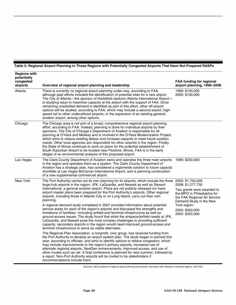
Table 5: Regional Airport Planning in Those Regions with Potentially Congested Airports That Have Not Prepared RASPs
Regions with potentially congested airports Overview of regional airport planning and leadership
FAA funding for regional airport planning, 1999–2008
Atlanta There is currently no regional airport planning under way, according to FAA, although past efforts included the identification of potential sites for a new airport. The City of Atlanta—the sponsor of Hartsfield-Jackson Atlanta International Airport—is studying ways to maximize capacity at the airport with the support of FAA. Once remaining unsatisfied demand is identified as part of this effort, other off-airport options will be studied, according to FAA, which may include a second airport, high-speed rail to other underutilized airports, or the expansion of an existing general-aviation airport, among other options.
1999: $100,000 2000: $100,000
Chicago The Chicago area is not part of a broad, comprehensive regional airport planning effort, according to FAA. Instead, planning is done for individual airports by their sponsors. The City of Chicago’s Department of Aviation is responsible for all planning at O’Hare and Midway and is involved in the O’Hare Modernization Project, which aims to reduce existing delays and increase capacity to meet future aviation needs. Other local agencies are responsible for other airports in the region. Finally, the State of Illinois continues to work on plans for the potential establishment of South Suburban Airport to be located near Peotone, Illinois. FAA is in the early stages of an environmental analysis of this proposed airport.
Las Vegas The Clark County Department of Aviation owns and operates the three main airports in the region and operates them as a system. The Clark County Department of Aviation has a strategic plan, has considered a regionwide solution to future capacity shortfalls at Las Vegas McCarran International Airport, and is planning construction of a new supplemental commercial airport.
1999: $200,000
New York The Port Authority carries out its own planning for its airports, which include the three large-hub airports in the region: JFK, LaGuardia, and Newark as well as Stewart International, a general aviation airport. Plans are not publicly released nor have airport master plans been prepared for the Port Authority’s airports. Other regional airports, including those in Atlantic City or on Long Island, carry out their own planning.
A regional demand study completed in 2007 provided information about potential service areas for each of the region’s airports and discussed the strengths and limitations of facilities—including airfield and terminal infrastructure as well as ground-access issues. The study found that while the airspace/airfield needs at JFK, LaGuardia, and Newark pose the most complex challenges to providing sufficient capacity, secondary airports in the region would need improved ground-access and terminal infrastructure to serve as viable alternates.
The Regional Plan Association, a nonprofit, civic group, has received funding from the Port Authority to develop an airport system plan. The study began in earnest this year, according to officials, and aims to identify options to relieve congestion, which may include improvements to the region’s primary airports, increased use of alternate regional airports, NextGen enhancements, improved access, and use of other modes such as rail. A final conference is planned for next summer, followed by a report. Non-Port Authority airports will be invited to be stakeholders if recommendations include them.
2002: $1,700,000 2008: $1,277,730 Two grants were awarded to the MPO in Philadelphia for the FAA Regional Air Service Demand Study in the New York region:
2003: $350,000 2005: $325,000
Sources: GAO analysis of regional airport planning documents, interviews with officials in selected regions, and FAA.
Page 28 GAO-10-120 National Airspace System
FAA and Airports Have Used These Plans Selectively in Decision Making
While regional airport planning has been undertaken in each of the regions forecast to have significantly congested airports, FAA has used the results of this planning selectively when working with airports or making funding decisions. In each of the five potentially congested regions we visited, FAA regional officials stated that they may look at RASPs or other regional airport plans when reviewing projects at individual airports. FAA regions, however, do not carry out a systematic review of RASPs to ensure that they meet the guidance for airport system planning, and none of the FAA regions we spoke with regularly used them in decision making when funding airport improvements, despite the potential identified by FAA and others for RASPs to identify potential options to alleviate congestion. For example, FAA officials in the Western-Pacific Region stated that capital investment decisions are made on the basis of airport master plans or airport layout plans. The officials noted that RASPs can serve as a tiebreaker among projects, but that funding decisions are made using national-level priorities. FAA officials in the Eastern Region also stated that they did not refer to RASPs when selecting projects for AIP funding, although they would assume that regional forecasts and airport roles would be reflected in airport master plans. As in the Western-Pacific Region, we were told that RASPs might be used to resolve tiebreakers for competing projects.
Airport officials in the regions we selected told us that no RASP to date had been adopted into the airport-level capital improvement plans—airport layout or airport master plans—that guide decision making. For example, airport officials in Philadelphia stated that regional airport planning, including the RASP, has little influence on decisions made by the City of Philadelphia or by Philadelphia International Airport. Officials at other airports, however, said that these plans may be considered during airport-level planning. In the Los Angeles region, airport officials at John Wayne Airport in Orange County, for example, stated that while they may consider the RASP when making decisions about airport improvements, it is not the primary driver for these decisions because, in their view, regional and airport priorities necessarily differ. By contrast, the airport sponsor of LAX has pursued suggestions or strategies from RASPs when making decisions regarding airport improvements or capacity. Los Angeles World Airports, which operates LAX, as well as airports in Ontario and Van Nuys, based internal strategic planning for LA/Palmdale Regional Airport on the distribution of passenger traffic among regional airports developed by the region’s MPO. Los Angeles World Airports also for a time pursued a decentralization strategy similar to that suggested in the RASP—attempting to develop LA/Palmdale Regional Airport—although the airport sponsor focused on serving local passengers, rather than
Page 29 GAO-10-120 National Airspace System
passengers that might travel to the airport from elsewhere in the region. Finally, Los Angeles World Airports is supporting the development of a high-speed rail line that would divert passenger traffic by either improving access to alternate regional airports or carrying passengers on busy regional corridors, which was also included in the RASP.46
Airport officials at San Diego International Airport and SFO—both in regions with significantly congested regions currently developing RASPs—anticipate using the RASPs for their airport-level planning. The San Diego RASP is being developed by the airport sponsor itself, and future airport plans at San Diego International are expected to reflect findings from the RASP, according to airport officials, although there is no assurance that the RASP would be considered by other airports in the region. Likewise, in San Francisco, SFO airport officials are supporting ongoing regional airport planning and stated that they expected to consider findings included in the RASP when developing airport plans.
While not included in our in-depth analysis of selected regions, state department of transportation officials in Florida explained that RASPs in the state are closely tied to airport decision making, given the link between these plans—which are developed as part of the state’s airport planning process—and the state’s airport improvement program. Airport capital plans reflect state priorities to be eligible for these state funds. RASPs are developed by committees made up of airport sponsors and MPOs. The state department of transportation facilitates and supports these committees, and the resulting regional plans are incorporated into the state’s aviation system plan, thus becoming state priorities. The priorities reflected in the RASPs, however, are not linked to the decision making done by FAA for AIP funding, according to a state official.
In those areas that have not developed RASPs, regional airport planning has contributed to some decision making. In the New York region, for example, FAA led efforts to carry out a regional demand study looking at current traffic at regional airports—both the primary and smaller regional airports—as well as surveying passengers to determine where they came from in the region and if alternate airports might be closer than the three
46Los Angeles World Airports attempted to develop service at alternative regional airports in Ontario and Palmdale. This effort has stalled, however, given the recent downturn in demand, and the sponsor has redirected its attention to improving LAX, according to airport officials. Recently, Los Angeles World Airports gave up its lease to LA/Palmdale Regional Airport.
Page 30 GAO-10-120 National Airspace System

congested primary airports. The study also identified the development needs for regional airports. Based in part on the study’s forecasts, the Port Authority acquired Stewart International Airport north of the city in 2007. The newly acquired Stewart International Airport is seen by the Port Authority to have the potential to ease some congestion pressure on other Port Authority airports—without removing passengers from the Port Authority system—if airlines can be attracted to provide service to serve the local population.47 By contrast, the Port Authority has not included the other potential alternate airports identified in the demand study—Westchester County and Long Island MacArthur Airport—in regional airport planning currently being undertaken by the Regional Plan Association, which is a nonprofit, civic group that has received funding from the Port Authority to develop an airport system plan. These alternate airports are outside the Port Authority system, and Regional Plan Association officials stated that non-Port Authority airports would be invited to participate in finalizing the regional plan if draft recommendations included them. Figure 5 illustrates, as of 2005, the service areas for the main airports in the New York-New Jersey region and shows the location of six other airports in the region, including Stewart International.
47The regional demand study found that Stewart International Airport served 13 percent of the population that was identified as being within its service area in 2005. An improved rail connection between Stewart International and New York City is under study. Such a connection could attract travelers who would otherwise travel from one of the region’s more congested airports.
Page 31 GAO-10-120 National Airspace System

Figure 5: Service Areas for the Primary Airports in the New York–New Jersey Region, 2005
ATLANTICOCEAN
LONG ISLAND SOUND
DELAW
ARE BAY
0 10 20 30 40 Statute miles
0 10 20 30 40 Nautical miles
BradleyBradleyInternationalInternational
(BDL)(BDL)
Sources: FAA Regional Air Service Demand Study and GAO.
PhiladelphiaPhiladelphiaInternationalInternational
(PHL)(PHL)
PhiladelphiaInternational
(PHL)
BradleyInternational
(BDL)
Atlantic CityAtlantic CityInternationalInternational
(ACY)(ACY)
Atlantic CityInternational
(ACY)
Trenton-Trenton-MercerMercer(TTN)(TTN)
Trenton-Mercer(TTN)
Lehigh ValleyLehigh ValleyInternationalInternational
(ABE)(ABE)
Lehigh ValleyInternational
(ABE)Newark LibertyNewark Liberty
InternationalInternational(EWR)(EWR)
Newark LibertyInternational
(EWR)John F. KennedyJohn F. Kennedy
InternationalInternational(JFK)(JFK)
John F. KennedyInternational
(JFK)
Long IslandLong IslandMacArthurMacArthur
(ISP)(ISP)
WestchesterWestchesterCountyCounty(HPN)(HPN)
StewartStewartInternationalInternational
(SWF)(SWF)
Long IslandMacArthur
(ISP)
WestchesterCounty(HPN)
StewartInternational
(SWF)
LaGuardiaLaGuardia(LGA)(LGA)
LaGuardia(LGA)
Newark service area LaGuardia service area JFK service area
Page 32 GAO-10-120 National Airspace System

FAA officials and others pointed to the regional airport planning in the Boston region as being a role model effort.48 Officials with Massport, the sponsor of Logan International Airport (Logan) in Boston, and planning officials began to seek regional solutions in the 1990s after it was determined that Logan, the region’s primary commercial facility, would be unable to fully accommodate growing regional demand and that there were no options to construct a new primary airport. Regional airport planning has included a series of demand studies and a RASP that concentrated on finding and implementing a mix of solutions. The resulting plans recommend improvements at Logan; the increased use of underutilized airports in the region and improvements at these airports; as well as the expanded use of other modes of travel, notably high-speed rail in the Northeast Corridor.
In the Boston Region, Which Is Not Forecast to Be Significantly Congested, Regional Airport Planning Was Tied to Airport Decision Making
FAA played an important role in the Boston region by supporting regional airport planning and incorporating the regional approach into its decision making for airport capital improvement projects. The regional airport planning in the Boston region was led by local airports and facilitated by the FAA regional office, which provided funding for studies as well as taking a leading role in the most recent demand study and the development of the 2006 RASP. FAA’s involvement in the regional airport planning was credited to the interest of the agency’s regional staff. Massport officials explained that regional airports would have been reluctant to participate in a project headed by Massport, and the involvement of the Massachusetts Aeronautics Division and FAA helped convene stakeholders and get people to participate in the process. FAA also worked with regional airports to develop capital plans to identify needed airport improvements that were consistent with the RASP, according to regional FAA and Massport officials.49
The Boston region does not have an airport among those forecast to be significantly congested in FAA’s FACT 2 report, assuming planned improvements occur, and FAA and Massport officials give some credit to the implementation of regional airport planning in reducing congestion.
48The Boston region was not among those airports forecast by the FAA’s FACT 2 report to be significantly congested by 2025, even if planned improvements occur.
49FAA, The New England Regional Airport System Plan, Fall 2006, which is available at the following Web address: http://www.faa.gov/airports/new_england/planning_capacity/airport_system_plan/media/nerasp_section_1.pdf.
Page 33 GAO-10-120 National Airspace System
Officials at Massport point to improvements at Logan—which included a new runway, new taxiways, reductions in minimum spacing between aircraft, and issuance of peak period pricing mechanisms—as well as to the regional airport planning as being important to addressing the capacity challenges that faced the airport. Furthermore, the region was significantly less congested following the September 11, 2001 (9/11), terrorist attacks, with passenger levels at Logan dropping 18 percent from 2000 to 2002, although this traffic has largely returned. Following the 9/11 attacks, there was an increase in passengers using Amtrak to travel to New York City, demonstrating the potential for high-speed rail to complement air service and potentially reduce airport congestion.
The realization of the goals of regional airport planning in the Boston region was greatly aided by the decision of Southwest Airlines to initiate service at T.F. Green Airport near Providence, Rhode Island, in 1996, and at Manchester-Boston Regional Airport in Manchester, New Hampshire, in 1998, and airline officials pointed to regional airport planning as a factor facilitating these decisions. Southwest officials stated that the regional demand study pointed to potential demand near these airports and helped to pique their interest, in addition to their own analysis, in exploring expanded service in the New England region. Furthermore, airport improvements at T.F. Green Airport and Manchester-Boston Regional Airport allowed for the expansion. The airline debuted service at one gate at T.F. Green. Due to the strong demand, the airline requested that the airport construct a terminal expansion, which allowed Southwest to expand to four gates over the next couple of years. According to airline officials, both of these alternate regional airports met the airline’s expectations.
Page 34 GAO-10-120 National Airspace System
Since Regional Airport Planning Is Advisory, Competing Interests Can Derail Development and Implementation, While Aligned Interests Can Aid Implementation
The Advisory Nature of RASPs and Other Regional Airport Plans and Competing Interests Are Factors That Hinder Planning and Implementation
The MPOs that conduct regional airport planning have no authority over which airport improvement projects are priorities in their regions and, as a result, the RASPs they produce have little direct influence over airport capital investment and other decisions. Because MPOs do have authority over surface transportation projects—only projects prioritized by MPOs are eligible to receive federal funding from the Federal Transportation Administration (FTA) and the Federal Highway Administration (FHWA)—MPOs can directly influence surface projects that affect airport access, but cannot directly affect the capacity of these airports. None of the airports we met with during the course of our review are required to consider or incorporate the recommendations of RASPs into their ALPs or airport master plans. In most of the 6 regions that have developed or are developing RASPs, airport officials—such as those at LAX and SFO—stated that they would consider the region’s perspective in an informal fashion, even though recommendations included in RASPs are not binding. Other airports we interviewed were more guarded about their consideration of regional airport planning conducted by MPOs. Airport officials at John Wayne Airport in the Los Angeles region stated that the region’s RASP is not a primary driver of airport decision making, in part because regional planning priorities are likely to differ from those of the airport, particularly regarding mitigation strategies for surrounding communities. Airport officials at Philadelphia International stated that the airport does its own planning without input from regional planners, although the airport is active in the development of regional airport
Page 35 GAO-10-120 National Airspace System
plans.50 As a result, regional priorities may not be reflected in the decision-making documents that guide capital improvements at airports. Ongoing research being developed for the ACRP similarly notes that while regional airport planning could fill the gap between airport- and national-level planning, most regional airport planning conducted to date has not been influential due in part to the fact that airport sponsors retain authority over planning and development decisions.
According to FAA, it is also not required to consider MPO-developed RASPs, even when these plans are funded with FAA grants.51 FAA officials stated that the inclusion or absence of a project in a RASP had little influence whether the agency approved AIP grants for an individual airport project, serving in some cases as a tiebreaker but not guiding project prioritization. FAA considers AIP grants for capital improvements on an airport-by-airport basis, based on national criteria. Airports justify improvement projects individually using forecasts from their own service areas, and the national criteria that FAA uses does not consider how improvements exist in a regional context, except during the environmental review process.52
As we have previously discussed, FAA regional offices have some latitude in determining which projects to fund, and FAA’s funding and support of regional airport planning itself may vary within the agency and by project. Thus, while FAA guidance and headquarters staff encourage regional airport planning, two MPOs in regions with significantly congested airports have had difficultly in obtaining funding for regional airport planning in recent years. For example, in the Philadelphia region, an MPO official told us they sought funds to assess capacity and demand across the airports in its region with a demand study similar to the ones completed
50Airport officials told us that regional planners would be able to provide input on airport-level plans at public hearings, during the public comment period. An airport official currently chairs the MPO’s regional aviation committee and updates the MPO on the airport’s planning activities.
51According to FAA, 49 U.S.C. § 47106(a)(1) gives the agency the option of reviewing a MPO-developed RASP for consistency with a project for purposes of AIP funding eligibility.
52According to FAA planning officials, airports within a region are considered during the environmental review process for specific projects. At that time, the agency considers service areas and the potential capacity of alternate airports and their ability to satisfy the required consideration of project alternatives under the National Environmental Policy Act of 1969. Pub. L. No. 91-190, 83 Stat. 852, codified at 42 U.S.C. § 4321, et seq.
Page 36 GAO-10-120 National Airspace System

with FAA funding in Boston and New York.53 FAA officials told us that they rejected the study for Philadelphia because it would have includesignificant marketing component—which is ineligible for AIP funding—and it might not be good timing for the MPO to conduct capacity analysis at the same time as the environmental impact statement for proposed improvements at Philadelphia International is under way. An MPO official told us that regional planners hoped to use the results of the study to develop recommendations and prioritize improvement projects in their region—as had been done with the FAA-supported demand study and related RASP in the Boston region. Additionally, FAA officials told us that AIP funding to the MPO had declined in recent years, but that FAA did not view other recent MPO proposals as useful. FAA has not provided funds for regional airport planning in Los Angeles since 2005, although the MPO has developed a RASP in the meantime without FAA funding. According to FAA regional officials, the regional airport planning carried out by the MPO offered impractical solutions—notably, a proposal to construct magnetic levitation (maglev) train lines to regional airports—that were not financially feasible. MPO officials in Los Angeles pointed to other aspects of RASPs developed by the MPO every 4 years, such as the forecasting and consideration of alternate regional airports, as evidence of its value, and expressed frustration that technical support from FAA was difficult to obtain.
d a
54
For MPOs that want to carry out continuous planning, the lack of consistent funding may limit their ability to maintain staff and conduct planning on an ongoing basis. FAA’s guidance on airport system planning points to the importance of continuous planning, but FAA’s AIP funding process is not structured to prioritize it. This is in contrast to the MPO-led surface transportation planning process, which according to FTA and FHWA guidance was developed to ensure continuous planning, among other things. Rather, projects are evaluated on a case-by-case basis for AIP funding, which favors projects with discrete products, although the AIP
handbook notes that funding is available for continuous planning, which may include continuing surveillance and coordination of the airport system, periodic plan reevaluation, special studies, and the updating of RASPs. The MPOs in two of the regions with potentially significantly
53The New York demand study included several of the regional airports in the Philadelphia region, but did not include Philadelphia International, the region’s most congested airport.
54According to regional officials, the maglev proposal will be replaced by the voter-approved, state high-speed rail system in the 2012 RASP.
Page 37 GAO-10-120 National Airspace System
congested airports maintain aviation planning staff to carry out regional airport planning on an ongoing basis. In each of these regions, the MPOs received AIP grant funding from FAA for regional airport planning for a number of years, but this funding has been curtailed in recent years. In Los Angeles, the MPO has received no AIP funding since 2005 and has continued to carry out regional airport planning using its own resources. While it received AIP funding in recent years, the MPO in Philadelphia limited the scope of its regional airport planning to special studies—rather than continuous system planning—according to regional planning officials, as the result of reduced FAA support for continuous system planning.55 According to ongoing research being developed for the ACRP, these two regions are among a handful of MPOs nationwide that employ aviation specialists—staff that could be involved in the type of monitoring involved in continuous planning.56
The advisory nature of regional airport planning and its lack of a connection to capital investment decisions are not the only hindrances to regional airport planning and implementation. We also found that a number of competing interests can derail a plan and prevent implementation. When the individual interests of airports, communities, and airlines are not aligned, for example, they can hinder regional airport planning and implementation. Furthermore, the lack of funding for planning can also be a hindrance. Additional hindrances include the following:
Airport interests. A major hindrance to regional airport planning and implementation are the differing interests of airports in a region that may conflict with an integrated regional approach. Airport interests may include maximizing revenue generation and protecting markets—including high-value business or long-haul markets. As a consequence, regional
55The reduction in funding for regional airport planning in the Philadelphia region continued in fiscal year 2009. In that year, FAA awarded the MPO $76,921 to count operations—arrivals and departures—at general aviation and reliever airports, according to regional officials. This amount contrasts with annual grant amounts ranging from $410,310 to $189,170 over the prior 10 years.
56Other MPOs able to maintain aviation specialists include those in St. Louis and Washington, D.C. The latter is unique among the nation’s MPOs in that it receives a steady stream of federal funding to support its regional airport planning. According to FAA, the Metropolitan Washington Council of Governments receives about $300,000 annually in the form of an annual state apportionment from AIP. These funds are to be spent within the specific state from which the apportionment came. Since there are no publicly owned airports in Washington, D.C., the funds are used for regional airport planning in the region.
Page 38 GAO-10-120 National Airspace System

airport planning may be more difficult to undertake and implement in locations where airports see themselves to be in direct competition with other airports in their region, particularly if they perceive that such planning may divert traffic or resources to competing airports. Airport officials in Philadelphia told us that they do not want to support federal efforts, including regional airport planning, that could lead to losing or diverting flights from their airport to other airports in the region, for example, because the City of Philadelphia—which owns Philadelphia International—does not want to lose revenue generated at its airport to other airports. In other regions, we found that distrust between some airports has limited the range of solutions considered in RASPs. For example, the MPO and Los Angeles World Airports airport officials told us that other airport sponsors in the region—including those for airports in Long Beach, Burbank, and Orange County—have viewed regional airport planning suspiciously, notably the planning undertaken by the now-defunct Southern California Regional Airport Authority. This authority theoretically had the ability to force airports to accept more traffic. Regional airport planning carried out by the MPO, however, does not include such authority, and since 2001 RASPs have been developed that respect the physical constraints and legal restrictions at individual airports in the region.
Community interests. Some local community interests, such as those focused on noise or environmental concerns, may impede or limit regional airport planning and implementation. As the result of community pressure, two airports in the Los Angeles region—John Wayne Airport in Orange County and Long Beach Airport—have legal agreements and requirements, respectively, that allow them to limit the capacity of their facilities, for example. MPO officials in the region told us that airport sponsors at these airports primarily participated in regional airport planning to ensure that existing limits on capacity or expansion were respected. These airports are forecast to need additional capacity by 2025, given that they are not expected to meet passenger demand. Other airports in the region are also working to respond to community pressure to limit growth or operations, and such agreements may further restrict the available airport capacity under certain conditions in the region. For example, the airport sponsor of LAX has agreed to limit the number of operations at the airport in response to community concerns about noise, air quality, and the quality of life in surrounding communities. In addition, the airport sponsor at Bob Hope Airport in Burbank applied to FAA to make a voluntary nighttime curfew permanent, which had the potential to put pressure on nearby airports, such as LAX, or airports in Ontario and Van Nuys. While FAA
Page 39 GAO-10-120 National Airspace System
denied the application, even voluntary agreements of this type reduce the regional options for meeting passenger demand for air travel.
Airline interests. Airlines act independently of both airports and communities, and their independence may complicate efforts to plan regionally. Airlines make decisions about which airports to serve and the level of services they will offer according to their business and network plans, and such decisions may not align with airport and MPO plans. Most notably, in a congested region, planning officials might suggest that traffic migrate to lesser-used alternate airports, as they have in Los Angeles. However, this suggestion may conflict with the business plans of airlines that already serve primary airports in a region. Such airlines generally want to focus their traffic in a city at one major airport, both for cost and revenue reasons.57 In addition, while MPOs may want to develop capacity in the system, this development may not align with the objectives of airlines. Individual airlines may prefer to sell limited capacity at a premium price or limit the ability of other airlines to provide competing service. FAA guidance on airport system planning points to the importance of understanding airline business models when suggesting the use of alternate regional airports. Regional planning and airport officials in several of the regions we visited noted that they concentrated on attracting new entrants to the market or airlines whose business plans included serving alternate airports—primarily low-cost carriers—for service at these airports. The use of demand management strategies that provide incentives for airlines to serve alternate regional airports—or a disincentive to serving congested, primary airports—could serve to align the interests of airlines and airports or regional planners as well, according to some airport officials.
Airport sponsors and MPOs in our selected regions indicated that they had little influence over airline service levels and locations, which made it difficult to align divergent and sometimes competing interests. Regional planners with whom we met also indicated that they found it difficult to engage airlines in their regional airport planning. For example, MPO officials in Philadelphia reported that airline representatives had attended
57First, it is costly to set up operations at multiple airports, therefore an airline would need to more than make up for these additional costs on the revenue side of their balance sheet. Second, airlines operating on a network system feed transferring traffic into their system at hubs, and decentralizing traffic would make this more difficult to accomplish, which is particularly true for the most profitable long-haul and international routes, according to industry officials.
Page 40 GAO-10-120 National Airspace System

only one planning meeting. Likewise, in San Diego, an airline representative was included on the advisory committee, but airlines were not participating in regional planning. According to airline representatives, airlines are typically not involved in regional planning, although they may participate in airport-level planning, given their interest in controlling costs. An additional complicating factor is a difference in airport or regional planning and airline planning. Whereas airports use 5- to 10-year forecasts to develop master plans for capacity investments and RASPs may be updated every 2 to 5 years, airlines’ assets are largely mobile and can move from one market to another with relative ease.
Legal restrictions. Current airport revenue rules generally do not allow airports to price their services regionally; therefore, using pricing to even supply and demand among various airports is not possible. Airfield revenues may not exceed the aggregate costs to the airport sponsor of providing airfield services and airfield assets currently in use, with certain exceptions.58 The fees that airports typically charge airlines to operate at individual airports—including rental charges and landing fees—are based on the historical costs of operating the facility according to FAA. Improving alternate airports can make them more expensive, since the costs for such improvements become part of the rate base charged to airlines. For example, in the Los Angeles region, fees for airlines at the more-congested LAX are less than at less-congested airports in the region, such as Ontario International, in part due to previous improvements at the smaller airport. Furthermore, airport-airline lease agreements, which, according to officials, can prohibit some airport sponsors from transferring funds from one airport to another, even if they have the same sponsor, also can limit the options available for regional airport planning. As a result, it may be challenging to adjust these fees in a regional context to provide financial incentives to airlines to serve less-congested airports, if these airports have higher operating costs.
58Policy Regarding Airport Rates and Charges, 73 Fed. Reg. 40430 (July 14, 2008), 2.2, amending the 1996 Policy Regarding Airport Rates and Charges, 61 Fed. Reg. 31994 (June 21, 1996). The 2008 amendment provided airport sponsors of congested airports (as defined in the policy) with the ability to include in the airfield fees a portion of the airfield costs of other, underutilized airports owned and operated by the same sponsor or a portion of the costs of airfield projects under construction. The 2008 amendment also allows a congested airport to impose a fee on each operation, under certain conditions. The current policy is being challenged in the D.C. Circuit Court of Appeals—Air Transportation Association of
America, Inc. v. Department of Transportation and the Federal Aviation
Administration, Case No. 08-1293 (D.C. Cir.).
Page 41 GAO-10-120 National Airspace System
From our in-depth analysis, we identified a number of factors that aided regions in the development and implementation of regional airport planning. In general, we found that when stakeholders were supportive of regional airport planning, the plans resulting from these efforts were more likely to be used. More specifically, the factors that helped align these various stakeholders include the following:
Regional Airport Planning Is Aided by Several Factors, and Implementation Only Occurs When Interests Are Aligned
Legal considerations. Legal considerations served to facilitate planning in two of our selected regions. After residents of San Diego County rejected a proposal to develop a second airport, a law was passed that required the county’s airport authority to develop a RASP by June 30, 2011.59 The law requires the airport authority—which operates San Diego International—to prepare and adopt a plan that identifies workable strategies to improve the performance of the regional airport system.60 In the San Francisco region, a state agency, the Bay Conservation and Development Commission, controls the permitting process for development within 100 feet of the shoreline of San Francisco Bay. Both SFO and Oakland International airports sit on land adjacent to the bay and therefore are subject to the commission’s review and permitting process, depending upon the type of development projects these airports propose. The commission has stated that it would deny projects—including the construction of new runways—that would affect the bay, unless the airports exhaust all reasonable alternatives to providing capacity. In practice, the region’s RASP development process has become the venue to explore such alternatives.
Constraints on infrastructure. A number of constraints to airport construction—geographic, environmental, and political—spur regional airport planning. In Boston, for example, Logan is largely locked into its existing footprint, given its waterfront location and surrounding community. Officials in several of our selected regions mentioned similar constraints as reasons for participating in regional airport planning. In San Francisco, filling the bay to build capacity would be extremely costly and may be unlikely, given environmental concerns. Likewise, terrain surrounding San Diego International and the airport’s small footprint limit expansion opportunities. Each of these regions is using regional airport
59Cal. Pub. Util. Code § 132358. The California law requires that the San Diego County Regional Airport Authority develop a regional aviation strategic plan for the region. Airport authority officials stated that this document will serve as the region’s RASP.
60Cal. Pub. Util. Code § 132358(a).
Page 42 GAO-10-120 National Airspace System
planning to help identify additional options for providing transportation capacity.
MPO and FAA interest and involvement. Regional airport planning was more likely to occur when a MPO or FAA took an active interest in advancing regional airport planning. In several of the regions we visited, for example, MPOs had aviation planners that carried out system planning. Such planners in Philadelphia have engaged in a variety of regional airport planning, including the development of a RASP and prioritizing airport projects for state funding. MPO officials are also active in Los Angeles at the Southern California Association of Governments. Over the course of many years, this MPO has developed several RASPs, and FAA has provided funding for some of this planning. The MPO also has created and maintained a sophisticated modeling tool, allowing it to do airport choice modeling for the entire region.61 Ongoing efforts to create and update RASPs under way in San Diego and San Francisco are being undertaken jointly by MPO and airport officials.
While some FAA and airport officials questioned the regional airport planning expertise of MPOs, MPOs regularly prepare surface transportation plans and this experience may aid them in developing RASPs. MPOs are required to develop long-range (20 year) transportation plans and short-range (4 year) Transportation Improvement Programs (TIP) that identify strategies for operating, managing, enhancing, maintaining, and financing a metropolitan area’s transportation system, among other things, and the elements suggested for RASPs are similar to those included in these plans.62 For example, the surface transportation plans prepared by MPOs monitor existing conditions, carry out forecasting, and identify current and future transportation needs and potential improvement strategies. FAA guidance for airport system planning also includes an inventory of the current aviation system, forecasting, an identification of air transportation needs, and the
61The MPO provided the seed money for the development of the forecasting and demand allocation model—known as RADAM—but most of the development was funded by private sources. As a result, the model itself is proprietary. According to regional officials, FAA prohibits the use of system planning grants for the development of modeling tools, including aviation forecasting models.
62To receive federal surface transportation funding—from FTA and FHWA—any project in an urbanized area must emerge from the relevant MPO and state department of transportation planning process. Projects funded with FAA funds need not be included in these regional transportation plans.
Page 43 GAO-10-120 National Airspace System

consideration of alternative airport systems.63 In a survey conducted of MPOs nationwide for a prior GAO report, nearly 19 percent of MPOs reported that they engaged in regional airport planning—sometimes as a result of state requirements.64 We found that 17 (41 percent) of the 41 largest MPOs that responded to the survey—those with populations with over 1 million people—indicated that they engaged in regional airport planning.65 Of these 41 MPOs, 39 have a large- or medium-hub airport within their jurisdictions.66
Airports noted that outside groups, such as MPOs; nonprofit groups; or FAA can be useful in establishing regional airport planning since they can mitigate some of the suspicion that might be present if airports, particularly dominant ones, lead the planning. According to ongoing research being developed for the ACRP, MPOs can offer airport managers truly regional perspectives on planning, data, and analyses on travel behavior and demand in a geographically broad area and a neutral “table” at which airport managers and other key stakeholders can sit to work through coordination options and opportunities. Establishing a neutral table was especially helpful in the Boston region where FAA took an active role in helping to formulate a RASP and then to implement the recommendations. FAA regional officials helped develop the region’s 2006 RASP by facilitating meetings among potentially reluctant stakeholders and leading an assessment of regional demand, among other tasks. FAA regional office then worked actively with airports in the region to integrate RASP recommendations into their capital plans and reviewed these plans against the RASP when making grant decisions.
Political benefit. In several of the regions we visited, airports supported regional airport planning to obtain political acceptance for airport
63Unlike the FTA or FHWA requirements for MPO surface transportation planning, FAA guidance does not include estimates of the impact on environmental features, including air quality.
64In GAO’s survey, 324 MPOs of the 381 MPOs nationwide responded. See appendix III of this report for a more detailed discussion of MPOs and regional airport planning nationwide. Also GAO, Metropolitan Planning Organizations: Options Exist to Enhance
Transportation Planning Capacity and Federal Oversight, GAO-09-868 (Washington, D.C.: Sept. 9, 2009), for more information about the survey.
65In the GAO survey, 41 large MPOs responded to questions about regional aviation planning, while there are 42 such MPOs in total, excluding Puerto Rico.
66The 2 MPOs without large- or medium-hub airports were among the 17 MPOs that carried out aviation planning activities.
Page 44 GAO-10-120 National Airspace System
improvement projects. Given sensitive environmental considerations, SFO and Regional Airport Planning Committee officials told us that they worked together on the RASP because any significant capital improvements would need the support of the regional body. Even when regional airport planning is undertaken without the leadership of a MPO, there can be political benefits. In the New York region, the Port Authority is funding a project by the Regional Plan Association to look at ways to build capacity within the Port Authority system. As part of this effort, Regional Plan Association officials told us they planned to poll the region’s residents before and after their planning process regarding delay and the public’s support for potential solutions. They anticipate that polling demonstrating greater public awareness of the problems posed by delays will build support for potential solutions, including less-popular options such as runway construction or other improvements at the three major airports in the region.
Airport benefit. When airport objectives complement each other—whether to increase, decrease, or maintain current flight levels—regional airport planning recommendations may be reflected in airport improvement decisions. In regions where a capacity-constrained primary airport wants to specialize in particular types of flights or service, for example, other airports in the region may benefit if they are interested in expanding other types of flights or services. Furthermore, we found that if a region’s primary airport or airports are engaged in regional airport planning, their involvement may engender momentum for planning and result in additional financial resources or other support. In Boston, which is a region generally seen as successful at regional airport planning, FAA officials told us that their efforts to shift traffic away from Logan was aided by Massport’s interest in reducing the number of smaller feeder flights that were consuming an increasing amount of the airport’s runway capacity. Its interest in making capacity available for international and long-haul flights rather than short-haul flights coincided with the interests of regional airports in New Hampshire and Rhode Island that wanted to expand service. Officials at SFO also expressed enthusiasm for renewed regional airport planning in their region. An airport official told us that such an effort might allow SFO to focus on a more-targeted segment of the aviation market, notably long-haul and international flights, while allowing alternate airports to expand shorter-haul domestic flights. SFO, together with the region’s other primary airports, has provided financial support to the regional planning process. In each of these cases, the region’s primary airport or airports took an active role in regional airport planning, by acting as participants as well as by contributing financial resources to sustain the efforts.
Page 45 GAO-10-120 National Airspace System
Conclusions The national airspace system is plagued by congestion and delay, with nearly one-in-four arriving flights delayed at major airports, even though a majority of the nation’s airports still have adequate capacity. FAA and others forecast that more airports and regions will be congested in the future, even if planned infrastructure and technological improvements occur. However, many regions that contain congested airports also have alternate airports that may be able to provide some congestion relief as well as other options, including using other modes of transportation such as high-speed rail. Regional airport planning can identify solutions to help relieve aviation congestion—that airport-level planning cannot.
RASPs should include the range of elements identified by FAA for airport system planning to help establish a viable system of airports. While FAA reviews RASPs and other regional system plans to determine if they are eligible for FAA funding, in those cases where RASPs have been completed, FAA does not necessarily review the plans for conformance with FAA guidance or standards. Without a review process, FAA may not have confidence that RASPs are of a sufficient quality to guide decision making or to ensure that they are integrated with local airport-level plans, state airport system plans, and the NPIAS. Nor is there an incentive for FAA to work with regions to help ensure that RASPs meet certain standards, both in terms of content and quality.
Except in the Boston region, the recommendations made in RASPs that we reviewed have not been systematically integrated into airport capital plans that currently guide airport decision making and FAA funding. Rather, both airport sponsors and FAA can choose to ignore RASPs, or to use them selectively, even though the federal government has contributed millions of dollars for their development. Congress, however, in creating the current AIP in 1982 indicated that FAA may give priority to projects that are consistent with integrated airport system plans, such as RASPs.67 If RASPs are ignored, the time, effort, and resources that MPOs, airports, and other regional bodies expend on these efforts—as well as FAA’s grant support—are not filling the gap between airport- and national-level planning efforts or ensuring that funding is used most efficiently to manage capacity within regions with large- or medium-hub airports.
67Pub. L. No. 97-248, § 509(b)(9), 96 Stat. 324, 685 (1982), codified as amended at 49 U.S.C. § 47120.
Page 46 GAO-10-120 National Airspace System
Recommendations for Executive Action
To ensure that federal AIP funds are employed to their maximum benefit and to improve the level of regional- and airport-level coordination, we recommend that the Secretary of Transportation direct the Administrator of FAA to take the following two actions:
1. Develop an FAA review process for regional airport system plans to ensure that they meet FAA standards and airport system planning guidance as well as provide technical support for regional planners undertaking such planning.
2. Use its existing statutory authority to give priority to funding airport projects that are consistent with RASPs.
We provided a draft of this report to DOT for its review and comment. DOT provided technical comments in an e-mail message on December 11, 2009, which we incorporated into this report as appropriate. In reviewing the draft’s second recommendation to require that the RASPs are integrated with airport-level plans so that they are consistent and tied to FAA funding decisions, DOT officials indicated that they did not believe they had the authority to require airports to incorporate RASP recommendations unless airports concurred. As a result, to create incentives for airports to work with MPOs and other regional organizations, we modified the second recommendation for FAA to use its existing statutory authority to give airport projects that are consistent with RASPs greater priority for AIP funding. DOT generally agreed to consider our recommendations.
Agency Comments and Our Evaluation
As arranged with your offices, unless you publicly announce the contents of this report earlier, we plan no further distribution until 30 days after the report date. At that time, we will send copies of this report to interested congressional committees, the Secretary of Transportation and the Acting Administrator of the Federal Aviation Administration. The report is also available at no charge on the GAO Web site at http://www.gao.gov.
Page 47 GAO-10-120 National Airspace System

If you or your staffs have any questions concerning this report, please contact me at (202) 512-2834 or [email protected]. Contact points for our Offices of Congressional Relations and Public Affairs may be found on the last page of this report. Staff members making key contributions to this report are listed in appendix IV.
Gerald Dillingham, Ph.D. Director, Physical Infrastructure Issues
Page 48 GAO-10-120 National Airspace System

Appendix I: Objectives, Scope, and
Methodology
Page 49 GAO-10-120
Appendix I: Objectives, Scope, and Methodology
To identify regions with potentially congested airports, we used the Federal Aviation Administration’s (FAA) 2007 report entitled Capacity
Needs in the National Airspace System, 2007–2025 (FACT 2).1 Using both demand and capacity forecasts, this report identifies airports that it predicts will face significant capacity constraints by 2015 and 2025. To obtain clarification on the methodology employed, we met with officials at both FAA and The MITRE Corporation to discuss the study’s design and findings and reviewed both published reports and unpublished work—including the scores received by airports in the four assessments used to measure demand and capacity—supporting the FACT 2 study. Appendix II provides more information about the methodology used in the FACT 2 report and its implications.
To evaluate the challenges facing regions with potentially congested airports, the extent of regional airport planning being undertaken, and the factors that have aided or hindered planning and the implementation of regional airport plans, we carried out an in-depth analysis of selected regions. We identified regions for this analysis using the following four criteria: (1) existing and predicted aviation congestion based on FAA’s FACT 2 study, (2) whether regions had sought funding from FAA to carry out regional airport planning and the extent of the funding provided by FAA, (3) whether regional airport planning had occurred, and (4) whether regions were served by a single airport or multiple airports and the extent to which multiple airports in a region were governed by the same sponsor. Our assessment of regions with congested airports included Los Angeles, New York, Philadelphia, San Diego, and San Francisco. We also assessed regional airport planning activities in Boston, although this region is not among those with airports that FACT 2 forecast to be significantly capacity constrained. FAA officials and experts pointed to the Boston region as having undertaken successful regional airport planning. Each of the regions we selected received funding from FAA for regional airport planning from 1999 to 2008, and regional airport planning has been undertaken in each region. Three of the regions are served by multiple airports—sometimes under the same sponsor—while Philadelphia and San Diego are in regions with one major airport. For each of the regions we selected, we reviewed regional airport planning documents and interviewed officials at FAA airport district offices, airports officials or
1See FAA, Capacity Needs in the National Airspace System, 2007–2025: An Analysis of
Airports and Metropolitan Area Demand and Operational Capacity in the Future (Washington, D.C.: May 2007), a study prepared by The MITRE Corporation, Center for Advanced Aviation System Development.
National Airspace System
Appendix I: Objectives, Scope, and
Methodology
sponsors, state aviation departments, and metropolitan planning organizations (MPO).2 These interviews addressed the following topics:
• The nature of the regional airport system, including challenges involving capacity constraints or congestion and local constraints.
• Participants or stakeholders in the regional airport planning process.
• The extent that regional airport plans are used by airports, MPOs, states, and others to guide airport decision making and FAA airport funding decisions.
• The inclusion of intermodal access and other ground transportation in regional airport plans.
• Factors that aid or hinder regional airport planning or the implementation of regional airport plans.
We interviewed FAA officials in the Office of Airport Planning and Programming to collect information about the types of plans involved in aviation planning; the nature and extent of regional airport planning in congested regions; the history of such regional planning; the roles of various stakeholders, including FAA; and the outcomes associated with regional airport planning to date. We also reviewed FAA’s advisory circular on the airport system planning process and related documents from FAA to summarize the guidance that FAA provides to airport system planners, including those in metropolitan areas.3
To analyze FAA funding for regional airport planning, we obtained grant data from FAA for metropolitan system planning in the agency’s airport improvement program (AIP) from fiscal years 1999 to 2008. These grants were awarded primarily to MPOs, but one state and several airport sponsors also received grants. To assess the reliability of these data, we reviewed the quality control procedures applied to the data by the Department of Transportation and subsequently determined that the data were sufficiently reliable for our purposes.
2In some regions, Councils of Governments or other regional bodies carry out regional planning, although we refer to “metropolitan planning organizations” throughout this report.
3FAA, The Airport System Planning Process, Advisory Circular No: 150/5070-7 (Washington, D.C.: Nov. 10, 2004).
Page 50 GAO-10-120 National Airspace System

Appendix I: Objectives, Scope, and
Methodology
To gain an understanding of the congested aviation regions and the potential impact of regional airport planning, we spoke with industry experts, including those in academia; airline industry representatives; and regional planners. We interviewed academics at the Massachusetts Institute of Technology and the University of California at Berkeley regarding work that they had undertaken on regional airport systems. We discussed airport system planning and congestion with the Air Transport Association, the National Association of State Aviation Officials, the ENO Transportation Foundation, and Airport Councils International. To discuss the results of regional airport planning in the Boston region, we interviewed officials with Southwest Airlines. We met with government officials and industry experts at a Transportation Research Board conference on aviation system planning. We also reviewed various reports and studies, including research on airport systems, congested regions, intermodal issues, and planning and on the use of alternative airports published by authors at the Massachusetts Institute of Technology, the University of California at Berkeley, GRA Incorporated, and the Airport Cooperative Research Program (ACRP) of the Transportation Research Board, among others. Finally, we reviewed previous GAO reports, including our prior work on aviation infrastructure, the Next Generation Air Transportation System (NextGen) program, MPOs, and high-speed rail.
We conducted this performance audit from September 2008 to December 2009, in accordance with generally accepted government auditing standards. Those standards require that we plan and perform the audit to obtain sufficient, appropriate evidence to provide a reasonable basis for our findings and conclusions based on our audit objectives. We believe that the evidence obtained provides a reasonable basis for our findings and conclusions based on our audit objectives.
Page 51 GAO-10-120 National Airspace System
Appendix II: F
An
Capacit
ACT 2 Study’s Methodology for
alyzing Future Airport and Metropolitan
y Needs
Page 52 GAO-10-120
Appendix II: FACT 2 Study’s Methodology for Analyzing Future Airport and Metropolitan Capacity Needs
The purpose of the FAA FACT 2 study is to analyze the extent to which airports and metropolitan areas in the United States will face aviation capacity constraints in the future. The study developed forecasts of expected operations (takeoffs and landings), demand, and the capacity to handle traffic at 56 airports and certain associated metropolitan areas.1 By comparing, for each of three time frames (2007, 2015, and 2025) an airport’s expected demand with its projected capacity, the study then measured, in four different ways, the extent to which each airport may experience congestion and delay. The study used specific thresholds to designate whether an airport would be capacity constrained according to each of the four capacity assessments. To be so designated, an airport must be found to be capacity constrained across all four assessments for a given time frame. According to FAA and MITRE officials with whom we spoke, the study was designed to identify which airports would be the most capacity constrained. Because of the focus of the study, some airports that are also likely to face some degree of capacity problems are not among those identified as capacity challenged in the study.
Using demand and capacity forecasts—each of which is evaluated in two different ways—the FACT 2 study produced four assessments of the extent of capacity challenges at each airport in 2015 and 2025.
FACT 2 Study Identified Future Capacity-Constrained Airports That Exceeded Specified Thresholds for All Four of the Study’s Capacity Assessments
Demand Forecasts The FACT 2 study used two different forecasts of future demand, both of
which use economic, demographic, and airline industry information (such as expected fares and the degree of competition) to assess the expected level of future aviations operations at each airport. Both forecasts are also generally “unconstrained,” meaning they predict the extent to which
1The FACT 2 study, which was completed in 2007, also measures the degree of capacity constraints in the near term. Specifically, the study provides 2007 estimates of congestion and delay, but these estimates were based on data from a somewhat earlier time frame. See Capacity Needs in the National Airspace System, 2007-2025.
National Airspace System

Appendix II: FACT 2 Study’s Methodology for
Analyzing Future Airport and Metropolitan
Capacity Needs
demand will grow at an airport regardless of whether that airport would actually be able to handle all of the traffic. Key aspects of the forecasts are summarized as follows:
• Terminal Area Forecasts (TAF): Produced by FAA each year, TAF forecasts project expected operations demand on an airport-by-airport basis, with separate forecasts for air carrier, commuter and air taxi, military, and general aviation operations.
• Future Air Traffic Estimator (FATE) forecasts: Produced by MITRE,2 FATE forecasts project origin to destination traffic between metropolitan areas within the United States. This model then analyses how flights are likely to be scheduled by airlines to meet that demand, based on projections about which airports within a city, flight routes, and types of aircraft will be used for each flight segment.3 The results are then restated on an airport-by-airport operations basis, and supplemented by the number of projected international and general aviation operations at each airport.
Airport Capacity FACT 2 used two methods to evaluate airport capacity which then fed into
the following two models of capacity constraint: the annual service volume (ASV) and national airspace system (NAS) modeling. Both models assessed existing capacity and for the 2015 and 2025 forecasts took into account planned additions or improvements to runways, technologies, and air traffic procedures. For the 35 Operational Evolution Partnership (OEP) airports and for Oakland International Airport, the 2025 analysis also took into account some elements of the expected improvements offered by NextGen implementation.
• ASV: The ASV is the level of capacity—expressed in the number of operations during a year—at each airport that, if fully utilized, would be expected to be associated with a given level of average delay. A FAA model established the ASV level by examining existing data on the relationship between the level of operations and extent of delay across
2The MITRE Corporation is a not-for-profit organization that conducts federally funded engineering and technical research on a variety of public policy issues. MITRE’s Center for Advanced Aviation System Development provides technical support and analysis on an array of issues for FAA.
3The model assumes the maintenance of current carrier hub structures and employs a logistic choice model to assign aircraft to each flight segment based on various factors, most notably segment distance and passenger density (the number of passengers).
Page 53 GAO-10-120 National Airspace System

Appendix II: FACT 2 Study’s Methodology for
Analyzing Future Airport and Metropolitan
Capacity Needs
a set of runway configurations in varied weather conditions at each airport. The model took into account the expected capacity-enhancing improvements and simulated, based on past experience, an ASV level that would be associated with a 7-minute average queuing delay at each airport.4
• NAS–Wide Modeling: While the ASV method establishes the level of demand that would be associated with an average level of delay, NAS modeling estimates the extent of delay that will result from a specific level of traffic, given an amount of capacity. The NAS modeling begins with “benchmark” airport capacity measures, which were established for most of the FACT 2 airports in an earlier study5 based on the most commonly used airfield configuration in three weather conditions, information on weight classes of fleet at the airport, and other operational factors. Future capacities were then estimated based on any planned airport improvements at the airport and in ATC procedures and on NextGen improvements.
Designation of Capacity-Constrained Airports
The key findings of the FACT 2 study are that assuming all capacity improvements—including those associated with NextGen for 2025—are taken into account, 6 airports will be capacity constrained in 2015 and 14 (an additional 8) will be capacity constrained in 2025. For an airport to be designated as capacity constrained in 1 of the study’s forecast years, the airport had to be designated as capacity constrained in each of the following four assessments:
• ASV with TAF forecasts: The ASV was compared with the TAF demand forecasts to obtain a ratio of forecasted demand to ASV. A threshold at 80 percent was used in designating airports as capacity constrained, meaning that forecasted demand was 80 percent or higher than the ASV.
4Because the calculation of an ASV was time-consuming, ASV levels for 2025 were not necessarily computed in all cases. In particular, because the designation of an airport as capacity constrained in any of the forecast years required the airport to be found capacity constrained across all four assessments, future ASV values were not calculated if the airport was not found capacity constrained in either of the NAS assessments. If that is the case, the two additional assessments are not needed for determining whether the airport will be designated as capacity constrained (because the airport has already been determined to not meet that designation) and thus up-to-date ASVs are not necessary.
5For those airports included in FACT 2 that did not have benchmark capacities already established, MITRE developed such measures.
Page 54 GAO-10-120 National Airspace System

Appendix II: FACT 2 Study’s Methodology for
Analyzing Future Airport and Metropolitan
Capacity Needs
• ASV with FATE forecasts: The ASV was also compared with the FATE demand forecasts to obtain a ratio of forecasted demand to ASV. A threshold at 80 percent was again used in designating airports as capacity constrained, meaning that forecasted demand was 80 percent or higher than the ASV. For example, for the Dallas–Forth Worth International (DFW) airport, the 2007 ASV ratio was 0.78 with the TAF demand forecast and 0.81 with the FATE forecast, indicating that the airport was just edging toward having a capacity problem at that time, according to the ASV assessments. For the 2025 forecasts at DFW, the ratios are 1.09 and 1.15 under TAF and FATE, respectively, indicating that according to the ASV assessments, DFW will become substantially more delayed by 2025.
• NAS with TAF forecasts: This NAS assessment uses a “network queuing” model that simulates how traffic flows across the NAS, given the level of demand on routes and the extent of capacity at airports. This analysis measures the following for each airport: (1) average scheduled arrival delay,6 (2) arrival queue delay,7 (3) percentage of scheduled arrival delay caused by local conditions, and (4) departure queue delay.8 An advantage of the NAS method is that by analyzing the relationship between operations and capacity across the network, rather than on an airport-by-airport basis, the model can take into account how circumstances at one airport influence delay experienced at other airports. Moreover, this analysis enables the contributory causes of measured delay at any given airport to be identified; that is, it distinguishes among delay caused by conditions at the given airport, at other airports, and in the airspace.
Using this model, two different triggers can cause an airport to be designated as capacity constrained. First, the capacity-constrained designation is triggered if the airport’s scheduled arrival delay is at least 12 minutes9 and, if in either weather condition examined, either (1) the arrival queue delay exceeds 12 minutes or (2) local conditions
6“Scheduled arrival delay” is the average delay per flight arrival at the airport.
7“Arrival queue delay” is the average delay while a flight waits to land at an airport.
8“Departure queue delay” is the average time flights wait for departure at an airport. This delay is caused by local factors.
9Twelve minutes was used as a threshold in these analyses on the basis of FAA and MITRE officials’ view that most airports considered to have congestion problems generally have an average delay of at least 12 minutes.
Page 55 GAO-10-120 National Airspace System
Appendix II: FACT 2 Study’s Methodology for
Analyzing Future Airport and Metropolitan
Capacity Needs
causes more than 50 percent of scheduled arrival delay. Using the secondary factors to supplement the scheduled arrival delay criteria allows capacity-constrained airports to be limited to those that experience delay caused by local factors. Second, an airport can also be designated as capacity constrained if the airport’s departure queue delay—which is considered to be fully caused by local factors—is at least 12 minutes.
• NAS with FATE forecasts: The second NAS assessment uses the NAS-wide modeling approach with the FATE demand forecasts. Instead of rerunning the NAS model with FATE forecasts, outputs from the NAS/TAF runs are used and the differences between the FATE demand forecasts and the TAF forecast are examined to calibrate how model outputs would likely have been different under FATE demand forecasts. This assessment measures only average scheduled arrival delay. Under this model, an airport is designated as capacity constrained if the airport’s average scheduled arrival delay is at least 12 minutes.
In addition to identifying airports that would be capacity constrained in the future, the FACT 2 study also identified metropolitan areas that are likely to have significant aviation capacity shortfalls. The study looked at Metropolitan Statistical Areas—geographic areas defined by the Office of Management and Budget—or combinations of such areas in the case of some larger metropolitan areas, and analyzed the expected aviation demand and capacity at the relevant airport or airports within those areas. For determining which metropolitan areas should be designated as capacity constrained, FACT 2 only examined those metropolitan areas that either contained a large- or medium-hub airport or at least two small-hub airports that the FACT 2 airport analysis had identified as capacity constrained. A metropolitan area could be designated in FACT 2 as capacity constrained for any of the following three reasons:10
FACT 2 Study Also Identified Metropolitan Areas That Will Face Capacity Constraints
• The metropolitan area contained a large-hub airport that the study deemed capacity constrained and there were no other secondary airports serving the metropolitan area.
10For this report, we considered regions surrounding the identified capacity-constrained airports, rather than using the congested metropolitan areas that FACT 2 identified.
Page 56 GAO-10-120 National Airspace System
Appendix II: FACT 2 Study’s Methodology for
Analyzing Future Airport and Metropolitan
Capacity Needs
• The metropolitan area contained at least two large hubs, both of which were identified to be capacity constrained.
• The study conducted an analysis of demand and capacity across the airports in each area. It used projected airport benchmark capacities and, using historical weather conditions, converted these hourly capacities into an annualized average expected capacity level for each airport in each forecast year. For each of the demand forecasts (TAF and FATE), capacity and demand across the relevant airports were summed for each forecast year. If the resulting ratio of metropolitan area demand (for either TAF or FATE) to metropolitan area capacity exceeded 0.8, then the metropolitan area was considered to be capacity constrained in that year.
Long-term forecasts of airport demand and capacity, such as those undertaken in FACT 2, naturally face uncertainties. FACT 2 looked almost 20 years into the future. A number of conditions could change over the course of those years and affect the accuracy of the forecasts, including unexpected changes in regional economic growth patterns, demographic movements, new airline industry business models, and the macroeconomy. New industries may also unexpectedly influence business and societal patterns. Since the time that FACT 2 was conducted, macroeconomic conditions have already changed considerably. In particular, because TAF and FATE demand forecasts were conducted prior to the current economic downturn, they are likely considerably higher than demand forecasts would be if they were to be conducted today.
FAA’s Methodology Was Designed to Identify the Most Seriously Congested Airports and May Understate Future Congestion Problems
The results of the FACT 2 study are not only impacted by forecasting uncertainties, but also the study’s purpose and design. According to officials from FAA and MITRE with whom we spoke, the FACT 2 study was intended to identify airports that will be highly capacity constrained—not just airports that may have some congestion and delay problems. In fact, the published study findings present only a list of airports that were found to be highly capacity constrained and do not report the underlying scores on the four assessments. For our work, we not only examined the published FACT 2 study, but also airports’ scores on the four assessments, and we also met several times with FAA and MITRE officials to gain a further understanding of the model design. We found that the objective of identifying “the worst of the worst” capacity-constrained airports was critical in structuring several elements of the FACT 2 study. These model elements are discussed more fully in the following text:
Page 57 GAO-10-120 National Airspace System

Appendix II: FACT 2 Study’s Methodology for
Analyzing Future Airport and Metropolitan
Capacity Needs
• Meeting all four congestion thresholds: The FACT 2 study identified airports as either being congested or not, rather than presenting airports’ degree of capacity constraints along a continuum. Furthermore, it required that an airport be designated as congested on all four assessments to be designated as capacity constrained. These model design elements have two implications. First, there is not a full presentation of the range of capacity constraint—the published report only states whether an airport was determined to be capacity constrained or not. But the underlying scores are of a continuous nature, and some airports were close to the trigger level on some criteria. Moreover, if an airport did not meet the threshold for a designation of a capacity problem on both of the NAS assessments, the ASV assessment may not have been completed, since ASV levels were only reestablished for later years if they were needed for the analysis. In short, the study’s capacity-constrained designation criteria obscure the more continuous nature of the data when designating which airports are on or off the list, and a complete assessment across all four criteria was not completed in all cases. Second, because underlying scores for the assessments are not provided in the final study, the results also do not show how much greater capacity problems are likely to be at some of the airports than at others that do receive a capacity-constrained designation. For example, the findings for the Newark and Philadelphia Airports indicate that congestion and delay will be substantially more problematic in those locations, even when compared with many other of the designated capacity-constrained airports.
• Seven-minute average delay threshold: The ASV assessments used a 7-minute average delay threshold for determining available airport capacity, rather than the 4-minute delay that, according to FAA and MITRE officials, is more commonly used to measure delay-prone airports within ASV studies. A lower average delay threshold would have resulted in more airports meeting the capacity-constrained threshold, according to the two ASV criteria.
• Planned improvements: The FACT 2 findings, which are predicated on the assumption that planned improvements will be completed in a timely manner, may understate future capacity problems if improvements fall behind schedule. The two sets of 2025 findings (i.e., with and without improvements) show that the planned improvements are critical for addressing capacity problems at airports. In particular, many more airports would be predicted to have significant capacity challenges under the FACT 2 analysis were it not for the greater capacity offered by the planned improvements. We have previously
Page 58 GAO-10-120 National Airspace System
Appendix II: FACT 2 Study’s Methodology for
Analyzing Future Airport and Metropolitan
Capacity Needs
reported that some airport improvement projects have faced or may face delay in either funding or implementation.11 If the planned improvements underlying the FACT 2 study face similar delay, then the study may understate future capacity problems.12 Similarly, we have reported that NextGen improvements face challenges that may affect timely implementation, including some airlines’ reluctance to invest in the necessary equipment, and the need for FAA to validate and certify new technologies and issue certain rules before midterm implementation can occur.13 In addition, airport officials with whom we spoke expressed concerns that benefits from NextGen technological gains might not be fully realized if FAA does not change air traffic management standards (such as lowering ceiling requirements for certain types of approaches) to match the new technology. FACT 2 acknowledged that more research on these types of air traffic management improvements is required.
• Unaccounted for constraints: Certain constraints or local considerations that may limit either the growth at individual airports or traffic distribution among airports within a region were not accounted for in the FACT 2 analyses. For example, the study’s unconstrained demand estimates did not take into account legal restrictions at two airports in the Los Angeles area on the number of flights that can
11In other work, we found that some airport improvement projects—including terminal renovations and runway reconstruction projects—have recently been delayed or canceled because of decreased revenue, less immediate demand for capacity-enhancing projects, and tightening credit markets. See GAO, Commercial Aviation: Airline Industry
Contraction Due to Volatile Fuel Prices and Falling Demand Affects Airports,
Passengers, and Federal Government Revenues, GAO-09-393 (Washington, D.C.: Apr. 21, 2009).
12While we were not able to identify specific airport projects in the FACT 2 analyses facing such delays, similar challenges are possible for the OEP projects included in the FACT 2 report. For example, we previously reported that FAA established a 5-year implementation time frame for its airspace redesign project in the New York/New Jersey/Philadelphia region, but has not yet developed a detailed implementation plan or determined the type or amount of equipment or software needed to implement the airspace redesign. See GAO, FAA Airspace Redesign: An Analysis of the New York/New Jersey/Philadelphia Project, GAO-08-786 (Washington, D.C.: July 31, 2008). FAA’s airspace redesign project in Chicago is also intended to reduce operational constraints, leading to additional airfield capacity at Midway International. FACT 2 assumes this project will be implemented by 2015, taking the airport off the list of those facing capacity constraints by 2015.
13For more information about the challenges facing the implementation of NextGen, see GAO, Next Generation Air Transportation System: Issues Associated with Midterm
Implementation of Capabilities and Full System Transformation, GAO-09-481T (Washington, D.C.: Mar. 25, 2009).
Page 59 GAO-10-120 National Airspace System

Appendix II: FACT 2 Study’s Methodology for
Analyzing Future Airport and Metropolitan
Capacity Needs
operate or the number of passengers that can be accommodated. Thus, FACT 2 may overestimate the operations at these airports and underestimate traffic growth at other airports in the region. FAA officials told us that they did not take these constraints into consideration since FACT 2 was measuring unconstrained demand. Furthermore, they expressed the opinion that the constraints could be changed if there was an interest in doing so locally. Regional officials noted that the current settlement at John Wayne Airport in Orange County expires in 2015. At that point, the county and community may negotiate changes to the current agreement, according to airport officials. This could mean that the FACT 2 demand forecasts for other airports in the region—most notably Los Angeles International Airport (LAX), which came close to being designated as a capacity-constrained airport in 2025—may underestimate future growth.
• Unaccounted for capacity constraints: The FACT 2 study also did not consider some potential capacity limitations. As noted in the study, when given an opportunity to comment on the FACT 2 methodology, some airport sponsors noted that an airport’s taxiways and terminal gates as well as airspace—rather than runways—can sometimes limit the number of operations that can be handled at an airport. The FACT 2 study, however, focused only on runways as the limiting capacity factor. MITRE officials told us that further analysis of these elements of capacity limitations are being examined currently.
• Assumed aircraft upgauging: Both demand forecasts, but particularly the FATE forecast, used in FACT 2 assumed some level of upgauging in aircraft size, meaning the average number of seats per aircraft is assumed to rise over the projection time frame. Some aviation experts with whom we spoke, however, do not believe much upgauging will occur in the coming years. If the upgauge assumptions overstate the extent to which seats per aircraft actually rise, the level of congestion in FACT 2 could be understated because more operations than indicated in the demand forecasts would be needed to accommodate
Page 60 GAO-10-120 National Airspace System

Appendix II: FACT 2 Study’s Methodology for
Analyzing Future Airport and Metropolitan
Capacity Needs
the projected passenger base.14 Nevertheless, FAA officials discussed the analysis that underlies the upgauge modeling for FATE and noted that the FATE forecasted upgauge is driven by past experience in how airlines have chosen to serve routes as demand has risen. Moreover, they pointed out that certain fleet types that are likely to be phased out in the next decade are likely to be replaced with somewhat larger aircraft.
According to the FACT 2 report, the analysis includes planned improvements affecting runway capacity for two future planning periods, 2015 and 2025.15 The planned improvements include the following:
• New or extended runways: New or extended runways were included as planned improvements. The OEP v8.0 and airport-specific planning documents were used to incorporate the runway improvements in either the 2015 or 2025 planning period.
FACT 2 Study’s Planned Improvements
• New or revised air-traffic control procedures: If a new or revised air-traffic control procedure was listed in the OEP v8.0 or defined by the FACT 2 analysis as consistent with a NextGen concept, it was modeled as an improvement in this study. NextGen concepts were applied only to the 35 OEP airports and Oakland International and then only in the 2025 planning scenario, given that NextGen is still in the early planning stages. NextGen concepts for en route or oceanic operations or changes to operations on the airport surface were not included.
14As a rough example, the FATE forecast for Chicago’s O’Hare airport forecasts 1,358,000 operations in 2025. Since the upgauge analysis in FATE only applies to domestic commercial flights, assume for the sake of this example that 70 percent of these operations are domestic commercial flights. Under this assumption, 950,600 domestic operations (.7*1,358,000) are projected for O’Hare in the 2025 FATE forecast. FAA and MITRE provided data on how much the average number of seats per aircraft rose in their projections for each airport—and the increase in gauge at O’Hare was predicted to be, on average, 12 seats per aircraft—from 96 per plane in 2007 to 108 per plane in 2025. The upgauging estimated for O’Hare by the FATE forecast was one of the largest among the airports included in the FACT 2 study. Under a simplifying assumption that load factors stayed roughly the same, we would expect that in 2025 the model would be indicating that roughly 11.4 million passengers (12 seats per aircraft x 950,600 yearly operations) were accommodated by the higher gauge of the aircraft. If fleet gauge does not increase over that time frame—that is, if the average gauge remains 96 per aircraft—it would take 118,750 (11.4 million passengers divided by 96 seats per plane) more operations in 2025—or 325 additional operations per day—to accommodate that traffic.
15FAA’s FACT 2 report identifies improvements for specific airports.
Page 61 GAO-10-120 National Airspace System
Appendix II: FACT 2 Study’s Methodology for
Analyzing Future Airport and Metropolitan
Capacity Needs
• Airspace redesign: Improvements derived from the redesign of the airspace surrounding an airport were included in the 2015 or 2025 scenario on the basis of the best information available. The redesign itself was not performed as part of this analysis.
• Other assumptions: The FACT 2 analysis assumed existing environmental restrictions that impact runway capacity, such as noise abatement procedures, would continue through the FACT planning periods. Planned taxiway, terminal, or ground access improvements were not included in this analysis because they were outside the scope of the models used.
Page 62 GAO-10-120 National Airspace System

Appendix III: Reg
Nation
ional Airport Planning
wide and in our Selected Regions
Page 63 GAO-10-120
FAA has provided over $34 million in funding to metropolitan regions or others carrying out metropolitan system planning in fiscal years 1999 to 2008. (See table 6.) These grant funds went to a range of efforts, including developing or updating regional airport system plans (RASP). The majority of these projects were sponsored by local MPOs or other regional planning bodies, although the state of Virginia also received a grant. Funding was also provided to several airports sponsors, including the Port Authority of New York and New Jersey; Clark County in Las Vegas; the Palm Beach County Board of Commissioners in South Florida; the Louisiana Airport Authority in the New Orleans region; and the San Diego County Regional Airport Authority, which operates San Diego International Airport.
Table 6: FAA Funding for Conducting or Updating Metropolitan System Plan Studies, 1999–2008
Metropolitan regiona FAA system planning funding
Alaska Burroughs $922,858
Atlanta 200,000
Boston 2,544,149
Buffalo/Niagara 20,000
Commonwealth of Virginia 326,000
Dallas–Fort Worth 2,757,106
Genesee/Finger Lake 73,800
Houston 950,000
Kansas City 90,000
Kodiak 363,196
Las Vegas 200,000
Los Angeles 8,250,600
Minneapolis-St. Paul 488,500
Monterey Bay 370,000
New Orleans 755,000
New Yorkb 3,652,730
Philadelphia 2,847,254
Phoenix 450,000
Pittsburgh 112,905
Salt Lake City 165,821
San Diego 1,500,000
San Francisco 765,000
Seattle 628,950
South Florida (Palm Beach) 2,516,250
Regional Airport Planning Nationwide
Appendix III: Regional Airport Planning Nationwide and in our Selected Regions
National Airspace System
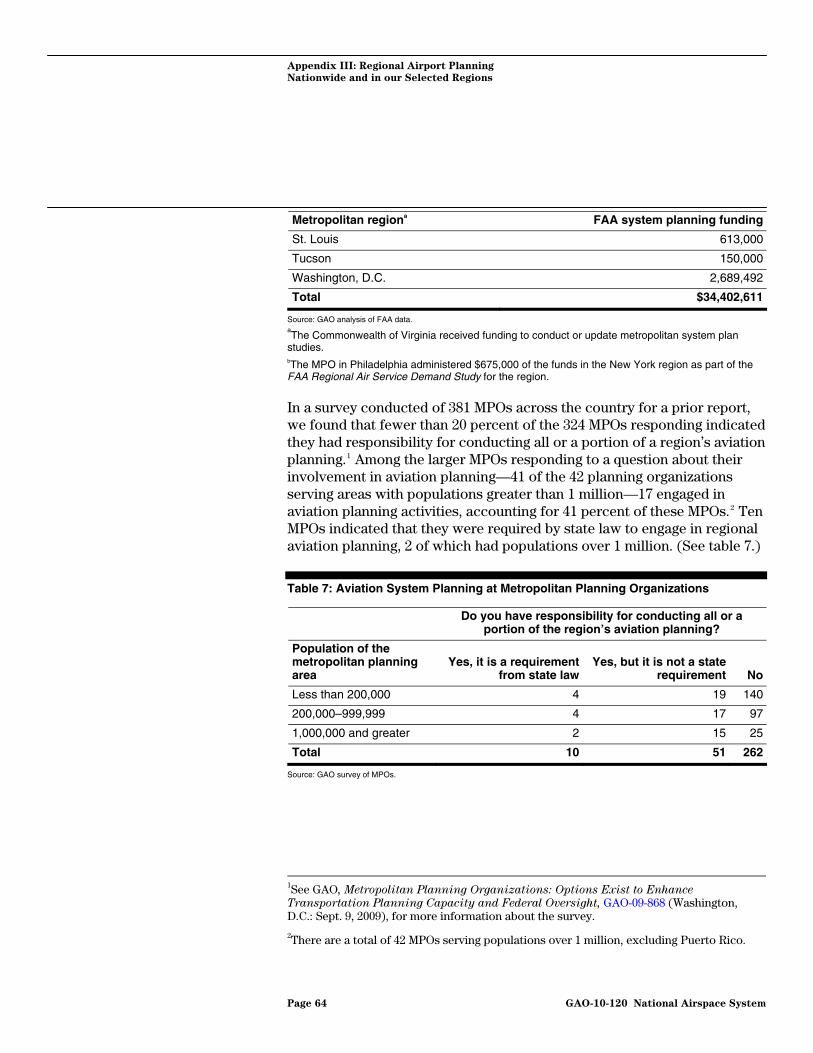
Appendix III: Regional Airport Planning
Nationwide and in our Selected Regions
Metropolitan regiona FAA system planning funding
St. Louis 613,000
Tucson 150,000
Washington, D.C. 2,689,492
Total $34,402,611
Source: GAO analysis of FAA data. aThe Commonwealth of Virginia received funding to conduct or update metropolitan system plan
studies. bThe MPO in Philadelphia administered $675,000 of the funds in the New York region as part of the FAA Regional Air Service Demand Study for the region.
In a survey conducted of 381 MPOs across the country for a prior report, we found that fewer than 20 percent of the 324 MPOs responding indicated they had responsibility for conducting all or a portion of a region’s aviation planning.1 Among the larger MPOs responding to a question about their involvement in aviation planning—41 of the 42 planning organizations serving areas with populations greater than 1 million—17 engaged in aviation planning activities, accounting for 41 percent of these MPOs.2 Ten MPOs indicated that they were required by state law to engage in regional aviation planning, 2 of which had populations over 1 million. (See table 7.)
Table 7: Aviation System Planning at Metropolitan Planning Organizations
Do you have responsibility for conducting all or a
portion of the region’s aviation planning?
Population of the metropolitan planning area
Yes, it is a requirement from state law
Yes, but it is not a state requirement No
Less than 200,000 4 19 140
200,000–999,999 4 17 97
1,000,000 and greater 2 15 25
Total 10 51 262
Source: GAO survey of MPOs.
1See GAO, Metropolitan Planning Organizations: Options Exist to Enhance
Transportation Planning Capacity and Federal Oversight, GAO-09-868 (Washington, D.C.: Sept. 9, 2009), for more information about the survey.
2There are a total of 42 MPOs serving populations over 1 million, excluding Puerto Rico.
Page 64 GAO-10-120 National Airspace System

Appendix III: Regional Airport Planning
Nationwide and in our Selected Regions
Regional Summaries
Boston Region There are three commercial service airports operated by separate
sponsors in the Boston region. Boston Logan International is a large-hub airport, and in 2008, 73 percent of flights to this facility arrived on time. A medium-hub airport, T.F. Green, near Providence, Rhode Island, and a small-hub airport, Manchester-Boston Regional in Manchester, New Hampshire, also provide commercial service to the region’s residents. FAA’s FACT 2 report did not forecast that any of the airports in the Boston region would become significantly capacity constrained by 2025, assuming planned improvements occur at Boston Logan and T.F. Green.
FAA officials in New England have taken an active role in trying to assist the region’s airports in planning for future capacity needs. Officials at Massport, which operates Boston Logan, told us that they realized that the airport would not be able to meet the region’s capacity needs. After an attempt to develop a second major airport in Massachusetts failed, they worked with FAA and other airports in the region to decentralize the region’s air traffic. This allowed Boston Logan an opportunity to specialize in international and long-haul routes over short-haul trips. Prior to the arrival of Southwest Airlines, regional demand studies demonstrated that there were markets that could be served from Boston’s alternate airports. Southwest Airlines officials told us that the demand forecasts piqued their interest in the alternate airports in the region, and that the airline has been pleased with how customers responded to its entry into Boston’s alternate airports. Prior to the emergence of T.F. Green and Manchester-Boston Regional, many residents drove from areas near these airports to travel from Boston Logan. Expanded service options have allowed some residents of the region to be served closer to where their trips originate.
Los Angeles Region Los Angeles World Airports operates two commercial-service airports in
the Los Angeles region: LAX is a large-hub airport, and Ontario International is a medium-hub airport. In 2008, 77 percent of flights to LAX arrived on time. There are two other medium-hub airports in the region operated by separate sponsors—John Wayne Airport in Orange County and Bob Hope Airport in Burbank. There is also a small-hub airport in Long Beach and a nonhub airport in Van Nuys, which is owned and operated by Los Angeles World Airports. FACT 2 predicted that both John Wayne and Long Beach airports will become significantly capacity constrained by 2015.
Page 65 GAO-10-120 National Airspace System

Appendix III: Regional Airport Planning
Nationwide and in our Selected Regions
The capacity challenges faced by the Los Angeles region are compounded by flight and operations restrictions at several airports in the region. The airports in Orange County and Long Beach have legal agreements or requirements that limit their ability to increase traffic levels and thereby relieve regional congestion. Likewise, the sponsor of Bob Hope Airport has entered into a voluntary agreement that prevents the development of new gates or the expansion of the footprint of the terminal until 2012, according to airport officials. LAX, for its part, has also agreed to a limit on the number of annual passengers at its facility under a settlement agreement with the surrounding community, according to regional planners. Los Angeles World Airports officials told us that while they previously attempted to promote the development of alternate facilities, such as LA/Palmdale Regional, the focus of their agency has shifted back to LAX, given the recent downturn and the backlog of maintenance at this facility. Several of the airports in the region are proposed to also serve as high-speed rail stops, including Ontario International and LA/Palmdale Regional. Such ground access improvements may help these airports play a greater role in delivering capacity for the region in the future.
New York Region The Port Authority of New York and New Jersey (Port Authority) operates
Newark Liberty International (Newark), John F. Kennedy International (JFK), and LaGuardia. These large-hub airports are consistently amongst the most delayed in the nation. In 2008, 62 to 68 percent of the flights to these facilities arrived on time (i.e., within 15 minutes of their scheduled arrival time). Stewart International, an airport 1 1/2 hours of the city by car, was recently acquired by the Port Authority and is a small-hub airport. Long Island Macarthur Airport in Ronkonkoma is a small-hub airport that operates outside of the Port Authority system. FAA’s FACT 2 report reported that LaGuardia and Newark were already significantly capacity constrained in 2007, and that JFK would become so in 2025.
The Port Authority is an intermodal organization that is exempt from some of the revenue-sharing prohibitions affecting other regions. Airports in the Port Authority system are part of a larger portfolio of transportation assets operated by the Port Authority, such as major bridges and tunnels. According to the Port Authority, because it was grandfathered under federal law prohibiting the use of airport revenues off airport property, the Port Authority is able to cross-subsidize transportation modes. The airports in the Port Authority’s system provide some of the revenue for other modes that operate at a loss, according to Port Authority officials. The region recently completed a regional air service demand study, and Port Authority officials told us that the forecasts developed for the study
Page 66 GAO-10-120 National Airspace System

Appendix III: Regional Airport Planning
Nationwide and in our Selected Regions
were essential for demonstrating the benefits of acquiring the lease for Stewart International. Port Authority officials told us that while they expected the facility to generate revenue eventually, it is now operating at a loss. At the request of FAA, the Port Authority is presently preparing updates to the airport layout plans for airports in its system. FAA officials told us that the last airport master plans the Port Authority prepared date back to 1970. According to Port Authority officials, planning for the airports happens in an ad hoc fashion, given intermodal competition within the agency. The local MPO, the New York Metropolitan Transportation Commission, does not play a role in regional airport planning beyond surface access. A nonprofit, the Regional Plan Association, has recently begun regional airport planning with Port Authority financing, which will focus on the airports under Port Authority sponsorship. Ground access is a significant consideration for the future development of Stewart International, and the Port Authority is cosponsoring a rail study with the New York Metropolitan Transportation Authority to evaluate access improvements to the airport.
Philadelphia Region There is one large-hub airport in the Philadelphia region—Philadelphia
International—and one small-hub airport—Atlantic City International—to the southeast in New Jersey. In 2008, 73 percent of flights to Philadelphia International arrived on time. Philadelphia International is owned by the City of Philadelphia, while Atlanta City International is jointly owned by the South Jersey Transportation Authority and FAA. FACT 2 forecast that Philadelphia International would become significantly capacity constrained by 2015.
Philadelphia International is presently pursuing a capital enhancement project to add an additional runway and expand another. The project is contentious, particularly with residents of Tinicum Township and Delaware County where environmental impacts, including emissions and noise, might increase. Atlantic City International provides some residents of the region with an alternate to the more congested Philadelphia International. The local MPO, the Delaware Valley Regional Planning Commission, is active in regional airport planning, focusing in recent years on planning for general aviation airports. MPO officials expressed an interest in continuing regional airport planning as well as undertaking a regional demand study similar to the ones completed in the Boston and New York regions.
Page 67 GAO-10-120 National Airspace System

Appendix III: Regional Airport Planning
Nationwide and in our Selected Regions
San Diego Region The San Diego region has one large-hub airport, San Diego International. In 2008, 78 percent of flights to this airport arrived on time. FACT 2 forecast that San Diego International would be significantly capacity constrained by 2025.
The primary airport in San Diego is run by the San Diego County Regional Airport Authority, which was previously involved in a major site-selection effort to build a new airport for the region. This effort was rejected by voters in 2006, however, and airport officials are now planning under the assumption that San Diego International will be the only major airport in the region. With this in mind, the airport sponsor is considering how it could maximize San Diego International’s capacity within its existing footprint. In addition, a state law passed in 2007 mandates that the airport authority prepare a RASP for the region by June 30, 2011. While the airport authority is working on the airside components of the study, the MPO is working on a multimodal transportation plan.
San Francisco Bay Area The San Francisco Bay Area has three major airports with different
sponsors. San Francisco International (SFO) is a large-hub airport, and in 2008, 69 percent of flights arrived on time. Both Oakland International and Norman Y. Mineta in San Jose are medium-hub airports. FACT 2 forecast that both SFO and Oakland International will be significantly capacity constrained by 2025.
SFO and Oakland International are located on land adjacent to San Francisco Bay and face significant obstacles to the construction of new runways as a result. The Regional Airport Planning Committee, which includes the Metropolitan Transportation Commission—the region’s MPO—will play a significant role in identifying potential alternate solutions for the region, and is currently leading efforts to develop a new RASP. This effort is being funded by FAA, the MPO, and airports in the region. SFO officials told us that they have committed themselves to studying nonconstruction ways to relieve congestion, and that they are not averse to having domestic, short-haul traffic shift to Oakland International or Norman Y. Mineta in San Jose or in instituting demand management strategies such as peak pricing to relieve congestion. SFO officials also stated that they are also considering improvements that may come from NextGen and other technological improvements.
Page 68 GAO-10-120 National Airspace System
Appendix IV:
A
GAO Contact and Staff
cknowledgments
Page 69 GAO-10-120
Appendix IV: GAO Contact and Staff Acknowledgments
Gerald Dillingham, Ph.D., (202) 512-2834 or [email protected]
In addition to the contact named above, Paul Aussendorf (Assistant Director), Amy Abramowitz, Lauren Calhoun, Delwen Jones, Paul Kazemersky, Molly Laster, Monica McCallum, Sara Ann Moessbauer, and Josh Ormond made key contributions to this report.
National Airspace System
GAO Contact
Staff Acknowledgments
(540182)

GAO’s Mission The Government Accountability Office, the audit, evaluation, and investigative arm of Congress, exists to support Congress in meeting its constitutional responsibilities and to help improve the performance and accountability of the federal government for the American people. GAO examines the use of public funds; evaluates federal programs and policies; and provides analyses, recommendations, and other assistance to help Congress make informed oversight, policy, and funding decisions. GAO’s commitment to good government is reflected in its core values of accountability, integrity, and reliability.
The fastest and easiest way to obtain copies of GAO documents at no cost is through GAO’s Web site (www.gao.gov). Each weekday afternoon, GAO posts on its Web site newly released reports, testimony, and correspondence. To have GAO e-mail you a list of newly posted products, go to www.gao.gov and select “E-mail Updates.”
Obtaining Copies of GAO Reports and Testimony
Order by Phone The price of each GAO publication reflects GAO’s actual cost of production and distribution and depends on the number of pages in the publication and whether the publication is printed in color or black and white. Pricing and ordering information is posted on GAO’s Web site, http://www.gao.gov/ordering.htm.
Place orders by calling (202) 512-6000, toll free (866) 801-7077, or TDD (202) 512-2537.
Orders may be paid for using American Express, Discover Card, MasterCard, Visa, check, or money order. Call for additional information.
Contact:
Web site: www.gao.gov/fraudnet/fraudnet.htm E-mail: [email protected] Automated answering system: (800) 424-5454 or (202) 512-7470
Ralph Dawn, Managing Director, [email protected], (202) 512-4400 U.S. Government Accountability Office, 441 G Street NW, Room 7125 Washington, DC 20548
To Report Fraud, Waste, and Abuse in Federal Programs
Congressional Relations
Chuck Young, Managing Director, [email protected], (202) 512-4800 U.S. Government Accountability Office, 441 G Street NW, Room 7149 Washington, DC 20548
Public Affairs
Please Print on Recycled Paper