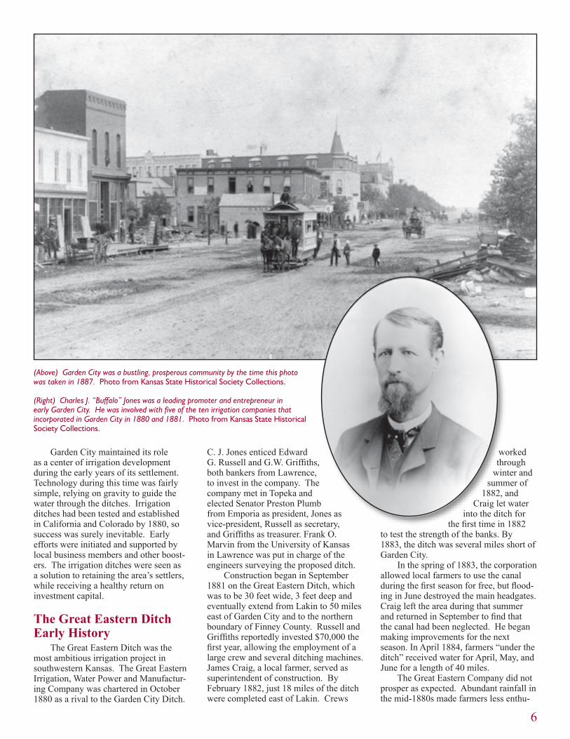
garden city, kansas, 1887
TRANSCRIPT

Newsletter of the Cultural Resources Division Kansas State Historical Society
September - October 2004 Vol. 26, No. 5
Article on page 5
The early settlers of Garden City and southwest Kansas were determined to transform the area into productive farmland by diverting the Arkansas River to their crops. Many of their manmade ditches stand today as remnants of the belief that man could conquer nature for the benefit of civilization.
Garden City, Kansas, 1887

11Transportation Enhancement
13Queen Anne Style
17Recording Rock Art at the
Katzenmeier Site
20Council Circles Mapped
1
Contents
KANSAS PRESERVATION
Published bimonthly by the Cultural Resources Divi-sion, Kansas State Historical Society, 6425 S.W. Sixth Avenue, Topeka, KS 66615-1099.
Please send change of address information to the above address or e-mail cultural_
Third-class postage paid at Topeka, KansasTerry W. Marmet,
Interim State Historic Preservation OfficerRichard Pankratz, Editor
Virginia Wulfkuhle, Associate EditorTracy Campbell, Editorial & Design Services
Partial funding for this publication is provided by the National Park Service, Department of the Interior. The contents and opinions do not necessarily reflect the views or policies of the Department of the Interior, nor does the mention of trade names or commercial products constitute an endorsement or recommendation by the Department of the Interior.
This program receives federal funds from the National Park Service. Regulations of the U.S. Department of the Interior strictly prohibit unlawful discrimination in departmental federally assisted programs on the basis of race, color, national origin, age, or handicap. Any person who believes he or she has been discriminated against in any program, activity, or facility operated by a recipient of federal assistance should write to: Office of Equal Op-portunity, National Park Service, 1849 C Street NW, Washington, DC 20240.
CorrectionThe July-August 2004 issue of Kansas Preservation was inadvertently identified on the cover as Vol. 25, No. 4. It should have read Vol. 26, No. 4.
Deadlines Approaching for Historic Preservation Fund and Heritage Trust Fund Grants
The November 15, 2004, deadline for submitting applications for 2005 federal Historic Preservation Fund (HPF) grants is fast approaching. Applications must be postmarked or hand-delivered by 4:30 p.m. on that date.
A minimum of $60,000 is expected to be awarded to such organizations as historical societies, universities, planning commissions, non-profit corporations, Certified Local Governments, and city and county governments. We expect that this will be a very competitive round of applications. Attendance at the HPF workshops held in August in Topeka and Hays was outstanding, and a number of quality preliminary applications were received.
The grant awards will be announced at the Historic Sites Board of Review meeting on February 26, 2005.
The next important milestone for the Heritage Trust Fund (HTF) grant program
is the deadline for preliminary applica-tions on January 15, 2005. Preliminary applications submitted for staff review are not mandatory but are highly recom-mended and have proven helpful to past applicants.
To be eligible, properties must be listed on the National Register of Historic Places, the Register of Historic Kansas Places, or be a contributing property in a registered historic district. If you have a question about your property’s status, or for more information about the grant programs, contact Teresa Kiss at (785) 272-8681 Ext. 216 or [email protected].
The three remaining HTF workshops are listed in the calendar section on the back of this issue.
The final HTF application submis-sion deadline is March 1, 2005. To receive an HTF application, please call (785) 272-8681 Ext. 245 or e-mail a request to [email protected].
2005 Preserve America Presidential Awards Call for Entries
Nominations are being accepted for the 2005 Preserve America Presidential Awards. These prestigious awards, intro-duced by First Lady Laura Bush last fall, honor exemplary achievements in protec-tion, preservation, sustainable use, and interpretation of heritage assets.
Four Preserve America Presiden-tial Awards are given each year: two for projects or programs that advance heritage tourism and two for outstanding privately funded historic preservation projects or programs.
During Preservation Week in May 2004, the winners of the first awards received their awards in the Oval Office from President and Mrs. Bush and were honored in a public ceremony in the East Room of the White House. Information about the 2004 winners can be found at www.achp.gov.
Nominations for the 2005 Preserve America Presidential Award must be postmarked by November 1, 2004. Additional information, as well as a downloadable nomination form, can be found at www.preserveamerica.gov.
Preserve America highlights the efforts of President and Mrs. Bush to preserve and celebrate our national heritage. The program is a White House initiative developed and carried out in cooperation with the Advisory Council on Historic Preservation (ACHP), the U.S. Department of the Interior, the U.S. Department of Commerce, and the U.S. Department of Agriculture. The ACHP, in partnership with the National Park Service, administers the Preserve America Presidential Awards program on behalf of the White House.

2
The Kansas Historic Sites Board of Review held its regular quarterly meeting on August 21, 2004, at the Kansas Histo-ry Center in Topeka.
Three Doniphan County properties were approved for delisting from both the National and State Registers because they had either been demolished or relocated without prior review. The three proper-ties were the Benjamin Harding House, 308 North Fifth Street, Wathena (razed); Mission-Herring Barn, 1 mile east of Highland (razed); and the Eclipse School, northeast of Troy (moved to Elwood).
The board approved one multiple property context statement and ten nominations for the National Register and five nominations for the State Register.
Review Board Approves 15 Nominations
Two bridges were added to the National Register multiple property submission Metal Truss Bridges in Kansas 1861-1939. The Stranger Creek Warren Truss Bridge, located on Haskell Road, 0.8 miles south of the intersec-tion with 262 Road, 0.5 miles south of Farmington in Atchison County, is a single span pony truss erected in 1925. The Hobbs Creek Truss Leg Bedstead Bridge is located on Hobbs Creek Road, 0.6 miles west of the intersection with Solomon Road, or 4.5 miles south and 2.4 miles east of Gypsum in Saline County. It was constructed by the Missouri Valley Bridge Company in 1907.
The multiple property context document entitled “Prehistoric Sites
Stranger Creek WarrenTruss BridgeAtchison County
Hobbs Creek Truss LegBedstead Bridge
Saline County
“Prehistoric Sites of Stranger Creek Basin, Kansas”
Multiple Property Context Statement (Two Sites Approved)
Battle of Black JackSite Expansion
Baldwin City Vicinity
Abernathy Furniture Company BuildingsLeavenworth
800 West Douglas Historic District
Wichita
Pettit Cleaners BuildingWinfield
Damon Runyon HouseManhattan
Minor Sod HouseMcDonald Vicinity
Stein HouseSeneca
Staatz HouseDickinson County
Vernon SchoolKansas City
Lillis GymnasiumLillis
South Fork SpillmanCreek Bridge
Lincoln County
The Pettit Cleaners building in Winfield displays a 1947 facade designed by architect William N. Caton in the Art Moderne style. The building now houses a coffee shop.

3
of Stranger Creek Basin, Kansas” can now serve as the basis for National Register nominations of archeological sites in the Stranger Creek drainage in Atchison, Jefferson, and Leavenworth counties. Two individual sites, the Evans Site (14LV1079) and the Scott Site (14LV1082) were the first approved under this context.
An expansion of the boundaries of the Battle of Black Jack Site, in the vicin-ity of Baldwin City, was approved. An additional parcel of 39.24 acres adjacent to the earlier approved nomination was recently acquired by the Lawrence Preservation Alliance for the Black Jack Battlefield Trust. The addition of this acreage to the previously approved nomination was accepted by the board.
A number of commercial properties were also approved for National Register nomination. The Abernathy Furniture Company, 200 Seneca Street, Leaven-worth, consists of three buildings dating from 1883, 1890, and 1905, which were integral parts of an important Leaven-worth industrial/manufacturing complex. The three Abernathy buildings have been rehabilitated for housing. (This project was featured in the January - February 2004 issue of Kansas Preservation.)
The 800 West Douglas Historic District (809, 811, and 815 West Douglas) in Wichita was approved for its association with the early town of Delano, located just west across the Arkansas River from Wichita.
The Pettit Cleaners building, located at 114 E. 8th Street in Winfield, is a commercial structure originally erected around 1880. The building, however, was nominated for its architectural signif-icance as an example of a streamlined Art Moderne commercial structure. The 1947 facade was designed by local archi-tect William N. Caton. The building now houses a coffee shop.
Two residences were approved for National Register listing. The Damon Runyon House at 400 Osage Street, Manhattan, was nominated for its associ-ation with Damon Runyon, a prominent newspaper columnist, sportswriter, novelist, playwright, and screenwriter in the first half of the twentieth century. Ordinarily birthplaces are not eligible for the National Register, but exceptions are made when they are the only extant resource associated with the individual. The structure is a modest frame house built for Damon’s father Alfred in 1878. Damon was born in the house in 1880,
and the family lived there until 1891.The Minor Sod House near McDon-
ald in Rawlins County was approved for its architectural significance as a sod house. Constructed in 1907-1908 by Sidney Graves, the sod house and the quarter section on which it stands were acquired by Tom and Mary Minor in 1909 and remained in their family until the early 1950s. The house was then unoccupied until its recent rehabilitation. The property is now used as the Minor Family Sod House Bed and Breakfast.
The properties approved for the State Register include two houses, a school, a gymnasium, and a bridge. The Stein House at 314 North Seventh Street in Seneca was built in 1913 for a local bank cashier. Constructed by Seneca builder Henry Bernard Woltkamp, the two-and-one-half story frame house was built in the “comfortable house” mode.
The original part of the Staatz House, located in northeastern Dickinson County (1824 Wolf Road), dates to 1867. The vernacular stone structure was erected by German Lutheran immigrant C. W. Staatz, who came to Dickinson County in 1856.
Vernon School, located at 3436 N. 27th Street, Kansas City, was built in
The Hobbs Creek Truss Leg Bedstead Bridge near Gypsum in Saline County was constructed by the Missouri Valley Bridge Company in 1907.

4
Since the last update in the March-April 2004 issue of Kansas Preserva-tion, 27 properties have been added to the National Register of Historic Places, raising the Kansas total to 888.
Two properties were added to the Metal Truss Bridges of Kansas 1861-1939 Multiple Property Submission:
Delaware River Warren Truss Bridge, Fairview vicinity, Brown CountyLakewood Park Bridge, Salina, Saline County
Two properties were added to the National Guard Armories of Kansas Multiple Property Submission:
Hiawatha National Guard Armory, 108 N. 1st Street, Hiawatha, Brown CountyKingman National Guard Armory, 111 S. Main Street, Kingman, Kingman County
Six historic districts were added to the Lawrence, Kansas, Multiple Prop-erty Submission:
Hancock (12th Street) Historic DistrictLawrence Downtown Historic DistrictPinckney I Historic DistrictPinckney II Historic DistrictNorth Rhode Island Street Historic DistrictSouth Rhode Island Street Historic District
••
•
•
••••••
1936 for the education of African-Ameri-can children in Kansas City. Construc-tion was funded by a local bond issue and a Public Works Administration grant. It was built on the same site as the 1858 “Colored School of Quindaro,” which was razed to make way for the new school. Both buildings bore the name
The other recently listed properties are presented in county order:John Drimmel, Sr. Farm, 16339 290th Road, Atchison vicinity, Atchison CountyBattle of Black Jack Site, Baldwin City vicinity, Douglas CountyVirginia School District #33, 71st Street and Clare Road, Shaw-nee, Johnson CountyPorter Hotel, 209 E. Main Street, Beloit, Mitchell CountyJenkins Building, 101 W. Mackenzie Street, White City, Morris CountyNemaha County Jail and Sheriff’s House, 113 N. 6th Street, Sen-eca, Nemaha CountyBarbeau House, 210 E. Washington Avenue, Lenora, Norton County (see photo on page 14)Lyda-Jean Apartments, 501 Houston Street, Manhattan, Riley CountyMcFarlane-Wareham House, 1906 Leavenworth Street, Manhat-tan, Riley CountyBitting Historic District, Wichita, Sedgwick CountyEast Douglas Historic District, Wichita, Sedgwick CountyPark Place-Fairview Historic District, Wichita, Sedgwick County Topeka-Emporia Historic District, Wichita, Sedgwick CountyMorton Albaugh House, 1331 S.W. Harrison Street, Topeka, Shawnee CountyMorgan House, 1335 SW Harrison Street, Topeka, Shawnee CountyWestminster Presbyterian Church, 1275 Boswell Street, Topeka, Shawnee CountyEdwin Smith House, 114 S. Jefferson, Wellington, Sumner County
•
••
••
•
•
•
•
•••••
•
•
•
of Bishop William Tecumseh Vernon, who served many years as president of Western University. The building is now owned by the A.M.E. Church and used as a neighborhood center.
The Lillis Gymnasium, located at 2753 28th Road in Lillis, Marshall County, was completed in 1938 with
Works Progress Adminis-tration funding. Although educational use ceased in 1977, the building contin-ued to be used for commu-nity activities. Damaged by a tornado in 1997, the roof and other parts of the building were subsequently repaired under the auspices of Lillis Community Center, Inc.
The South Fork Spillman Creek Bridge is a double arch masonry bridge that spans the South Fork of Spillman Creek in southeast Cedron Township in Lincoln County. The bridge faced demolition when it was scheduled for replacement in 1992 because of safety concerns; instead KDOT rerouted K-181 and transferred the bridge to the Sylvan Grove Historical Society. The
bridge sits in a small park near K-181 and may be viewed by travelers.
The next meeting of the Kansas Historic Sites Board of Review will be held Saturday, November 6, 2004. The meeting begins at 9 a.m. in the class-rooms at the Kansas Museum of History, 6425 S.W. Sixth, Topeka, Kansas.
Shown above is an interior view of the Minor Sod House, which is located in the McDonald vicinity of Rawlins County. The 1907 sod structure is now used as a bed and breakfast.
National Register Update

5
The Garden City ditches were the “humble beginnings of irrigation in southwestern Kansas,” asserts James Sherow in his book, Watering the Valley. The early settlers of southwest Kansas, he states, were determined to transform the area into productive farmland by divert-ing the Arkansas River to their crops. This basic need for water resulted in the construction of miles of irriga-tion ditches in the 1880s that had profound political, developmental, and economic effects on the region. Many of the ditches remain today as remnants of the belief that man could conquer nature for the benefit of civilization.
Today portions of two such ditches, the Great Eastern Ditch and the Kansas/Farmers’ Ditch, are eligible for listing on the National Register of Historic Places.
Early Garden City Development
In April 1879, Garden City had four houses, two lumberyards, two hotels, one livery stable, one attorney, one surveyor, three land offices, and one contracting and building firm. Despite the sparse number of residents, the town’s handful of buildings and surrounding fields held promise for settlers. Prosperity was beginning to reach the region: the railroad had reached Dodge City in 1872, a moderate distance to the southeast; a
federal land office was established in Larned in 1874; and the eccentric Arkan-sas River flowed through the valley. The inconsistent river was reportedly half a mile wide at Lakin west in Kearny County, but it often disappeared into its sandy riverbed during the early spring
and droughts. Surely this waterway could be put to efficient use.
Brothers William D. and James R. Fulton, the latter a noted buffalo hunter, arrived in Garden City from Sterling, Kansas. Charles J. “Buffalo” Jones joined the Fultons in their development. A plat was filed in the Dodge City court-house for the town of Garden City on April 8, 1879, listing March 16, 1878, as the date of settlement. The settlement was beginning to look promising—wheat was planted, a gristmill was planned for construction by the Arkansas River, and settlers were arriving. The Fultons’ origi-nal two quarter-sections were eventually supplemented by land owned by John A. Stevens and Jones.
Then a 14-month drought hit south-western Kansas in 1879. The poor crops prompted some settlers to leave; those who stayed and replanted were rewarded with another dismal harvest, and the area population began to shrink. The effect of the poor crops led to the inspiration and early implementation of the area’s first irrigation ditch. W. H. Armentrout, a mill
owner who had no wheat to grind at his new mill, allowed Squire Worrell to use the flow from the millstream to irrigate his own crops. When Worrel’s crops flourished, others realized the potential of irrigation.
The Garden City Irrigation Compa-ny, the first of many irrigation conglomerates, was formed in November 1879 by Jones and began construc-tion of the area’s first commercial irrigation ditch in the early winter of 1880. Local and far-flung investors and boosters for southwestern Kansas immedi-ately saw the benefits of irriga-tion. If crops flourished every year, settlers would not leave the area and other
businesses could thrive. Farmers would also pay for the irrigated water, likely benefitting investors.
Sherow aptly describes Charles J. “Buffalo” Jones as “a speculator and a half.” Jones was a proponent for saving the remaining buffalo herds and an enthusiastic supporter for southwestern Kansas. He was listed as an officer on the boards of five of the ten irrigation companies that incorporated in 1880 and 1881. He personally took credit, whether deserved or not, for every major advance in Garden City.
The irrigation ditches of the 1880s had a profound effect on the area. The Garden City of 1880 had few real structures, only a few dugouts and log cabins. By 1888, the town had grown to a population of 8,000 and was the county seat of the newly-created Finney County, the largest in Kansas. Richard J. Hinton, a correspondent for Harper’s Weekly, attributed this growth to one small irriga-tion ditch built in 1880, a ditch that eventually led to thousands of irrigated acres.
The Great Eastern andFarmers’ Ditches of Finney County
This view of the headgates in the Great Eastern Ditch near Garden City was taken in the 1890s.Photo from Kansas State Historical Society Collections.
This article was abstracted from a cultural resources management report prepared by consultant Susan Jezak Ford under contract to the Kansas Department of Transportation and is printed with the permission of Ford and KDOT. KDOT commissioned the study in advance of a highway project in the vicinity of the Finney County irrigation ditches.
6
Garden City maintained its role as a center of irrigation development during the early years of its settlement. Technology during this time was fairly simple, relying on gravity to guide the water through the ditches. Irrigation ditches had been tested and established in California and Colorado by 1880, so success was surely inevitable. Early efforts were initiated and supported by local business members and other boost-ers. The irrigation ditches were seen as a solution to retaining the area’s settlers, while receiving a healthy return on investment capital.
The Great Eastern Ditch Early History
The Great Eastern Ditch was the most ambitious irrigation project in southwestern Kansas. The Great Eastern Irrigation, Water Power and Manufactur-ing Company was chartered in October 1880 as a rival to the Garden City Ditch.
C. J. Jones enticed Edward G. Russell and G.W. Griffiths, both bankers from Lawrence, to invest in the company. The company met in Topeka and elected Senator Preston Plumb from Emporia as president, Jones as vice-president, Russell as secretary, and Griffiths as treasurer. Frank O. Marvin from the University of Kansas in Lawrence was put in charge of the engineers surveying the proposed ditch.
Construction began in September 1881 on the Great Eastern Ditch, which was to be 30 feet wide, 3 feet deep and eventually extend from Lakin to 50 miles east of Garden City and to the northern boundary of Finney County. Russell and Griffiths reportedly invested $70,000 the first year, allowing the employment of a large crew and several ditching machines. James Craig, a local farmer, served as superintendent of construction. By February 1882, just 18 miles of the ditch were completed east of Lakin. Crews
worked through
winter and summer of
1882, and Craig let water
into the ditch for the first time in 1882
to test the strength of the banks. By 1883, the ditch was several miles short of Garden City.
In the spring of 1883, the corporation allowed local farmers to use the canal during the first season for free, but flood-ing in June destroyed the main headgates. Craig left the area during that summer and returned in September to find that the canal had been neglected. He began making improvements for the next season. In April 1884, farmers “under the ditch” received water for April, May, and June for a length of 40 miles.
The Great Eastern Company did not prosper as expected. Abundant rainfall in the mid-1880s made farmers less enthu-
(Above) Garden City was a bustling, prosperous community by the time this photo was taken in 1887. Photo from Kansas State Historical Society Collections.
(Right) Charles J. “Buffalo” Jones was a leading promoter and entrepreneur in early Garden City. He was involved with five of the ten irrigation companies that incorporated in Garden City in 1880 and 1881. Photo from Kansas State Historical Society Collections.

7
siastic about purchasing irrigated water, and in 1886 the company’s expenses outweighed its revenues. Nevertheless, the company continued to purchase land and several laterals were added to the Great Eastern north and west of Deerfield. When drought hit the region in 1886, farmers found the ditch unmain-tained and dry. The company’s 1887 solution to repair and extend the ditch to 40 miles in length left the investors deeply in debt.
Despite financial woes, by 1888 the Great Eastern was the largest and most important irrigation canal in the Arkansas Valley. Extending 96 miles over upland, its construction canals boosted the local economy. Estimates for the construc-tion of the Great Eastern ditch range from $50,000 to $100,000. The project provided employment for many farmers, especially in winter months.
The company sold the Great Eastern Ditch on May 10, 1890, to the South-west Irrigation Company, a Kansas City syndicate backed with English capital and managed by Frank Denny, a Garden City resident. Drought, a depression, and bad engineering calculations in the 1890s bankrupted the new owners. Farmers, it turned out, were not reliable purchasers of irrigated water. Wheat and sorghum were raised without supplemental moisture, and the farmers only requested
Current west view of the Great Eastern Ditch and operating machinery at Big Lowe and Rodkey Roads. Photo by Susan Ford.
Current east view of the Great Eastern Ditch and operating machinery at Big Lowe and Rodkey Roads. Photo by Susan Ford.
water during the droughts. It wasn’t until the introduction of sugar beets to the area that farmers found a need for constant, reliable irrigation.
Current descriptionThe Great Eastern Ditch today is
well maintained and is primarily owned by the Garden City Company. Its main purpose is to distribute reservoir water
collected from winter precipitation. Areas of the ditch viewed by the author are approximately 40 feet wide and 4 feet deep with dirt banks. The ditch meanders north of the Arkansas River from approx-imately 2 miles west of the Kearny/Finney county line, angling 2 miles northeast where it then splits, with one segment angling northeast and another angling southeast, ending just northwest of Garden City.

8
At the time of the author’s visit to the Garden City area in April 2004, water was flowing in the ditch. Concrete culverts, concrete and metal gates, and machinery to regulate the water are present along the ditch, some in good repair and some in need of maintenance. Crops grown along the Great Eastern Ditch are primarily corn and milo.
The Kansas Ditch/Farmers’ Ditch Early History
The Farmers’ Ditch follows an investment and development pattern similar to that of the Great Eastern Ditch. James Craig and other residents of the Garden City area began it as the Kansas Ditch. It was sold to C. J. Jones and a group of investors that incorporated it in February 1880 as the Kansas Irrigat-ing, Water Power and Manufacturing Company.
Land for the ditch was surveyed north and west of Garden City. The Kansas Ditch was proposed to be 20 miles long, 22 feet wide, and 4 feet deep, beginning at the north bank of the Arkan-sas River about 12 miles west of Garden City. Jones promised farmers along the line that he would pay for headgates and construction equipment in return for
half interest in the ditch. Farmers would furnish labor and receive their own half interest. Construction would cost $250 per mile and would eventually serve 21,600 to 38,000 acres.
The Kansas canal was larger but similar in design to the first canal in the region, the Garden City Ditch. The Kansas Ditch, however, differed in two important ways that typified canal irriga-tion in the 1880s: eastern investors finan-cially controlled it, and it extended into the uplands of Finney County.
The ditch left the Arkansas River approximately 13 miles above Garden City near the Finney-Kearny County line. In the spring of 1881, another ditch, known as the Sherlock Canal, was started a short distance down the river and completed at 8 miles. In 1882 the two canals were consolidated as the Kansas Canal and sold to a group of Illinois investors incorporated as the Illinois Irrigating and Water Power Company. By 1884, the canal was 30 miles long. At the headgate it measured 40 feet wide and 4 feet deep; at Garden City it was 10 feet wide and 2 feet deep.
The Kansas Ditch was the first to carry water to the uplands of Finney County. To achieve this, the fall was reduced 2-3 feet per mile, sending it
up out of the valley. The Kansas Ditch eventually irrigated almost 10,000 acres, although as early as 1882 patrons complained of inadequate water and poor maintenance. The ditch never supplied the farmers of the uplands with adequate irrigation as promised.
Frank Denny, a Garden City resident, purchased the failing ditch in 1890, along with the Garden City Ditch. Under the Southwestern Company, he ran the Garden City, Kansas, and Great Eastern ditches. In October 1901, the Finney County Farmers’ Irrigation Association bought the Kansas Ditch and renamed it the Farmers’ Ditch.
Current descriptionThe Farmers’ Ditch today is well
maintained and owned by sharehold-ers. It is used to distribute reservoir water collected from winter precipita-tion. Areas of the ditch viewed by the author are approximately 40 feet wide and 4 feet deep with dirt banks. The ditch begins approximately 8 miles west and 2 miles south of Holcomb and angles 3 miles to the northeast toward Garden City, where laterals extend 3 miles north of Garden City and the ditch continues 3 miles to the southeast. Concrete culverts,
The Great Eastern Ditch spread eastward from Hartland in Kearny County to reach areas just northwest of Garden City. The Kansas/Farmers’ Ditch began at Deerfield and extended just north of Garden City. (This map was used to illustrate Anne M. Marvin’s article, “Irrigation and Boosterism in Southwest Kansas,” Kansas History, Spring 1996, and is used with her permission.)

9
concrete and metal gates, and machinery to regulate the water are present along the ditch. Crops grown along the Farmers’ Ditch are primarily alfalfa and wheat.
Later Ditch HistoryOnce construction for the irrigation
ditches was underway, the Garden City area was publicized as truly irrigated. The system of ditches was described as partially finished, but far more waterable acres were promoted than were actually available. Water was viewed as almost inexhaustible, with runoff from mountain snows regularly filling the Arkansas River.
The Irrigator, a Garden City newspa-per, regularly covered the wonders of the ditches. In July 1882, the weekly waxed poetic:
What has transformed that once bleak desert, Utah, from its former natural barrenness and unproductiveness to the garden spot of the entire country? Irrigation. What has placed the country between Cairo and Alexandria, Egypt, in advance of all European agricultural regions? Irrigation. And what, twenty years hence, will place Garden City and Sequoyah County upon the highest plane of agricultural development of which it is possi-ble to conceive? Irrigation.
There was some concern by area supporters that potential settlers would believe that nothing could be grown without artificial watering methods. The
ditches were then alluded to in publicity as insurance against the rare drought. It was also widely believed at the time that “rain follows the plow,” so irrigated crops would surely increase regional rainfall.
Boosters stressed that an impressive yield of irrigated crops would have an advantage in the nearby railroad, which would give farmers access to far-flung markets. This scheme was unfortunately rooted in visualization rather than reality. The large onion crop that occurred with the construction of the Garden City Ditch was too expensive to ship, and sat rotting in Finney County.
Local support for the irrigation ditch-es waxed and waned. In the early 1880s, drought conditions brought enthusiasm, but heavier rainfall in the mid-1880s made farmers less supportive. The ideal weather of the mid-1880s brought an influx of settlers to southwestern Kansas and, by 1886, local boosters claimed a county population of 10,000. The gener-ous rainfall was a mixed blessing, aiding farmers but threatening the ditch compa-nies with financial disaster. Lack of interest in supporting irrigation led to low maintenance and no improvements on the ditches. Overall, the decade brought an uneven pattern of upkeep, shaky patron-management relations, and financial instability for the ditch companies.
From the outset, the irrigation ditches were also beset by nature-related problems. Sudden downpours threat-ened dams and headgates and even the banks of the ditches. Beavers traveling upriver burrowed into banks and caused leaks. Early hard winters could delay the end-of-season cleaning of the canals and freeze water before equipment could be turned off. Flooding could make roads and railroad tracks near the ditches impassable.
Most of the ditches changed hands around 1890. Many of the new owners offered mortgages to properties along the canals or leased land to sharecroppers, in addition to selling water. The Great Eastern and Kansas ditch companies regularly offered to lease land, plow it, and water it for either a cash rent or portion of the crop. It is not known, however, if this sharecropping offer was frequently utilized
The Garden City area suffered from a severe drought from 1886 to the early 1890s, forcing the valley to come to grips with its natural environment. The farmers desperately needed irrigation in 1887 for the first time since construc-tion of the ditches, but the ditches were not able to meet the need. In 1888 and 1889, there was nevertheless an unwill-
Current west view of the Farmers’ Ditch west of US-50 on VFW Road. Photo by Susan Ford.
Current southeast view of the Farmers’ Ditch north of US-50 on Big Lowe Road. Photo by Susan Ford.

10
ingness to acknowledge a problem with surface water supply, and improvements in the irrigation system were still seen as a viable answer. It was apparent to farmers that existing ditches would never meet the demand for water, so they pushed for expanded routes.
The Arkansas River could never again deliver adequate water to support the area’s agricultural goals. Support for irrigating surface water faded in the 1890s in the Garden City area. Simply put, farmers refused to purchase water from the ditches on a regular basis, and investors did not receive the quick financial returns that they anticipated. Beginning in 1889, interest in exploring groundwater resources overshadowed the use of river water. By the mid-1890s, ditch irrigation began to be compromised by the appropriation of water from the Arkansas River by Colorado water users. This coincided with the development of technology capable of drawing on groundwater reserves. By 1900, only a few of the ditches were used and large portions were abandoned.
The turn of the century brought sugar beets, a cash crop with precise water requirements, to Garden City. George W. Swink, a promoter and speculator from Rocky Ford, Colorado, convinced local farmers to raise the beets for the Ameri-can Crystal Sugar Company. The crop turned out to be fairly profitable for the local farmers but quite labor-intensive. Planting occurred in early April, when the plants needed warm, moist soil. When the plant developed four leaves, it needed steady, consistent watering. Approximate-ly 100 days after planting, it needed very little watering.
Swink met with Garden City businessmen interested in investing in a sugar factory for the area. He convinced them that they could secure a legal right to water flow from the Arkansas River. The construction ditches pre-dated most Colorado ditches, he noted, so prior appropriation laws should protect the local beet production. Swink and his faction purchased the Great
Eastern and other ditches, merely to resell them to investors from Colorado Springs, turning a nice profit for Swink and his cohorts. The Great Eastern Ditch changed hands a number of times, driven primarily by investment in the new sugar company and acquiring control from local farmers.
By 1910, the sugar beet factory was completed west of town. A large pumping system, driven by a steam-powered electrical plant, supplemented surface water with groundwater. The flows were sent into the ditches, benefitting the local farmers through consistent irrigation. This period, however, was fraught with lawsuits over water rights, inconsistent maintenance of the ditches, and murky transfers of ownership. Local farmers resented workers imported from the east coast and knowledgeable in growing sugar beets.
In the 1880s, ditches irrigated 200,000 acres in Finney County. This number plunged to only 60,000 in 1920. Through it all, the sugar company, now the Garden City Company, retained ownership of the Great Eastern Ditch, providing steady operation of the canal. Difficulties were often outweighed by
boom years that brought funds into the community and raised property values. Many water rights issues were not clearly and legally resolved until the 1940s.
By 1949, Garden City-area farmers were successfully using an integrated system of ditches and pumping practices to grow their crops, now primarily wheat and corn. Although the 1880s irrigation ditches no longer served as the primary water sources, their usefulness was never lost. Significant portions of the Great Eastern and Farmers’ ditches are still in use today.
ConclusionsThe influence of the Great Eastern
and Farmers’ ditches on the history and development of Garden City is signifi-cant. The relatively unchanged appear-ance of large sections of the ditches is also very significant. Portions of these two irrigation ditches are eligible for listing on the National Register of Histor-ic Places under Criterion A in the area of agriculture.
The construction of the Great Eastern and Farmers’ irrigation ditches had a long-lasting impact on Garden City. The Garden City of 1882 was a shabby place, but this condition soon changed. Within one year, the city was incorpo-rated. Finney County was incorporated in March 1883 as the largest county in the state. Garden City became the county seat and also earned the distinction of gaining the new federal land office in western Kansas. This progress came about, in part, due to the new irrigation. The ditches brought recognition, popula-tion, and commerce to Garden City and helped assure its survival.
Sources
Marvin, Anne M. “The Fertile Domain.” Thesis, University of Kansas, 1986.
Marvin, Anne M. “Irrigation and Boosterism in Southwest Kansas, 1880-1890.” Kansas History Vol. 19, No. 1 (Spring 1996): 36-51.
Miner, Craig. West of Wichita; Settling the High Plains of Kansas, 1865-1890. Lawrence, KS: University Press of Kansas, 1986.
Montgomery, Olga. Interview by author. Garden City, KS, 21 April 2004.
Salter, Kevin. Telephone interview by author. 28 April 2004.
Sherow, James E. Watering the Valley. Lawrence, KS: University Press of Kansas, 1990.
Sorensen, Conner. “A History of Irrigation in the Arkansas River Valley in Western Kansas, 1880-1910.” Thesis, University of Kansas, May 1968.
Tomayko, James E. “Irrigation Technology and the Development of Southwest Kansas.” Ph.D. dissertation, Carnegie-Mellon University, July 1980.
The ditches brought recognition, population, and commerce to Garden City and helped assure its
survival. Today, portions of the Great Eastern and Farmers’ irrigation ditches are eligible for listing on the National Register of Historic Places under
Criterion A in the area of agriculture.

11
A cross the state, numerous structures that once stood unused and underutilized have been brought back to life and made valuable assets to their communities. Buildings once regarded as white elephants are now
used as museums, visitors’ centers, public libraries, and theaters. A major funding source for rehabilitating these historic trans-portation-related structures is the Transportation Enhancement program administered by the Kansas Department of Transporta-tion (KDOT).
In 1991, Congress passed the Intermodal Surface Transportation Efficiency Act (ISTEA, pronounced “ice tea”) authorizing that ten percent of the funds in the Surface Transportation Program be set aside for Transportation Enhancement (TE) activities through fiscal year 1997. The broad goals of ISTEA were to encourage diverse modes of travel and increase the community benefits by enhancing the
Transportation Enhancement A Powerful Tool for Historic Preservation
scenic beauty, environmental protection, walk-ability, and bike-ability, or historic preservation of an area affected by a surface transportation facility.
Between 1992 and 2001, state transportation departments made more than $3 billion in TE funds available for projects. Nearly 11,000 projects received TE funding during that period, of which 2,300 included a historic preservation or archeological element.
Kansas received $32 million in ISTEA funds from fiscal year 1992 through fiscal year 1997. When ISTEA expired, the Transportation Equity Act for the 21st Century (TEA-21) was signed into law on June 9, 1998, after two years of debate. Kansas received $56 million in TEA-21 funds from fiscal year 1998 through fiscal year 2003. When the TEA-21 act expired, a nine-month extension act provided Kansas with $8.9 million in transportation enhancement funds.
BEFORE
AFTER
The Marion Depot has a new life as a public library after a $624,000 restoration.
The Transportation Enhancement program is a federal reimburse-
ment program requiring a minimum twenty percent local
match. The application deadline is November 8, 2004, with funds becoming available to successful
applicants in October 2005.
There have been 233 TE proj-ects in 97 different Kansas communities:
69 historic preservation projects obligating $24.9 million in federal funds,
68 landscape/scenic enhancement projects obligating $26.9 million in federal funds, and
96 pedestrian/bicycle projects obligating $44.4 million in federal funds.
•
•
•

12
Eligibility RequirementsAll proposed projects must relate to surface transportation,
defined as “all elements of the intermodal transportation system, including water, but exclusive of aviation and military transpor-tation.”
The project must serve or have served a transportation need for the general public. Proximity to a highway or transportation system alone is not sufficient. For example, a historic build-ing adjacent to a particu-lar highway would not be considered eligible for TE funds if it has no clear link to transporta-tion; likewise, a historic building or structure need not be adjacent to a highway, railroad, or other transpor-tation system if it has a histori-cal associa-tion with transportation. Highways are often moved and railroad lines abandoned. Even old stables that served historic trails may be eligible to receive TE funding.
For the historic preservation category, KDOT additionally requires that buildings, structures, and objects should either be listed on the National Register of Historic Places, listed on the Register of Historic Kansas Places, officially designated historic by city or county government, or determined eligible for listing on the National Register by the State Historic Preservation Office.
Historic properties that are not normally considered for listing on the National Register of Historic Places (brick streets and railroads, for example), must meet the following eligibilty requirements: a verifiable, documentable history; integrity of appearance, design, materials, and location; and at least fifty years old.
The Kansas Historic Preservation Office (KHPO) assists KDOT by reviewing the applications submitted in the Historic Preservation category. Projects must conform with the broad criteria required of all TE projects and are evaluated on the basis of need (i.e., condition of the property), capability of the applicant to carry out the project, feasibility of the project, use of proper historic preservation standards, geographic distribu-tion, relative significance of the resource, long-range plans for the property, public support and involvement, and the support of the metropolitan planning office where applicable. Later in the process, the KHPO will review the plans and specifications of the funded projects to ensure conformity with the Secretary of Interior’s Standards for Rehabilitation.
Transportation Enhancement A Powerful Tool for Historic Preservation
Cont. on page 16
The Twelve Eligible Enhancement Activities
1) Provision of facilities for pedestrians and bicycles – Examples of eligible activities include new or reconstructed sidewalks, walkways, or curb ramps; bike lane striping, wide paved shoul-ders, bike parking and bus racks; off-road trails; bike and pedes-trian bridges and underpasses.
2) Provision of safety and educational activities for pedestrians and bicyclists (added under TEA-21).
3) Preservation of abandoned railway corridors (including the conversion and use for pedestrian or bicycle trails).
4) Acquisition of scenic easements and scenic or historic sites.
5) Scenic or historic highway programs (including the provision of tourist and welcome center facilities) – Eligible activities in-clude construction of turnouts and overlooks on scenic or his-toric roads; visitor centers and viewing areas; designation signs and markers along historic corridors.
6) Landscaping and other scenic beautification – Eligible im-provements may include street furniture, lighting, public art and landscaping along streets and transit stops; beautification activi-ties along historic highways, trails, and interstates; enhancement of waterfronts and gateways.
7) Control and removal of outdoor advertising – Billboard inventories or removal of illegal and nonconforming billboards are examples of eligible activities.
8) Environmental mitigation to address water pollution due to highway runoff or reduce vehicle-caused wildlife mortality while maintaining habitat connectivity – Eligible activities include run-off pollution prevention studies; soil erosion controls; detention and sediment basins; wildlife underpasses.
9) Archeological planning and research – Research, preserva-tion planning, and interpretation; developing interpretive signs, exhibits and guides; inventories and surveys.
10) Historic Preservation – Eligible activities include preserva-tion of buildings and facades in historic districts; restoration and reuse of historic buildings for transportation-related purposes; access improvements to historic sites and buildings.
11) Rehabilitation and operation of historic transportation buildings, structures, or facilities (including historic railroad facili-ties and canals) – Examples of eligible activities are restoration of railroad depots, bus stations, and lighthouses; as well as reha-bilitation of railroad trestles, tunnels, and bridges.
12) Establishment of transportation museums (added under TEA-21) – May include the conversion of railroad stations or historic properties to museums with transportation themes as well as fund new construction.
Examples of activities that TE will not fund:
Preliminary engineering or designParks, shelters, picnic tables or other recreational pur-pose facilitiesAircraft/aviation museums (although funded in the origi-nal ISTEA program)ATV trailsPedestrian/bike trails used solely for recreational useStand-alone parking lots and comfort stationsMaintenance of facilitiesSafety rest areasReplicas of historic transportation buildings
••
•
••••••
The Elk Falls Pratt Truss Bridge is shown after preservation work made possible by $9,546 in Transportation Enhancement funds. The bridge crosses the Elk River in Elk County,
13
The Queen Anne style became the dominant residential style in America from 1880 until 1910.
Known for its asymmetry and rich surface textures, the style provided an opportunity for both high style designers and vernacular builders to incorporate some or all elements of the Queen Anne in residential architecture. The style permitted a broad individual interpreta-tion, providing an impetus to expand the vocabulary of architectural form. Defined by large turrets, front porches, and large decorated gables, the Queen Anne became the first uniquely American style.
Introduced to this country at the 1876 Centennial Exposition in Phila-delphia, the Queen Anne had its roots in the designs of English architect Norman Shaw. Shaw blended classical and medieval ideas, using tile, half-timber-ing, stucco, and brick to create manor houses and urban dwellings. Shaw was a leader in the search for a new archi-tectural expression that would capture
Architectural Style in KansasThis is the sixth in the series of architectural
style articles to be published in Kansas Preservation. The
articles are designed to provide general
background information about architectural style
and may also be used as context statements for National Register
nominations.
The Queen AnneThe Queen of Late-ninteenth and
Early-twentieth Century Style
The following publications may be helpful for determining and describing style:
Blumenson, John. Identifying American Architecture. Nashville: American Association of State and Local History, 1977.
Gowans, Alan. The Comfortable House: North American Suburban Architecture 1890- 1930. Cambridge, MA: M. I. T. Press, 1986.
Harris, Cyril. Dictionary of Architecture and Construction. New York: McGraw-Hill, 1975.
Massey, James C., and Shirley Maxwell. House Styles in America: The Old-House Journal Guide to the Architecture of American Homes. New York: Penguin, 1996.
McAlester, Virginia and Lee. A Field Guide to American Houses. New York, Alfred A. Knopf, Inc., 1984.
Poppeliers, John, and S. Allen Chambers. What Style is It? Washing-ton, D.C.: Preservation Press, 1983.
Whiffen, Marcus. American Architec-ture Since 1780: A Guide to the Styles. Cambridge, MA: M. I. T. Press, 1969.
picturesque qualities of Gothic style and compete with the Italianate style.
Eminent American architect Henry Hobson Richardson translated Shaw’s interpretation, substituting shingles for tiles as facing on the upper walls and stone for brick on the ground story. Richardson designed the Watts-Sherman House (c. 1874-1876) at Newport, Rhode Island in 1874, regarded as the first American Queen Anne house. As the style evolved in America, only a small percentage of English-style masonry and half-timbered designs were built. The vast majority of American Queen Anne houses were built of wood around a balloon frame.
Balloon framing was developed by Chicago carpenter Augustine Taylor in the 1830s. In balloon framing, the studs are continuous from the foundation sill to the top wall plate. Floor structures (one, two, or more) are hung from the studs. Balloon framing, which replaced post-and-beam construction, was made possible by the availability of structural
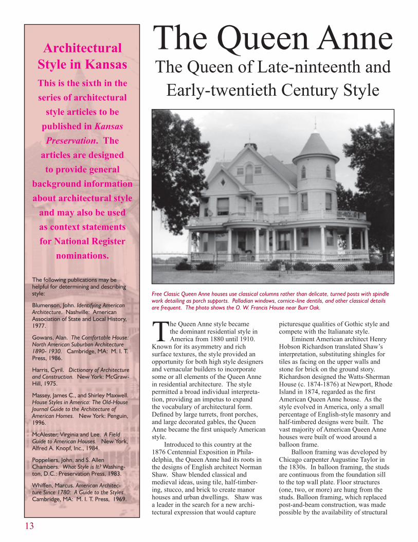
Free Classic Queen Anne houses use classical columns rather than delicate, turned posts with spindle work detailing as porch supports. Palladian windows, cornice-line dentils, and other classical details are frequent. The photo shows the O. W. Francis House near Burr Oak.

14
Glossary
Balloon frame - light timber framing using studs (commonly 2” x 4”) closely spaced; developed in the U. S. in the 1830s.
Balustrade - a railing or parapet with balus-ters and railing, with or without a base.
Bay window - a multi part window that projects from the wall surface, usually with angled windows at the sides, extending from the ground up one or more stories.
Fish scale shingle - a shingle having straight sides and rounded bottoms.
Gable - the triangular portion of an end wall between the roof slopes and under the roof ridge.
Palladian window - a featured window com-prised of a large center window topped by a fanlight, flanked by narrow windows.
Sash - a frame for glass in a window or door. Double-hung sash windows have two sashes, while casements have one or more. If a window is fixed, it is considered one sash.
Turret - a small, thin tower.
lumber sawed to uniform sizes. Balloon framing’s flexibility allowed designers to mold shapes even on modest houses.
Much of the ornament applied to Queen Anne houses was mass produced in factories and shipped by rail to desti-nations nationwide. Fish scale shingles, sunburst panels, spindlework, window frames, porches, stairs, and large panes of factory-made glass could be purchased from architectural supply companies or ordered from catalogues. The new industrialism made abundant ornament accessible to American builders and homeowners of all classes.
The style lent itself to an eclectic
mix of highly decorated surfaces and asymmetrical proportions. Plain wall surfaces were avoided through such devices as towers, turrets, tall ribbed and molded chimneys, projecting pavil-ions and second floors, porches, balco-nies, and chamfered or canted bays. Clapboarding integrated with fish scale shingling, pebble dash, spindlework, and sunburst panels was widely used to break up the horizontal wall plane. Steeply pitched hipped roofs with cross gables and bracketed eaves defined most house types.
Fenestration added an important element to the Queen Anne style’s
(Left) Numerous pattern-book authors published designs that could be constructed by local builders. Shown here is the Barbeau House in Lenora.
(Below) Attached Queen Anne rowhouses like the Hicks Block in Topeka (c. 1889) are uncommon but occur in both gabled and flat roof forms.
(Lower Left) Many Queen Anne houses have delicate, turned porch supports and spindle work or ornamentation that was made in a factory, shipped to the site, and then tacked or glued into place by a local carpenter. The historic photograph shows the Cleo Miller House in Lebo.

in Queen Anne design. By the 1870s, advances in grinding tints and mixing mineral paints and stains offered the homeowner a wide array of color choices at affordable prices. Four or five colors were often combined on a house. Hues of red, green, gold, soft brown and gray were used to simulate the colors of nature. Light, warm neutral colors were favored for smaller house while darker neutrals with dark trim were often select-ed for larger houses.
Dissemination of information about the Queen Anne style occurred in architectural journals like American
15
vocabulary. In addition to frequent bay windows that might contain curved glass, swinging casement windows with small, diamond-shaped panes; stained, leaded, and etched glass windows; colored glass panels; and sash windows decorated with small colored glass panes provided typical fenestration options for house designers. Like many features associ-ated with the Queen Anne style, the latter window treatment was introduced to the American public through a popular build-ing catalogue of the day, the 1876 edition of Palliser’s.
Color was an essential element
In addition to paint samples, researchers often rely on black and white historic photographs to determine the original
paint colors for a house. While invaluable resources, the photographs provide
information about color placement but not necessarily the color itself. Nineteenth century negatives render yellow and red much darker than they really are, while
blue appears much lighter than it really is. Consulting period journals and building
catalogues offers a third method to research possible color combinations.
A typical late-nineteenth-century Queen Anne style house featured various kinds of machine-made shingles, wooden ornamentation for the porches, and an elaborate chimney. This ca. 1890s photograph shows the Marbury House at 429 Greenwood, part of what is now the Potwin Place Historic District in Topeka. Photo from the Kansas State Historical Society collections.
Architect and Building News and The Scientific American Architects and Build-ers Edition. The monthly journals, which were directed at the growing popula-tion of professional architects, appeared between 1885 and 1905. Each issue featured two buildings and their plans, illustrated in color with specifications and descriptions.
Pattern books and builders’ catalogues provided even greater oppor-tunity for the Queen Anne style to be disseminated. These were inexpensive publications that reached thousands of people. George Barber’s first pattern
Atchison’s McInteer Villa (c.1889-1890) is a rare and elaborate interpretation of a masonry Queen Anne. Most Queen Anne examples were built of wood.

book, Cottage Souvenir, was published in 1887. The publication included twenty-five designs and cost $.85. Intended for the public at large, these publications encouraged the mixing and integration of various stylistic elements.
Barber followed the practice estab-lished by George Palliser and corre-sponded directly with the client. Barber’s illustrated catalogues included price lists for his drawings and order forms. Clients could also engage Barber’s firm to design a custom house.
Barber became one of the country’s most successful late-nineteenth-century domestic architects. By 1900, the Knoxville, Tennessee-based company employed as many as thirty drafts-men and about twenty secretaries. The company shipped pre-cut house kits nationwide. An 1892 Barber house shipped by rail to Oregon required fourteen boxcars to transport it. The partially assembled house was shipped with drapes, carpets, plumbing, and lights. A foreman from Barber’s office accompanied the shipment and hired local workmen to erect the building.
As the twentieth century approached, classical detailing began to supplant the Gothic and perpendicular elements of the original Queen Anne style. Free Classicism became synonymous with the Queen Anne. Classical details like swags, garlands, Palladian windows, and cornice-line dentils began to ornament the asymmetrical houses with corner towers. Free Classicism gradu-ally evolved into the Colonial Revival style. Side gable roofs eclipsed high pitched, hipped, and cross-gable roofs; corner towers and projecting bays were eliminated; and highly textured surfaces were smoothed as symmetry supplanted asymmetry.
The pervasive influence of the Queen Anne style may be seen on an otherwise plain, gable front house with fish scale shingling in the gables and bay windows. Sometimes the only vestige of the style appears as a delicately turned porch support or spindlework frieze. The dissemination of the style through expositions, professional journals, pattern books, and to a great extent, the railways, offered many Americans an opportunity to build a house with a distinctly Ameri-can identity.
16
This article was prepared by Martha Hagedorn-Krass, an architectural historian with the Cultural Resources Division. Electronic versions of the article are available by contacting her at [email protected]. Unless otherwise identified, photos are from the files of the Historic Preservation Office.
Application Process and Time LineApplications are available from KDOT and are now being accepted for
the 2006/2007 funding cycle. The application deadline is November 8, 2004, with funds becoming available to successful applicants in October 2005. It is important to note that the Transportation Enhancement program is not a grant program; rather it is a federal reimbursement program requiring a minimum twenty percent local match. In-kind or donated labor and materials are NOT considered to be part of the match.
Preservation SuccessesTransportation Enhancement funds provide a powerful tool for preserva-
tion. The restoration and adaptive reuse of historic railroad depots is one of the most common projects in the Historic Preservation category. Depots in Ottawa, Marion, Garnett, Dodge City, Liberal, El Dorado, Lawrence, and other towns have been revitalized with TE funding. Other projects have involved the preservation and restoration of historic bridges such as the relocation of the Austin Bridge to the Sante Fe Park in Chanute and the restoration of the Fort Fletcher Stone Arch Bridge near Walker in Ellis County. Restoration of histor-ic brick streets has occurred in Emporia, Goodland, and Troy. Additional land was acquired at the Mine Creek Battlefield Site with TE funding.
Future of TETransportation Enhancement funding will likely be reauthorized by
Congress and continue to be a major source for funding large, transportation-related historic preservation projects. There remain countless historic build-ings and structures in Kansas with links to transportation, many neglected and deteriorating, that await restoration and reuse.
Questions about specific historic preservation projects may be directed to Richard Pankratz at KSHS at (785) 272-8681 Ext. 217 or Patrick Zollner at Ext. 257. General questions regarding the Transportation Enhancement program may be directed to Kay Jordan-Cain in the Office of Engineering Support, KDOT, (785) 296-7940.
This article was prepared by Patrick Zollner, an architectural historian with the Cultural Resources Division. Photos were provided by Kaye Jordan-Cane, Kansas Department of Transportation.
Transportation Enhancement Cont. from page 12
Transportation Enhancement funds have assisted with restoration of brick streets in Emporia, Goodland, and Troy.

17
Rock art sites are at once familiar, yet enigmatic. One can see how they were created and, in some cases, recognize human and animal forms; yet the reasons for their creation and the ideas they depict often remain mysteries. Rock art is a term encompassing an almost infinite variety of pictures or designs carved into or drawn on exposed bedrock or rock weathered from it. Because bed-rock outcrops—or blocks of stone or boulders adjacent to out-crops—are used, rock art is associated with a particular place. In contrast, some art created from stone, such as carved pipe bowls, is portable.
Pictographs are painted on rock exposures, often termed “panels,” using pigments and binders created from animal, veg-etable, or mineral products. Petroglyphs are cut into or scratched on the rock surface using an object with a sharp point, typically a metal, bone, stone, or wooden implement. Pecking the rock sur-face repeatedly with another stone or other hard object is another method used to produce a petroglyph. The overwhelming major-ity of rock art sites in Kansas are petroglyphs, made by incising or scratching. Almost 90 petroglyph sites have been recorded in the
Recording Rock Art at the Katzenmeier Site (14EW401)
state but only one pictograph site. The majority of these sites are located in the central part of the state, particularly in Ellsworth, Lincoln, and Russell counties, where there are numerous outcrops of Dakota sandstone.
Rock art can be created by anyone, and the site files contain examples of modern-day petroglyphs, including a depiction of a farm tractor and a house with pitched roof, chimney, and multiple-pane windows, among others. The oldest petroglyph sites record-ed are those created by American Indians. These petroglyphs are distinguished by a number of factors: their stylistic attributes, par-ticularly of the human and animal figures; the subjects portrayed, for example, bison, people holding bows or spears, and people and horses with what appear to be decorations on their bodies; and the weathered appearance of many of these glyphs, indicating they have been in existence for some time.
How old the petroglyphs may be is not known for certain, but it is doubtful that they are thousands of years old. More likely, the oldest may be in the range of 600 years more or less. Some petroglyphs depict horses, which were not present until the Span-
Measurements were taken on glyphs within the grid and transferred to large sheets of graph paper.
18
ish brought them to the New World after A.D. 1521. Horses were not in common use by Plains Indians until the fifteenth or sixteenth centuries. Other petroglyphs appear to be of rifles or muskets, and firearms also are associated with later time periods when Europeans and Americans were trading with tribes resident in the Central Plains.
Another consideration is the relative fragility of the sandstone on which the glyphs were placed. Compared to other types of rocks, like granite or slate that are durable and tough, Dakota sandstone is soft and readily weathers. Individual ledges may be well cemented (for instance, buildings at Fort Harker were constructed of Dakota sandstone), but much of the outcrop-ping rock is actively eroding away. Within the last 15 years, two well-known sites, Palmer’s Cave and the Indian Hill site, have suffered massive rock falls that destroyed most of their petroglyphs. Alexander Gardner photographed each of these places for a series of stereoscopic views taken along the route of the Union Pacific Railway, published in 1868. These photographs were the first made of Kansas petroglyphs and are valuable records of sites now lost.
Recording, analysis, and interpretation of rock art is further advanced in some other parts of the United States in comparison to Kan-sas. In some regions, styles of figures or designs have been identi-fied, an internal chronology of the rock art has been determined, and interpretations of the rock art have been proposed. The key to accomplishing analysis and interpretation is having adequate recording of the sites. Recording methods include sketching the rock art in pencil or copying it using paint or watercolor media; photographing it in color or black and white film, either as flat images or by stereography; stereophotogrammetry recording in which stereophotographs are transformed into contour maps; making rubbings of the stone, similar to recording tombstone inscriptions; tracing the rock art directly onto a transparent me-dium, such as clear plastic; and taking impressions of petroglyphs using material such as rubber compound that will mold itself to the shape of the petroglyph and retain the shape after removal. Each method has advantages and disadvantages, and nothing should be used that would harm the rock art being recorded. Ideally, the rock art will be recorded using more than one technique, so that attributes not clearly revealed by one method will be apparent in another. For example, photographs may clearly show the shape
of a petroglyph, but stereophotogrammetry of the same glyph will show the depth of the lines and help the viewer discern natural irregularities in the rock.
The Katzenmeier SiteThe Katzenmeier Site is a petroglyph site in Ellsworth County
that is listed on the National Register of Historic Places as part of a thematic nomination. It has been recorded by taking a series of black and white photographs and color slides that are referenced to a key, showing the relationship of the view in the photo or slide to the rock outcrop that contains the glyphs. This site was chosen for the 2004 Kansas Archeology Training Program rock art record-ing class because of its accessibility, size, and number of petro-
glyphs located there.The petroglyphs are
located on a rock face exposed within a short, approximately 30-foot-high bluff on the west side of an intermittent stream. Most of the petroglyphs are on one large panel, de-fined by a slight overhang, approximately 30 feet wide and 7 feet tall, but other glyphs are placed on either side. The overhang offers some protection from the weather; there is a natural break near the top that causes rainwater and snow melt to fall from
there, instead of running down the face that bears the petroglyphs. There is a noticeable difference in the appearance of the glyphs within the protective overhang and those on other panels. The lines of the exposed petroglyphs are not as distinct as those within the overhang.
Unfortunately, the overhang did not protect glyphs that were removed from two places on the outcrop by an unknown person or persons in the past. A pair of large rectangular gouges with chisel marks show where these glyphs had been located. Ad-ditionally, the remaining glyphs had been “chalked” prior to the recording project. Chalk had been used to highlight lines and thus make the figures more visible, presumably for photography. It was noted that chalk lines had been added to make some figures more “complete.” Using chalk can alter the shape of grooved lines on softer sandstone panels and potentially gouge out trapped organic remains within the original grooves that might be used as material for radiocarbon dating.
The class focused on the petroglyphs located on the main panel. These are crowded together, with some glyphs superim-
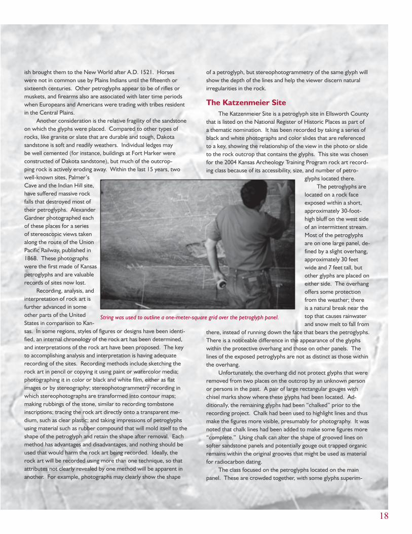
String was used to outline a one-meter-square grid over the petroglyph panel.

19
posed on others. The figure of a large bison dominates the panel, but most of the petro-glyphs are clearly intended to show a human form (anthropomorph). Most have rectangular bodies, some have upraised arms, bent at the elbow, and triangular legs. These anthropo-morphic figures have round heads but no facial features. In contrast, some of the round-head figures located adjacent to the gouged area have eyes and appear to be wearing headdresses. They carry weapons; one has a bow, and two have long spears. One spear-carrier also has what appears to be a large shield in front of his body. These glyphs are made with lines that are cut or incised deeply into the sandstone. Other superimposed glyphs are composed of figures scratched into the rock. They are not as clearly visible, but they include an anthropomorphic figure leading a horse. Interspersed among the glyphs are occasionally a set of initials left there by nine-teenth- or twentieth-century visitors.
The recording project consisted of making full-size drawings of the petroglyphs on large sheets of graph paper. The paper was 53 x 80 cm in size and divided into a 1-square-centimeter grid. A 1-meter square grid, 2 meters wide and 6 meters long, was laid out over the petroglyphs using pieces of masking tape to mark the corners. String was then stretched from each corner and taped into place to form the sides of the grid. Measure-ments were taken from the sides of the grid to points on the glyphs, and the measurements were transferred to the paper. All lines were recorded, even if they did not appear to belong to a figure, as with the initials. Because the paper was smaller than the petroglyph grid, four sheets were used, each sheet designated as a quadrant of the grid being recorded. This method was deemed to be an appropriate way to record the glyphs, because it caused no damage to them (only a few grains of sand from the rock face stuck to the tape), and it resulted in an accu-rate copy. The sheets of paper can be joined to form a life-size representation of the portion of the petroglyph site that was recorded.
The size of the site and the complexity of the overlapping glyphs, coupled with the amount of time allotted for the class,
were factors that combined to limit the amount of recording that could be accomplished. However, this partial record is valuable as it clearly shows some of the scratched designs that are obscured in the photographs. The measured drawings also provide a baseline record of the petroglyphs, and any future changes in individual glyphs or additions to the panel will be ap-parent. It is also possible to reestablish a grid and complete the recording of the panel.
By recording the Katzenmeier petroglyphs, the class has made another contribution to the documentation of Kansas rock art sites. Their effort can be viewed as part of a continu-um, beginning with Alexander Gardner’s 1868 photographs.
The drawings were full-size copies of the petroglyphs.
This article was written and the accompanying photographs taken by Martin Stein. Stein is an archeologist with the Cultural Resources Division who has had a long-time interest in Kansas rock art.
The author thanks Amos Katzenmeier for allowing the class to visit the petroglyph site in order to complete the recording project.
The petroglyph panel is located on a sandstone bluff partially shaded by mature trees.

20
During the 2004 Kansas Arche-ology Training Program field school, a small team of surveyors
mapped two of the five council circles unique to McPherson and Rice Counties of Kansas. Dating back at least 500 years, a council circle is a grouping of four kidney-shaped structures around a central mound and hearth area. Borrow pits adjacent to the structures accentuate their concentric arrangement. The size of these council circles is in the range of 100 to 200 meters across. It is speculated that these structures were ceremonial centers for a village—ceremonial facili-ties and residences of priests or political leaders—or perhaps lodges for men’s societies (Vehik 2002:39). The council circles may have functioned together to monitor solstices (Wedel 1967:60-62, 1977:143-145, 1990:45).
These sites were discovered only in the Little River focus of the Great Bend aspect of the Wichita Indian culture and date to the late prehistoric period, approx-imately A.D. 1500 (Wedel 1968a:371). The five council circle sites are Tobias (14RC8), Paul Thompson (14RC12), Kermit Hayes 2 (14RC13), Sharps Creek (14MP301), and Paint Creek (14MP1). They are in adjacent counties in central
Council Circles Mapped in Central Kansas
Kansas and are located near tributaries of the Little Arkansas and Smoky Hill Rivers.
Three of the council circles are locat-ed in Rice County and were excavated by Waldo Wedel for the Smithsonian Insti-tution in the 1940s. The two remaining council circles are in McPherson County and remain intact. As time progresses, these structures are reclaimed by nature and disturbed by farming practices. It is important to preserve what remains of these sites, as nothing like them exists elsewhere in the country.
MethodsA part of the preservation strategy
consists of creating accurate contour maps of the present condition of the council circles, documenting the size and shape of the structures before further changes take place. This will enable more accurate analysis of these sites in the future.
The goal during the June 2004 archeological training program at Linds-borg was to map three of the five circles. Two were excluded from the project. The Tobias circle has been completely excavated, and the resulting topography
in that part of the site mostly repre-sents backfilling, although some of the borrow depressions may be original. The Kermit Hayes circle is cultivated and has agricultural terraces running across it; it is assumed that there is not much surface expression of the circle.
KSHS archeologist Martin Stein led a team in mapping two sites over a four-day period. Two days were spent at the Paul Thompson site in Rice Coun-ty (14RC12), and two days were spent at the Sharps Creek site in McPherson Coun-ty (14MP301). Assisting Stein were Kan-sas Anthropological Association volunteers Roy Bay, Lynn Gentine, and Rose Marie Wallen. The intention was to also map the Paint Creek council circle, but due to heavy overgrowth of poison ivy and sumac, the team opted to postpone the exercise until weed control had been achieved.
Martin Stein was assisted by Rose Marie Wallen and Roy Bay in mapping the Sharps Creek Council Circle. Photo by Craig Cooper.
It is important to preserve
what remains of these sites,
as nothing like them exists
elsewhere in the country.

21
This article was prepared by Rose Marie Wallen, a resident of Lindsborg and an active KAA member since 1992. Her paper is the result of an archeological report writing class offered at the 2004 KATP field school.
In each case, the area documented was in accordance with the geographic setting. Both council circles are located on hilltops, although the Sharps Creek site is slightly on a side hill. Enough of the surrounding area was mapped so that not only the contours of the council circle were evident but also those of its hilltop setting. At the Thompson site, an area 155 x 340 meters was mapped. At Sharps Creek, a 200 x 220-meter area was mapped. Stein operated the TopCon GTS 210 total station while two KAA assis-tants positioned themselves in the survey area with target prisms to which laser sightings could be taken. After setting up the total station equipment over a fixed datum reference point, Stein took readings as the assistants paced off the survey area in a grid-like fashion. Where
variation in the elevation of the surface feature was more extreme, measurements were made at more frequent intervals. Rises and depressions were given special care in order to reveal the shape of the council circle remains. When all of the target area had been traversed, the total station data was used to create a contour map via a computer mapping program. From the contour map, a speculative drawing of the appearance of the council circle structures can be made.
Future WorkFurther information about the struc-
ture of these council circles might be gained using electrical resistance survey and magnetic field gradient survey (see Kansas Preservation 26(4):13-15.) These non-invasive geophysical investigations would preserve the structures; if excavat-ed, they essentially would be destroyed. Furthermore, it is probable that Wedel’s earlier excavations at the Rice County council circles have already provided enough archeological evidence to draw
conclusions about the nature and use of these structures.
Maintenance of the sites should consist of reducing weedy overgrowth and shrubbery, which attracts burrow-ing animals that destroy the features. As stated earlier, the Paint Creek circle could not be mapped along with the other sites because of the problem of overgrowth. Plans to address this situation in the near future are being made so that the council circle mapping project can be completed.
ConclusionsThe five council circles of the
Wichita Indian culture have existed in central Kansas for at least 500 years. They initially were destroyed through fire, neglect, and decline of the culture to which they pertained. The original structures must have been substantial to be evident into the twenty-first century. The apparently durable remnants will not continue long into the future, however, due to agriculture, burrowing animals, and erosion. While mapping and remote
The mapping project resulted in this detailed contour map of the Sharps Creek site.

22
Bibliography
Bevitt, C. Tod, and Dave Maki. “Laying the Groundwork: The Geophysical Survey of 14MP407.” Kansas Preservation 26(4)(2004):13-15.
Vehik, Susan C. “Topics, Themes, and Thoughts in Little River Focus Archeology: Research After Udden.” The Kansas Anthro-pologist 22 (2002):35-44.
Wedel, Waldo R. “The Council Circles of Central Kansas: Were They Solstice Regis-ters?” American Antiquity 32 (1967): 54-63.
Wedel, Waldo R. “After Coronado in
geophysical sensing could add useful information about the council circles, it is not desirable to “dig” them more than has already been done in Wedel’s scientific investigations.
According to Wedel’s conclusions, the material culture of these structures was little different from that of other Wichita houses. Their value lies in their unique physical form. Therefore, the council circle remains, in particular 14MP301 that has not been excavated or farmed, should be preserved intact as national treasures. Maintenance should be done in the immediate future at the remaining sites to assure preservation of these rare cultural features.
* Bill Groth is generally in the office on Tuesday and Thursday.**Allen Wiechert is generally in the office on Monday and Friday.
CRD Staff Position/Duties Ext E-mail Address
Will Banks SHPO Archeologist, Project Reviews 214 [email protected]
Anne Bauer Special Projects Archeologist 256 [email protected]
Dorothy Booher Half-time Office Assistant (p.m.) 230 [email protected]
Christy Davis Asst Div Director, Project Reviews, CLG 215 [email protected]
Jennifer Epperson SHPO Archeologist, Project Reviews 225 [email protected]
Anita Frank Archeology Site Files 268 [email protected]
Chris Garst Archeological Lab Tech (a.m.)Special Projects Archeologist (p.m.)
151 cgarst@kshs
Cathie Griffin Half-time Office Assistant (a.m.) 230 [email protected]
Bill Groth* Architect, Heritage Trust Fund 227 [email protected]
Martha Hagedorn-Krass Nat’l & State Register, Pres. Planning 213 [email protected]
Bob Hoard State Archeologist 269 [email protected]
Faye Johnson Division Secretary 240 [email protected]
Teresa Kiss Grants Manager, HTF & HPF 216 [email protected]
Katrina Klingaman Federal and State Tax Credits 226 [email protected]
Patty Koerner Half-time Office Asst (p.m.)-Archeology 235 [email protected]
Kristen Lonard Half-time Office Assistant (a.m.)Federal and State Tax Credits
Dick Pankratz Division Director, Project Reviews 217 [email protected]
Martin Stein Archeologist 258 [email protected]
Randy Thies Archeologist 267 [email protected]
Karen Travis Half-time Office Assistant (p.m.)Scanning Project
Cynthia Vahsholtz Grants Assistant 245 [email protected]
Tim Weston Highway Archeologist 266 [email protected]
Allen Wiechert** Architect, Heritage Trust Fund 227 [email protected]
Virginia Wulfkuhle Public Archeologist 255 [email protected]
Listed here are the personnel of the Cultural Resources Division as of September 15, 2004, with telephone extensions and e-mail addresses. All may be reached by calling (785) 272-8681 and dialing the extension number. Fax materials should be sent to the appropriate person’s attention at (785) 272-8682. For general information on the division’s programs, call Ext. 240.
Contacting the Cultural Resources Division
Staff
Quivira.” Kansas Historical Quarterly 34 (1968):369-385.
Wedel, Waldo R. “Some Thoughts on Central Plains-Southern Plains Archeologi-cal Relationships.” Great Plains Journal 7 (1968):53-62.
Wedel, Waldo R. “Native Astronomy and the Plains Caddoans.” In Native American Astronomy, edited by A. Aveni, pp. 131-145. Austin: University of Texas Press, 1977.
Wedel, Waldo R. “Coronado, Quivira, and Kansas: An Archeologist’s View.” Great Plains Quarterly 10 (1990):139-151.
Happenings in Kansas
NONPROFITORG.
U.S. POSTAGEP A I D
Topeka, Kans.Permit No. 299
KANSAS STATE HISTORICAL SOCIETYCultural Resources Division6425 S.W. Sixth AvenueTopeka, KS 66615-1099
Return Service Requested
KSHS, Inc. Annual MeetingNovember 5, 2004 Kansas History Center
Lewis and Clark Living History ProgramNovember 6, 2004 Kansas History CenterCaptain Lewis’ Company from the Frontier Army Living History Association will present a program on Lewis and Clark. The program is free and open to the public.
Kansas Historic Sites Board of ReviewNovember 6, 20049:00 a.m.Kansas History Center Classrooms
Veteran’s DayNovember 11, 20049:00 a.m. - 5:00 p.m.Kansas History Center and Museum6425 SW Sixth AvenueVeterans admitted free to the Kansas Museum of History; historic films on war bonds; war letter exhibit; announcements about a special collecting project of military items; special sessions on researching war records; behind-the-scenes tours.
Heritage Trust Fund WorkshopNovember 18, 200410:00 a.m.City-County Building300 West Ash, Room 107BSalina, Kansas
Kansas to Boost Agritourism Industry
The Agritourism Promotion Act, passed by the 2004 Kansas Legislature and signed by Gov. Kathleen Sebelius, became effective July 1.
The Kansas Agritourism Advisory Council defines agritourism as the public visitation to a working farm, ranch, winery, or agricultural operation, or active agricultural heritage site for enjoyment, outdoor recreation, activities, education, shopping, dining or lodging.
The promotion act is expected to encourage the growth of the Kansas agritourism industry with a registra-tion process through which the Kansas Department of Commerce can assist in the promotion of agritourism operations. A new tax credit will help offset the expense of agritourism liability insurance for existing and new operations.
Under the new law, all new and existing agritourism operations must register with the Kansas Department of Commerce to be eligible for limited liability and the income tax credit. There is no fee for registration, which is valid for five years.
The Kansas Department of Comm-erce has already mailed more than 400 registration packets detailing the require-ments of the act. To receive a packet, contact Alisa VinZant at (785) 368-7260 or Janna Dunbar at (785) 296-8132 or [email protected].
To help promote agritourism and explain how the new act works, a confer-ence on “Fields of Green: Building Agritourism So They Will Come” will be held November 3-4, 2004, at the Highland Hotel in Great Bend. Contact the numbers above for more information.
Creative HolidaysDecember 4, 2004Kansas History Center and Museum ClassroomsThis free family celebration highlights the many cultures of Kansas through “make and take” activities, food, music, and fun!
Heritage Trust Fund WorkshopDecember 9, 200410:00 a.m.Carnegie Center for the Arts701 SecondDodge City, Kansas
Beyond Lewis and Clark: The Army Explores the WestDecember 10, 2004 - August 14, 2005Kansas History Center and MuseumA blockbuster traveling exhibit marking the 200th anniversary of the Lewis & Clark expedition and its impact on the west. This display is a collaborative effort between the Kansas, Virginia, and Washington State historical societies, the U.S. Army’s Frontier Army Museum at Leavenworth, and the U.S. Army Center of Military History.
Heritage Trust Fund WorkshopJanuary 13, 20052:00 p.m. Kansas History Center
Kansas DayJanuary 28, 2005Kansas History Center and MuseumCelebrate the state’s birthday. Activities include programs, hands-on learning experiences, and living history performances. Pre-registration is encouraged. Free admission!