gary macdougall premjit singh managing your distributed data
TRANSCRIPT

Gary MacDougall
Premjit Singh
Managing your Distributed Data

Feedback
• Please provide your feedback on:-www.Esri.com/ucsessionsurveys-Use Offering ID : 616

Workshop Overview
• Data Distribution- What, Why and How
• Distribute Data using Geodatabase Replication- Concept Overview
- Types of Data Distribution Strategies
- Defining Data to be Distributed
• Synchronizing Distributed Data using Geodatabase Replication
• Demos
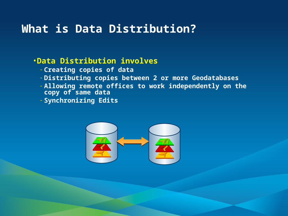
What is Data Distribution?
• Data Distribution involves- Creating copies of data - Distributing copies between 2 or more Geodatabases- Allowing remote offices to work independently on the copy of
same data - Synchronizing Edits

Why Distribute Data?
• Increases Availability- Distribute Data Geographically
• Improves Performance- Load Balancing
• Easy Accessibility- Mobile Users and Field Crews
• Easy Sharing through- Online
- Desktop
- Server
- Mobile
- Developer
- Solutions
CloudCloud
ServerServerMobile
Desktop
Web

How to Distribute Data?
• Creating Copies- Creating copies of Geodatabases on CDs and DVDs
- Distributed to Offices
- Updated Geodatabases send back to the main office
- Edits are compared Manually to keep data in sync
- Difficult and Tedious Process
• Geodatabase Replication- Distribute Data through ArcGIS System

Geodatabase Replication Overview
• Distribute Data across 2 or more Geodatabases- Involves Creation of a Replica Pair
• Geodatabases are edited Independently- Loosely Coupled
• Synchronize Edits- No manual comparison required
• DBMS Independent- Source can be SQL Server and Target could be Oracle
• Built on Versioning
- The Source Geodatabase is always ArcSDE

Geodatabase Replication Overview (Cont.)
• Supports Full Geodatabase Data Model- Topologies, Networks, Terrains
• Supports Connected and Disconnected Enviornments
• Supports LAN and WAN- LAN - connects to local Geodatabases
- WAN – connects to remote Geodatabases
- Geodata Services on ArcGIS Server

Geodatabase Replication - Concepts
• 2 Step Process• Creating Replica• Synchronizing Edits
Replica AReplica A
ParentParent
ChildChild
Replica AReplica A
Replica AReplica A

Geodatabase Replication – Concepts (Cont.)
• Based on Synchronization Direction- 3 Types of Data Distribution Strategies
- Check-Out / Check-In
- One-way
- Two-way

Check-Out / Check-In Data Distribution
• Edits are performed on Child Goedatabase
• Synchronizes Once - Child to Parent
• Child is any Geodatabase Type
• Parent must be an ArcSDE Geodatabase
• Example: Mobile Users and Field Crews
Central Office

Demos – Public Safety Special Events Maps

Gary MacDougall
Demo 1

One-Way Data Distribution
• One Direction Multiple Synchronization- Source to Target or Target to Source (10)
• Source Geodatabase- Must be an ArcSDE Geodatabase- Use archiving to track changes (10)
• Target Geodatabase- Any Geodatabase type- Considered read-only
• Example: - Production - Publication Use Case
ProductionGeodatabase
Readers
ArcIMSArcGISServer
Editors
PublicationGeodatabase

One-Way Data Distribution (Contd.)
• Another Option to track changes
- Archiving
• No Version Management- Reconcile – Post and Compress not
Affected
• Source Geodatabase must be ArcSDE
• One –Way Parent to Child

One-Way Data Distribution (Contd.)
• One-Way Child to Parent
• Child Geodatabase is ArcSDE• Child Replica Version is Default.

Gary MacDougall
Demo 2

Two-Way Data Distribution
• Multiple Synchronization In Both Directions
• Both Source and Target must be ArcSDE Geodatabases
• Example: Multiple Editors Use Case

Data Requirements for Data Distribution
• Data must be writable
• Data must be versioned - Without option to move edits to base
• Two way and One way replicas- Data must have a GlobalId column
- Spatial data must be high precision

Data Types Supported By Geodatabase Replication
• Fully Supported- Simple Feature Classes and Tables, Geometric Networks,
Topologies, Representations, Relationship Classes, Annotation, Cadastral datasets (10.1)
• Source Data can be Replicated - Terrains and Network datasets
• Copied during Creation - Raster datasets, Raster catalogs, Mosaic datasets
• Not Supported - Schematics datasets, Locators
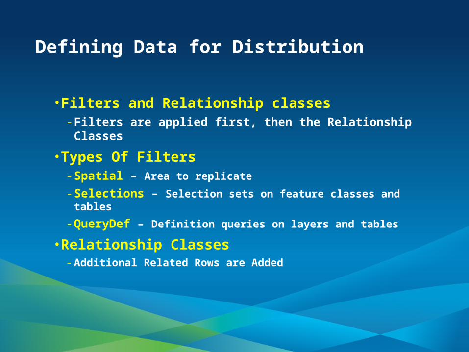
Defining Data for Distribution
• Filters and Relationship classes- Filters are applied first, then the Relationship Classes
• Types Of Filters- Spatial – Area to replicate
- Selections – Selection sets on feature classes and tables
- QueryDef – Definition queries on layers and tables
• Relationship Classes- Additional Related Rows are Added

Defining Related Data for Data Distribution
Owner
John
Mary
Parent Replica
Incidents
John Incident
Mary Incident
John Bldg.John Bldg.
Mary Bldg.Mary Bldg.
RC2RC2RC1RC1
Owner
Mary
Incidents
Mary Incident
RC1RC1 RC2RC2
Mary Bldg.Mary Bldg.
Child Replica

Demo 3

Synchronizing Distributed Data
• Involves- Transferring and Applying Data Changes
- Inserts, Updates and Deletes
• Geodatabase Replication Synchronization-Synchronizes in Both Directions or in Single Direction
-Uses Message Exchange
-Fault Tolerant
-Uses Versioning (or Archiving for one way (10))
-Can synchronize as Replica Owner or ArcSDE user

Which Data is Synchronized
• For Replica of Two-Way and One-Way- Replica Filters used to find changes to SYNC
- Edits related to data in the replica are synchronized (schema only filter required)
• Check-out Replicas - All Edits are Synchronized

Which Data is Synchronized (Contd.)
• Maintains Relationships- Apply changes to Relationships on Sync
• Geometric Network- Rebuilds Modified Network
• Topology- Marks Dirty Area

Synchronizing Distributed Data using Geodatabase Replication
• Connected Synchronization (Two-Way)
ChildChildParentParent

Synchronizing Distributed Data using Geodatabase Replication (Contd.)
• Disconnected Synchronization (Two-Way)- Does not require the replica Geodatabases to be on the same
network
• Message exchange is performed by the end user
• Involves Export, File Transfer and Import
- File transfer can use ftp, CD through the mail, etc.
AAAAAAAA
ParentParent ChildChild
TransferTransfer
TransferTransfer

Geodatabase Replication Conflict Policies
• Choose to define conflicts by row or by attribute
• Geodatabase Replication offers three ways to resolve conflicts :
- Favor of the database (Automatic)- Favor the imported changes (Automatic)- Manual
- Replica is marked as in Conflict
- Need to resolve conflicts manually at a later time
- Can send but not receive while conflicts exist
- Not supported when Synchronizing in Both Directions

Geodatabase Replication Error Handling
• Roll Backs to pre-synchronize state if synchronization fails
• If a message is lost, the next message includes the lost message changes and new changes
• Designed to keep Replicas Consistent
• Replica log records Error Information

Geodatabase Replication Synchronization Tools
• Manual Tools- Desktop commands / GP tools
- Choose to Synchronize when needed
• Automated Tools- Schedule Synchronizations
- Use GP models and the Windows Scheduler
- Recommended

Gary MacDougall
Demo 4
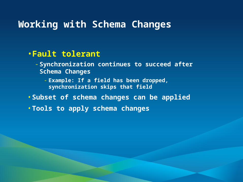
Working with Schema Changes
• Fault tolerant- Synchronization continues to succeed after Schema
Changes- Example: If a field has been dropped, synchronization skips that
field
• Subset of schema changes can be applied
• Tools to apply schema changes

Schema Changes that can be Applied
Add Change Drop
Field Y Y (domains) Y
Domain Y Y Y
Table/FC YY (Domain, Add/drop field)
Y
Geometric network
N N Y
Topology N N Y
Feature dataset N N Y
Relationship class
NY (add/drop field,
domain)Y

Best Practices to Apply Schema Changes
• Lock down the system
• Apply periodic schema comparisons
• Apply system wide schema changes

Gary MacDougall
Demo 5

New In ArcGIS 10.1
• Better trouble shooting tools
• Used in other workflows• Local editing commands
• A Feature Service that you can edit from Desktop
• Feature Service Disconnected Editing REST API
• Publishing to the Cloud

Geodatabase Replication – White Paper
• Geodatabase Replication and Compress
• http://video.esri.com/watch/1073/publishing-feature-services-to-arcgis-for-server-with-replicated-data-
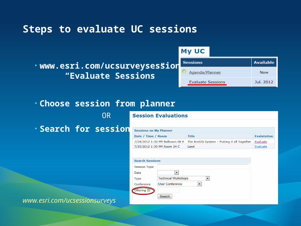
Steps to evaluate UC sessions
• www.esri.com/ucsurveysessions “Evaluate Sessions”
• Choose session from planner
OR
• Search for session
www.esri.com/ucsessionsurveys

• Please fill out the evaluation:
www.esri.com/ucsessionsurveys
First Offering ID: 616
Second Offering ID: 700
• Thank you for attending
• Have fun at UC2012
• Open for Questions

Thank you

Questions
