gasbuggy, new mexico, natural gas and produced water sampling and
TRANSCRIPT

Gasbuggy, New Mexico, Natural Gas and Produced Water Sampling and Analysis Results for 2012 December 2012
Approved for public release; further dissemination unlimited
LMS/GSB/S09448
Available for sale to the public from:
U.S. Department of Commerce National Technical Information Service 5301 Shawnee Road Alexandria, VA 22312 Telephone: 800.553.6847 Fax: 703.605.6900 E-mail: [email protected] Online Ordering: http://www.ntis.gov/help/ordermethods.aspx
Available electronically at http://www.osti.gov/bridge Available for a processing fee to U.S. Department of Energy and its contractors, in paper, from:
U.S. Department of Energy Office of Scientific and Technical Information P.O. Box 62 Oak Ridge, TN 37831-0062 Phone: 865.576.8401 Fax: 865.576.5728 Email: [email protected]
Reference herein to any specific commercial product, process, or service by trade name, trademark, manufacturer, or otherwise, does not necessarily constitute or imply its endorsement, recommendation, or favoring by the United States Government or any agency thereof or its contractors or subcontractors.
LMS/GSB/S09448
Gasbuggy, New Mexico, Natural Gas and Produced Water Sampling and Analysis Results for 2012
December 2012
Approved for public release; further dissemination unlimited

This page intentionally left blank

U.S. Department of Energy Gasbuggy, New Mexico, Natural Gas and Produced Water Sampling and Analysis Results for 2012 December 2012 Doc. No. S09448 Page i
Contents 1.0 Introduction ............................................................................................................................1 2.0 Site Location and Background ...............................................................................................1 3.0 Sample Analytical Results .....................................................................................................3 4.0 Conclusions ............................................................................................................................4 5.0 References ..............................................................................................................................5
Figure Figure 1. Gasbuggy Site Location Map .......................................................................................... 2
Tables Table 1. Gasbuggy Natural Gas Production Well Produced Water Sample Analysis Results ....... 4 Table 2. Gasbuggy Natural Gas Production Well Gas Sample Analysis Results ........................... 4
Map Gas Sample Location

Gasbuggy, New Mexico, Natural Gas and Produced Water Sampling and Analysis Results for 2012 U.S. Department of Energy Doc. No. S09448 December 2012 Page ii
This page intentionally left blank

U.S. Department of Energy Gasbuggy, New Mexico, Natural Gas and Produced Water Sampling and Analysis Results for 2012 December 2012 Doc. No. S09448 Page 1
1.0 Introduction The U.S. Department of Energy (DOE) Office of Legacy Management conducted annual natural gas sampling for the Gasbuggy, New Mexico, Site on June 20 and 21, 2012. This long-term monitoring of natural gas includes samples of produced water from gas production wells that are located near the site. Water samples from gas production wells were analyzed for gamma-emitting radionuclides, gross alpha, gross beta, and tritium. Natural gas samples were analyzed for tritium and carbon-14. ALS Laboratory Group in Fort Collins, Colorado, analyzed water samples. Isotech Laboratories in Champaign, Illinois, analyzed natural gas samples.
2.0 Site Location and Background The Gasbuggy site comprises 640 acres in Rio Arriba County, New Mexico, approximately 55 miles east of the city of Farmington and approximately 21 miles southwest of the town of Dulce, in the Carson National Forest (see Figure 1). As part of the Plowshare program, one underground nuclear detonation was conducted at the Gasbuggy site on December 10, 1967, in an effort to stimulate natural gas production in the gas-bearing Pictured Cliffs Formation. The detonation took place at a depth of 4,240 feet below ground surface, approximately 40 feet below the Pictured Cliffs Sandstone/Lewis Shale contact. The detonation had an estimated yield of 29 kilotons. There are no wells, springs, surface water, or gas wells onsite. All sampling locations are off of the Gasbuggy site proper. Six offsite natural gas production wells were sampled during this event. Gas sample locations (see attached map) range from 1 mile to 1.7 miles from the emplacement hole, also known as surface ground zero (SGZ). All six of the gas wells sampled are perforated for gas production from the Pictured Cliffs Formation, the same formation targeted by the Gasbuggy test. One of the six gas wells is a horizontal completion within the Pictured Cliffs Formation and is indicated on the attached map as having a different bottom hole location than the well head location at the surface. The number of natural gas production wells that are sampled can vary from year to year, due to varying production schedules for the wells that may be dictated by current natural gas prices. The U.S. Environmental Protection Agency performed water sampling at water wells, springs, and ponds in the Gasbuggy vicinity from the inception of the Hydrologic Monitoring Program in 1972 through 2007. DOE’s Office of Legacy Management performed the hydrologic sampling at these locations in 2007, 2008, and 2009. Results of the historical hydrologic monitoring at Gasbuggy have consistently shown that groundwater and surface water at the sample locations have not been impacted by radionuclides from the nuclear test. DOE evaluated the Hydrologic Monitoring Program and concluded that the water sample locations were too shallow and too far from SGZ to realistically be impacted by detonation-related contaminants (DOE 2009a). Therefore, annual hydrologic monitoring was no longer considered necessary, and the frequency of hydrologic monitoring was reduced to once every 5 years. The next hydrologic monitoring event is scheduled for 2014.

Gasbuggy, New Mexico, Natural Gas and Produced Water Sampling and Analysis Results for 2012 U.S. Department of Energy Doc. No. S09448 December 2012 Page 2
Figure 1. Gasbuggy Site Location Map
U.S. Department of Energy Gasbuggy, New Mexico, Natural Gas and Produced Water Sampling and Analysis Results for 2012 December 2012 Doc. No. S09448 Page 3
Sampling of natural gas and produced water from nearby producing gas wells was conducted for the first time during the 2009 sampling event. Nearby gas wells that are producing gas from the same formation affected by the Gasbuggy test represent a more plausible contaminant migration pathway. Therefore, DOE will sample natural gas production wells annually or as determined necessary. DOE will also sample new natural gas wells that are drilled in the vicinity of Gasbuggy. DOE has established notification agreements with the U.S. Bureau of Land Management and the U.S. Forest Service, whereby DOE will be notified of new gas well permitting activity in the area.
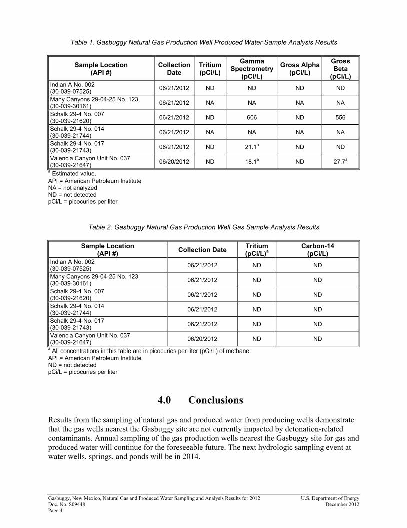
3.0 Sample Analytical Results Analytical results from the June 20–21, 2012, sampling event are shown in Tables 1 and 2. Tritium, the most mobile detonation-related contaminant and consequently the contaminant of greatest concern to DOE, was not detected in any of the water or natural gas samples. Low levels of gross beta activity were detected in samples of produced water from two of the natural gas production wells; one of the results was an estimated value.1 The other well, Schalk 29-4 No. 007, had a gross beta activity level of 556 picocuries per liter (pCi/L). This well also had a gamma spectrometry result of 606 pCi/L from potassium-40. Similar results were obtained from this well during the 2011 sampling event (DOE 2011). Potassium-40 decays by beta emission along with a gamma ray and is likely the source of the gross beta activity detected in the well. Potassium-40 is a naturally occurring radioisotope that is not a byproduct of a nuclear detonation and, therefore, is not attributable to the Gasbuggy test. The well identified as Valencia Canyon Unit No. 037 with the estimated value of 27.7 pCi/L for gross beta activity also had a gamma spectrometry estimated value of 18.1 pCi/L for actinium- 228. Actinium-228 is a naturally occurring radioisotope that is part of the thorium-232 decay chain, and it decays by beta emission along with a gamma ray. It is likely that the gross beta activity detected in this well reflects actinium-228 decay. Actinium-228 is not a byproduct of a nuclear detonation and, therefore, is not attributable to the Gasbuggy test. Gas wells Many Canyons 29–04–25 No. 123 and Schalk 29-4 No. 014 did not have any produced water for sample analyses at the time of sampling, which was also the case in 2011. Refer to Table 1 for produced water sample analytical results. No tritium or carbon-14 was detected in the natural gas samples. Although tritium has never been detected, carbon-14 has been detected in low concentrations during past sampling events (DOE 2009b and DOE 2010). Refer to Table 2 for natural gas sample analytical results.
1 When a reported radionuclide concentration is less than three times the method detection limit, the result is considered an estimated value because of the high degree of uncertainty associated with very low measured concentrations.
Gasbuggy, New Mexico, Natural Gas and Produced Water Sampling and Analysis Results for 2012 U.S. Department of Energy Doc. No. S09448 December 2012 Page 4
Table 1. Gasbuggy Natural Gas Production Well Produced Water Sample Analysis Results
Sample Location (API #)
Collection Date
Tritium (pCi/L)
Gamma Spectrometry
(pCi/L)
Gross Alpha (pCi/L)
Gross Beta
(pCi/L) Indian A No. 002 (30-039-07525)
06/21/2012 ND ND ND ND
Many Canyons 29-04-25 No. 123 (30-039-30161)
06/21/2012 NA NA NA NA
Schalk 29-4 No. 007 (30-039-21620)
06/21/2012 ND 606 ND 556
Schalk 29-4 No. 014 (30-039-21744)
06/21/2012 NA NA NA NA
Schalk 29-4 No. 017 (30-039-21743)
06/21/2012 ND 21.1a ND ND
Valencia Canyon Unit No. 037 (30-039-21647)
06/20/2012 ND 18.1a ND 27.7a
a Estimated value. API = American Petroleum Institute NA = not analyzed ND = not detected pCi/L = picocuries per liter
Table 2. Gasbuggy Natural Gas Production Well Gas Sample Analysis Results
Sample Location (API #)
Collection Date Tritium (pCi/L)a
Carbon-14 (pCi/L)
Indian A No. 002 (30-039-07525)
06/21/2012 ND ND
Many Canyons 29-04-25 No. 123 (30-039-30161)
06/21/2012 ND ND
Schalk 29-4 No. 007 (30-039-21620)
06/21/2012 ND ND
Schalk 29-4 No. 014 (30-039-21744)
06/21/2012 ND ND
Schalk 29-4 No. 017 (30-039-21743)
06/21/2012 ND ND
Valencia Canyon Unit No. 037 (30-039-21647)
06/20/2012 ND ND
a All concentrations in this table are in picocuries per liter (pCi/L) of methane. API = American Petroleum Institute ND = not detected pCi/L = picocuries per liter
4.0 Conclusions Results from the sampling of natural gas and produced water from producing wells demonstrate that the gas wells nearest the Gasbuggy site are not currently impacted by detonation-related contaminants. Annual sampling of the gas production wells nearest the Gasbuggy site for gas and produced water will continue for the foreseeable future. The next hydrologic sampling event at water wells, springs, and ponds will be in 2014.
U.S. Department of Energy Gasbuggy, New Mexico, Natural Gas and Produced Water Sampling and Analysis Results for 2012 December 2012 Doc. No. S09448 Page 5
5.0 References DOE (U.S. Department of Energy), 2009a. Gasbuggy, New Mexico Long-Term Hydrologic Monitoring Program Evaluation Report, LMS/GSB/S04019, Office of Legacy Management, Grand Junction, Colorado, June. DOE (U.S. Department of Energy), 2009b. Gasbuggy, New Mexico, Hydrologic and Natural Gas Sampling and Analysis Results for 2009, LMS/GSB/S05869, Office of Legacy Management, Grand Junction, Colorado, November. DOE (U.S. Department of Energy), 2010. Gasbuggy, New Mexico, Hydrologic and Natural Gas Sampling and Analysis Results for 2010, LMS/GSB/S07076, Office of Legacy Management, Grand Junction, Colorado, December. DOE (U.S. Department of Energy), 2011. Gasbuggy, New Mexico, Natural Gas and Produced Water Sampling and Analysis Results for 2011, LMS/GSB/S08153, Office of Legacy Management, Grand Junction, Colorado, September.

Gasbuggy, New Mexico, Natural Gas and Produced Water Sampling and Analysis Results for 2012 U.S. Department of Energy Doc. No. S09448 December 2012 Page 6
This page intentionally left blank

30-039-30161Bottom Hole
T29NR04W
T29NR03W
T28NR04W
T28NR03W
Emplacement Hole
29
35
3136
32
23 24 1920
26 25 30
10 11 12
6
5
1514
13
78
2922.07
7313.02
6033
.87
6860
.63
7614.8577
69.7
8
8784.73
9107
.07
30-039-07525
30-039-21743
30-039-30161
30-039-21620
30-039-21744
30-039-21647
October 30, 2012DATE PREPARED: FILENAME:
S0944900
Distances of Sampled Natural Gas Wells,and Bottom Hole Locations From Emplacement Hole
Gasbuggy, NM, Site2012 Sampling Event
U.S. DEPARTMENT OF ENERGYGRAND JUNCTION, COLORADO
S.M. Stoller CorporationWork Performed by
Under DOE ContractNo. DE-AM01-07LM00060
1,000 0 1,000 2,000500Feet
LEGEND
Natural Gas Well
Natural Gas Well - Bottom Hole
Emplacement Hole
Emplacement Hole to Natural Gas Well (Feet)
Emplacement Hole to Natural Gas Well - Bottom Hole (Feet)
Natural Gas Well to Bottom Hole (Feet)
M:\LTS\111\0079\08\003\S09449\S0944900.mxd smithw 10/30/2012 1:18:26 PM