gel 001 a0141 1. - university of texas at dallas
TRANSCRIPT

FIRSTPROOF
a0005 EARTH PROCESSES
Ocean Trenches
R J Stern, The University of Texas at Dallas,Richardson, TX, USA
� 2004, Elsevier Ltd. All Rights Reserved.
s0005 Introduction
p0005 An oceanic trench is a long, narrow, and generallyvery deep depression of the seafloor. Oceanic trenchesare the deepest places on the Earth’s solid surface andrange down to 11 km below sea-level. These tremen-dous depths mark fundamental breaks in the Earth’slithosphere, the great plates that we all ride on. Ifmid-ocean ridges are where the Earth turns itselfinside out, trenches are where the Earth swallows itsskin. The asymmetry of trenches reflects a deeperphenomenon: as one plate bends down to return tothe mantle, the other plate strains to fill the growingvoid. The depths of trenches are governed by manythings, most importantly sediment flux but also theage of the downgoing lithosphere, the convergencerate, intermediate slab dip, and even the width ofthe sinking plate. Trenches are sites where fluids are‘squeezed’ out of the subducted sediments and anewly recognized biosphere thrives.
s0010 Early Years of Study
p0010 Trenches are the most spectacular morphologicalfeatures on the Earth’s solid surface, but they werenot clearly defined until the late 1940s and 1950s.The depths of the oceans were scarcely imagined untilwe began to lay telegraph cables between the con-tinents in the late nineteenth and early twentiethcenturies. The elongated bathymetric expression oftrenches was not recognized early, and the term‘trench’ does not appear in Murray and Hjort’s classicoceanography overview. Instead they used the term‘deep’ to describe the deepest parts of the ocean, suchas the Challenger Deep, which is now recognized asthe greatest gash on the solid surface of the Earth.Experiences in the World War I battlefields embla-zoned the concept of a trench as an elongate depres-sion defining an important boundary, so it is nosurprise that the term ‘trench’ was used to describenatural features in the early 1920s. The term was firstused in a geological context by Scofield two years
after the war ended to describe a structurally con-trolled depression in the Rocky Mountains. Johnstone,in his 1923 textbook An Introduction to Ocean-ography, first used the term in its modern senseto describe a marked elongate depression of theseafloor.
p0015During the 1920s and 1930s, Vening Meineszdeveloped a unique gravimeter that could measuregravity in the stable environment of a submarineand used it to measure gravity over ocean trenches.His gravity measurements revealed that trenches aresites of downwelling in the solid Earth. The conceptof downwelling at trenches was characterized byGriggs in 1939 as the tectogene hypothesis, forwhich he developed an analogous model using apair of rotating drums. The war in the Pacific led togreat improvements in bathymetry, especially in thewestern and northern Pacific, and the linear nature ofthe trenches became clear. The rapid growth of deep-sea research efforts, especially the widespread use ofechosounders in the 1950s and 1960s, confirmedthe morphological utility of the term. The importanttrenches were identified and sampled, and their gre-atest depths were sonically plumbed. The heroicphase of trench exploration culminated in the 1960descent of the bathyscaphe Trieste, which set an un-beatable world record by diving to the bottom of theChallenger Deep. Following Dietz’ and Hess’ articu-lation of the seafloor-spreading hypothesis in theearly 1960s and the plate-tectonic revolution inthe late 1960s, the term ‘trench’ has been redefinedso that it now has tectonic as well as morphologicalconnotations.
p0020Trenches mark one of the most important types ofnatural boundary on the Earth’s solid surface, thatbetween two lithospheric plates. There are threetypes of lithospheric-plate boundary: divergent(where lithosphere and oceanic crust are created atmid-ocean ridges (Earth Processes: Mid-ocean ridges(00149)), convergent (where one lithospheric platesinks beneath another and returns to the mantle(Earth Processes: Convergent Plate Boundaries: Accre-tionary Wedges (00456))), and transform (where twolithospheric plates slide past each other). Trenches arethe spectacular and distinctive morphological featuresof convergent plate boundaries (Figure 1). Plates movetogether along convergent plate boundaries at ratesthat vary from a few millimetres to ten or more centi-metres per year. Trenches form where oceanic litho-sphere is subducted at a convergent plate margin,
AU:3
AU:4
AU:5
AU:6
AU:7
AU:8
AU:9
AU:1
Article Number: GEOL: 00141

FIRSTPROOF
presently at a global rate of about a tenth of a squaremetre per second.
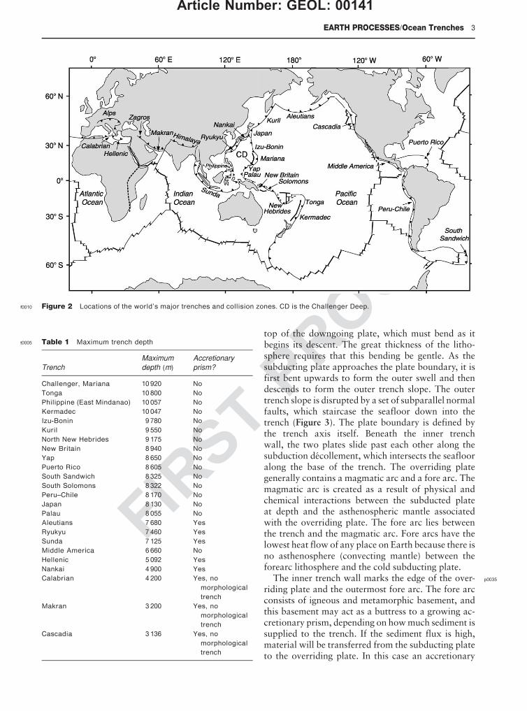
s0015 Geographical Distribution
p0025 Thereareabout50 000 kmofconvergentplatemarginsin the world, mostly around the Pacific Ocean – thereason that they are sometimes called ‘Pacific-type’margins – but they also occur in the eastern IndianOcean, and there are relatively short convergent-margin segments in the Atlantic and Indian Oceansand in the Mediterranean Sea (Figure 2). Trenches aresometimes buried and lack bathymetric expression,but the fundamental structures that they representmean that the name should still be applied in thesecases. This applies to the Cascadia, Makran, southernLesser Antilles, and Calabrian trenches (Table 1).Trenches, magmatic (island) arcs, and zones of earth-quakes that dip under the magmatic arc as deeply as700 km are diagnostic of convergent plate boundaries
and their deeper manifestations, subduction zones.Trenches are related to but distinguished from zonesof continental collision, where continental lithosphereenters the subduction zone. When buoyant continentalcrust enters a trench, subduction eventually stops andthe convergent plate margin becomes a collision zone.Features analogous to trenches are associated withcollision zones; these include sediment-filled fore-deeps, referred to as peripheral foreland basins, suchas that which the Ganges and Tigris–Euphrates riversflow along.
s0020Morphological Expression
p0030Trenches are the centrepieces of the distinctive physi-ography of a convergent plate margin. Transects ac-ross trenches yield asymmetric profiles, with relativelygentle (ca. 5�) outer (seaward) slopes and steeper (ca.10–16�) inner (landward) slopes. This asymmetry isdue to the fact that the outer slope is defined by the
f0005 Figure 1 Profile across a typical trench (the Japan Trench near 39� N). (A) Seismic-reflection image (pre-stack depth migration) and(B) interpretation, including crustal units and seismic velocities (in km s
�1). Dashed box in (A) indicates the region shown in detail in
Figure 3A. Vertical exaggeration in (B) is four times. The model is shaded according to the seismic velocities, and selected digitalvalues are also shown. Modified from Tsuru, Park, Takahashi, et al. Tectonic features of the Japan Trench convergent margin off
Sanriku, northeastern Japan, revealed by multichannel seismic reflection data. Journal of Geophysical Research 105: 16 403–16 413.AU:12
Article Number: GEOL: 00141
2 EARTH PROCESSES/Ocean Trenches
FIRSTPROOF
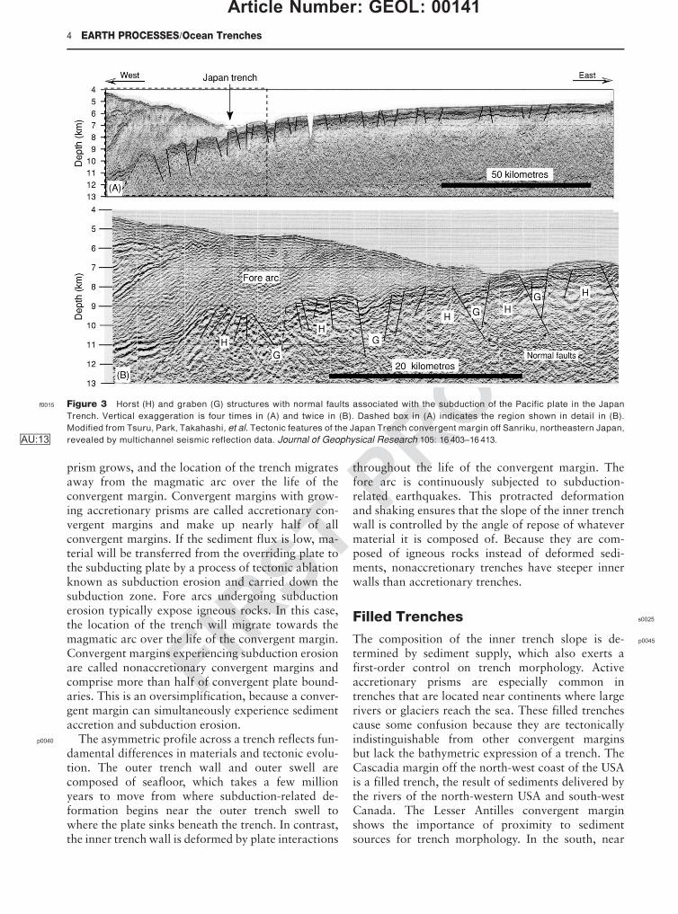
top of the downgoing plate, which must bend as itbegins its descent. The great thickness of the litho-sphere requires that this bending be gentle. As thesubducting plate approaches the plate boundary, it isfirst bent upwards to form the outer swell and thendescends to form the outer trench slope. The outertrench slope is disrupted by a set of subparallel normalfaults, which staircase the seafloor down into thetrench (Figure 3). The plate boundary is defined bythe trench axis itself. Beneath the inner trenchwall, the two plates slide past each other along thesubduction decollement, which intersects the seaflooralong the base of the trench. The overriding plategenerally contains a magmatic arc and a fore arc. Themagmatic arc is created as a result of physical andchemical interactions between the subducted plateat depth and the asthenospheric mantle associatedwith the overriding plate. The fore arc lies betweenthe trench and the magmatic arc. Fore arcs have thelowest heat flow of any place on Earth because there isno asthenosphere (convecting mantle) between theforearc lithosphere and the cold subducting plate.
p0035The inner trench wall marks the edge of the over-riding plate and the outermost fore arc. The fore arcconsists of igneous and metamorphic basement, andthis basement may act as a buttress to a growing ac-cretionary prism, depending on how much sediment issupplied to the trench. If the sediment flux is high,material will be transferred from the subducting plateto the overriding plate. In this case an accretionary
f0010 Figure 2 Locations of the world’s major trenches and collision zones. CD is the Challenger Deep.
t0005 Table 1 Maximum trench depth
Trench
Maximum
depth (m)
Accretionary
prism?
Challenger, Mariana 10 920 No
Tonga 10 800 No
Philippine (East Mindanao) 10 057 No
Kermadec 10 047 No
Izu-Bonin 9 780 No
Kuril 9 550 No
North New Hebrides 9 175 No
New Britain 8 940 No
Yap 8 650 No
Puerto Rico 8 605 No
South Sandwich 8 325 No
South Solomons 8 322 No
Peru–Chile 8 170 No
Japan 8 130 No
Palau 8 055 No
Aleutians 7 680 Yes
Ryukyu 7 460 Yes
Sunda 7 125 Yes
Middle America 6 660 No
Hellenic 5 092 Yes
Nankai 4 900 Yes
Calabrian 4 200 Yes, no
morphological
trench
Makran 3 200 Yes, no
morphological
trench
Cascadia 3 136 Yes, no
morphological
trench
EARTH PROCESSES/Ocean Trenches 3
Article Number: GEOL: 00141
FIRSTPROOF
prism grows, and the location of the trench migratesaway from the magmatic arc over the life of theconvergent margin. Convergent margins with grow-ing accretionary prisms are called accretionary con-vergent margins and make up nearly half of allconvergent margins. If the sediment flux is low, ma-terial will be transferred from the overriding plate tothe subducting plate by a process of tectonic ablationknown as subduction erosion and carried down thesubduction zone. Fore arcs undergoing subductionerosion typically expose igneous rocks. In this case,the location of the trench will migrate towards themagmatic arc over the life of the convergent margin.Convergent margins experiencing subduction erosionare called nonaccretionary convergent margins andcomprise more than half of convergent plate bound-aries. This is an oversimplification, because a conver-gent margin can simultaneously experience sedimentaccretion and subduction erosion.
p0040 The asymmetric profile across a trench reflects fun-damental differences in materials and tectonic evolu-tion. The outer trench wall and outer swell arecomposed of seafloor, which takes a few millionyears to move from where subduction-related de-formation begins near the outer trench swell towhere the plate sinks beneath the trench. In contrast,the inner trench wall is deformed by plate interactions
throughout the life of the convergent margin. Thefore arc is continuously subjected to subduction-related earthquakes. This protracted deformationand shaking ensures that the slope of the inner trenchwall is controlled by the angle of repose of whatevermaterial it is composed of. Because they are com-posed of igneous rocks instead of deformed sedi-ments, nonaccretionary trenches have steeper innerwalls than accretionary trenches.
s0025Filled Trenches
p0045The composition of the inner trench slope is de-termined by sediment supply, which also exerts afirst-order control on trench morphology. Activeaccretionary prisms are especially common intrenches that are located near continents where largerivers or glaciers reach the sea. These filled trenchescause some confusion because they are tectonicallyindistinguishable from other convergent marginsbut lack the bathymetric expression of a trench. TheCascadia margin off the north-west coast of the USAis a filled trench, the result of sediments delivered bythe rivers of the north-western USA and south-westCanada. The Lesser Antilles convergent marginshows the importance of proximity to sedimentsources for trench morphology. In the south, near
f0015 Figure 3 Horst (H) and graben (G) structures with normal faults associated with the subduction of the Pacific plate in the Japan
Trench. Vertical exaggeration is four times in (A) and twice in (B). Dashed box in (A) indicates the region shown in detail in (B).
Modified from Tsuru, Park, Takahashi, et al. Tectonic features of the Japan Trench convergent margin off Sanriku, northeastern Japan,
revealed by multichannel seismic reflection data. Journal of Geophysical Research 105: 16 403–16 413.AU:13
4 EARTH PROCESSES/Ocean Trenches
Article Number: GEOL: 00141
FIRSTPROOF
the mouth of the Orinoco River, there is no morpho-logical trench, and the fore arc and the accretionaryprism have a total width of almost 500 km. Theaccretionary prism is so large that it forms the islandsof Barbados and Trinidad. Northwards the fore arcnarrows, the accretionary prism disappears, andnorth of 17 �N only the morphology of a trench isseen. In the extreme north, far away from sedimentsources, the Puerto Rico Trench is over 8600 m deep,and there is no active accretionary prism. A similarrelationship between proximity to rivers, fore arcwidth, and trench morphology can be observed fromeast to west along the Alaskan–Aleutian convergentmargin. The convergent plate boundary off the coastof Alaska changes along its strike from a filled trenchwith a broad fore arc in the east (near the coastalrivers of Alaska) to a deep trench with a narrow forearc in the west (near the Aleutian islands). Anotherexample is the Makran convergent margin off thecoasts of Pakistan and Iran, where the trench is filledby sediments from the Tigris–Euphrates and Indusrivers. Thick accumulations of turbidite depositsalong a trench can be supplied by down-axis transportof sediments that enter the trench 1000–2000 kmaway, as is found in the Peru–Chile Trench south ofValparaiso and in the Aleutian Trench. Convergencerate can also be important in controlling trenchdepth, especially for trenches near continents, be-cause slow convergence may mean that the capacityof the convergent margin to dispose of sediment isexceeded.
p0050 Thus, trench morphology can be expected to evolvecontinuously as oceans close and continents con-verge. While the ocean is wide, the trench may befar away from continental sources of sediment andso may be deep. As the continents converge, thetrench may increasingly be filled with continentalsediments and shoals. A simple definition of the tran-sition from subduction to collision is when a plateboundary previously marked by a trench has filledsufficiently to rise above sea-level.
s0030 Accretionary Prisms andSediment Transport
p0055 Accretionary prisms grow by frontal accretion – wheresediments are scraped off, bulldozer-fashion, near thetrench – or by underplating of subducted sedimentsand perhaps oceanic crust along the shallow parts ofthe subduction decollement. Frontal accretion overthe life of a convergent margin results in the youngestsediments being found in the outermost part of theaccretionary prism and the oldest sediments beingfound in the innermost portion. Older (inner) partsof the accretionary prism are much more lithified and
have steeper structures than the younger (outer) parts.Underplating is difficult to detect in modern subduc-tion zones but may be recorded in ancient accretionaryprisms, such as the Franciscan Group of California, inthe form of tectonic melanges and duplex structures.Different modes of accretion are reflected in themorphology of the inner slope of the trench, whichgenerally shows three morphological provinces. Thelower slope comprises imbricate thrust slices, whichform ridges. The middle part of the slope may com-prise a bench or terraces. The upper slope is smootherbut may be cut by submarine canyons.
p0060Because accretionary convergent margins have highrelief, are continuously deformed, and accommodatea large flux of sediments, they are sites of vigoroussediment dispersal and accumulation. Sediment trans-port is controlled by submarine landslides, debrisflows, turbidity currents, and contourites. Submarinecanyons transport sediment from beaches and riversdown the upper slope. These canyons are formed bychannelized turbidites and generally lose definitionwith depth because continuous tectonic readjustmentsdisrupt the channels. Sediments move down the in-ner trench wall via channels and a series of fault-controlled basins. The trench itself serves as an axisof sediment transport. If enough sediment moves intothe trench, it may be completely filled, and turbiditycurrents will then be able to carry sediment wellbeyond the trench and may even surmount the outerswell. Sediments from the rivers of south-west Canadaand the north-western USA spill over where the Cas-cadia trench would be and reach the Juan de Fucaspreading ridge several hundred kilometres to thewest.
p0065The slope of the inner trench wall of an accretionaryconvergent margin continuously adjusts to the thick-ness and width of the accretionary prism. The prismmaintains a ‘critical taper’, established by the Mohr–Coulomb failure criterion for the pertinent materials.A package of sediments scraped off the downgoinglithospheric plate will deform until it and the accre-tionary prism that it has been added to attain a critical-taper (constant slope) geometry. Once critical taper isattained, the wedge slides stably along its basal de-collement. Strain rate and hydrological propertiesstrongly influence the strength of the accretionaryprism and thus the angle of critical taper. Fluid porepressure can modify rock strength and is an importantdeterminant of critical taper angle. Low permeabilityand rapid convergence may lead to pore pressures thatexceed lithostatic pressure and result in a relativelyweak accretionary prism with a shallowly taperedgeometry, whereas high permeability and slow conver-gence lead to lower pore pressures, stronger prisms,and steeper geometry.
EARTH PROCESSES/Ocean Trenches 5
Article Number: GEOL: 00141

FIRSTPROOF
p0070 The Hellenic Trench system is unusual because itsconvergent margin subducts evaporites. The slope ofthe southern flank of the Mediterranean Ridge (itsaccretionary prism) is low, about 1�, which indicatesvery low shear stress on the decollement at the baseof the wedge. Evaporites influence the critical taper ofthe accretionary complex, because their mechanicalproperties differ from those of siliciclastic sedimentsand because of their effect upon fluid flow and fluidpressure, which control effective stress. In the 1970s,the linear deeps of the Hellenic Trench south of Cretewere interpreted as being similar to trenches in othersubduction zones, but, with the realization that theMediterranean Ridge is an accretionary complex, itbecame apparent that the Hellenic Trench is actuallya starved fore arc basin, and that the plate boundarylies south of the Mediterranean Ridge.
s0035 Water and Biosphere
p0075 The volume of water escaping from within and be-neath the fore arc results in some of the Earth’s mostdynamic and complex interactions between aqueousfluids and rocks. Most of this water is trapped inpores and fractures in the upper lithosphere and thesediments of the subducting plate. The average forearc is underlain by a solid volume of oceanic sedimentthat is 400 m thick. This sediment enters the trenchwith 50–60% porosity. The sediment is progressivelysqueezed as it is subducted, reducing void space andforcing fluids out along the decollement and up intothe overlying fore arc, which may or may not have anaccretionary prism. Sediments accreted to the fore arcare another source of fluids. Water is also bound inhydrous minerals, especially clays and opal. Theincreasing pressure and temperature experiencedby the subducted materials convert the hydrous min-erals to denser phases that contain progressively lessstructurally bound water. Water released by dehydra-tion accompanying phase transitions is another sourceof fluid introduced to the base of the overriding plate.These fluids may travel diffusely through the accre-tionary prism, via interconnected pore spaces in sedi-ments, or may follow discrete channels along faults.Sites of venting may take the form of mud volcanoesor seeps and are often associated with chemosyntheticcommunities. Fluids liberated in the shallowest partsof the subduction zone may also escape along the plateboundary but have rarely been observed to drainalong the trench axis. All of these fluids are dominatedby water but also contain dissolved ions and organicmolecules, especially methane. Methane is often se-questered in an ice-like form (clathrate) in the forearc. Gas hydrates are a potential energy source andcan rapidly break down. The destabilization of gas
hydrates has contributed to global warming in thepast and will probably do so in the future.
p0080Chemosynthetic communities thrive where fluidsseep out of the fore arc. Cold seep communities havebeen discovered on inner trench slopes in the westernPacific, especially around Japan, in the Eastern Pa-cific, along the North, Central, and South Americancoasts from the Aleutian to the Peru–Chile Trenches,on the Barbados prism, in the Mediterranean, and inthe Indian Ocean, along the Makran and Sunda con-vergent margins. These communities have been founddown to depths of 6000 m. They have received muchless attention than the chemosynthetic communitiesassociated with hydrothermal vents. Chemosyntheticcommunities are located in a variety of geologicalsettings: above over-pressured sediments in accretion-ary prisms, where fluids are expelled through mudvolcanoes or ridges (Barbados, Nankai, and Casca-dia); along active erosive margins with faults; andalong escarpments caused by debris slides (JapanTrench, Peruvian margin). Surface seeps may belinked to massive hydrate deposits and destabiliza-tion (e.g. Cascadia margin). High concentrations ofmethane and sulphide in the fluids escaping fromthe seafloor are the principal energy sources forchemosynthesis.
s0040Empty Trenches andSubduction Erosion
p0085Trenches distant from an influx of continental sedi-ments lack an accretionary prism, and the inner slopeof such trenches is commonly composed of igneousor metamorphic rocks. Nonaccretionary convergentmargins are characteristic of (but not limited to)primitive arc systems. Primitive arc systems arethose that are built on oceanic lithosphere, such asthe Izu–Bonin–Mariana, Tonga–Kermadec, andScotia (South Sandwich) arc systems. The inner trenchslopes of these convergent margins expose the crust ofthe fore arcs, including basalt, gabbro, and serpenti-nized mantle peridotite. These exposures allow easyaccess to materials from the lower oceanic crust andupper mantle, and provide a unique opportunity tostudy the magmatic products associated with the ini-tiation of subduction zones. Most ophiolites are prob-ably formed in a fore arc environment during theinitiation of subduction, and this setting favoursophiolite emplacement during collision with blocksof thickened crust. Not all nonaccretionary con-vergent margins are associated with primitive arcs.Trenches adjacent to continents where there is a lowinflux of sediments from rivers, such as the centralpart of the Peru–Chile Trench, may also lack anaccretionary prism.
6 EARTH PROCESSES/Ocean Trenches
Article Number: GEOL: 00141

FIRSTPROOF
p0090 The igneous basement of a nonaccretionary fore arcmay be continuously exposed by subduction erosion.This transfers material from the fore arc to the sub-ducting plate and can take the form of frontal erosionor basal erosion. Frontal erosion is most active in thewake of seamounts being subducted beneath the forearc. Subduction of large edifices (seamount tunnel-ling) oversteepens the fore arc, causing mass failuresthat carry debris towards and ultimately into thetrench (Figure 4). This debris may be deposited ingraben of the downgoing plate and subducted withit. In contrast, structures resulting from basal erosionof the fore arc are difficult to recognize on seismic-reflection profiles, so the occurrence of basal erosionis difficult to confirm. Subduction erosion may also
diminish a once-robust accretionary prism if the fluxof sediments into the trench diminishes.
p0095Nonaccretionary fore arcs may also be sites of ser-pentinite mud volcanism. Serpentinite mud volcanoesform where fluids released from the downgoing platepercolate upwards and interact with the cold mantlelithosphere of the fore arc. Peridotite is hydrated intoserpentinite, which is much less dense than peridotiteand so will rise diapirically when there is an oppor-tunity to do so. Some nonaccretionary fore arcs, forexample the Marianas, are subjected to strong ex-tensional stresses, which allows buoyant serpenti-nite to rise to the seafloor and form serpentinitemud volcanoes. Chemosynthetic communities arealso found on non-accretionary margins such as
f0020 Figure 4 Downgoing seamounts and subduction erosion in the Middle America Trench off the coast of Costa Rica, where the Cocos
Plate is being rapidly subducted (80mmyr�1). (A) Four seamounts in various stages of subduction (1–4) are particularly well
manifested in the bathymetry of the inner trench wall. Seamount 1 (about 1 km tall) is approaching the trench and will enter it in
about 200 000 years. Seamount 2 entered the trench about 200 000 years ago and is destroying the inner trench wall. The collision has
caused oversteepening, with relief locally exceeding 0.5 km, leading to collapse at the sides and especially in the wake of the
seamount. Note the slump and fractures. Oversteepening causes submarine landslides and flows of debris towards the trench,
rebuilding the angle of repose and flooding the trench floor. Seamount 3 entered the trench about 400 000 years ago and has been
swallowed beneath the accretionary prism. Debris continues to be shed from the impact zone and flows into the trench. Seamount 4
entered the trench about 600 000 years ago, and the region above it has almost completed its collapse above the sunken seamount.
Subduction erosion usually occurs when debris flows fill graben (Figure 3B) in the downgoing plate and are carried down. Note alsothe seismic-reflection profile across the Central American fore arc. (B) Detail of part of the seismic-reflection profile. The frontal
ca. 40 km of the margin has a rough margin-wedge top produced by seamount subduction. (C) Where the margin wedge is more than
6–8 km thick its top is smooth, cut only by normal faulting. Modified from Ranero C and von Huene R (2000) Subduction erosion along
the Middle America convergent margin. Nature 404: 748–752.AU:14
EARTH PROCESSES/Ocean Trenches 7
Article Number: GEOL: 00141

FIRSTPROOF
the Marianas, where they thrive on vents associatedwith serpentinite mud volcanoes.
s0045 Outer Trench Swell
p0100 The outer rise is where the descending plate begins toflex and fault as it approaches the subduction zone.Here, the lithosphere is bent upwards by plate stresses,just as the plate is bent downwards in the trench – inneither case is the plate in isostatic equilibrium. Typic-ally, the gravity over the outer swell is about 50 mGalshigher than expected from isostasy, while gravity overthe trench is about 200 mGals less than that expectedfrom isostatic considerations. The bending of the plateis associated with tension in the upper 20 km, andshallow earthquakes, caused by tensional failureinduced by the downward bending of the oceanicplate, are common: about 20 extensional outer-riseearthquakes of magnitude 5 or greater occur annually.Most axes of tension are perpendicular to the trench,
regardless of the direction of relative motion betweenthe two plates, indicating that failure is controlled bybending stresses in the plate. Plate bending also causesdeeper (down to 50 km) earthquakes due to compres-sion. The width of the outer rise is directly related tothe flexural rigidity of the lithosphere. The thicknessof the elastic lithosphere varies between 20 km and30 km for most trench profiles. Faulting related toplate bending and stair-stepping of the descendingslab into the trench may allow seawater to infiltratedeep into the crust and perhaps into the upper mantle.Faulting of the downgoing plate results in a horst-and-graben structure, which allows sediment that reachesthe trench to be deposited in graben and carried down-ward. This faulting also breaks up seamounts as theyapproach the trench (Figure 5). The mechanism offrontal erosion may operate through the combinedeffects of seamount tunnelling, mass wasting andtransport to the trench, deposition in a graben on thedowngoing plate, and descent into the mantle.
f0025 Figure 5 Bathymetric profile showing normal faulting affecting the Daiichi-Kahima Seamount as it enters the Japan Trench, east of
Tokyo. The seamount, which was originally a guyot (conical sides and a flat top), has been cut by a normal fault that drops its western
third by about 1 km. Smaller normal faults related to bending of the plate as it approaches the trench affect the eastern part of the
seamount and the seafloor around it. Data from JODC-Expert Grid Data for Geography – 500m (J-EGG500) Japan Oceanographic Data
Center. View is from 225� (azimuth) and 30� (elevation), illumination is from the east. Vertical exaggeration is 5.5 times. Figure
generated by Tomoyuki Sasaki of the Ocean Research Institute, University of Tokyo.
ColorImage
8 EARTH PROCESSES/Ocean Trenches
Article Number: GEOL: 00141

FIRSTPROOF
s0050 Controls on Trench Depth
p0105 There are several factors that control the depths oftrenches. The most important is the supply of sedi-ment, which may fill the trench so that there is nobathymetric expression. It is therefore not surprisingthat the deepest trenches are all nonaccretionary.Table 1 shows that all trenches deeper than 8000 mare nonaccretionary. In contrast, all trenches withgrowing accretionary prisms are shallower than8000 m. A second factor controlling trench depth isthe age of the lithosphere at the time of subduction.Because oceanic lithosphere cools and thickens as itages, it subsides. The older the seafloor, the deeperit lies, and this controls the minimum depth fromwhich the seafloor begins its descent. This obviouscorrelation can be removed by looking at the relativedepth (Dd), which is the difference between the re-gional seafloor depth and the maximum trenchdepth. The relative depth is affected by the age of thelithosphere at the trench, the convergence rate, andthe dip of the subducted slab at intermediate depths.Finally, narrow slabs can sink and roll back morerapidly than broad plates, because it is easier for theunderlying asthenosphere to flow around the edges ofthe sinking plate. Such slabs may have steep dips atrelatively shallow depths and so may be associatedwith unusually deep trenches, such as the ChallengerDeep.
See Also
Geology: Tools of investigation: Gravity (00108); Seis-mic (00110). Earth Processes: Mid-ocean ridges (00149);Mantle (00122); Plate tectonics: Overview (00127); Con-
vergent Plate Boundaries: Accretionary Wedges (00456);
Crust (00460).
Further Reading
Fisher RL (1997) Deep-sea trench. In: Encyclopedia ofScience and Technology. 8th edn. McGraw-Hill.
Fisher RL and Hess HH (1963) Trenches. In: Hill MN (ed.)The Sea: volume 3. The Earth Beneath the Sea, pp.411–436. New York: Wiley-Interscience.
Hamilton WB (1988) Plate tectonics and island arcs.Geological Society of America Bulletin 100: 1503–1527.
Hawkins JW, Bloomer SH, Evans CA, and Melchior JT(1984) Evolution of intra-oceanic arc–trench systems.Tectonophysics 102: 175–205.
Jarrard RD (1986) Relations among subduction param-eters. Reviews of Geophysics 24: 217–284.
Ladd JW, Holcombe TL, Westbrook GK, and Edgar NT(1990) Caribbean marine geology: active margins ofthe plate boundary. In: Dengo G and Case J (eds.) TheGeology of North America: volume H. The CaribbeanRegion, pp. 261–290. Boulder: Geological Society ofAmerica.
Sibuet M and Olu K (1998) Biogeography, biodiversity andfluid dependence of deep-sea cold-seep communities atactive and passive margins. Deep Sea Research Part II:Topical Studies in Oceanography 45: 517–567.
Smith WHF and Sandwell DT (1997) Global sea floortopography from satellite altimetry and ship depthsoundings. Science 277: 1956–1962.
Stern RJ (2002) Subduction zones. Reviews of Geophysics10.1029/2001RG0001.
von Huene R and Scholl DW (1993) The return of sialicmaterial to the mantle indicated by terrigeneous materialsubducted at convergent margins. Tectonophysics 219:163–175.
Watts AB (2001) Isostasy and Flexure of the Lithosphere.Cambridge: Cambridge University Press.
Wright DJ, Bloomer SH, MacLeod CJ, Taylor B, andGoodlife AM (2000) Bathymetry of the Tonga Trenchand forearc: a map series. Marine GeophysicalResearches 21: 489–511.
AU:10
AU:11
EARTH PROCESSES/Ocean Trenches 9
Article Number: GEOL: 00141