gender & gis: guidance notes - adpc · research contexts that have integrated gender in gis in...
TRANSCRIPT
Editor: Christine Apikul
Artwork: Danate Donparadorn
This document was produced for the United States Agency for International Development/
Regional Development Mission for Asia (USAID/RDMA).
Suggested citation: SERVIR-Mekong. 2015. Gender and GIS: Guidance Notes. Asian
Disaster Preparedness Center: Bangkok, Thailand.
GENDER AND GIS
G UI DAN CE N O T E S BERNADETTE P. RESURRECCIÓN AND KARLEE JOHNSON
STOCKHOLM ENVIRONMENT INSTITUTE
Gender and GIS: Guidance Notes
1
ABOUT THE AUTHORS
Dr. Bernadette (Babette) P. Resurrección is a Senior Research Fellow at the Stockholm
Environment Institute (SEI) Asia Centre. She has researched gender, livelihoods, climate
change adaptation, migration, and natural resource management in Cambodia, the Philippines,
Thailand, and Vietnam. Apart from book chapters and scientific papers in journals, she has co-
edited Gender and Natural Resource Management: Livelihoods, Mobility and Interventions
(Routledge, 2012) and Water Rights and Social Justice in Mekong Waters (Routledge, 2011).
Karlee Johnson is a Research Assistant at SEI’s Asia Centre. Her responsibilities include
conducting research on disaster risk reduction, climate change adaptation, vulnerability and
disaster resilience.
The Stockholm Environment Institute (SEI) is an independent international research institute,
chiefly concerned with environment and development. SEI has been engaged in environment
and development issues at local, national, regional and global policy levels for more than 25
years. SEI believes that scientific insights can guide people and institutions through change and
should inform decision making and public policy. SEI’s Asia Centre, based in Bangkok, has
in-house research and policy expertise on water resources development, climate change
adaptation, disaster risk reduction, gender, and environment and development.
Gender and GIS: Guidance Notes
2
Contents
ABOUT THE AUTHORS
FIGURES AND TABLES
ABBREVIATIONS AND ACRONYMS
1. INTRODUCTION.................................................................................................... 5 1.1 About SERVIR-Mekong ................................................................................................... 5 1.2 Objectives of the Guidance Notes .................................................................................... 5 1.3 Structure of the Guidance Notes ...................................................................................... 6
2. THE RISE OF GENDER ........................................................................................ 7 2.1 What do we mean by ‘gender’? ....................................................................................... 7 2.2 Does a focus on gender means a focus on women, men, or both? .................................. 7 2.3 What do we mean by ‘gender equality’ and ‘gender equity’? ......................................... 8 2.4 Other gender terms and concepts .................................................................................... 9 2.5 Policy and program approaches to gender ................................................................... 10 2.6 Gender, environment and development ......................................................................... 11 2.7 Gender-specific impacts of climate change and disasters ............................................. 14
3. WHAT IS GENDER MAINSTREAMING? ....................................................... 18 3.1 Gender mainstreaming in geographic information systems .......................................... 19
4. PRODUCING GENDER-SENSITIVE GIS APPLICATIONS FOR ENVIRONMENTAL MANAGEMENT, CLIMATE CHANGE ADAPTATION AND DISASTER RISK REDUCTION .................................................................... 28
4.1 Conduct a gender analysis of resource use systems in climate change or disaster risk contexts ................................................................................................................................ 29 4.2 Collect gender-disaggregated data ............................................................................... 34 4.3 Geo-reference the observations or data ........................................................................ 36
5. CONCLUDING REMARKS ................................................................................ 39
REFERENCES ........................................................................................................... 40
Gender and GIS: Guidance Notes
3
FIGURES AND TABLES
Figures
Figure 1. Resource and land use map on gender-differentiated responsibility, control and labor in Zambrana, Dominican Republic ........................................................................ 21
Figure 2. Multiple economies and households, 1989–1995, downtown Moscow ................... 22
Figure 3 a, b, c. Nada’s mobility and emotional topographies before and after the disaster of September 11, Columbus, Ohio ....................................................................................... 24
Figure 4. Spatial differences in the percentage of day that women spend working ................ 25
Figure 5. Spatial differences in the percentage of responsibility women have for collecting drinking water .................................................................................................................. 25
Figure 6. Gender map of cropping systems in Ghana using data from expert consultation .... 27
Figure 7. The three key steps for producing gender-sensitive GIS applications ..................... 29
Figure 8. Sample workflow for the development of gender-sensitive GIS applications ......... 36
Tables
Table 1. Gender approaches in policies and programs ............................................................ 10
Table 2. Gender-differentiated impacts of climate change and disasters, sources and secondary effects for women ........................................................................................... 15
Table 3. Gender-specific impacts of droughts in key areas ..................................................... 16
Table 4. Gender-specific impacts of floods in key areas ......................................................... 17
Table 5. The gender analysis of natural resource management: Parameters and sample indicators ......................................................................................................................... 30
Table 6. The gender analysis of climate change and disaster risk contexts: Parameters and sample indicators ............................................................................................................. 33
Gender and GIS: Guidance Notes
4
ABBREVIATIONS AND ACRONYMS
ADPC Asian Disaster Preparedness Center
CGIAR Consultative Group for International Agricultural Research
FAO Food and Agriculture Organization of the United Nations
GIS Geographic Information System(s)
IFPRI International Food Policy Research Institute
NASA National Aeronautics and Space Administration
OECD Organisation for Economic Co-operation and Development
SEI Stockholm Environment Institute
SIG Spatial Informatics Group
UN DESA United Nations Department of Economic and Social Affairs
UN ECOSOC United Nations Economic and Social Council
USAID United States Agency for International Development
Gender and GIS: Guidance Notes
5
1. Introduction
1.1 About SERVIR-Mekong
The SERVIR-Mekong program’s goal is to enhance climate change adaptation and landscape
management in the Lower Mekong sub-region. The program aims to achieve this through the
increased application of geospatial analysis to critical, urgent or common policy and planning
needs, especially in the context of climate change adaptation, disaster risk reduction and
response, Mekong basin development, water security, food security, and landscape
management to reduce greenhouse gas emissions.
More specifically, SERVIR-Mekong focuses on:
Improving the sharing of user-tailored geospatial data, products and services for
establishing a vibrant geospatial information user community of practice;
Developing new, high-quality and user-tailored data, tools, applications and models to
address on-the-ground priorities;
Building and institutionalizing technical capacity of government decision makers and
key civil society groups from the Lower Mekong sub-region to integrate geospatial
information into their decision making, planning and communication; and
Strengthening the Asian Disaster Preparedness Center (ADPC) as a sustainable
regional provider of geospatial data, analyses and capacity-building services.
SERVIR-Mekong is being implemented by a consortium of partners led by ADPC, and includes
the Spatial Informatics Group (SIG), Stockholm Environment Institute (SEI) and Deltares. The
program is supported by the United State Agency for International Development (USAID) and
the National Aeronautics and Space Administration (NASA).
1.2 Objectives of the Guidance Notes
The Gender and GIS: Guidance Notes is targeted at geographic information system (GIS)
application developers and potential application users, and intends to provide step-by-step
guidance on integrating gender concerns in the production of GIS applications for
environmental/natural resource management, disaster risk management and building resilience
to climate change.
Gender and GIS: Guidance Notes
6
Specifically, the Guidance Notes aim to:
Give detailed stepwise guidance on how to undertake a gender analysis that will inform
the production of the GIS applications. It includes potential parameters and sample
indicators for gender-disaggregated data collection;
Offer practical advice on possible types and sources of gender-related data and
information to integrate with GIS applications; and
Provide examples of gender-sensitive GIS applications to demonstrate the
effectiveness and potential of integrating gender with GIS technologies and the
production processes.
1.3 Structure of the Guidance Notes
The Gender and GIS: Guidance Notes is organized into five sections. This first section
introduces the SERVIR-Mekong program, and the objectives and structure of the Guidance
Notes. The next section discusses the concept of gender and explains the gender-related terms
used in the Guidance Notes. It also looks at the linkages between gender, environment and
development, and focuses in particular on the positioning of gender in natural
resource/environmental management, disaster risk management and climate change adaptation.
The third section sheds light on the concept and practice of gender mainstreaming as a policy
option, and gender mainstreaming in GIS. This section also provide examples from a variety of
research contexts that have integrated gender in GIS in one form or another. Based on the
contexts and experiences presented, the next section details the key steps for developing
gender-sensitive GIS applications, which includes conducting a gender analysis, collecting
gender-disaggregated data and geo-referencing the data. The concluding section summarizes
the main points covered in each section.
Gender and GIS: Guidance Notes
7
2. The Rise of Gender
In recent decades, gender has become a fixture on the global development agenda. While often
being touted as a ‘fix-all’ for long-standing developmental issues, gender is also becoming a
major point of consideration within both the climate change adaptation and disaster risk
reduction arenas. Gender has made its way from being a relatively sidelined idea to a visible
component within the policies and programs of many international bodies, national and local
governments, and non-governmental organizations.
Earlier efforts to incorporate gender concerns into policy making in the 1970s typically resulted
in the creation of standalone women’s divisions or programs within government institutions,
however these failed to recognize gender as an integrated and cross-cutting subject (UNDP
2007). A growing dissatisfaction with the separate nature of gender programs led to the push
for gender to be considered as a central component in all legislation, policies and programs (UN
ECOSOC 1997; UNDP 2007). At the Fourth United Nations World Conference on Women in
1995, governments, civil society and development stakeholders agreed on the concept of
‘gender mainstreaming’ as a global strategy to promote gender equality through the Beijing
Platform of Action (Derbyshire 2002; Trocaire 2010).
While ‘gender’ has become a rather common term, it is important to clarify its depth and
breadth to ensure that practitioners are able to meaningfully engage with it.
2.1 What do we mean by ‘gender’?
‘Gender’ is often used interchangeably with ‘sex’, which generally refers to the biological
differences between females and males (Groverman and Gurung 2001). However, while sex is
determined by one’s biology and anatomy, gender is a social construct that relates to the roles,
attitudes and behaviors that women and men are expected to have by society (CARE
International 2009). Given that gender is fluid and learned through socialization, which is
highly context-specific, it can deeply vary both within and across cultures (CARE International
2009). It is also important to consider that socially-produced notions of gender do not
necessarily reflect self-identification: Some individuals do not associate themselves with being
female or male, and others may identify with both genders.
2.2 Does a focus on gender means a focus on women, men, or both?
Gender and GIS: Guidance Notes
8
There is a common misunderstanding that gender is a ‘women’s-only’ issue. In reality, both
women and men can be greatly affected, in both public and private spheres, by their ascribed
gender roles and expectations (Trocaire 2010).
Throughout much of the world, there has been a 'male breadwinner-female caregiver' division
of labor that largely determines the opportunities available to both women and men (Hook
2006). For example, as women are often expected to fulfill the role of full-time domestic
caretaker, they are left with limited time or opportunities to access education or skills
development training (Solar 2010). Although less common, men may also feel confined by
their gender. For example, as men are expected to be the sole breadwinner in their families in
many societies, they can face intense pressure in bringing in enough income to support the
entire household (UN DESA 2011). These instances illustrate how the roles of both female and
male in society are largely determined by their gender and the associated expectations with that
gender.
Using a gender perspective allows us to explore the socially-constructed roles, opportunities
and challenges associated with being a woman or a man, and unpack the complex power
dynamics between women and men in society (UNDP 2009 in Otzelberger 2011; Pincha 2008).
Gender deconstructs notions of being ‘female’ or ‘male’, in order to identify how these roles
positively or negatively shape experiences, including in the development process.
In most contexts, it is women that typically face the consequence of unequal gender relations,
hence the focus on women and girls in most gender-related programming (UNDP 2007). This
contributes to the common regard for gender work as being about women and their ‘issues’.
Yet, a narrowly-defined approach to gender that focuses only on women would overlook the
complex interactions surrounding women and men, which provide the backbone for gender
relations. An equal consideration of men is crucial to understanding the role that men have in
shaping women’s (in)equality, and vice versa (Trocaire 2010).
2.3 What do we mean by ‘gender equality’ and ‘gender equity’?
Both equality and equity are important factors contributing to improved gender relations.
Achieving gender equality does not mean that women and men become the same, but rather
that their opportunities and rights are not governed or hindered by being a woman or a man
(CARE International 2009). A situation in which gender equality has been achieved would
mean that women and men have equal decision-making power, equal access to and control of
resources, and equal opportunities for education, employment and livelihood activities (FAO
2012).
Gender and GIS: Guidance Notes
9
Gender equity is often used interchangeably with gender equality. However, gender equity is
concerned with justice in the distribution of resources, benefits, responsibilities and
opportunities between women and men, girls and boys (FAO 2012; CARE International 2009).
While equality supports fairness of opportunities, equity is grounded in the fairness of
outcomes, meaning the exercise of equal rights to ensure just outcomes between women and
men (Derbyshire 2002). As a concept, gender equity recognizes the uneven power relations
between women and men and that different measures are needed to counteract this imbalance
to achieve equal results (Pincha 2008; CARE International 2009). As such, gender equity is an
important precondition for achieving gender equality.
2.4 Other gender terms and concepts
Gender roles
As with gender, gender roles are socially constructed and vary across time and space. They can
be influenced by age, education, socio-economic status, ethnicity and religion. Gender roles
contain a pre-defined, although constantly evolving, set of characteristics and behaviors that
women and men (and often girls and boys) are expected to adhere to. Women are generally
expected to take up reproductive roles within the household, which consist of raising children,
caring for the sick and elderly, collecting water for cooking and household use, and food
preparation (Pincha 2008). On the other hand, men are often expected to have productive roles
through wage labor and (in)formal market production (UNDP 2007). Given the unpaid nature
of women’s work, their livelihood activities often remain ‘invisible’ to those outside the
household, reinforcing women’s barriers to socio-economic visibility (Pincha 2008).
Gender gaps
In most societies, the gender specific roles prescribed to women and men influence, to varying
degrees, the opportunities that are made available to them. The discrepancies in opportunities,
status and rights between women and men can be seen as ‘gender gaps’. While there are some
cases in which men have an unequal position in society, it is largely women that have fewer
opportunities and are more restricted by their gender (Derbyshire 2002). Men tend to yield
greater power and influence in decision-making bodies, and are often the greatest beneficiaries
of available resources in a community. The time-consuming, yet unpaid, reproductive roles of
women are often overlooked, resulting in the poor valuation of their work by men (UNDP
2007).
Gender and GIS: Guidance Notes
10
The gendered division of labor, typically demarcated by productive (paid) and reproductive
(unpaid) roles, shapes patterns of access and control of important resources and services, with
men historically controlling the vast amount of resources. The access to and control of resources
is further intertwined with existing power relations (Reeves and Baden 2000). However, it is
important to differentiate between ‘access to’ and ‘control of’—a woman may have access to
land, seeds and water for growing crops, but her husband may control how much time she is
able to work on the land and the quantity of resources she is able to use (UNDP 2007).
Overall, women face greater challenges in accessing education, health, financial resources,
technology, land and other assets, all of which require women to work harder to secure their
livelihoods (Jost et al. 2014; Solar 2010). Women also usually have less access to public spaces
and more restricted mobility, which may confine them to the home. Using a gender approach
helps to reveal the gaps between women and men and the underlying social, political, economic
and cultural factors contributing to these gaps (Pincha 2008).
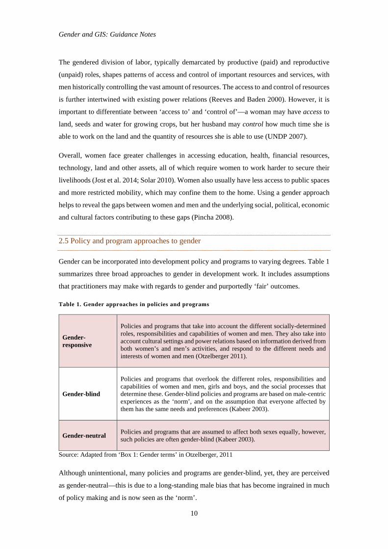
2.5 Policy and program approaches to gender
Gender can be incorporated into development policy and programs to varying degrees. Table 1
summarizes three broad approaches to gender in development work. It includes assumptions
that practitioners may make with regards to gender and purportedly ‘fair’ outcomes.
Table 1. Gender approaches in policies and programs
Gender-responsive
Policies and programs that take into account the different socially-determined roles, responsibilities and capabilities of women and men. They also take into account cultural settings and power relations based on information derived from both women’s and men’s activities, and respond to the different needs and interests of women and men (Otzelberger 2011).
Gender-blind
Policies and programs that overlook the different roles, responsibilities and capabilities of women and men, girls and boys, and the social processes that determine these. Gender-blind policies and programs are based on male-centric experiences as the ‘norm’, and on the assumption that everyone affected by them has the same needs and preferences (Kabeer 2003).
Gender-neutral
Policies and programs that are assumed to affect both sexes equally, however, such policies are often gender-blind (Kabeer 2003).
Source: Adapted from ‘Box 1: Gender terms’ in Otzelberger, 2011
Although unintentional, many policies and programs are gender-blind, yet, they are perceived
as gender-neutral—this is due to a long-standing male bias that has become ingrained in much
of policy making and is now seen as the ‘norm’.
Gender and GIS: Guidance Notes
11
In the context of climate change, gender-blindness can lead to the exclusion of women from
decision-making processes, and thus sidestep their knowledge and stakes on environmental
issues. This produces additional ‘gender risks’ that can worsen gender inequality by reinforcing
power structures, exacerbate poverty (due to limited access to financial resources and livelihood
opportunities), and decrease the potential benefits of the proposed climate change adaptation
strategy (Otzelberger 2011). On the other hand, ‘gender opportunities’ can be made when
adaptation strategies include both women and men, and consider their unique roles, challenges
and needs in the context of a changing climate. These opportunities can contribute to gender
equality, poverty reduction and successful adaptation strategies that are appropriate for the
needs of both women and men (Otzelberger 2011).
2.6 Gender, environment and development
It is increasingly recognized that the impacts of climate change and disasters, and responses to
these events, are gender-differentiated. While previous discourses on climate change and
disasters were largely un-gendered, there is a growing body of research that critically considers
gender’s role in shaping environmental risks (Ahmed 2004). Given that environmental change
continues to have the greatest consequences for women, there is a clear need to better
mainstream gender in climate change adaptation and disaster risk reduction strategies.
Climate change and disasters occur in a wide range of geographical, socio-economic and
cultural settings, thus the impacts of such events are rarely uniform (Enarson 2000). The
existing power relations in these various contexts, based on gender, class and economic status,
may determine the degree of impact for people based on their positioning with these power
structures (Bradshaw 2004). The dynamic social processes and gender-derived power relations
that create this uneven exposure to environmental risks create strongly gender-differentiated
impacts (Helmer and Hilhorst 2006). This sheds light on the uneven distribution of resources
and access to them, competing livelihood priorities, and disparities in education, awareness,
and mobility between women and men. These factors either create an enabling, or disabling
environment, for women and men to prepare for and cope with the impacts.
Overall, women are more negatively affected by environmental change than men. This is
especially true in areas where natural resources play a major role in supporting livelihoods, as
women are more dependent on them and likely to use them on a daily basis (Enarson et al.
2003). As resources become scarce during times of climate uncertainty, men may maintain
tighter control over natural resource use, and women must carry out their responsibilities with
a smaller resource base, burdening women with heavier workloads and reinforcing unequal
Gender and GIS: Guidance Notes
12
power structures (UNDP 2007). However, due to their varying responsibilities, women and
men have different interactions with the environment, presenting each of them with unique
challenges and opportunities to protect (or degrade) it (Neimanis 2005). For example, the
gendered division of labor requires women in many societies to work on the land for family
subsistence. As a result, women develop a strong relationship with nature and may have better
knowledge on how to better conserve natural resources in the face of environmental risks
(Enarson et al. 2003). On the other hand, men’s tight control of natural resources may force
women to seek alternatives and overexploit nearby natural resource bases, leading to land
degradation and resource scarcity (UNDP 2007).
Viewing climate change and disasters through a gender lens can help disentangle the complex
causes of gendered vulnerability. It is important to discern the gender-specific impacts of
various climate and disaster-related events. However, while it is crucial to understand the
gender-specific impacts of environmental change by exploring the underlying factors that shape
women and men’s experiences, a gender analysis is not a simplistic endeavor. Without proper
guidance and skills, gender analyses may homogenize women, presenting their struggles as
uniform, and linking their needs purely to only their reproductive roles (Cupples 2007). The
assumption that all men and all women have identical experiences overlooks the intersection
of gender with other factors, including ethnicity, poverty, class, age, disability and legal status
(Fordham 1998; Enarson et al. 2003). Additionally, as mentioned before, gender identities are
not static and may even become more fluid during climate-related hazards and disasters, for
example, as women may need to take over as breadwinners in the absence of their husbands
after a disaster (Cupples 2007). Gender is dynamic, changes over time, and intersects with other
identity categories such as class, race, ethnicity and disability. It must be recognized that gender
is just one of myriad variables contributing to an individual’s experience in a changing climate
and continuing disaster uncertainty.
As mentioned above, gender and associated roles can greatly influence the impacts of climate
change and disasters on women and men. The gender division of labored that associates
productive roles with men and reproductive roles with women is a major contributing factor to
this. The work patterns of women and men require them to use different sets of inputs and
resources, requiring a different interaction with the environment, and thus different impacts are
felt once the environment has undergone a change (Neimanis 2005).
Broadly speaking, the differential impacts can be linked to: 1) access to and control over natural
resources such as land, water and energy; and 2) participation in decision-making on the
management of resources both within the household and at greater institutional scales. Both of
Gender and GIS: Guidance Notes
13
these factors are inherently linked with gender, gender roles and related social expectations of
women and men.
Access to and control over land, water and energy resources
In many societies, land is registered in the name of the male head of the household and women
rarely have any land rights (Enarson et al. 2003). When women are given land, they are often
located in marginal, hazard-prone areas with the least secure tenure rights (UNDP 2007). The
absence of land rights means that women also rarely have control over the natural resources
found in and around these lands, and access to them is strictly controlled by men. Furthermore,
not only do women face more difficulty in obtaining and accessing assets, they are also more
vulnerable to the loss of these assets, which can be quickly taken away from them in the event
of divorce or death of their husband (Goh 2012).
In many developing countries, women are responsible for collecting water and fuel for domestic
use. In poorly serviced areas where there is insufficient pumped water, women must travel far
distances to access water that is both enough for their household needs and of acceptable quality
for consumption. As will be discussed later, climate-related hazards, such as droughts, can dry
up water resources, putting an additional strain on women. Additionally, while women will
usually prioritize water for household use by family members during times of water scarcity,
men may feel inclined to use water for irrigation of cash crops to meet short-term economic
needs (UNDP 2007). Similar to water, the fuel that women are largely responsible for
collecting, including wood and agricultural waste, may require them to walk long distances in
order to find sufficient quantities—which is further complicated by extreme weather events that
make access difficult.
Participation in decision-making processes at different scales
The gendered perception of women as homemakers and caretakers largely confines them to
private spheres. Women, therefore, have little opportunity to represent themselves in formal,
and even informal, systems of governance rendering them politically marginalized with limited
decision-making power. As a result, their needs are often ignored, or only become secondary
to those of men, who have a more visible and dominant presence in community, local and
national governing bodies (Pincha 2008). As mentioned above, women often have strong
knowledge of their environments given their responsibilities in the daily collection of important
natural resources. The absence of women from policy-making processes, both at small and large
scales, prevents their needs, as well as insights on the environment, from being considered with
repercussions not only for women, but for the entire household.
Gender and GIS: Guidance Notes
14
Women’s lack of decision-making power in public spaces is also reflected in private domains.
Men, often regarded as the family breadwinner, tend to be the voice of authority, including on
natural resource use. The ‘household’ is typically portrayed as a cohesive entity with all
members sharing mutual interests and making decisions that benefit the household as a whole.
However, as within wider society, the household can be a contentious space where gender feeds
into a complex interplay of power and competing interests (Bradshaw 2004). Men’s perceptions
on how resources should be allocated within the household may lead to under allocation, or
serious misuse of resources, as most household work is carried out by women who have the
familiarity of the actual inputs required to complete the tasks. The failure of men to recognize
women as contributors to the household economy undermines their participation and devalues
their knowledge, which is often gained through first-hand experiences.
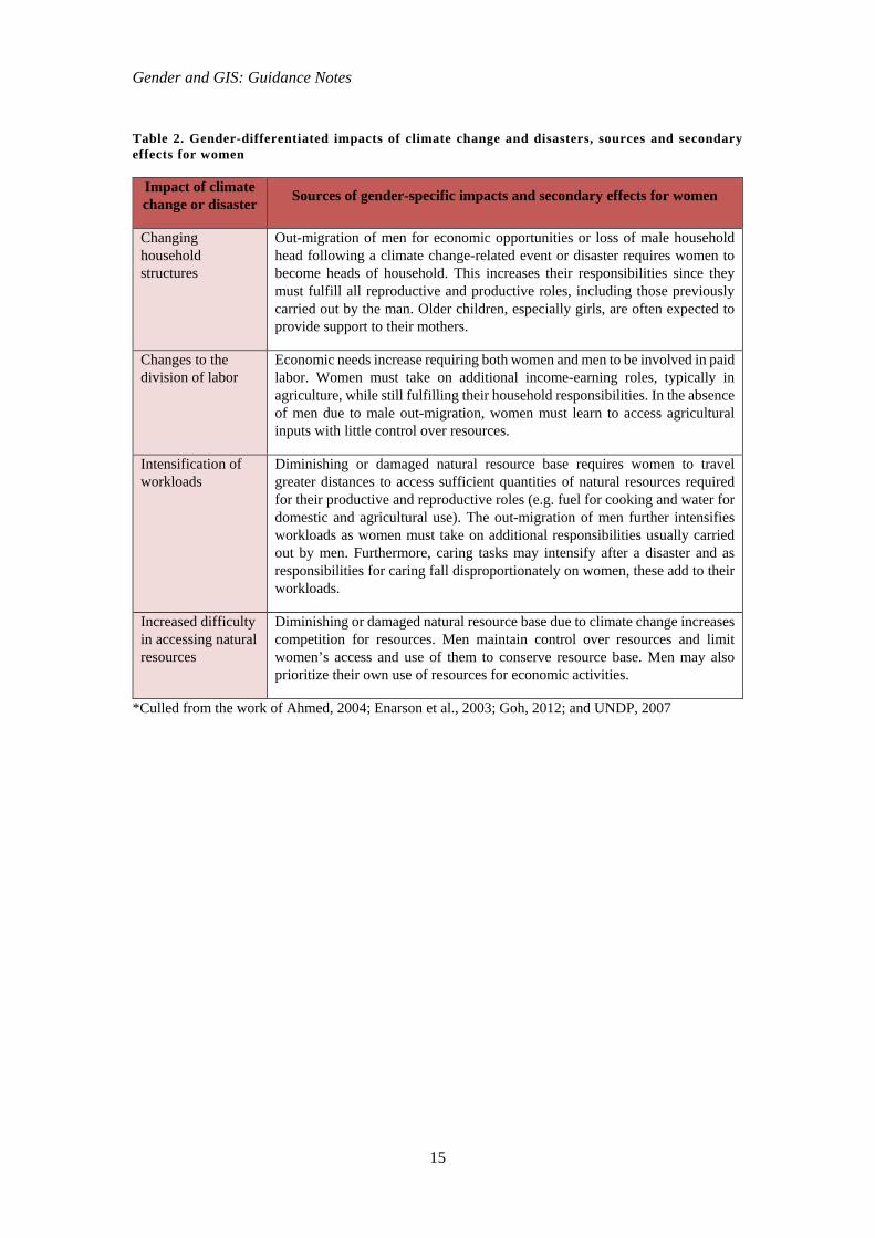
2.7 Gender-specific impacts of climate change and disasters
The full range of effects that climate change and disasters can have on women and men is still
emerging. However, existing research reveals some common impacts including:
Changing household structures;
Changes to the division of labor;
Intensification of workloads, particularly for women; and
Increased difficulty in accessing natural resources.
These impacts are not exhaustive but give insight into the unique challenges faced, particularly
by women, in securing their livelihoods and carrying out household responsibilities in the face
of environmental shocks and stresses, such as droughts, floods and heavy precipitation. The
out-migration of men is a major driving force of the above-mentioned impacts. As the
availability of wage opportunities can dramatically decrease during climate extremes, men
often migrate in search of economic opportunities elsewhere. Women, whose livelihoods
typically revolve less around wage labor, are less mobile than men, and therefore stay behind
to assume the role as household lead.
Gender and GIS: Guidance Notes
15
Table 2. Gender-differentiated impacts of climate change and disasters, sources and secondary effects for women
Impact of climate change or disaster Sources of gender-specific impacts and secondary effects for women
Changing household structures
Out-migration of men for economic opportunities or loss of male household head following a climate change-related event or disaster requires women to become heads of household. This increases their responsibilities since they must fulfill all reproductive and productive roles, including those previously carried out by the man. Older children, especially girls, are often expected to provide support to their mothers.
Changes to the division of labor
Economic needs increase requiring both women and men to be involved in paid labor. Women must take on additional income-earning roles, typically in agriculture, while still fulfilling their household responsibilities. In the absence of men due to male out-migration, women must learn to access agricultural inputs with little control over resources.
Intensification of workloads
Diminishing or damaged natural resource base requires women to travel greater distances to access sufficient quantities of natural resources required for their productive and reproductive roles (e.g. fuel for cooking and water for domestic and agricultural use). The out-migration of men further intensifies workloads as women must take on additional responsibilities usually carried out by men. Furthermore, caring tasks may intensify after a disaster and as responsibilities for caring fall disproportionately on women, these add to their workloads.
Increased difficulty in accessing natural resources
Diminishing or damaged natural resource base due to climate change increases competition for resources. Men maintain control over resources and limit women’s access and use of them to conserve resource base. Men may also prioritize their own use of resources for economic activities.
*Culled from the work of Ahmed, 2004; Enarson et al., 2003; Goh, 2012; and UNDP, 2007
Gender and GIS: Guidance Notes
16
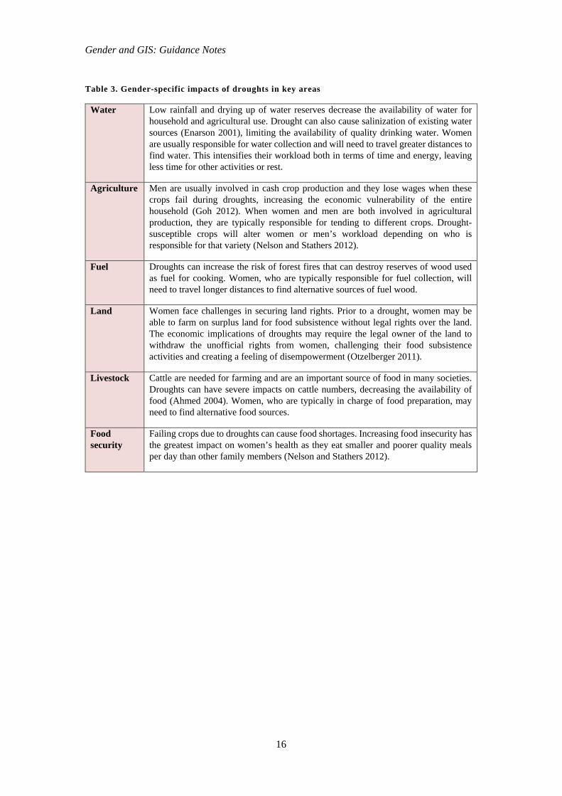
Table 3. Gender-specific impacts of droughts in key areas
Water Low rainfall and drying up of water reserves decrease the availability of water for household and agricultural use. Drought can also cause salinization of existing water sources (Enarson 2001), limiting the availability of quality drinking water. Women are usually responsible for water collection and will need to travel greater distances to find water. This intensifies their workload both in terms of time and energy, leaving less time for other activities or rest.
Agriculture Men are usually involved in cash crop production and they lose wages when these crops fail during droughts, increasing the economic vulnerability of the entire household (Goh 2012). When women and men are both involved in agricultural production, they are typically responsible for tending to different crops. Drought-susceptible crops will alter women or men’s workload depending on who is responsible for that variety (Nelson and Stathers 2012).
Fuel Droughts can increase the risk of forest fires that can destroy reserves of wood used as fuel for cooking. Women, who are typically responsible for fuel collection, will need to travel longer distances to find alternative sources of fuel wood.
Land Women face challenges in securing land rights. Prior to a drought, women may be able to farm on surplus land for food subsistence without legal rights over the land. The economic implications of droughts may require the legal owner of the land to withdraw the unofficial rights from women, challenging their food subsistence activities and creating a feeling of disempowerment (Otzelberger 2011).
Livestock Cattle are needed for farming and are an important source of food in many societies. Droughts can have severe impacts on cattle numbers, decreasing the availability of food (Ahmed 2004). Women, who are typically in charge of food preparation, may need to find alternative food sources.
Food security
Failing crops due to droughts can cause food shortages. Increasing food insecurity has the greatest impact on women’s health as they eat smaller and poorer quality meals per day than other family members (Nelson and Stathers 2012).
Gender and GIS: Guidance Notes
17
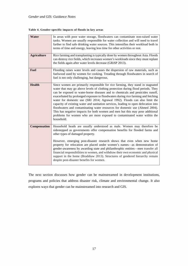
Table 4. Gender-specific impacts of floods in key areas
Water In areas with poor water storage, floodwaters can contaminate non-raised water tanks. Women are usually responsible for water collection and will need to travel farther to find safe drinking water sources. This intensifies their workload both in terms of time and energy, leaving less time for other activities or rest.
Agriculture Rice farming and transplanting is typically done by women throughout Asia. Floods can destroy rice fields, which increases women’s workloads since they must replant the fields again after water levels decrease (GRiSP 2013).
Fuel Flooding raises water levels and causes the dispersion of raw materials, such as fuelwood used by women for cooking. Treading through floodwaters in search of fuel is not only challenging, but dangerous.
Health Since women are primarily responsible for rice farming, they stand in stagnated water that may go above levels of clothing protection during flood periods. They can be exposed to water-borne diseases and to chemicals and pesticides runoff, exacerbated by prolonged exposure to floodwaters during rice farming and fetching water for domestic use (SRI 2014; Agrawal 1992). Floods can also limit the capacity of existing water and sanitation services, leading to open defecation into floodwaters and contaminating water resources for domestic use (Ahmed 2004). This has negative impacts for both women and men but this may pose additional problems for women who are more exposed to contaminated water within the household.
Compensation Household heads are usually understood as male. Women may therefore be sidestepped as governments offer compensation benefits for flooded farms and other types of damaged property.
However, emerging post-disaster research shows that even when new home property for relocation are placed under women’s names—as demonstration of gender-awareness by awarding state and philanthrophic entities—men transfer all financial responsibilities to women, and withdraw their own economic and physical support in the home (Bradshaw 2013). Structures of gendered hierarchy remain despite post-disaster benefits for women.
The next section discusses how gender can be mainstreamed in development institutions,
programs and policies that address disaster risk, climate and environmental change. It also
explores ways that gender can be mainstreamed into research and GIS.

Gender and GIS: Guidance Notes
18
3. What is Gender Mainstreaming?
Mainstreaming a gender perspective, or gender mainstreaming, is the internationally-agreed
upon strategy to promote gender equality, a result of a consensus reached among countries and
organizations that participated in the United Nations World Conference on Women in 1995 in
Beijing. It can be seen as a strategy to counteract prevailing gender discrimination and
inequality. The United Nations Economic and Social Council (UN ECOSOC) defines gender
mainstreaming as “…the process of assessing the implications for women and men of any
planned action, including legislation, policies or programs, in all areas and at all levels. It is a
strategy for making gender equality concerns and experiences an integral dimension of the
design, implementation, monitoring and evaluation of policies and programs in all political,
economic and societal spheres so that women and men benefit equally and inequality is not
perpetuated. The ultimate goal is to achieve gender equality” (UN ECOSOC 1997).
Gender mainstreaming means more than simply tacking on an additional gender component to
existing laws and programs. It requires the development and implementation of gender policies
at all levels within organizational structures, as opposed to only in independent, concentrated
units (UNDP 2007). All sectors must be informed by a gender-responsive approach and
integrate this within policies, programs and project cycles to ensure effective gender
mainstreaming.
Mainstreaming gender in institutions, policies and programs can broaden to encompass
mainstreaming efforts in research endeavors, the presentation and interpretation of research
data, and the communication of data and findings. For instance, sensitivity to gender inequality
issues in research on natural resource management regimes under conditions of climate change
and disaster risks enables a more inclusive and holistic view of the breadth of disadvantage and
impact on people’s lives and livelihoods. Policy actions and decisions can therefore act on the
information and respond in more gender-sensitive ways. Mainstreaming gender in GIS is one
approach to serve such ends.
Gender and GIS: Guidance Notes
19
3.1 Gender mainstreaming in geographic information systems
. . . when the gaze-from-space is uninformed by the logic of gendered livelihoods and landscapes, then the erasure of women’s place in the mapped spaces is all but certain.
Dianne Rocheleau, Professor of Geography, 1995
GIS is a user-driven visual technology that enables the creation, organization and presentation
of data in a spatially referenced form, which might include the production of maps and charts.
It relies on data exploration, layering and visualization (McLafferty 2005; AAAS 2015). GIS
is widely used as a tool for decision making in policy arenas, as it can inform and shape
decisions that respond to gender inequalities in environmental management, climate change
adaptation and disaster risk reduction.
The benefits of GIS are that they are able to synthesize different types of geospatial data from
different sources such as remote satellite imagery and other geospatial technologies, in order to
reveal spatial patterns, and possibly simplify the observations of specialists and stakeholders
through a geospatial presentation of information (AAAS 2015). SERVIR-Mekong specifically
intends to build the capacity of governments and other key stakeholders in the Lower Mekong
countries to employ and strengthen their use of GIS through publicly-available satellite imagery
and geospatial technologies, such as mapping and analysis software, for environmental
management, disaster risk management and building resilience to climate change.
Gender issues and gender-related information have a relevant role to play in the creation and
use of GIS to improve decisions on environmental management, disaster risk management and
building resilience to climate change. Together with various gender mainstreaming approaches,
GIS can shape these decisions so that they address gender inequality for more sustainable
development. There is growing recognition of the power of spatial analysis in assisting
development programs but to date, the importance of mapping gender in development programs
remains limited and constrained.
The usefulness of integrating gender with GIS is multiple. First, a concern for gender frontally
places ‘people on the map’ and complements efforts to spatially track actual or potential
environmental, climate and disaster impacts on ecosystems and geographical locations.
Second, by placing ‘people on the map,’ GIS can present the actual and potential gender-
differentiated impacts and implications of environmental and climate change on types of human
populations and their settlements, livelihoods, livelihood spaces and resource use regimes.
Gender and GIS: Guidance Notes
20
Third, while there is an extensive collection of excellent in-depth studies on gender in
agriculture, water management, and overall natural resource management, this information is
not available for larger geographic areas and are not spatially synthesized. As maps and
analyses based on GIS become an important tool for environment, climate response and
development planning, the lack of spatially referenced information on gender is particularly
noteworthy, and thus there is an urgent need to integrate this information into GIS to allow
wider spatial and scalar visualization that could enable gender-responsive policy agendas.
Fourth, gender in GIS allows researchers to identify patterns in the social and gendered
organization of environmental management systems in environmentally-degraded and climate-
affected areas, thereby allowing researchers and practitioners alike to better understand how to
target interventions to women and men on the ground in a wider geographical space.
Despite the apparent paucity of gender integration with GIS and cartography in general, gender
scholars have long employed forms of GIS to present more spatial analysis-friendly research
findings ‘at a glance’ and argue for the need to address forms of gender-unequal practices and
conditions.
In the early 1990s, feminist geographers studying complex natural resource use systems
presented how these systems interacted with women and men’s labor and time, and how women
and men’s access to and control of resources were different, as well as indicated spaces
dominantly female and male, or both. Some of the classic examples of this era are presented
below, which at that time did not make use of digital technologies, but were representations of
grounded and manual participatory mapping exercises and data collection. These are being
shown here to demonstrate the translation of social and gender data into spatial representations
for specific research purposes, and as precursors to more sophisticated digitalized GIS
applications of gender-related data created in recent years.
Gender and GIS: Guidance Notes
21
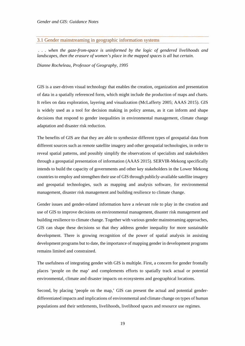
Figure 1. Resource and land use map on gender-differentiated responsibility, control and labor in Zambrana, Dominican Republic
Source: Rocheleau and Ross, 1995
Figure 1 shows who had control, responsibility and labor obligations for each resource and land
use space in the agroforesty project and study site. The map shows that men had more control
(management and decision-making entitlements) over land and other resources, while women
were expected to devote more labor time in developing these resources. Part of women’s labor
was devoting travel time to a processing plant for forest products. From this reading, policy
interventions might thus seek to narrow the differences between control and labor rights of
women and men, while ensuring the sustainable use of these forest and land resources, and the
sustainable livelihoods for local households.
Today, the conventional—usually static—cartographic models are being replaced by highly
interactive, agile and innovative GIS models enabling the dynamic visualization of spatial data.
Gender and GIS: Guidance Notes
22
Visualization itself therefore becomes a powerful tool of analysis rather than a presentation of
its outcome (Pavlovskaya and St. Martin 2007).
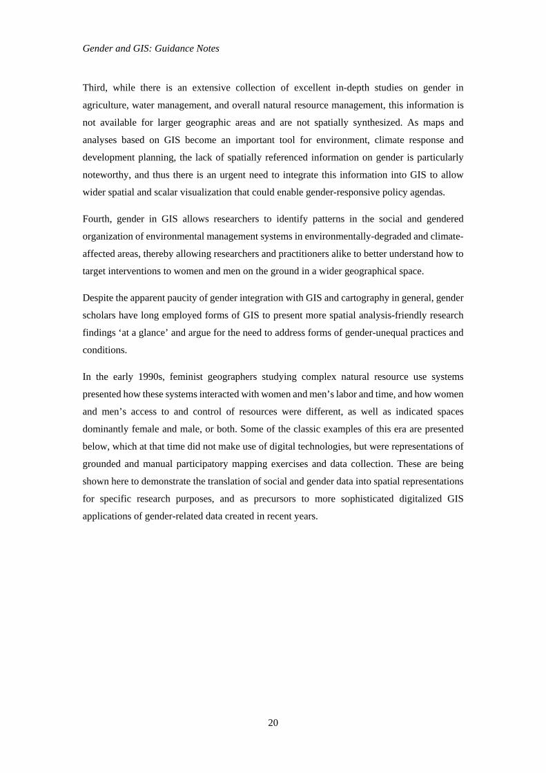
For instance, in Pavlovskaya’s study on the link between the micro‐geographies of women’s
everyday lives and urban restructuring in Moscow after the collapse of communism, she used
GIS to visualize the multiple economies of households in Moscow before and after the Soviet
collapse (figure 2). In her study, multiple economies included gendered activities that were
formal and informal, monetized and non-monetized, belonging to state and private sectors,
occurring in the larger economies or within the home, and often were network-based. Many of
these types of income earning and production of goods and services were invisible in official
statistics but they co-shaped the daily lives of women together with housework, childcare at
home, and their reliance on informal networks of support. These constrained or enabled
women’s participation in the wider labor market. Collecting this information through in-depth
qualitative interviews and then visualizing the previously invisible landscape of undervalued
economic activities shed light on the local and gendered experiences of economic and social
changes in transitioning societies (Pavlovskaya and St. Martin 2007: 598-599).
Figure 2. Multiple economies and households, 1989–1995, downtown Moscow
Source: Pavlovskaya, 2009
GIS can be used to digitally represent and interpret oral and life histories, and can accommodate
qualitative information. GIS can also be used to help express meanings, memories, feelings and
emotions. The emotional power of moving images and the techniques in narrative cinema can
be used to create GIS movies or visualizations that tell stories about the lives of marginalized
Gender and GIS: Guidance Notes
23
people, and highlight social injustice and the effects of social change (Kwan and Ding 2008).
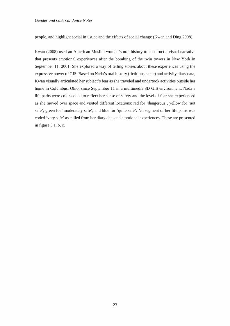
Kwan (2008) used an American Muslim woman’s oral history to construct a visual narrative
that presents emotional experiences after the bombing of the twin towers in New York in
September 11, 2001. She explored a way of telling stories about these experiences using the
expressive power of GIS. Based on Nada’s oral history (fictitious name) and activity diary data,
Kwan visually articulated her subject’s fear as she traveled and undertook activities outside her
home in Columbus, Ohio, since September 11 in a multimedia 3D GIS environment. Nada’s
life paths were color-coded to reflect her sense of safety and the level of fear she experienced
as she moved over space and visited different locations: red for ‘dangerous’, yellow for ‘not
safe’, green for ‘moderately safe’, and blue for ‘quite safe’. No segment of her life paths was
coded ‘very safe’ as culled from her diary data and emotional experiences. These are presented
in figure 3 a, b, c.
Gender and GIS: Guidance Notes
24
Figure 3 a, b, c. Nada’s mobility and emotional topographies before and after the disaster of September 11, Columbus, Ohio
Source: Kwan, 2008
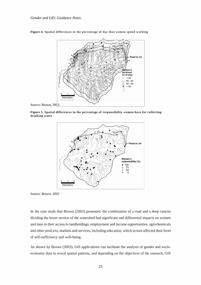
As demonstrated by earlier geographers studying human-landscape dynamics, gender concerns
in contemporary land use systems can also be presented using GIS technologies. For instance,
figures 4 and 5 illustrate how spatial analysis can be used to make sense of how geographical
and location dimensions like access to a road affect women’s lives and workloads in the Yarsha
Khola watershed east of Kathmandu, Nepal. The map shows that women’s workloads were
greater for households that were closer to the road (figure 4), and women who lived far from
the road had more responsibility to collect drinking water from available resources (figure 5).
Moreover, households with better road access tended to have smaller landholdings, so male
members required off-farm employment to meet their livelihood needs, which placed a greater
burden on women and reproductive work in their households (Brown 2003).
Figure 3b: Nada’s mobility pattern and emotions several days after September 11
Figure 3a: Nada’s mobility pattern on a typical weekday before September 11
Figure 3c: Nada’s mobility pattern and emotions several weeks after September 11.
Gender and GIS: Guidance Notes
25
Figure 4. Spatial differences in the percentage of day that women spend working
Source: Brown, 2003
Figure 5. Spatial differences in the percentage of responsibility women have for collecting drinking water
Source: Brown, 2003
In the case study that Brown (2003) presented, the combination of a road and a deep canyon
dividing the lower section of the watershed had significant and differential impacts on women
and men in their access to landholdings, employment and income opportunities, agrochemicals
and other products, markets and services, including education, which in turn affected their level
of self-sufficiency and well-being.
As shown by Brown (2003), GIS applications can facilitate the analysis of gender and socio-
economic data to reveal spatial patterns, and depending on the objectives of the research, GIS
Gender and GIS: Guidance Notes
26
maps often communicate this information more effectively than graphs or tables. In figures 4
and 5, the influence of the road on gender and socio-economic issues is highlighted, and the
need to promote gender-equal development activities becomes clear. GIS analysis of gender
and socio-economic data has implications for policy and infrastructural development. By using
GIS applications, the potential impacts of infrastructure projects can be demonstrated,
monitored and mitigated.
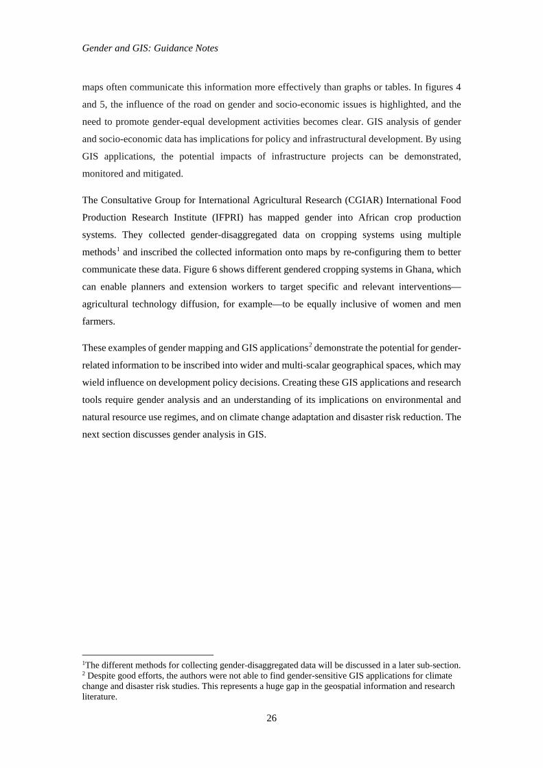
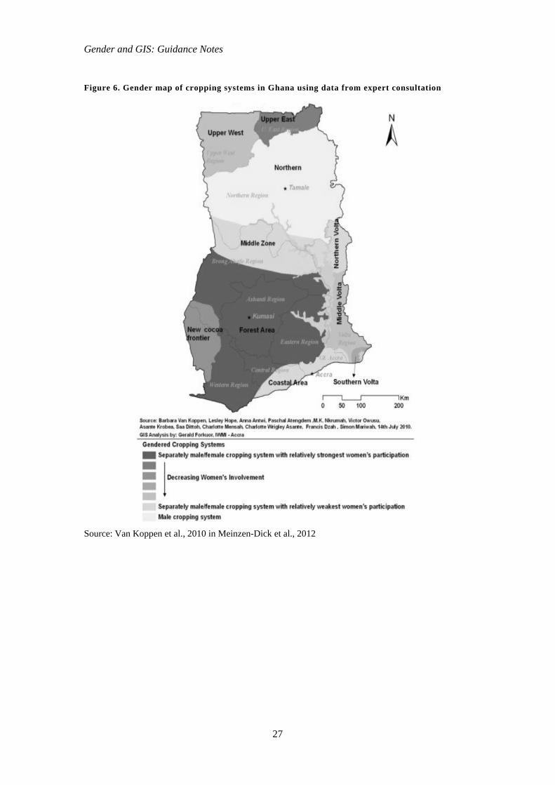
The Consultative Group for International Agricultural Research (CGIAR) International Food
Production Research Institute (IFPRI) has mapped gender into African crop production
systems. They collected gender-disaggregated data on cropping systems using multiple
methods1 and inscribed the collected information onto maps by re-configuring them to better
communicate these data. Figure 6 shows different gendered cropping systems in Ghana, which
can enable planners and extension workers to target specific and relevant interventions—
agricultural technology diffusion, for example—to be equally inclusive of women and men
farmers.
These examples of gender mapping and GIS applications2 demonstrate the potential for gender-
related information to be inscribed into wider and multi-scalar geographical spaces, which may
wield influence on development policy decisions. Creating these GIS applications and research
tools require gender analysis and an understanding of its implications on environmental and
natural resource use regimes, and on climate change adaptation and disaster risk reduction. The
next section discusses gender analysis in GIS.
1The different methods for collecting gender-disaggregated data will be discussed in a later sub-section. 2 Despite good efforts, the authors were not able to find gender-sensitive GIS applications for climate change and disaster risk studies. This represents a huge gap in the geospatial information and research literature.
Gender and GIS: Guidance Notes
27
Figure 6. Gender map of cropping systems in Ghana using data from expert consultation
Source: Van Koppen et al., 2010 in Meinzen-Dick et al., 2012
Gender and GIS: Guidance Notes
28
4. Producing Gender-sensitive GIS Applications for Environmental Management, Climate Change Adaptation and Disaster Risk Reduction
Producing a gender-sensitive GIS application for decision making in environmental
management, climate change adaptation and disaster risk reduction generally involves doing a
gender analysis. A gender analysis is the systematic examination of roles, relationships and
processes between women and men in all societies, focusing on rights, representation and
workloads, revealing imbalances between women and men, and thus indicating disadvantage.
A gender analysis attempts to explain the mechanisms by which gender inequality is
maintained. It also includes the examination of the multiple ways in which women and men, as
social actors, engage in strategies to transform or maintain existing roles, relationships and
processes in their own interest or the interest of others.
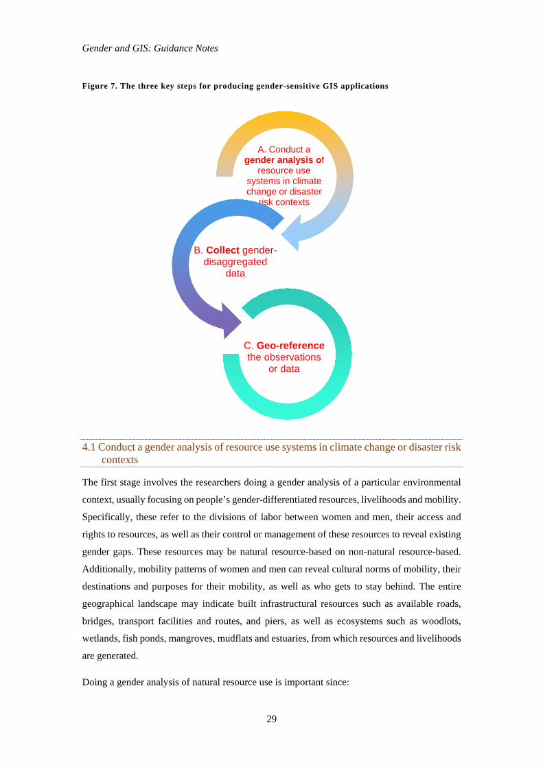
Creating a gender-sensitive GIS application involves three stages (figure 7), and can be further
ramified based on the contexts under study. These three stages often have fuzzy boundaries as
activities undertaken may overlap each other.
Gender and GIS: Guidance Notes
29
Figure 7. The three key steps for producing gender-sensitive GIS applications
4.1 Conduct a gender analysis of resource use systems in climate change or disaster risk contexts
The first stage involves the researchers doing a gender analysis of a particular environmental
context, usually focusing on people’s gender-differentiated resources, livelihoods and mobility.
Specifically, these refer to the divisions of labor between women and men, their access and
rights to resources, as well as their control or management of these resources to reveal existing
gender gaps. These resources may be natural resource-based on non-natural resource-based.
Additionally, mobility patterns of women and men can reveal cultural norms of mobility, their
destinations and purposes for their mobility, as well as who gets to stay behind. The entire
geographical landscape may indicate built infrastructural resources such as available roads,
bridges, transport facilities and routes, and piers, as well as ecosystems such as woodlots,
wetlands, fish ponds, mangroves, mudflats and estuaries, from which resources and livelihoods
are generated.
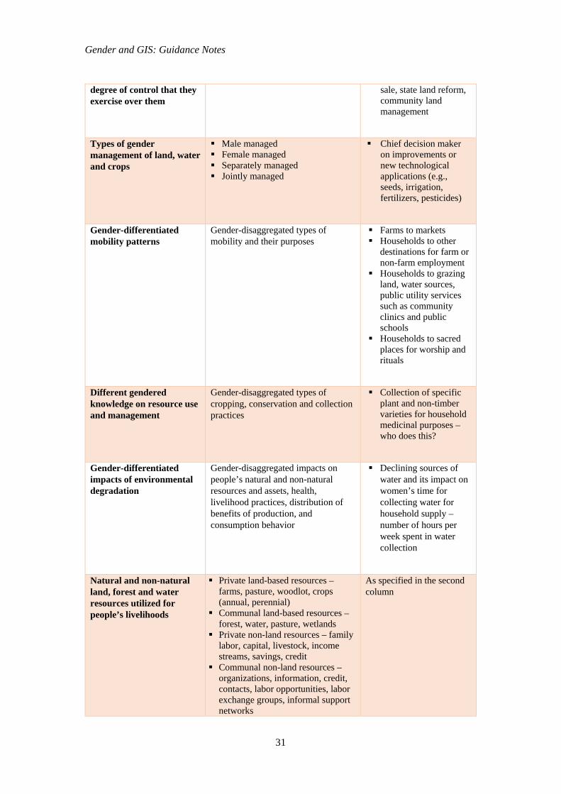
Doing a gender analysis of natural resource use is important since:
A. Conduct a gender analysis of
resource use systems in climate change or disaster
risk contexts
B. Collect gender-disaggregated
data
C. Geo-referencethe observations
or data
Gender and GIS: Guidance Notes
30
Women and men interact with the natural resource base through their productive
and reproductive roles and responsibilities, where women often shoulder both
types of responsibilities;
Women and men have different and uneven rights of access and control of natural
resources;
Women and men are the sources of different knowledge and skills in the use and
management of natural resources;
Women and men experience the effects of environmental changes in gender-
specific ways; and
Women and men negotiate their interests and expand their rights within a
broader system of power in the household, community and state.
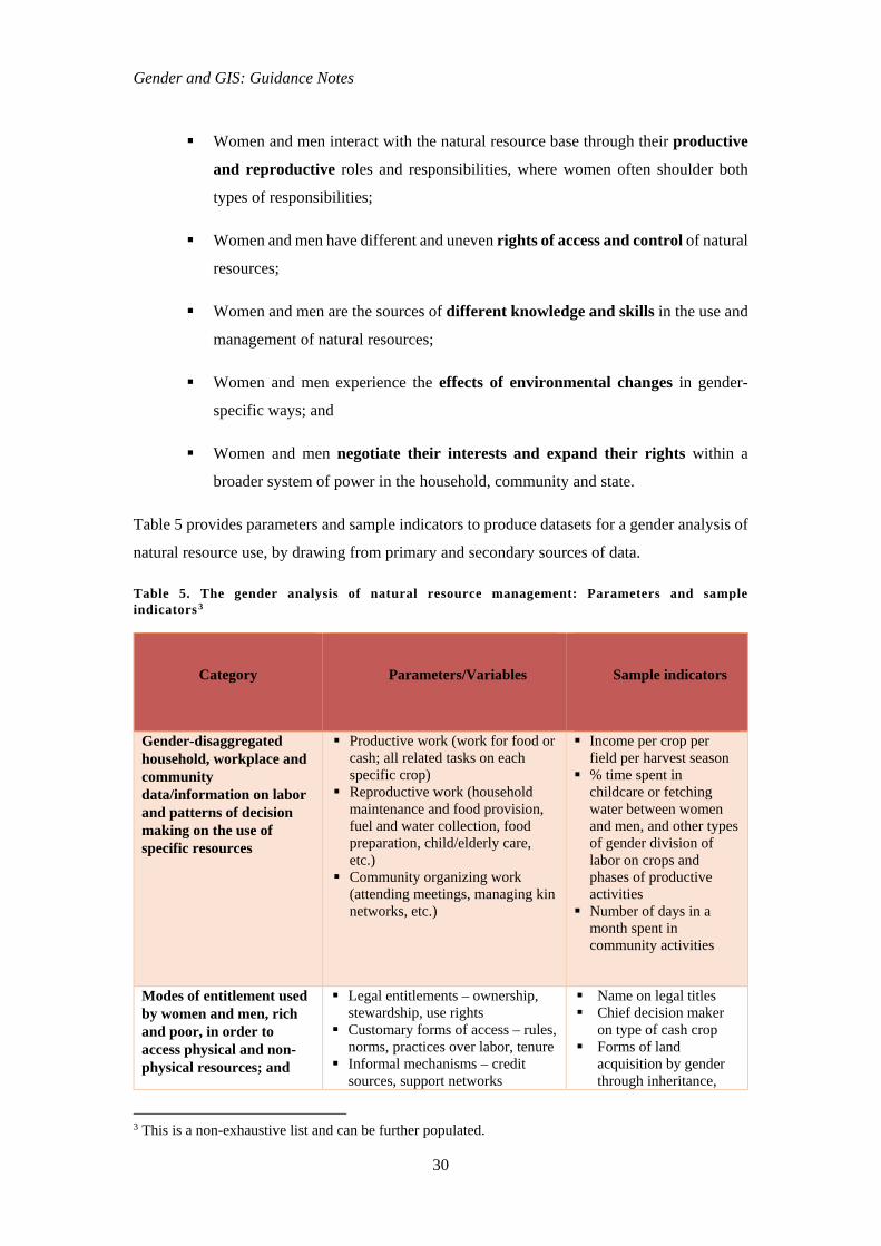
Table 5 provides parameters and sample indicators to produce datasets for a gender analysis of
natural resource use, by drawing from primary and secondary sources of data.
Table 5. The gender analysis of natural resource management: Parameters and sample indicators 3
Category
Parameters/Variables
Sample indicators
Gender-disaggregated household, workplace and community data/information on labor and patterns of decision making on the use of specific resources
Productive work (work for food or cash; all related tasks on each specific crop)
Reproductive work (household maintenance and food provision, fuel and water collection, food preparation, child/elderly care, etc.)
Community organizing work (attending meetings, managing kin networks, etc.)
Income per crop per field per harvest season
% time spent in childcare or fetching water between women and men, and other types of gender division of labor on crops and phases of productive activities
Number of days in a month spent in community activities
Modes of entitlement used by women and men, rich and poor, in order to access physical and non-physical resources; and
Legal entitlements – ownership, stewardship, use rights
Customary forms of access – rules, norms, practices over labor, tenure
Informal mechanisms – credit sources, support networks
Name on legal titles Chief decision maker
on type of cash crop Forms of land
acquisition by gender through inheritance,
3 This is a non-exhaustive list and can be further populated.
Gender and GIS: Guidance Notes
31
degree of control that they exercise over them
sale, state land reform, community land management
Types of gender management of land, water and crops
Male managed Female managed Separately managed Jointly managed
Chief decision maker on improvements or new technological applications (e.g., seeds, irrigation, fertilizers, pesticides)
Gender-differentiated mobility patterns
Gender-disaggregated types of mobility and their purposes
Farms to markets Households to other
destinations for farm or non-farm employment
Households to grazing land, water sources, public utility services such as community clinics and public schools
Households to sacred places for worship and rituals
Different gendered knowledge on resource use and management
Gender-disaggregated types of cropping, conservation and collection practices
Collection of specific plant and non-timber varieties for household medicinal purposes – who does this?
Gender-differentiated impacts of environmental degradation
Gender-disaggregated impacts on people’s natural and non-natural resources and assets, health, livelihood practices, distribution of benefits of production, and consumption behavior
Declining sources of water and its impact on women’s time for collecting water for household supply – number of hours per week spent in water collection
Natural and non-natural land, forest and water resources utilized for people’s livelihoods
Private land-based resources – farms, pasture, woodlot, crops (annual, perennial)
Communal land-based resources – forest, water, pasture, wetlands
Private non-land resources – family labor, capital, livestock, income streams, savings, credit
Communal non-land resources – organizations, information, credit, contacts, labor opportunities, labor exchange groups, informal support networks
As specified in the second column
Gender and GIS: Guidance Notes
32
While all the variables above are vital gender indices of natural resource management, not all
of them might be important to address specific objectives of a GIS project. The selection of
these variables will be determined by the logics of the research problem and objectives of the
planned GIS application.
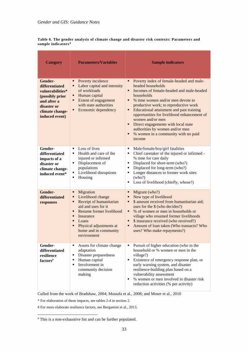
Doing a gender analysis of climate change and disaster risk contexts, on the other hand,
involves collecting information on the gender-differentiated effects of a climate change or
disaster occurrence (e.g., drought, higher precipitation, flooding) on women and men, such as
outcomes of loss and damage of natural or non-natural resource assets, and as a result,
determine whose well-being, livelihoods, time, health, lives, incomes and mobility are
disrupted temporarily or permanently, or subsequently enabled. A gender analysis may also
characterize ex-ante and ex-post facto gender-related and other social, economic, political,
geophysical conditions of vulnerability. Additionally, a gender analysis can draw from data
on gender-differentiated responses to climate change and disaster occurrences, whether short-
term or long-term. Finally, gender-differentiated factors that enable resilience should also be
characterized and indicated.
Gender and GIS: Guidance Notes
33
Table 6. The gender analysis of climate change and disaster risk contexts: Parameters and sample indicators 4
Category Parameters/Variables Sample indicators
Gender-differentiated vulnerabilities* (possibly prior and after a disaster or climate change-induced event)
Poverty incidence Labor capital and intensity
of workloads Human capital Extent of engagement
with state authorities Economic dependency
Poverty index of female-headed and male-headed households
Incomes of female-headed and male-headedhouseholds
% time women and/or men devote toproductive work; to reproductive work
Educational attainment and past trainingopportunities for livelihood enhancement ofwomen and/or men
Direct engagements with local stateauthorities by women and/or men
% women in a community with no paidincome
Gender-differentiated impacts of a disaster or climate change-induced event*
Loss of lives Health and care of the
injured or infirmed Displacement of
populations Livelihood disruptions Housing
Male/female/boy/girl fatalities Chief caretaker of the injured or infirmed -
% time for care daily Displaced for short-term (who?) Displaced for long-term (who?) Longer distances to former work sites
(who?) Loss of livelihood (chiefly, whose?)
Gender-differentiated responses
Migration Livelihood change Receipt of humanitarian
aid and uses for it Resume former livelihood Insurance Loans Physical adjustments at
home and in communityenvironment
Migrant (who?) New type of livelihood $ amount received from humanitarian aid;
uses for the $ (who decides?) % of women or men in households or
village who resumed former livelihoods $ insurance received (who received?) Amount of loan taken (Who transacts? Who
uses? Who make repayments?)
Gender-differentiated resilience factors#
Assets for climate changeadaptation
Disaster preparedness Human capital Involvement in
community decisionmaking
Pursuit of higher education (who in thehousehold or % women or men in thevillage?)
Existence of emergency response plan, orearly warning system, and disasterresilience-building plan based on avulnerability assessment
% women or men involved in disaster riskreduction activities (% per activity)
Culled from the work of Bradshaw, 2004; Mustafa et al., 2008; and Moser et al., 2010 * For elaboration of these impacts, see tables 2-4 in section 2.
# For more elaborate resilience factors, see Bergamini et al., 2013.
4 This is a non-exhaustive list and can be further populated.
Gender and GIS: Guidance Notes
34
By doing a gender analysis and impact assessment5 of environment/natural resource use in
climate change and disaster risk contexts, the substantive design of the gender-sensitive GIS
application is achieved. As a next step, practitioners and researchers have to locate and access
secondary datasets, decide on the methods for primary data collection, and design the
appropriate instruments that will generate data and relevant information.
4.2 Collect gender-disaggregated data
Secondary data from publicly available records are important because they often provide more
geographical coverage, for instance across subnational districts, countries, contiguous and
transboundary regions, villages, etc. Where such data can be geo-referenced, they can be put
into GIS applications, which are increasingly being used today for making decisions on
development interventions. Unfortunately, because of the lack of gender-disaggregated
secondary data generally, and in particular in existing environment and climate databases and
impact assessments, gender is not included in spatial prioritization and GIS applications
(Quisumbing et al. 2014). Building up reliable secondary databases can therefore ‘put gender
on the map.’
Secondary data can be drawn from existing datasets on food production, demography and
environment notably from the Food and Agriculture Organization of the United Nations (FAO),
the Organisation for Economic Co-operation and Development (OECD) and the United Nations
Department of Economic and Social Affairs (UN DESA); documents and knowledge products
from the United Nations Economic and Social Commissions in developing regions; the World
Bank’s Living Standards Measurements Study; the USAID MEASURE Demographic and
Health Surveys; national agricultural, environment and population census bureaus that have
records of results from socio-economic surveys with statistically representative sampling
covering entire countries with consistent methodologies over time; databases and research
products especially postgraduate theses and refereed papers in university libraries; and existing
electronic journal and e-book databases.
For primary data collection, GIS application developers will have to identify the unit of analysis
to be used on the GIS map. It may be useful to ask: what is the type of farm management system
determined at the level of production at the household, or village? In order to create the map, it
may be important to aggregate to village level, identifying the general patterns in a village,
5 Samples of these are in tables 2-4 in section 2.
Gender and GIS: Guidance Notes
35
province with different villages, or region with different provinces. Furthermore, while there
may be a dominant pattern, other types of farm management systems usually are present in the
same area, and ways must be found to equally represent these.
Methods for primary data collection will vary depending on the objectives of the GIS
application. To produce a GIS map on gender and agriculture, for instance, the IFPRI (2012)
team suggests four methods in their gender mapping work on Sub-Saharan Africa. They are (1)
expert consultations, (2) open online surveys, (3) review of the literature, and (4) aggregation
of household survey data. These sources of information can triangulate and validate the
collected data.
In this era of Big Data, information to produce gender-sensitive GIS applications may be
crowdsourced and grow in breadth over time. One example is the initiative to document active
women and women’s groups in disaster risk reduction efforts, such as the Women and Girls on
the Map initiative (https://womenandgirlsonthemap.crowdmap.com/). This crowdsourced
material gives a sense of the growth of women as a vibrant and dynamic constituency in disaster
risk reduction globally.
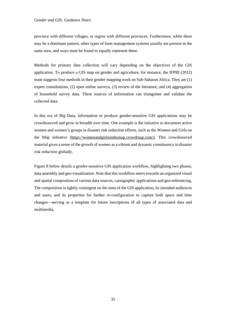
Figure 8 below details a gender-sensitive GIS application workflow, highlighting two phases,
data assembly and geo-visualization. Note that this workflow steers towards an organized visual
and spatial composition of various data sources, cartographic applications and geo-referencing.
The composition is tightly contingent on the aims of the GIS application, its intended audiences
and users, and its properties for further re-configuration to capture both space and time
changes—serving as a template for future inscriptions of all types of associated data and
multimedia.
Gender and GIS: Guidance Notes
36
Figure 8. Sample workflow for the development of gender-sensitive GIS applications
The next sub-section discusses the final stage of assigning gender data to geographical points,
a process referred to as geo-referencing.
4.3 Geo-reference the observations or data
To ‘geo-reference’ means to assign information or data to geographical locations in physical
space. Geo-referencing may be applied to any kind of object or structure that can be related to
a geographical location, such as roads, neighborhoods, mountain slopes, bridges, buildings,
human-constructed monuments, or any geographical point of interest or relevance. Technically,
this means aligning data to a known coordinate system so that it can viewed, queried and
analyzed. For example, by extracting the gender indicators of interest from datasets and data
sources on the percentage of female-headed households and male-headed households
respectively in a province, and mapping them to administrative units (district, municipality,
commune, or city), we can know the breadth of these types of households in a given
administrative unit.
GIS Analysis
Imaging platform
Remotely sensed
imagery
Datasets: Primary data
(surveys, interviews,
oral histories;
expert consultations
etc.)
Links between spatial data and
other media (photos, audio,
video, texts)
Presentation of geo-referenced data on gender-related spatial and temporal
units using 2D or 3D formats
Maps, interactive devices,
animation, portals
Datasets: Secondary
data (United Nations, World Bank,
censuses, etc.)
Geo-Visualization
Data Assembly
Gender and GIS: Guidance Notes
37
Once gender datasets are geo-referenced, researchers and policy makers can easily link this
information to other datasets that may have not been able to include gender information. Such
a database could, for instance, provide district or subnational-level mapping of variables such
as the percentage of female and male agricultural landless workers, or female and male literacy
rates, and other statistics useful for characterizing and explaining causes for gender-related
patterns across geographic spaces and scales.
While it is critical to identify broad patterns of unequal gender roles in natural resource
management, climate change adaptation and disaster risk reduction, it is equally important to
recognize that these patterns can change. Shifts in economic and socio-political conditions can
significantly alter the dynamic between women and men in various ways. As markets develop,
women can find new opportunities for income generation, but they can also be pushed out of
the market by men and other types of women (Pavlovskaya and St. Martin 2007). Migration by
men to respond to economic opportunities prevails in much of the developing world and can
have mixed and even contradictory impacts on women’s decision-making power and workloads
as left-behind persons. Therefore, while gender activities over space might change, the time
dimension is equally crucial to chronicle and examine. For this, it may be useful to organize
gender and GIS elements in diachronic fashion, for example making use of diachronic or multi-
temporal frames and representations to reflect dynamic change.
Recent efforts to incorporate and layer qualitative, multimedia gender-related information into
GIS are contributing to the growing interface of gender with GIS technologies. Sketch maps
and local knowledge have been brought into GIS to represent diverse gendered understandings
of space and place. Researchers are linking oral history and diary information to people and
places in GIS to give voice, literally, to research subjects (Kwan 2008). There are innovative
efforts at bringing together historical maps, texts and diaries in GIS to reveal the complex,
multifaceted trajectories of change in people’s lives and through time and space.
One celebrated example was from the work of McLafferty (2002) who described the case of
women diagnosed with breast cancer on Long Island, USA. To better explain the high level of
breast cancer risk in their communities, local women sought to shift their investigation of the
illness from personal risk factors to environmental ones (e.g., water toxicity) in order to draw
the attention of the government and the public to this issue. This small group of women began
collecting statistics via door-to-door surveys, county-level breast cancer statistics, state cited
genetic factors, etc. The women initially chose pin-maps to analyze their data, but quickly
learned of the limitations, and resorted to GIS analysis. After gaining a considerable amount of

Gender and GIS: Guidance Notes
38
momentum, these women were given a USD 27 million grant to continue their valuable
research. These developments linking gender with GIS give more voice to research subjects,
transforming them from objects of research to agency-driven subjects of research, and therefore
engaging them in a process of empowering themselves, as McLafferty’s case has shown.
Gender and GIS: Guidance Notes
39
5. Concluding Remarks
The Gender and GIS: Guidance Notes is targeted at GIS application developers and potential
application users, and intends to provide step-by-step guidance on integrating gender concerns
in the production of GIS applications for environmental/natural resource management, disaster
risk management and building resilience to climate change.
To address this objective, stepwise guidance is provided on undertaking a gender analysis of
environmental and climate change, and disaster risks for GIS applications, including suggesting
parameters and sample indicators for data collection. It offers practical advice on possible types
and sources of gender-related data that can be integrated with GIS imaging platforms, and with
remotely sensed imagery for GIS analysis. Additionally, the possibilities for geo-visualization
is discussed by suggesting cartographic and multimedia devices using aggregated spatial units
and multi-temporal presentations to capture dynamic change in gendered lives and relations in
the environmental, climate change and disaster risk contexts.
The Guidance Notes gives some of the best examples of gender-integrated GIS applications in
scholarly literature, to demonstrate the effectiveness and potentials of integrating gender with
GIS technologies and production processes, and their empowering and action-informing
benefits. Unfortunately to date, very little gender-sensitive GIS has been developed in the fields
of climate change resilience and disaster risk reduction. There is therefore an urgent need to
produce them, and SERVIR-Mekong seems to be well-placed to address this huge gap.
GIS applications using gender-analytical information can potentially influence decisions in
policy making, serve as a heuristic tool for raising awareness on gender-blind policy practices,
and enable communities to minimize gender-unequal risks and address the global challenges of
environmental degradation, climate change and increasing disaster risks.
Gender and GIS: Guidance Notes
40
References
AAAS. 2015. What are Geospatial Technologies? American Association for the Advancement of Science.
Agrawal, B. 1992. The Gender and Environment Debate: Lessons from India. Feminist Studies, Vol. 18(1), pp. 119-158.
Ahmed, S. 2004. The Gendered Context of Vulnerability: Coping and Adapting to Floods in Eastern India. Paper prepared for the 2004 Honolulu Gender Equality and Disaster Risk Reduction Workshop.
Bergamini, N. et al. 2013. Indicators of Resilience in Socio-ecological Production Landscapes (SEPLs). Yokohama: United Nations University Institute of Advanced Studies.
Bradshaw, S. 2013. Gender, Development and Disasters. Cheltenham/Northampton: Edward Elgar.
Bradshaw, S. 2004. Socio-economic impacts of natural disasters: A gender analysis. Santiago: Sustainable Development and Human Settlements Division, Women and Development Unit, Economic Commission for Latin America and the Caribbean.
Brown, S. 2003. Spatial Analysis of Socioeconomic Issues: Gender and GIS in Nepal. Mountain Research and Development, Vol. 23(4), pp. 338-344.
CARE International. 2009. CARE International Gender Policy.
Cupples, J. 2007. Gender and Hurricane Mitch: Reconstructing subjectivities after disaster. Disasters, Vol. 31(2), pp. 155-175.
Derbyshire. 2002. Gender Manual: A Practical Guide for Development Policy Makers and Practitioners. Social Development Division, Department for International Development, UK.
Enarson, E. 2000. Gender and Natural Disasters. Infocus Programme on Crisis Response and Reconstruction, Working Paper No. 1. Geneva: International Labour Organization.
Enarson, E. 2001. “We Want Work”: Rural Women in the Gujarat Drought and Earthquake. Quick Response Research Report #135. Boulder, Colorado: Natural Hazards Research and Applications Information Center, University of Colorado.
Enarson, E. et al. 2003. Working with women at risk. Practical guidelines for assessing local disaster risk. International Hurricane Center, Florida International University.
FAO. 2012. Gender and climate change research in agriculture and food security for rural development training guide, Rome: Food and Agriculture Organization. Available at http://www.fao.org/docrep/015/md280e/md280e00.pdf.
Goh, A.H.X. 2012. A literature review of the gender-differentiated impacts of climate change on women’s and men’s assets and well-being in developing countries. CAPRi Working Paper No. 106. Washington, D.C.: International Food Policy Research Institute.
Groverman, V. and Gurung, J.D. 2001. Gender and Organisational Change Training Manual. International Centre for Integrated Mountain Development.
Gender and GIS: Guidance Notes
41
GRiSP. 2013. Women in motion. CGIAR Global Rice Science Partnership. Los Baños, Philippines: International Rice Research Institute.
Helmer, M. and Hilhorst, D. 2006. Natural disasters and climate change. Disasters, Vol. 30(1), pp. 1-4.
Hook, J. L. 2006. Care in context: men’s unpaid work in 20 countries, 1965-2003. American Sociological Review, Vol. 71(4), pp. 639-660.
Jost, C., Ferdous, N., and Spicer, T. D. 2014. Gender and Inclusion Toolbox: Participatory Research in Climate Change and Agriculture. CGIAR Research Program on Climate Change, Agriculture and Food Security, CARE International and the World Agroforestry Centre, Copenhagen, Denmark.
Kabeer, N. 2003. Gender Mainstreaming in Poverty Eradication and the Millennium Development Goals. A handbook for policy-makers and other stakeholders, London: Commonwealth Secretariat.
Kwan, M.P. and Ding, G. 2008. Geo-Narrative: Extending Geographic Information Systems for Narrative Analysis in Qualitative and Mixed-Method Research. The Professional Geographer, Vol. 60(4), pp. 443-465.
Kwan, M.P. 2008. From oral histories to visual narratives: re-presenting the post-September 11 experiences of the Muslim women in the USA. Social & Cultural Geography, Vol. 9(6), pp. 653-669.
Meizen-Dick, R. et al. 2012. Engendering Agricultural Research, Development, and Extension. Washington D.C.: International Food Policy Research Institute.
McLafferty, S. 2005. Women and GIS: Geospatial Technologies and Feminist Geographies. Cartographica, Vol. 40(4), pp. 37-45.
McLafferty, S. 2002. Mapping women's worlds: Knowledge, power and the bounds of GIS. Gender, Place & Culture, Vol 9(3), pp. 263-269.
Moser, C. and Stein, A. 2010. Implementing Urban Participatory Climate Change Adaptation Appraisals:A Methodological Guideline. Manchester: The Global Urban Research Centre.
Mustafa, D. et al. 2008. Pinning Down Vulnerability: From Narratives to Numbers, From Risk to Resilience Working Paper No. 2, eds. Moench, M., Caspari, E. and Pokhrel, A. ISET, ISET-Nepal and ProVention, Kathmandu, Nepal.
Neimanis, A. 2005. Gender Mainstreaming in Practice: A Handbook. Bratislava: United Nations Development Programme Regional Centre for Europe and the CIS.
Nelson, V. and Stathers, T. 2012. Resilience, power, culture and climate: A case study from semi-arid Tanzania and new research directions. Gender & Development, Vol. 17(1), pp. 81-94.
Otzelberger, A. 2011. Gender-Responsive Strategies on Climate Change: Recent Progress and Ways Forward for Donors. BRIDGE, Institute of Development Studies, University of Sussex, UK.
Gender and GIS: Guidance Notes
42
Pavlovskaya, M. E. 2009. Non-quantitative GIS. In S. Elwood and M. Cope, eds. Qualitative GIS: A Mixed Methods Approach to Integrating Qualitative Research and Geographic Information Systems. London: Sage Publications.
Pavlovskaya, M.E. and St. Martin, K. 2007. Feminism and Geographic Information Systems: From a Missing Object to a Mapping Subject. Geography Compass, Vol. 1(3), pp. 583-606.
Pincha, C. 2008. Gender Sensitive Disaster Management. A Toolkit for Practitioners. Mumbai: Earthworm Books for Oxfam America and NANBAN Trust.
Quisumbing, A.R. et al., eds. 2014. Gender in Agriculture: Closing the Knowledge Gap. Rome: FAO.
Reeves, H. and Baden, S. 2000. Gender and Development: Concepts and Definitions. Prepared by Bridge for Department for International Development, UK, Report No 55.
Rocheleau, D. 1995. Maps, numbers, text and context: Mixing methods in feminist political ecology. The Professional Geographer, Vol. 47(4), pp. 458-466.
Rocheleau, D. and Ross, L. 1995. Trees as tools, trees as text: Struggles over resources in Zambrana-Chacuey, Dominican Republic. Antipode, Vol. 27(4), pp. 407-428.
SRI. 2014. SRI and its impacts on women. System of Rice Intensification International Network and Resources Center, Cornell University.
Solar, W. R. 2010. Rural Women, Gender, and Climate Change: A literature review and invited perspectives on climate change impacts and processes of adaptation in Cambodia.
Trocaire 2010. Gender mainstreaming resource pack: A practical guide for programming. Kildare, Ireland: Trocaire.
UNDP. 2007. Gender Mainstreaming: A Key Driver of Development in Energy and Environment Training Manual. New York: Energy and Environment Group, United Nations Development Programme.
UNDP. 2009. Resource Guide on Gender and Climate Change. New York: United Nations Development Programme.
UNDESA. 2011. Men in Families and Family Policy in a Changing World. New York: United Nations Department of Economic and Social Affairs.
UN ECOSOC. 1997. Agreed conclusions on mainstreaming the gender perspective into all policies and programmes in the United Nations system. Excerpt from A/52/3. United Nations Economic and Social Council.