general code of ordinances for marathon county chapter 17
TRANSCRIPT
General Code of Ordinances
for Marathon County
Chapter 17 – Zoning Code
Draft to Environmental Resources
Committee
02/06/2020
Formatting and Links to be corrected
upon final version

i
ii
TABLE OF CONTENTS
TABLE OF CONTENTS .............................................................................................. i
TITLE 1 SHORT TITLE, PURPOSE AND SCOPE ............................................................ 1 Chapter 17.101 General ............................................................................................................ 1 Section 17.101.01 Title ............................................................................................................... 1
Section 17.101.02 Purpose ........................................................................................................ 1
Section 17.101.03 Interpretation ............................................................................................... 2
Section 17.101.04 Conflict ......................................................................................................... 2
Section 17.101.05 Inconsistencies ............................................................................................ 2
Section 17.101.06 Compliance with Other Applicable Regulations ......................................... 2
Section 17.101.07 Authority ....................................................................................................... 2
Section 17.101.08 Validity and Separability ............................................................................ 3
Section 17.101.09 Repealer ....................................................................................................... 3
Section 17.101.10 Adoption ....................................................................................................... 3
Section 17.101.11 Effective Date .............................................................................................. 3
Section 17.101.12 Successor Statutes ....................................................................................... 3
TITLE 2 ZONING DISTRICTS AND USES ..................................................................... 4 Chapter 17.201 Zoning Districts ............................................................................................... 4 Section 17.201.01 Zoning Districts ............................................................................................ 4
Section 17.201.02 Zoning Districts Map.................................................................................... 4
Section 17.201.03 Interpretation of District Boundaries .......................................................... 5
Section 17.201.04 Zoning District Purpose Statements ..................................................... 5
Chapter 17.202 Schedule of Regulations ................................................................................ 7 Section 17.202.01 Standard Methods of Measurement .............................................................. 7
Section 17.202.02 Schedule of Regulations .................................................................................. 7
Section 17.202.03 Footnotes to the Schedule of Regulations ................................................. 9
Section 17.202.04 Business Regional (B-R) District Building Design Standards.................. 10
Section 17.202.05 Substandard Lots .......................................................................................... 11
Section 17.202.06 Projections into Yard Areas ....................................................................... 12
Section 17.202.07 Permitted Height Exceptions..................................................................... 12
Section 17.202.08 Principle Building ....................................................................................... 13
Section 17.202.09 Clear Vision Areas ...................................................................................... 13
Section 17.202.10 Structures Permitted within Setback Lines .............................................. 15
Section 17.202.11 Floor Area Standards ................................................................................. 15
Chapter 17.203 Permitted Uses by District........................................................................... 16
Section 17.203.01 Permitted Uses and Conditional Uses ...................................................... 16
Section 17.203.02 North American Standard Industrial Classification ................................. 16
Section 17.203.03 Prohibited Uses and Uses Not Expressly Permitted ................................ 16
Section 17.203.04 Multiple Uses ............................................................................................. 16
Section 17.203.05 Table of Permitted Uses ............................................................................ 17
Chapter 17.204 Development Standards for Specific Uses ................................................ 22
Agricultural Land Uses ....................................................................... 22
iii
Section 17.204.01 Agricultural Buildings and Uses ................................................................ 22
Section 17.204.02 Aircraft Landing Fields, Private ................................................................. 24
Section 17.204.03 Biomass Storage, Processing and Production ......................................... 24
Section 17.204.04 Saw Mill ...................................................................................................... 24
Section 17.204.05 Commercial/Private Greenhouses ........................................................... 24
Section 17.204.06 Land Spreading of Municipal Sewage Sludge ......................................... 24
Section 17.204.07 Kennel and Pet Boarding Facility.............................................................. 24
Section 17.204.08 Livestock Collection and Transfer Depots ................................................ 26
Section 17.204.09 Animal Waste Storage Facilities ............................................................... 26
Section 17.204.10 Migrant Labor Camp .................................................................................. 26
Section 17.204.11 Ponds .......................................................................................................... 26
Section 17.204.12 Roadside Stands ........................................................................................ 26
Section 17.204.13 Slaughterhouse .......................................................................................... 27
Section 17.204.14 Public Stable/Riding Academy and Private Stable .................................. 27
Section 17.204.15 Stock water Ponds ..................................................................................... 28
Residential Land Uses ........................................................................... 28
Section 17.204.16 Mixed Residential Development Option ................................................... 28
Section 17.204.17 Mixed Use Building – Residential with Non-residential .......................... 28
Section 17.204.18 Multi-Family Dwelling ................................................................................. 28
Section 17.204.19 Conservation Development Option ........................................................... 30
Section 17.204.20 Single-Family Dwelling, Detached ............................................................ 31
Section 17.204.21 Two-Family Dwelling .................................................................................. 31
Section 17.204.22 Manufactured Home and Mobile Home ................................................... 32
Section 17.204.23 Farm Consolidation (General Ag & Farmland Preservation) ................... 33
Community, Civic, and Institutional Uses .............................................. 34
Section 17.204.24 Campgrounds and Recreational Vehicle Parks ....................................... 34
Section 17.204.25 Cemeteries ................................................................................................. 36
Section 17.204.26 Charitable or Philanthropic Organizations ............................................... 36
Section 17.204.27 Day Care Uses ............................................................................................ 36
Section 17.204.28 Community Living Arrangements.............................................................. 37
Section 17.204.29 Cultural, Municipal or Public Use .............................................................. 37
Section 17.204.30 Hospitals, Medical Clinics and Human Care Institutions ........................ 37
Section 17.204.31 Institution for Higher Education, Parochial, Technical School,
Colleges and Universities .......................................................................... 38
Section 17.204.32 Place of Worship ........................................................................................ 38
Section 17.204.33 K – 12 Schools .......................................................................................... 38
Section 17.204.34 Facilities for a Private Club, Fraternal Organization
or Community Group ................................................................................. 38
Commercial Office and Service Uses .................................................... 39
Section 17.204.35 Adult Entertainment Use ........................................................................... 39
Section 17.204.36 Bed and Breakfast ..................................................................................... 41
Section 17.204.37 Car Wash .................................................................................................... 41
Section 17.204.38 Drive through Facility ................................................................................. 42
Section 17.204.39 Gas Station ................................................................................................. 43
Section 17.204.40 Gun Ranges ............................................................................................... 43
Section 17.204.41 Archery Ranges .......................................................................................... 44
iv
Section 17.204.42 Public or Self-Storage ................................................................................ 44
Section 17.204.43 Recreation, Private Indoor ........................................................................ 44
Section 17.204.44 Recreation, Private Outdoor ...................................................................... 45
Section 17.204.45 Retail Sales, Outdoor ................................................................................. 45
Section 17.204.46 Vehicle Sales, Service or Rental (New and/or Used) .............................. 46
Section 17.204.47 Mechanical Equipment Sales and Service............................................... 46
Section 17.204.48 Veterinary Hospital, Clinic, or Office ......................................................... 46
Section 17.204.49 Places of Assembly .................................................................................... 46
Industrial and Extraction Uses .............................................................. 47
Section 17.204.50 Manufacturing, Fabricating and Processing (Heavy) .............................. 48
Section 17.204.51 Solid Waste Disposal, Composting and Recycling Facility ...................... 48
Section 17.204.52 Junk Yard, Storage/Impound Yard, and Salvage Yard ............................ 48
Section 17.204.53 Warehousing/Distribution ......................................................................... 49
Section 17.204.54 Nonmetallic Mining .................................................................................... 49
Section 17.204.542 Metallic Mining Exploration ....................................................................... 50
Section 17.204.543 Metallic Mining Bulk Sampling ................................................................. 52
Section 17.204.544 Metallic Mining Prospecting ...................................................................... 54 Section 17.204.545 Metallic Mining .......................................................................................... 57
Accessory, Temporary, and Other Uses ................................................. 68
Section 17.204.55 Garage, Yard, Estate and In-home Sales ................................................. 68
Section 17.204.56 Minor Home Occupation / Home Professional Business ........................ 68
Section 17.204.57 Major Home Occupation / Home Professional Business ........................ 69
Section 17.204.58 Hunting and/or Fishing Shelters .............................................................. 70
Section 17.204.59 Recreational Vehicles (Private) ................................................................. 70
Section 17.204.60 Large Wind Energy Systems...................................................................... 70
Section 17.204.61 Limited Outdoor Sales, Display or Storage Areas Accessory to
Principle Use .............................................................................................. 71
Section 17.204.62 Concrete and/or Blacktop Mix Plant, processing, stockpiling,
and recycling of road building materials .................................................. 72
Section 17.204.63 Outdoor Dining .......................................................................................... 72
Section 17.204.64 Temporary Residential Structure .............................................................. 73
Section 17.204.65 Special Event, Transient Amusements and
Temporary/Intermittent Events ................................................................ 73
TITLE 3 SPECIAL PURPOSE ZONING DISTRICTS ........................................................ 74
Chapter 17.301 Farmland Preservation District .................................................................... 74
Section 17.301.01 Purpose ...................................................................................................... 74
Section 17.301.02 Permitted Agricultural Uses in the Farmland Preservation District ........ 74
Section 17.301.03 Permitted Agriculture Related Uses ......................................................... 76
Section 17.301.04 Permitted Accessory Uses ......................................................................... 76
Section 17.301.05 Permitted Temporary Uses ........................................................................ 78
Section 17.301.06 Permitted Residential Uses ....................................................................... 78
Section 17.301.07 Conditional Residential Uses .................................................................... 79
Section 17.301.08 Conditional Agricultural Related Uses ...................................................... 79
Section 17.301.09 Conditional Utilities and Governmental, Institutional, Religious, or
Nonprofit Community Uses ....................................................................... 80
Section 17.301.10 Rezoning Land Out of a Farmland Preservation Zoning District ............ 81
v
Chapter 17.302 M-H Manufactured/Mobile Home Park District .............................................. 82
Section 17.302.01 Purpose ...................................................................................................... 82
Section 17.302.02 Uses ............................................................................................................ 82
Section 17.302.03 Application for Permit ................................................................................ 82
Section 17.302.04 Intent; Conflicts .......................................................................................... 83
Chapter 17.303 Highway Corridor and Interchange Overlay District ....................................... 84
Section 17.303.01 Purpose ...................................................................................................... 84
Section 17.303.02 Abrogation and Greater Restrictions ........................................................ 84
Section 17.303.03 Access Control ........................................................................................... 84
Chapter 17.304 Wellhead Protection Overlay District ................................................................ 85
Section 17.304.01 Purpose and Authority ............................................................................... 85
Section 17.304.02 Application of Regulations ........................................................................ 85
Section 17.304.03 Groundwater Protection Overlay District Zone A ..................................... 87
Section 17.304.04 Groundwater Protection Overlay District Zone B ..................................... 88
Section 17.304.05 Groundwater Protection Overlay District Zone C ..................................... 88
Section 17.304.06 Design and Performance Standards ........................................................ 89
Section 17.304.07 Administration ............................................................................................ 89
Chapter 17.305 Airport Approach Protection Overlay District ............................................. 90
Section 17.305.01 Authority ..................................................................................................... 90
Section 17.305.02 Map ............................................................................................................. 90
Section 17.305.03 Application of Regulations ........................................................................ 90
Section 17.305.04 Prosecution ................................................................................................ 91
TITLE 4 GENERAL PROVISIONS ............................................................................... 92
Chapter 17.401 Accessory Structures and Fences .............................................................. 92
Section 17.401.01 General Standards Applicable to All Accessory Structures .................... 92
Section 17.401.02 Accessory Buildings ................................................................................... 92
Section 17.401.03 Decks and Landings .................................................................................. 93
Section 17.401.04 Swimming Pools ......................................................................................... 94
Section 17.401.05 Fence and Wall Regulations ..................................................................... 94
Chapter 17.402 General Provisions ...................................................................................... 96
Section 17.402.01 Conditions and Safeguards ....................................................................... 96
Section 17.402.02 Special Costs .............................................................................................. 96
Section 17.402.03 Sidewalks ................................................................................................... 96
Section 17.402.04 Temporary Buildings .................................................................................. 96
Section 17.402.05 Relaxation of Standards for Persons of Disability ................................... 96
Section 17.402.06 Boundary Line Policy ................................................................................. 97
Section 17.402.07 Wetland Boundary Policy........................................................................... 97
Chapter 17.403 Exterior Lighting ........................................................................................... 98
Section 17.403.01 Purpose ...................................................................................................... 98
Section 17.403.02 Definitions .................................................................................................. 98
Section 17.403.03 Intensity ...................................................................................................... 98
Section 17.403.04 General Provisions ..................................................................................... 99
vi
Section 17.403.05 Standards by Type of Fixture ................................................................. 100
Section 17.403.06 Exempt Lighting ...................................................................................... 100
Section 17.403.07 Exceptions ............................................................................................... 101
Section 17.403.08 Review ..................................................................................................... 101
Chapter 17.404 Wireless TelecCommunications Facilities ................................................ 102
Section 17.404.01 Mobile Tower Siting ................................................................................ 102
Chapter 17.405 Wind and Energy Conversion Systems ..................................................... 104
Section 17.405.01 Purpose ................................................................................................... 104
Section 17.405.02 Location, Setbacks, Number of Units and Height ................................ 104
Section 17.405.03 Lighting, Design and Noise .................................................................... 105
Section 17.405.04 Applicability ............................................................................................. 106
Section 17.405.05 Approval Process and Permit Requirements ........................................ 106
Section 17.405.06 Contents of Application .......................................................................... 106
Section 17.405.07 Maintenance and Abandonment ........................................................... 107
Section 17.405.08 Variances................................................................................................. 107
Section 17.405.09 Violations ................................................................................................. 107
Section 17.405.10 Administration and Enforcement........................................................... 107
Section 17.405.11 Penalties .................................................................................................. 107
Chapter 17.405 Wind Energy Systems (WES) .................................................................... 104
Section 17.405.01 Purpose ................................................................................................... 104
Section 17.405.02 Permit, Application, and Filing Requirements ...................................... 104
Section 17.405.03 Local Regulations ................................................................................... 106
Section 17.405.04 Local Procedure ..................................................................................... 119
Section 17.405.05 Modifications to an approved system ................................................... 110
Section 17.405.06 Post Construction Filing Requirement ................................................... 110
Section 17.405.07 Compliance Monitoring ......................................................................... 110
Section 17.405.08 Decommissioning Review ..................................................................... 111
Section 17.405.09 Appeals ................................................................................................... 111
Section 17.405.10 Complaints ............................................................................................. 111
Chapter 17.406 Traffic Impact Analysis .............................................................................. 108
Section 17.406.01 Study Area ............................................................................................... 108
Section 17.406.02 Contents .................................................................................................. 108
Section 17.406.03 Traffic Study and Traffic Data Inventory and File ................................. 109
Chapter 17.407 Performance Standards ............................................................................ 110
Section 17.407.01 General Performance Standards ........................................................... 110
Section 17.407.02 Prohibited Uses ....................................................................................... 110
Chapter 17.408 Solar Energy Systems (SES) 116
Section 17.408.01 Purpose and Intent ................................................................................. 116
Section 17.408.02 Private Use: Permit, Application, and Filing Requirements .................. 116
Section 17.408.03 Commercial Use: Permit, Application, and Filing Requirements .......... 117
Section 17.408.04 Application Approval and Permit Issuance ............................................ 119
vii
TITLE 5 PARKING .................................................................................................. 111
Chapter 17.501 General ........................................................................................................ 111
Section 17.501.01 General Standards ................................................................................. 111
Chapter 17.502 Parking Requirements .............................................................................. 112
Section 17.502.01 Parking Requirements ............................................................................ 112
Section 17.502.02 Minimum Number of Required Parking Spaces ................................... 114
Section 17.502.03 Modification of Minimum Parking Requirements ................................. 116
Chapter 17.503 Parking Design Standards ........................................................................ 118
Section 17.503.01 Commercial/Industrial Parking Lot Layout and Design Standards ..... 118
Section 17.503.02 Surfacing ................................................................................................. 120
Section 17.503.03 Off-Street Loading and Unloading ......................................................... 121
TITLE 6 BUFFERING AND SCREENING .................................................................. 122
Chapter 17.601 General ....................................................................................................... 122
Section 17.601.01 Purpose and Intent ................................................................................. 122
Section 17.601.02 Scope ....................................................................................................... 122
Section 17.601.03 Submittal Requirements ........................................................................ 122
Section 17.601.04 Design Standards ................................................................................... 122
Section 17.601.05 Walls ........................................................................................................ 122
Section 17.601.06 Storage and Service Area Screening ..................................................... 123
Section 17.601.07 Entranceway Landscaping ..................................................................... 123
Section 17.601.08 Location of Buffering and Screening ..................................................... 123
Section 17.601.09 Maintenance ........................................................................................... 123
Section 17.601.10 Modification of Buffering and Screening Requirements ...................... 123
Section 17.601.11 Plant Material Adjacent to Farmland Preservation District ................. 124
Section 17.601.12 Waiver of Requirements ......................................................................... 124
Chapter 17.602 Buffering and Screening ........................................................................... 125
Section 17.602.01 Buffering and Screening Requirements ................................................ 125
Chapter 17.603 Standards for Buffer and Screening Materials ........................................ 127
Section 17.603.01 General .................................................................................................... 127
Section 17.603.02 Plant Material Spacing ........................................................................... 127
Section 17.603.03 Existing Vegetation ................................................................................. 127
Section 17.603.04 Size and Variety of Plant Materials ........................................................ 127
TITLE 7 SIGNS ....................................................................................................... 128
Chapter 17.701 General ........................................................................................................ 128
Section 17.701.01 Purpose and Intent ................................................................................. 128
Section 17.701.02 Administration ......................................................................................... 129
Section 17.701.03 Substitution ............................................................................................. 130
Section 17.701.04 General Standards ................................................................................. 130
Section 17.701.05 Design Standards ................................................................................... 131
Section 17.701.06 Computation and Rules of Measurement ............................................. 131
Section 17.701.07 Location Standards for All Signs ........................................................... 132
Section 17.701.08 Illumination of Signs ............................................................................... 133
viii
Section 17.701.09 Maintenance of Signs............................................................................. 133
Section 17.701.10 Removal of Signs .................................................................................... 134
Section 17.701.11 Abandoned Signs .................................................................................... 134
Section 17.701.12 Nuisance ................................................................................................. 135
Section 17.701.13 Enforcement and Penalties.................................................................... 135
Chapter 17.702 Signs Allowed With a Permit ..................................................................... 136
Section 17.702.01 Signs Allowed With a Permit .................................................................. 136
Section 17.702.02 On-premise Building Mounted Signs ..................................................... 136
Section 17.702.03 On-premise Ground Signs ...................................................................... 137
Section 17.702.04 Off-premise Ground Signs ...................................................................... 137
Section 17.702.05 Changeable Copy and Electronic Message Center Signs .................... 138
Section 17.702.06 Billboards ................................................................................................ 138
Chapter 17.703 Signs Allowed Without a Permit ................................................................ 139
Section 17.703.01 Signs Allowed Without a Permit ............................................................. 139
Section 17.703.02 Temporary Signs ..................................................................................... 139
Section 17.703.03 Exempt Signs .......................................................................................... 140
Section 17.703.04 Parking Lot Identification Signs ............................................................. 140
Section 17.703.05 Public Signs ............................................................................................. 140
Section 17.703.06 Seasonal Decorations ............................................................................ 140
Section 17.703.07 Signs within Buildings ............................................................................ 140
Chapter 17.704 Prohibited Signs ........................................................................................ 141
Section 17.704.01 Prohibited Signs ...................................................................................... 141
Chapter 17.705 Non-conforming Signs ............................................................................... 142
Section 17.705.01 Non-conforming Signs ............................................................................ 142
TITLE 8 ADMINISTRATION ..................................................................................... 143
Chapter 17.801 Administrative Organization and Responsibilities ................................... 143
Section 17.801.01 Zoning Administrator .............................................................................. 143
Section 17.801.02 Environmental Resources Committee (Planning Committee) ............. 144
Section 17.801.03 Board of Adjustment ............................................................................... 144
Section 17.801.04 Environmental Resources Committee ................................................... 147
Section 17.801.05 County Board .......................................................................................... 147
Section 17.801.06 Schedule of Fees .................................................................................... 147
Chapter 17.802 Zoning Permits ........................................................................................... 148
Section 17.802.01 Zoning Permits Required ........................................................................ 148
Section 17.802.02 Application Requirements ...................................................................... 148
Section 17.802.03 Review and Issuance of Zoning Permit ................................................. 149
Section 17.802.04 Expiration of Zoning Permits .................................................................. 149
Chapter 17.803 Conditional Use Permits ............................................................................ 150
Section 17.803.01 Purpose ................................................................................................... 150
Section 17.803.02 Application Procedures .......................................................................... 150
ix
Section 17.803.03 Basis of Determination ........................................................................... 153
Section 17.803.04 Regulations Pertaining to Conditional Uses .......................................... 154
Section 17.803.05 Enforcement of Town Issued Conditional Use Permits ........................ 154
Chapter 17.804 Variances and Appeals .............................................................................. 155
Section 17.804.01 Purpose ................................................................................................... 155
Section 17.804.02 Application Procedures .......................................................................... 156
Section 17.804.03 Application Requirements ...................................................................... 157
Section 17.804.04 Public Hearing by the Board of Adjustment .......................................... 157
Section 17.804.05 Standards for Variances and Appeals ................................................... 158
Section 17.804.06 Action by the Board of Adjustment ........................................................ 159
Section 17.804.07 Variance Approval Period ....................................................................... 159
Section 17.804.08 Stay of Proceedings ................................................................................ 159
Chapter 17.805 Non-conformities ....................................................................................... 160
Section 17.805.01 Applicability ............................................................................................. 160
Section 17.805.02 Purpose ................................................................................................... 160
Section 17.805.03 Authority to Continue .............................................................................. 160
Section 17.805.04 Construction Approval Prior to Ordinance ............................................. 160
Section 17.805.05 Displacement .......................................................................................... 160
Section 17.805.06 Illegal Uses .............................................................................................. 160
Section 17.805.07 Unsafe Structures ................................................................................... 160
Section 17.805.08 Certificate of Non-conforming Use ........................................................ 161
Section 17.805.09 District Changes ...................................................................................... 161
Section 17.805.10 Repairs and Maintenance ...................................................................... 161
Section 17.805.11 Non-conforming Uses ............................................................................. 161
Section 17.805.12 Non-conforming Structures .................................................................... 162
Section 17.805.13 Non-conforming Lots of Record ............................................................. 163
Chapter 17.806 Amendments.............................................................................................. 164
Section 17.806.01 Purpose ................................................................................................... 164
Section 17.806.02 Authority .................................................................................................. 164
Section 17.806.03 Initiation of Amendments ....................................................................... 164
Section 17.806.04 Application Procedures .......................................................................... 164
Section 17.806.05 Public Notice by the Environmental Resources Committee ................ 166
Section 17.806.06 Town Board(s) Action.............................................................................. 166
Section 17.806.07 Environmental Resources Committee Action,
Approval, Modifying, or Disapproval ..................................................... 166
Section 17.806.08 County Board Action ............................................................................... 167
Section 17.806.09 Protest Provision for Zoning Amendment ............................................. 167
Section 17.806.10 County Clerk Action ................................................................................ 167
Section 17.806.11 Town Board(s) Action – Veto .................................................................. 168
Section 17.806.12 Limitation of Actions ............................................................................... 168
Section 17.806.13 Shoreland, Shoreland-Wetland, and Floodplain Zoning....................... 168
Section 17.806.14 Standards for Rezoning .......................................................................... 169
Section 17.806.15 Reconsideration ...................................................................................... 170
Section 17.806.16 Amendments to Definitions ................................................................... 170
Chapter 17.807 Enforcement, Violations and Penalties .................................................... 171
Section 17.807.01 Declaration of Unlawful Conduct, Activities and Conditions ................ 171
Section 17.807.02 Liability .................................................................................................... 171
x
Section 17.807.03 Investigation of Compliance, Notice of Violation .................................. 171
Section 17.807.04 Prosecution, Injunction and Penalties in Court Proceedings ............... 171
Section 17.807.05 Other Enforcement Provisions ............................................................... 172
Chapter 17.808 Application Fee Refund Policy .................................................................. 173
Section 17.808.01 General Application Refund Policy ......................................................... 173
Section 17.808.02 Hearing Refund Policy ............................................................................ 173
Chapter 17.809 Site Plan Review ........................................................................................ 174
Section 17.809.01 Purpose ................................................................................................... 174
Section 17.809.02 Conformance with Approved Site Plan .................................................. 174
TITLE 9 DEFINITIONS ............................................................................................ 175
Chapter 17.901 General ....................................................................................................... 175
Section 17.901.01 Rules of Construction ............................................................................. 175
Chapter 17.902 General Definitions .................................................................................... 176
Chapter 17.903 Sign Definitions ......................................................................................... 202
xi
LIST OF FIGURES
Figure 1. Triangle Clear Vision Area ............................................................................................... 14
Figure 2. Clear Vision Area ............................................................................................................ 15
Figure 3. Light Fixture Orientation and Shielding .......................................................................... 99
Figure 4. Parking Lot Double Striping .......................................................................................... 120
Figure 5. Calculation of Sign Area ................................................................................................ 132
Figure 6. Building Height .............................................................................................................. 182
Figure 7. Lot Types ........................................................................................................................ 188
Figure 8. Setback Terms ............................................................................................................... 196
Figure 9. Determination of Basement vs. Story .......................................................................... 198
LIST OF TABLES
Table 1. Zoning Districts Established ............................................................................................. 4
Table 2. Schedule of Regulations ................................................................................................... 8
Table 3. Uses Permitted by District ............................................................................................... 18
Table 4. Farmland Preservation District Use Regulations ........................................................... 74
Table 5. Uses Permitted by Wellhead Protection Overlay Districts............................................. 85
Table 6. Detached Accessory Building Standards ....................................................................... 93
Table 7. Maintained Horizontal Illuminance Requirements ........................................................ 99
Table 8. Minimum Parking Requirements .................................................................................. 114
Table 9. Barrier Free Spaces Required ...................................................................................... 119
Table10. Parking Design Standards ............................................................................................ 119
Table 11. Required Loading Spaces ............................................................................................. 121
Table 12. Buffer Minimum Development Standards ................................................................... 125
Table 13. Type of Sign Permitted with a Permit by Zoning District ........................................... 136
Table 14. Dimension and Location Standards for On Premise Ground Signs ........................... 137
Table 15. Dimension and Location Standards for Off Premise Ground Signs ........................... 137
Table 16. Type of Sign Permitted Without a Permit by Zoning District ..................................... 139
Table 17. Animal Units ................................................................................................................... 179

Title 1: Short Title, Purpose and Scope
1
Title 1: SHORT TITLE, PURPOSE AND SCOPE
Chapter 17.101 General
Section 17.101.01 TITLE
This chapter shall be known and cited as the Marathon County Zoning Code.
Section 17.101.02 PURPOSE
This code is adopted to secure and provide the following objectives for the County of Marathon:
1. To promote the public health, safety, comfort, and welfare of the residents of the County of Marathon;
2. To establish and maintain zoning districts in order to protect the property rights of all individuals by
assuring the compatibility and efficient relationships of uses and practices within districts;
3. To facilitate the provision of public utilities and public services;
4. To provide the proper arrangement of streets or highways in relation to existing or proposed streets and
highways (and the County’s transportation plan);
5. To promote orderly, efficient, and appropriate development of land;
6. To provide uniform procedures and standards for observance by both the approving authority and the sub-
divider for the division, subdivision, and development of land;
7. To provide standards and guidelines for compatibility of designs, materials, layout, landscaping, and
effective use of land for quality commercial development;
8. To provide reasonable and appropriate visual identification of commercial establishments;
9. To ensure adequate provision of open space for light, air, and fire safety;
10. To manage traffic via access points and other planning tools;
11. To preserve and protect existing trees and vegetation, flood plains, stream corridors, and other areas of
scenic and environmental significance from adverse impacts of land development;
12. To provide guidelines for development of recreational uses;
13. To require the adequate and safe provision of transportation, water, sewage, and drainage in the county;
14. To preserve the character and quality of residential neighborhoods;
15. To preserve the character and quality of agricultural areas;
16. To provide appropriate technical assistance to towns during the planning and zoning phase of
extraterritorial zoning discussions; and
17. To assure the County’s policy of providing an opportunity for towns to opt out of county zoning by
conducting a comprehensive revision of zoning ordinances at a minimum of ten-year intervals
Title 1: Short Title, Purpose and Scope
2
Section 17.101.03 INTERPRETATION
In the interpretation and application, the provisions of this Zoning Ordinance shall be held to be the minimum
requirements for the promotion of public health, safety, and general welfare.
The following rules of construction shall apply to this chapter:
1. The particular shall control the general; in case of any difference of meaning or implication between the
text of this chapter and any caption or illustration, the text shall control; “shall” is mandatory, “may” is
permissive; words used in the present tense shall include the future and words used with singular number
shall include the plural, and the plural the singular, unless the context clearly indicates the contrary;
“building” or “structure” includes any part thereof; “used for”; includes “arranged for”, “person” includes
an individual, corporation, partnership, incorporated association or any other similar entity; unless the
context clearly indicates the contrary, where a regulation involves two or more items, conditions, provisions
or events connected by the conjunction “and”, “or” or “either/or,” the conjunction shall be interpreted as
follows: “and” indicates that all the connected items, conditions, provisions or events shall apply; “or”
indicates that the connected items, conditions, provisions or events shall apply singly or in any
combination; “either/or” indicates that the connected items, conditions, provisions or events shall apply
singly but not in combination. All measured distances shall be to the nearest integral foot. If a fraction is ½
foot or more, the integral foot next above shall be taken. The masculine gender includes the feminine and
neuter.
2. The provisions of this chapter shall be held to be minimum requirements and shall be liberally construed in
favor of the county and shall not be deemed a limitation or repeal of any other power granted by the WI
Stats. and related administrative codes.
Section 17.101.04 CONFLICT
Whenever the regulations of this Zoning Ordinance conflict with any other lawfully adopted rules, regulations or
ordinances, private deed restrictions or private covenants, the more restrictive or that imposing the highest
standards shall govern.
This chapter shall not repeal, impair or modify private covenants or other ordinances, except that it shall apply
whenever it imposes stricter regulations.
Section 17.101.05 INCONSISTENCIES
In the event any of the requirements or regulatory provisions of these regulations are found to be
inconsistent with one another, the more restrictive or greater requirements shall be deemed in each case to
be applicable.
Section 17.101.06 COMPLIANCE WITH OTHER APPLICABLE REGULATIONS
A. All uses and associated premises, buildings, structures, activities, roads, parking areas, utilities,
construction, shall be in compliance with the county subdivision regulations, applicable building and
health codes and all other applicable regulations adopted by County Board and administered by the
County of Marathon. Compliance with all state building departments and other applicable state and
federal agencies are required.1. All uses and associated premises, buildings, structures, activities,
roads, parking areas, utilities, and construction, shall be in compliance with all the requirements of this
code of the general code of ordinances, the county subdivision regulations, applicable building and
health codes, and all other applicable regulations adopted by County Board and administered by the
County of Marathon. Compliance with all state building departments and other applicable state and
federal agencies are required.
B. 2. No approval pursuant to this code shall be issued where the applicant is in violation of this code or
any code administered by the department, nor for any parcel(s) of land which have an outstanding
violation unitl the violation is corrected. A request for waiver of this provision may be made to the
Department Director.
Title 1: Short Title, Purpose and Scope
3
Section 17.101.07 AUTHORITY
This chapter is adopted under the authority granted to the County Board under
Wisconsin State Statutes
59.03, 59.04, 59.07, 59.69, 59.692, 59.694, 59.696, 59.697, 59.698, 59.70, 59.971, 87.30, 66.0401,
66.0404, and 144.26 and 145 and 236, WI Stats.
Department of Natural Resources NR 811 & 812
Chapters SPS 382 & 383
Wis. Adm. Code Sec. 407, 415, 440 and 445, NR 809, 810, 812, 815, 820, 850 and 856 and WI Stats. 280.
NR 200 et. Seq., NR 135, 140, 299 and 340 requirements, WI Stats...
30, 31, 281 and 283.
WI Stats. 299, Wis. Adm. Code.
103, 350, 351, 352 and 353 and under Section 404 of the Federal Clean Water Act
WI Stats. Admin. Code 216.
Wis. Admin. Code NR415.075
Wis Stats. Admin. Code PSC 128
SPS 307.41
Wisconsin Statute, Chapter 91, Farmland Preservation, 91.46(6)
Section 17.101.08 VALIDITY AND SEPARABILITY
If any part, section, subsection, paragraph, subparagraph, sentence, phrase, clause, term, word, or any
provision or provisions of this Zoning Ordinance or amendments thereto, are held to be invalid by a court of
competent jurisdiction, such decision shall not affect the validity of the remaining portions of this Zoning
Ordinance or amendments thereto.
Should any section, clause, provision or portion of this chapter be adjudged unconstitutional or invalid by a
court of competent jurisdiction, the remainder of this chapter shall not be affected thereby.
Section 17.101.09 REPEALER
All existing ordinances of Marathon County, Wisconsin pertaining to zoning that are inconsistent herewith are
hereby repealed. Except as provided in Section 17.101.09 and 17.101.10.
Section 17.101.10 ADOPTION
Adoption:
1. Upon passage by the County Board, this Chapter becomes effective.
Section 17.101.11 EFFECTIVE DATE
This Zoning Ordinance shall take effect and be in force from the date adopted by the town until a comprehensive
revision is completed.

Title 1: Short Title, Purpose and Scope
4
This Chapter shall be in full force and effect throughout each town upon adoption as provided in Chapter
59.69, WI Stats.
Section 17.101.12 SUCCESSOR STATUTES
All references to “WI Stats.” or “WI Stats.” Or “Stats.” Shall mean the current WI Stats. and their successor
statutes.
Title 2: Zoning Districts and Uses
5
Title 2: ZONING DISTRICTS AND USES
Chapter 17.201 Zoning Districts
Section 17.201.01 ZONING DISTRICTS
In order to classify, regulate, and restrict the location of trades, residences, recreation, and other land uses and
the location of buildings, designed for special uses, to regulate and limit the height, bulk, number of stories,
and size of buildings and other structures hereafter erected or altered, to regulate and limit the amount of lot
area which may be occupied, setback lines, size of yards, courts, and other open spaces within and surrounding
such buildings, the density of population, the incorporated territory of Marathon County, Wisconsin is hereby
divided into zone districts. All such regulations are uniform for each building, structure or use within each zone
district.
The County is divided into zoning districts as follows:
Table 1. Zoning Districts Established
General Zoning Districts Special Purpose Zoning Districts
U-R Urban Residential District M-H Manufactured /Mobile Home Park District
L-D-R Low Density Residential District HWY Highway Corridor and Interchange Overlay
District
R-R Rural Residential District W-P Wellhead Protection Overlay District
R-E Rural Estate District F-P Farmland Preservation District
G-A General Agriculture District A-A-P Airport Approach Protection
C-V/R-C Conservancy and Recreation District
N-C Neighborhood Commercial District
C Commercial Regional District
B-R Business Regional District
L-I Light Industrial, Research, and Office
District
H-I Heavy Industrial District
Section 17.201.02 ZONING DISTRICTS MAP
These districts are shown upon the maps of the towns of this county, designated as the “Zoning Maps of
Marathon County, Wisconsin” and as such maps are prepared and adopted by the towns coming under this
chapter, they thereby become a part of this chapter. All notations, references, and other information shown
upon the zoning maps of the towns shall be as much a part of this chapter as if the matter and the things set
forth by the maps were fully described herein.
A. The districts and their boundary lines are indicated upon a map entitled “Zoning Districts Map of the County
of Marathon, Wisconsin" which map is part of this Zoning Ordinance. The Zoning Districts Map together with
all notations, references, and other matters shown thereon are hereby declared a part of this Zoning
Ordinance.
B. The original or master of such Zoning Districts Map shall be retained in County of Marathon, Wisconsin
Conservation, Planning and Zoning Department, maintained current with amendments and be available to
the public.
Title 2: Zoning Districts and Uses
6
Section 17.201.03 INTERPRETATION OF DISTRICT BOUNDARIES
Where uncertainty exists with respect to the boundaries of any of the aforesaid districts as shown on the Zoning
Districts Map, the following rules shall apply:
A. Where Boundaries Approximately Follow Streets, Alleys, or Highways. Where district boundaries are
indicated as approximately following the center line or right-of-way lines of streets, the center line or alley
line of alleys, or the center line or right-of-way lines of highways, such lines shall be construed to be such
district boundaries.
B. Where Boundaries Parallel Street Right-of-Way Lines, Alley Lines, or Highway Right-of-Way Lines.
Where district boundaries are so indicated that they are approximately parallel to the center lines or
right-of-way lines of streets, the center lines or alley lines of alleys, or the centerlines or right-of-way
lines of highways, such district boundaries shall be construed as being parallel thereto and at such
distance therefrom as indicated on the Map. If no distance is given, such dimensions shall be
determined by the use of the scale shown on the Zoning Map.
C. Where Boundaries Approximately Follow Lot Lines. Where district boundaries are indicated as
approximately following lot lines, such lot lines shall be construed to be such boundaries.
D. Where Boundaries Do Not Follow or Parallel Street, Alley, Highway, or Lot Lines. Where district boundaries
are so indicated that they do not follow or parallel street, alley, highway, or lot lines, but do connect points
established by the intersection of such lines, such straight lines connecting such points shall be construed
to be the district boundaries. Where district boundaries are so indicated that they follow topographical
features, such lines shall be construed as following the center line of such features. The location of such
topographical features shall be determined by use of the scale shown on the zoning map.
E. Where Boundaries Follow USGS Contours. Where district boundaries are indicated by the land below the
USGS contour elevation such as the floodplain area the pool elevation at the original lot line shall be
designated on the zoning map. For the specific location falling between the original lot lines the local pool
elevation shall be calculated using the straight line interpolation method.
F. Vacation of Public Ways. Whenever any street, alley, or public way is vacated in the manner authorized by
law the zoning districts adjoining each side of the street, alley, or public way shall be automatically
extended to the center of such vacations and all areas included in the vacation shall then and henceforth
be subject to all regulations of the extended districts.
Section 17.201.04 ZONING DISTRICT PURPOSE STATEMENTS
A. U-R Urban Residential District. The purpose of the U-R district is to encourage relatively greater density
residential development in areas generally adjacent to the built up sections of the community or in areas
of existing development of such density. The Residential districts are designed to encourage a suitable
environment for family life by permitting under certain conditions, such neighborhood facilities as
churches, schools, playgrounds, and appropriate institutions and by protecting the residential character
against non-compatible uses. The U-R district is to encourage multi-family development at densities up to
five dwelling units per acre in areas adjacent to community shopping facilities. Development is to consist
primarily of single-family (attached or detached), planned unit development, and multi-family dwellings in
groupings which will provide for the efficient development and utilization of community facilities.
B. L-D-R Low Density Residential District. The purpose of the L-D-R district is to accommodate single-family
residential use along existing streets and to promote single-family residential development (involving the
extension of new streets) where sanitary sewer and municipal water may be available. The densities are
intended to provide for areas of suburban character in the community and to prevent excessive demands
on sewerage and water systems, streets, schools, and other community facilities. The districts are
intended to avoid overcrowding by requiring certain minimum yards, open spaces, and site area while
making available a variety of dwelling types and densities to serve a wide range of individual requirements
and thereby providing a more orderly and efficient extension of public facilities.
C. R-R Rural Residential District. The purpose of the R-R district is to accommodate single-family residential
use along existing streets, to preserve the rural character while promoting open space single-family
residential development (involving the extension of new streets), and to separate agricultural uses from
Title 2: Zoning Districts and Uses
7
other more extensive community development within the county. Limited agricultural activities are
permitted in this district. These areas may or may not be serviced by municipal water and sanitary sewer.
D. R-E Rural Estate District. The purpose of the R-E district is to accommodate single-family residential use
along existing streets, to preserve the rural character while promoting open space single-family medium
residential development (involving the extension of new streets), and to separate agricultural uses from
other more extensive community development within the County. Limited agricultural activities and
livestock are allowed in this district. These areas may or may not be serviced by municipal water and
sanitary sewer.
E. G-A General Agricultural. The purpose of the G-A district is designed to foster the preservation and use of
agricultural land related uses and to provide for limited residential uses in a rural environment but not the
division of land as classified in 18.07(2) and (3) into five or more tracts, parcels or lots within a five year
period. This district provides for limited residential development with modest densities that require
relatively large land areas that are compatible with the surrounding rural land use activities. The district is
intended to provide towns with multiple options to guide growth and development in concert with the
comprehensive planning efforts.
F. F-P Farmland Preservation Zoning. The intent of this district is to maintain highly productive agricultural
lands in food and fiber production by effectively limiting encroachment of non-agricultural development
and minimizing land use conflicts among incompatible uses. This district is not intended to accommodate
non-agricultural growth.
G. C-V/R-C Conservancy/Recreation District. The purpose of the Conservancy/Recreation district is to
provide areas that conserve existing undeveloped natural areas and include the following:
1. To preserve and protect the value of distinctive geologic, topographic, botanic, historic, or scenic
areas;
2. To protect the ecological balance of an area;
3. To conserve natural resources, such as river valleys, and tracts of forest land; and
4. To reduce the problems created by intensive development of areas having excessively high water
tables, or which are subject to flooding, or which are topographically unsuited for urban type uses.
5. To provide for the orderly and attractive grouping of passive recreation-oriented establishments,
facilities, and structures.
H. N-C Neighborhood Commercial District. The purpose of the N-C district is to accommodate the wide
range of retail stores and personal service establishments which cater to frequent recurring needs.
I. C Commercial District. The purpose of the C district is to provide or promote uses principally to
accommodate the sale of retail goods, personal services, and administrative establishments, thereby
encouraging local or regional shopping areas. It is intended that the design of this district will encourage
grouping of business establishments located on a unified site providing adequate off-street parking
facilities as well as an efficient and safe method for handling vehicular and pedestrian traffic.
J. B-R Business Regional District. The purpose of the B-R district is to provide for regional commercial uses
which are compatible with highway travel. The purpose of this district is to accommodate local or regional
shopping areas which rely upon automobile travel. Where possible, access roads with controlled egress
and ingress to highways and local roads should be encouraged.
K. L-I Light Industrial. Industrial Research and Office district. The purposes of the L-I district are:
1. To provide an environment exclusively for and conducive to the development and protection of modern
administrative facilities and research institutions that are office-like in physical appearance and
service requirements.
2. To provide for and accommodate industrial uses in the fields of repair, storage, manufacturing,
processing, wholesaling, and distribution, free from the encroachment of residential, retail, and
institutional uses unless otherwise specified in this ordinance. The uses allowed are those which,
because of their normally unobjectionable characteristics, can be in relatively close proximity to
residential and commercial districts.
L. H-I Heavy Industrial. The Heavy Industrial district is intended to provide for uses which by their nature
could exhibit characteristics harmful, noxious, or detrimental to surrounding uses of the land.
Title 2: Zoning Districts and Uses
8
M. F-P Farmland Preservation District. See Section 17.301.01
N. M-H Manufactured/Mobile Home Park District See Section 17.302.01
O. HWY Highway Corridor Overlay District. See Section 17.303.01
P. W-P Well Head Protection Overlay District. See Section 17.304.01
Q. A-A-P Airport Approach Protection Overlay District. See Section 17.305.01
Chapter 17.202 Schedule of Regulations
The regulations in this Chapter establish minimum, and in some cases maximum dimensional standards for
development in the various zoning districts.
Section 17.202.01 STANDARD METHODS OF MEASUREMENT
The following standard methods of measurement are used in applying the dimensional requirements
established in this Ordinance.
A. Minimum Street Yard Setback Requirements. The minimum yard setback requirements listed in Table 2
shall be measured from the center line of road right-of-way and/or the right-of-way, whichever distance is
greater, unless specifically noted otherwise.
1. Private roads and railroad. Private easement roads and railroads serving more than one residence
or parcel, or from a railroad right-of-way, shall be 30 feet from the described easement or right-of-
way. In the case of an easement that does not have a legal description the setback shall be 30 feet
from the nearest point on the edge of the traveled way.
B. Lot line setback measurement standards. Measurements for setbacks shall be from the lot line to closest
point of the wall of the structure unless there are decks, porches, patios, landings, stoops or roof
overhangs of greater than two feet. Then the setback measurement is to the closest edge of that structure.
C. Attached Accessory Structures Considered Part of Principle Structure. Attached accessory garages and
other structures, and enclosed porches, patios, terraces, and decks shall be deemed a part of such main
building for the purpose of determining compliance with the yard requirements of this Ordinance.
D. Net Lot Area and Open Space Calculations County and State Subdivision.
1. For purposes of compliance with this Ordinance, the term lot area shall mean net lot area. Lakes,
ponds, jurisdictional wetlands, utility easements, public street rights-of-way, and private road
easements are excluded from area calculations for net lot area.
2. No space which for the purpose of a building has been counted or calculated as part of a side yard,
rear yard, front yard, or other open spaces required by these regulations may, by reason of change in
ownership or otherwise, be counted or calculated to satisfy the yard or other open space requirement
of, or for, any other building.
Section 17.202.02 SCHEDULE OF REGULATIONS
A. Schedule of Regulations. The following Table 2 is the schedule of regulations and presents the minimum
and maximum dimension, volume, and density requirements for each zoning district within the County of
Marathon.
B. Footnotes to the Schedule of Regulations. Superscript text in parentheses in any cell in the schedule of
regulations is a reference to one of the footnotes in Section 17.202.03 following the table.
C. Unit of Measurement. All requirements in the following table are in feet unless otherwise noted.

Title 2: Zoning Districts and Uses
9
D. Shoreland, Shoreland Wetland, and Floodplain Regulations and Provisions. The shoreland,
Shoreland wetland, and floodplain regulation and provisions of Chapter 22 (when applicable)
supersede any of the setback requirements of the schedule of regulations.
Title 2: Zoning Districts and Uses
10
Table 2. Schedule of Regulations
Zoning District
Minimum Lot Minimum Yard Setback (A)
MAX.
Building
Height
(feet)
Max.
Density (CB) (units/acre)
Lot Area
(sq. ft.)(acre)
**
Easement
Acreage
Frontage
(at street
in feet)
Width
(at
building
line in
feet)
Road (F)
(setback in feet
from Right of Way)
Side
(feet)
Rear
(feet)
U–R Urban Residential w/sanitary sewers & public
water
10,000(IH)
(.229 ac) 60(EF) 60
See Section
17.202.03(1) 7 35 35 3.7
w/o sanitary sewers & public
water
20,000(IH)
(.459 ac) 80(EF) 60
See Section
17.202.03(1)
10 35 35 1.85
two-family dwelling 18,000(IH)
(.413 ac) 100 -
See Section
17.202.03(1)
10 25 35 3.88
Any other permitted or
conditionally permitted use
20,000
(.459 ac) 100 -
See Section
17.202.03(1)
15 25 35 4.8
L-D-R Low Density
Residential w/sanitary sewers & public
water
20,000(IH)
(.459 ac) 60(EF) (D)) 60
See Section
17.202.03(1)
7 35 35 1.85
w/o sanitary sewers & public
water
43,560(IH)
(1 ac) 80(EF) 80
See Section
17.202.03(1)
15 35 35 1
R-R Rural Residential 87,120(IH)
(2 ac) 100 (ED) 150
See Section
17.202.03(1)
15 35 35 0.5
R-E Rural Estate 217,800(IH)
(5 ac) 200 (ED) 175
See Section
17.202.03(1)
20 35 35 .2
F-P Farmland
Preservation
Note: See Chapter
17.301 for specific
regulations
1,524,600
(35 ac)(DC) 150 (D)(E) 200
See Section
17.202.03(1)
20 35 35 0.029
G-A General Agriculture 435,600
(10 ac) 200 (ED) 200
See Section
17.202.03(1)
20 35 35 0.1
C-V/R-C
Conservancy/Recreation 87,120
(2 ac) 150 200
See Section
17.202.03(1)
25 35 35 0.5
N-C–Neighborhood
Commercial adjacent to non-residential
district
43,560
(1 ac) 100 80
See Section
17.202.03(1)
15 25 35 --
adjacent to residential
district
43,560
(1 ac) 100 80
See Section
17.202.03(1)
20 40 35 --
C Commercial adjacent to non-residential
district
16,000
(.367 ac) 75 --
See Section
17.202.03(1)
0 25 40 --
adjacent to residential
district
16,000
(.367 ac) 75 --
See Section
17.202.03(1)
10 40 40 --
B-R Business Regional adjacent to non-residential
district
10,000
(.229) 66 -
See Section
17.202.03(1)
20 25 40 -
adjacent to residential
district
10,000
(.229) 66 -
See Section
17.202.03(1)
75 40 40 -
L-I Light Industrial-Office adjacent to non-residential
district
43,560
(1 ac) 125 -- 110 25 35 50 --
adjacent to residential
district
43,560
(1 ac) 125 -- 110 25 50 50 --
H-I Heavy Industrial 43,560
(1 ac) 125 -- 110 20 35 60(G) --
Title 2: Zoning Districts and Uses
11
adjacent to non-residential
district
adjacent to residential
district
43,560
(1 ac) 150 -- 110 25 50 60(G) --
M-H Manufactured/Mobile
Home Park District See Chapter 17.302
HWY Highway Corridor and
Interchange Overlay See Chapter 17.303
W-P Wellhead Protection
Overlay See Chapter 17.304
Notes to the Schedule of Regulations:
Superscript text in parentheses in any cell in the above Table 2 is a reference to one of the footnotes in the following Section
17.202.03.
Whenever “existing street” is used in the above Table 2, it means an existing dedicated, improved, and accepted public street.
Section 17.202.03 FOOTNOTES TO THE SCHEDULE OF REGULATIONS
A. Shoreland-Wetland, and Floodplain Regulations and Provisions. Refer to Chapter 22.1001 for shoreland
wetland, and floodplain regulations and provisions.
B. Setbacks from Septic/Private Onsite Waste Treatment System.
1. POWTS in ground dispersal area(Drainfield)
a. Building: 10 feet
b. Swimming Pool: 15 feet
2. Treatment Tank or Holding Tanks
a. Building: five feet
C. Maximum Density Based on Net Developable Area. See the definitions section for the calculation of net
developable density.
D. Farmland Preservation. See the Farmland preservation district for specific criteria Section 17.301.01.
E. Minimum Flag Lot Frontage. Minimum frontage on an existing street shall be 66 feet when it is
determined by the administrator that obtaining the required frontage per Table 2 established by zoning
district is not feasible or requiring such frontage would be unessessary burdensome. Taking into
consideration lot arrangement and configuration, environmental conditions, pre-existing structures and the
intent of the land division.
1. Residential Easements: Shall be a cleared easement at least 66 feet in width that shall be continuous
from the highway to the part of the subdivision sold.
2. Residential Ownership: Lots having less than 66 feet of frontage but least 33 feet as of February 16,
2016 will be considered legal access for residential construction.
F. Front Yard/Side Yard (Road) Setbacks. Setbacks from roads shall be measured from the road right-of-way
and/or the centerline of the traveled way. Preference shall be given to measurements from right-of-way.
1. Road Classifications:
a. a. Class A: All State and federal highways are hereby designated as Class A
highways.
b. b. Class B: All County trunk highways are hereby designated as Class B
highways. For the purpose of this chapter any road will be considered as a
County trunk after it has been placed on the County trunk system by the County Board
and approved by the State Department of Transportation.
c. c. Class C: All town roads, public streets and highways not otherwise classified
are hereby designated Class C highways.
2. Setbacks:
a. Class A Highways.
The setback for Class A highways shall be 110' from the centerline of the highway and/or 50 feet
Title 2: Zoning Districts and Uses
12
from the right-of-way line, whichever distance is greater, except that for any freeway or divided
Class A highway the setback distance shall be 50 feet from the right-of-way line.
b. Class B Highways.
The setback for Class B highways shall be 83 feet from the centerline of such highway and/or 42
feet from the right-of-way line, whichever distance is greater. Buildings which were legally built at
a setback of 75 feet to 83 feet from the centerline may be added to or rebuilt on the existing
foundation subject to the limitations in Section 17.19(1)(a)4 and 17.25.
c. Class C Highways
The setback from Class C highways shall be 63 feet from the centerline of such highway and/or
30 feet from the right-of-way line, whichever distance is greater. Dedicated public accesses to
navigable water shall not be considered Class C highways for setback purposes unless they serve
a dual purpose of access to navigable water and vehicular access to adjoining parcels of land.
d. Easement/Railroad right-of-way – 30 feet from the described easement or right-of-way.
e. Dedicated public accesses to navigable water shall not be considered Class C highways for
setback purposes unless they serve a dual purpose of access to navigable water and vehicular
access to adjoining parcels of land.
G. Lot frontage in Cul-de-sac. The minimum frontage at the street in cul-de-sac shall be 45 feet for the L-D-R
and U-R Districts.
H. Height exceptions in the H–2 District. The Board of Adjustment may grant a building height exemption for
buildings in the industrial district, subject to the following standards:
1. The height exemption may not exceed 80 feet, 35 feet maximum in shoreland areas.
2. The purpose of the height exemption shall be to accommodate functional building elements that are
incidental to the permitted use of the building.
3. The horizontal area of the building elements that are exceeding the maximum height permitted in the
district shall not exceed 50% of the total horizontal roof area of the building.
4. The Board of Adjustment may require additional building setbacks to minimize impact on residential
districts or uses.
I. Easement Acreage: No permanent easement shall be recorded which reduces the lot size below minimum
acreage.
J. Lot Area Averaging. Lot areas for individual lots in a subdivision or site condominium development may be
smaller than the minimum lot area for the district provided that:
1. Average Lot Area. The average area of all the lots in the development meets or exceeds the minimum
lot area for the district.
2. Minimum Lot Width. The minimum lot width in an average lot area development may be reduced to
not less than 85% of the minimum lot width required in the schedule of regulations.
3. Resultant Density. The overall density of the development does not exceed the density that could be
achieved using a conventional layout.
4. Exclusive Development Option. The modifications permitted under this section may not be used in
conjunction with any other development option, such as the conservation development Section
17.204.19 or the mixed residential development option Section 17.204.16.
K. Building Design Standards. See Section 17.202.04 for building design standards.
Section 17.202.04 BUSINESS REGIONAL (B-R) DISTRICT BUILDING DESIGN STANDARDS
The following building design standards apply to all buildings constructed in the B-R Business Regional districts
in the county.
A. Building Transparency.
Title 2: Zoning Districts and Uses
13
1. Minimum First Floor Transparency. The minimum transparency on the first floor front façade shall be
65% for buildings with non-residential first floor uses in the B-R districts, and 40% for buildings with
residential first floor uses.
2. Maximum Upper Floor Transparency. The maximum transparency on upper stories shall not exceed
60%.
3. Ground Floor Glass. All ground floor windows shall use transparent, non-reflective, non-tinted glass.
B. Ground Story Entrances. All buildings shall have a principle entrance on the front façade of the building
facing the street. Secondary entrances may be provided on side or rear facades.
C. Buildings wider than 75 feet in the B-R District shall incorporate vertical elements in the principle façade
that break up the mass of the building to mimic smaller-scale development. Such vertical elements shall
occur at least every 75 feet.
D. Mechanical Equipment and Service Areas.
1. Service Areas, including utility access, loading areas, and dumpsters shall be located in side or rear
yards and shall be screened from view from any street and any residentially used property.
2. Mechanical and Utility Equipment, such as gas or electrical meters, telephone boxes, utility
cabinets, HVAC equipment, and other similar utility devices (whether ground, wall, or roof mounted)
shall be screened from view along any parcel line abutting a residentially used property. Exterior
screening materials shall be the same as the predominant materials of the principle building.
E. Building Materials.
1. Combination of Materials. Building materials may be combined on a building façade horizontally, with
the heavier material below the lighter material.
2. Primary Building Materials. Primary building materials shall be used on a minimum of 60% of the
façade area of the building (excluding the area of doors and windows).
Durable natural or natural-appearing building materials such as brick, stone, exposed logs or timber,
split face block, or other similar materials are preferred primary building materials. Durable synthetic
building materials that convincingly match the appearance of natural building materials may be used
as a primary building material.
3. Accent Building Materials. Accent materials may be used on up to 40% of the façade area of the
building (excluding the area of doors and windows).
Acceptable accent materials include decorative precast concrete block, metal, and glass. Non-durable
building materials such as EIFS (Exterior Insulation and Finish System) may be used as an accent
building material on up to 10% of the total wall area of any façade, but may not be used on the base
level of a building.
4. Modification to the Building Material Standards. The Board of Adjustment may approve modifications to
the building material standards to allow for alternate materials or to alter the minimum or maximum
percentages upon finding that:
a. a. Approval of the modification will not result in development that is incompatible with,
or will negatively impact existing or potential future development in the vicinity of the subject
property.
b. b. The requested modification is consistent with the intent and purpose of this
Ordinance.
c. c. The modification will result in a superior development when compared with what
could be achieved through a strict application of the design and aesthetic requirements of this
Ordinance.
d. d. A lesser modification will not accomplish the same purpose as the requested
modification.
Section 17.202.05 SUBSTANDARD LOTS
Title 2: Zoning Districts and Uses
14
A. Lots of existing record prior to the adoption of this chapter or the establishment or change of zoning
districts, but of substandard size, may be devoted to uses permitted in the district in which located,
provided the requirements of applicable Wisconsin Administrative Codes and all dimensional setback
requirements of this Code can be satisfied.
B. The boundaries of existing lots may be altered provided:
1. The resulting parcel(s) are in compliance with the zoning district lot size standards in which the
parcel(s) are located or
2. There is not sufficient contiguous ownership to comply with minimum lot size standards and the Zoning
Administrator has waived this requirement based on the following standards:
a. The boundary alterations are needed to address specific existing lot deficiencies and/or are
needed for title correction purposes or
b. The boundary alterations are for other purposes and documentation is provided to prove the
remaining lots are either buildable or unbuildable.
C. Farmland Preservation District. Substandard farmland preservation lots or parcels having less than 35
acres. See Chapter 17.301.
Section 17.202.06 PROJECTIONS INTO YARD AREAS
A. Every part of a required yard shall be open to the sky unobstructed, except for accessory buildings, and for
the ordinary projections of skylights, sills, belt courses, cornices, and ornamental features projecting not to
exceed one foot. The ordinary projection of chimneys or flues is permitted into the required side, rear, and
front yards.
B. Uncovered stairs, landings, and fire escapes may project into any yard but shall
not exceed six feet in width and not be closer than three feet to side or rear lot line. Also see General Code of
Ordinances for Marathon County Chapter 22 Shoreland, Shoreland-Wetland, and Floodplain regulations for
greater restrictions on waterfront properties.
AC. Ornamental light standards, flag poles, trees, memorial statues, and outdoor fuel-dispensing equipment
are permitted in any yard unless otherwise restricted by this code and so placed as not to be a distraction
or hazard when in the front yard.
BD. Improvements intended to provide universal accessibility (in accordance with the ADA) into a structure
such as wheelchair ramps may protrude into any yard or required setbacks. The permitted encroachment
for such structures shall be the minimum reasonably necessary to accommodate universal accessibility
and shall be removed once no longer required.
AlsoNote: Ssee the General Code of Ordinances for Marathon County Chapter 22 Shoreland, Shoreland-
Wetland, and Floodplain regulations for greater restrictions on waterfront properties.
E. Uncovered patios, porches, decks, or balconies attached to a dwelling may project up to six feet into a
required front yard, but in no case shall be closer than 20 feet to any right-of-way or similar easement.
Section 17.202.07 PERMITTED HEIGHT EXCEPTIONS
A. Except as specifically stated in other parts of these regulations, no building shall be erected, converted,
enlarged, reconstructed, or structurally altered to exceed the height limit hereinafter established for the
district in which the building is located, except that penthouse or roof structures for the housing of
elevators, stairways, tanks, ventilating fans, or similar equipment required to operate and maintain the
building, and fire or parapet walls, skylights, flagpoles, chimneys, wireless masts, water tanks, or similar
structures may be erected above the height limits herein subject to the following requirements:
1. No such structure may be erected to exceed by more than 15 feet the height limits of
the district in which it is located.
2. No such structure shall have a total area greater than 25% of the roof area of the building.
Title 2: Zoning Districts and Uses
15
3. No such structure may be used for any purpose other than a use incidental to the
main use of the building.
4. Radio, television, and wireless aerials or masts are subject to the requirements of Chapter 17.404.
B. Places of worship, silos, barns, windmills, towers, steeples, stage lofts and screens, smokestacks may be
erected to a height not to exceed 75 feet, unless if the structure building is set back from each lotyard line
at least one foot for each foot of additional building height above the height limit otherwise provided in the
district in which the building is located. Unless otherwise governed by Federal or State regulations.
C. Adjacent to airports the maximum height of any object, except for field crops and fences under five feet
high, located within 500 feet of either side of the centerline of a landing strip and extended to a distance
of two miles from the end of the runway shall be no higher than 1/50 of the distance of the object to the
boundary of the airport as provided in 114.136(2) (b), WI Stats.. See Airport Approach Protection Overlay
regulations as described in Chapter 17.305.
Section 17.202.08 PRINCIPLE BUILDING
No more than one single-family or two-family dwelling unit shall be permitted on any lot and every dwelling shall
be located on a lot having required frontage on a public street unless otherwise specifically stated in these
regulations.
Section 17.202.09 CLEAR VISION AREA (CVA)
A. Purpose: The CVA setbacks are intended to provide motorists a safe braking and stopping distance to
avoid accidents and to provide motorists turning onto roads, streets, and highways a safe accelerating
distance to merge with traffic to reduce traffic congestion. As essential as they are to the traffic safety,
CVA regulations cannot guarantee unobstructed vision due to topography, natural vegetative growth, and
development that may encroach. Obstacles to be kept out of CVAs need only be capable of causing a
traffic hazard; they need not actually be shown to cause unsafe traffic conditions. Obstacles which may be
allowed are ones which a typical motorist in a vehicle can be expected to see over, under, or through
reasonably enough to see approaching traffic. See Section 17.202.10.
B. Clear Vision Area. The triangular clear vision area is described as follows (see Figure 1).
C. Standards for CVAs
1. At each uncontrolled road intersection or road-railroad intersection in the General Agriculture (G-A) and
Farmland Preservation (F-P) area formed at the corner intersection of two public road centerlines, the
two sides of the triangle area being 300 feet from a Class A highway intersection, 200 feet from a
Class B highway intersection, and 150 feet from a Class C highway and private easement road
intersections, and the third side being a line connecting these two sides, or.
2. At controlled intersections vegetation and landscape restrictions shall be as follows:
a. In agricultural zones, when one road has a stop or yield sign: The leg of the CVA following the
centerline of the road that has no stop or yield sign shall be the length as required in (C-1). The
CVA line shall extend from the end of that line to a point on the center line of the street which has
the stop or yield sign and which is 100 feet from the intersection of the centerlines of the two
streets.
b. When both roads have stop signs, yield signs or traffic lights, or the intersection is in a non-
agricultural zone, vegetation and landscape restrictions shall be as follows: The CVA line shall be
bounded by the street centerlines and a line connecting points on them 100 feet from their
intersection.
c. Within a CVA, no structure shall be constructed and no vegetative material shall be planted or
landscaping done that causes or will cause an obstruction to view between a height of 30 inches
and 10 feet above the elevation of the road or highway. Vegetation or landscaping occurring in the
CVA may be ordered to be pruned, thinned, and/or removed if it is capable of causing a traffic
hazard and removal of the obstacle to view has been requested by the unit of government having
jurisdiction over one or more of the intersecting roads, streets, or highways, or by a law
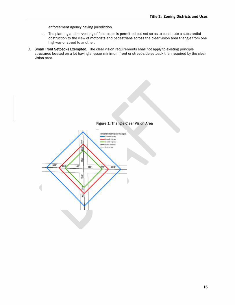
Title 2: Zoning Districts and Uses
16
enforcement agency having jurisdiction.
d. The planting and harvesting of field crops is permitted but not so as to constitute a substantial
obstruction to the view of motorists and pedestrians across the clear vision area triangle from one
highway or street to another.
D. Small Front Setbacks Exempted. The clear vision requirements shall not apply to existing principle
structures located on a lot having a lesser minimum front or street-side setback than required by the clear
vision area.
Figure 1: Triangle Clear Vision Area
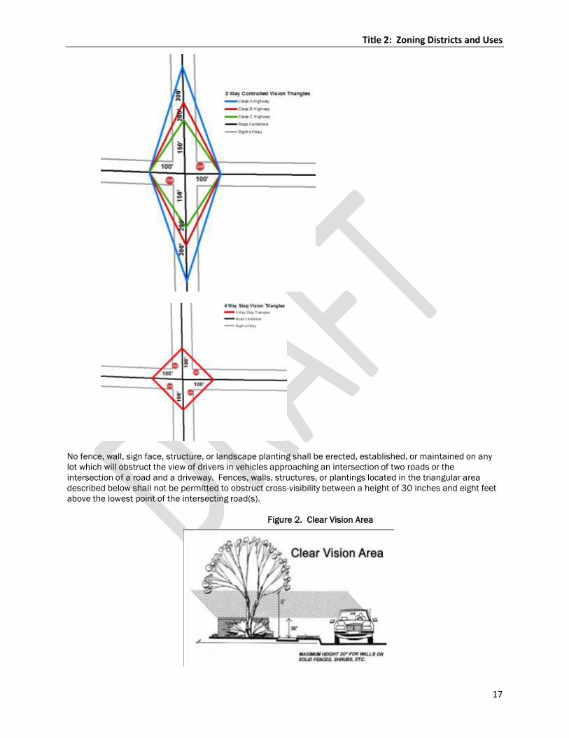
Title 2: Zoning Districts and Uses
17
No fence, wall, sign face, structure, or landscape planting shall be erected, established, or maintained on any
lot which will obstruct the view of drivers in vehicles approaching an intersection of two roads or the
intersection of a road and a driveway. Fences, walls, structures, or plantings located in the triangular area
described below shall not be permitted to obstruct cross-visibility between a height of 30 inches and eight feet
above the lowest point of the intersecting road(s).
Figure 2. Clear Vision Area
Title 2: Zoning Districts and Uses
18
Section 17.202.10 STRUCTURES PERMITTED WITHIN SETBACK LINES
A. The following structures shall be permitted within yard setback areas.
1. Open fences.
2. Petroleum and gas transmission lines, telephone, telegraph, cable television, and power transmission
poles and lines and portable equipment both above and below ground that is readily removable in its
entirety. Additions to and replacement of all such structures may be made, provided the owner will file
with the Zoning Administrator or designee an agreement in writing that the owner will move or remove
all new construction, additions, and replacements erected after the adoption of this chapter at his or
her expense, when necessary to the public interest, i.e. highway construction, airport, sewer and water
lines, etc.
3. Underground structures not capable of being used as foundations for future prohibited over-ground
structures.
4. Access to frontage roads constructed by the public to plans approved by the County Highway
Committee.
5. Signs placed by the public authorities for the guidance or warning of traffic.
Section 17.202.11 FLOOR AREA STANDARDS
Structures used as a dwelling shall provide for each unit the following above ground living area.
A. Single-family dwelling: 800 square feet minimum
B. Hunting/Fishing Shelters: 800 square feet maximum
C. Manufactured single-family homes: 800 square feet minimum
D. Mobile Homes: 800 square feet minimum
1. Mobile home note: This does not supersede or regulate building (i.e. construction) or safety standards
for manufactured homes, as such regulations are preempted from state and local control by the
National Manufactured Housing Construction and Safety Standards Act of 1974 (42 U.S.C.A. 5401).
2. Furthermore, the regulations contained herein are not intended to conflict with and shall comply with
applicable provisions of Wisconsin regulations. Applicable WI Stats. shall preempt any conflicts.
E. Two-family dwelling: Minimum 800 square feet per unit
F. Multi-family apartments: These are minimum square foot requirements and include kitchen and bath
areas but do not include utility, storage rooms, or basement areas.
1. Three-bedroom unit: 1,300 square feet of living area for each unit.
2. Two-bedroom unit: 1,024 square feet of living area for each unit.
3. One-bedroom unit: 800 square feet of living area for each unit.
4. One room efficiency: 585 square feet of living area for each unit.
4.
Chapter 17.203 Permitted Uses by District
Section 17.203.01 PERMITTED USES AND CONDITIONAL USES
In order to avoid intrusion of undesirable uses and to foster all possible benefits for a continued high quality
environment, all residential and non-residential land and structure uses have been classified into permitted
uses and uses allowed by conditional use permit. Permitted uses include those which require a minimum of
limitation and are therefore permitted anywhere within a zoning district. Conditional uses may be appropriate at
some, but not all, locations within a zoning district and are subject to a discretionary decision process. See
Chapter 17.805 (Conditional Land Use Review) for review and decision procedures for conditional use permits.
Title 2: Zoning Districts and Uses
19
At the expense of the applicant, additional reports, studies, and documentation may be required by the
Zoning Administrator, Board of Adjustment, and/or Committee to insure public health, safety, general welfare;
and to promote orderly, efficient, and appropriate development of land in Marathon County.
Section 17.203.02 ADOPTION OF NORTH AMERICAN INDUSTRIAL CLASSIFICATION SYSTEM (NAICS)
In listing uses for zoning districts, this chapter employs a terminology found in the North American Industrial
Classification System (NAICS); standard used by Federal statistical agencies. NAICS was developed under the
auspices of the Office of Management and Budget, and adopted in 1997 to replace the Standard Industrial
Classification (SIC) system. See: http://www.census.gov/eos/www/naics/index.html for detailed descriptions
of all of the NAICS categories.
Reference shall be made to the NAICS manual as a source of definitions of these terms.
Section 17.203.03 PROHIBITED USES AND USES NOT EXPRESSLY PERMITTED
No building shall be erected, converted, enlarged, reconstructed, or structurally altered, nor shall any building
or land with public and/or privately developed improvements be used, arranged to be used, or designed to be
used, in a manner which does not comply with all of the district provisions established by these regulations for
the districts in which the building or land is located.
A. Uses which do not appear in the Zoning Ordinance by virtue of their omission from all permitted use lists, all
conditionally permitted use lists, all accessory use lists, and all other use lists are prohibited.
B. A prohibited use may become a permitted use if the Committee approves an amendment incorporating the
prohibited use into appropriate use lists for appropriate zoning district(s).
C. A prohibited use may become a permitted use if the Committee determines the use should be a permitted
use in an appropriate zoning district because it is substantially similar in character to specifically permitted
use in such district.
D. Uses for enterprises or purposes that are contrary to federal, state, or local laws or ordinances are
prohibited.
Section 17.203.04 MULTIPLE USES
A use may be combined with any other use(s) permitted in the zoning district provided that the regulations for
each use are maintained.
Section 17.203.05 TABLE OF PERMITTED USES
The following Table 3 lists the uses that may be permitted in each zoning district, provided that the
development also meets the design and building standards set forth for each district, along with all other
development standards contained in this Ordinance. For instance, when a certain use, is or may be, permitted
in more than one zoning district, each zoning district will have different standards for building bulk, location,
and design. The customized design standards set forth in each zoning district are tailored to the existing and
intended character of each zoning district, and are further intended to prevent inappropriate development from
occurring within the county.
A. Uses Permitted in Each District. Table 3 lists the permitted uses in each district. Refer to Chapter 17.203
for definitions of all uses listed in the following Table 3.
B. Development Standards Applicable to Uses. Whenever a specific development standard is
included for a particular use in Table 3, any development must comply with the requirements
of the referenced section. All development standards are listed in Chapter 17.204.

Title 2: Zoning Districts and Uses
20
C. Special Purpose Zoning Districts Not Listed in Table 3. Refer to Table 3 for the uses and
development standards applicable in the special purpose zoning districts. Special purpose
zoning districts are not listed in Table 3, and include the, Manufactured/Mobile Home Park
District, Highway Corridor and Interchange Overlay, Wellhead Protection Overlay, and Airport
Approach Protection Overly. Refer to Title 3.
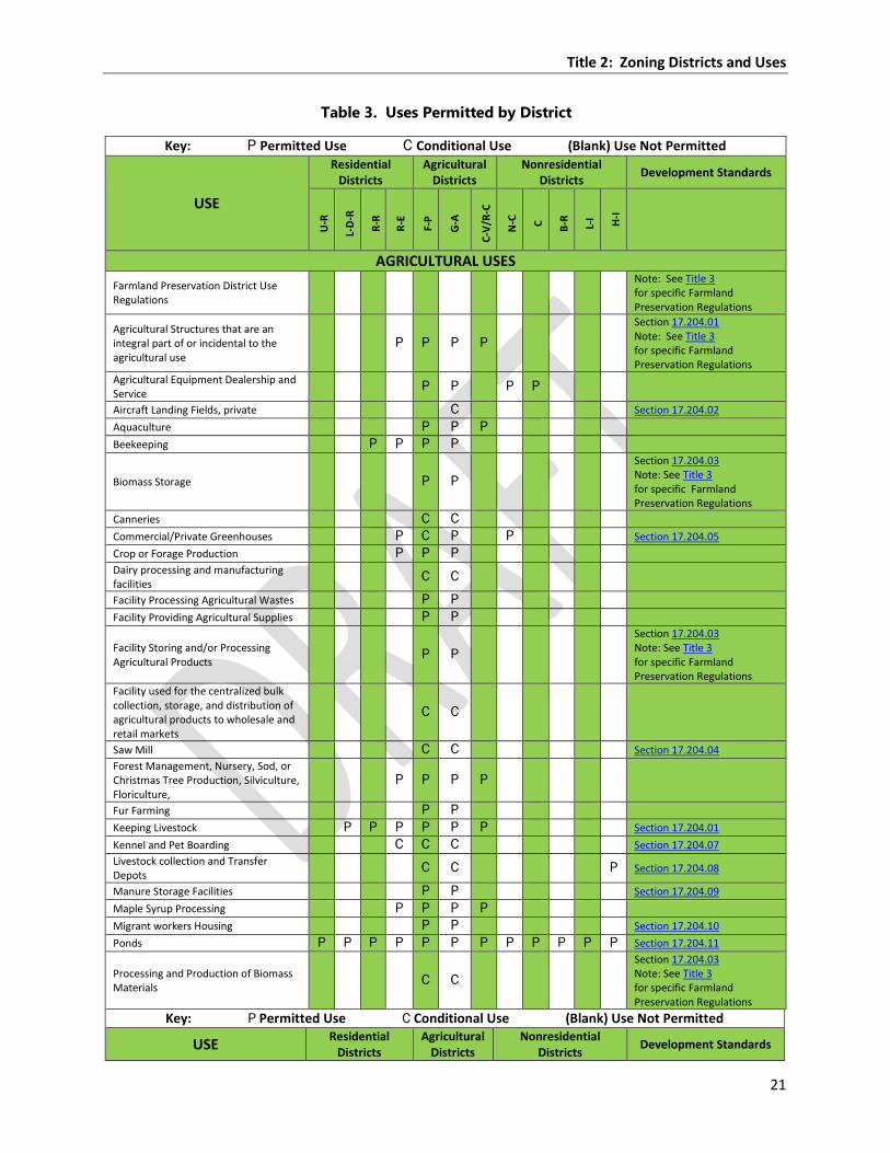
Title 2: Zoning Districts and Uses
21
Table 3. Uses Permitted by District
Key: P Permitted Use C Conditional Use (Blank) Use Not Permitted
USE
Residential Districts
Agricultural Districts
Nonresidential Districts
Development Standards
U-R
L-D
-R
R-R
R-E
F-P
G-A
C-V
/R-C
N-C
C
B-R
L-I H-I
AGRICULTURAL USES
Farmland Preservation District Use Regulations
Note: See Title 3 for specific Farmland Preservation Regulations
Agricultural Structures that are an integral part of or incidental to the agricultural use
P P P P
Section 17.204.01 Note: See Title 3 for specific Farmland Preservation Regulations
Agricultural Equipment Dealership and Service
P P P P
Aircraft Landing Fields, private C Section 17.204.02
Aquaculture P P P
Beekeeping P P P P
Biomass Storage P P
Section 17.204.03 Note: See Title 3 for specific Farmland Preservation Regulations
Canneries C C
Commercial/Private Greenhouses P C P P Section 17.204.05
Crop or Forage Production P P P
Dairy processing and manufacturing facilities
C C
Facility Processing Agricultural Wastes P P
Facility Providing Agricultural Supplies P P
Facility Storing and/or Processing Agricultural Products
P P
Section 17.204.03 Note: See Title 3 for specific Farmland Preservation Regulations
Facility used for the centralized bulk collection, storage, and distribution of agricultural products to wholesale and retail markets
C C
Saw Mill C C Section 17.204.04
Forest Management, Nursery, Sod, or Christmas Tree Production, Silviculture, Floriculture,
P P P P
Fur Farming P P
Keeping Livestock P P P P P P Section 17.204.01
Kennel and Pet Boarding C C C Section 17.204.07
Livestock collection and Transfer Depots
C C P Section 17.204.08
Manure Storage Facilities P P Section 17.204.09
Maple Syrup Processing P P P P
Migrant workers Housing P P Section 17.204.10
Ponds P P P P P P P P P P P P Section 17.204.11
Processing and Production of Biomass Materials
C C
Section 17.204.03 Note: See Title 3 for specific Farmland Preservation Regulations
Key: P Permitted Use C Conditional Use (Blank) Use Not Permitted
USE Residential
Districts Agricultural
Districts Nonresidential
Districts Development Standards
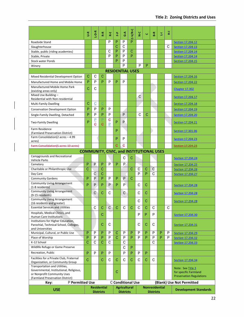
Title 2: Zoning Districts and Uses
22
U-R
L-D
-R
R-R
R-E
F-P
G-A
C-V
/R-C
N-C
C
B-R
L-I H-I
Roadside Stand P P P P Section 17.204.12
Slaughterhouse C C C Section 17.204.13
Stable, public (riding academies) C P P C Section 17.204.14
Stable, Private P P P P Section 17.204.14
Stock water Ponds P P Section 17.204.15
Winery P P P
RESIDENTIAL USES Mixed Residential Development Option C C C Section 17.204.16
Manufactured Home and Mobile Home P P P P P P Section 17.204.22
Manufactured Mobile Home Park (existing areas only)
C C Chapter 17.302
Mixed Use Building – Residential with Non-residential
C Section 17.204.17
Multi-Family Dwelling C C C Section 17.204.18
Conservation Development Option P P P P Section 17.204.19
Single-Family Dwelling, Detached P P P P P C C Section 17.204.20
Two-Family Dwelling P P
C
P
C
C
P P P Section 17.204.21
Farm Residence (Farmland Preservation District)
P Section 17.301.06
Farm Consolidation(2 acres – 4.99 acres)
P P Section 17.204.23
Farm Consolidation(5 acres-10 acres) C C Section 17.204.23
COMMUNITY, CIVIC, and INSTITUTIONAL USES Campgrounds and Recreational Vehicle Parks
C C Section 17.204.24
Cemetery P P P P P P Section 17.204.25
Charitable or Philanthropic Use C C C C C C Section 17.204.26
Day Care C C P P C Section 17.204.27
Community Gardens P P P P P P C
Community Living Arrangement (1-8 residents)
P P P P P P C C Section 17.204.28
Community Living Arrangement (9-15 residents)
C C C C C C Section 17.204.28
Community Living Arrangement (16 residents and greater)
C C Section 17.204.28
Essential Services and Utilities C C C C C C C C C C Hospitals, Medical Clinics, and Human Care Institutions
C P P P Section 17.204.30
Institutions for Higher Education, Parochial, Technical School, Colleges, and Universities
C C C C C Section 17.204.31
Municipal, Cultural, or Public Use P P P P C P P P P P P P Section 17.204.29
Place of Worship P P P P C P P P P P P P Section 17.204.32
K-12 School C C C C C C Section 17.204.33
Wildlife Refuge or Game Preserve C P Recreation, Public P P P P P P P P Facilities for a Private Club, Fraternal Organization, or Community Group
C C C C C C C C C Section 17.204.34
Transportation and Utilities, Governmental, Institutional, Religious, or Nonprofit Community Uses (Farmland Preservation District)
C Note: See Title 3 for specific Farmland Preservation Regulations
Key: P Permitted Use C Conditional Use (Blank) Use Not Permitted
USE Residential
Districts Agricultural
Districts Nonresidential
Districts Development Standards
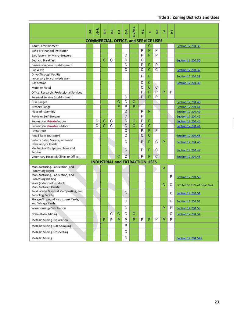
Title 2: Zoning Districts and Uses
23
U-R
L-D
-R
R-R
R-E
F-P
G-A
C-V
/R-C
N-C
C
B-R
L-I
H-I
COMMERCIAL, OFFICE, and SERVICE USES Adult Entertainment C Section 17.204.35
Bank or Financial Institution P P P
Bar, Tavern, or Micro-Brewery C P P P
Bed and Breakfast C C C C Section 17.204.36
Business Service Establishment C P P P
Car Wash C C C C Section 17.204.37
Drive-Through Facility (accessory to a principle use)
P P Section 17.204.38
Gas Station C C Section 17.204.39
Motel or Hotel C C C
Office, Research, Professional Services P P P P P
Personal Service Establishment C P P P
Gun Ranges C C C Section 17.204.40
Archery Range P P P Section 17.204.41 Place of Assembly C P P Section 17.204.49
Public or Self-Storage C P Section 17.204.42
Recreation, Private Indoor C C C C C P P Section 17.204.43
Recreation, Private Outdoor C C C C C C C Section 17.204.44
Restaurant C P P P
Retail Sales (outdoor) C C C Section 17.204.45
Vehicle Sales, Service, or Rental (New and/or Used)
C P P C P Section 17.204.46
Mechanical Equipment Sales and Service
C P P C Section 17.204.47
Veterinary Hospital, Clinic, or Office C C P P C Section 17.204.48
INDUSTRIAL and EXTRACTION USES Manufacturing, Fabrication, and Processing (light) P
Manufacturing, Fabrication, and Processing (heavy) P Section 17.204.50
Sales (indoor) of Products Manufactured Onsite C C Limited to 15% of floor area
Solid Waste Disposal, Composting, and Recycling Facility C C Section 17.204.51
Storage/Impound Yards, Junk Yards, and Salvage Yards C C Section 17.204.52
Warehousing/Distribution C P P Section 17.204.53
Nonmetallic Mining C C C C C Section 17.204.54
Metallic Mining Exploration P P P P P P P P P P Metallic Mining Bulk Sampling P
Metallic Mining Prospecting C
Metallic Mining C Section 17.204.545
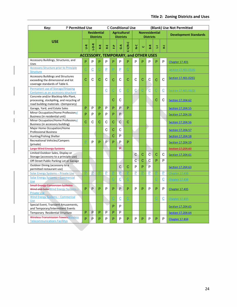
Title 2: Zoning Districts and Uses
24
Key: P Permitted Use C Conditional Use (Blank) Use Not Permitted
USE
Residential Districts
Agricultural Districts
Nonresidential Districts
Development Standards
U-R
L-D
-R
R-R
R-E
F-P
G-A
C-V
/R-C
N-C
C
B-R
L-I
H-I
ACCESSORY, TEMPORARY, and OTHER USES Accessory Buildings, Structures, and Uses
P P P P P P P P P P P P Chapter 17.401
Accessory Structure prior to Principle Structure
C C C P P P C Section 17.401.01(A)
Accessory Buildings and Structures exceeding the dimensional and lot coverage standards of Table 6.
C C C C C C C C C C C C Section 17.401.02(E)
Permanent use of Storage/Shipping Containers as an accessory structure
C C C C C C C C C Section 17.401.01(D)
Concrete and/or Blacktop Mix Plant, processing, stockpiling, and recycling of road building materials –(temporary)
C C C C Section 17.204.62
Garage, Yard, and Estate Sales P P P P P P P Section 17.204.55
Minor Occupation/Home Professional Business (in residential unit)
P P P P P P Section 17.204.56
Minor Occupation/Home Professional Business (in accessory building)
C C C C C C C Section 17.204.56
Major Home Occupation/Home Professional Business
C C C Section 17.204.57
Hunting/Fishing Shelter C P Section 17.204.58
Recreational Vehicles/Campers (private)
P P P P P P P Section 17.204.59
Large Wind Energy Systems P Section 17.204.60
Limited Outdoor Sales, Display or Storage (accessory to a principle use)
C C C C C Section 17.204.61
Off-Street Public Parking Lot or Garage C C C P P
Outdoor Dining (accessory to a permitted restaurant use)
C C P P P Section 17.204.63
Solar Energy Systems – Private Use P P P P P P P P P P P P Chapter 17.408
Solar Energy Systems – Commercial Use
C C C C C Chapter 17.408
Small Energy Conversion Systems: Wind and SolarWind Energy Systems – Private Use
P P P P P P P P P P P P Chapter 17.405
Wind Energy Systems – Commerical Use
C C C C C Chapter 17.405
Special Event, Transient Amusements, and Temporary/Intermittent Events
P P Section 17.204.65
Temporary Residential Structure P P P P P P Section 17.204.64
Wireless Transmission TowersWireless Telecommunications Facillitys
P P P P P P P P P P P P Chapter 17.404
Title 2: Zoning Districts and Uses
25
Chapter 17.204 Development Standards for Specific Uses
Agricultural Land Uses
Section 17.204.01 AGRICULTURAL BUILDINGS AND USES
A. Minimum General Standards
1. Livestock and Fowl:
a. Shall comply with the Marathon County Animal Waste Storage & Nutrient Management Ordinance,
Livestock Facilities Licensing Ordinance and other applicable Wisconsin Administrative Codes and
County ordinances including dairying, livestock, and poultry animal husbandry.
b. Grazing livestock shall be adequately fenced to ensure proper confinement.
c. Animal units shall comply with NR 243 or as amended from time to time.
2. Animal Confinement Facilities/Livestock Facilities:
a. Such facilities shall be in compliance with the General Code of Ordinances for Marathon County
Chapter 13 Livestock Facilities Licensing Ordinance and Marathon County Animal Waste Storage -
& Nutrient Management Ordinance.
3. Buildings:
a. Animal Lots and structures used for the housing, sheltering, or feeding of livestock shall be
located no less than 100 feet from any lake or stream.
1) Where meeting this setback is impossible or impractical due to location of existing agricultural
facilities, as verified by the Zoning Administrator, new buildings and building additions may be
constructed at a lesser setback provided the new buildings and/or additions secure a
variance through the Board of Adjustment.
b. Buildings housing animals shall be at least 25 feet from any adjoining property line.
B. In the Farmland Preservation District. See Chapter 17.301.
C. In the G-A District Only.
1. General farming:
a. Permitted agricultural activities such as crop or forage production, nurseries, sod, or Christmas
tree production, silviculture, maple syrup production, floriculture, aquaculture, fur farming, forest
management, non-commercial greenhouses, beekeeping, vegetable warehouses, seasonal sale of
seed and fertilizer, and other similar enterprises or uses,
b. Farms may not be operated for the disposal or reduction of garbage, sewage, rubbish, or offal;
2. Livestock:
a. Animal Unit Density: No maximum animal unit per acre.
b. Where 500 or more animal units are proposed the rules contained in the Marathon County
Livestock Facilities Licensing Ordinance, Chapter 13, shall apply.
3. Agricultural related Uses:
a. The following activity, facility, or use whether located on or off a farm and is considered either a
primary and/or an incidental agricultural related use as determined by the Zoning Administrator
include: agricultural equipment dealership, facility providing agricultural supplies, facility for
storing and/or processing agricultural products, facility for processing agricultural wastes, and by-
product disposal facilities.
D. In the R-E and CV/RC District.
1. Agricultural uses, such as a garden, greenhouse, nursery, and usual farm buildings are subject to the
following restrictions:
a. Raising or breeding of livestock, fowl, or poultry for commercial purposes shall only be permitted
on lots of five acres or more.
b. Animal Unit Density: 0.5 animal units per acre.
Title 2: Zoning Districts and Uses
26
c. The storage or use of manure or any odor or dust producing substance is prohibited within 25 feet
of a property line.
2. Livestock:
a. a. Chickens.s
1) 1) Minimum lot size for housing chickens and fowl is two acres.
b. b. Horses..
1) 1) Minimum of three acres for one horse, and an additional 1½ acres for each
additional horse.
c. c. All other livestock.
1) 1) Minimum lot size for housing all other livestock is three acres.
E. In the R-R District only.
The following animals may be kept for show, breeding, and consumed by the residents/owner of the parcel and
are subject to the following restrictions:
1. Livestock:
a. Horses..
1) Minimum of three acres for one horse, and an additional 1½ acres for each additional horse.
b. Chickens & fowl, excluding peacocks.
1) Minimum lot size for housing chickens & fowl, excluding peacocks is 2 acres.
2) Maximum total of 12 chickens/fowl. Hens only; no roosters.
3) Chickens/fowl must be kept in an enclosure at all times. The enclosure includes the covered
structure(s) and fenced area. The enclosure shall be a minimum of 25 feet from any side or
rear lot line and completely in the rear yard of the home. Setback shall be measured from
fencing and structure.
4) If the structure is over 100 square feet a zoning permit is required.
5) The fenced enclosure and covered structure shall be maintained and kept in a sanitary
condition so as not to create a nuisance.
c. All other livestock.
1) Minimum lot size for housing all other livestock is 3 acres.
2) Animal Unit Density: 0.25 animal units per acre.
F. In the L-D-R District.
1. Livestock, (except see F (2) and horses shall not be permitted.
2. Chickens.
a. Minimum Lot size for housing chickens is two acres.
b. Maximum of 12 chickens. Hens only; no roosters.
c. Chickens must be kept in an enclosure at all times. The enclosure includes the covered
structure(s) and fenced area. The enclosure shall be a minimum of 25 feet from any side or rear
lot line and completely in the rear yard of the home. Setback shall be measured from fencing and
structure.
G. In the U-R District.
1. Livestock, horses, and chickens shall not be permitted.
Title 2: Zoning Districts and Uses
27
Section 17.204.02 AIRCRAFT LANDING FIELDS, PRIVATE
Private aircraft landing fields are air transportation facilities for the purpose of providing takeoff, landing,
storage, and maintenance of private aircraft including ultralight aircraft and private helicopters may be
permitted provided the following requirements are met:
A. Minimum Site Area. The site area is not less than 20 acres.
B. Building Setback. All buildings and storage areas shall be located a minimum 100 feet from all lot lines.
1. All runway and landing areas shall be located to provide for the safe operation of the facility and to
prevent hazards to surrounding property.
2. Approval of the Federal Aviation Association (FAA).
Section 17.204.03 BIOMASS STORAGE, PROCESSING AND PRODUCTION
The storage, processing, and production of biomass product may be permitted provided the following
requirements are met:
A. Screening. The storage, processing, and production area shall be fully screened from view of any
residential district.
B. Setback. All biomass activities shall be 500 feet from any residence other than the owner’s.
C. Noise and Odor. Such activity shall be conducted so as not to be detrimental to any person, property or the
general welfare by reason of excessive noise or odor.
D. Brine Processing. Brine processing may not be permitted.
Section 17.204.04 SAWMILL
Sawmills. Shall be located a minimum of 500 feet from a residence other than the owner’s.
Section 17.204.05 COMMERCIAL/PRIVATE GREENHOUSE
A. Commercial:
1. Shall not be located within 100 feet of any boundary of a residential lot other than that of the owner or
lessee of such greenhouse.
B. Private:
1. Shall be treated as an accessory structure.
Section 17.204.06 LAND SPREADING OF MUNICIPAL SEWAGE SLUDGE
A. Land spreading of municipal sewage sludge when done in accordance with, and subject to, the conditions
contained in a permit from the Department of Natural Resources issued pursuant to Wisconsin
Administrative Code NR 204 and any Marathon County Nutrient Management Plan.
Section 17.204.07 KENNEL AND PET BOARDING FACILITY
A. Kennel. The boarding, breeding, raising, grooming, or training of seven or more dogs over six months of
age either:
1. Not owned by the owner or occupant of the premises, or
2. For commercial gain may be permitted, and shall conform to section 17.204.07(B)
Title 2: Zoning Districts and Uses
28
B. Pet Boarding Facility. A pet boarding facility, sometimes referred to as “doggie day care,” is a business for
the temporary boarding and care of common household pets generally during daytime hours, but in some
cases including overnight boarding. Pet boarding facilities may provide related services such as grooming
or training, but no animals may be bred or sold at a pet boarding facility unless the pet boarding facility is
accessory to a principle retail use. Kennel and pet boarding facilities are subject to the following
requirements:
1. Minimum Site Area. Such activity shall be permitted only on a parcel of land not less than five acres in
area.
2. Enclosures. All animals shall be kept in pens or cages designed, constructed, and maintained so as to
be harmonious and appropriate in appearance with the character of the general area in which located,
and such use will not affect the character of the same area in a negative way.
3. Enclosure Setbacks. All pens or cages shall be located not less than 100 feet from any property line
and all animals shall be kept therein or within a building. No animal shall be allowed to run at large.
4. Noise and Odor. Such activity shall be conducted so as not to be detrimental to any person, property,
or the general welfare by reason of excessive noise or odor.
5. Nuisance Prohibited. The keeping of the animals described in this subsection shall not constitute a
nuisance to persons living in the surrounding area. Upon receipt of a written complaint filed by a
neighbor with the County stating the animals constitute a nuisance, the Board of Adjustment shall hold
a hearing with notice to all property owners within 300 feet of the property where the animals are
kept. The Board of Adjustment shall determine if, in fact, the animals do constitute a nuisance.
If the Board of Adjustment determines that the animals have and will likely continue to constitute a
nuisance, the animals shall not be kept on the property after the date set by the Board of Adjustment.
If, in the opinion of the Board of Adjustment, there is reason to believe that reasonable measures will
be taken to alleviate the nuisance associated with the animals, the Board of Adjustment may issue a
permit, renewable yearly, for the keeping of such animals with or without restrictions. If a hearing is
held and a determination is made, the matter may not be reviewed again on a complaint of a neighbor
unless there has been a change of circumstances.
6. No person shall allow animals under such person’s control or ownership to constitute a nuisance.
Notwithstanding anything to the contrary in this ordinance, this subsection shall not be a limitation on,
any other County ordinance pertaining to animals, and the enforcement of it.
7. Wastewater. A wastewater treatment system may require review and approval by the Department of
Natural Resources and Department of Safety & Professional Services.
8. On-site vehicular circulation shall be configured to accommodate vehicles within the boundaries of the
site. In no case shall vehicles awaiting drop-off or pick-up of a pet be allowed to encroach onto a public
or private street.
9. Overnight stay. Any pets being boarded overnight shall be confined within the building from the hours
of 10:00 p.m. until 7:00 a.m.
10. Facilities shall be constructed, maintained, and operated so that the sounds and smell of animals
cannot be discerned outside of the building. Outdoor runs shall be maintained so that no odors are
discernable from adjacent properties.
11. Outdoor runs where pets will be permitted either on or off-leash shall be set back a minimum of 100
feet from any adjacent residentially zoned or used land. The 100 foot setback notwithstanding,
outdoor runs shall be located as far as practicable from any adjacent residential zoning district. Any
outdoor runs where pets will be permitted off-leash shall be surrounded by a minimum 54-inch, (4 ½
feet), tall fence. If the fence will be visible from any adjacent residential district or road right-of-way,
the fence shall be decorative in nature, determined by the Zoning Administrator.
12. The Zoning Administrator and/or Board of Adjustment may require a landscaped buffer or solid wall to
be provided between the outdoor run and any adjacent district if the location proposed outdoor run
could negatively impact adjacent land.
Title 2: Zoning Districts and Uses
29
Section 17.204.08 LIVESTOCK COLLECTION AND TRANSFER DEPOTS
A. Setbacks. Shall be located not less than 300 feet from a residential district.
B. On-site vehicular circulation shall be configured to accommodate vehicles within the boundaries of the
site. In no case shall vehicles awaiting drop-off or pick-up of livestock be allowed to encroach onto a public
or private street.
Section 17.204.09 ANIMAL WASTE STORAGE FACILITIES
Animal waste storage facilities shall adhere to Marathon County Animal Waste Storage and Nutrient
Management Code, Chapter 11.02 guidelines or any other applicable agency requirements.
Section 17.204.10 MIGRANT LABOR CAMP
Migrant Labor camps shall be certified under Wisconsin Statute 103.92.
A. Migrant labor camp shall be an accessory use to an active principle use, under the same ownership.
Section 17.204.11 PONDS
A. Slope. The slope from the shoreline shall be no greater than three feet horizontal to one foot vertical to a
water depth of six feet.
B. Setbacks:
1. New pPonds shall be located a minimum of 30 feet from any property boundary or road right-of-way
and/or 63ft from the centerline; whichever distance is greater line when
constructed/excavated/expanded. and no property line shall be established/created within 30 feet of
an existing pond.
2. Ponds shall be located 50 feet from any drain field and 25 feet from a septic or holding tank.
3. Reduction of setback is allowed to the minimum principlePonds shall be located in accordance with
the minimum side and rear yard setbacks required in the district of which it is located shown in Table
2. if Tthe lands shall slopes away from the required reduced setbacks and any overflow devices are
shall be directed in the opposite direction as the reduced required setback(s). All new pond
construction excavation, and/or expansion shall not result in the flow of, pooling, or diversion of water
onto other properties without prior permission or authorization.
4. An agreement must be signed whereby all owners of the properties acknowledge that a pond crosses
property lines, and said agreement shall be recorded for each of the affected property records at the
Register of Deeds.
C. Dams, dikes, or berms:
1. Earthen dams or dikes greater than six feet high shall be designed, or the design shall be approved, by
a State licensed engineer or hydrologist to ensure structural integrity.
2. Dams, dikes, or berms must be outside of road right-of-ways and easements.
D. Exempt Activities
1. Ponds that are governed by either a NR340 or a NR135 permit will be exempt from obtaining a pond
permit as long as these permits are in good standing.
Section 17.204.12 ROADSIDE STANDS
Roadside stands shall be used solely by the owner or the tenant of a property on which it is located for the sale
of seasonal agricultural products that are produced on the premises. Roadside stands shall comply with the
following standards:
A. Such stand, sign, and required off-street parking shall be located and set back in such a manner so as not
to create a traffic hazard.
B. Such uses may not encroach into any right-of-way.
Title 2: Zoning Districts and Uses
30
C. One roadside stand per farm, of not more than 300 square feet used solely for the sale of products more
than 50% of which were produced on the premise.
D. Stand to be removed and stored back of the building line on the property at the conclusion of the seasonal
sales.
Section 17.204.13 SLAUGHTERHOUSE
Slaughterhouses may be permitted as a conditional use in the G-A, F-P and H-I Districts provided the following
requirements are met:
A. Slaughterhouses shall be located not less than 1,000 feet from any residential structure other than that of
the owner of the premises, his agent or employee.
B. Trash Containers. There shall be trash containers of sufficient size and capacity to contain any and all
wastes generated by the operation of business.
C. Noise and Odor. Such activity shall be conducted so as not to be detrimental to any person, property, or
the general welfare by reason of excessive noise or odor.
Section 17.204.14 PUBLIC STABLE / RIDING ACADEMY, AND PRIVATE STABLE
A. Public stables, including riding academies, are subject to State Statute 91.01(1) and the following
requirements:
1. Minimum Area. The uses may be permitted on parcels of land that are at least 10 contiguous acres or
more in area.
2. Building Setbacks. The stable shall be so situated on the site so as to be at least 300 feet from any
residences on abutting parcels or lots.
3. Access and Frontage. Ingress and egress to the stable area shall be provided solely through the parcel
in question, which shall abut a public right-of-way.
4. Parking. Adequate off-street parking facilities shall be provided on the site.
5. Manure Management shall adhere to Marathon County Animal Waste Storage and Nutrient
Management Code, Chapter 11.02 or any other applicable agency requirements.
6. Outdoor Lighting. Floodlights or any other source of artificial lighting provided to facilitate night riding
activities shall be properly shielded or directed away from residences or abutting properties, and shall
be turned off nightly no later than 11:00 p.m.
B. Private stables ancillary to a private residence and shall be permitted only for the use of the property
owner, or lessee thereof, and his or her family and/or friends invited to use such animals without payment
of any fee are subject to the following:
1. Minimum Lot Area. A minimum lot area of three acres is required for private stables.
2. Maximum Number of Animals. A minimum of three acres of contiguous land shall be provided for the
first horse, and each additional horse stabled shall require 1½ additional acres of land. The property
shall be under control or use of the permit holder with either title or lease.
3. Outdoor Use Area Locations and Setbacks. Confinement areas and/or stables shall, in all instances, be
located in the rear and/or side yard. Horses shall be confined to fenced pastures, paddocks, or stables
unless harnessed and under the direct control of a person.
4. Building Setbacks. An accessory building used as a stable shall be a minimum of 25 feet from any
property line and a minimum of 50 feet from any dwelling other than the owner’s.
5. Manure management shall adhere to Marathon County Animal Waste Storage and Nutrient
Management Code, Chapter 11.02, or any other applicable agency requirements.
6. Nuisance. In each instance when the Zoning Administrator issues a permit for a private stable, the
Committee shall find that there has been compliance with the conditions of this subsection, that the
activity will not or has not been a nuisance to residents in the area, is compatible with adjacent land
uses, and is consistent with the public health, safety, and welfare of the county.
Title 2: Zoning Districts and Uses
31
Section 17.204.15 STOCKWATER PONDS
Stock water ponds are ponds constructed for the exclusive use of watering livestock. They are eligible for a
reduced application fee if the following requirements are met:
A. Surface Area. The stock water pond surface area is 2,500 square feet or less.
B. Fencing. The stock water pond area must be fenced for livestock.
C. Slope. The slope from the shoreline shall be no greater than three feet horizontal to one foot vertical to a
maximum water depth of six feet.
RESIDENTIAL LAND USES
Section 17.204.16 MIXED RESIDENTIAL DEVELOPMENT OPTION
A. Purpose. To encourage innovation in residential subdivision design, the mixed development option may be
permitted as a conditional use to provide for more efficient layout of lots, streets, and utilities; for the
preservation of open space and recreation areas; and for the provision of a variety of housing options in a
low-density and predominantly single-family setting.
Section 17.204.17 MIXED USE BUILDING – RESIDENTIAL WITH NON-RESIDENTIAL
A. Location of Residential Units. No residential unit may be located on a floor underneath a floor containing a
non-residential use.
B. Permitted Non-residential Uses. Non-residential uses permitted in a mixed use residential with non-
residential building are limited to those that are permitted in the district by Table 3. Uses Permitted by
District. Conditional use approval is required for any use listed as a conditional land use.
Section 17.204.18 MULTI – FAMILY DWELLING
A building used exclusively for residential purposes containing three or more residential dwelling units where
each dwelling unit has its own exterior entrance; is capable of individual use and maintenance without
trespassing on adjoining dwellings; and access, utilities and service facilities are independent for each
dwelling. Multi-family dwellings are subject to the following standards:
A. Proximity to Improved Street. The property shall be within 250 feet of a fully improved public right-of-way
and street.
B. Access Points. Any multi-family dwelling developments with more than 20 units shall have two access
points to the public street.
C. Traffic Control.
1. A traffic impact study shall be provided for any project including 40 or more dwelling units. See Chapter
17.406 for traffic impact study requirements.
2. Traffic control lights shall be provided at private roads or at intersections with primary streets if
warranted by the traffic impact study.
D. Recreation Areas.
1. Passive or active outdoor recreation areas (including but not limited to seating areas, playgrounds,
swimming pools, walking paths, plazas, courtyards, and other recreational elements in accordance
with the intended character of the development) shall be provided at a ratio of at least 5% of the
gross site area of the development. These open space areas are in addition to the area of any
required setbacks yards.
2. The minimum area of each recreation area shall be not less than 1,200 square feet.
Title 2: Zoning Districts and Uses
32
3. The length to width ratio of each area, as measured along the perimeter, shall not exceed 4:1.
4. Such areas shall be centrally and conveniently located to be physically and visibly accessible to
residents, and shall not be located within any required yard setbacks or building separations.
E. Trash. Central facilities for collection and disposal of trash shall be provided, and screened.
F. Sidewalks. Minimum 5-foot wide concrete sidewalks shall be provided to connect parking areas, public
sidewalks, and recreation areas to all building entrances; such sidewalks shall also be provided along
collector roads and streets within the development; and streets adjacent to the development.
G. Density. The maximum density shall not exceed that permitted in the zoning district.
H. Building Design Standards. Apartment buildings shall comply with the following standards:
1. Building Entrances. Each building shall have at least one entrance door on each street-facing façade
to create an appearance that is consistent with a single-family character. Entrances to individual units
may occur off an interior hallway that is accessed via a front door, or may be located on the side or rear
of the building. Interior hallways may also have a secondary entrance on the side or rear of the
building.
I. Parking. On-street parking spaces on interior streets are encouraged and shall count toward the minimum
parking requirement. Parking spaces on streets exterior to the development shall not be counted toward
the minimum parking requirement.
Title 2: Zoning Districts and Uses
33
Section 17.204.19 CONSERVATION DEVELOPMENT OPTION
A. Purpose. Conservation development is an optional form of development that is offered as an alternative to
the regulations of the zoning districts where the open space option is permitted. The purpose of the
conservation development option is to protect and promote the health, safety, and general welfare of the
County, to enhance the visual appearance of residential development, to protect and promote the
character and vista of the rural areas within the County, to prevent unnecessary clutter and congestion
within such developments and the surrounding neighborhoods, to protect environmentally sensitive areas,
and to establish regulations for flexible design alternatives to the requirements of the underlying district to
encourage site design practices that provide for efficient layout of infrastructure and preserve open space
and natural features, while maintaining density control in conformity with the underlying district.
B. Standards to Apply. Where the standards of the open space option and the underlying district differ, the
conservation option development standards shall apply. However, the density under the conservation
option shall not be greater than the maximum density of the underlying district based on the net
developable density of the development.
C. Application. The conservation option may be used at the option of the developer when the proposed
residential development has an area of 10 or more acres.
D. Uses.
1. 1. Permitted Uses. The following uses are permitted in a conservation development.
a. a. Single-family dwelling, detached.
b. b.
Accessory buildings and uses incidental and subordinate to the single-family dwelling use,
excluding any activity conducted as a business.
2. Conditionally Permitted Uses. None.
E. Density. The permitted density in a conservation development shall not exceed the maximum density
permitted in the zoning district per Table 2. Schedule of Regulations, based on net development density.
F. Lot Requirements.
1. Minimum Lot Area. The minimum lot area in a conservation development shall be 70% of the
minimum area required in a conventional development in the underlying zoning district.
2. Minimum Lot Width. The minimum lot width at the building setback line in a conservation development
shall be 70% of the minimum width required in a conventional development in the underlying zoning
district.
3. Minimum Front and Side Street Yard Setback. The minimum front and side street yard setback in a
conservation development shall be 75 feet in the R-R district, 40 feet in the L-D-R district, and 30 feet
in the U-R district.
4. Minimum Interior Side Yard Setback. The minimum interior side yard setback in a conservation
development shall be 10 feet in the R-R district, 8 feet in the R-1 district, and 7 feet in the U-R district.
5. Minimum Rear Yard Setback. The minimum rear yard setback in a conservation development shall be
60 feet in an R-R district and 40 feet in an L-D-R or U-R district.
G. Dwelling Area Requirements. The minimum floor area of a dwelling unit in a conservation development
shall be 1,700 square feet.
H. Maximum Building Height. The maximum building height shall be 35 feet.
I. Minimum Open Space Requirements.
1. Minimum Area Required. An amount of common open space equal to or greater than the area gained
through the reduction of lots below the minimum lot area required in the district shall be provided. For
the purposes of calculating the minimum open space requirement, only lots that are reduced below the
minimum area required in the district shall be included.
Title 2: Zoning Districts and Uses
34
2. Unbuildable Site Conditions. A maximum of 20% of the land dedicated toward the minimum open
space requirement may meet one or more of the unbuildable site conditions listed in the definition of
net developable area. A minimum of 80% of open space lands shall be otherwise buildable, upland
area. Any area planned or designated for stormwater management facilities may not be counted
towards the minimum open space requirement.
2.
3. Access to Open Space Areas. Each open space area shall have frontage on a street to ensure that the
open space land is accessible and visible to all residents of the development. The minimum
contiguous linear frontage each open space area is required to have along a street shall be
determined by dividing the area of open space (in square feet) by 1,500, or 100 feet, whichever is less.
An open space area may have multiple frontages on a street or streets, and secondary frontages may
be of any length provided that one frontage meets the minimum contiguous linear frontage
requirement.
4. Phased Developments. When a subdivision is to be developed in phases, the common area required
to reduce the lot sizes in any particular phase shall be provided in the current phase and/or already
provided in earlier phases.
J. Maintenance, Perpetuation of Open Space, Guarantee of Development. The open space requirement may
be accomplished by providing for the retention of open space in common ownership of the individual
owners within the development through appropriate legal documents, with appropriate provision to assure
continuous maintenance and the use of the common property for the purpose intended. The legal
documents shall place unencumbered title to the common property in a form of common ownership
representing the residents of the development, shall place responsibility for the management and
maintenance of all common property, shall set forth the restrictive covenants, and place responsibility for
the enforcement thereof, and shall provide for the subjection of each lot within the development to
assessment of its proportionate share of maintenance costs of the common property. Such legal
documents shall be filed with the application for approval of the open space requirement and shall be
approved as to form by the County Corporation Counsel. Such legal documents shall be recorded as deeds
or plats are recorded with the County Register of Deeds Office. Or, the open space requirement may be
accomplished by an alternative approach approved by the Committee as part of site plan approval.
Section 17.204.20 SINGLE-FAMILY DWELLING, DETACHED
A. Dwelling. The structure must be in compliance with the Wisconsin Uniform Building Code and Private On-
Site Waste Ordinance.
B. Dwellings in N-C & C districts:
1. Structure must be in compliance with the Wisconsin Uniform Building Code and Private On-Site Waste
Ordinance.
2. Dwelling must be accessory to the business on the property
3. Dwelling is for the owners of the business.
Section 17.204.21 TWO-FAMILY DWELLING
A. Dwelling. Two-family dwelling units may share the same lot. The structure must be in compliance with the
Wisconsin Uniform Building Code and Private On-Site Waste Ordinance.
B. Setback Requirements. Attached single-family dwelling unit buildings shall adhere to zoning district
setbacks Section 17.202.03 E.
C. Individual Entrances Required. All dwelling units shall have entrances that are directly accessible from the
exterior of the building. No unit shall gain access from an interior hallway within a building. The primary
exterior entrance to all units shall face a street with a connection leading from the roadside sidewalk to the
front entrance of the unit. In no case shall a front entrance to a townhouse unit face the rear yard of
another dwelling unit or a service area.
1. Front Porch or Stoop Required.
Each dwelling unit or building subdivision shall have a minimum 30 square feet unenclosed porch or stoop
Title 2: Zoning Districts and Uses
35
.
E. Garages
A. Garages are encouraged to be accessed from side or rear facades, particularly when a parcel has side
street access.
Section 17.204.22 MANUFACTURED HOME AND MOBILE HOME
Manufactured Homes. Manufactured homes shall have a minimum floor area of 800 square feet and
conform to the following standards:
A. A manufactured home used for human habitation must meet the construction standards contained in
Wisconsin Administrative Code Chapter SPS 327.
B. Manufactured home must be constructed in conformance with the federal construction and safety
standards established by the secretary of housing and urban development pursuant to the “Manufactured
Housing Construction and Safety Standards Act of 1974,” 88 Stat. 700, 42 U.S.C.A. 5401, 5403, and that
has a permanent label or tag affixed to it, as specified in 42 U.S.C.A. 5415
C. A manufactured home is considered to be single-family residence and is an allowed use in any zoning
district where single-family dwellings are an allowed principle use provided that:
1. A site plan is submitted with the zoning permit application to the department for review and approval.
The site plan must show the size of the manufactured home, its location on the lot, all yard
measurements, and the location of the septic tank, drain field, and water supply.
2. The manufactured home must be set on an enclosed foundation in accordance with Wisconsin Statute
70.043(1) and Wisconsin Administrative Code Chapter SPS 321, 3. The manufactured home must be
securely anchored to its foundations in accordance with Wisconsin Uniform Dwelling Codes. The
number of tie-downs must conform to the manufacturer’s recommendations, provided that there are
at least four tie-downs.
4. The manufactured home must be installed in accordance with the manufacturer’s instructions and is
properly connected to utilities.
5. The hitch and wheels must be removed.
6. The roof must be double pitched so that there is at least a 3-inch vertical rise for each 12-inches of
horizontal run. The roof must have a minimum 8-inch overhang on each perimeter wall and the
overhang must be architecturally integrated into the design of the dwelling. The roof must be
residential in appearance; must be covered with an approved material, such as wood, asphalt,
composition, fiberglass shingles, or metal.
7. The exterior siding material must be residential in appearance; may consist of clapboards, concrete,
masonry, simulated clapboards such as conventional vinyl or metal siding, stucco, wood, wood shingle
shakes, or a similar material. The exterior siding material must extend to ground level, except that
when a solid concrete or masonry perimeter foundation is used, the siding material need not extend
below the top of the foundation.
Mobile Homes. Mobile homes shall have a minimum floor area of 800 square feet and conform to the
following standards:
A. A mobile home that does not meet the standards of 17.204.22(A-C) may not be located on a lot outside
of an approved and licensed Manufactured/Mobile Home Park, except as permitted under Section
17.204.64 or as otherwise authorized by this ordinance.for more than 12 months unless it meets the
requirements of a permanent dwelling and is taxed accordingly.
The hitch and wheels must be removed.
B.
Skirting. Skirting specifically designed for manufactured homes, or some other material, must
enclose the area between the ground and the bottom of the manufactured home.
C.
Title 2: Zoning Districts and Uses
36
Section 17.204.23 FARM CONSOLIDATION
Farm residences constructed prior to January 1, 2014, and farm structures may be separated from the farm
plot, and not be required to be rezoned, provided that the parcel created conforms to all the following
regulations:
A. Permitted Use.
1. Conforms to all regulations forth in the Rural Residential district.
2. Lot size not to exceed 4.99 acres, and meets the requirements of the General Code of Ordinances for
Marathon County Chapter 18, Land Division and Survey Regulations.
B. Residences constructed after January 1, 2014 would be required to rezone from the Farmland
Preservation or General Agricultural Zoning.

Title 2: Zoning Districts and Uses
37
COMMUNITY, CIVIC, and INSTITUTIONAL USES
Section 17.204.24 CAMPGROUNDS AND RECREATIONAL VEHICLE PARKS
A. Campgrounds. Campgrounds which provide sites for primitive camping, tent camping, and camping trailers
shall not contain a total number of campsites that exceed eight campsites per acre, excluding any acreage
located in the shoreland setback area, floodplain or wetlands. Publicly or privately owned and/or operated
campgrounds, summer camps and group accommodations are subject to the following:
1. Property Line Setback. All structures and activity areas, except off-street parking area, shall be located
at least 100 feet from all property lines.
2. Ingress/Egress Separation. All points of entrance or exit shall be located no closer than 200 feet from
the intersection of two major thoroughfares and/or no closer than 200 feet from the intersection of a
major thoroughfare and a collector street.
3. Natural Buffers Preferred. Site locations should be preferred that offer natural or man-made barriers
that would lessen the effect of intrusion into the area.
4. Accessory Uses. Only retail uses which are customarily accessory or incidental to the main
recreational use shall be permitted as part of the campground. Permitted retail uses are refreshment
stands, souvenir stands, concession stands, park office, and the limited sale of groceries when the
customers are primarily the campers using the park.
5. Minimum Lot Area. A minimum lot area of 20 acres shall be required.
6. Supervision; Nuisance. All activities, programs, and other events shall be adequately and properly
supervised so as to prevent any hazard and to assure against any disturbance or nuisance to
surrounding properties, residents, or to the community in general.
7. State Rules. All campground uses shall comply with applicable state regulations.
B. Recreational Vehicle Parks. Recreational vehicle parks shall comply with the following requirements:
1. Minimum Lot Area. No permit shall be issued for the establishment of a recreational vehicle park
unless such park is situated on a minimum of 20 acres of land.
2. Recreational Vehicle Parks which provide sites for a mixture of recreational vehicles, motor homes,
camping trailers, tent sites, and primitive camping shall not contain a total number of campsites that
exceed 12 camping sites per acre, excluding any acreage located in the shoreland setback area,
floodplain or wetlands.
3. Sites. Each recreational vehicle site or individual campsite shall be no less than 25 feet in width and
40 feet in length.
4. Where the recreational vehicle park fronts on a lake or other water frontage, the frontage width shall
be not less than 500 feet per every 20 acres. The number of campsites and recreational vehicle sites
to be allowed on a body of water shall be determined by the conditional use permit procedure set forth
in this ordinance including but not limited to considering the gross water area, the number of such
sites in a campground or recreational vehicle park, the number of permanent and seasonal residents
on the body of water and the total amount of frontage owned by such other residents, the amount of
frontage for future residential development, and water frontage values. All other applicable provisions
of this ordinance must also be met.
5. A zoning permit is required when the aggregate area of the patios/decks exceeds 200 square feet.
When not connected, or immediately adjacent, to a patio or deck, a six foot wide landing not exceeding
the length of the camping unit is exempt.
6. No more than two manufactured homes shall be permitted in a campground in a temporary or
permanent nature.
Title 2: Zoning Districts and Uses
38
7. Park Model Unit, or Manufactured Home on existing camping spaces shall obtain a zoning permit prior
to placement and shall meet all Shoreland, yard, and street setbacks and be provided with a state
approved method for sewage disposal when intended for human habitation.
8. Subleasing of campsites or recreational vehicles, motor homes, and camping trailers located in
campgrounds and recreational vehicle parks is strictly prohibited.
9. An earth tone colored storage shed up to 48 square feet shall be permitted at an individual campsite.
10. Structures commonly associated with a campsite such as fire rings, picnic tables, grills, and necessary
utility hook-ups shall be permitted at an individual campsite.
11. A three season room up to 400 square feet with no bedroom or bathroom attached to the recreational
vehicle shall be permitted at an individual campsite.
C. Recreational Vehicle Park Setbacks. The following minimum setback regulations shall apply:
1. No building, structure, camp site, or recreational vehicle site shall be located within 200 feet of
adjacent property lines when the adjacent property is zoned single or multi-family residential districts.
For all other use districts, the minimum distance shall be 100 feet. No building, structure, campsite, or
recreational vehicle shall be closer than 75 feet to any state, county, or town highway or road or
arterial street or roadway right-of-way.
2. Recreational vehicles or tents shall not be located so close to the traveled portion of any streets or
roadway within such park as to create a safety hazard.
3. No part of any recreational vehicle or tent, or any addition or appurtenance thereto, shall be placed
within 10 feet of any other recreational vehicle or tent, or addition or appurtenance thereto, nor within
50 feet of any accessory/service building or structure.
D. Height. No building, structure, or recreational vehicle located in a campground and recreational vehicle
park shall exceed two stories or 25 feet in height.
E. Parking. There shall be at least one off-street parking space available for each individual camp site or
recreational vehicle site which shall be located within 100 feet of such site. However, the total number of
parking spaces provided in each campground and recreational vehicle park shall be equal to no less than
1-1/3 times the maximum number of sites which can be located in compliance with this ordinance.
F. Landscaping. Within a 50 foot peripheral setback area along each property line of such a park, designated
screen fencing or landscape planting shall be placed so as to be 50% or more opaque between the heights
of two feet and eight feet from the average ground elevation when viewed from any point along each
property line and not to encroach on the clear vision area.
G. Design and Improvement. The design and improvements provided in such proposed parks, including
street widths and construction of approach streets or ways, shall conform to the requirements of the
Marathon County Subdivision Regulations. However, the street widths and construction requirements in
the Subdivision Regulations shall be applied only to those streets which would be necessary to service a
future conventional residential subdivision on such tract of land and need not be applied to secondary
mobile home site access streets or ways unless the Zoning Administrator or Board of Adjustment
determines certain requirements are necessary for ingress and egress of public emergency or service
vehicles.
H. Common Space. Each park shall provide at least three acres of common space, exclusive of the required
50 foot peripheral setback area in which common recreational or service facilities can be located. An
additional 200 square feet of common space shall be provided for each campground or recreational
vehicle in excess of 160 located within such park. Any such common space shall be reasonably compact in
area so as to be usable and shall be located on well-drained land which is not subject to periodic flooding
or lengthy periods of wet conditions.
I. Exception, Special Event Campground. A campground designed, maintained, intended or used for the
purpose of providing sites for non-permanent overnight use of camping units at a special event, as those
terms are defined in ATCP 79, the operator of which special event campground has applied for and
obtained a permit under ATCP79 shall not be required to meet the requirements of this section during the
period of the special event, subject to the condition that the remaining provisions of Chapter 17.204.65,
Marathon County are otherwise met.
Title 2: Zoning Districts and Uses
39
Section 17.204.25 CEMETERIES
Cemeteries are permitted in the U-R, L-D-R, R-R, R-E, G-A, and F-P districts and are subject to the requirements
of WI Stats. Chapter 157, Disposition of Human Remains, Subchapter II, Cemeteries.
A. General. The area proposed for a cemetery shall be used for cemetery purposes only, and shall comply
with the following requirements:
1. Ingress/Egress Separation. All points of entrance or exit shall be located no closer than 200 feet from
the intersection of two arterial streets; and/or no closer than 200 feet from the intersection of an
arterial street and a collector street.
2. Lot Area. The minimum lot area required for a cemetery site shall be 20 acres.
3. Parking. Sufficient parking space shall be provided as to not deter traffic flow within the cemetery.
4. Signs. Only signs designating entrances, exits, traffic direction, and titles shall be permitted, and must
be approved by the Zoning Administrator.
5. Landscape Buffer. Adequate screening with shrubs, trees, or compact hedges shall be provided
parallel to property lines adjacent to or abutting residential dwellings; such shrubs, trees, and hedges
shall not be less than two feet in height and shall be maintained in good condition.
Section 17.204.26 CHARITABLE OR PHILANTHROPIC ORGANIZATIONS
All activities, programs and other events by quasi-public institutionally or organizationally owned and/or
operated recreational, instructional, and meeting facilities shall be adequately and properly supervised so as to
prevent any hazard and to assure against any disturbance or nuisance to surrounding properties, residents, or
to the community in general.
Section 17.204.27 DAY CARE USES
Child Day Care
The care of less than four children shall not be regulated under this Chapter. The following day care uses
include the following types of facilities: Type A - Day-Care Home (four to eight children); Type B - Day Care Home
(nine to 15 children); and Type C - Group Day Care Center (nine or more children). These day care facilities shall
comply with the following requirements:
A. Type A – Day Care Home (four to eight children)
Occupied residences in which a qualified person(s) provide child care for four to eight children. Refer to
Wisconsin Statute 66.1017(1) (a). These shall not be considered “Home Occupations” for the purpose of
the Chapter.
B. Type B – Day Care Home (nine to 15 children)
Occupied residences in which a qualified person(s) provide child care for nine to 15 children. Refer to
Wisconsin Statute 48.65. These shall not be considered “Home Occupations” for the purpose of the
Chapter.
C. Type C – Group Day Care Center (nine or more children)
Group day care centers provide child care services for nine or more children by qualified persons. Group
day care facilities may include nursery schools and day care centers; however, shall not be located within a
residential unit. Group day care facilities may be operated on a profit or not-for-profit basis in conjunction
with another principle use such as a church, school, business, and civic organization.
Adult Day Care
The care of less than three non-related people receiving care from a non-family member in the same structure
shall not be regulated under this Chapter, but considered a home occupation. The following day care uses
include the following types of facilities:
A. Adult Day Care Center
Care provided for part of a day, e.g. / less than 24 hours, in a group facility for adults.
B. Family Adult Day Center
Care provided for part of a day for small groups of no more than six adults in the home of a provider.

Title 2: Zoning Districts and Uses
40
Section 17.204.28 COMMUNITY LIVING ARRANGEMENTS
Community living arrangement land uses include all facilities provided for in 46.02(22), WI Stats., including
child welfare agencies, group homes for children, and community based residential facilities. Community living
arrangements do not include day care centers, nursing homes, general hospitals, special hospitals, and
prisons or jails. Community living arrangement facilities are regulated depending upon their capacity per the
requirements established in 60.63, WI Stats.
A. Community Living Arrangement (1 to 8 residents)
Community living arrangements with a capacity for eight or fewer, shall be subject to the limitations set
forth in WI Stats. 59.69(15) and 60.63.
1. The total capacity of all community living arrangements shall not exceed 1% of a Town’s population
unless specifically authorized by the Town Board following a public hearing.
B. Community Living Arrangement (9 to 15 residents)
Community living arrangements with a capacity for eight or fewer, shall be subject to the limitations set
forth in WI Stats. 59.69(15) and 60.63.
1. The total capacity of all community living arrangements shall not exceed 1% of a Town’s population
unless specifically authorized by the Town Board following a public hearing.
C. Community Living Arrangement (15 residents and greater)
Community living arrangements with a capacity for 15 residents and greater, shall be subject to the
limitations set forth in WI Stats. 60.63.
1. No community living arrangement shall be established within 2,000 feet of any other such facility
regardless of its capacity.
2. The total capacity of all community living arrangements shall not exceed 1% of a Town’s population
unless specifically authorized by the Town Board following a public hearing.
Section 17.204.29 CULTURAL, MUNICIPAL OR PUBLIC USE
A. Government building(s) located in any District shall comply with the following requirements:
1. Ingress/Egress Separation. All points of entrance or exit shall be located no closer than 200 feet from
the intersection of two major thoroughfares and/or no closer than 200 feet from the intersection of a
major thoroughfare and a collector street.
2. Thoroughfares. Such developments shall be located on arterial streets, at intersections of arterial or
collector streets, or on service roads for interstates.
3. Minimum Lot Area. The minimum lot area shall be 1½ acres.
Section 17.204.30 HOSPITALS, MEDICAL CLINICS, AND HUMAN CARE INSTITUTIONS
Institutions for human medical care, hospitals, sanitariums, convalescent homes, nursing homes, homes for the
aged, and philanthropic institutions are subject to the following:
A. Property Line Setbacks. All structures and activity areas, except off-street parking area, shall be located at
least 100 feet from any property line.
B. Minimum Lot Area. The minimum lot area shall be at least 3 acres.
C. Ingress/Egress Separation. All points of entrance or exit shall be located no closer than 100 feet from the
intersection of two major thoroughfares and/or no closer than 100 feet from the intersection of a major
thoroughfare and a collector street.
D. Thoroughfares. Such developments shall be located on major thoroughfares, at intersections of major
and/or collector streets, or on service roads for major thoroughfares
Title 2: Zoning Districts and Uses
41
Section 17.204.31 INSTITUTION FOR HIGHER EDUCATION, PAROCHIAL, TECHNICAL SCHOOL, COLLEGES, AND UNIVERSITIES
A. Thoroughfare. In all districts where institutions for higher education are permitted as conditional uses
such facilities shall be located on major thoroughfares, at intersections of major collector streets or on
service roads of major thoroughfares.
B. Residential Districts. Where permitted in residential districts, such uses shall comply with the following
requirements:
1. Property Line Setbacks. All structures and activity areas, except off-street parking area, shall be
located at least 50 feet from all property lines.
2. Minimum Lot Area. The minimum lot area shall be 3 acres.
3. Ingress/Egress Separation. All points of entrance or exit shall be located no closer than 100 feet from
the intersection of two major thoroughfares and/or no closer than 100 feet from the intersection of a
major thoroughfare and a collector street.
Section 17.204.32 PLACE OF WORSHIP
A. Preferred Location. In all districts where churches and other religious facilities are permitted, such facilities
shall be encouraged adjacent to parks and other nonresidential uses such as schools and shopping
facilities where use could be made of joint parking facilities.
B. Residential Districts. Churches and other religious facilities located in any residential district shall comply
with the following requirements:
1. Ingress/Egress Separation. All points of entrance or exit shall be located no closer than 50 feet from
the intersection of two major thoroughfares and/or no closer than 50 feet from the intersection of a
major thoroughfare and a collector street.
2. Thoroughfares. Such developments shall be located on major thoroughfares, at intersections of major
and/or collector streets, or on service roads for major thoroughfares.
3. Property Line Setback. All structures and activity areas, except off-street parking areas, shall be
located at least 100 feet from all property lines.
4. Minimum Lot Area. T he minimum lot area shall be 1½ acres.
Section 17.204.33 K-12 SCHOOLS
A. Property Line Setback. All structures and activity areas, except off-street parking areas, shall be located at
least 100 feet from all property lines.
B. Ingress/Egress Separation. All points of entrance or exit shall be located no closer than 200 feet from the
intersection of two major thoroughfares and/or no closer than 200 feet from the intersection of a major
thoroughfare and a collector street.
C. Minimum Lot Size. The minimum lot size shall be 3 acres.
Section 17.204.34 FACILITIES FOR A PRIVATE CLUB, FRATERNAL ORGANIZATION, OR COMMUNITY GROUP
A. Location. Such uses may only be located along an arterial or collector street.
B. Minimum Site Area in Residential Districts. Such uses shall have a minimum lot area of 1 acre in
residential districts.
C. Minimum Lot Frontage in Residential Districts. Such uses shall have a minimum lot frontage of 150 feet in
residential districts.
Title 2: Zoning Districts and Uses
42
COMMERCIAL, OFFICE, and SERVICE USES
Section 17.204.35 ADULT ENTERTAINMENT USE
Adult Entertainment Uses shall conform to the following standards:
A. Purpose. It is the purpose of this section to regulate adult entertainment uses in order to promote the
health, safety, morals, and general welfare of the citizens of the county, and to establish reasonable and
uniform regulations to prevent the harmful location and concentration of Adult entertainment uses and to
minimize their negative secondary effects within the county. Based upon studies undertaken and reported
by numerous other communities, it is recognized that the adult businesses, identified in this section
because of their very nature, have serious objectionable operational characteristics that cause negative
secondary effects upon nearby residential, educational, religious, and other similar public and private uses.
The regulation of adult entertainment uses is necessary to ensure that their negative secondary effects will
not contribute to the blighting or downgrading of surrounding areas.
The provisions of this section do not have the purpose or effect of imposing a limitation or restriction on
the content of any communicative materials, including sexually oriented materials. The provisions of this
section are not intended to offend the guarantees of the First Amendment to the United States
Constitution, or to restrict or deny access by adults to adult entertainment uses and their products, or to
deny access by the distributors and exhibitors of sexually oriented entertainment to their intended market.
Neither is it the intent nor effect of this section to condone or legitimize the distribution of obscene
material.
The regulations in this section are for the purpose of locating these uses in areas where the adverse
impact of their operations may be minimized by the separation of such uses from one another and places
of public congregation.
B. Findings. Based on evidence of the negative secondary effects of adult uses as identified in a series of 43
secondary effects studies published by the National Law Center for Children and Families in 2005, and
specifically based on studies conducted by the following cities: Denver, Colorado (1998); Garden Grove,
California (1991); Houston, Texas; Indianapolis, Indiana (1984); Kansas City, Missouri; Los Angeles,
California; New York, New York (2 Studies-1994); Oklahoma City, Oklahoma; and St. Paul Minnesota; and
based on findings incorporated in various court cases, Marathon County finds that adult entertainment
uses as a category of establishments are correlated with harmful secondary effects, and that the foregoing
referenced reports are reasonably believed to be relevant to the problems that Marathon County, WI is
seeking to abate and prevent in the future.
Due to the demonstrated potential for harmful secondary effects, the county further determines that it is in
the best interests of Marathon County, WI for adult entertainment uses to be permitted subject to the
specific standards contained herein. The primary control or regulation is for the purpose of preventing a
concentration of these uses in any one area, i.e., not more than two such uses within a specified distance
of each other which would create such adverse effect(s).
C. Classifications. Adult entertainment uses are classified as follows:
1. Adult arcades;
2. Adult bookstores, adult novelty stores or adult video stores;
3. Adult cabarets;
4. Adult massage parlors;
5. Adult motion picture theaters;
6. Adult theaters;
7. Escort agencies;
8. Nude model studios; and
9. Sexual encounter centers.
D. Location.
1. Zoning Districts. Adult entertainment uses may only be conditionally permitted in the Commercial
District C.
Title 2: Zoning Districts and Uses
43
2. Separation Requirements. No adult entertainment use shall be permitted:
a. Within 500 feet of any other existing Adult Entertainment Use, and/or
b. Within 1,000 feet of any residentially zoned district, or any of the following residentially related
uses:
1) Churches, monasteries, chapels, synagogues, convents, rectories, religious article, or religious
apparel stores;
2) Schools up to and including the 12th grade, including their adjunct play areas; and
3) Public playgrounds, public swimming pools, public parks, and public libraries.
3. Measurement of Distances. For the purposes of this section spacing distances shall be measured as
follows:
a. From all property lines of any Adult Entertainment Use;
b. From the outward line of the boundary of all residential zoning districts;
c. From all property lines of any residential-related use as enumerated in subsection 2.b.1) through
(3) above.
E. Signs and Other Visible Messages. All adult entertainment uses shall be permitted signs or other visible
messages based on the allowable sign area of the applicable district, provided that messages that are
visible or intended to be visible from outside the property (such as on or within doors or windows) shall not
display materials, items, publications, pictures, films, videocassettes, or printed material available on the
premises; or pictures, films, videocassettes, or live presentation of persons performing, or services offered
on the premises.
F. Discontinuance of Operation. Should any adult entertainment use cease or discontinue operation for a
period of 12 months, it may not resume or be replaced by any other adult entertainment use unless such
use complies with all the requirements set forth in this section.
G. Modifications to Conditional Use Permit. An application for a conditional zoning permit for an adult
entertainment use in the Commercial District:
1. Shall be heard by the Board of Adjustment within 30 days of receipt;
2. The Board of Adjustment shall make a decision upon such application at the time of hearing;
3. The decision of the Board of Adjustment shall be appealable as specified in Chapter 17.805. The
provisions in this subsection G. control over any contrary provision in the Zoning Ordinance of the
County.
H. Severability. Each of the provisions of this section are severable, and if any provision is held invalid by a
court of competent jurisdiction, the remaining provisions shall not be affected, but shall remain in full force
and effect.
Title 2: Zoning Districts and Uses
44
Section 17.204.36 BED AND BREAKFAST
A. Bed and breakfast, may be located in an, R-R, R-E, G-A, and N-C Districts with the following conditions, and
any other specific conditions imposed by the Board of Adjustment:
1. Owner Occupied. The owner must reside at the site and provide proof of residency annually to the
Zoning Administrator.
2. Guests. A maximum of three guest units shall be permitted.
3. Safety Items. Each facility shall have the following safety items:
a. Smoke alarms in each unit;
b. Two fire extinguishers, which shall be “abc” rating and one shall be located in the kitchen and one
shall be located at main entrance/exit;
c. First-aid kit;
d. Emergency lighting and/or other safety devices as recommended by the fire chief.
4. Food Licensing. Food licensing shall be mandated by Marathon County Health Department.
5. Health and Safety. Home occupancy must meet state health and safety requirements.
6. Signs. Signage shall be subject to Title 7, Signs.
7. Limitation on Stay. The same guest or group of registrants shall not stay at the facility for a period of
more than seven consecutive days or more than 14 total days within a given calendar year.
8. Cause for Repeal of Permit. Failure to comply with these conditions and subject to Chapter 254.61 WI
Stats. or other such agencies shall be cause for repeal of the conditional use permit.
9. Trash. Shall provide central facilities for collection and disposal of trash.
10. Facility must be ADA compliant.
B. In the G-A District.
1. Converted Dwellings Only. Shall be converted dwellings only; no new principle structures shall be
erected for that purpose.
Section 17.204.37 CAR WASH
A. Setbacks. Shall, at a minimum, conform to all setback requirements of the district in which they are
permitted and shall be subject to Zoning Administrator approval.
B. Performance Standards. The construction, operation, and maintenance of such use shall not be
hazardous, noxious, or offensive due to the emission of odor, noise vibration, refuse matters, or water-
carried wastes.
C. Ingress/Egress. Ingress and egress driveways shall be limited to one driveway to any one road, shall not
exceed 30 feet each in width, shall be separated from the intersection of any two road right-of-way lines by
at least 40 feet, and from the intersection of any property line with any road right-of-way line by at least 10
feet.
D. Stacking Space. There shall be an adequate area for stacking of vehicles waiting servicing so as to ensure
no interference with traffic flow. The Zoning Administrator will address and determine the adequacy of the
stacking area during site plan review.
E. Site Plan Review Required. No conditional use permit shall be issued until final site plans have been
submitted and approved by the Board of Adjustment.
Title 2: Zoning Districts and Uses
45
Section 17.204.38 DRIVE THROUGH FACILITY
Any use or building that contains a drive-through facility that is designed to provide service to a patron who
remains in their car shall comply with the requirements of this section. These requirements are intended to
support, enhance, and create a high quality public realm; to support and enhance the pedestrian environment
and pedestrian connections; and to encourage development that fits well with and improves its existing or
planned context.
A. Building Design. Drive-through uses must be built as an integral architectural element of the primary
structure and use. Building materials shall be the same as those used in the primary structure. Drive-
through facilities and structures separate from the primary structure are prohibited.
B. Building Location and Orientation. The principle building to which the drive-through use is accessory
should be located at or near the front and, if applicable, side street setback lines. Any building with a drive-
through use shall have a prominent entrance facing each street upon which it has frontage.
C. Drive-Through Setback. Drive-through uses, including the drive-through window and any canopies, shall be
located to the rear or side of the primary structure, and set back a minimum of 10 feet from the front or
side street building wall of the primary structure.
D. Stacking.
1. Stacking lanes shall not be located between the building and a street, and may not be located in a
required front yard.
2. Stacking lanes shall not impede maneuvering or travel lanes on or off-site.
3. There is no minimum stacking requirement, however, the applicant must submit evidence that the
proposed number of stacking spaces provided in stacking lanes will be adequate to serve the
anticipated traffic. Such evidence may include anticipated number of cars per hour, average service
time per car, or other applicable information.
E. Headlight Glare. Drive-through uses shall be configured and screened such that glare from the headlights
of vehicles waiting in the stacking lane is obstructed from shining into a public right-of-way or neighboring
residential use.

Title 2: Zoning Districts and Uses
46
Section 17.204.39 GAS STATION
A. Miscellaneous. Gasoline service stations shall conform to all setback requirements of the district in which
they are permitted except that gasoline pump islands need not conform to the building setback lines but
shall be setback from all road right-of-way lines at least 25 feet. Lubrication, washing, and other incidental
servicing of motor vehicles and all supply and merchandise storage shall be completely within an enclosed
building except as provided elsewhere herein. Lighting, including permitted illuminated signs, shall be
arranged so as not to reflect or cause glare that would constitute a nuisance to any residential district or
hazard to traffic on any public thoroughfare. Ingress and egress driveways shall be limited to two, shall not
exceed 30 feet each in width, shall be separated from the intersection of any two road right-of-way lines by
at least 40 feet, and from the intersection of any other property line with any road right-of-way line by at
least 10 feet.
B. Stacking Spaces. Employee vehicles and vehicles waiting servicing or return to customers following
servicing shall be parked in areas indicated for such parking on the approved site plan. Such parking areas
shall not be closer than 50 feet to any road right-of-way.
C. Outdoor Storage. Not more than eight square feet of ground area may be used for the outdoor storage of
discarded materials, automobile parts, scrap, and other waste prior to their collection and subsequent
disposal. Such storage areas shall be completely obscured from view from any point off the site by a
masonry wall not less than five feet in height. Such storage area shall not be located between the principle
building and any road right-of-way line and shall be made structurally a part of the principle building or
shall be located a distance from the principle building not greater than 10 feet.
D. Visibility at Intersections. All sites shall comply with the clear vision area requirements of Section
17.202.10.
E. Rental Trucks and Trailers. The rental and storage of utility trailers and trucks offered for rent shall be
permitted in conjunction with an automobile service station upon compliance with the following conditions:
1. Setbacks. Storage areas for rental trailers and trucks shall conform to all building setback lines;
2. Separation of Uses. Storage areas shall be clearly separated from, and shall not interfere with areas
approved on the site plan for vehicular circulation, automobile servicing, and vehicular parking areas
necessary and incidental to the primary purpose of the gasoline service station operation; and
3. Paved Area. Storage areas shall be permitted only on paved portions of the site.
Section 17.204.40 GUN RANGES
A. Shooting stands shall be no less than 1,000 feet from residential buildings, other than that of the owner,
his agent or employee unless owners and occupants of such residences waive this condition in writing.
B. No firing shall be toward or over any named navigable water (determined at the time of application)
located within 1,000 feet of the bullet barrier or population center located within two miles of the bullet
barrier. Safety of potential users of non-named minor navigable streams (determined at the time of
application) shall be addressed in the application, and if deemed safe by the Board of Adjustment, firing
toward or over these streams may be permitted.
C. The range shall be clearly identified from all directions with conspicuous "Danger Shooting Range" signs.
D. There shall be a barrier, impenetrable to any missile fired on the range, which shall extend a distance
above and to each side of the targets equal to one foot for each 25 yards to the most remote shooting
stand, but in no case less than four feet, nor shall barriers be required to be more than 20 feet above the
target or 30 feet to either side of the target unless land uses down range would require a higher or wider
barrier.
E. Any other conditions the Board of Adjustment considers necessary for the public safety.
F. Trap and skeet ranges providing the owner of the trap or skeet range has under control by ownership or
lease an area no less than 1,800 feet wide and 900 feet deep and providing further that there shall be no
residences within 1,000 feet of the external boundaries of the range, unless owners and occupants of
such residences waive this condition in writing.
Title 2: Zoning Districts and Uses
47
Section 17.204.41 ARCHERY RANGES
B.A. Indoor Ranges.
1. Lane width and side clearance – 24 inch minimum, 30 inches is preferred.
2. For a 20-yard range, the NFAA requires a minimum vertical clearance of eight feet, six inches. For kids
with light bows, 10 feet is preferred. This clearance is between the floor and anything hanging from
the ceiling in the line-of-fire, such as structural beams or light fixtures. Obviously, light fixtures
immediately above the target but are not in the line-of-fire only need to be head height.
C.B. Outdoor Ranges.
1. The ground should be flat, free of obstructions, and the shooting direction should be within 45° of true
north in the Northern Hemisphere (shooter less likely to face sun).
2. Each shooting lane should be no narrower than 10 feet. Safety (buffer) lanes along the side
boundaries should be no less than 15 yards.
3. No firing shall be over any named navigable water (determined at the time of application) Safety of
potential users of unnamed minor navigable streams (determined at the time of application) shall be
addressed in the application, and if deemed safe by the Zoning Administrator, firing toward or over
these streams may be permitted.
4. If targets are placed within 100 feet of the property line shooting must be directed into the lot unless a
barrier is placed behind the target to ensure arrows/bolts do not leave property.
5. The safety area behind the target at the longest distance should be no less than 40 yards.
6. Five yards minimum is recommended behind the shooting line for the competitors, plus at least
another five yards for bow racks, chairs, etc.
Section 17.204.42 PUBLIC OR SELF STORAGE
Public storage facilities including self-service storage facilities and mini-storage shall conform to the following
standards:
A. Security. Electronic surveillance equipment shall be required to serve as security for the facility.
B. Lot Coverage. Lot coverage of all structures shall be limited to 80% of the lot area.
C. Circulation. All one-way driveways shall provide for one 10 foot parking lane and one travel lane of a width
sufficient to permit emergency vehicle circulation. Traffic direction and parking shall be designated by
signage or driveway painting. All two-way driveways shall provide for one 10 foot parking lane and two 12
foot travel lanes. The parking lanes may be eliminated when the driveway does not serve storage units.
D. Buffer. A 25 foot wide landscaping buffer zone, along residential zoned boundaries, shall be required and
landscaping shall require trees in the ratio of at least one tree for every 2,000 square feet or fraction
thereof of area landscaped. Landscaping shall consist of a variety of hardy evergreen planted material
consisting of trees, low-medium-high profile shrubs, together with suitable ground cover and be
maintained.
E. Outside Storage Prohibited. Outside storage is prohibited in the self-service storage facilities.
Section 17.204.43 RECREATION, PRIVATE INDOOR
Private An indoor recreational facilityuse, is operated as a business which is generally for profit or gain, such facilities
may, accommodateing individual, organized or franchised sports, athletic training and/or recreational amusements.
This use, conducted wholly indoors, may or may not include spectator seating and encompasses a variety of
activities including, but not limited to, basketball courts, ice hockey rink, soccer field, tennis courts, volleyball
courts, swimming pool, gymnasium, martial arts studio, fitness club, bowling alley, arcade, miniature golf
course, billard hall, community center, or other similar usesetc. Such a facility may provide regular organized,
franchised and/or charitable events. All uses shall be so operated as to create no significant impact on
surrounding properties. All facilities and uses permitted pursuant to this section shall remain in Ccompliance
Title 2: Zoning Districts and Uses
48
with all applicable standards including the performance standards of Chapter 17.407 . shall constitute an
operation with no significant impact.
Section 17.204.44 RECREATION, PRIVATE OUTDOOR
Privately owned and/or operated An outdoor recreational facilities facilityrecreational use is operated as a
business which is generally for profit or gain, such facilities may accommodate individual, organized or franchised
sports, athletic training and/or recreational amusements, generally for profit or gain, accommodating individual,
organized or franchised sports, athletic training and/or recreational amusements. This intensive use,
conducted wholly outindoors, may or may not include spectator seating and encompasses a variety of activities
including, but not limited to used intensively including picnic areas, parks, playgrounds, ball athletic fields,
swimming facilities, tennis clubs, golf courses, driving ranges, riding academies, and country clubs, paintball
courses, tracks for motorized and nonmotorized sports. Such a facility may provide regular organized,
franchised and/or charitable events. All facilities and uses permitted pursuant to this section are subject to
the following:
A. General. Recreation All facilities and activities permitted pursuant to this section shall remain in
compliance with all applicable standards including the performance standards of Chapter 17.407 and
shall meet the following requirements:
1. Natural Barriers. Site locations shall provide natural or man-made barriers that would lessen the effect
of intrusion into an area.
2. Accessory Uses. Only retail uses which are customarily accessory or incidental to the main recreational
use shall be permitted and shall include such uses as refreshment stands, souvenir stands, and
concession stands.
3. Supervision; Nuisance. All activities, programs, and other events shall be adequately and properly
supervised so as to prevent any hazard and to assure against any disturbance or nuisance to
surrounding properties, residents, or to the community in general.
B. Residential Districts. Recreational facilities pursuant to this section located in any residential district shall
meet the following requirements:
1. Property Line Setback. All structures and activity areas, except off-street parking areas, shall be
located at least 100 feet from all property lines.
2. Ingress/Egress Separation. All points of entrance or exit shall be located no closer than 50 feet from
the intersection of two major thoroughfares and/or no closer than 50 feet from the intersection of a
major thoroughfare and a collector street.
Section 17.204.45 RETAIL SALES, OUTDOOR
A. Lot Requirements. The minimum lot area shall be 10,000 square feet, and the minimum lot width shall be
100 feet.
B. Setbacks.
1. Display areas shall meet the setback requirement applicable to principle buildings in the zoning
district.
2. Storage areas. The outdoor storage of products for sale shall not be located in any required front or
side yard and shall be handled and stored so as to present an orderly, planned, efficient operation at
all times.
Title 2: Zoning Districts and Uses
49
Section 17.204.46 VEHICLE SALES, SERVICE OR RENTAL (NEW AND/OR USED)
A. Pavement. All areas subject to vehicular use shall be encouraged to be paved with durable dust-free
surfacing, with appropriate bumper guards where needed.
B. Display Areas.
1. Display areas shall be set back a minimum of 10 feet from any front property line.
2. When adjacent to a residential zoning district, display, and storage areas shall comply with the setback
requirements applicable to a principle building, and a minimum six-foot obscuring wall or buffer shall
be provided.
3. When adjacent to a nonresidential zoning district, display, and storage areas shall be set back a
minimum of 10 feet from any side or rear property line.
C. Parking Limitation. Any motor vehicle that is being servicedrepaired shall not remain on the premises for
more than 310 days. No vehicle shall remain on the premises for more than 10 days if deemed the vehicle
will not be serviced, unless, otherwise authorized by the ordinance.
D. Dismantling Prohibited. No vehicle shall be dismantled unless said vehicle is being repaired and said
repair shall be accompanied by a repair order showing the description of the automobile, owner, and the
description of the work required. A valid and current license plate shall be displayed on all vehicles.
E. Sales Prohibited. No vehicle parked on the property shall be dismantled for the purposes of selling,
bartering, swapping, or giving of any part or parts of said vehicle.
F. Impounding Prohibited. The impounding of vehicles shall not be permitted pursuant to the conditions of
this section.
Section 17.204.47 MECHANICAL EQUIPMENT SALES AND SERVICE
A. Parking in Required Front Yard. There shall be no parking in the required front yard area or minimum road
setback area as designated by the road classification in Section 17.202.03(F), other than employees
and/or customers waiting for service.
B. Rubbish. The premises shall be devoid of all rubbish, litter, debris, and parts.
C. Trash Containers. There shall be trash containers of sufficient size and capacity to contain any and all
wastes generated by the operation of business.
D. Commercial District Standards. The following standards apply in the Commercial Districts (in addition to all
of the above standards):
1. Inside Building. All service activities shall take place inside the building.
Section 17.204.48 VETERINARY HOSPITAL, CLINIC OR OFFICE
All such uses shall be located in a building having adequate soundproofing and odor control. The boarding of
animals shall be restricted to allow overnight lodging only as necessary for animals receiving medical attention.
Section 17.204.49 PLACES OF ASSEMBLY
A. Wedding Barns.
1. Agricultural Building must be brought into compliance with the Wisconsin Commercial Building Code.
2. If building is to be used for public use or as a place of employment on a temporary basis, a temporary
event must be issued under SPS 361.03(12) and SPS 314.01(5).
Title 2: Zoning Districts and Uses
50
INDUSTRIAL and EXTRACTION USES
General Standards. The following general standards for the Industrial districts are to provide areas for
manufacturing, warehousing, other light industrial/office/research operations, and may include intensive
agricultural related uses. It may also be used for commercial storage facilities, contractor and trade
establishments, and similar businesses. However, such use may not be detrimental to the surrounding area or
to the county as a whole because of dust, groundwater degradation, noise, odor, physical appearance, smoke,
traffic, or other nuisance factors.
A. Site Plan Requirement. A site plan must be reviewed and approved by the Zoning Administrator and/or
the Board of Adjustment prior to the start of any new construction or any addition or alteration that adds to
the area of an existing structure or to the total area of all existing structures on the site.
B. Development Standards. The development standards contained in this section are minimum standards
and must be met by any industrial use established after the effective date of this ordinance or any
applicable amendment and by any prior non-conforming use that is added to, altered, expanded, extended,
or modified after the effective date of this ordinance or any applicable amendment.
1. Driving Surfaces. All driveways, parking areas, and roads must be maintained in a durable condition.
2. Enclosures. All allowed and permitted uses must be conducted within completely enclosed buildings,
unless outdoor uses have been included in a site plan that has been reviewed and approved by the
Zoning Administrator and/or Board of Adjustment and subject to any conditions set by the Board of
Adjustment.
3. Landscaping. All landscaping shown on an approved site plan must be established and maintained in
a healthy condition. Landscaping materials must be replaced when necessary.
4. Lighting. Lighting used to illuminate any portion of the site must be shielded and arranged so that it
does not directly shine on any abutting property.
5. Waste Receptacle. The site must be kept free of debris and refuse and contained within a waste
receptacle.
6. Loading and unloading. Adequate space must be provided for the loading, parking, standing, and
unloading of motor vehicles without undue interference with the public use of roadways. No portion of
a vehicle that is loading, parked, standing, or unloading may project into a public roadway.
7. Noise. The sound generated by a use may not exceed 70 decibels at the lot line.
8. Odor. No use may cause or result in the emission of any substance or combination of substances into
the ambient air and produce an objectionable odor unless preventative measures satisfactory to the
department are taken to abate or control the emission. An odor will be deemed objectionable when
either or both of the following tests are met:
a. If the department, upon investigation, determines that the odor is objectionable based upon the
nature, intensity, frequency, and duration of the odor, taking into consideration the type of area
involved and any other pertinent factor identified by the department.
b. If 60% of a sample of persons exposed to the odor in their place of residence or employment,
other than the place that is the odor’s source, find the odor to be objectionable based upon its
nature, intensity, frequency, and duration.
9. Outdoor Storage. Outdoor storage is permitted if the storage area is screened and the stored materials
are not visible from any public road.
10. Screening. Required screening may be provided by use of fences, hedges, or other plantings, and
walls that are at least four feet in height. Any required screening must be maintained in good
condition.
11. Vibration. Ground vibrations generated by a use must not be perceptible at any point on the lot line
without the use of instruments, excluding nonmetallic mining operations.
12. Other. No use may emit dangerous or obnoxious fumes, glare, heat, or radiation that extends beyond
any lot line on which the use is located.
Title 2: Zoning Districts and Uses
51
Section 17.204.50 MANUFACTURING, FABRICATING, AND PROCESSING (HEAVY)
Heavy manufacturing and processing activities are permissible only if, in the opinion of the Board of
Adjustment, adequate conditions exist or can be imposed that will make such uses compatible with the
purposes of this ordinance and will minimize impacts on residential neighborhoods. Compliance with the
performance standards of Chapter 17.407 shall be the minimum threshold for compatibility with neighboring
residential uses.
Section 17.204.51 SOLID WASTE DISPOSAL, COMPOSTING, AND RECYCLING FACILITY
Land disposal of waste material other than agricultural waste and sanitary landfill, provided no location shall
be within ½ mile of the boundary of any residential district and the operation shall be in full compliance with
NR 214 and 500–555, or other applicable Department of Natural Resources codes. Composting and recycling
sites shall not be located within 500 feet of a residential structure. Solid waste disposal, composting and
recycling facilities are subject to the follow conditions:
A. Any solid waste disposal, composting, and recycling facility must be located so that it does not prevent or
interfere with the proper development of the surrounding area.
B. Any solid waste disposal, composting, and recycling facility shall be adequately fenced or otherwise
screened year round with a dense shrub growth to prevent unsightliness and the blowing of materials off
the premises.
C. Minimum front, side, and rear yards shall be 50 feet.
Section 17.204.52 JUNK YARD, STORAGE/IMPOUND YARD, AND SALVAGE YARD
Junk, storage/impound, and salvage yards are subject to Section 17.407 as well as the following conditions :
A. Lot Depth. TheA required setbackyard shall be 150 feet in depth whenever contiguous to a residential
district or residentially used property.
B. Open Space. At least the first 50 feet of any yard shall be open space landscaped and maintained so as to
minimize undesirable visual effects generated by the impound yard and may not be used for any other
purpose. The balance of the yard area may be used as open space, employee picnic or recreation areas, or
employee and visitor parking, subject to conditions deemed appropriate by the Board of Adjustment. Any
area used for employee and visitor parking shall have a hard surface such as asphalt or concrete.
C. Fence Adjacent to Residential District or Use. Any yard contiguous to a residential district or residential
used property shall have a Type C buffer complying with the requirements of Chapter 17.602.
D. Fence General. That portion of a lot used for the impound area shall be completely enclosed with a solid
fence six feet in height. That portion of a fence not subject to paragraph C above shall be fenced pursuant
to specifications appearing in Section 17.401.05 B.
E. Circulation; Storage. Each storage space for an impounded vehicle shall be contiguous to a driving aisle.
No storage space may contain more than one impounded motor vehicle.
F. Prohibited. Impounded motor vehicles may not be dismantled, wrecked, sold, exchanged, traded, painted,
or given any body repair work.
G. Repairs. Impounded motor vehicles may be given engine, mechanical, electrical, and similar repairs
needed to allow inoperable cars to become operable. The repairs contemplated by this Section are minor
repairs and do not include substantial or complete motor replacement. All repairs shall be made within a
building.
Title 2: Zoning Districts and Uses
52
H. Totaled Vehicles. Any impounded motor vehicle which is totaled, substantially totaled, or motor-less, may
not be stored in an impound motor vehicle yard more than 30 days. Such vehicles must be relocated to
junk yards, salvage yards, or automobile wrecking yards.
I. Inventory Report. An operator of an impound motor vehicle yard must submit an inventory report to the
Zoning Administrator as frequently as the Zoning Administrator may require, except that the Zoning
Administrator may not require the submission of said report any more frequently than once a month. Said
report shall be submitted on a form designed by the Zoning Administrator. Two copies of said form shall be
given to the operator when the operator gets a zoning certificate. One copy shall be used by the operator to
submit a first report. The second copy shall be used by the operator to make copies to be used for
subsequent reports.
J. Monitoring. The Zoning Administrator shall have the authority with the prior written consent of the
Corporation Counsel Department, to promulgate rules and regulations reasonably necessary to administer
monitoring the operation of said yards.
K. Waste Storage and Disposal.
Section 17.204.53 WAREHOUSING/DISTRIBUTION
Coal, coke, bulk storage, flammable liquids, and underground storage are not permitted within 300 feet of any
residential district.
Section 17.204.54 NONMETALLIC MINING
Nonmetallic mining may be permitted as a conditional use in the R-E, F-P, G-A, C-V/R-C, and the H-I districts in
accordance with the following:
General Requirements. Mining of nonmetallic minerals and the processing for manufacture of materials
incidental to such extraction and the erection of buildings and the installation of equipment and machinery are
subject to the following requirements:
A. A. Aerial Photograph and Map.
1. The boundary of the affected parcel and any adjacent parcel, pipelines, railroads, streams,
utilities, and wetlands on the proposed extraction site and any adjacent parcel.
1. 2. 2. The name of the owner of each adjacent parcel and the location of all structures within 300
feet of the proposed mine site.
3. 3. The proposed location, extent, and depth of the intended sand, gravel, and rock excavation,
showing the setback distances.
4. 4. The proposed location of any ponds, sediment basins, and stockpiles showing the setback
distances.
5. 5. The surface drainage and estimated depth to groundwater.
B. Operational Information.
1. The duration of any applicable lease.
2. The estimated date that operations will commence and terminate.
3. Anticipated hours of operation.
4. The proposed primary travel routes to transport material to and from the site.
5. A description of the excavation and processing equipment to be used.
6. A description of measures to be taken to screen or buffer the operation from view from any adjacent
residential parcel.
7. A description of measures to be taken to control dust, noise, and vibrations from the operation.
C. Operation.
Title 2: Zoning Districts and Uses
53
1. All blasting must be done by a state licensed and certified blaster, who must have a certificate of
liability or proof of liability insurance.
2. All excavation equipment must be constructed, maintained, and operated in such a manner as to
eliminate, as practicable, dust, noise, or vibration that might adversely affect or injure any person living
in the vicinity of the operation.
3. Any excavation access road must have and be maintained with a dustless surface.
4. Operations must be conducted in such a manner that any water runoff from the operation does not
adversely affect any adjacent parcel.
5. All equipment and temporary structures, such as stone crusher, conveyor, or screener, must be
removed from the site within 90 days of the termination of extraction operations.
D. Setback Requirements.
1. The excavation must be setback at least 100 feet from any existing occupied structure other than the
owner’s.
2. All operations shall be at least 50 feet from the centerline of any right-of-way and 10 feet from any
property line unless there is a written agreement between adjoining owners both of whom hold valid
nonmetallic mining permits under which they both agree to mine up to their common property line.
Mining up to or into the right-of-way may be authorized where it is determined by the unit of
government having jurisdiction over the road that such mining would be beneficial.
3. All accessory uses such as offices and parking areas shall be at least 75 feet from any right-of-way or
property line.
E. Nonmetallic mining shall comply with the terms of Marathon County Nonmetallic Mining Code, Chapter 21,
General Code of Ordinances.
F. All nonmetallic mining shall be required to provide for the proper closure and reclamation of the extraction
site to an agricultural use.
G. Nonmetallic mining activity and operation shall be consistent with Wisconsin Statute, Chapter 91,
Farmland Preservation, 91.46(6)
Farmland Preservation Districts. Nonmetallic mineral extraction in Farmland Preservation Districts may be
permitted if the all of the following apply:
A. The operation complies with Subchapter 1 of Chapter 295, WI Stats., and rules promulgated under that
subchapter, with General Code of Ordinances for Marathon County Chapter 21 Nonmetallic Mining
Reclamation Code under Wisconsin Statute Section 295.13 or Wisconsin Statute Section 295.14, and
general requirements standards under this section and provided the reclamation of the extraction site is to
an agricultural use (including all applicable provisions of this ordinance), and with any applicable
requirements of the Wisconsin Department of Transportation concerning the restoration of nonmetallic
mining sites.
B. The operation and its location in the Farmland Preservation zoning district are consistent with the
purposes of the Farmland Preservation zoning district.
C. The operation and its location in the Farmland Preservation zoning district are reasonable and appropriate,
considering alternative locations outside the Farmland Preservation zoning district, or are specifically
approved under state of federal law.
D. The operation is reasonably designed to minimize the conversion of land around the extraction site from
agricultural use or open space use.
E. The operation does not substantially impair or limit the current or future agricultural use of surrounding
parcels of land that are zoned for or legally restricted to agricultural use.
F. The owner agrees to restore the land to agricultural use, consistent with any required reclamation plan,
when extraction is completed.
Title 2: Zoning Districts and Uses
54
Section 17.204.542 METALLIC MINING EXPLORATION
A. This section is established for metallic mining exploration in accordance with state law, including but not
limited to, WI Stats. 293 and Wisconsin Administrative Code NR 130.
B. The requirements of this section apply to any and all operators of exploration sites within towns that have
adopted the General Code of Ordinances for Marathon County Chapter 17 – Zoning Code.
C. An application for an exploration permit shall be filed with the Zoning Administrator contemporaneously
with the filing of a WI DNR exploration license application.
D. Exploration may be permitted in all zoning districts except urban and low density residential,
manufactured/mobile home park, highway corridor/interchange overlay, and wellhead protection overlay
district if conducted and consistent with this Zoning Ordinance.
E. Issuance.
Exploration permits shall be issued only in conformity with the provisions of this section, unless the Zoning
Administrator receives a written order from the Board of Adjustment (BOA) deciding an appeal or variance.
F. Application Requirements.
Completed applications for exploration permits shall be submitted to the Zoning Administrator, and
accompanied by the appropriate fee as specified by the Department fee schedule on forms provided by
the Zoning Administrator.
At a minimum, the applicant must supply the following information:
1. Copies of all state and federal documents with respect to the proposed exploration that have been
submitted to the respective State and Federal agencies;
2. Name, address, and phone number of all property owners and applicants;
3. The location, dimensions, and parcel identification number of the lot(s) including a legal description;
4. Zoning district;
5. Location of any and all nearby public and private streets;
6. A plan of the site drawn to scale showing dimensions of the lot and the location of all existing,
temporary and proposed building(s) or structures and location of existing or proposed private onsite
wastewater treatment system;
7. The boundary of the affected parcel(s) and any adjacent parcel(s), pipelines, railroads, streams,
utilities, and wetlands on the proposed exploration site and any adjacent parcel;
8. Financial Responsibility under Section 17.204.545(L)(1) General Liability Insurance is hereby
incorporated as if set forth in full.
G. Notification. Upon receipt of an application, the Zoning Administrator shall notify the political
subdivision(s) of jurisdiction, the Metallic Mining Committee Chair, the Environmental Resources
Committee Chair, and the DNR.
H. Inspections and Reports.
Section 17.204.545(M) is hereby incorporated as if set forth in full.
I. Fees.
The applicant shall submit a $500 for an exploration permit as specified in Section 17.801.06, schedule
of fees.
J. Review and Issuance of Exploration Permit.
Exploration permits shall be reviewed and acted upon by the Zoning Administrator under the following
conditions:
1. 1. Within 20 business days after receipt of the completed application, provided that payment of all
applicable fees have been made, the Zoning Administrator shall issue an exploration permit if the
application and information obtained through field inspections complies with all applicable
regulations. If denied, the Zoning Administrator shall give written notice of denial and state reasons for
denial including sections of the Zoning Ordinance that the applicant does not comply with.
2. 2. An application for an exploration permit which has been made to the county, pursuant to sections A.
through F. above, shall be processed under the regulations effective at the time the application was
submitted.
3. 3. Timing of the issuance and term of the exploration permit shall be consistent with the
procedures outlined in NR 130.06.
Title 2: Zoning Districts and Uses
55
4. 4. The Zoning Administrator shall issue a placard to be posted by the applicant in a
conspicuous place on the property for which an exploration permit is issued, attesting to the fact that
the activity is in conformance with the provisions of this Zoning Ordinance.
K. Commencement and Termination of Exploration Permits.
1. 1. Commencement. The applicant shall notify the county by registered mail of intent to drill on a parcel
contemporaneously with the notification to the WI DNR.
2. 2. Termination of exploration activities shall be in compliance with WI Stats. 293.13 and NR 130.06
and 130.08.
Section 17.204.543 METALLIC MINING BULK SAMPLING
A. Purpose and Intent.
This section is established for metallic mining bulk sampling in accordance with state law, including but
not limited to, WI Stats. 293 and in accordance with the purpose and intent expressed in Section
17.204.545(A). All bulk sampling permitted pursuant to this section shall be located, constructed,
operated and reclaimed to protect the public health, safety and general welfare. B. Successor Statutes and Administrative Rules Incorporated.
This ordinance has been passed and published in response to 2017 WI ACT 134, which removed barriers
to the initiation of nonferrous metallic mining in WI and authorized bulk sampling. The provisions of the act
are effective July 1, 2018. At the time of the publication of this ordinance, the State has not published any
administrative rules governing bulk sampling. The effect of Act 134 is to amend, repeal, and create certain
sections of WI statutes. It is anticipated that related statutes and administrative rules and regulations,
current at the time of publication of this ordinance, will also undergo substantial change in response to Act
134. All citations to state or federal statutes and/or regulations shall include any and all modifications,
amendments, or revisions thereto after the effective date of this ordinance.
NOTE: Upon promulgation, by the State, of administrative rules governing bulk sampling, this code section
shall be reviewed.
C. The requirements of this section apply to any and all operators of bulk sampling sites within towns that
have adopted General Code of Ordinances for Marathon County Chapter 17 Zoning Code.
D. General Requirements.
1. Bulk sampling may be permitted in the General Agricultural (G-A) district.
2. The applicant for a bulk sampling permit shall demonstrate that they have applied for all necessary
approvals, licenses and permits for the proposed bulk sampling from the WI DNR (including, but not
limited to, those under WI Stats. 30, 31, 107, 280 to 299), from any other agency of the Wisconsin,
and from any federal agency with jurisdiction.
3. The reclamation standards set forth in WI Stats. 293.13(2) shall apply to bulk sampling activities in
Marathon County.
4. All applicants shall be required to provide for the proper closure and reclamation of the bulk sampling
site to a permitted use under the general agricultural district.
5. All excavation shall be setback at least 100 feet from any existing occupied structure other than the
owner’s.
6. All operations shall be at least 10 feet from the any right-of-way and property boundaries.
Unprocessed and processed materials stockpiles, equipment storage, fueling stations, other related
accessory uses such as scales, are not allowed within the setback area.
7. Bulk sampling up to or into a right-of-way may be authorized in writing by the political subdivision
having jurisdiction over the right-of-way.
8. Screening is required along any adjacent residential parcels. Screening may include but is not limited
to vegetation, berms, natural landscape, temporary visual screening, fencing, and/or distance.
Existing vegetation, topography, and/or landscape on proposed site and/or adjacent parcel may be
taken into consideration.
9. Lighting shall be limited to that which is minimally necessary for safe operations for bulk sampling.
10. All petroleum products kept onsite and related to the operation shall be stored in state approved fuel
storage tank systems and fueling areas.
11. Safety and Security. The applicant shall comply with the applicable and appropriate state and federal
requirements.
12. The applicant shall utilize appropriate Best Management Practices as specified by Wisconsin
Administrative Code NR 415.075 f [control of dust and mud] and NR 445 [control of hazardous
pollutants].
Title 2: Zoning Districts and Uses
56
13. The applicant/operator shall avoid or minimize adverse environmental impacts related to bulk
sampling of nonferrous metallic minerals to the extent practicable, as set forth and consistent with
Stats. 293, as determined by the DNR.
14. The applicant/operator shall not utilize any chemical extraction or processing methods on the site.
15. All equipment and temporary structures must be removed prior to the termination of the permit.
16. Before the bulk sampling permit is approved by the Zoning Administrator, the applicant shall provide
documentation regarding an agreement with the political subdivision(s) with jurisdiction over the
primary travel routes to transport material and/or equipment to and from the site. The agreement may
address the prevention of potential road damage. The agreement shall address the repair of road
damage that occurs due to bulk sampling. In the event the applicant demonstrates that no agreement
addressing road damage under this paragraph can be reached, the Zoning Administrator may require
a reasonable surety addressing the cost to repair road damage. NOTE: WI Stats. 349.16(1)(c) sets
forth a process for addressing road damage retrospectively. Said process may be used but is not
mandated by this ordinance.
17. Hours of operation for bulk sampling shall not exceed 7:00 am to 7:00 pm, Monday through Friday,
excluding holidays. This shall include startup and shutdown of equipment.
18. Blasting hours shall not exceed 8:00 am to 6:00 pm. All blasting shall be done in compliance with
State and Federal guidelines and requirements, including Stats. 307.41 Wisconsin Administrative
Code. All blasting must be done by a state licensed and certified blaster who must have a certificate
of liability or proof of liability insurance. Blasting logs shall be provided to the County within 5 working
days, excluding weekends, of a written request from the County. Blasting logs shall include only the
date, time and location of any blasting activities.
19. The applicant/operator shall post on site at the entry point from the public road(s), primary and
secondary contacts to receive public comment and provide further information.
E. Application Requirements.
1. An application for a bulk sampling permit shall be filed with the Zoning Administrator
contemporaneously with the filing of a WI DNR bulk sampling application, pursuant to WI Stats. 293.26.
2. The application submitted for a bulk sampling permit shall not be determined to be complete, unless
the following is submitted:
a. Application fee, an electronic copy and two paper copies of the following original materials;
b. Complete WI DNR application for bulk sampling, including the bulk sampling plan, pursuant to WI
Stats. 293.26.
c. All State and Federal documents with respect to the proposed bulk sampling and the following
information and/or plans reasonably reflecting the best information available at the time of the
application.
d. Aerial Photograph(s) and Map(s).
1) The boundary of the affected parcel(s) and any adjacent parcel(s), pipelines, railroads,
streams, utilities, and wetlands on the proposed extraction site and any adjacent parcel;
2) The proposed boundary of the future mine site for which data is being collected through bulk
sampling;
e. A map of all well locations on affected parcel(s) and adjacent parcel(s);
f. The proposed location, extent, and depth of the proposed bulk sampling, showing the setback
distances;
g. The proposed location of areas to be used for material handling;
h. The proposed location of any ponds, sediment basins, stockpiles, and showing the setback
distances;
i. The proposed location of any onsite fuel storage facilities and waste storage facilities;
j. The locations of proposed permanent and temporary structure(s) showing setback distances;
k. The surface drainage and estimated depth to groundwater.
l. Descriptions of Bulk Sampling as follows:
1) The estimated date that activities will commence and terminate;
2) The proposed primary travel routes to transport material to and from the site, type of vehicle
used in transport, average loaded weight of vehicle, and the common schedule of travel to
be used for transporting;
3) A description of measures to be taken to control noise and vibrations from the activities;
4) A description of the proposed frequency and amount of blasting, if any, to be used;
5) A description of measures to be taken to control dust including excavation, grading,
stockpiling, and hauling on internal and external roads;
Title 2: Zoning Districts and Uses
57
6) A description of the methods, machinery and equipment to be used for extraction and
mechanical processing of extracted material;
7) A description of the measures to be taken to stabilize excavated areas prior to reclamation;
8) A description of measures to be taken to screen or buffer the operation from view with
vegetative or other screening devices from adjacent residential properties;
9) A description of proposed lighting to be used during the bulk sampling; including the type
and style of lighting to be used and its power source(s);
10) A description of security and safety measures including any proposed fencing, gating, or
signing;
11) Anticipated hours of operation including start-up and shutdown of all equipment;
12) A schedule of calculations providing details of all materials excavated including overburden
and any other materials removed from any portion of the excavation site.
13) Financial Responsibility under Section 17.204.545(L) (1) General Liability insurance is
hereby incorporated as if set forth in full.
m. The primary and secondary contacts to receive public comment and provide further information
relating to the application and operations.
F. Notification. Upon receipt of an application, the Zoning Administrator shall notify the political subdivision(s)
of jurisdiction, the Metallic Mining Committee Chair, the Environmental Resources Committee Chair, and
the DNR.
G. Issuance. There shall be no more than one Bulk Sampling Permit granted per potential mining site. A bulk
sampling permit shall be issued only in conformity with the provisions of this Zoning Ordinance, unless the
Zoning Administrator receives a written order from the Board of Adjustment (BOA) deciding an appeal or
variance. H. Inspections and Reports. Section 17.204.545(M) is hereby incorporated as if set forth in full.
I. Emergencies.
At the discretion of the Zoning Administrator, the conditions set forth herein may be modified temporarily
to the extent necessary to mitigate an emergency.
J. Fees.
The applicant shall submit a fee for the evaluation of the bulk sampling application in the amount of
$1,500.00 to cover the estimated cost of evaluating the operator’s bulk sampling permit application.
Section 17.204.544 METALLIC MINING PROSPECTING
A. This section is established for metallic mining prospecting in accordance with state law, including but not
limited to, WI Stats. 293 and Wisconsin Administrative Code NR 131 and in accordance with the purpose
and intent expressed in Section 17.204.545(A).
B. Successor Statutes and Administrative Rules Incorporated.
This ordinance has been passed and published in response to 2017 WI ACT 134, which removed barriers
to the initiation of nonferrous metallic mining in WI. The provisions of the act are effective July 1, 2018.
The effect of Act 134 is to amend, repeal, and create certain sections of WI statutes. It is anticipated that
related statutes and administrative rules and regulations, current at the time of publication of this
ordinance, may undergo changes in response to Act 134. All citations to state or federal statutes and/or
regulations shall include any and all modifications, amendments, or revisions thereto after the effective
date of this ordinance.
C. The requirements of this section apply to any and all operators of prospecting sites within towns that have
adopted General Code of Ordinances for Marathon County Chapter 17 Zoning Code.
D. General Requirements.
1. All prospecting permitted pursuant to this section shall be located, constructed, operated and
reclaimed to protect the public health, safety and general welfare.
2. Prospecting may be permitted by the Marathon County Board of Adjustment (BOA) in accordance with
Chapter 17.803 of this code as a conditional use in the General Agricultural (G-A) district.
3. The applicant for a prospecting conditional use permit shall comply with eligibility criteria set forth in
Section 17.803.02 of this code and shall demonstrate that they have applied for all necessary
approvals, licenses and permits for the proposed prospecting from the WI DNR (including, but not
limited to, those under WI Stats. 30, 31, 107, 280 to 299), from any other agency of the Wisconsin,
and from any federal agency with jurisdiction.
4. The reclamation standards set forth in Wisconsin Administrative Code NR 131.08 and WI Stats.
293.13(2) shall apply to prospecting activities in Marathon County.
Title 2: Zoning Districts and Uses
58
5. All prospecting shall be required to provide for the proper closure and reclamation of the extraction
site to a permitted use under the general agricultural district.
6. All excavation shall be setback at least 100 feet from any existing occupied structure other than the
owner’s.
7. All operations shall be at least 10 feet from the right-of-way and property boundaries. Unprocessed
and processed materials stockpiles, equipment storage, fueling stations, other related accessory uses
such as scales, are not allowed within the setback area.
8. Prospecting up to or into a right-of-way may be authorized in writing by the political subdivision having
jurisdiction over the right-of-way.
9. Screening may be required along any adjacent residential parcel. Screening may include but is not
limited to vegetation, berms, natural landscape, and/or distance. Existing vegetation, topography,
and/or landscape on proposed site and/or adjacent parcel may be taken into consideration.
10. Lighting shall be limited to that which is minimally necessary for safe operations for prospecting.
11. All petroleum products kept onsite and related to the operation shall be stored in state approved fuel
storage tank systems and fueling areas.
12. Safety and Security. The applicant shall comply with the applicable and appropriate state and federal
requirements.
13. The applicant shall utilize appropriate Best Management Practices as specified by Wisconsin
Administrative Code NR 415.075 [control of dust and mud] and NR 445 [control of hazardous
pollutants].
14. The applicant/operator shall avoid or minimize adverse environmental impacts related to prospecting
of nonferrous metallic minerals to the extent practicable.
15. The applicant/operator shall not utilize any chemical extraction or processing methods on the site.
16. All equipment and temporary structures must be removed prior to the termination of the conditional
use permit as determined by the BOA.
17. Before the conditional use permit is approved by the BOA, the applicant shall provide financial
assurance to the political subdivision(s) with jurisdiction ensuring that the primary travel routes to
transport material and/or equipment to and from the site will be constructed, maintained, repaired
and reconstructed, as determined by the political subdivision(s). Not to exceed the costs of complete
reconstruction. The amount of the financial assurance shall be determined by the political
subdivision(s) with jurisdiction. A copy of the financial assurance and a letter from the political
subdivision(s) with jurisdiction stating the financial assurance has been properly filed and meets their
requirements shall be submitted to the Zoning Administrator. In the event the applicant demonstrates
that no agreement regarding financial assurance under this paragraph can be reached, the Zoning
Administrator may require a reasonable surety related to the cost to construct, maintain, repair and
reconstruct all affected public roadways. Prior to release of the financial assurance, all improvements
shall be inspected by the political subdivision(s) with jurisdiction and found to have been completed
according to specifications.
18. Blasting hours may be regulated by the conditions placed on the conditional use permit. All blasting
shall be done in compliance with State and Federal guidelines and requirements, including Stats.
307.41 Wisconsin Administrative Code. All blasting must be done by a state licensed and certified
blaster who must have a certificate of liability or proof of liability insurance. Blasting logs shall be
provided to the County within five working days of a written request from the County. Blasting logs shall
include only the date, time and location of any blasting activities.
19. It is the intention of the County to foster communication between applicants and other local units of
government for the purposes of reaching agreement relative to impacts to general public health,
safety, and welfare.
E. Application Requirements.
1. An application for a prospecting conditional use permit shall be filed with the Zoning Administrator
contemporaneously with the filing of a WI DNR prospecting permit application.
2. The application submitted for a prospecting conditional use permit shall not be determined to be
complete, unless the following is submitted:
a. Application fee, an electronic copy and two paper copies of the following original materials;
b. Complete WI DNR application for prospecting pursuant to WI Stats. 293.35 and NR 131.06, 131.07,
and 131.08.
c. All State and Federal documents with respect to the proposed prospecting and the following
information and/or plans reasonably reflecting the best information available at the time of the
application.
d. Aerial Photograph(s) and Map(s).
Title 2: Zoning Districts and Uses
59
1) The boundary of the affected parcel(s) and any adjacent parcel(s), pipelines, railroads,
streams, utilities, and wetlands on the proposed extraction site and any adjacent parcel;
2) The proposed boundary of the future mine site for which data is being collected through
prospecting;
l.e. A map of all well locations on affected parcel(s) and adjacent parcel(s);
m.f. The name of the owner of each affected and adjacent parcel(s) and the location of all structures
within 300 feet of the proposed prospecting site;
n.g. The proposed location, extent, and depth of the proposed prospecting, showing the setback
distances;
o.h. The proposed location of areas to be used for material handling;
p.i. The proposed location of any ponds, sediment basins, stockpiles, and showing the setback
distances;
q.j. The proposed location of any onsite fuel storage facilities and waste storage facilities;
r.k. The locations of proposed permanent and temporary structure showing setback distances;
s. The surface drainage and estimated depth to groundwater.
l. t.
m. Descriptions of prospecting as follows:
1) The estimated date that activities will commence and terminate;
2) The proposed primary travel routes to transport material to and from the site, type of vehicle
used in transport, average loaded weight of vehicle, and the common schedule of travel to
be used for transporting;
3) A description of measures to be taken to control noise and vibrations from the activities;
4) A description of the proposed frequency and amount of blasting, if any, to be used;
5) A description of measures to be taken to control dust including excavation, grading,
stockpiling, and hauling on internal and external roads;
6) A description of the methods, machinery and equipment to be used for extraction and
mechanical processing of extracted material;
7) A description of measures to be taken to screen or buffer the operation from view with
vegetative or other screening devices from adjacent residential properties;
8) A description of proposed lighting to be used during the prospecting; including the type and
style of lighting to be used and its power source(s);
9) A description of security and safety measures including any proposed fencing, gating, or
signing;
10) Anticipated hours of operation including start-up and shutdown of all equipment;
11) A description of measures to be taken to avoid or minimize adverse environmental impacts
related to prospecting of a sulfur bearing ore;
12) A schedule of calculations providing details of all materials excavated including overburden
and any other materials removed from any portion of the excavation site.
13) Financial Responsibility under Section 17.204.545(L)(1) General Liability insurance is hereby
incorporated as if set forth in full.
F. Inspections and Reports.
Section 17.204.545(M) is hereby incorporated as if set forth in full.
G. Emergencies.
At the discretion of the Zoning Administrator, the conditions set forth herein may be modified temporarily
to the extent necessary to mitigate an emergency.
H. Fees.
1. The applicant shall submit a fee for a conditional use permit as specified in Section 17.801.06,
Schedule of Fees.
2. The applicant shall submit a fee for the evaluation of the prospecting application in the amount of
$1,500.00 to cover the estimated cost of evaluating the operators prospecting permit application. Upon
completion of its evaluation, the County shall adjust the fee to reflect the actual cost of evaluation less
any fees paid for the same services to satisfy other requirements. Evaluation of a prospecting permit
application shall be complete upon the grant or denial of a prospecting permit. Costs under this
subsection shall include staff time, equipment and material costs, licensed professionals and legal
counsel.
Title 2: Zoning Districts and Uses
60
Section 17.204.545 METALLIC MINING
A. Purpose and Intent.
The purpose of this section is to regulate, consistent with Marathon County’s Comprehensive Plan, metallic
mineral mining in Marathon County and to promote the public health, safety, and general welfare and
accomplish the purposes under WI Stats. 59.69(1), including but not limited to the protection of water,
groundwater, forest and other natural resources, and the protection of property values and the property tax
base. In addition, it is the purpose of this section to coordinate the requirements of this section with other
applicable state and federal requirements. It is not the intent of Marathon County to duplicate or
supersede the regulatory authority of the Wisconsin Department of Natural Resources (WI DNR) or other
state and federal government agencies. Furthermore, it is the intent of Marathon County to require
applicants to provide copies of the information submitted by applicants to the WI DNR or other state and
federal government agencies for the purposes of permitting. It is also the intent of Marathon County to
require the applicant to pay all costs including but not limited to the review, permitting and monitoring of
metallic mining.
Marathon County, geographically, is the largest county in the State of Wisconsin with an area of 1,584
square miles. Marathon County continues to attract people to the community with a population growing
from 126,031 in 2000 to 134,063 in 2010. Marathon County provides opportunities that make the
Marathon County area a preferred place to live, work, visit, and do business. It is valued for its scenic
beauty and recreational resources. It also has known deposits of metallic minerals. If not properly
regulated, metallic mineral mining could have an adverse impact on the environmental character and
quality of the communities in Marathon County.
B. Authority. This Chapter is adopted under authority of the powers set forth in WI Stats. 59.01, 59.03,
59.04, 59.51, 59.54(6), 59.57, 59.69, 59.70, 92.07, and 293.
C. Interpretation/Severability. Where provisions of this section of the Marathon County Zoning Ordinance
impose requirements or procedures that differ from other provisions in this ordinance, the provisions of
this section shall govern. Should any portion of this section be declared unconstitutional or invalid by a
court of competent jurisdiction, the remainder of this section shall not be affected.
D. Marathon County Metallic Mining Local Impact Committee. See Chapter 2 for membership and duties and
responsibilities of Marathon County Metallic Mining Local Impact Committee.
E. Successor Statutes and Administrative Rules Incorporated.
1. This ordinance has been passed and published in response to 2017 WI ACT 134, which removed
barriers to the initiation of nonferrous metallic mining in WI. The provisions of the act are effective July
1, 2018. The effect of this act is to amend, repeal, and create certain sections of WI statutes. It is
anticipated that related statutes and administrative rules and regulations, current at the time of
publication of this ordinance, will also undergo substantial change in response to 2017 WI ACT 134.
All citations to state or federal statutes and/or regulations shall include any and all modifications,
amendments, or revisions thereto after the effective date of this ordinance.
F. Conditional Use Permit Required.
1. The requirements of this section apply to any and all operators of metallic mining sites within towns
that have adopted Chapter 17 Marathon County General Code of Ordinances and commencing
operation or expansion of an existing metallic mine effective upon passage and publication according
to law.
2. No person or business entity may commence construction of a metallic mine or conduct metallic
mining in Marathon County unless in conformance with a valid metallic mining conditional use permit
issued by the County pursuant to this section.
3. A conditional use permit issued in accordance with this section may contain conditions, restrictions
and limitations on mine construction, operation, and reclamation of mining activities as necessary to
achieve the intent of this section.
4. Conditions established by the conditional use permit pursuant to this section must be met at all times
or the applicant may be found in violation and be subject to forfeitures, penalties, permit suspension
or revocation or other enforcement provided herein.

Title 2: Zoning Districts and Uses
61
5. A conditional use permit issued pursuant to this section shall become effective on the date the
applicant is issued a WI metallic mining permit for the identical mining site.
6. Any conditional use permit issued pursuant to this section may be in addition to any local agreement
entered into by the County and the applicant. Local agreements may address conditions set forth
herein.
7. Any conditional use permit issued pursuant to this section may be in addition to any other state,
federal or local permits, licenses or approvals necessary for any mine construction or any aspect of the
mining operation.
G. Timing Milestones & Triggering Events. The following is a list of significant regulatory milestones and
events prescribed by statute, rule or regulation:
2. Notice of Intent to file WI DNR Mining permit application.
1.
3.2. Activation of Local Impact Committee (Marathon County Metallic Mining Committee).
3. Filing of conditional use permit Application is required prior to and as part of the WI DNR Mining Permit
Application.
4. Filing of WI DNR Mining permit application.
5. WI DNR Review of completeness of WI DNR Mining permit application.
6. Environmental Impact Report (may not be required).
7. Environmental Impact Statement.
8. Notice of WI DNR Public Hearing.
9. Determination of completeness of conditional use permit Application.
11. Public Hearing regarding proposed Local Agreement(s).
10. 12. Approval of Local Agreement(s).
11. 13. Notice of Marathon County Board of Adjustment Public Hearing.
12.
14.13. Marathon County Board of Adjustment Decision.
15. WI DNR Public Comment Period Regarding Permit Issuance.
14. 16. WI DNR Decision Document.
15. 16. Commencement of Operations.
17. Commencement of Operations.
18.17. Reclamation – Commencement and Completion.
19.18. Closure of Mine.
20.19. Long Term Monitoring.
21.20. WI DNR – Partial and/or Full Certificate of Completion.
22.21. Post Mining Land Use Established.
23.22. Marathon County - Certificate of Completion.
24.23. Continuance and phased release of Financial Assurance(s).
25.24. Final Release of Financial Assurance(s).
H. General Requirements.
1. All mines permitted pursuant to this section shall be located, constructed, operated and reclaimed to
protect the public health, safety and general welfare.
2. Metallic mining may be permitted by the Marathon County Board of Adjustment (BOA) in accordance
with Chapter 17.803 of this code as a conditional use in the General Agricultural (G-A) district. The
powers of the BOA include, but are not limited to, establishing conditions which regulate the duration,
transfer or renewal of the permit.
3. The applicant shall comply with eligibility criteria set forth in Section 17.803.02 of this code. The
applicant for a mining permit shall demonstrate that they have applied for all necessary approvals,
licenses and permits for the proposed project from the WI DNR (including, but not limited to, those
under WI Stats. 30, 31, 107, 280 to 299), from any other agency of the Wisconsin, and from any
federal agency with jurisdiction over the mining or mining operation.
Title 2: Zoning Districts and Uses
62
4. Mining activities are prohibited within any areas described in Administrative Code, NR 132.18,
unless an exemption is granted by WI DNR under NR 132.19. The areas include both the above-
ground portion and the underground portion extending vertically from the site boundaries within the
specified setback areas as follows:
a. Any area designated as unsuitable as described in NR 132.03(25)(a)(b);
b. Within 1,000 feet any navigable lake, pond, or flowage;
c. Within 300 feet of any navigable river or stream;
d. Within a floodplain;
e. Within 1,000 feet of the nearest edge of the right-of-way of any of the following: any state trunk
highway, interstate or federal primary highway; the boundary of a state public park; the boundary
of a scenic easement purchased by the WI DNR or the Department of Transportation; the
boundary of a designated scenic or wild river; a scenic overlook designated by the department by
rule; or a bike or hiking trail designated by the United States Congress or the Wisconsin
Legislature; unless, regardless of season, the site is visually inconspicuous due to screening or
being visually absorbed due to natural objects, compatible natural plantings, earth berm or other
appropriate means, or unless, regardless of season, the site is screened so as to be aesthetically
pleasing and inconspicuous as is feasible;
f. Within wetlands, to the extent regulated under 293.13(2)(c)8 and 281.36.
5. Mining activities are prohibited within any of the following described areas unless it is determined by
BOA that the activity will not have an adverse impact upon the described area. The areas include both
the above-ground portion and the underground portion extending vertically from the mining site
boundaries within the specified setback areas as follows:
a. 800 feet of any Marathon County owned land, excluding road right of ways;
b. 800 feet of any land owned by a city, village, town or any other political subdivisions of the State of
Wisconsin, excluding road right of ways;
c. 800 feet of any residential structure;
d. 650 feet of any non- residential structures;
e. 1200 feet of any water well used for potable water.
6. Buffer Zones.
a. A 500 foot buffer zone shall be established and maintained from the boundaries of the mining
site, except for identified haulageways. The buffer zone is an area to be left in its natural state
except for the planting of native trees or shrubs to provide an aesthetic visual barrier to the active
mine site. The buffer zone is to remain during active mining and for a period of 40 years following
issuance of certificate of completion by WI DNR of mining unless an alternate use is approved by
the county as part of the reclamation plan.
7. Environmental Impact Report & Statement.
a. An environmental impact report and statement shall be completed pursuant to WI Stats. 1.11,
293 and NR 150.
8. Mine Reclamation Standards.
a. The standards set forth in Wisconsin Administrative Code NR 132.07(4)(g) and NR 132.08 shall
apply to metallic mineral mining activities in Marathon County.
9. Location and Operation.
a. A metallic mineral mining project shall be located, designed, constructed and operated in such a
manner so as to prevent any surface or subsurface discharge from the facility into navigable
waters or groundwater that would cause a violation of any applicable water quality standard
contained in or promulgated pursuant to WI Stats. 281 and 283, or constitute an unlawful
discharge of any hazardous substance under WI Stats. 292, or under any other State, Federal or
local law.
10. Financial Assurance.
a. In addition to financial assurance provided to state and federal agencies, the applicant shall provide
adequate financial assurance naming the County and other political subdivisions affected by the
Title 2: Zoning Districts and Uses
63
mining operation as beneficiaries or additional insureds, in kinds and amounts as set forth below
in Section 17.204.545(I). Assurance shall include:
1) General Liability Insurance.
2) Other Financial Assurance(s) Required by WI DNR.
3) Groundwater Trust Fund.
4) Property Value Compensation Fund.
5) Road Damage Compensation Trust Fund.
6) Political Subdivisions Compensation Fund.
11. Control of Environmental Pollution.
a. The Applicant shall comply with the standards of WI Stats. 160, 280, 281, 283, 285, 291, 292 and
293, and related Administrative Codes including but not limited to NR 102, 103, 105, 132, 135,
140, 142, 151, 182, 200 et seq., 300 et seq., 500 et seq., 660 and 700 et seq.
12. Groundwater Protection.
a. The Applicant shall comply with the standards of the Preventive Action Limits and Enforcement
Standards set forth in NR140 and 820, Wisconsin Administrative Code, shall apply and be enforced,
including but not limited to application of the provisions of NR 132 and 182, Wisconsin
Administrative Code.
13. Surface Water Protection.
a. The Applicant shall comply with the requirements of:
1) The Non-Agricultural Performance Standards set forth in NR 151, Wisconsin Administrative
Code.
2) The water quality standards set forth in NR 102, 103, 104 and 105, Wisconsin Administrative
Code.
3) The provisions of NR 132, 182, 207, 216, 269, and 270, Wisconsin Administrative Code.
4) All stormwater including stormwater runoff, snow or ice melt runoff and surface runoff and
drainage from the active mine site, shall at a minimum be managed and controlled in
accordance with federal and/or state regulations, including but not limited to those under WI
Stats. 30 and NR 151, 216 and 132, Wisconsin Administrative Code.
5) All activities in or near navigable waters shall be in accordance with all applicable federal or
state approvals, including but not limited to those under WI Stats. 30 and 31, 33 U.S.C. Section
1344 and all applicable shoreland, shoreland-wetland, and floodplain zoning ordinances.
14. Wastewater Discharges.
a. The Applicant shall comply with the standards of all wastewater discharges to surface or ground
water in accordance with all applicable federal or state approvals; including but not limited to those
under WI Stats. 281, 283, 292 and 293.
15. Water Supplies.
a. The Applicant shall comply with the standards of WI Stats. 160, 293.65, and 30, 31, 280, and 281,
and related Administrative Code Standards and Federal laws.
16. Hydrologic Studies.
a. The results of any hydrologic studies conducted in furtherance of any Environmental Impact Report
provided to the WI DNR shall be provided to Marathon County; applicant shall pay the cost of a
licensed professional hired by the county to interpret the results.
17. Well Monitoring.
a. The Applicant shall, prior to commencement of construction of any mine, and during the period of
operation of any mine, and for forty (40) years after completion of mine reclamation, pay the cost
of well monitoring. Periodic well monitoring shall occur for all private and public wells, subject to, or
potentially at risk of, depletion or contamination, identified by a hydrologic study. The wells shall be
monitored, in order to provide baseline data concerning quantity and quality of water adequate for
all purposes, including, but not limited to, determining the validity of any well damage claim. The
well monitoring intervals and analytical parameters shall be established at the time of permit
application and included in the permit as a condition of permit approval. The well monitoring
required under this chapter shall be performed by an independent licensed professional hired by
the County.
18. Air Quality Standards.
a. The Applicant shall comply with the standards of NR 400 et seq., Wisconsin Administrative Code.
19. Hazardous Waste Standards.
a. The Applicant shall comply with the standards of NR 662 et seq., Wisconsin Administrative Code.
20. Solid Waste Standards.
Title 2: Zoning Districts and Uses
64
a. The Applicant shall comply with the standards of NR 182, 528, and 538, Wisconsin Administrative
Code.
b. All solid and hazardous waste which is not subject to the mine permit issued by the WI DNR shall be
disposed of at a solid waste or hazardous waste facility.
21. Traffic Safety, Road Maintenance and Infrastructure.
a. All studies, plans, reports and analyses regarding roads, traffic, traffic safety, drainage, utilities, and
public utilities shall be in conformance with Wisconsin Department of Transportation standards.
22. Mine Safety and Security.
a. The applicant shall comply with the requirements of NR 132.07(3)(i) and (j), NR 132.07(4)(m), and
NR 132.17(2), Wisconsin Administrative Code.
23. Prevention of Adverse Impacts.
a. The Applicant shall comply with the standards of NR 132.08(2)(c), Wisconsin Administrative Code.
b. The applicant shall not allow adverse impacts during mining operations, or 40 years following
issuance by WI DNR of a certificate of completion of mining, including, but not limited to those
situations set forth in NR 132.10(1)(j), Wisconsin Administrative Code as follows:
1) Significant landslides or substantial deposition from the proposed operation in stream or lake
beds;
2) Significant surface subsidence which cannot be reclaimed; or
3) Hazards resulting in irreparable damage to any of the following, which cannot be avoided by
removal from the hazard area or mitigated by purchase or by obtaining the consent of the owner;
4) Dwellings;
5) Public buildings and land;
a) Schools;
b) Churches;
c) Cemeteries;
d) Commercial or institutional buildings;
e) Public roads, or
f) Habitat required for survival of vegetation or wildlife designated as an endangered species
through prior inclusion in rules adopted by the WI DNR if such endangered species cannot
be firmly re-established elsewhere.
24. Limitations on Blasting.
a. The applicant shall comply with the requirements of NR 132.07(5) and SPS Chapter 307, Wisconsin
Administrative Code.
b. Blasting hours may be regulated by the conditions placed on the conditional use permit.
c. All blasting shall be done in compliance with State and Federal guidelines and requirements,
including SPS 307, Wisconsin Administrative Code.
d. All blasting must be done by a state licensed and certified blaster, who shall have a certificate of
liability or proof of liability insurance.
e. Blasting logs shall be provided to the County upon written request within 72 hours, excluding
weekends, and legal holidays. Blasting logs shall include but not limited to, the date, time and
location of any blasting activities.
25. Public Lands.
a. Notice and Consultation. The County shall provide notice of any application for mining permit on
lands owned, in whole or part, by the state or federal governments, the County, towns or any other
political subdivisions of either the state or federal governments, to the governmental body or
administrator responsible for each such parcel or tract of land, and such governmental body or
administration shall be consulted by the BOA before action is taken on the conditional use permit
and/or exemption.
b. Consistency with Public Purpose. Before a mining permit is issued it shall be determined by the
BOA, that such use of the land is not in violation of any laws or regulation governing the public use
of said land and that such use of the land in question shall not unduly interfere with or violate the
purpose or purposes for which such land is owned and maintained by the governmental body in
question.
26. Local Agreement.
a. A local agreement, pursuant to WI Stats. 293.41, between Marathon County and the applicant shall
be in place prior to the issuance of a conditional use permit.
I. Processing.

Title 2: Zoning Districts and Uses
65
1. In this subsection, “processing” shall mean milling, concentrating, refining, or chemically treating ore
mined at the site.
2. The results of any studies conducted and information gathered in furtherance of any Environmental
Impact Report and mining plan, pursuant NR 132.07, Wisconsin Administrative Code, regarding
processing of the ore extracted that is provided to the WI DNR shall also be provided to Marathon County
prior to the issuance of any conditional use permit or upon request of the County; applicant shall pay
the cost of a licensed professional hired by the county to interpret the reports.
J. Local Agreements.
1. Negotiating Process.
a. All conditions established pursuant to this ordinance may be subject to local agreement pursuant
to WI Stats. 293.41.
b. The County Board shall abide by the requirements of the Wisconsin Open Meetings Law, WI Stats.
19.81 et seq.
2. Approval Process.
a. Governing Body. The governing body for the purposes of approving a local agreement under Stats.
293.41 is the County Board.
3. Timing.
a. No local agreement shall be approved for public hearing under Stats. 293.41 until the applicant has
filed all applications for all necessary approvals, conditional use permits and permits from the WI
DNR and any other state or federal agency with jurisdiction over the prospecting or mining site or
operation, and those permit applications have been deemed complete by the agency to whom they
have been submitted and the applicant has filed the Environmental Impact report under WI Stats.
23.11 relating to any state permit applications.
Note (1): There is no triggering event or decision rendered by the WI DNR which certifies that an
application for a mining permit is “deemed complete.” The application is deemed complete at the
time that the comment period has expired and further information has not been requested by the
WI DNR.
Note (2): It is the intent of the County to commence communication and negotiation of local
agreements with the applicant any time after the filing of the Notice of Intent to Apply for a permit
with the WI DNR. It is the intent of the County to approve said agreements after the applicant has
submitted all information required by the WI DNR and/or the County.
b. A local agreement, pursuant to WI Stats. 293.41, between Marathon County and the applicant shall
be in place prior to the issuance of a conditional use permit.
4. Non-Applicability Provisions.
a. The local agreement may not declare any portions of this ordinance non-applicable to a metallic
mining operation or include variances from this ordinance except upon an affirmative vote of a
majority of the Marathon County Environmental Resource Committee, an affirmative vote of a
majority of the members of the County Board, and upon the affirmative vote of the Town Board of
each Town in which the proposed mining site is located. Any exceptions, variances, or rezoning must
comply with federal and state law.
b. A local agreement may include the right to reopen and modify the local agreement after it has been
approved under conditions specified in the local agreement. In such a case, the agreement shall
be modified in accordance with the approval process set forth above except that any vote to reopen
and modify must be made by a three-fourths vote of the County Board.
K. Application Requirements.
1. An application for a conditional use permit shall be filed with the Zoning Administrator
contemporaneously with the filing of a WI DNR Mining Permit application.
2. The application submitted for a conditional use permit for a metallic mining permit shall not be
determined to be complete, unless the following is submitted:
a. Application fee, an electronic copy and one paper copy of the following original materials;
b. Copies of all deeds, leases and landowner agreements for proposed mine site;
c. Complete application for mining pursuant to WI. Stats. 293.37 and NR 132.06;
d. All State and Federal documents with respect to the proposed mining permit and the following
information:
1) Environmental Impact Report prepared under WI Stats. 23.11.
2) Environmental Impact Statement pursuant to WI Stats. 293.39.
Title 2: Zoning Districts and Uses
66
3) Mining Operational Plan pursuant to NR 132.07.
4) Reclamation Plan pursuant to NR 132.
5) Hydrologic study which identifies and characterizes groundwater resources that potentially
could be impacted by the mining activity, including all accessible public and private wells
subject to depletion or contamination.
6) A map and aerial photo identifying the proposed locations of existing and proposed permanent
and temporary structures showing setback distances to property boundaries, right of ways,
potable wells and private onsite wastewater treatment systems.
7) A description of the proposed primary travel routes to transport material to and from the site,
type of vehicle used in transport, average loaded weight of vehicle, and the anticipated schedule
of travel to be used for transporting. The description shall identify the following information:
a) The anticipated need for road modifications resulting from the likely mine-related traffic
impacts, including both primary and secondary impacts and shall fully describe the existing
reasonably foreseeable mine-related changes to traffic patterns, traffic volume, the class
of roads associated with those patterns, and any load-related needs and restrictions.
b) All reasonably foreseeable road construction and maintenance needs arising in Marathon
County and affected towns from operation of the proposed mine and reasonably
foreseeable secondary impacts of the mining operation which may result in the demand for
additional road improvements, including, but not limited to, transport of materials and
equipment to and from the mining site.
8) A description of the proposed frequency and amount of blasting, if any, to be used in the
operation.
9) A description of measures to be taken to control dust including during mining, stockpiling, and
on haul roads (internal and external).
10) A description of measures to be taken to screen or buffer the operation from view with
vegetative or other screening devices from adjacent properties.
11) A description of proposed lighting to be used during the mining operation; including location,
type, style and intensity of lighting to be used and its power source(s).
12) A description of security and safety measures including any proposed fencing, gating, or signing.
13) A description of the anticipated hours of operation including startup, shutdown, and
maintenance of all equipment.
14) A description of how ore extracted is processed.
15) If for any reason a mining permit is not required by the WI DNR or if the application requirements
for a State of Wisconsin mining permit change substantially from those in effect on the effective
date of this chapter, the applicant shall provide the county with all of the information, materials
and application content that would be required to be provided to the WI DNR under the mine
permit application process.
L. Financial Responsibility. The period of the financial assurance is dictated by the period of time required to
reach milestones as set forth below. The financial assurances set forth below shall survive any transfer of
ownership and/or the conditional use permit, until specifically released by the County.
1. General Liability Insurance.
Applications for a mining permit shall be accompanied by a copy of a certificate of insurance, as required
by the WI DNR, certifying that the applicant has in force general liability insurance policy issued by an
insurance company authorized to do business in Wisconsin or evidence that the operator has satisfied
state or federal self-insurance requirements. Insurance shall cover all mining activities of the applicant
and afford personal injury and property damage protection. Marathon County and any other political
subdivisions affected shall be named as beneficiaries and/or additional insureds. Insurance provisions
shall provide coverage of operations in the United States and shall be consistent with current Marathon
County insurance minimum coverages. In addition, applicant shall demonstrate pollution impairment
liability coverage of not less than $1,000,000 per claim.
Note: Marathon County Minimum Coverages, as of April 2018, are:
Wisconsin Statutory Workers Compensation Coverage Minimums.
General Liability $1,000,000 per occurrence and $2,000,000 in aggregate for bodily injury
and Property Damage.
Professional Liability Coverage, $1,000,000 per occurrence and $2,000,000 in aggregate.

Title 2: Zoning Districts and Uses
67
Automobile Liability $1,000,000 per occurrence and in aggregate for bodily injury and
property damage.
Excess Liability Coverage, $1,000,000 over the General Liability and Automobile Liability
Coverage.
If aircraft are used in conjunction with this project, $2,000,000 per occurrence and in
aggregate for bodily injury and property damage.
2. Applications for a mining permit shall be accompanied by a copy of all other proof of financial
assurance, as required by the WI DNR, pursuant to WI Stats. 293.51.
3. Groundwater Trust Fund.
a. The applicant shall make a deposit into an interest-bearing trust account for each well potentially
impacted, as identified by the hydrologic study, in the amount of $15,000.00. The original deposit,
any additional deposits, as requested by the County Administrator, pursuant to par. e, below, and
other accumulated interest shall remain in the trust account for a period of 100 years after
certificate of completion, issued by the WI DNR. If no outstanding claims are pending at the end of
the 100 year period, any remaining balance shall be returned to the operator. The applicant agrees
to establish the trust account at a bank or financial organization identified by Marathon County.
b. The applicant shall pay the cost for the County to monitor all potentially impacted private or public
wells as identified by the hydrologic study. The applicant shall also pay the cost of any licensed
professional hired by the county to collect and interpret the results.
c. The groundwater trust fund shall be used to pay for replacing any contaminated, damaged or
depleted wells and/or for providing potable water to any well owner/claimant whose well has been
contaminated, damaged or depleted. The mine operator may object to payment of these claims only
if it can establish that the contamination, damage or depletion is not due in whole or in any part to
the mining operation.
d. Any person whose well is contaminated, damaged or depleted beyond the identified hydrologic study
area may apply for funds for a replacement well or alternate water supply if that person can
demonstrate, by the preponderance of the evidence, that the contamination, damage or depletion
was due in whole or in any part to the mining operation.
e. The Marathon County Administrator or their designee is designated to supervise and administer the
Groundwater Trust Fund. It shall approve of the distribution of monies from said fund to claimants
under this subsection. The County Administrator, shall be empowered to hold meetings and hire
licensed professionals to assist him or her in the proceeds of ascertaining the entitlement of the
claimant to compensation, to ascertain the amount of such damages and to authorize
disbursements to the claimant or to purchase and provide water to the claimant. The Groundwater
Trust Fund shall also be monitored to determine if there are adequate funds to cover actual and/or
pending claims. The County Administrator shall request the operator to provide additional funding
within 30 days if funding is deemed inadequate.
4. Property Value Compensation Fund.
a. The applicant may enter into a property value compensation agreement with any political
subdivision where property values are, or are likely to be, impacted by the mining operation.
b. Marathon County, at the cost of the applicant, may hire a licensed independent agent to create a
distribution plan for a compensation fund which identifies property whose values have suffered or
may suffer a substantial economic impact as a result of mining operations. Criteria to be used for
the determination of impact shall come from the Environmental Impact Report and Statement, and
other criteria as determined by the licensed independent agent. Prior to the commencement of any
mining, the operator shall compensate those property owners identified in the distribution plan.
5. Road Damage Compensation Trust Fund.
a. The applicant may enter into a roadway maintenance agreement with any political subdivision
whose roads are, or are likely to be, affected by the mining operation.
b. The applicant shall fund an irrevocable road damage compensation trust. The applicant shall initially
deposit funds in an amount determined by the BOA to be the reasonably anticipated cost to
construct, maintain, repair and reconstruct all affected public roadways to meet the traffic demands
to be caused by the mining operation. The cost projection shall be based on a roadway improvement
and maintenance engineering study required by the BOA, at the applicant’s expense.
Title 2: Zoning Districts and Uses
68
c. The Marathon County Administrator or their designee shall supervise and administer the fund. The
County Administrator shall approve the distribution of monies from said fund to claimants under
this subsection. The County Administrator shall be empowered to hold meetings and hire licensed
professionals to assist him or her in the process of ascertaining the entitlement of the claimant to
compensation, the amount of damages, and authorizing disbursements to the claimant. The County
Administrator may seek the cooperation and assistance of the County Infrastructure Committee and
County Highway Commissioner, if any, in planning and undertaking all road studies, planning,
construction, maintenance and repair pursuant to the road damage compensation trust. The trust
fund shall also be monitored to determine if there are adequate funds to cover actual and/or
pending claims. The County Administrator shall request the operator to provide additional funding
within 30 days if funding is deemed inadequate.
6. Political Subdivisions Compensation Fund.
a. The applicant may enter into a local impact agreement with any political subdivision which is, or is
likely to be, impacted by the mining operation.
b. Marathon County, at the cost of the applicant, may hire a licensed independent agent to create a
distribution plan for compensation to political subdivisions that have suffered or may suffer a
substantial economic impact as the result of mining operations. Criteria to be used for the
determination of impact shall come from the Environmental Impact Report and Statement, and
other criteria as determined by the licensed independent agent. Prior to the commencement of
any mining, the operator shall compensate those political subdivisions identified in the
distribution plan.
7. Application Fee.
a. The application fee for a metallic mining conditional use permit shall be in the amount of $50,000.
This fee will be used as an advance deposit to cover actual costs, described below. The balance of
the fee, or any additional costs incurred that have been billed by the County, shall be held by the
County in a segregated fund until the final billing for actual costs has been paid and then refunded
to the applicant.
8. Actual Costs.
a. The applicant for a proposed mining project shall be responsible for all costs reasonably incurred
by the County as necessary to evaluate the operator’s application for a conditional use permit and
for any permits required from the State of Wisconsin and the Federal Government, and to participate
in any administrative or legislative meetings, public hearings and adjudicatory or contested hearings
related to such mining project, including the hearings required under this section.
b. The applicant shall also be responsible for those costs incurred before or after the application for
the conditional use permit is filed with the County and for monitoring any such mining project which
becomes operational, continuing for the life of the operation and during the 40 years following
closure.
c. Costs under this subsection shall include staff time, equipment and material costs, licensed
professionals and legal counsel. Such costs shall not exceed those which are reasonably charged
for the same or similar services by licensed professionals of the type retained. The County shall also
avoid duplication of services where reasonably possible, taking into consideration the normal duties
and responsibilities of the staff.
d. Prior to processing an application for a permit under this section, if the department determines that
the cost involved in permit review and approval will exceed $50,000, the department shall supply
an estimate of the cost involved in the permit review and approval process.
e. Costs under this section may be billed to the applicant for reimbursement to the County on a
quarterly basis and shall be paid within 30 days of such billing. Should the applicant fail or refuse
to pay costs within 30 days upon request or demand from the County, the County may stop the
processing of the permit application.
f. If an applicant withdraws its application at any time after its submittal, all fees and charges
assessed for work to that point in time by the County shall be paid by the applicant. Any balance
would be refunded to applicant.
Title 2: Zoning Districts and Uses
69
M. Inspections and Reports.
1. Inspections.
a. Upon application for a conditional use permit, the applicant and property owner are deemed as a
condition of application to have consented to allow inspections of the mining site and all mining
operations by the county for the purpose of determining compliance with the provisions of this
section and the terms and conditions of the conditional use permit. Inspections may occur pursuant
to this section upon showing of proper identification, with or without advance notice to the applicant
and/or property owner.
2. Reports.
a. Operator shall supply copies of all mine operation reports provided to the WI DNR until such time
that a certificate of completion is issued.
N. Commencement of Mining Operations.
N.
1. The granting of a conditional use permit shall not be deemed effective until the operator has procured
all necessary permits from the state and federal agencies to construct, operate, close, reclaim, and
monitor the mining operation and provided all financial assurances required by those permits.
Construction must be commenced within two years of the effective date of the last state and federal
permit issued or the conditional use permit shall be null and void.
O. Permit Modification.
O.
1. The County reserves the right to reopen and modify a conditional use permit after it has been granted if
it is determined, upon the basis of substantial evidence, including evidence presented at state or federal
hearings, that mining activity pursuant to the permit would endanger the public health, welfare or safety.
2. In order to reopen a permit, the County or the conditional use permit permitee shall identify the specific
terms of the permit subject to reopening and file an application for a public hearing with BOA. The BOA
shall hold a public hearing in accordance with the procedures in Section 17.804.04. No modifications
to an existing permit shall be made unless supported by the substantial evidence and approved by the
BOA.
3. Successors in Interest. In the event one operator succeeds to the interest of another by sale,
assignment, lease, or otherwise, the operator holding the conditional use permit shall notify the
Zoning Administrator. Such transfer of ownership shall constitute grounds for the BOA to re-open
and/or modify the conditional use permit to protect the public health, welfare or safety. Any successor
acquiring rights of ownership, possession or operation of the permitted mine shall be subject to all
existing conditions of the conditional use permit and any conditions established as a result of BOA
action.
a. No transfer of the conditional use permit may occur until the successor has satisfied all financial
assurance requirements under this code.
b. All forms of financial assurance must name the County as the beneficiary.
c. The successor shall also provide proof that it has satisfied all financial assurances required by the
WI DNR.
d. The operator holding the permit shall maintain proof of financial assurance until the successor
acquiring ownership, possession or operation of the mine obtains BOA approval.
4. In the event the state/federal laws and/or regulations are amended to the extent that the terms and
conditions of the conditional use permit are affected, the applicant shall apply for a modification to the
permit within 6 months of the effective date of such amendments.
Title 2: Zoning Districts and Uses
70
P. Violation/Enforcement.
P.
1. Conducting Metallic Mining Operations without a conditional Use Permit are subject to the following:
a. After the fact permit application fees; and
b. Penalties under Section 17.204.545(N).
2. Such other and further relief, including but not limited to, equitable relief granted by a court of competent
jurisdiction.
3. Permit Revocation or Suspension. The Zoning Administrator may revoke or suspend a mining permit
issued under this section if it is determined that there is substantial evidence that any of the following
has occurred:
a. Statutes, ordinances, or permit requirements have been violated;
b. Financial Assurance has not been provided as required or has lapsed;
c. Insurance coverage has lapsed or fallen below required levels;
d. Actual costs have not been paid for permit processing, monitoring or review;
e. Applicant has failed to comply with County, State and Federal Regulations;
f. Failure to strictly comply with County, State and Federal laws, regulations or permits;
g. The mine is idle for two consecutive years.
Q. Penalties.
Q.
1. Any operator violating this section shall, upon conviction, pay a forfeiture of not less than $250 nor
more than $10,000, plus costs per day for each day a violation continues. Forfeitures for second or
subsequent offenses shall be not less than $500 nor more than $20,000 plus costs per day for each
day a violation continues.
Title 2: Zoning Districts and Uses
71
ACCESSORY, TEMPORARY, AND OTHER USES
Section 17.204.55 GARAGE, YARD, ESTATE AND IN-HOME SALES
A. Garage, Yard, Estate, and In-Home Sales. The sale of household items or products on a short-term basis
shall comply with the following requirements.
1. Shall be permitted in all residential districts and shall be restricted to the owner of the property or by a
firm conducting an estate or in-home sale on behalf of the owner of the residence.
2. Shall be limited to a maximum of four sales per year, with a maximum duration of three days per sale.
3. All temporary signs advertising the yard sale must be removed on the last day of the sale. No signs
shall be located or placed in the public right-of-way.
Section 17.204.56 MINOR HOME OCCUPATION/ HOME PROFESSIONAL BUSINESS
A. Minor Home Occupation. Any occupation for gain or support, when such occupation employs only
members of the resident family. No person other than a member of the resident family shall be employed
on the premises. A minor home occupation may include such uses as babysitting, canning, laundering, and
crafts. Home occupations shall comply with the following requirements listed in Subsection B.
B. Minor Home Professional Business. Any professional occupation or business may include such uses as
attorneys, doctors, dentistry, real estate brokerage, photography studio, and service oriented shops such
as beauty and barber shops, tax preparation, and licensed children’s day care. A minor home professional
business shall not employ more than two persons not members of the resident family. Minor home
professional businesses shall comply with the following requirements:
1. Location within Dwelling Unit. Such use shall be conducted entirely within the dwelling unit or
approved accessory structure owned by the person conducting the home occupation or home
professional business as his or her private residence. No minor home occupation and/or home
professional business activity shall be conducted within an accessory structure except as follows:
a. A conditional use permit shall be required to establish or maintain a minor home occupation or
professional office within an accessory structure on a parcel that has a principle use of residential
or agricultural.
2. Incidental and Secondary. Such use shall be clearly incidental and secondary to the use of the
dwelling for dwelling purposes and shall not involve any extension or other structural modification of
the dwelling;
3. No stock-in-trade shall be kept or sold except that made on the premises. This provision shall not apply
to stock or products kept for the purpose of off-premises demonstration, sales, or service.
4. Reside in Dwelling. Such use shall be conducted only by persons residing in the dwelling unit;
5. Floor Area Limitation.
a. Home Occupation: No more than 25% of the floor area of one floor
b. Home Professional Business: No more than 50% of the floor area of one floor
6. Nuisance. Such use shall not create a nuisance by reason of noise, odor, dust, vibration, fumes,
smoke, electrical interference, or other causes;
7. Signage. There shall be no outward evidence of such use except not more than one sign as authorized
by Title 7.
8. Traffic/Parking. Traffic or parking generated by such home occupation shall not be significantly greater
in volume or requirement than normally to be expected in a residential neighborhood.
9. POWTS System. A private on-site wastewater treatment system evaluation shall be conducted and any
improvement to or replacement of the system must be completed before the business may
commence.
10. Farmland Preservation District. Use shall not impair or limit the current or future agricultural use of
the farm or of other protected farmland.
Title 2: Zoning Districts and Uses
72
Section 17.204.57 MAJOR HOME OCCUPATION/ HOME PROFESSIONAL BUSINESS
A. Major Home Occupation/Home Professional Business. Any home occupation or home professional
business may include uses such as upholstery, small engine repair, pet boarding, kennel, appliance repair,
and veterinary clinic. A major home occupation/home professional business shall not employ more than
two persons not members of the resident family. Major home occupation/home professional businesses
shall comply with the following requirements:
1. Location. A conditional Use Permit shall be required to establish or maintain a major home occupation
or professional office within an accessory structure on a parcel that has a principle use of residential
or agricultural. Such use shall be conducted primarily outside of the residence used by the person
conducting the major home occupation/home professional business as his private residence.
2. Incidental and Secondary. Such use shall be clearly incidental and secondary to the use of the
dwelling for dwelling purposes and shall not involve any extension or other structural modification of
the dwelling.
3. Reside in Dwelling. Such use shall be conducted only by persons residing in the dwelling unit.
4. Architectural Design. Any structure used as a major home occupation/home professional business
must be compatible in terms of height, bulk, and building materials type of the District in which it is
located.
5. Minimum Yard Setback. All structures must comply with district requirements.
6. Nuisance. Such use shall not create a nuisance by reason of noise, light, odor, dust, vibration, fumes,
smoke, electrical interference, or other causes.
7. Outdoor Storage. Outdoor sales, storage and display of goods, supplies and equipment shall not be
located in any required setbackyard. All goods, supplies, or equipment shall be located within the
building being used as the major home occupation or home professional business.
8. Signage. There shall be no outward evidence of such use except not more than one sign as authorized
by Title 7.
9. Traffic/Parking. Traffic or parking generated by such major home occupation/home professional
business shall not be significantly greater in volume or requirement than normally to be expected in a
residential neighborhood.
10. POWTS System. A private on-site wastewater treatment system evaluation shall be conducted and any
improvement to or replacement of the system must be completed before the business may
commence.
11. Farmland Preservation District. The use shall not impair or limit the current or future agricultural use
of the farm or of other protected farmland.
B. Home Occupation or home professional businesses that primarily conduct service off site are exempt from
the conditional use permit and shall conform to the standards in Section A. These may include but not
limited to: contractors for building, heating, ventilation and air-conditioning, plumbing, water well drilling,
and appliance repair.
Title 2: Zoning Districts and Uses
73
Section 17.204.58 HUNTING AND/OR FISHING SHELTERS
A. Hunting and Fishing Shelters. Hunting and fishing shelters shall meet the following requirements:
1. Size. Maximum area of 800 square feet of above ground living area.
2. Only one hunting and fishing shelter per parcel.
3. A hunting and/or fishing shelter agreement shall be recorded at the Register of Deeds with property.
4. The shelter complies with the provisions of Chapter Safety and Professional Services 383, Wisconsin
Administrative Code, and the sanitary requirements of General Code of Ordinances for Marathon
County Chapter 15 Private Sewage Systems.
5. Shall obtain a Uniform Dwelling Code permit.
6. Must acquire a site address from Marathon County for E911.
7. May include a maximum of four of the following:
a. Any plumbing fixtures. If any plumping fixtures are present or will be installed, a private onsite
waste treatment system or hook up to municipal sewer and water is required.
b. Full or partial basement, including crawlspaces, and frost walls.
c. Electric services by connection to the lines of a power company.
d. Attached or detached garage.
e. Insulated using common insulation products.
f. Telephone service based locally.
g. Central heating or cooling, including electric heat, furnace or other heater with a circulation
system.
Section 17.204.59 RECREATIONAL VEHICLES (PRIVATE)
A. Use:
1. Recreational vehicles may be allowed for the recreational use in all districts except but are not allowed
within in the Urban –Residential (U-R) and the Low Density Residential (L-D-R) Districts, DNR mapped
or delineated Wetlands nor, and Floodplain areas where such use is not permitted in Chapter 22 of
Marathon County’s code of ordinances. They Recreational vehicles shall not be used for the purpose of
permanent habitation.
2. If the recreational vehicle is parked longer than 180 days it shall be screened from the right-of-way.
3. The wheels or any similar transporting device of any recreational vehicle shall not be removed, except
for repairs, nor shall any such recreational vehicle be otherwise fixed to the ground in any manner that
would prevent immediate removal.
3.4. Recreational Vehicles are required to have an adequate self-contained sanitary system which shall be
pumped or treated in compliance with Chapter 15 and/or shall have a compliant Private Onsite
Wastewater Treatement System (POWTS) specifically designed and/or designated to accommodate
the Recreational Vehicle’s waste.
B. Storage:
1. Any recreational vehicle may be stored in any Residential or Agricultural district if a principle structure
is located on the property.
2. Recreational vehicles may be parked or stored on the owner’s premises, provided no living quarters or
business use is conducted therein.
3. Recreational vehicles may be stored or parked indefinitely, provided the unit is stored in or behind a
structure or is screened from the right-of-way.
Section 17.204.60 LARGE WIND ENERGY SYSTEMS

Title 2: Zoning Districts and Uses
74
Large wind energy systems are permitted in the G-A district and are subject to the requirements of Wisconsin
Administrative Code, Chapter 128 of the Department of Public Service Commission, and any ordinance
adopted pursuant to Wisconsin Administrative Code 128.10, subject to the authority granted by Wisconsin
Statute 66.0401(f) to political subdivisions to deny an application if the proposed site of the wind energy
system is in an area primarily designated for future residential or commercial development.
Title 2: Zoning Districts and Uses
75
Section 17.204.61 LIMITED OUTDOOR SALES, DISPLAY, OR STORAGE AREAS ACCESSORY TO A PRINCIPLE USE
Limited outdoor sales, display, and storage not exceeding 1 square foot of outdoor space for every five square
feet of indoor building space is subject to the following requirements:
A. In the N-C, C, and B-R Districts. Limited outdoor sales, display, and storage areas shall comply with the
following regulations:
1. Outdoor sales, storage and display of goods, supplies, and equipment (limited to those sold or used on
the premises) may not be located in any required setbackyard or other required open space.
2. All goods, supplies, or equipment shall be screened from any adjacent residential lot and from any
street right-of-way by a substantially solid wall or fence specified in Section 17.401.05 B.
3. Outdoor display and storage areas shall be maintained in a neat and orderly fashion.
4. The site plan, submitted to the Zoning Administrator pursuant to Chapter 17.803 shall indicate:
a. The area to be used for outdoor display/storage.
b. Proposed fence locations.
5. Outdoor storage and/or display areas shall not be located in areas intended for vehicular or
pedestrian traffic circulation according to the site plan.
B. In the L-I District. Accessory outdoor display and storage areas may be provided in the L-I District pursuant
to the following regulations:
1. Outdoor sales, storage and display of goods, supplies, and equipment (limited to those sold or used on
the premises) may not be located in any required setbackyard or other required open space.
2. All goods, supplies, or equipment shall be screened from any adjacent residential lot and from any
street right-of-way by:
a. A substantially solid wall or fence erected to a height of not less than four feet, or
b. By planting a strip of land at least eight feet in width with dense landscaping (including substantial
all season planting) at least four feet high to obstruct sight and noise.
3. Outdoor display and storage areas shall be maintained in a neat and orderly fashion.
4. The site plan, submitted to the Zoning Administrator pursuant to Chapter 17.803 shall indicate:
a. The area to be used for outdoor display and/or storage,
b. Proposed fence location, and
c. The location and type of any artificial illumination devices contemplated.
Title 2: Zoning Districts and Uses
76
Section 17.204.62 CONCRETE AND/OR BLACKTOP MIX PLANT, PROCESSING, STOCKPILING, AND RECYCLING OF ROAD BUILDING MATERIALS – (TEMPORARY)
A. The Temporary plant shall be strongly advised to be located within an existing permitted nonmetallic mine
that is up-to-date with all annual fees, financial assurance, and there are currently no violations.
B. The temporary plant shall not be located within 100 feet of a residence (unless it is the owner or operators
residence).
C. Hours of operation shall be limited to Monday through Friday 7 am-7 pm (unless changed or altered by the
BOA).
D. The temporary plant permit is valid for a maximum of 1 year (unless changed or altered by the BOA).
E. No portion of the batch plant or its operation shall be located on a public or private street.
F. The temporary plant shall be operated in a manner that eliminates unnecessary dust, noise, and odor.
G. The site must be clear of all equipment, material and debris upon completion of the project or upon
expiration of the permit, whichever comes first.
Section 17.204.63 OUTDOOR DINING
Outdoor dining and table service, including but not limited to patios and sidewalk cafes, are subject to the
following requirements:
A. The sales and service of food outdoors shall be incidental to a similar principle use indoors and adjacent to
that principle use.
B. Outdoor dining areas shall not obstruct the entrance to any building or sidewalk. If outdoor dining areas
are located on a sidewalk in front of a building, a minimum five foot wide clear pedestrian travel way shall
be maintained on the sidewalk or pathway.
C. Temporary, manufactured, or free standing food service providers are not considered outdoor dining uses.
D. The outside table service shall be located in a manner which will not interfere with visibility, vehicular or
pedestrian mobility or access to County or public utility facilities. The determination of whether the outside
table service (or any part thereof) interferes shall be made by the Zoning Administrator at the time of
application based on the characteristics of each proposed site.
E. The height of any barrier or installed landscaping shall not exceed 3½ feet. Any barriers permitted in a
public right-of-way shall be entirely portable.
F. Signs are not allowed in the outside table service area with the exception of a menu sign. Business names
may be allowed on the valence of awnings and/or umbrellas.
G. All outside table services must be readily accessible to, and useable by, individuals with disabilities.
H. Approval of a right of way use permit by the agency with jurisdiction.
I. Use and occupation of the public right-of-way which is allowed under this ordinance may be temporarily
suspended, without prior notice or hearing when, in the discretion of the Zoning Administrator and Town
Chairperson, any such use, occupation or obstruction may interfere with public safety efforts or programs,
special events, street improvement activities, construction activities, cleaning efforts, or other similar
activities or with the health, welfare, or safety of the citizens of the County.
Title 2: Zoning Districts and Uses
77
Section 17.204.64 TEMPORARY RESIDENTIAL STUCTURE
The temporary use of a manufactured home, mobile home or dwelling unit shall be permitted while a
permanent dwelling is under construction, providing the temporary dwelling unit and the proposed permanent
dwelling are located on the same lot or parcel of land. A temporary residential structure is subject to the
following requirements:
A. The temporary residential structure shall not be inhabited for more than one year, unless an extension is
authorized in writing by the town board.
B. A County sanitary permit has been obtained for the permanent dwelling.
C. An approved private waste disposal system is utilized by the temporary dwelling unit
Section 17.204.65 SPECIAL EVENT, TRANSIENT AMUSEMENTS, AND TEMPORARY/INTERMITTENT EVENTS
Transient amusements and temporary/intermittent uses such as music festivals, carnivals, rodeos, horse
shows, circuses, temporary campgrounds, and specialty club events and shows are subject to the Marathon
County Assemblies Ordinance and shall require a temporary zoning permit. Temporary campgrounds shall
conform to the requirements of Department of Agriculture, Trade and Consumer Protection (DATCP), ATCP 79,
Wisconsin Administrative Code which shall apply until amended and then apply as amended, and be licensed
under ATCP 79 Wisconsin Administrative Code as special event campgrounds. These activities shall not be
permitted for more than seven consecutive days, or more than three times in any 365 day period.
Title 3: Special Purpose Zoning Districts
78
Title 3: SPECIAL PURPOSE ZONING DISTRICTS
Chapter 17.301 FP Farmland Preservation Zoning District
Section 17.301.01 PURPOSE
The intent of this district is to maintain highly productive agricultural lands in food and fiber production,
preserve productive farms by effectively limiting encroachment of non-agricultural development and minimizing
land use conflicts among incompatible uses, control public service costs, and maintain a viable agricultural
base to support agricultural processing and service industries. The Farmland Preservation zoning district is an
area planned primarily for agricultural use, agricultural-related use, or both, and that is identified as an
agricultural preservation area or in a farmland preservation plan described in 91.12(1) WI Stats. or identified
under 91.10(1)(d) in a farmland preservation plan described in the 91.12(2) WI Stats. This district is not
intended to accommodate or facilitate nonagricultural growth.
Eligible landowners in compliance with the provisions of the Farmland Preservation Law are eligible to receive
tax credits under WI Stats. 71.57-61.
Section 17.301.02 PERMITTED AGRICULTURAL USES IN THE FARMLAND PRESERVATION DISTRICT
The following Table 4 lists the uses that may be permitted in the Farmland Preservation zoning district in
accordance with the Wisconsin Department of Agriculture, Trade and Consumer Protection (DATCP).
A. Agricultural uses listed in Table 4 shall include the permitted agricultural uses and/or activity conducted
for the purpose of earning an income or livelihood.
Table 4. Farmland Preservation District Use Regulations
Key: P Permitted Use C Conditional Use (Blank) Use Not Permitted
USE
Farmland Preservation District Development Standards
Permitted Uses Conditional Uses
AGRICULTURAL USES Any use that DATCP, by rule,
identifies as an agricultural use P
Aquaculture P
Beekeeping P
Crop or forage production P
Enrolling land in a federal agricultural
commodity payment program or a
federal or state agricultural land
conservation payment program
P
Fur farming P
Keeping livestock P Section 17.204.01
Nursery, sod, or Christmas tree
production, Silviculture, Forest
Management, Floriculture P
Title 3: Special Purpose Zoning Districts
79
Key: P Permitted Use C Conditional Use (Blank) Use Not Permitted
USE
Farmland Preservation District Development Standards
Permitted Uses Conditional Uses
AGRICULTURAL RELATED USES
Agricultural equipment dealership P
Any other use that DATCP, by rule,
identifies as an agricultural-related
use P
Canneries C
Commercial Greenhouses C Section 17.204.05
Dairy processing and manufacturing
facilities C
Facility for processing agricultural
wastes P
Facility for storing and/or processing
agricultural products P
Facility providing agricultural supplies P
Facilities used for the centralized
bulk collection, storage and
distribution of agricultural products to
wholesale and retail markets
C
Facilities used to provide veterinarian
services C
Processing and production of
biomass materials C
The storage of biomass product when
screened from view of any residential
district and 500 feet from any
residence other than the owner’s.
P Section 17.204.03
ACCESSORY USES
Home occupation and Home
Professional Business P C Section 17.204.53
Manure storage facilities. Shall
comply with the permit requirements
of General Code of Ordinances for
Marathon County Chapter 11.02
Animal Waste Storage and Nutrient
Management Code
P
One roadside stand per farm P Section 17.204.12
Ponds P Section 17.204.11
Riding stables & riding academies
pursuant to Section 17.204.14 and
State Statute 91.01(1) P Section 17.204.14
Stockwater ponds P Section 17.204.15
Structures that are an integral part of
or incidental to the agricultural use P
Section 17.204.01
Wireless Transmission
TowersWireless Telecommunications
Facility P Section 17.404
Solar Energy Systems – Private Use P Chapter 17.408
Small Energy Conversion Systems:
Wind and SolarWind Energy Systems
– Private Use P Chapter 17.405
TEMPORARY USES
Transient amusements and
temporary/intermittent uses such as
music festivals, carnivals, rodeos,
horse shows, circuses, temporary
campgrounds, and specialty club
events and shows
P Section 17.204.61
Title 3: Special Purpose Zoning Districts
80
RESIDENTIAL USES
Farm Consolidations (2- 4.99 ac) P Section 17.301.06
Farm Residence P Section 17.301.06
Hunting and Fishing Shelters C Section 17.204.55
Key: P Permitted Use C Conditional Use (Blank) Use Not Permitted
USE
Farmland Preservation District Development Standards
Permitted Uses Conditional Uses
Lot or Parcel Reconfiguration P Section 17.301.06
Manufactured Home P Section 17.204.22
Migrant Labor Camp P Section 17.204.10
UTILITIES AND GOVERNMENTAL, INSTITUTIONAL, RELIGIOUS, OR NONPROFIT COMMUNITY USES
Governmental, institutional, religious,
or nonprofit community uses C Section 17.301.09
Nonmetallic mining extraction C Section 17.204.51
Transportation, communication,
pipeline, electric transmission, utility,
public utility substations or drainage
uses
C Section 17.301.09
Nonmetallic mining extraction C Section 17.204.51
Temporary concrete batching and/or
blacktop mix plant, processing,
stockpiling and recycling of road
building materials
C
Oil and gas exploration or production C
Solar Energy Systems –Commercial
Use C Chapter 17.408
Wind Energy Systems – Commercial
Use C Chapter 17.405
B. Agricultural uses listed in Table 4 shall include the permitted agricultural uses and/or activity conducted
for the purpose of earning an income or livelihood.
1. Crop or forage production.
2. Keeping livestock, beekeeping, and fur farming.
3. Nursery, sod, or Christmas tree production, silviculture, floriculture, and forest management.
4. Enrolling land in a federal agricultural commodity payment program or a federal or state agricultural
land conservation payment program.
5. Any other use that the DATCP, by rule, identifies as an agricultural use.
Section 17.301.03 PERMITTED AGRICULTURE RELATED USES
A. Agriculture-related Uses.
1. An agricultural equipment dealership.
2. Facility providing agricultural supplies.
3. Facility for storing and/or processing agricultural products.
4. Facility for processing agricultural wastes.
5. The storage, processing, and production area of biomass product shall be screened from view of any
residential district. All biomass activities shall be 500 feet from any residence other than the owner’s.
6. Any other use that the DATCP, by rule, identifies as an agricultural-related use.
Title 3: Special Purpose Zoning Districts
81
6.
Section 17.301.04 PERMITTED ACCESSORY USES
A. Accessory Uses.
1. Riding stables & riding academies pursuant to Section 17.204.14 and State Statute 91.01(1).
2. Ponds.
3. Stockwater ponds.
4. Structures that are an integral part of, or incidental to, the agricultural use.
5. Manure storage facilities. Shall comply with the permit requirements of General Code of Ordinances
for Marathon County Chapter 11.02 Animal Waste Storage and Nutrient Management Code.
6. One roadside stand per farm.
a. No more than 300 square feet of floor area.
b. Used solely for the sale of products more than 50% of which was produced on the premises.
7. Home occupation.
8. Home profession.
Title 3: Special Purpose Zoning Districts
82
Section 17.301.05 PERMITTED TEMPORARY USES
A. Temporary Uses.
1. Transient amusements and temporary/intermittent uses such as music festivals, carnivals, rodeos,
horse shows, circuses, temporary campgrounds, and specialty club events and shows are subject to
the Marathon County Assemblies Ordinance and shall require a temporary zoning permit.
a. Temporary campgrounds shall conform to the requirements of Chapter Department of Health
Services (DHS) 178, Wisconsin Administrative Code which shall apply until amended and then
apply as amended, and be licensed under DHS 178 Wisconsin Administrative Code as special
event campgrounds.
b. These activities shall not be permitted for more than seven consecutive days and shall not be
permitted more than three times in any year.
Section 17.301.06 PERMITTED RESIDENTIAL USES
A. Farm Residence. Single-family or duplex residence; 1 residential structure per lot or parcel, which meets
one of the following standards:
1. Minimum lot or parcel size to establish a farm residence is 35 acres.
2. Lots or parcels having less than 35 acres that legally exist prior to approval of the section may be
developed pursuant to Section 17.202.05 A of this Chapter.
a. Approval Dates:
Towns of Brighton, Day, Eau Pleine, Hull, Marathon, and McMillan – April 21, 2015.
3. Lot or Parcel Reconfiguration. A lot or parcel having an area less than 35 acres may be reduced to a
minimum of two acres or a lot or parcel of any size may be enlarged provided either of these actions
do not create a non-conforming lot or parcel, and further provided there is no net increase in the
number of lots or parcels.
a. Minimum lot or parcel width shall be 150 feet.
b. Minimum frontage on a public highway shall be 33 feet.
c. No lot or parcel shall be reduced in a way that creates substandard dimensions of setbacks for
structures, private onsite wastewater treatment systems (POWTS), or other regulated features.
d. Reductions in lot or parcel area shall comply with the provisions of General Code of Ordinances for
Marathon County Chapter 18 Land Division and Surveying Regulations.
4. E. Outlots may be created within the Farmland Ppreservation zoning district as long as the
outlot(s)that are created specifically for the transfer of ownership AND combined to adjacent pProperty
oOwner(s) for the intent of agricultural use. As an example, Aan outlot created to be transferred to a
neighboring/adjacent agriculatural property for the purpose of farming and/or use in conformance
with Wis. Stats., Chapter 91 is allowed. Outlots created in the Ffarmland Ppreservation zoning district
for any other purpose is a violation of the intent and purpose of the Farmland Ppreservation zoning
district.
B. Manufactured Home. Shall be subject to the following standards:
1. Meets the requirement of a farm residence.
2. Manufactured after June 15, 1976.
3. Proof of U.S. Department of Housing and Urban Development (HUD) certification.
4. Placed on a permanent foundation, with proper securing per uniform dwelling code.
5. Proper approved skirting placed on manufactured homes.

Title 3: Special Purpose Zoning Districts
83
C. Migrant Labor Camp. A migrant labor camp shall be certified under 103.92 and shall be administered and
enforced by any rules promulgated under section by the Department of Workforce Development.
D. Farm Consolidations. Farm residences constructed prior to January 1, 2014, and farm structures may be
separated from the farm plot, and not be required to be rezoned, provided that the parcel created
conforms to all regulations set forth in the Rural Residential district, but not to exceed 4.99 acres, and
meets the requirements of the General Code of Ordinances for Marathon County Chapter 18, Land
Division and Survey Regulations. Residences constructed after January 1, 2014 would be required to
rezone from Farmland Preservation Zoning.
Title 3: Special Purpose Zoning Districts
84
Section 17.301.07 CONDITIONAL RESIDENTIAL USES
A. Hunting and Fishing Shelters. Hunting and fishing shelters shall meet the following requirements:
1. Must conform to State Statute 91.46(2).
2. Size. Maximum area of 800 square feet of above ground living area.
3. Only one hunting and fishing shelter per parcel.
4. A hunting and/or fishing shelter agreement shall be recorded at the Register of Deeds with property.
5. The shelter complies with the provisions of Chapter Safety and Professional Services 383, Wisconsin
Administrative Code, and the sanitary requirements of General Code of Ordinances for Marathon
County Chapter 15 Private Sewage Systems.
6. Shall obtain a Uniform Dwelling Code permit.
7. Must acquire a site address from Marathon County for E911.
8. May include a maximum of 4 of the following:
a. Any plumbing fixtures. If any plumping fixtures are present or will be installed, a private onsite
waste treatment system or hook up to municipal sewer and water is required.
b. Full or partial basement, including crawlspaces, and frost walls.
c. Electric services by connection to the lines of a power company.
d. Attached or detached garage.
e. Insulated using common insulation products.
f. Telephone service based locally.
g. Central heating or cooling, including electric heat, furnace or other heater with a circulation
system.
Section 17.301.08 CONDITIONAL AGRICULTURAL RELATED USES
A. Processing and production of biomass materials.
B. Facilities used for the centralized bulk collection, storage and distribution of agricultural products to
wholesale and retail markets.
C. Facilities used to provide veterinarian services.
D. Canneries.
E. Dairy processing and manufacturing facilities.
F. Commercial greenhouses.
Title 3: Special Purpose Zoning Districts
85
Section 17.301.09 CONDITIONAL UTILITIES AND GOVERNMENTAL, INSTITUTIONAL, RELIGIOUS, OR NONPROFIT
COMMUNITY USES
A. Transportation, communication, pipeline, electric transmission, utility, public utility substations or drainage
uses, if all of the following apply:
1. 1. The use and its location in the farmland preservation zoning district are consistent with the
purposes of the farmland preservation zoning district.
2. 2. The use and its location in the farmland preservation zoning district are reasonable and
appropriate, considering alternative locations, or are specifically approved under State or Federal Law,
66.04.
3. 3. The use is reasonably designed to minimize conversion of land at and around the site of the
use, from agricultural use or open space use.
4. The use does not substantially impair or limit the current or future agricultural use of
surrounding parcels of land that are zoned for, or legally restricted to, agricultural use.
4.
5. Construction damage to land remaining in agricultural use is minimized and repaired, to the
extent feasible.
5.
B. B. Governmental, institutional, religious, or nonprofit community uses, if all of the following apply:
1. The use and its location in the farmland preservation zoning district are consistent with the purposes
of the farmland preservation zoning district.
2. The use and its location in the farmland preservation zoning district are reasonable and appropriate,
considering alternative locations, or are specifically approved under State or Federal Law.
3. The use is reasonably designed to minimize conversion of land at and around the site of the use, from
agricultural use or open space use.
4. The use does not substantially impair or limit the current or future agricultural use of surrounding
parcels of land that are zoned for, or legally restricted to, agricultural use.
5. Construction damage to land remaining in agricultural use is minimized and repaired, to the extent
feasible.
Title 3: Special Purpose Zoning Districts
86
Section 17.301.10 REZONING LAND OUT OF A FARMLAND PRESERVATION ZONING DISTRICT
A. Except as provided in Subsection (B), Marathon County may not rezone land out of the farmland
preservation zoning district unless Marathon County finds all of the following in writing, after public
hearing, as part of the official record of the rezoning:
1. The rezoned land is better suited for a use not allowed in the farmland preservation zoning district.
2. The rezoning is consistent with Marathon County and the town’s comprehensive plan.
3. The rezoning is substantially consistent with the Marathon Farmland Preservation Plan which is in
effect at the time of the rezoning.
4. The rezoning will not substantially impair or limit current of future agricultural use of other protected
farmland.
5. Adequate public facilities to serve the rezone are present or will be provided.
6. Providing of public facilities will not be an unreasonable burden to local government.
7. The rezoning request needs to demonstrate a need for the proposed development.
8. The rezone request will not cause unreasonable air and water pollution, soil erosion, or adverse
effects on rare or irreplaceable natural areas.
9. The availability of alternative locations has been addressed.
10. The location of the proposed development is to minimize the amount of agricultural land converted.
B. Subsection 17.301.10 A. does not apply to any of the following:
1. A rezoning that is affirmatively certified by the Wisconsin Department of Agriculture, Trade and
Consumer Protection under Chapter 91, Wisconsin Statute.
2. A rezoning that makes the farmland preservation zoning ordinance map more consistent with the
county farmland preservation plan map, certified under Chapter 91, Wisconsin Statute, which is in
effect at the time of the rezoning.
C. By March 1 of each year, the Department shall provide to the Wisconsin Department of Agriculture, Trade
and Consumer Protection a report of the number of acres that the (political subdivision) has rezoned out of
the farmland preservation zoning district under Section 17.301.10 during the previous year and map that
clearly shows the location of those areas.
Title 3: Special Purpose Zoning Districts
87
Chapter 17.302 M-H Manufactured/Mobile Home Park District
Section 17.302.01 PURPOSE
The M-H Manufactured/Mobile Home Park District is created to provide for the regulation of existing
manufactured housing areas in the County and to regulate the use of manufactured homes therein.
Manufactured/Mobile Home Parks may be allowed as a conditional use in the M-H district subject to the
requirements of this section and upon issuance of a conditional use permit by the Board of Adjustment after
public hearing.
Section 17.302.02 USES
Within the M-H Manufactured/Mobile Home Park District, no building, structure or premises shall be used,
arranged to be used, or designed to be used, except for manufactured homes for single-family dwellings (1
dwelling per manufactured home lot) which is a principle permitted use. No business other than home
occupations as defined in Section 17.204.53 shall be conducted in any manufactured home within a
Manufactured/Mobile Home Park district.
Section 17.302.03 APPLICATION FOR PERMIT
An application for a conditional use permit for a Manufactured/Mobile Home Park shall be filed with the Zoning
Administrator and contain the information required by the Department of Safety and Professional Services
Chapters SPS 382 & 383, and the Department of Natural Resources NR 811 & 812. Plans shall be prepared
showing all features required by this ordinance and Chapters ADM 65. Upon receipt of the plans, one set shall
be forwarded to the County Health Department for their review and comments. Written comments or testimony
shall be provided to the Board of Adjustment on all applications by a Health Department representative.
A. Requirements for existing park.
1. Existing Manufactured/Mobile Home Park facilities operating prior to the approval of this ordinance
will not be required to meet the standards established under Section 17.302.03 B. unless otherwise
required by state, health, or federal rules and regulations.
B. Requirements for new or expanding park.
1. The minimum size of a Manufactured/Mobile Home Park shall be 10 acres.
2. Each park shall provide manufactured home lots and each such lot shall be clearly defined or
delineated. Each lot shall have an area of not less than 5,000 square feet and an average width of not
less than 50 feet, provided that Manufactured/Mobile Home Parks which existed lawfully at the time
of the adoption of the chapter and have lots that do not comply with any of the foregoing minimum
area and width requirements may continue to operate. New site development within or contiguous to
an existing park shall conform to the standards of this chapter.
3. Manufactured homes shall be so located on each lot that there shall be at least a 20 foot clearance
between manufactured homes. No manufactured home shall be located closer than five feet to any
accessory building within the park. Manufactured homes and accessory structures shall meet the
street, side and rear yard requirements for the zoning district in which the Manufactured/Mobile
Home Park is located.
4. Private internal streets shall comply with ADM 65.09(3). There shall not be more than two entrances
or exits to, such street or highway from any mobile home park. Access shall be approved by the unit of
government having jurisdiction over the street or highway.
5. Walkways to service buildings shall not less than three feet wide and shall be graveled or hard
surface.
6. All driveways and walkways within the park shall be well lighted at night.
7. Electrical connections shall meet the requirements of the Department of Safety and Professional
Services Chapter SPS 316.
8. Each manufactured home lot shall be provided with two parking spaces.
Title 3: Special Purpose Zoning Districts
88
9. Each Manufactured/Mobile Home Park shall be completely surrounded, except for permitted
entrances and exits, by a yard, in addition to all other required yards setbacks and open spaces, which
shall be planted to permanent grasses, flowers, shrubs and trees so as to provide a 50% opacity to a
height of eight feet during all seasons of the year. Plantings shall comply with Section 17.603.02.
10. Manufactured/Mobile Home Parks shall conform to the requirements of all applicable statutes and
Wisconsin Administrative Code.
11. Service buildings housing sanitation facilities shall be permanent structures complying with all
applicable ordinances and statutes regulating buildings, electrical installations and plumbing and
sanitation systems.
12. Garbage and recycling containers with tight fitting lids shall be provided in quantities adequate to
permit disposal of all garbage and recyclables materials. All containers shall be kept in sanitary
condition with contents disposed of at least once each week.
13. Adequate provisions shall be made for the disposal of all sewage from a Manufactured/Mobile Home
Park into a municipal sanitary sewer where available, or by properly constructed and maintained
sewage system approved by the Department of Safety and Professional Services.
14. Open space commons and/or play areas shall be included in the design at the ratio of 9,000 square
feet per 10 lots or fraction thereof, exclusive of district setback requirements.
15. Each Manufactured/Mobile Home Park shall maintain an office where a register complying with ADM
65.15 shall be kept. The register shall be open to county or town officials for inspection.
Section 17.302.04 INTENT; CONFLICTS
This chapter does not regulate building (i.e. construction) or safety standards for manufactured homes, as
such regulations are preempted from state and local control by the National Manufactured Housing
Construction and Safety Standards Act of 1974 (42 U.S.C.A. 5401).
Furthermore, the regulations contained herein are not intended to conflict with, and shall comply with
applicable provisions or general laws of the State of Wisconsin. Applicable WI Stats. shall preempt and
conflicts.
Title 3: Special Purpose Zoning Districts
89
Chapter 17.303 Highway Corridor and
Interchange Overlay District
Section 17.303.01 PURPOSE
A. Purpose. The Highway Corridor and Interchange Overlay District is intended to promote highway safety by
protecting the traffic carrying capacity of divided highways through access controls to the intersecting
roads and the orderly development of adjacent lands much of which will be related to the particular
corridor and interchange. Commercial and industrial uses shall be restricted to interchange areas only
while agriculture and some limited residential development may be permitted where access is via an at-
grade intersection.
Section 17.303.02 ABROGATION AND GREATER RESTRICTIONS
When the Highway Corridor and Interchange Overlay District and the underlying zoning district regulations
conflict, the most restrictive combination of regulations shall prevail.
Section 17.303.03 ACCESS CONTROL
A. Access Control. Access from abutting property to an intersecting highway shall be permitted only at
designated access points, which shall be located as follows:
1. There shall be no access points located within 1,000 feet of the most remote end of an on or off ramp.
A lesser distance may be permitted by the Board of Adjustment upon prior written approval by a
designated representative of the agency having jurisdiction over such highway.
2. To avoid dangerous jogs in alignment, permitted access points along opposite sides of intersecting
highways shall be located with or directly opposite each other, or directly opposite a median strip
crossover, or separated by no less than 300 feet of lateral distance along the highway.
3. Each building or group of contiguous buildings shall have not more than two access points to the
abutting road, and no such access point shall exceed 35 feet in width at the property line.
In order to reduce the number of such entrances and promote the safety of travel upon the abutting
road, wherever practicable buildings or groups of buildings shall use entrances in common.
4. The intervals between permitted entrances onto a road shall be closed to vehicular access by a curb,
drainage ditch, planting strip or equally effective barrier.
B. Temporary Access. The access requirements may be temporarily waived subject to the following
conditions:
1. A temporary access permit may be obtained from the Board of Adjustment for a period of one year,
providing the applicant has obtained approval in writing for such a temporary permit from the agency
having jurisdiction over the highway.
2. Use of access shall be limited to the use described in the application for the temporary access permit.
3. This access permit shall be temporary in nature and may be revoked upon the provision of a frontage
road or other internal circulation system which would provide a reasonable alternate means of access.
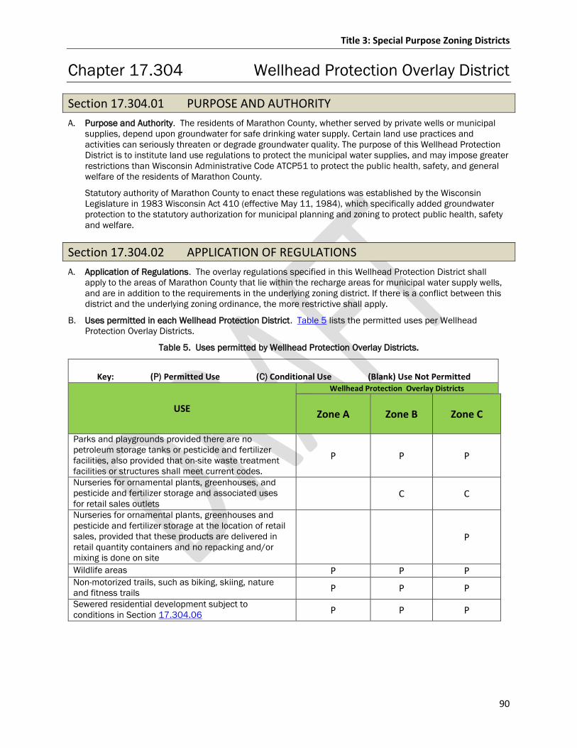
Title 3: Special Purpose Zoning Districts
90
Chapter 17.304 Wellhead Protection Overlay District
Section 17.304.01 PURPOSE AND AUTHORITY
A. Purpose and Authority. The residents of Marathon County, whether served by private wells or municipal
supplies, depend upon groundwater for safe drinking water supply. Certain land use practices and
activities can seriously threaten or degrade groundwater quality. The purpose of this Wellhead Protection
District is to institute land use regulations to protect the municipal water supplies, and may impose greater
restrictions than Wisconsin Administrative Code ATCP51 to protect the public health, safety, and general
welfare of the residents of Marathon County.
Statutory authority of Marathon County to enact these regulations was established by the Wisconsin
Legislature in 1983 Wisconsin Act 410 (effective May 11, 1984), which specifically added groundwater
protection to the statutory authorization for municipal planning and zoning to protect public health, safety
and welfare.
Section 17.304.02 APPLICATION OF REGULATIONS
A. Application of Regulations. The overlay regulations specified in this Wellhead Protection District shall
apply to the areas of Marathon County that lie within the recharge areas for municipal water supply wells,
and are in addition to the requirements in the underlying zoning district. If there is a conflict between this
district and the underlying zoning ordinance, the more restrictive shall apply.
B. Uses permitted in each Wellhead Protection District. Table 5 lists the permitted uses per Wellhead
Protection Overlay Districts.
Table 5. Uses permitted by Wellhead Protection Overlay Districts.
Key: (P) Permitted Use (C) Conditional Use (Blank) Use Not Permitted
USE
Wellhead Protection Overlay Districts
Zone A Zone B Zone C
Parks and playgrounds provided there are no
petroleum storage tanks or pesticide and fertilizer
facilities, also provided that on-site waste treatment
facilities or structures shall meet current codes.
P P P
Nurseries for ornamental plants, greenhouses, and
pesticide and fertilizer storage and associated uses
for retail sales outlets C C
Nurseries for ornamental plants, greenhouses and
pesticide and fertilizer storage at the location of retail
sales, provided that these products are delivered in
retail quantity containers and no repacking and/or
mixing is done on site
P
Wildlife areas P P P Non-motorized trails, such as biking, skiing, nature
and fitness trails P P P
Sewered residential development subject to
conditions in Section 17.304.06 P P P
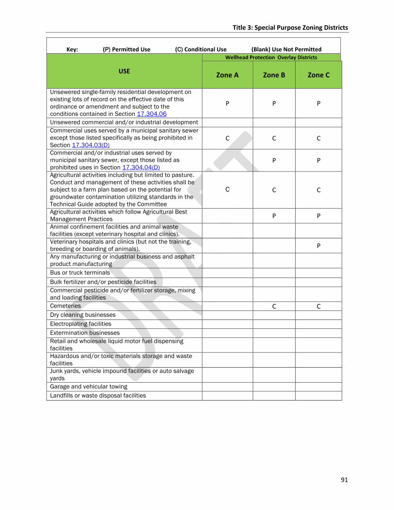
Title 3: Special Purpose Zoning Districts
91
Key: (P) Permitted Use (C) Conditional Use (Blank) Use Not Permitted
USE
Wellhead Protection Overlay Districts
Zone A Zone B Zone C
Unsewered single-family residential development on
existing lots of record on the effective date of this
ordinance or amendment and subject to the
conditions contained in Section 17.304.06
P P P
Unsewered commercial and/or industrial development
Commercial uses served by a municipal sanitary sewer
except those listed specifically as being prohibited in
Section 17.304.03(D)
C C C
Commercial and/or industrial uses served by
municipal sanitary sewer, except those listed as
prohibited uses in Section 17.304.04(D) P P
Agricultural activities including but limited to pasture.
Conduct and management of these activities shall be
subject to a farm plan based on the potential for
groundwater contamination utilizing standards in the
Technical Guide adopted by the Committee
C C C
Agricultural activities which follow Agricultural Best
Management Practices P P
Animal confinement facilities and animal waste
facilities (except veterinary hospital and clinics).
Veterinary hospitals and clinics (but not the training,
breeding or boarding of animals). P
Any manufacturing or industrial business and asphalt
product manufacturing
Bus or truck terminals
Bulk fertilizer and/or pesticide facilities
Commercial pesticide and/or fertilizer storage, mixing
and loading facilities
Cemeteries C C Dry cleaning businesses
Electroplating facilities
Extermination businesses
Retail and wholesale liquid motor fuel dispensing
facilities
Hazardous and/or toxic materials storage and waste
facilities
Junk yards, vehicle impound facilities or auto salvage
yards
Garage and vehicular towing
Landfills or waste disposal facilities
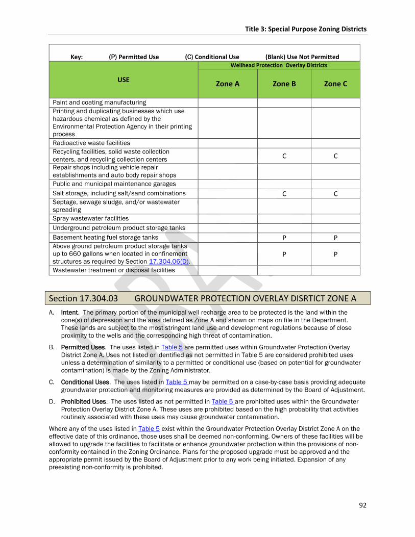
Title 3: Special Purpose Zoning Districts
92
Key: (P) Permitted Use (C) Conditional Use (Blank) Use Not Permitted
USE
Wellhead Protection Overlay Districts
Zone A Zone B Zone C
Paint and coating manufacturing
Printing and duplicating businesses which use
hazardous chemical as defined by the
Environmental Protection Agency in their printing
process
Radioactive waste facilities
Recycling facilities, solid waste collection
centers, and recycling collection centers C C
Repair shops including vehicle repair
establishments and auto body repair shops
Public and municipal maintenance garages
Salt storage, including salt/sand combinations C C Septage, sewage sludge, and/or wastewater
spreading
Spray wastewater facilities
Underground petroleum product storage tanks
Basement heating fuel storage tanks P P Above ground petroleum product storage tanks
up to 660 gallons when located in confinement
structures as required by Section 17.304.06(D). P P
Wastewater treatment or disposal facilities
Section 17.304.03 GROUNDWATER PROTECTION OVERLAY DISRTICT ZONE A
A. Intent. The primary portion of the municipal well recharge area to be protected is the land within the
cone(s) of depression and the area defined as Zone A and shown on maps on file in the Department.
These lands are subject to the most stringent land use and development regulations because of close
proximity to the wells and the corresponding high threat of contamination.
B. Permitted Uses. The uses listed in Table 5 are permitted uses within Groundwater Protection Overlay
District Zone A. Uses not listed or identified as not permitted in Table 5 are considered prohibited uses
unless a determination of similarity to a permitted or conditional use (based on potential for groundwater
contamination) is made by the Zoning Administrator.
C. Conditional Uses. The uses listed in Table 5 may be permitted on a case-by-case basis providing adequate
groundwater protection and monitoring measures are provided as determined by the Board of Adjustment.
D. Prohibited Uses. The uses listed as not permitted in Table 5 are prohibited uses within the Groundwater
Protection Overlay District Zone A. These uses are prohibited based on the high probability that activities
routinely associated with these uses may cause groundwater contamination.
Where any of the uses listed in Table 5 exist within the Groundwater Protection Overlay District Zone A on the
effective date of this ordinance, those uses shall be deemed non-conforming. Owners of these facilities will be
allowed to upgrade the facilities to facilitate or enhance groundwater protection within the provisions of non-
conformity contained in the Zoning Ordinance. Plans for the proposed upgrade must be approved and the
appropriate permit issued by the Board of Adjustment prior to any work being initiated. Expansion of any
preexisting non-conformity is prohibited.
Title 3: Special Purpose Zoning Districts
93
Section 17.304.04 GROUNDWATER PROTECTION OVERLAY DISRTICT ZONE B
A. Intent. A secondary portion of the municipal well recharge areas to be protected is the land which lies
within Zone B as shown in Table 5 and on maps on file in the Department. Land use restrictions within
Zone B are less restrictive than in Zone A because of longer flow times and a greater potential for
remediation, dilution, and attenuation.
B. Permitted Uses. The uses listed in Table 5 are permitted within Groundwater Protection Overlay District
Zone B. Uses not listed or identified as not permitted in Table 5 are considered prohibited uses unless a
determination as outlined in Section 17.304.03 B. is made for similar uses.
C. Conditional Uses. The uses listed in Table 5 may be permitted on a case-by-case basis providing adequate
groundwater protection and monitoring measures are provided as determined by the Board of Adjustment.
D. Prohibited Uses. The uses listed as not permitted in Table 5 are prohibited uses within Groundwater
Protection Overlay District Zone B, except as provided in Sections 17.304.04.C or 17.304.06. These uses
are prohibited based on the high probability that activities routinely associated with these uses may cause
groundwater contamination.
Where any of the uses listed in Table 5 exist within Groundwater Protection Overlay District Zone B on the
effective date of this ordinance, owners of these facilities will be allowed to upgrade the facilities to facilitate or
enhance groundwater protection pursuant to the provisions outlined in Section 17.304.03.D. Expansion of any
preexisting non-conforming use is prohibited.
Section 17.304.05 GROUNDWATER PROTECTION OVERLAY DISRTICT ZONE C
A. Intent. The outermost portion of the municipal well recharge area to be protected is the land which lies
within Zone C as shown on maps on file in the Department. Land use restrictions within Zone C are less
restrictive than in either Zone A or Zone B because it is the portion of the recharge area most distant from
the well(s).
B. Permitted Uses. The uses listed in Table 5 are permitted within Groundwater Protection Overlay District
Zone C. Uses not listed or identified as not permitted in Table 5 are considered prohibited uses unless a
determination as outlined in Section 17.304.03 B. is made for similar uses.
C. Conditional Uses. The uses listed in Table 5 may be permitted on a case-by-case basis providing adequate
groundwater protection and monitoring measures are provided as determined by the Board of Adjustment.
D. Prohibited Uses. The uses listed as not permitted in Table 5 are prohibited uses within the Groundwater
Protection Overlay District Zone C except as provided in Sections 17.304.05 C. or 17.304.06. Uses
prohibited based on the high probability that activities routinely associated with these uses may cause
groundwater contamination are listed in Table 5.
Where any of the uses listed in Table 5 exist within Groundwater Protection Overlay District C on the effective
date of this district, owners of these facilities will be allowed to upgrade the facilities to facilitate or enhance
groundwater protection pursuant to the provisions outlined in Section 17.304.03 D. Expansion of any
preexisting non-conforming use is prohibited.
Title 3: Special Purpose Zoning Districts
94
Section 17.304.06 DESIGN AND PERFORMANCE STANDARDS
The following standards and requirements shall apply to all uses permitted within the Groundwater Protection
Overlay District.
A. Lot Size. Minimum lot size for unsewered residential uses shall be two acres except for:
1. Existing lots of record on the effective date of this ordinance.
2. Developments which will be served by municipal sewer. In order to provide for efficiently serving the
development with municipal sewer, lots smaller than two acres can be approved provided that
sufficient land area will be maintained in an undeveloped state such that no more than one residence
is allowed for each two acres of the overall development.
B. Landscaping and Maintained Lawn or Grass.
1. All commercial and industrial uses shall be allowed a maximum of 50% of the lot area to be
maintained lawn or grass. In no instance shall the area of maintained lawn or grass exceed the area of
impervious surfaces on the lot.
2. Natural vegetative covers not requiring the use of pesticides or fertilized after initial establishment are
encouraged as an alternative to lawn or grass.
C. Storm Drainage and Snow Melt. All storm drainage for commercial and industrial sites shall be retained
on the site or discharged to a municipally operated storm drain in accordance to storm water best
management practices. If retained on the site, storm water shall be discharged to settling basins where it
shall percolate through at least six inches of topsoil with vegetation established. Use of drywells or other
subsurface drains for storm water drainage is prohibited, as is the use of a groundwater pond.
D. Petroleum, Pesticide, Fertilizer and Salt Storage.
1. All petroleum product storage tanks shall provide leak-proof containment not less than 125% of the
tank volume except basement heating fuel storage tanks.
2. Pesticide and fertilizer storage is permitted at the location of retail sales of these products provided
that the products are delivered in retail quantity containers and no repackaging and/or mixing is done
on the site.
3. Pesticide and fertilizer storage is permitted on a farm for use on that farm by the owner or farm
operator.
4. Bulk liquid pesticide/fertilizer storage containers exceeding 55 gallons are permitted providing the
containers are located within a leak-proof containment area not less than 125% of the volume of the
largest container. Interstate Commerce Commission (ICC) approved transport containers do not
require containment.
5. Salt storage must conform to standards in the Department of Transportation, Chapter 277 of the
Wisconsin Administrative Code.
E. Animal Waste – Storage and Handling.
1. Animal waste storage facilities must meet the standards of the Marathon County Animal Waste
Management Ordinance.
2. Animal waste, in combination with chemical fertilizer or other soil amendments, shall not be applied at
rates which exceed the nutrient requirements of the crops grown on the application site.
3. Conduct and management of agricultural activity shall be subject to a plan utilizing standards in the
Marathon County Technical Guide adopted by the Environmental Resources Committee
Section 17.304.07 ADMINISTRATION
A. Determinations. The boundaries of the Groundwater Protection Overlay Districts shall be shown on the
maps for Marathon County. Boundary determinations for specific properties shall be made by the Zoning
Administrator by scaling distances from these maps.
B. Appeals. Appeals to a boundary determination or any other administrative decision by the Zoning
Administrator connected with this ordinance shall be made to the Board of Adjustment as provided in Title
8 of this Ordinance and shall be supported with appropriate technical documentation as determined by the
Board of Adjustment.
Title 3: Special Purpose Zoning Districts
95
Chapter 17.305 Airport Approach Protection Overlay District
Section 17.305.01 AUTHORITY
A. Statutory Authority. The Airport Approach Protection regulations are adopted under the authority granted
by the Department of Aeronautics and Astronautics, Chapter 114, Section 114.136, WI Stats..
Section 17.305.02 MAP
A. Map. All zones established by this section are as shown on the map dated September 7, 1999, entitled
“Zoning Map for Central Wisconsin Airport, Marathon County, Wisconsin,” which is on file in the office of
the County Clerk, electronically stored in the County Geographic Information System, and is adopted by
reference.
Section 17.305.03 APPLICATION OF REGULATIONS
A. Height Zones.
No structure shall be constructed, altered or located and no trees shall be allowed to grow to a height in excess
of the height limit indicated on the maps referred to in Section 17.305.02 except as may be authorized by
Section 17.305.03.G 1. These restrictions shall not apply to legal fences or farm crops which are cut at
least once a year.
B. Other Restrictions.
1. Use Restrictions. Notwithstanding the provisions of Section 17.305.03 A., no use may be made of
land in any zone governed by the Chapter in such a manner as to create electrical interference with
radio communication between the airport and aircraft, make it difficult for pilots to distinguish
between airport lights and others, result in glare in the eyes of pilots using the airport or impair the
vicinity of the airport, or otherwise endanger the landing, taking off, or maneuvering of aircraft.
2. Development Restrictions. Notwithstanding the provisions of Section 17.305.03 A., no zoning permit
for new, altered, or enlarged principle structures will be issued for any property located in any zone
governed by this Chapter unless the provisions of the “Noise and Avigation Easement and Non-suit
Covenant” are incorporated into such zoning permit.
C. Permits.
1. Proposed Structures. Except for accessory structures meeting the height requirements below, no
structure shall be constructed, erected or installed in any zone created by Section 17.305.02 A. until
the owner or his/her agent has applied for and obtained a permit from the Zoning Administrator.
Application for the permit shall indicate the use of the proposed structure and shall describe and
locate the use with sufficient accuracy to determine whether the structure will conform to these
regulations. The Zoning Administrator shall issue the permit if all provisions of this Chapter are
complied with. The permit shall be posted in a prominent place on the premises prior to and during
the period of construction, erection, installation or establishment.
Height Limitations for Accessory Structures – Permit Exemption.
a. Any accessory structure which is to be constructed within ½ mile of the airport boundary and
which will be less than 20 feet high from the lowest point on the ground next to the structure and
the highest point on the structure, including any appurtenances, shall be exempt from obtaining a
permit.
b. Any accessory structure which is to be constructed from ½ mile to the three mile limit of the
“Zoning Map for Central Wisconsin Airport, Marathon County, WI” and which will be less than 50
feet high from the lowest point on the ground next to the structure and the highest point on the
structure, including any appurtenances, shall be exempt from obtaining a permit.
c. Accessory structures exceeding these limits including structural or architectural members, masts,
poles, antennae, electronic broadcasting or receiving equipment and similar structures shall
obtain a permit prior to construction or erection.
Title 3: Special Purpose Zoning Districts
96
2. Existing Uses. Before any non-conforming structure may be replaced or a structural addition is made,
a permit shall be obtained as prescribed by Section 17.305.03 C. 1. Authorizing the change,
replacement or addition. The permit shall be issued if the structure will not become a greater hazard
to air navigation than it was on the effective date of 12/29/1971, or than it was when the application
for permit is made.
D. Non-conforming Uses, Structures and Vegetation.
1. Pre-Existing Non-conforming Uses. The regulations prescribed in Section 17.305.02 A. and 17.305.03
A. shall not be construed to require the removal, lowering or other change or alteration of any non-
conforming structure, or otherwise interfere with the continuance of any non-conforming use, except
as otherwise provided by Section 17.305.03 C. 2.
2. Changes. Nothing contained in this Chapter shall require any change in the construction, alteration or
intended use of any structure, if the construction or alteration was begun prior to the effective date of
12/29/1971 and if such is diligently prosecuted.
3. Removal. This section shall not interfere with the removal of non-conforming uses by purchase or the
use of eminent domain. The Airport Manager shall have the right to trim, prune or remove, at owners’
(Marathon and Portage Counties) expense, any tree which was planted after adoption of this Chapter
and found in violation of the height restriction for the zone in which it is located.
E. Administration.
The Zoning Administrator or designee shall administer and enforce the regulations prescribed herein.
Applications for permits and variances shall be made to the Zoning Administrator using forms furnished by
his/her or designee. Applications shall be decided within 10 days unless F.A.A. approval is requested by
the Zoning Administrator. Application for action by the Board of Adjustment shall be transmitted by the
Zoning Administrator to the Board for hearing and decision using procedures contained in Title 8.
F. Hazard Marking and Lighting.
If needed to carry out the purpose of this Section, any permit or variance granted under Section 17.305.03
C. or D. may include conditions which require the owner of the structure or trees in question to install,
operate and maintain, at the owner’s expense, such markers and lights as may be necessary to indicate
the presence of an airport hazard to fliers.
G. Appeals and Review.
1. Variances. Upon appeal in special cases, the Board of Adjustment may, after investigation and public
hearing, grant a variance not to be contrary to the public interest where, owing to special conditions, a
literal enforcement of this chapter would result in unnecessary hardship, and the variance would do
substantial justice and would not create a hazard to the safe, normal operation of aircraft.
2. Aggrieved Person. Any person aggrieved or affected by any decision or action of the Zoning
Administrator, may appeal the decision or action to the Board of Adjustment.
3. Procedure. Any appeal taken pursuant to this Chapter shall be in conformity with the procedure
established by 59.694, WI Stats. and the variance and appeals provisions in Title 8.
Section 17.305.04 PROSECUTION
A. Prosecution.
The Corporation Counsel shall prosecute violations of this chapter.
Title 4: General Provisions
97
Title 4: GENERAL PROVISIONS
Chapter 17.401 Accessory Structures and Fences
Section 17.401.01 GENERAL STANDARDS APPLICABLE TO ALL ACCESSORY STRUCTURES
1. A. Principle Building Structure Required. In U-R, R-R and L-D-R, and R-R districts, accessory structures or
buildings shallmay only be constructed or placed on a lot that contains a principle structure,building unless
a conditional use permit is obtained from the Board of Adjustment. The standards of 17.401.02(E)(2) also
apply to all conditional use permit applications under this section, the structure shall also adhere to any
additional conditions placed on the permit by the Board of Adjustment. Refer to Table 2 for all permitted
and conditional use options by zoning district..
B. Materials/Appearance. To the extent possible, the exterior façade materials, appearance and
architectural design of all accessory structures are encouraged toshall match the character of the use to
which they are accessory, as well as the district of which they are located. It is strongly encouraged that
the overall appearance of the structure shall be in accordance with the purpose of the district where it is
located.
1. Storage/shipping containers used as permanent accessory structures are prohibited in the U-R, L-D-R,
and R-R zoning districts and may be required to be screened from roads and/or adjacent properties in
those districts in which they are allowed. Where applicable, screening may be manmade and/or
vegetative and shall be approved by the zoning administrator prior to the issuance of a zoning permit.
See Table 3 for all permitted and conditionally approved uses designated by zoning district.
1.
C. Temporary Accessory Structures. In residential districts, temporary accessory structures that do not
require permanent attachment to the ground but have similar characteristics as an accessory structure
and are intended to serve the same purpose as an accessory structure with permanent attachment, such
as moveable carports, shall meet district yard setback requirements.
1. All storage/shipping containers used on a temporary basis during construction, grading projects, or
agricultural operations when utilized solely for the storage of supplies, solid waste, or equipment
associated with construction, grading, or agricultural operations may be permitted in all zoning
districts without the issuance of a zoning permit. Yet, shall remain onsite for no longer than 90 days in
relation with an onsite project or until a permit associated with the onsite project expires or becomes
void.
Section 17.401.02 ACCESSORY BUILDINGS
The use of the accessory building must be secondary and incidental to the principle use.
A. Attached Accessory Buildings. An accessory building which is attached to the main building by a common
wall and roof shall comply with all the requirements and regulations that are applicable to the principle
building.
B. Detached Accessory Buildings. Detached accessory buildings shall not be used as a separate dwelling unit
and shall comply with the requirements of the following Table 6:
C. Accessory Structures housing Livestock: Section 17.204.01 (A) (3)
D. Accessory Structures within shoreland jurisdiction: Existing and new accessory buildings shall comply with
all Marathon County shoreland regulations and provisions.
E. Construction of Detached Accessory Structures exceeding the dimensional building standards:
1. 1. A conditional Use Permit may be applied for the construction of a detached accessory
structure with floor area and components differing from the dimensional and maximum lot coverage
standards listed in Table 6.
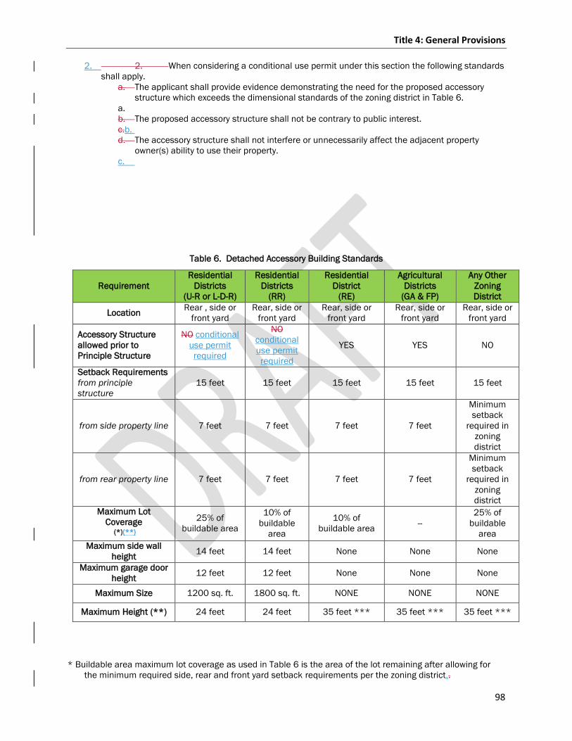
Title 4: General Provisions
98
2. 2. When considering a conditional use permit under this section the following standards
shall apply.
a. The applicant shall provide evidence demonstrating the need for the proposed accessory
structure which exceeds the dimensional standards of the zoning district in Table 6.
a.
b. The proposed accessory structure shall not be contrary to public interest.
c.b. d. The accessory structure shall not interfere or unnecessarily affect the adjacent property
owner(s) ability to use their property.
c.
Table 6. Detached Accessory Building Standards
Requirement
Residential
Districts
(U-R or L-D-R)
Residential
Districts
(RR)
Residential
District
(RE)
Agricultural
Districts
(GA & FP)
Any Other
Zoning
District
Location Rear , side or
front yard
Rear, side or
front yard
Rear, side or
front yard
Rear, side or
front yard
Rear, side or
front yard
Accessory Structure
allowed prior to
Principle Structure
NO conditional
use permit
required
NO
conditional
use permit
required
YES YES NO
Setback Requirements
from principle
structure
15 feet 15 feet 15 feet 15 feet 15 feet
from side property line 7 feet 7 feet 7 feet 7 feet
Minimum
setback
required in
zoning
district
from rear property line 7 feet 7 feet 7 feet 7 feet
Minimum
setback
required in
zoning
district
Maximum Lot
Coverage
(*)(**)
25% of
buildable area
10% of
buildable
area
10% of
buildable area --
25% of
buildable
area
Maximum side wall
height 14 feet 14 feet None None None
Maximum garage door
height 12 feet 12 feet None None None
Maximum Size 1200 sq. ft. 1800 sq. ft. NONE NONE NONE
Maximum Height (**) 24 feet 24 feet 35 feet *** 35 feet *** 35 feet ***
* Buildable area maximum lot coverage as used in Table 6 is the area of the lot remaining after allowing for
the minimum required side, rear and front yard setback requirements per the zoning district..
Title 4: General Provisions
99
** “Maximum height” Iin Shoreland areas: Refer to Chapter 22 Marathon County Shoreland, Shoreland-
Wetland, and Floodplain Regulations..
*** For height exemptions refer to Section 17.202.07.
Section 17.401.03 DECKS AND LANDINGS
A. Setbacks.
1. The outer perimeter of a deck shall not extend into a setback area.
2. Decks and Landings in shoreland areas refer to General Code of Ordinances Chapter 22 Shoreland,
Shoreland-Wetlands, and Floodplain & NR 115.
Section 17.401.04 SWIMMING POOLS
Public or private in-ground or above-ground swimming, wading or other pools containing over 1½ feet of water
depth shall be considered as structures for the purpose of permits, shall not be located in front yards but may
be located in side and/or rear yards subject to location regulations pertaining to accessory structures.
Section 17.401.05 FENCES/WALL REGULATIONS
Any fence or wall shall be well maintained, harmonious and appropriate in appearance with the existing
character of the immediate area in which it is to be located, and shall not be hazardous or disturbing to
existing or future neighboring uses.
A. Residential Districts.
1. Location in Front Yards. In residential districts, a fence, wall, hedge, or shrubbery may be erected,
placed, maintained, or grown along a lot line on residentially zoned property or adjacent thereto to a
height not exceeding six feet above the ground level, except that no fence, wall, hedge, or shrubbery
which is located in a required front or corner side yard shall exceed a height of four feet.
2. Materials. Barbed wire and other similar hazardous materials are prohibited in residential districts,
except for agricultural uses.
3. Fences in shoreland areas refer to Chapter 22 Marathon County Shoreland, Shoreland-Wetland and
Floodplain and NR 115.
B. Nonresidential Districts.
1. Location in Front Yards. In nonresidential districts and non-single-family lots in the U-R -District,
fences and walls may be permitted in any front yard provided that the fence or wall does not exceed a
maximum height of four feet.
2. Location in Side and Rear Yards. Fences or walls may be permitted in any required side or rear yard to
a maximum height of six feet. In the case of fences/walls required to screen outdoor storage areas,
the fence/wall height shall be one foot higher than the material to be screened, or 12 feet, whichever
is lower.
C. General Requirements. All fences and walls shall comply with the following general requirements:
1. Materials.
a. In and Near Residential Districts. Materials used for fences and walls located in or within 200
feet of a residential district shall consist of treated wood or wood which is recognized and
approved as a durable species, brick, masonry, vinyl, vinyl-coated chain link, metal bars not
Title 4: General Provisions
100
exceeding 1½ inches in diameter or other durable and weather- resistant materials which may be
approved by the zoning official.
b. Screening Walls. Any wall used for screening purposes shall be constructed of masonry material
(e.g., brick, decorative stone) that is architecturally compatible with the materials used on the
façade of the principle structure on the site. Concrete block may only be used for screening walls
in the rear yard.
2. Maintenance. Walls and fences shall be maintained in good condition. Rotten, crumbled, or broken
components shall be replaced, repaired, or removed. It is strongly encouraged (if necessary) to secure
an access agreement with the adjacent property owner for the purpose of maintenance of said fence.
3. Prohibited obstructions.
a. Right-of-Way. Fences and walls shall not be erected within two feet of the public right-of-way.
b. Corner Clear Vision Area. Any fence erected in a corner clear vision area (see Section 17.202.09)
shall have a minimum of 50% of the area of the vertical surface open to light and air.
c. Obstruction of Adjacent Uses Prohibited. No wall or fence may be erected where it will prevent or
unreasonably obstruct the use of any adjacent parcel, nor shall a wall or fence be erected where it
would prevent or unreasonably obstruct the safe use of an existing driveway or other means of
access to any adjacent parcel. In enforcing this provision, the county may require a wall or fence
to be set back a minimum distance from a driveway or property line.
4. Orientation of finished side. Where a fence or wall has a single finished or decorative side, it shall be
oriented to face outward toward adjacent parcels or street rights-of-way (away from the interior of the
lot to which the fence is associated).
5. Site drainage and utilities. Fences and walls shall not be erected in a manner that obstructs the free
flow of surface water or causes damage to underground utilities. Any changes to existing grade shall
require approval by the Zoning Administrator.
6. Location. Fences and walls shall be located completely within the boundaries of the lot(s) to which
they are associated.

Title 4: General Provisions
101
Chapter 17.402 General Provisions
Section 17.402.01 CONDITIONS AND SAFEGUARDS
A. Conditions and Safeguards, Generally. The Zoning Administrator, Board of Adjustment, and/or Committee
shall have the power to safeguard the intent and objectives of this Zoning Ordinance by imposing
appropriate restrictions and safeguards as conditions of any approval it gives.
B. Access Management. In the exercise of the power to impose safeguards and conditions, the Zoning
Administrator, Board of Adjustment, and/or Committee may, including but not limited to SR 29, have the
power to limit or reduce street ingress and egress accesses as well as to require owners and developers to
grant easements to adjacent property owners in such locations as the Department of Transportation shall
require and other requirements as specified in Chapter 17.303. These powers and conditions are
exercised, in general, to assure public health, safety, welfare and convenience, to reduce the traffic impact
along Marathon County’s major thoroughfares and to permit traffic to flow safely from site to site along
drives parallel to the state highways without having to cross multi-lane highways.
Section 17.402.02 SPECIAL COSTS
When the Committee or Board of Adjustment finds it necessary to maintain a strict record of public hearing
procedures, or when either the Committee or Board deems it necessary to cause special studies to be made,
then the applicant shall bear all direct and related costs.
Section 17.402.03 SIDEWALKS
Minimum five foot wide sidewalks shall be required along both sides of a street in U-R zoning. When a street
abuts land that has a low likelihood of development due to environmental or other restrictions, the Committee
may require sidewalks to be constructed on only one side of the street.
Section 17.402.04 TEMPORARY BUILDINGS
Temporary buildings for uses incidental to construction work may be erected in any of the zone districts herein
established, however, such temporary building or buildings shall be removed upon the completion or
abandonment of the construction work. Location of temporary structures shall be indicated on site plans
submitted to the Zoning Administrator, Board of Adjustment and/or the Committee for approval pursuant to
Section 17.802.02.
Section 17.402.05 RELAXATION OF STANDARDS FOR PERSONS WITH DISABILITIES
The Zoning Administrator may issue a permit to relax dimensional standards of this ordinance in order to
provide reasonable accommodation of persons with disabilities as required by provisions of federal and state
law. Such relaxation shall be consistent with federal guidelines for accommodation of persons with disabilities
and shall, where practicable, be terminated when the facility is no longer in use by a disabled person. A person
applying for a permit for construction under this section shall establish:
1. That the facility or premises are routinely used by a disabled person;
2. The nature and extent of the disability; and
3. That the relaxation requested is the minimum necessary to provide reasonable use of the facility by
the disabled person.
Title 4: General Provisions
102
Section 17.402.06 Boundary Lot Line Policy All uses and activities established after the effective date of this Zoning Ordinance shall comply with the
following standards:
A. To ensure that the minimum setbacks will be met for proposed projects, the property owner shall clearly
mark in the field the lot line(s) and property corners adjacent to where the activity will take place if:
1. The proposed activity is to take place within ten (10) feet of the minimum setback distance of the lot
line(s).
Furthermore, the administrator may required the lot line(s) to be surveyed by a professional land surveyor
if:
1. The proposed activity is to take place within ten (10) feet of the minimum setback distance of the lot
line(s).
Furthermore, the administrator may required the lot line(s) to be surveyed by a professional land surveyor
if:
B.
1. The location of the marked lot line(s) by the property owner is not consistent with the location of the lot
line(s) shown in public records; and/or
2. If there is a disagreement by any of the parties involved about the location of the lot line(s).
Furthermore, the administrator may required the lot line(s) to be surveyed by a professional land
surveyor if:
2. The location of the marked lot line(s) by the property owner is not consistent with the
location of the lot line(s) shown in public records; and/or
3. If there is a disagreement by any of the parties involved about the location of the lot line(s).
If required, markings shall be clearly visible and accurate prior to, as well as at the time of inspection.
The property owner must clearly mark the boundary line(s) and boundary corners adjacent to where the
activity will take place, if the proposed activity is overseen by the Department and one of the following
applies:
A. The activity to take place is within five feet of the minimum setback distance.
B. If the location of the boundary line(s) shown by the property owner or his/her agent is not
consistent with the location of the boundary line(s) shown on public records.
If required, markings shall be clearly visible and accurate prior to, as well as at, the time of
inspection. This may be by means of the property owner marking the boundary line(s) themselves
or having it surveyed. If there is a disagreement by any of the parties involved about the location of
the boundary lines(s), the Department may require the boundary line(s) to be surveyed by a
registered land surveyor.
A.C.
Section 17.402.07 Wetland Boundary Policy
All uses and activities established after the effective date of this Zoning Ordinance shall comply with the
following standards:
A. The property owner must clearly mark the wetland boundary(ies) adjacent to where the activity will take
place, if the proposed activity is overseen by the Department and one of the following applies:To ensure
that a proposed project will not encroach into protected wetland areas, the applicant and/or agent shall
have the wetland boundaries marked in the field if the proposed activity is to take place within 35 feet of a
Title 4: General Provisions
103
mapped wetland as shown on the Wisconsin DNR wetland inventory maps. The maps can be viewed at
https://dnrmaps.wi.gov/H5/?Viewer=SWDV&runWorkflow=Wetland.
a. The activity to take place is within 35 feet of a wetland on the Wisconsin Wetland Inventory as
depicted on the Department of Natural Resources Surface Water Data Viewer. The maps can be
viewed at http://dnrmaps.wi.gov/SL/Viewer.html?Viewer=SWDV&runWorkflow=Wetland
b. If the location of the wetland boundary line(s) shown by the property owner or his/her agent is not
consistent with the location of the wetland boundary line(s) shown on public records.
B. Furthermore, the administrator may take into consideration all available information when determining
whetherre the wetland boundaries shall be marked. This may include wetland indicators (such as soil
types, slopes & elevations, vegetation types, hydrology), professional judgement, previous delineations
conducted on the property, etc. With this information, markings may also be required for areas greater
than 35’ from a mapped wetland as shown on the Wisconsin DNR wetland inventory maps.
C. If required, the markings of the wetland boundary shall be clearly visible and accurate prior to, as well as
at the time of inspection. If there is a disagreement by any of the parties involved about the location of the
marked wetland boundary, the administrator may require the wetland boundary to be confirmed by WI
DNR and/or the Army Corps of Engineers.
H. If the proposed project will encroach into the wetland area, the owner shall be responsible for meeting any
and all standards required by other agencies, as well as securing any additional required permits from
other agencies prior to approval of any permit(s) issued from CPZ.If required, markings shall be clearly
visible and accurate prior to, as well as at, the time of inspection. Marking of the boundary can be
completed by one of the following…
a. Onsite determination by the Army Corp of Engineers and/or Department of Natural Resources establishing
a wetland boundary. Written documentation from the Army Corp of Engineers and/or Department of
Natural Resources shall be submitted with application.
b. Boundary delineated by a wetland delineator and confirmation from the Army Corp of Engineers and/or
Department of Natural Resources. Written documentation from the Army Corp of Engineers and/or
Department of Natural Resources shall be submitted with application.
Title 4: General Provisions
104
Chapter 17.403 Exterior Lighting
Section 17.403.01 PURPOSE
The purpose of this chapter is to preserve, protect, and enhance the lawful nighttime use and enjoyment of all
properties in the county through the use of appropriate lighting practices and systems in the commercial and
industrial districts. Exterior lighting shall be designed, installed and maintained to control glare and light
trespass, minimize obtrusive light, conserve energy and resources, maintain safety, security and productivity,
and prevent the degradation of the nighttime visual environment. It is the further intent of this chapter to
encourage the use of innovative lighting designs and decorative light fixtures that enhance the character of the
community while preserving the nighttime visual environment. The standards in this chapter are based on the
recommendations of the Illuminating Engineering Society of North America’s Lighting Handbook.
Section 17.403.02 DEFINITIONS
As used in this chapter, the following terms shall have the following meanings:
A. Fixture. A complete lighting unit consisting of a lamp or lamps, together with any reflectors, refractors,
diffusers, baffles, or other devices to distribute the light, and with parts to position and protect the lamp
and to connect the lamps to the power supply; also called the luminaire.
B. Footcandle. A unit of illumination. One footcandle equals one lumen of light flux distributed evenly on one
square foot of surface.
C. High Activity Area. Areas of frequent pedestrian activity or congregation. Examples include, but are not
limited to, building entrances, ATMs, cluster mail boxes, transit shelters or stops, gas station canopies, and
outdoor sales areas.
D. Low Activity Area. Areas that are dedicated primarily to vehicle use, and where there is infrequent turnover
of parking spaces or other pedestrian activity. Examples include, but are not limited to, office or industrial
parking lots, and security lighting applications.
E. Medium Activity Area. Areas of vehicle use where there is frequent turnover of parking spaces and where
persons transition from vehicle to foot travel, or areas of infrequent pedestrian use. Examples include, but
are not limited to, retail parking lots and dumpsters or trash disposal areas in residential areas.
F. Uniformity Ratio. The ratio of average illumination to minimum illumination. More evenly illuminated areas
are perceived to be safer, as more consistent illumination aids visual acuity of the human eye. EXAMPLE: A
uniformity ratio of 4:1 means that, for a given area, the lowest level of illumination (1) should be no less
than ¼ or “four times less” than the average (4) level of illumination.
G. Visual Acuity. The ability to detect a different aspect of detail. Excessive brightness, insufficient light or
drastic changes in illuminance levels in a small area can hinder visual acuity.
Section 17.403.03 INTENSITY
The following illumination requirements shall apply on all sites within the County:
A. Horizontal Illuminance Requirements. The intensity of light within illuminated portions of a site shall
comply with the requirements of the following Table 7. The reviewing authority shall determine which
portions of the site are high, medium, or low activity areas. All footcandle illuminance measurements are
taken at five feet above grade level.
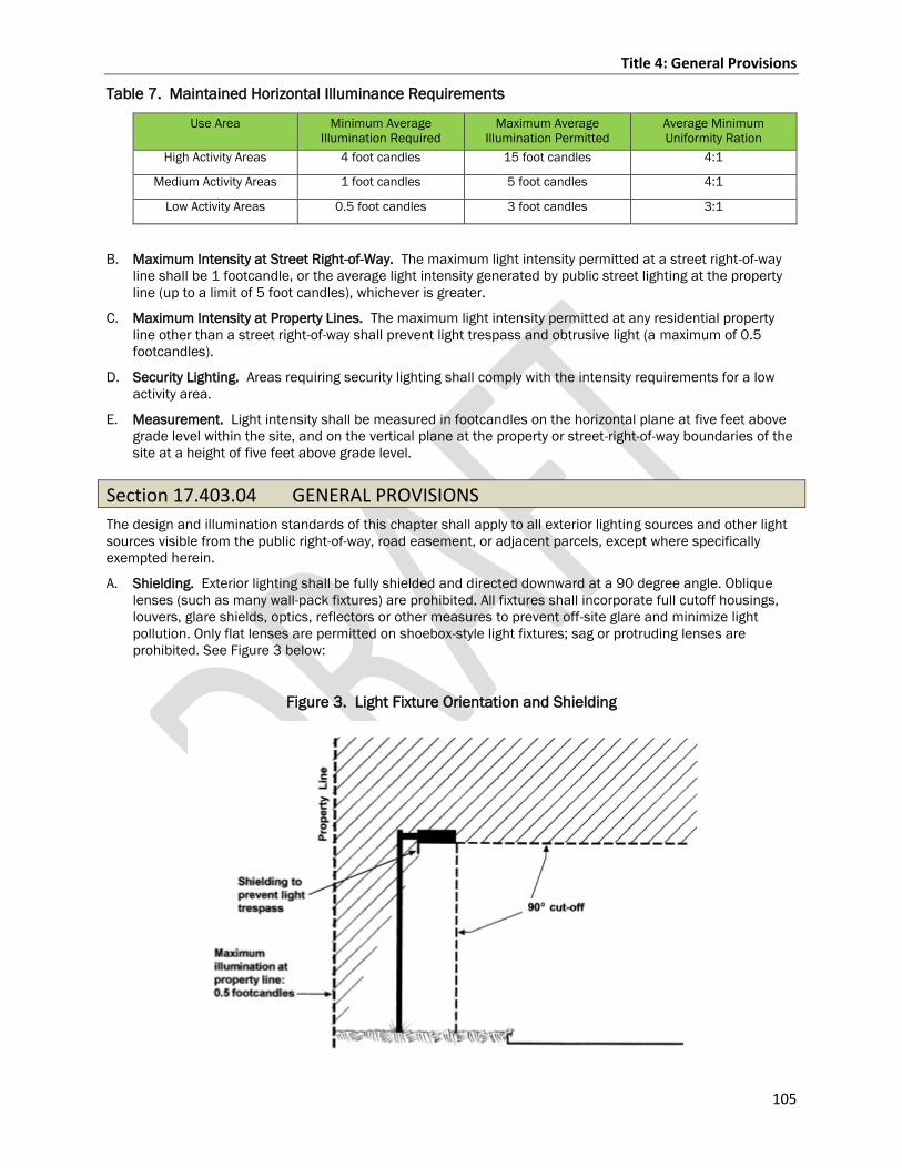
Title 4: General Provisions
105
Table 7. Maintained Horizontal Illuminance Requirements
Use Area Minimum Average
Illumination Required
Maximum Average
Illumination Permitted
Average Minimum
Uniformity Ration
High Activity Areas 4 foot candles 15 foot candles 4:1
Medium Activity Areas 1 foot candles 5 foot candles 4:1
Low Activity Areas 0.5 foot candles 3 foot candles 3:1
B. Maximum Intensity at Street Right-of-Way. The maximum light intensity permitted at a street right-of-way
line shall be 1 footcandle, or the average light intensity generated by public street lighting at the property
line (up to a limit of 5 foot candles), whichever is greater.
C. Maximum Intensity at Property Lines. The maximum light intensity permitted at any residential property
line other than a street right-of-way shall prevent light trespass and obtrusive light (a maximum of 0.5
footcandles).
D. Security Lighting. Areas requiring security lighting shall comply with the intensity requirements for a low
activity area.
E. Measurement. Light intensity shall be measured in footcandles on the horizontal plane at five feet above
grade level within the site, and on the vertical plane at the property or street-right-of-way boundaries of the
site at a height of five feet above grade level.
Section 17.403.04 GENERAL PROVISIONS
The design and illumination standards of this chapter shall apply to all exterior lighting sources and other light
sources visible from the public right-of-way, road easement, or adjacent parcels, except where specifically
exempted herein.
A. Shielding. Exterior lighting shall be fully shielded and directed downward at a 90 degree angle. Oblique
lenses (such as many wall-pack fixtures) are prohibited. All fixtures shall incorporate full cutoff housings,
louvers, glare shields, optics, reflectors or other measures to prevent off-site glare and minimize light
pollution. Only flat lenses are permitted on shoebox-style light fixtures; sag or protruding lenses are
prohibited. See Figure 3 below:
Figure 3. Light Fixture Orientation and Shielding
Title 4: General Provisions
106
B. Glare. Exterior lighting sources shall be designed, constructed, located and maintained in a manner that
does not cause off-site glare on neighboring properties or street rights-of-way. The light emitting element of
any light fixture shall not be directly visible from a neighboring property, as this is the primary cause of
glare.
C. Lamps.
1. Wattage. Lamps with a maximum wattage of 250 watts (or LED equivalent) per fixture are permitted
for use in the County to maintain a unified lighting standard and to minimize light pollution.
2. LED Lighting. LED fixtures may be used for any outdoor lighting application. Any LED fixture used for
parking lot or street lighting purposes shall comply with applicable Illuminating Engineering Society of
North America standards.
D. Animated lighting. Permanent exterior site lighting intended to illuminate outdoor areas shall not be of a
flashing, moving, animated, or intermittent type.
Section 17.403.05 STANDARDS BY TYPE OF FIXTURE
A. Freestanding pole and building mounted lighting. The maximum height of fixtures used for site lighting is
25 feet. Where a pole or building mounted fixture is located within 50 feet of a residentially zoned or used
property, the maximum pole height shall be 15 feet.
Section 17.403.06 EXEMPT LIGHTING
The following exterior lighting types are exempt from the requirements of this Chapter, except that the Zoning
Administrator may take steps to minimize glare, light trespass or light pollution impacts where determined to
be necessary to protect the health, safety and welfare of the public:
A. Holiday Decorations when in season.
B. Pedestrian Walkway Lighting.
C. Building Up-Lighting. Provided that the light emitting element of the fixture is shielded from direct view
from any vehicle or pedestrian travel or use area, and that the fixture is directed at a vertical building
surface.
D. Pre-Emption. Instances where federal or state laws, rules or regulations take precedence over the
provisions of this Chapter.
E. Temporary Emergency Lighting.
F. Special Event Lighting for time periods of seven or fewer days provided that the lighting will not
significantly impact residential areas.
Title 4: General Provisions
107
Section 17.403.07 EXCEPTIONS
The County recognizes that there are certain uses or circumstances not otherwise addressed in this Chapter,
such as:
C.A. Sports stadiums.
D.B. Street lighting.
E.C. Lighting for monuments and flags that may have special exterior lighting requirements.
The use of lamps with greater than 250 watts may permit the use of lamps with wattages up to 400 watts
if the applicant can demonstrate that the higher wattage fixture is necessary to provide adequate lighting
on the site and that the light fixture is in compliance with all other requirements of this chapter. The
exemption for higher wattage lamps shall not be granted if the same lighting effect can be reasonably
accomplished on the site by incorporating additional 250 watt or lower fixtures into the site design.
F.D. Decorative light fixtures. The Zoning Administrator and/or Board of Adjustment may approve decorative
light fixtures that may be unshielded as an alternative to shielded fixtures, provided that such fixtures will
enhance the aesthetics of the site and will not cause undue off-site glare or light pollution. Such fixtures
may utilize LED, incandescent, tungsten-halogen, metal halide or other lamps with full-spectrum color
rendering properties with a maximum equivalent wattage of 150 watts per fixture.
The reviewing authority for the application, to which the exception request is a party, may waive or modify
specific provisions of this Chapter for a particular use or circumstance upon determining that all of the
following conditions have been satisfied. The reviewing authority shall consider the following criteria in making
its decision:
A. The waiver or modification is necessary because of safety or design factors unique to the use,
circumstance or site.
B. The minimum possible light intensity is used that would be adequate for the intended purpose.
Consideration shall be given to maximizing safety and energy conservation, and to minimizing light
pollution, off-site glare and light trespass on to neighboring properties or street rights-of-way.
C. For lighting related to streets or other vehicle access areas, a determination is made that the purpose of
the lighting cannot be achieved by installation of reflective markers, lines, informational signs or other
passive means.
Additional conditions or limitations may be imposed by the reviewing authority to protect the public health,
safety or welfare, or to fulfill the purpose of this Chapter.
Section 17.403.08 Review
All lighting plans must be approved prior to installation.
A. Site plans may be approved as part of the approval for the overall use.
1. Administrative review for permitted uses per Section 17.802.03.
2. Board of Adjustment for conditional uses per Section 17.803.02
B. If lighting plan is not approved within overall use a separate administrative review is required.
Title 4: General Provisions
108
Chapter 17.404 Wireless TelecCommunications Facilities
Section 17.404.01 MOBILE TOWER SITING
A. MOBILE TOWER SITING.
1. Application. New Tower
a. A county zoning permit is required for the siting and construction of any new mobile service
support structure and facilities in a county zoned town or within shoreland jurisdiction.
b. A written permit application must be completed by any applicant and submitted to the Zoning
Administrator. The application must contain the following information:
1) The name and business address of, and the contact individual for, the applicant.
1)2) The location of the proposed or affected support structure.
2)3) The location of the proposed mobile service facility.
3)4) Proof a site address has been issued for the tower and is in the E911 system.
4)5) Copy of easement or agreement with landowner if the land is not owned by the company.
5)6) Must be located outside of the airport height district (three mile radius from Central Wisconsin
Airport) or obtain an airport height zoning permit and Noise and Avigation Easement and Non-
suit Covenant pursuant to the Marathon County General Code of Ordinances Chapter 17.305
Airport Approach Protection.
6)7) A construction plan which describes the proposed mobile service support structure and the
equipment and network components, including antennas, transmitters, receivers, base
stations, power supplies, cabling, and related equipment to be placed on or around the new
mobile service support structure.
7)8) An explanation as to why the applicant chose the proposed location and why the applicant did
not choose co-location, including a notarized sworn statement from an individual who has
responsibility over the placement of the mobile service support structure attesting that co-
location within a two mile radius would not result in the same mobile service functionality,
coverage, and capacity; is technically infeasible; or is economically burdensome to the mobile
service provider.
c. c. If an applicant submits to the county an application for a permit to engage in an activity
described in this ordinance, which contains all of the information required under this ordinance,
the county shall consider the application complete. If the county does not believe that the
application is complete the county shall notify the applicant in writing, within 10 calendar days of
receiving the application, that the application is not complete. The written notification shall specify
in detail the required information that was incomplete. An applicant may resubmit an application
as often as necessary until it is complete.
d. d. Within 90 calendar days of its receipt of a complete application, the county shall
complete all of the following or the applicant may consider the application approved, except that
the applicant and the county may agree in writing to an extension of the 90 calendar day period:
1) Review the application to determine whether it complies with all applicable aspects of the
political subdivision’s building code and, subject to the limitations in this section, zoning
ordinances.
2) Make a final decision whether to approve or disapprove the application.
3) Notify the applicant, in writing, of its final decision.
4) If the decision is to disapprove the application, include with the written notification substantial
evidence which supports the decision.
e. e. The county may disapprove an application if an applicant refuses to evaluate the
feasibility of co-location within the applicant’s search ring of ½mile and provide the sworn
statement described under paragraph Section 17.404.01 A.1.b.8).
Title 4: General Provisions
109
2. Application Process. Co-location of antennas without increasing height of the tower.
a. A written and signed affidavit from an engineer submitted to the department stating the following;
1) Number of antennas to be added and the total number of antennas.
2) That the structure can support the amount of antennas and equipment.
3) That the frequencies will not interfere with existing antennas on the tower.
3. Application Process. Co-location of antennas increasing height of tower.
a. A written and signed affidavit from an engineer submitted to the department stating the following;
1) Number of antennas to be added and the total number of antennas.
2) Total height of the structure.
3) That the structure can support the amount of antennas and equipment.
4) That the frequencies will not interfere with existing antennas on the tower.
b. Tower is to be located outside of the airport height district (three mile radius from Central
Wisconsin Airport) or verify that the structure’s height meets the terms of the Marathon County
General Code of Ordinances Chapter 17.305 Airport Approach Protection Overlay District.
c. If an airport height zoning permit and Noise and Avigation Easement and Non-suit Covenant are
not on file they must be completed and filed pursuant to the Marathon County General Code of
Ordinances Chapter 17.305 Airport Approach Protection Overlay District.
4. Height, Yard, Area and Other Requirements.
a. Height: Must meet the terms of the Marathon County General Code of Ordinances Chapter
17.305 Airport Approach Protection if within three miles of Central Wisconsin Airport.
b. Side Yards. Minimum width of any side yard shall be 20 feet from the guy wires or tower
whichever is closer to the lot line. If an applicant provides the county with an engineering
certification showing that a mobile service support structure, or an existing structure, is designed
to collapse within a smaller area than the setback or fall zone area required that shall be used
unless the county provides the applicant with substantial evidence that the engineering
certification is flawed.
c. Rear Yard. Minimum depth of any rear yard shall be 35 feet from the guy wires or tower
whichever is closer to the lot line. If an applicant provides the county with an engineering
certification showing that a mobile service support structure, or an existing structure, is designed
to collapse within a smaller area than the setback or fall zone area required that shall be used
unless the county provides the applicant with substantial evidence that the engineering
certification is flawed.
Title 4: General Provisions
110
Chapter 17.405 Wind and Energy Conversion Systems(WES)
Section 17.405.01 PURPOSE
The purpose of this Chapter is to regulate private use wind and energy conversion systems (referred to from this point on as WECS) for the production of electricity for use on the subject site. These regulations are established to ensure that WECS will be developed and maintained in a manner that maximizes utilization of Marathon County’s wind and solar energy resources and to balance the need for clean, renewable energy while protecting the public health, safety and welfare.
Section 17.405.02 LOCATION, SETBACKS, NUMBER OF UNITS AND HEIGHT
A. Zoning Districts.
1. Rooftop-mounted WECS may be located in any zoning district as an accessory use subject to the restrictions and requirements of this Chapter.
2. Ground-mounted WECS may be located in any zoning district as an accessory use subject to the following restrictions and requirements of this Chapter.
B. Setbacks for Ground-Mounted WECS.
1. General. A ground-mounted WECS shall be set back from all property lines, street right-of-way lines, and overhead utility lines a minimum distance equal to 1.1 times the total height of the WECS. Setbacks shall be measured from the center of the wind turbine or solar panel base. With respect to an overhead utility line that provides service only to a single building or a single parcel of land, the setback requirements shall be met if the turbine is placed so that no portion of a rotor blade extends closer than 10 feet to the utility line.
2. No WECS is permitted in a floodplain or shoreland/wetland.
3. All Districts.
a. In the case of a tilt-down WECS that does not exceed 34 feet in height and is located in a residential district, the WECS shall be set back equal to 1.1 times the total height of the WECS. If the tower is a tilt-down and/or crank-up monopole design, the pole must pull down or retract toward the installation site and away from all adjoining properties. If guy wires are utilized as part of the tower design, then the guy wire anchors shall be placed at least 15 feet from any abutting property boundaries.
Title 4: General Provisions
111
b. WECS may be located in any yard of the lot, but must meet setback requirements. WECS are encouraged to be in the rear yard. An exception is when a WECS is a rooftop-mounted system.
c. No part of a WECS shall be located within or over drainage, utility or other established easements, or on or over property lines.
C. Height.
1. The height of a ground-mounted WECS shall be limited by the setback requirements of this section. The height of a rooftop or other building-mounted WECS shall not exceed the maximum permitted building height for the property by more than 20%. For a rooftop or other building-mounted WECS that exceeds the maximum permitted building height by more than 20%, the Board of Adjustment after a public hearing, may approve a greater height if the Board of Adjustment determines that the placement of the WECS and context of the WECS site will mitigate any significant negative visual or safety impacts on nearby properties.
2. Airport Approach Protection. All WECS located within the airport approach protection overlay district shall adhere to restrictions of Chapter 17.305 Airport Approach Protection Overlay District.
3. Shoreland Jurisdiction. Refer to General Code of Ordinances Chapter 22 Marathon County Shoreland, Shoreland-Wetlands, and Floodplain Regulations.
D. Number of Units. Each structure or parcel shall be limited to the construction of 1 WECS unit, unless approved by the Board of Adjustment.
Section 17.405.03 LIGHTING, DESIGN AND NOISE
A. Lighting. WECS shall not be illuminated except as required by the Federal Aviation Administration.
B. Structural Design. WECS shall be designed to meet all requirements of all applicable state building codes and federal regulations.
C. Aesthetic Design. WECS shall be designed in a manner that makes them as visually unobtrusive as possible, while meeting safety requirements. To this end, towers shall be monopole. With respect to color, WECS shall be white or off-white or unpainted metal, unless other colors are required by federal regulations.
Title 4: General Provisions
112
D. Signs. All installations will have a durable permanent sign warning of electric shock and identifying the manufacturer and installer with contact information for both, but shall not include any off-premise advertising or any advertising for businesses or other activities located on the premises. The total area of such signs shall not exceed two square feet nor exceed a height of five feet.
E. Noise.
1. No WECS located on a residential parcel shall create noise that exceeds a maximum of 35 decibels at any property line on which the WECS is located.
2. WECS located in districts other than residential shall not create noise that exceeds a maximum of 55 decibels at any property line on which the WECS is located.
3. Measurement of sound levels shall not be adjusted for, or averaged with, non-operating periods.
4. Any WECS exceeding these levels shall immediately cease operation upon notification by the Zoning Administrator and may not resume operation until the noise levels have been reduced, verified and approved by the Zoning Administrator.
5. WECS unable to comply with these noise restrictions shall be shut down immediately and removed upon notification by the Zoning Administrator.
6. A manufacturer's sound report shall be required with a zoning permit application.
F. Prohibit Climbing. The base of the tower shall be designed so it is not climbable for a distance of 12 feet, as measured from the ground.
G. Electrical Components. All electrical components of the WECS shall conform to relevant and applicable local, state and national codes, and relevant and applicable international standards. All electrical wires associated with a WECS, other than wires necessary to connect the wind generator to the tower wiring shall be located underground.
H. Electrical interference. No WECS shall be installed in any location where its proximity with existing fixed broadcast, retransmission, or reception antenna for radio, television, or wireless phone or other personal communication systems would produce electromagnetic interference with signal transmission or reception.
Title 4: General Provisions
113
I. Rotor Safety. Each WECS shall be equipped with both manual and automatic controls to limit the rotational speed of the blade within the design limits of the rotor. An external, manual shut-off switch shall be included with the installation. The minimum distance between the ground and any protruding blades utilized on a ground mounted WECS shall be 15 feet as measured at the lowest point of the arc of the blades.
Title 4: General Provisions
114
Section 17.405.04 APPLICABILITY
A. General Applicability. No WECS shall be erected, enlarged or extended without conformance to the provisions of this Chapter, and other applicable regulations, as evidenced by the issuance of a Zoning Permit by the Zoning Administrator and, where required, approval by the Board of Adjustment.
B. Board of Adjustment Approval. Approval by the Board of Adjustment in accordance with the provisions of this Chapter shall be required for all ground-mounted or rooftop-mounted WECS that exceed the applicable Zoning District height limit, and number of WECS units.
Section 17.405.05 APPROVAL PROCESS AND PERMIT REQUIREMENTS
A. Submission of Application. An application to construct or alter a WECS is subject to the regulations of this Chapter and shall be submitted to the Zoning Administrator as part of a zoning permit application.
B. Determination of Compliance. The Zoning Administrator shall determine if the application conforms to regulations of this Chapter and other applicable regulations of the County, except for those provisions that require a determination by the County Board of Adjustment under provisions of this Chapter.
C. Referral to Board of Adjustment. For proposals subject to approval by the Board of Adjustment, under Section 17.405.04 B., the Zoning Administrator shall refer the application to the Board of Adjustment for review and action.
D. Notice Requirements. Prior to taking action on a WECS application subject to its approval under provisions of this Chapter, the Zoning Administrator shall mail notices describing the proposal to all owners of property located within a distance of the proposed WECS equal to 300 feet of the property lines of subject property. Such notice shall be sent by class II notice at least 10 calendar days prior to the date of the public meeting. The Zoning Administrator shall also provide notice at the same time to any supervisor who represents an area in which notices are to be mailed to property owners.
E. Permit Issuance. The Zoning Administrator shall issue the required zoning permit if he or she determines that the application conforms to the requirements of this Chapter and other applicable regulations.
Section 17.405.06 CONTENTS OF APPLICATION
All applications subject to the provisions of this Chapter shall be accompanied by the following information, as applicable.
Title 4: General Provisions
115
A. Ground-Mounted WECS. In addition to information required by other provisions of these codified ordinances, the following information shall be submitted with an application for ground-mounted and accessory structures or components to demonstrate compliance with the provisions of this Chapter.
1. Site Plan. A site plan of the subject property showing property lines and physical dimensions of the property, easements, adjoining streets, the proposed WECS and any proposed and existing buildings, fencing, power lines, structures, landscaping, driveways, parking, and curb cuts on the subject property.
2. Elevation. An elevation drawing showing the proposed WECS height, and collapse radius.
3. Specifications. WECS specifications, including manufacturer and model, noise rating, rotor diameter, tower height and tower type (freestanding or guyed).
4. Foundation Blueprint. Applicant shall provide WECS tower foundation blueprints or drawings.
5. Fee, as established by the county.
B. Rooftop-mounted WECS. In addition to information required by other provisions of these codified ordinances, the following information shall be submitted with an application for a WECS proposed to be attached to the roof of a building or to another structure and subject to approval by the Zoning Administrator under the provisions of this Chapter.
1. Elevation. An elevation drawing of the building or structure to which the proposed WECS will be attached, showing the placement of the WECS and indicating the color of the structure and any enclosures in relation to the surface to which it will be attached and showing the projection of the WECS from the structure, marked with all necessary dimensions.
2. Specifications. WECS specifications, including manufacturer and model, noise rating, rotor diameter, mounting, height, and type.
3. Fee, as established by the county.
Section 17.405.07 MAINTENANCE AND ABANDONMENT
A. Maintenance and Monitoring. All buildings, structures, fences, and property used in connection with a WECS shall be maintained in good condition and in safe working order.
Title 4: General Provisions
116
B. Out-of-Service.
1. Notice. A WECS that is not in use for a continuous six-month period will be deemed to be out-of-service and the Zoning Administrator may issue a Notice of Out-of-Service to the owner. The owner shall have the right to respond to the Notice of Out-of-Service within 30 days from Notice receipt date.
2. Removal. If the WECS is determined to be out-of-service, the owner of a WECS shall remove the WECS at the owner’s sole expense within three months of receipt of Notice of Out-of-Service. If the owner fails to remove the WECS, the County may pursue a legal action to have the WECS removed at the owner’s expense.
Section 17.405.08 VARIANCES
A variance must be requested for any construction of a WECS that does not adhere to all provisions of this Chapter. In addition thereto, a variance must be requested to:
1. Construct more than one WECS unit on any structure or parcel.
2. To construct WECS that exceeds the maximum permitted building height for the property by more than 20%.
Section 17.405.09 VIOLATIONS
It is unlawful for any person to construct, install, or operate a WECS that is not in compliance with this Chapter.
Section 17.405.10 ADMINISTRATION AND ENFORCEMENT
A. Zoning Administrator. This Chapter shall be administered by the Zoning Administrator.
B. Inspection. The Zoning Administrator may enter any property for which a zoning permit has been issued under this Chapter to conduct an inspection to determine whether the conditions stated in the permit have been met.
C. Abate Violations. The Zoning Administrator may issue orders to abate any violation of this Chapter.
D. Issue Citations. The Zoning Administrator may issue a citation for any violation of this Chapter.
Title 4: General Provisions
117
E. Legal Counsel. The Zoning Administrator may refer any violation of this ordinance to legal counsel for enforcement.
Section 17.405.11 PENALTIES
A. Whoever violates any provision of this Chapter shall be subject to Section 17.807.04 Prosecution, injunction and penalties in court proceedings, and Section 17.807.05 other enforcement provisions.
B. The Zoning Administrator shall have the right to issue and enforce a “Stop Work” order to any and all perceived violators of this Chapter.
C. Each improper installation of a separate WECS unit shall constitute a separate offense.
Section 17.405.01 PURPOSE
The purpose of this Chapter is to adopt and incorporate the requirements of Wis. Stats., 66.0401 and Wis.
Admin. Code PSC 128 as a local ordinance and to establish local regulations on the installation, siting, use, and
decommissioning of wind energy systems that are authorized by, compliant with, and are no more restrictive
than the rules promulgated by the Wisconsin Public Service Commission and that serve to preserve or protect
the public health, safety, and welfare.
Section 17.405.02 PERMIT, APPLICATION, AND FILING REQUIREMENTS
A. Permit Requirements and Fee(s):.
The owner, or their agent, of the property on which a wind energy system is proposed to be installed, constructed,
or expanded must apply for and receive a zoning permit from the Department before any such work can
commence. The applicant shall pay an application review fee, which is applied to the cost of reviewing the
application. In the event the permit is granted by the zoning administrator or Board of Adjustment, the applicant
shall pay a separate permit fee before any permit is issued.
1. For Small Wind Energy Systems:
a. Applications for conditional use permits and/or zoning permits must meet the requirements in this
Chapter. The exemptions listed under PSC 128.60 shall apply to an application that is submitted
for a small wind energy system.
2. For Large Wind Energy Systems:
a. The application review fee shall include the requirement that the applicant shall pay all costs
incurred by the county in connection with the review and processing of the application, including
the cost for services provided by outside attorneys, engineers, environmental specialists, planners,
and other consultants and experts deemed necessary by the county. Source: PSC 128.32(5).
1) The department is authorized to contract with one or more engineers, environmental
specialists, planners, and other consultants and experts to perform necessary services in
connection with this ordinance.
2) The corporation counsel is authorized to contract with outside legal counsel to perform services
in connection with this ordinance.
b. The county shall make the applicant aware of any such costs prior to incurring the cost and, if the
applicant decides not to pay the costs, the application shall be denied.
c. The county shall invoice the applicant for the actual and necessary costs incurred pursuant to this
chapter. The applicant will be provided 30 days from the date of the invoice to reimburse the county.
Title 4: General Provisions
118
B. Application Requirements
1. For Small Wind Energy Systems - An owner shall file an application with the department that, at a
minimum, includes the following information:
a. Wind energy system description and maps showing the locations of all proposed wind energy
facilities. (This may include the description and maps for alternative wind energy facility locations.)
b. Technical description of wind turbines and wind turbine sites.
c. Timeline and process for constructing the wind energy system.
d. Information regarding anticipated impact of the wind energy systems on local infrastructure.
e. Information regarding noise anticipated to be attributable to the wind energy system.
f. Information regarding shadow flicker anticipated to be attributable to the wind energy system,
consistent with PSC 128.15
g. Information regarding the anticipated effects of the wind energy system on existing land uses
adjacent to the wind energy system
h. Information regarding the anticipated effects of the wind energy system on airports and airspace
i. Information regarding the anticipated effects of the wind energy system on line-of-sight
communications, consistent with PSC 128.16
j. A list of all state and federal permits required to construct and operate the wind energy system
k. Information regarding the planned use and modification of roads during the construction, operation,
and decommissioning of the wind energy system, including a process for assessing road damage
caused by wind energy system activities and for conducting road repairs at the owner’s expense.
l. A representative copy of all notices issued consistent with PSC 128.105(1) and 128.30(5)
2. For Large Wind Energy Systems - An owner shall file an application with the department that, at a
minimum, includes the following information:
a. All information required under 17.405.02(B)(1) (a-f) and (h-k) of this chapter
b. Information regarding the anticipated effects of the wind energy system on existing land uses within
0.5 mile of the wind energy system.
c. A representative copy of all notices issued under sub. PSC 128.105(1), 128.30(5), and 128.42(1),
which are:
1) Pre-application notice – At least 90 days before an owner files an application to construct a
wind energy system, an owner shall use commercially reasonable methods to provide written
notice of the planned wind energy system to all of the following:
a) Land owners within one mile of the planned wind turbine host property
b) Political subdivisions within which the wind energy system may be located
c) Emergency first responders and air ambulance service providers serving the political
subdivisions within which the wind energy system may be located
d) The Wisconsin department of transportation
e) The public service commission
f) The Wisconsin department of natural resources
g) The Wisconsin department of agriculture, trade and consumer protection
h) The office of the deputy undersecretary of the U.S. department of defense
2) Notice of process for making complaints – Before construction of a wind energy system begins,
an owner shall provide written notice of the process for making complaints and obtaining
mitigation measures to all residents and landowners within 0.5 mile of any wind energy system
facility. An owner shall include in the notice the requirements under PSC 128.40(1) for
submitting a complaint to the owner, a petition for review to the political subdivision, and an
Title 4: General Provisions
119
appeal to the commission, and shall include a contact person and telephone number for the
owner for receipt of complaints or concerns during construction, operation, maintenance and
decommissioning.
3) A copy of all emergency plans developed in collaboration with appropriate first responders
under s. PSC 128.18(4)(b). An owner may file plans using confidential filing procedures as
necessary.
4) A decommissioning and site restoration plan providing reasonable financial assurance that the
owner will be able to comply with s. PSC 128.19.
3. For All Applications. Evidence shall be included for all applications to show that, on the same day an
owner filed an application under this ordinance, the owner used commercially reasonable methods to
provide written notice of the filing of the application to property owners and residents located within one
mile of the proposed location of any wind energy system facility. The notice shall include all of the
following:
a. A complete description of the wind energy system, including the number and size of the wind
turbines.
b. A map showing the location of all proposed wind energy system facilities.
c. The proposed timeline for construction and operation of the wind energy system.
d. Locations where the application is available for public review.
e. Owner contact information.
Section 17.405.03 Local Regulations
A. Airport Approach Protection Overlay District.
An owner may not construct any wind energy system that does not comply with the Marathon County Airport
Zoning Ordinance which, in part, controls the height of structures within the Airport Approach Protection Overlay
District (Chapter 17.305).
B. Farmland Preservation Zoning District.
No conditional use permit or zoning permit application for a commercial use wind energy system shall be
approved by the Marathon County Board of Adjustment within the Farmland Preservation Zoning District, unless
such application meets the standards and conditions identified in Wis. Stats., 91.46(4)(a-e) also listed in Section
17.301.09 of this ordinance.
1. The use and its location in the farmland preservation zoning district are consistent with the purposes
of the farmland preservation zoning district.
2. The use and its location in the farmland preservation zoning district are reasonable and appropriate,
considering alternative locations, or are specifically approved under State or Federal Law, 66.04.
3. The use is reasonably designed to minimize conversion of land at and around the site of the use, from
agricultural use or open space use.
4. The use does not substantially impair or limit the current or future agricultural use of surrounding
parcels of land that are zoned for, or legally restricted to, agricultural use.
5. Construction damage to land remaining in agricultural use is minimized and repaired, to the extent
feasible.
C. Abandonment and Decommissioning.
1. A wind energy system that that is at the end of its useful life and/or does not generate electricity for a
continuous period of 540 days will be deemed abandoned and the department may send a Notice of
Abandonment to the owner.
2. If, within 30 days of receipt of a Notice of Abandonment, the owner provides the department with
information showing to the department’s satisfaction that the wind energy system has not been
abandoned, the department will withdraw the Notice.
Title 4: General Provisions
120
3. Unless the department withdraws the Notice of Abandonment, a wind energy system tower must be
decommissioned as prescribed by PSC 128.19. If the owner fails to remove a wind energy system and
reclaim the site, the county may remove or cause the removal of the wind energy system and arrange
for the reclamation of the site.
4. For Large Wind Energy Systems.
a. An owner with a nameplate capacity of one megawatt or larger shall provide the county with financial
assurance of the owner’s ability to pay the actual and necessary cost to decommission the wind
energy system before commencing major civil construction activities.
1) An owner shall provide the county with 3 estimates of the actual and necessary cost to
decommission the wind energy system. The cost estimates shall be prepared by third parties
agreeable to the owner and the county. The amount of financial assurance required by the
county will be the average of the 3 estimates.
2) An owner shall establish financial assurance that is acceptable to the county and that places
the county in a secured position. The financial assurance must provide that the secured funds
may only be used for decommissioning the wind energy system until such time as the county
determines that the wind energy system has been decommissioned, as provided for in PSC
128.30(5)(b), or the county approves the release of the funds, whichever occurs first. The
financial assurance must also provide that the county may access the funds for the purpose of
decommissioning the wind energy system if the owner does not decommission the system when
decommissioning is required.
3) An owner shall establish financial assurance that allows the county to access funds for the
purpose of decommissioning the wind energy system if the owner does not decommission the
wind energy system when decommissioning is required. Source: PSC 128.19(3)(c)(4)
b. The county may periodically request information from the owner regarding industry costs for
decommissioning the wind energy system. If the county finds that the future anticipated cost to
decommission the wind energy system is at least 10 percent more or less than the amount of
financial assurance provided under this section, the county may correspondingly increase or
decrease the amount of financial assurance required.
c. The county may require an owner to submit a substitute financial assurance of the owner’s choosing
if an event occurs that raises material concern regarding the viability of the existing financial
assurance.
d. Except as provided below in 17.405.03(C)(4)(e), if a wind energy system was constructed on land
owned by a person or persons other than the owner of the wind energy system, the owner of the
wind energy system shall ensure that the property is restored to preconstruction condition, unless
otherwise provided in a contract signed by an affected landowner, considering any modifications
needed to comply with DNR requirements.
e. If a wind energy system was constructed on a brownfield, as defined in Wis. Stats., 238.13 (1) (a),
the owner shall restore the property to eliminate effects caused by the wind energy system, except
for the effects of environmental remediation activities, as defined in Wis. Stats., 238.13 (1) (d).
5. All abandonment and decommissioning is subject to review as provided in Section 17.405.08
D. Lighting Criteria.
1. For Small Wind Energy System:
a. A small wind energy wind system may be artificially lighted only if lighting is required by the Federal
Aviation Administration.
b. An owner shall use shielding or control systems approved by the Federal Aviation System to reduce
visibility of light when viewed from the ground.
E. Noise Criteria.
1. For Small Wind Energy Systems:
a. The noise generated by the operation of a small wind energy system may not exceed 50 dB(A) during
the daytime hours and 45 dB(A) during the nighttime hours as measured at the outside wall of a
Title 4: General Provisions
121
nonparticipating residence or occupied community building that existed when the owner gave notice
pursuant to PSC 128.105(1) or for which complete publicly available plans for construction were
on file with a political subdivision within 30 days of the date when the owner gave notice pursuant
to PSC 128.105(1).
b. The owner of an adjacent nonparticipating residence or adjacent occupied community building may
relieve the owner of the small wind energy system of the requirement to meet any of the noise limits
in this section by written contract as provide in PSC 128.14(5) and (6).
c. The owner shall provide the notice as prescribed by PSC 128.61(4).
d. If an owner receives a complaint of a violation of the noise standards contained in PSC 128.14 and
the owner has not provided the department with the results of an accurate test conducted within 2
years of the date of the complaint showing that the small wind energy system is in compliance with
the noise standard at the location relating to the complaint, the owner shall promptly conduct a
noise study to evaluate compliance with the noise standards at that location using the most current
version of the noise measurement protocol as described in PSC 128.50(2).
2. For Large Wind Energy Systems:
a. If an owner receives a complaint of a violation of the noise standards contained in PSC 128.14 and
the owner has not provided the department with the results of an accurate test conducted within 2
years of the date of the complaint showing that the wind energy system is in compliance with the
noise standard at the location relating to the complaint, the owner shall promptly conduct a noise
study to evaluate compliance with the noise standards at that location using the most current
version of the noise measurement protocol as described in PSC 128.50(2).
F. Ownership Changes.
1. For small wind energy systems. The owner shall provide the county with notice of any change in
ownership of the wind energy system on or before the effective date of the change.
2. For large wind energy systems. A notice of change in ownership of the wind energy system shall include
information showing that the financial responsibility specified under 17.405.03(C) of this Chapter will
be met by the new owner, prior to the change of ownership.
G. Setbacks and Siting Criteria.
An owner shall work with a political subdivision and owners of participating and nonparticipating properties to
site wind turbines to minimize individual hardships. Source: 128.13(1)(c)
1. For Small Wind Energy Systems:
a. A small wind energy system must be set back at least 1.0 times the maximum blade tip height from
any nonparticipating property line, nonparticipating residence, occupied community building, or
overhead communication and electrical transmission line, not including utility service lines to
individual houses or outbuildings. Source PSC 128.61(3)
b. The owner of an adjacent nonparticipating residence or adjacent occupied community building may
waive the required setback distance by providing a written agreement with the owner to the
department.
2. For Large Wind Energy Systems:
a. A large wind energy system shall comply with the minimum setback distances shown in Table 1 in
PSC 128.13, which are:
Description Setback Distance*
Occupied Community Buildings The lesser of 1,250 feet or 3.1 times the
maximum blade tip height
Participating Residences 1.1 times the maximum blade tip height
Nonparticipating Residences The lesser of 1,250 feet or 3.1 times the
maximum blade tip height
Title 4: General Provisions
122
* Wind turbine setback distances shall be determined as a straight line from the vertical centerline of the wind
turbine tower to the nearest point on the permanent foundation of a building or residence or to the nearest
point on the property line or feature, as applicable.
H. Notice of Federal or State Agency Consultation.
1. An owner shall, within 30 days of consulting with any federal or state agency about the construction,
operation, or decommissioning of the wind energy system, provide the county with information about
the reason for the consultation. Source PSC 128.33(1)
2. An owner shall, within 30 days of receiving any non-binding recommendation for the construction,
operation, or decommissioning of the wind energy system from any federal or state agency, provide the
county with information about the consultation. Source PSC 128.33(1)
Section 17.405.04 Local Procedure
A. Private use wind energy systems. regardless of size shall be processed as a permitted use.
B. Commercial use Wind Energy Systems regardless of size shall be processed as a conditional use through
the Board of Adjustment.
C. Application Processing.
1. Within 45 days of receiving the application, the department shall notify the applicant whether the
application is complete and, if it is not, what the applicant must do in order to make it complete.
a. The applicant shall provide the additional information specified in the notice to the department
within 60 days of the date of the notice.
b. If the applicant fails to provide additional information specified in the notice to complete the
application within 60 days of the date of the notice, the application shall be deemed abandoned.
The owner may file a new application at a later date, subject to payment of a new application review
fee. There is no limit to the number of times that an owner may file an application.
c. An application shall be deemed complete if it complies with the filing requirements of Section
17.405.02 of this ordinance and of PSC 128.50.
2. As soon as reasonably possible after receiving a complete application, the department shall publish a
class 1 notice, under ch. 985 Stats., stating that an application for approval has been filed with the
county.
a. For Private Uses. The department will accept written comments on the application for a minimum
period of 10 days following the date of the published notice.
b. For Commercial Uses. The application will be forwarded to the Board of Adjustment for its
consideration consistent with 17.803 of this ordinance.
3. The county shall make a record of its decision making on an application for approval, including a
recording of any public hearing, copies of documents submitted at any public hearing, and copies of any
other documents provided to the county in connection with the application for approval.
Participating Property Lines None
Nonparticipating Property Lines 1.1 times the maximum blade tip height
Public Road Right-of-Way 1.1 times the maximum blade tip height
Overhead Communication and Electric Transmission or
Distribution Lines – not including utility service lines to
individual houses or outbuildings
1.1 times the maximum blade tip height
Overhead Utility Service Lines – Lines to individual houses or
outbuildings None
Title 4: General Provisions
123
4. The county shall base its decision on an application for approval on written findings of fact that are
supported by the evidence in the record.
a. For large wind energy systems. The county may deny an application if the proposed site of the wind
energy system is in an area primarily designated for future residential or commercial development
as shown in an adopted comprehensive plan. Source Wis. Stats., 66.0401(4)(f)(2)
5. The county shall approve or disapprove an application for approval no later than 90 days after the day
on which it notifies the applicant that the application for approval is complete. The county may extend
this time period in writing provided the extension is done during the initial 90-day period, except the
total amount of time for all extensions granted may not exceed 90 days. Any combination of the
following extensions may be granted:
a. An extension of up to 45 days if the county needs additional information to determine whether to
approve or deny the application.
b. An extension of up to 90 days if the applicant makes a material modification to the application.
c. An extension of up to 90 days for other good cause specified in writing by the county.
If the county fails to act within the initial 90 days, or within any extended time period, the application is
considered approved.
6. The decision made by the county of any application shall be made in writing to the applicant and must
include the reasons for denial.
7. The county shall provide a written decision to the applicant and the public service commission. Said
decision shall contain findings of fact supported by evidence in the record.
Section 17.405.05 Modification to an Approved System
A. Material change.
1. An owner may not make a material change in the approved design, location or construction of a wind
energy system without the prior written approval of the administrator and/or Board of Adjustment. An
owner shall submit an application for a material change for an approved wind energy system to the
county. The county may not reopen the merits of the earlier approval, but shall consider only those
issues relevant to the proposed change.
2. An application for material change is subject to PSC 128.35.
3. At its discretion, the county may hold at least one public meeting to obtain comments on and to inform
the public about a proposed material change to an approved wind energy system.
Section 17.405.06 POST CONSTRUCTION FILING REQUIREMENTS
A. Within 90 days of the date a wind energy system commences operation, the owner shall file with the
department and the public service commission an as-built description of the wind energy system, an
accurate map of the wind energy system showing the location of all wind energy system facilities, geographic
information system information showing the location of all wind energy system facilities, and current
information identifying the owner of the wind energy system.
B. An owner shall label each wind turbine location described in its filing and shown on the map of the wind
energy system with a unique identifier consistent with the information posted at the wind turbine location
under PSC 128.18(1).
Section 17.405.07 COMPLIANCE MONITORING
The following compliance monitoring standards apply only to Large Wind Energy Systems, where all such systems
are also subject to PSC 128.36.
A. The department may contract with a third party inspector to monitor and report to the department regarding
the owner’s compliance with permit requirements during construction. The inspector monitoring compliance
under this section shall also report to a state permitting authority upon the state permitting authority’s
Title 4: General Provisions
124
request. The inspector shall make monthly written reports to the department. The owner shall reimburse the
county for the actual and necessary cost of the inspector.
B. An owner shall maintain an operation and maintenance log for each wind turbine. The log must contain the
following information:
1. Date and time maintenance was performed
2. Nature of the maintenance performed
3. Reason for the maintenance
4. All reported complaints
C. An owner shall, at the owner’s expense, provide the department with a copy of the operations and
maintenance log for each wind turbine for each month upon the request of the county.
D. The department may at the owners expense retain such consultants or experts as it deems necessary to
assess and determine whether the wind energy system facilities are compliant or to assess whether the
wind energy system facilities are being maintained in good repair and operating condition.
Section 17.405.08 DECOMMISSIONING REVIEW
A. An owner shall file a notice of decommissioning completion with the county and any political subdivision
within which its wind energy system facilities are located when a wind energy system approved by the
county has been decommissioned and removed.
B. The department shall conduct a decommissioning review to determine whether the owner has
decommissioned and removed the wind energy system as required by PSC 128.19(1)(a) and whether the
owner has complied with its site restoration obligations under PSC 128.19(4) when applicable.
C. The owner shall cooperate with the county by participating in the decommissioning review process and
ensure its obligations under PSC 128.19(3) are met.
Section 17.405.09 APPEALS
A. A decision of a department to determine that an application is incomplete under 17.405.04(C)(1), or to
approve, disapprove, or impose a restriction upon a wind energy system, or an action of a county to
enforce a restriction on a wind energy system, may be appealed only as provided in this section.
B. Any aggrieved person seeking to appeal a decision or enforcement action specified under 17.405.09 may
begin the political subdivision's administrative review process as set forth in 17.804.
1. If the person is still aggrieved after the administrative review is completed, the person may file an
appeal with the commission. No appeal to the commission under this section may be filed later than
30 days after the county has completed its administrative review process. For purposes of this
section, if the county fails to complete its administrative review process within 90 days after an
aggrieved person begins the review process, the county is considered to have completed the process
on the 90th day after the person began the process.
2. Rather than beginning an administrative review under 17.405.09, an aggrieved person seeking to
appeal a decision or enforcement action of a county specified in 17.405.04(C)(4)(a) may file an
appeal directly with the commission. No appeal to the commission under this section may be filed
later than 30 days after the decision or initiation of the enforcement action.
3. An applicant whose application for approval is denied under 17.405.09 may appeal the denial to the
commission. The commission may grant the appeal notwithstanding the inconsistency of the
application for approval with the political subdivision's planned residential or commercial development
if the commission determines that granting the appeal is consistent with the public interest.
Section 17.405.10 COMPLAINTS
Title 4: General Provisions
125
A. Complaint process for wind energy systems.
1. An aggrieved person who has made a complaint to an owner in accordance with PSC 128.40 may
petition the county for review of the complaint if it has not been resolved within 45 days of the day the
owner received the original complaint.
2. The petition for review must be filed with the department within 90 days of the date of the original
complaint and shall contain the following:
a. Name, address, and telephone number of the person filing the petition.
b. Copy of the original complaint to the owner.
c. Copy of the owner’s original response.
d. Statement describing the unresolved complaint.
e. Statement describing the desired remedy.
f. Any other information the complainant deems relevant to the complaint.
g. Notarized signature of the person fling the petition.
3. The department shall forward a copy of the petition to the owner by certified mail within 10 days of the
department receiving the petition.
4. The owner shall file a written answer to the petition with the department and provide a copy of its
answer to the complainant within 30 days of its receipt of the petition. The answer must include the
following:
a. Name, address, and telephone number of the person filing the answer.
b. Statement describing the actions taken by the owner in response to the complaint.
c. Statement of the reasons why the owner believes that the complaint has been resolved or why the
complaint remains unresolved.
d. Statement describing any additional action the owner plans or is willing to take to resolve the
complaint.
e. Any other information the owner deems relevant to the complaint.
f. Notarized signature of the person filing the answer.
5. The complainant and the owner may, within 30 days following the owner’s filing of its answer, file such
additional information with the department as each deems appropriate.
6. The department may request such additional information from the complainant and the owner as it
deems necessary to complete its review.
7. The department may retain such consultants or experts as it deems necessary to complete its review.
8. The department shall issue a written decision and may take such enforcement action as it deems
appropriate with respect to the complaint.
9. The decision of the department and enforcement action is subject to review under Wis. Stats.,
66.0401(5).
B. Additional process for large wind energy systems.
1. An owner shall comply with the notice requirements contained in PSC 128.42(1).
2. An owner shall, before construction of a large wind energy system begins, provide the department with
a copy of the notice issued pursuant to PSC 128.42(1), along with a list showing the name and
address of each person to whom the notice was sent and a list showing the name and address of each
political subdivision to which the notice was sent.
3. An owner shall, before construction of a large wind energy system begins, file with the department the
name and telephone number of the owner’s contact person for receipt of complaints or concerns
during construction, operation, maintenance, and decommissioning. The owner shall keep the name
and telephone number of the contact person on file with the department.

Title 4: General Provisions
126
Title 4: General Provisions
127
Chapter 17.406 Traffic Impact Analysis
Section 17.406.01 STUDY AREA
The base transportation impact study area shall include all major roadways (collectors, arterials, and
interstates) within one mile of the site. The study area shall be expanded to include at least the intersection(s)
of the major access roadway(s) with the first major or minor arterial roadway in each travel direction from the
development if traffic generated by the proposed development would potentially affect levels of service at the
intersection. The study area shall be verified by the department before the preparation of the transportation
impact report.
Section 17.406.02 CONTENTS
The transportation impact report shall contain the following for the specified impact study area:
A. Road Network. A detailed description of the collector and arterial road network, including existing and
programmed roadway lanes and lane right-of-way widths; existing and programmed traffic signal locations
and signal phasing; existing and planned ingress and egress locations for development mutually served by
major roadway facilities with the proposed development (including all access locations adjacent to and
within 600 feet of the proposed development property lines); and existing and programmed public
transportation services and facilities.
B. Development Details. A description of development, including phasing and anticipated completion dates.
C. Existing Conditions. A detailed description of the existing traffic conditions, including the average daily
traffic.
D. Capacity Analyses. Capacity analyses shall be conducted at the intersections of all major roadways in the
impact area that are signalized or that warrant signalization.
E. Level of Service Impact. Based on the capacity analyses described in sub-paragraph (D) above, a
summary of existing levels of service on the impact area network shall be provided.
F. Traffic Impacts. A detailed analysis of traffic impact of the proposed development, including the following
components:
1. Trip Generation. Indicate daily and peak hour trip generation data. Peak hour trip generation data
should reflect the impact anticipated due the existing street peak hour. The analysis shall show in
tabular form the land use components, the trip generation rates, and the total trips generated by land
use type.
2. Internal/External Split. Indicate the internal/external split and pass-by trips for daily and peak hour
travel. The analysis shall indicate the basis for capturing internal and external trips.
3. Trip Distribution. Indicate the basis for determining trip distribution for the proposed development and
the resultant trip distribution by cardinal direction (north, south, east, and west).
4. Trip Assignment. Identify the trip assignment (daily and peak hour) within the study area. Daily
volumes shall be noted along roadway links. Peak hour volumes shall be reflected in turning
movements at development entrances and major roadway intersections.
5. Trip Generation. Daily and peak hour trip generation, as well as inbound/outbound direction split shall
be based on the report entitled "Trip Generation (5th edition)" by the Institute of Transportation
Engineers published in 1991, or its successors, except when special trip generation research
conducted by a registered engineer practicing in the area of transportation engineering demonstrates
alternative data to be more appropriate.
Title 4: General Provisions
128
6. Detailed Cumulative Transportation Impact Analysis. This analysis shall include existing traffic, traffic
growth due to other approved development, and the impact of the proposed development. This
analysis must identify projected average daily and peak hour volumes for all collector and arterial
roadways and intersections and must identify the development impact separately from the cumulative
traffic volume. For the purposes of these analyses, background traffic shall be identified as existing
plus other approved development traffic. Other development traffic shall be identified by using actual
traffic analyses for approved projects and historical growth trends on the subject roadways as
appropriate.
Capacity analyses shall be conducted to identify levels of service resulting from the cumulative traffic
demands, including the proposed development. When the combination of background traffic and the
impact from the subject development will reduce the Level of Service (LOS) below acceptable LOS
standards, analyses shall be conducted to identify those improvements required to maintain
acceptable Level of Service standards, as determined by the Department or applicable agency/entity.
These improvements shall be identified clearly.
Section 17.406.03 TRAFFIC STUDY AND TRAFFIC DATA INVENTORY AND FILE
The Department shall keep a file of all traffic studies, including the capacity allocated for each approved
project. In determining the projected demand in Section 17.406.02 above the impact analysis shall include
trips already allocated in previous development approvals. The Department shall provide information when
appropriate data already exists and is available in order to prevent duplication.
Title 4: General Provisions
129
Chapter 17.407 Performance Standards
Section 17.407.01 GENERAL PERFORMANCE STANDARDS
All uses and activities established after the effective date of this Zoning Ordinance shall comply with the
following standards:
A. Vibrations. No use shall cause earth vibrations or concussions detectable without the aid of instruments
beyond its lot lines with the exception of vibration produced as a result of construction or demolition
operations.
1. Nonmetallic mining operations shall be regulated by the State of Wisconsin, Department of Safety and
Professional Services, Chapter SPS 307.
B. Dust, Fumes, Vapors and Gases.
1. The emission of dust, dirt, fly ash, fumes, vapors or gases which can cause any damage to human
health, animals, vegetation, or property, or which can cause any soiling or staining of persons or
property at any point beyond the lot line of the use creating the emission, is prohibited.
C. Heat. No use shall produce heat detectable without the aid of instruments beyond its lot lines.
D. Glare. No use shall produce a strong, intense light or a reflection thereof beyond its lot lines.
E. Storage and Waste Disposal in Industrial Districts.
1. No highly flammable or explosive liquids, solids or gases shall be stored in bulk above the ground,
except tanks or drums of fuel directly connected with energy devices or heating appliances located
and operated on the same lot as the tanks or drums of fuel.
2. All outdoor storage facilities for fuel, raw materials and products, and all fuel, raw materials and
products stored outdoors, shall be enclosed by an approved safety fence.
3. No materials or wastes shall be deposited upon a lot in such form or manner that they may be
transported off the lot by natural causes or forces, nor shall any substance which can contaminate a
stream or watercourse or otherwise render such stream or watercourse undesirable as a source of
water supply or recreation, or which will destroy aquatic life, be allowed to enter any stream or
watercourse.
Section 17.407.02 PROHIBITED USES
No use shall be permitted or authorized to be established which, when conducted in compliance with the
provisions of these regulations, and any additional conditions and requirements prescribed, is or may become
hazardous, noxious or offensive due to the emission of odor, dust, smoke, cinders, gas, fumes, noise, vibration,
electrical interference, refuse matter, or water carried wastes.
.
130
Chapter 17.408 Solar Energy Systems (SES)
Section 17.408.02 PURPOSE AND INTENT A. The purpose of this Chapter is to adopt and incorporate the requirements and standards of Wis. Stats.,
66.0401 to regulate Solar Energy Systems (SES) for the production of electricity and/or conversion of energy
for uses on-site as well as those systems which produce electricity for off-site use and distribution. The
regulations of this chapter have been established to ensure Solar Energy Systems are sited, constructed,
maintained, and decommissioned in a manner that maximizes utilization of Marathon County’s solar energy
resources, while also balancing the need for clean renewable energy and protecting the public health, safety
and welfare of the community.
B. No SES shall be erected, enlarged or extended without conformance to the provisions of this chapter and
other applicable regulations, as evident by the issuance of a zoning permit by the Zoning Administrator
and/or where required, conditional use permit approval by the Board of Adjustment.
C. All applications regulated by this chapter may be subject to additional conditions and restrictions consistent
with but no more restrictive than those in Wis. Stats., 66.0401(1M). Where such conditions are considered
and applied on a case-by-case basis; as well as satisfy one of the following:
1. Serves to preserve or protect the public health or safety.
2. Does not significantly increase the cost of the system or significantly decrease its efficiency.
3. Allows for an alternative system of comparable cost and efficiency.
Section 17.408.03 PRIVATE USE: PERMIT, APPLICATION, AND FILING REQUIREMENTS,
Private use Solar Energy Systems shall be permitted in all zoning classifications as seen in Table 2 of this
ordinance, subject to the requirements, standards, and processes set forth in this Ordinance.
A. Height. Solar energy systems must meet the following height requirements:
1. Building or roof mounted solar energy systems shall not exceed the maximum allowed height in any
zoning district, unless the system protrudes less than 1 foot from the surface from which it is directly
attached.
2. Ground or pole mounted solar energy systems shall not exceed 35 feet in height when oriented at
maximum tilt.
B. Setback(s). Solar energy systems shall meet the accessory structure setbacks for the zoning district on which
the system is located.
1. Roof or Building mounted Solar Energy Systems. In addition to the building setback, the collector surface
and mounting devices for roof-mounted solar energy systems shall not extend beyond the exterior
perimeter of the building on which the system is mounted or built, unless the collector and mounting
system has been explicitly engineered to safely extend beyond the edge, and setback standards are not
violated. Exterior piping for solar hot water systems shall be allowed to extend beyond the perimeter of
the building on a side yard exposure. Solar collectors mounted on the sides of buildings and serving as
awnings are considered to be building-integrated systems and are regulated as awnings.
2. Ground mounted Solar Energy Systems. Ground-mounted solar energy systems may not extend into the
required setbacks when oriented at minimum design tilt.
C. Visibility. Solar energy systems shall be designed to blend into the architecture of the building as described
in subsection C.1-3 below, to the extent such provisions do not diminish solar production or increase costs,
consistent with Wis. Stats., 66.0401.
1. Building Integrated Photovoltaic Systems. Building integrated photovoltaic solar energy systems shall
be permitted, provided the building component in which the system is integrated meets all required
setbacks for the district in which the building is located, as well as UDC and performance standards.
2. Roof Mounted Solar Energy Systems. Solar energy systems that are flush-mounted on pitched roofs are
blended with the building architecture. Non-flush mounted pitched roof systems shall not be higher than
Title 5: Parking
131
the roof peak, and the collector shall face the same direction as the roof on which it is mounted, to
minimize wind loading and structural risks to the roof.
3. Reflectors. All solar energy systems using a reflector to enhance solar production shall minimize
reflected light from the reflector affecting adjacent or nearby properties. Measures to minimize reflected
light include selective placement of the system, screening on the north side of the solar array, modifying
the orientation of the system, reducing use of the reflector system, or other remedies that limit reflected
light.
D. Coverage. Roof or building mounted solar energy systems, excluding building-integrated systems, shall allow
for adequate roof access for fire-fighting purposes to the south-facing or flat roof upon which the panels are
mounted.
E. Historic Buildings. Solar energy systems on buildings within designated historic districts or on locally
designated historic buildings (exclusive of State or Federal historic designation) must receive approval of
the community Heritage Preservation Commission, consistent with the standards for solar energy systems
on historically designated buildings published by the U.S. Department of Interior.
F. Plan Approval Required. All solar energy systems shall require approval by the Zoning Administrator.
1. Plan Applications. Plan applications for solar energy systems shall be accompanied by to scale
horizontal and vertical (elevation) drawings. The drawings must show the location of the system on the
building or on the property for a ground-mount system, including the property lines.
a. Pitched Roof Mounted Solar Energy Systems. For all roof-mounted systems other than a flat roof,
the elevation drawing(s) must show the highest finished slope of the solar collector and the slope
of the finished roof surface on which it is mounted.
b. Flat Roof Mounted Solar Energy Systems. For flat roof applications, a drawing shall be submitted
showing the following in addition to all applicable requirements set forth in this ordinance.
I. The distance to the roof edge and any parapets on the building and shall identify the height
of the building on the street frontage side,
II. The proposed distance to property lines, right-of-ways, and/or easements
III. The highest finished height of the solar collector as well as the finished surface of the roof.
G. Approved Solar Components. Electric solar energy system components must have an UL (Underwriters
Laboratories) or equivalent listing and solar hot water systems must have an SRCC (Solar Rating &
Certification Corporation) rating.
H. Compliance with Building Code. All solar energy systems shall meet the approval of local building code
officials, consistent with the State of Wisconsin Building Code or the Building Code adopted by the local
jurisdiction, and solar thermal systems shall comply with HVAC-related requirements of the Energy Code.
Compliance with State Electric Code - All photovoltaic systems shall comply with the Wisconsin State Electric
Code.
I. Compliance with State Plumbing Code. Solar thermal systems shall comply with applicable Wisconsin State
Plumbing Code requirements.
J. Utility Notification. All grid-intertie solar energy systems shall comply with the interconnection requirements
of the electric utility. Off-grid systems are exempt from this requirement.
Section 17.408.04 COMMERCIAL USE: PERMIT, APPLICATION, AND
FILING REQUIREMENTS
Marathon County encourages the development of commercial use solar energy systems where such systems
present few land use conflicts with current and future development patterns. Ground-mounted solar energy
systems that qualify as a commercial use are subject to the conditional use permit process in those districts
designated in Table 2 of this ordinance.
A. Commercial Use. Ground-mounted solar energy systems that are not an accessory use to existing parcels,
structures, or uses, as well as are designed for providing energy to off-site uses and/or export to the
wholesale market, are permitted under the following standards:
1. Conditional Use Permit. Commercial use SES require a conditional use permit in all designated districts
seen in Table 2.
132
a. No conditional use permit for a commercial use SES shall be approved by the Board of Adjustment
within the Farmland Preservation Zoning District unless such application proposal also meets the
standards and conditions identified in Wis. Stats., 91.46(4)(a-e) also listed in Section 17.301.09 of
this ordinance.
2. Stormwater and NPDES. Commercial Use SES are subject to the Wisconsin DNR stormwater
management, erosion, sediment control provisions as well as NPDES permit requirements.
3. Ground cover and buffer areas. The following provisions shall be met related to the clearing of existing
vegetation and establishment of vegetated ground cover. Additional requirements and standards may
apply as required by the Zoning Administrator and/or Board of Adjustment.
a. Large-scale removal of mature trees on the site is discouraged. Marathon County may set additional
restrictions on tree clearing, or require mitigation for cleared trees.
b. To the greatest extent possible, the top soil shall not be removed during development, unless part
of a remediation effort.
c. Soils shall be planted and maintained for the duration of operation in perennial vegetation to
prevent erosion, manage run off, and improve soil.
d. Seeds should include a mix of grasses and wildflowers, exclusively native to the region of the project
site that, which will result in a short stature prairie with a diversity of forbs or flowering plants that
bloom throughout the growing season. Blooming shrubs may be used in buffer areas as appropriate
for visual screening.
e. Seed mixes and maintenance practices shall be consistent with those recommendations made by
the department and/or Wisconsin DNR.
f. Plant material must not have been treated with systemic insecticides, particularly neonicotinoids.
g. The applicant shall submit a financial guarantee in the form of a letter of credit, cash deposit or
bond in favor of the Community equal to one hundred twenty-five (125) percent of the costs to meet
the ground cover and buffer area standard. The financial guarantee shall remain in effect until
vegetation is sufficiently established.
4. Foundations. A qualified engineer shall certify that the foundation and design of the solar panels racking
and support is within accepted professional standards, given local soil and climate conditions.
5. Other standards and codes. All commercial use SES shall be in compliance with all applicable local,
state and federal regulatory codes, including the State of Wisconsin Uniform Building Code, as
amended; and the National Electric Code, as amended.
6. Power and communication lines. Power and communication lines running between banks of solar
panels and to nearby electric substations or interconnections with buildings shall be buried
underground. Exemptions may be granted by Marathon County Conservation, Planning, and Zoning
Department in instances where shallow bedrock, water courses, or other elements of the natural
landscape interfere with the ability to bury lines, or distance makes undergrounding infeasible, at the
discretion of the Zoning Administrator
7. Site Plan Required. A detailed site plan for both existing and proposed conditions must be submitted,
showing location of all solar arrays, other structures, property lines, rights-of-way, service roads,
floodplains, wetlands and other protected natural resources, topography, electric equipment, screening
features, and all other characteristics requested by the Zoning Administrator. The site plan should also
show all zoning districts, and overlay districts.
8. Aviation Protection. For solar farms located within 1,000 feet of an airport or within approach zones of
an airport, the applicant must complete and provide the results of the Solar Glare Hazard Analysis Tool
(SGHAT) for the Airport Traffic Control Tower cab and final approach paths, consistent with the Interim
Policy, FAA Review of Solar Energy Projects on Federally Obligated Airports, or most recent version
adopted by the FAA.
9. Agricultural Protection. Commercial use SES must comply with site assessment or soil identification
standards that are intended to protect agricultural soils.
10. Decommissioning. A decommissioning plan shall be required to ensure that facilities are properly
removed after their useful life. Decommissioning of solar panels must occur in the event they are not in
use for 12 consecutive months. The plan shall include provisions for removal of all structures and
Title 5: Parking
133
foundations, restoration of soil and vegetation, and a plan ensuring financial resources will be available
to fully decommission the site. Structures and/or foundations shall be disposed of at a licensed solid
waste disposal facility and/or otherwise in a manner consistent with federal, state, and local regulations.
Marathon County Conservation, Planning, and Zoning Department may require the posting of a bond,
letter of credit or the establishment of an escrow account to ensure proper decommissioning.
Section 17.408.05 APPLICATION APPROVAL AND PERMIT ISSUANCE.
A. The Zoning Administrator and/or Board of Adjustment shall issue the required zoning or grant the conditional
use permit(s) if it is determined the SES application and proposal conforms to the requirements of this
Chapter, all applicable standards of this ordinances, as well as meets or will meet any additional conditions
placed on the permit(s) by the Zoning Administrator and/or Board of Adjustment.
1. All Private Use SES are subject to administrative review and approval based on the standards and
conditions of this section in all zoning districts.
a. See Chapter 17.802 for additional zoning permit application requirements and review procedures.
2. All Commercial Use SES are subject to administrative and Board of Adjustment review and approval as
a conditional Use in all zoning districts designated in Table 2.
a. See Chapter 17.803 for additional conditional use permit application standards, procedures, and
review requirements.
134
Title 5: PARKING
Chapter 17.501 General
Whenever a parking lot is built, such parking lot shall be laid out, constructed and maintained in accordance
with the regulations of this title. The building of a parking lot is subject to the requirements for a zoning permit.
Section 17.501.01 GENERAL STANDARDS
Off-street parking, in conjunction with all land and building uses shall be provided as herein prescribed:
A. Existing Off-Street Parking. If off-street parking existed at the effective date of this ordinance in connection
with the operation of an existing building or use shall not be reduced to an amount less than would by this
ordinance be required for such building or use.
B. Location of Parking Spaces.
1. Proximity. In all districts, in connection with every building or part thereof hereafter created, sufficient
parking facilities shall be provided off-street to meet all the parking needs; the nearest edge of such
facilities shall be within 500 feet of the principle permitted use or building.
2. Location of Parking Spaces.
a. In Residential Districts. A residential use must provide at least two spaces per dwelling unit.
Parking may be located in front or side or rear yards except in yard setback areas. Vehicles shall
park on the driveway surface area.
b. In Commercial Districts. Off-street parking may be located in all yards, provided that a minimum
20-foot wide landscaped strip is provided between the parking area and the street right-of-way
line. When off-street parking facilities are located in the required side or rear yard adjacent to a
parcel in a residential district, a minimum 10-foot wide landscaped area shall be provided
between the parking area and the lot line.
c. In B-R and Industrial Districts. Off-street parking may be located in all yards, provided that a
minimum 20-foot wide landscaped strip is provided between the parking area and the street right-
of-way line. When off-street parking facilities are located in the required side or rear yard adjacent
to a parcel in a residential district, a minimum 10-foot wide landscaped buffer area shall be
provided between the parking area and the lot line. The landscaped buffer area shall comply with
the standards for a Type B buffer (Chapter 17.603), and the Zoning Administrator and/or Board of
Adjustment may require a decorative masonry wall.
3. Single-family residential off-street parking shall consist of a parking strip, driveway, parking bay,
garage or combination thereof and shall be located on the premises they are intended to serve. Such
single-family residential off-street parking is exempt from the regulations of this Title governing a
parking lot.
C. Landscaping of off-street parking lots shall be subject to the requirements of Title 6 (Buffering and
Screening), Section 17.602.01.
D. Use of Off-Street Parking Areas. Required off-street parking shall be for use of occupants, employees,
visitors, and patrons and shall be limited in use to motor vehicles.
135
Chapter 17.502 Parking Requirements
Section 17.502.01 PARKING REQUIREMENTS
A. Measurement Standards. For the purpose of computing the number of parking spaces required, the
following measurement standards are used:
1. Floor Area. For the purposes of this title, and where floor area is the unit for determining the required
number of parking spaces, "floor area" in offices, merchandising and service types of uses shall mean
the area used for service to the public and shall exclude areas used principally for non-public purposes
such as storage, incidental repair, processing, show windows, rest rooms and dressing rooms.
2. Fractional Spaces. When calculations for determining the required number of parking spaces results
in a fractional space, any fraction of less than ½ may be disregarded, while a fraction of ½ or more
shall be counted as one space.
3. Employee Parking. Parking spaces required for employees shall be based on the maximum number of
employees on the premises at any one time during the largest typical daily work shift.
4. Places of Assembly. For religious institutions, sports arenas, or similar places of assembly in which
those in attendance occupy benches, pews, or similar seating, each two feet of such seating shall be
counted as one seat. For places of assembly without fixed seating, the parking requirement shall be
calculated on the basis of the maximum permitted occupancy of the structure or facility as permitted
by the Wisconsin Building Code.
5. Persons. Any parking standard calculated on the basis of ‘persons’, ‘students’, or a similar group shall
be based upon the maximum permitted occupancy of the structure or facility as permitted by the
Wisconsin Building Code.
B. Minimum Parking Required. The minimum number of off-street parking spaces shall be determined in
accordance with the following Table 8. Minimum Parking Requirements. For the list of uses that are
included in each category, refer to Section 17.203.05.
C. Maximum Parking Permitted. To minimize excessive areas of parking which negatively impact aesthetic
standards and contribute to high volumes of storm water runoff, the maximum amount of off-street
parking permitted for any use shall not exceed 200% of the minimum parking requirements of Table 8.
This requirement shall not apply to single-family or two-family dwellings. The Zoning Administrator and/or
Board of Adjustment may permit additional parking over and above the maximum parking limit based on
documented evidence indicating that the maximum parking permitted will not be sufficient to
accommodate the use on a typical day.
D. Uses Not Listed. For uses not listed in Table 8, the default parking requirement for the category of use
shall apply, unless the reviewing authority determines that the standard for another use is more
appropriate than the default parking standard.
E. Parking Lots in Residential Districts. The Board of Adjustment may issue a conditional zoning permit for
parking lots in residential districts subject to the following conditions:
1. Accessory Use. The parking lot shall be accessory to and for the use in connection with one or more
permitted or conditionally permitted uses in an adjoining commercial or industrial district.
2. Size and Location. Such parking lot shall contain not less than 5,000 square feet, which shall abut at
least 50 feet, either directly or across a street, on the district in which the use for which the parking is
provided, permitted or conditionally permitted.
3. Setbacks. Such parking lot area shall conform to the minimum building lines of the district in which
the parking area is located.
4. Passenger Parking Only. Such parking lot shall be used solely for the parking of passenger vehicles
and no commercial repair work or service of any kind shall be conducted in such parking lot.
5. Signs. No sign of any kind, other than entrance and exit signs shall be permitted.
6. Ingress/Egress. Entrances and exits shall be at least 20 feet from any adjacent property located in
any residential district.
Title 5: Parking
136
7. Screening.
a. Type. Such parking lot shall be efficiently screened on each side by a fence of acceptable design,
wall or compact hedge.
b. Height; Width. Such fence, wall or hedge shall be not less than four feet in height and no solid
portion shall be more than six feet in height and shall be maintained in good condition. The
planting strip for hedges shall be no less than three feet in width.
c. Side Setback. The space between such fence, wall or hedge and the side lot line of adjoining
premises in any residential district shall be landscaped with grass, hardy shrubs or evergreen
ground cover and maintained in good condition.
F. Bicycle Parking. Bicycle parking shall only apply in B-R districts. Bicycle parking areas, including racks, are
required in conjunction with off-street parking lots that are larger than 25 spaces. One bicycle space shall
be provided for every 25 required vehicle parking spaces or fraction thereof. Shelters, bicycle lockers, or
other methods of protecting the parked bicycles are encouraged. Bicycle parking spaces may be located
anywhere on the site, including inside the building, and need not be located within the boundaries of the
vehicle parking lot, but shall be located proximate to building entrances. Bicycle parking spaces shall not
be located in a manner that would in any way obstruct required building ingress or egress for fire safety.
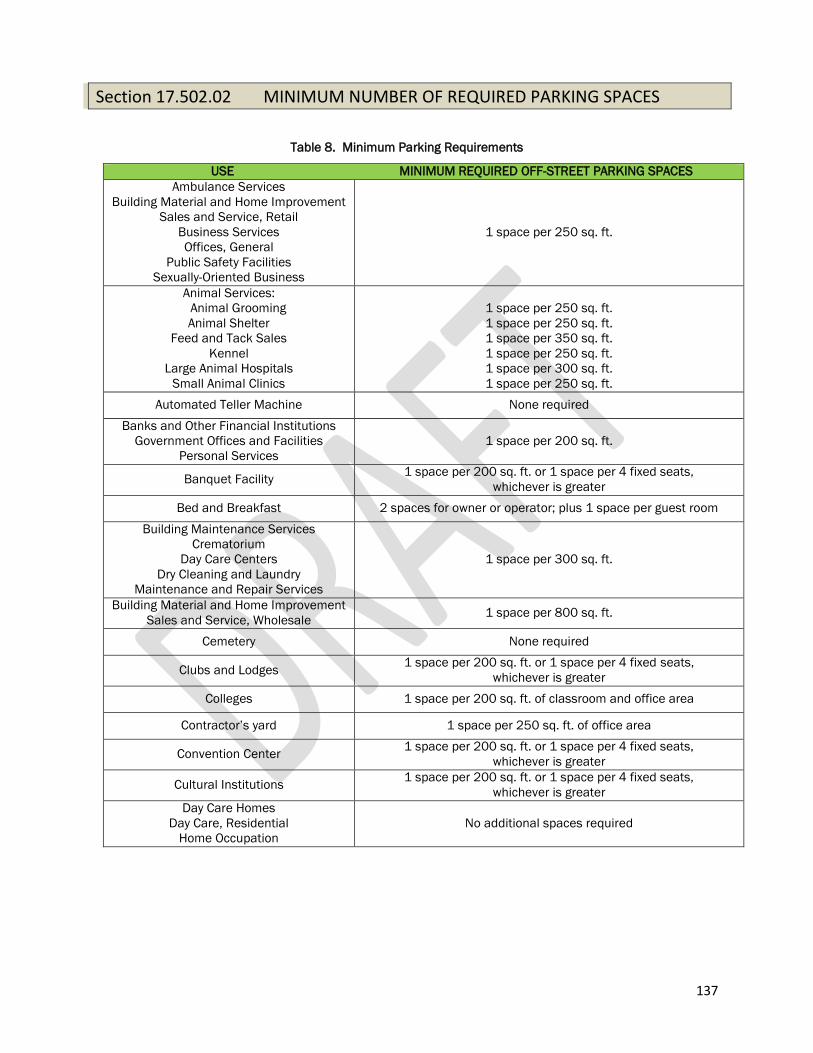
137
Section 17.502.02 MINIMUM NUMBER OF REQUIRED PARKING SPACES
Table 8. Minimum Parking Requirements
USE MINIMUM REQUIRED OFF-STREET PARKING SPACES
Ambulance Services
Building Material and Home Improvement
Sales and Service, Retail
Business Services
Offices, General
Public Safety Facilities
Sexually-Oriented Business
1 space per 250 sq. ft.
Animal Services:
Animal Grooming
Animal Shelter
Feed and Tack Sales
Kennel
Large Animal Hospitals
Small Animal Clinics
1 space per 250 sq. ft.
1 space per 250 sq. ft.
1 space per 350 sq. ft.
1 space per 250 sq. ft.
1 space per 300 sq. ft.
1 space per 250 sq. ft.
Automated Teller Machine None required
Banks and Other Financial Institutions
Government Offices and Facilities
Personal Services
1 space per 200 sq. ft.
Banquet Facility 1 space per 200 sq. ft. or 1 space per 4 fixed seats,
whichever is greater
Bed and Breakfast 2 spaces for owner or operator; plus 1 space per guest room
Building Maintenance Services
Crematorium
Day Care Centers
Dry Cleaning and Laundry
Maintenance and Repair Services
1 space per 300 sq. ft.
Building Material and Home Improvement
Sales and Service, Wholesale 1 space per 800 sq. ft.
Cemetery None required
Clubs and Lodges 1 space per 200 sq. ft. or 1 space per 4 fixed seats,
whichever is greater
Colleges 1 space per 200 sq. ft. of classroom and office area
Contractor’s yard 1 space per 250 sq. ft. of office area
Convention Center 1 space per 200 sq. ft. or 1 space per 4 fixed seats,
whichever is greater
Cultural Institutions 1 space per 200 sq. ft. or 1 space per 4 fixed seats,
whichever is greater
Day Care Homes
Day Care, Residential
Home Occupation
No additional spaces required
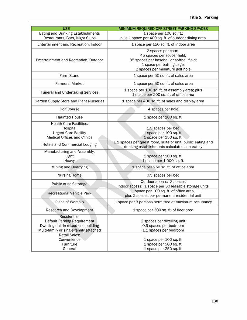
Title 5: Parking
138
USE MINIMUM REQUIRED OFF-STREET PARKING SPACES
Eating and Drinking Establishments
Restaurants, Bars, Night Clubs
1 space per 100 sq. ft.;
plus 1 space per 400 sq. ft. of outdoor dining area
Entertainment and Recreation, Indoor 1 space per 150 sq. ft. of indoor area
Entertainment and Recreation, Outdoor
2 spaces per court;
45 spaces per soccer field;
35 spaces per baseball or softball field;
1 space per batting cage;
2 spaces per miniature golf hole
Farm Stand 1 space per 50 sq. ft. of sales area
Farmers’ Market 1 space per 50 sq. ft. of sales area
Funeral and Undertaking Services 1 space per 100 sq. ft. of assembly area; plus
1 space per 200 sq. ft. of office area
Garden Supply Store and Plant Nurseries 1 space per 400 sq. ft. of sales and display area
Golf Course 4 spaces per hole
Haunted House 1 space per 100 sq. ft.
Health Care Facilities:
Hospital
Urgent Care Facility
Medical Offices and Clinics
1.5 spaces per bed
1 space per 100 sq. ft.
1 space per 150 sq. ft.
Hotels and Commercial Lodging 1.1 spaces per quest room, suite or unit; public eating and
drinking establishments calculated separately
Manufacturing and Assembly:
Light
Heavy
1 space per 500 sq. ft.
1 space per 1,000 sq. ft.
Mining and Quarrying 1 space per 250 sq. ft. of office area
Nursing Home 0.5 spaces per bed
Public or self-storage Outdoor access: 3 spaces
Indoor access: 1 space per 50 leasable storage units
Recreational Vehicle Park 1 space per 100 sq. ft. of office area,
plus 2 spaces per permanent residential unit
Place of Worship 1 space per 3 persons permitted at maximum occupancy
Research and Development 1 space per 300 sq. ft. of floor area
Residential:
Default Parking Requirement
Dwelling unit in mixed use building
Multi-family or single-family attached
2 spaces per dwelling unit
0.9 spaces per bedroom
1.1 spaces per bedroom
Retail Sales:
Convenience
Furniture
General
1 space per 100 sq. ft.
1 space per 500 sq. ft.
1 space per 250 sq. ft.
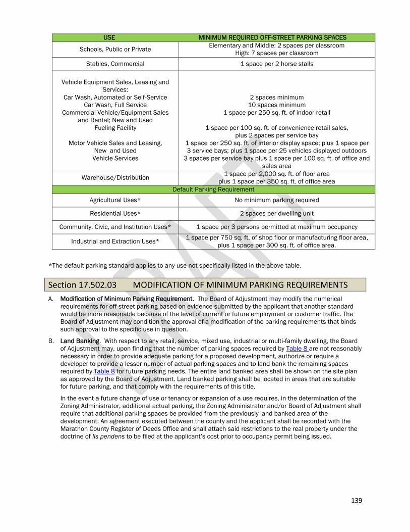
139
USE MINIMUM REQUIRED OFF-STREET PARKING SPACES
Schools, Public or Private Elementary and Middle: 2 spaces per classroom
High: 7 spaces per classroom
Stables, Commercial 1 space per 2 horse stalls
Vehicle Equipment Sales, Leasing and
Services:
Car Wash, Automated or Self-Service
Car Wash, Full Service
Commercial Vehicle/Equipment Sales
and Rental; New and Used
Fueling Facility
Motor Vehicle Sales and Leasing,
New and Used
Vehicle Services
2 spaces minimum
10 spaces minimum
1 space per 250 sq. ft. of indoor retail
1 space per 100 sq. ft. of convenience retail sales,
plus 2 spaces per service bay
1 space per 250 sq. ft. of interior display space; plus 1 space per
3 service bays; plus 1 space per 25 vehicles displayed outdoors
3 spaces per service bay plus 1 space per 100 sq. ft. of office and
sales area
Warehouse/Distribution 1 space per 2,000 sq. ft. of floor area
plus 1 space per 350 sq. ft. of office area
Default Parking Requirement
Agricultural Uses* No minimum parking required
Residential Uses* 2 spaces per dwelling unit
Community, Civic, and Institution Uses* 1 space per 3 persons permitted at maximum occupancy
Industrial and Extraction Uses* 1 space per 750 sq. ft. of shop floor or manufacturing floor area,
plus 1 space per 300 sq. ft. of office area.
*The default parking standard applies to any use not specifically listed in the above table.
Section 17.502.03 MODIFICATION OF MINIMUM PARKING REQUIREMENTS
A. Modification of Minimum Parking Requirement. The Board of Adjustment may modify the numerical
requirements for off-street parking based on evidence submitted by the applicant that another standard
would be more reasonable because of the level of current or future employment or customer traffic. The
Board of Adjustment may condition the approval of a modification of the parking requirements that binds
such approval to the specific use in question.
B. Land Banking. With respect to any retail, service, mixed use, industrial or multi-family dwelling, the Board
of Adjustment may, upon finding that the number of parking spaces required by Table 8 are not reasonably
necessary in order to provide adequate parking for a proposed development, authorize or require a
developer to provide a lesser number of actual parking spaces and to land bank the remaining spaces
required by Table 8 for future parking needs. The entire land banked area shall be shown on the site plan
as approved by the Board of Adjustment. Land banked parking shall be located in areas that are suitable
for future parking, and that comply with the requirements of this title.
In the event a future change of use or tenancy or expansion of a use requires, in the determination of the
Zoning Administrator, additional actual parking, the Zoning Administrator and/or Board of Adjustment shall
require that additional parking spaces be provided from the previously land banked area of the
development. An agreement executed between the county and the applicant shall be recorded with the
Marathon County Register of Deeds Office and shall attach said restrictions to the real property under the
doctrine of lis pendens to be filed at the applicant’s cost prior to occupancy permit being issued.
Title 5: Parking
140
C. Shared Parking. Two or more buildings or uses may collectively provide the required off-street parking, in
which case the required number of parking spaces shall not be less than the sum of the requirements for
the several individual uses computed separately. However, in cases of dual functioning of off-street
parking where operating hours do not overlap, the Zoning Administrator and/or Board of Adjustment may
reduce the required number of parking spaces based on the peak hour demand. Shared parking shall be
located within 500 feet of the building it is intended to serve, measured from the property line of the site
containing the parking facility.
1. Excess Shared Parking Area. Shared parking areas should contain sufficient parking area to
accommodate spill over parking in situations where the Zoning Administrator and/or Board of
Adjustment determines that the probability of increased parking demand or frequency thereof for
associated uses is above that which is required for each separate use as required by Table 8. Excess
shared parking areas shall be located within 500 feet of the building it is intended to serve, measured
from the property line of the site containing the parking facility. Excess shared parking areas shall
apply to and conform to the following conditions:
a. Applicability. Excess parking area shall only apply to buildings that contain 4 or more building
units.
b. Quantity of Shared Parking Area. Excess parking areas shall be equal to the required number of
parking spaces for the several individual uses computed separately, plus 20%. The Zoning
Administrator and/or Board of Adjustment may modify the amount of excess parking based on
evidence submitted by the applicant.
D. Mixed Use. In the case of a mixed use facility, the number of off-street parking facilities required shall
equal the sum of the required spaces of the various uses computed individually. If the Zoning
Administrator and/or Board of Adjustment determine that special characteristics of the uses within such a
facility will require fewer spaces than the computed sum, the Zoning Administrator and/or Board of
Adjustment may reduce the required number of spaces by no more than ½ the sum of the spaces required
for each individual use.
141
Chapter 17.503 Parking Design Standards
Section 17.503.01 COMMERCIAL/INDUSTRIAL PARKING LOT LAYOUT AND DESIGN STANDARDS
A. Parking Area Design. Parking areas shall be of useable shape, and encouraged to be improved with
bituminous concrete or equivalent surfacing unless required by development standards (refer to Section
17.503.02, Surfacing) and so graded and drained as to dispose of all surface water within the area.
B. Lighting. All lighting used to illuminate parking areas shall be so arranged as to direct light away from
adjoining premises or rights-of-way. Open light sources, such as the stringing of light bulbs shall be
prohibited.
C. Access Points. Access points shall be located to minimize traffic congestion and avoid undue interference
with pedestrian access at street intersections. Setbacks, widths and siting of driveway(s) are under the
jurisdiction of the applicable town, county Highway Department, and/or Wisconsin Department of
Transportation.
D. Maneuvering Lanes. All parking areas shall be provided adequate access by means of maneuvering lanes.
Backing directly into any public or private street from an off-street parking space shall be prohibited.
E. Pedestrian Circulation (B-R District only). Parking and loading areas, maneuvering lanes and access points
shall be designed to cause no interference with safe and convenient movement of automobile and
pedestrian traffic on and adjacent to a site. Parking lots shall also conform to the following to ensure safe
pedestrian movement within and adjacent to parking areas:
1. Separation. The parking lot layout shall accommodate direct and continuous pedestrian circulation,
clearly divided from vehicular areas.
2. Crosswalks. Pedestrian crosswalks shall be provided, distinguished by textured paving or pavement
striping and integrated into the sidewalk network.
3. Pavement Markings. Pavement markings such as directional arrows on and flush with the pavement
shall be provided, as approved by the Board of Adjustment.
4. Directional Signs. Directional signs including but not limited to stop, yield or pedestrian crossing signs
shall be provided.
5. ADA Considerations. All parking and loading areas shall conform to applicable sections of the (or
hereafter amended) Americans with Disabilities Act (ADA) Standards for Accessible Design.
6. Other Pedestrian Safety Measures. The Zoning Administrator and/or Board of Adjustment may require
speed bumps or other parking lot improvements where such improvements are deemed necessary.
The Zoning Administrator and/or Board of Adjustment should seek input from the Sheriff Department
when additional safety measures are being considered.
G. Barrier Free Parking Spaces.
1. Barrier Free Spaces Required. Each parking lot that serves a building, except single-and two-family
dwelling units, shall have a number of level parking spaces, identified by a sign which indicates the
spaces are reserved for physically handicapped persons. Barrier-free parking shall comply with the
Federal Americans with Disabilities Act.
2. Construction Standard. Each barrier-free parking space shall have no more than a nominal 3% grade
and shall be not less than eight feet in width and be adjacent to an access aisle not less than five feet
in width. Required van-accessible barrier-free spaces must be eight feet in width and be adjacent to
an access aisle not less than eight feet in width.
3. Number of Barrier Free Spaces Required. Barrier free spaces shall be required in accordance with
Table 9. Table 9 is based on the most recent Department of Justice ADA accessible parking
requirements. If the accessible parking requirements are updated, the updated standards shall
supersede those listed in Table 9.
Table 9. Barrier Free Spaces Required.
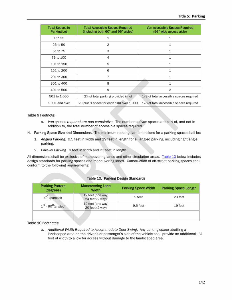
Title 5: Parking
142
Total Spaces in
Parking Lot
Total Accessible Spaces Required
(including both 60” and 96” aisles)
Van Accessible Spaces Required
(96” wide access aisle)
1 to 25 1 1
26 to 50 2 1
51 to 75 3 1
76 to 100 4 1
101 to 150 5 1
151 to 200 6 1
201 to 300 7 1
301 to 400 8 1
401 to 500 9 2
501 to 1,000 2% of total parking provided in lot 1/8 of total accessible spaces required
1,001 and over 20 plus 1 space for each 100 over 1,000 1/8 of total accessible spaces required
Table 9 Footnote:
a. Van spaces required are non-cumulative. The numbers of van spaces are part of, and not in
addition to, the total number of accessible spaces required.
H. Parking Space Size and Dimensions. The minimum rectangular dimensions for a parking space shall be:
1. Angled Parking. 9.5 feet in width and 19 feet in length for all angled parking, including right angle
parking.
2. Parallel Parking. 9 feet in width and 23 feet in length.
All dimensions shall be exclusive of maneuvering lanes and other circulation areas. Table 10 below includes
design standards for parking spaces and maneuvering lanes. Construction of off-street parking spaces shall
conform to the following requirements:
Table 10. Parking Design Standards
Parking Pattern
(degrees)
Maneuvering Lane
Width Parking Space Width Parking Space Length
0o
(parallel) 12 feet (one way)
24 feet (2 way) 9 feet 23 feet
1 o
- 90o
(angled) 12 feet (one way)
20 feet (2 way) 9.5 feet 19 feet
Table 10 Footnotes:
a. Additional Width Required to Accommodate Door Swing. Any parking space abutting a
landscaped area on the driver’s or passenger’s side of the vehicle shall provide an additional 1½
feet of width to allow for access without damage to the landscaped area.
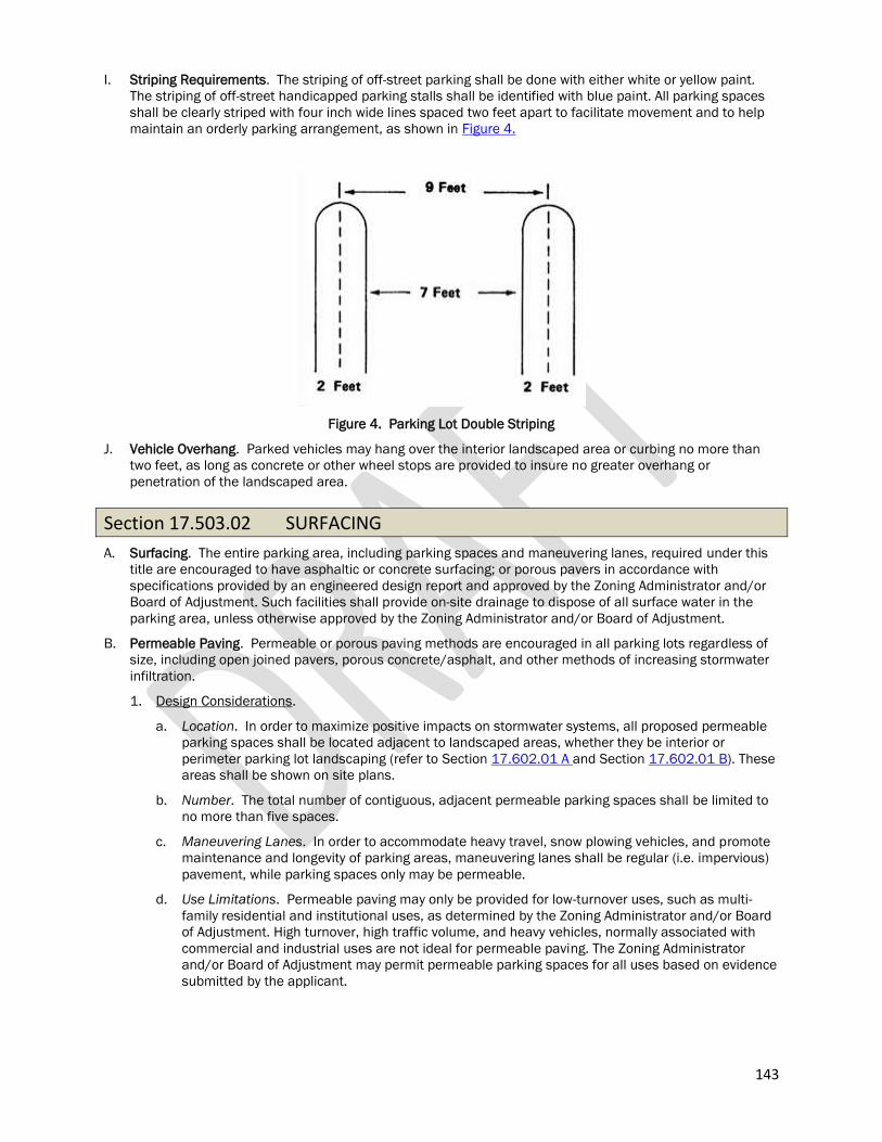
143
I. Striping Requirements. The striping of off-street parking shall be done with either white or yellow paint.
The striping of off-street handicapped parking stalls shall be identified with blue paint. All parking spaces
shall be clearly striped with four inch wide lines spaced two feet apart to facilitate movement and to help
maintain an orderly parking arrangement, as shown in Figure 4.
Figure 4. Parking Lot Double Striping
J. Vehicle Overhang. Parked vehicles may hang over the interior landscaped area or curbing no more than
two feet, as long as concrete or other wheel stops are provided to insure no greater overhang or
penetration of the landscaped area.
Section 17.503.02 SURFACING
A. Surfacing. The entire parking area, including parking spaces and maneuvering lanes, required under this
title are encouraged to have asphaltic or concrete surfacing; or porous pavers in accordance with
specifications provided by an engineered design report and approved by the Zoning Administrator and/or
Board of Adjustment. Such facilities shall provide on-site drainage to dispose of all surface water in the
parking area, unless otherwise approved by the Zoning Administrator and/or Board of Adjustment.
B. Permeable Paving. Permeable or porous paving methods are encouraged in all parking lots regardless of
size, including open joined pavers, porous concrete/asphalt, and other methods of increasing stormwater
infiltration.
1. Design Considerations.
a. Location. In order to maximize positive impacts on stormwater systems, all proposed permeable
parking spaces shall be located adjacent to landscaped areas, whether they be interior or
perimeter parking lot landscaping (refer to Section 17.602.01 A and Section 17.602.01 B). These
areas shall be shown on site plans.
b. Number. The total number of contiguous, adjacent permeable parking spaces shall be limited to
no more than five spaces.
c. Maneuvering Lanes. In order to accommodate heavy travel, snow plowing vehicles, and promote
maintenance and longevity of parking areas, maneuvering lanes shall be regular (i.e. impervious)
pavement, while parking spaces only may be permeable.
d. Use Limitations. Permeable paving may only be provided for low-turnover uses, such as multi-
family residential and institutional uses, as determined by the Zoning Administrator and/or Board
of Adjustment. High turnover, high traffic volume, and heavy vehicles, normally associated with
commercial and industrial uses are not ideal for permeable paving. The Zoning Administrator
and/or Board of Adjustment may permit permeable parking spaces for all uses based on evidence
submitted by the applicant.
Title 5: Parking
144
3. Approval. These methods may only be used when the permeable paving will have sufficient strength
to bear expected vehicle loads for the parking area, as demonstrated by the applicant. In addition, all
permeable pavement shall comply with the community’s Stormwater Management Regulations (if
applicable). As such, all proposed permeable pavement shall be reviewed by the community’s officials
who may consult with state and federal agencies and other technical experts as necessary.
C. When Surfaced. The parking area shall be surfaced within two months of occupancy of the use it is to
serve if it is for a new use, and within two months of the effective date of rezoning if said parking area is to
serve an existing use or uses, except when weather conditions prohibiting the pouring of concrete or
asphalt extend such time period.
Section 17.503.03 OFF-STREET LOADING AND PARKING
Every building used for nonresidential purposes which customarily receives or distributes goods by motor
vehicle shall provide sufficient space on the premises for all loading, unloading and service purposes on the
basis of the following minimum regulations:
A. Location. Access to truck loading and unloading space shall be provided directly from a public street or
alley or from any right-of-way that will not interfere with public use of the streets or alley and will allow
orderly and safe movement.
B. Supplemental to Off-Street Parking. Loading space required pursuant to this section shall be provided in
addition to off-street parking spaces required under Section 17.502.02.
C. Dimensions. Such loading and unloading space shall be 10 feet by 40 feet in area with a 14 foot height
clearance and shall be provided according to Table 11:
Table 11. Required Loading Spaces
Gross Usable Floor Area
(in square feet) Loading/Unloading Space Required
0 to 19,999 0
20,000 to 49,999 1
50,000 to 99,999 2
Over 100,000 2 spaces plus one additional space for each
additional 100,000 square feet or fraction thereof
Title 6: Buffering and Screening
145
Title 6: BUFFERING AND SCREENING
Chapter 17.601 General
Section 17.601.01 PURPOSE AND INTENT
The purposes and intent of the buffering and screening requirements of this Title are to:
A. Performance Standards. Minimize the transmission of nuisances associated with noise, dust, glare, and
litter ffrom one land use to another. of nuisances associated with noise, dust, glare, and litter.
B. Visual Pollution. Minimize visual pollution that may otherwise occur within and/or near a land use project
area. Minimal screening provides an impression of separation of spaces, and more extensive screening
can entirely shield the visual effects of an intense land use from a less intense land use.
C. Privacy. Establish a greater sense of privacy from visual or physical intrusion of intense land uses, the
degree of privacy varying with the intensity of screening.
D. Appearance. Establish aesthetically pleasing, functionally appropriate and sustainable landscaping design
for the long-term enhancement of the appearance of development in the community.
E. Safeguards. Safeguard the public health, safety and welfare, and preserve and enhance aesthetic
qualities that contribute to community character.
Section 17.601.02 SCOPE
A. Application of Buffering and Screening Requirements. The provisions of this Title shall apply to
commercial and industrial developments adjacent to residential districts. The regulations contained
herein do not apply to individual single-family lots.
Section 17.601.03 SUBMITTAL REQUIREMENTS
All buffering and screening plans shall be signed and sealed by a registered Architect, Surveyor or Engineer
and shall include all of the information required by Section 17.802.02.
Section 17.601.04 DESIGN STANDARDS
A. Visibility. Buffering and screening materials shall be laid out in conformance with the requirements of
Section 17.202.09 and shall not conflict with visibility for motorists or pedestrian access.
Section 17.601.05 WALLS
A. Generally. Walls required under this title shall have no openings for vehicular traffic or other purposes,
except such openings as may be approved by the county. All walls required in this ordinance shall be
constructed of decorative stone or brick. The height of the wall shall be measured from the prevailing
grade of the land on the side of the wall facing the less intense use. Walls shall be erected on a concrete
foundation which shall have a minimum depth of 3½ feet below a grade and shall not be less than eight
inches wider than the wall to be erected.
B. Substitution. A six foot tall decorative opaque vinyl fence or densely planted evergreen landscaping
sufficient to form a living green wall with a minimum height of six feet may be permitted by the Zoning
Administrator and/or Board of Adjustment in lieu of a masonry wall when the characteristics of the two
abutting uses would make such a substitution appropriate.
Title 6: Buffering and Screening
146
Section 17.601.06 STORAGE AND SERVICE AREA SCREENING
Vehicle use areas, service areas, and dumpsters, compactors and similar refuse-related elements shall be
screened from adjacent residential areas and from the public right-of-way. Such screening may be
accomplished by a masonry wall, building wing wall, or densely planted landscape buffer, or other means
acceptable to the Zoning Administrator.
Section 17.601.07 ENTRANCEWAY LANDSCAPING
In all residential districts, so called entranceway structures, including but not limited to walls, columns, gates,
and landscaping that mark entrances to single-family subdivisions or multiple housing projects may be
permitted and may be located in a required yard, except as provided in Section 17.202.09 (clear vision areas),
provided that such entranceways shall comply with all codes and ordinances of the county and shall be
approved by the appropriate authority (town, county, state, county Highway Dept.).
Section 17.601.08 LOCATION OF BUFFERING AND SCREENING
Screening required under this Title shall be located directly adjacent to the lot line except where underground
utilities interfere.
Section 17.601.09 MAINTENANCE
The owner of the property shall be responsible for all maintenance of site buffering and screening as follows:
A. Neat, Orderly, Healthy. Buffering and screening shall be kept in a neat, orderly and healthy growing
condition, free from debris and refuse.
B. Pruning. Pruning shall be minimal at the time of installation, only to remove dead or diseased branches.
Subsequent pruning shall assure proper maturation of plants to achieve their approved purpose.
C. Dead, Damaged, Diseased. All dead, damaged, or diseased plant material shall be removed immediately
and replaced within 6 months after it dies or in the next planting season, whichever occurs first.
Section 17.601.10 MODIFICATION OF BUFFERING AND SCREENING REQUIREMENTS
Recognizing that a wide variety of land uses and the relationships between them can exist, and that varying
circumstances can mitigate the need for buffering and screening, the Zoning Administrator and/or Board of
Adjustment may reduce or waive the buffer and screening zone requirements of this Title 6 and approve an
alternative buffer and screening plan. The Zoning Administrator and/or Board of Adjustment shall find that the
following standards have been met whenever it modifies any buffering and screening requirement:
A. Character. The buffering and screening plan shall protect the character of new and existing residential
neighborhoods against negative impacts such as noise, glare, light, air pollution, trash and debris, and
hazardous activities.
B. Compatibility. The alternate width and type of buffer zone and screening provided therein will ensure
compatibility with surrounding and nearby land uses because:
1. Scale, Bulk, etc. The development is compatible with and sensitive to the immediate environment of
the site and neighborhood relative to architectural design, scale, bulk, building height, identified
historical character, disposition and orientation of buildings on the lot and visual integrity.
2. Preserve Natural Features. The site has natural existing vegetation and/or topography, natural bodies
of water or wetland areas or other existing conditions which offer screening consistent with the
standards set forth in this Title 6. The Zoning Administrator and/or Board of Adjustment shall require
the preservation of these natural features as a condition of site plan approval.
3. Privacy; Minimize Negative Impacts. The arrangement, design and orientation of buildings on the site
maximize privacy and isolate adjacent and nearby land uses from any potential negative impacts of
the project.

Title 6: Buffering and Screening
147
Section 17.601.11 PLANT MATERIALS ADJACENT TO FARMLAND PRESERVATION DISTRICT
The planting of deciduous and evergreen trees within 15 feet of the boundary line between residential districts
and farmland preservation districts is discouraged.
Section 17.601.12 WAIVER OF REQUIREMENTS
The Zoning Administrator and/or Board of Adjustment approving the buffer and screening plan may waive or
reduce the requirements of this Title upon determining that the following would apply:
A. Purpose. The purpose of this Title cannot be met; and
B. Health, Safety, Welfare. Safeguard the public health, safety and welfare, and preserve the aesthetic
qualities and enhance the community character.
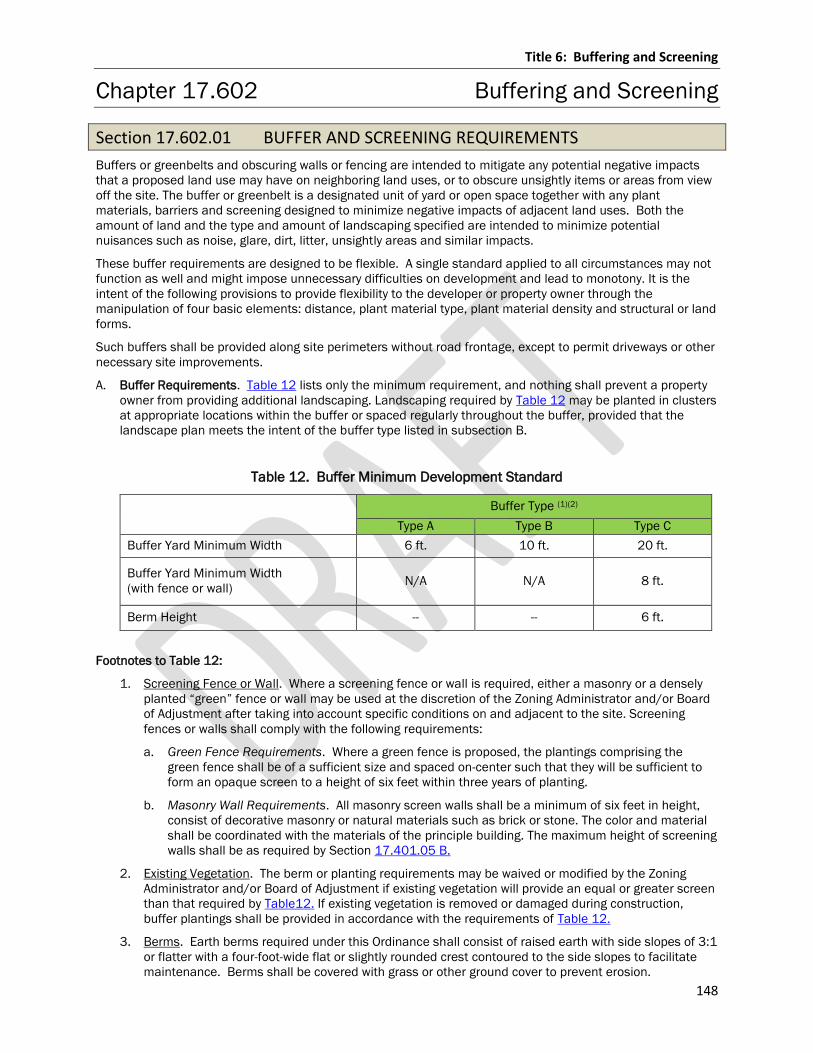
Title 6: Buffering and Screening
148
Chapter 17.602 Buffering and Screening
Section 17.602.01 BUFFER AND SCREENING REQUIREMENTS
Buffers or greenbelts and obscuring walls or fencing are intended to mitigate any potential negative impacts
that a proposed land use may have on neighboring land uses, or to obscure unsightly items or areas from view
off the site. The buffer or greenbelt is a designated unit of yard or open space together with any plant
materials, barriers and screening designed to minimize negative impacts of adjacent land uses. Both the
amount of land and the type and amount of landscaping specified are intended to minimize potential
nuisances such as noise, glare, dirt, litter, unsightly areas and similar impacts.
These buffer requirements are designed to be flexible. A single standard applied to all circumstances may not
function as well and might impose unnecessary difficulties on development and lead to monotony. It is the
intent of the following provisions to provide flexibility to the developer or property owner through the
manipulation of four basic elements: distance, plant material type, plant material density and structural or land
forms.
Such buffers shall be provided along site perimeters without road frontage, except to permit driveways or other
necessary site improvements.
A. Buffer Requirements. Table 12 lists only the minimum requirement, and nothing shall prevent a property
owner from providing additional landscaping. Landscaping required by Table 12 may be planted in clusters
at appropriate locations within the buffer or spaced regularly throughout the buffer, provided that the
landscape plan meets the intent of the buffer type listed in subsection B.
Table 12. Buffer Minimum Development Standard
Buffer Type (1)(2)
Type A Type B Type C
Buffer Yard Minimum Width 6 ft. 10 ft. 20 ft.
Buffer Yard Minimum Width
(with fence or wall) N/A N/A 8 ft.
Berm Height -- -- 6 ft.
Footnotes to Table 12:
1. Screening Fence or Wall. Where a screening fence or wall is required, either a masonry or a densely
planted “green” fence or wall may be used at the discretion of the Zoning Administrator and/or Board
of Adjustment after taking into account specific conditions on and adjacent to the site. Screening
fences or walls shall comply with the following requirements:
a. Green Fence Requirements. Where a green fence is proposed, the plantings comprising the
green fence shall be of a sufficient size and spaced on-center such that they will be sufficient to
form an opaque screen to a height of six feet within three years of planting.
b. Masonry Wall Requirements. All masonry screen walls shall be a minimum of six feet in height,
consist of decorative masonry or natural materials such as brick or stone. The color and material
shall be coordinated with the materials of the principle building. The maximum height of screening
walls shall be as required by Section 17.401.05 B.
2. Existing Vegetation. The berm or planting requirements may be waived or modified by the Zoning
Administrator and/or Board of Adjustment if existing vegetation will provide an equal or greater screen
than that required by Table12. If existing vegetation is removed or damaged during construction,
buffer plantings shall be provided in accordance with the requirements of Table 12.
3. Berms. Earth berms required under this Ordinance shall consist of raised earth with side slopes of 3:1
or flatter with a four-foot-wide flat or slightly rounded crest contoured to the side slopes to facilitate
maintenance. Berms shall be covered with grass or other ground cover to prevent erosion.
Title 6: Buffering and Screening
149
B. Buffer Descriptions and Requirements. The following is a description of the intended character and
function of each buffer type. The specific requirements for each buffer type are listed in subsection A
above and the type of buffer is listed below.
1. Type A: Low density screening to partially block visual contact between zoning classifications.
2. Type B: Medium density screen to partially block visual contact between zoning classifications and to
create spatial separation.
3. Type C: High density screen intended to substantially block visual contact between zoning
classifications and create spatial separation. Type C planting buffers reduce light and noise trespass
that would otherwise intrude upon adjacent zoning classifications. Must form an opaque screen to a
height of six feet within three years of planting.
Title 6: Buffering and Screening
150
Chapter 17.603 Standards for Buffer and Screening Materials
Section 17.603.01 GENERAL
Whenever a landscape planting screen or other plantings are required under this Ordinance, such plantings
shall be installed according to accepted good planting procedures and in a sound, workmanlike manner. All
plant material shall meet current standards of the American Association of Nurserymen and approved by the
American National Standards Institute, Inc. (ANSI 260.1, 1996).
A. Names. All plant material shall be true to name in conformance to the current edition of Standardized
Plant Names established by the American Joint Committee on Horticultural Nomenclature, or other source
accepted by the county.
B. Plantings. All plant material shall be nursery grown in a northern climate; hardy to the climate of
Wisconsin; appropriate for the soil, climatic and environmental conditions; and resistant to disease and
insect attack.
C. Topsoil Depth. A minimum 4 inches of topsoil shall be provided for all lawn areas, ground covers, and
planting beds.
D. Artificial Plants Prohibited. Artificial plant material is prohibited and shall not be used to meet the
requirements of this Title.
Section 17.603.02 PLANT MATERIAL SPACING
Spacing of plant materials required under this Title shall be as follows:
A. Property/Fence Line. Plant materials shall not be placed closer than four feet from the fence line or
property line.
B. Public Right-of-way. Deciduous trees and all shrubs may not be planted within five feet, and evergreen
trees may not be planted within 10 feet, of any a public right-of-way.
C. Fire Hydrant. Trees and shrubs may not be planted within 10 feet of a fire hydrant (if applicable).
D. Staggered Rows. Where plant materials are planted in two or more rows, planting shall be staggered in
rows.
Section 17.603.03 EXISTING VEGETATION
Healthy existing trees on a site may be used to satisfy any of the requirements of this title, subject to Board of
Adjustment approval.
Section 17.603.04 SIZE AND VARIETY OF PLANT MATERIALS
A. Variety; Size. To ensure adequate variety, and to avoid monotony and uniformity within a site, required
plant materials shall not include more than 20% of any single plant species.
Title 7: Signs
151
Title 7: SIGNS
Chapter 17.701 General
Section 17.701.01 PURPOSE AND INTENT
Purpose. The sign regulations, including provisions to control the type, design, size, location, motion,
illumination, enforcement and maintenance thereof, are established in order to achieve among others the
following purposes:
A. Aesthetics; Property Values. To protect and enhance the physical appearance of the community in a lawful
manner that recognizes the rights of property owners. To enhance and protect the physical appearance of
the community and to protect and enhance property values, by:
1. Encouraging the appropriate design, scale, and placement of signs.
2. Encouraging the orderly placement of signs on the building while avoiding regulations that are so rigid
and inflexible that all signs in a series are monotonously uniform.
B. Attractiveness. Promote the creation of an attractive visual environment that promotes a healthy economy
by maintaining a visually attractive, residential, commercial, industrial and other use districts, by:
1. Permitting businesses to inform, identify, and communicate effectively.
2. Directing the general public through the use of signs while maintaining attractive and harmonious
application of signs on the buildings and sites.
C. Public Safety. To foster public safety along public and private streets within the community by assuring
that all signs are in safe and appropriate locations.
1. To ensure that signs are located and designed to reduce sign distraction and eliminate any confusion
that may be contributing factors in traffic congestion and accidents, and maintain a safe and orderly
pedestrian and vehicular environment.
2. To promote the public health, safety and welfare by avoiding conflicts between signs and traffic control
devices, avoiding traffic hazards, and reducing visual distractions and obstructions.
D. Design. To control the design and size of signs to ensure that their appearance will be aesthetically
harmonious with an overall design for the area and to encourage the use of creative and visually attractive
signs.
E. County Objective. To promote the most desirable developments and economic activity consistent with the
objectives of the County of Marathon.
F. Review Procedures. Provide review procedures that enable the County to comprehensively evaluate the
appropriateness of a sign to the site, building and surroundings. To have administrative review procedures
that are the minimum necessary to:
1. Balance the community’s objectives and regulatory requirements with the reasonable advertising and
way finding needs of businesses.
2. Allow for consistent enforcement of the Sign Code.
3. Minimize the time required to review a sign application.
4. Provide flexibility as to the number and placement of signs so the regulations are more responsive to
business needs while maintaining the community’s standards.
G. Prohibition. Prohibit all signs not expressly permitted by this Title.
H. To allow businesses, institutions, and individuals to exercise their right to free speech by displaying an
image on a sign, and to allow audiences to receive such information.
I. To provide for reasonable and appropriate communication and identification for on premise and off-
premise signs in commercial and industrial districts in order to foster successful businesses.
Title 7: Signs
152
Intent. The administration of sign regulations are not established to harm First Amendment interests that is
disproportionate in light of the relevant regulatory objectives and the importance of balancing countervailing
objectives achieved through reasonable governmental regulations other than to protect the safety and general
welfare of the public through justifiable government regulations.
Sign restrictions shall not be based on hostility or favoritism toward an underlying message expressed, nor
does the treatment restrict speaker-based, event-based, or content-based messages. Rather, the following
regulations are reflective of ordinary practical application of well-established procedures guaranteeing that
government shall not favor or disfavor messages without equitable treatment and reasonable regulation.
Section 17.701.02 ADMINISTRATION
A. Permit Required. To ensure compliance with this Title, all signs not exempt by Chapter 17.703 of this Title
shall obtain Administrative Review or conditional Use Review approval before securing a Zoning Permit to
construct, alter, replace or move a sign. No permanent sign shall be located closer than 75 feet from the
ordinary high-water mark of any navigable or perennial body of water, in the floodway of any stream or in
any shoreland-wetland.
B. Sign Permit Application Requirements. A complete sign permit application shall consist of all of the
following:
1. Application Form. An application form supplied by the Department that is filled out and signed by the
person or entity that will own the sign and the person or entity who owns the property or their
designee. Application to include a site plan drawn to scale showing all of the following:
a. Lot. The location and dimensions of the property’s boundary lines;
b. Buildings. The location of all buildings and structures on the lot;
c. Existing Signage. The location, dimensions, and description of all existing signage on the
property;
d. Proposed Signage. The sign design and layout proposed, including total area of the sign(s), sign
height, character, materials and color of letters, lines and symbols;
e. Illumination. For illuminated signs, the method of illumination, the number and type of lamps and
lens material and a statement that the illumination of each sign will comply with the provisions in
Section 17.701.03.
f. Elevations. Elevations and specifications for proposed signs, including proposed landscaping for
ground mounted signs. If a sign is proposed to be on a wall, then the entire wall that such sign will
be attached to must be depicted showing the location of the sign on said wall.
g. Construction Details. Details and specifications for construction, erection and attachment as may
be required by the Zoning Administrator.
h. The name of the sign contractor or company responsible for construction of the sign.
i. Other Information. All other information deemed pertinent by the Zoning Administrator or
designee thereof.
2. Fee. An application fee per the Department fee schedule;
C. Review Procedure
1. Site Plan Review. Signs may be approved as part of an overall site review for a conditional use which
is reviewed by the Board of Adjustment.
2. Administrative Review. Any sign that will be accessory to any principle use that is not subject to Site
Plan approval shall be processed and acted upon as follows:
a. A sign permit application will not be approved by the Zoning Administrator until a complete sign
permit application, as outlined in Section 17.701.02 B., above, has been submitted;
b. A complete sign permit application shall be reviewed by the Zoning Administrator and shall be
granted or denied within 30 days;
c. No public hearing shall be required;
d. No written notice of the application or associated action shall be required;
Title 7: Signs
153
e. Sign applications approved by the county may be subject to other county or state agency approval.
2. Conditional Use Review. Any sign that will be accessory to a principle use which is subject to Site Plan
review shall be reviewed and acted upon as part of that Site Plan review process and shall be
reviewed and acted upon separately;
A complete sign permit application must be submitted at least 45 calendar days prior to the regular
Board of Adjustment meeting at which the applicant wishes to be heard;
D. Effective Date and Permits. No applicant action shall take place on a sign application until all of the
following have occurred:
1. Zoning Administrator Approval. The Zoning Administrator has approved the application;
2. Notice of Action. Written Notice of Action has been received; and
3. Zoning Permit Issued. The Zoning Administrator has issued a zoning permit.
No building or other permits shall be issued until all of the above have occurred.
E. Amendments. Modifications proposed for any sign that has received approval, whether installed or not,
must be approved by the Zoning Administrator pursuant to the procedures set forth in this Section.
F. Removal. When any sign is removed for any reason other than maintenance (repair, refurbishing or
repainting), all mast arms, guys of any nature, clips, brackets, and all other components of the removed
sign shall be removed with the sign. A new zoning permit and associated sign review shall be required for
any subsequent installation of a sign, including but not limited reinstallation of the removed sign.
G. Denial. In the event that the Zoning Administrator denies a sign permit application, the applicant shall be
provided written notification of denial. Such written notification shall outline the reasons for denial and
include applicable references to code sections that must be complied with in order to secure application
approval.
H. Appeal. Any applicant has the right to appeal the Zoning Administrator or Board of Adjustment’s decision,
as may be applicable, by filing a notice of appeal within 30 days of receipt of a notice of denial per Chapter
17.804.
Section 17.701.03 SUBSTITUTION
Notwithstanding anything herein to the contrary, noncommercial copy may be substituted for commercial copy
on any lawful sign structure, and any sign permitted by this Title may contain a noncommercial message.
Section 17.701.04 GENERAL STANDARDS
A. Application; Conflict. The construction, erection, safety and maintenance of all signs shall be in
accordance with the applicable county codes, rules or regulations. The provisions of this Title shall not
amend or in any way interfere with other codes, rules or regulations governing traffic signs within the
county. Whenever there is a conflict between any provisions of any adopted ordinance, rule or regulation,
the more restrictive provisions shall govern.
B. Minimum Requirements. In their interpretation and application, the provisions of this Title, as most
recently amended, shall be considered the minimum requirements.
C. Conformance Required. Signs shall be designed, erected, painted, created, altered, reconstructed, moved
and maintained in the county in accordance with the type, design, size, location, illumination and other
provisions set forth in this Title.
D. Construction Standards.
1. The construction, erection, safety and maintenance of all signs shall comply with all applicable county
standards and regulations including but not limited to applicable state fire codes.
2. Permanent signs shall be fabricated on and of materials that are of good quality and good durability.
Wood shall be treated to prevent deterioration. Letters, figures, and characters shall be securely
attached to the sign structure.
Title 7: Signs
154
3. Temporary signs shall be durable and weather-resistant and fastened or anchored sufficiently,
whether attached to the building or positioned in the ground.
4. All building mounted signs shall be attached by means of metal anchors, bolts or expansion screws,
and in no case shall any sign be secured with wire.
Section 17.701.05 DESIGN STANDARDS
Signs, as permitted in the various zoning districts, shall be professionally designed, constructed and installed
so as to be compatible in character with regard to the architecture of the building on which they are located,
and to the materials, color and size of signs designed or located on the same building and on adjoining
buildings in order to produce an overall unified effect in accordance with the standards set forth in this section.
A. Vertical Dimension. The lowest member of all signs which are supported or suspended from a building
shall not be less than eight feet above the finished grade of a sidewalk or other pedestrian way. If located
over pavement used for vehicular traffic or within 1½ feet of the vertical projection of the edges of such
pavement, the lowest member of the sign shall not be less than 15 feet above the finished pavement.
B. Relation to Traffic Devices. No sign shall be erected in a right-of-way, in proximity to railroad crossings, or
at the intersection of any rights-of-way in such a manner as to obstruct sight lines along any public way; or
at any location where, by reason of the position, shape, or color, it may interfere with, obstruct the view of,
or be confused with, any authorized traffic sign signal or device as defined in the Manual of Uniform Traffic
Control Devices. Signs visible from the street shall not make use of the words “stop”, “go”, “slow”, “look”,
“danger”, or any other word, phrase, symbol or character in such a manner as to interfere with, mislead, or
confuse traffic.
C. Graphics. The lettering on a sign shall be clearly legible and in scale with the sign surface upon which it is
placed.
D. Materials. Signs shall be constructed of materials which are of appropriate quality and durability.
E. Smooth Sign Face. No nails, tacks or wires shall be permitted to protrude from the front of any sign.
Section 17.701.06 COMPUTATION AND RULES OF MEASUREMENT
A. Measurement of Sign Area. For the purposes of determining compliance with the sign area requirements
of this Title, sign area shall be calculated as follows:
1. Generally. Measurement of a sign includes the entire area within a rectangle enclosing the extreme
limits of writing, representation, emblem, or any figure of similar character, together with any frame or
other material or color forming an integral part of the display or used to differentiate the sign from the
background against which it is placed. This excludes the necessary supports or uprights on which the
sign is placed (refer to Figure 5).
2. Air Under Ground and Between Projecting Sign. Air under a ground sign between supporting posts, air
between a projecting sign and the wall to which it is attached, and lighting fixtures and associated
brackets shall not be included in the calculation of sign area (refer to Figure 5).
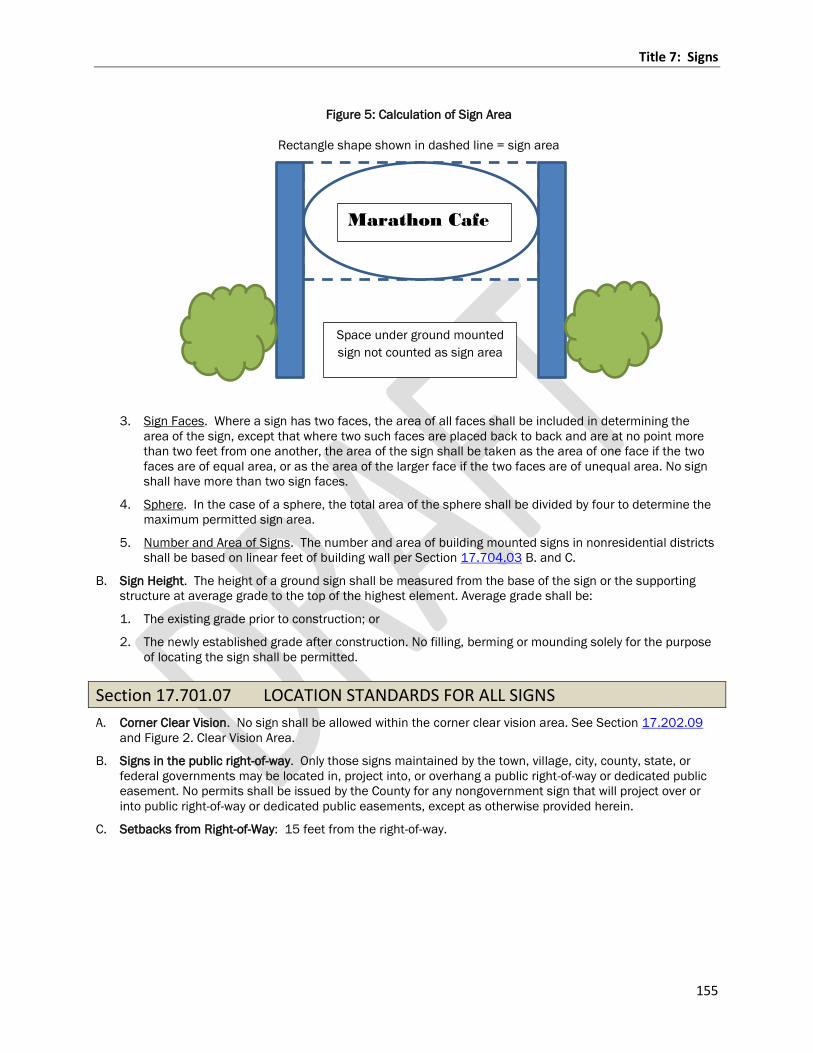
Title 7: Signs
155
Figure 5: Calculation of Sign Area
Rectangle shape shown in dashed line = sign area
3. Sign Faces. Where a sign has two faces, the area of all faces shall be included in determining the
area of the sign, except that where two such faces are placed back to back and are at no point more
than two feet from one another, the area of the sign shall be taken as the area of one face if the two
faces are of equal area, or as the area of the larger face if the two faces are of unequal area. No sign
shall have more than two sign faces.
4. Sphere. In the case of a sphere, the total area of the sphere shall be divided by four to determine the
maximum permitted sign area.
5. Number and Area of Signs. The number and area of building mounted signs in nonresidential districts
shall be based on linear feet of building wall per Section 17.704.03 B. and C.
B. Sign Height. The height of a ground sign shall be measured from the base of the sign or the supporting
structure at average grade to the top of the highest element. Average grade shall be:
1. The existing grade prior to construction; or
2. The newly established grade after construction. No filling, berming or mounding solely for the purpose
of locating the sign shall be permitted.
Section 17.701.07 LOCATION STANDARDS FOR ALL SIGNS
A. Corner Clear Vision. No sign shall be allowed within the corner clear vision area. See Section 17.202.09
and Figure 2. Clear Vision Area.
B. Signs in the public right-of-way. Only those signs maintained by the town, village, city, county, state, or
federal governments may be located in, project into, or overhang a public right-of-way or dedicated public
easement. No permits shall be issued by the County for any nongovernment sign that will project over or
into public right-of-way or dedicated public easements, except as otherwise provided herein.
C. Setbacks from Right-of-Way: 15 feet from the right-of-way.
Marathon Cafe
Space under ground mounted
sign not counted as sign area
Title 7: Signs
156
Section 17.701.08 ILLUMINATION OF SIGNS
A. Electronic Message Center Signs. See Section 17.704.05 for additional requirements.
B. Illumination of Signs. All externally illuminated signs shall comply with the following standards.
1. Such fixture shall be mounted above the sign face with all light directed downward and concentrated
on the area of the sign. No externally illuminated sign shall be up-lit or utilize light directed upwards
from the ground towards the sign face.
2. Illuminated signs or lighting devices shall employ only a light of constant intensity.
3. Such fixtures shall prevent glare upon adjacent properties, or rights-of-way so as to not cause glare or
reflection that may constitute a traffic hazard or nuisance.
4. All light sources to illuminate signs, internal or external, shall be shielded from all adjacent buildings
and rights-of-way. Light sources shall not be of such brightness so as to cause glare hazardous to the
motoring public or adjacent buildings and uses.
C. Maximum Illumination. In no case shall any sign illumination, whether internally or externally illuminated,
exceed a level of illumination of 0.07 foot candles when measured from the nearest or adjacent
residential zoned property or use.
Section 17.701.09 MAINTENANCE OF SIGNS
All signs shall be maintained in accordance with the following:
A. Maintenance; Safety. The property owner, occupant, or other person responsible for the sign shall
maintain the sign in a condition fit for the intended use and he/she shall have a continuing obligation to
comply with all county code requirements and the requirements of this Title.
B. Removal for Repair or Similar Purposes. Whenever any sign, either conforming or non-conforming to these
regulations, is required to be removed for the purpose of repair, refurbishing, or repainting, the same may
be done without a permit or any payment of fees provided that all of the following conditions are met:
1. There shall be no alteration or remodeling to the sign face, lettering (except as otherwise permitted for
changeable copy), sign base, sign support(s) or the mounting of the sign itself.
2. There shall be no enlargement or increase in any dimensions of the sign or its structure.
3. The sign shall be accessory to a legally permitted, conditional or non-conforming use.
C. Removal Order; General. The Zoning Administrator may order any sign to be painted or refurbished
whenever needed to keep the sign in a neat and safe condition. All supports, guys, braces and anchors for
such signs shall be maintained in a safe condition, and it shall be unlawful for the owners or person having
charge of such sign not to remove and repair said sign after receiving notice from the Zoning
Administrator.
D. Internal Illumination. If a sign, approved by a county-issued zoning permit to be internally illuminated and
the sign or any of its letters or message are only partially lit, all illumination of the sign shall be
discontinued until the sign is repaired and properly illuminated as it was designed and approved in the
Zoning Permit for the sign.
E. Notice; Remedy. If the Zoning Administrator finds that any sign is unsafe, insecure, a menace to the
public; or constructed, erected, or maintained in violation of the provisions of this Ordinance, notice shall
be given in writing by the Zoning Administrator sent first class mail to the property owner, occupant, tenant
or other person responsible for the sign. The property owner, occupant, tenant or other person responsible
for the sign shall, within 30 calendar days of the date of such notification, correct such condition or
remove the sign. If the correction has not been made within 30 calendar days, the Zoning Administrator
may issue enforcement actions as specified under Section 17.701.13.
Title 7: Signs
157
Section 17.701.10 REMOVAL OF SIGNS
A. Nuisance Sign; Removal Process. The Zoning Administrator is authorized to order the removal or
maintenance of any sign which constitutes a nuisance, besides abandoned signs, which shall conform to
Chapters 17.703 and 17.704. Any such order shall be served upon the owner in possession of the sign by
personal service, regular mail service, or posting notice on the premises where the sign is located. The
timeframe for compliance shall commence from the date of such notification.
B. Compliance. Whenever the removal of any permanent sign, excluding abandoned signs as defined by this
Ordinance, has been ordered by the Zoning Administrator, the owner or person in possession of the
premises, and/or the permit holder shall comply with such order within 30 calendar days after notice is
served upon him/her. Whenever the removal or maintenance of a temporary or portable sign has been
ordered by the Zoning Administrator, the owner or person in possession of such sign shall comply with the
order within 14 calendar days after notice. In the event of noncompliance, the Zoning Administrator may
issue enforcement actions as specified under Section 17.701.13.
Section 17.701.11 ABANDONED SIGNS
Abandoned signs shall be subject to the following:
A. Nuisance. Abandoned signs shall be deemed to be a public nuisance by reason that continued lack of use
results in lack of reasonable and adequate maintenance, thereby causing deterioration and a blighting
influence on nearby properties.
B. Date of Sign Abandonment. Whenever a sign is abandoned, the Zoning Administrator shall first document
the date of sign abandonment.
C. Determination of Violation. An abandoned sign shall be considered a violation of this Ordinance only after
the Zoning Administrator further documents that both of the following circumstances exist:
1. A period of not less than 180 consecutive days has elapsed since the date of sign abandonment; and
2. No Zoning Permit has been issued during such period for the building, building unit and/or use
associated with the abandoned sign.
D. Removal Notice. An abandoned sign, including non-conforming sign support structures, appurtenances
and internal sign components, shall be removed by the property owner, occupant, tenant or other person
responsible for the sign or having the beneficial use of the building, structure or land upon which such sign
is located within 30 calendar days following written notice by the Zoning Administrator. Any such notice
shall be served upon the property owner, occupant, tenant or other person responsible for the sign by mail
service, or posting notice on the premises where the sign is located. The timeframe for compliance shall
commence from the date of such notification.
E. Appeal. A party served with such notice shall have the right to appeal the Zoning Administrator’s order by
filing a notice of appeal with the Board of Adjustment within 30 calendar days of receipt of the notice.
F. Enforcement. Upon failure to file a timely notice of appeal or failure to comply with such notice within the
time specified in this section, the Zoning Administrator may issue enforcement actions as specified under
Section 17.701.13.
Title 7: Signs
158
Section 17.701.12 NUISANCE
Any sign or other object placed, displayed, erected, constructed, reconstructed, illuminated, altered or
permitted to remain on any premises in violation of this Ordinance and any sign heretofore erected,
constructed or displayed without legal authorization is hereby declared to constitute a nuisance, and in
addition to any penalty provided in the Codified Ordinances for such violation, the nuisance may be abated in
the manner provided now or in the future by the statutes of Wisconsin or in the manner provided in Section
17.701.13.
Section 17.701.13 ENFORCEMENT AND PENALTIES
A. Injunction Proceedings. Whenever any person, firm or corporation fails, neglects or refuses to comply with
any order of the Zoning Administrator under the provisions of this Ordinance, or whenever any sign is in
violation of, or not in conformity with, any provision of this Ordinance, the Zoning Administrator may, at
his/her discretion, institute and maintain in the name of the county an appropriate action at law or in
equity to restrain the execution in violation of this Ordinance, to prevent the use of such sign and/or
structure and to prevent or terminate any violation of this Ordinance.
B. Penalty.
1. Whoever violates any of the provisions of this Chapter or any order of the Zoning Administrator issued
in accordance with this Chapter or resists enforcement shall be subject to issuance of a citation
pursuant to the Schedule of Deposits set forward by the Marathon County Committee.
2. Whoever violates any of the provisions of this Chapter or any order of the Zoning Administrator issued
in accordance with this Chapter or resists enforcement shall, upon conviction thereof, be subject to a
forfeit not less than $10 nor more than $200 and costs of prosecution for each violation and in
default of payment of such forfeiture and costs shall be imprisoned in the county jail until payment
thereof, but not exceeding 30 calendar days. A separate offense shall be deemed committed each day
during, or on, which a violation occurs or continues.
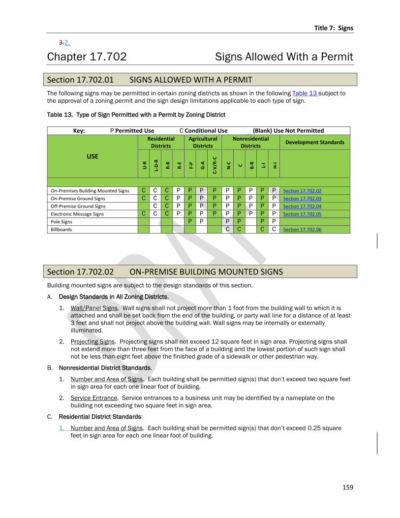
Title 7: Signs
159
3.2.
Chapter 17.702 Signs Allowed With a Permit
Section 17.702.01 SIGNS ALLOWED WITH A PERMIT
The following signs may be permitted in certain zoning districts as shown in the following Table 13 subject to
the approval of a zoning permit and the sign design limitations applicable to each type of sign.
Table 13. Type of Sign Permitted with a Permit by Zoning District
Key: P Permitted Use C Conditional Use (Blank) Use Not Permitted
USE
Residential Districts
Agricultural Districts
Nonresidential Districts
Development Standards U
-R
L-D
-R
R-R
R-E
F-P
G-A
C-V
/R-C
N-C
C
B-R
L-I
H-I
On-Premises Building Mounted Signs C C C P P P P P P P P P Section 17.702.02
On-Premise Ground Signs C C C P P P P P P P P P Section 17.702.03
Off-Premise Ground Signs C C P P P P P P P P P Section 17.702.04
Electronic Message Signs C C C P P P P P P P P P Section 17.702.05
Pole Signs P P P P P P
Billboards C C C C Section 17.702.06
Section 17.702.02 ON-PREMISE BUILDING MOUNTED SIGNS
Building mounted signs are subject to the design standards of this section.
A. Design Standards in All Zoning Districts.
1. Wall/Panel Signs. Wall signs shall not project more than 1 foot from the building wall to which it is
attached and shall be set back from the end of the building, or party wall line for a distance of at least
3 feet and shall not project above the building wall. Wall signs may be internally or externally
illuminated.
2. Projecting Signs. Projecting signs shall not exceed 12 square feet in sign area. Projecting signs shall
not extend more than three feet from the face of a building and the lowest portion of such sign shall
not be less than eight feet above the finished grade of a sidewalk or other pedestrian way.
B. Nonresidential District Standards.
1. Number and Area of Signs. Each building shall be permitted sign(s) that don’t exceed two square feet
in sign area for each one linear foot of building.
2. Service Entrance. Service entrances to a business unit may be identified by a nameplate on the
building not exceeding two square feet in sign area.
C. Residential District Standards:
1. Number and Area of Signs. Each building shall be permitted sign(s) that don’t exceed 0.25 square
feet in sign area for each one linear foot of building.
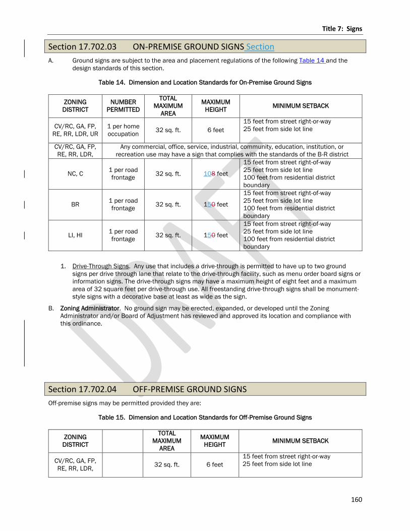
Title 7: Signs
160
Section 17.702.03 ON-PREMISE GROUND SIGNS Section
A. Ground signs are subject to the area and placement regulations of the following Table 14 and the
design standards of this section.
Table 14. Dimension and Location Standards for On-Premise Ground Signs
ZONING
DISTRICT
NUMBER
PERMITTED
TOTAL
MAXIMUM
AREA
MAXIMUM
HEIGHT MINIMUM SETBACK
CV/RC, GA, FP,
RE, RR, LDR, UR
1 per home
occupation 32 sq. ft. 6 feet
15 feet from street right-or-way
25 feet from side lot line
CV/RC, GA, FP,
RE, RR, LDR,
Any commercial, office, service, industrial, community, education, institution, or
recreation use may have a sign that complies with the standards of the B-R district
NC, C 1 per road
frontage 32 sq. ft. 108 feet
15 feet from street right-of-way
25 feet from side lot line
100 feet from residential district
boundary
BR 1 per road
frontage 32 sq. ft. 150 feet
15 feet from street right-of-way
25 feet from side lot line
100 feet from residential district
boundary
LI, HI 1 per road
frontage 32 sq. ft. 150 feet
15 feet from street right-of-way
25 feet from side lot line
100 feet from residential district
boundary
1. Drive-Through Signs. Any use that includes a drive-through is permitted to have up to two ground
signs per drive through lane that relate to the drive-through facility, such as menu order board signs or
information signs. The drive-through signs may have a maximum height of eight feet and a maximum
area of 32 square feet per drive-through use. All freestanding drive-through signs shall be monument-
style signs with a decorative base at least as wide as the sign.
B. Zoning Administrator. No ground sign may be erected, expanded, or developed until the Zoning
Administrator and/or Board of Adjustment has reviewed and approved its location and compliance with
this ordinance.
Section 17.702.04 OFF-PREMISE GROUND SIGNS
Off-premise signs may be permitted provided they are:
Table 15. Dimension and Location Standards for Off-Premise Ground Signs
ZONING
DISTRICT
TOTAL
MAXIMUM
AREA
MAXIMUM
HEIGHT MINIMUM SETBACK
CV/RC, GA, FP,
RE, RR, LDR, 32 sq. ft. 6 feet
15 feet from street right-or-way
25 feet from side lot line
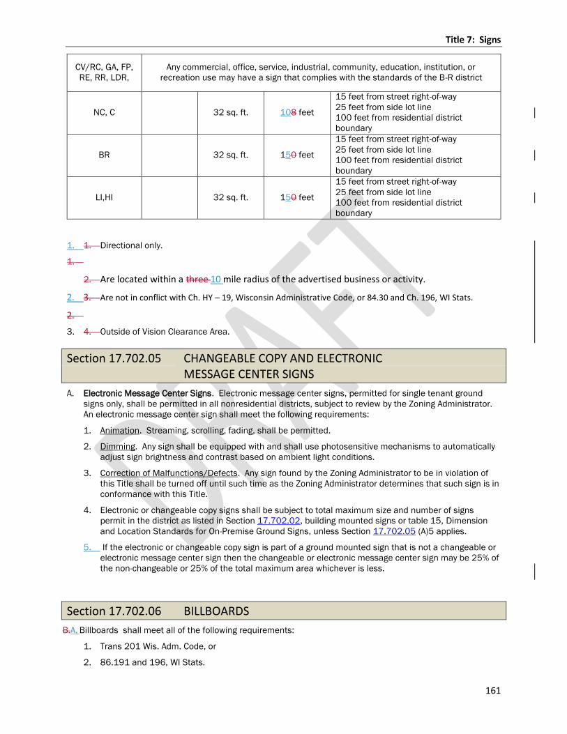
Title 7: Signs
161
CV/RC, GA, FP,
RE, RR, LDR,
Any commercial, office, service, industrial, community, education, institution, or
recreation use may have a sign that complies with the standards of the B-R district
NC, C 32 sq. ft. 108 feet
15 feet from street right-of-way
25 feet from side lot line
100 feet from residential district
boundary
BR 32 sq. ft. 150 feet
15 feet from street right-of-way
25 feet from side lot line
100 feet from residential district
boundary
LI,HI 32 sq. ft. 150 feet
15 feet from street right-of-way
25 feet from side lot line
100 feet from residential district
boundary
1. 1. Directional only.
1.
2. Are located within a three 10 mile radius of the advertised business or activity.
2. 3. Are not in conflict with Ch. HY – 19, Wisconsin Administrative Code, or 84.30 and Ch. 196, WI Stats.
2.
3. 4. Outside of Vision Clearance Area.
Section 17.702.05 CHANGEABLE COPY AND ELECTRONIC MESSAGE CENTER SIGNS
A. Electronic Message Center Signs. Electronic message center signs, permitted for single tenant ground
signs only, shall be permitted in all nonresidential districts, subject to review by the Zoning Administrator.
An electronic message center sign shall meet the following requirements:
1. Animation. Streaming, scrolling, fading, shall be permitted.
2. Dimming. Any sign shall be equipped with and shall use photosensitive mechanisms to automatically
adjust sign brightness and contrast based on ambient light conditions.
3. Correction of Malfunctions/Defects. Any sign found by the Zoning Administrator to be in violation of
this Title shall be turned off until such time as the Zoning Administrator determines that such sign is in
conformance with this Title.
4. Electronic or changeable copy signs shall be subject to total maximum size and number of signs
permit in the district as listed in Section 17.702.02, building mounted signs or table 15, Dimension
and Location Standards for On-Premise Ground Signs, unless Section 17.702.05 (A)5 applies.
5. If the electronic or changeable copy sign is part of a ground mounted sign that is not a changeable or
electronic message center sign then the changeable or electronic message center sign may be 25% of
the non-changeable or 25% of the total maximum area whichever is less.
Section 17.702.06 BILLBOARDS
B.A. Billboards shall meet all of the following requirements:
1. Trans 201 Wis. Adm. Code, or
2. 86.191 and 196, WI Stats.

Title 7: Signs
162
3. Signs and billboards shall meet all yard requirements for the district in which they are located,
4. Minimum separation of 1,000 feet from all other billboards which exceed 300 square feet in area.
Billboards which are not within the jurisdiction of the Wisconsin Administrative Code or State Statutes, shall
meet the same size requirements as on premise signs per Section 17.7024.03.
Chapter 17.703 Signs Allowed Without a Permit
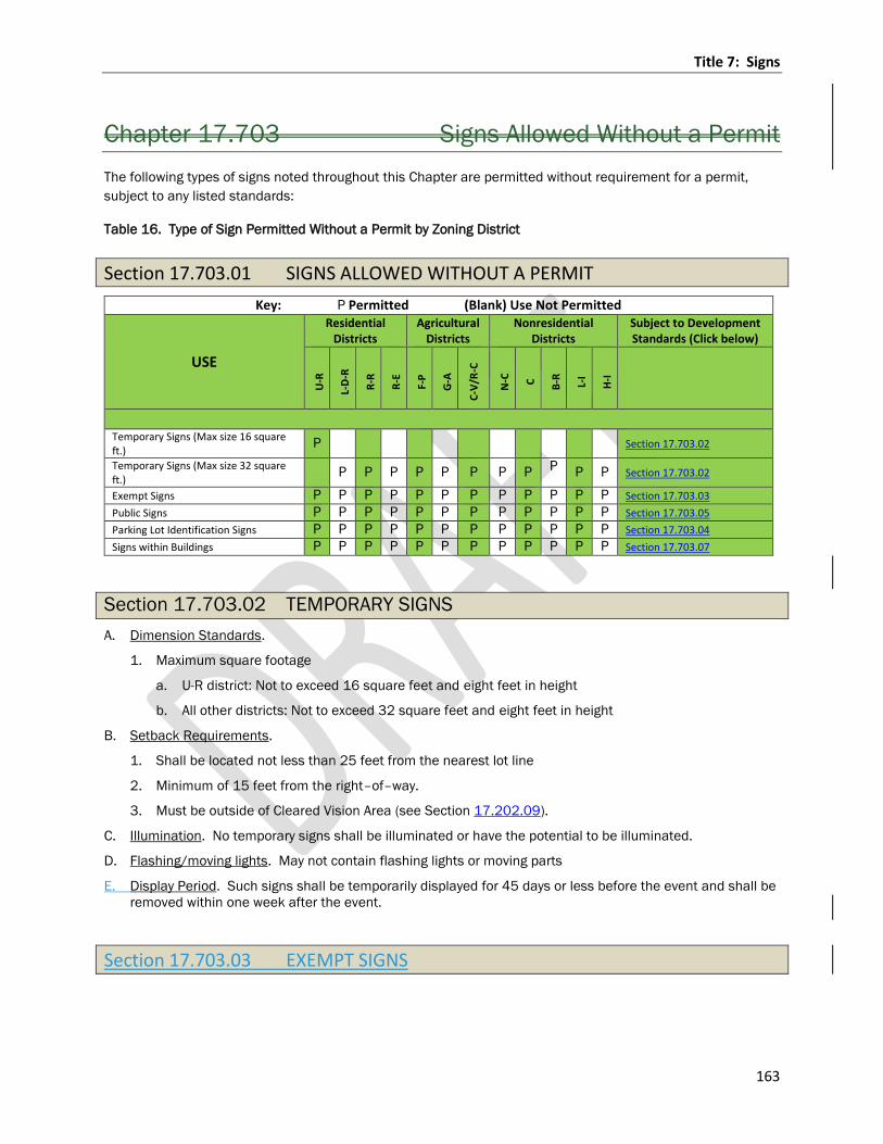
Title 7: Signs
163
Chapter 17.703 Signs Allowed Without a Permit
The following types of signs noted throughout this Chapter are permitted without requirement for a permit,
subject to any listed standards:
Table 16. Type of Sign Permitted Without a Permit by Zoning District
Section 17.703.01 SIGNS ALLOWED WITHOUT A PERMIT
Key: P Permitted (Blank) Use Not Permitted
USE
Residential Districts
Agricultural Districts
Nonresidential Districts
Subject to Development Standards (Click below)
U-R
L-D
-R
R-R
R-E
F-P
G-A
C-V
/R-C
N-C
C
B-R
L-I
H-I
Temporary Signs (Max size 16 square ft.)
P Section 17.703.02
Temporary Signs (Max size 32 square ft.)
P P P P P P P P P P P Section 17.703.02
Exempt Signs P P P P P P P P P P P P Section 17.703.03
Public Signs P P P P P P P P P P P P Section 17.703.05
Parking Lot Identification Signs P P P P P P P P P P P P Section 17.703.04
Signs within Buildings P P P P P P P P P P P P Section 17.703.07
Section 17.703.02 TEMPORARY SIGNS
A. Dimension Standards.
1. Maximum square footage
a. U-R district: Not to exceed 16 square feet and eight feet in height
b. All other districts: Not to exceed 32 square feet and eight feet in height
B. Setback Requirements.
1. Shall be located not less than 25 feet from the nearest lot line
2. Minimum of 15 feet from the right–of–way.
3. Must be outside of Cleared Vision Area (see Section 17.202.09).
C. Illumination. No temporary signs shall be illuminated or have the potential to be illuminated.
D. Flashing/moving lights. May not contain flashing lights or moving parts
E. Display Period. Such signs shall be temporarily displayed for 45 days or less before the event and shall be
removed within one week after the event.
Section 17.703.03 EXEMPT SIGNS
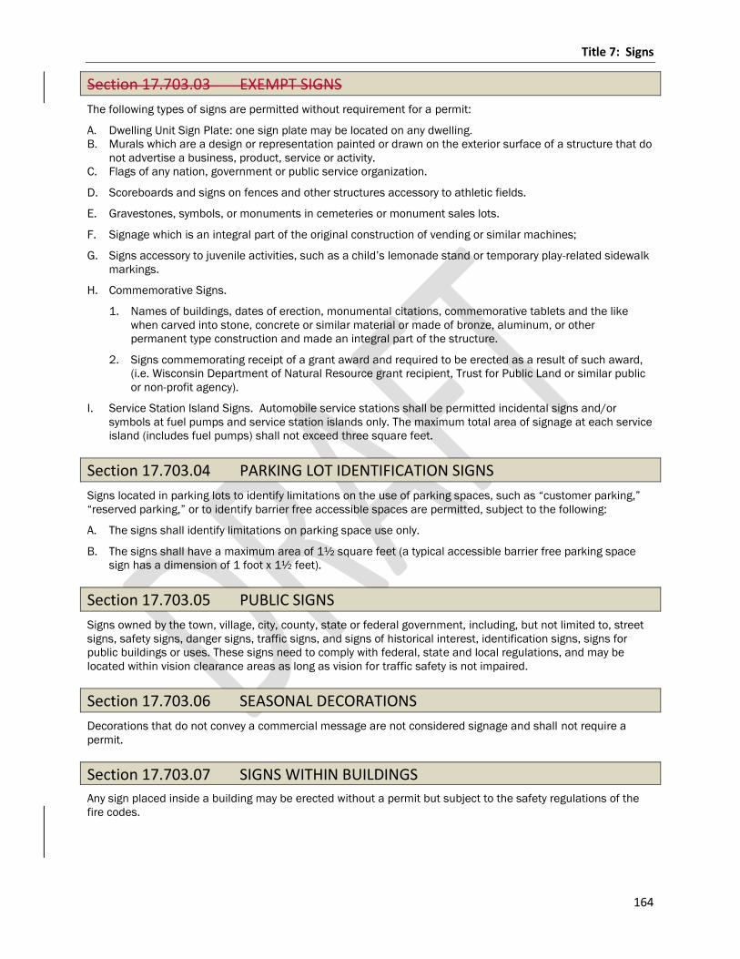
Title 7: Signs
164
Section 17.703.03 EXEMPT SIGNS
The following types of signs are permitted without requirement for a permit:
A. Dwelling Unit Sign Plate: one sign plate may be located on any dwelling.
B. Murals which are a design or representation painted or drawn on the exterior surface of a structure that do
not advertise a business, product, service or activity.
C. Flags of any nation, government or public service organization.
D. Scoreboards and signs on fences and other structures accessory to athletic fields.
E. Gravestones, symbols, or monuments in cemeteries or monument sales lots.
F. Signage which is an integral part of the original construction of vending or similar machines;
G. Signs accessory to juvenile activities, such as a child’s lemonade stand or temporary play-related sidewalk
markings.
H. Commemorative Signs.
1. Names of buildings, dates of erection, monumental citations, commemorative tablets and the like
when carved into stone, concrete or similar material or made of bronze, aluminum, or other
permanent type construction and made an integral part of the structure.
2. Signs commemorating receipt of a grant award and required to be erected as a result of such award,
(i.e. Wisconsin Department of Natural Resource grant recipient, Trust for Public Land or similar public
or non-profit agency).
I. Service Station Island Signs. Automobile service stations shall be permitted incidental signs and/or
symbols at fuel pumps and service station islands only. The maximum total area of signage at each service
island (includes fuel pumps) shall not exceed three square feet.
Section 17.703.04 PARKING LOT IDENTIFICATION SIGNS
Signs located in parking lots to identify limitations on the use of parking spaces, such as “customer parking,”
“reserved parking,” or to identify barrier free accessible spaces are permitted, subject to the following:
A. The signs shall identify limitations on parking space use only.
B. The signs shall have a maximum area of 1½ square feet (a typical accessible barrier free parking space
sign has a dimension of 1 foot x 1½ feet).
Section 17.703.05 PUBLIC SIGNS
Signs owned by the town, village, city, county, state or federal government, including, but not limited to, street
signs, safety signs, danger signs, traffic signs, and signs of historical interest, identification signs, signs for
public buildings or uses. These signs need to comply with federal, state and local regulations, and may be
located within vision clearance areas as long as vision for traffic safety is not impaired.
Section 17.703.06 SEASONAL DECORATIONS
Decorations that do not convey a commercial message are not considered signage and shall not require a
permit.
Section 17.703.07 SIGNS WITHIN BUILDINGS
Any sign placed inside a building may be erected without a permit but subject to the safety regulations of the
fire codes.
Title 7: Signs
165
Chapter 17.704 Prohibited Signs
Section 17.704.01 PROHIBITED SIGNS
All signs not expressly permitted in this Title or exempt from regulation pursuant to this Title, shall be
prohibited in the county. Prohibited signs include but are not limited to the following:
A. Abandoned signs.
B. Signs on Utility Poles or Traffic Control Devices. Signs attached or placed adjacent to any utility pole, traffic
sign post, traffic signal or any other official traffic control device.
C. Signs on Street Trees.
D. Signs that Block Ingress or Egress. Any sign that is placed or maintained so as to interfere with free
ingress to or egress from any door, window, fire escape or parking lot.
E. Signs in the street right-of-way.
F. No sign shall employ any parts or elements which revolve, rotate, whirl, spin, flash or otherwise make use
of mechanical, off-premise human (i.e. hand held or costumes) or electronic derived motion, to attract
attention.
G. Mobile Signs: Except those on licensed commercial delivery and service vehicles. Signs attached to or
painted on vehicles/trailers and parked in a position and location with the primary purpose of displaying
the sign shall be prohibited.
H. Any sign not specifically authorized by this Title.
Chapter 17.705 Non-conforming Signs
Section 17.705.01 NON-CONFORMING SIGNS
Non-conforming signs shall conform and be subject to the following requirements:
A. Continuation. The purpose of this section is to provide for the continuation of, as well as limitations on,
non-conforming signs, should the presence of a legal non-conforming sign exist.
B. Maintenance. A non-conforming sign shall be maintained in good condition pursuant to this Title, and may
continue until such sign is required to be removed as set forth in this section.
C. Alteration, Relocation or Replacement. A non-conforming sign shall not be structurally altered, relocated
or replaced unless it is brought into conformance with the provisions of this Title, except as otherwise
permitted in this section.
D. Reconstruction of a Damaged Sign. If a sign face and/or its support is damaged by any means to the
extent where the repair cost exceeds 50% of the replacement cost of the sign, such sign may not be
reconstructed except in accordance with this Title. If the repair costs do not exceed 50% of the
replacement cost of the sign, the sign may be repaired, subject to approval of consistency in design by the
Zoning Administrator and provided all repair work is completed within 90 calendar days of the date the
damage was incurred. Any sign destroyed or damaged to any extent by vandalism may be rebuilt to its
original state within 90 calendar days.
E. Servicing. Sign panel replacement (including changeable copy), painting, servicing, cleaning or minor
repairs to a non-conforming sign shall be permitted, subject to the following requirements:
1. The sign shall be restored to its original design;
2. There shall be no changes to the size, shape, location, structure or framing; and
3. All work is in compliance with applicable codes and regulations, as well as all other provisions of this
Title.
Title 7: Signs
166
F. Termination. A non-conforming sign shall immediately lose its legal non-conforming status, and shall be
brought into conformance with this Title or removed, when any of the following occur.
1. The size or shape of the sign is changed;
2. The sign structure is altered; or
3. If the property upon which the sign is located ceases to be used for a period of six consecutive months
from the date of a documented inspection or date of utility disconnect from the use of which it
advertises.
G. Severability. Nothing in this Title shall prohibit the construction of a non-conforming sign for which a
Zoning Permit has been issued prior to the effective date of this Title, or any amendment thereto, provided
that construction is completed within 90 calendar days after the issuance of the Zoning Permit.
Title 8: Administration
167
Title 8: ADMINISTRATION
Chapter 17.801 Administrative Organization
and Responsibilities
Section 17.801.01 ZONING ADMINISTRATOR
The Zoning Administrator of the County shall be the zoning official for the purpose of effecting proper
administration and enforcement of this Zoning Ordinance, appointed by and under the supervision of the
Department Director.
A. Zoning Administrator. There is hereby created the office of Zoning Administrator for the administration and
enforcement of the provisions of this chapter.
1. Deputy zoning administrators may be appointed to assist the Zoning Administrator in carrying out the
function of his/hertheir office generally within the town in which they reside. Their specific duties shall
be determined by the Zoning Administrator. Compensation for deputy zoning administrators shall be
determined by the Committee.
B. Powers and Duties of the Zoning Administrator. In the administration and enforcement of this chapter, the
Zoning Administrator shall have the following powers and duties:
1. Appoint Deputy Zoning Administrators, delegate duties, and give guidance to staff members.
2. Advise applicants as to the provisions of this chapter and assist them in preparing permit applications.
3. Receive, review, and investigate permit applications and fees and make inspections to determine
compliance with the provisions of this ordinance.
4. Review all applications for zoning permits, site plans, cConditional uUse pPermits, variances, rezones
and take any action required under guidelines stated in this ordinance.
5. Issue zoning permits, cConditional uUse pPermits, non-conforming use permits certificate in
conformance with the provisions of this zoning ordinance. Inspect properties for compliance with this
chapter and document compliance.
6. Issue written notices to parties responsible for violations of this zoning ordinance identifying the
violation and request compliance.
7. Make on-site inspections of premises to determine compliance of land use activities with provisions of
this ordinance. Have access to any structure or premises for the purpose of performing his/her duties
at a reasonable hour, by permission of the owner and/or occupant or upon issuance of a special
inspection warrant in accordance with 66.0119, WI Stats.. By applying for a permit or approval, an
applicant consents to allow the Zoning Administrator to enter upon and inspect the property as
needed.
8. Upon reasonable cause or question as to proper compliance, to revoke any zoning or CConditional
uUse pPermit and issue cease and desist orders requiring the cessation of any building, moving,
alteration or use which is in violation of the provisions of this chapter and/or order restoration and/or
after-the-fact compliance.
9. Make administrative decisions and determinations as are specifically assigned to the Zoning
Administrator by the terms of this chapter.
10. Forward to the Committee completed applications for petitions for amendments to this ordinance
11. Forward to the Board of Adjustment all materials related to applications for conditional use permits
(CUPs), appeals, variances, or other matters on which the Board of Adjustment is required to act.
12. Report violations of this chapter or other land use regulations to the Environmental Resource
Committee , the Board of Adjustment, or Corporation Counsel, as necessary.
Title 8: Administration
168
C. Maintenance of Records. The Zoning Administrator shall maintain in the county office:
1. Records of applications received: committee, board, or department action on such applications;
permits issued; inspections made; enforcement actions undertaken; and other similar activities.
2. An original or master of the zoning district map, maintained current with amendments. The boundary
lines of each zoning district change shall be described.
3. An original or master of the zoning code shall be maintained current with amendments.
Section 17.801.02 ENVIRONMENTAL RESOURCES COMMITTEE
A. Composition, Organization, and Membership. The composition, terms of members, organization and
meetings of the Committee shall be in accordance with applicable sections of Chapter 2, Section 2.05
County statutory, program, joint committees and task forces of the Marathon County Code of Ordinances
and pursuant to 59.69 WI Stats and serves as the County Planning Agency pursuant to 236.02(3) WI
Stats. The Committee shall consist of seven members. The Marathon County Board Chairperson shall
appoint two County Board Supervisors, who are members of the Extension and Education Committee, and
four other County Board Supervisors to the committee as well as one Farm Service Agency (FSA) Member.
[Source: 92.06(1) (b), WI Stats.]
B. Duties and responsibilities.
The duties and responsibilities of the Committee are set forth in the General Code of Ordinances for
Marathon County Chapter 2.
Section 17.801.03 BOARD OF ADJUSTMENT
A. Establishment. There is hereby established a Board of Adjustment pursuant to WI Stats. 59.694 for the
purpose of hearing and deciding administrative appeals, variance applications and applications for
conditional uses as provided in this chapter in harmony with the general purpose and intent of this
chapter.
B. Composition, Organization, and Membership. The composition, terms of members, organization and
meetings of the Board of Adjustment shall be in accordance with applicable sections of Chapter 2, Section
2.06 County non-governance committees, boards, commissions, task forces, and other group relationships
of the Marathon County Code of Ordinances. The Board of Adjustment shall be appointed by the County
Administrator and confirmed by the County Board. It shall consist of five members one of whom shall be a
County Board Supervisor, and two alternate members. Alternate members shall serve when a regular
member will be unable to participate at a scheduled hearing due to conflict of interest or for any other
reason.
C. Membership Requirements.
1. The members of the Board of Adjustment shall all reside within the County and outside of the limits of
incorporated cities and villages; provided, however, that no two members shall reside in the same
town. Terms shall be for staggered three-year periods beginning July 1.
2. The Board of Adjustment shall choose its own chairperson. Official oaths shall be taken by members in
accordance with 19.01, WI Stats., within 10 days of receiving notice of their appointment.
3. Vacancies shall be filled for an unexpired term in the same manner as appointments for a full term.
Each member shall be paid an amount to be determined by the County Board for each day he/she
attends a meeting of the Board and in addition he/she shall receive mileage for each mile traveled in
going to and returning from the places of meeting or site inspections by the most usual traveled route,
at the rate established by the County Board.
Title 8: Administration
169
D. Operating Rules.
1. The Board shall comply with all requirements of the Wisconsin open meeting law in the conduct of the
business before it. The nature of the Board's proceedings are quasijudicial. The Board may, therefore,
deliberate in closed session after a hearing on the matter, provided legal requirements are complied
with.
2. The Board may conduct site inspections of premises and the surrounding areas which are the subject
of matters before the Board, provided that when the Board as a unit or individual members are
engaged in such site inspections, they shall not allow interested parties to present arguments. Any
information or materials shall be received or presented only at hearings before the Board.
3. The Board shall conduct a public hearing on all conditional uses, variances, and administrative
appeals, and resolve boundary disputes before it and shall cause a Class 2 notice under 985, WI
Stats.., to be published and shall give due notice of the hearing to all parties in interest, the town
clerk, by certified mail and the town chairman by ordinary mail. Any party may administer oaths to
parties testifying and may compel attendance of witnesses.
a. Due notice to parties in interest shall mean that the office of the Zoning Administrator will by
ordinary mail provide reasonable advance notice of all hearings and meetings on any pending
matter to the applicant, to owners of record as shown in the real estate file in the property lister’s
office of properties which are located within 300' of the parcel involved in the application, to the
clerk and chairman of the town and county board supervisor where the property is located, to the
clerk of any city or village located within 1.5 miles of the property involved in the application and
to other parties who have made known to the office their specific interest in the matter and their
request to receive such notices, and applicable state and federal agencies.
b. Failure of the office to accomplish such provisions of notice shall not invalidate or prejudice the
proceedings, provided the Board concludes that reasonable efforts were made or that the parties
who subsequently complain of not having been sent or of not receiving notice did, in fact, know of
the proceedings and had reasonable opportunity to attend or be represented or to convey their
views prior to the Board's decision.
4. All testimony before the Board by persons other than Board members and written or documentary
evidence or material pertaining to matters before the Board shall be received at the hearings
conducted by the Board provided that the content of relevant ordinance or statutory materials shall be
deemed to be before the Board in all cases and need not be entered into the record. All parties in
interest shall be afforded reasonable opportunity to comment on all materials or information so
received. Board members who are in possession of facts which may have a bearing on the matter
before the Board shall enter same into the record of the hearing and opportunity shall be allowed for
comments on such entries.
5. If following the close of a hearing the Board finds it necessary or desirable to receive additional
information, evidence or arguments which may have a bearing upon the Board's decision, it shall
reconvene a public hearing by properly posting an agenda, for the purpose of so doing.
6. The Board shall deliberate on matters before it. The concurring vote of a majority of the Board shall be
necessary to approve any conditional uses, variance or administrative appeal before the Board and to
reverse any order, requirement, decision or determination of any administrative official or to decide in
favor of the applicant or appellant on any matter upon which it is required to pass under this chapter.
The vote of each member on each matter decided by the Board shall be recorded in the minutes. If a
member is absent or if a member fails to vote, such fact shall similarly be recorded. The minutes of
the Board shall show the Board's decisions and the votes of members thereon. Each decision of the
Board shall be accompanied by written reasons in support of the determination, decision, and findings
of fact, which written statement shall be signed or acknowledged by the Chair and Secretary and
entered into the record.
7. All decisions by the Board shall be made in accord with the standards of this chapter. The Board shall
decide all matters before it within a reasonable time.
8. The Board shall cause complete records to be kept of its examinations on matters before it, of public
hearings, site inspections, decisions and other official actions, which shall be immediately filed in the
Department, and shall be a public record.
9. The Board may adopt procedural rules not in conflict with this chapter or State law.
Title 8: Administration
170
E. Duties and responsibilities. Pursuant to 59.694(1), (2) and 59.692(4), (5), WI Stats., duties and
responsibilities include, but are not limited to, the following:
1. Conditional Use Permits. The Board of Adjustment shall have authority to hear and decide conditional
use permits based on meeting all standards set forth in Chapter 17.803 of this ordinance.
2. Variance. The Board of Adjustment shall have authority to hear and decide variances based on
meeting all standards set forth in Chapter 17.804 of this ordinance.
3. Appeals. The Board of Adjustment shall have authority to hear and decide appeals based on meeting
all standards set forth in Chapter 17.804 of this ordinance.
4. Interpretation of the Zoning Map. The Board of Adjustment shall act on all questions as they may arise
in the administration of this Ordinance, including the interpretation of the zoning district map, and the
interpretation of the exact location of a boundary line between zoning districts shown on the zoning
district map.
a. Interpretation of Shoreland Boundaries. The Board of Adjustment shall have the authority to hear
and decide applications for interpretations of the location of shoreland boundaries, after the
Committee has made a review and recommendation. Shoreland boundaries shall be altered by
the Board of Adjustment only when the applicant presents evidence that clearly and conclusively
establishes that the location as shown on shoreland boundary maps is incorrect or arbitrary.
To hear and decide conditional use applications to the terms which the Board of Adjustment is
required to pass under this chapter.
F. Court Review. Any person or persons, jointly or severally aggrieved by any decision of the Board of
Adjustment, or any taxpayer, officer, department, board of the County may present to a court of record, a
petition, duly verified, setting forth that such decision is illegal, in whole or in part, specifying the grounds
of illegality. Such petition shall be presented to the court within 30 days after the filing of the decision of
the Board of Adjustment.
G. Certiorari. Upon the presentation of such petition, the court may allow a writ of certiorari directed to the
Board of Adjustment to review such decision of the Board and shall prescribe therein the time within a
return thereto must be made. The allowance of the writ shall not stay proceedings upon the decision
appealed from, but the court may, on application of notice to the Board and on due cause shown, grant a
restraining order.
H. Return Writ. The Board of Adjustment shall not be required to return the original papers acted upon it, but
it shall be sufficient to return certified or sworn copies thereof or of such portions thereof as may be called
for by such writ. The return shall concisely set forth other facts as may be pertinent and materials to show
the grounds of the decision appealed from and shall be verified.
I. Court Decision. If, upon hearing, it shall appear to the court that testimony is necessary for the proper
disposition of the matter, it may take evidence or appoint a referee to take such evidence as it may direct
and report the same to the court with findings of fact and conclusions of law, which shall constitute a part
of the proceedings upon which the determination of the court shall be made. The court may reverse or
affirm, wholly or partly, or may modify the decision brought up for review.
J. Costs. Costs shall not be allowed against the Board unless it shall appear to the Board that it acted with
gross negligence, in bad faith or with malice in making the decision appealed from. All issues in any
proceeding under this section shall have preference over all civil action and proceedings.
Title 8: Administration
171
Section 17.801.04 ENVIRONMENTAL RESOURCES COMMITTEE
A. Membership. The Environmental Resources Committee shall be comprised of six County Board
Supervisors and one representative of the Town Associations of Marathon County appointed by the County
Board Chairperson at the April meeting of the County Board in even numbered years.
B. Term. Members shall serve two year terms concurrent with their terms of office as County Board
Supervisors.
C. Reporting Relationship. The Environmental Resources Committee is accountable to the County Board. It
shall have the responsibility for outcome monitoring and overseeing the implementation of all policies
related to the environmental resources of the County. The Environmental Resources Committee shall have
the primary responsibility for conferring with and providing guidance to the following County departments:
1. Conservation, Planning, & Zoning.
2. Parks, Recreation & Forestry.
3. Solid Waste Management.
D. Duties and Responsibilities.
The duties and responsibilities of the Committee are set forth in the General Code of Ordinances for
Marathon County Chapter 2.
E. Committee Relationships. The Environmental Resources Committee shall be the committee of jurisdiction
providing the leadership for interaction, communications, and policy recommendations to the County
Board with respect to the following:
1. Environmental Resources Committee.
2. Parks, Recreation and Forestry Committee.
3. Solid Waste Board.
F. Other Organization Relationships. The Environmental Resources Committee will also serve as Marathon
County’s liaison to the following organizations.
1. Marathon County Park Commission.
2. Board of Adjustment.
Section 17.801.05 COUNTY BOARD
The County Board is responsible for the enactment, amendment and repeal of this Chapter. The County Board
appropriates funds in support of the Conservation, Planning, and Zoning Department, the office of the Zoning
Administrator, the Environmental Resources Committee, and Board of Adjustment., and the Environmental
Resources Committee.
Section 17.801.06 SCHEDULE OF FEES
A. Fee Schedule. See Department approved fee schedule as approved by the Committee.
B. Nonrefundable. All fees received by the Zoning Administrator are nonrefundable, and shall be placed in
the County treasury, except if applicant files a written request n application for a refund under Chapter
17.808 and is granted approval.
C. Double FeeAfter-the-Fact fee. Any building or structure erected, constructed, placed, moved or structurally
altered or for any development or use of land, premises, building, or structure without obtaining all permits
and approvals prior to commencing the above stated activities shall result in a double fee.
Title 8: Administration
172
Chapter 17.802 Zoning Permits
Section 17.802.01 ZONING PERMITS REQUIRED
A. Permit Required. A zoning permit shall be issued before any of the following may occur:
1. Prior to the erection, structural alteration, or moving of any building or structure except as exempted in
this chapter.
2. Prior to the establishment of a new use, whether the land is currently vacant or if a substantial change
in land use is proposed.
3. Prior to any change in use of an existing building or structure.
B. Exemptions. A zoning permit shall not be required for the following:
1. Alterations involving ordinary maintenance and repair.
2. For new minor structures as defined in Chapter 17.902.
C. Issuance. Zoning permits shall be issued only in conformity with the provisions of this Zoning Ordinance,
unless the Zoning Administrator receives a written order from the Board of Adjustment deciding an appeal
or variance. Zoning permits shall be issued only if the parcel is in compliance with General Code of
Ordinances Chapter 18 Marathon County Land Division and Surveying Regulations and where applicable,
issuance of a sanitary permit is a precondition to issuance of a zoning permit.
Section 17.802.02 APPLICATION REQUIREMENTS
Completed applications for zoning permits shall be submitted to the Zoning Administrator, and accompanied by
the appropriate fee as specified by the Department fee schedule. Applications for zoning permits shall be on
forms provided by the Zoning Administrator.
At a minimum the applicant must supply the following information:
A. Name, address, and phone number of all persons having an ownership in the premises,
B. The location, dimensions, and parcel identification number of the lot or lots including a legal description;
C. Zoning district;
D. Relative location of any and all nearby public and private streets;
E. The existing and intended use of the lot or lots;
F. A plan of the site drawn to scale showing dimensions of the lot and the location of all existing, temporary
and proposed building(s) or structures and location of existing or proposed private onsite wastewater
treatment system;
G. Required front, rear, side yard area, open space, and parking;
H. On residential parcels, the number of dwelling units contained within each building and proposed number
of bedrooms;
I. Location and dimensions of all buildings or structures to be erected, structurally altered, or moved; and
J. Such other information concerning the lot or adjacent lots as may be necessary to determine conformance
with this Zoning Ordinance.
Title 8: Administration
173
Section 17.802.03 REVIEW AND ISSUANCE OF ZONING PERMIT
Zoning permits shall be reviewed and acted upon by the Zoning Administrator under the following conditions:
A. Within 20 working days after receipt of the completed application, provided that payment of all applicable
fees have been made. The Zoning Administrator shall issue a zoning permit if the application and
information obtained through field inspections complies with all applicable regulations. If denied, the
Zoning Administrator shall give written notice of denial and state reasons for denial including sections of
the Zoning Ordinance that the applicant does not comply with.
B. Upon approval of conditional uses by the Board of Adjustment as set forth in Chapter 17.803.
C. Upon approval of a variance or appeal by the Board of Adjustment as set forth in Chapter 17.804.
D. Once the Board of Adjustment has authorized issuance of a zoning permit, the Zoning Administrator shall
issue the zoning permit within 20 working days of such authorization except as otherwise provided in this
section.
E. An application for a zoning permit which has been made to the county pursuant to Sections 17.802.01
and 17.802.02 shall be processed under the regulations effective at the time the application was
submitted.
F. The Zoning Administrator shall issue a placard to be posted in a conspicuous place on the property for
which a zoning permit is issued, attesting to the fact that the activity is in conformance with the provisions
of this Zoning Ordinance.
Section 17.802.04 EXPIRATION OF ZONING PERMITS
A. Commencement. The zoning permit shall become void if no construction has begun or use changed within
six months of the date of issuance of the permit unless an extension is granted by the Zoning
Administrator for another six month period. After one year, a new zoning permit is required. Site
preparation does not constitute start of construction.
B. Completion. If the project in the zoning permit application has not been completed within two years of the
date of issuance, the permit shall be revoked by the Zoning Administrator, and written notice shall be given
to the persons affected, with notice that further work, described on the revoked zoning permit shall not
proceed unless and until a new zoning permit has been obtained.
Title 8: Administration
174
Chapter 17.803 Conditional Use Permits
Section 17.803.01 PURPOSE
A. Purpose. Certain uses are of such a nature or their effects are as dependent upon specific circumstances
as to make impractical the determination in advance of where and when and under what conditions they
should be permitted. Provision has been made in this chapter for the determination of such uses as
conditional uses. Conditional uses are land uses listed as such in Table 3 Uses Permitted by District. They
may be established in such district only upon approval by the Board of Adjustment.
The procedures and standards in this Chapter are intended to provide a consistent and uniform method
for review of conditional use permit proposals. These review procedures and standards are intended to
accomplish the following purposes:
1. Ensure full compliance with the standards contained in this ordinance and other applicable local
ordinances, and state and federal laws.
2. Achieve efficient use of the land.
3. Prevent adverse impact on adjoining or nearby properties.
4. Protect natural resources.
5. Facilitate development in accordance with the County’s land use objectives per the Comprehensive
Plan.
Section 17.803.02 APPLICATION PROCEDURES
Any application for a conditional Use Permit under this Zoning Ordinance shall be submitted in accordance with
the following procedures:
A. Application. Any application for a conditional Use Permit shall be submitted to the Board of Adjustment on
forms provided by the Zoning Administrator. Each application shall be accompanied by the payment of a
fee as specified by the Department fee schedule. The application may include single parcels of land or
groupings of parcels, contiguous or noncontiguous. In addition, the Board of Adjustment, where
appropriate, may refer an application to qualified consultants for study and a report if it deems necessary.
The cost of such study and report shall be at the expense of the applicant and the report shall be
completed as soon as is practicable.
B. Applicant Eligibility. The application shall be submitted by the owner of an interest in land for which
conditional use approval is sought, or by the owner’s designated agent. The applicant or a designated
representative should be present at all scheduled review meetings and/or public hearings or consideration
of the proposal may be delayed.
C. Information Required with Application.
1. Form. Form provided by Zoning Administrator completed by applicant.
2. Site Plan. Site plan or plot plan that complies with the site plan submittal requirements of Section
17.802.02 F. A site plan which does not meet the stipulated requirements shall be considered
incomplete and shall therefore not be subject to formal review or placed on the Board of Adjustment
agenda.
3. Fee. A fee as specified in the Department fee schedule.
4. General Standards. A statement supported by substantiating evidence regarding the requirements
enumerated in Section 17.803.03 B.
D. Timeframe. Conditional use applications must be submitted to the Zoning Administrator or designee at
least 45 days prior to the Board of Adjustments meeting.
E. Submission of a Completed Plan. The conditional use application materials including the completed site
plan, and required fees, shall be submitted to the Zoning Administrator for review.
Title 8: Administration
175
F. Review by County Officials. The Zoning Administrator and other appropriate county officials shall review
the site plan and application materials, and prepare a written review, which shall specify any deficiencies
in the site plan and application and make recommendations as appropriate.
G. Submission of a Revised Plan and Conditional Use Application. The applicant shall revise the site plan and
application materials, based on the recommendations set forth in the Zoning Administrator’s review. The
applicant shall then submit the revised plan for further review by staff and the Board of Adjustment.
H. Board of Adjustment Public Hearing. After all application materials have been deemed complete, the
application shall be transmitted by the Zoning Administrator to the Board of Adjustment and reviewed in
accordance with following public hearing procedures:
1. Acceptance for Processing. The application shall be placed on the agenda of the next available
scheduled Board of Adjustment meeting.
2. Notification. The Board of Adjustment shall hold a public hearing in accordance with the procedures
specified in Section 17.801.03 D.
3. Board of Adjustment Consideration and Review. The Board of Adjustment shall review the proposed
development, as presented on the submitted form and site plans and specifications, in terms of the
standards established in this Zoning Ordinance.
4. Process. The Board of Adjustment shall consider the site plan and conditional use application
simultaneously.
5. Plan Revision. If the Board of Adjustment determines that revisions are necessary to bring the
conditional use proposal into compliance with applicable standards and regulations, the applicant
shall be given the opportunity to submit a revised application and site plan. Following submission of
revised application materials, the conditional use proposal shall be placed on the agenda of the next
available scheduled meeting of the Board of Adjustment for further review and possible action.
I. Board of Adjustment Determination. The Board of Adjustment shall review the application for conditional
use, together with the previous meetings’ findings and reports and recommendations from the Zoning
Administrator, public safety officials, and other reviewing agencies. The Board of Adjustment shall then
make a determination on the conditional use application, as set forth in Section 17.803.03 and based on
the Substantial Evidence, other requirements and standards of this ordinance. The Board of Adjustment
may approve, approve with conditions, or deny a conditional use request as follows:
1. Approval. Upon determination by the Board of Adjustment that the final plan for conditional use is in
compliance with the standards and requirements of this ordinance and other applicable ordinances
and laws, approval shall be granted.
2. Approval with Conditions. The Board of Adjustment may impose reasonable conditions with the
approval of a conditional use proposal, to the extent authorized by law. Conditions imposed shall meet
all of the following requirements:
a. Conditions must be to the extent of practical and measurable
b. Conditions shall be designed to protect natural resources, the health, safety, and welfare and the
social and economic well-being of those who will use the land use or activity under consideration,
residents and landowners immediately adjacent to the proposed land use or activity, and the
community as a whole.
c. Conditions shall be related to the valid exercise of the police power and purposes which are
affected by the proposed use or activity.
d. Conditions shall be necessary to meet the intent and purpose of this ordinance, related to the
standards established in this ordinance for the land use or activity under consideration, and
necessary to insure compliance with those standards. These conditions may include, but are not
limited to the following:
1) Permit duration, transfer or renewal
2) Setback and yard dimensions.
3) Specified sewage disposal and water supply facilities.
4) Landscaping and planting screens.
5) Operational controls.
6) Sureties.
Title 8: Administration
176
7) Deed restrictions.
8) Location of structures, docks, piers or signs.
9) Location and amount of parking facilities.
10) Type of construction.
11) The obtaining of other permits required by the state or federal government agencies, and
other county requirements based upon other ordinances as conditions that must be met
before issuance of such permit.
3. Denial. Upon determination by the Board of Adjustment that a conditional use proposal does not
comply with the spirit or intent or standards and regulations set forth in this ordinance, or would
constitute a nuisance by reason of noise, dust, smoke, odor, or other similar factors, or otherwise
would be injurious to the public health, safety, welfare, and orderly development of the county, the
conditional use proposal shall be denied.
J. Recording of Board of Adjustment Action. Each action taken with respect to a conditional use shall be duly
recorded in the minutes of the Board of Adjustment. The minutes shall record the findings of fact relative
to each conditional use proposal, the grounds for the action taken, and any conditions imposed in
conjunction with approval.
K. Effect of Approval. Upon approval, a conditional use shall be deemed a conforming use permitted in the
district in which it is proposed, subject to any conditions imposed and final approval of the site plan. Such
approval shall affect only the lot or portion thereof on which the proposed use is located. Once granted a
conditional use permit shall remain in effect as long as the conditions upon which the permit was issued
are followed, but the Board of Adjustment may impose conditions such as the permits duration, transfer or
renewal.
L. Application for a Zoning Permit when required. Prior to issuance of a zoning permit, the applicant shall
submit proof of the following:
1. Final approval of the conditional use application.
2. Final approval of the site plan.
3. Final approval of any required engineering plans.
4. Approval of all other applicable county, state, or federal permits.
M. Expiration of Conditional Use Approval. The conditional use permit shall become void…
1. At the expiration of one year after the date of issuance unless construction is commenced.
a. Upon written request from the applicant, a 12 month extension from the date of expiration may
be granted by the Board of Adjustment, if it finds that the approved conditional use application and
site plan adequately represent current conditions on and surrounding the site. The written request
for extension must be received prior to the expiration date or a new application for conditional use
review will be required.
2. If the project has not is started within the one year after the date of issuance, construction has not
must been completed and the use has not started within two years of the date of issuance.
3. Nonmetallic mining activities will be considered to be continuous if the nonmetallic mining
reclamation permit is maintained as specified in General Code of Ordinances for Marathon County
Chapter 21 Nonmetallic Mining Reclamation Code.
N. Rescinding of Conditional Use Approval. Approval of a conditional use permit and site plan may be
rescinded by the Board of Adjustment if construction is not in conformance with the approved plans. In
addition, the breach of any condition, safeguard or requirement shall automatically invalidate the permit
granted, and shall constitute a violation of this zoning ordinance.
1. Consideration and Notice. Should rescinding be considered, the Zoning Administrator shall ask that
the conditional use be placed on the agenda of the Board of Adjustment. The Board of Adjustment
shall notify the original applicant and/or project representative of the date, time and place of the
meeting at least 20 days prior to the meeting at which the case will be considered. The applicant shall
be given the opportunity to present information and to answer questions. The Board of Adjustment, as
appropriate, may rescind approval if it finds that a violation exists and has not been remedied prior to
the meeting.
Title 8: Administration
177
Section 17.803.03 BASIS OF DETERMINATION
A. Conformance with Requirements. The applicant shall be required to establish by clear and convincing
evidence that the applicable standards of this Chapter, the specific standards pertinent to each
conditional use, including site plan review criteria set forth for applicable site development standards for
specific uses set forth elsewhere in this Chapter (refer to Chapter 17.204, Development Standards for
Specific Uses) have been met.
B. General Standards. The Board of Adjustment shall review the particular facts and circumstances of each
proposed conditional use in terms of the following standards:
1. Compatibility with Adjacent Uses. The proposed conditional use shall be designed, constructed,
operated and maintained to be compatible with uses on surrounding land. The site design shall
minimize the impact of site activity on surrounding properties. In determining whether this
requirement has been met, consideration shall be given to:
a. The location and screening of vehicular circulation and parking areas in relation to surrounding
development.
b. The location and screening of outdoor storage, outdoor activity or work areas, and mechanical
equipment in relation to surrounding development.
c. The hours of operation of the proposed use. Approval of a conditional use may be conditioned
upon operation within specified hours considered appropriate to ensure minimal impact on
surrounding uses.
d. The bulk, placement, and materials of construction of the proposed use in relation to surrounding
uses.
2. Comprehensive Plan. The proposed conditional use will be harmonious with and in accordance with
the general objectives or with any specific objective of the town and county comprehensive plan.
3. Compliance with Applicable Regulations. The proposed conditional use shall be in compliance with all
applicable federal, state, and local laws and ordinances.
4. Use of Adjacent Property. The proposed conditional use shall not interfere with the use and enjoyment
of adjacent property.
5. Public Services. The proposed conditional use will be served adequately by essential public facilities
and services including but not necessarily limited to utilities, highways, streets, police and fire
protection, drainage structures, refuse disposal, and school(s); unless the project proposal contains
an acceptable plan for providing necessary services or evidence that such services will be available by
the time the conditional use is completed.
6. Impact of Traffic. The location of the proposed conditional use shall, within the zoning district,
minimize the impact of traffic generated by the proposed use. In determining whether this requirement
has been met, consideration shall be given to the following:
a. Proximity and access to major thoroughfares.
b. Estimated traffic generated by the proposed use.
c. Proximity and relation to intersections.
d. Adequacy of driver sight distances.
e. Location of and access to off-street parking.
f. Required vehicular turning movements.
g. Provision of pedestrian traffic (if applicable).
Title 8: Administration
178
7. Enhancement of Surrounding Environment. The proposed conditional use shall provide the maximum
feasible enhancement of the surrounding environment, and shall not unreasonably interfere with or
discourage the appropriate development and use of adjacent land and buildings or unreasonably
affect their value. In determining whether this requirement has been met, consideration shall be given
to:
a. The provision of landscaping and other site amenities. Provision of additional landscaping over
and above the specific requirements of this Ordinance may be required as a condition of approval
of a conditional use.
b. The bulk, placement, and materials of construction of proposed structures in relation to
surrounding uses.
8. Impact on Public Health, Safety, and Welfare. The proposed conditional use shall not involve any
activities, processes, materials, equipment, or conditions of operation, and shall not be located or
designed in a manner that is detrimental to public health, safety, and welfare. In determining whether
this requirement has been met, consideration shall be given to the production of traffic, noise,
vibration, smoke, fumes, odors, dust, glare, light, and environmental impact.
9. Isolation of Existing Uses. The location of the proposed conditional use shall not result in a small
residential area being substantially surrounded by non-residential development, and further, the
location of the proposed conditional use shall not result in a small non-residential area being
substantially surrounded by incompatible uses.
10. Substantial Evidence. Substantial evidence means facts and information, other than merely personal
preferences or speculation, directly pertaining to the requirements and conditions.
Section 17.803.04 REGULATIONS PERTAINING TO CONDITIONAL USES
For uses listed as conditionally permitted in Section 17.203.05 Table 3. Uses Permitted by District, in addition
to complying with the general standards set forth in Section 17.803.03. B., an application for a Conditional Use
Permit shall not be approved unless all applicable conditions and standards of Chapter 17.204 (Development
Standards for Specific Uses) are complied with for each conditional use, in addition to all applicable district
regulations.
Section 17.803.05 ENFORCEMENT OF TOWN ISSUED CONDITIONAL USE PERMITS
Conditional use permits/Special Exceptions issued by any town prior to its adoption of this ordinance shall
remain in full force and effect and are enforceable under this ordinance, except to the extent the use is no
longer allowed as a conditional use under this ordinance. If the use subject to the permit or special exception
is eliminated as a conditional use by this ordinance, the use shall remain as a legal non-conforming use, but
any restriction or terms set forth in the permit or exception shall not be enforceable. Administration and
enforcement of Conditional use permits shall be as provided in Chapter 17.803 & 17.807.
Title 8: Administration
179
Chapter 17.804 Variance and Appeals
Section 17.804.01 PURPOSE
A. Purpose. The purpose of this chapter is to provide guidelines and standards to be followed by the Board of
Adjustment in considering requests for variances and appeals, where the jurisdiction of the Board of
Adjustment has been established by Section 17.801.03.
B. Purpose of Variances and Appeals.
1. Variances. Variances are waivers in the terms of this chapter. In a variance case, the terms of this
chapter are not in dispute. An applicant for a variance acknowledges that this chapter forbids the
development for which approval is sought. Two avenues of relief can be pursued in such a case. One
is for the applicant to seek an amendment to this chapter. The second possible avenue of relief, one
that is available only under strictly defined circumstances, is to seek a variance. Variances are an
available form of relief only where the use in question is allowed in the zoning district, but the
dimensional standards (setbacks, minimum lot area, building height, etc.), block or hinder the desired
form of development. Where dimensional standards create a hardship which can be relieved by
modifying the standards for that parcel of land without destroying the basic intent of this chapter, a
variance is the appropriate means of granting the relief. The variance procedure allows the impact of
general rules to be varied in response to unusual circumstances without involving the County Board in
amendment procedures for each such localized situation. The Board of Adjustment may authorize in
specific cases such variance from the terms of this chapter as will not be contrary to the public
interest where owing to special conditions affecting a particular property a literal enforcement of the
provisions of this chapter would result in unnecessary hardship.
2. Appeals Matters.
a. Decisions by the Zoning Administrator which consists of interpretations of the terms of this
chapter and which are made in the course of determining whether a permit of approval will be
issued by such Administrator are appealable to the Board of Adjustment as administrative
appeals.
b. Decisions by the Zoning Administrator to issue an enforcement demand or to commence other
chapter enforcement activities, where the Administrator has determined that violation of this
chapter exists, is appealable to the Board of Adjustment as an administrative appeal.
c. Decisions by the Committee which consists of interpretations of the terms of this chapter and
which are made in the course of determining whether a permit or approval will be issued by the
Zoning Administrator are appealable to the Board of Adjustment as administrative appeals. An
appeal must be filed within 30 days of issuance of the applicable written decision, and such
appeal shall be made on forms made available by the Zoning Administrator.
180
Section 17.804.02 APPLICATION PROCEDURES
Completed applications for variances and appeals shall be submitted to the Zoning Administrator, and
accompanied by the appropriate fee as specified by the Department fee schedule. Applications for variances
and appeals shall be on forms provided by the Zoning Administrator.
Any application for a variance or appeal under this zoning ordinance shall be submitted in accordance with the
following procedures:
A. Application. Any application for a variance or appeal shall be submitted to the Board of Adjustment on
forms provided by the Zoning Administrator. Each application shall be accompanied by the payment of a
fee as specified by the Department fee schedule. The application may include single parcels of land or
groupings of parcels, contiguous or noncontiguous. In addition, the Board of Adjustment, where
appropriate, may refer an application to qualified consultants for study and a report if it deems necessary.
The cost of such study and report shall be at the expense of the applicant and the report shall be
completed as soon as is practicable.
B. Applicant Eligibility.
1. The application for a variance shall be submitted by the owner of an interest in land for which variance
is sought, or by the owner’s designated agent. The applicant or a designated representative should be
present at all scheduled review meetings and/or public hearings or consideration of the proposal may
be delayed.
2. The application for an appeal may be initiated by any person aggrieved by the decision or
interpretation being appealed or by any officer, department, board or committee of the County
government. An aggrieved appellant must have a legally recognizable interest which is or will be
affected by the action of the zoning authority in question. The applicant or a designated representative
should be present at all scheduled review meetings and/or public hearings or consideration of the
proposal may be delayed.
C. Information Required with Application.
1. Form. Forms provided by Zoning Administrator to be completed by the applicant. Applications
involving a request for a variance shall specify the section number(s) containing the standards from
which a variance is sought and the nature and extent of such variance.
2. Variance Site Plan. Site plan or plot plan that complies with the site plan submittal requirements of
Section 17.802.02 F. A site plan which does not meet the stipulated requirements shall be considered
incomplete and shall therefore not be subject to formal review or placed on the Board of Adjustment
agenda.
3. Grounds for Appeal: An appeal shall be commenced by filing a notice of appeal specifying the decision
appealed from, the grounds for appeal, and the relief requested.
4. Fee. A fee as specified in the Department fee schedule.
5. General Standards. A statement supported by substantiating evidence regarding the requirements
enumerated in Section 17.803.03 B.
D. Timeframe.
1. Variances. Variance applications must be submitted to the Zoning Administrator or designee at least
45 days prior to the Board of Adjustment meeting.
2. Appeal. Applications for appeal shall be filed with the Zoning Administrator or designee within 30
business days after making of the decision or interpretation being appealed.
E. Complete. Variance and appeal applications must be complete before they will be accepted and
processed.
Title 8: Administration
181
Section 17.804.03 APPLICATION REQUIREMENTS
At a minimum the applicant must supply the following information:
A. Variance Application.
1. Contents. In order to be complete, a variance application must contain the following information,
where applicable:
a. A completed variance application form including property owner(s) signature.
b. A site plan and information as set forth in Section 17.802.02.
c. The name, address, phone number and signature of the person authorized by the owner(s) to be
the representative.
d. A statement indicating the exact nature of the variance being requested and why the variance is
necessary.
e. A statement demonstrating the variance requested is needed due to an unnecessary hardship,
unique property limitations and that there will be no harm to public interests.
f. Any additional information required by the Zoning Administrator or the Board of Adjustment to
make the determination requested herein.
B. Appeals Application.
1. Contents. In order to be complete, an appeals application must contain the following information;
a. The code section which was the subject of the determination, decision, and/or action.
b. The determination, decision, and/or action or part thereof that is being appealed.
c. A clear and concise statement of the decision the appellant wants the Board of Adjustment to
make.
d. Reasons why the determination, decision, and/or action or part thereof was inappropriate.
e. Reasons indicating why the relief requested by the appellant in subsection c, above, are
appropriate.
Section 17.804.04 PUBLIC HEARING BY THE BOARD OF ADJUSTMENT
A. Board of Adjustment Public Hearing. After all application materials have been deemed complete, the
application shall be transmitted by the Zoning Administrator to the Board of Adjustment and reviewed in
accordance with following public hearing procedures:
1. Acceptance for Processing. The application shall be placed on the agenda of the next available
scheduled Board of Adjustment meeting.
2. Notification. The Board of Adjustment shall hold a public hearing in accordance with the procedures
specified in Section 17.801.03 D.
B. Board of Adjustment Consideration and Review. The Board of Adjustment shall review the proposed
variance or appeal, as presented on the submitted form and site plans and documentation, in terms of the
standards established in this Zoning Ordinance.
1. Process. The Board of Adjustment shall consider all documents simultaneously.
2. Plan Revision. If the Board of Adjustment determines that revisions are necessary to bring the
proposal into compliance with applicable standards and regulations, the applicant shall be given the
opportunity to submit a revised application and site plan. Following submission of revised application
materials, the proposal shall be placed on the agenda of the next available scheduled meeting of the
Board of Adjustment for further review and possible action.
C. Hearing Continuation. The Board of Adjustment members may recess such public hearing as necessary to
gather additional information or evidence needed to make a decision. If the time and place of the
continued hearing is publicly announced at the time of adjournment, no further notice shall be required.
182
Section 17.804.05 STANDARDS FOR VARIANCES AND APPEALS
Variances and appeals shall be granted only in accordance with and based on the findings set forth in this
section. The burden of proof for variances and appeals shall be upon the applicant. The extent to which the
following factors, standards, and criteria apply to a specific case shall be determined by the Board of
Adjustment.
A. Area Variances.
1. No variance may be granted unless there is an unnecessary hardship present in that a literal
enforcement of the terms of the zoning ordinance would unreasonably prevent the owner from using
the property for a permitted purpose (leaving the property owner without any use that is permitted for
the property) or render conformity with such restrictions unnecessarily burdensome. The Board of
Adjustment must consider the purpose of the zoning restriction, the zoning restriction’s effect on the
property, and the short-term, long-term and cumulative effects of a variance on the neighborhood, the
community and on the public interests.
2. No variance may be granted unless there is a hardship due to the unique physical limitations of the
property such as steep slopes or wetlands rather than the circumstances of the applicant.
3. No variance may be granted that is contrary to the public interest as expressed by the objectives of the
ordinance
B. Evidence Required. The applicant shall show by a preponderance of the evidence that the variance is
justified, as determined by the Board of Adjustment. A variance:
1. Shall be consistent with the spirit, intent and purpose of this chapter.
2. Shall not be granted because of conditions that are common to a group of adjacent lots or premises.
3. Shall not be granted unless it is shown that the variance will not be contrary to the public interest and
will not be damaging to the rights of other persons or property values in the area.
4. Shall not be granted for actions which require an amendment to this chapter or the maps.
5. Shall not have the effect of granting or increasing a use of property which is prohibited in a particular
zoning district.
6. Shall not be granted solely on the basis of economic gain or loss;
7. Shall not be granted for a self-created hardship;
8. Shall not damage the rights or property values of other persons in the area;
9. Shall not allow any alteration of an historic structure, including its use, which would preclude its
continued designation as an historic structure;
10. Shall demonstrate whether the spirit and intent behind the zoning requirement would be observed and
substantial justice done by granting a variance; and/or
11. Shall not permit standards less restrictive than those required by the WI Stats., Wisconsin
Administrative Code or the State Department of Natural Resources.
C. Variance Conditions.
1. Conditions shall be attached in writing to all approved variances where such conditions will achieve
compliance with standards of this chapter.
2. Conditions may include, but are not limited to, specifications in Section 17.803.02.
D. Appeal to Board of Adjustment. Applicant may file an appeal on determinations, decisions, and/or actions
on matters relating to this ordinance where it is alleged that an error in any order, requirement, decision or
interpretation has been made. The Board of Adjustment shall reverse a determination, decision, and/or
action only if it finds that the determination, decision, and/or action appealed:
1. Was arbitrary or capricious; or
2. Was based on an erroneous finding of a material fact; or
3. Was based on erroneous interpretation of this Ordinance or zoning law; or
4. Constituted an abuse of discretion.
Title 8: Administration
183
Section 17.804.06 ACTION BY THE BOARD OF ADJUSTMENT
Decisions by the Board of Adjustment. Following a public hearing and other investigation, the Board shall
decide the matter based upon whether the decision, determination or interpretation being appealed was in
error. The Board may reverse or affirm, wholly or partly, or may modify the decision, determination, or
interpretation appealed from and may make such decision as ought to have been made, and to that end shall
have all powers of the official from whom the appeal is taken. All decisions by the Board on administrative
appeals shall be based upon the terms of this chapter and evidence as to legislative intent. With an affirmative
decision, the Board of Adjustment may impose conditions.
Section 17.804.07 VARIANCE APPROVAL PERIOD
If construction has not commenced within 12 months after the Board of Adjustment grants a variance to
permit the erection or alteration of a building, then the variance shall become null and void. The period of
approval may be automatically extended by 12 months if the variance was sought in conjunction with a site
plan for which approval has been extended by the Zoning Administrator and/or Board of Adjustment.
Section 17.804.08 STAY OF PROCEEDINGS
An appeal to the Board of Adjustment shall stay enforcement proceedings in furtherance of the appealed
action, unless the Zoning Administrator and/or Corporation Counsel certifies to the Board of Adjustment, that
by reason of the facts stated in the appeal, a stay would cause imminent peril to life or property, in which case
proceedings shall not be stayed other than by an injunction granted by a court of record on application on
notice to the officer from whom the appeal is taken and on due cause shown. A stay of enforcement
proceedings shall not stay the County’s authority to issue a stop work order on a project that may be in
progress and being performed in a manner that is not in conformance with applicable ordinances and
regulations. Also, it shall not stay a project when the appeal is brought by a third-party contesting the issuance
of a permit.
184
Chapter 17.805 Non-conformities
Section 17.805.01 APPLICABILITY
The provisions of this Chapter shall apply to uses, structures, and lots that legally existed as of the effective
date of this Ordinance, February 16, 2016, but that become non-conforming as the result of application of this
ordinance to them or from reclassification of the property under any subsequent amendments to this
ordinance.
Section 17.805.02 PURPOSE
It is the general policy of the County of Marathon to allow non-conforming uses, structures, or lots to continue
to exist and to be put to productive use. However, it is also the general policy of the county to bring as many
aspects of such non-conformities into conformance with this ordinance as is reasonably practicable, all subject
to the limitations of this chapter. The limitations of this chapter are intended to recognize the interests of
property owners in continuing to use their property but to reasonably control expansions, reestablishment of
discontinued uses, and the re-establishment of non-conforming buildings and structures that have been
substantially destroyed.
Section 17.805.03 AUTHORITY TO CONTINUE
Non-conformities shall be allowed to continue in accordance with the requirements of this Chapter.
Section 17.805.04 CONSTRUCTION APPROVED PRIOR TO ORDINANCE
Nothing in this chapter shall prohibit the completion of construction and use of a non-conforming building for
which a zoning permit has been issued prior to the effective date of this ordinance, provided that the
construction is commenced within 90 days after the issuance of such permit; that construction is carried on
diligently and without interruption for a continuance period in excess of 30 days; and that the entire building
shall have been completed within two years after the issuance of said zoning permit.
Section 17.805.05 DISPLACEMENT
No non-conforming use shall be extended to displace a conforming use.
Section 17.805.06 ILLEGAL USES
Non-conforming uses existing at the effective date of this ordinance not validly established under existing
zoning laws shall be declared illegal non-conforming uses and shall be discontinued within a period of two
years following the effective date of this ordinance. Conditionally permitted uses in any district shall not be
considered a legally established use, unless validly non-conforming, under this or any prior ordinance unless a
valid conditional use permit has been issued pursuant to the relevant ordinance and unless such permit
remains valid.
Section 17.805.07 UNSAFE STRUCTURES
Nothing in this chapter shall prevent the strengthening or restoring to a safe condition of any portion of a
building or structure declared unsafe by the Zoning Administrator.
Title 8: Administration
185
Section 17.805.08 CERTIFICATE OF NON-CONFORMING USE
The Zoning Administrator shall issue a “Certificate of Non-conforming Use” to all known owners of legal non-
conforming use property, the use of which does not conform to the provisions of the district in which the
property is located.
Section 17.805.09 DISTRICT CHANGES
Whenever the boundaries of a district shall be changed so as to transfer an area from one district to another of
a different classification, the foregoing provisions shall also apply to any non-conforming use created thereby.
Section 17.805.10 REPAIRS AND MAINTENANCE
Repairs and normal maintenance required to keep non-conforming uses and structures in a safe condition
shall be permitted, provided that no alterations shall be made except those allowed by this chapter or required
by law or ordinance.
Section 17.805.11 NON-CONFORMING USES
Non-conforming uses shall be subject to the following standards:
A. Enlargement. A non-conforming use may be enlarged, increased, or extended beyond the area it occupied
as of the effective date of this Ordinance, February 16, 2016, provided that the Zoning Administrator
and/or Board of Adjustment, finds all of the following:
1. The enlargement will not interfere with the operation of conforming uses in the district or with
circulation on adjacent public streets;
2. The enlargement will cause no greater adverse impacts on surrounding properties than did the original
non-conforming use; and
3. All increases and enlargements do not exceed 50% of the area that the non-conforming use occupied
as of the effective date of this ordinance.
B. Relocation. No non-conforming use shall be moved in whole or in part from its original location as of the
effective date of this ordinance to any other part of such parcel, building, structure, or to another lot except
in compliance with this ordinance.
C. Discontinuance and Abandonment.
1. If a non-conforming use is discontinued for a period of 12 consecutive months or more, any use of the
property thereafter shall be in conformance with regulations and provisions set by this ordinance for
the district in which such property is located.
2. Discontinuance of a non-conforming use may be indicated by non-use and the removal of either stock-
in-trade or substantially all equipment, fittings, or furniture needed to operate the use.
D. Damage or Destruction. If any structure that is devoted in whole or in part to a non-conforming use is
damaged or destroyed, by any means, to the extent of more than 50%, such use shall not be restored
except in conformance with this ordinance. The determination of such assessed value shall be made by
the Zoning Administrator or designee, which may, if necessary, consult with a county-appointed appraiser.
E. Change in Use/Substitution.
1. The Board of Adjustment may permit a non-conforming use to be changed to a second non-conforming
use provided that the new use shall be of the same general character or of a character less intensive
than the original non-conforming use and provided the new use will result in equal or less impact on
the surrounding community and district.
2. A non-conforming use that changes to a conforming use or to a second non-conforming use as set
forth in paragraph (1) above may not thereafter revert to the original non-conforming use.
F. Accessory Uses. No use that is accessory to a principle non-conforming use shall continue after such
principle non-conforming use ceases or terminates.
186
G. Non-conforming as to Parking.
1. Non-conformity as to off-street parking or loading shall not render a use subject to the conditions of
this Chapter.
2. A use that is non-conforming as to off-street parking or loading shall not be changed to another use
requiring more off-street parking or loading unless the additional required parking or loading is
provided.
3. The Board of Adjustment may permit a non-conforming use to provide off-street parking or loading on
a lot other than the lot on which the use is located.
Section 17.805.12 NON-CONFORMING STRUCTURES
Non-conforming structures shall be subject to the following standards:
A. Enlargement. A building which is non-conforming due to setbacks shall be allowed so long as the
extension is not closer to the property line and the extension does not exceed 50% of the existing building
footprint over the life of the structure.
A non-conforming structure may otherwise be enlarged, increased, or extended beyond the area it
occupied as of the effective date of this Ordinance, provided the Zoning Administrator, finds all of the
following:
1. The enlargement will not create a new non-conformity or increase the degree of existing non-
conformity (e.g., if a structure is non-conforming as to rear yard setback as of the effective date of this
Ordinance, it cannot subsequently be enlarged such that it becomes non-conforming as to height or
encroaches further into the required rear yard setback);
2. The enlargement will not interfere with the operation of conforming uses in the District or with
circulation on adjacent public streets;
3. The enlarged structure will cause no greater adverse impacts on surrounding properties than did the
original non-conforming structure; and
4. That over the life of the structure, all increases and enlargements do not exceed 50% of the footprint
that the non-conforming structure occupied as of the effective date of this Ordinance.
B. Damage or Destruction.
1. If any non-conforming structure is damaged or destroyed, by violent wind, vandalism, fire, flood, ice,
snow, mold, or infestation the structure may be reconstructed at the same size, same location and
same use. If the structure damaged or destroyed is in a floodplain, it must be flood proofed pursuant
to General Code of Ordinances for Marathon County Chapter 22 Shoreland, Shoreland-Wetland, and
Floodplain. If no zoning permit is issued within one year of the date of the calamity or if a zoning
permit has been issued and construction is not completed within two years of the date of the calamity
any new structure shall be in conformance with this ordinance.
2. If a non-conforming structure is damaged or destroyed, by any means, to the extent of 50% or less, no
repairs or restoration shall be made unless commenced within six months and completed within 24
months of the date of the calamity. The determination of such damage shall be made by the Board of
Adjustment, which may, if necessary, consult with an outside building expert.
C. Rebuilding, Renovating or Remodeling.
1. Any non-conforming structure may be rebuilt, renovated or remodeled at the same size, same location
and same use,enlargement may be permitted if the addition(s) conform to 17.805.12(A) as well as all
other applicable ordinances and regulations . If the structure is in a floodplain and/or shoreland overlay
district , it must comply with floodplain and/or shoreland regulations pursuant to General Code of
Ordinances for Marathon County Chapter 22 Shoreland, Shoreland-Wetland, and Floodplain.
D. Relocation. Non-conforming structures shall not be moved for any reason or for any distance except to be
brought into compliance with this ordinance.

Title 8: Administration
187
Section 17.805.13 NON-CONFORMING LOTS OF RECORD
A. Development Permitted. Regardless of the size of a lot of record that legally existed as of the effective
date of this Ordinance, and subject to paragraph B. below, such lot may be developed for any use
permitted in the district in which the lot is located, provided that where setback, width, open space,
density, or other requirements make development impractical, the Board of Adjustment may permit
development to occur after granting specific variances.
B. Land Division. No portion of such parcel shall be used or sold in a manner that renders compliance with
the lot area requirements set forth in this ordinance less feasible, nor shall any division of any parcel be
made that creates a lot with a width or area less than the requirements set forth in this ordinance.
188
Chapter 17.806 Amendments
Section 17.806.01 PURPOSE
A. Purpose. To set forth the procedures for the adoption and amendment of the text of this chapter and the
zoning maps adopted by this chapter.
B. Comprehensive Revision. It shall be the county’s policy of providing an opportunity for Marathon County
towns to reconsider and opt out of county zoning by conducting a comprehensive revision of this chapter
at a minimum of ten-year intervals. Ten-year intervals shall ensure zoning code compliance with the
county’s and town’s comprehensive plan revisions in accordance with state statutes.
C. Shoreland and Floodplain Amendments. Amendments to regulations or changes to district boundaries in
shoreland or floodplain areas shall be based on standards set forth in the General Code of Ordinances for
Marathon County Chapter 22 Shoreland, Shoreland-Wetland, and Floodplain
Section 17.806.02 AUTHORITY
Authority. The regulations imposed and the zoning districts created under authority of this chapter may be
amended from time to time by ordinance in accordance with 59.69, WI Stats. An amendment shall be granted
or denied by the County Board only after a public hearing before the Committee and a report of its findings and
recommendations has been submitted to the County Board.
Text or Map Amendments. The County Board may amend the regulations of an ordinance or change the
district boundaries. Amendments may be to the text of the ordinance and/or to the zoning maps adopted by
this chapter.
Section 17.806.03 INITIATION OF AMENDMENTS
A. Initiation. A petition for amendment of this chapter may be initiated by any property owner in the area to
be affected by the amendment, by the town board of any town wherein this chapter is in effect, by the
Zoning Administrator, by any member of the County Board or the Committee as follows:
1. Motion of the Committee; or
2. Adoption of a resolution by County Board and direction to the Committee; or
3. Filing of a petition for zoning amendment application with the Zoning Administrator.
Section 17.806.04 APPLICATION PROCEDURES
Any application for a petition for zoning amendment under this Zoning Ordinance shall be submitted in
accordance with the following procedures:
A. Application. Any application for a petition for zoning amendment to the text of this ordinance or an
amendment to change the zoning classification of a particular property shall be commenced by filing the
petition with the Zoning Administrator on the forms provided by the Zoning Administrator. Each application
shall be accompanied by the payment of a fee as specified by the Department fee schedule. The petition
shall explicitly describe the proposed amendment and shall be signed by the applicant. Petitions for
rezoning of a specific site shall be accompanied by a map and legal description.
B. Information Required with Application.
1. Form. Form provided by Zoning Administrator and completed by property owner or agent.
2. Name, address, and phone number of all persons having an ownership in the premises,
3. The location, dimensions, and parcel identification number of the lot or lots including a legal
description;
4. Existing zoning district and proposed zoning district;
5. The existing and intended use of the lot or lots;
Title 8: Administration
189
6. Such other information concerning the lot or adjacent lots as may be necessary to determine
conformance with this zoning ordinance.
7. Site Plan. A plan of the site drawn to scale showing dimensions of the lot and the location of all
existing and proposed building and structures; required front, rear, side yard area, open space, and
parking areas, driveways, easements; location of nearby public and private streets and other existing
improvements on the site and within 100 feet of the site; location of existing drainage courses,
floodplains, lakes and streams, and woodlots; location of private onsite wastewater treatment systems
(POWTS), existing and proposed (if applicable); location and size of water mains and building service
leads, existing and proposed (if applicable);
8. A copy of the proposed text change in the regulation set forth in this zoning ordinance.
9. If an application is initiated under Section 17.807.01, a fee as specified in the department fee
schedule shall be deposited with Zoning Administrator.
10. A statement on how the proposed amendment relates to the Marathon County Comprehensive Plan.
C. Additional Information as may be required by the Zoning Administrator, Committee or County Board
including but not limited to:
1. A resolution(s) from the Town Board where the zone change is proposed stating the town’s position on
the requested zone change and whether it complies with the town’s adopted comprehensive plan, or
resolutions from a majority of the towns affected by a proposed ordinance amendment with
affirmative resolutions on the proposed amendment.
2. Written approval from the Wisconsin Department of Transportation or County Highway Dept.
authorizing the construction/use of a driveway in their respective jurisdictions for the use proposed in
the zone change request.
D. Applications to amend the Zoning Ordinance text shall include at least items B. 1, 8, 9, and 10.
E. County Clerk. Competed petitions for any change to the district boundaries or amendments to the
regulations shall be filed with the County Clerk and/or Zoning Administrator shall:
1. Upon submittal of a zoning change, the Zoning Administrator shall forward a copy to the town clerk(s)
for review by the town planning commission and/or town board.
2. Immediately refer it to the Committee for their consideration, report and recommendations.
3. Immediately send a copy of the petition or a notice of the public hearing to the county supervisors of
any affected district.
4. Report all petitions referred under this section to the County Board at a subsequent meeting.
190
Section 17.806.05 PUBLIC NOTICE BY THE ENVIRONMENTAL RESOURCES COMMITTEE
Upon receipt of a complete petition, the Committee shall:
A. Call a public hearing thereon.
B. Provide notice of the time and place of such hearing by publication within the county of a class 2 notice
under Chapter 985, WI Stats.
C Provide public notice by certified mail to the property owner, applicant, and town clerk of each town
affected by the proposed amendment at least 10 days prior to the date of such hearing. Proof of receipt of
the notice maybe substituted for certified mail.
D. Provide notice by ordinary mail or electronic notice to the petitioner, parties of interest and landowners
within 300 feet of the described parcel for rezoning unless the Committee, in the case of mass rezoning’s,
waives this requirement when other methods have been used to notify the public.
E. Provide notice by ordinary mail or electronic notice to state agencies, federal agencies, other county
agencies and cities and villages where and when appropriate (i.e., floodplain zoning, shoreland zoning and
extraterritorial zoning).
F. The Committee shall schedule a public hearing no less than 45 days from the mailing of the application to
the affected Town(s), or as soon as practical thereafter. If a written response is received from the Town(s)
within the 45 day period, or is submitted with the application, the public hearing may be scheduled at
once.
Section 17.806.06 TOWN BOARD(S) ACTION
If an affected town disapproves of the proposed amendment, the town board shall:
A. File a certified copy of the resolution adopted by the town board disapproving of the petition with the
Committee.
B. This resolution must be filed prior to, at, or within 10 days after the public hearing in the office of the
Zoning Administrator.
C. Any town may extend its time for disapproving any proposed amendment under B. of this section by 20
days if the town board adopts a resolution providing for the extension and files a certified copy of the
resolution with the County Clerk. The 20 day extension shall remain in effect until the town board adopts a
resolution rescinding the 20 day extension and files a certified copy of the resolution with the County Clerk.
Section 17.806.07 ENVIRONMENTAL RESOURCES COMMITTEE ACTION APPROVAL, MODIFYING, OR DISAPPROVAL
A. If the Town Board affected in the case of an amendment relating to the location of boundaries of districts
files an official resolution of disapproval, or the town boards of a majority of the towns affected in the case
of all other amendatory ordinances file such resolutions, the Committee may not recommend approval of
the petition without change, but may only recommend approval with change or recommend disapproval.
1. As soon as possible after the public hearing, the Committee shall act on such petition by either:
a. Approving the petition; or
b. Modifying and approving the petitionApproving the petition with change; or
c. Disapproving the petition.
B. If the Committee approves, modifies and approves the petition, it shall cause an ordinance to be drafted
effectuating its determination and shall submit such proposed ordinance directly to the County Board with
its recommendations.
C. If the Committee decision recommends denial of the petition, it shall report that recommendation directly
to the County Board with the reason for such action.
Title 8: Administration
191
D. Proof of publication of the notice of the public hearing held by the Committee and proof of the giving of
notice to the town clerk of such hearing shall be submitted at the public hearing, reported in the hearing
minutes submitted to the County Board and filed with the petition for zoning amendment with the Zoning
Administrator.
E. Town Board resolutions filed under Section 17.806.06 shall be attached to either report.
F. Shoreland and Floodplain. Amendments to regulations or changes to districts affecting protected
shorelands or floodplains shall not require the approval or be subject to the disapproval of any town.
Section 17.806.08 COUNTY BOARD ACTION
A. Following such hearing and after careful consideration of the Committee's recommendation, the County
Board shall vote on the passage of the proposed change or amendment as follows:
1. Adopt the ordinance as drafted.
2. Adopt the ordinance with amendments.
3. Deny the petition for amendment.
4. Refuse to deny the petition as recommended by the committee, in which case, it shall refer the
petition back to the committee with directions to draft an ordinance to effectuate the petition and
report the same back to the County Board.
5. Upon report required by par. 4, the Board may:
a. Adopt the ordinance.
b. Reject the ordinance.
Section 17.806.09 PROTEST PROVISIONS FOR ZONING AMENDMENTS
A. Protest Provision. If a protest against a proposed change or amendment is filed with the County Clerk at
least 24 hours prior to the date of the meeting of the County Board at which the recommendation of the
Committee is to be considered, duly signed and acknowledged by the owners of 50% or more of the area
proposed to be altered, or by abutting owners of over 50% of the total perimeter of the area proposed to
be altered included within 300 feet of the parcel or parcels proposed to be rezoned, action on such
ordinance may be deferred until the Committee has had a reasonable opportunity to ascertain and report
to the County Board as to the authenticity of such ownership statements. Each signer shall state the
amount of area or frontage owned and shall include a description of the land owned by him or her. If such
statements are found to be true, such ordinance shall not be adopted except by the affirmative vote of ¾
of the members of the County Board of Supervisors present and voting. If such statements are found to be
untrue to the extent that the required frontage or area ownership is not present, such protest may be
disregarded.
Section 17.806.10 COUNTY CLERK ACTION
A. County Clerk Action. If any such amendatory ordinance makes only the change sought in the petition and
if the petition was not disapproved at or within 10 days after the public hearing by the town board of the
town affected in the case of an ordinance relating to the location of district boundaries or by the town
boards of a majority of the towns affected in the case of all other amendatory ordinances, it shall become
effective upon passage. The County Clerk or designee shall:
1. Maintain record of the date on which such ordinance becomes effective.
2. Notify the Town Clerk of all towns affected by such ordinance of such effective date.
3. Insert such effective date in the proceedings of the County Board.
4. Any other such amendatory ordinance when so adopted, shall within seven days thereafter, be
submitted in duplicate by registered mail to the Town Clerk of each town in which lands affected by
such ordinance are located.
192
B. Records and Publication.
1. Maintain record in the office of the County Clerk receipt of all disapproving and approving resolutions.
2. File in the office of the Zoning Administrator a copy of such resolutions and related correspondence,
which shall become a part of the records of the Committee.
3. Maintain record in the office of the County Clerk the dates on which such ordinances or amendments
become effective.
4. Report such activity to the County Board.
5. Cause such ordinance amendment or report to be published in accordance with appropriate statutes.
Section 17.806.11 TOWN BOARD(S) ACTION - VETO
A. Text Amendments.
1. Within 40 days of adoption, the town board may file certified copies of resolutions disapproving such
amendments with the County Clerk.
2. Within a shorter time, file certified copies of resolutions approving the amendments.
3. If a majority of Towns file an approving resolution, a text amendment shall thereupon be in effect in all
of the towns affected by the ordinance.
B. Map Amendment.
1. Within 40 days of adoption, town boards may file certified copies of resolution disapproving the
amendment with the County Clerk.
2. Within a shorter time, file certified copies of a resolution approving the amendment.
3. If the town board does not submit a veto resolution, the amendment becomes effective 40 days from
adoption.
Section 17.806.12 LIMITATION OF ACTIONS
A landowner, occupant or other person affected by this chapter or an amendment hereto who claims that this
Chapter or amendment is invalid because procedures prescribed by the statutes or this chapter were not
followed, shall commence an action within the time provided by Chapter 893.73(1), WI Stats.., except this law
does not apply unless there has been at least one publication of a notice of a zoning hearing in a local
newspaper of general circulation and unless there has been held a public hearing on this chapter or
amendment at the time and place specified in the notice.
Section 17.806.13 SHORELAND, SHORELAND-WETLAND, AND FLOODPLAIN ZONING
A. General Code of Ordinances for Marathon County Chapter 22, Shoreland, Shoreland-Wetland, and
Floodplain zoning regulations amendment procedures.
Title 8: Administration
193
Section 17.806.14 STANDARDS FOR REZONING
A. Standards for Farmland Preservation Rezoning. Marathon County may not rezone land out of the
Farmland Preservation Zoning District unless Marathon County finds all of the following, after a public
hearing, as part of the official written record of the rezoning:
1. The rezoned land is better suited for a use not allowed in the Farmland Preservation Zoning district.
2. The rezoning is consistent with Marathon County and the town’s comprehensive plan.
3. The rezoning is substantially consistent with the Marathon County Farmland Preservation Plan which
is in effect at the time of the rezoning.
4. The rezoning will not substantially impair or limit current of future agricultural use of other protected
farmland.
5. Adequate public facilities to serve the rezone are present or will be provided.
6. Providing of public facilities will not be an unreasonable burden to local government.
7. The rezoning request needs to demonstrate a need for the proposed development.
8. The rezone request will not cause unreasonable air and water pollution, soil erosion, or adverse
effects on rare or irreplaceable natural areas.
9. The availability of alternative locations has been addressed.
10. The location of the proposed development is to minimize the amount of agricultural land converted.
B. Standards for Other Rezoning’s. Decisions on petitions for rezoning of one zoning district to another
zoning district allowed by this chapter shall consider the following:
1. Existing zoning and use of the lands.
2. Proposed zoning and uses of the lands.
3. Need for the proposed uses.
4. Availability of adequate public facilities to serve the proposed land use change.
5. Reasonableness of the burdens on local government to provide needed services.
6. Suitability of the proposed uses to the existing uses adjacent thereto.
7. Relationship of the proposed uses to the existing uses adjacent thereto.
8. Relationship of the zoning amendment to Chapter 15 (Private Onsite Wastewater Treatment Systems),
Chapter 18 (Land Division and Surveying Regulations) and Chapter 22 (Shoreland, Shoreland-
Wetland, and Floodplain Regulations).
9. The proposed zoning request is in compliance with the town and county comprehensive plan.
C. Special Rezoning Considerations:
1. The Committee may recommend and the County Board may adopt an ordinance affecting an
amendment of the zoning district map containing the condition that the change in the map will take
effect on such date occurring within 12 months of the date of the County Board approval of the
amendment when the first on-site inspection for building location is made and approved for the
project sought to be established and, in the event such approved inspection has not occurred by the
12 month time period, the possibility of making effective the rezoning will then be terminated. Failure
to perfect the rezone as described above shall constitute a waiver of the rezone and require re-
application.
194
2. The Committee may recommend, and the County Board may adopt, an ordinance effecting an
amendment of the zoning district map containing the condition that the change in map will take effect
on such date occurring within six months of the date of County Board approval of the amendment
when a restrictive covenant set forth in 3 below, has been recorded binding the property to conditions
specified in the amending ordinance, and in the event such covenant is not recorded by the end of the
six month period, the possibility of making effective the rezoning will then be terminated. Failure to
perfect the rezone as described above shall constitute a waiver of the rezone and require re-
application.
3. Restrictive covenants shall be between the persons who petition for the zone change and the other
landowners within 300 feet of the described parcel. Conditions specified to be in such required
covenants shall be related to the purpose of this chapter. They may include, as specified cases
warrant, limits of permissible uses to less than the full range of uses otherwise allowable in the district
into which the land is being rezoned.
Enforcement rights over such covenant controls shall be afforded to the county, the town and parties
who entered into the restrictive covenant. The covenant controls shall be amendable or repealable
upon petition of the owner of the lands subject to the controls and approval of the Committee after a
hearing similar to a rezoning hearing. A rezoning of lands to a different zoning district shall also act to
repeal the covenant controls. Except as provided above, the covenants shall run with the land.
Section 17.806.15 RECONSIDERATION
A. Reconsideration. No application, petition or appeal which has been acted upon by the Board of
Adjustment, Committee, or County Board shall be considered again within one year of such action. A
petition for reconsideration based upon a material alteration from the original application or petition may
be made by the original applicant and/or County or CPZ. No application, petition or appeal shall be
reconsidered unless the Committee or Board determines by majority vote that the petition for
reconsideration contains a material alteration from the original application or petition. Any evidence which,
in the opinion of the Committee or Board, could have reasonably been presented at the previous hearing
does not qualify as a material alteration.
1. Petition for Reconsideration. Any party requesting reconsideration of an application, petition or appeal
shall file a petition for reconsideration along with the requisite filing fee. Petitions for reconsideration
shall be in writing and shall state the reasons for the request and be accompanied by necessary data
and diagrams which establish a material alteration. The filing fee for a petition for reconsideration will
not be refunded in the event the Committee or Board decides not to reconsider the application or
petition.
2. Rehearing. A rehearing shall be held if the Committee or Board determines that the petition for
reconsideration is based upon a material alteration from the original application or petition by a
majority vote. The rehearing shall be subjected to the same fee and notice and procedural
requirements as the original hearing.
3. Any reconsideration decision by the Board of Adjustment, Committee or County Board shall not be
reconsidered again.
Section 17.806.16 AMENDMENTS TO DEFINITIONS
Whenever an amendment is made to the text of the zoning ordinance, the appropriate definitions pertinent to
such amendment shall be included in applicable Section of Title 9, Definitions.
Title 8: Administration
195
Chapter 17.807 Enforcement, Violations and Penalties
Section 17.807.01 DECLARATION OF UNLAWFUL CONDUCT, ACTIVITIES AND CONDITIONS
A. No person shall erect, construct, place or structurally alter any building or structure or establish or change
any use of land, premises, building or structure in violation of the provisions of this chapterOrdinance.
B. No person shall fail to comply with any standard of this chapter Ordinance or with any condition or
qualification placed upon the issuance of a permit or approval of variance granted, in due course, under
this chapter.
C. All violations of this chapter Ordinance are declared public nuisances.
Section 17.807.02 LIABILITY
A. Owners of lands or properties, occupiers of land or premises and agents of owners or occupants including,
without limitation because of enumeration, building contractors, surveyors, plumbers, installers, soil
technicians, road builders, grading and excavating contractors and their agents, are responsible for
compliance with all provisions of this chapter which beare upon their area of competency and
responsibility.
B This chapter applies fully to all governmental and quasi-public and quasi-governmental lands,
developments and activities unless specifically exempted by state or federal Law.
Section 17.807.03 INVESTIGATION OF COMPLIANCE, NOTICE OF VIOLATION
A. The Zoning Administrator is responsible for inspecting and investigating compliance of land use activities
within the terms of this chapter.
B. If, upon such investigation, the Zoning Administrator becomes aware of a condition which he or she
concludes is unlawful as defined in Section 17.807.01, a notice of such violation shall be sent to the
parties to the situation whom he or she deem to be responsible and potentially liable, pursuant to Section
17.807.02 of the detected violation. The notice of violation shall include:
1. A demand that the condition that is alleged to constitute the present or potential violation be halted,
prevented from occurring or remedied; or
2. A statement that a complaint on the condition and demand for prosecution has been or will be
transmitted to the Corporation Counsel and/or to enforcement officials, state/federal agencies or
both.
C. In the event the property owner refuses the Zoning Department to enter upon the property for purposes of
conducting an inspection, the Zoning Administrator may apply for a special inspection warrant.
Section 17.807.04 PROSECUTION, INJUNCTION AND PENALTIES IN COURT PROCEEDINGS
A. The Corporation Counsel shall prosecute all violations of this chapter reported by the Zoning Administrator
in accordance with this chapter and Chapter 25.04.
B. Nothing in this section shall be deemed to prohibit private prosecutions of violations of this chapter
pursuant to Chapter 59.69(11), or other sections of the WI Stats. or Common Law.
C. The following forfeitures and penalties are hereby established for violation of this chapter:
1. For violations specified in Section 17.807.01, a forfeiture as specified in Chapter 25.04 shall be
imposed upon conviction or adjudication, plus the cost of prosecution for each violation.
2. Each day a violation exists or continues shall be a separate offense.
196
D. As a substitute for or an addition to forfeiture actions, the Corporation Counsel may, on behalf of the
county, seek enforcement of any and all parts of this chapter by court actions seeking injunctional or
restraining orders or orders for restoration of the site.
1. Upon the refusal of property owner to remedy the violation, as authorized by the Court, the Zoning
Administrator may enter upon property to remedy a violation of this chapter. The costs incurred by the
county to remedy a violation of this chapter may be assessed against the real estate as a special
charge.
E. In lieu of prosecution, the Zoning Administer may enter into a written agreement with the responsible
parties to resolve a violation of this chapter.
Section 17.807.05 OTHER ENFORCEMENT PROVISIONS
A. Where a conditional use or a variance has been approved subject to specified conditions and where such
conditions are not complied with, the Board of Adjustment may entertain and conduct a hearing upon a
petition to revoke the conditional use approval or variance. Such hearing and action upon a petition shall
follow procedures similar to those followed in considering the granting of such a use or variance. A finding
of noncompliance with the conditions originally imposed shall be grounds for revocation.
B. A permit issued under mistake of fact or in violation of this ordinance, Wisconsin Administrative Code, or
WI Stats. gives the permitee no vested right and is revocable.
C. Pursuant to 59.692(1t) WI Stats., Marathon County may not commence an enforcement action against a
person who owns a building or structure that is in violation of a shoreland zoning standard or an ordinance
enacted under 59.692 WI Stats. if the building or structure has been in place for more than ten years.
These buildings and structures remain violations of this ordinance until such time as they are removed,
relocated to a conforming location, or otherwise altered to become conforming.
Title 8: Administration
197
Chapter 17.808 Application Fee Refund Policy
Section 17.808.01 GENERAL APPLICATION REFUND POLICY
A. Applicants of a general zoning permit may request a refund of the application fee within one year of
issuance of the permit, if the permit was necessitated by at least one of the following circumstances:
1. A mistake of material fact by a county employee. A mistake of material fact means an inadvertent
error by a county employee with respect to any fact (e.g. measurement, distance, physical location,
etc.) which is essential to the ultimate determination of the issuance of the permit.
2. A misapplication of zoning ordinance by a county employee. A misapplication of zoning ordinance
means an inadvertent error by a county employee with respect to the applicability of a specific code
section to a given fact situation (e.g. category or usage, etc.), and does not include a good faith
dispute with respect to the interpretation of zoning code sections.
3. A cChange in regulations during application process: If an application is processed during a revision to
the code and the regulations change prior to the issuing of the permit resulting in no need for the
permit.
4. A change in regulations after issuance of a permit: If a permit is issued and regulations change not
requiring the permit anymore and that the permit is still valid and the project has not been started.
B. Refund requests shall be made, in writing, to the office of the Zoning Administrator.
C. Upon receipt of a written request for refund of application fees, the Zoning Administrator shallschedule
the matter for determination and may make a discretionary determination to grant or deny the request
decision based on the language above, as well as all other applicable information..
D. The Committee shall may take up the matter within 30 days of request and is empowered to grant a
refund of the application fee if they find that at least one of the circumstances set forth above exist.
E. Said determinationcision by the Zoning AdministratorCommittee is subject to appeal procedure set forth in
Chapter 17.804 Variance and Appeals of the General Code of Ordinances for the County of Marathon
Zoning Ordinance.
Section 17.808.02 HEARING REFUND POLICY
A. Applicants for Committee or Board of Adjustment hearings may request a refund of the application fee
within one year of Committee or Board action if the application for hearing was necessitated by either or
both of the following circumstances:
1. A mistake of material fact by a county employee. A mistake of material fact means an inadvertent
error by a county employee with respect to any fact (e.g. measurement, distance, physical location,
etc.) which is essential to the ultimate determination of the Committee or Board.
2. A misapplication of zoning ordinance by a county employee. A misapplication of zoning ordinance
means an inadvertent error by a county employee with respect to the applicability of a specific code
section to a given fact situation (e.g. category or usage, etc.), and does not include a good faith
dispute with respect to the interpretation of zoning code sections.
3. A cChange in regulations during application process: If a hearing application is processed during a
revision to the code and the regulations change prior to the hearing resulting in no need for the
hearing.
B. B. Refund requests
shall be made, in writing, to the Zoning Administrator.
C. Upon receipt of a written request for refund of application fees, the Zoning Administrator shall make a
determination to grant or deny the request based on the language above, as well as all other applicable
information.
D. Said determination by the Zoning Administrator is subject to appeal procedure set forth in Chapter 17.804
Variance and Appeals of the General Code of Ordinances for the County of Marathon Zoning Ordinance.

198
Notice of this policy shall be provided to all applicants for hearing by the Zoning Administrator. Refund requests
shall be made, in writing, to the office of the Zoning Administrator.
C. Upon receipt of a request for refund of application fees, the Zoning Administrator shall schedule the matter
for determination by the Committee.
D. The Committee shall take up the matter upon proper notice to the requestor and is empowered to grant a
refund of the application fee if the Committee finds that either or both of the circumstances set forth
above exist.
E. Said decision by the
Committee is subject to Administrative Review procedure set forth in Chapter 24 of the General Code of
Ordinances for the County of Marathon.
Chapter 17.809 Site Plan Review
Section 17.809.01 PURPOSE
The procedures, standards and required information in this code are intended to provide a consistent and
uniform method of review of proposed development plans, to provide general site design and planning
guidelines, to ensure full compliance with the regulations and standards contained in this code and other
applicable ordinances and laws, to achieve efficient use of land, to protect natural resources, and to prevent
adverse impact on adjoining or nearby properties. It is the intent of the site plan review requirements to
encourage cooperation and consultation between the County and the applicant to facilitate development in
accordance with the County’s land use objectives and to insure that significant design elements shall be
considered in future development.
Section 17.809.02 CONFORMANCE WITH APPROVED SITE PLAN
A. Suspension by Zoning Administrator. Property which is the subject of site plan approval must be developed
in strict compliance with the approved site plan, inclusive of any amendments, which has received the
approval of the Zoning Administrator or the Board of Adjustment. If construction and development does not
conform with the approved site plan, the approval of the site plan shall be suspended by the Zoning
Administrator by written notice and posted upon the premises involved and mailed to the last known
address of the owner.
Upon suspension of this approval, all construction activities shall cease upon the site until the time the
violation has been corrected or the Zoning Administrator or the Board of Adjustment has approved a
modification to the site plan.
B . Rescind Site Plan Approval. Approval of a site plan may be rescinded by the Zoning Administrator or the
Board of Adjustment upon determination that the site has not been improved, constructed or maintained in
compliance with approved permits, site plans, or conditions of site plan approval. In addition, the breach of
any condition, safeguard or requirement shall automatically invalidate the approval granted, and shall
constitute a violation of this Zoning Ordinance.
C . Revisions to Approved Site Plans.
1 . Minor revisions to an approved site plan may be administratively reviewed by the Zoning Administrator,
provided that such changes do not materially alter the approved site design, intensity of use or demand
for public services.
2. If revisions to an approved conditional use permit site plan materially alters the approved site design,
intensity of use or demand for public services, the revision shall be submitted to the Board of Adjustment
for approval.
Title 9: Definitions
199
Title 9: DEFINITIONS
Chapter 17.901 General
Section 17.901.01 RULES OF CONSTRUCTION
The following rules of construction shall apply to the text of this Ordinance:
A. The particular shall control the general.
B. In the case of any difference of meaning or implication between the text of this Ordinance and any caption
or illustration, the text shall control.
C. The word “shall” is always mandatory and not discretionary. The words “may” or “should” are permissive
and discretionary.
D. Words used in the present tense shall include the future, and words used in the singular number shall
include the plural, and the plural the singular, unless the context clearly indicates the contrary.
E. A “building” or “structure” includes any part thereof. The word “dwelling” includes “residence”. The word
“lot” includes the words “plot” or “parcel”.
F. The phrase “used for” includes “arranged for,” “designed for,” “intended for,” “maintained for” or
“occupied for.”
G. The word “person” includes an individual, a patron, a firm, an association, an organization, a corporation
(public or private), a partnership or co-partnership, a limited liability company, an incorporated or
unincorporated association, a trust, or any other entity recognizable as a “person” under the laws of
Wisconsin.
H. Unless the context clearly indicates the contrary, where a regulation involves 2 or more items, conditions,
provisions or events connected by the conjunction “and,” “or” or “either ... or,” the conjunction shall be
interpreted as follows:
1. “And” indicates that all the connected items, conditions, provisions or events shall apply.
2. “Or” indicates that all the connected items, conditions, provisions or events shall apply singly or in any
combination (i.e., “or” also means “and/or”).
3. “Either ... or” indicates that the connected items, conditions, provisions or events may apply singly.
I. The terms “this Zoning Ordinance” or “this Ordinance” includes the Zoning Ordinance of the County of
Marathon and any amendments there to.
J. The terms “abutting” or “adjacent to” include property “across from”, such as across a street, alley, or an
easement. This term shall also apply to adjacent zoning districts in an adjacent community.
K. The word “he” includes “she.”
L. The phrase “such as” shall mean “such as, but not limited to.”
M. The word “including” shall mean “including, but not limited to.”
N. Terms not defined in Title 9 (Definitions), or elsewhere in this ordinance shall have the meaning
customarily assigned to them.
Title 9: Definitions
200
Chapter 17.902 General Definitions
As used in this zoning ordinance, certain terms are defined as follows:
Abandoned Sign. A sign which no longer correctly advertises or directs a person to a bona fide business,
person, goods, product, activity, or service. A sign is considered abandoned if:
1. It does not display a well-maintained message for a consecutive 60 day period;
2. The use to which the sign is accessory is discontinued or terminated for more than 180 consecutive
days;
3. The owner of the sign cannot be located at the owner’s last known address as reflected on the records
of the County; or
4. A structure designed to support a sign no longer supports the sign for a period of 30 consecutive days.
Abandonment of mining has the meaning given in NR132.03 (1)Abandoned Sign. A sign which no longer
correctly advertises or directs a person to a bona fide business, person, goods, product, activity, or service. A
sign is considered abandoned if:
1. It does not display a well-maintained message for a consecutive 60 day period;
2. The use to which the sign is accessory is discontinued or terminated for more than 180 consecutive
days;
3. The owner of the sign cannot be located at the owner’s last known address as reflected on the records
of the County; or
4. A structure designed to support a sign no longer supports the sign for a period of 30 consecutive days.
Accessory Building or Use. A subordinate building or use that is intended to be used in a manner that is clearly
incidental to, customarily found in connection with, subordinate to, and located on the same lot or parcel as
the principle use to which it is exclusively related.
Accessory Sign. A sign that is subordinate to the main use on a lot and used for purposes clearly incidental to
those of the main use.
Awning Sign. See Building Mounted Sign.
Adult Entertainment. Any business which primarily features sexually oriented or sexually stimulating material
and/or performances, including the following: adult arcade, adult bookstore, adult novelty store, adult video
store, adult cabaret, adult massage parlor, adult motion picture theater, adult theater, escort agency, nude
model studio, or sexual encounter center or similar establishment or any place that permits patrons to be
filmed or photographed performing "sexually explicit activities" or displaying "specified anatomical areas" for
electronic transmission over the wireless device, the internet, film, motion picture, videocassette, DVD or other
photographic reproduction.
"Sexually oriented" when used to describe film, motion picture, videocassette, DVD, slides, or other
photographic reproductions shall mean film, movies, motion picture, videocassette, DVD, slides or other
photographic reproductions that regularly depict material which is distinguished or characterized by an
emphasis on matter depicting or describing "sexually explicit activities" or "specified anatomical areas" offered
for observation by the patron(s) on the premises of a sexually oriented business. The definition of "adult
entertainment use" shall not include an establishment where a medical practitioner, psychologist, psychiatrist
or similar professional person licensed by the State engages in medically approved and recognized sexual
therapy.
Terms relating to adult entertainment uses are further defined as follows:
Title 9: Definitions
201
1. Adult Arcade. Any place to which the public is permitted or invited where either or both (i) motion
picture machines, projectors, video or laser disc players, or (ii) other video or image-producing devices
are available, run via coin, token or any form of consideration, to show images to five or fewer persons
at one time; and where the images shown and/or live entertainment presented are characterized by
the depiction or description of specified sexual activities or specified anatomical areas.
2. Adult Bookstore, Adult Novelty Store, or Adult Video Store. A commercial establishment which, as one
of its principle business purposes, offers for sale or rental for any form of consideration one or more of
the following:
a. Books, magazines, periodicals or other printed matter, or photographs, films, motion pictures,
video cassettes or video reproductions, slides, or other visual representations that are
characterized by the depiction or description of “specified sexual activities” or “specified
anatomical areas”; or
b. Instruments, devices, or paraphernalia, other than prophylactics, that are designed for use in
connection with specified sexual activities.
A commercial establishment may have other principle business purposes that do not involve the
offering for sale or rental of material depicting or describing “specified sexual activities” or “specified
anatomical areas” and still be categorized as “adult bookstore, adult novelty store, or adult video
store” so long as one of its principle business purposes is the offering for sale or rental for
consideration the specified materials which are characterized by the depiction or description of
“specified sexual activities” or “specified anatomical areas”.
3. Adult Cabaret. A nightclub, bar, restaurant, or similar commercial establishment that regularly
features:
a. Persons who appear in a state of semi-nudity;
b. Live entertainment characterized by the depiction or description of specified anatomical areas or
specified sexual activities;
c. Live entertainment of an erotic nature including exotic dancers, strippers, male or female
impersonators, or similar entertainment; or
d. Films, motion pictures, video cassettes, slides or other photographic reproductions that are
characterized by the depiction or description of specified sexual activities or specified anatomical
areas.
4. Adult Massage Parlor. Any place where, for any form of consideration or gratuity, massage, alcohol
rub, administration of fomentations, electric or magnetic treatments, or any other manipulation of the
human body occurs as part of or in connection with specified sexual activities, or where any person
providing such treatment, manipulation, or service related thereto, exposes his or her specified
anatomical areas. An Adult Massage Parlor, in contrast to a Myotherapy Establishment, is considered
a sexually oriented business for purposes of these regulations.
5. Massage. The treating of external parts of the body for remedial or hygienic purposes, consisting of
stroking, kneading, rubbing, tapping, pounding, vibrating, or stimulating with the hands or with the aid
of any mechanical or electrical apparatus or appliances, with or without such supplementary aids as
rubbing alcohol, liniments, antiseptics, oils, powder, creams, lotions, ointment or other such similar
preparations commonly used in the practice of massage, under such circumstances that it is
reasonably expected that the person to whom the treatment is provided shall pay any consideration
whatsoever therefore. For purposes of this ordinance, the term "bodywork" shall mean massage.
6. Myotherapy Establishment. Any individual, group of individuals, person or business which engages in
the practice of massage as defined herein, and which has a fixed place of business where any person,
firm, association, partnership, limited liability company or corporation carries on any of the activities
as defined herein. Myotherapy establishment shall also include, but not be limited to, a Turkish bath
parlor, steam bath, sauna, magnetic healing institute, health club, health spa, or physical fitness club
or business that offers massages on occasion or incidental to its principle operation, as well as an
individual's home where a person is engaged in the practice of massage for consideration. The
definition of sexually oriented business shall not include the practice of massage in a licensed
hospital, sanitarium, nursing home, medical clinic or the offices of a physician, surgeon, chiropractor,
osteopath, psychologist, clinical social worker and family counselor, who are licensed to practice their
Title 9: Definitions
202
respective professions in the State of Wisconsin, or who are permitted to practice temporarily under
the auspices of an associate or an establishment duly licensed in the State of Wisconsin, clergymen,
certified members of the American Massage and Therapy Association and certified members of the
International Myomassethics Federation. A Myotherapy Establishment engaged in the practice of
massage as defined herein is considered a Regulated Use but not a sexually oriented business for
purposes of these regulations.
7. Adult Motion Picture Theater. A commercial establishment where, for any form of consideration, films,
motion pictures, video cassettes, slides, or similar photographic reproductions are regularly shown
which are characterized by the depiction or description of “specified sexual activities” or “specified
anatomical areas”.
8. Adult Theater. A theater, concert hall, auditorium, or similar commercial establishment that regularly
features persons who appear in a state of semi-nudity, live performances which are characterized by
the depiction or description of specified anatomical areas, specified sexual activities, or live
entertainment of an erotic nature including exotic dancers, strippers, male or female impersonators,
or similar entertainment.
9. Covering. Any clothing or wearing apparel, including pasties, but does not include any substance that
can be washed off the skin, such as paint or make-up, or any substance designed to simulate the
appearance of the anatomic area beneath it.
10. Entertainer. A person who performs some type of activity or pose with the intent of allowing others to
witness that activity or pose.
11. Escort. A person, who for consideration in any form, agrees or offers to act as a companion guide or
date for another person, or who agrees or offers to privately perform as an entertainer, including, but
not limited to, the modeling of lingerie, the removal of clothing, the performance of a dance or skit, or
the providing of specified sexual activities for another person. Under this definition, "privately" shall
mean a performance for an individual, or that individual's guests.
12. Escort Agency. A person or business association, who furnishes, offers to furnish or advertises to
furnish escorts as one of its primary business purposes, for a fee, tip or other consideration.
13. Nude Model Studio. Any place where a person who appears semi-nude or who displays specified
anatomical areas is provided to be observed, sketched, drawn, painted, sculptured, photographed, or
similarly depicted by other persons who pay money or any form of consideration. Nude Model Studio
shall not include:
a. A proprietary school licensed by the State of Wisconsin, or a college, junior college or university
supported entirely or in part by public taxation.
b. A private college or university that offers educational programs in which credits are transferable to
a college, junior college, or university supported entirely or partly by taxation; or
c. An establishment holding classes in a structure that has no sign visible from the exterior of the
structure and no other advertising that indicates a semi-nude person is available for viewing;
where in order to participate in a class a student must enroll at least three days in advance of the
class; and where no more than one semi-nude model is on the premises at any one time.
14. Nudity or State of Nudity or Nude. Exposing to view the genitals, pubic area, vulva perineum, anus,
anal cleft or cleavage, or pubic hair with less than a fully opaque covering; exposing to view any
portion of the areola of the female breast with less than a fully opaque covering; exposing to view male
genitals in a discernibly turgid state, even if entirely covered by an opaque covering; or exposing to
view any device, costume, or covering that gives the appearance of or stimulates any of these
anatomical areas.
15. Person. An individual, proprietorship, partnership, firm, association, joint stock company, corporation
or combination of individuals whatever form or character.
16. Principle Business Purpose. 25 percent or more of the stock in trade of the business offered for sale
or rental for consideration measured as a percentage of either the total linear feet of merchandise for
sale or rental for consideration on display or the gross receipts of merchandise for sale or rental for
consideration, whichever is greater.
Title 9: Definitions
203
17. Semi-Nudity or Semi-Nude Condition or Semi-Nude. Exposing to view, with less than a fully opaque
covering, any portion of the female breast below the top of the areola or any portion of the buttocks.
This definition shall include the entire lower portion of the female breast exhibited by a dress, blouse,
shirt, leotard, bathing suit, or other clothing, provided that the areola is not exposed in whole or in
part.
18. Sexual Encounter Center. A business or commercial enterprise that, as one of its principle business
purposes, offers for any form of consideration:
a. Physical contact in the form of wrestling or tumbling between persons of the opposite sex; or
b. Activities between male and female persons and/or persons of the same sex when one or more of
the persons is semi-nude.
19. Specified Anatomical Areas.
a. The human male genitals in a discernibly turgid state, even if completely and opaquely covered; or
b. Less than completely and opaquely covered human genitals, pubic region, buttocks or female
breast below a point immediately above the top of the areola.
20. Specified Sexual Activities. Any of the following:
a. The fondling or other erotic touching of human genitals, pubic region, buttocks, anus, or female
breasts;
b. Sex acts, normal or perverted, actual or simulated, including intercourse, oral copulation,
masturbation, or sodomy; or
c. Any activity intended to arouse, appeal to or gratify a person's lust, passions or sexual desires; or
d. Human genitals in a state of sexual stimulation, arousal or tumescence; or
e. Excretory functions as part of or in connection with any of the activities set forth in (a) through (d),
inclusive, above.
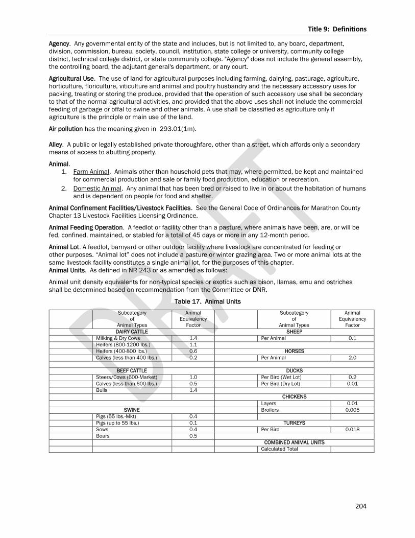
Title 9: Definitions
204
Agency. Any governmental entity of the state and includes, but is not limited to, any board, department,
division, commission, bureau, society, council, institution, state college or university, community college
district, technical college district, or state community college. "Agency" does not include the general assembly,
the controlling board, the adjutant general's department, or any court.
Agricultural Use. The use of land for agricultural purposes including farming, dairying, pasturage, agriculture,
horticulture, floriculture, viticulture and animal and poultry husbandry and the necessary accessory uses for
packing, treating or storing the produce, provided that the operation of such accessory use shall be secondary
to that of the normal agricultural activities, and provided that the above uses shall not include the commercial
feeding of garbage or offal to swine and other animals. A use shall be classified as agriculture only if
agriculture is the principle or main use of the land.
Air pollution has the meaning given in 293.01(1m).
Alley. A public or legally established private thoroughfare, other than a street, which affords only a secondary
means of access to abutting property.
Animal.
1. Farm Animal. Animals other than household pets that may, where permitted, be kept and maintained
for commercial production and sale or family food production, education or recreation.
2. Domestic Animal. Any animal that has been bred or raised to live in or about the habitation of humans
and is dependent on people for food and shelter.
Animal Confinement Facilities/Livestock Facilities. See the General Code of Ordinances for Marathon County
Chapter 13 Livestock Facilities Licensing Ordinance.
Animal Feeding Operation. A feedlot or facility other than a pasture, where animals have been, are, or will be
fed, confined, maintained, or stabled for a total of 45 days or more in any 12-month period.
Animal Lot. A feedlot, barnyard or other outdoor facility where livestock are concentrated for feeding or
other purposes. “Animal lot” does not include a pasture or winter grazing area. Two or more animal lots at the
same livestock facility constitutes a single animal lot, for the purposes of this chapter.
Animal Units. As defined in NR 243 or as amended as follows:
Animal unit density equivalents for non-typical species or exotics such as bison, llamas, emu and ostriches
shall be determined based on recommendation from the Committee or DNR.
Table 17. Animal Units
Subcategory
of
Animal Types
Animal
Equivalency
Factor
Subcategory
of
Animal Types
Animal
Equivalency
Factor
DAIRY CATTLE SHEEP
Milking & Dry Cows 1.4 Per Animal 0.1
Heifers (800-1200 lbs.) 1.1
Heifers (400-800 lbs.) 0.6 HORSES
Calves (less than 400 lbs.) 0.2 Per Animal 2.0
BEEF CATTLE DUCKS
Steers/Cows (600-Market) 1.0 Per Bird (Wet Lot) 0.2
Calves (less than 600 lbs.) 0.5 Per Bird (Dry Lot) 0.01
Bulls 1.4
CHICKENS
Layers 0.01
SWINE Broilers 0.005
Pigs (55 lbs.-Mkt) 0.4
Pigs (up to 55 lbs.) 0.1 TURKEYS
Sows 0.4 Per Bird 0.018
Boars 0.5
COMBINED ANIMAL UNITS
Calculated Total
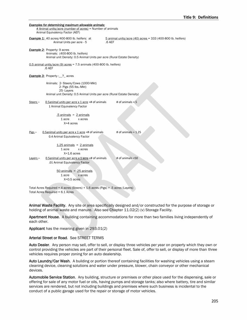
Title 9: Definitions
205
Examples for determining maximum allowable animals:
# Animal units/acre (number of acres) = Number of animals
Animal Equivalency Factor (AEF)
Example 1: 40 acres/400-800 lb. heifers: at 5 animal units/acre (40) acres = 333 (400-800 lb. heifers)
Animal Units per acre - 5 .6 AEF
Example 2: Property: 9 acres
Animals: (400-800 lb. heifers)
Animal unit Density: 0.5 Animal Units per acre (Rural Estate Density)
0.5 animal units/acre (9) acres = 7.5 animals (400-800 lb. heifers)
.6 AEF
Example 3: Property :__?_ acres
Animals: 2- Steers/Cows (1000-Mkt)
2- Pigs (55 lbs.-Mkt)
25- Layers
Animal unit Density: 0.5 Animal Units per acre (Rural Estate Density)
Steers – 0.5animal units per acre x 1 acre =# of animals # of animals =.5
1 Animal Equivalency Factor
.5 animals = 2 animals
1 acre x acres
X=4 acres
Pigs – 0.5animal units per acre x 1 acre =# of animals # of animals = 1.25
0.4 Animal Equivalency Factor
1.25 animals = 2 animals
1 acre x acres
X=1.6 acres
Layers – 0.5animal units per acre x 1 acre =# of animals # of animals =50
.01 Animal Equivalency Factor
50 animals = 25 animals
1 acre x acres
X=0.5 acres
Total Acres Required = 4 acres (Steers) + 1.6 acres (Pigs) + .5 acres (Layers)
Total Acres Required = 6.1 Acres
Animal Waste Facility. Any site or area specifically designed and/or constructed for the purpose of storage or
holding of animal waste and manure. Also see Chapter 11.02(2) (v) Storage Facility.
Apartment House. A building containing accommodations for more than two families living independently of
each other.
Applicant has the meaning given in 293.01(2)
Arterial Street or Road. See STREET TERMS
Auto Dealer. Any person may sell, offer to sell, or display three vehicles per year on property which they own or
control providing the vehicles are part of their personal fleet. Sale of, offer to sell, or display of more than three
vehicles requires proper zoning for an auto dealership.
Auto Laundry/Car Wash. A building or portion thereof containing facilities for washing vehicles using a steam
cleaning device, cleaning solutions and water under pressure, blower, chain conveyor or other mechanical
devices.
Automobile Service Station. Any building, structure or premises or other place used for the dispensing, sale or
offering for sale of any motor fuel or oils, having pumps and storage tanks; also where battery, tire and similar
services are rendered, but not including buildings and premises where such business is incidental to the
conduct of a public garage used for the repair or storage of motor vehicles.
Title 9: Definitions
206
Automobile Wrecking Yard, Junk Yard, or Salvage Yard. Any area of land where three or more vehicles,
unlicensed and/or not in running condition, an accumulation of auto parts, or both, are stored in the open and
are not being restored to operation. Any land, building or structure used for the wrecking or storing of such
motor vehicles, or parts thereof, not in running condition. Any area where tire carcasses are stored or recycled.
Any area where three or more pieces of unlicensed or inoperative construction equipment, motorcycles,
snowmobiles, boats or appliances or their parts are stored and are not being restored to operation, or any land
or structure for the wrecking or storing of such vehicles, equipment or appliances, or parts thereof, not in
working condition. The examples listed by this definition are examples and not intended to be an inclusive list.
Awning. Any structure made of cloth or metal with a frame attached to a building and projecting over a
sidewalk, when the same is so erected as to permit its being raised to a position flat against the building when
not in use.
Awning Sign. See Building Mounted Sign.
Banner. A sign that is mounted on or attached to a non-rigid surface such as cloth fabric, plastic or similar
material with no enclosing framework that is mounted to a building or other structure at one or more edges.
Bank or Financial Institution. A business that offers financial services.
Banner. A sign that is mounted on or attached to a non-rigid surface such as cloth fabric, plastic or similar
material with no enclosing framework that is mounted to a building or other structure at one or more edges.
Bar or Tavern. Any premises wherein alcoholic beverages are sold at retail for consumption on the premises
and minors are excluded therefrom by law. It shall not mean a premise wherein such beverages are sold in
conjunction with the sale of food for consumption on the premises.
Baseline data has the meaning given in NR 132.03(3)
Basement. See: STORY
Bed and Breakfast Establishment. A business as defined in WI Stats. 254.61(1).
Bedroom. A room furnished with a bed and intended primarily for sleeping.
Board of Adjustment. The Body established under 59.694, WI Stats., for counties and designated “Board of
Adjustment.”
Brewery. A plant where malt liquors are produced greater than 15,000 barrels of beer per year.
Buildable Area: The remaining area of a parcel to be designated for buildings and structures excluding Right-Of-
Way, easements, side, rear, and front yard setbacks established for each zoning district.
Building. A structure which encloses space above or below grade or both.
Building Directory Sign. A wall sign that is mounted adjacent to a building entrance identifying tenants that
occupy space in the building.
Building Footprint: The portion of a lot or site covered by a building or structure at the surface level, measured
on a horizontal plane.
Building Height. The vertical distance measured from the bottom of the floor joists or floor slab of the first
story to the highest point of the roof for flat roofs; and to the deck line of mansard roofs; and to the average
height between eaves and ridges for gable, hip, and gambrel roofs. Where buildings have multiple or conflicting
roof styles, the most restrictive method of measurement applies. See Figure 6. Building Height.
Building-Mounted Sign. A sign that is adjacent to or attached to a building wall, door, or related architectural
feature. Such signs include, but are not limited to awning, canopy, projecting, and wall signs.
1. Awning Sign. A sign painted on, printed on, attached flat against the surface of, or hanging below an
awning. An awning sign includes any lightweight fabric protective cover over a door, entrance, window
or other architectural feature.
2. Hanging or Suspended Sign. A sign that is suspended from the underside of a horizontal plane
surface and is supported by such surface.
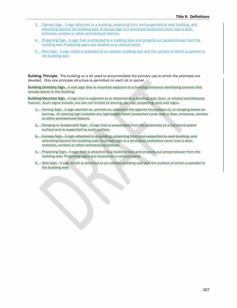
Title 9: Definitions
207
3. Canopy Sign. A sign attached to a building, projecting from and supported by said building, and
extending beyond the building wall. A canopy sign is a structural protective cover over a door,
entrance, window or other architectural feature.
4. Projecting Sign. A sign that is attached to a building face and projects out perpendicular from the
building wall. Projecting signs are located on a vertical plane.
5. Wall Sign. A sign which is attached to an exterior building wall and the surface of which is parallel to
the building wall.
Building, Principle. The building on a lot used to accommodate the primary use to which the premises are
devoted. Only one principle structure is permitted on each lot or parcel.
Building Directory Sign. A wall sign that is mounted adjacent to a building entrance identifying tenants that
occupy space in the building.
Building-Mounted Sign. A sign that is adjacent to or attached to a building wall, door, or related architectural
feature. Such signs include, but are not limited to awning, canopy, projecting, and wall signs.
1. Awning Sign. A sign painted on, printed on, attached flat against the surface of, or hanging below an
awning. An awning sign includes any lightweight fabric protective cover over a door, entrance, window
or other architectural feature.
2. Hanging or Suspended Sign. A sign that is suspended from the underside of a horizontal plane
surface and is supported by such surface.
3. Canopy Sign. A sign attached to a building, projecting from and supported by said building, and
extending beyond the building wall. A canopy sign is a structural protective cover over a door,
entrance, window or other architectural feature.
4. Projecting Sign. A sign that is attached to a building face and projects out perpendicular from the
building wall. Projecting signs are located on a vertical plane.
5. Wall Sign. A sign which is attached to an exterior building wall and the surface of which is parallel to
the building wall.
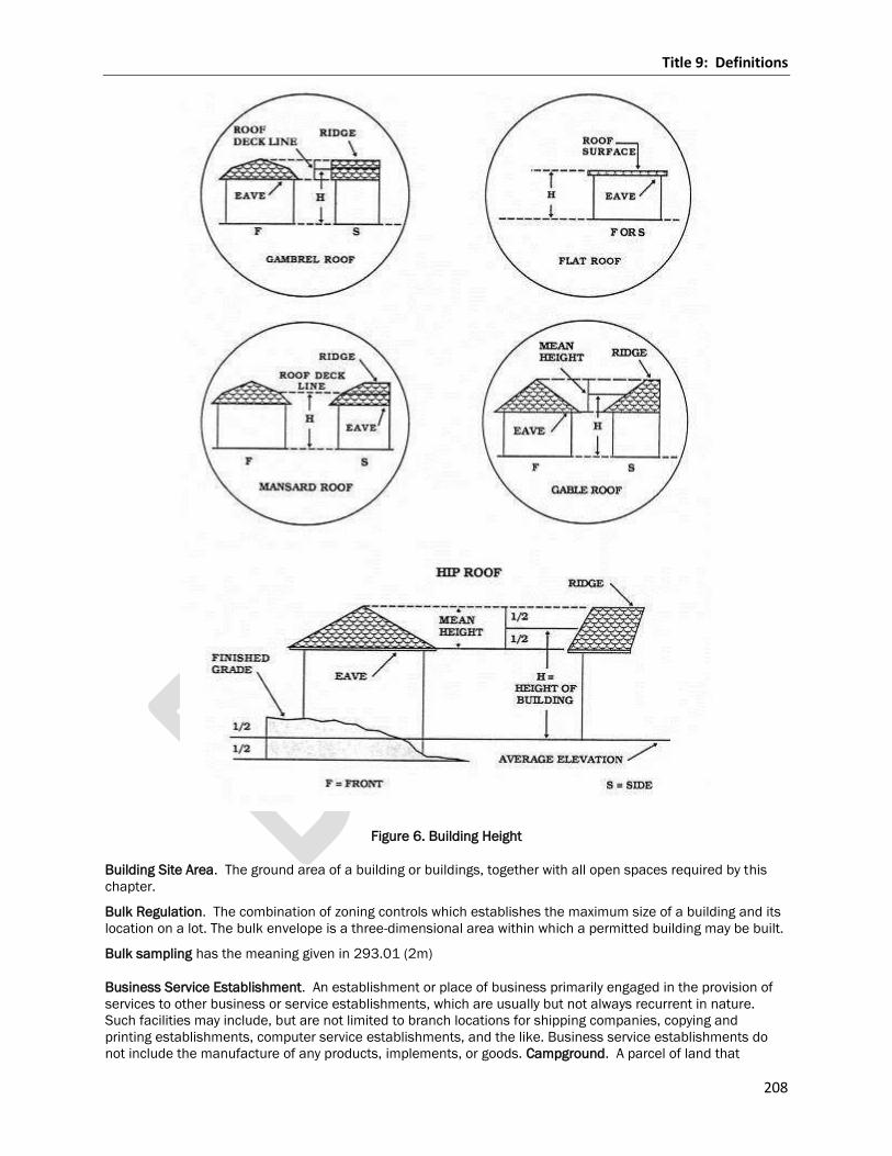
Title 9: Definitions
208
Figure 6. Building Height
Building Site Area. The ground area of a building or buildings, together with all open spaces required by this
chapter.
Bulk Regulation. The combination of zoning controls which establishes the maximum size of a building and its
location on a lot. The bulk envelope is a three-dimensional area within which a permitted building may be built.
Bulk sampling has the meaning given in 293.01 (2m)
Business Service Establishment. An establishment or place of business primarily engaged in the provision of
services to other business or service establishments, which are usually but not always recurrent in nature.
Such facilities may include, but are not limited to branch locations for shipping companies, copying and
printing establishments, computer service establishments, and the like. Business service establishments do
not include the manufacture of any products, implements, or goods. Campground. A parcel of land that
Title 9: Definitions
209
contains sites for temporary occupancy of tents, travel trailers, motor homes and other recreational vehicles, or
which contains cabins or similar structures for temporary use. A campground may be improved with water,
sewer, or septic utilities, and/or electricity, or may be "rustic," with minimal utilities and facilities.
Camper, See Recreational Vehicle Canopy. Any structure, other than an awning made of cloth or metal with
frames attached to a building, projecting over a sidewalk.
Copy Area. The actual area of a sign applied to any background. Copy area shall be completed by drawing
straight lines as closely as possible to the copy extremities encompassing individual letters or words.
Canopy Sign. See Building Mounted Sign.
Changeable Copy Sign. A portion of a permanent sign with letters, characters, or graphics that are not
permanently affixed to the structure, framing, or background allowing the letters, characters or graphics to be
modified manually from time to time as situations change.
Cold Air Inflatable Balloon. A temporary sign composed of a nonporous bag of tough, light material filled with
unheated air, which may or may not float in the atmosphere.
Car Wash. A facility consisting of self-service bays or automatic lines for the washing of passenger vehicles.
Such uses typically include vacuuming stations and other associated car care uses.
Carport. A covered automobile parking space not completely enclosed by walls or doors.
Car Wash. A facility consisting of self-service bays or automatic lines for the washing of passenger vehicles.
Such uses typically include vacuuming stations and other associated car care uses.
Cemetery. Land used for the burial of the dead, and dedicated for cemetery purposes, including crematories,
columbarium, mausoleums and mortuaries.
Central Sewer System. A system where individual lots are connected to a common sewerage system whether
publicly or privately owned and operated.
Certificate of Compliance. A certification issued by the Administrator stating that the construction and the use
of land or a building, the elevation of fill or the lowest floor of a structure is in compliance with all of the
provisions of this ordinance.
Changeable Copy Sign. A portion of a permanent sign with letters, characters, or graphics that are not
permanently affixed to the structure, framing, or background allowing the letters, characters or graphics to be
modified manually from time to time as situations change.
Clear Vision Area. A triangular space which permits an unobstructed view at the intersection of highways or
streets with other highways, streets or roads or at the intersection of highways or streets with railroads.
Club. An association for some common purpose, but not including a group organized for or which is actually
engaged in rendering a service which is customarily carried on as a business. A roadhouse or tavern shall not
be construed as a club.
Cold Air Inflatable Balloon. A temporary sign composed of a nonporous bag of tough, light material filled with
unheated air, which may or may not float in the atmosphere.
Collector Street. See STREET TERMS
Collocation. The use of a wireless telecommunications facility by more than one wireless telecommunications
provider.
Committee. The Committee designated by Marathon County Board having jurisdiction over this ordinance and
designated as the County Planning Agency authorized by 59.69(2) WI Stats., a/k/a Environmental Resources
Committee.
Community Living Arrangements. A place where five or more unrelated people live together in a community
setting, services provided include room and board, supervision and support services.
Comprehensive Plan. The long-range plan for the development of the County and its environs as officially
adopted on May 23, 2006, or amended thereafter.
Condominium. The land together with all buildings, improvements and structures thereon, all easements,
rights and appurtenances belonging thereto, and all articles of personal property which have been submitted
to the provisions under Chapter 703 WI Stats..
Title 9: Definitions
210
Conservation Area. An area of land where the water table is generally at, near or above the land surface.
Contour. The continuous line of the same elevation above mean sea level as determined by the United States
Coast and Geodetic Survey.
Copy Area. The actual area of a sign applied to any background. Copy area shall be completed by drawing
straight lines as closely as possible to the copy extremities encompassing individual letters or words.
Corner Lot. See Lot Types.
County Planning Agency. A county zoning committee authorized by 59.69(2) WI Stats.
County Technical Guide. The County Technical Guide developed primarily by the USDA Natural Resources
Conservation Service to protect soil and water resources consists of standards designed to minimize negative
impacts of agricultural production practices. The Technical Guide was adopted by the Committee on November
7, 1977. It is amended from time to time as standards are revised based on current research.
Crawlway or Crawl Space. An enclosed area below the first usable floor of a building, generally less than five
feet in height, used for access to plumbing and electrical utilities.
Cul-de-sac. See Street Terms.
Cultural, Municipal, or Public Use. A public or private non-profit facility for the benefit of and service to the
general public including, but not limited to, community centers, cultural facilities such as libraries or museums,
police and fire stations, and municipal and government uses.
Day(s). Calendar day(s) unless otherwise specified.
Day Care or Child Care Facility. For the purpose of this code a day care or child care facility shall have the
same definition as contained in 48.65(1) WI Stats.
Deck. A structure usually made of wood and/or synthetic materials which is accessory to a principle structure
and which has no roof covering or side walls.
Density. The number of dwelling units developed on an acre of land.
Department. Marathon County Conservation, Planning, and Zoning Department.
Development. Any artificial change to improved or unimproved real estate including, but not limited to, the
construction of buildings, structures or accessory structures; the construction of additions or substantial
improvements to buildings, structures or accessory structures; the placement of building or structures; mining,
dredging, filling, grading, paving, excavation or drilling operations; and the storage, deposition or extraction of
materials, public or private sewage disposal systems or water supply facilities.
Development Entrance Sign. A ground sign which identifies a residential or commercial subdivision, industrial
or office park, or development with three or more buildings.
1. Street Island Sign. A
small piece of land surrounded by public streets, private streets, and/or common driveways that is located
near the entrance to a residential subdivision, a residential complex, a commercial or office park, an
institutional complex, an industrial park or the like.
Directional Sign. Any sign which solely serves to designate the location or direction of any place or area
located on the premises on which the sign is located.
District. A designated area of Marathon County for which the regulations governing the use of the land and
buildings are uniform.
Double Frontage Lot. See Lot Types.
Drive-Through Facility. Any portion of a building or structure from which business is transacted, or is capable of
being transacted directly with customers located in a motor vehicle. The term "drive-thru" shall also include
"drive-up" and "drive-in".
Dwelling. A building or portion thereof designed exclusively for residential occupancy, including one-family,
two-family and multi-family dwellings.
Title 9: Definitions
211
Electronic Message Center Sign. A changeable copy sign that utilizes computer generated messages or some
other electronic means of changing copy.
Encroachment. An encroachment is any fill, structure, building, accessory use, principle use or development in
an easement or required yard setback area.
Environmental pollution has the meaning given in 293.01(4)
Essential Services and Utilities. The erection, construction, alteration or maintenance by public utilities or
governmental departments, or commissions, of underground or overhead gas, electrical, steam or water
transmission or distribution systems, collection, communications, supply or disposal systems including poles,
wires, mains, drains, sewers, pipes, conduit, cables, fire alarm boxes, police call boxes, traffic signals, hydrants
and other similar equipment and accessories necessary for the furnishing of adequate service by such public
utilities or governmental departments or commissions or for the public health, safety or general welfare.
Existing Mobile Home Park or Mobile Home Subdivision. A parcel (or contiguous parcels) of land divided into
two or more mobile home lots for rent or sale on which the construction of facilities for servicing the lots
(including, at a minimum, the installation of utilities, either final site grading or the pouring of concrete pads,
and the construction of streets) is completed before the effective date of this ordinance.
Existing Street. See Street Terms.
Family. One or more persons related by birth, marriage or legal adoption occupying a dwelling unit and living
as a single housekeeping unit, or not more than four unrelated persons occupying a dwelling unit and living as
a single housekeeping unit.
Farm. All lands under common ownership that is primarily devoted to agriculture use.
Farmland Preservation Agreement. Any of the following agreements between an owner of land and the
department under which the owner agrees to restrict the use of land in return for tax credits.
1. An agreement or transition area agreement entered into under 91.13,2007 WI Stats. or 91.14,2007
WI Stats.
2. An agreement entered into under 91.60 WI Statutes.
Farmland Preservation Area. An area that is planned primarily for agricultural use, agricultural related use, or
both, and that is identified as an agricultural preservation area or transition area in a farmland preservation
plan described in 91.12(1) WI Stats. or identified under 91.10(1)(d) in a farmland preservation plan described
in the 91.12(2) WI Stats.
Farmland Preservation Plan. A plan for the preservation of farmland in a county, including an agricultural
preservation plan under Subchapter IV of Chapter 91, 2007 WI Stats.
Farm Operator. An owner occupant of a parcel of land as defined in 91.60(2) (a) WI Stats.
Farm Residence. A single family or duplex residence that is the only residential structure on the farm and
meets the requirements of Section 17.301.06.
Feedlot. A feedlot shall be determined to be any of the following facilities, when they are a business and
means of livelihood:
1. Any tract of land or structure wherein any type of fowl or the byproducts thereof are raised in close
quarters for sale at wholesale or retail.
2. Any structure, pen or corral wherein cattle, horses, sheep, goats, swine, and other animals domestic
and/or exotic are maintained in close quarters for the purpose of fattening, milking or production of
other animal products for final sale and/or shipment to market.
Fence. A barrier constructed so as to contain or enclose an area as a protective measure.
Fence, Open. A fence which does not exceed 50% opacity when viewed from any angle.
Finding of Fact. A concise statement of the action taken by a board or commission, either drafted during the
meeting, or prepared by staff in advance, that is in the form of a motion and which is recorded as part of the
minutes for the meeting at which the action was taken.
Finished Grade. See Grade.

Title 9: Definitions
212
Flashing Sign. A sign which contains an intermittent of flashing, scintillating, blinking or traveling light source
which includes signs that give the illusion of intermittent or flashing light by means of animation, or an
externally- mounted intermittent light source.
Flood Plain. That area defined by FEMA as the 100 year pool elevation as designated on the Zoning Map.
Floor Area. The sum of the gross horizontal areas of the several floors of a building, measured from the
exterior faces of exterior walls or from the center line of common walls separating two buildings. Floor area for
the purposes of these regulations, shall not include unfinished basement, garage elevator and stair bulkheads,
attic space, terraces, breezeways, open porches and uncovered steps.
Forfeited any bond has the meaning given in NR 132.03(6)
Flashing Sign. A sign which contains an intermittent of flashing, scintillating, blinking or traveling light source
which includes signs that give the illusion of intermittent or flashing light by means of animation, or an
externally- mounted intermittent light source.
Freestanding Sign. See Ground Sign.
Frontage. All the property on one side of a street adjacent to and contiguous with the line of a public right-of-
way.
Front Lot Line. See Lot Line Front Yard. See Yard Terms.
Fur Farm. Any property comprising land or building or both, used for the purpose of raising or harboring fur
bearing animals including those defined in 29.001(30), WI Stats., and also including chinchillas and other fur
bearing animals, whether the animals are kept for breeding or slaughtering or pelting purposes.
Garage, Private. An accessory building or an accessory portion of the principle building, enclosed on all sides
and designed or used for the shelter or storage of passenger vehicles and located on the same lot as the
dwelling to which it is accessory.
Garage, Public. A building or portion thereof other than a private or storage garage, designed or used for
equipping, servicing, repairing, hiring, selling or storing motor driven vehicles.
Gas Station. A place where gasoline, kerosene or any other motor fuel is offered for sale to the public. Such
uses may include facilities for the sale of other retail products.
Gas Station Canopy Sign. A sign which is located upon the canopy above the gas station islands and is
intended to shield such area from the elements. A gas station canopy is typically supported by columns.
Ground Sign. Any sign that is supported by the ground and not attached to a building (also referred to as a
freestanding or monument sign).
Grade.
1. Finished Grade. For buildings abutting one street only, the elevation of the sidewalk at the center of
the wall facing the street (or the elevation of the center line of the street where no sidewalk exists), for
buildings having walls facing more than one side street, the average elevation of the sidewalk at the
centers of all walls facing the street, for buildings having no walls facing the street, the average level
of the finished surface of the ground adjacent to the exterior walls of the building. (Any wall
approximately parallel to a street line is to be considered as facing the street.)
2. Natural Grade. The elevation of the undisturbed natural surface of the ground prior to any excavation
or fill.
Greenhouse/Nursery. The cultivation of plants for subsequent sale or personal enjoyment.
Gross Acreage. Land area measured on the horizontal plane, and including land occupied by all natural and
manmade features of the landscape.
Gross Lot Area. See Lot Area, Gross.
Ground Sign. Any sign that is supported by the ground and not attached to a building (also referred to as a
freestanding or monument sign).
Habitable Structure. Any structure, or portion of a structure, used or intended to be used for permanent or
intermittent human occupancy.
Title 9: Definitions
213
Hanging or Suspended Sign. See Building Mounted Sign.
Hearing Notice. A publication or posting meeting the requirements of 985, Statutes.
Historic Structure. Any structure that is listed preliminarily determined to meet the requirements for listing, as
an individual structure part of a district, or on an inventory of the National Register, determined by the
Secretary of the Interior, or on a State or local inventory of Historic Places.
Home Occupation/Home Professional Business - Minor. Any occupation or business conducted by a family
member in his/her home for gain or support when such occupation is incidental to the residential use of the
premises.
Home Occupation/Home Professional Business - Major. Any occupation or business conducted by a family
member in his/her home or accessory structure for gain or support when such occupation is incidental to the
residential use of the premises.
Hospital or Medical Clinic.
1. Hospital. Any building or other structure containing beds for at least four patients and devoted to the
medical diagnosis, treatment or other care of human ailments.
2. Medical Clinic. Any building or other structure devoted to the medical diagnosis, treatment and care of
human outpatients.
Hotel. A building in which board and lodging are provided to the transient public for compensation.
Human Care Institution. A facility for the aged or mentally or physically infirm, protected with suitable fire
protection devices including sprinklers, audible alarms, smoke and heat detectors and emergency lighting,
conducted within any abode, building, institutional residence or home used for the reception and care, for a
consideration, of three or more persons who, by reason of age or mental or physical infirmities, are not capable
of properly caring for themselves or who are elderly, and for which a license has been issued by the State.
Human Habitation. The act of occupying a structure as a dwelling or sleeping place, whether intermittently or
as a principle residence.
Illegal Sign. A sign for which no valid permit was issued by the County at the time such sign was erected, or a
sign that is not in compliance with the current zoning ordinance and does not meet the definition of a non-
conforming sign.
Illuminated Sign. A sign that provides artificial light direction on or through any transparent or translucent
material, from a source of light connected with such sign, or a sign illuminated by a light with a source so
obscured and shielded that no direct light rays from it are visible from a public right-of-way or from an abutting
property. Impounded Motor Vehicle. Any motor powered vehicle whether operable or inoperable and whether
licensed or unlicensed, taken into custody and possession by a governmental agency or its legal agent
pursuant to authority provided by statute, governmental regulations, or court order for the purpose of storage
pending a final determination as to the disposition of said vehicle.
Institution for Higher Education. A facility for post-secondary education that grants associate, bachelor,
master, or doctoral degrees and that may include research functions or professional schools.
Interchange. A grade separated intersection with one or more turning lanes for travel between intersecting
highways.
Interior Lot. See Lot Types Interstate. See Street Terms.
Junk. Materials or products from materials such as glass, rags, paper, metals or plastic either worn out,
broken, fit to be discarded or recycled.
Kennel. The breeding, raising, and/or training of dogs, cats, or other household pets of three months age or
older not owned by the owner or occupant of the premises or for commercial gain.
Land Use. Any nonstructural use made of unimproved or improved real estate. Also see: "DEVELOPMENT".
Landing. An uncovered platform at the end of a flight of stairs or a platform for ingress and egress to a
structure or a jump platform. A landing is a structural appurtenance not more than four feet wide unless
further restricted in this Chapter.
Lattice Tower. A support structure constructed of vertical metal struts and cross braces forming a triangular or
square structure which often tapers from the foundation to the top.
Title 9: Definitions
214
Lawn or Grass Maintenance. The cutting or clipping of grass and the use of pesticides and fertilizer within
prescribed manufacturers limits.
Legal Non-conforming Sign. Any sign that legally does not comply and conform to the provisions of this
ordinance, at the time of the effective date of this ordinance.
Limited Outdoor Sales, Display or Storage (accessory to principle use). Outdoor display or sales of goods that
are accessory to a principle use.
Livestock. Bovine animals, equine animals, goats, poultry, sheep, swine, farm-raised deer, farm-raised game
birds, camelids, ratites, and farm-raised fish.
Loading Space. An off-street space or berth on the same lot with a building or contiguous to a group of
buildings, for the temporary parking of a commercial vehicle while loading or unloading merchandise or
materials, and which abuts upon a street, alley or other appropriate means of access.
Local Street. See Street Terms.
Lot. A parcel of land occupied or designed to be occupied by one principle structure or use and its accessory
structures or uses, including the open spaces required by this chapter, and abutting on a public street or other
officially approved means of access. A lot may be a parcel designated in a plat or described in a conveyance
recorded in the Office of the Register of Deeds, or any part of a large parcel when such part complies with the
requirements of this chapter as to width and area for the district in which it is located. No land included in any
street, highway or railroad right-of-way shall be included in computing lot area.
Lot Area. The computed area contained within the lot lines. Where the lot has been conveyed to the center of
the street the area of the lot lying within the established street right-of-way shall not be included as part of the
lot area for the purpose of these regulations.
Lot Area, Net. Gross lot area minus any portions of the lot located within lakes, ponds, jurisdictional wetlands,
utility easements, public street rights-of-way and private road easements.
Lot Coverage. The portion of the lot area that is covered by any buildings.
Lot Depth. The mean horizontal distance between the right-of-way line of the street and the rear lot line.
Lot Line. The boundary of a recorded parcel of record or a line established by a recorded survey (Certified
Survey or Subdivision) or a boundary created by recorded metes and bounds, or rectangular description. A
property line defining the limits of a lot.
1. Front Lot Line. In the case of an interior lot, the line separating such lot from the street. In the case of
a corner or through lot, the line separating such lot from that street which is designated as the front
street in the request for zoning compliance permit.
2. Rear Lot Line. The lot boundary opposite and most distant from the front lot line. In the case of a
pointed or irregular lot, it shall be an imaginary line parallel to the farthest from the front lot line, not
less than ten feet long and wholly within the lot.
3. Side Lot Line. A side lot line is any lot line not a front lot line or a rear lot line. A side lot line separating
a lot from a side street is a side street lot line. A side lot line separating a lot from another lot or lots is
an interior side lot line.
4. Side Street Lot Line. In the case of a corner lot, the side street lot line is the line separating such lot
from the street which is not designated as the front street in the plat or in the application for a building
permit or zoning occupancy permit.
Lot Types.
1. Corner Lot. A lot where the interior angle of two adjacent sides at the intersection of the two streets is
less than 135 degrees. A lot abutting upon a curved street shall be considered a corner lot for the
purposes of this ordinance if the arc is a radius of less than 150 feet and the tangents to the curve, at
the two points where the lot lines meet the curve or the straight street line extended form an interior
angle of less than 135 degrees. (See Figure 7 Lot Types)
2. Double Frontage Lot. Any interior lot having frontage on two more or less parallel streets as
distinguished from a corner lot. In the case of a row of double frontage lots, all sides of such lots
adjacent to streets shall be considered frontage, and front yards shall be provided as required. (See
Figure 7 Lot Types)
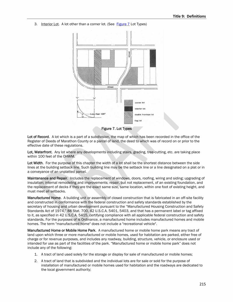
Title 9: Definitions
215
3. Interior Lot. A lot other than a corner lot. (See Figure 7 Lot Types)
Figure 7. Lot Types
Lot of Record. A lot which is a part of a subdivision, the map of which has been recorded in the office of the
Register of Deeds of Marathon County or a parcel of land, the deed to which was of record on or prior to the
effective date of these regulations.
Lot, Waterfront. Any lot where any developments including stairs, grading, tree-cutting, etc. are taking place
within 100 feet of the OHWM.
Lot Width. For the purpose of this chapter the width of a lot shall be the shortest distance between the side
lines at the building setback line. Such building line may be the setback line or a line designated on a plat or in
a conveyance of an unplatted parcel.
Maintenance and Repair. Includes the replacement of windows, doors, roofing, wiring and siding; upgrading of
insulation; internal remodeling and improvements; repair, but not replacement, of an existing foundation, and
the replacement of decks if they are the exact same size, same location, within one foot of existing height, and
must meet all setbacks.
Manufactured Home. A building unit or assembly of closed construction that is fabricated in an off-site facility
and constructed in conformance with the federal construction and safety standards established by the
secretary of housing and urban development pursuant to the “Manufactured Housing Construction and Safety
Standards Act of 1974,” 88 Stat. 700, 42 U.S.C.A. 5401, 5403, and that has a permanent label or tag affixed
to it, as specified in 42 U.S.C.A. 5415, certifying compliance with all applicable federal construction and safety
standards. For the purposes of is Ordinance, a manufactured home includes manufactured homes and mobile
homes. The term "manufactured home" does not include a "recreational vehicle".
Manufactured Home or Mobile Home Park. A manufactured home or mobile home park means any tract of
land upon which three or more manufactured or mobile homes, used for habitation are parked, either free of
charge or for revenue purposes, and includes any roadway, building, structure, vehicle, or enclosure used or
intended for use as part of the facilities of the park. “Manufactured home or mobile home park” does not
include any of the following:
1. A tract of land used solely for the storage or display for sale of manufactured or mobile homes;
2. A tract of land that is subdivided and the individual lots are for sale or sold for the purpose of
installation of manufactured or mobile homes used for habitation and the roadways are dedicated to
the local government authority;
Title 9: Definitions
216
3. A tract of land within an area that is subject to local zoning authority and subdivision requirements
and is subdivided, and the individual lots are for sale or sold for the purpose of installation of
manufactured or mobile homes for habitation.
Manufacturing, Fabrication and Processing (light). A manufacturing establishment whose operations include
storage of materials; processing, fabrication, or assembly of products; and loading and unloading of new
materials and finished products. These uses do not produce or use in large quantities as an integral part of the
manufacturing process toxic, hazardous, or explosive materials. Because of the nature of its operations and
products, little or no noise, odor, vibration, glare and/or air/water pollution is produced, and therefore, these
uses have minimal impact on surrounding properties. This definition includes all uses or products in the
following NAICS groups2:
1. 311 Food Manufacturing (except 311223 Other Oilseed Processing, 311225 Fats and Oils Refining
and Blending, 311311 Sugarcane Mills, 311312 Cane Sugar Refining , 311313 Beet Sugar
Manufacturing, 311611 Animal (except poultry) Slaughtering, 311613 Rendering and Meat Byproduct
Processing, 311615 Poultry Processing, 311711 Seafood Canning, 311712 Fresh and Frozen
Seafood Processing, 311942 Spice and Extract Manufacturing)
2. 312111 Soft Drink Manufacturing
3. 312112 Bottled Water Manufacturing
4. 313 Textile Mills
5. 314 Textile Product Mills
6. 315 Apparel Manufacturing
7. 316 Leather and Allied Product Manufacturing
8. 321 Wood Product Manufacturing (except 321114 Wood Preservation)
9. 322 Paper Manufacturing (except 32211 Pulp Mills, 322121 Paper (except newsprint) Mills,
322122Newsprint Mills, and 32213 Paperboard Mills)
10. 323 Printing and Related Support Activities
11. 326 Plastics and Rubber Products Manufacturing (except 326211 Tire Manufacturing)
12. 332 Fabricated Metal Product Manufacturing (except 332111 Iron and Steel Forging and 332112
Nonferrous Forging)
13. 333 Machinery Manufacturing
14. 334 Computer and Electronic Product Manufacturing
15. 335 Electrical Equipment, Appliance, and Component Manufacturing
16. 336 Transportation Equipment Manufacturing
17. 337 Furniture and Related Product Manufacturing
18. 339 Miscellaneous Manufacturing
19. 511 Publishing Industries
Manufacturing and Processing (heavy). A manufacturing establishment whose operations include storage of
materials; processing, fabrication, or assembly of products; and loading and unloading of new materials and
finished products. These uses may produce or use in large quantities as an integral part of the manufacturing
process toxic, hazardous, or explosive materials. Noise, odor, dust, vibration, glare, or visual impacts, as well as
potential public health problems in the event of an accident, could impact adjacent properties.
This definition includes all uses or products in the following NAICS groups3:
1. 311 Food Manufacturing uses that are not included in General Manufacturing uses, including:
a. 311223 Other Oilseed Processing
b. 311225 Fats and Oils Refining and Blending
c. 311312 Cane Sugar Refining
Title 9: Definitions
217
Tit
le 1
1
Defi
nit
ion
s
d. 311313 Beet Sugar Manufacturing
e. 311611 Animal (except poultry) Slaughtering
f. 311613 Rendering and Meat Byproduct Processing
g. 311615 Poultry Processing
h. 311311 Sugarcane Mills
i. 311711 Seafood Canning
j. 311712 Fresh and Frozen Seafood Processing
k. 311942 Spice and Extract Manufacturing
2. 312 Beverage and Tobacco Product Manufacturing
3. 321114 Wood Preservation
4. 322 Paper Manufacturing uses that are not considered General Manufacturing uses, including:
a. 32211 Pulp Mills
b. 322121 Paper (except newsprint) Mills
c. 322122 Newsprint Mills
d. 32213 Paperboard Mills
5. 324 Petroleum and Coal Products Manufacturing
6. 325 Chemical Manufacturing
7. 326211 Tire Manufacturing
8. 327 Nonmetallic Mineral Product Manufacturing
9. 331 Primary Metal Manufacturing
10. 332111 Iron and Steel Forging
11. 332112 Nonferrous Forging
2 See: http://www.census.gov/eos/www/naics/index.html for detailed descriptions of all of the NAICS categories
referenced in the above definitions.
3 See: http://www.census.gov/eos/www/naics/index.html for detailed descriptions of all of the NAICS categories referenced in the above definitions.
Marquee Sign. A sign, other than an awning or canopy sign, that is attached to, in any manner, or made a part
of any permanent roof-like structure projecting from a wall of a building above an entrance and extending over
a street, sidewalk, or part thereof. Marquee signs generally contain changeable copy on the vertical plane or
face of the sign.
Materials has the meaning given in NR 132.03(7)
Microbrewery. A brewery that produces less than 15,000 barrels (17,600 hectoliters) of beer per year.
Microbreweries sell to the public by one or more of the following methods: the traditional three-tier system
(brewer to wholesaler to retailer to consumer); the two-tier system (brewer acting as wholesaler to retailer to
consumer); and, directly to the consumer through carryout and/or on-site taproom or restaurant sales.
Migrant Labor Camp: Site and all structures maintained as living quarters by, for or under the control and
supervision of any person for ; any migrant worker or any other person who is not related by blood or marriage
to his or her employer and who occasionally or habitually leaves an established place of residence to travel to
another locality to accept seasonal employment in the planting, cultivating, raising, handling, drying, packing,
packaging, processing, freezing, grading or storing of agricultural or horticulture commodity in its
unmanufactured state.
Migrant Worker: Any person who temporarily leaves a principle place of residence outside of this state and
comes to this state for not more than 10 months in a year to accept seasonal employment in the planting,
Title 9: Definitions
218
cultivating, raising, handling, drying, packing, packaging, processing, freezing, grading or storing of agricultural
or horticulture commodity in its unmanufactured state.
Mill has the meaning given in NR 132.03(10)
Minerals. Sand, gravel, clay, peat, peat moss, topsoil, shale, gypsum, halite, limestone, dolomite, sandstone,
other stone, metalliferous or nonmetalliferous ore, or other material or substance of commercial value
excavated in a solid state from natural deposits on or in the earth, but does not include coal.
Mining or mining operation has the meaning given in 293.01(9) & NR 132.03(11)
Mining permit has the meaning given in 293.01(11) & NR 132.03(12)
Mining plan has the meaning given in NR 132.03(13)
Mining site has the meaning given in 293.01(12) & NR 132.03(14)
Minor Street. See Street Terms.
Minimum Setback Line. Lines parallel to the street right-of-way line or lot lines and at a distance therefrom
equal to the required depth of the front, side or rear yards. For front yards where the right-of-way line is an
arterial or collector street, the building line shall be measured from the proposed center line of the traveled
way.
Mixed Use District. Mixed use districts are a subset of nonresidential districts that permit both residential and
nonresidential uses.
Mobile Home. A building unit or assembly of closed construction that is fabricated in an off-site facility, is more
than thirty-five body feet in length or, when erected on site, is three hundred twenty or more square feet, is
built on a permanent chassis, is transportable in one or more sections, and does not qualify as a manufactured
home.
Mobile Recreational Vehicle. A vehicle which is built on a single chassis, 400 square feet or less when
measured at the largest horizontal projection, designed to be self-propelled, carried or permanently towable by
a licensed, light-duty vehicle, is licensed for highway use if registration is required and is designed primarily not
for use as a permanent dwelling, but as temporary living quarters for recreational, camping, travel or seasonal
use.
Mobile Tower. Commercial radio or TV broadcasting studio and/or tower and microwave relay towers, cellular
telephone towers and similar structures which support antennas, dishes, or other broadcast, relay,
amplification, and other transmission devices and their accessory structures.
Monitoring data has the meaning given in NR 132.03(15)
Monopole. A support structure constructed of a single, self- supporting hollow metal tube securely anchored to
a foundation.
Monument Sign. See Ground Sign.
Mural. A design or representation painted or drawn on the exterior surface of a structure.
Motel or Tourist Cabin. A building or group of buildings which contain living or sleeping accommodations used
primarily for transient occupancy, and have individual entrances from outside the building to serve each such
living or sleeping unit.
Multi Family Dwelling. A building used exclusively for residential purposes containing three or more residential
dwelling units. A multi-family structure where units are available for lease or rent for periods of less than one
month shall be considered a lodging use.
Mural. A design or representation painted or drawn on the exterior surface of a structure.
Natural Area. An area of land and/or water which has retained its natural character to some degree or has
some unusual flora, fauna, geological, archaeology, scenic or similar features of scientific or educational
interest. A natural area need not be completely undisturbed.
Natural Grade. See Grade.
Title 9: Definitions
219
Net Developable Area. The developable area of a site determined by deducting 15% of the gross site area for
streets and utilities plus any site area(s) encumbered by the following unbuildable site conditions from the
gross acreage of the proposed residential development (the acreage to be subdivided):
1. Jurisdictional wetlands, as defined in U. S. Army Corps of Engineers’ Corps of Engineers Wetlands
Delineation Manual, Technical Report Y-87-1, U. S. Army Engineer Waterways Experiment Station,
Vicksburg, Miss. Jurisdictional wetland as regulated by section 404 of the Clean Water Act consisting
of (a) hydric soils, (b) hydrophytic vegetation, and (c) wetland hydrology (generally meaning that they
support more than 50% wetland vegetation, and are poorly drained soils that are periodically
inundated or saturated).
2. Floodplains, areas that lie within a FEMA 100-year floodplain, either with in elevations determined by
FEMA or mapped by FEMA.
3. Steep slopes, defined as a slope greater than 25%.
4. Easements, defined as rights-of-way that prohibit residential construction.
Steep slopes and, easements, and wetland and riparian setbacks within yard setbacks may be included in
gross acreage for purposes of determining “net developable area.”
Net Developable Density. The number of dwelling units permitted to be developed on the net developable area
of a site per this Ordinance.
Net Lot Area. See Lot Area, Net.
New Street. See Street Terms.
Non-conformities.
1. Non-conforming Structure. A structure or portion thereof lawfully existing at the effective date of this
ordinance or amendments thereto that does not conform to ordinance provisions for the district in
which it is located, but is otherwise in compliance with all other applicable federal, state, and county
laws, ordinances, regulations and codes.
2. Non-conforming Use of Land. A use that lawfully occupied a parcel or contiguous parcels of land or
structure and land in combination at the effective date of this ordinance or amendments thereto that
does not conform to the use regulations of the district in which it is located, or does not have special
approval where provisions of this Ordinance require such approval, but is otherwise in compliance with
all other applicable federal, state, and county laws, ordinances, regulations and codes.
3. Non-conforming Lot of Record. A platted or unplatted parcel of land lawfully existing at the effective
date of this ordinance or amendments thereto that does not conform to ordinance provisions for the
district in which it is located.
4. Illegal Structure. A structure or portion thereof, which is not a conforming or a non-conforming
structure, or is not in compliance with all applicable federal, state, and county laws, ordinances,
regulations and codes.
5. Illegal Use of Land. A use that occupies one or more contiguous parcels of land, or structures and
land in combination, which is not a conforming or a nonconforming use, or is not in compliance with all
applicable federal, state, and county laws, ordinances, regulations and codes.
6. Cessation. To terminate, abandon or discontinue a use of land or building for a period of time that,
under the provisions of this ordinance, would prevent the use from being resumed.
Nonferrous metallic mineral has the meaning given in 293.01(12m)
Nonmetallic Mining. The definition as contained in 21.03 of the General Code of Ordinances for Marathon
County Chapter 21 Nonmetallic Mining Reclamation Code.
Nonresidential District. Nonresidential districts include the N-C-1, C-2, B-R, L-I and H-I districts.
Noxious Matter. Material which is capable of causing injury to living organisms by chemical reaction or is
capable of causing detrimental effects upon the physical or economic well-being of individuals.
Nuisance. Anything that interferes with the use or enjoyment of property, endangers personal health, safety or
is offensive to a person of ordinary sensibilities.
Title 9: Definitions
220
Occupancy. Pertains to and is the purpose for which a building is used or intended to be used. A change of
occupancy is not intended to include a change of tenants or proprietors.
Occupied. Including the word “occupancy” shall mean used at the time in question.
Off-Street Public Parking Lot or Garage. A building, or portion of a building, in which more than four motor
vehicles are, or are intended to be, housed under arrangements made with patrons for renting or leasing such
space and accommodations, and in which no repair work is carried on.
Office. A room or group of rooms used for conducting a business profession, service, or government. Such
facilities may include, but are not limited to, offices of attorneys, engineers, architects, physicians, dentists,
accountants, finance companies, real estate companies, insurance companies, financial planners, or
corporate offices. Offices exclude manufacturing activities, but may include research and development
activities.
Open Space. Any portion of the lot which is not occupied by any building or structure or is not hard surfaced
with a man-made material. Furthermore, any land or area, the preservation of which in its present use would:
1. Conserve and enhance natural or scenic resources; or
2. Protect streams or water supply; or
3. Promote conservation of soils, wetlands, or beaches; or
4. Enhance the value to the public of abutting or neighboring parks, forests, wildlife preserves, nature
reservations, or sanctuaries; or
5. Enhance recreation opportunities.
Operator has the meaning given in 293.01(13) & NR 132.03(16)
Opinion Sign. A temporary sign that announces the candidacy of persons running for public office, addresses
issues to be voted upon at an election, or otherwise expresses an opinion or point of view, but does not
advertise any products, goods, services or businesses.
Ordinary High Water Mark (OHWM). The point on the bank or shore up to which the presence and action of
surface water is so continuous as to leave a distinctive mark such as by erosion, destruction or prevention of
terrestrial vegetation, predominance of aquatic vegetation or other easily recognized characteristic.
Ore has the meaning given in NR 132.03(17)
Outdoor Dining. Areas located outdoors in the open air or under canopies that are open to the elements where
food or drinks are served to patrons. Outdoor dining may occur on a public sidewalk, or on a patio, deck,
rooftop, or other similar location located on private property.
Outlot. Means a parcel of land other than a lot or block as designated on the survey map, intended for transfer
of ownership, public use including but not limited to utilities and stormwater control, private or public right-of-
way, or a non-buildable parcel having wetlands, poor soils and/or topographic conditions. An outlot may not be
used as a building site.
1. See Section 17.301 for specifics related to Outlots within the Farmland Preservation Zoning District.
Overburden has the meaning given in NR 132.03(18)
Owner. The individual property owner that intends to own and operate the WECS in accordance with this
ordinance.
Park. A pleasure ground set apart for recreation of the public, to promote health and enjoyment.
Park, Amusement. An area publicly or privately owned, containing amusement and recreational facilities and
devices, whether operated for profit or not.
Park Model Unit. A structure resembling a mobile home or manufactured home in construction and design,
generally having less than 400 square feet of total floor area, and not a mobile recreational vehicle due to its
inability to be towed by conventional cars or trucks.
Parking Lot. A lot where automobiles are parked or stored temporarily, but not including the wrecking of
automobiles or other vehicles or storage for the purpose of repair or wrecking.
Title 9: Definitions
221
Parking Space. An off-street space or berth for the temporary parking of a vehicle for a period longer than
required to load or unload persons or goods.
Pasture. Grazing animals on growing vegetation with no supplemental feed at up to five animal units per acre.
Also rotational grazing systems designed periodically to exceed five animal units per acre, which comply with
the standards in the County Technical Guide adopted by the Committee.
Person. Includes any individual or group of individuals, corporation, partnership, association, or any other
entity, including state and local governments and agencies, or any combination thereof.
Personal Service Establishment. An establishment or place of business primarily engaged in the provision of
services of a personal nature related to the care, hygiene, or appearance of the human body or the
maintenance of items worn or carried by persons. Such services are usually but not always recurrent in nature.
Examples of personal service uses include, but are not limited to, beauty and barber shops, shoe repair shops,
health spas, therapeutic massage, and tailor shops.
Pet Boarding Facility. A business for the temporary boarding and care of common household pets. Boarding
generally occurs during daytime hours, but may include overnight boarding. Pet boarding facilities may provide
related services such as retail sales, grooming, or training, but no animals may be bred or sold at a pet
boarding facility.
Place of Assembly. A facility for public assembly including, but not limited to arenas, auditoriums, conference
facilities, banquet facilities, convention centers, exhibition halls, theatres, performing arts centers, or any other
use where people gather for recreational, charitable, or commercial purposes.
Place of Worship. A facility used for regular organized religious worship and related activities, including living
quarters for church ministry or other members of the religious order who carry out their duties primarily on the
site, religious education classes, and limited recreation facilities.
Planning Commission. The Environmental Resources Committee of the County of Marathon.
Pole Sign. A sign which is supported by or suspended from a freestanding column or columns.
Political Sign. See Opinion Sign.
Pond. A seasonal or permanent body of water, created by excavation, by dike construction or by a combination
of both. The only ponds within this definition subject to shoreland setback regulations by this Chapter are
those under 30.19, WI Stats, and which have been declared navigable.
Pond, Landscape/Ornamental. A pond usually of small size exclusively used as a landscape feature in a
residential yard usually lined with a pre-formed or flexible liner and not to be used for any agricultural or
recreation use other than viewing. (Considered a minor structure by this ordinance).
Porch. An attachment which is part of a principle structure usually functioning as a passageway into the main
part of the structure and/or as additional seasonal living space.
Potential mining site means the surface area disturbed by an applicant pursuant to a prospecting and/or bulk
sampling permit. The site includes the surface area from which the nonferrous metallic minerals or refuse or
both have been removed, the surface area covered by refuse, all lands disturbed by the construction or
improvement of haulage ways, and any surface areas in which structures, equipment, materials and any other
items used in the potential mining operation are situated.
Premises. An area of land occupied by the buildings or other physical uses which are an integral part of the
activity conducted upon the land and such open spaces as are arranged and designed to be used in
conjunction with that activity.
Primary School. Facilities for elementary, junior, and secondary schools including the customarily associated
facilities such as administrative offices and auditoriums.
Principle Building. See Building, Principle
Private Club, Fraternal Organization, or Community Group. A membership organization that holds regular
meetings and that may, subject to other regulations controlling such uses, maintain dining facilities, serve
alcohol, or engage professional entertainment for the enjoyment of dues paying members and their guests.
Private Sewage System/Private On-Site Waste Treatment System (POWTS). For the purpose of this code a
private sewage system shall have the same definition as contained in 145.01(12) WI Stats.
Title 9: Definitions
222
Private Street. See Street Terms.
Project Construction Sign. A sign which directs attention to the promotion, development and construction of
the property on which it is located and which identifies the owner, architects, engineers, contractors and other
individuals or firms involved with the construction of the project.
Projecting Sign. See Building Mounted Sign.
Prospecting has the meaning given in 293.01 (18) & NR 131.03 (15)
Prospecting data has the meaning given in NR 131.03 (16)
Prospecting permit has the meaning given in 293.01 (19) & NR 131.03 (17)
Prospecting plan has the meaning given in 293.01 (20) & NR 131.03 (18)
Prospecting site has the meaning given in 293.01 (21) & NR 131.03 (19)
Prospector has the meaning given in 293.01 (22)
Professional Office. The office of a doctor, practitioner, dentist, minister, architect, landscape architect,
professional engineer, lawyer, author, musician or other recognized profession.
Public or Self-Storage. A building or group of buildings containing separate storage spaces used for the
storage of personal property.
Public Street. See Street Terms.
Public Utility. Any person, firm, corporation, governmental agency or board fully authorized to furnish to the
public, electricity, gas, steam, telephone, telegraph, transportation, water or any other similar public utilities.
Quarrying. The removal of rock, gravel, decomposed granite, sand, topsoil or other natural material from the
earth by excavating, stripping, leveling or any other process whereby these materials are substantially removed
from the site.
Real Estate Sign. A sign advertising the sale, rental or lease of the premises or part of the premises on which
the sign is displayed.
Rear Lot Line. See Lot Line.
Rear Yard. See Yard Terms.
Reclamation has the meaning given in 293.01(23) & NR 132.03(21)
Reclamation plan has the meaning given in 293.01(24) & NR 132.03(22)
Recreation or Youth Camp. An area containing one or more permanent buildings used occasionally or
periodically for the accommodation of members of associations or groups for recreational purposes.
Recreation, Private Indoor. Indoor recreation uses that may be smaller in scale, such as arcades, billiards
halls, bowling alleys, indoor shooting ranges and similar uses; or larger in scale, such as soccer, hockey, tennis,
swimming, or other similar uses.
Recreation, Private Outdoor. Outdoor recreation uses that are not open to the general public or which charge
an admission or usage fee. Typical uses may include country clubs, golf courses, miniature golf, swimming
pools, tennis courts, volleyball courts, soccer, baseball, go-cart tracks, batting cages, golf driving ranges (not
associated with a golf course), amusement parks, and similar uses.
Recreation, Public. An open area and/or facilities designed for the active and/or passive use of the general
public.
Recreational Vehicle. A vehicle which is built on a single chassis, 400 square feet or less when measured at
the largest horizontal projection, designed to be self-propelled, carried or permanently towable by a licensed,
light duty vehicle, is licensed for highway use if registration is required and is designed primarily not for the use
as a permanent dwelling, but as temporary living quarters for recreational, camping, travel or seasonal use.
Title 9: Definitions
223
Refuse has the meaning given in 293.01(25) & NR 132.03(22)
Rendering Plant. A plant for the reduction of dead animals or slaughtered animals not suitable for human
consumption to by-products such as hide, skin, grease, bones, glue and soap and for the storage of such by-
products.
Required Yard. See Yard Terms.
Residential District. Residential districts include the U-R, L-D-R, R-R, R-E, F-P, G-A, C-V/R-C districts.
Restaurant. A place of business dedicated to the preparation and sale of food and beverage for immediate
consumption on or off site. A restaurant may sell alcoholic beverages for consumption on the premises as a
use.
Retail Sales. Any generally recognized retail business that supplies commodities on the premises to the
general incidental public where all sales and display of goods shall occur entirely indoors. Commodities
supplied may include groceries and similar food products for consumption off the premises.
Retail Sales, Outdoor. The keeping or display in an enclosed area outside of a building or structure of any
goods, material, or merchandise in the same place for more than 24 hours. Common examples include garden
supplies, burial monuments, building and landscape materials and lumber yards.
Riding Stable. A building or premises used for the rent or lease of horses or animals for hire.
Right-of-Way Line. A dividing line between a lot, tract or parcel of land and a contiguous street. Where the lot,
tract or parcel of land has been conveyed to the center of the street, the street right-of-way line then becomes
the inside line of land reserved for street purposes.
Roadside Stand. A structure having a ground area of not more than 300 sq. ft., readily removable in its
entirely, not fully enclosed and to be used solely for the sale of farm products more than ½ of which were
produced on the premises or adjacent premises. There shall not be more than one such roadside stand on any
single premise.
Real Estate Sign. A sign advertising the sale, rental or lease of the premises or part of the premises on which
the sign is displayed.
Roof Sign. A display sign which is erected, constructed, and maintained above any portion of the roof or
exterior walls of a building or structure.
Rotor. The nonstationary part of a wind turbine.
Rotor Radius. The distance between the center point of the rotor and the outermost point on the rotor or
blade.
Sandwich Board Sign. A temporary ground sign not secured or attached to the surface upon which it is located
constructed in such a manner as to form an “A” or a tent-like shape, hinged or not hinged at the top; each
angular face held at an appropriate distance by a supporting member.
Sanitarium. A health station, retreat, or an institution for the recuperation and treatment of persons suffering
from physical or mental disorders.
Setback Line / Building Line. The minimum allowable distance from a given point or line of reference, such as
a thoroughfare, right-of-way, Ordinary High Water Mark or lot line to the nearest vertical wall or other element
of a building or structure.
Setback: The minimum distance required between a structure and the road right of way, side, and rear lot
lines, and other structures….
Setback Lines; Title 2; Chapter 18- Building Setback Line-Yard
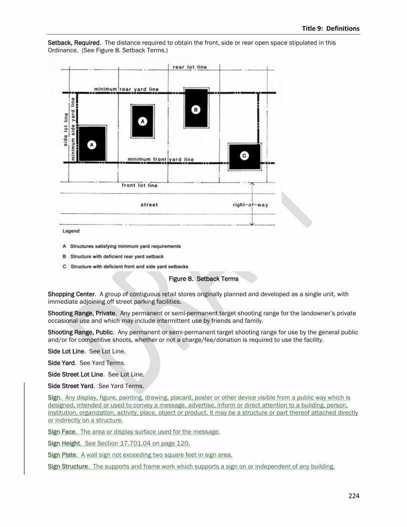
Title 9: Definitions
224
Setback, Required. The distance required to obtain the front, side or rear open space stipulated in this
Ordinance. (See Figure 8. Setback Terms.)
Figure 8. Setback Terms
Shopping Center. A group of contiguous retail stores originally planned and developed as a single unit, with
immediate adjoining off street parking facilities.
Shooting Range, Private. Any permanent or semi-permanent target shooting range for the landowner’s private
occasional use and which may include intermittent use by friends and family.
Shooting Range, Public. Any permanent or semi-permanent target shooting range for use by the general public
and/or for competitive shoots, whether or not a charge/fee/donation is required to use the facility.
Side Lot Line. See Lot Line.
Side Yard. See Yard Terms.
Side Street Lot Line. See Lot Line.
Side Street Yard. See Yard Terms.
Sign. Any display, figure, painting, drawing, placard, poster or other device visible from a public way which is
designed, intended or used to convey a message, advertise, inform or direct attention to a building, person,
institution, organization, activity, place, object or product. It may be a structure or part thereof attached directly
or indirectly on a structure.
Sign Face. The area or display surface used for the message.
Sign Height. See Section 17.701.04 on page 120.
Sign Plate. A wall sign not exceeding two square feet in sign area.
Sign Structure. The supports and frame work which supports a sign on or independent of any building.
Title 9: Definitions
225
Single-Family Dwelling, Attached. A building containing three or more dwelling units where each dwelling unit
has its own exterior entrance; is capable of individual use and maintenance without trespassing on adjoining
dwellings; and access, utilities and service facilities are independent for each dwelling.
Single Family Dwelling, Detached. A dwelling designed for or used exclusively for residence purposes by one
family.
Slaughterhouse. Any building or premises used for the killing or dressing of fowl, cattle, sheep, swine, goats or
horses and the storage, freezing and curing of meat and preparation of either meat products, by-products or
both.
Solid waste has the meaning given under 281.01(15).
Special Advertising Event Sign. A temporary sign associated with a special event and displayed for a specified
and limited period of time.
Stable.
1. Private Stable. A building and associated site improvements for the keeping of horses for
noncommercial use by the residents of the lot, not including the keeping of horses for others or for
commercial breeding.
2. Public Stable. The keeping of horses for hire, breeding, or commercial use.
Storage/Impound Yard. A use involving primarily the keeping of personal or business property or motor
vehicles outside of a building, or a use where the use is characterized primarily by its outdoor component.
Examples of such uses include, but are not limited to contractor’s supply yards, lumber yards, recreational
vehicle storage yards, commercial vehicle storage, motor vehicle impound yards, and the like.
Storage/Shipping container. A structure/container designed for the storage and/or shipment of goods by
means of boat, train or truck. Such storage containers are self-contained units which do not have axles or
wheels directly attached to them. These containers may be used as permanent accessory structures as well as
for the temporary storage and/or the moving of small amounts of goods, supplies, construction waste, or
equipment.
Story. That part of a building, other than a mezzanine, included between the surface of one floor and the
surface of the floor next above, or if there be no floor above, that part of the building which is above the
surface of the highest floor thereof. Specifically:
1. First Story. The highest story having its interior floor surface not more than four feet above the curb
level, or the average elevation of the finished grade along the front of the building where it set back
from the street.
2. Basement. That portion of a building wholly or partly below grade, but so constructed that the vertical
distance from the average grade to the basement floor is greater than the vertical distance from the
average grade to the basement ceiling. A basement shall not be included as a story for height
measurement. A basement is considered a story if over 50% of its height is above the level from which
the height of the building is measured. (See Figure 9. Determination of Basement vs. Story)
3. Half-story. That part of a building between a pitched roof and the uppermost full story, such part
having a floor area which does not exceed ½ of the floor area of such full story, provided the area
contains at least 200 square feet, with a clear height of at least 7 feet 6 inches.
4. Mezzanine. A full story when it covers more than 33% of the area of the story underneath such
mezzanine or if the vertical distance from the floor next below it to the floor next above it is 24 feet or
more.
Street Island Sign. See Development Entrance Sign.
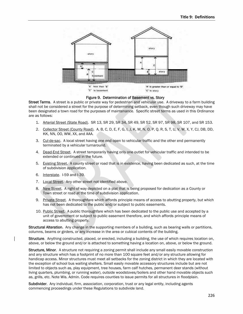
Title 9: Definitions
226
Figure 9. Determination of Basement vs. Story
Street Terms. A street is a public or private way for pedestrian and vehicular use. A driveway to a farm building
shall not be considered a street for the purpose of determining setback, even though such driveway may have
been designated a town road for the purposes of maintenance. Specific street terms as used in this Ordinance
are as follows:
1. Arterial Street (State Road). SR 13, SR 29, SR 34, SR 49, SR 52, SR 97, SR 98, SR 107, and SR 153.
2. Collector Street (County Road). A, B, C, D, E, F, G, I, J, K, M, N, O, P, Q, R, S, T, U, V, W, X, Y, CJ, DB, DD,
KK, NN, OO, WW, XX, and AAA.
3. Cul-de-sac. A local street having one end open to vehicular traffic and the other end permanently
terminated by a vehicular turnaround.
4. Dead-End Street. A street temporarily having only one outlet for vehicular traffic and intended to be
extended or continued in the future.
5. Existing Street. A county street or road that is in existence, having been dedicated as such, at the time
of subdivision application.
6. Interstate. I-59 and I-39.
7. Local Street. Any other street not identified above.
8. New Street. A right-of-way depicted on a plat that is being proposed for dedication as a County or
Town street or road at the time of subdivision application.
9. Private Street. A thoroughfare which affords principle means of access to abutting property, but which
has not been dedicated to the public and/or subject to public easements.
10. Public Street. A public thoroughfare which has been dedicated to the public use and accepted by a
unit of government or subject to public easement therefore, and which affords principle means of
access to abutting property.
Structural Alteration. Any change in the supporting members of a building, such as bearing walls or partitions,
columns, beams or girders, or any increase in the area or cubical contents of the building.
Structure. Anything constructed, placed, or erected, including a building, the use of which requires location on,
above, or below the ground and/or is attached to something having a location on, above, or below the ground.
Structure, Minor. A structure not requiring a zoning permit shall include any small easily movable construction
and any structure which has a footprint of no more than 100 square feet and/or any structure allowing for
handicap access. Minor structures must meet all setbacks for the zoning district in which they are located with
the exception of school bus waiting shelters. Small easily movable accessory structures include but are not
limited to objects such as, play equipment, tree houses, farm calf hutches, permanent deer stands (without
living quarters, plumbing, or running water), outside woodstoves/boilers and other hand movable objects such
as, grills, etc. Note Wis. Admin. Code requires counties to issue permits for all structures in floodplain.
Subdivider. Any individual, firm, association, corporation, trust or any legal entity, including agents
commencing proceedings under these Regulations to subdivide land.
Title 9: Definitions
227
Subdivision. As identified in the General Code of Ordinances for Marathon County Chapter 18 Land Division
and Surveying Regulations.
Subdivision Sign. See Development Entrance Sign.
Substantially Altered. A change in a sign or sign structure, as differentiated from maintenance or repair
including a change in height, location, area, shape, or material. In the case of manual or automatic changeable
copy signs, a change in copy does not constitute a substantially altered sign.
Substantial Damage. Damage of any origin sustained by a structure whereby the cost of restoring the
structure to its pre-damaged condition would equal or exceed 50 percent of the equalized assessed value of
the structure before the damage occurred.
Substantial Improvement. Any repair, reconstruction or improvement of a structure, the value of which equals
or exceeds 50% of the present equalized assessed value of the structure either before the improvement or
repair is started or, if the structure has been damaged and is being restored, before the damage occurred. The
term does not include either any project for improvement of a structure to comply with existing State or local
health, sanitary or safety code specifications which are solely necessary to assure safe living conditions or any
alteration of a structure or site documented as deserving preservation by the State Historical Society or listed
on the National Register of Historic places. Ordinary maintenance repairs are not considered structural repairs,
modifications or additions. Such ordinary maintenance repairs include internal and external painting,
decorating, paneling and replacement of doors, windows and other nonstructural components. The term does
not, however, include:
1. Any improvement to a structure which is considered "new construction,"
2. Any project for improvement of a structure to correct existing violations of state or local health,
sanitary, or safety code specifications which have been identified prior to the application for a
development permit by the local code enforcement official and which are the minimum necessary to
assure safe living conditions; or
3. Any alteration of a "historic structure," provided that the alteration will not preclude the structure's
continued designation as a "historic structure".
Substantially Altered. A change in a sign or sign structure, as differentiated from maintenance or repair
including a change in height, location, area, shape, or material. In the case of manual or automatic changeable
copy signs, a change in copy does not constitute a substantially altered sign.
Swimming Pool, Family. A swimming pool used or intended to be used solely by the owner or lessee thereof
and his family, and by friends invited to use it without payment of any fee.
Tailings have the meaning given in NR 132.03(24).
Technical School. Private educational facilities including business and commercial technical schools, art
schools, dance schools and specialized educational facilities.
Temporary Sign. A sign that is designed to be used only temporarily and is not intended to be permanently
attached to a building, a structure or permanently installed in the ground.
Transmission Equipment. Poles, towers, wires, cables, conduits, vaults, laterals, pipes, main valves for high
voltage electrical transmission, natural gas, and other utility products and services not intended for direct
access by retail customers, but whose purpose is transmission from point of origin to distribution stations or
similar locations.
Transparent. Fine or sheer enough to be seen through.
Turbine Height. The distance between the ground elevation at the base of the structure and the upper most
point of the rotor/blade/structure and/or revolution.
Title 9: Definitions
228
Two-Family Dwelling. A building designed and used exclusively by two families living independently of each
other.
Unnecessary Hardship. A circumstance where special conditions, which are not self-created, affect a particular
property and make strict conformity with restrictions governing area, setbacks, frontage, height or density
unnecessarily burdensome or unreasonable in light of the purposes of this chapter.
Unsuitability has the meaning given in 293.01(25) & NR 132.03(22)
Use. The purpose for which a building or premises is or may be occupied. In the classification of uses, a "use"
may be a use as commonly understood or the name of an occupation, business, activity or operation carried
on, or intended to be carried on in a building or on premises, or the name of a building, place or thing which
name indicates the use or intended use.
Useable Open Space. The required portion of a lot excluding the required front yard area which is unoccupied
by principle or accessory buildings and available to all occupants of the building for use for recreational and
other leisure activities normally carried on outdoors. This space shall be unobstructed to the sky and shall not
be devoted to service driveways or off-street parking or loading space, and shall be a minimum of twenty feet
of dimension on the ground.
Variance. A grant of relief from the standards of these regulations consistent with the variance conditions
herein.
Vehicle or Equipment Sales or Rental. A building and land used principally for the sale of automobiles or other
large vehicles or equipment.
Veterinary Office, Clinic or Hospital. A place used for the care, grooming, diagnosis and treatment of sick,
ailing, infirm or injured animals and those who are in need of medical or surgical attention and may include
overnight accommodations on the premises for treatment, observation and/or recuperation.
Violation. A condition that occurs when a structure or other activity requiring a permit or approved by this Code
is commenced without first obtaining the required permit and/or where the structure or activity is not in
compliance with the terms of this Code.
Wall Sign. See Building Mounted Sign
Warehousing/Distribution. Establishments primarily engaged in selling durable and nondurable goods to
retailers; industrial, commercial, institutional, farm, building trade contractors, or professional business uses;
or to other wholesalers. Activities may include physically assembling, sorting, and grading goods into large lots
and breaking bulk for redistribution in smaller lots. Operations with more than 25 percent of sales to retail
customers are considered a retail use, and shall be located in an appropriate zone.
Waste rock has the meaning given in NR 132.03(26)
Waters of the state has the meaning given in 293.01(29)
Water supply has the meaning given in 293.01(30)
WECS. Wind and Energy Conversion System.
Well. An excavation opening in the ground made by digging, boring, drilling, driving or other methods, for the
purpose of obtaining groundwater regardless of its intended use.
Well Field. A parcel of land used primarily for the purpose of locating wells to supply a municipal water system.
Wetlands. Those areas where water is at, near or above the land surface long enough to be capable of
supporting aquatic or hydrophytic vegetation and which have soils indicative of wet conditions.
Wildlife Refuge or Game Preserve. An area of land that is protected and managed in order to preserve a
particular type of habitat and its flora and fauna which may or may not be rare or endangered.
Wall Sign. See Building Mounted Sign
Window Sign. A sign applied or attached to the exterior or interior of a window or located in such a manner
within a building that it is visible from the exterior of the building through a window. Merchandise for sale on
the premises that is located in a window display shall not be considered a window sign.
Title 9: Definitions
229
Wind Energy Conversion System – Private Use. A WECS which consists of a wind turbine, tower, and
associated control or conversion electronics for the purpose of providing electrical power to a lawful principle
use. A system having a rated capacity of 10 kilowatts (kW) or less for residential use or 100kW or less for non-
residential uses shall be considered a private system for the purposes of these regulations.
Wind Turbine. A WECS that converts wind energy into electricity through use of a wind turbine generator and
includes such elements as a wind turbine generator hub, blade or rotor, tower, inverter, change controller and
dump load, transmission wiring and controls and (possibly) battery bank and/or utility interconnecting
equipment.
Wind Turbine Hub. An electric power generator to which the blade or rotor of a wind turbine is attached.
Wireless Telecommunication Antenna. The physical device through which electromagnetic, wireless
telecommunications signals authorized by the Federal Communications Commission are transmitted or
received. Antennas used by amateur radio operators are excluded from this definition.
Wireless Telecommunications Equipment Building. The structure in which the electronic receiving and relay
equipment for a wireless telecommunications facility is housed.
Wireless Telecommunications Facility. A facility consisting of the equipment and structures involved in
receiving telecommunications or radio signals from a mobile radio communications source and transmitting
those signals to a central switching computer which connects the mobile unit with the land-based telephone
lines.
Wireless Telecommunications Tower. A structure intended to support equipment used to transmit and/or
receive telecommunications signals, including monopoles, guyed and lattice construction steel structures.
Yard. See Yard Terms.
Yard Terms.
1. Yard. TheA n open areaspace of the same lot between the lot line and the building line, unoccupied
and unobstructed by any portion of a building or structure from the ground upward, except as
otherwise provided herein. (See Figure 10. Yard Terms.)
2. Front yard. The An open space area extending across the full width of a lot and being thethe depth of
which shall be the perpendicular distance between the existing or proposed roadstreet right-of-way or
proposed road right-of-way andto the principle structure. (See Figure 10. Yard Terms.)
32. Rear yard. The area A yard extending across the full width of the lot, the depth of which shall be the
minimum horizontal distance between the rear lot line and a line parallel thereto through the nearest
point of the principle structure. (See Figure 10. Yard Terms.)
43. Side yard. The area extending from the front yard to the rear yard of the lot, the width of
which shall be the distance between the side lot line and a line parallel thereto through the nearest
point of the principle structure. (See Figure 10. Yard Terms.)
A yard extending from the street yard to the rear yard of the lot, the width of which shall be the minimum
horizontal distance between the side lot line and a line parallel thereto through the nearest point of
the principle structure.
4. Side street yard. The area extending between the front yard and the rear yard situated between the
side street lot line and the face of the principle building which is parallel to, or most nearly parallel to,
the side street lot line.5
5. Required yard. The areaA spaceyard, as defined herein, that occupies the area space of a required
setback.
6. Yard. An open space of the same lot between the lot line and the building line, unoccupied and
unobstructed by any portion of a building or structure from the ground upward, except as otherwise
provided herein.
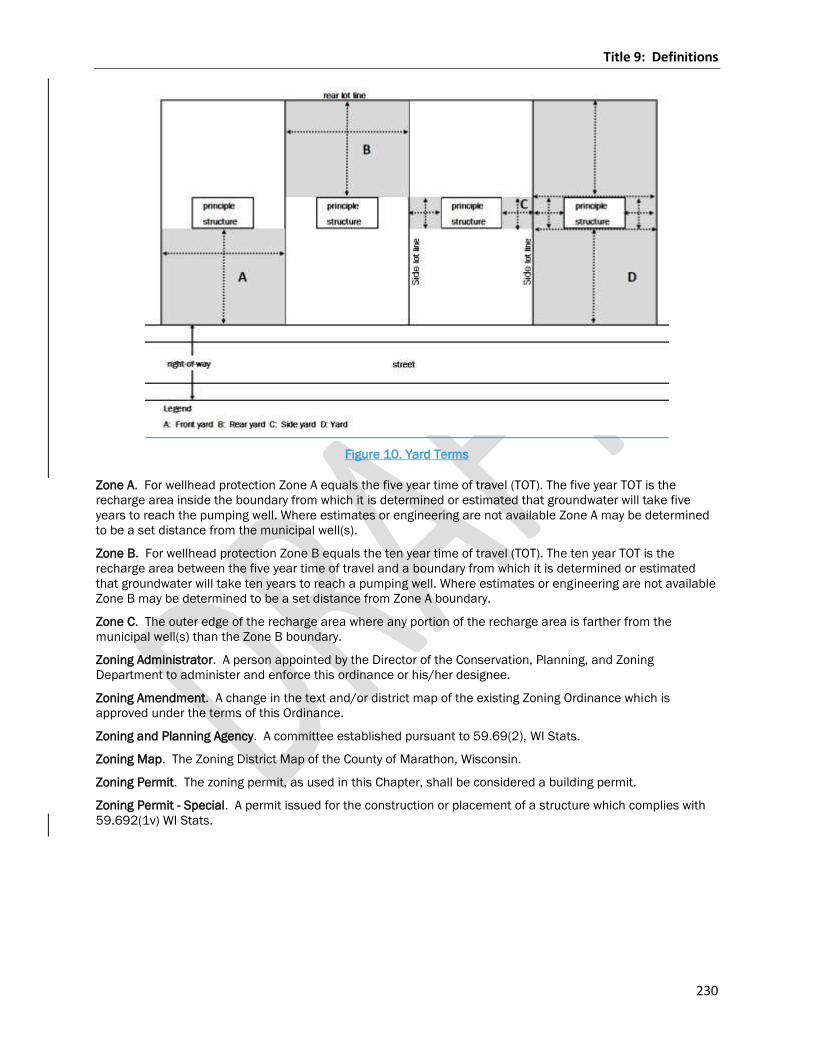
Title 9: Definitions
230
Figure 10. Yard Terms
Zone A. For wellhead protection Zone A equals the five year time of travel (TOT). The five year TOT is the
recharge area inside the boundary from which it is determined or estimated that groundwater will take five
years to reach the pumping well. Where estimates or engineering are not available Zone A may be determined
to be a set distance from the municipal well(s).
Zone B. For wellhead protection Zone B equals the ten year time of travel (TOT). The ten year TOT is the
recharge area between the five year time of travel and a boundary from which it is determined or estimated
that groundwater will take ten years to reach a pumping well. Where estimates or engineering are not available
Zone B may be determined to be a set distance from Zone A boundary.
Zone C. The outer edge of the recharge area where any portion of the recharge area is farther from the
municipal well(s) than the Zone B boundary.
Zoning Administrator. A person appointed by the Director of the Conservation, Planning, and Zoning
Department to administer and enforce this ordinance or his/her designee.
Zoning Amendment. A change in the text and/or district map of the existing Zoning Ordinance which is
approved under the terms of this Ordinance.
Zoning and Planning Agency. A committee established pursuant to 59.69(2), WI Stats.
Zoning Map. The Zoning District Map of the County of Marathon, Wisconsin.
Zoning Permit. The zoning permit, as used in this Chapter, shall be considered a building permit.
Zoning Permit - Special. A permit issued for the construction or placement of a structure which complies with
59.692(1v) WI Stats.
Title 9: Definitions
231
Chapter 17.903 Sign Definitions
As used in this Zoning Ordinance, certain terms are defined as follows:
Abandoned Sign. A sign which no longer correctly advertises or directs a person to a bona fide business,
person, goods, product, activity, or service. A sign is considered abandoned if:
1. It does not display a well-maintained message for a consecutive 60 day period;
2. The use to which the sign is accessory is discontinued or terminated for more than 180 consecutive
days;
3. The owner of the sign cannot be located at the owner’s last known address as reflected on the records
of the County; or
4. A structure designed to support a sign no longer supports the sign for a period of 30 consecutive days.
Accessory Sign. A sign that is subordinate to the main use on a lot and used for purposes clearly incidental to
those of the main use.
Awning Sign. See Building Mounted Sign.
Banner. A sign that is mounted on or attached to a non-rigid surface such as cloth fabric, plastic or similar
material with no enclosing framework that is mounted to a building or other structure at one or more edges.
Building Directory Sign. A wall sign that is mounted adjacent to a building entrance identifying tenants that
occupy space in the building.
Building-Mounted Sign. A sign that is adjacent to or attached to a building wall, door, or related architectural
feature. Such signs include, but are not limited to awning, canopy, projecting, and wall signs.
1. Awning Sign. A sign painted on, printed on, attached flat against the surface of, or hanging below an
awning. An awning sign includes any lightweight fabric protective cover over a door, entrance, window
or other architectural feature.
2. Hanging or Suspended Sign. A sign that is suspended from the underside of a horizontal plane
surface and is supported by such surface.
3. Canopy Sign. A sign attached to a building, projecting from and supported by said building, and
extending beyond the building wall. A canopy sign is a structural protective cover over a door,
entrance, window or other architectural feature.
4. Projecting Sign. A sign that is attached to a building face and projects out perpendicular from the
building wall. Projecting signs are located on a vertical plane.
5. Wall Sign. A sign which is attached to an exterior building wall and the surface of which is parallel to
the building wall.
Copy Area. The actual area of a sign applied to any background. Copy area shall be completed by drawing
straight lines as closely as possible to the copy extremities encompassing individual letters or words.
Canopy Sign. See Building Mounted Sign.
Changeable Copy Sign. A portion of a permanent sign with letters, characters, or graphics that are not
permanently affixed to the structure, framing, or background allowing the letters, characters or graphics to be
modified manually from time to time as situations change.
Cold Air Inflatable Balloon. A temporary sign composed of a nonporous bag of tough, light material filled with
unheated air, which may or may not float in the atmosphere.
Development Entrance Sign. A ground sign which identifies a residential or commercial subdivision, industrial
or office park, or development with three or more buildings.
1. Street Island Sign. A small piece of land surrounded by public streets, private streets, and/or common
driveways that is located near the entrance to a residential subdivision, a residential complex, a
commercial or office park, an institutional complex, an industrial park or the like.
Directional Sign. Any sign which solely serves to designate the location or direction of any place or area
located on the premises on which the sign is located.
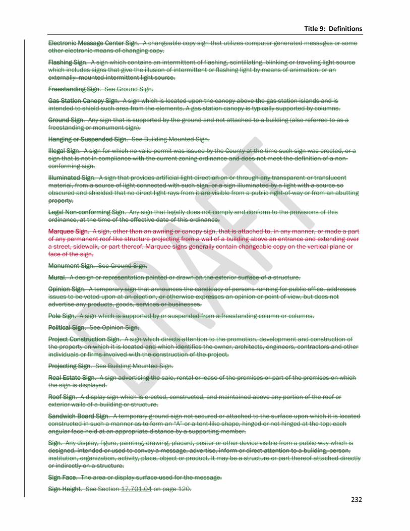
Title 9: Definitions
232
Electronic Message Center Sign. A changeable copy sign that utilizes computer generated messages or some
other electronic means of changing copy.
Flashing Sign. A sign which contains an intermittent of flashing, scintillating, blinking or traveling light source
which includes signs that give the illusion of intermittent or flashing light by means of animation, or an
externally- mounted intermittent light source.
Freestanding Sign. See Ground Sign.
Gas Station Canopy Sign. A sign which is located upon the canopy above the gas station islands and is
intended to shield such area from the elements. A gas station canopy is typically supported by columns.
Ground Sign. Any sign that is supported by the ground and not attached to a building (also referred to as a
freestanding or monument sign).
Hanging or Suspended Sign. See Building Mounted Sign.
Illegal Sign. A sign for which no valid permit was issued by the County at the time such sign was erected, or a
sign that is not in compliance with the current zoning ordinance and does not meet the definition of a non-
conforming sign.
Illuminated Sign. A sign that provides artificial light direction on or through any transparent or translucent
material, from a source of light connected with such sign, or a sign illuminated by a light with a source so
obscured and shielded that no direct light rays from it are visible from a public right-of-way or from an abutting
property.
Legal Non-conforming Sign. Any sign that legally does not comply and conform to the provisions of this
ordinance, at the time of the effective date of this ordinance.
Marquee Sign. A sign, other than an awning or canopy sign, that is attached to, in any manner, or made a part
of any permanent roof-like structure projecting from a wall of a building above an entrance and extending over
a street, sidewalk, or part thereof. Marquee signs generally contain changeable copy on the vertical plane or
face of the sign.
Monument Sign. See Ground Sign.
Mural. A design or representation painted or drawn on the exterior surface of a structure.
Opinion Sign. A temporary sign that announces the candidacy of persons running for public office, addresses
issues to be voted upon at an election, or otherwise expresses an opinion or point of view, but does not
advertise any products, goods, services or businesses.
Pole Sign. A sign which is supported by or suspended from a freestanding column or columns.
Political Sign. See Opinion Sign.
Project Construction Sign. A sign which directs attention to the promotion, development and construction of
the property on which it is located and which identifies the owner, architects, engineers, contractors and other
individuals or firms involved with the construction of the project.
Projecting Sign. See Building Mounted Sign.
Real Estate Sign. A sign advertising the sale, rental or lease of the premises or part of the premises on which
the sign is displayed.
Roof Sign. A display sign which is erected, constructed, and maintained above any portion of the roof or
exterior walls of a building or structure.
Sandwich Board Sign. A temporary ground sign not secured or attached to the surface upon which it is located
constructed in such a manner as to form an “A” or a tent-like shape, hinged or not hinged at the top; each
angular face held at an appropriate distance by a supporting member.
Sign. Any display, figure, painting, drawing, placard, poster or other device visible from a public way which is
designed, intended or used to convey a message, advertise, inform or direct attention to a building, person,
institution, organization, activity, place, object or product. It may be a structure or part thereof attached directly
or indirectly on a structure.
Sign Face. The area or display surface used for the message.
Sign Height. See Section 17.701.04 on page 120.
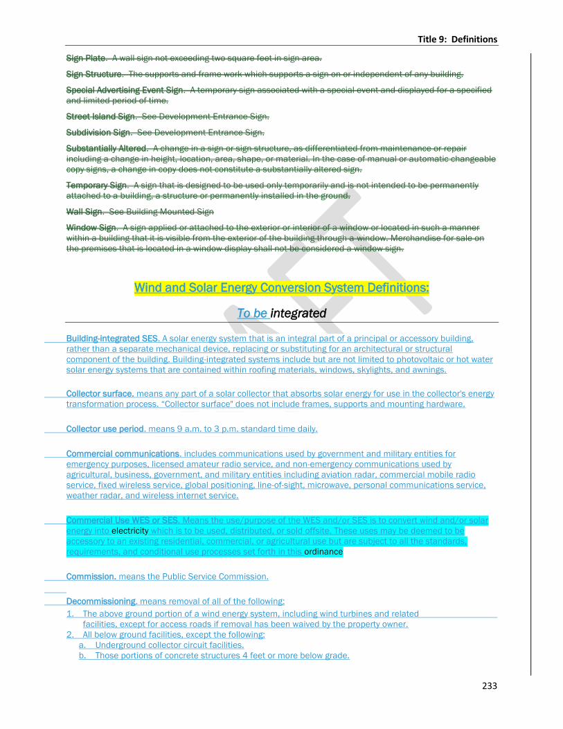
Title 9: Definitions
233
Sign Plate. A wall sign not exceeding two square feet in sign area.
Sign Structure. The supports and frame work which supports a sign on or independent of any building.
Special Advertising Event Sign. A temporary sign associated with a special event and displayed for a specified
and limited period of time.
Street Island Sign. See Development Entrance Sign.
Subdivision Sign. See Development Entrance Sign.
Substantially Altered. A change in a sign or sign structure, as differentiated from maintenance or repair
including a change in height, location, area, shape, or material. In the case of manual or automatic changeable
copy signs, a change in copy does not constitute a substantially altered sign.
Temporary Sign. A sign that is designed to be used only temporarily and is not intended to be permanently
attached to a building, a structure or permanently installed in the ground.
Wall Sign. See Building Mounted Sign
Window Sign. A sign applied or attached to the exterior or interior of a window or located in such a manner
within a building that it is visible from the exterior of the building through a window. Merchandise for sale on
the premises that is located in a window display shall not be considered a window sign.
Wind and Solar Energy Conversion System Definitions:
To be integrated
Building-integrated SES. A solar energy system that is an integral part of a principal or accessory building,
rather than a separate mechanical device, replacing or substituting for an architectural or structural
component of the building. Building-integrated systems include but are not limited to photovoltaic or hot water
solar energy systems that are contained within roofing materials, windows, skylights, and awnings.
Collector surface. means any part of a solar collector that absorbs solar energy for use in the collector's energy
transformation process. “Collector surface" does not include frames, supports and mounting hardware.
Collector use period. means 9 a.m. to 3 p.m. standard time daily.
Commercial communications. includes communications used by government and military entities for
emergency purposes, licensed amateur radio service, and non-emergency communications used by
agricultural, business, government, and military entities including aviation radar, commercial mobile radio
service, fixed wireless service, global positioning, line-of-sight, microwave, personal communications service,
weather radar, and wireless internet service.
Commercial Use WES or SES. Means the use/purpose of the WES and/or SES is to convert wind and/or solar
energy into electricity which is to be used, distributed, or sold offsite. These uses may be deemed to be
accessory to an existing residential, commercial, or agricultural use but are subject to all the standards,
requirements, and conditional use processes set forth in this ordinance
Commission. means the Public Service Commission.
Decommissioning. means removal of all of the following:
1. The above ground portion of a wind energy system, including wind turbines and related
facilities, except for access roads if removal has been waived by the property owner.
2. All below ground facilities, except the following:
a. Underground collector circuit facilities.
b. Those portions of concrete structures 4 feet or more below grade.
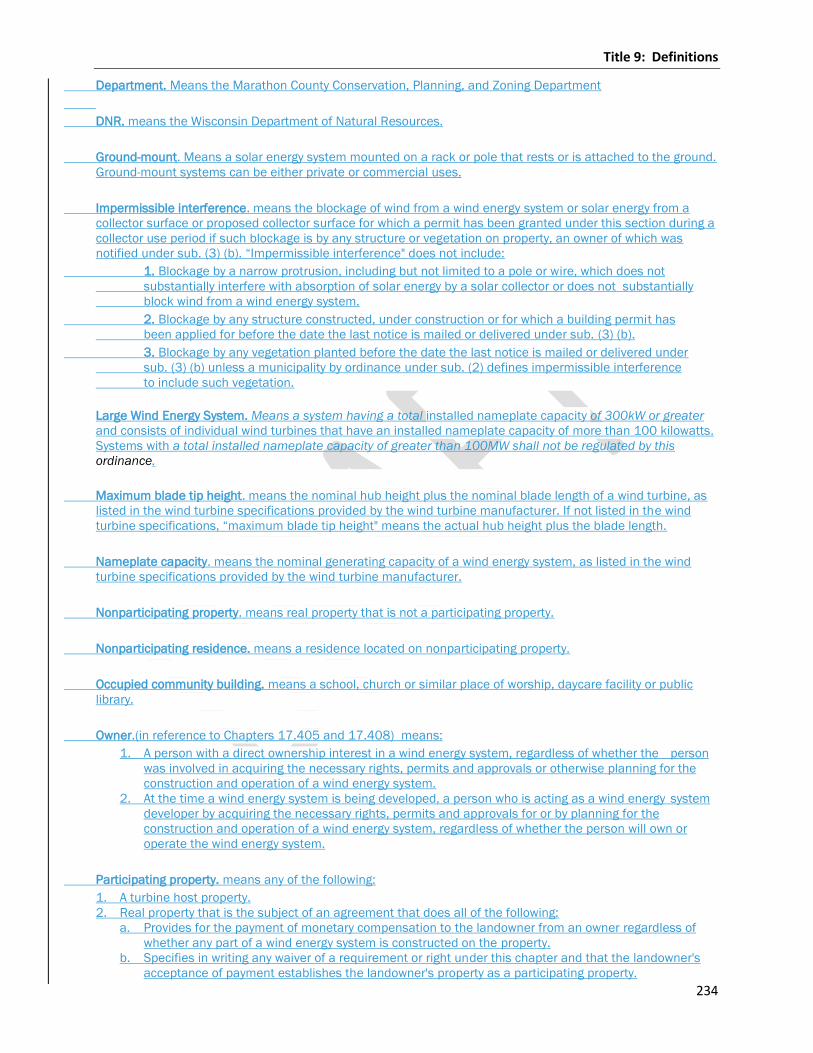
Title 9: Definitions
234
Department. Means the Marathon County Conservation, Planning, and Zoning Department
DNR. means the Wisconsin Department of Natural Resources.
Ground-mount. Means a solar energy system mounted on a rack or pole that rests or is attached to the ground.
Ground-mount systems can be either private or commercial uses.
Impermissible interference. means the blockage of wind from a wind energy system or solar energy from a
collector surface or proposed collector surface for which a permit has been granted under this section during a
collector use period if such blockage is by any structure or vegetation on property, an owner of which was
notified under sub. (3) (b). “Impermissible interference" does not include:
1. Blockage by a narrow protrusion, including but not limited to a pole or wire, which does not
substantially interfere with absorption of solar energy by a solar collector or does not substantially
block wind from a wind energy system.
2. Blockage by any structure constructed, under construction or for which a building permit has
been applied for before the date the last notice is mailed or delivered under sub. (3) (b).
3. Blockage by any vegetation planted before the date the last notice is mailed or delivered under
sub. (3) (b) unless a municipality by ordinance under sub. (2) defines impermissible interference
to include such vegetation.
Large Wind Energy System. Means a system having a total installed nameplate capacity of 300kW or greater
and consists of individual wind turbines that have an installed nameplate capacity of more than 100 kilowatts.
Systems with a total installed nameplate capacity of greater than 100MW shall not be regulated by this
ordinance.
Maximum blade tip height. means the nominal hub height plus the nominal blade length of a wind turbine, as
listed in the wind turbine specifications provided by the wind turbine manufacturer. If not listed in the wind
turbine specifications, “maximum blade tip height" means the actual hub height plus the blade length.
Nameplate capacity. means the nominal generating capacity of a wind energy system, as listed in the wind
turbine specifications provided by the wind turbine manufacturer.
Nonparticipating property. means real property that is not a participating property.
Nonparticipating residence. means a residence located on nonparticipating property.
Occupied community building. means a school, church or similar place of worship, daycare facility or public
library.
Owner.(in reference to Chapters 17.405 and 17.408) means:
1. A person with a direct ownership interest in a wind energy system, regardless of whether the person
was involved in acquiring the necessary rights, permits and approvals or otherwise planning for the
construction and operation of a wind energy system.
2. At the time a wind energy system is being developed, a person who is acting as a wind energy system
developer by acquiring the necessary rights, permits and approvals for or by planning for the
construction and operation of a wind energy system, regardless of whether the person will own or
operate the wind energy system.
Participating property. means any of the following:
1. A turbine host property.
2. Real property that is the subject of an agreement that does all of the following:
a. Provides for the payment of monetary compensation to the landowner from an owner regardless of
whether any part of a wind energy system is constructed on the property.
b. Specifies in writing any waiver of a requirement or right under this chapter and that the landowner's
acceptance of payment establishes the landowner's property as a participating property.
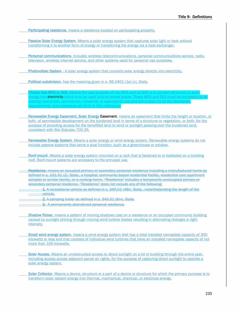
Title 9: Definitions
235
Participating residence. means a residence located on participating property.
Passive Solar Energy System. Means a solar energy system that captures solar light or heat without
transforming it to another form of energy or transferring the energy via a heat exchanger.
Personal communications. includes wireless telecommunications, personal communications service, radio,
television, wireless internet service, and other systems used for personal use purposes.
Photovoltaic System - A solar energy system that converts solar energy directly into electricity.
Political subdivision. has the meaning given in s. 66.0401 (1e) (c), Stats.
Private Use WES or SES. Means the use/purpose of the WES and/or SES is to convert wind and/or solar
energy into electricity which is to be used and/or stored onsite. These WES and SES must be accessory to an
existing residential, commercial, industrial, or agricultural use and are subject to all the standards,
requirements, and processes set forth in this ordinance.
Renewable Energy Easement, Solar Energy Easement. means an easement that limits the height or location, or
both, of permissible development on the burdened land in terms of a structure or vegetation, or both, for the
purpose of providing access for the benefited land to wind or sunlight passing over the burdened land,
consistent with Wis Statutes 700.35.
Renewable Energy System. Means a solar energy or wind energy system. Renewable energy systems do not
include passive systems that serve a dual function, such as a greenhouse or window.
Roof-mount. Means a solar energy system mounted on a rack that is fastened to or ballasted on a building
roof. Roof-mount systems are accessory to the principal use.
Residence. means an occupied primary or secondary personal residence including a manufactured home as
defined in s. 101.91 (2), Stats., a hospital, community-based residential facility, residential care apartment
complex or similar facility, or a nursing home. “Residence" includes a temporarily unoccupied primary or
secondary personal residence. “Residence" does not include any of the following:
1. A recreational vehicle as defined in s. 340.01 (48r), Stats., notwithstanding the length of the
vehicle.
2. A camping trailer as defined in s. 340.01 (6m), Stats.
3. A permanently abandoned personal residence.
Shadow flicker. means a pattern of moving shadows cast on a residence or an occupied community building
caused by sunlight shining through moving wind turbine blades resulting in alternating changes in light
intensity.
Small wind energy system. means a wind energy system that has a total installed nameplate capacity of 300
kilowatts or less and that consists of individual wind turbines that have an installed nameplate capacity of not
more than 100 kilowatts.
Solar Access. Means an unobstructed access to direct sunlight on a lot or building through the entire year,
including access across adjacent parcel air rights, for the purpose of capturing direct sunlight to operate a
solar energy system.
Solar Collector. Means a device, structure or a part of a device or structure for which the primary purpose is to
transform solar radiant energy into thermal, mechanical, chemical, or electrical energy.
Title 9: Definitions
236
Solar Collector Surface. Means any part of a solar collector that absorbs solar energy for use in the collector’s
energy transformation process. Collector surface does not include frames, supports and mounting hardware.
Solar Daylighting. Means a device specifically designed to capture and redirect the visible portion of the solar
spectrum, while controlling the infrared portion, for use in illuminating interior building spaces in lieu of
artificial lighting.
Solar Energy. Means a radiant energy received from the sun that can be collected in the form of heat or light by
a solar collector.
Solar Energy System. Means a device, array of devices, or structural design feature, which has the primary
purpose of harvesting energy by transforming solar energy into another form of energy or transferring heat
from a collector to another medium using mechanical, electrical, or chemical means.
Solar Heat Exchanger. Means a component of a solar energy device that is used to transfer heat from one
substance to another, either liquid or gas.
Solar Hot Air System - (also referred to as Solar Air Heat or Solar Furnace). Means a solar energy system that
includes a solar collector to provide direct supplemental space heating by heating and recirculating
conditioned building air. The most efficient performance typically uses a vertically mounted collector on a
south-facing wall.
Solar Hot Water System (also referred to as Solar Thermal). Means a system that includes a solar collector and
a heat exchanger that heats or preheats water for building heating systems or other hot water needs, including
residential domestic hot water and hot water for commercial processes.
Solar Mounting Devices. Means the racking, frames, or other devices that allow the mounting of a solar
collector onto a roof surface or the ground.
Solar Resource. Means a view of the sun from a specific point on a lot or building that is not obscured by any
vegetation, building, or object for a minimum of four hours between the hours of 9:00 AM and 3:00 PM
Standard time on all days of the year.
Solar Storage Unit. means a component of a solar energy device that is used to store solar generated
electricity or heat for later use.
Turbine host property. means real property on which at least one wind turbine is located.
Wind access easement. means a written document that creates a legal interest in real property that restricts
the use the property to avoid interference with the wind resource on another property.
Wind energy system. means equipment and associated facilities that convert and then store or transfer energy
from the wind into usable forms of energy. Source: Wis. Stats., 66.0403(1)(m)
Wind energy system easement. means a written document that creates a legal interest in real property that
permits an owner to place, construct or operate a wind turbine or other wind energy system facility on the
property.
Wind energy system emergency. means a condition or situation at a wind energy system that presents a
significant threat of physical danger to human life or a significant threat to property or a natural event that
causes damage to wind energy system facilities.
Wind energy system facility. means any component of a wind energy system, such as a wind turbine, collector
circuit, access road, electric system interconnection facility or operation and maintenance facility.

Title 9: Definitions
237
Wind energy system lease. means a written agreement between a landowner and an owner of a wind energy
system that establishes the terms and conditions associated with the placement, construction or operation of
a wind turbine or other wind energy system facility on a landowner's property.