general information settlements hydrology liuqiu - taiwan total … · 0 0,2 0,4 0,8 km liuqiu -...
TRANSCRIPT
"
£
"
£
!
^
^
^
9
4
K
Liuqiu
S ource: Esri, Digita lGlobe, GeoEye, Ea rthsta r Geogra phics, CNES /Airbus DS , US DA, US GS , AEX , Getma pping, Aerogrid, IGN, IGP, swisstopo, a nd the GIS User Community120°22'30"E
120°22'30"E
120°21'0"E
120°21'0"E
22°21'0"N
22°21'0"N
22°19'30"N
22°19'30"N
227000
227000
228000
228000
229000
229000
230000
230000
231000
231000
232000
232000
2470
000
2470
000
2471
000
2471
000
2472
000
2472
000
2473
000
2473
000
2474
000
2474
000
2475
000
2475
000
T C-2016-000100-T W N
!(
PhilippineSea
SouthChina Sea
LuzonStrait
Liuqiu
01
02
03
04
05
06
^
Taiwan
PhilippineSea
SouthChinaSea
LuzonStrait
EastChinaSea
TaiwanStrait
T a ipei
Cartographic Information
1:10000
±Grid: W GS 1984 UT M Z one 51N ma p coordina te system
Full color IS O A1, medium resolution (200 dpi)
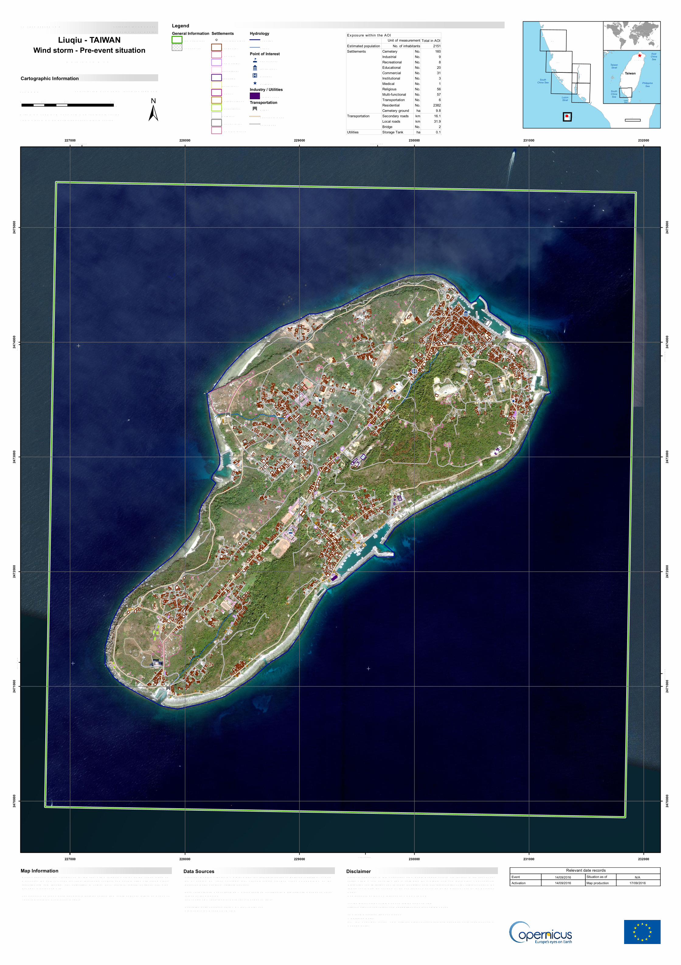
M era nti typhoon, world’s strongest so fa r this yea r with a ca tegory 5 storm, hit the T a iwa n Isla nd onW ednesda y the 14th of S eptember 2016, threa tening southern a nd ea stern cities with strong winds,torrentia l ra in a nd flooding. T he a uthorities in T a iwa n ha ve received reports of floods a nd windda ma ges in K a ohsiung City.T he present ma p shows ba sic topogra phic fea tures derived from public da ta sets, refined by mea ns ofvisua l interpreta tion of pre-event ima gery.
Tick ma rks: W GS 84 geogra phica l coordina te system
Product N.: 06LIUQIU, v1, EnglishActiva tion ID: EM S R 181
Pre-event ima ge: W orldView-2 © Digita l Globe, Inc. (2013), (a cquired on 06/02/2013 03:00 UT C, GS D0.5 m, a pprox. 0% cloud covera ge, 8.5° off-na dir a ngle), provided under COPER NICUS by theEuropea n Union a nd ES A, a ll rights reserved.Ba se vector la yers: OpenS treetM a p © OpenS treetM a p contributors, W ikima pia .org, GeoNa mes 2015,refined by the producer.Inset ma ps: JR C 2013, Na tura l Ea rth 2012, GeoNa mes 2013.Popula tion da ta : La ndsca n 2010 © UT BAT T ELLE, LLCDigita l Eleva tion M odel: S R T M 30 m
0 0,4 0,80,2km
Liuqiu - TAIWANWind storm - Pre-event situation
R eference M a p
Data Sources
LegendGeneral Information
Area of InterestNot a na lyzed
Settlements! Popula ted Pla ce
R esidentia lCemeteryCommercia lEduca tiona lIndustria lInstitutiona lM edica lM ulti-functiona lR ecrea tiona lR eligiousTra nsporta tionCemetery ground
HydrologyCoa stlineS trea m
Point of Interest4 Educa tiona l
9 Institutiona l
K M edica l
^ R eligiousIndustry / Utilities
S tora ge T a nkTransportation"
£
BridgeS econda ry R oa dLoca l R oa d
Products ela bora ted in this Copernicus EM S R a pid M a pping a ctivity a re rea lized to the best of oura bility, within a very short time fra me, optimising the a va ila ble da ta a nd informa tion. All geogra phicinforma tion ha s limita tions due to sca le, resolution, da te a nd interpreta tion of the origina l sources. Nolia bility concerning the contents or the use thereof is a ssumed by the producer a nd by the Europea nUnion.M a p produced by IT HACA relea sed by e-GEOS (ODO).For the la test version of this ma p a nd rela ted products visithttp://emergency.copernicus.eu/ma pping/list-of-components/EM S R 181ems-ra pid-ma [email protected] .eu© Europea n UnionFor full Copyright notice visit http://emergency.copernicus.eu/ma pping/ems/cite-copernicus-ems-ma pping-porta l
Disclaimer Relevant date recordsEventActivation
Situation as ofMap production
14/09/201614/09/2016
N/A 17/09/2016
Map Information
10km
Total in AOIEstimated population 2151
Cemetery No. 160Industrial No. 9Recreational No. 8Educational No. 20Commercial No. 31Institutional No. 3Medical No. 1Religious No. 56Multi-functional No. 57Transportation No. 6Residential No. 2382Cemetery ground ha 9.8Secondary roads km 16.1Local roads km 31.9Bridge No. 2
Utilities Storage Tank ha 0.1
Exposure within the AOI
No. of inhabitantsSettlements
Transportation
Unit of measurement