general land capability map of jamaica n.h. batjes ... · general land capability map of jamaica...
TRANSCRIPT
I
Miscellaneous Soils Paper No: 2
GENERAL LAND CAPABILITY MAP OF JAMAICA
N.H. Batjes
(October 1986)
I I I
MINISTRY OF AGRICULTURE
Rural Physical Planning Division
Jamaica Soi1 Survey Project
ISRIC LIBRAHY
•ê m. -y w < L ^
Wao«nlnoen, The Motherlando
Table o-f Contents
1 GENERAL 1 2 LAND CAPABILITY_CLASSES 1 3 THE_MAP ~ 2 4 QQNQL.LJDING_REMARKS 3
REFERENCES 4
Scanned from original by ISRIC - World Soil Information, as ICSU World Data Centre for Soils. The purpose is to make a safe depository for endangered documents and to make the accrued information available for consultation, following Fair Use Guidelines. Every effort is taken to respect Copyright of the materials within the archives where the identification of the Copyright holder is clear and, where feasible, to contact the originators. For questions please contact [email protected] indicating the item reference number concerned.
XII15
1 GENERAL
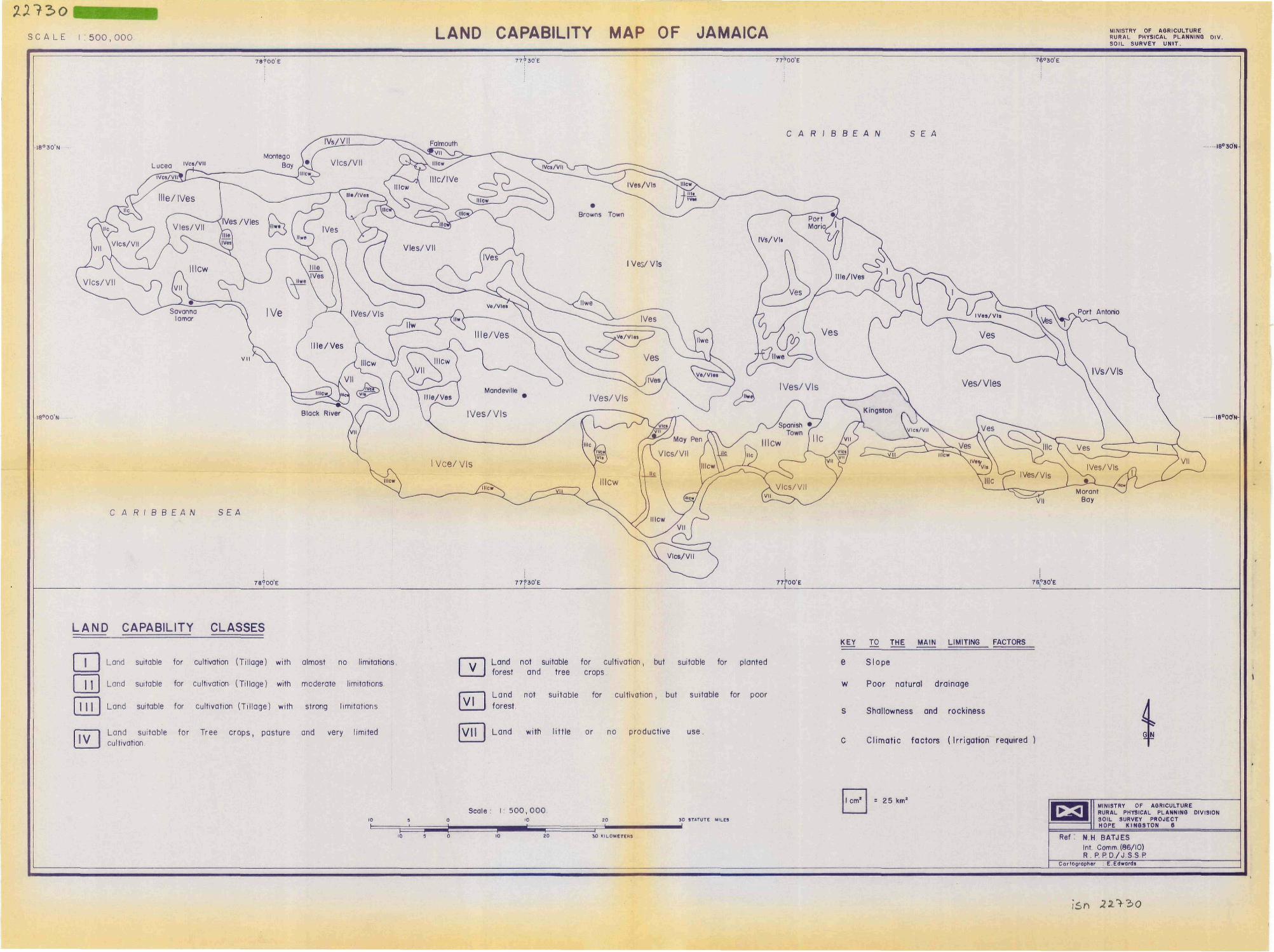
The exploratory soi 1 map o-f Jamaica (Batjes, 1985) gives information about Jamaica's soi Is and their occurrence in the landscape. With additional knowledge o-f the cl imate (IICA, 1983) and land use, this soi1 map can be used to delineate zones with si mi 1 ar general capabilities -for agriculture. The resulting land capability map should be used with the explicit understanding that, because o-f the general isation which is inherent to the 1:500,000 scale, there will be many smal 1 areas of di-f-ferent capabilities which cannot be shown.
The grouping of land into broad capability classes is useful for educational purposes (e.g. National Atlas) and for determining the country's available acreage for intensive forms of land use. The General Land Capability Map is not, however, suited for specific land use recommendations for which purpose a Computerized Land Evaluation System is being developed at the Rural Physical Planning Division of the Ministry of Agriculture, Jamaica (sëe .Batjes, Bouwman & Sinclair, 1986).
Section 2 defines the broad land capability classes and their subratings which are based on the type of major limitations for intensive land use. A short description of the land corresponding to each identified capability subclass is presented in Section 3. Concluding remarks are made in Section 4.
2 LAND CAPABILITY CLASSES
The land capability classification used for this map is a modification of the system which has been used in thé Soil and Land Use Surveys of Jamaica (R.R.C., 1958-1970). Seven categories of capability classes, which are indicated with Roman numerals, are shown on the map, some of which are divided into subclasses. This division is indicated by smal 1 suffix letters and based on the main limiting factors.
The land capability classes define broad categories of use:
- I Land suitable for cultivation (til lage) with almost no 1i mitati ons.
- 1 -
- II Land suitable -For cultivation (til lage) with moderate 1imitations.
- III Land suitable -for cultivation (til lage) with strong 1imitations.
- IV Land suitable for tree crops, pasture and very limited cultivation.
- V Land not suitable for cultivation, but suitable for tree crops and planted forest.
- VI Land not suitable for cultivation, but suitable for poor forest.
- VII Land with little or no productive use.
Taking into account the level of generalization, four subclasses are considered, viz.: 'e' if the principal limiting factor is steepness of slope or erosion hazard; *c* if it is the climate, that is a combination of low annual rainfall, high potential evapotranspiration, and a growing season shorter than 60 consecutive days; 'f' if it is the shallowness and rockiness of the soi1; "w* if it is poor natural drainage or excess water caused by regular flooding.
3 THE MAP
Cl_ass_X land is level or nearly level (O to 5 percent slopes) with deep, freely drained, medium textured soiIs which have high natural fertility and good water retention characteristics. Simple management practices, 1ike a well balanced erop rotation with appropriate field maintenance, are required to sustain optimum yields. Class I land is very limited in extent and distribution and mainly found as small areas along the south eastern and northern coast.
Land is rated as Cl_ass_Ij[ when the 1 imi tations only moderately reduce the overall suitability for cultivation (tillage). This type of land requires moderate management practices to permit sustained good yields. Class lic land is al most level and occurs in an area with a very unfavourable rainfall distribution. Under adequate irrigation, it would be rated as Class I land. Class U w e land shows moderate 1imitations for tillage which are mainly due to unfavourable internal drainage and the risk of erosion because of rolling slopes (8 to 16 percent). It also has moderate fertility and the soi1 is slightly acid. Class II land covers small parts of the country and includes interior valleys in udic areas (Uwe) and areas of recent alluvial soils in the
- 2 -
dry southern plains (lic).
The Cl.ass_I_.IIcw capability class comprises o-f gently undulating land (O to 5 percent slope) which shows strong limitations -for cultivation due to poor natural drainage, poor workability (mainly cracking clay soils) and dry climate. This type of land requires drainage works and irrigation to be made suitable for cultivation. The St. Catherine, Cl arendon and Westmorel and Plains are the major areas of Class IIIcw land, but minor areas of this subclass occur along the northern coast.
The areas that are designated as C_ass IV contain a mixture of land which is mainly suitable for pasture and commercial tree crops with only smal1 areas suited for intensive cultivation. The main limiting factors are steepness of slope (generally 16 to 30 percent) with ensuing susceptibility to erosion, and localized shallowness and rockiness of the soils. Class IVes land is very extensive throughout the island and especially in the central part.
C_ass_V land occurs mainly in the north western part of Jamaica in hilly and mountainous areas (slopes over 30 percent) where the soils are predominantly shallow, rocky and highly susceptible to erosion. This category of land can support tree crops and planted forest if appropriate erosion control is exercised. Cultivation is not recommended for this type of land.
Land identified as C_ass_VI_, is not suitable for intensive forms of agriculture due to very unfavourable soi 1, slope or climate conditions and should therefore be left in its natural state. In selected areas it is moderately suitable for tree crops and planted forest but this always requires extensive erosion control. Class VI land is extensive in the upper levels of the Blue Mountain Range (Vies), some of the limestone hills in south and central Jamaica (Vies), and in the heavily karstified cockpit country.
Shallowness, rockiness and droughtiness, or low foothold and swampiness, or strong salinity and regular flooding precludes most agricultural uses on C_ass_V_I_ land. This type of land vncompasses the big morasses of St. Elizabeth, that can only be made suitable for cultivation after major drainage works, smaller swamps in the eastern and western extermities of the island, tidal swamps and flats, and big areas of rock outcrops and shallow soils.
4 CONCLUDING REMARKS
The attached map shows the general capability of the land in
- 3 -
Jamaica for agriculture. The legend is adapted -from the Land Capability System developed by R.R.C. (1958-1970), which de-fines generalized categories o-F land use like arable land, pasture and forestry. The importance of making speci-fic land use proposals, however, is evident. Consequently, it is necessary to rate each mapping unit with respect to a range o-F crops. Hence, the develcpment of a Computerized Land Evaluation System for Jamaica at the Rural Physical Planning Division o-F the Ministry o-F Agriculture.
REFERENCES
BATJES, N.H. (1985) Exploratory soil map of Jamaica (1:500,000). Rural Physical Planning Unit, Central Region, Ministry of Agriculture, Jamaica.
BATJES, N.H., A.F. BOUWMAN & K.M. SINCLAIR (1986) Jamaica Physical Land Evaluation System (JAMPLES). Technical Soils Bulletin No 3, Jamaica Soil Survey Project, Rural Physical Planning Division, Ministry of Agriculture, Jamaica.
IICA (1983) Agro-climatic study of Jamaica. Inter—American Institute for Cooperation on Agriculture/ORSTOM, San José, Costa Rica.
R.R.C. (1958-1970) Soil and Land Use Surveys, Jamaica. The Regional Research Centre, Soil Research and Survey Section, University of the West Indies, Trinidad.
ENCL0SURE: General Land Capability Map of Jamaica (1:500,000)
- 4 -
n^ïo SC A LE I : 5 0 0 , 0 0 0 LAND CAPABILITY MAP OF JAMAICA MINISTRY OF AQRICULTURE
RURAL PHYSICAL PLANNING DIV. SOIL SURVEY UNIT.
77^30'E
I8°30'N
I8°00'N
78?00'E 77P00E "7ë°30'E
C A R i B B E A N S E A
Lucea I V c » / v "
IVcs/VII
Port Antonio
C A R I B B E A N SE A
78?00'E 77?30'E 76,°30'E
I8°30N.
I8°00'N-
LAND CAPABILITY CLASSES KEY TO THE MAIN LIMITING FACTORS
Land suitable for cultivation (Tillage) with almost no limitations
Land suitable for cultivation (Tillage) with moderate limitations.
I I I Land suitable for cultivation (Tillage) with strong limitations
Land not suitable for cultivation, but suitable for planted forest and tree crops.
C~~ | Land not suitable for cultivation, but suitable for poor
l V ' I forest
Land suitable for Tree crops, pasture and very limited » I cultivation
V I I Land with l i t t le or no productive use.
e S lope
w Poor natural drainage
s Shallowness and rockiness
C Cl imat ic factors (Irrigation required )
4
Scale l 500,000 10
Icm* = 25 km*
3 0 3TATUTE MILES
1 0 KILOMETERS
MINISTRY OF AQRICULTURE RURAL PHYSICAL PLANNING DIVISION SOIL SURVEY PROJECT HOPE KINGSTON 6
Ref : N.H BATJES Int Comm. (86/10) R. P. P D / J SS.P
Cartogropher E.Edwards
l5n 22>30