general manager department lutwyche …location of site dtmr road reserve between old port road and...
TRANSCRIPT

15 of 954
Ordinary Council Meeting - 31 October 2017
5.2. TELECOMMUNICATIONS FACILITY AT OLD PORT ROAD, PORT DOUGLAS
Figure 1 - Locality Plan
REPORT AUTHOR(S) Simon Clarke, Planning Coordinator
GENERAL MANAGER Nicholas Wellwood, General Manager Operations
DEPARTMENT Development Assessment and Coordination
PROPOSAL Material Change of Use Telecommunications Facility
APPLICANT Telstra Corporation LimitedC/- Service StreamPO Box 510LUTWYCHE QLD 4030
LOCATION OF SITE DTMR Road Reserve between Old Port Road and Port Douglas Road, Port Douglas (Site Coordinates : -16.523882 145.467985)
PROPERTY
LOCALITY PLAN
N/A

16 of 954
Ordinary Council Meeting - 31 October 2017
LOCALITY Port Douglas and Environs
PLANNING AREA Residential 1
PLANNING SCHEME Douglas Shire Planning Scheme 2006
REFERRAL AGENCIES Department of Transport and Main Roads via SARA.
NUMBER OF SUBMITTERS Not applicable
STATUTORY ASSESSMENT DEADLINE
9 November 2017
APPLICATION DATE 15 March 2017
RECOMMENDATION
That Council approves the development application for Telecommunications Facility over land identified as Department of Transport and Main Roads’ Road Reserve between Old Port Road and Port Douglas Road, Port Douglas (Site Coordinates : -16.523882 145.467985), subject to the following:
APPROVED DRAWING(S) AND / OR DOCUMENT(S)
The term ‘approved drawing(s) and / or document(s)’ or other similar expressions means:
Drawing or Document Reference DateSite Layout and Access Q113844 SHT S1 1 February 2017Site Layout Q113844 SHT S1-1 1 February 2017Antenna Layout Q113844 SHT S1-2 1 February 2017North East Elevation Q113844 SHT S3 1 February 2017
ASSESSMENT MANAGER CONDITIONS
1. Carry out the approved development generally in accordance with the approved drawing(s) and/or document(s), and in accordance with:
a. The specifications, facts and circumstances as set out in the application submitted to Council; and
b. The following conditions of approval and the requirements of Council’s Planning Scheme and the FNQROC Development Manual.
Except where modified by these conditions of approval
Timing of Effect
2. The conditions of the Development Permit must be effected prior to Commencement of Use, except where specified otherwise in these conditions of approval.
17 of 954
Ordinary Council Meeting - 31 October 2017
Limited Approval
3. The Development hereby approved lapses at the expiry of any license agreement with the Department of Transport and Main Roads or any renewal of it. Prior to the lapse of the life of the approval the telecommunications tower and all associated infrastructure, buildings, structures and fencing must be decommissioned and removed and the site reinstated to its original condition to the satisfaction of the Chief Executive Officer. All costs associated with the decommissioning and final removal shall be borne by the Applicant or entity that operates the tower at the time of removal.
Health
4. The facility must comply with all relevant State and National Standards in relation to emission of light, vibration, odour and radiation.
The telecommunications facility must be operated in accordance with Radio Communications (Electromagnetic Radiation – Human Exposure) Standard 2003 in relation to the limits for continuous exposure of the general public to radio-frequency electromagnetic energy or other Standard of the Commonwealth of Australia more relevant at the time.
Construction Process
5. All construction and use of the premises should occur with minimal damage to existing trees and particular attention to be given to the root systems. Attention should be paid not only to he canopy but also to potential root disturbance from fencing and tower foot excavation. Where necessary the assistance of an arborist should be retained to ensure the health of nearby trees.
Colours
6. The exterior finishes and colours of the facility must be non-reflective and must blend with the natural colours of the surrounding environment.
Fencing and Signage
7. Construct fencing for the perimeter of the facility with a minimum 1.8 metre high mesh security fence being of a dark colour. The facility is to be signed with appropriate hazard and warning signs.
Acid Sulfate Soils – Basement / Pool Disturbance
8. The footing excavation proposed may result in disturbance of potential acid sulfate soils (PASS). Prior to excavation, an acid sulfate soil investigation must be undertaken. The investigation must be performed in accordance with the latest ‘Guidelines for Sampling and Analysis of Lowland Acid Sulfate Soils in Queensland’ produced by the Department of Natural Resources and Mines (previously DNRW), and State Planning Policy 2/02 – Planning and Managing Development Involving Acid Sulfate Soils.
18 of 954
Ordinary Council Meeting - 31 October 2017
Where it is found that PASS exist, treatment of soil must be undertaken on-site to neutralise acid, prior to disposal as fill, in accordance with the DNRM ‘Queensland Acid Sulfate Soil Technical Manual’.
REFERRAL AGENCY CONDITIONS & REQUIREMENTS
Referral Agency Referral Agency Reference Date Council Electronic
ReferenceState Assessment & Referral Agency (Department of Infrastructure, Local Government & Planning
SDA-0417-038878 7 June 2017 816729
ADVICE1. This approval, granted under the provisions of the Sustainable Planning Act
2009, shall lapse four (4) years from the day the approval takes effect in accordance with the provisions of sections 339 and 341 of the Sustainable Planning Act 2009.
2. All building site managers must take all action necessary to ensure building materials and / or machinery on construction sites are secured immediately following the first cyclone watch and that relevant emergency telephone contacts are provided to Council officers, prior to commencement of works.
3. This approval does not negate the requirement for compliance with all other relevant Local Laws and other statutory requirements.
LAND USE DEFINITIONS*
In accordance with the Douglas Shire Planning Scheme 2006, the approved land use of Telecommunications Facilities is defined as:
Means the use of premises for the provision of telecommunication services.
The use excludes Low Impact Telecommunications Facilities as defined by the Telecommunications (Low Impact Facilities Determination) 1997 under the Telecommunications Act.
*This definition is provided for convenience only. This Development Permit is limited to the specifications, facts and circumstances as set out in the application submitted to Council and is subject to the abovementioned conditions of approval and the requirements of Council’s Planning Scheme and the FNQROC Development Manual.
EXECUTIVE SUMMARY
Council is in receipt of a development application for a telecommunications facility consisting of a 31.3 metre high monopole on road reserve at the southern side of the intersection of Port Douglas Road and Old Port Road, Port Douglas.
19 of 954
Ordinary Council Meeting - 31 October 2017
The location chosen for the proposed facility is within a small clearing with adjacent established vegetation, such that the proposed monopole will be unobtrusive. Approval is recommended subject to conditions.
TOWN PLANNING CONSIDERATIONS
Background
The site is a vacant area of land between Port Douglas Road and Old Port Road. The site is surrounded by residential land and tourist accommodation. The closest dwelling is located approximately 35 metres to the south.
Proposal
The proposed development is for a Telecommunications Facility tower consisting of:
The construction of a new 30m monopole, with an overall height of 31.3m;
One (1) Triangular Head Frame;
Three (3) ARGUS RVVPX310.11B-T2 panel antennas (2533mm x 350mm x 208mm) at a centreline elevation of 30m;
One (1) Telstra GPS antenna base mounted at 3100mm;
The installation of associated equipment, including Remote Radio Units, Combiners, Feeders, Mast Head Amplifiers etc.;
One (1) Telstra equipment shelter [3280mm (L) x 2280mm (W) x 2995mm (H)] adjacent to the proposed facility;
Telstra compound security fence with double access gates.
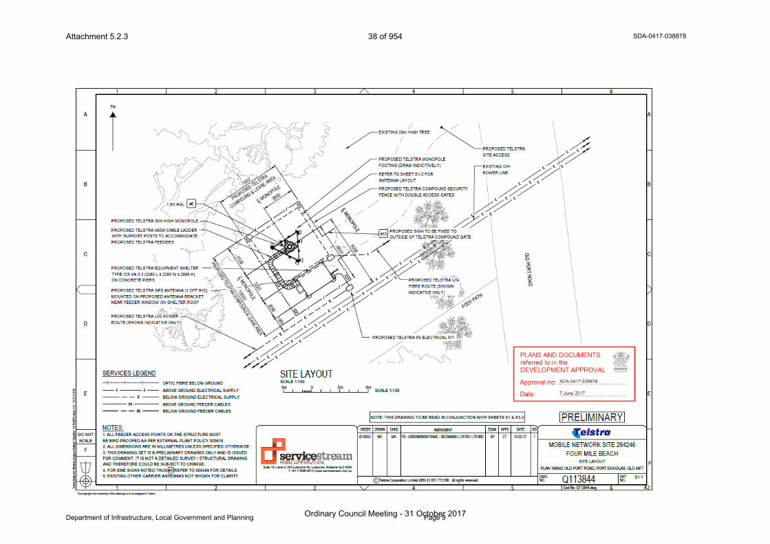
The layout plan is included in Attachment 1.
The purpose of the facility is to cater for an identified need to improve 3G and 4G services to the Four Mile Beach area. The facility at Four Mile Beach will form an integral part of the Telstra NextG network and will enable Telstra to enhance and expand mobile and broad band services in the region.
Access to the site is proposed from Old Port Road via a track within the road reserve.
Telstra will enter into a License Agreement with the Department of Transport and Main Road once a development approval has been issued. This arrangement does not trigger any need for a lot reconfiguration application.
State Planning Requirements
The application was lodged with Council on the 15 March 2017 and is therefore to be assessed under the Sustainable Planning Act 2009.

20 of 954
Ordinary Council Meeting - 31 October 2017
State Planning Regulatory Provisions (SPRP)
State Planning Regulatory Provision (Adopted Charges) applies to the proposed development. However, as Council has adopted an Infrastructure Charges Resolution (No 1) 2015 in accordance with the SPRP, no further assessment of this SPRP is required.
The proposed development is not subject to any other SPRPs.
State Planning Policies
The single State Planning Policy (SPP) applies to the assessment of certain forms of development. Assessment against the SPP reveals that the Water Quality (Climatic Regions) Code is triggered. However, it is not relevant because the proposed facility is to be established on an area significantly less than 2,500m2. There are negligible adverse effects on the environmental values of receiving waters.
State Referral Agencies
Schedule 7 of the Sustainable Planning Regulation 2009 identifies referral agencies. The State Assessment and Referral Agency (SARA) is the single referral agency for all development applications where the Chief Executive of SPA has jurisdiction. In accordance with Schedule 7 of SPA, the proposed development triggers referral to SARA as the proposed development is within a State Controlled Road.
SARA has assessed the application and has provided its approval subject to conditions.
Douglas Shire Planning Scheme Assessment
The proposed Telecommunications facility is to be located within the road reserve. In these cases, the site assumes the zoning of the closest lot, which in this case is the Residential 1 Planning Area. A Telecommunications facility is Code Assessable Development within this particular Planning Area.
The following Codes apply to the development.
Table 1.
Douglas ShirePort Douglas and Environs Planning Locality
Code Applicabilit
yCompliance
Locality Port Douglas and Environs See comment
belowPlanning Area Residential 1 Complies
Defined Use Telecommunications Facility Complies
Acid Sulfate Soils Code Conditioned to
complyCultural Heritage and Valuable Sites Code x -
Overlay Codes
Natural Hazards Code x -
General Codes Design and Siting of Advertising Devices Code x -

21 of 954
Ordinary Council Meeting - 31 October 2017
Douglas ShirePort Douglas and Environs Planning Locality
Code Applicabilit
yCompliance
Filling and Excavation Code Complies
Landscaping Code Complies
Natural Areas and Scenic Amenity Code x -
Reconfiguring a Lot Code x -
Vehicle Parking and Access Code Complies
Sustainable Development Code x -
Vegetation Management Code x -
Compliance Issues
Port Douglas and Environs Locality Code
The proposed development, because of its functionality, needs to be on a structure that exceeds the height of development nominated in the Acceptable Measure with the Locality code, which specifies a maximum height of 6.5 metres for unroofed structures. The corresponding Performance Outcome requires the development to complement the height of surrounding development. The slim-line design will assist in integrating the facility into its vegetated surroundings, which will conceal the tower from most external views. Attachment 2 includes photomontages of the proposed facility.
Despite this minor conflict, the development is considered to be consistent with the Code purpose meeting community need and consolidating Port Douglas as the major tourist accommodation and tourist service centre in the Shire.
Access
The proposal is equipped with adequate access for the purpose of the development. As the facility will be unstaffed and operated remotely, access for the operation is not required on a regular basis. Occasional access for maintenance purposes is typically required no more than 5 – 6 times per year.
Acid Sulfate Soils.
Conditions of approval will address Acid Sulfate Soil Management.
Referral Agency Requirements
Referral agency conditions apply to the proposed development and will be attached to the development approval.
Public Notification / Submissions
The application is code assessable and does not require public notification. Therefore, there is no ability to lodge submissions in relation to the proposed development.
22 of 954
Ordinary Council Meeting - 31 October 2017
ADOPTED INFRASTRUCTURE CHARGES
The proposed development does not trigger Adopted Infrastructure Charges.
COUNCIL’S ROLE
Council can play a number of different roles in certain circumstances and it is important to be clear about which role is appropriate for a specific purpose or circumstance. The implementation of actions will be a collective effort and Council’s involvement will vary from information only through to full responsibility for delivery.
The following area outlines where Council has a clear responsibility to act:
Regulator: Meeting the responsibilities associated with regulating activities through legislation or local law.
Under the Sustainable Planning Act 2009 and the Sustainable Planning Regulation 2009, Council is the assessment manager for the application.
ATTACHMENTS
1. Attachment 1 - Approved Plan(s) and Document(s) [5.2.1]2. Attachment 2 - Photo-montages [5.2.2]3. Attachment 3 - Concurrency Agency Response [5.2.3]

The copyright and ownership of the drawings is to be assigned to Telstra
PART OF THE ROAD RESERVEFOR OLD PORT ROAD NEAR THEINTERSECTION WITH PORTDOUGLAS ROAD
PROPERTY DESCRIPTION
SITE ACCESS SCALE 1:2500
ORDERDO NOTSCALE
F
1
E
D
2 3
C
B
A
1 2 3
C Telstra Corporation Limited ABN 33 051 775 556 All rights reserved.
4 5
DWGNO.
DRAWN CHKD AMENDMENT DATEEXAM APPD ISS
6NO.SHT
A3
F
E
D
4 5
C
B
6
A
Cad file: Q113844.dwg
MOBILE NETWORK SITE 294246FOUR MILE BEACH
Q113844 S1
SITE LAYOUT AND ACCESSPLAN 168542 OLD PORT ROAD, PORT DOUGLAS, QLD 4877
TN
SITE STRUCTURE CO-ORDINATES (GDA94)GPS READING ACCURACY: ± 10m
CENTRE OF POLELATITUDE GDA 94
-16.52388GDA 94
145.46799LONGITUDE
LOCALITY PLANNOT TO SCALE
COPYRIGHT C WHEREIS REGISTERED TRADEMARK OF SENSIS PTY LTD.R
Suite 1B, Level 4, 543 Lutwyche Rd, Lutwyche, Brisbane QLD 4030
T +61 7 3068 6913 | www.servicestream.com.au
REFER TO SHEET S1-1FOR SITE LAYOUT
4011839.01 MK MN PD - 30052560W0007SSMC - WCDMA850 / LTE700 / LTE1800 SP CT 01.02.17 1
Telst
ra N
etwor
ks W
ireles
s pro
gram
Deli
very
Temp
late -
0178
66P0
2 iss
ue 11
.4 X
X /X
X/ 20
15
NOTE: THIS DRAWING TO BE READ IN CONJUNCTION WITH SHEETS S1-1 & S1-2SCALE 1:25000 100m50m 50m
PRELIMINARY
RFNSA SITE No. 4877006
ULYSSES AVENUE
PORT DOUGLAS ROAD
OLD PORT ROAD
NAUT
ILUS S
TREE
T
EXISTING POWER POLE#5089965
EXISTING POWER POLE#5089847
EXISTING POWER POLE#5089853
EXISTING POWER POLE #5089856WITH TRANSFORMER
EXISTING TREES (TYP.)
EXISTING BUILDING(TYP.)
EXISTING O/H POWER LINE
NOTES:1. ALL FEEDER ACCESS POINTS ON THE STRUCTURE MUST BE BIRDPROOFED AS PER EXTERNAL PLANT POLICY 003615.2 ALL DIMENSIONS ARE IN MILLIMETRES UNLESS SPECIFIED OTHERWISE.3. THIS DRAWING SET IS A PRELIMINARY DRAWING ONLY AND IS ISSUED FORCOMMENT. IT IS NOT A DETAILED SURVEY / STRUCTURAL DRAWING ANDTHEREFORE COULD BE SUBJECT TO CHANGE.
SERVICES LEGEND
ABOVE GROUND ELECTRICAL SUPPLYBELOW GROUND ELECTRICAL SUPPLY
BELOW GROUND FEEDER CABLES
OPTIC FIBRE BELOW GROUNDT T T
ABOVE GROUND FEEDER CABLES
PROPOSED TELSTRA SITE
Attachment 5.2.1 23 of 954
Ordinary Council Meeting - 31 October 2017

The copyright and ownership of the drawings is to be assigned to Telstra
SITE LAYOUTSCALE 1:150
PRELIMINARYORDER
DO NOTSCALE
F
1
E
D
2 3
C
B
A
1 2 3
C Telstra Corporation Limited ABN 33 051 775 556 All rights reserved.
4 5
DWGNO.
DRAWN CHKD AMENDMENT DATEEXAM APPD ISS
6NO.SHT
A3
F
E
D
4 5
C
B
6
A
Cad file: Q113844.dwg
MOBILE NETWORK SITE 294246FOUR MILE BEACH
Q113844 S1-1
SITE LAYOUTPLAN 168542 OLD PORT ROAD, PORT DOUGLAS, QLD 4877Suite 1B, Level 4, 543 Lutwyche Rd, Lutwyche, Brisbane QLD 4030
T +61 7 3068 6913 | www.servicestream.com.au
Telst
ra N
etwor
ks W
ireles
s pro
gram
Deli
very
Temp
late -
0178
66P0
2 iss
ue 11
.4 X
X /X
X/ 20
15 SCALE 1:1500 3m 6m3m
4011839.01 MK MN PD - 30052560W0007SSMC - WCDMA850 / LTE700 / LTE1800 SP CT 01.02.17 1
NOTE: THIS DRAWING TO BE READ IN CONJUNCTION WITH SHEETS S1 & S1-2
C MONOPOLE
L
PROPOSED SIGN TO BE FIXED TOOUTSIDE OF TELSTRA COMPOUND GATE#13
EXISTING 20m HIGH TREE
PROPOSED TELSTRA 450W CABLE LADDERWITH SUPPORT POSTS TO ACCOMMODATEPROPOSED TELSTRA FEEDERS
PROPOSED TELSTRA COMPOUND SECURITYFENCE WITH DOUBLE ACCESS GATES
PROPOSED TELSTRASITE ACCESS
PROPOSED TELSTRA 30m HIGH MONOPOLE
PROPOSED TELSTRA MONOPOLEFOOTING (DRAW INDICITIVELY)
TN
NOTES:1. ALL FEEDER ACCESS POINTS ON THE STRUCTURE MUSTBE BIRD PROOFED AS PER EXTERNAL PLANT POLICY 003615.2. ALL DIMENSIONS ARE IN MILLIMETRES UNLESS SPECIFIED OTHERWISE.3. THIS DRAWING SET IS A PRELIMINARY DRAWING ONLY AND IS ISSUEDFOR COMMENT. IT IS NOT A DETAILED SURVEY / STRUCTURAL DRAWINGAND THEREFORE COULD BE SUBJECT TO CHANGE.4. FOR EME SIGNS NOTED THUS #X REFER TO 005486 FOR DETAILS.5. EXISTING OTHER CARRIER ANTENNAS NOT SHOWN FOR CLARITY.
PROPOSED TELSTRA U/G POWERROUTE (SHOWN INDICATIVE ONLY)
PROPOSED TELSTRA U/GFIBRE ROUTE (SHOWNINDICATIVE ONLY)
OLD PORT ROAD
FOOT PATH
SERVICES LEGEND
ABOVE GROUND ELECTRICAL SUPPLYBELOW GROUND ELECTRICAL SUPPLY
BELOW GROUND FEEDER CABLES
OPTIC FIBRE BELOW GROUNDT T T
ABOVE GROUND FEEDER CABLES
8000
3500
6500C MONOPOLE
L
EXISTING O/HPOWER LINE
1000
REFER TO SHEET S1-2 FORANTENNA LAYOUT
C MONOPOLE
3500L
2280
3220
7000
PROPOSED TELSTRA
COMPOUND & LEASE AREA
PROPOSED TELSTRA EQUIPMENT SHELTERTYPE ICS Mk 3.3 (3280 L x 2280 W x 2995 H)ON CONCRETE PIERS
PROPOSED TELSTRA GPS ANTENNA (1 OFF A12)MOUNTED ON PROPOSED ANTENNA BRACKETNEAR FEEDER WINDOW ON SHELTER ROOF
1.5m AGL #6
PROPOSED TELSTRA P5 ELECTRICAL PIT
10000
PROPOSED TELSTRA COMPOUND & LEASE AREA
Attachment 5.2.1 24 of 954
Ordinary Council Meeting - 31 October 2017
The copyright and ownership of the drawings is to be assigned to Telstra
ANTENNA LAYOUT AT EL 30.0mSCALE 1:25
PRELIMINARYORDER
DO NOTSCALE
F
1
E
D
2 3
C
B
A
1 2 3
C Telstra Corporation Limited ABN 33 051 775 556 All rights reserved.
4 5
DWGNO.
DRAWN CHKD AMENDMENT DATEEXAM APPD ISS
6NO.SHT
A3
F
E
D
4 5
C
B
6
A
Cad file: Q113844.dwg
MOBILE NETWORK SITE 294246FOUR MILE BEACH
Q113844 S1-2
ANTENNA LAYOUTPLAN 168542 OLD PORT ROAD, PORT DOUGLAS, QLD 4877Suite 1B, Level 4, 543 Lutwyche Rd, Lutwyche, Brisbane QLD 4030
T +61 7 3068 6913 | www.servicestream.com.au
Telst
ra N
etwor
ks W
ireles
s pro
gram
Deli
very
Temp
late -
0178
66P0
2 iss
ue 11
.4 X
X /X
X/ 20
15
0 1000500 SCALE 1:25500
4011839.01 MK MN PD - 30052560W0007SSMC - WCDMA850 / LTE700 / LTE1800 SP CT 01.02.17 1
NOTE: THIS DRAWING TO BE READ IN CONJUNCTION WITH SHEETS S1 & S1-1
1
2
3
A1
A2
A3
PROPOSED TELSTRA WCDMA850 / LTE700/ LTE1800 PANEL ANTENNAS (3 OFF A1, A2& A3) ON PROPOSED MOUNTS
PROPOSED TELSTRA TRIANGULARHEADFRAME TO SUIT ROCLA POLE
PROPOSED TELSTRA 30mHIGH MONOPOLE
PROPOSED TELSTRA LTE1800RRU'S (3 OFF) MOUNTED ONPROPOSED MOUNTS
BEHIND EACHPANEL ANTENNA #2
PROPOSED TELSTRA LTE700 / WCDMA850 TMA'S(3 OFF) ATTACHED BEHIND PROPOSEDTELSTRA PANEL ANTENNAS (A1, A2 & A3)
X PROPOSED TELSTRAPANEL ANTENNAAX
ANTENNA LEGEND
NOTES:1. ALL FEEDER ACCESS POINTS ON THE STRUCTURE MUST BE BIRDPROOFED AS PER EXTERNAL PLANT POLICY 003615.2. ALL DIMENSIONS ARE IN MILLIMETRES UNLESS SPECIFIED OTHERWISE.3. THIS DRAWING SET IS A PRELIMINARY DRAWING ONLY AND IS ISSUEDFOR COMMENT. IT IS NOT A DETAILED SURVEY / STRUCTURAL DRAWINGAND THEREFORE COULD BE SUBJECT TO CHANGE.4. FOR EME SIGNS NOTED THUS #X REFER TO 005486 FOR DETAILS.
TN
HEADFRAMEORIENTATION 86°TN
X FUTURE TELSTRAPANEL ANTENNAAX
1
1
2
2
3
3
FUTURE TELSTRA PANEL ANTENNAS(6 OFF A4, A5, A6, A7, A8 & A9)
A4
A7A5
A8
A6
A9
FUTURE TELSTRA RRU'S (3 OFF)MOUNTED BELOW PROPOSEDRRU'S ON PROPOSED MOUNTS
RRU LAYOUT AT EL 28.0mSCALE 1:25
Attachment 5.2.1 25 of 954
Ordinary Council Meeting - 31 October 2017
PRELIMINARYDO NOT
1
SCALE
2
ORDER
E
D
C Telstra Corporation Limited ABN 33 051 775 556 All rights reserved.
AMENDMENT
3
DRAWN CHKD
4
EXAM APPD
DWGNO.
5
ISSDATE
NO.SHT
A3V6
F
E
D
C
B
A
1 2
C
B
3 4 5
A
6
Cad file: Q113844.dwg
MOBILE NETWORK SITE 294246FOUR MILE BEACH
Q113844 S3
NORTH EAST ELEVATIONPLAN 168542 OLD PORT ROAD, PORT DOUGLAS, QLD 4877
NORTH EAST ELEVATIONSCALE 1:125
The copyright and ownership of the drawings is to be assigned to Telstra
Suite 1B, Level 4, 543 Lutwyche Rd, Lutwyche, Brisbane QLD 4030
T +61 7 3068 6913 | www.servicestream.com.au
Telst
ra N
etwor
ks W
ireles
s pro
gram
Deli
very
Temp
late -
0178
66P0
2 iss
ue 11
.4 X
X /X
X/ 20
15
0 SCALE 1:1255m2m
4011839.01 MK MN PD - 30052560W0007SSMC - WCDMA850 / LTE700 / LTE1800 SP CT 01.02.17 1
NOTE: THIS DRAWING TO BE READ IN CONJUNCTION WITH SHEET S3-1
E.L. 0.0mGROUND LEVEL
PROPOSED SIGN TO BEFIXED TO OUTSIDE OFTELSTRA COMPOUND GATE
#13
EXISTING 10m HIGH TREE BEYOND
EXISTING 20m HIGH TREE
E.L. 30.0m (±100mm) R.L. 41.8m AHDC/L PROPOSED TELSTRA WCDMA850 / LTE700 / LTE1800PANEL ANTENNAS (3 OFF A1, A2 & A3)C/L FUTURE TELSTRA PANEL ANTENNAS (6 OFF A4, A5,A6, A7, A8 & A9)TOP OF PROPOSED TELSTRA CONCRETE MONOPOLE
E.L. 20.0m (±100mm) R.L. 31.8m AHDTOP OF EXISTING TREE
E.L. 10.0m (±100mm) R.L. 21.8m AHDTOP OF EXISTING TREE
PROPOSED TELSTRA EQUIPMENT SHELTERTYPE ICS Mk 3.3 (3280 L x 2280 W x 2995 H)ON CONCRETE PIERS
PROPOSED TELSTRA GPS ANTENNA (1 OFF A12)MOUNTED ON PROPOSED ANTENNA BRACKETNEAR FEEDER WINDOW ON SHELTER ROOF
PROPOSED TELSTRA 450W CABLE LADDERWITH SUPPORT POSTS TO ACCOMMODATEPROPOSED TELSTRA FEEDERS (8 OFF)
1.5m AGL#6
PROPOSED TELSTRA 30mHIGH MONOPOLE
PROPOSED TELSTRA MONOPOLEFOOTING DRAWN INDICATIVELY
PROPOSED TELSTRA LTE700 / WCDMA850TMA'S (3 OFF) ATTACHED BEHIND PROPOSEDTELSTRA PANEL ANTENNAS (A1, A2 & A3)
PROPOSED TELSTRA FEEDER CABLESTO RUN INTERNALLY TO MONOPOLE
BEHIND EACHPANEL ANTENNA #2
E.L. 31.3m (±100mm) R.L. 43.1m AHDOVERALL HEIGHT
E.L. 3.1m (±100mm) R.L. 423.7m AHDBASE OF PROPOSED TELSTRA GPS ANTENNA (1 OFF A12)
NOTES:1. ALL FEEDER ACCESS POINTS ON THE STRUCTURE MUST BE BIRDPROOFED AS PER EXTERNAL PLANT POLICY 003615.2. ALL DIMENSIONS ARE IN MILLIMETRES UNLESS SPECIFIED OTHERWISE.3. THIS DRAWING SET IS A PRELIMINARY DRAWING ONLY AND IS ISSUEDFOR COMMENT. IT IS NOT A DETAILED SURVEY / STRUCTURAL DRAWINGAND THEREFORE COULD BE SUBJECT TO CHANGE.4. FOR EME SIGNS NOTED THUS #X REFER TO 005486 FOR DETAILS.
#6 EME TELSTRA #6 SIGNPROPOSED SIGN SECURED 1.5m AGLTO MONOPOLE USING STAINLESSSTEEL STRAPS
EME TELSTRA #2 SIGNSIGNS TO BE UV STABLE STICKERSAND FIXED TO REAR OF ALL TELSTRAPANEL ANTENNAS (3 OFF)
EME TELSTRA #13 SIGNPROPOSED SIGN SECURED TOTELSTRA COMPOUND GATE USINGSTAINLESS STEEL STRAPS
SITE EME SIGNAGE#2
#13
PROPOSED TELSTRA TRIANGULARHEADFRAME TO SUIT POLE
PROPOSED TELSTRA U/G POWERROUTE (SHOWN INDICATIVE ONLY)
PROPOSED TELSTRA U/G FIBREROUTE (SHOWN INDICATIVE ONLY)
PROPOSED TELSTRA P5 FIBRE PIT
E.L. 27.0m (±100mm) R.L. 38.8m AHDC/L FUTURE TELSTRA RRU'S (3 OFF)
E.L. 28.0m (±100mm) R.L. 39.8m AHDC/L PROPOSED TELSTRA LTE1800 RRU'S (3 OFF)
PROPOSED TELSTRA COMPOUNDSECURITY FENCE WITH DOUBLEACCESS GATES
(R.L. 11.8m AHD)
Attachment 5.2.1 26 of 954
Ordinary Council Meeting - 31 October 2017

168542 OLD
POR
T DO
UG
LAS R
OA
D, PO
RT D
OU
GLA
S, QLD
4877
FOU
R M
ILE BEA
CH 2
94246
Vie
w fro
m R
oad R
eserv
e n
ear th
e in
ters
ectio
n o
f Port D
ougla
s R
oad a
nd O
ld P
ort R
oad
TW
O
13
-09
-17
1
Attachment 5.2.2 27 of 954
Ordinary Council Meeting - 31 October 2017
168542 OLD
POR
T DO
UG
LAS R
OA
D, PO
RT D
OU
GLA
S, QLD
4877
FOU
R M
ILE BEA
CH 2
94246
Vie
w fro
m O
ld P
ort R
oad R
eserv
e
TH
RE
E
13
-09
-17
1
Attachment 5.2.2 28 of 954
Ordinary Council Meeting - 31 October 2017
Attachment 5.2.2 29 of 954
Ordinary Council Meeting - 31 October 2017

Page 1Far North Queensland Regional OfficeGround Floor, Cairns Port AuthorityPO Box 2358Cairns QLD 4870
Our reference: SDA-0417-038878Applicant reference: 4011839.01 - Four Mile BeachCouncil reference: MCUC 1972/2017
07 June 2017
Chief Executive OfficerDouglas Shire CouncilPO Box 723Mossman QLD [email protected]
Dear Madam / Sir
Concurrence agency response—with conditionsMaterial Change of Use for a telecommunications facility within the road reserve adjacent to 24L Old Port Road, Port Douglas, QLD 4877 – Lot 24 on SP168542 (Given under section 285 of the Sustainable Planning Act 2009)
The referral agency material for the development application described below was received by the Department of Infrastructure, Local Government and Planning under section 272 of the Sustainable Planning Act 2009 on 3 May 2017.
Applicant details
Applicant name: Telstra Corporation Ltd
Applicant contact details: C/- Service StreamPO Box 510Lutwyche QLD [email protected]
Site details
Street address: Road Reserve adjacent to Old Port Road and Port Douglas Road, Port Douglas QLD 4877
Adjacent to 24L Old Port Road, Port Douglas QLD 4877
Lot on plan: Adjacent to Lot 24 on SP168542
Site Coordinates: -16.523882, 145.467985
Local government area: Douglas Shire
Attachment 5.2.3 30 of 954
Ordinary Council Meeting - 31 October 2017
SDA-0417-038878
Department of Infrastructure, Local Government and Planning Page 2
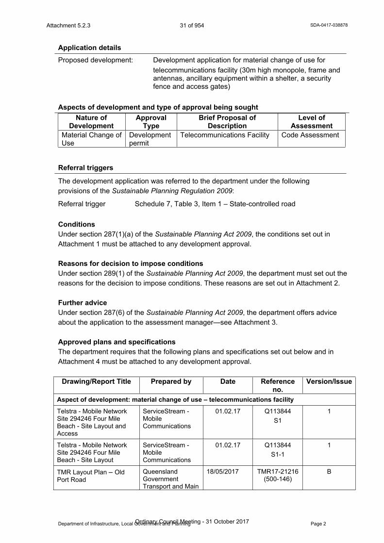
Application detailsProposed development: Development application for material change of use for
telecommunications facility (30m high monopole, frame and antennas, ancillary equipment within a shelter, a security fence and access gates)
Aspects of development and type of approval being soughtNature of
DevelopmentApproval
TypeBrief Proposal of
DescriptionLevel of
AssessmentMaterial Change of Use
Development permit
Telecommunications Facility Code Assessment
Referral triggers
The development application was referred to the department under the following provisions of the Sustainable Planning Regulation 2009:
Referral trigger Schedule 7, Table 3, Item 1 – State-controlled road
ConditionsUnder section 287(1)(a) of the Sustainable Planning Act 2009, the conditions set out in Attachment 1 must be attached to any development approval.
Reasons for decision to impose conditionsUnder section 289(1) of the Sustainable Planning Act 2009, the department must set out the reasons for the decision to impose conditions. These reasons are set out in Attachment 2.
Further adviceUnder section 287(6) of the Sustainable Planning Act 2009, the department offers advice about the application to the assessment manager—see Attachment 3.
Approved plans and specificationsThe department requires that the following plans and specifications set out below and in Attachment 4 must be attached to any development approval.
Drawing/Report Title Prepared by Date Reference no.
Version/Issue
Aspect of development: material change of use – telecommunications facility
Telstra - Mobile Network Site 294246 Four Mile Beach - Site Layout and Access
ServiceStream - Mobile Communications
01.02.17 Q113844 S1
1
Telstra - Mobile Network Site 294246 Four Mile Beach - Site Layout
ServiceStream - Mobile Communications
01.02.17 Q113844 S1-1
1
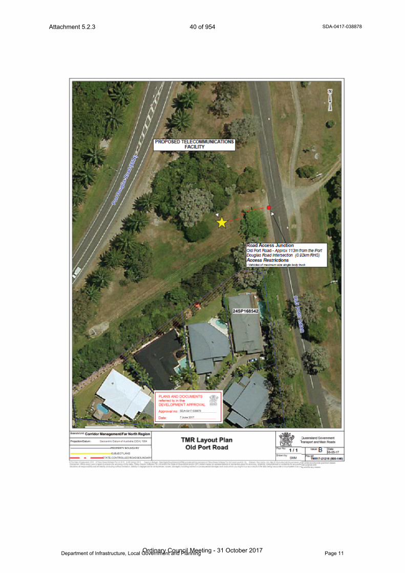
TMR Layout Plan – Old Port Road
Queensland Government Transport and Main
18/05/2017 TMR17-21216 (500-146)
B
Attachment 5.2.3 31 of 954
Ordinary Council Meeting - 31 October 2017

SDA-0417-038878
Department of Infrastructure, Local Government and Planning Page 3
Roads
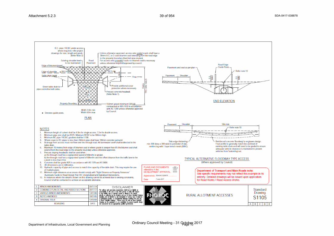
Rural Allotment Accesses FNQROC 26/11/14 Standard DrawingS1105
E
A copy of this response has been sent to the applicant for their information.
For further information, please contact Tony Croke, Principal Planning Officer, SARA Far North QLD on 4037 3205, or email [email protected] who will be pleased to assist.
Yours sincerely
Brett NancarrowManager (Planning)
cc: Telstra Corporation Ltd C/- Service Stream, [email protected]
enc: Attachment 1—Conditions to be imposedAttachment 2—Reasons for decision to impose conditionsAttachment 3—Further adviceAttachment 4—Approved Plans and Specifications
Attachment 5.2.3 32 of 954
Ordinary Council Meeting - 31 October 2017
SDA-0417-038878
Department of Infrastructure, Local Government and Planning Page 4
Our reference: SDA-0417-038878Applicant reference: 4011839.01 - Four Mile BeachCouncil reference: MCUC 1972/2017
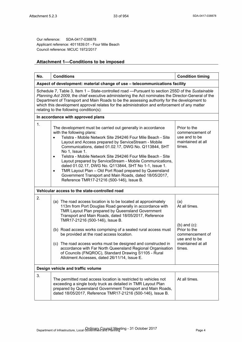
Attachment 1—Conditions to be imposed
No. Conditions Condition timing
Aspect of development: material change of use – telecommunications facility
Schedule 7, Table 3, Item 1 – State-controlled road —Pursuant to section 255D of the Sustainable Planning Act 2009, the chief executive administering the Act nominates the Director-General of the Department of Transport and Main Roads to be the assessing authority for the development to which this development approval relates for the administration and enforcement of any matter relating to the following condition(s):
In accordance with approved plans
1.The development must be carried out generally in accordance with the following plans: Telstra - Mobile Network Site 294246 Four Mile Beach - Site
Layout and Access prepared by ServiceStream - Mobile Communications, dated 01.02.17, DWG No. Q113844, SHT No 1, Issue 1.
Telstra - Mobile Network Site 294246 Four Mile Beach - Site Layout prepared by ServiceStream - Mobile Communications, dated 01.02.17, DWG No. Q113844, SHT No 1-1, Issue 1.
TMR Layout Plan – Old Port Road prepared by Queensland Government Transport and Main Roads, dated 18/05/2017, Reference TMR17-21216 (500-146), Issue B.
Prior to the commencement of use and to be maintained at all times.
Vehicular access to the state-controlled road
2.(a) The road access location is to be located at approximately
113m from Port Douglas Road generally in accordance with TMR Layout Plan prepared by Queensland Government Transport and Main Roads, dated 18/05/2017, Reference TMR17-21216 (500-146), Issue B.
(b) Road access works comprising of a sealed rural access must be provided at the road access location.
(c) The road access works must be designed and constructed in accordance with Far North Queensland Regional Organisation of Councils (FNQROC), Standard Drawing S1105 - Rural Allotment Accesses, dated 26/11/14, Issue E.
(a) At all times.
(b) and (c): Prior to the commencement of use and to be maintained at all times.
Design vehicle and traffic volume
3.The permitted road access location is restricted to vehicles not exceeding a single body truck as detailed in TMR Layout Plan prepared by Queensland Government Transport and Main Roads, dated 18/05/2017, Reference TMR17-21216 (500-146), Issue B.
At all times.
T13
Attachment 5.2.3 33 of 954
Ordinary Council Meeting - 31 October 2017

SDA-0417-038878
Department of Infrastructure, Local Government and Planning Page 5
Our reference: SDA-0417-038878Your reference: 4011839.01 - Four Mile BeachCouncil reference: MCUC 1972/2017
Attachment 2—Reasons for decision to impose conditions
The reasons for this decision are: To ensure the road access location to the state-controlled road from the site does not
compromise the safety and efficiency of the state-controlled road. To ensure the design of any road access maintains the safety and efficiency of the
state-controlled road. To ensure the turning movements of vehicles entering and exiting the premises via the
road access maintains the safety and efficiency of the state-controlled road.
T13
Attachment 5.2.3 34 of 954
Ordinary Council Meeting - 31 October 2017
SDA-0417-038878
Department of Infrastructure, Local Government and Planning Page 6
Our reference: SDA-0417-038878Your reference: 4011839.01 - Four Mile BeachCouncil reference: MCUC 1972/2017
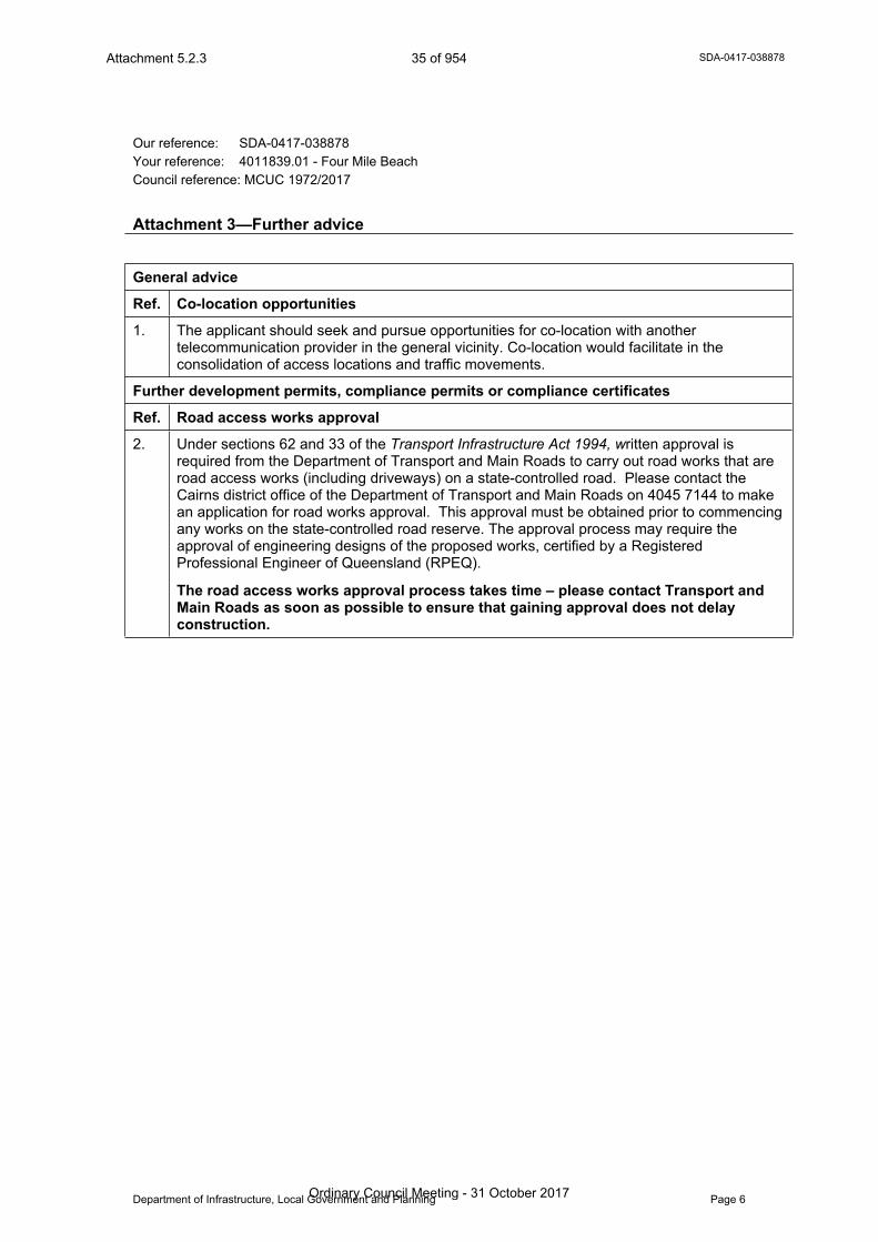
Attachment 3—Further advice
General advice
Ref. Co-location opportunities
1. The applicant should seek and pursue opportunities for co-location with another telecommunication provider in the general vicinity. Co-location would facilitate in the consolidation of access locations and traffic movements.
Further development permits, compliance permits or compliance certificates
Ref. Road access works approval
2. Under sections 62 and 33 of the Transport Infrastructure Act 1994, written approval is required from the Department of Transport and Main Roads to carry out road works that are road access works (including driveways) on a state-controlled road. Please contact the Cairns district office of the Department of Transport and Main Roads on 4045 7144 to make an application for road works approval. This approval must be obtained prior to commencing any works on the state-controlled road reserve. The approval process may require the approval of engineering designs of the proposed works, certified by a Registered Professional Engineer of Queensland (RPEQ).
The road access works approval process takes time – please contact Transport and Main Roads as soon as possible to ensure that gaining approval does not delay construction.
T13
Attachment 5.2.3 35 of 954
Ordinary Council Meeting - 31 October 2017

SDA-0417-038878
Department of Infrastructure, Local Government and Planning Page 7
Our reference: SDA-0417-038878Your reference: 4011839.01 - Four Mile BeachCouncil reference: MCUC 1972/2017
Attachment 4—Approved plans and specifications
T13
Attachment 5.2.3 36 of 954
Ordinary Council Meeting - 31 October 2017

SDA-0417-038878
Department of Infrastructure, Local Government and Planning Page 8
Attachment 5.2.3 37 of 954
Ordinary Council Meeting - 31 October 2017
SDA-0417-038878
Department of Infrastructure, Local Government and Planning Page 9
Attachment 5.2.3 38 of 954
Ordinary Council Meeting - 31 October 2017
SDA-0417-038878
Department of Infrastructure, Local Government and Planning Page 10
Attachment 5.2.3 39 of 954
Ordinary Council Meeting - 31 October 2017
SDA-0417-038878
Department of Infrastructure, Local Government and Planning Page 11
Attachment 5.2.3 40 of 954
Ordinary Council Meeting - 31 October 2017