generative urbanism - curve
TRANSCRIPT
Generative Urbanism: Re-Imagining the Mid-size City
BY FELIPE GONZALEZ
A thesis submitted to
The Faculty of Graduate and Postdoctoral Affairs
in partial fulfillment of the requirements for the degree of
Master of Architecture Professional
Azrieli School of Architecture and Urbanism
Carleton University
Ottawa, Ontario
© 2012 Felipe Gonzalez

Library and Archives Canada
Published Heritage Branch
Bibliotheque et Archives Canada
Direction du Patrimoine de I'edition
395 Wellington Street Ottawa ON K1A0N4 Canada
395, rue Wellington Ottawa ON K1A 0N4 Canada
Your file Votre reference
ISBN: 978-0-494-91535-6
Our file Notre reference
ISBN: 978-0-494-91535-6
NOTICE:
The author has granted a nonexclusive license allowing Library and Archives Canada to reproduce, publish, archive, preserve, conserve, communicate to the public by telecommunication or on the Internet, loan, distrbute and sell theses worldwide, for commercial or noncommercial purposes, in microform, paper, electronic and/or any other formats.
AVIS:
L'auteur a accorde une licence non exclusive permettant a la Bibliotheque et Archives Canada de reproduire, publier, archiver, sauvegarder, conserver, transmettre au public par telecommunication ou par I'lnternet, preter, distribuer et vendre des theses partout dans le monde, a des fins commerciales ou autres, sur support microforme, papier, electronique et/ou autres formats.
The author retains copyright ownership and moral rights in this thesis. Neither the thesis nor substantial extracts from it may be printed or otherwise reproduced without the author's permission.
L'auteur conserve la propriete du droit d'auteur et des droits moraux qui protege cette these. Ni la these ni des extraits substantiels de celle-ci ne doivent etre imprimes ou autrement reproduits sans son autorisation.
In compliance with the Canadian Privacy Act some supporting forms may have been removed from this thesis.
While these forms may be included in the document page count, their removal does not represent any loss of content from the thesis.
Conformement a la loi canadienne sur la protection de la vie privee, quelques formulaires secondaires ont ete enleves de cette these.
Bien que ces formulaires aient inclus dans la pagination, il n'y aura aucun contenu manquant.
Canada

Outline
Abstract 1
Introduction 2
Chapter One: Ottawa's Urban History
1.1 1903 - Preliminary Report to the Ottawa Improvement Corporation 4
1.2 1915 - Report of the Federal Plan Commission on a General Plan For the Cities of Ottawa and Hull 7
1.3 1922 - Federal District Plan For Ottawa 11
1.4 Proposal of a Federal District 11
1.5 A Modern Plan for Canada's Capital: 1950 Greber Plan 13
1.6 1988 Plan for Canada's Capital: A federal land use plan 18
1.7 1999 - The Plan for Canada's Capital 20
Chapter Two: Current and Future Ottawa
2.1 Current Ottawa 23
2.2 The Downtown Urban Design Strategy 2020 26
2.3 Case Studies: The LRT system 27
2.4 Case Studies: The Bronson "Makeover" 32
2.5 Development of "Midsize Cities" 33
Chapter Three: The Compact City
3.1 Sustainable Cities, Cities and Ecosystems 36
3.2 Ecosystems 37
3.3 Cities as Sustainable Ecosystems 38
3.4 Sustainable Transportation 40
3.5 Biodiversity * 41

3.6 Metabolism of Cities 42
Chapter Four: The Carless City
4.1 The effects of Car Culture, Urban effects of car culture 45
4.2 Ecology and Car Culture 48
4.3 Sustainable Transportation Systems 49
4.4 Rail Transit Modes 49
4.4.1 Light Rail Transit (LRT) 50
4.5 Rail versus Bus 51
4.6 Bicycles 52
4.7 Pedestrians 54
Chapter Five: Generative Urbanism
5.1 Actual Situation of Ottawa 56
5.2 Connecting Ottawa: From the suburbs to downtown. 57
5.3 Nodes, Transportation Hubs + Social condensers 60
5.4 Programmatic Bleed: Downtown Ottawa Master Plan 65
Post-script 68
Annex: Palace of the Body 70
Acknowledgments 78
Bibliography 79

Abstract
In the past two decades, architects and urban planners have been
searching for a new approach towards urban design. The
"modernist" approach created "car-based cities" with common
issues: sprawl, isolated suburbs, and depressed urban cores.
Most urban centers, especially developing and "mid-size" cities,
are struggling with these issues, which are affecting their
productivity and efficiency.
Generative Urbanism is a proposal towards the social and
spatial improvement of the "Mid-size City". It takes advantage
of the attributes of the existing city and mitigating its
deficiencies. The project is based in Ottawa, Canada, a capital
city with a difficult history of urban planning. Ottawa is a "car-
based" city, facing complex issues of commuting, mass
transportation, and overwhelming urban growth. The resulting
architecture project ["Palace of the body"] develops strategies
that connects the urban center with its surroundings, creates
spaces for inter-action, and improves existing and future
infrastructure and mass transportation systems.
Generative Urbanism re-imagines the "mid-size city" as a set of
new and existing networks that work to generate a livable,
functioning urban entity by linking new social programs to the
provision of large-scale infrastructure.
1

Introduction
We live in a world that is highly urbanized; in 1900 only a tenth
of the world's population lived in cities.1 Today more than half
the world's population lives in an urban center. The global urban
population is growing at a staggering pace, concentrating
development and economy within the urban boundaries. This
expansion has created a new scenario, making architects and
urban planners challenge the way cities have been conceived.
Our cities are a result of a "modernist" approach based on the
use of the automobile, and the development of its infrastructure.
The lack of success in managing urban growth added to a
massive appeal of the automobile has resulted in a migration of
population and activities to the outskirts of the urban core. The
extensive suburban developments of the last decades has led to
decentralized cities with complex commuting issues, depressed
urban cores and an increase in congestion and pollution.
These issues are gradually developing in "midsize" cities. In the
recent past, "megacities" accommodated urban migration, but its
"economies of scale" are saturated, opening the door for
"midsize" cities to become generators of economic activity. The
competitiveness and quality of life of these cities depend on how
these issues are undertaken; and what urban possibilities arise
from these solutions. At the moment, cities are focusing on
developing sustainable policies for their current and future
plans. Most of these policies focus on technical subjects,
1 Rogers, Richard. 1998. Cities for a Small Planet. Westview Press, p.4
2

neglecting the most important ingredient in the urban realm: its
inhabitants.
Ottawa is one of these "midsize" cities; as the capital of Canada
it appeals towards locals, visitors and investors. But Ottawa is a
"car-based" city, it no longer has a lively downtown, it is not
stimulating, and its streets and public places lack small events
and convergence of activities. These issues combined with
public concerns towards the mass transportation system and
long commutes reflect in Ottawa's lack of competitiveness and
importance compared to other "midsize" cities in Canada.
This thesis addresses the potential of combining existing and
new networks to generate an alternative proposal of the "mid
size" city. Generative Urbanism intends to create new links
between existing infrastructures, mass transportation, and new
social programs. It proposes new spaces of interaction that link
the city with its center, by providing spaces for its inhabitants to
have new social experiences. These new spaces would
ultimately transform the "mid-size" city into a competitive and
efficient urban center filled with activity, bringing its inhabitants
together to fully develop its potential.
3

1. Ottawa's Urban History
1876-1900 1956 2000 s
< .<
Figure 1. Ottawa's Urban Growth From 1876 to 2000's. Source: National
Capital Commission (NCC) 2010
1.11903 - Preliminary Report to the Ottawa Improvement
Corporation
In 1903 Frederick G. Todd (1876 -1948) was assigned to
produce a Report for the Ottawa Improvement Corporation.
Todd was the founder of the Town Planning Institute of Canada
and perhaps the first professional landscape architect in the
country2. Ottawa had an extensive amount of land, a growing
population and unlimited source of waterpower for
manufacturing. To take advantage of this, Todd presented a
scheme based on the design of parks and open spaces to give the
Capital a "national Character".
At the time, people wanted Ottawa to be the " Washington of the
North"; but Todd completely disagreed, due to Ottawa's
landscape characteristics. Instead, Todd proposed a plan for the
future, suggesting great spaces for enjoyment in natural open
areas. This would prevent crowded populations and promote
2 Todd, Frederick. 1903. Preliminary report for the Ottawa improvement commission. https://qshare.queensu.ca/Users01/gordond/planningcanadascapital/todd 1903/ Title.htm. Accessed September 20th, 2011.
4

health and pleasure. He anticipated Ottawa's dual stand between
nature and industry, a conflict that he considered decisive in the
future development of the Capital. The park system designed by
Todd had the following components:
Large natural parks or reserves
Canada has some of the most beautiful forests in the
world, for this reason Todd thought it was suitable to
keep forest reserves close to the Capital city. These
reserves would be examples of the natural forests for
future generations and a place of nature that could be
found at driving distance.3
Suburban Parks
Todd considered suburban parks vital for the city. This
medium size parks were supposed to be located at a short
distance from the city core. He considered that the use of
these parks would animate the city, giving those who
couldn't go out of the city in the summer a place for
leisure and enjoyment.4
Boulevards and parkways
Boulevards and parkways are connecting routes,
especially between the parks, the center of the city and
through the riverbanks.
3 Todd, P. 7 4 Todd, P. 10

Waterway parks - Bathing
Waterway parks are located along the banks of the river.
Todd proposed that these waterway parks were designed
in a way that people could use them for bathing. By
doing this, the city would create a bathing culture and
recognition of the bodies of water as an important asset
of the city.5
City Parks and Squares
Since 1903 Todd anticipated the importance of small
squares and city parks for a city. He saw them as
breathing spaces that should be located throughout the
city to counteract the crowded areas within the urban
fabric. The city parks and squares proposed were
different from the suburban parks; they provided a place
for recreation in the immediate neighbourhood.6
Although Frederick Todd advised the commission to follow his
preliminary parks plan for the capital; the Ottawa improvement
commission decided to drop him as a consultant and relied on
his staff to finish his work. Some of the parks proposed by Todd
were built, but the work made by the OIC after he was dropped
was disappointing. Although his plan was not completely taken
into consideration, many of its parks and parkways resurfaced
later on plans by Bennett (1915), Cauchon (1923) and Greber
(1950).
5 Todd, P. 22 6 Todd, P. 23

Figure 2. 1903 Parks Plan. Source: Todd, Frederick. 1903. Preliminary
report for the Ottawa improvement commission.
1.2 1915 - Report of the Federal Plan Commission on a
General Plan for the Cities of Ottawa and Hull
The early years of the OIC were highly criticized; coincidentally
they overlapped with the emergence of modern city planning in
North America and Britain. During 1911 a typhoid epidemic
and a housing shortage made Ottawa a principal candidate for a
new city plan. After intense political battles, the federal plan
commission appointed architect Edward Bennett as chief
planning consultant (1913). The decision was appropriate, since
Bennett was among the finest American planners of his time and
a leading voice in the 'City Beautiful' movement.7
7 Gordon, David. 1998. A City Beautiful Plan for Canada's Capital: Edward Bennett and the 1915 Plan for Ottawa and Hull. Planning Perspectives: 13. pg. 275. https://qshare.queensu.ca/Users01/gordond/planningcanadascapital/bennettl9 15/review_DG_Ottawal915.pdf. Accessed February 15th, 2011.

Bennett's Plan was presented in an exhibition at the Downtown
Ottawa Office building in January 1915. The 1915 plan for the
Federal Plan Commission consisted of the following
components:
Regional parks and forest preserves system
Parkway and Playground plan
Street layout for future suburban expansion
Regional passenger and freight railway plans
Regional Highway plans
New plans for street railway lines
Utility Analysis
Waterway and flood analysis
Plans for municipal and federal government buildings
Central business district plan
Preliminary Zoning scheme
The analyses made for this plan were well thought out and
consequently predicted much of Ottawa's future development.
The population projections were accurate, stating that the
Ottawa-Hull region would grow from 125,000 to 250,000 by O
1950. The parks system followed much of Todd's previous
analysis. Bennett's team also prepared an estimate on traffic and
rail system based on other American cities. It turned out to be
relevant except on what concerned the use of the automobile,
which had conservative projections.9 Bennett did not expect the
massive appeal automobiles would have in the future. Probably
one of the most insightful outcomes was in the Railway plans.
Bennett saw a problem regarding the future streetcar congestion
8 Gordon, P. 284 9 Gordon, P.284
8

downtown, and advised the city to consider a streetcar subway
under Wellington Street10.
Bennett gave the city a new identity by organizing the
government center. He placed the parliament building on the
edge of Barrack Hill; this was a special site due to its landscape
characteristics (the view towards the river and its visual
notoriety towards the city). In this reorganization, Bennett
proposed that all federal government buildings were located
along Wellington Street (west), while all the municipal
buildings, along Elgin Street (south-east). 11 The 1915 plan
included Hull, the overlooked parallel city across the river.
Bennett proposed its civic center and bridge connections to
Ottawa.
One of the most interesting decisions in the plan was the zoning
provision; separating the city into six different districts ranging
from industrial, transport areas to residential. Bennett also
included height limitations to protect the prominence of the
Parliament Buildings.
The 1915 plan was one of Canada's first comprehensive plans.12
Unfortunately, its implementation and fate where not as
successful, and wias finally ignored. The Federal Commission
made crucial mistakes in the printing and translation of the
report. Those mistakes translated into distribution issues
throughout Canada, and even some political rejection. The plan
was finally dropped. Canada was focused on war, and on the
reconstruction of the Centre Block of the Parliament Buildings,
10 Gordon, P. 285 11 Gordon, P.285 12 Gordon, P. 275
9

which caught fire. Either way, the plan suffered from opposition
towards the 'City Beautiful' style consequently it was said it
focused more on aesthetics than on town planning. This resulted
to be its final downfall.
Figure 3. Drawing # 5 City of Ottawa, view of proposed municipal and
railway centre and General Street System. Source: 1915 General plan for
the cities of Ottawa an Hull
mi. rus*
Figure 4. General Street System. Source: 1915 General plan for the cities of
Ottawa an Hull
10

1.3 1922- Federal District Plan For Ottawa
Ottawa was entering a complicated path that other cities such as
London or. Washington did before. They developed different
plans but they partially implemented them or did not execute
them at all. The 1922 plan acknowledged that Ottawa didn't
have a concrete plan for its current and future dimensions. The
result of past plans had left the city with a tangible parliament
building area, an urban grid and a few spaces saved for public
gatherings.
Other than that, the city was suffering with a housing deficit that
was evident since the 1915 plan. There were major health
concerns due to slums establishing around and inside the city.
This problem started to contrast against the natural beauty and
landscape.13
The city of Hull was also a concern within the Federal District
Plan. It was considered that Hull had been neglected in the past.
The creation of a provincial town-planning department was vital
to include Hull in the Capital Region.
1.4 Proposal of a Federal District
Noulan Cauchon, a consulting engineer and town planner,
submitted a proposal to reconsider the political organization
within the Capital Region (1922). He suggested the creation of a
" Federal District Commission" that would be in charge of
"controlling and developing the physical and infrastructural
13 Cauchon, Noulan. 1922 Federal district plan for Ottawa. https://qshare.queensu.ca/Users01/gordond/planningcanadascapital/cauchonl 922/index.htm. Accessed September 20th, 2011.
11

projects within the cities of Ottawa, Hull and its
surroundings"14. Consequently, municipalities were going to
give up some of its political power to a commission of experts
that would guide the development of both cities. The new
commission's main objective was to guide the execution of
plans considering current and future conditions. The 1922 plan
proposed the following15:
Railways
The plan proposed the reorganization of the railway
system by eliminating excessive amount of tracks and
maintenance; it was imperative to improve the efficiency
of the system.
Railways Right of Way and Rapid Transit Railways
The proposal consisted on turning radial railways into
radial highways, thus creating rapid connections with the
city. This allowed citizens to move longer distances,
hence the possibility of having new housing areas for
development.
Power and Industrial Development
A proposed dam at the "Little Chaudiere" would create
additional power needed for the industrial development
of the city. Ottawa has always been situated in a strategic
location within the economic map of the country. The
proposal wanted to take advantage of the natural
resources of the region.
14 A Federal District for Ottawa, Journal of the Town Planning Institute of
Canada, Vol. 1, No. 9, April 1922, P. 3-6 15 A Federal District for Ottawa, P.3-6
12

National Parks
The plan proposed a national park at the Laurentian hills
that started at the dam in the shore of the Ottawa River
and extended towards the north. This mountain park was
complementary to other proposals of internal parks and
parkways within the Capital city.
fMUMfeiri frtirwft n.a^vt«r* tHSTIu >»•.
Feotfcw, OWWICT BUN
Figure 5. Federal District Plan. Source: Cauchon, Noulan, 1922 Federal
District Plan,
1.5 A Modern Plan for Canada's Capital: 1950 Greber Plan
After another disappointing and unfulfilled plan, Ottawa was
still a chaotic and irregular city. Prime Minister Mackenzie
King was determined to give Canadians a proper Capital. King,
believed in town planning as a social reform tool, and
understood the potential and the importance the city could have
not only for its citizens but also for all Canadians.16 Ottawa and
16 Gordon, David. Weaving a Modern Plan for Canada's Capital: Jacques Greber and the 1950 Plan for The National Capital Region. https://qshare.queensu.ca/Users01/gordond/planningcanadascapital/greberl95 0/Greber_review.htm. Accessed September 20th, 2011.
13

Hull were immersed in an urban crisis. Both cities needed major
improvements especially after World War II. In 1945, the city of
Ottawa was crowded with temporary wood structures used as
office buildings; this condition added to the infrastructure chaos
and resulted in an unbearable situation.17
Prime Minister King met Jacques Greber during a trip to Paris in
1936. King instantly connected with Greber. Greber was
France's leading urban planner and chief architect of the 1937
Paris World Fair site that Mackenzie King was visiting. Greber
had experience working in North America; he worked on the
1917 Master Plan for the Benjamin Franklin Parkway
(Philadelphia), among other private park commissions.
On this trip, King interviewed Greber and invited him to Ottawa
to prepare an urban plan for the city's core. Greber travelled to
Ottawa in 1937, and quickly understood the infrastructure
problems the city was facing. He proposed an initial plan
combining elements of Bennett and Cauchon's proposals. The
result was the National War Memorial and Plaza unveiled in the
Royal visit in 1939.18
After the success of the War Memorial King invited Greber to
continue its plan for Ottawa and multiply its effect all
throughout the downtown area. The plan got stalled due to the
Second World War, when Greber had to return to France and
was accounted for the reconstruction of Nord-Normandie.
17 Gordon, Weaving a Modem Plan for Canada's Capital: Jacques Greber and the 1950 Plan for The National Capital Region. Accessed September 20th, 2011 18 Gordon, Weaving a Modern Plan for Canada's Capital: Jacques Greber and the 1950 Plan for The National Capital Region. Accessed September 20th, 2011
14

To ensure success, King established the NCPC (National Capital
Planning Committee), which was independent from the FDC
(Federal District Commission) and had representatives from
across Canada.19 Greber was appointed as consultant for the
NCPS (National Capital Planning Service), the "only full time
professional planning organization in Canada (1945)".20 With a
team of architects, planners, Landscape architects and engineers
Greber started the plan for a National Capital Region that
included both Ottawa and Quebec side of the river. The
components of the 1950 Plan were:
Relocation of the Railway system and industries from
the inner city to the suburbs
Construction of new cross boulevards and bridges
Decentralization of government offices to the suburbs
Slum clearance and urban renewal of LeBreton Flats
Expansion of urban area from 250,000 to 500,000 lots
Surround future urban area with a Greenbelt
A wilderness park at the Gatineau Hills and park systems
along the rivers and canal
The relocation of the railway system turned to be crucial for the
1950's plan. It helped to reorganize the infrastructure of the
downtown core by reconnecting the road grid and separating
industry from housing areas. The government buildings were
relocated near Parliament Hill; research, administrative and
office areas were decentralized to suburban office parks. This
19 Gordon, Weaving a Modern Plan for Canada's Capital: Jacques Greber and the 1950 Plan for The National Capital Region. Accessed September 20 2011 20 Gordon, Weaving a Modern Plan for Canada's Capital: Jacques Greber and the 1950 Plan for The National Capital Region. Accessed February 29 2012
15

allowed the city to get rid of the temporary buildings and free up
space for public institutions such as libraries, theaters and
galleries.
The four-kilometer Greenbelt was planned around the urban
areas to control sprawl and limit urbanization. If the city grew
beyond 500,000 neighbourhood units it had to take place outside i
the Greenbelt, in Satellite towns. Greber recommended
expanding the parkways all the way to the Greenbelt and to
extend the Gatineau Park as close as possible to the downtown
core.
One of the major problems the plan had was its population
projection. No one expected the post-war baby boom and a
strong government expansion. This resulted in a city of 500,000
in 1966 that grew to 1,1 million by 1996.22 By 1970, the
suburban expansion outside the Greenbelt started, and the
northern area of the Greenbelt (Quebec side), was completely
populated.
Unfortunately the design of the streets and boulevards made by
Greber were not taken into account. In fact, most of the street
designs were made by provincial and regional traffic engineers,
which didn't have the special touch that Greber expected. This
resulted in streets and boulevards that omitted street furniture
and substantial sidewalks in favour of traffic space.23 Finally,
the skyline that Bennett and Greber tried to preserve was ruined
21 A proposal based on Ebenezer Howard's 1898 social cities scheme 22 Gordon, Weaving a Modern Plan for Canada's Capital: Jacques Greber and the 1950 Plan for The National Capital Region. Accessed September 20 2011 23 Gordon, Weaving a Modem Plan for Canada's Capital: Jacques Greber and the 1950 Plan for The National Capital Region. Accessed September 20 2011
16

in 1965. In favour of more tax income, the government allowed
skyscrapers in the downtown area to surpass the limit height.
This ruined the view of Parliament hill from the south.
The 1950 Plan was the first urban plan that was implemented
almost to completion. Mackenzie King's dream was fulfilled
and the Ottawa became a genuine capital city. The
reorganization of infrastructure, the investment in sewage
treatments for the river, and the eventual construction of the
Queensway changed completely the way the city operated. The
open (Green) space network became iconic in the city. These
changes transformed the public and leisure spaces developing
tourism and a higher quality of life.
Figure 6. Master Plan. Greber, Jacques Source: 1950 Plan for The National
Capital Region
17

Figure 7. Proposed Highway Plan. Greber, Jacques Source: 1950 Plan for
The National Capital Region
1.6 1988 Plan for Canada's Capital: A federal land use
plan
It took more than two decades to complete Greber's 1950 plan.
During this time, especially in the late 1960s, Ottawa suffered
changes that had a meaningful influence on the city's future. In
February 1969, during the Federal-Provincial Constitutional
Conference, the city modified its boundaries integrating Ottawa,
Hull and its surroundings. A new rule for the distribution of
Federal employment was issued. Federal employment had to
represent the demographic distribution of the Capital Region. To
make this happen a new business area was created in Hull,
changing its skyline and urban relations towards Ottawa.
18

In the late 1960s, two other changes influenced Ottawa's future:
the creation of regional bodies with planning mandates, and new
obligations for the NCC. Ontario created the Regional
Municipality of Ottawa-Carleton, while Quebec created the
Outaouais Regional Community. Both regional bodies had
major influences in how the region was managed, and how its
municipal services were executed. On the other hand, the NCC
focused on transforming Canada's Capital into a "meeting place
for all, that had to be preserved, and its national identity
displayed". By the end of the 1980s, Greber's plan was
completed; the city needed a new vision for the Capital.
In 1988, the new Federal Land Use Plan aimed to transform
Canada's capital into a national symbol. It emphasized
renovating public spaces into "Capital Stages". The idea was to
incentivize tourism by improving the quality of city spaces and
the access to the Capital. The plan also concentrated on boosting
collaborations between planning entities within the region. The
Plan had 4 main goals:
Consolidation of the federal presence in the Capital:
priority to political, cultural and administrative
institutions on federal lands, distributed the public
service in the region, established cultural, national and
international institutions in the city core and others
Enhancement of the Capital's green image and greater
accessibility to riverbanks: institute and protect the park
network, improve network of recreational pathways,
guarantee public access to shore lands)
19

Enhance the quality and appearance of arrival points and
scenic entries to the Capital: improve scenic routes and
attractions, institutions, facilities and events of national
importance, and improve the entry points to the City
Focus on the Capital as a symbol: creation of new urban
design policies for the city24
The 1988 Plan left an imprint on Canada's Capital. It created
events such as the Canada Day celebrations and Winterlude. It
promoted tourism and started to develop tools to attract visitors.
There was an intense program of restoration and beautification
of major parks and heritage buildings. And finally, major
infrastructure rehabilitation took place specifically in the main
entrances to the city and in the development of the first phase of
Confederation Boulevard.
1.7 1999 - The Plan for Canada's Capital
The closing decade of the 20th century embodied technological
and social changes that eventually started to influence planning
and city building. The 1999 Plan for Canada's Capital
recognized these changes and adapted the previous plan towards
a sustainable, fast-growing, and multicultural city. Ottawa
started to develop an interest in sustainable planning principles,
which would become fundamental taking account the
importance of its natural assets and its future population growth.
24 National Capital Commission (NCC). Horizon 2067 the plan for Canada's Capital. Pg.28. http://www.canadascapital.gc.ca/sites/default/files/pubs/charting-the-future-of-canadas-capital-in-the-21st-century.pdf. Accessed February 29th, 2012.
20

Canada was also facing other social changes that influenced
Ottawa's future plans: an aging population, immigration and
cultural diversity, new information technologies and an
increasing role of other provinces. These issues forced the city
to increase interaction between planning regional bodies towards
the development of a new plan for the Capital Region.
The Plan for Canada's Capital intended to amalgamate the needs
of the city with those of the region. The main goals of the 1999
Plan were Capital Settings, Capital Destinations and Capital
Links:
Capital Settings: New sustainable principles adopted in
city planning gave relevance to the protection of parks
and public spaces. This became a fundamental issue for
the city.
Capital Destinations: Ottawa increases preservation
policies and intends to showcase cultural heritage and
destination points to Canadians and foreign tourists. The
city supports the development of Confederation
Boulevard and the preservation of Parliament Hill as
significant national cultural sites in the Capital core.
Capital Links: The plan proposes better connections and
entrance points to the Capital Region. This includes
interprovincial bridges, parkways and improving the
transportation network.
25 National Capital Commission (NCC). Horizon 2067 the plan for Canada's Capital. P. 27
21

After the implementation of the 1999 Plan, Downtown Ottawa
and Gatineau were linked by the completion of the
Confederation Boulevard project. Other infrastructure projects
were executed (refurbishment of the Champlain Bridge), and a
significant amount of land was acquired. Although this was
important, the plan lacked execution in terms of its main goal: a
more sustainable, fast growing, multicultural city. In
consequence, a new strategy was proposed a few years later.
22

2. Current and Future Ottawa
2.1 Current Ottawa
Ottawa has slowly established itself as a Capital city. It is
Canada's 4th largest city, with a population of 800,000
inhabitants (1.1 million in its Metropolitan area). The Capital is
not only recognized for its vast natural and agricultural areas. It
is gradually becoming one of Canada's cultural centers, a high
tech research hub (with top Universities within its boundaries),
and it is one of the top telecommunications research and
development centers in the world. Ottawa has Canada's highest
household income, and the most highly educated workforce in
the country. The Capital has become a multicultural city; its
Canada's 4th urban center for immigration, with 25% of its
residents bom outside the country.26
Since the 1999 plan, Ottawa has faced new stimulating
challenges. In 2001, the city decided to change its government
structure by amalgamating 11 urban and rural municipalities and
1 regional municipality into 1 government structure. Taking this
into account, the new city expects an incredible level of growth.
A modest city, getting close to 800,000 inhabitants in the year
2000, is expected to grow to around 1,2 million or more within
the next 20 years; transforming Ottawa into a complex urban
region.
To respond to the new challenges, Ottawa has developed an
26 City of Ottawa, Official Plan Ottawa. Pg. 1 http://www.ottawa.ca/city_hall/ottawa2020/official_plan/vol_l/pdf/section_0 l_en.pdf. Accessed March 1st, 2012.
23

official plan based on the premise of sustainability.27 Ottawa has
acknowledged that it has to face similar challenges as other
North American cities: weakening of the ecosystem, population
growth, extensive use of the automobile and consumerism.
Accordingly, Ottawa has developed a framework to manage its
future growth. "Ottawa 20/20" view the city as a "compact, >JQ
efficient, equitable, affordable, environmentally healthy city".
Within Ottawa 20/20 there is an Official Plan that supports the
development inside and out the urban boundaries. It explores the
possibilities the city has to increase its residential and
employment densities along the main corridors. It also examines
alternatives to the automobile through the promotion of new
transit possibilities, cycling and walking. Ottawa 2020 has seven
principles that direct the city's future:
A Caring and Inclusive City: Ottawa should be diverse
and inclusive, with infrastructure for the disabled and
inviting to new comers, immigrants and seniors. It
should engage more with its citizens and fulfill its basic
needs (such as security, leisure, transit, housing, among
others).
A Creative City, Rich in Heritage, and Unique in
Identity: Ottawa should promote a vibrant and
attractive mix of activities within the arts and creative
27 Sustainable development is defined by the Official Plan as:" development that meets the need of the present generation without compromising the ability of future generations to meet their own needs". City of Ottawa,Official Plan Ottawa. Pg. 1 http://www.ottawa.ca/city_hall/ottawa2020/officiaLplan/vol_l/pdf/section_0 l_en.pdf. Accessed March 1st, 2012. 28 City of Ottawa, Ottawa 2020 management Plan. Ottawa pedestrian Plan. P g l l . http://ottawa.ca/cs/groups/content/@webottawa/documents/pdf/mdaw/mdyw/ ~edisp/con041239.pdf. Accessed October 20th, 2011.
24

realm. It should generate a sense of place with its local
heritage, arts, culture and its unique landscape.
A Green and Environmentally Sensitive City: Ottawa
should preserve and strengthen its relationship with the
natural habitats and the green spaces network. It should
focus its future transportation needs on transit modes,
cycling and walking. And should develop land wisely
within the city avoiding urban sprawl.
A City of Distinct Liveable Communities:
Communities in Ottawa are in need of an identity that
makes them feel proud and that they are an integral part
of the city. These communities have to be aesthetically
pleasing and well connected between each other. They
have to be well balanced between housing, employment
and leisure activities and green spaces.
An Innovative City where Prosperity is Shared
among All: Ottawa wants to create a vibrant economy
based on strong local businesses and a recognized rural
economy. The city wants to encourage education,
training, and information to overcome obstacles and
increase employment opportunities.
A Responsible and Responsive City: Ottawa wants to
be responsible with its finances; the city wants the
general public to be aware and knowledgeable of what is
going on in order to be able to contribute.
25

A Healthy and Active City: Ottawa wants to create an
environment where sports and recreation are main activities
within its society. This will promote health through the
creation of community facilities that are accessible to all. 29
2.2 The Downtown Urban Design Strategy 2020
With Ottawa 20/20, the city has prepared the "Downtown
Ottawa Urban Design Strategy". This plan recognizes the
downtown area as an essential focal point of the city. The aim of
"Downtown Ottawa Urban Design Strategy" is to re-urbanize
the area by increasing the quality of public and urban
environments. Consequently transforming a downtown area
defined by its business district into an economical/cultural core
full of vitality and activity. This new local identity should meet
the "needs and demands" of a city of more than a million
inhabitants.
The "Downtown Ottawa Urban Design Strategy" suggests a
central area that encourages new residential developments,
improves access to water and green spaces and promotes mixed-
use projects. It also recommends reducing de reliance on
automobiles by making public transit a priority and supporting
walking and biking as means of transportation. It urges the use
of compact/mixed use projects to reduce transportation
demands, which would also help to minimize the land used for
parking. The strategy also promotes heritage and conservation as
principal themes within the urban core.
29 City of Ottawa. The Ottawa 2020 process and the guiding principles. http://www.ottawa.ca/city_hall/ottawa2020/official_plan/vol_l/01_introducti on/index_en-03.html. Accessed March 12th, 2012.
26

The "Downtown Ottawa Urban Strategy" creates a framework
for the development of streetscape infrastructure, open spaces,
and art. It targets 41 different strategies, which are a shared
vision of the City of Ottawa, the National Capital Commission
and the neighbourhoods. In this context, the downtown area
becomes a central aspect in redefining the image of the city.
Through these strategies the City of Ottawa expects to
reconfigure public infrastructure to create a positive, successful
and desirable place to live.
Figure 8. Downtown Urban Design Strategy 2020. Source City of Ottawa
2.3 Case Studies: The LRT system and The Bronson
Makeover
After realizing that the traffic issue in Ottawa is growing year-
by-year without apparent solution, the city decided to pursue the
Light Rail System Project. The Project started in January 2007,
27

when a task force on transportation was created. They released
the "Moving Ottawa" report (June 2007), recommending an
"east-west rail tunnel bored through downtown to alleviate the
current transit bottleneck and build a more inviting
streetscape." 30 With this recommendation in hand, the
Transportation master plan was revised; consequently, cost and
affordability studies were executed establishing a funding
scheme.
The cost of the project was estimated in $2.1 billion, a budget
that was secured through the investment of provincial and
federal funds. With the budget secured, studies and plans started
in 2009. On May - June 2011 Council approved reports
concerning the schedule and implementation of the project.
Subsequently, on October 2011, the City shortlisted three
consortia that will formulate a Request for Proposal (RFP).31
The construction of this project will start in early 2013 and
should be operational by mid-2018.
Ottawa states that this project has multiple benefits. The project
will span 12.5 km from Tunney's pasture to Blair station, and
will have 13 stations. With this project the city expects to reduce
bus traffic by 50% within the city core, making Ottawa a
"friendly place for pedestrian and bicycle users". It is expected
that by 2031, transit ridership will increase by 78%. This makes
the LRT a priority taking account that the O-train already
30 City Of Ottawa. Ottawa Light Rail, Background, Task Force Report. http://www.ottawalightrail.ca/en/project-plan/background. Accessed March 13th, 2012. 31 The three consortia chosen by the city are: Ottawa Transit Partners, led by Vinci Concessions, Rideau Transit Group, led by ACS Infrastructure Canada Inc., Rideau Transit Partners, led by Bouygues Travaux Publics S.A.
28

exceeded its initial user forecast: 7,300 users a day (expected)
compared to 10,200 riders a day (current).32
Figure 9. Ottawa Light Rail. Source :City of Ottawa, www.
ottawalightrail.ca
Although the LRT project seems to be a positive proposal
towards improving the transportation system of the Capital, it
still raises concerns. After a 2.1 billion investment, the
introduction of the light rail will only increase 9% the transit use
within the city. In fact, auto drivers and auto passengers
dominate, accounting for 71% of transportation trips.33
HHSB ~ PMRciEFwrtrt Oltw Q#T
Figure 10. Ridership Share. Source City of Ottawa
32 City of Ottawa. Fast Facts Ottawa Light Rail. http://www.ottawalightrail.ca/en/project-plan/fast-facts/page:5. Accessed March 13th, 2012. 33 City Of Ottawa. Horizon 2067 The Plan For Canada's Capital. Pg. 63. http://www.canadascapital.gc.ca/sites/default/files/pubs/charting-the-future-of-canadas-capital-in-the-21st-century.pdf. Accesed November 11, 2011.
tuttte Tamil
Auto Pa sun 13%
M
29

As stated before, the LRT project will open new spaces for
pedestrian and bicycle users. But these users are only 12% of the
riders (11% walk, 1 % Bicycle). Although there is a bicycle plan
for 2018, it has a goal of increasing bicycle ridership from 1.7%
to 3% (by 2021). A very low increase considering that 73% of
households in Ottawa own bicycles54; and pioneer cities such as
Copenhagen have 36% of its population commuting to work.35
The LRT project is not specific in its connections and its role
within a multimodal transportation system.
The system is also conceived from Tunney's Pasture to Blair
Station. In the NCR "the leading districts in terms of population,
including several outer suburbs, contrast with the main sources
of employment, with the downtown centres of both Ottawa and
Gatineau having the lowest numbers of residents". 36
Accordingly, the centers have the highest amount of jobs but a
low population, resulting in high volume flows of commuters.
This is expected since 80% of the trips to Central Ottawa come
from other Ontario districts.37 Looking at the AM peak inter-
district flows from suburban Ottawa, and the PM peak inter-
district flows from central Ottawa, it is evident that a great
amount of frequent east-west trips will not be attended in the
proposed LRT project.
34 City of Ottawa. Ottawa Cycling Plan (2008). Chapter 1, Pg. 6. Chapter 2 Pg. 4,5 35 Outram Christine, Bidennan Assaf and Ratt Carloi. 2010. Self Engineering Ecologies. Ecological Urbanism, Lars Muller Publishers. Pg. 172. 36 HDR | iTRANS. National Capital Region Travel Trend Study (2011). TRANS Committee, http://www.ncr-trans-rcn.ca/uploadedFiles/resources/NCRTrendStudyPart 1 -FinalReport_20110207.pdf. Accessed March 1, 2012 37 HDR | iTRANS. National Capital Region Travel Trend Study (2011). TRANS Committee. P. 38.
30

Figure 10. AM. peak inter-district flows from suburban Ottawa. Source
City of Ottawa, Source: National Capital Region Travel Trend Study (2011)
Figure 11. PM. peak inter-district flows from centra] Ottawa, Source:
National Capital Region Travel Trend Study (2011)
In fact, the city is planning major rezoning and redevelopment
around three of the stations of the LRT project. The stations
outside the city core are bordered by light industry and low-
density retail. If this situation continues, it is a possibility that
the LRT project will not have enough users as projected. The
city needs to double the population in these areas in the next 20
years to ensure success to the LRT project. If the LRT project
31

attended the inhabitants that come every day from the suburbs
and back, ridership would most likely be ensured. In contrast,
the city needs to find ways to elevate ridership and densify areas
that are between the downtown core and the disconnected
suburbs. In conclusion, the users that live in the suburbs will not
be attended by the LRT project; therefore they would still use
the automobile as their main transportation system.
2.4 The Bronson "Makeover"
On November 2011 it was publicly announced that Bronson
Avenue was going to undertake a makeover. The main reason
for reconstruction is to install new underground water and sewer
lines. Since the beginning, the community and residents opposed
this intervention. In the design, Bronson Avenue is going to be
widened 0.6 m. City staff understands that Bronson is already a
"constrained" Avenue, and that extra space for traffic is
necessary. On the other hand, residents feel that the Avenue's
new design goes against safety measures. They understand that
if the Avenue is wider, cars can go even faster and it would start
to feel like a "provincial highway".
Some community members recognize that the flow of traffic in
the Avenue is important, but they consider that widening streets
is closer to "1960's Thinking" coincidentally when traffic
engineers where in charge of street designs. The community is
concerned with the lack of care towards pedestrians and bicycle
users. They consider that it is very difficult to cross the street; an
38 Tunney, Catharine. Community Hails Bronson Ave. Decision. Centretown News. February 3rd, 2012. Pgl,2.
32

issue that is critical considering that Parks, housing, a school
and a Community Centre are bordering the Avenue.
The $30 million project has become quite controversial. Since
November, City Staff has made changes to its original design.
They have widened some sidewalks, but the street keeps the
same amount of lanes. Although residents expected major
improvements (like a "road diet" cutting 4 lanes to 3), they
didn't come through, and speeding, loss of tenants due to the
noisy street, and unsafe crossings will continue.39 The city
demonstrates once more its design priorities, continuing car-
based city policies over pedestrians.
2.5 Development of "Mid-size Cities"
Half of the world's population lives in cities, which indicates
that a massive urbanization has taken place. Growth in the last
decades has been focused on 'megacities'; metropolises with
populations over 10 million people. While cities such as Tokyo,
Los Angeles, or Mexico D.F. have been a substantial agent for
world economy, in the near future the trend will change.
According to the McKinsey Global Institute, there are 600 urban
centers (which have only a fifth of the population of the world)
that generate 60% of the global GDP (Gross Domestic
Product).40 McKinsey refers to them as "middleweight" cities,
urban centers with populations ranging from 150,000 to 10
million.
39 Cockburn, Neco. Battle Lines Forming as Bronson Makeover Looms. The Ottawa Citizen, Section C. November 24th, 2011. Pg.1,4. 40 McKinsey Global Institute. Urban World: Mapping the Economic Power of Cities. McKinsey & Company, March 2011.
33

These "middleweight" cities are expected to grow rapidly,
becoming by 2025 vital generators of economic activity. In fact,
McKinsey projects that these cities will report 50% of the global
GDP growth between 2007 and 2025. Though the cities with the
largest growth potential are located in the developing world,
Canada should consider this subject decisive since it has 20 of
the 600 "middleweight" cities within its territory. Canada should
focus its efforts in developing "regional - second cities" like
Ottawa and take advantage of this major growth potential.
Actually, these "middleweight" cities have another benefit: the
potential to innovate. Regional clusters such as Ottawa have the
possibility to unite diverse contributors (the private sector, the
public sector, academia, large corporations, entrepreneurs
among others), to pursue strategies and benefit from the
expected growth patterns.41 It is important that these cities are
prepared for the upcoming growth. Planning and management
strategies become fundamental to organize the immediate and
future objectives (50 years into the future). Therefore cities
would avoid problems that would deteriorate the quality of life
(congestion, pollution, lack of affordable housing,
infrastructure), which would reduce the possibility of having a
dynamic economy.
The reason why these middle size cities are such an influential
factor is the "economies of scale" than can be developed in
concentrated urban centers. This expansion will foster emerging
markets that will reduce poverty and create opportunities for
companies that can thrive form this dynamic situation. But this
41 Dobby Christine, Rapid Growth: Coming to a City Near You, The Ottawa Citizen, Section D Pg. 1. November 24 2011
34

growth can only happen if the cities manage correctly future
challenges. Cities will be obliged to anticipate urban trends, and
they should be ready to handle complex scenarios that will
gradually emulate the ones larger cities have. The "economies of
scale" will allow industries to be more efficient and augment its
productivity compared to the ones in rural settings. It is
important to note that services are less expensive when provided
to a concentrated population. Thus water, housing and education
is projected to be 30 to 50% cheaper in these urban centers
compared to sparsely populated areas.42
The reason why "Megacities" have stopped thriving is because
they have exhausted their "economies of scale". For this reason,
"midsize" cities have to create strategies to handle the above
average growth in population and per capita GDP. By 2025, 13
"midsize" cities will grow beyond the 10 million inhabitants; the
only one in North America is Chicago. If the government
concentrates in aspects such as demographics, households and
incomes "Middleweights" like Ottawa will have the opportunity
to outperform other cities. To achieve this, the city has to
become much more competitive, dynamic, and attractive for
investors, citizens and visitors.
42 McKinsey Global Institute, Urban World: Mapping the Economic Power of Cities, McKinsey & Company, March 2011
35

3. The Compact City
3.1 Sustainable Cities, Cities and Ecosystems
Cities are providers of opportunities that enhance the exchange
of goods and services and social/cultural interactions. In the last
decades, urbanization trends have changed from dense, mix-use,
small cities with local economies to sprawled 'megacities'
governing over a distant global network. As a result, urban
population expands at a rate of 1.78% per year.43 If the trend
continues, urban residents will be 66% of the population by the
year 2025. This is a challenging situation for the development of
cities, thus generating complex and diverse issues. With extreme
growth, urban economies are prioritizing processes that transfer
energy and materials into products for a predatory global
market. The result of this approach is an economic and
ecological imbalance that is represented in problems such as:
climate change, water supply shortage, and. reduction of oil
reserves, regional environmental damage, and loss of
biodiversity among others.
These problems impact directly the growth of cities. Issues such
as sprawl and car dependence generate a lack of community and
social alienation. The extreme growth rate of cities is also
damaging the bioregional context and generating disconnect
between the environment and the urban fabric. To address these
issues, innovative cities have to redevelop their economic and
social relationships with their surroundings and inhabitants.
43 Newman Peter & Jennings Isabella. 2008. Cities as sustainable ecosystems: principles and practices. Washington D.C. Island Press. Pg. 34
36

3.2 Ecosystems
"Ecosystem: A dynamic and complex system of plant, animal
and microorganism communities and their non-living
environment all interacting as a functional unit within a defined
physical location. "44
Ecosystems are a perfect example in which to base the economic
and social relationships needed. They are place based,
cooperative, diverse, self-regulating through feedback loops,
decentralized, conserving and solar based.45 Ecosystems are
divided in two: Autotrophic and Heterotrophic.
"Autotrophic: Self feeding. The term is applied to organisms
that produce their own food (such as plants through
photosynthesis) and to ecosystems that produce enough energy
internally to meet their own needs." 46
"Heterotrophic: "Other feeding". A term applied to organisms
that cannot make its own food — for example animals - or an
ecosystem that cannot produce sufficient energy internally from
photosynthetic processes to meet its own metabolism (that is, it
need external inputs of energy besides light). "47
44 United Nations Environment Programme (UNEP). Glossary of environmental terms, http://www.nyo.unep.org/action/apl.htm. Accessed October 28th, 2011. 45 Newman and Jennings, P. 37 46 Newman and Jennings, Glossary 47 Luck et al. 2001. The urban funnel and the spatially heterogeneous ecological footprint. Ecosystems 4 : 782-96.
37

Actual urban ecosystems are considered heterotrophic. Cities are
unable to support their own metabolism with their production
(the consumption of organic matter is much bigger that the
production of new organic matter). As a result cities are obliged
to import resources such as food and fossil fuels to maintain
their housing, commercial and industrial areas. In nature some
ecosystems that are heterotrophic receive additional energy
requirements from adjacent ecosystems. In this case these
bounded ecosystems can be seen as autotrophic in a bioregional
level. As stated, cities could work in a bioregional level with
other cities to balance the production and consumption of
energy. City economy, as we know it, would have to drastically
change in order to create a local and autotrophic approach for
the region.
3.3 Cities as Sustainable Ecosystems (CASE)
Cities are to be designed based on economies with restoring
feedback loops implemented on their bioregion. By doing this,
cities will be capable to respond to global issues (such as the
impact on greenhouse gases, extreme oil consumption,
biodiversity loss) balancing the global ecosystem with a
sustainable production-consumption ratio. The Cities As
Sustainable Ecosystems (CASE) approach invites cities to
understand their role as part of bioregions that are constantly
searching for an "ecological balance". 48 By implementing
bioregional economies, cities would balance themselves with the
carrying capacity of their bioregion, instead of remote markets
all over the world. This approach gives cities the chance to re
48 Newman & Jennings, P. 44
38

explore their region in terms of production of food, energy,
water and waste disposal.
Modern cities rely on fossil fuels and plant-based energy, which
are unsustainable since they are finite resources. The future of
sustainable cities is in the use of renewable resources. The
transition to a sustainable production of energy has to be
implemented in buildings, transportation and industry. Ideally, a
city would have an infrastructure designed to support and
develop these changes. Quality transit systems (preferably
multimodal) are fundamental to structure the city, diminishing
the dependence on cars. With a walking and cycling network as
a support, all neighbourhoods and districts can be laced between
each other. Cities should count with autotrophic energy systems
with local and well distributed water systems. Waste
management is also crucial; consequently production would
shift and create as little waste as possible by implementing
recycling policies.
As changes take place, and as infrastructure reunites the
inhabitants of the city, new social relationships start to flourish.
This new social infrastructure is decisive for the new bioregional
economy to work. The strength of communities and the social
connection between them creates a sense of belonging and a
responsibility towards the city. Further development of
infrastructure for social encounters would create bonds at the
neighbourhood scale preventing isolated family units, common
in today's cities.
39

3.4 Sustainable Transportation
One of the most effective ways to transform a city into
sustainability is to introduce sustainable transportation. With the
introduction of sustainable transportation urban economies
transform. Cities have systems that depend on oil consumption
such as the transportation of goods and people. This situation
leaves cities with an economic and social vulnerability in
regards to oil scarcity (and its elevating price). Cities that are car
dependent suffer for the following reasons:
Car dependent cities spend 15 to 20 % of their wealth in
transportation; transit oriented cities spend 5 to 8%.
From a sample of 100 cities those with strong rail
systems are 43% more wealthy than week rail cities.
Car dependence is expensive because cars waste space;
cars take 2,500 people per hour in one lane, trains take
50,000.
People who live in car dependent cities use between 20
to 40% of their income in transportation49
If cities are compact they don't need to. rely on cars for
transportation. In fact, other ways of transportation could be
encouraged like walking or cycling. This brings an immense
amount of benefits to a city from the economical (less fees in
transportation, greater energy independence) to the social (fair
access to transportation systems, promotion and sense of
community, exercise and social activities). With an attractive
mix of pedestrian and bicycle lanes, multimodal public
49 Newman & Jennings, P. 45
40

transportation and interesting public spaces people have the
opportunity to create a bond with their city and their community.
3.5 Biodiversity
"Biological diversity - or biodiversity - is the term given to the
variety of life on Earth and the natural patterns it forms,
encompassing the full range of species, genetic variation, and
ecosystems in a given place. "50
Biodiversity forms the networks in which we all live. All the
activities in ecosystems depend directly on biodiversity thus the
goods and services needed for sustainability rely on a healthy
understanding of our environment. Biodiversity in cities is a
subject that is fundamental due to the increase need, protection
and handling of services such as water, air, waste, and recycling.
Current city building places a heavy load to the ecosystems they
inhabit, an issue that increases with sprawling.
Consumption in cities takes a bigger toll on ecosystems when
there is an increase exploitation of energy and products that
come from outside the bioregion. To turn around this situation
cities have to link themselves with their bioregions in different
levels. Certain strategies can be enforced to attain this links such
as: the creation of static and dynamic reserves within the city
and its surroundings, educate the population about their
bioregion, reduce the ecological footprint of the city, and design
ecological architecture and infrastructure and design cities as
biodiversity arks.
so Newman & Jennings, P.65
41

3.6 Metabolism of Cities
COM
M ttmmm
Outputs Goo*
«Q©3, HQ& 3&2J
di*xrfu>
Figure 12. Linear Metabolism, Cities consume and pollute at the same
rate, Source: Rogers, Richard. Cities for a small planet
Figure 13. Circular Metabolism, Cities minimise new inputs and
maximise recycling, Source: Rogers, Richard. Cities for a small planet
The introduction of sustainable planning has changed the way
we understand the metabolism of cities. For decades planners
have developed cities that exploit the environment, basing then-
designs in gaining profit through technological development.
Changing this mentality towards sustainable objectives means to
change the way we behave, govern, and build our cities. The
"linear metabolism" used until now, consist of acquiring energy
(coal, oil or nuclear) to satisfy our needs (food, energy and
goods) in a specific environment, the city. With the use of linear
metabolism we consume in excess and create high pollution
ratings such as organic and inorganic wastes, and emissions.
Organic
input*
42

Cities should shift towards a "circular metabolism", where the
energy used for our needs is renewable, and where those
"inputs" can be recycled when needed. This way, the city can
"output" less pollution and recycle as much waste as possible.
Cities have to be viewed as ecological systems, and maximizing
the use of resources is considered fundamental, and where
efficiency is a valuable asset. In the past, planners used to
develop projects like highways without taking account what
would happen in terms of environmental and social issues. This
type of planning has created cities with high ecological
footprints that devour resources and create social barriers. 51
Planners and architects can reverse the trend by designing
compact cities. A compact city "grows around centers of social
and commercial activity located at public transport nodes".52
These nodes become a focal point in the city, a place where
neighbourhoods can develop in a sustainable way with close by
amenities. The Compact City is defined as" a network of these
neighbourhoods, each with its own parks and public spaces and
accommodating a diversity of overlapping private and public
activities".53
51 Ottawa has an ecological footprint of 8.59,4"1 largest footprint in Canada, and beyond the country's average (7.25). Anielski, Mark. Ecological footprints of Canadian municipalities and regions (2005), http://www.anielski.com/Documents/EFA%20Report%20FINAL%20Feb%2 02.pdf. Accessed March 2, 2012 52 Rogers J1. 38 53 Rogers P. 39
43

Zonlre of (««»»to reilsmw ontta aiara® cas
ComsBet nw»« reaww Wawt end oUot* wsfttfng «d online.
Figure 14. Compact mixed-use nodes reduce journey requirements and
create lively sustainable neighbourhoods, Source: Rogers, Richard. Cities
for a small planet
Compact cities are associated with mass transit systems. Cities
need transportation systems that can travel at high speeds across
the city, linking neighbourhoods. This way, cross-city
transportation is efficient; and local transportation can be done
by local systems. This reduces the volumes of traffic, and
creates effective local lines of tram, rail and buses; and open up
safe spaces for cycling and walking. This generates new
possibilities in the city, where planners and architects can design
multifunctional "open minded spaces" where people can
socialize and participate.
Figure 15. Compact nodes linked by mass transit systems can be
arranged in response to local constrains, Source: Rogers, Richard. Cities
for a small planet
44

4. The Carless City
4.1 The effects of Car Culture, Urban effects of car culture
The use of the automobile has created a culture that has
transformed the way we perceive and relate to the cities we live
in. Due to the extensive use of the automobile, cities have
shifted from "traditional core dominated cities to polycentric
and extended urban regions". Cities have been growing in an
intermittent manner through the creation of polycentric areas
that have been intensively networked between each other. By
loosing the central core and spreading activities throughout the
urban region, cities extended their peripheral areas. This new
extensions of the city, combined with the dominance of car
culture created a new world of service stations, drive through,
malls and leisure activities only accessible by the population that
owned cars.54
This condition transformed the urban landscape. Managed by
traffic engineers', cities were thought out through the lens of
circulation and storage of vehicles. Nonetheless, people found
new "freedom" with the use of the car. It made their lives
flexible: they could go at the speed they wanted, at any time and
any direction within a complex infrastructure that connected
their main activities: work, home and leisure.55
Contrariwise, the extensive use of the automobile didn't
translate into connectivity or accessibility. By designing new
54 Graham Stephen and Marvin Simon. 2001. Splintering Urbanism networked infrastructures, technological mobilities and the urban condition. Routiedge, New York. 55 Graham and Marvin
45

and extensive road networks, the city, once compact,
transformed into fragments connected by a system of roads and
highways. In theory this new system was made to connect the
city, but in practice if partitioned and fragmented the urban
fabric. In fact, changes were evident in the transformation of the
street. Once an epicenter of multi-use and meeting spaces, the
street became a motorized transit space only made for car flows
and parked vehicles.56 This new situation created not only
physical fragmentation but also social separation within
neighbourhoods and communities.
The use of the automobile changed our perception of the city.
Due to the extensive network created, cities have stretched and
widened, their urban fabrics resulting in long distances only
covered by car. The consequence for the city is segregation
within the urban region. Since the implementation of car based
networks, our cities and cultures have separated basic city
conditions: home from work, rich from poor, old from young.57
The extreme fragmentation that cities are suffering calls for new
social spaces, but because of the way cities are built these spaces
are not visible or accessible. Essentially, the street became a
dangerous place. With the use of the car, the social use of the
street decreased. With less eyes and activities on these areas,
street crime rates went up, which resulted in an alienation of the
street space.58
Highways and street networks were designed between the
1920's and 1960's to improve cohesion. These networks that
56 Graham and Marvin 57 Graham and Marvin, P. 120 58 Graham and Marvin, P. 117 - 120
46

became the main element of urban plans, intended to maximize
regional connections and productivity. The search of this
unified city through a car oriented urban form took urban
planners such as Robert Moses to "create a system in perpetual
motion". Urban planners became enthusiastic about the
possibilities opened up by terms such as "flow" or "traffic". A
new Utopian era had started in which the arterial highways
dominated over city spaces, to the point that the city itself could
become an impediment for traffic flow. Commuters became a
main character, and the city was designed and manufactured to
their own appeal. Since commuters were generally white
middle (working) class, other population (such as the poor and
the black) where neglected by urban planners slowly segregating
this minority groups.59
The new sprawling city lacks a concrete center; in fact the
boundary between center. and periphery is unclear. 60 The
infrastructure that configures the city links a large amount of
city spaces that are loosely connected between each other.
"The urban plane only accommodates necessary
movement, fundamentally the car; highways are a
superior version of boulevards and plazas, taking more
and more space; their design, seemingly aiming for
automotive efficiency, is in fact surprisingly sensual, a
utilitarian pretence entering the domain of smooth »61 space.
59 Graham and Marvin, P. 123 60 Graham and Marvin, P. 115-120 61 Koolhaas Rem and Mau Bruce. 1995. S, M, L, XL, Essay: The Generic City. Monacelli Press.
47

4.2 Ecology and Car Culture
In the early 1970's there was a reaction against the energy
crises: the environmental movement. Car culture has been a
fundamental figure regarding the environmental issues we face
since the 1970's. Once the world noticed that our energy
resources were finite, the use of the car has exposed our
relationship with energy and waste. The environmental
movement was fundamental in shaping how infrastructure was
developed after the 1970's. The infrastructure networks focused
on energy supply connections specifically solving concerns
about system vulnerability and dependence of energy sources.62
Although the research of new energy sources has not reached a
massive appeal, and we are still dependent on oil-based energy,
some changes have been made. There has been a great
investment in expansion and research looking to diversify
energy sources especially for transportation.63 Due to these new
interests, governments have been forced to consider alternative
options, offering more investment to mass transit, which have
replaced the urban highway projects of the past. This change of
focus is altering dramatically how cities are being designed and
configured.
Mass transportation is not only shifting the way we go from
point A to B, but also our relationships towards our
surroundings. More and more transport stations and hubs are
becoming social spaces of interaction and leisure.64 The shift
62 Graham and Marvin 6j Graham and Marvin 64 Graham and Marvin
48

from the personal space of the car towards the social space of
the mass transit is a reality cities are facing every day.
4.3 Sustainable Transportation Systems
Cities are looking for solutions to their transportation needs. For
years traffic engineers have been in charge of solving the
problem, but their solutions are generally car based. They have
created bigger and faster highways, larger streets and complex
street systems. The experience of the last few decades' shows
how if a street system or a highway is expanded it will
eventually get filled with thousands of new users creating even
more traffic.
Since car based cities have become chaotic, cities have turned
their attention towards sustainable transportation systems. These
arrays of transportation systems go from complex rail transit
systems to bicycle and pedestrian paths. Ottawa is investing in a
new mass transit system: Rail Transit.
4.4 Rail Transit Modes
Rail Transit Modes have four specific characteristics: external
guidance, rail technology, electric propulsion and ROW
separation. These characteristics are defined in Urban Transit
Systems and Technology (2007 .V. Vuchic) as follows:
External Guidance: Rail transit modes are guided by
tracks, having a superior quality compared to other non-
guided modes. This translates to a permanent and
growing identity towards the system, which results in
49

higher passenger rates and an impact on urban
developments in areas connected by the system.
Rail Technology: Rail technology is efficient and simple.
It consists of steel wheels running on two steel rails that
are in charge of guiding the system; it is unique and
superior to other systems due to a single contact point to
the ground.
Electric Propulsion: Most of the rail transit systems in
the world use electricity as their main source of power. It
produces excellent performance, low maintenance, low
levels of pollution and noise and energy recovery during
breaking (also known as regeneration).
ROW separation: Determines the investment and the
operation of transportation modes. A rail system
provides a physical separation, making it superior in
features such as capacity, safety and speed. In general
terms, rail systems will have an advantage when the row
separation is augmented; except in cases where there are
short services, where the bus has a well-defined
advantage.
4.4.1 Light Rail Transit (LRT)
Light Rail Transit is one of the most popular systems used in
cities. Its characteristics are appealing, and its flexibility is
advantageous when planning transit strategies (It can travel in
tunnels, and stop in high or low platforms depending on the
needs of a station). Light rail transit is electrically powered; it
50

has high capacity (around 250 persons - 20 to 50% seated), its
quiet and has a high riding quality. LRT can operate 1 to 4 car
trains, with a completely separated Right Of Way. Its design
allows it to have maximum speeds between 70 to 80 km / hr.,
although certain models can reach 100 to 125 km /hr.
4.5 Rail versus Bus
For many cities there is a choice that has to be made in regards
to mass transit systems: should Rail be implemented? Buses? Or
both? The operation of one or the other generally depends on
the demand of passengers. A Rail system is not very efficient
when working under low demand routes. On the other hand, it
is an effective system when a high demand of passengers
requires a specific transit route.
The high level of investment in a rail system also reflects in a
higher service quality and a stronger identity towards it, some of
the even becoming icons of the city itself. Thus rail systems,
especially when having a separated ROW, have an enormous
impact on transit ridership and change completely the way the
transit of the city is organized:
"Major study on rail transit, found out that the per capita
bus travel (in the US) cities with rail transit is the same
or slightly higher than in cities served by bus transit
only. This indicates that rail systems increase total transit
usage, in the long run, by the number of trips they serve.
In other words, the introduction of an LRT or metro line
51

usually generates more transit trips on all modes than it
diverts from the bus lines it replaces."65
Cities that use bus systems as its only transportation system
reflect that transit is considered less important than the ones that
have rail systems.66 This is exposed in features like rail transit
lines generally offer a simple and comprehensive type of
service; it's in general terms quite constant during the whole
day. When a rail system is connected to a bus system through a
transportation hub or station, they create an integrated network
that results in high efficiency. Rail transit systems are an
investment that create densification and land use around their
main stations. This means that a Rail transit system tends to play
a major role in the intensification of investment in a city,
boosting local economy.
4.6 Bicycles
"The average American, as of 2005, spent thirty eight
hciurs annually stuck in traffic. In 1969, nearly half of the
American children walked or biked to school; now just
16 percent do. From 1977 to 1995, the number of trips
people made on foot dropped by nearly half. This has
given rise to a joke: In America a pedestrian is someone
who has just parked their car".67
The bicycle is a key element in the success of a sustainable city.
It gives people the chance to transport themselves in short or
65Vuchic, Vukan R. 2007.Urban Transit Systems and Technology. Hoboken, NJ: John Wiley & Sons. Print. P.. 300 66 Vuchic, Vukan R. 67 Vanderbilt, Tom. 2008. Traffic, Why we drive the way we do (and what says about us). Random House Inc. P. 16.
52

medium distances for a minimum price and effort. Nonetheless
some cities have prioritized car traffic policies and have made
bicycle traffic dangerous and unappealing. In Ottawa, bicycles
have constantly been a popular topic in the political arena, but in
reality, the city's infrastructure consists of unconnected paths or
unequipped streets.
Figure 16. Actual bicycle paths in Ottawa (2008), Red: existing bicycle
lane Blue: City owned Pathways, Cyan: NCC Pathway Source: Ottawa
Bicycle Plan.
The discrepancy between governmental promises and reality
makes Ottawa one of the cities were only 1 or 2 % of the trips
are done by bicycles. For cities to have a coherent policy, they
have to focus their attention in making room for bicycles in
conventional streets. Like any other person in traffic, someone
in a bike also has errands, school, and work or leisure activities.
The policies implemented have to transform the cyclist from an
endangered transit type, to a citizen that has the infrastructure to
go safely across the city.
Ottawa plans to implement a bicycle strategy that would
increase its critical mass by 1.3% in 20 years. At the moment the
plan consist of creating a network of facilities that can be used
53

by active cyclists. In the long run the city wants Ottawa to be
identified as the "premiere cycling capital of Canada and one of
the most sustainable transportation cities in the world".68
To achieve what Ottawa wants takes more than expanding,
linking and connecting facilities. Cities that have focused their
energy in implementing bicycle policies have reduced parking
spaces and driving lanes in favor of bicycle paths. They have
also made bicycle traffic an integrated part of their
transportation strategies. This way bicycles can be transported
within subways, buses and trains, which makes it possible to
combine bicycle trips with transportation systems.
Cities have facilitated bicycle parking at stations, schools, and
offices or near housing. These cities have created bicycle lanes
that are safe and separated from car traffic, generating a special
space for bicycle users. Above all, its essential to create a
bicycle culture implementing campaigns like "open bicycle
streets" that allows the city to create a positive mass effect
towards bicycles as it has been done in New York and South
America.69
4.7 Pedestrians
Pedestrians are critical to functioning cities: they bring life and
interaction while making small demands in terms of "70
infrastructure. Pedestrian traffic consumes very little resources
since it's the same user the one providing the energy;
68 City of Ottawa. Ottawa Cycling Plan. 2008 69 Gehl Jan. 2010. Cities for People. Washington D.C. Island Press. Pg. 185-188. 70 Gehl, P. 105
54

consequently creating a transport that is clean and silent. An
acceptable walking distance for a pedestrian is around 500 m,
although it depends on the quality of the path.71 In general
terms, most of the city centers have an area of 1 square km,
providing pedestrians with most of the city services at walking
distance. 72
Before cars based cities, pedestrians were very important in the
streets. Since the introduction of the car, pedestrians have been
pushed towards the sidewalks. These spaces are not fit for
pedestrians; they are filled with obstacles such as signs,
lampposts, parking meters, and parked bikes or cars. Cities
should make decisions thinking from the pedestrian point of
view. Pedestrians make spaces lively, they are economically
significant for retail, and they bring safety and vitality to the
streets. Planners and architects can improve pedestrian traffic by
giving them higher priority in intersection crossings, less
waiting times in lights, and creative paths that are enjoyable and
manageable, generating surprise and interest.
71 Gehl, P. 121 7? Gehl, P. 121
55

5. Generative Urbanism
5.1 Actual Situation of Ottawa
"The city of the future will function as a place of
interchange and intersection. Architecture will lie at the
crossroads of modal connectivity."73
Like many "mid - size" cities, Ottawa has found itself in a
crossroad. After more than a century of urban planning, the city
is dispersed. Consequently, it has developed small peripheral
urban areas away from the city core. The notion of city is
blurred, and the boundaries that correspond to it are unclear. In
fact, many "citizens" of Ottawa, may not even consider
themselves as "Ottawans"; they rather identify themselves as
part of the small peripheral urban areas.
Ottawa has the same focal points as it did seventy years ago:
Parliament buildings, Beautiful landscapes and office
(Government) areas. Since the 1970's people have populated the
peripheral areas more that the urban core, a trend that still
continues. The city has failed to deliver urban spaces for people
to enjoy different lifestyles and activities; therefore citizens look
for other (sub)urban areas that can provide those qualities.
Unfortunately, this trend, (helped by the car-based urban
strategies of the past) has resulted in a "lifeless" downtown core,
and an extensive daily commute within the urban region.
73 Hoete, Anthony. 2003. ROAM Reader On the Aesthetics of Mobility, Black Dog Publishing, London. P. 110.
56

figirrel: POPUI ATIOM GROWTH
35,000
30,000
25,000
20.000
15,000
taooo
S.000
0 1991-96
O Insidt Greaibdt • Pural
isse-oi
I Urban Cintres
AVERAGE COMMUTE TO WORK (km) Source: Statistics Canada, 2001 Ce«tsi»
9.2
U TJ LLf
Figure 17. Population growth and Average distance to commute to work
Source: City of Ottawa.
Ottawa is expected to have a population growth of 50% in the
next 10 to 20 years. It is also one of the "mid-size" cities that
could generate vast economic activity. Although Ottawa has an
initiative based on sustainable development (Ottawa 2020), it is
unclear how it would manage vast population growth, avoid
sprawl, reconnect with the (sub)urban areas, and revitalize the
urban core. These subjects are key for a "mid-size" city to be
competitive. A new urban proposal is, therefore, advanced:
Generative Urbanism.
5.2 Connecting Ottawa: From the suburbs to downtown
One of the principal components of a competitive city is its
transportation system. In the past decades, Ottawa based its
public transportation in a bus system. The system connects the
suburban areas through "Transit ways" with independent lanes
for buses. Although fast, the system collapses once it enters the
downtown area, where the once "independent" system, mixes
57

with regular transit, therefore creating congestion and lack of
efficiency.
R AM ATA
M
OTTAWA M i
Figure 18. Ottawa Transitway map Source: OC transpo
The city decided to introduce Light Rail to overcome its transit
issues. As stated before, the proposed LRT will not connect the
suburbs, and will force the city to develop areas just to ensure
enough transit volume. The city developed a previous Rail
strategy, the "O-Train" which has been successful, although not
very influential in terms of passenger volume and transit
solutions.
The proposed strategy is based on connection. To boost
competitiveness, a "mid-size" city should bring together private
and public actors of the metropolitan area, integrating them in a
"relative space".74 The actual LRT connects the city through an
"east-west" corridor. The new proposal will extend this corridor,
using the biggest "east-west" infrastructure in the city: Highway
417. The 417 cruises through the city segregating north from
south; but it works perfectly as a connector, since all the small
urban areas in the region have direct access to it.
74 Dobby. P.l
58

SECTION BANK + 417 - EAST
P 1
Figure 19. Section through Highway 417, North South Segragation
Source: Generative Urbanism Proposal
This "Regional" light rail line would connect the suburbs,
starting at Orleans, and finishing in Kanata. This "east-west"
corridor would be fundamental for the city's connection; hence
it would link the areas with the highest percent of growth and
commuters, with the downtown core. This new line would not
replace the LRT proposed by the city; it would complement it.
The new scheme would connect the downtown LRT with the
new "417 line" and with the "O-train" creating a strong "east-
west" connection as well as "north-south". With the
development of this new system, the city is not only
interconnecting its urban centres, but its linking itself to the bus
station, train station, and eventually the airport. This will allow
the city to re-connect efficiently with the region and the world.
• P « m At
iaa * as
SECTION BANK * 417 - WEST
59

frimni M H" • IX - • 1 'I 0ee~f»ww-jQi|w>#lelwi« jg_«w<F Ok>M»flWii> i..itl'i>m%» nT~l«W
Figure 20. Schematic Proposal of a New Transportation System
Source: Generative Urbanism Proposal
"It is transport that will make or break the sustainability of a
city. Compacted mixed-use communities should be grouped
round public transport hubs with the individual community,,
planned around walking and cycling distances";75
5.3 Nodes, Transportation Hubs + Social condensers
The new rail line through Highway 417, creates a different
scenario; the redevelopment of infrastructure within a new
network. Having a rail transportation line changes the urban
relationships with the context. A rail project generally boosts
investment and densification in areas close to the main stations.
This is essential for the "417" corridor, since vacant lots, unused
green spaces, parking lots and light industry border it.
75 Rogers P. 166
60

The downtown core has 3 main "north-south" corridors, Elgin
St, Bank St and Bronson Ave. In the intersection of these main
corridors with the 417, transit stations would be placed, creating
spaces of interchange - or nodes: "A node is an intersection of
two modes or two modal lines and is, thus, a potential
interchange. Some nodes are materialized in space as railway
stations, airports network hubs, and ultimately cities." 76
Knowing that a considerable amount of people would flow
through the new transportation system, the nodes would be
spaces of interaction. These nodes would boost city life, creating
spaces of exchange with programs like leisure, work, housing or
retail.
^RONSON7417 ELGIN/417
Figure 21. Urban analisys of mayor intersections with Highway 417 :
Elgin Street, Bank Street and Bronson Avenue
Source: Generative Urbanism Proposal
76 Hoete. P. 13
61

These nodes would change the 417 corridor. The base of the 417
would change from a concrete structure, to retail areas. This will
allow a major economic and social benefit, plus the possibility
of piercing the 417 structure, creating new north-south
pedestrian connections. This structure would have two
transportation stations: the light rail station at the highway level,
and a connecting bus station at the pedestrian level. This way
the Rail system that transits through the 417 would have
immediate connection with the local transportation system: the
bus.
To take advantage of the flow of people a "new" typology
would, be introduced: the Social Condenser.77 This typology
consists of a public building that would hover over the Rail
station. This building would contain a program that would
improve interaction, thus introducing those social spaces that the
city is lacking. The program of these buildings would depend on
the urban analysis made of each area; consequently Bank Street
would have a Palace of the Body, Bronson a Palace of
Education, and Elgin a Palace of Culture.78
77 Soviet architects introduced social condensers in 1925-1932; they were developed to transform society, using architecture as a vessel. The "social condensers" were made to transform the individual of a capitalist society, into a socialist "militant", were his interests would merge with the interests of all. Kopp, Anatole. 1970. Town and Revolution; Soviet Architecture and City Planning, 1917-1935. New York: G. Braziller, 78 The "Palace" is significant in modern architecture. Soviet architects considered the palace "a Building designed to serve all of society". The "Palace of culture" or Clubs, were developed to give society "facilities for recreation and relaxation after a day of work". The "Palace" became the place where children or adults could broaden individual interests, thus becoming "collective human beings". In fact, sports where an important activity in this new search of social interests; sports became a critical part of social culture. Lissitzky, El. 1970. Russia: architecture for world revolution. Cambridge, Massachusetts: MIT Press.
62

The "Palace of the Body" was developed as an example of one
of these "Social Condensers". Its program consists of a sports
facility that would enhance activity in the area. Bank Street is
known as a commercial strip, but it lacks spaces for sports and
leisure, a critical issue in a soon to be populated downtown core.
Office buildings occupy the area that surrounds the node; this
tendency was also included in the condenser.' Consequently, the
condenser is a cross programming of a sports facility (platform)
and a "densified" office building (towers). The introduction of
these two programs, plus the transportation stations and retail
make the building a complete transportation hub. It is a mixed-
use 24-hour building that improves interaction and social
activity.
Figure 22. 'Yalace of the Body", View from Highway 417
Source: Generative Urbanism Proposal
63

Figure 23. "Palace of the Body", View from Catherine Street
Source: Generative Urbanism Proposal
//ff>7 / x
' /ff ' /
s 'f/jk I /
Figure 24. "Palace of the Body", Perspective view
Source: Generative Urbanism Proposal
64

Figure 25. 'Talace of the Body", Perspective view
Source: Generative Urbanism Proposal
5.4 Programmatic Bleed: Downtown Ottawa Master Plan
The social condensers along the 417 will be connected with the
city in two ways: through a pedestrian/bicycle access and by a
bus system. The pedestrian access would allow connecting the
platform with its surroundings. This will generate the
redevelopment of unused green areas into urban parks that
would eventually connect with each other and with the green
space network of the city. The interaction of the Social
Condenser with the parks would activate them, and
reintroducing this areas to the urban fabric. The introduction of a
complete bicycle and pedestrian path system would connect the
"social condensers" with its local surroundings. This with these
connections multi modal transportation is enhanced and car
usage is expected to drop considerably.
65

Figure 26. "Master Plan" Connecting Networks Source: Generative
Urbanism Proposal
The transportation hub would also be connected to the city
through a bus system. Next to the retail, each hub would have a
bus station that would connect the project in a "north south"
axis. This connection, would improve the interaction between
the hub and the city.
Since the amount of activity is bound to increase due to the
"social condensers", it is expected that the activity of the
corridor increase as well. This means that the "potential
development sites" that the city of Ottawa mentions in its
"Downtown Urban Strategy" would increase value, and would
become perfect sites for the redevelopment of the downtown
core. The increased connection between the "Social condensers"
and the city would incentivize a programmatic bleed; where
social activity and interaction would filter in the urban core.
66

This will force the city to develop the vacant lots and parking
spaces, to redevelop parks and waterfronts, creating a dynamic
and interconnected downtown area.
Figure 27. Potential development sites joined by the New Master
Plan Source: Downtown Ottawa Urban Strategy & Generative
Urbanism Proposal
67

Postscript
"Mid-size" cities are becoming competitive in terms of urban
planning; it's a fact that their productivity and efficiency will be
fundamental for a dynamic economy. Like Ottawa, many of
these cities are looking for a "compact, efficient, equitable,
affordable, environmentally friendly city". But how can a city
manage to overcome obstacles such as extreme population
growth, sprawl, and revitalization of urban centers and at the
same time achieve the above characteristics?
Many of these "Mid-size" cities have planning strategies for
their immediate and future goals. But most of them fail in the
execution. Ottawa has a history of unfulfilled urban plans; half
way through the "Ottawa 2020" strategy it seems that it is bound
to repeat its mistakes.
The Generative Urbanism plan developed in this thesis could be
executed in many "mid size" cities. It establishes new
relationships with existing infrastructure, it connects the urban
centers around the region, it creates new urban spaces of
interaction, it works simultaneously with mass transportation,
and above all it generates urban renewal within an established
urban core. All of these characteristics would ultimately make a
city much more competitive, efficient and attractive for locals,
visitors and investors.
Ultimately, the strategies presented in Generative Urbanism try
to improve a city that is aware of its deficiencies but also of its
attributes. Ottawa has huge issues with commutes; its numbers
are close to the ones of Montreal and not far away from those of
68

Toronto. It is by all means a city that is heterotrophic. It relies
excessively on having large amounts of land for development
and agriculture, not realizing that it's a precious but finite
resource. On the contrary, Generative Urbanism intends to
explore the attributes of the city. It connects its most important
resource, its inhabitants. A city that lives from government
labour, a growing amount of students and immigrants should
strengthen its communities. This social connection will not only
bring economical benefits but would finally create belonging
and responsibility towards the city from all inhabitants.
Consequently, Generative Urbanism is a first step towards an
Autotrophic city. A city that interacts and exchanges flows of
people, produce and energy with its region to support itself. That
is finally what cities like Ottawa are looking for, cities that
flourish economically and are enjoyable by all.
69

Annex: Palace of the Body
Figure 28. Exterior Perspective (Isabella Street and Bank Street) Source: Generative
Urbanism Proposal
Figure 29. Exterior Perspective (Highway 417 and Bank Street) Source: Generative
Urbanism Proposal
70

•w*p
Figure 30. Interior Perspective, Main Hall Source: Generative Urbanism Proposal
ur -
v * « .
Figure 31. Interior Perspective, Sports Hall Source: Generative Urbanism Proposal
1
Figure 32. Interior Perspective, Office Area Source: Generative Urbanism Proposal
71

'AT*
rjw
nw
WW
"GW.
wtf?
tav
WAFP •*W<*r
»w«
•k /y -"SJ
f7> ifef>. »•
':4V'" -ff' Witt
• :';,rW
»\
Figure 33. Exterior Perspective, View from Bank Street Source: Generative Urbanism
Proposal
r
Figure 34. Exterior Perspective, View from Bank Street Source: Generative Urbanism
Proposal
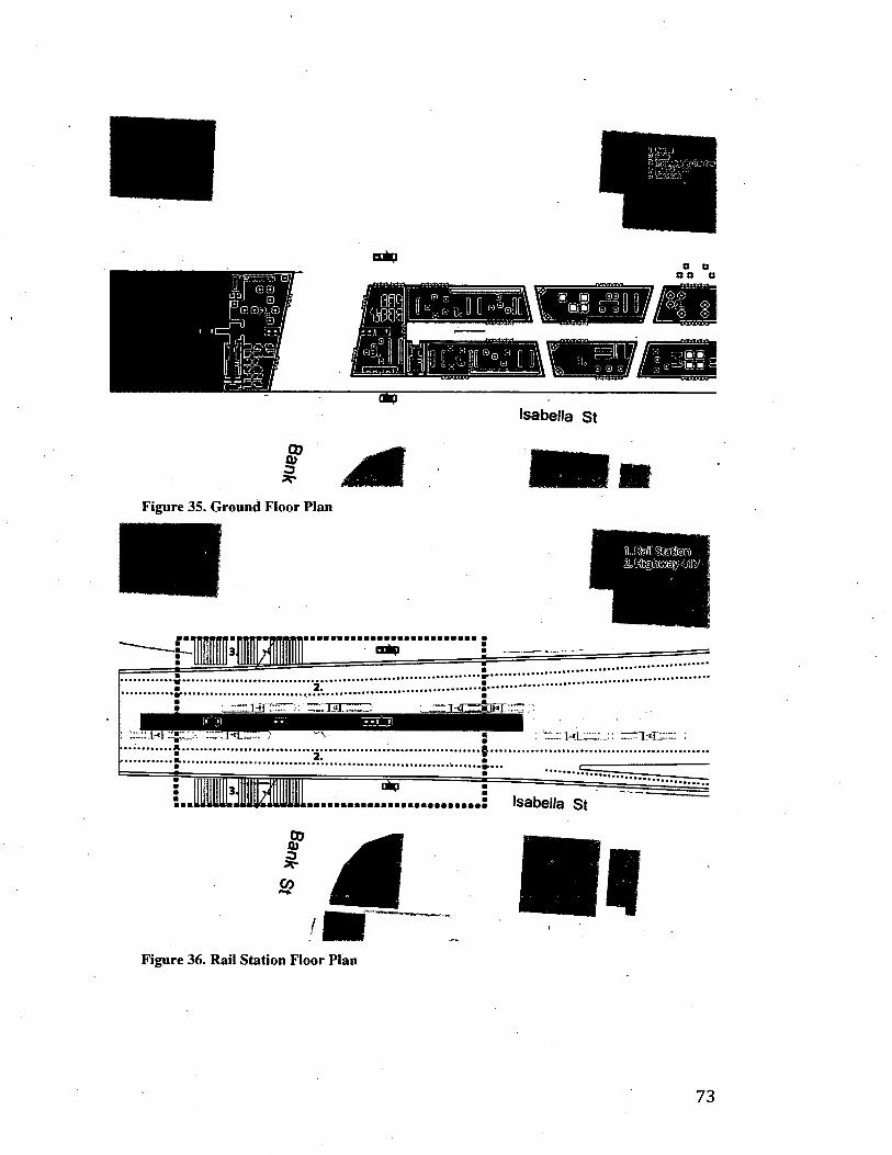
Isabella St
M Figure 35. Ground Floor Plan
a 1-cCdosj
Isabella St
CD 0) 3 *-
CO
Figure 36. Rail Station Floor Plan
73

© V®/
© © ©
© ©
© ©
©
1.
ft
1. ENTRY HALL 2. FOOD COURT 3. CAFE 4.SQUASH COURTS
5. POOL FACILITIES 6. SERVICES
Figure 36. Food Court
© CD © © © ©
© © ©
©
© ©
©
1. MAIN HALL . 2. CHANGING ROOMS 3. OFFICE HALL 4.CLINIC 5. POOL
Figure 37. Main Floor
74

® ©
<S> @ •J>
& ®
Co)
(h)
i
£££S
S
1. OFFICE 2. DANCE STUDIO 3. SOCCER FIELD 4. TRACK 5. OUTSIDE BLEACHERS
Figure 38. Roof Floor
® <*> $ ®
©
C°;
<s>
&
& 0
1. OFFICE 2. MARTIAL ARTS 3. SOCCER 4. TRACK 5. BLEACHERS
Figure 39. Office Spaces
75

1. OFFICE 2. GYM TOWER 3. OFFICE TOWER 4. SOCCER 5. TRACK 6. BLEACHERS
Figure 40. Office Spaces
BLEACHERS,
Figure 41. Roof Plan
76

IfSllSt
TRANSVERSAL SECTION B-B'
Figure 42. Transversal Section
'4?i
i'AYA1!1
£3 B
Figure 43. Longitudinal Section
77

ACNOWLEGMENTS.
Thank you.
To my advisor Inderbir S. Riar for creating a space of
creativity and research that inspired me to push beyond the academic
requirements of Carleton, therefore discovering new interests for my
professional life.
To my Mom, for her patience, support, and constant
motivation; for making this couple of years at Carleton possible, and
for showing me that a challenge can always be solved with hard work
and enthusiasm. To my Brothers and Sister, for their support and
encouragement.
To Hona, for being at my side, always believing in me. For
encouraging me to fully enjoy my time at Carleton. I couldn't have
done any of this with out you.
To Roger Connah, for giving me the chance to come to
Carleton.
To Dustin, Ray, Robin, Robbie and Kristen for making my
time at Carleton unforgettable.
78

Bibliography
1. Anielski, Mark. Ecological footprints of Canadian municipalities and regions (2005),
-http://www.anielski.com/Documents/EFA%20Report%20FINAL%2 0Feb%202.pdf. Accessed March 2, 2012.
2. Cauchon, Noulan, 1922 Federal district plan for Ottawa. https://qshare.queensu.ca/Users01/gordond/planningcanadascapital/c auchonl922/index.htm. Accessed September 20th, 2011.
3. City of Ottawa. Fast Facts Ottawa Light Rail. http://www.ottawalightrail.ca/en/project-plan/fast-facts/page:5. Accessed March 13th, 2012.
4. City Of Ottawa. Ottawa Light Rail, Background, Task Force Report. http://Www.ottawalightrail.ca/en/project-plan/background. Accessed March 13th, 2012.
5. City of Ottawa, Official Plan Ottawa. http://www.ottawa.ca/city_hall/ottawa2020/official_plan/vol_ 1/pdf/s ection_01_en.pdf. Accessed March 1st, 2012.
6. City of Ottawa, Ottawa 2020 management Plan. Ottawa pedestrian Plan. http://ottawa.ca/cs/groups/content/ @ webottawa/documents/pdf/mda w/mdyw/~edisp/con041239.pdf. Accessed October 20th, 2011.
7. City of Ottawa. The Ottawa 2020 process and the guiding principles. http://www.ottawa.ca/city_hall/ottawa2020/official_plan/vol_l/01_i ntroduction/index_en-03.html. Accessed March 12th, 2012.
8. Cockburn, Neco. Battle Lines Forming as Bronson Makeover Looms. The Ottawa Citizen, Section C. November 24th, 2011.
9. Dobby Christine, Rapid Growth: Coming to a City Near You, The Ottawa Citizen, Section D Pg. 1. November 24 2011
10. Gehl Jan. 2010. Cities for People. Washington D.C. Island Press.
11. Gordon, David. 1998. A City Beautiful Plan for Canada's Capital: Edward Bennett and the 1915 Plan for Ottawa and Hull. Planning Perspectives: 13. https://qshare.queensu.ca/Users01/gordond/planningcanadascapital/ bennettl915/review_DG_Ottawal915.pdf. Accessed February 15th, 2011.
12. Gordon, David. Weaving a Modern Plan for Canada's Capital: Jacques Greberand the 1950 Plan for The National Capital Region.
79

https://qshare.queensu.ca/Users01/gordond/planningcanadascapital/ greberl950/Greber_review.htm. Accessed September 20th, 2011
13. Graham Stephen and Marvin Simon. 2001. Splintering Urbanism networked infrastructures, technological mobilities and the urban condition. Routledge, New York. .
14. HDR | iTRANS. National Capital Region Travel Trend Study (2011). TRANS Committee, http://www.ncr-trans-rcn.ca/uploadedFiles/resources/NCRT rendStudyPart 1 -FinalReport_20110207.pdf. Accessed March 1, 2011.
15. Hoete, Anthony. 2003. ROAM Reader On the Aesthetics of Mobility, Black Dog Publishing, London.
16. Koolhaas Rem and Mau Bruce. 1995. S, M, L, XL, Essay: The Generic City. Monacelli Press.
17. Kopp, Anatole. 1970. Town and Revolution; Soviet Architecture and City Planning, 1917-1935. New York: G. Braziller
18. Lissitzky, El. 1970. Russia: architecture for world revolution. Cambridge, Massachusetts: MIT Press
19. Luck et al. 2001. The urban funnel and the spatially heterogeneous ecological footprint. Ecosystems 4.
20. McKinsey Global Institute. Urban World: Mapping the Economic Power of Cities. McKinsey & Company, March 2011.
21. National Capital Commission (NCC). Horizon 2067 the plan for Canada's Capital. http://www.canadascapital.gc.ca/sites/default/files/pubs/charting-the-future-of-canadas-capital-in-the-21 st-century.pdf. Accessed February 29th, 2012.
22. Newman Peter & Jennings Isabella. 2008. Cities as sustainable ecosystems: principles and practices. Washington D.C. Island Press.
23. Outram Christine, Biderman Assaf and Ratt Carloi. 2010. Self Engineering Ecologies. Ecological Urbanism, Lars Muller Publishers.
24. Rogers, Richard. 1998. Cities for a Small Planet. Westview Press
25. Todd, Frederick. 1903. Preliminary report for the Ottawa improvement commission. https://qshare.queensu.ca/Users01/gordond/planningcanadascapital/t oddl903/Title.htm. Accessed September 20th, 2011.
80

26. Tunney, Catharine. Community Hails Bronson Ave. Decision. Centretown News. February 3rd, 2012.
27. United Nations Environment Programme (UNEP). Glossary of environmental terms, http://www.nyo.unep.org/action/apl.htm. Accessed October 28th, 2011.
28. Vanderbilt, Tom. 2008. Traffic, Why we drive the way we do (and what says about us). Random House Inc.
29. Vuchic, Vukan R. 2007.Urban Transit Systems and Technology. Hoboken, NJ: John Wiley & Sons. Print.
81

Generative Urbanism: Re-Imagining the Mid-size City
BY FELIPE GONZALEZ
A thesis submitted to
The Faculty of Graduate and Postdoctoral Affairs
in partial fulfillment of the requirements for the degree of
Master of Architecture Professional
Azrieli School of Architecture and Urbanism
Carleton University
Ottawa, Ontario
© 2012 Felipe Gonzalez

Library and Archives Canada
Published Heritage Branch
Bibliotheque et Archives Canada
Direction du Patrimoine de I'edition
395 Wellington Street Ottawa ON K1A0N4 Canada
395, rue Wellington Ottawa ON K1A 0N4 Canada
Your file Votre reference
ISBN: 978-0-494-91535-6
Our file Notre reference
ISBN: 978-0-494-91535-6
NOTICE:
The author has granted a nonexclusive license allowing Library and Archives Canada to reproduce, publish, archive, preserve, conserve, communicate to the public by telecommunication or on the Internet, loan, distrbute and sell theses worldwide, for commercial or noncommercial purposes, in microform, paper, electronic and/or any other formats.
AVIS:
L'auteur a accorde une licence non exclusive permettant a la Bibliotheque et Archives Canada de reproduire, publier, archiver, sauvegarder, conserver, transmettre au public par telecommunication ou par I'lnternet, preter, distribuer et vendre des theses partout dans le monde, a des fins commerciales ou autres, sur support microforme, papier, electronique et/ou autres formats.
The author retains copyright ownership and moral rights in this thesis. Neither the thesis nor substantial extracts from it may be printed or otherwise reproduced without the author's permission.
L'auteur conserve la propriete du droit d'auteur et des droits moraux qui protege cette these. Ni la these ni des extraits substantiels de celle-ci ne doivent etre imprimes ou autrement reproduits sans son autorisation.
In compliance with the Canadian Privacy Act some supporting forms may have been removed from this thesis.
While these forms may be included in the document page count, their removal does not represent any loss of content from the thesis.
Conformement a la loi canadienne sur la protection de la vie privee, quelques formulaires secondaires ont ete enleves de cette these.
Bien que ces formulaires aient inclus dans la pagination, il n'y aura aucun contenu manquant.
Canada

Outline
Abstract 1
Introduction 2
Chapter One: Ottawa's Urban History
1.1 1903 - Preliminary Report to the Ottawa Improvement Corporation 4
1.2 1915 - Report of the Federal Plan Commission on a General Plan For the Cities of Ottawa and Hull 7
1.3 1922 - Federal District Plan For Ottawa 11
1.4 Proposal of a Federal District 11
1.5 A Modern Plan for Canada's Capital: 1950 Greber Plan 13
1.6 1988 Plan for Canada's Capital: A federal land use plan 18
1.7 1999 - The Plan for Canada's Capital 20
Chapter Two: Current and Future Ottawa
2.1 Current Ottawa 23
2.2 The Downtown Urban Design Strategy 2020 26
2.3 Case Studies: The LRT system 27
2.4 Case Studies: The Bronson "Makeover" 32
2.5 Development of "Midsize Cities" 33
Chapter Three: The Compact City
3.1 Sustainable Cities, Cities and Ecosystems 36
3.2 Ecosystems 37
3.3 Cities as Sustainable Ecosystems 38
3.4 Sustainable Transportation 40
3.5 Biodiversity * 41

3.6 Metabolism of Cities 42
Chapter Four: The Carless City
4.1 The effects of Car Culture, Urban effects of car culture 45
4.2 Ecology and Car Culture 48
4.3 Sustainable Transportation Systems 49
4.4 Rail Transit Modes 49
4.4.1 Light Rail Transit (LRT) 50
4.5 Rail versus Bus 51
4.6 Bicycles 52
4.7 Pedestrians 54
Chapter Five: Generative Urbanism
5.1 Actual Situation of Ottawa 56
5.2 Connecting Ottawa: From the suburbs to downtown. 57
5.3 Nodes, Transportation Hubs + Social condensers 60
5.4 Programmatic Bleed: Downtown Ottawa Master Plan 65
Post-script 68
Annex: Palace of the Body 70
Acknowledgments 78
Bibliography 79

Abstract
In the past two decades, architects and urban planners have been
searching for a new approach towards urban design. The
"modernist" approach created "car-based cities" with common
issues: sprawl, isolated suburbs, and depressed urban cores.
Most urban centers, especially developing and "mid-size" cities,
are struggling with these issues, which are affecting their
productivity and efficiency.
Generative Urbanism is a proposal towards the social and
spatial improvement of the "Mid-size City". It takes advantage
of the attributes of the existing city and mitigating its
deficiencies. The project is based in Ottawa, Canada, a capital
city with a difficult history of urban planning. Ottawa is a "car-
based" city, facing complex issues of commuting, mass
transportation, and overwhelming urban growth. The resulting
architecture project ["Palace of the body"] develops strategies
that connects the urban center with its surroundings, creates
spaces for inter-action, and improves existing and future
infrastructure and mass transportation systems.
Generative Urbanism re-imagines the "mid-size city" as a set of
new and existing networks that work to generate a livable,
functioning urban entity by linking new social programs to the
provision of large-scale infrastructure.
1

Introduction
We live in a world that is highly urbanized; in 1900 only a tenth
of the world's population lived in cities.1 Today more than half
the world's population lives in an urban center. The global urban
population is growing at a staggering pace, concentrating
development and economy within the urban boundaries. This
expansion has created a new scenario, making architects and
urban planners challenge the way cities have been conceived.
Our cities are a result of a "modernist" approach based on the
use of the automobile, and the development of its infrastructure.
The lack of success in managing urban growth added to a
massive appeal of the automobile has resulted in a migration of
population and activities to the outskirts of the urban core. The
extensive suburban developments of the last decades has led to
decentralized cities with complex commuting issues, depressed
urban cores and an increase in congestion and pollution.
These issues are gradually developing in "midsize" cities. In the
recent past, "megacities" accommodated urban migration, but its
"economies of scale" are saturated, opening the door for
"midsize" cities to become generators of economic activity. The
competitiveness and quality of life of these cities depend on how
these issues are undertaken; and what urban possibilities arise
from these solutions. At the moment, cities are focusing on
developing sustainable policies for their current and future
plans. Most of these policies focus on technical subjects,
1 Rogers, Richard. 1998. Cities for a Small Planet. Westview Press, p.4
2

neglecting the most important ingredient in the urban realm: its
inhabitants.
Ottawa is one of these "midsize" cities; as the capital of Canada
it appeals towards locals, visitors and investors. But Ottawa is a
"car-based" city, it no longer has a lively downtown, it is not
stimulating, and its streets and public places lack small events
and convergence of activities. These issues combined with
public concerns towards the mass transportation system and
long commutes reflect in Ottawa's lack of competitiveness and
importance compared to other "midsize" cities in Canada.
This thesis addresses the potential of combining existing and
new networks to generate an alternative proposal of the "mid
size" city. Generative Urbanism intends to create new links
between existing infrastructures, mass transportation, and new
social programs. It proposes new spaces of interaction that link
the city with its center, by providing spaces for its inhabitants to
have new social experiences. These new spaces would
ultimately transform the "mid-size" city into a competitive and
efficient urban center filled with activity, bringing its inhabitants
together to fully develop its potential.
3

1. Ottawa's Urban History
1876-1900 1956 2000 s
< .<
Figure 1. Ottawa's Urban Growth From 1876 to 2000's. Source: National
Capital Commission (NCC) 2010
1.11903 - Preliminary Report to the Ottawa Improvement
Corporation
In 1903 Frederick G. Todd (1876 -1948) was assigned to
produce a Report for the Ottawa Improvement Corporation.
Todd was the founder of the Town Planning Institute of Canada
and perhaps the first professional landscape architect in the
country2. Ottawa had an extensive amount of land, a growing
population and unlimited source of waterpower for
manufacturing. To take advantage of this, Todd presented a
scheme based on the design of parks and open spaces to give the
Capital a "national Character".
At the time, people wanted Ottawa to be the " Washington of the
North"; but Todd completely disagreed, due to Ottawa's
landscape characteristics. Instead, Todd proposed a plan for the
future, suggesting great spaces for enjoyment in natural open
areas. This would prevent crowded populations and promote
2 Todd, Frederick. 1903. Preliminary report for the Ottawa improvement commission. https://qshare.queensu.ca/Users01/gordond/planningcanadascapital/todd 1903/ Title.htm. Accessed September 20th, 2011.
4

health and pleasure. He anticipated Ottawa's dual stand between
nature and industry, a conflict that he considered decisive in the
future development of the Capital. The park system designed by
Todd had the following components:
Large natural parks or reserves
Canada has some of the most beautiful forests in the
world, for this reason Todd thought it was suitable to
keep forest reserves close to the Capital city. These
reserves would be examples of the natural forests for
future generations and a place of nature that could be
found at driving distance.3
Suburban Parks
Todd considered suburban parks vital for the city. This
medium size parks were supposed to be located at a short
distance from the city core. He considered that the use of
these parks would animate the city, giving those who
couldn't go out of the city in the summer a place for
leisure and enjoyment.4
Boulevards and parkways
Boulevards and parkways are connecting routes,
especially between the parks, the center of the city and
through the riverbanks.
3 Todd, P. 7 4 Todd, P. 10

Waterway parks - Bathing
Waterway parks are located along the banks of the river.
Todd proposed that these waterway parks were designed
in a way that people could use them for bathing. By
doing this, the city would create a bathing culture and
recognition of the bodies of water as an important asset
of the city.5
City Parks and Squares
Since 1903 Todd anticipated the importance of small
squares and city parks for a city. He saw them as
breathing spaces that should be located throughout the
city to counteract the crowded areas within the urban
fabric. The city parks and squares proposed were
different from the suburban parks; they provided a place
for recreation in the immediate neighbourhood.6
Although Frederick Todd advised the commission to follow his
preliminary parks plan for the capital; the Ottawa improvement
commission decided to drop him as a consultant and relied on
his staff to finish his work. Some of the parks proposed by Todd
were built, but the work made by the OIC after he was dropped
was disappointing. Although his plan was not completely taken
into consideration, many of its parks and parkways resurfaced
later on plans by Bennett (1915), Cauchon (1923) and Greber
(1950).
5 Todd, P. 22 6 Todd, P. 23

Figure 2. 1903 Parks Plan. Source: Todd, Frederick. 1903. Preliminary
report for the Ottawa improvement commission.
1.2 1915 - Report of the Federal Plan Commission on a
General Plan for the Cities of Ottawa and Hull
The early years of the OIC were highly criticized; coincidentally
they overlapped with the emergence of modern city planning in
North America and Britain. During 1911 a typhoid epidemic
and a housing shortage made Ottawa a principal candidate for a
new city plan. After intense political battles, the federal plan
commission appointed architect Edward Bennett as chief
planning consultant (1913). The decision was appropriate, since
Bennett was among the finest American planners of his time and
a leading voice in the 'City Beautiful' movement.7
7 Gordon, David. 1998. A City Beautiful Plan for Canada's Capital: Edward Bennett and the 1915 Plan for Ottawa and Hull. Planning Perspectives: 13. pg. 275. https://qshare.queensu.ca/Users01/gordond/planningcanadascapital/bennettl9 15/review_DG_Ottawal915.pdf. Accessed February 15th, 2011.

Bennett's Plan was presented in an exhibition at the Downtown
Ottawa Office building in January 1915. The 1915 plan for the
Federal Plan Commission consisted of the following
components:
Regional parks and forest preserves system
Parkway and Playground plan
Street layout for future suburban expansion
Regional passenger and freight railway plans
Regional Highway plans
New plans for street railway lines
Utility Analysis
Waterway and flood analysis
Plans for municipal and federal government buildings
Central business district plan
Preliminary Zoning scheme
The analyses made for this plan were well thought out and
consequently predicted much of Ottawa's future development.
The population projections were accurate, stating that the
Ottawa-Hull region would grow from 125,000 to 250,000 by O
1950. The parks system followed much of Todd's previous
analysis. Bennett's team also prepared an estimate on traffic and
rail system based on other American cities. It turned out to be
relevant except on what concerned the use of the automobile,
which had conservative projections.9 Bennett did not expect the
massive appeal automobiles would have in the future. Probably
one of the most insightful outcomes was in the Railway plans.
Bennett saw a problem regarding the future streetcar congestion
8 Gordon, P. 284 9 Gordon, P.284
8

downtown, and advised the city to consider a streetcar subway
under Wellington Street10.
Bennett gave the city a new identity by organizing the
government center. He placed the parliament building on the
edge of Barrack Hill; this was a special site due to its landscape
characteristics (the view towards the river and its visual
notoriety towards the city). In this reorganization, Bennett
proposed that all federal government buildings were located
along Wellington Street (west), while all the municipal
buildings, along Elgin Street (south-east). 11 The 1915 plan
included Hull, the overlooked parallel city across the river.
Bennett proposed its civic center and bridge connections to
Ottawa.
One of the most interesting decisions in the plan was the zoning
provision; separating the city into six different districts ranging
from industrial, transport areas to residential. Bennett also
included height limitations to protect the prominence of the
Parliament Buildings.
The 1915 plan was one of Canada's first comprehensive plans.12
Unfortunately, its implementation and fate where not as
successful, and wias finally ignored. The Federal Commission
made crucial mistakes in the printing and translation of the
report. Those mistakes translated into distribution issues
throughout Canada, and even some political rejection. The plan
was finally dropped. Canada was focused on war, and on the
reconstruction of the Centre Block of the Parliament Buildings,
10 Gordon, P. 285 11 Gordon, P.285 12 Gordon, P. 275
9

which caught fire. Either way, the plan suffered from opposition
towards the 'City Beautiful' style consequently it was said it
focused more on aesthetics than on town planning. This resulted
to be its final downfall.
Figure 3. Drawing # 5 City of Ottawa, view of proposed municipal and
railway centre and General Street System. Source: 1915 General plan for
the cities of Ottawa an Hull
mi. rus*
Figure 4. General Street System. Source: 1915 General plan for the cities of
Ottawa an Hull
10

1.3 1922- Federal District Plan For Ottawa
Ottawa was entering a complicated path that other cities such as
London or. Washington did before. They developed different
plans but they partially implemented them or did not execute
them at all. The 1922 plan acknowledged that Ottawa didn't
have a concrete plan for its current and future dimensions. The
result of past plans had left the city with a tangible parliament
building area, an urban grid and a few spaces saved for public
gatherings.
Other than that, the city was suffering with a housing deficit that
was evident since the 1915 plan. There were major health
concerns due to slums establishing around and inside the city.
This problem started to contrast against the natural beauty and
landscape.13
The city of Hull was also a concern within the Federal District
Plan. It was considered that Hull had been neglected in the past.
The creation of a provincial town-planning department was vital
to include Hull in the Capital Region.
1.4 Proposal of a Federal District
Noulan Cauchon, a consulting engineer and town planner,
submitted a proposal to reconsider the political organization
within the Capital Region (1922). He suggested the creation of a
" Federal District Commission" that would be in charge of
"controlling and developing the physical and infrastructural
13 Cauchon, Noulan. 1922 Federal district plan for Ottawa. https://qshare.queensu.ca/Users01/gordond/planningcanadascapital/cauchonl 922/index.htm. Accessed September 20th, 2011.
11

projects within the cities of Ottawa, Hull and its
surroundings"14. Consequently, municipalities were going to
give up some of its political power to a commission of experts
that would guide the development of both cities. The new
commission's main objective was to guide the execution of
plans considering current and future conditions. The 1922 plan
proposed the following15:
Railways
The plan proposed the reorganization of the railway
system by eliminating excessive amount of tracks and
maintenance; it was imperative to improve the efficiency
of the system.
Railways Right of Way and Rapid Transit Railways
The proposal consisted on turning radial railways into
radial highways, thus creating rapid connections with the
city. This allowed citizens to move longer distances,
hence the possibility of having new housing areas for
development.
Power and Industrial Development
A proposed dam at the "Little Chaudiere" would create
additional power needed for the industrial development
of the city. Ottawa has always been situated in a strategic
location within the economic map of the country. The
proposal wanted to take advantage of the natural
resources of the region.
14 A Federal District for Ottawa, Journal of the Town Planning Institute of
Canada, Vol. 1, No. 9, April 1922, P. 3-6 15 A Federal District for Ottawa, P.3-6
12

National Parks
The plan proposed a national park at the Laurentian hills
that started at the dam in the shore of the Ottawa River
and extended towards the north. This mountain park was
complementary to other proposals of internal parks and
parkways within the Capital city.
fMUMfeiri frtirwft n.a^vt«r* tHSTIu >»•.
Feotfcw, OWWICT BUN
Figure 5. Federal District Plan. Source: Cauchon, Noulan, 1922 Federal
District Plan,
1.5 A Modern Plan for Canada's Capital: 1950 Greber Plan
After another disappointing and unfulfilled plan, Ottawa was
still a chaotic and irregular city. Prime Minister Mackenzie
King was determined to give Canadians a proper Capital. King,
believed in town planning as a social reform tool, and
understood the potential and the importance the city could have
not only for its citizens but also for all Canadians.16 Ottawa and
16 Gordon, David. Weaving a Modern Plan for Canada's Capital: Jacques Greber and the 1950 Plan for The National Capital Region. https://qshare.queensu.ca/Users01/gordond/planningcanadascapital/greberl95 0/Greber_review.htm. Accessed September 20th, 2011.
13

Hull were immersed in an urban crisis. Both cities needed major
improvements especially after World War II. In 1945, the city of
Ottawa was crowded with temporary wood structures used as
office buildings; this condition added to the infrastructure chaos
and resulted in an unbearable situation.17
Prime Minister King met Jacques Greber during a trip to Paris in
1936. King instantly connected with Greber. Greber was
France's leading urban planner and chief architect of the 1937
Paris World Fair site that Mackenzie King was visiting. Greber
had experience working in North America; he worked on the
1917 Master Plan for the Benjamin Franklin Parkway
(Philadelphia), among other private park commissions.
On this trip, King interviewed Greber and invited him to Ottawa
to prepare an urban plan for the city's core. Greber travelled to
Ottawa in 1937, and quickly understood the infrastructure
problems the city was facing. He proposed an initial plan
combining elements of Bennett and Cauchon's proposals. The
result was the National War Memorial and Plaza unveiled in the
Royal visit in 1939.18
After the success of the War Memorial King invited Greber to
continue its plan for Ottawa and multiply its effect all
throughout the downtown area. The plan got stalled due to the
Second World War, when Greber had to return to France and
was accounted for the reconstruction of Nord-Normandie.
17 Gordon, Weaving a Modem Plan for Canada's Capital: Jacques Greber and the 1950 Plan for The National Capital Region. Accessed September 20th, 2011 18 Gordon, Weaving a Modern Plan for Canada's Capital: Jacques Greber and the 1950 Plan for The National Capital Region. Accessed September 20th, 2011
14

To ensure success, King established the NCPC (National Capital
Planning Committee), which was independent from the FDC
(Federal District Commission) and had representatives from
across Canada.19 Greber was appointed as consultant for the
NCPS (National Capital Planning Service), the "only full time
professional planning organization in Canada (1945)".20 With a
team of architects, planners, Landscape architects and engineers
Greber started the plan for a National Capital Region that
included both Ottawa and Quebec side of the river. The
components of the 1950 Plan were:
Relocation of the Railway system and industries from
the inner city to the suburbs
Construction of new cross boulevards and bridges
Decentralization of government offices to the suburbs
Slum clearance and urban renewal of LeBreton Flats
Expansion of urban area from 250,000 to 500,000 lots
Surround future urban area with a Greenbelt
A wilderness park at the Gatineau Hills and park systems
along the rivers and canal
The relocation of the railway system turned to be crucial for the
1950's plan. It helped to reorganize the infrastructure of the
downtown core by reconnecting the road grid and separating
industry from housing areas. The government buildings were
relocated near Parliament Hill; research, administrative and
office areas were decentralized to suburban office parks. This
19 Gordon, Weaving a Modern Plan for Canada's Capital: Jacques Greber and the 1950 Plan for The National Capital Region. Accessed September 20 2011 20 Gordon, Weaving a Modern Plan for Canada's Capital: Jacques Greber and the 1950 Plan for The National Capital Region. Accessed February 29 2012
15

allowed the city to get rid of the temporary buildings and free up
space for public institutions such as libraries, theaters and
galleries.
The four-kilometer Greenbelt was planned around the urban
areas to control sprawl and limit urbanization. If the city grew
beyond 500,000 neighbourhood units it had to take place outside i
the Greenbelt, in Satellite towns. Greber recommended
expanding the parkways all the way to the Greenbelt and to
extend the Gatineau Park as close as possible to the downtown
core.
One of the major problems the plan had was its population
projection. No one expected the post-war baby boom and a
strong government expansion. This resulted in a city of 500,000
in 1966 that grew to 1,1 million by 1996.22 By 1970, the
suburban expansion outside the Greenbelt started, and the
northern area of the Greenbelt (Quebec side), was completely
populated.
Unfortunately the design of the streets and boulevards made by
Greber were not taken into account. In fact, most of the street
designs were made by provincial and regional traffic engineers,
which didn't have the special touch that Greber expected. This
resulted in streets and boulevards that omitted street furniture
and substantial sidewalks in favour of traffic space.23 Finally,
the skyline that Bennett and Greber tried to preserve was ruined
21 A proposal based on Ebenezer Howard's 1898 social cities scheme 22 Gordon, Weaving a Modern Plan for Canada's Capital: Jacques Greber and the 1950 Plan for The National Capital Region. Accessed September 20 2011 23 Gordon, Weaving a Modem Plan for Canada's Capital: Jacques Greber and the 1950 Plan for The National Capital Region. Accessed September 20 2011
16

in 1965. In favour of more tax income, the government allowed
skyscrapers in the downtown area to surpass the limit height.
This ruined the view of Parliament hill from the south.
The 1950 Plan was the first urban plan that was implemented
almost to completion. Mackenzie King's dream was fulfilled
and the Ottawa became a genuine capital city. The
reorganization of infrastructure, the investment in sewage
treatments for the river, and the eventual construction of the
Queensway changed completely the way the city operated. The
open (Green) space network became iconic in the city. These
changes transformed the public and leisure spaces developing
tourism and a higher quality of life.
Figure 6. Master Plan. Greber, Jacques Source: 1950 Plan for The National
Capital Region
17

Figure 7. Proposed Highway Plan. Greber, Jacques Source: 1950 Plan for
The National Capital Region
1.6 1988 Plan for Canada's Capital: A federal land use
plan
It took more than two decades to complete Greber's 1950 plan.
During this time, especially in the late 1960s, Ottawa suffered
changes that had a meaningful influence on the city's future. In
February 1969, during the Federal-Provincial Constitutional
Conference, the city modified its boundaries integrating Ottawa,
Hull and its surroundings. A new rule for the distribution of
Federal employment was issued. Federal employment had to
represent the demographic distribution of the Capital Region. To
make this happen a new business area was created in Hull,
changing its skyline and urban relations towards Ottawa.
18

In the late 1960s, two other changes influenced Ottawa's future:
the creation of regional bodies with planning mandates, and new
obligations for the NCC. Ontario created the Regional
Municipality of Ottawa-Carleton, while Quebec created the
Outaouais Regional Community. Both regional bodies had
major influences in how the region was managed, and how its
municipal services were executed. On the other hand, the NCC
focused on transforming Canada's Capital into a "meeting place
for all, that had to be preserved, and its national identity
displayed". By the end of the 1980s, Greber's plan was
completed; the city needed a new vision for the Capital.
In 1988, the new Federal Land Use Plan aimed to transform
Canada's capital into a national symbol. It emphasized
renovating public spaces into "Capital Stages". The idea was to
incentivize tourism by improving the quality of city spaces and
the access to the Capital. The plan also concentrated on boosting
collaborations between planning entities within the region. The
Plan had 4 main goals:
Consolidation of the federal presence in the Capital:
priority to political, cultural and administrative
institutions on federal lands, distributed the public
service in the region, established cultural, national and
international institutions in the city core and others
Enhancement of the Capital's green image and greater
accessibility to riverbanks: institute and protect the park
network, improve network of recreational pathways,
guarantee public access to shore lands)
19

Enhance the quality and appearance of arrival points and
scenic entries to the Capital: improve scenic routes and
attractions, institutions, facilities and events of national
importance, and improve the entry points to the City
Focus on the Capital as a symbol: creation of new urban
design policies for the city24
The 1988 Plan left an imprint on Canada's Capital. It created
events such as the Canada Day celebrations and Winterlude. It
promoted tourism and started to develop tools to attract visitors.
There was an intense program of restoration and beautification
of major parks and heritage buildings. And finally, major
infrastructure rehabilitation took place specifically in the main
entrances to the city and in the development of the first phase of
Confederation Boulevard.
1.7 1999 - The Plan for Canada's Capital
The closing decade of the 20th century embodied technological
and social changes that eventually started to influence planning
and city building. The 1999 Plan for Canada's Capital
recognized these changes and adapted the previous plan towards
a sustainable, fast-growing, and multicultural city. Ottawa
started to develop an interest in sustainable planning principles,
which would become fundamental taking account the
importance of its natural assets and its future population growth.
24 National Capital Commission (NCC). Horizon 2067 the plan for Canada's Capital. Pg.28. http://www.canadascapital.gc.ca/sites/default/files/pubs/charting-the-future-of-canadas-capital-in-the-21st-century.pdf. Accessed February 29th, 2012.
20

Canada was also facing other social changes that influenced
Ottawa's future plans: an aging population, immigration and
cultural diversity, new information technologies and an
increasing role of other provinces. These issues forced the city
to increase interaction between planning regional bodies towards
the development of a new plan for the Capital Region.
The Plan for Canada's Capital intended to amalgamate the needs
of the city with those of the region. The main goals of the 1999
Plan were Capital Settings, Capital Destinations and Capital
Links:
Capital Settings: New sustainable principles adopted in
city planning gave relevance to the protection of parks
and public spaces. This became a fundamental issue for
the city.
Capital Destinations: Ottawa increases preservation
policies and intends to showcase cultural heritage and
destination points to Canadians and foreign tourists. The
city supports the development of Confederation
Boulevard and the preservation of Parliament Hill as
significant national cultural sites in the Capital core.
Capital Links: The plan proposes better connections and
entrance points to the Capital Region. This includes
interprovincial bridges, parkways and improving the
transportation network.
25 National Capital Commission (NCC). Horizon 2067 the plan for Canada's Capital. P. 27
21

After the implementation of the 1999 Plan, Downtown Ottawa
and Gatineau were linked by the completion of the
Confederation Boulevard project. Other infrastructure projects
were executed (refurbishment of the Champlain Bridge), and a
significant amount of land was acquired. Although this was
important, the plan lacked execution in terms of its main goal: a
more sustainable, fast growing, multicultural city. In
consequence, a new strategy was proposed a few years later.
22

2. Current and Future Ottawa
2.1 Current Ottawa
Ottawa has slowly established itself as a Capital city. It is
Canada's 4th largest city, with a population of 800,000
inhabitants (1.1 million in its Metropolitan area). The Capital is
not only recognized for its vast natural and agricultural areas. It
is gradually becoming one of Canada's cultural centers, a high
tech research hub (with top Universities within its boundaries),
and it is one of the top telecommunications research and
development centers in the world. Ottawa has Canada's highest
household income, and the most highly educated workforce in
the country. The Capital has become a multicultural city; its
Canada's 4th urban center for immigration, with 25% of its
residents bom outside the country.26
Since the 1999 plan, Ottawa has faced new stimulating
challenges. In 2001, the city decided to change its government
structure by amalgamating 11 urban and rural municipalities and
1 regional municipality into 1 government structure. Taking this
into account, the new city expects an incredible level of growth.
A modest city, getting close to 800,000 inhabitants in the year
2000, is expected to grow to around 1,2 million or more within
the next 20 years; transforming Ottawa into a complex urban
region.
To respond to the new challenges, Ottawa has developed an
26 City of Ottawa, Official Plan Ottawa. Pg. 1 http://www.ottawa.ca/city_hall/ottawa2020/official_plan/vol_l/pdfsection_0 l_en.pdf. Accessed March 1st, 2012.
23

official plan based on the premise of sustainability.27 Ottawa has
acknowledged that it has to face similar challenges as other
North American cities: weakening of the ecosystem, population
growth, extensive use of the automobile and consumerism.
Accordingly, Ottawa has developed a framework to manage its
future growth. "Ottawa 20/20" view the city as a "compact, >JQ
efficient, equitable, affordable, environmentally healthy city".
Within Ottawa 20/20 there is an Official Plan that supports the
development inside and out the urban boundaries. It explores the
possibilities the city has to increase its residential and
employment densities along the main corridors. It also examines
alternatives to the automobile through the promotion of new
transit possibilities, cycling and walking. Ottawa 2020 has seven
principles that direct the city's future:
A Caring and Inclusive City: Ottawa should be diverse
and inclusive, with infrastructure for the disabled and
inviting to new comers, immigrants and seniors. It
should engage more with its citizens and fulfill its basic
needs (such as security, leisure, transit, housing, among
others).
A Creative City, Rich in Heritage, and Unique in
Identity: Ottawa should promote a vibrant and
attractive mix of activities within the arts and creative
27 Sustainable development is defined by the Official Plan as:" development that meets the need of the present generation without compromising the ability of future generations to meet their own needs". City of Ottawa,Official Plan Ottawa. Pg. 1 http://www.ottawa.ca/city_hall/ottawa2020/officiaLplan/vol_l/pdf/section_0 l_en.pdf. Accessed March 1st, 2012. 28 City of Ottawa, Ottawa 2020 management Plan. Ottawa pedestrian Plan. P g l l . http://ottawa.ca/cs/groups/content/@webottawa/documents/pdf/mdaw/mdyw/ ~edisp/con041239.pdf. Accessed October 20th, 2011.
24

realm. It should generate a sense of place with its local
heritage, arts, culture and its unique landscape.
A Green and Environmentally Sensitive City: Ottawa
should preserve and strengthen its relationship with the
natural habitats and the green spaces network. It should
focus its future transportation needs on transit modes,
cycling and walking. And should develop land wisely
within the city avoiding urban sprawl.
A City of Distinct Liveable Communities:
Communities in Ottawa are in need of an identity that
makes them feel proud and that they are an integral part
of the city. These communities have to be aesthetically
pleasing and well connected between each other. They
have to be well balanced between housing, employment
and leisure activities and green spaces.
An Innovative City where Prosperity is Shared
among All: Ottawa wants to create a vibrant economy
based on strong local businesses and a recognized rural
economy. The city wants to encourage education,
training, and information to overcome obstacles and
increase employment opportunities.
A Responsible and Responsive City: Ottawa wants to
be responsible with its finances; the city wants the
general public to be aware and knowledgeable of what is
going on in order to be able to contribute.
25

A Healthy and Active City: Ottawa wants to create an
environment where sports and recreation are main activities
within its society. This will promote health through the
creation of community facilities that are accessible to all. 29
2.2 The Downtown Urban Design Strategy 2020
With Ottawa 20/20, the city has prepared the "Downtown
Ottawa Urban Design Strategy". This plan recognizes the
downtown area as an essential focal point of the city. The aim of
"Downtown Ottawa Urban Design Strategy" is to re-urbanize
the area by increasing the quality of public and urban
environments. Consequently transforming a downtown area
defined by its business district into an economical/cultural core
full of vitality and activity. This new local identity should meet
the "needs and demands" of a city of more than a million
inhabitants.
The "Downtown Ottawa Urban Design Strategy" suggests a
central area that encourages new residential developments,
improves access to water and green spaces and promotes mixed-
use projects. It also recommends reducing de reliance on
automobiles by making public transit a priority and supporting
walking and biking as means of transportation. It urges the use
of compact/mixed use projects to reduce transportation
demands, which would also help to minimize the land used for
parking. The strategy also promotes heritage and conservation as
principal themes within the urban core.
29 City of Ottawa. The Ottawa 2020 process and the guiding principles. http://www.ottawa.ca/city_hall/ottawa2020/official_plan/vol_l/01_introducti on/index_en-03.html. Accessed March 12th, 2012.
26

The "Downtown Ottawa Urban Strategy" creates a framework
for the development of streetscape infrastructure, open spaces,
and art. It targets 41 different strategies, which are a shared
vision of the City of Ottawa, the National Capital Commission
and the neighbourhoods. In this context, the downtown area
becomes a central aspect in redefining the image of the city.
Through these strategies the City of Ottawa expects to
reconfigure public infrastructure to create a positive, successful
and desirable place to live.
Figure 8. Downtown Urban Design Strategy 2020. Source City of Ottawa
2.3 Case Studies: The LRT system and The Bronson
Makeover
After realizing that the traffic issue in Ottawa is growing year-
by-year without apparent solution, the city decided to pursue the
Light Rail System Project. The Project started in January 2007,
27

when a task force on transportation was created. They released
the "Moving Ottawa" report (June 2007), recommending an
"east-west rail tunnel bored through downtown to alleviate the
current transit bottleneck and build a more inviting
streetscape." 30 With this recommendation in hand, the
Transportation master plan was revised; consequently, cost and
affordability studies were executed establishing a funding
scheme.
The cost of the project was estimated in $2.1 billion, a budget
that was secured through the investment of provincial and
federal funds. With the budget secured, studies and plans started
in 2009. On May - June 2011 Council approved reports
concerning the schedule and implementation of the project.
Subsequently, on October 2011, the City shortlisted three
consortia that will formulate a Request for Proposal (RFP).31
The construction of this project will start in early 2013 and
should be operational by mid-2018.
Ottawa states that this project has multiple benefits. The project
will span 12.5 km from Tunney's pasture to Blair station, and
will have 13 stations. With this project the city expects to reduce
bus traffic by 50% within the city core, making Ottawa a
"friendly place for pedestrian and bicycle users". It is expected
that by 2031, transit ridership will increase by 78%. This makes
the LRT a priority taking account that the O-train already
30 City Of Ottawa. Ottawa Light Rail, Background, Task Force Report. http://www.ottawalightrail.ca/en/project-plan/background. Accessed March 13th, 2012. 31 The three consortia chosen by the city are: Ottawa Transit Partners, led by Vinci Concessions, Rideau Transit Group, led by ACS Infrasuucture Canada Inc.. Rideau Transit Partners, led by Bouygues Travaux Publics S.A.
28

exceeded its initial user forecast: 7,300 users a day (expected)
compared to 10,200 riders a day (current).32
Figure 9. Ottawa Light Rail. Source :City of Ottawa, www.
ottawalightrail.ca
Although the LRT project seems to be a positive proposal
towards improving the transportation system of the Capital, it
still raises concerns. After a 2.1 billion investment, the
introduction of the light rail will only increase 9% the transit use
within the city. In fact, auto drivers and auto passengers
dominate, accounting for 71% of transportation trips.33
HHSB ~ PMRciEFwrtrt Oltw Q#T
Figure 10. Ridership Share. Source City of Ottawa
32 City of Ottawa. Fast Facts Ottawa Light Rail. http://www.ottawalightrail.ca/en/project-plan/fast-facts/page:5. Accessed March 13th, 2012. 33 City Of Ottawa. Horizon 2067 The Plan For Canada's Capital. Pg. 63. http://www.canadascapital.gc.ca/sites/default/files/pubs/charting-the-future-of-canadas-capital-in-the-21st-century.pdf. Accesed November 11, 2011.
tuttte Tamil
Auto Pa sun 13%
M
29

As stated before, the LRT project will open new spaces for
pedestrian and bicycle users. But these users are only 12% of the
riders (11% walk, 1 % Bicycle). Although there is a bicycle plan
for 2018, it has a goal of increasing bicycle ridership from 1.7%
to 3% (by 2021). A very low increase considering that 73% of
households in Ottawa own bicycles54; and pioneer cities such as
Copenhagen have 36% of its population commuting to work.35
The LRT project is not specific in its connections and its role
within a multimodal transportation system.
The system is also conceived from Tunney's Pasture to Blair
Station. In the NCR "the leading districts in terms of population,
including several outer suburbs, contrast with the main sources
of employment, with the downtown centres of both Ottawa and
Gatineau having the lowest numbers of residents". 36
Accordingly, the centers have the highest amount of jobs but a
low population, resulting in high volume flows of commuters.
This is expected since 80% of the trips to Central Ottawa come
from other Ontario districts.37 Looking at the AM peak inter-
district flows from suburban Ottawa, and the PM peak inter-
district flows from central Ottawa, it is evident that a great
amount of frequent east-west trips will not be attended in the
proposed LRT project.
34 City of Ottawa. Ottawa Cycling Plan (2008). Chapter 1, Pg. 6. Chapter 2 Pg. 4,5 35 Outram Christine, Biderman Assaf and Ratt Carloi. 2010. Self Engineering Ecologies. Ecological Urbanism, Lars Muller Publishers. Pg. 172. 36 HDR | iTRANS. National Capital Region Travel Trend Study (2011). TRANS Committee, http://www.ncr-trans-rcn.ca/uploadedFiles/resources/NCRTrendStudyPart 1 -FinalReport_20110207.pdf. Accessed March 1, 2012 37 HDR | iTRANS. National Capital Region Travel Trend Study (2011). TRANS Committee. P. 38.
30

Figure 10. AM. peak inter-district flows from suburban Ottawa. Source
City of Ottawa, Source: National Capital Region Travel Trend Study (2011)
Figure 11. PM. peak inter-district flows from central Ottawa, Source:
National Capital Region Travel Trend Study (2011)
In fact, the city is planning major rezoning and redevelopment
around three of the stations of the LRT project. The stations
outside the city core are bordered by light industry and low-
density retail. If this situation continues, it is a possibility that
the LRT project will not have enough users as projected. The
city needs to double the population in these areas in the next 20
years to ensure success to the LRT project. If the LRT project
31

attended the inhabitants that come every day from the suburbs
and back, ridership would most likely be ensured. In contrast,
the city needs to find ways to elevate ridership and densify areas
that are between the downtown core and the disconnected
suburbs. In conclusion, the users that live in the suburbs will not
be attended by the LRT project; therefore they would still use
the automobile as their main transportation system.
2.4 The Bronson "Makeover"
On November 2011 it was publicly announced that Bronson
Avenue was going to undertake a makeover. The main reason
for reconstruction is to install new underground water and sewer
lines. Since the beginning, the community and residents opposed
this intervention. In the design, Bronson Avenue is going to be
widened 0.6 m. City staff understands that Bronson is already a
"constrained" Avenue, and that extra space for traffic is
necessary. On the other hand, residents feel that the Avenue's
new design goes against safety measures. They understand that
if the Avenue is wider, cars can go even faster and it would start
to feel like a "provincial highway".
Some community members recognize that the flow of traffic in
the Avenue is important, but they consider that widening streets
is closer to "1960's Thinking" coincidentally when traffic
engineers where in charge of street designs. The community is
concerned with the lack of care towards pedestrians and bicycle
users. They consider that it is very difficult to cross the street; an
38 Tunney, Catharine. Community Hails Bronson Ave. Decision. Centretown News. February 3rd, 2012. Pgl,2.
32

issue that is critical considering that Parks, housing, a school
and a Community Centre are bordering the Avenue.
The $30 million project has become quite controversial. Since
November, City Staff has made changes to its original design.
They have widened some sidewalks, but the street keeps the
same amount of lanes. Although residents expected major
improvements (like a "road diet" cutting 4 lanes to 3), they
didn't come through, and speeding, loss of tenants due to the
noisy street, and unsafe crossings will continue.39 The city
demonstrates once more its design priorities, continuing car-
based city policies over pedestrians.
2.5 Development of "Mid-size Cities"
Half of the world's population lives in cities, which indicates
that a massive urbanization has taken place. Growth in the last
decades has been focused on 'megacities'; metropolises with
populations over 10 million people. While cities such as Tokyo,
Los Angeles, or Mexico D.F. have been a substantial agent for
world economy, in the near future the trend will change.
According to the McKinsey Global Institute, there are 600 urban
centers (which have only a fifth of the population of the world)
that generate 60% of the global GDP (Gross Domestic
Product).40 McKinsey refers to them as "middleweight" cities,
urban centers with populations ranging from 150,000 to 10
million.
39 Cockburn, Neco. Battle Lines Forming as Bronson Makeover Looms. The Ottawa Citizen, Section C. November 24th, 2011. Pg.1,4. 40 McKinsey Global Institute. Urban World: Mapping the Economic Power of Cities. McKinsey & Company, March 2011.
33

These "middleweight" cities are expected to grow rapidly,
becoming by 2025 vital generators of economic activity. In fact,
McKinsey projects that these cities will report 50% of the global
GDP growth between 2007 and 2025. Though the cities with the
largest growth potential are located in the developing world,
Canada should consider this subject decisive since it has 20 of
the 600 "middleweight" cities within its territory. Canada should
focus its efforts in developing "regional - second cities" like
Ottawa and take advantage of this major growth potential.
Actually, these "middleweight" cities have another benefit: the
potential to innovate. Regional clusters such as Ottawa have the
possibility to unite diverse contributors (the private sector, the
public sector, academia, large corporations, entrepreneurs
among others), to pursue strategies and benefit from the
expected growth patterns.41 It is important that these cities are
prepared for the upcoming growth. Planning and management
strategies become fundamental to organize the immediate and
future objectives (50 years into the future). Therefore cities
would avoid problems that would deteriorate the quality of life
(congestion, pollution, lack of affordable housing,
infrastructure), which would reduce the possibility of having a
dynamic economy.
The reason why these middle size cities are such an influential
factor is the "economies of scale" than can be developed in
concentrated urban centers. This expansion will foster emerging
markets that will reduce poverty and create opportunities for
companies that can thrive form this dynamic situation. But this
41 Dobby Christine, Rapid Growth: Coming to a City Near You, The Ottawa Citizen, Section D Pg. 1. November 24 2011
34

growth can only happen if the cities manage correctly future
challenges. Cities will be obliged to anticipate urban trends, and
they should be ready to handle complex scenarios that will
gradually emulate the ones larger cities have. The "economies of
scale" will allow industries to be more efficient and augment its
productivity compared to the ones in rural settings. It is
important to note that services are less expensive when provided
to a concentrated population. Thus water, housing and education
is projected to be 30 to 50% cheaper in these urban centers
compared to sparsely populated areas.42
The reason why "Megacities" have stopped thriving is because
they have exhausted their "economies of scale". For this reason,
"midsize" cities have to create strategies to handle the above
average growth in population and per capita GDP. By 2025, 13
"midsize" cities will grow beyond the 10 million inhabitants; the
only one in North America is Chicago. If the government
concentrates in aspects such as demographics, households and
incomes "Middleweights" like Ottawa will have the opportunity
to outperform other cities. To achieve this, the city has to
become much more competitive, dynamic, and attractive for
investors, citizens and visitors.
42 McKinsey Global Institute, Urban World: Mapping the Economic Power of Cities, McKinsey & Company, March 2011
35

3. The Compact City
3.1 Sustainable Cities, Cities and Ecosystems
Cities are providers of opportunities that enhance the exchange
of goods and services and social/cultural interactions. In the last
decades, urbanization trends have changed from dense, mix-use,
small cities with local economies to sprawled 'megacities'
governing over a distant global network. As a result, urban
population expands at a rate of 1.78% per year.43 If the trend
continues, urban residents will be 66% of the population by the
year 2025. This is a challenging situation for the development of
cities, thus generating complex and diverse issues. With extreme
growth, urban economies are prioritizing processes that transfer
energy and materials into products for a predatory global
market. The result of this approach is an economic and
ecological imbalance that is represented in problems such as:
climate change, water supply shortage, and. reduction of oil
reserves, regional environmental damage, and loss of
biodiversity among others.
These problems impact directly the growth of cities. Issues such
as sprawl and car dependence generate a lack of community and
social alienation. The extreme growth rate of cities is also
damaging the bioregional context and generating disconnect
between the environment and the urban fabric. To address these
issues, innovative cities have to redevelop their economic and
social relationships with their surroundings and inhabitants.
43 Newman Peter & Jennings Isabella. 2008. Cities as sustainable ecosystems: principles and practices. Washington D.C. Island Press. Pg. 34
36

3.2 Ecosystems
"Ecosystem: A dynamic and complex system of plant, animal
and microorganism communities and their non-living
environment all interacting as a functional unit within a defined
physical location. "44
Ecosystems are a perfect example in which to base the economic
and social relationships needed. They are place based,
cooperative, diverse, self-regulating through feedback loops,
decentralized, conserving and solar based.45 Ecosystems are
divided in two: Autotrophic and Heterotrophic.
"Autotrophic: Self feeding. The term is applied to organisms
that produce their own food (such as plants through
photosynthesis) and to ecosystems that produce enough energy
internally to meet their own needs." 46
"Heterotrophic: "Other feeding". A term applied to organisms
that cannot make its own food — for example animals - or an
ecosystem that cannot produce sufficient energy internally from
photosynthetic processes to meet its own metabolism (that is, it
need external inputs of energy besides light). "47
44 United Nations Environment Programme (UNEP). Glossary of environmental terms, http://www.nyo.unep.org/action/apl.htm. Accessed October 28th, 2011. 45 Newman and Jennings, P. 37 46 Newman and Jennings, Glossary 47 Luck et al. 2001. The urban funnel and the spatially heterogeneous ecological footprint. Ecosystems 4 : 782-96.
37

Actual urban ecosystems are considered heterotrophic. Cities are
unable to support their own metabolism with their production
(the consumption of organic matter is much bigger that the
production of new organic matter). As a result cities are obliged
to import resources such as food and fossil fuels to maintain
their housing, commercial and industrial areas. In nature some
ecosystems that are heterotrophic receive additional energy
requirements from adjacent ecosystems. In this case these
bounded ecosystems can be seen as autotrophic in a bioregional
level. As stated, cities could work in a bioregional level with
other cities to balance the production and consumption of
energy. City economy, as we know it, would have to drastically
change in order to create a local and autotrophic approach for
the region.
3.3 Cities as Sustainable Ecosystems (CASE)
Cities are to be designed based on economies with restoring
feedback loops implemented on their bioregion. By doing this,
cities will be capable to respond to global issues (such as the
impact on greenhouse gases, extreme oil consumption,
biodiversity loss) balancing the global ecosystem with a
sustainable production-consumption ratio. The Cities As
Sustainable Ecosystems (CASE) approach invites cities to
understand their role as part of bioregions that are constantly
searching for an "ecological balance". 48 By implementing
bioregional economies, cities would balance themselves with the
carrying capacity of their bioregion, instead of remote markets
all over the world. This approach gives cities the chance to re
48 Newman & Jennings, P. 44
38

explore their region in terms of production of food, energy,
water and waste disposal.
Modern cities rely on fossil fuels and plant-based energy, which
are unsustainable since they are finite resources. The future of
sustainable cities is in the use of renewable resources. The
transition to a sustainable production of energy has to be
implemented in buildings, transportation and industry. Ideally, a
city would have an infrastructure designed to support and
develop these changes. Quality transit systems (preferably
multimodal) are fundamental to structure the city, diminishing
the dependence on cars. With a walking and cycling network as
a support, all neighbourhoods and districts can be laced between
each other. Cities should count with autotrophic energy systems
with local and well distributed water systems. Waste
management is also crucial; consequently production would
shift and create as little waste as possible by implementing
recycling policies.
As changes take place, and as infrastructure reunites the
inhabitants of the city, new social relationships start to flourish.
This new social infrastructure is decisive for the new bioregional
economy to work. The strength of communities and the social
connection between them creates a sense of belonging and a
responsibility towards the city. Further development of
infrastructure for social encounters would create bonds at the
neighbourhood scale preventing isolated family units, common
in today's cities.
39

3.4 Sustainable Transportation
One of the most effective ways to transform a city into
sustainability is to introduce sustainable transportation. With the
introduction of sustainable transportation urban economies
transform. Cities have systems that depend on oil consumption
such as the transportation of goods and people. This situation
leaves cities with an economic and social vulnerability in
regards to oil scarcity (and its elevating price). Cities that are car
dependent suffer for the following reasons:
Car dependent cities spend 15 to 20 % of their wealth in
transportation; transit oriented cities spend 5 to 8%.
From a sample of 100 cities those with strong rail
systems are 43% more wealthy than week rail cities.
Car dependence is expensive because cars waste space;
cars take 2,500 people per hour in one lane, trains take
50,000.
People who live in car dependent cities use between 20
to 40% of their income in transportation49
If cities are compact they don't need to. rely on cars for
transportation. In fact, other ways of transportation could be
encouraged like walking or cycling. This brings an immense
amount of benefits to a city from the economical (less fees in
transportation, greater energy independence) to the social (fair
access to transportation systems, promotion and sense of
community, exercise and social activities). With an attractive
mix of pedestrian and bicycle lanes, multimodal public
49 Newman & Jennings, P. 45
40

transportation and interesting public spaces people have the
opportunity to create a bond with their city and their community.
3.5 Biodiversity
"Biological diversity - or biodiversity - is the term given to the
variety of life on Earth and the natural patterns it forms,
encompassing the full range of species, genetic variation, and
ecosystems in a given place. "50
Biodiversity forms the networks in which we all live. All the
activities in ecosystems depend directly on biodiversity thus the
goods and services needed for sustainability rely on a healthy
understanding of our environment. Biodiversity in cities is a
subject that is fundamental due to the increase need, protection
and handling of services such as water, air, waste, and recycling.
Current city building places a heavy load to the ecosystems they
inhabit, an issue that increases with sprawling.
Consumption in cities takes a bigger toll on ecosystems when
there is an increase exploitation of energy and products that
come from outside the bioregion. To turn around this situation
cities have to link themselves with their bioregions in different
levels. Certain strategies can be enforced to attain this links such
as: the creation of static and dynamic reserves within the city
and its surroundings, educate the population about their
bioregion, reduce the ecological footprint of the city, and design
ecological architecture and infrastructure and design cities as
biodiversity arks.
so Newman & Jennings, P.65
41

3.6 Metabolism of Cities
COM
M ttmmm
Outputs Goo*
«Q©3, HQ& 3&2J
di*xrfu>
Figure 12. Linear Metabolism, Cities consume and pollute at the same
rate, Source: Rogers, Richard. Cities for a small planet
Figure 13. Circular Metabolism, Cities minimise new inputs and
maximise recycling, Source: Rogers, Richard. Cities for a small planet
The introduction of sustainable planning has changed the way
we understand the metabolism of cities. For decades planners
have developed cities that exploit the environment, basing their
designs in gaining profit through technological development.
Changing this mentality towards sustainable objectives means to
change the way we behave, govern, and build our cities. The
"linear metabolism" used until now, consist of acquiring energy
(coal, oil or nuclear) to satisfy our needs (food, energy and
goods) in a specific environment, the city. With the use of linear
metabolism we consume in excess and create high pollution
ratings such as organic and inorganic wastes, and emissions.
Organic
input*
42

Cities should shift towards a "circular metabolism", where the
energy used for our needs is renewable, and where those
"inputs" can be recycled when needed. This way, the city can
"output" less pollution and recycle as much waste as possible.
Cities have to be viewed as ecological systems, and maximizing
the use of resources is considered fundamental, and where
efficiency is a valuable asset. In the past, planners used to
develop projects like highways without taking account what
would happen in terms of environmental and social issues. This
type of planning has created cities with high ecological
footprints that devour resources and create social barriers. 51
Planners and architects can reverse the trend by designing
compact cities. A compact city "grows around centers of social
and commercial activity located at public transport nodes".52
These nodes become a focal point in the city, a place where
neighbourhoods can develop in a sustainable way with close by
amenities. The Compact City is defined as" a network of these
neighbourhoods, each with its own parks and public spaces and
accommodating a diversity of overlapping private and public
activities".53
51 Ottawa has an ecological footprint of 8.59,4"1 largest footprint in Canada, and beyond the country's average (7.25). Anielski, Mark. Ecological footprints of Canadian municipalities and regions (2005), http://www.anielski.com/Documents/EFA%20Report%20FINAL%20Feb%2 02.pdf. Accessed March 2, 2012 52 Rogers J1. 38 53 Rogers P. 39
43

Zonlre of (««»»to reilsmw ontta aiara® cas
ComsBet nw»« reaww Wawt end oUot* wsfttfng «d online.
Figure 14. Compact mixed-use nodes reduce journey requirements and
create lively sustainable neighbourhoods, Source: Rogers, Richard. Cities
for a small planet
Compact cities are associated with mass transit systems. Cities
need transportation systems that can travel at high speeds across
the city, linking neighbourhoods. This way, cross-city
transportation is efficient; and local transportation can be done
by local systems. This reduces the volumes of traffic, and
creates effective local lines of tram, rail and buses; and open up
safe spaces for cycling and walking. This generates new
possibilities in the city, where planners and architects can design
multifunctional "open minded spaces" where people can
socialize and participate.
Figure 15. Compact nodes linked by mass transit systems can be
arranged in response to local constrains, Source: Rogers, Richard. Cities
for a small planet
44

4. The Carless City
4.1 The effects of Car Culture, Urban effects of car culture
The use of the automobile has created a culture that has
transformed the way we perceive and relate to the cities we live
in. Due to the extensive use of the automobile, cities have
shifted from "traditional core dominated cities to polycentric
and extended urban regions". Cities have been growing in an
intermittent manner through the creation of polycentric areas
that have been intensively networked between each other. By
loosing the central core and spreading activities throughout the
urban region, cities extended their peripheral areas. This new
extensions of the city, combined with the dominance of car
culture created a new world of service stations, drive through,
malls and leisure activities only accessible by the population that
owned cars.54
This condition transformed the urban landscape. Managed by
traffic engineers', cities were thought out through the lens of
circulation and storage of vehicles. Nonetheless, people found
new "freedom" with the use of the car. It made their lives
flexible: they could go at the speed they wanted, at any time and
any direction within a complex infrastructure that connected
their main activities: work, home and leisure.55
Contrariwise, the extensive use of the automobile didn't
translate into connectivity or accessibility. By designing new
54 Graham Stephen and Marvin Simon. 2001. Splintering Urbanism networked infrastructures, technological mobilities and the urban condition. Routiedge, New York. 55 Graham and Marvin
45

and extensive road networks, the city, once compact,
transformed into fragments connected by a system of roads and
highways. In theory this new system was made to connect the
city, but in practice if partitioned and fragmented the urban
fabric. In fact, changes were evident in the transformation of the
street. Once an epicenter of multi-use and meeting spaces, the
street became a motorized transit space only made for car flows
and parked vehicles.56 This new situation created not only
physical fragmentation but also social separation within
neighbourhoods and communities.
The use of the automobile changed our perception of the city.
Due to the extensive network created, cities have stretched and
widened, their urban fabrics resulting in long distances only
covered by car. The consequence for the city is segregation
within the urban region. Since the implementation of car based
networks, our cities and cultures have separated basic city
conditions: home from work, rich from poor, old from young.57
The extreme fragmentation that cities are suffering calls for new
social spaces, but because of the way cities are built these spaces
are not visible or accessible. Essentially, the street became a
dangerous place. With the use of the car, the social use of the
street decreased. With less eyes and activities on these areas,
street crime rates went up, which resulted in an alienation of the
street space.58
Highways and street networks were designed between the
1920's and 1960's to improve cohesion. These networks that
56 Graham and Marvin 57 Graham and Marvin, P. 120 58 Graham and Marvin, P. 117 - 120
46

became the main element of urban plans, intended to maximize
regional connections and productivity. The search of this
unified city through a car oriented urban form took urban
planners such as Robert Moses to "create a system in perpetual
motion". Urban planners became enthusiastic about the
possibilities opened up by terms such as "flow" or "traffic". A
new Utopian era had started in which the arterial highways
dominated over city spaces, to the point that the city itself could
become an impediment for traffic flow. Commuters became a
main character, and the city was designed and manufactured to
their own appeal. Since commuters were generally white
middle (working) class, other population (such as the poor and
the black) where neglected by urban planners slowly segregating
this minority groups.59
The new sprawling city lacks a concrete center; in fact the
boundary between center. and periphery is unclear. 60 The
infrastructure that configures the city links a large amount of
city spaces that are loosely connected between each other.
"The urban plane only accommodates necessary
movement, fundamentally the car; highways are a
superior version of boulevards and plazas, taking more
and more space; their design, seemingly aiming for
automotive efficiency, is in fact surprisingly sensual, a
utilitarian pretence entering the domain of smooth »61 space.
59 Graham and Marvin, P. 123 60 Graham and Marvin, P. 115-120 61 Koolhaas Rem and Mau Bruce. 1995. S, M, L, XL, Essay: The Generic City. Monacelli Press.
47

4.2 Ecology and Car Culture
In the early 1970's there was a reaction against the energy
crises: the environmental movement. Car culture has been a
fundamental figure regarding the environmental issues we face
since the 1970's. Once the world noticed that our energy
resources were finite, the use of the car has exposed our
relationship with energy and waste. The environmental
movement was fundamental in shaping how infrastructure was
developed after the 1970's. The infrastructure networks focused
on energy supply connections specifically solving concerns
about system vulnerability and dependence of energy sources.62
Although the research of new energy sources has not reached a
massive appeal, and we are still dependent on oil-based energy,
some changes have been made. There has been a great
investment in expansion and research looking to diversify
energy sources especially for transportation.63 Due to these new
interests, governments have been forced to consider alternative
options, offering more investment to mass transit, which have
replaced the urban highway projects of the past. This change of
focus is altering dramatically how cities are being designed and
configured.
Mass transportation is not only shifting the way we go from
point A to B, but also our relationships towards our
surroundings. More and more transport stations and hubs are
becoming social spaces of interaction and leisure.64 The shift
62 Graham and Marvin 6j Graham and Marvin 64 Graham and Marvin
48

from the personal space of the car towards the social space of
the mass transit is a reality cities are facing every day.
4.3 Sustainable Transportation Systems
Cities are looking for solutions to their transportation needs. For
years traffic engineers have been in charge of solving the
problem, but their solutions are generally car based. They have
created bigger and faster highways, larger streets and complex
street systems. The experience of the last few decades' shows
how if a street system or a highway is expanded it will
eventually get filled with thousands of new users creating even
more traffic.
Since car based cities have become chaotic, cities have turned
their attention towards sustainable transportation systems. These
arrays of transportation systems go from complex rail transit
systems to bicycle and pedestrian paths. Ottawa is investing in a
new mass transit system: Rail Transit.
4.4 Rail Transit Modes
Rail Transit Modes have four specific characteristics: external
guidance, rail technology, electric propulsion and ROW
separation. These characteristics are defined in Urban Transit
Systems and Technology (2007 .V. Vuchic) as follows:
External Guidance: Rail transit modes are guided by
tracks, having a superior quality compared to other non-
guided modes. This translates to a permanent and
growing identity towards the system, which results in
49

higher passenger rates and an impact on urban
developments in areas connected by the system.
Rail Technology: Rail technology is efficient and simple.
It consists of steel wheels running on two steel rails that
are in charge of guiding the system; it is unique and
superior to other systems due to a single contact point to
the ground.
Electric Propulsion: Most of the rail transit systems in
the world use electricity as their main source of power. It
produces excellent performance, low maintenance, low
levels of pollution and noise and energy recovery during
breaking (also known as regeneration).
ROW separation: Determines the investment and the
operation of transportation modes. A rail system
provides a physical separation, making it superior in
features such as capacity, safety and speed. In general
terms, rail systems will have an advantage when the row
separation is augmented; except in cases where there are
short services, where the bus has a well-defined
advantage.
4.4.1 Light Rail Transit (LRT)
Light Rail Transit is one of the most popular systems used in
cities. Its characteristics are appealing, and its flexibility is
advantageous when planning transit strategies (It can travel in
tunnels, and stop in high or low platforms depending on the
needs of a station). Light rail transit is electrically powered; it
50

has high capacity (around 250 persons - 20 to 50% seated), its
quiet and has a high riding quality. LRT can operate 1 to 4 car
trains, with a completely separated Right Of Way. Its design
allows it to have maximum speeds between 70 to 80 km / hr.,
although certain models can reach 100 to 125 km /hr.
4.5 Rail versus Bus
For many cities there is a choice that has to be made in regards
to mass transit systems: should Rail be implemented? Buses? Or
both? The operation of one or the other generally depends on
the demand of passengers. A Rail system is not very efficient
when working under low demand routes. On the other hand, it
is an effective system when a high demand of passengers
requires a specific transit route.
The high level of investment in a rail system also reflects in a
higher service quality and a stronger identity towards it, some of
the even becoming icons of the city itself. Thus rail systems,
especially when having a separated ROW, have an enormous
impact on transit ridership and change completely the way the
transit of the city is organized:
"Major study on rail transit, found out that the per capita
bus travel (in the US) cities with rail transit is the same
or slightly higher than in cities served by bus transit
only. This indicates that rail systems increase total transit
usage, in the long run, by the number of trips they serve.
In other words, the introduction of an LRT or metro line
51

usually generates more transit trips on all modes than it
diverts from the bus lines it replaces."65
Cities that use bus systems as its only transportation system
reflect that transit is considered less important than the ones that
have rail systems.66 This is exposed in features like rail transit
lines generally offer a simple and comprehensive type of
service; it's in general terms quite constant during the whole
day. When a rail system is connected to a bus system through a
transportation hub or station, they create an integrated network
that results in high efficiency. Rail transit systems are an
investment that create densification and land use around their
main stations. This means that a Rail transit system tends to play
a major role in the intensification of investment in a city,
boosting local economy.
4.6 Bicycles
"The average American, as of 2005, spent thirty eight
hours annually stuck in traffic. In 1969, nearly half of the
American children walked or biked to school; now just
16 percent do. From 1977 to 1995, the number of trips
people made on foot dropped by nearly half. This has
given rise to a joke: In America a pedestrian is someone
who has just parked their car".67
The bicycle is a key element in the success of a sustainable city.
It gives people the chance to transport themselves in short or
65Vuchic, Vukan R. 2007.Urban Transit Systems and Technology. Hoboken, NJ: John Wiley & Sons. Print. P.. 300 66 Vuchic, Vukan R. 67 Vanderbilt, Tom. 2008. Traffic, Why we drive the way we do (and what says about us). Random House Inc. P. 16.
52

medium distances for a minimum price and effort. Nonetheless
some cities have prioritized car traffic policies and have made
bicycle traffic dangerous and unappealing. In Ottawa, bicycles
have constantly been a popular topic in the political arena, but in
reality, the city's infrastructure consists of unconnected paths or
unequipped streets.
Figure 16. Actual bicycle paths in Ottawa (2008), Red: existing bicycle
lane Blue: City owned Pathways, Cyan: NCC Pathway Source: Ottawa
Bicycle Plan.
The discrepancy between governmental promises and reality
makes Ottawa one of the cities were only 1 or 2 % of the trips
are done by bicycles. For cities to have a coherent policy, they
have to focus their attention in making room for bicycles in
conventional streets. Like any other person in traffic, someone
in a bike also has errands, school, and work or leisure activities.
The policies implemented have to transform the cyclist from an
endangered transit type, to a citizen that has the infrastructure to
go safely across the city.
Ottawa plans to implement a bicycle strategy that would
increase its critical mass by 1.3% in 20 years. At the moment the
plan consist of creating a network of facilities that can be used
53

by active cyclists. In the long run the city wants Ottawa to be
identified as the "premiere cycling capital of Canada and one of
the most sustainable transportation cities in the world".68
To achieve what Ottawa wants takes more than expanding,
linking and connecting facilities. Cities that have focused their
energy in implementing bicycle policies have reduced parking
spaces and driving lanes in favor of bicycle paths. They have
also made bicycle traffic an integrated part of their
transportation strategies. This way bicycles can be transported
within subways, buses and trains, which makes it possible to
combine bicycle trips with transportation systems.
Cities have facilitated bicycle parking at stations, schools, and
offices or near housing. These cities have created bicycle lanes
that are safe and separated from car traffic, generating a special
space for bicycle users. Above all, its essential to create a
bicycle culture implementing campaigns like "open bicycle
streets" that allows the city to create a positive mass effect
towards bicycles as it has been done in New York and South
America.69
4.7 Pedestrians
Pedestrians are critical to functioning cities: they bring life and
interaction while making small demands in terms of "70
infrastructure. Pedestrian traffic consumes very little resources
since it's the same user the one providing the energy;
68 City of Ottawa. Ottawa Cycling Plan. 2008 69 Gehl Jan. 2010. Cities for People. Washington D.C. Island Press. Pg. 185-188. 70 Gehl, P. 105
54

consequently creating a transport that is clean and silent. An
acceptable walking distance for a pedestrian is around 500 m,
although it depends on the quality of the path.71 In general
terms, most of the city centers have an area of 1 square km,
providing pedestrians with most of the city services at walking
distance. 72
Before cars based cities, pedestrians were very important in the
streets. Since the introduction of the car, pedestrians have been
pushed towards the sidewalks. These spaces are not fit for
pedestrians; they are filled with obstacles such as signs,
lampposts, parking meters, and parked bikes or cars. Cities
should make decisions thinking from the pedestrian point of
view. Pedestrians make spaces lively, they are economically
significant for retail, and they bring safety and vitality to the
streets. Planners and architects can improve pedestrian traffic by
giving them higher priority in intersection crossings, less
waiting times in lights, and creative paths that are enjoyable and
manageable, generating surprise and interest.
71 Gehl, P. 121 7? Gehl, P. 121
55

5. Generative Urbanism
5.1 Actual Situation of Ottawa
"The city of the future will function as a place of
interchange and intersection. Architecture will lie at the
crossroads of modal connectivity."73
Like many "mid - size" cities, Ottawa has found itself in a
crossroad. After more than a century of urban planning, the city
is dispersed. Consequently, it has developed small peripheral
urban areas away from the city core. The notion of city is
blurred, and the boundaries that correspond to it are unclear. In
fact, many "citizens" of Ottawa, may not even consider
themselves as "Ottawans"; they rather identify themselves as
part of the small peripheral urban areas.
Ottawa has the same focal points as it did seventy years ago:
Parliament buildings, Beautiful landscapes and office
(Government) areas. Since the 1970's people have populated the
peripheral areas more that the urban core, a trend that still
continues. The city has failed to deliver urban spaces for people
to enjoy different lifestyles and activities; therefore citizens look
for other (sub)urban areas that can provide those qualities.
Unfortunately, this trend, (helped by the car-based urban
strategies of the past) has resulted in a "lifeless" downtown core,
and an extensive daily commute within the urban region.
73 Hoete, Anthony. 2003. ROAM Reader On the Aesthetics of Mobility, Black Dog Publishing, London. P. 110.
56

figirrel: POPUI ATIOM GROWTH
35,000
30,000
25,000
20.000
15,000
taooo
S.000
0 1991-96
O Insidt Greaibdt • Pural
isse-oi
I Urban Cintres
AVERAGE COMMUTE TO WORK (km) Source: Statistics Canada, 2001 Ce«tsi»
9.2
U TJ LLf
Figure 17. Population growth and Average distance to commute to work
Source: City of Ottawa.
Ottawa is expected to have a population growth of 50% in the
next 10 to 20 years. It is also one of the "mid-size" cities that
could generate vast economic activity. Although Ottawa has an
initiative based on sustainable development (Ottawa 2020), it is
unclear how it would manage vast population growth, avoid
sprawl, reconnect with the (sub)urban areas, and revitalize the
urban core. These subjects are key for a "mid-size" city to be
competitive. A new urban proposal is, therefore, advanced:
Generative Urbanism.
5.2 Connecting Ottawa: From the suburbs to downtown
One of the principal components of a competitive city is its
transportation system. In the past decades, Ottawa based its
public transportation in a bus system. The system connects the
suburban areas through "Transit ways" with independent lanes
for buses. Although fast, the system collapses once it enters the
downtown area, where the once "independent" system, mixes
57

with regular transit, therefore creating congestion and lack of
efficiency.
R AM ATA
M
OTTAWA M i
Figure 18. Ottawa Transitway map Source: OC transpo
The city decided to introduce Light Rail to overcome its transit
issues. As stated before, the proposed LRT will not connect the
suburbs, and will force the city to develop areas just to ensure
enough transit volume. The city developed a previous Rail
strategy, the "O-Train" which has been successful, although not
very influential in terms of passenger volume and transit
solutions.
The proposed strategy is based on connection. To boost
competitiveness, a "mid-size" city should bring together private
and public actors of the metropolitan area, integrating them in a
"relative space".74 The actual LRT connects the city through an
"east-west" corridor. The new proposal will extend this corridor,
using the biggest "east-west" infrastructure in the city: Highway
417. The 417 cruises through the city segregating north from
south; but it works perfectly as a connector, since all the small
urban areas in the region have direct access to it.
74 Dobby. P.l
58

SECTION BANK + 417 - EAST
P 1
Figure 19. Section through Highway 417, North South Segragation
Source: Generative Urbanism Proposal
This "Regional" light rail line would connect the suburbs,
starting at Orleans, and finishing in Kanata. This "east-west"
corridor would be fundamental for the city's connection; hence
it would link the areas with the highest percent of growth and
commuters, with the downtown core. This new line would not
replace the LRT proposed by the city; it would complement it.
The new scheme would connect the downtown LRT with the
new "417 line" and with the "O-train" creating a strong "east-
west" connection as well as "north-south". With the
development of this new system, the city is not only
interconnecting its urban centres, but its linking itself to the bus
station, train station, and eventually the airport. This will allow
the city to re-connect efficiently with the region and the world.
• P « m At
iaa * as
SECTION BANK * 417 - WEST
59

frimni M IM»*« H" • IX - • 1 'I J * — j g _ I ..iti'i>m%» nT~l«W
Figure 20. Schematic Proposal of a New Transportation System
Source: Generative Urbanism Proposal
"It is transport that will make or break the sustainability of a
city. Compacted mixed-use communities should be grouped
round public transport hubs with the individual community,,
planned around walking and cycling distances";75
5.3 Nodes, Transportation Hubs + Social condensers
The new rail line through Highway 417, creates a different
scenario; the redevelopment of infrastructure within a new
network. Having a rail transportation line changes the urban
relationships with the context. A rail project generally boosts
investment and densification in areas close to the main stations.
This is essential for the "417" corridor, since vacant lots, unused
green spaces, parking lots and light industry border it.
75 Rogers P. 166
60

The downtown core has 3 main "north-south" corridors, Elgin
St, Bank St and Bronson Ave. In the intersection of these main
corridors with the 417, transit stations would be placed, creating
spaces of interchange - or nodes: "A node is an intersection of
two modes or two modal lines and is, thus, a potential
interchange. Some nodes are materialized in space as railway
stations, airports network hubs, and ultimately cities." 76
Knowing that a considerable amount of people would flow
through the new transportation system, the nodes would be
spaces of interaction. These nodes would boost city life, creating
spaces of exchange with programs like leisure, work, housing or
retail.
^RONSON7417 ELGIN/417
Figure 21. Urban analisys of mayor intersections with Highway 417 :
Elgin Street, Bank Street and Bronson Avenue
Source: Generative Urbanism Proposal
76 Hoete. P. 13
61

These nodes would change the 417 corridor. The base of the 417
would change from a concrete structure, to retail areas. This will
allow a major economic and social benefit, plus the possibility
of piercing the 417 structure, creating new north-south
pedestrian connections. This structure would have two
transportation stations: the light rail station at the highway level,
and a connecting bus station at the pedestrian level. This way
the Rail system that transits through the 417 would have
immediate connection with the local transportation system: the
bus.
To take advantage of the flow of people a "new" typology
would, be introduced: the Social Condenser.77 This typology
consists of a public building that would hover over the Rail
station. This building would contain a program that would
improve interaction, thus introducing those social spaces that the
city is lacking. The program of these buildings would depend on
the urban analysis made of each area; consequently Bank Street
would have a Palace of the Body, Bronson a Palace of
Education, and Elgin a Palace of Culture.78
77 Soviet architects introduced social condensers in 1925-1932; they were developed to transform society, using architecture as a vessel. The "social condensers" were made to transform the individual of a capitalist society, into a socialist "militant", were his interests would merge with the interests of all. Kopp, Anatole. 1970. Town and Revolution; Soviet Architecture and City Planning, 1917-1935. New York: G. Braziller, 78 The "Palace" is significant in modern architecture. Soviet architects considered the palace "a Building designed to serve all of society". The "Palace of culture" or Clubs, were developed to give society "facilities for recreation and relaxation after a day of work". The "Palace" became the place where children or adults could broaden individual interests, thus becoming "collective human beings". In fact, sports where an important activity in this new search of social interests; sports became a critical part of social culture. Lissitzky, El. 1970. Russia: architecture for world revolution. Cambridge, Massachusetts: MIT Press.
62

The "Palace of the Body" was developed as an example of one
of these "Social Condensers". Its program consists of a sports
facility that would enhance activity in the area. Bank Street is
known as a commercial strip, but it lacks spaces for sports and
leisure, a critical issue in a soon to be populated downtown core.
Office buildings occupy the area that surrounds the node; this
tendency was also included in the condenser.' Consequently, the
condenser is a cross programming of a sports facility (platform)
and a "densified" office building (towers). The introduction of
these two programs, plus the transportation stations and retail
make the building a complete transportation hub. It is a mixed-
use 24-hour building that improves interaction and social
activity.
Figure 22. 'Yalace of the Body", View from Highway 417
Source: Generative Urbanism Proposal
63

Figure 23. "Palace of the Body", View from Catherine Street
Source: Generative Urbanism Proposal
//ff>7 / x
' /ff ' /
s 'f/jk I /
Figure 24. "Palace of the Body", Perspective view
Source: Generative Urbanism Proposal
64

Figure 25. 'Talace of the Body", Perspective view
Source: Generative Urbanism Proposal
5.4 Programmatic Bleed: Downtown Ottawa Master Plan
The social condensers along the 417 will be connected with the
city in two ways: through a pedestrian/bicycle access and by a
bus system. The pedestrian access would allow connecting the
platform with its surroundings. This will generate the
redevelopment of unused green areas into urban parks that
would eventually connect with each other and with the green
space network of the city. The interaction of the Social
Condenser with the parks would activate them, and
reintroducing this areas to the urban fabric. The introduction of a
complete bicycle and pedestrian path system would connect the
"social condensers" with its local surroundings. This with these
connections multi modal transportation is enhanced and car
usage is expected to drop considerably.
65

Figure 26. "Master Plan" Connecting Networks Source: Generative
Urbanism Proposal
The transportation hub would also be connected to the city
through a bus system. Next to the retail, each hub would have a
bus station that would connect the project in a "north south"
axis. This connection, would improve the interaction between
the hub and the city.
Since the amount of activity is bound to increase due to the
"social condensers", it is expected that the activity of the
corridor increase as well. This means that the "potential
development sites" that the city of Ottawa mentions in its
"Downtown Urban Strategy" would increase value, and would
become perfect sites for the redevelopment of the downtown
core. The increased connection between the "Social condensers"
and the city would incentivize a programmatic bleed; where
social activity and interaction would filter in the urban core.
66

This will force the city to develop the vacant lots and parking
spaces, to redevelop parks and waterfronts, creating a dynamic
and interconnected downtown area.
Figure 27. Potential development sites joined by the New Master
Plan Source: Downtown Ottawa Urban Strategy & Generative
Urbanism Proposal
67

Postscript
"Mid-size" cities are becoming competitive in terms of urban
planning; it's a fact that their productivity and efficiency will be
fundamental for a dynamic economy. Like Ottawa, many of
these cities are looking for a "compact, efficient, equitable,
affordable, environmentally friendly city". But how can a city
manage to overcome obstacles such as extreme population
growth, sprawl, and revitalization of urban centers and at the
same time achieve the above characteristics?
Many of these "Mid-size" cities have planning strategies for
their immediate and future goals. But most of them fail in the
execution. Ottawa has a history of unfulfilled urban plans; half
way through the "Ottawa 2020" strategy it seems that it is bound
to repeat its mistakes.
The Generative Urbanism plan developed in this thesis could be
executed in many "mid size" cities. It establishes new
relationships with existing infrastructure, it connects the urban
centers around the region, it creates new urban spaces of
interaction, it works simultaneously with mass transportation,
and above all it generates urban renewal within an established
urban core. All of these characteristics would ultimately make a
city much more competitive, efficient and attractive for locals,
visitors and investors.
Ultimately, the strategies presented in Generative Urbanism try
to improve a city that is aware of its deficiencies but also of its
attributes. Ottawa has huge issues with commutes; its numbers
are close to the ones of Montreal and not far away from those of
68

Toronto. It is by all means a city that is heterotrophic. It relies
excessively on having large amounts of land for development
and agriculture, not realizing that it's a precious but finite
resource. On the contrary, Generative Urbanism intends to
explore the attributes of the city. It connects its most important
resource, its inhabitants. A city that lives from government
labour, a growing amount of students and immigrants should
strengthen its communities. This social connection will not only
bring economical benefits but would finally create belonging
and responsibility towards the city from all inhabitants.
Consequently, Generative Urbanism is a first step towards an
Autotrophic city. A city that interacts and exchanges flows of
people, produce and energy with its region to support itself. That
is finally what cities like Ottawa are looking for, cities that
flourish economically and are enjoyable by all.
69

Annex: Palace of the Body
Figure 28. Exterior Perspective (Isabella Street and Bank Street) Source: Generative
Urbanism Proposal
Figure 29. Exterior Perspective (Highway 417 and Bank Street) Source: Generative
Urbanism Proposal
70

•w*p
Figure 30. Interior Perspective, Main Hall Source: Generative Urbanism Proposal
ur -
v * « .
Figure 31. Interior Perspective, Sports Hall Source: Generative Urbanism Proposal
1
Figure 32. Interior Perspective, Office Area Source: Generative Urbanism Proposal
71

'AT*
rjw
nw
WW
"GW.
wtf?
tav
WAFP •*W<*r
»w«
•k /y -"SJ
f7> ifef>. »•
':4V'" -ff' Witt
• :';,rW
»\
Figure 33. Exterior Perspective, View from Bank Street Source: Generative Urbanism
Proposal
r
Figure 34. Exterior Perspective, View from Bank Street Source: Generative Urbanism
Proposal

Isabella St
M Figure 35. Ground Floor Plan
a 1-cCdosj
Isabella St
CD 0) 3 *-
CO
Figure 36. Rail Station Floor Plan
73

© V®/
© © ©
© ©
© ©
©
1.
ft
1. ENTRY HALL 2. FOOD COURT 3. CAFE 4.SQUASH COURTS
5. POOL FACILITIES 6. SERVICES
Figure 36. Food Court
© CD © © © ©
© © ©
©
© ©
©
1. MAIN HALL . 2. CHANGING ROOMS 3. OFFICE HALL 4.CLINIC 5. POOL
Figure 37. Main Floor
74

® ©
<S> @ •J>
& ®
Co)
(h)
i
£££S
S
1. OFFICE 2. DANCE STUDIO 3. SOCCER FIELD 4. TRACK 5. OUTSIDE BLEACHERS
Figure 38. Roof Floor
® <*> $ ®
©
C°;
<s>
&
& 0
1. OFFICE 2. MARTIAL ARTS 3. SOCCER 4. TRACK 5. BLEACHERS
Figure 39. Office Spaces
75

1. OFFICE 2. GYM TOWER 3. OFFICE TOWER 4. SOCCER 5. TRACK 6. BLEACHERS
Figure 40. Office Spaces
BLEACHERS,
Figure 41. Roof Plan
76

IfSllSt
TRANSVERSAL SECTION B-B'
Figure 42. Transversal Section
'4?i
i'AYA1!1
£3 B
Figure 43. Longitudinal Section
77

ACNOWLEGMENTS.
Thank you.
To my advisor Inderbir S. Riar for creating a space of
creativity and research that inspired me to push beyond the academic
requirements of Carleton, therefore discovering new interests for my
professional life.
To my Mom, for her patience, support, and constant
motivation; for making this couple of years at Carleton possible, and
for showing me that a challenge can always be solved with hard work
and enthusiasm. To my Brothers and Sister, for their support and
encouragement.
To Hona, for being at my side, always believing in me. For
encouraging me to fully enjoy my time at Carleton. I couldn't have
done any of this with out you.
To Roger Connah, for giving me the chance to come to
Carleton.
To Dustin, Ray, Robin, Robbie and Kristen for making my
time at Carleton unforgettable.
78

Bibliography
1. Anielski, Mark. Ecological footprints of Canadian municipalities and regions (2005),
.http://www.anielski.com/Documents/EFA%20Report%20FINAL%2 0Feb%202.pdf. Accessed March 2, 2012.
2. Cauchon, Noulan, 1922 Federal district plan for Ottawa. https://qshare.queensu.ca/Users01/gordond/planningcanadascapital/c auchonl922/index.htm. Accessed September 20th, 2011.
3. City of Ottawa. Fast Facts Ottawa Light Rail. http://www.ottawalightrail.ca/en/project-plan/fast-facts/page:5. Accessed March 13th, 2012.
4. City Of Ottawa. Ottawa Light Rail, Background, Task Force Report. http://Www.ottawalightrail.ca/en/project-plan/background. Accessed March 13th, 2012.
5. City of Ottawa, Official Plan Ottawa. http://www.ottawa.ca/city_hall/ottawa2020/official_plan/vol_ 1/pdf/s ection_01_en.pdf. Accessed March 1st, 2012.
6. City of Ottawa, Ottawa 2020 management Plan. Ottawa pedestrian Plan. http://ottawa.ca/cs/groups/content/ @ webottawa/documents/pdf/mda w/mdyw/~edisp/con041239.pdf. Accessed October 20th, 2011.
7. City of Ottawa. The Ottawa 2020 process and the guiding principles. http://www.ottawa.ca/city_hall/ottawa2020/official_plan/vol_l/01_i ntroduction/index_en-03.html. Accessed March 12th, 2012.
8. Cockburn, Neco. Battle Lines Forming as Bronson Makeover Looms. The Ottawa Citizen, Section C. November 24th, 2011.
9. Dobby Christine, Rapid Growth: Coming to a City Near You, The Ottawa Citizen, Section D Pg. 1. November 24 2011
10. Gehl Jan. 2010. Cities for People. Washington D.C. Island Press.
11. Gordon, David. 1998. A City Beautiful Plan for Canada's Capital: Edward Bennett and the 1915 Plan for Ottawa and Hull. Planning Perspectives: 13. https://qshare.queensu.ca/Users01/gordond/planningcanadascapital/ bennettl915/review_DG_Ottawal915.pdf. Accessed February 15th, 2011.
12. Gordon, David. Weaving a Modern Plan for Canada's Capital: Jacques Greberand the 1950 Plan for The National Capital Region.
79

https://qshare.queensu.ca/Users01/gordond/planningcanadascapital/ greberl950/Greber_review.htm. Accessed September 20th, 2011
13. Graham Stephen and Marvin Simon. 2001. Splintering Urbanism networked infrastructures, technological mobilities and the urban condition. Routledge, New York. .
14. HDR | iTRANS. National Capital Region Travel Trend Study (2011). TRANS Committee, http://www.ncr-trans-rcn.ca/uploadedFiles/resources/NCRT rendStudyPart 1 -FinalReport_20110207.pdf. Accessed March 1, 2011.
15. Hoete, Anthony. 2003. ROAM Reader On the Aesthetics of Mobility, Black Dog Publishing, London.
16. Koolhaas Rem and Mau Bruce. 1995. S, M, L, XL, Essay: The Generic City. Monacelli Press.
17. Kopp, Anatole. 1970. Town and Revolution; Soviet Architecture and City Planning, 1917-1935. New York: G. Braziller
18. Lissitzky, El. 1970. Russia: architecture for world revolution. Cambridge, Massachusetts: MIT Press
19. Luck et al. 2001. The urban funnel and the spatially heterogeneous ecological footprint. Ecosystems 4.
20. McKinsey Global Institute. Urban World: Mapping the Economic Power of Cities. McKinsey & Company, March 2011.
21. National Capital Commission (NCC). Horizon 2067 the plan for Canada's Capital. http://www.canadascapital.gc.ca/sites/default/files/pubs/charting-the-future-of-canadas-capital-in-the-21 st-century.pdf. Accessed February 29th, 2012.
22. Newman Peter & Jennings Isabella. 2008. Cities as sustainable ecosystems: principles and practices. Washington D.C. Island Press.
23. Outram Christine, Biderman Assaf and Ratt Carloi. 2010. Self Engineering Ecologies. Ecological Urbanism, Lars Muller Publishers.
24. Rogers, Richard. 1998. Cities for a Small Planet. Westview Press
25. Todd, Frederick. 1903. Preliminary report for the Ottawa improvement commission. https://qshare.queensu.ca/Users01/gordond/planningcanadascapital/t oddl903/Title.htm. Accessed September 20th, 2011.
80

26. Tunney, Catharine. Community Hails Bronson Ave. Decision. Centretown News. February 3rd, 2012.
27. United Nations Environment Programme (UNEP). Glossary of environmental terms, http://www.nyo.unep.org/action/apl.htm. Accessed October 28th, 2011.
28. Vanderbilt, Tom. 2008. Traffic, Why we drive the way we do (and what says about us). Random House Inc.
29. Vuchic, Vukan R. 2007.Urban Transit Systems and Technology. Hoboken, NJ: John Wiley & Sons. Print.
81