genesis and classification of soils from subtropical ... · genesis and classification of soils...
TRANSCRIPT
ArticleRev Bras Cienc Solo 2016;40:e0150503
1DOI: 10.1590/18069657rbcs20150503
* Corresponding author: E-mail: [email protected]
Received: December 15, 2015Approved: March 28, 2016
How to cite: Dortzbach D, Pereira MG, Anjos LHC, Fontana A, Silva Neto EC. Genesis and Classification of Soils from Subtropical Mountain Regions of Southern Brazil. Rev Bras Cienc Solo. 2016;40:e0150503.
Copyright: This is an open-access article distributed under the terms of the Creative Commons Attribution License, which permits unrestricted use, distribution, and reproduction in any medium, provided that the original author and source are credited.
Genesis and Classification of Soils from Subtropical Mountain Regions of Southern BrazilDenilson Dortzbach(1), Marcos Gervasio Pereira(2)*, Lúcia Helena Cunha dos Anjos(2), Ademir Fontana(3) and Eduardo de Carvalho Silva Neto(2)
(1) Empresa de Pesquisa Agropecuária e Extensão Rural de Santa Catarina, Centro de Informações de Recursos Ambientais e de Hidrometeorologia, Florianópolis, Santa Catarina, Brasil.
(2) Universidade Federal Rural do Rio de Janeiro, Departamento de Solos, Seropédica, Rio de Janeiro, Brasil.(3) Empresa Brasileira de Pesquisa Agropecuária, Embrapa Solos, Rio de Janeiro, Rio de Janeiro, Brasil.
ABSTRACT: Soils formed in high mountainous regions in southern Brazil are characterized by great accumulation of organic matter (OM) in the surface horizons and variation in the degree of development. We hypothesized that soil properties and genesis are influenced by the interaction of parent materials and climate factors, which differ depending on the location along the altitudinal gradient. The goal of this study was to characterize and classify the soil, evaluate soil distribution, and determine the interactive effects of soil-forming factors in the subtropical mountain regions in Santa Catarina state. Soil samples were collected in areas known for wine production, for a total of 38 modal profiles. Based on morphological, physical, and chemical properties, soils were evaluated for pedogenesis and classified according to the Brazilian System of Soil Classification, with equivalent classes in the World Reference Basis (WRB). The results indicated that pedogenesis was strongly influenced by the parent material, weather, and relief. In the areas where basic effusive rocks (basalt) were observed, there was formation of extensive areas of clayey soils with reddish color and higher iron oxide contents. There was a predominance of Nitossolos Vermelhos and Háplicos (Nitisols), Latossolos Vermelhos (Ferralsols), and Cambissolos Háplicos (Cambisols), highlighting the pedogenetic processes of eluviation, illuviation of clay, and latosolization in conditions of year-long, large-volume, well-distributed rainfall and stability of land forms. In areas with acid effusive rocks (rhyodacites), medial or clayey soils were observed with lower iron oxide content, invariably acidic, and with low base content. For these soils, relief promoted substantial removal of material, resulting in intense rejuvenation, with a predominance of Cambissolos Háplicos (Cambisols) and lesser occurrence of Nitossolos Brunos (Nitisols) and Neossolos Litólicos (Leptosols). Soils formed from sedimentary rocks also tended to be more acidic, but with higher sand content, and the soils identified were Cambissolos Háplicos and Húmicos (Cambisols). Cluster analysis separated the soil profiles into three groups: the first and largest was formed by profiles originating from sedimentary rocks and rhyodacites; the second, smaller group was formed by four profiles in the Água Doce region (acidic rocks); and the third was formed by profiles derived from basalt. Discriminant analysis was effective in grouping soil classes. Thus, the study highlighted the importance of geology in the formation of soils in this landscape associated with climate and relief.
Keywords: geology, soil formation, taxonomic classification.
Division – Soil in Space and Time | Commission – Soil Genesis and Morphology
Dortzbach et al. Genesis and Classification of Soils from Subtropical Mountain Regions...
2Rev Bras Cienc Solo 2016;40:e0150503
INTRODUCTIONSoils formed in the high-altitude regions in the state of Santa Catarina (southern region of Brazil) are characterized by high accumulations of soil organic matter (SOM) in their surface horizons and variation in regard to pedogenetic development. This development is likely influenced by weathering conditions, which results from the nature of the parent material (rocks) and the climate (high altitude). In such environments, colder climates, together with higher levels of Al, contribute to reduce biological activity, and consequently there is slower decomposition and mineralization of SOM. The deposition and mineralization of SOM allows it to accumulate in surface horizons, resulting in formation of horizons with either an organic (histic) or a mineral (humic) composition (Almeida et al., 2000).
Several types of rocks can be found in this region and, depending on their mineral composition and/or particle size distribution, they can greatly affect the intensity of weathering and, in turn, soil composition, especially in regard to clay content, mineralogy, and the dominance of elements such as Al and Fe. Because of climate dynamics, SOM, and rock composition, soils with a brown or yellowish-brown color (associated with high SOM content) are predominant in high-altitude regions. High humidity and SOM content affect both the formation and the persistence of iron oxides, generally favoring goethite over hematite and thereby resulting in yellow soils (Schwertmann and Taylor, 1989; Almeida et al., 2000).
Along with climate and parent material, geographical relief directly affects water dynamics and indirectly the soil moisture regime, due to differences in the intensity of solar irradiance, temperature decline with increasing altitude, and the influence of relief on natural vegetation, which is also an important factor in soil formation. Soils from steep regions are subject to rejuvenation caused by erosion, and, consequently, profiles are shallower and pedogenetically less developed than soils from low relief landscapes, where higher infiltration rates result in the formation of deeper soils (Silva et al., 2009).
Thus, the soils developed in the environment of the present study area have peculiar attributes; however, knowledge regarding their properties is still limited. The acquisition of such information may contribute to monitoring changes that take place in the soils, as well as their response in agricultural use under different management systems, especially the cultivation of grapes for wine production. This knowledge is of great importance in the area under study because it has undergone continuous and rapid changes in landscape (Boldrini, 2009).
The hypothesis of this study is that the occurrence and genesis of the soils considered here are affected by the interaction between parent material and climatic factors, which differ along the altitude gradient. Therefore, the objective of the study was to characterize and classify the soils, to evaluate their distribution and determine the interactive effects among the soil formation factors in the subtropical mountain regions of the state of Santa Catarina, Brazil.
MATERIALS AND METHODS
Study area
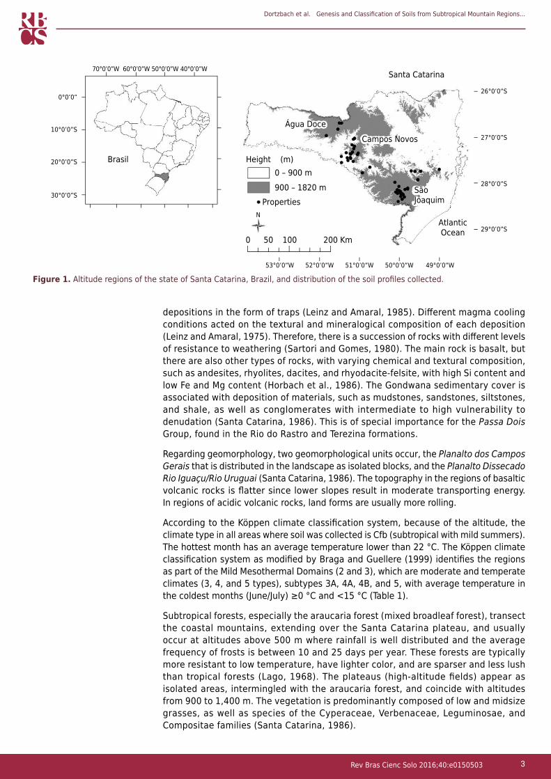
The study was conducted in the municipalities of Água Doce, Campos Novos, and São Joaquim. These regions are the main producers of fine wines from high-altitude regions in the state of Santa Catarina (Figure 1).
The geology of the area consists of rocks from the Serra Geral formation, above the Paraná River Basin, as well as Paleozoic sedimentary rocks from the Paraná River Basin. The region’s primary characteristic is its heterogeneity caused by geological
Dortzbach et al. Genesis and Classification of Soils from Subtropical Mountain Regions...
3Rev Bras Cienc Solo 2016;40:e0150503
depositions in the form of traps (Leinz and Amaral, 1985). Different magma cooling conditions acted on the textural and mineralogical composition of each deposition (Leinz and Amaral, 1975). Therefore, there is a succession of rocks with different levels of resistance to weathering (Sartori and Gomes, 1980). The main rock is basalt, but there are also other types of rocks, with varying chemical and textural composition, such as andesites, rhyolites, dacites, and rhyodacite-felsite, with high Si content and low Fe and Mg content (Horbach et al., 1986). The Gondwana sedimentary cover is associated with deposition of materials, such as mudstones, sandstones, siltstones, and shale, as well as conglomerates with intermediate to high vulnerability to denudation (Santa Catarina, 1986). This is of special importance for the Passa Dois Group, found in the Rio do Rastro and Terezina formations.
Regarding geomorphology, two geomorphological units occur, the Planalto dos Campos Gerais that is distributed in the landscape as isolated blocks, and the Planalto Dissecado Rio Iguaçu/Rio Uruguai (Santa Catarina, 1986). The topography in the regions of basaltic volcanic rocks is flatter since lower slopes result in moderate transporting energy. In regions of acidic volcanic rocks, land forms are usually more rolling.
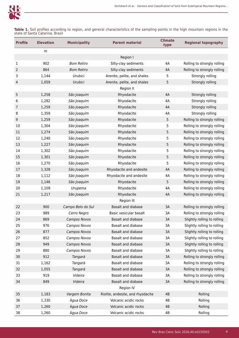
According to the Köppen climate classification system, because of the altitude, the climate type in all areas where soil was collected is Cfb (subtropical with mild summers). The hottest month has an average temperature lower than 22 °C. The Köppen climate classification system as modified by Braga and Guellere (1999) identifies the regions as part of the Mild Mesothermal Domains (2 and 3), which are moderate and temperate climates (3, 4, and 5 types), subtypes 3A, 4A, 4B, and 5, with average temperature in the coldest months (June/July) ≥0 °C and <15 °C (Table 1).
Subtropical forests, especially the araucaria forest (mixed broadleaf forest), transect the coastal mountains, extending over the Santa Catarina plateau, and usually occur at altitudes above 500 m where rainfall is well distributed and the average frequency of frosts is between 10 and 25 days per year. These forests are typically more resistant to low temperature, have lighter color, and are sparser and less lush than tropical forests (Lago, 1968). The plateaus (high-altitude fields) appear as isolated areas, intermingled with the araucaria forest, and coincide with altitudes from 900 to 1,400 m. The vegetation is predominantly composed of low and midsize grasses, as well as species of the Cyperaceae, Verbenaceae, Leguminosae, and Compositae families (Santa Catarina, 1986).
Figure 1. Altitude regions of the state of Santa Catarina, Brazil, and distribution of the soil profiles collected.
0°0’0”
10°0’0”S
26°0’0”S
20°0’0”S
30°0’0”S
27°0’0”S
28°0’0”S
29°0’0”S
Brasil
0
53°0’0”W
50 100 200 Km
52°0’0”W 51°0’0”W 50°0’0”W 49°0’0”W
N
Properties
70°0’0”W 60°0’0”W 50°0’0”W 40°0’0”WSanta Catarina
Água DoceCampos Novos
SãoJoaquim
AtlanticOcean
Height (m)0 – 900 m900 – 1820 m
Dortzbach et al. Genesis and Classification of Soils from Subtropical Mountain Regions...
4Rev Bras Cienc Solo 2016;40:e0150503
Table 1. Soil profiles according to region, and general characteristics of the sampling points in the high mountain regions in the state of Santa Catarina, Brazil
Profile Elevation Municipality Parent material Climate type Regional topography
mRegion I
1 902 Bom Retiro Silty-clay sediments 4A Rolling to strongly rolling2 864 Bom Retiro Silty-clay sediments 4A Rolling to strongly rolling3 1,144 Urubici Arenite, pelite, and shales 5 Strongly rolling4 1,059 Urubici Arenite, pelite, and shales 5 Strongly rolling
Region II5 1,258 São Joaquim Rhyodacite 4A Strongly rolling6 1,282 São Joaquim Rhyodacite 4A Strongly rolling7 1,259 São Joaquim Rhyodacite 4A Strongly rolling8 1,359 São Joaquim Rhyodacite 4A Strongly rolling9 1,259 São Joaquim Rhyodacite 5 Rolling to strongly rolling10 1,304 São Joaquim Rhyodacite 5 Rolling to strongly rolling11 1,274 São Joaquim Rhyodacite 5 Rolling to strongly rolling12 1,240 São Joaquim Rhyodacite 5 Rolling to strongly rolling13 1,227 São Joaquim Rhyodacite 5 Rolling to strongly rolling14 1,302 São Joaquim Rhyodacite 5 Rolling to strongly rolling15 1,301 São Joaquim Rhyodacite 5 Rolling to strongly rolling16 1,270 São Joaquim Rhyodacite 5 Rolling to strongly rolling17 1,328 São Joaquim Rhyodacite and andesite 4A Rolling to strongly rolling18 1,112 São Joaquim Rhyodacite and andesite 4A Rolling to strongly rolling19 1,146 São Joaquim Rhyodacite 5 Rolling to strongly rolling20 1,109 Urupema Rhyodacite 4A Rolling to strongly rolling21 1,217 São Joaquim Rhyodacite 4A Rolling to strongly rolling
Region III22 900 Campo Belo do Sul Basalt and diabase 3A Rolling to strongly rolling23 989 Cerro Negro Basic vesicular basalt 3A Rolling to strongly rolling24 869 Campos Novos Basalt and diabase 3A Slightly rolling to rolling25 976 Campos Novos Basalt and diabase 3A Slightly rolling to rolling26 877 Campos Novos Basalt and diabase 3A Slightly rolling to rolling27 852 Campos Novos Basalt and diabase 3A Slightly rolling to rolling28 949 Campos Novos Basalt and diabase 3A Slightly rolling to rolling29 880 Campos Novos Basalt and diabase 3A Slightly rolling to rolling30 912 Tangará Basalt and diabase 3A Rolling to strongly rolling31 1,162 Tangará Basalt and diabase 3A Rolling to strongly rolling32 1,055 Tangará Basalt and diabase 3A Rolling to strongly rolling33 919 Videira Basalt and diabase 3A Rolling to strongly rolling34 849 Videira Basalt and diabase 3A Rolling to strongly rolling
Region IV35 1,183 Vargem Bonita Riolite, andesite, and rhyodacite 4B Rolling36 1,330 Água Doce Volcanic acidic rocks 4B Rolling37 1,260 Água Doce Volcanic acidic rocks 4B Rolling38 1,260 Água Doce Volcanic acidic rocks 4B Rolling

Dortzbach et al. Genesis and Classification of Soils from Subtropical Mountain Regions...
5Rev Bras Cienc Solo 2016;40:e0150503
Sample collection and laboratorial analyses
Soil sampling pits were opened to collect 38 modal profiles (Table 1), as described by Santos et al. (2013a). Soil samples from all horizons were dried, ground, and passed through a 2-mm sieve, resulting in fine air-dried soil (FADS).
Chemical (pH in water, Mg2+, K+, Na+, P, and Al3+) and physical (particle density - Pd and particle size distribution - sand, silt, and clay) properties were evaluated (Donagema et al., 2011), and the following parameters were calculated: sum of bases (SB), cation exchange capacity (CEC) at pH 7.0, clay activity (Tclay), and degree of flocculation (DF). The levels of SiO2, Al2O3, and Fe2O3 were determined after acid digestion (sulfuric acid attack method) and used to calculate the ki index (silica to aluminum ratio) and kr index (silicate to oxide ratio) (Camargo et al., 1986).
Based on the morphological attributes and the physical and chemical properties, the soil profiles were classified according to the Brazilian System of Soil Classification (Sistema Brasileiro de Classificação de Solos - SiBCS) (Santos et al., 2013b).
Data analysis
The soil profiles were grouped into four regions according to their geology, and identified by the municipality of origin: I - region of sedimentary rocks - profiles 1 to 4 (Bom Retiro and Urubici); II - region of acidic igneous rocks - rhyodacite - profiles 5 to 21 (São Joaquim); III - region of igneous rocks - basalt - profiles 22 to 34 (Campos Novos); and IV - region of acidic igneous rocks - Palmas type - profiles 35 to 38 (Água Doce).
Theoretical inferences regarding pedogenesis were made based on combined analyses of the associated morphological, chemical, physical, and mineralogical attributes related to soil formation factors and pedogenetic processes.
To support decision making, the attributes were subjected to descriptive statistics, and similarities between the soil profiles were evaluated by multivariate analysis. Quantitative data were used to estimate the Euclidian distance, which generated a dissimilarity matrix, and the Nearest Neighbor Hierarchical Clustering method was applied, based on the presentation of a similarity dendrogram (Johnson and Wichern, 2007). The physical and chemical attributes of the subsurface soil horizons were used for analyses.
Discriminant analysis was used for distinction and characterization of soils, for separating different groups (according to physical and chemical attributes), and for establishing previously defined groups (soil classes), enabling visualization of the groups in a multidimensional space and indicating the contribution of the original variables to each discriminant function. All variables evaluated from the A and B horizons were individually used for this analysis. When more than one B horizon occurred, the horizon with the greatest expression in the soil profile was used.
All analyses were carried out using the software SPSS (Statistical Package for Social Sciences) version 20.0.
RESULTS AND DISCUSSION
Characterization and distribution of soils in the regions
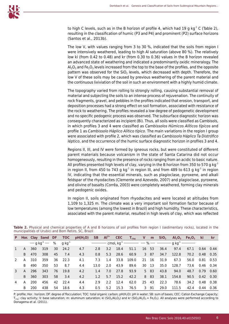
In region I, among the soil formation factors, the parent material was the determining factor for the coarser particle size of the profiles compared with the other regions. The influence of the parent material associated with the cold and humid climate resulted in formation of soils with low sum of bases (SB) and base saturation (V), high levels of Al3+ (above 4.0 cmolc kg-1), an alytic character (Santos et al., 2013b) (P1, P3, and P4), and high activity clays (Tclay ≥27.0 cmolc kg-1 clay). The climate also contributed
Dortzbach et al. Genesis and Classification of Soils from Subtropical Mountain Regions...
6Rev Bras Cienc Solo 2016;40:e0150503
to high C levels, such as in the B horizon of profile 4, which had 19 g kg-1 C (Table 2), resulting in the classification of humic (P3 and P4) and prominent (P2) surface horizons (Santos et al., 2013b).
The low V, with values ranging from 3 to 30 %, indicated that the soils from region I were intensively weathered, leading to high Al saturation (above 80 %). The relatively low ki (from 0.42 to 0.48) and kr (from 0.30 to 0.36) values in the B horizon revealed an advanced state of weathering and indicated a predominantly oxidic mineralogy. The Al2O3 and Fe2O3 levels increased from the top to the base of the profiles, and the opposite pattern was observed for the SiO2 levels, which decreased with depth. Therefore, the low V of these soils may be caused by previous weathering of the parent material and the continuous lixiviation of the soil in such an environment with a highly humid climate.
The topography varied from rolling to strongly rolling, causing substantial removal of material and subjecting the soils to an intense process of rejuvenation. The continuity of rock fragments, gravel, and pebbles in the profiles indicated that erosion, transport, and deposition processes had a strong effect on soil formation, associated with resistance of the rock to weathering. The profiles revealed a low degree of pedogenetic development and no specific pedogenic process was observed. The subsurface diagnostic horizon was consequently characterized as incipient (Bi). Thus, all soils were classified as Cambisols, in which profiles 3 and 4 were classified as Cambissolos Húmicos Alíticos típicos and profile 1 as Cambissolo Háplico Alítico típico. The main variations in the region I group were associated with profile 2, which was classified as Cambissolo Háplico Ta Distrófico léptico, and the occurrence of the humic surface diagnostic horizon in profiles 3 and 4.
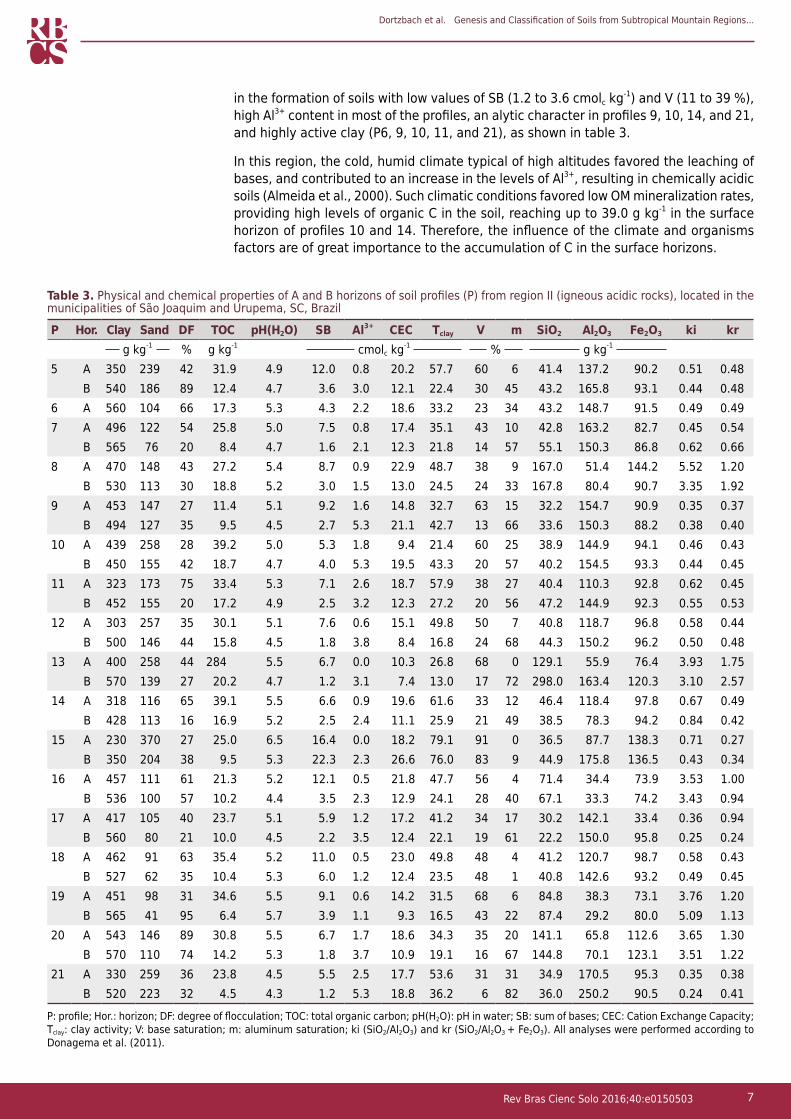
Regions II, III, and IV were formed by igneous rocks, but were constituted of different parent materials because volcanism in the state of Santa Catarina did not occur homogeneously, resulting in the presence of rocks ranging from an acidic to basic nature. All profiles presented high levels of clay, varying in the B horizon from 350 to 570 g kg-1 in region II, from 450 to 743 g kg-1 in region III, and from 489 to 613 g kg-1 in region IV, indicating that the essential minerals, such as plagioclase, pyroxene, and alkali feldspar of the rhyodacites (Clemente and Azevedo, 2007) and plagioclase, pyroxene, and olivine of basalts (Corrêa, 2003) were completely weathered, forming clay minerals and pedogenic oxides.
In region II, soils originated from rhyodacites and were located at altitudes from 1,109 to 1,325 m. The climate was a very important soil formation factor because of low temperatures (among the lowest in Brazil) and high humidity. These characteristics, associated with the parent material, resulted in high levels of clay, which was reflected
P: profile; Hor.: horizon; DF: degree of flocculation; TOC: total organic carbon; pH(H2O): pH in water; SB: sum of bases; CEC: Cation Exchange Capacity; Tclay: clay activity; V: base saturation; m: aluminum saturation; ki (SiO2/Al2O3) and kr (SiO2/Al2O3 + Fe2O3). All analyses were performed according to Donagema et al. (2011).
Table 2. Physical and chemical properties of A and B horizons of soil profiles from region I (sedimentary rocks), located in the municipalities of Urubici and Bom Retiro, SC, Brazil
P Hor. Clay Sand DF TOC pH(H2O) SB Al3+ CEC Tclay V m SiO2 Al2O3 Fe2O3 ki krg kg-1 % g kg-1 cmolc kg-1 % g kg-1
1 A 360 319 30 24.2 4.7 2.8 3.2 18.4 51.1 16 53 36.4 97.4 67.1 0.64 0.44B 470 308 45 7.4 4.3 0.8 5.3 28.6 60.9 3 87 34.7 122.8 70.2 0.48 0.35
2 A 310 359 36 22.3 4.1 7.3 1.4 33.8 109.0 21 16 31.9 67.3 56.0 0.81 0.53B 490 350 53 8.7 4.4 13.0 2.0 43.9 89.6 30 13 35.0 128.7 73.6 0.46 0.34
3 A 296 343 76 19.8 4.2 1.4 7.0 27.8 93.9 5 83 43.8 94.0 48.7 0.79 0.60B 360 303 58 3.4 4.2 1.2 5.7 15.2 42.2 8 83 38.1 154.8 90.5 0.42 0.30
4 A 200 456 42 22.4 4.4 2.9 2.2 12.4 62.0 25 43 22.3 78.6 34.2 0.48 0.38B 200 438 54 18.6 4.3 0.5 5.2 15.3 76.5 3 91 29.0 111.5 42.4 0.44 0.36
Dortzbach et al. Genesis and Classification of Soils from Subtropical Mountain Regions...
7Rev Bras Cienc Solo 2016;40:e0150503
in the formation of soils with low values of SB (1.2 to 3.6 cmolc kg-1) and V (11 to 39 %), high Al3+ content in most of the profiles, an alytic character in profiles 9, 10, 14, and 21, and highly active clay (P6, 9, 10, 11, and 21), as shown in table 3.
In this region, the cold, humid climate typical of high altitudes favored the leaching of bases, and contributed to an increase in the levels of Al3+, resulting in chemically acidic soils (Almeida et al., 2000). Such climatic conditions favored low OM mineralization rates, providing high levels of organic C in the soil, reaching up to 39.0 g kg-1 in the surface horizon of profiles 10 and 14. Therefore, the influence of the climate and organisms factors are of great importance to the accumulation of C in the surface horizons.
P: profile; Hor.: horizon; DF: degree of flocculation; TOC: total organic carbon; pH(H2O): pH in water; SB: sum of bases; CEC: Cation Exchange Capacity; Tclay: clay activity; V: base saturation; m: aluminum saturation; ki (SiO2/Al2O3) and kr (SiO2/Al2O3 + Fe2O3). All analyses were performed according to Donagema et al. (2011).
Table 3. Physical and chemical properties of A and B horizons of soil profiles (P) from region II (igneous acidic rocks), located in the municipalities of São Joaquim and Urupema, SC, Brazil
P Hor. Clay Sand DF TOC pH(H2O) SB Al3+ CEC Tclay V m SiO2 Al2O3 Fe2O3 ki krg kg-1 % g kg-1 cmolc kg-1 % g kg-1
5 A 350 239 42 31.9 4.9 12.0 0.8 20.2 57.7 60 6 41.4 137.2 90.2 0.51 0.48B 540 186 89 12.4 4.7 3.6 3.0 12.1 22.4 30 45 43.2 165.8 93.1 0.44 0.48
6 A 560 104 66 17.3 5.3 4.3 2.2 18.6 33.2 23 34 43.2 148.7 91.5 0.49 0.497 A 496 122 54 25.8 5.0 7.5 0.8 17.4 35.1 43 10 42.8 163.2 82.7 0.45 0.54
B 565 76 20 8.4 4.7 1.6 2.1 12.3 21.8 14 57 55.1 150.3 86.8 0.62 0.668 A 470 148 43 27.2 5.4 8.7 0.9 22.9 48.7 38 9 167.0 51.4 144.2 5.52 1.20
B 530 113 30 18.8 5.2 3.0 1.5 13.0 24.5 24 33 167.8 80.4 90.7 3.35 1.929 A 453 147 27 11.4 5.1 9.2 1.6 14.8 32.7 63 15 32.2 154.7 90.9 0.35 0.37
B 494 127 35 9.5 4.5 2.7 5.3 21.1 42.7 13 66 33.6 150.3 88.2 0.38 0.4010 A 439 258 28 39.2 5.0 5.3 1.8 9.4 21.4 60 25 38.9 144.9 94.1 0.46 0.43
B 450 155 42 18.7 4.7 4.0 5.3 19.5 43.3 20 57 40.2 154.5 93.3 0.44 0.4511 A 323 173 75 33.4 5.3 7.1 2.6 18.7 57.9 38 27 40.4 110.3 92.8 0.62 0.45
B 452 155 20 17.2 4.9 2.5 3.2 12.3 27.2 20 56 47.2 144.9 92.3 0.55 0.5312 A 303 257 35 30.1 5.1 7.6 0.6 15.1 49.8 50 7 40.8 118.7 96.8 0.58 0.44
B 500 146 44 15.8 4.5 1.8 3.8 8.4 16.8 24 68 44.3 150.2 96.2 0.50 0.4813 A 400 258 44 284 5.5 6.7 0.0 10.3 26.8 68 0 129.1 55.9 76.4 3.93 1.75
B 570 139 27 20.2 4.7 1.2 3.1 7.4 13.0 17 72 298.0 163.4 120.3 3.10 2.5714 A 318 116 65 39.1 5.5 6.6 0.9 19.6 61.6 33 12 46.4 118.4 97.8 0.67 0.49
B 428 113 16 16.9 5.2 2.5 2.4 11.1 25.9 21 49 38.5 78.3 94.2 0.84 0.4215 A 230 370 27 25.0 6.5 16.4 0.0 18.2 79.1 91 0 36.5 87.7 138.3 0.71 0.27
B 350 204 38 9.5 5.3 22.3 2.3 26.6 76.0 83 9 44.9 175.8 136.5 0.43 0.3416 A 457 111 61 21.3 5.2 12.1 0.5 21.8 47.7 56 4 71.4 34.4 73.9 3.53 1.00
B 536 100 57 10.2 4.4 3.5 2.3 12.9 24.1 28 40 67.1 33.3 74.2 3.43 0.9417 A 417 105 40 23.7 5.1 5.9 1.2 17.2 41.2 34 17 30.2 142.1 33.4 0.36 0.94
B 560 80 21 10.0 4.5 2.2 3.5 12.4 22.1 19 61 22.2 150.0 95.8 0.25 0.2418 A 462 91 63 35.4 5.2 11.0 0.5 23.0 49.8 48 4 41.2 120.7 98.7 0.58 0.43
B 527 62 35 10.4 5.3 6.0 1.2 12.4 23.5 48 1 40.8 142.6 93.2 0.49 0.4519 A 451 98 31 34.6 5.5 9.1 0.6 14.2 31.5 68 6 84.8 38.3 73.1 3.76 1.20
B 565 41 95 6.4 5.7 3.9 1.1 9.3 16.5 43 22 87.4 29.2 80.0 5.09 1.1320 A 543 146 89 30.8 5.5 6.7 1.7 18.6 34.3 35 20 141.1 65.8 112.6 3.65 1.30
B 570 110 74 14.2 5.3 1.8 3.7 10.9 19.1 16 67 144.8 70.1 123.1 3.51 1.2221 A 330 259 36 23.8 4.5 5.5 2.5 17.7 53.6 31 31 34.9 170.5 95.3 0.35 0.38
B 520 223 32 4.5 4.3 1.2 5.3 18.8 36.2 6 82 36.0 250.2 90.5 0.24 0.41
Dortzbach et al. Genesis and Classification of Soils from Subtropical Mountain Regions...
8Rev Bras Cienc Solo 2016;40:e0150503
The topography factor, which ranged from rolling to strongly rolling, promoted considerable removal of material, resulting in intense rejuvenation in most of the profiles. There was no expression of a specific pedogenesis process, leading to characterization of 13 profiles as Cambissolos, and profile 6 as Neossolo Litólico Distrófico típico (Leptosol). In most cases, surface C levels were not high enough to characterize the A horizon as humic, which was also associated with the shallowness of the surface horizon.
In areas with lesser slope, which favored higher water infiltration into the soil profile, more pedogenically developed soils were observed. Some soils were formed by the specific pedogenetic process of illuviation/alluviation, as observed in profiles 5, 7, and 18. In these soils, there was translocation of clay from the A horizon to the B horizon, with highly evident expression of clay skins on the faces of the aggregates, which were well developed, reflecting the genesis of the mountainous nitric subsurface horizon and identifying the soil order as Nitossolos (Nitosols). At the Suborder categorical level, profiles 5 and 7 were classified as Nitossolos Brunos, a result of the climate, which led to browner colors, with hues ranging from 10YR to 7.5YR. The presence of goethite, which is usually the most abundant Fe oxide in soils of cold and humid regions, was relevant (Schwertamnn and Taylor, 1989). The formation of hematite is suppressed by the accumulation of organic compounds that prevent the formation of ferrihydrite (hematite precursor) (Inda Junior, 2002). For the Cambissolos, the lack of any other distinctive characteristics classified them as Háplicos at the Suborder level.
At the third level, Great Group, profiles 9, 10, 14, and 21 were classified as alytic; profile 7 had an aluminic character (Al levels ≥4 cmolc kg-1, clay activity <20 cmolc kg-1, Al saturation (m) ≥50 %, and/or V <50 %). The other profiles were classified as dystrophic, with P11 having high activity clay (≥27 cmolc kg-1) associated with low V. The other profiles exhibited low activity clay.
At the Subgroup level, profile 11 was identified as leptic, with lithic contact between 0.50 and 1.0 m from the surface, whereas P5 was classified as humic. Because of the lack of distinctive diagnostic attributes, the other profiles were classified as typic.
The low V, with values in the B horizon from 6 to 48 % (except for P15), indicated a high level of leaching in soils from the region II group, accompanied by high potential acidity (H+Al) and a large portion of the sorptive complex occupied by Al (Table 3). However, the values are below those observed for regions I and IV and similar to those of region III.
The clay levels were very high, and the total sand content very low. Despite a decrease in the SiO2 levels, characterizing loss of silica due to the alteration of primary minerals, the resistance to weathering imposed by the mineralogy of the rhyodocite and the selection of larger fractions maintained high amounts of Si in the horizons relative to those found in the region III profiles (originating from basalt). These results indicated that the rhyodocite essential minerals (plagioclase, pyroxene, and alkali feldspar) were weathered and formed clay minerals and pedogenic oxides.
The high ki values, from 3.1 to 5.5 in profiles 8, 13, 16, 19, and 20 (Table 3), indicated that there is an evolution toward the formation of 2:1 minerals interlayered with 1:1 minerals in these profiles. In the areas surrounding São Joaquim and Água Doce, there was a predominance of rocks with a more acidic character (rhyodacites), which, unlike typical basalt, have higher silica content, reaching values close to or above 60 % (Teske, 2010).
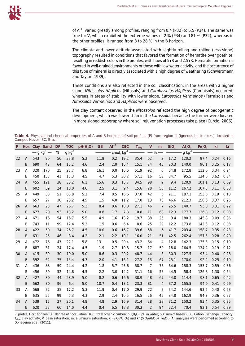
In region III, soils developed from basalt and were located at latitudes lower than the other regions, from 832 to 1,128 m, and the parent material was responsible for the fine clayey texture (higher than 600 g kg-1), except for profiles 23, 30, 31, and 32, which exhibited a clayey texture in the B horizon (Table 4). Relief played an important role in the weathering of these soils because of lower slope (slightly rolling to rolling), allowing higher infiltration of water into the soil and resulting in deeper soils. This also explained the low sum of bases, with values below 3.0 cmolc kg-1, except for P23 and P32. The levels
Dortzbach et al. Genesis and Classification of Soils from Subtropical Mountain Regions...
9Rev Bras Cienc Solo 2016;40:e0150503
of Al3+ varied greatly among profiles, ranging from 0.4 (P32) to 6.5 (P34). The same was true for V, which exhibited the extreme values of 2 % (P34) and 81 % (P32), whereas in the other profiles, it ranged from 8 to 28 % in the B horizon.
The climate and lower altitude associated with slightly rolling and rolling (less slope) topography resulted in conditions that favored the formation of hematite over goethite, resulting in reddish colors in the profiles, with hues of 5YR and 2.5YR. Hematite formation is favored in well-drained environments or those with low water activity, and the occurrence of this type of mineral is directly associated with a high degree of weathering (Schwertmann and Taylor, 1989).
These conditions are also reflected in the soil classification; in the areas with a higher slope, Nitossolos Háplicos (Nitosols) and Cambissolos Háplicos (Cambisols) occurred; whereas in areas of stability with lower slope, Latossolos Vermelhos (Ferralsols) and Nitossolos Vermelhos and Háplicos were observed.
The clay content observed in the Nitossolos reflected the high degree of pedogenetic development, which was lower than in the Latossolos because the former were located in more sloped topography where soil rejuvenation processes take place (Curcio, 2006).
P: profile; Hor.: horizon; DF: degree of flocculation; TOC: total organic carbon; pH(H2O): pH in water; SB: sum of bases; CEC: Cation Exchange Capacity; Tclay: clay activity; V: base saturation; m: aluminum saturation; ki (SiO2/Al2O3) and kr (SiO2/Al2O3 + Fe2O3). All analyses were performed according to Donagema et al. (2011).
Table 4. Physical and chemical properties of A and B horizons of soil profiles (P) from region III (igneous basic rocks), located in Campos Novos, SC, Brazil
P Hor. Clay Sand DF TOC pH(H2O) SB Al+3 CEC Tclay V m SiO2 Al2O3 Fe2O3 ki krg kg-1 % g kg-1 cmolc kg-1 % g kg-1
22 A 543 90 56 33.8 5.2 11.8 0.2 19.2 35.4 62 2 17.2 120.2 97.4 0.24 0.16B 690 43 64 15.2 4.6 2.4 2.0 10.4 15.1 24 45 20.3 140.0 96.1 0.25 0.17
23 A 320 170 25 23.7 6.8 16.1 0.0 16.6 51.9 92 0 34.8 172.8 112.0 0.34 0.24B 450 153 41 15.3 4.5 4.7 5.3 30.2 57.1 16 53 34.7 95.5 124.6 0.62 0.34
24 A 455 121 38 38.2 6.1 15.6 0.3 15.7 34.5 98 2 9.4 120.9 101.1 0.13 0.09B 602 39 24 18.0 4.6 2.5 3.1 9.4 15.6 28 55 11.2 167.2 107.5 0.11 0.08
25 A 449 33 51 63.8 5.2 7.4 0.5 16.6 37.0 42 6 21.1 187.1 153.6 0.19 0.13B 657 27 30 28.2 4.5 1.5 4.0 11.2 17.0 13 73 46.6 212.3 150.6 0.37 0.26
26 A 663 23 47 26.7 5.3 8.4 0.6 18.0 27.1 46 7 25.5 140.7 93.0 0.31 0.22B 677 20 93 13.2 5.0 0.8 1.7 7.3 10.8 11 68 12.3 177.7 136.8 0.12 0.08
27 A 671 16 54 16.7 5.5 4.9 1.6 13.2 19.7 38 25 9.4 180.3 145.8 0.09 0.06B 743 11 99 12.4 5.2 1.5 0.6 6.4 8.6 25 29 12.2 173.8 142.3 0.12 0.08
28 A 422 50 34 26.7 4.5 10.0 0.6 16.7 39.6 58 6 41.7 203.4 158.7 0.35 0.23B 631 25 46 8.4 4.2 2.1 2.2 10.1 16.0 21 51 42.5 262.4 157.5 0.28 0.20
29 A 472 76 47 22.1 5.8 13 0.5 20.4 43.2 64 4 12.8 142.3 135.3 0.15 0.10B 687 31 24 17.4 4.5 1.9 2.7 10.8 15.7 17 59 18.0 164.5 134.2 0.19 0.12
30 A 415 39 30 19.0 5.0 8.6 0.3 20.2 48.7 44 3 30.3 127.5 93.4 0.40 0.28B 592 62 75 15.4 4.3 2.0 4.1 16.1 27.2 13 67 25.1 170.0 92.2 0.25 0.19
31 A 436 83 59 24.4 4.2 1.8 5.7 25.6 58.7 7 76 54.6 158.3 153.7 0.59 0.36B 456 89 52 14.8 4.5 2.2 3.0 14.2 31.1 16 58 44.5 58.4 126.8 1.30 0.54
32 A 427 30 44 23.9 5.0 8.2 0.6 16.6 38.9 48 67 44.0 114.4 98.1 0.65 0.42B 562 80 96 6.4 5.0 10.7 0.4 13.1 23.3 81 4 37.2 155.5 94.0 0.41 0.29
33 A 568 82 38 17.2 5.3 11.9 0.4 17.0 29.9 72 3 34.2 144.6 93.5 0.40 0.28B 635 55 99 6.3 4.3 2.9 2.4 10.5 16.5 26 45 34.8 162.9 94.3 0.36 0.27
34 A 539 17 37 20.1 4.8 4.8 2.9 16.9 31.4 28 38 31.2 150.2 93.4 0.35 0.25B 620 33 66 14.0 4.4 0.4 6.5 18.8 30.3 2 94 22.4 70.4 92.1 0.54 0.29
Dortzbach et al. Genesis and Classification of Soils from Subtropical Mountain Regions...
10Rev Bras Cienc Solo 2016;40:e0150503
In addition, the low clay activity (Tclay) reflected the advanced state of weathering of Latossolos compared with Nitossolos, which showed higher Tclay values.
Clay translocation from the A to the B horizon, with moderate development and frequent presence of clay skins and well-developed aggregates, indicated the pedogenetic process of clay eluviation and illuviation, reflecting the genesis of the nitric horizon characteristic of Nitossolos. With regard to Latossols, they had a fine clayey texture and a high degree of flocculation, reaching 93 and 99 % in the oxic horizon, indicating the specific pedogenetic process of latolization, responsible for considerable removal of silica and bases and a relative increase in Fe and Al oxides.
In the Suborder categorical level, profiles 22, 26, 27, 30, and 34 were classified as Vermelhos (located at lower altitudes), indicating the effect of climate and relief, allowing for higher expression of the Fe oxide hematite in the soil color. The other profiles, for their lack of distinctive characteristics, were classified as Háplicos. At the third level (Great Group), eight of the 13 profiles from region III were dystrophic, 2 (P25 and P30) had an aluminic character, two had an alytic character (P34 and P23), and one was eutrophic (P32). At the Subgroup level, all profiles were classified as typic.
The low V indicated that the soils from region III were highly leached and had high potential acidity (H+Al), although with values lower than those found in regions I and IV and similar to those of region II. In general, the SiO2 content was the lowest, compared to soils from the other regions. The Fe2O3 level was generally higher in region III in comparison with the soils originating from rhyodacites and sedimentary rocks. However, most profiles in this region possessed moderate levels of Fe oxides. According to Santos et al. (2013b), Fe2O levels between 80 and 180 g kg-1 of soil define the mesoferric soil character, which was unusual for these soils originating from basalt, where high Fe content would be expected.
In studies with basaltic and acidic rocks, Levi and Melfi (1972) concluded that weathering was faster on basaltic rocks because of the occurrence of high levels of ferromagnesian minerals (olivine and piroxene), which are the first to be altered, resulting in a higher number of fissures, favoring drainage and, consequently, weathering. The acidic rocks were more compact and resistant to weathering because of the higher amount of quartz and aluminosilicated minerals.
Soils from region IV, originating from volcanic acidic rocks - Palmas type, were located at altitudes ranging from 1,252 to 1,330 m, with a slightly rolling and rolling topography. This topography favored the erosive process, retarding pedogenesis and rejuvenating the profiles, and the soils were classified as Cambissolos Húmicos (P35 and P36) and Háplicos (P37 and P38). Consequently, no specific pedogenetic process was observed for these soils.
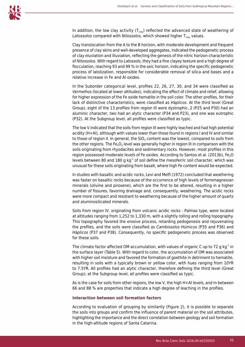
The climate factor affected OM accumulation, with values of organic C up to 72 g kg-1 in the surface layer (Table 5). With regard to color, the accumulation of OM was associated with higher soil moisture and favored the formation of goethite in detriment to hematite, resulting in soils with a typically brown or yellow color, with hues ranging from 10YR to 7.5YR. All profiles had an alytic character, therefore defining the third level (Great Group); at the Subgroup level, all profiles were classified as typic.
As is the case for soils from other regions, the low V, the high H+Al levels, and m between 66 and 88 % are properties that indicate a high degree of leaching in the profiles.
Interaction between soil formation factors
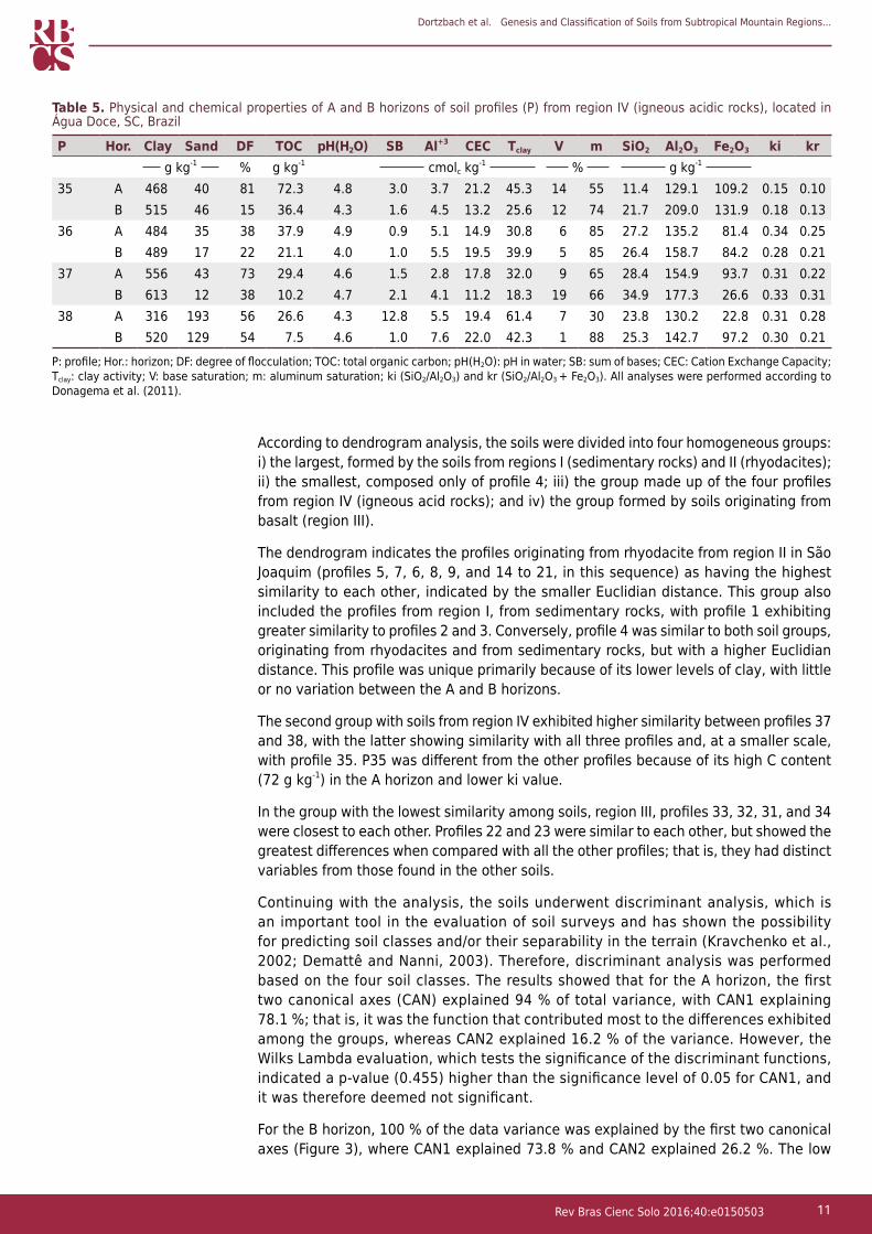
According to evaluation of grouping by similarity (Figure 2), it is possible to separate the soils into groups and confirm the influence of parent material on the soil attributes, highlighting the importance and the direct correlation between geology and soil formation in the high-altitude regions of Santa Catarina.
Dortzbach et al. Genesis and Classification of Soils from Subtropical Mountain Regions...
11Rev Bras Cienc Solo 2016;40:e0150503
According to dendrogram analysis, the soils were divided into four homogeneous groups: i) the largest, formed by the soils from regions I (sedimentary rocks) and II (rhyodacites); ii) the smallest, composed only of profile 4; iii) the group made up of the four profiles from region IV (igneous acid rocks); and iv) the group formed by soils originating from basalt (region III).
The dendrogram indicates the profiles originating from rhyodacite from region II in São Joaquim (profiles 5, 7, 6, 8, 9, and 14 to 21, in this sequence) as having the highest similarity to each other, indicated by the smaller Euclidian distance. This group also included the profiles from region I, from sedimentary rocks, with profile 1 exhibiting greater similarity to profiles 2 and 3. Conversely, profile 4 was similar to both soil groups, originating from rhyodacites and from sedimentary rocks, but with a higher Euclidian distance. This profile was unique primarily because of its lower levels of clay, with little or no variation between the A and B horizons.
The second group with soils from region IV exhibited higher similarity between profiles 37 and 38, with the latter showing similarity with all three profiles and, at a smaller scale, with profile 35. P35 was different from the other profiles because of its high C content (72 g kg-1) in the A horizon and lower ki value.
In the group with the lowest similarity among soils, region III, profiles 33, 32, 31, and 34 were closest to each other. Profiles 22 and 23 were similar to each other, but showed the greatest differences when compared with all the other profiles; that is, they had distinct variables from those found in the other soils.
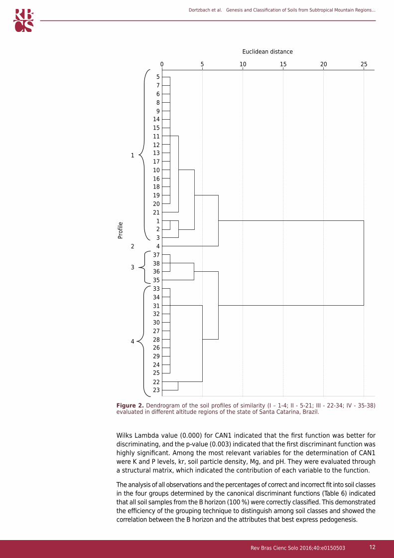
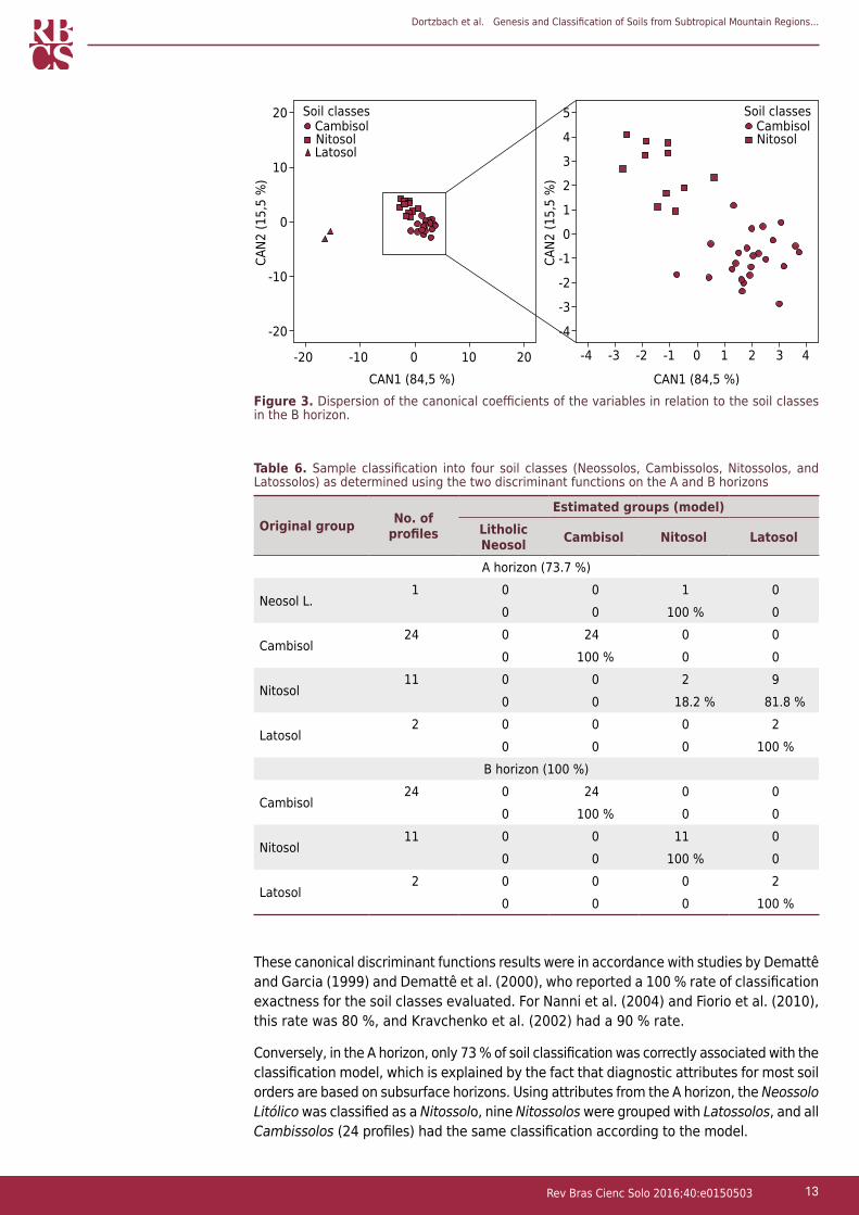
Continuing with the analysis, the soils underwent discriminant analysis, which is an important tool in the evaluation of soil surveys and has shown the possibility for predicting soil classes and/or their separability in the terrain (Kravchenko et al., 2002; Demattê and Nanni, 2003). Therefore, discriminant analysis was performed based on the four soil classes. The results showed that for the A horizon, the first two canonical axes (CAN) explained 94 % of total variance, with CAN1 explaining 78.1 %; that is, it was the function that contributed most to the differences exhibited among the groups, whereas CAN2 explained 16.2 % of the variance. However, the Wilks Lambda evaluation, which tests the significance of the discriminant functions, indicated a p-value (0.455) higher than the significance level of 0.05 for CAN1, and it was therefore deemed not significant.
For the B horizon, 100 % of the data variance was explained by the first two canonical axes (Figure 3), where CAN1 explained 73.8 % and CAN2 explained 26.2 %. The low
P Hor. Clay Sand DF TOC pH(H2O) SB Al+3 CEC Tclay V m SiO2 Al2O3 Fe2O3 ki krg kg-1 % g kg-1 cmolc kg-1 % g kg-1
35 A 468 40 81 72.3 4.8 3.0 3.7 21.2 45.3 14 55 11.4 129.1 109.2 0.15 0.10B 515 46 15 36.4 4.3 1.6 4.5 13.2 25.6 12 74 21.7 209.0 131.9 0.18 0.13
36 A 484 35 38 37.9 4.9 0.9 5.1 14.9 30.8 6 85 27.2 135.2 81.4 0.34 0.25B 489 17 22 21.1 4.0 1.0 5.5 19.5 39.9 5 85 26.4 158.7 84.2 0.28 0.21
37 A 556 43 73 29.4 4.6 1.5 2.8 17.8 32.0 9 65 28.4 154.9 93.7 0.31 0.22B 613 12 38 10.2 4.7 2.1 4.1 11.2 18.3 19 66 34.9 177.3 26.6 0.33 0.31
38 A 316 193 56 26.6 4.3 12.8 5.5 19.4 61.4 7 30 23.8 130.2 22.8 0.31 0.28B 520 129 54 7.5 4.6 1.0 7.6 22.0 42.3 1 88 25.3 142.7 97.2 0.30 0.21
Table 5. Physical and chemical properties of A and B horizons of soil profiles (P) from region IV (igneous acidic rocks), located in Água Doce, SC, Brazil
P: profile; Hor.: horizon; DF: degree of flocculation; TOC: total organic carbon; pH(H2O): pH in water; SB: sum of bases; CEC: Cation Exchange Capacity; Tclay: clay activity; V: base saturation; m: aluminum saturation; ki (SiO2/Al2O3) and kr (SiO2/Al2O3 + Fe2O3). All analyses were performed according to Donagema et al. (2011).
Dortzbach et al. Genesis and Classification of Soils from Subtropical Mountain Regions...
12Rev Bras Cienc Solo 2016;40:e0150503
Wilks Lambda value (0.000) for CAN1 indicated that the first function was better for discriminating, and the p-value (0.003) indicated that the first discriminant function was highly significant. Among the most relevant variables for the determination of CAN1 were K and P levels, kr, soil particle density, Mg, and pH. They were evaluated through a structural matrix, which indicated the contribution of each variable to the function.
The analysis of all observations and the percentages of correct and incorrect fit into soil classes in the four groups determined by the canonical discriminant functions (Table 6) indicated that all soil samples from the B horizon (100 %) were correctly classified. This demonstrated the efficiency of the grouping technique to distinguish among soil classes and showed the correlation between the B horizon and the attributes that best express pedogenesis.
Figure 2. Dendrogram of the soil profiles of similarity (I – 1-4; II - 5-21; III - 22-34; IV - 35-38) evaluated in different altitude regions of the state of Santa Catarina, Brazil.
Prof
ile
1
2
3
4
Euclidean distance
0 5 10 15 20 25
57689
141511121317101618192021
1234
3738363533343132302728262924252223
Dortzbach et al. Genesis and Classification of Soils from Subtropical Mountain Regions...
13Rev Bras Cienc Solo 2016;40:e0150503
These canonical discriminant functions results were in accordance with studies by Demattê and Garcia (1999) and Demattê et al. (2000), who reported a 100 % rate of classification exactness for the soil classes evaluated. For Nanni et al. (2004) and Fiorio et al. (2010), this rate was 80 %, and Kravchenko et al. (2002) had a 90 % rate.
Conversely, in the A horizon, only 73 % of soil classification was correctly associated with the classification model, which is explained by the fact that diagnostic attributes for most soil orders are based on subsurface horizons. Using attributes from the A horizon, the Neossolo Litólico was classified as a Nitossolo, nine Nitossolos were grouped with Latossolos, and all Cambissolos (24 profiles) had the same classification according to the model.
Table 6. Sample classification into four soil classes (Neossolos, Cambissolos, Nitossolos, and Latossolos) as determined using the two discriminant functions on the A and B horizons
Original group No. of profiles
Estimated groups (model)Litholic Neosol Cambisol Nitosol Latosol
A horizon (73.7 %)
Neosol L.1 0 0 1 0
0 0 100 % 0
Cambisol24 0 24 0 0
0 100 % 0 0
Nitosol11 0 0 2 9
0 0 18.2 % 81.8 %
Latosol2 0 0 0 2
0 0 0 100 %B horizon (100 %)
Cambisol24 0 24 0 0
0 100 % 0 0
Nitosol11 0 0 11 0
0 0 100 % 0
Latosol2 0 0 0 2
0 0 0 100 %
Figure 3. Dispersion of the canonical coefficients of the variables in relation to the soil classes in the B horizon.
Soil classes Soil classesCambisol Cambisol
NitosolNitosolLatosol
20
10
0
-10
-20
0
5
3
1
-1
-3
4
2
0
-2
-4
10 20-10-20 0 2 4-2-4 -1-3 1 3
CAN2
(15,
5 %
)
CAN1 (84,5 %) CAN1 (84,5 %)
CAN2
(15,
5 %
)
Dortzbach et al. Genesis and Classification of Soils from Subtropical Mountain Regions...
14Rev Bras Cienc Solo 2016;40:e0150503
CONCLUSIONS
The genesis of soils from the high mountain regions of Santa Catarina has been greatly affected by parent material, climate, and relief factors, which was reflected in the formation of soils with high clay content, low sum of bases and base saturation, and high aluminum and carbon content.
Most soils from the region were classified as Cambissolos (63 %). However, Nitossolos (29 %) and Latossolos (5 %) were also present, indicating the influence of topography and climate on the expression of pedogenetic processes. In addition, Neossolos Litólicos (3 %) were found in areas of strongly rolling land.
Combined analysis of the edaphic variables enabled classification of the soils into three groups. The first and largest group included the profiles originating from parent materials such as rhyodacite and sedimentary rocks; the second and smallest group was constituted by the four profiles from the Água Doce region (acidic rocks); and the third was formed by profiles originating from basalt.
Discriminant analysis based on variables from the B horizon was an efficient method for grouping of soil classes.
REFERENCESAlmeida JA, Maçaneiro KC, Klamt E. Mineralogia da fração argila de solos vermelhos com horizontes superficiais brunados do Planalto de Lages. Rev Bras Cienc Solo. 2000;24:815-28. doi:10.1590/S0100-06832000000400014
Boldrini I. Biodiversidade dos campos do planalto das araucárias. Brasília, DF: Ministério do Meio Ambiente; 2009.
Braga HJ, Ghellere R. Proposta de diferenciação climática para o Estado de Santa Catarina. In: Anais do 11º Congresso Brasileiro de Agrometeorologia e Reunião Latinoamericana de Agrometeorologia [CD-ROM]; 1999; Florianópolis. Florianópolis: Sociedade Brasileira de Agrometeorologia; 1999.
Camargo OA, Moniz AC, Jorge JA, Valadares JMAS. Métodos de análises química, mineralógica e física de solos do Instituto Agronômico de Campinas. Campinas: Instituto Agronômico de Campinas; 1986. (Boletim técnico, 106).
Clemente CA, Azevedo AC. Mineral weathering in acid saprolites from subtropical, Southern Brazil. Sci Agric. 2007;64:601-7. doi:10.1590/S0103-90162007000600007
Corrêa J. Mineralogia e gênese das principais classes de solos de encostas basálticas do estado de Santa Catarina [dissertação]. Lages: Universidade Estadual de Santa Catarina; 2003.
Curcio GR. Caracterização geomorfológica, pedológica e vegetacional dos ambientes fluviais do rio Iguaçu - Paraná - Brasil [tese]. Curitiba: Universidade Federal do Paraná; 2006.
Demattê JAM, Garcia GJ. Alteration of soil properties through a weathering sequence as evaluated by spectral reflectance. Soil Sci Soc Am J. 1999;63:327-42. doi:10.2136/sssaj1999.03615995006300020010x
Demattê JAM, Huete AR, Ferreira Jr LG, Alves MC, Nanni MR, Cerri CE. Evaluation of tropical soils through ground and orbital sensors. In: Proceedings of the 2nd International Conference on GIS in Agriculture and Forestry; 2000; Lake Buena Vista. Lake Buena Vista: Erim; 2000. v.2. p.34-41.
Demattê JAM, Nanni MR. Weathering sequence of soils developed from basalt as evaluated by laboratory (IRIS), airborne (AVIRIS) and orbital (TM) sensors. Int J Rem Sens. 2003;24:4715-38. doi:10.1080/0143116031000075116
Donagema GK, Campos DVB, Calderano SB, Teixeira WG, Viana JH. Manual de métodos de análises de solos. 2a ed. Rio de Janeiro: Embrapa Solos; 2011.
Dortzbach et al. Genesis and Classification of Soils from Subtropical Mountain Regions...
15Rev Bras Cienc Solo 2016;40:e0150503
Fiorio PR, Demattê JAM, Nanni MR, Formaggio AR. Diferenciação espectral de solo utilizando dados obtidos em laboratórios e por sensor orbital. Bragantia. 2010;69:453-66. doi:10.1590/S0006-87052010000200025
Horbach R, Kuck L, Marimon RG. Geologia. In: Brasil. Instituto Brasileiro de Geografia e Estatística. Levantamento de Recursos Naturais. Rio de Janeiro: 1986. v.33. p.29-312.
Inda Junior AV. Caracterização de goethita e hematita em solos poligenéticos [tese]. Porto Alegre: Universidade Federal do Rio Grande do Sul; 2002.
Johnson A, Wichern DW. Applied multivariate statistical analysis. 6th ed. New Jersey: Prentice-Hall; 2007.
Kravchenko AN, Bollero GA, Omonode RA, Bullock DG. Quantitative mapping of soil drainage classes using topographical data and soil electrical conductivity. Soil Sci Soc Am J. 2002;66:235-43. doi:10.2136/sssaj2002.0235
Lago PF. Santa Catarinense: a terra, o homem e a economia. Florianópolis: UFSC; 1968.
Leinz V, Amaral SE. Geologia física. Brasília, DF: Ministério da Educação e Cultura/Instituto Nacional do Livro; 1975.
Leinz V, Amaral SE. Águas continentais de superfície. Geologia geral. 3a ed. São Paulo: Companhia Editora Nacional; 1985.
Levi F, Melfi AJ. Geochemical and mineralogical studies on the first stages of weathering of basic and related rocks. Rev Bras Geocienc. 1972;2:1-7.
Nanni MR, Demattê JAM, Fiorio PR. Análise discriminante dos solos por meio de resposta espectral no nível terrestre. Pesq Agropec Bras. 2004;39:995-1006. doi:10.1590/S0100-204X2004001000007
Santa Catarina. Gabinete de Planejamento e Coordenação Geral. Atlas de Santa Catarina. Florianópolis: Gaplan; 1986.
Santos HG, Jacomine PKT, Anjos LHC, Oliveira VA, Lumbreras JF, Coelho MR, Almeida JA, Cunha TJF, Oliveira JB. Sistema brasileiro de classificação de solos. 3a ed. Brasília, DF: Embrapa; 2013b.
Santos RD, Lemos RC, Santos HG, Ker JC, Anjos LHC, Shimizu SM. Manual de descrição e coleta de solo no campo. 6a ed. Viçosa, MG: SBCS; 2013a.
Sartori PL, Gomes CB. Composição química-mineralógica das últimas manifestações vulcânicas na região de Santa Maria, RS. Anais Acad Bras Cienc. 1980;52:125-33.
Schwertmann U, Taylor RM. Iron oxides. In: Dixon JB, Weed SB, editors. Minerals in soil environments. 2nd ed. Madison: Soil Science Society of America; 1989. p.379-438.
Silva FM, Chaves MS, Lima, ZMC. Geografia física II. Natal: EDUFRN; 2009.
Teske R. Relações solo - litologia numa sequência de solos desenvolvidos de rochas efusivas no Planalto Sul de Santa Catarina [dissertação]. Lages: Universidade do Estado de Santa Catarina; 2010.