genetic relations between the central and southern
TRANSCRIPT
HAL Id: hal-01261614https://hal.archives-ouvertes.fr/hal-01261614
Submitted on 25 Jan 2016
HAL is a multi-disciplinary open accessarchive for the deposit and dissemination of sci-entific research documents, whether they are pub-lished or not. The documents may come fromteaching and research institutions in France orabroad, or from public or private research centers.
L’archive ouverte pluridisciplinaire HAL, estdestinée au dépôt et à la diffusion de documentsscientifiques de niveau recherche, publiés ou non,émanant des établissements d’enseignement et derecherche français ou étrangers, des laboratoirespublics ou privés.
Genetic relations between the central and southernPhilippine Trench and the Sangihe Trench
Serge E. Lallemand, Michel Popoff, Jean-Paul Cadet, Anne-Gaëlle Bader,Manuel Pubellier, Claude Rangin, Benoit Deffontaines
To cite this version:Serge E. Lallemand, Michel Popoff, Jean-Paul Cadet, Anne-Gaëlle Bader, Manuel Pubellier, et al..Genetic relations between the central and southern Philippine Trench and the Sangihe Trench. Journalof Geophysical Research. Oceans, Wiley-Blackwell, 1998, 103 (B1), pp.933-950. �hal-01261614�

JOURNAL OF GEOPHYSICAL RESEARCH, VOL. 103, NO. B1, PAGES 933-950, JANUARY 10, 1998
Genetic relations between the central and southern
Philippine Trench and the Sangihe Trench 1 . 2 3
Serge E. Lallemand, Mxchel Popoff, Jean-Paul Cadet, Anne-Gaelle Badertl ß 4 . 4 ß 3
Manuel Pubelher, Claude Rangre, and Benoit Deffontmnes
Abstract. We surveyed the junction between the central and southern Philippine Trench and the Sangihe Trench near 6øN using swath bathymetry, gravity, and magnetics. These data, along with seismicity, allow us to discuss the genetic relations between these trenches and the forces acting on converging plates. Our final model favors the northern extension of the Halmahera Arc up to 8øN, with three segments offset left-laterally along NW-SE transform faults. Accretion of the northern segment to Mindanao Island 4 to 5 m.y. ago resulted in the failure within the Philippine Sea Plate east of the arc. Initiation of the Philippine Trench between 7øN and 10øN agrees with the maximum recorded depth of the Philippine Trench floor (10,000 m below sea-level) and Philippine Sea slab (200 km). South of 6øN (trench junction), another segment of the arc is being subducted beneath the Sangihe margin, while south of 3øN, the southern segment of the Halmahera Arc is still active. The rapid southward shallowing of the trench floor along the southern Philippine Trench, the type of faulting affecting both sides of the trench, the lack of significant interplate seismicity, and the concentration of the seismicity beneath the Miangas- Talaud Ridge are interpreted as a slowing down of the subduction along this branch of the Philippine Trench compared with the rest of the subduction zone. The Sangihe deformation front has been recognized up to 7øN but seems active only south of 6øN.
1. Introduction
In May 1994, the R/V Ltatalante surveyed the area south of 7øN during the MODEC cruise (see location on Figures 1 and 2). Swath bathymetry, sonar imagery, six-channel reflection seismics, gravity, and magnetic anomalies were recorded in the northern part of the Molucca Sea and along the Philippine Trench up to 11 øN off Leyte (Figure 2).
The Philippine Sea Plate (PSP) is mostly surrounded by trenches (Figure 1), except along a short segment in the south where the Ayu spreading center forms the boundary between the PSP and the Caroline Plate [Fujiwara et al., 1995]. Furthermore, the convergence is partitioned along its western boundary, so that slip vectors cannot be simply used for constraining its motion [McCaffrey, 1996]. Consequently, the exact azimuth and magnitude of plate motion along its rim remain controversial [Seno, 1977; Karig and Cardwell, 1986; Huchon, 1986; Ranken et al., 1984; Seno et al., 1993; McCqffrey, 1996]. The numerous subduction zones fringing the western boundary of the PSP on each side of the Philippine Islands render the southwestern plate boundary particularly complex. This problem is especially true south of Mindanao
IUMR CNRS-UM2 5573, Laboratoire de G6ophysique et Tec.tonique, ISTEEM Montpellier France.
ZUMR CNRS-UN•A 6526 G6•sciences Azur, Valbonne, France. 3URA CNRS-UPMC 1759, D6partement de G6otectonique, Pads. aURA CNRS-ENS 1516, D6partement de G6ologie, Pads.
Copyright 1998 by the ganerican Geophysical Union.
Paper number 97JB02620. 014õ-0227/98/97JB-02620509.00
in the Molucca Sea (Figure 2), where it is impossible, on the basis of global plate kinematics, to estimate the relative plate convergence individually along each subduction zone. Preliminary results from Geodynamics of the South and South East Asia (GEODYSSEA) Global Positioning System (GPS) measurements indicate that the "Sundaland block" is rotating clockwise with respect to Eurasia around a pole located south of Australia [Chamot-Rooke et al., 1997]. The convergence between Sundaland and PSP is distributed over a 600 km wide
zone from Sulawesi to L'uzon islands. Only 45% of the convergence, i.e., -- 3 cm/yr, is accommodated along the Philippine Trench in the southern Philippines and probably even less along the southern branch of the Philippine Trench according to Rangin et al. [1997] (no definite constraints).
The convergence across the Philippine Trench may decrease in magnitude south of 6øN, as indicated by shallowing bathymetry and the disappearance of the accretionary wedge from 4 ø to 2øN [Nichols et al., 1990]; symmetrically, the same situation occurs north of 15øN as shown by the scarce earthquake hypocenters and diminution of converging character of the inner wall as seen on reflection seismics
[Lewis and Hayes, 1983]. So'uth of Mindanao, the bathymetric trough in the prolongation of the Philippine Trench deviates toward the southeast by about 30 ø (Figures 1 and 2). The trench fringes the Snellius Ridge to the east [Rangin et al., 1996] and shallows from 9500 m at 6øN (junction between central and southern Philippine Trench) to 5000 m at 3øN, where the last seismic evidence of thrusting is observed [Nichols et al., 1990]. Immediately south of 3øN, the East Morotai Plateau clogs the bathymetric trench. Part of the 1994 survey, discussed here, was devoted to the tectonic significance of the junction near 6øN between the central and southern branches of the Philippine Trench and the possible relations with the northern termination of the Sangihe Trench. In fact, the
933

934 LALLEMAND ET AL.: PHILIPPINE-SANGIHE TRENCHES GENETIC REI JATIONS
Sulu
EURASIAN
P-LATE
Benham Rise
Shikoku " _•-
Basin • Amami
Plat. eau
/ ur•a•a 0 / Plateau
Parece
Vela
Basin
P^C}Fc
PLATE
Plateau
20'N
10'N
CAROLINE PLATE
[AHERA Melanesian Trenchl O•
120OE 1130OE PLATE -• 1140'E• )"""'--..• • 1150'E '• Figure 1. Tectonic setting of the Philippine Sea Plate modified after Hall et al. [1995]. The stippled area of the West Philippine Basin is the area produced by spreading after anomaly 20 (-- 45 Ma); anomaly identifications in the West Philippine Basin are from Hilde and Lee [1984]. The box outlines the location of Figure 2.
deformation front of the Sangihe subduction zone has been traced during the MODEC cruise [Rangin eta/., 1996] up to the junction between the central and southern Philippine Trench. The deformation is thus distributed in the northern Molucca Sea over the Cotobato, Sangihe, and Philippine subduction zones, the latter two joining near 6øN.
2. Geodynamic Background
2.1. Converging Plates
The Molucca Plate, between Halmahera and Sulawesi/Sangihe island arcs on Figure 2, has no surface

LALLEMAND ET AL.: PHILIPPINE-SANGIHE TRENCHES GENETIC RELATIONS 935
15 ø N
10 ø N
WEST
HILIPPINE BASIN
/
MINDANAO
south- segm.
5øN
/-%
o
o
0 ø N 125 ø E 130 ø E
Figure 2. Map showing 'the main structural features in the vicinity of the Philippine Trench. Bathymetry from General Bathymetfic Chart of the Oceans (GEBCO) database except in the area surveyed during MODEC and DAVAPUS oceanographic cruises (dashed domain). Isobaths every 500 m. The thick solid arrow represents the convergence of the PSP relative to the fixed Eurasia plate after Seno et al. [1993]. The length of the arrow exactly represents 90 km, i.e., 1 m.y. of convergence. Magnetic lineations (16 to 26) and transform faults (dashed lines) are from Hilde and Lee [1984]. The Philippine Trench has been cut into four segments (segm.) (see text for details). T, trench; P, plateau; E MOR P, East Morotai Plateau; S R, Snellius Ridge, M T, Marl Fault, D G, Davao Gulf. Solid dots are deep-sea drilling sites, numbered Deep Sea Drilling Project (DSDP) or Ocean Drilling Project (ODP) sites and the absolute age (Ma) of the oceanic crust, e.g., 292 (49).

936 LALLEMAND ET AL.: PHK,IPP]NE-SANGIHE TRENCHF_S GENETIC RELATIONS
expression except a collisional complex pinched between these two active volcanic arcs [Silver and Moore, 1978]. Three major lithospheric plates interact in the Molucca Sea south of Mindanao, in the vicinity of the southern branch of the Philippine Trench (Figure 1), The Eurasia plate to the west, composed of marginal basins (Celebes, Sulu, or South China Sea) separated by continental fragments drifted from the Eurasia continent, converges obliquely with the PSP to the east, along the so-called Philippine mobile belt. The mobile belt consists of sliver arc terranes fringed by N-S subduction zones and laterally displaced between the former Eurasia Plate and PSP [Rangin and PubeIlier, 1990; Pubellier et al., 1992]. To the south, the Australian plate moves northward relative to Eurasia and interacts complexly with the NW-SE convergence between the Eurasian Plate and the PSP.
2.2. Philippine Fault
The Philippine Trench and fault system south of Luzon is often cited as a case study for strain partitioning [e.g., Fitch, 1972; Pinet, 1990; Aurelio, 1992; Quebral, 1994; McCaffrey, 1992]. The central part of the sinistral Philippine Fault, south of Luzon, formed in Plio-Pleistocene times [Aurelio, 1992; •uebral, 1994]. On the basis of field observations• Quebral et al. [1996] show that the fault reactivates preexisting collisional features. Its southward propagation is related to the completion of the collision. Motion along the fault diminishes progressively in Mindanao in a WNW-ESE trending. horse-tail system (Figure 2). Detailed seafloor imagery allowed us to map the southernmost offshore trace of the Philippine Fault, i.e., the Mati Fault near 6ø30'N (Figure 2) [Rangin et al., 1996]. The fault does not extend in the Davao Gulf south of Mindanao (Figure 2), as previously supposed [•uebral et al., 1996]. ;Fhe N-S trending Miangas-Talaud Ridge lies in the southern prolongation of the Philippine Fault and has been interpreted as the emerged backstop of the west- vetgent Sangihe subduction zone [Rangin et al., 1996]. Both N-S trending thrusts and NW-SE strike-slip faults characterize this seismicaJly active ridge [Quebral, 1994; Quebral et al., 1996; A.-G. Bader et al., Active silvering of oceanic crust anong the Molucca Ridge (Indonesia-Philippine): Geodynamic implic•ition, submitted to Tectonics, 1997, here in after referred to as Bader et al., submitted manuscript, 1997].
2.3. Philippine Trench
The origin of the Philippine Trench has been related to the flip of subduction from west to east of the Philippine Islands after the locking of convergence to the west caused by the collision of the Palawan and Zamboanga continental blocks [Barrier et al., 1991 ]. The collision of the Palawan block with Mindoro is dated 8 to 9 Ma [Rangin et al., 1989; Marchadler and Rangin, 1990] and a large amount of shortening (50%) could thereafter have been accommodated by intra-arc deformation. In this hypothesis, the Philippine Trench is thus younger than 8 to 9 Ma. The oldest recorded age for the volcanic activity related to the subduction of the PSP is 2.5 Ma in Leyte [Sajona et al., 1994], which means that subduction along the Philippine Trench probably started before 4 Ma (taking into account the minimum time required between initiation of subduction and volcanism).
The obliquity (defined as the angle between the plate convergence vector and the direction orthogonal to the trench) of plate convergence across the Philippine Trench, from a
pole of •'otation based on best fit to slip vectors at trench, varies from about 30 ø to 35 ø in the northern and southern segments of the trench, to 20 ø near 10øN and, locally, 0 o between 6øN and 7øN, according to McCaffrey [1996] (about 20 ø more using tl•e pole of Seno et al. [1993]).
3. Gravity, Magnetics, and Seismicity of the Study Area
3.1. Gravity
A free-air gravity anomaly map was produced after the cruise [Rangin et al., 1996]. Because of the large width of the swath, ship tracks were spaced every 10 nautical miles on average, so that geophysical measurements such as gravity, magnetics, or reflection seismics were not optimum for generating a homogeneous grid. However, we observe a remarkable correspondence between our data and the satellite- derived free-air gravity database of Smith and Sandwell [1995] (Figure 3). This comparison gives more confidence in the gravity values, taken from the global database, along the trench axis. Equidistant bathymetric and gravimetric transects (every 150 kin), normal to the trench, are plotted on Figure 4.
The first observation is that the minimum free-air anomaly (FAA = -260 mGaD occurs where the trench is deepest (-10100 m) near 10øN (transects 4 and 5 on Figure 4) but also over a broad area west of the junction near 6øN, where the lower trench slope is 6500 _+ 3000 m deep (tranSect 7 on Figure 4). There the width of the gravity low (less than -200 regal) is 100 km, yet it is only 30 km near 10øN. The minimum (-260 regal) is shifted westward by about 25 km with respect to the morphological trench (-220 regal). This has been interpreted as (1) low-densitY material belonging either to the Sangibe accretionary wedge or to a subducting basin of the northern Halmahera arc [Rangin et aI., 1996]; (2) the result of extension due to a horsetail term. ination of the Philippine Fault (M. Pubellier et al., Upper plate deformation induced by subduction of large asperities: Molucca Sea and Mindanao (Philippines-Indonesia) submitted tO Tectonophysics, 1997, here. in after referred to as Pubellier et al., submitted manuscript, 1997); or (3) caused by the vertical offse t of the subducting PSP along a N-S trending west dipping intraplate thrust located beneath the eastern flank bf the Miangas Ridge (Bader et al., submitted manuscript, 1997).
Second, the FAA associated with the outer rise (bending) of the Philippine Sea Plate before •ntering the subduction zone increases both in magnitude and width when approaching the junction near 6øN. This probably reflects the flexural response of the PSP at a convex trench junction [Deplus and Dubois, 1989].
Third, the Philippine Trehch gravity low diverges southward of the junction (Figure 3) into two branches. The western branch extends southward along 127ø+20'E (across a steep ESE-WNW gradient near 5øN) throughout the Molucca Sea, reaching -180 mGal between the Halmahera and Sulawesi volcanic arcs. This low has b6en attributed to the expression of the Sangihe and/or Halmahera Trenches [Moore and Silver, 1983]. The eastern branch extends southeastward at an angle with the N-S central Philippine Trench. It corresponds to the morphological southern branch of the Philippine Trench. This low decreases significantly southward reaching 0 mGal .at 3ø30'N, where the water depth is still 6000 m. The flexure of the PSP, when approaching the Philippine Trench, is

LALLEMAND ET AL.: PHILIPPINE-SANGIHE TRENCHES GENETIC RELATIONS 937
122 ø 124 ø 126 ø 128 ø 130" 132 ø 134 ø
Figure 3. Free-air gravity anomaly map from Smith and Sandwell [1995], contours every 20 mGal. Bathymetric and gravimetric transects (1 to 9) of Figure 4 shown. T, trench.

938 LALLEMAND ET AL.: PHILIPPINE-SANGIItE TRENCHES GENETIC REI,ATIONS
West Philippine Basin
m•"'""•v -"--"'-'•2000i x•400o s_9oo
Samar 6000 -, .•- _:•- • '
© •o i -lOO
eyte - 5 • --- 6• ...... 200
•-20o .
-• 4000 5ooo
.
.
'•-•=oao •- 4000 • 5000
-Ni•oo•- ' ' Mindanao b 8000 9000
--o
5000
'--'--;-"•6ooo
5000
..... ' ' -- • --"6000
';/"X2oo -•1oo
© "N- .... i.o7 • .,-••- __o • ~200
•2oo• --¾ 4000 • 50o0
N6.Oo•- ' ß -6000 _•;z ,• 8000 9000
Mindanao
•200 ....
.• _• •1oo • ......... -•_ -lOO
-•ooo• .... _• aooo -•t• so•gOO ........ •ooo Davao Basin '
.... 2• "••000
..... -,ooo . • •o'• ø ..... •ooo Snellius Ridge ß
-.•100 i '--- .. ---100 -%•-•oo
• -200 .
•_ .... ,•ooo•i •• , -••ooo : ToN Ridge
__,o• ...... lOO __1oo
• --.lO• •-200 -
,•000 -- 1000 .• _ ...... •7oo0, .?• ..... ••ooo
5000 5•0
Figure 4. Superimposed (bottom) bathymetric and (top) gravimetric transects normal to the Philippine Trench. See Figure 3 for location. VE = 10 (bathymetry in meters extrapolated from Mammerickx et al. [1976] and MODEC survey). Gravity anomalies are expressed in milliGals. The morphological trench is always at a distance of 250 km from the beginning of the transect. The first 250 km to the west of the transects correspond to the overriding plate, and the 600 km to the right are the unsubducted Philippine Sea Plate.
LALLEMAND ET AL.: PHILIPPINE-SANGIHE TRENCHF3 GENETIC RELATIONS 939
expressed both in bathymetry and gravity at, and to the north of, the junction (transects I to 7, Figure 4), but it is mainly expressed in the gravity 150 km south of the junction (transect 8, Figure 4) and disappears south of 3ø30'N (transect 9, Figure 4). Consequently, the Philippine Trench loses its gravity/morphology subduction character south of 3ø30'N, except the local low of- 50 mGal observed immediately east of Halmahera island between 1 and 2øN.
3.2. Magnetics
Very low amplitude magnetic anomalies were recorded on the outer wall of the Philippine Trench during the MODEC cruise. Mrozowski et al. [1982] suggested that the subducting Philippine Sea crust, south of Luzon, was not typical oceanic crest but rather a thickened crust as indicated by slightly higher gravity anomalies and the lack of clear magnetic lineations. They distinguished the "main Philippine Basin" from the "southern subbasin" along latitudes 7 + 1 ø N. This southern sub-basin is = 100-200 m shallower than the main
basin. This is due both to a slightly greater sediment cover in the subbasin and to a shallower depth of the top of its acoustic basement. Reconstructions of the PSP generally take the southern subbasin to be older than 50 Ma [e.g., Hall et aI., 1995]. NW-SE trending anomaly 21 has been drilled at Deep Sea Drilling Project (DSDP) site 291 giving an Eocene age of 48 Ma (Figure 2). South of there, the crust is older and of uncertain origin [Hall, 1996]. Anomaly 26 (60 Ma) has been tentatively identified by Hilde and Lee [1984] between latitudes 7 and 8øN just off the trench, as shown on Figure 2. Using extrapolations from their magnetic map, the structural grain of the crust, parallel to the magnetic lineations, should strike N130 ø + 20 ø depending on the latitude, while fracture zones should trend N35 ø _ 5 ø.
3.3. Seismicity
The Benioff zone of the west dipping Philippine Sea slab is well defined beneath the Philippines Islands from 15øN (at the latitude of south Luzon) to 7øN (the latitude of South Mindanao) reaching 200 km in depth from 7øN to 10øN. South of 7øN, seismicity is inadequate to see the slab geometry [Cardwell et al., 1980] because the Philippine Sea slab is too short and the contorted Molucca slab interferes. Cardwell et al.
[1980] defined a trace for the Philippine Sea slab as far south as 3øN off Morotai. Cross sections of seismicity between latitudes IøN and 10øN (Figure 5) illustrate the complexity of earthquake distribution, especially between 4øN and 7øN. Earthquake hypocenters reflect the mechanical identity of the PSP lithosphere under compression, west of Halmahera Trench, down to IøN (Figure 5), but interplate seismicity is scarce, as indicated by a plot of focal mechanisms of shallow earthquakes 6xtracted from the Harvard centmid moment tensor (CMT) data set (Figure 6).
The PSP is undergoing trench-perpendicular bending north of 6øN, along or. immediately east of'the trench axis, whereas no bending related extension is observed in the south within the same pl'ate. This could reflect the existence of E-W cornpressive tectonic forces acting on the subducting PSP along the southern branch of the trench which inhibits any shallow extension within the plate.
It is clear from seismicity records (Figure 6) that the main interplate seismogenic zone, south of 6øN, corresponds to the N-S Miangas-Talaud Ridge which is interpreted by Rangin et
al. [1996] as the emergence of the Sangihe backstop. Earthquake distribution suggests that much more convergence is accommodated beneath the Miangas-Talaud Ridge (Sangibe subduction) than beneath the inner wall of the southern branch of the Philippine Trench.
4. Morphology Revealed by Swath Bathymetric Survey
We divide the 1800 km long Philippine Trench into four segments, mostly based on depth and the azimuth of the trench axis (Figures 2 and 7).
4.1. Northern segment
The northern segment of the trench, between 15ø30'N and 12øN, has a mean depth of 6500 m (see Figure 2). The Benham Plateau clogs the trench to the north so that the trench axis locally trends N60øW, whereas it trends N25øW south of the plateau. The obliquity of the convergence between the lbrearc sliver and the PSP could be less than 30 ø according to the high level of slip partitioning at these latitudes [McCaffrey, 1996].
4.2. North-Central Segment
This segment of the trench, between 12øN and 8ø40'N, trends roughly N18øW. Figure 8 gives a sample of the bathymetric map obtained along the ship's mute, on which the depth of the trench floor is often 10000 m; 10100 m was reached at 9ø22'N, which ranks the Philippine Trench among the deepest in the world. The slab reaches 200 km depth in the southern part of this segment (Figure 5).
The mean dip of the PSP, just before entering the subduction zone, is 6 ø. Normal faulting is observed near the trench with maximum vertical scarp offsets reaching 1500 m at 10ø30'N. Mean vertical offsets generally range between 250 and 500 m. Scarps trend between N30øW and N-S (see rose diagram, Figure 8) slightly oblique to the N30 ø to N50øW oceanic crust fabric (see magnetic lineations, Figure 2). It thus seems that most of the faults were formed recently as a consequence of the strong bending of the PSP. They mostly face the trench, but some face eastward. The trench axis
appears as a succession of en 6chelon narrow basins, each 30 to 60 km long, trending N25øW, regularly offset along N-S segments 10 km long.
The lowermost inner slope dips about 20 ø all in the survey area (between 8ø50'N and 10ø40'N) and is deeper than 8000 m. Such a high taper (20 ø of surface frontal slope + 6 ø of subducting plate slope) necessarily implies inner slope instabilities and gravitational collapse of material down into the trench, using reasonable parameters of friction and pore fluid pressures in, and at the base of, the margin [Lallemand et al., 1994]. As no filling of the trench is observed (V-shaped cross section), we conclude that the entire volume of slumped material is continuously underthrust beneath the inner trench wall. The steepness of the lower part of the inner wall may result from the high interplate macrofriction generated by the seafloor roughness (scarps) but also to the subcrustal removal of the margin near the toe.
4.3. South-Central Segment
In Figures 9 and 10, we did not separate the south-central (between 8ø40'N and 6ø10'N) and southern segments (between

940 LALLEMAND ET AL.: PHILIPP•SANGIHE TRENCHF• GENETIC RELATIONS
Philippine T. Philippine Fault ru SangiheT. I '- 500 • 1500 km '- 50•0 ! I I I71 I I; L J I I I , _ I I I' I I I'."•' 0 .,..I. [ [ [ ] 0 ' ß ' ':.'"•,•..'::•. ..... ":•: ß ß ':t?.•...:'.' ß - ß a,.: %1. •" -
...%.? • ' ;t'•.. ß '". - % -'½ % .
-soo .. -soo .:
km ß km -'
Philippine T. SangiheT.[ tu
o• Cotobato Z. [ I • = 500 L L L •5oo•m
! ! ! ! I I ITI I ß I ß! !• [_J 0
-..•t ?'•- ..- --
ß
• -500 -500 .-. - km ..: km -
,..
Philippine Fault I ,,
o m Negros T. .Philippine Z. • I i I .15•1001 ! I I I I I:_ I
..:.. . •L•-•. •. . .
.
Philippine Fault I •
Philippine T. •>
. ..,.....?..:. :.•-'.. 'r,'
ß
..
Philippin, e Fault • Cotobato T. Philippine T. • 57•..•.•!• m km 0 .I i ] I .I ' I ' I 1•:•'1151 O0 . '•. •.?'.•- ' ß ,.
: .: .•'.
-500 • ' • .
km .•. ß
Halmahera T. Philippine Fault
m Sangih m m Cotobato T. Ph(lip.•ne T. • • 500 m 1500 km • 500 • km ß I .i_..] I I I ] I I ] I I_'•'l J I [ .]. I I I I I I ] ] ]. ];'?'
0 . ß .;¾,.:: ..... •::o'.:,' :.-•.:•=•.•: "::.: '- 0 .... . •.,..'...,,. ,.• ..... .¾.-.....:?: .:- ß ;;" ;.
.
-500 • -500 • •. km km .-'
Figure 5. Cross sections, down to 700 km depth, with earthquake hypocenters projected along vertical planes at latitudes 1 øN to 10øN, with a width of 1 o of latitude, between longitudes 118øE (0 km) and 130øE (1332 km). Data sources come from (1) the Council of the National Seismic System which use data from the Northern California Earthquake Data Center from 1964 to 1977 (magnitudes Mw = 4 to 7.9) and (2) Harvard Centroid Moment Tensor (CMT) hypocenters from 1977 to 1994 (magnitudes Mw = 4.9 to 7.7). T, trench.

LALLEM,•qD ET AL.: PHILIPPINE-SANG1HE TRENCHES GENETIC RELATIONS 941
11
lO
125 127 128 129 130 126
Focal mechanisms of earthquakes shallower than 60 km
(January 1977 to December 1994; Harvard CMT data set)
11
10
--½'" 9 043
15 15
8 .,,.,,
..,..
5
7
•, _ Pujada P •...' ".z. trench •"'~7•, •-,*•-, r • _MODEC_ 4: .- ß junction
• • ß/ . •.15-33• • • 5
Ta,aud&i I /
•••/ -••( .:.' /Morotai / I 2 2 'b.•mJ-- 125 126 127 128 129 130
Figure 6. Harvard CMT solutions for shallow earthquakes (0-60 km) along the Philippine Trench (1977 to 1994). Size of beachballs is a function of earthquake moment. MODEC label indicates sections of plate boundary studied during MODEC cruise [Rangin etal., 1996]. Numbers are centroid depth of earthquakes (km) given for some events. Note the frequent shallow seismicity beneath the Philippine margin north of 6øN and beneath the Pujada-Talaud Ridge south of 6øN. There are very few shallow earthquakes on the west side of the southern branch of the Philippine Trench, indicating that seismic coupling is very low compared to the north. Most earthquakes are deeper than 100 km and probably correspond to the Molucca Sea Benioff zone dipping in the opposite direction. P, peninsula.


LALLEMAND ET AL.: PHILIPPINE-SANGIHE TRENCHES GENETIC RELATIONS 943
9800m • • 9600m ?
, , !0000m ",
E 126' 30' I
IOOOOm
9900
-t- N I0'
9850m
+N 9'30'
9800m •X•, '5'•• •'• 10050m
30 20 '•A ' ' %'
,O,00m'.. Om
+N9' + -., E 126' 30' E 127'
E 127'
; --- -I-'N I0
"':½'-? N 9
Figure 8. Bathymetric map obtained using a single track along the Philippine Trench axis after the MODEC cruise (DAVAPUS cruise). Isobaths every 100 m. Structural interpretation is shown at the same scale on the left, with dashed line for the axis of the trench, solid line for the deformation front, and triangles on the overriding plate side. Barbs are on the downfaulted side along the normal faults of the subducting plate. Diagram of oceanic faults direction is also shown (azimuth/cumulate fault lengths).
5. Structural Synthesis and Discussion 5.1. Philippine Trench From North to South
The geometry of the Philippine Sea slab seems rather symmetrical both north and south of 9øN. The slab is longest v•here the trench is deepest and where arc magmatism is the
oldest. One can thus imagine that subduction first initiated ne,tr 9øN and then propagated to both north and south at some point, at least 4 m.y. ago according to the oldest age of the volcanic arc. To the north, the convergence between the Eurasia plate and the PSP is transferred from the west dipping Philippine Trench to the east dipping Manila Trench (Figure

944 LALLEMAND ET AL.: PHILIPPINE-SANGIHE TRENCHES GENETIC RELATIONS
22/04183
36 km
(• I 3f02/93 25 km
EI2T •
trench I
axis
's\o• e
El2 • 3,2,
outer
slope
26111/81 18 km
slump scar
Eurasia
plate
05106187
15 krn
05/06187 • 33 km
05•06•87
16 krn
..r...•.--- Sangihe •:" ';'~' deformation front
26/05/81
10 km
trench unction
20/07183 03
17 km 0
4--- r- :1,- ;
(
',,: Philippine Sea -- plate
"'
,- t"',- ___1. i'D ri-'- i
i
Snellius ' • :-' "• '\ •'.c_'•,' .•,; \ ex /-z. \ outer slope
Ridge Figure 9. Bathymetric map obtained during the MODEC cruise in the vicinity of the trench junction southeast of Mindanao. lsobaths every 100 m. Stars represents epicenters of shallow earthquakes for which focal mechanisms are available (see Figure 6). Date and depth of events are indicated near the beachballs.
1). Both subduction zones overlap between 13øN and 16øN. To the south, the convergence is transferred from the Philippine Trench mainly to the Sangihe Trench as attested by the regional seismicity (Figure 6).
5.2. Molucca Sea and Philippine Sea Slabs
We have used closely spaced latitudinal cross-sections of seismicity (Figure 5) to propose an isopach map of the Benioff zones of the Molucca Sea and Philippine Sea slabs in the study area (Figure 13). The doubly verging Molucca slab, described near Mayu and Tifore Islands (see location on Figure 2) by McCa.[fi'ey el al. [ 1980] is recognized up to 4øN with a NNE-SSW trending hinge. The west dipping slab reaches almost 700 km beneath the Celebes Basin (see the cross section at 7øN on Figure 5) and 200 km east of Halmahera island (between IøN and 3øN on Figure 5). The contour lines differ slightly from the geometry proposed by Cardwell et al. [1980], especially between 4øN and 8øN, where it seems pointless to choose between the various slab combinations.
The important point is that seismicity occurs down to 200 km over a broad area between latitudes 4øN to 8øN and between
125øE and 128øE. This is the area of the junction between the central and southern Philippine Trench and the Sangihe Trench. Interpretative E-W cross sections will be further given (Figure 14), based on the detailed bathymetry from the MODEC cruise and onland geology, in agreement with seislnicity and gravity data.
5.3. The 20 to 30 m.y. Long-Lived Sangihe Trench
The west dipping Molucca Sea slab reaches the mantle discontinuity beneath the Celebes Basin, attesting that at least 1000 km of plate convergence has been accommodated across the Sangihe Trench. This is clearly the deepest slab known along the Philippine mobile belt. Late Miocene volcanics attributed to the Sangihe subduction were found in .st•uthwestern Mindanao [Pubellier et al., 1991]. Tholeiitic and calc-alkaline magmatism of early Miocene (19 and 22 Ma) and

LALLEMAND ET AL.' PHILIPPINE-SANGIHE TRENCHES GENETIC RELATIONS 945
\ 9700 rn
c•
c
?-- 9100m • •'•-• 9500m
9600 rn •,•"• t + N7'
I ••t II! TRENCH JUNCTION
E 127' •3 I
8600 rn
--l*'-- perspective shaded
.•,, : view of figure 11 -...-,Q + N 5'30'
9000 m [ •
\ ? %, •, %//750m1
8500 m 750m 8250 m
E 128' E 128' •0' I l,
E 127' 30' I
bathymetric map of figure 12
Figure 10. Structural interpretation of bathymctric map (Figure 9) with dashed line for the axis of tile trench, solid linc for the deformation front, and triangles on the overriding plate side. Barbs are on the downfaulted side along the normal faults of tile subducting plate. Diagrams of fault directions are also sllown for both south-central and southern segments. The four corners delineate tile location of tile area used for tile shaded perspective view of Figure 11. Thin dots outline the rectangular area of Figure 12.
even Oligocene (28 Ma) have also been reported in tile northern arm of Sulawesi by Priadi [1993]. Present volcanic activity along the Sangihe volcanic arc arm the high level of seismicity beneath tile Sangibe lorearc attest to convergence being still active along this subduction zone. The 1000 km of convergence during 25 m.y. gives a mean convergence rate of 4 cm/yr, which is rensonable. This is a minimum estimate because we ignore the possibility of the slab passing tllrougl'• the "6'70 kin" mantle discontinuity. Tile Sangihc Trench has been traced east of tile Talaud Ridge by the MODEC team [Rangin et al., 1996] and might extend up to 7øN following the base of tile steep middle slope (Figures 2 and 9).
5.4. The l0 m.y. Long-Lived Halmahera Subduction Zone and Its Supposed Northern Extension
The east dippin,, Molucca Sea slab reaches 200 km depth belween latitudes I and 3øN (Figures 5 and 13). Tile volcanic arc, related to eastward subduction of the Moluccu Sea plate at the Halmahera Trench was initiated at tile be2innin,, of the
late Miocene lSt(t)•i HaLira and Hall, 1991'1, with a brief cessatio• of volcanism durin,, the Pleistocene IHa!l, 1987] z-- ß
The 3u0 km long, at maximum, east dipping slab obtained duri!lg 10 m.y. years gives amax. imum mean rate of 3 cm/yr

946 LALLEMAND ET AL.: PHILIPPINE-SANGIHE TRENCHES GENETIC RELATIONS
depth •n meters
rhombohedral '- small basin
',• -- normal zone of
• "' trench faults accommodation
• • • • axis
Fi•ur• ]l. Perspective •hadcd vicw of par[ of the somhcm Philippin• Trench. Vicw looMn• toward th• •W. The frontal •ccfion cro•c• the 5an•ihc deformation front, •l•c 5nc]]iu• Ridge, and •hc lower Philippine Trcnch. Wc•t t•ci• •carps of normal t'au]ts arc clc•rly ob•crvcd on •h• oumr wall. Th• castward t'l•nk (•carp) of the 5ncllius Ridge is observable in cms• section. 5mall rhomboh•dral detected on thc low•r •]op• just north of [his scarp. The •-5 [r•ndin• 5an•ih• ticformation I•11owcd on the wc•t •idc of the diagram. Vertical cx•crmion = x 5.
for convergence across the Halmahera Trench. The present deformation front turns eastward just north of Morotai island (Figure 2) as revealed during the MODEC cruise [Rangin eta!., 1996]. However, two possible lines of evidences are present, pertaining to a northern extension of the Halmahera arc: (1) based on stratigraphic correlations, Hall [1987] considered that the basement of East Mindanao and the Halmahera
basement complex were part of a single arc and forcare of Late Cretaceous - Early Tertiary age; (o) according to morphological and •ravimetric data recorded during the MODEC cruise, the Snellius Plateau, which is pinched between the Sangihe and the southern Philippine Trenches, might represent a relict of the northern Halmahera Arc between Morotai and Mindanao. In this hypothesis, the former Halmahera Trench, north of 3øN, should have been subducted
beneath the Sangihe deformation front.
5.5. Fate of the Molucca Sea Slab
We have tentatively interpreted three latitudinal cross sections of seismicity in the junction area between the Philippine, Sangibe, and former Halmahera Trenches (Figure 14). We did not cut the Molucca Sea slab (west dipping high- angle reverse fault) along its hinge as proposed by Cardwell et al. [1980] and McCaffi'ey et al. [1980] for the southern part of the Molucca Sea and by Bader et al. (submitted manuscript, 1997) for the northern part, because it was not necessarily required to fit the seismicity or gravity data. Inasmuch as the Miangas-Talaud Ridge could represent the basement of the Sangihe forearc of oceanic origin [Rangin et al., 1996] (Bader et al., submitted manuscript, 1997), we think that it is simpler to relate the high-angle reverse faulting mechanisms to the
deformation of the forearc basement rather than to the deeper Molucca Sea plate. The question of whether or not the Molucca plate is faulted at its hinge is not critical for the present model. According to Hall's [1996] Cenozoic reconstruction model of Southeast Asia, the Molucca Sea was a very wide area formed by trapping of Indian Ocean lithosphere at 25 Ma. Its aoe should thus be pre-Tertiary. Such an old and dense, oceanic lithosphere should sink into the mantle after arc-arc collision rather than be accreted, in agreement with the deepening of the slab northwestward {,Figure 13). Depending on the upper mantle viscosity, the inverted U-shaped slab will sink vertically (low viscosity) or will sink toward the WNW in the direction of the longest slab (high viscosity plus slab pull) requiring the unbending of the opposite-verging slab.
5.6. Progressive Subduction and Accretion of the Northern Extension of the Halmahera Arc
From south to north, we observe (l) the active Halmahera volcanic arc associated with a clear deformation front
(Halmahera Trench) for which, probably recent, northern termination has been traced during the MODEC cruise until 3øN; (2) a remnant of the Halmahera Arc (Snellius Ridge) entering the Sangihe subduction zone; and (3) an exotic terrane, which should represent the northern extension of the Italmahera Arc, accreted east of the Philippine t;ault in lX lindanao. Intense deformation and stacking of lithospheres are evidenced from seismicity distribution between 4øN and 8øN (Figure 5). The three interpretative cross sections attempt to reconcile the various data in this complex area.
5.6.1. The 5øN section. At this latitude, the
Molucca Sea slab is sufficiently shallow to be responsible for

LALLEMAND ET AL.: PHILIPPINE-SANGIHE TRENCHES GENETIC RELATIONS 947
E127ø50 ' E128 ø
NORMAL N5ø30 '
LOWER SLOPE
N5o20 '
isobaths each 20 rn
0 5 km I ! I
Figure 12. Bathymetric map focused on the main N60øW Fault Zone, showing both normal and left-lateral strike-slip components (see text for details).
the Sanoihe Arc volcanism The Snellius Rid.o,c which represents the relict of the northern extension of the Halmahera Arc, and the lorearc domain are subducted beneath
the Sangihe forearc, causing the uplift of Talaud island. The former Halmahera Trench is now buried underneath nearly 100 km of lithosphere, and the relative motion between the subducted Halmahera forearc and the west dipping Molucca slab could now occur in the other sense, compared with the prexious convergence between the arc and the east dipping slab. According to seismicity distribution, the Philippine Sea slab and the east dipping Molucca slab should join at depth.
5.6.2. The 6øN section. Earthquakes deeper than 200 km might reflect the presence of the •inking Molucca slab. We interpret the 200-kin-thick seismic zone below the Miangas islands as related to the stacking of the Sangibe lorearc and Halmahera Arc and forearc lithospheres. The positive buoyancy of arc and forearc material prevents their subduction deeper in the mantle. Their subcrustal accretion may cause the local steepening of the Philippine Sea slab with eventual intraplate shearing associated with the 50- to 80-km- deep swarm of earthquakes. The eastward verging thrusts associated with the Sarangani Peninsula and the IVliangas Ridge were reported by Rangin et al. [1996].
5.6.3. The 7øN section. At this latitude, the •1olucca Sea slab is only detectable by earthquake hypocenters deeper than 400 km. The plate configuration is similar with those of the previous section at 6øN. The section crosses the ß ',outhernmost termination of the Philippine Fault which bounds the accreted Halmahera Arc lHa!!, 1987; Pubellier et
a/., 1991]. A swarm of earthquakes occurred at about the same clcpth as 1 ø to the south within the subducting PSP, suggesting a strong intraplate deformation.
5.7. Transfer of Convergence From the Sangihe Trench to the Philippine Trench and the Origin of the Philippine Trench
Combining data from various sources, we propose a simple geodynamic story for the study area. We consider that the present situation at IøN prevailed 6 m.y. ago at 8"N. At that time, the Sangihe Trench and the Halmahera Arc extended northward until 8øN. The Halmahera Arc consisted of en
dchelon N-S trending arc segments offset left-laterally along NW-SE transform faults. The cross-section along 5øN {,Figure 14) could be representative of the situation along 8øN, 4 m.y. ago. The northern segment of the Halmahera Arc was accreted to the Eurasia margin and the subduction jumped eastward from the old Sangihe Trench to the nascent Philippine Trench. The failure of the Philippine Sea lithosphere just east of the Italmahera Arc initiated either at 8øN or slightly north, as suggested by the deepest trench floor and present PSP Benioff 7one and rapidly propagated both northward and southward. The deformed suture zone between the host margin and the :.tccreted tcrr:tne was then reactivated into a strike-slip fault: the Philippine Fault, as a response of slip partitioning under oblique convergence. Today, the old Sangihe Trench is inactive north of 6øN, because the Philippine Trench and Philippine Fault can accomn•odate most of the convergence,
948 LALLEMAND ET AL.: PHILIPPINE-SANGIHE TRENCHES GENETIC RELATIONS
Present
Area of the Molucca slab
Contact zone
Hinge of the Molucca slab
Depth contours of the Molucca and Philippine slabs in km
Most active deformation fronts
Accommodation zone
Active volcanoes
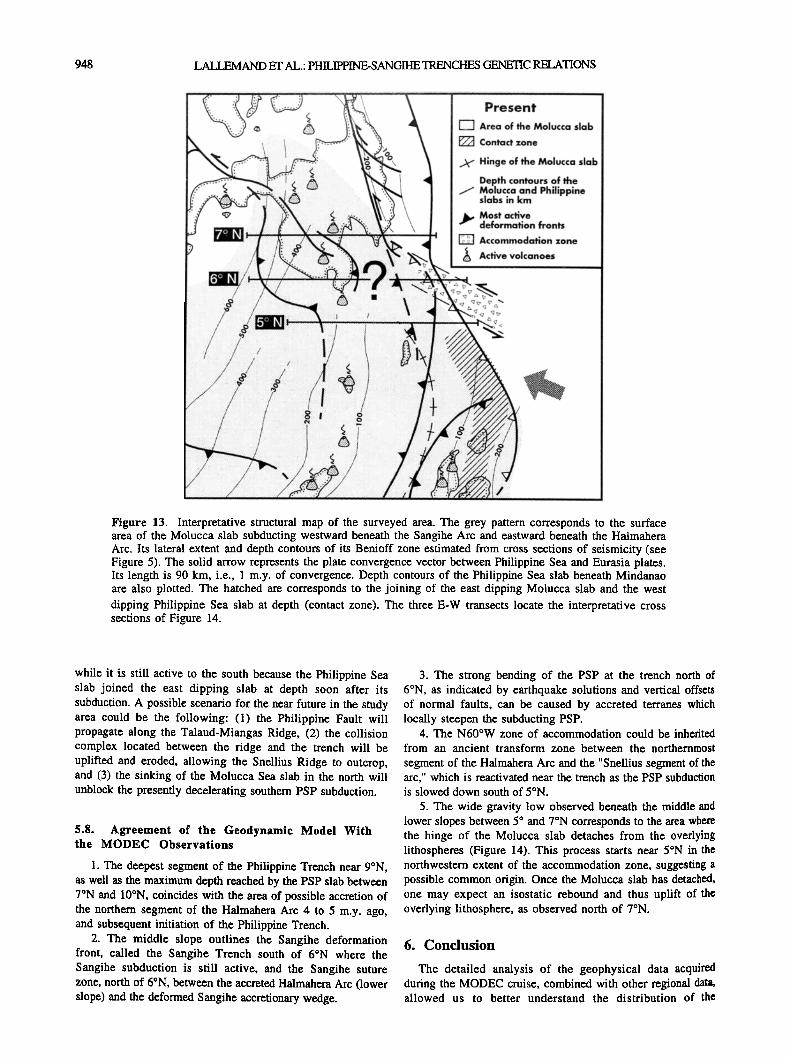
Figure 13. Interpretative structural map of the surveyed area. The grey pattern corresponds to the surface area of the Molucca slab subducting westward beneath the Sangihe Arc and eastward beneath the Halmahera Arc. Its lateral extent and depth contours of its Benioff zone estimated from cross sections of seismicity (see Figure 5). The solid arrow represents the plate convergence vector between Philippine Sea and Eurasia plates. Its length is 90 km, i.e., I m.y. of convergence. Depth contours of the Philippine Sea slab beneath Mindanao are also plotted. The hatched are corresponds to the joining of the east dipping Molucca slab and the west dipping Philippine Sea slab at depth (contact zone). The three E-W transects locate the interpretative cross sections of Figure 14.
while it is still active to the south because the Philippine Sea slab joined the east dipping slab at depth soon after its subduction. A possible scenario for the near future in the study area could be the following: (1) the Philippine Fault will propagate along the Talaud-Miangas Ridge, (2) the collision complex located between the ridge and the trench will be uplifted and eroded, allowing the Snellius Ridge to outcrop, and (3) the sinking of the Molucca Sea slab in the north will unblock the presently decelerating southern PSP subduction.
5.8. Agreement of the Geodynamic Model With the MODEC Observations
1. The deepest segment of the Philippine Trench near 9øN, as well as the maximum depth reached by the PSP slab between 7øN and 10øN, coincides with the area of possible accretion of the northern segment of the Halmahera Arc 4 to 5 m.y. ago, and subsequent initiation of the Philippine Trench.
2. The middle slope outlines the Sangihe deformation front, called the Sangihe Trench south of 6øN where the Sangihe subduction is still active, and the Sangihe suture zone, north of 6øN, between the accreted Halmahera Arc (lower slope) and the deformed Sangihe accretionary wedge.
3. The strong bending of the PSP at the trench north of 6øN, as indicated by earthquake solutions and vertical offsets of normal faults, can be caused by accreted terranes which locally steepen the subducting PSP.
4. The N60øW zone of accommodation could be inherited
from an ancient transform zone between the northernmost
segment of the Halmahera Arc and the "Snellius segment of the arc," which is reactivated near the trench as the PSP subduction is slowed down south of 5øN.
5. The wide gravity low observed beneath the middle and lower slopes between 5 ø and 7øN corresponds to the area where the hinge of the Molucca slab detaches from the overlying lithospheres (Figure 14). This process starts near 5øN in the northwestern extent of the accommodation zone, suggesting a possible common origin. Once the Molucca slab has detached, one may expect an isostatic rebound and thus uplift of the overlying lithosphere, as observed north of 7øN.
6. Conclusion
The detailed analysis of the geophysical data acquired during the MODEC cruise, combined with other regional data, allowed us to better understand the distribution of the

LALLEMAND ET AL.: PHILIPPINE-SANGIHE TRENCHES GENETIC RELATIONS 949
middle slope (Sangihe suture zone)
Cotobato Trench Pujada Peninsula Cotobato Arc
Philippine (Mati) Fault Philippine •, transfer zone I • Trench
200 km , , , ,
middle slope Sarangani (Sangihe suture zone) Peninsula
Cotobato Trench • Miangas Ridge ß I Philippine Trench
•:: -' • - • ß ---- .....
Sangihe Sangihe Trench Cotobato Trench forearc basin Snellius Ridge
/
Figure 14. Interpretative lithospheric cross-sections along 5øN (southern segment), 6øN (trench junction), and 7øN (south-central segment). These sections are based on seismicity (grey dots), global geodynamic context, and surface observations from the MODEC cruise. Thick lines are plate boundaries. Depths are in kilometers. See text for details and Figure 13 for location.
deformation in the vicinity of the Philippine Trench junction near 6øN. The origin of the Philippine Trench is controversial in that it is commonly attributed to the 8 to 9 Ma collision between the Palawan and Zamboanga continental terranes, while arc volcanism and slab length suggested a younger age of about 4 to 5 Ma. We suggest that. the accretion of the
northern part of the Halmahera arc and forearc to Mindanao during early Pliocene triggered the failure of the PSP along the Philippine Trench. The trench has propagated both north and south soon after and was recently slowed down along the southern branch because the PSP slab joined the Molucca Sea slab at depth.

950 LALLEMAND ET AL.: PHILIPPINE-SANGIHE TRENCHES GENETIC RELATIONS
Acknowledgments. We acknowledge S. Dominguez and Y. Font for their assistance in using GMT software and providing the basic documents for some figures. J.-F. Brouillet and A. Delplanque redrew some of the figures. R. Russo and C. Wibberley are acknowledged for their improvement of the English in the first and second versions of the manuscript respectively. J. Ch6ry discussed some problems related to the mechanics of the lithosphere with us. We thank B. Taylor, R. McCaffrey, and D. Jurdy for their constructive reviews. CNRS-INSU and IFREMER provided grants for participating in the MODEC cruise and financial support for the data reduction and analyses. The R/V L'Atalante crew is thanked for their very professional work. We also acknowledge our Filipino and Indonesian colleagues who were on board and with whom we had very interesting discussions. Contribution UMR "G6ophysique & Tectonique," "G6osciences Azur nø160," "G6otectonique," and "G6ologie de I'ENS".
References
Aurelio, M. A., Tectonique du segment central de la Faille Philippine-- Etude structurale, cin6matique et 6volution g6odynamique(in French with English abstract), Mdm. Sci. Terre Univ., 92-22, 420 pp., 1992.
Barrier, E., P. Huchon, and M. Aurelio, Philippine fault: A key for Philippine kinematics, Geology, 19, 32-35, 1991.
Cardwell, R. K., B. L. Isacks, and D. E. Karig, The spatial distribution of earthquakes, focal mechanism solutions, and subducted lithosphere in the Philippine and northeastern Indonesian Islands, in The Tectonic and Geologic Evolution qf Southeast Asian Seas and Islands, Part L Geophys. Monogr. Ser., vol. 23, edited by D. E. Hayes, pp. 1-35, AGU, Washington D.C., 1980.
Chamot-Rooke, N., C. Vigny, A. Walpersdorf, X. Le Pichon, P. Huchon, and C. Rangin, Sundaland motion detected from GEODYSSEA GPS measurements, Part I, Implications for motion at Sunda trenches, paper presented at GEODYSSEA (Geodynamics of the South and South East Asia) Concluding International Symposium, EC-ASEAN, Penang, Malaysia, April 14-18, 1997.
Deplus, C., and J. Dubois, Flexural response of the oceanic lithosphere at an arc-arc junction: Implication for the subduction of aseismic ridges, Tectonophysics, 160, 63-73, 1989.
Fitch, T. J., Plate convergence, transcurrent faulting and internal deformation adjacent to southeast Asia and western Pacific, J. Geophys. Res., 77, 4432-4460, 1972.
Fujiwara, T., K. Tamaki, H. Fujimoto, T. Ishii, N. Seama, H. Toh, K. Koizumi, C. Igarashi, J. Segawa, and K. Kobayashi, Morphological studies of the Ayu trough, Philippine Sea-Caroline Plate boundary, Geophys. Res. Lett., 22, 109-I 12, 1995.
Hall, R., Plate boundary evolution in the Halmahera region, Indonesia, Tectonophysics, 144, 337-352, 1987.
Hall, R., Reconstructing Cenozoic SE Asia, in Tectonic evolution of Southeast Asia. edited by R. Hall and D. Blurtdell, Geophys. Sot:. Spec. PubL, 106, 153-184, 1996.
Hall, R., J. R. All, C. D. Anderson, and S. J. Baker, Origin and motion history of the Philippine Sea Plate, Tectonophysics, 251, 229-250, 1995.
Hilde, T. W. C., and C.-S. Lee, Origin and evolution of the West Philippine Basin: A new interpretation, Tectonophysics, 102, 85-104, 1984.
Huchon, P., Comment on "Kinematics of the Philippine Sea Plate" by B. Ranken, R. K. Cardwell, and D. E. Karig, Tectonics, 5, 166-168, 1986.
Karig, D.E., and R. K. Cardwell, Reply, Tectonics, 5, 169-170, 1986. Lallemand, S. E., P. Schniirle, and J. Malavieille, Coulomb theory
applied to accretionary and nonaccretionary wedges: Possible causes for tectonic erosion and/or frontal accretion, J. Geophys. Res., 99, 12033-12055, 1994.
Lewis, S. D., and D. E. Hayes, The tectonics of northward propagating subruction along eastern Luzon, Philippine Islands, in The Tectonic and Geologic Evolution of Southeast Asian Seas and Islands, Part II, Geophys. Monogr. Ser., vol. 27, edited by D. E. Hayes, pp. 57-78, AGU, Washington, D.C., 1983.
Mammerickx, J., R. L. Fisher, F. J. Emmel, and S. M. Smith, Bathymetry of the east and southeast Asian seas, Scripps Institution qf Oceanography, La Jolla, Map, 1976.
Marchadier, Y., and C. Rangin, Polyphase tectonics at the southern tip of the Manila trench, Mindoro-Tablas Islands, Philippines, Tectonophysics, J83, 273-287, 1990.
McCaffrey, R., E. A. Silver, and R. W. Raitt, Crustal structure of the Molucca Sea collision zone, Indonesia, in The Tectonic and Geologic Evolution q[ Southeast Asian Seas and Islands, Part L Geophys. Monogr. Ser., vol. 23, edited by D. E. Hayes, pp. 161-177, AGU, Washington, D.C., 1980.
McCaffrey, R., Oblique plate convergence, slip vectors, and forearc deformation, J. Geophys. Res., 97, 8905-8915, 1992.
McCaffrey, R., Estimates of modem arc-parallel strain rates in fore arcs, Geology, 24, 27-30, 1996.
Moore, G, F., .and E. A. Silver, Collision processes in the northern
Molucca Sea. in The Tectonic and Geologic Evolution of Southeast Asian Seas and Islands, Part II, Geophys. Monogr. Ser., vol. 27, edited by D. E. Hayes, pp. 360-371, AGU, Washington D.C., 1983.
Mrozowski, C. L., S. D. Lewis, and D. E. Hayes, Complexities in the tectonic evolution of the west Philippine Basin, Tectonophysics, 82, 1-24, 1982.
Nichols, G., R. Hall, J. Milsom, D. Masson, L. Parson, N. Sikumbang, B. Dwiyanto, and H. Kallagher, The southern termination of the Philippine Trench, Tectonophysics, 183, 289-303, 1990.
Pinet, N., Un exemple de grand d6crochement actif en contexte de subduction oblique: La faille Philippine dans sa partie septentrionale(in French with 'English abstract), Doc. Travaux, 8, 391 pp., 1990.
Priadi, B., G6ochimie du magmatisme de l'ouest et du nord de Sulawesi, Indon6sie--Tra•age des sources et .implications g6odynamiques, th•se, 240 pp., Univ. Paul Sabatier, Toulouse, France} 1993.
Pubellier, M., R. Quebral, C. Rangin, B..Deffontaines, C. Muller, J. Butterlin, and J. Manzano, The Mindanao. collision zone: A soft collision event within a continuous Neogene strike-slip setting, J. SE Asian Earth Sci., 6, 239-248, 1991.
Pubellier, M., N. Pinet, and C. Rangin, Docking of the Philippine mobile belt against the Eurasian margin: Closure of the South China Sea, in Marine Geology and Geophysics of the South China Sea, edited by Jin X., H. R. Kudrass, and G. Pautot, pp. 71-82, China Ocean Press, Hangzhou, China, 1992.
Quebral, R. D., Tectonique du segment meridional de ia Faille Philippine, Mindanao oriental, Philippines: Passage d'une zone de collision /tune zone de d6crochement (in French with English abstract), Mdm. Sci. Terre Univ., 94-00, 1994.
Quebral, R., M. Pubellier, and C. Rangin, The onset of movement on the Philippine Fault in eastern Mindanao: A transition from a collision to strike-slip environment, Tecumics, 15, 713-726, 1996.
Rangin, C., and M. Pubellier, Subduction and accretion of Philippine Sea Plate fragments along the Eurasian margin, in Tectonics qf Circum- Pact•fic Continental Mart,ins, edited by J. Aubouin and J. Bourgois, pp. 139-164, VSP, Utrecht, 1990.
Rangin, C., M. Pubellier, and L. Jolivet, Collision entre les marges de l'Eurasie et de l'Australie: Un processus de fermeture des bassins marginaux du Sud-Est Asiatique, C. R. Acad. Sci., Ser. II, 309, 1223- 1229, 1989.
Rangin, C., D. Dahrin, R. Quebral, and the MODEC Scientific Party, Collision and strike-slip faulting in the northern Molucca Sea (Philippines and Indonesia): Preliminary results of a morphotectonic study, in Tectonic Evolution of Southeast Asia, edited by R. Hall and D. Blundell, Geol. Soc. Spec. Publ., 106, 29-46, 1996.
Rangin, C., M. Pubellier, C. Vigny, X. Le Pichon, M. Aurelio, R. Quebral, and A.-G. Bader, Distribution of deformation across the Sundaland/Philippine Sea Plate boundary from GPS results, paper presented at GEODYSSEA (Geodynamics of the South and South East Asia) Concluding International Symposium, EC-ASEAN, Penang, Malaysia, April 14-18, 1997.
Ranken, B., R. K. Cardwell, and D.E. Karig, Kinematics of the Philippine Sea Plate, Tectonics, 3, 555-575, 1984.
Sajona, F. G., H. Bellon, R. C. Maury, M. Pubellier, J. Cotten, and C. Rangin, Magmatic response to abrupt changes in geodynamic settings: Pliocene-Quatemary calc-alkaline and Nb-enriched lavas from Mindanao (Philippines), Tectonophysics, 237, 47-72, 1994.
Seno, T.,. The instantaneous rotation vector of the Philippine Sea Plate relative to the Eurasian Plate, Tectonophysics, 42, 209-226, 1977.
Seno, T., S. Stein, and A.E. Gripp, A model for the motion of the Philippine Sea Plate consistent with NUVEL-1 and geological data, J. Geophys. Res., 98, 17,941-17,948, 1993.
Silver, E. A., and J. C. Moore, The Molucca collision zone, Indonesia, J. Geophys. Res., 83, 1681-1691, 1978.
Smith, W. H. F., and D. T. Sandwell, Marine gravity field from declassified Geosat and ERS1 altimetry, Eos Trans. AGU, 76(46), Fall Meet. Suppl., F156, 1995.
Sufni Hakim, A., and R. Hall, Tertiary volcanic rocks from the Halmahera Arc, Eastern Indonesia, J. SE Asian Earth Sci., 6, 271- 287, 1991.
A.-G. Bader, M. Pubellier, and C. Rangin, URA CNRS-ENS 1516, D6partement de G6ologie, 21 rue Lhomond, 75231 Paris c6dex 5, France.
J.-P. Cadet, and B. Deffontaines, URA CNRS-UPMC 1759, D6partement de G6otectonique, T 26-0, El, boite 129, 4 place Jussieu, 75252 Paris c6dex 5, France.
S. E. Lallemand, UMR CNRS-UM2 5573, Institut des Sciences de la Terre, de l'Eau et de l'Espace (ISTEEM), Laboratoire de G6ophysique et Tectonique, C.C. 60, place E. Bataillon, 34095 Montpellier c6dex 5, France. (e-mail: [email protected])
M. Popoff, UMR CNRS-UNSA 6526 G6osciences Azur, 250 rue Albert Einstein, 06560 Valbonne, France.
(Received January 30, 1997; revised July 2, 1997; accepted September 12, 1997.)