geo-ecology of the lake urema / central mozambique
TRANSCRIPT
Geo-ecology of the Lake Urema / Central Mozambique
Diploma thesisBeate Böhme
Prof. B. MerkelDipl. Geol. F. Steinbruch
Prof. R. GloaguenPD H. Heilmeier
Rostock, 23-09-2005
supervised by:

Introduction Study area Methods Results Conclusions 2Questions
Introduction
● important ecological feature in the Gorongosa National Park: ecological diversity, rich wildlife
– after civil war in Mozambique (1976-1992): attempts for rehabilitation and investigation of park area

Introduction Study area Methods Results Conclusions 3Questions
Research questions
concern: extent of lake decreased, siltation
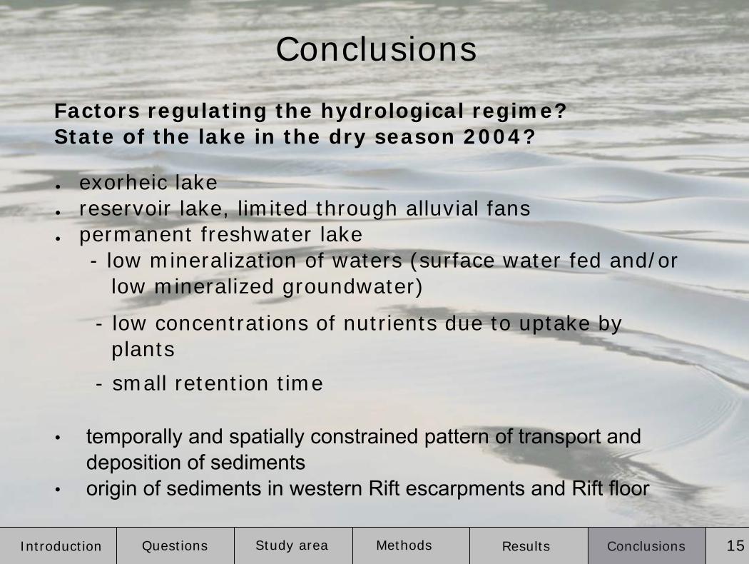
1) Factors regulating the hydrological regime?
2) State of the lake in the dry season 2004?
3) Variations of the lake's extent over the last 20 years?
Reasons?

Introduction Study area Methods Results Conclusions 4Questions
Study area

Introduction Study area Methods Results Conclusions 5Questions
● Southern Africa
● Central Mozambique
● Urema Rift
Gorongosa National Park

Introduction Study area Methods Results Conclusions 6Questions
Cheringoma Plateau (300 m a.s.l.):seaward dipping sequence from Cretaceous to Pleistocene
Rift Floor (< 100 m a.s.l.):unconsolidated pleistocene to recent alluvial deposits
Gorongosa Mountain (max. 1863 m a.s.l.):cretaceous granitic intrusive;steep flanks
Báruè Midlands (300-800 m a.s.l.):Precambrian gneisses and migmatites; undulating to incised landform
Lake Urema
vertical exaggeration 25line of sight N-NE
Geology
40 km

Introduction Study area Methods Results Conclusions 7Questions
● part of Pungoe R. catchment
● inflow from Rift escarpments
● outflow: Urema River
● dry season inflow through
Vunduzi River
● lake extent: 10-200 km²
Gorongosa National Park

Introduction Study area Methods Results Conclusions 8Questions
MethodsRemote Sensing- 11 satellite scenes 1979-2000(Landsat MSS, TM, ETM+, ASTER)- NDVI- supervised classification
Field work- bathymetric survey- water balance- water chemistry- sediment composition - littoral vegetation
Morphological analyses- SRTM DTM 90 m- (ASTER DTM)- satellite images- elevation profiles- stream profiles- morphological parameters
Laboratory analyses- water: major ions, TIC, DOC- sediments: grain size distri-
bution, TOC, mineral compo-sition (XRD)

Introduction Study area Methods Results Conclusions 9Questions
BGW-training sitesResult of supervised classification (Maximum likelihood with null class)Result of supervised classification, sieved, shoreline as polygon

Introduction Study area Methods Results Conclusions 10Questions
Results

Introduction Study area Methods Results Conclusions 11Questions
catchment area:total: 8755 km²
lake:maximum length: 10.1 kmmaximum width: 4.1 kmshore line development: 3.1
land/lake catchment ratio: 461:1
Nhandugue-Mucombeze
Vunduzi
Sungue-Muredeze
Drainage system = blue, catchment area = yellow, Park = red
Morphometric parameters (2nd October 2000)

Introduction Study area Methods Results Conclusions 12Questions
DTM of the Urema Basin
cross section Rift
cross section Muredeze “plug”
[m a.s.l.]

Introduction Study area Methods Results Conclusions 13Questions
● Transpar. = 0.24-0.7 m
● Diss. O2 = 15-115 %
● NO3- < 0.5 mg/l
● NH4+ < 0.1 mg/l
● PO43- < 0.2 mg/l
● SO42- < 20 mg/l
1
2
3
4
6
7
5
Water chemistry
● Twater = 24-28°C
● pH = 5.9-9.1
● EC = 32-171 µS/cm
● Eh = 292-522 mVH

Introduction Study area Methods Results Conclusions 14Questions
● average size: 20.5 km² ± 2.8 km²
● 05/1997: five times of average size due to cyclones
● small inner-annual changes (<1 km²)
08/1979
09/1991
1960
07/1993
05/1994 07/1994
05/1995 09/1995
07/1996 05/1997
10/2000 12/2000
Lake's extent
Introduction Study area Methods Results Conclusions 15Questions
Conclusions
● exorheic lake ● reservoir lake, limited through alluvial fans● permanent freshwater lake
- low mineralization of waters (surface water fed and/or low mineralized groundwater)
- low concentrations of nutrients due to uptake by plants
- small retention time
Factors regulating the hydrological regime? State of the lake in the dry season 2004?
• temporally and spatially constrained pattern of transport and deposition of sediments
• origin of sediments in western Rift escarpments and Rift floor

Introduction Study area Methods Results Conclusions 16Questions
• no trend in variation of lake size between 1979 and 2000
Variations of the lake's extent over the last 20 years? Reasons?
Major threats for maintenance of the lake:� sedimentation and change of the local base level
� change of water supply from the catchment area

Thanks for your attention
and special thanks to:● Franziska Steinbruch (GIS UCM), Prof. Broder Merkel (chair of
hydrogeology TUBAF), Prof. Richard Gloaguen (working group Remote Sensing TUBAF), PD Dr. Hermann Heilmeier (working group biology/ecology TUBAF), Fernando Januario, Roberto Zohlo, Jose Paulino Capece and his team of the Gorongosa National Park
● AG Boden- und Gewässerschutz TUBAF, ARAC Beira, DAAD, INAM Maputo, Ministry of Tourism Mozambique, SUBTECH Diving & Marine Co. Durban, ZGIS Salzburg