geo2010 s004 geoportal-application_development
TRANSCRIPT

1

<Insert Picture Here>
S004 GeoPortal Application Development
Mashups With Oracle Spatial and FMW Mapviewer
Carlos Vicens
Oracle Sales Consultant

The following is intended to outline our general
product direction. It is intended for information
purposes only, and may not be incorporated into any
contract. It is not a commitment to deliver any
material, code, or functionality, and should not be
relied upon in making purchasing decisions.
3
relied upon in making purchasing decisions.
The development, release, and timing of any
features or functionality described for Oracle’s
products remains at the sole discretion of Oracle.

<Insert Picture Here>
Outline
• What are Spatial and MapViewer
• The basic mashup: maps in apps
• External services and MapViewer
• Use cases
• Discussion
4
• Discussion

“Points”“Lines”
“Polygons”
Oracle database
What is Oracle Spatial
5
Data
Rasters
Topologies
3Df1
f2n1
n2
e1
e2e3
e4
Networks

“Spatial” Tables
• Just like regular tables
• Contain a column of type SDO_GEOMETRY to store
the geometric shape of the objects
CREATE TABLE map_countries (id NUMBER PRIMARY KEY,
6
id NUMBER PRIMARY KEY,name VARCHAR2(30),geometry SDO_GEOMETRY);

Analyze
SELECT c.holding_company, c.locationFROM competitor c,
Find all competitors within 2 miles of Northport Branch
7
Map data © NAVTEQ
c.locationFROM competitor c,
bank bWHERE b.site_id = 1604AND SDO_WITHIN_DISTANCE(
c.location, b.location,'distance=2 unit=mile‘
) = 'TRUE'

Analyze
What percentage of Yellowstone is in each state ?
WITH p AS (
SELECT s.state,
sdo_geom.sdo_area (
sdo_geom.sdo_intersection (
s.geom, p.geom, 0.5),
0.5, 'unit=sq_km') area
FROM us_states s, us_parks p
8
FROM us_states s, us_parks p
WHERE SDO_ANYINTERACT (s.geom, p.geom) = 'TRUE'
AND p.name = 'Yellowstone NP'
)
SELECT state, area,
RATIO_TO_REPORT(area) OVER () * 100 AS pct
FROM p
ORDER BY pct DESC;
STATE AREA PCT
---------- ---------- ---------
Wyoming 8100.7515 91.0636012
Montana 640.296007 7.19780878
Idaho 154.659879 1.73859

Oracle Fusion Middleware MapViewer
• A J2EE component (.ear) for developing web mapping applications.
Usually deployed in WLS.
• Renders geospatial content stored in an Oracle database.
Background maps can be from 3rd party providers.
• Provides Java, Javascript, and XML request/response APIs.
9

Oracle Mapviewer
Mapviewer metadata
Mapviewer application
Styles – style definitions (markers, colors etc)
OAS, WLS
or other J2EE container Oracle Maps Javascript API
10
Oracle Database
Styles – style definitions (markers, colors etc)
Themes – association of style with data
Base Maps – collection of themes
Tilecaches – predefined base map tiles
build
build
build
Spatial data

Oracle Mapviewer : architecture
Mapviewer client sideexternal map providers
eLocation, Google, Bing
MapViewer server components
Dynamic
HTTP: (map tiles and feature data)(Map interaction client lib)
11
Oracle Database
WebLogic
or J2EE
Containermap cacheserver
Oracle Maps server-side
Dynamic SQL queries
rendering
engine adapter
HTTP
(get map tiles)

Mapviewer facilitates different options
• For content
– Local (Oracle database)
– Online web services
– Hybrid (local database + online content)
• For development
12
• For development
– Java or javascript code embedded in application
– Using ADF Faces (<dvt:map>)

Mashup methods
and examples
13

Basic Mashup: Application Content and MapViewer
• Simplest form: a database query containing a spatial
column, aka a MapViewer theme
• Or the result of a stored procedure which
• Can be spatial (e.g. asset location) or non-spatial
(e.g. work orders)
14
(e.g. work orders)
• Must have a location identifier (e.g. asset id)
• Or contain the location

MapViewer renders database and map content
stored in a local database
15

Display Results of Stored Procedures
16

OTM 6.2 Order Release ActionMap Order Release Shipment Routes
Destination of OUTBOUND
Unplanned Order
1717
Shipment Destination
Shipment Source

MapViewer enables custom map styles
18

19

External Services and MapViewer
• Can be spatial (e.g. weather) or non-spatial (e.g. BI
report)
• Must have a location identifier (e.g. county name, or
region id)
• Or contain the location (e.g. georss)
20
• Or contain the location (e.g. georss)
• Can be an XML document (BI report, georss) or
JSON or embeddable content (e.g. media)
• Or an OGC WebFeatureService 1.0 response (i.e. a
GML 2.11 feature)

Display Content (XML) from External Services
21
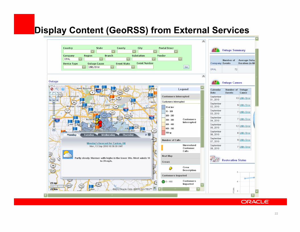
Display Content (GeoRSS) from External Services
22

Display Content (JSON) from External Services
23

Display Content (media) from External Services
24

External Content (StreetView) on MapViewer Maps
25

External Map Services and MapViewer
• Built-in support for Google and Bing Maps
– Purely for tiles not their full javascript API
• Interface (MVCustomTileLayer) for accessing other
online map services (e.g. ESRI or OpenStreetMap)
• OGC WebMapService and WebFeatureService
26
• OGC WebMapService and WebFeatureService
interfaces are also supported

MapViewer also renders application content on
background maps from online services
27

External Map Tiles in MapViewer
28

CustomTileLayer Interface and OpenStreetMap
29

CustomTileLayer Interface and ESRI ArcGIS Online
30

Summary
• MapViewer displays application content on maps
• The content can be in an Oracle database, or
• Can come from other platforms or services
– Such as OBIEE or web services like Weatherbug
• The map data can be stored using Spatial, or
31
• The map data can be stored using Spatial, or
• The background maps can come from services
– E.g. Bing or Google Maps

The preceding is intended to outline our general
product direction. It is intended for information
purposes only, and may not be incorporated into any
contract. It is not a commitment to deliver any
material, code, or functionality, and should not be
relied upon in making purchasing decisions.
32
relied upon in making purchasing decisions.
The development, release, and timing of any
features or functionality described for Oracle’s
products remains at the sole discretion of Oracle.

Spatial at OOW 2010 - Sessions
Date/Time Title Location
Tuesday, Sept 21
11:00 a.m.Managing Critical Infrastructure with Autodesk
Topobase and Oracle Technology
Palace Hotel
Presidio
11:00 a.m.The Smart Grid Choice: Oracle Utilities Smart Grid
Roadmap Overview
Palace Hotel
Sea Cliff
12:30 p.m. Oracle Spatial 11g Release 2 Customer RoundtableMoscone South
Room 200
33
Wed., Sept 22
11:30 a.m.Oracle Spatial 11g Release 2 New Features Deep
Dive
Moscone South
Room 200
11:30 a.m.How to Build a Spatial Data Warehouse for NIS
Telecom, Using Oracle Locator
Hotel Nikko
Mendocino I/II
4:45 p.m.Best Practices with Oracle Spatial 11g and Fusion
Middleware’s MapViewer
Moscone South
Room 200

Spatial at OOW 2010 - Sessions
Date/Time Title Location
Thursday, Sept 23
11:00 a.m.How to Build Network Applications with Oracle
Spatial Network Data Model
Hotel Nikko
Golden Gate
Spatial at OOW 2010 – Hands-On Labs
Date/Time Title Location
Thursday, Sept 23
34
Thursday, Sept 23
10:00 a.m.
Using Java to Build Maps with Oracle Spatial and
Fusion Middleware MapViewer
Hilton SF
Franciscan
A/B/C/D
11:30 a.m.
Implementing Oracle Spatial Web Services Hilton SF
Franciscan
A/B/C/D
1:00 p.m.
Tracking Moving Objects with Oracle Spatial and
Oracle Complex Event Processing
Hilton SF
Franciscan
A/B/C/D

Spatial at OOW 2010 – Develop Sessions
Date/Time Title Location
Tuesday, Sept. 21
2:30 p.m.
Building Mashups Using Oracle Spatial and
Fusion Middleware MapViewer
Hotel Nikko
Nikko Ballroom I
Spatial at OOW 2010 – JavaOne Sessions
Date/Time Title Location
35
•DEMOgrounds
•Advanced Geospatial Analysis with Oracle Spatial- Moscone West, W-042
•Oracle Spatial for Mapping and Business Applications- Moscone West, W-043
Date/Time Title Location
Monday, Sept. 20
2:30 p.m.
Beyond Smartphones: Rich Applications and
Services for the Mobile Masses
Hotel Nikko
Nikko Ballroom I

36

37

External Content (StreetView) on MapViewer Maps
38